#Snowpack/#Runoff news: Folks are upbeat for the Rio Grande boating season

Rio Grande at Del Norte gage May 14, 2017 via Colorado Division of Water Resources.

From The Santa Fe New Mexican (Sami Edge):

“We will remember 2017,” said [Steve] Harris, who from his porch on Friday could see willow trees bending in the fast-moving, brown current. “It’s been 10 years since we’ve seen this kind of water.”

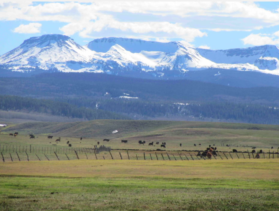
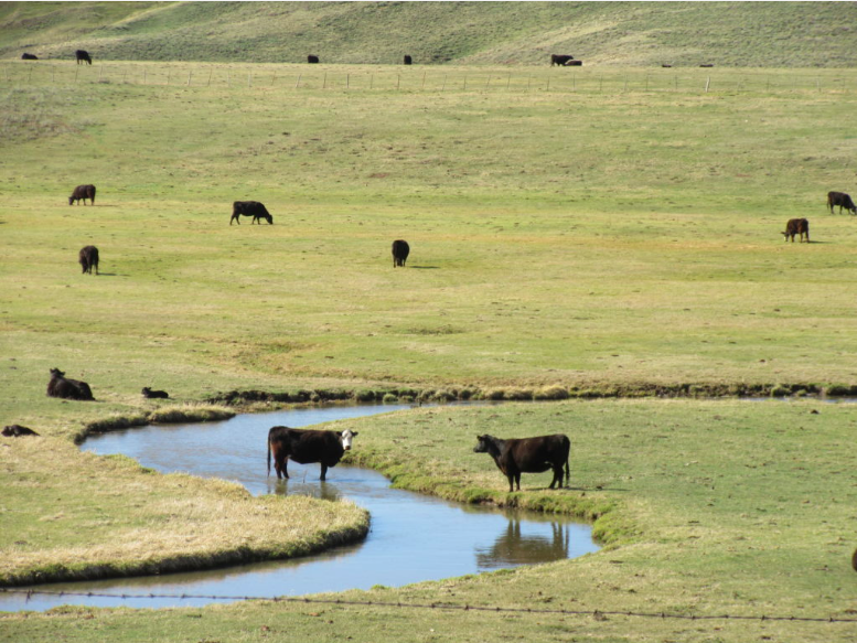
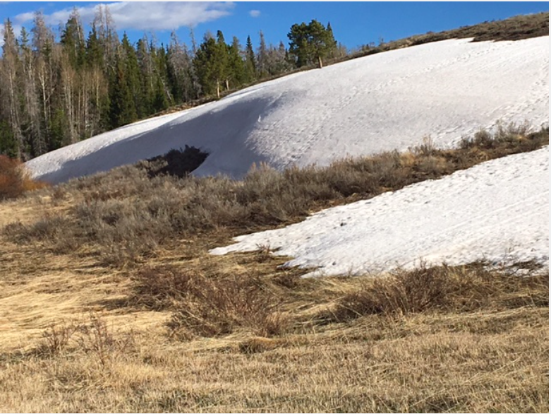
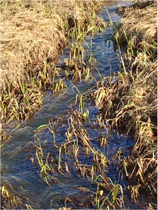
The Rio Grande and other rivers in Northern New Mexico are surging. Experts say the heavy winter snowpack in New Mexico and Colorado mountains, coupled with recent cold snaps and a boost from spring precipitation, mean New Mexico will have more runoff than in past years, and it will last further into the summer season. And that is good news for irrigators, recreational users, municipal water systems and wildlife that depend on the rivers.

“We’ve had, particularly on the Rio Grande, a very good snowpack year,” said Royce Fontenot, senior service hydrologist for the National Weather Service in Albuquerque. “The positive impacts are going to be that agriculture and water users on the Rio Grande and San Juan are going to have more water than they’ve had in recent years.”

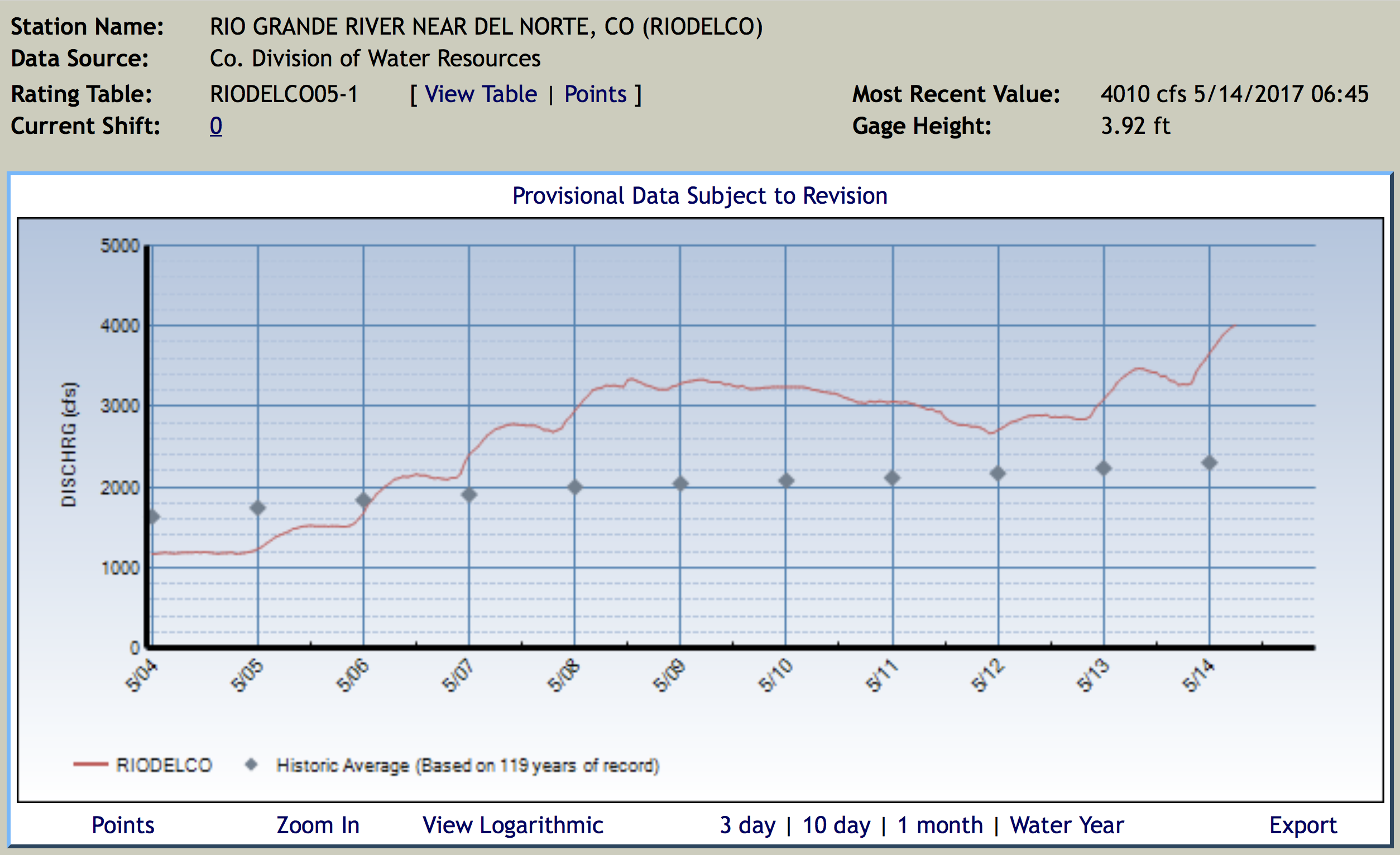
The Rio Grande currently has twice as much water flowing through it than is typical for this time of year. On Friday, the river gauge at the village of Embudo recorded 4,020 cubic feet per second, which is more than double the 85-year average for the same date.

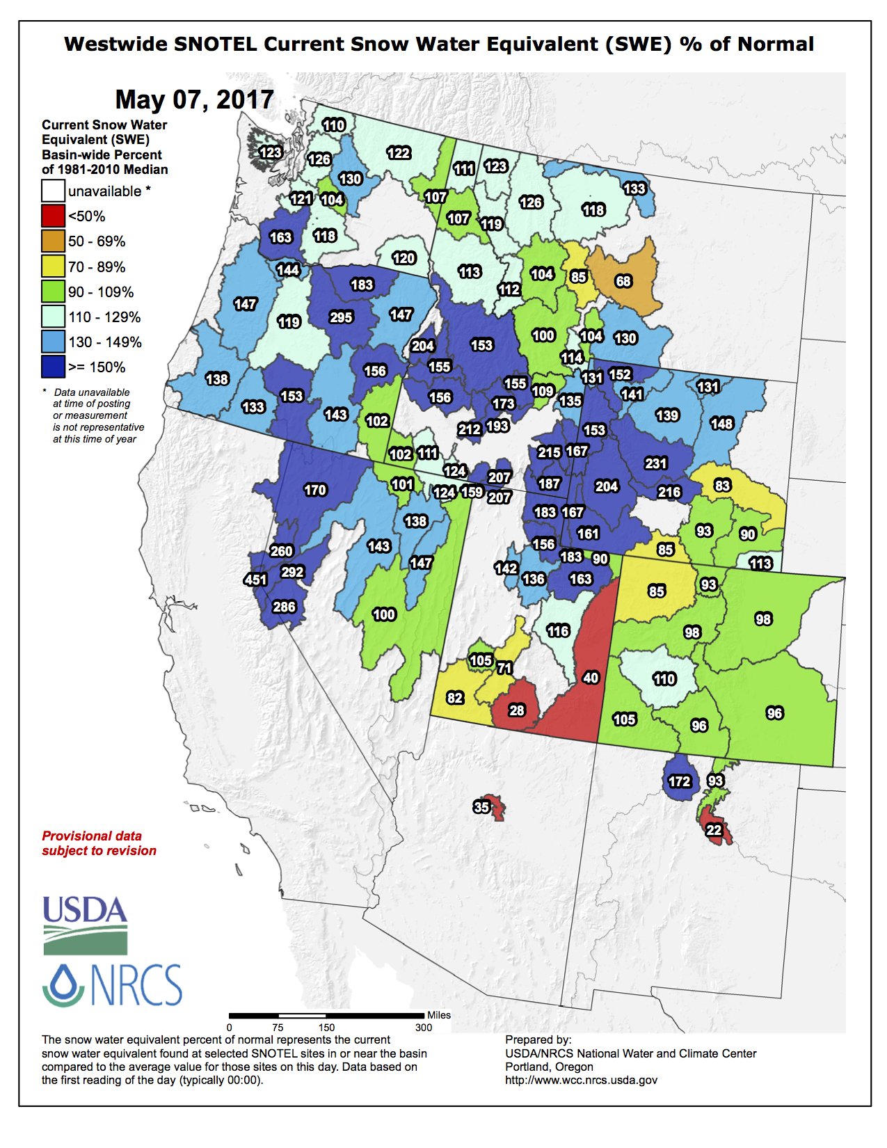
The Upper Rio Grande snowpack, which feeds the headwaters in Southern Colorado, was at 122 percent of its historical median Friday, according to a map published by the U.S. Bureau of Reclamation. Snowpack in New Mexico’s Sangre de Cristo Mountains, which shed water into the river south of the state line, measured at 150 percent.

The Rio Chama snowpack, which supplies important reservoirs and the river for which it is named, had a snowpack Friday that was 266 percent of the historical median.

Mary Carlson, public affairs specialist for the Bureau of Reclamation’s Albuquerque office, says the snowmelt is strong enough that, for the first time in a few years, Heron Reservoir will be able to fully allocate the water promised to contractors, and El Vado Reservoir is again allowed to store water, which isn’t allowed when reservoirs downstream are at a critical level. Water forecasts from the Natural Resources Conservation Service estimate that El Vado inflow from March through July will be 171 percent of normal.

“We have been in extreme drought for many years here in New Mexico. All of our reservoirs are now really low. This above average snowpack is a really big deal at this point,” Carlson said. “It’s looking like it’s overall going to be a really good year for water.”

At the Santa Cruz Reservoir, water is cascading down the dam’s overflow spillways, said Kenny Salazar, water manager for the Santa Cruz Irrigation District He expects to see chile crops and kitchen gardens flourish along the eight miles of irrigation ditches in the district. He just hopes warm nighttime temperatures don’t make the Santa Cruz River jump its banks.

Garrett VeneKlasen, executive director of the New Mexico Wildlife Federation, has a similarly optimistic outlook for New Mexico wildlife. More water and more plants means more turkey, elk, bighorns and songbirds, and next year, maybe even bears with two cubs…

Santa Fe stands to benefit, too. Snows in the canyon east of the city feed the McClure and Nichols reservoirs, a significant source of water supply for the community water, which, like Albuquerque, also diverts water from the Rio Grande. On Friday, flows in the Santa Fe River before it reaches McClure were at 22 cubic feet per second, which is above the 17-year average of 17 cfs.

From KOAA.com:

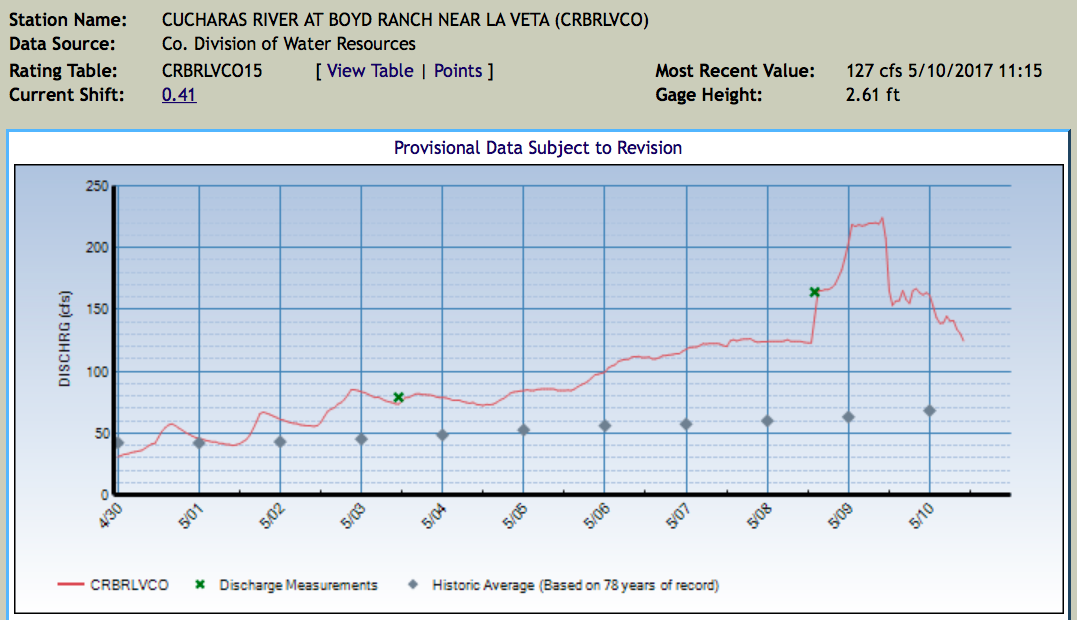
As of 5:30 a.m. Friday, the river stage was at 11.6 feet. If the water rises to 12 feet, water will start approaching Highway 194. At 13 feet, nearby structures will be threatened. According to the National Weather Service, the water could reach 12.2 feet as early as Friday.

From The Pueblo Chieftain (Ryan Severance):

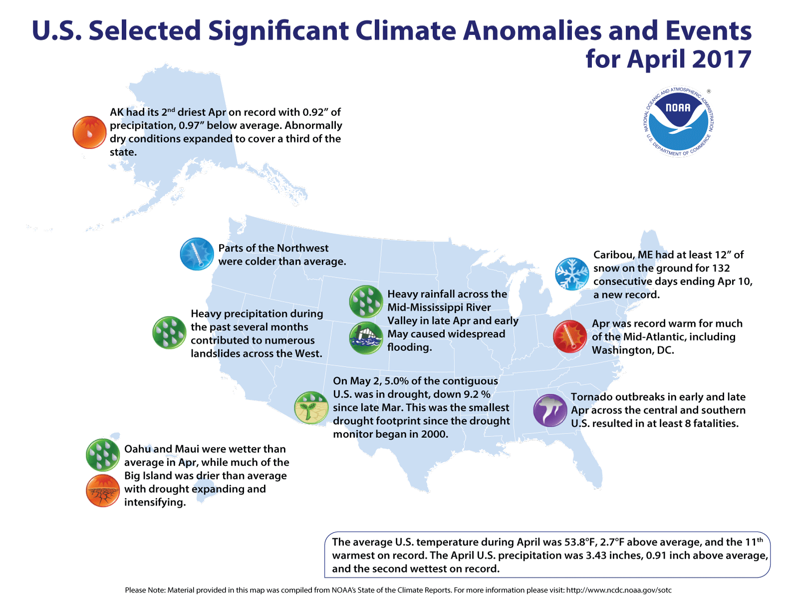
The Beulah area received anywhere from 2 to 6 inches of precipitation from Wednesday afternoon through late Thursday morning, according to the National Weather Service’s Pueblo office…

Pueblo Mountain Park in Beulah received 4.48 inches of precipitation from Wednesday to Thursday, the NWS said, and has received 5.82 inches in the past three days. Since March 23 there has been 16.04 inches of precipitation at the park.

The rain began pelting the town late Wednesday afternoon before turning into hail for a while. The hail then became rain again and fell consistently through the night and into early Thursday morning before tapering off by late morning.

Statewide snowpack Basin High/Low graph May 14, 2017 via the NRCS.

Rifle “State of the River” meeting recap: We, “are all in this together” — Annie Whetzel

Colorado River Basin in Colorado via the Colorado Geological Survey

The Middle Colorado Watershed Council, MCWC, aims to protect the stretch of Colorado River from the mouth of Glenwood Canyon to De Beque at the western edge of Garfield County. We work with everyone who uses water from the agricultural community, to city water users (including tooth-brushers and lawn-waterers), to oil and gas developers and every governmental agency in between to encourage wise water use and ensure safe water quality for everyone involved.

Working with the Colorado River District for the State of the River was a great reminder that navigating these diverse interests and subsequent water uses is a common thread for the entire river, from the headwaters of the Colorado down to the river terminus. Through education, dialog and exchange of information we have a chance to better understand and manage the finite resource.

The MCWC has a few projects on the ground and on the horizon that aim to connect our stretch of river to the larger river system. These efforts involve riparian restoration, a nice term for fighting invasive species like tamarisk and ensuring native plants have a chance to grow back, and water quality management.

Tamarisk

Tamarisk Coalition chose the MCWC as one of nine programs to join their Restore Our Rivers campaign. The campaign provides tools and funding for river restoration programs that combat tamarisk and Russian olive and more…

This summer the MCWC will begin a few restoration projects and will continue to monitor existing projects. It is our way of working along our 75 mile stretch of river and understanding how we fit into the larger picture.

As for water quality monitoring, we are undertaking a citizen science program to establish a baseline for what is in our water in the middle Colorado River and its tributaries. Upstream and downstream of us, many groups already test water quality, and therefore again, we are tasked with understanding how our section of river fits into the larger system. Our citizen science program is designed to find out what water quality looks like today, see how that compares to the past, and allows for the opportunity to evaluate trends into the future. How are we affecting water quality and are there opportunities to improve? The data we and our stakeholders collect will help us understand our basin better, but will also provide service to everyone downstream of us.

Our little, but significant, stretch of river is ours to take care of. Managing the entire Colorado River might seem like a daunting task, but we can be stewards for our stretch, from Glenwood Canyon to De Beque. The steps we take to protect our water helps our little basin, but also, we are working a much larger system throughout the west, because we are all in this together.

Annie Whetzel is community outreach coordinator at the Middle Colorado Watershed Council. To learn more about the council, go to http://www.midcowatershed.org. You can also find the council on Facebook at http://facebook.com/midcowatershed.

Central Colorado Water Conservancy District: Augmentation water, water education, wildlife habitat, regional advocacy

High Plains in eastern Colorado. Photo credit Bob Berwyn.

From The Greeley Tribune (Randy Knutson):

Since its creation in 1965, the Central Colorado Water Conservancy District has played a pivotal role in addressing that need. The district provides critical water storage for district residents and users and the communities they call home.

The district is a voice, and a force, for how we can best use our water to fuel agricultural and other local industries — and be a champion of the region’s water issues. CCWCD has taken up the task of lobbying on behalf of its water users in the General Assembly. Whether opposing detrimental legislation or promoting new laws, the district has been an active advocate to increase water availability to CCWCD constituents.

The district also helps provide wildlife habitat through irrigated farmlands and on the water it manages at northeast Colorado reservoirs by providing the necessary environment for fish, birds and animals. When needed, our storage provides flood control throughout the region. And as we move into the future, we will provide increased recreational opportunities, like boating and fishing, to complement the needs of our growing communities.

The district is exploring new options and partners to fill the water supply gap that is projected in northeastern Colorado. The district’s partnerships include the Chatfield Reallocation Project with Denver Water, Trout Unlimited, Greenway Foundation and others. Partnerships like this have allowed CCWCD to receive grant funding to expand its mission as a local conservancy district.

Educating the public about wise water use, the importance of storage and the role water plays in our lives and economy, became another focus for the district during the 1990s and remains a priority today. The district organized its first Children’s Water Festival in Colorado in 1990, and it is still held every year. Grant money has been used to develop a water curriculum — “Water Wise Colorado” — for grades K-12. More recent programs include Well Watch, a system of monitor wells for data collecting at school properties, and a weeklong professional development workshop for teachers held every summer.

Foremost are the district’s efforts over the decades to shore up water-storage capacity. Colorado’s climate always has been unpredictable, and the district has helped see its users through periods of prolonged drought as well as torrential rain. Employing an extensive portfolio of water rights, wells, irrigation ditches, rivers, recharge ponds and reservoirs, the district has helped the communities it serves across northeastern Colorado navigate the ebbs and flows of water over the decades.

However, since 2005, many wells in the South Platte River Basin were shut down or now have usage restrictions. That’s why the district received voter support in 2012 for a bond to purchase water rights and new sources. Now the district once again needs to increase its storage capacity.

Without adequate storage, all the conservation efforts available won’t amount to much. While the latter is broadly popular and typically receives all the support it needs in our state legislature, it is the former, storage that ensures the water we conserve will stick around to ensure Colorado quite literally can put food on everyone’s table.

That is why the district is always planning for the future. We will be working through the Colorado Water Plan, as well as continually utilizing the district’s own water plan. Implementing these plans and accomplishing our local, regional and statewide storage goals both require coordination and cooperation among many different stakeholders.

Over the coming months, the district will start identifying storage needs and preparing to discuss with community leaders, elected officials and the broader community the investments necessary to store our water and secure our economic and agricultural future.

We are looking forward to engaging with you on this critical topic. To learn more and to follow the conversation, we ask that you join us on Facebook at facebook.com/CentralCOWater.

Randy Knutson is president of the board of directors of Central Colorado Water Conservancy District.

Water Education Colorado 2017 President’s Award Reception

The Denver Art Museum was the location for The Colorado Foundation for Water Education’s President’s Award Reception yesterday evening.

Eric Kuhn received the Dianne Hoppe Leadership Award and Drew Beckwith was honored as an Emerging Leader.

Each year when I attend this event I am struck by the camaraderie shown by the water folks here in Colorado. Water really does bring us together to find solutions, and at the end of the day we have so much to agree on. Water for Ag, water to drive the economy, water for the fish and bugs. It takes a great number of people to meet the water needs of the Headwaters State, collaboration is key, and this event helps us to connect.

Jim Lochhead introduced Eric Kuhn and detailed his accomplishments while leading the Colorado River District. The Colorado River Cooperative Agreement and the Windy Gap Firming agreement were at the top of the list. Lochhead also praised Mr. Kuhn as one of the two most influential persons in the Colorado River Basin along with Pat Mulroy.

Drew Beckwith

Eric Hecox told us about Drew Beckwith’s influence on the Statewide Water Supply Initiative. Eric credited Mr. Beckwith for poring over the workbooks, questioning assumptions, and advocating for conservation.

Drew is an accomplished water educator himself choosing video in the Drew in a Canoe series. He helped get the public on board with legislation passed in 2016 to legalize rain barrels.

People that install rain barrels are, “More connected to water,” he said.

This is always a great event to attend. Thanks Jayla, Caitlin, Jenny, and Stephanie.

The latest briefing from the Western Water Assessment is hot off the presses

Click here to read the assessment. Here’s an excerpt:

Highlights:

  • A wetter-than-normal April and early May led to a bumpy snowpack trajectory through the peak(s) and into the main melt season, and as of May 11, SWE is above normal in all areas except northwestern Colorado, southeastern Wyoming, and southern Utah. The highest, wettest Snotel sites in the region appear to have just peaked, among them Grand Targhee (WY) and Snowbird (UT), both at about 60″ of SWE, well above normal.
  • With very large snowpacks and the melt well underway, daily streamflows in northern Utah and western Wyoming rivers are at high (>90th percentile) or record-high values, with yet higher flows and flooding potential on tap with upcoming warm, sunny weather. An elevated risk of flooding in these basins, as well as in the Arkansas basin in Colorado, will persist for several weeks.
  • The May 1 NRCS spring-summer runoff forecasts changed only slightly from the April 1 forecasts at most points. The regional picture is still tipped towards above-average runoff, though with a clear gradient between the much-above-average (>130%) volumes expected in northern and central Utah and most of Wyoming, and the more variable but closer-to-average volumes elsewhere. Forecasted Lake Powell April-July inflows have slipped again, to 123% of average per NRCS, and 120% of average per NOAA CBRFC.
  • April saw mostly above-normal precipitation for the region, with central and western Wyoming, far northern Utah, and southeastern Colorado coming out very wet, while central and southern Utah and western Colorado were on the dry side. Statewide, Wyoming yet again was the winner, in the 93rd percentile for precipitation, with Colorado in the 72nd percentile, and Utah in the 53rd percentile.
  • Drought conditions have markedly improved since early April, so that the region now has less drought coverage than at any time since August 2009. There was reduction of drought in southeastern Colorado and northeastern Wyoming, though some degradation to D0 in southeastern Utah. D1 or D2 conditions now cover only 2% of Colorado (down from 22%), 0.1% of Wyoming (down from 9%), and 0% of Utah.
  • The tropical Pacific remains on the warm side of ENSO-neutral conditions, though with some cooling in the last few weeks. The ENSO forecast models call for neutral conditions to continue, but with the chances of transition to El Niño conditions rising to ~50% by late summer and fall.
  • Fort Collins: Possible ballot initiative about Poudre River through town

    Poudre River Bike Path bridge over the river at Legacy Park photo via Fort Collins Photo Works.

    From The Fort Collins Coloradoan (Kevin Duggan):

    The group [Save the Poudre] is considering asking Fort Collins voters to require the city to “actively oppose and work to stop” new water projects that would reduce the river’s flow through Fort Collins, according to a city memo.

    Save the Poudre, which has fought the proposed Northern Integrated Supply Project, or NISP, and its Glade Reservoir for more than a decade, might soon start the process of getting an initiative on the November ballot that could change city water policy.

    Secretary Zinke Announces $23.6 Million for Water Reclamation and Reuse Projects and Studies

    Water reuse via GlobalWarming.com.

    Here’s the release from the US Bureau of Reclamation (Peter Soeth):

    Bureau of Reclamation Funding Goes to Six Authorized Projects, Thirteen Feasibility Studies and Four Research Studies in California, Kansas, Nevada, Oklahoma, Texas, Utah and Washington

    U.S. Secretary of the Interior Ryan Zinke today announced that the Bureau of Reclamation awarded $23,619,391 to communities in seven states for planning, designing and constructing water recycling and re-use projects; developing feasibility studies; and researching desalination and water recycling projects. The funding is part of the Title XVI Water Reclamation and Reuse program.

    “This funding provides essential tools for stretching limited water supplies by helping communities reclaim and reuse wastewater and impaired ground or surface waters,” said Secretary Zinke. “These tools are just part of the toolkit for bridging the gap between water supply and demand and thus making water supplies more drought-resistant. In addition to this funding, Reclamation is actively supporting state and local partners in their efforts to boost water storage capacity. ”

    Title XVI Authorized Projects are authorized by Congress and receive funding for planning, design and/or construction activities on a project-specific basis. Six projects will receive $20,980,129. They are:

  • City of Pasadena Water and Power Department (California), Pasadena Non-Potable Water Project, Phase I, $2,000,000
  • City of San Diego (California), San Diego Area Water Reclamation Program, $4,200,000
  • Hi-Desert Water District (California), Hi-Desert District Wastewater Reclamation Project, $4,000,000
  • Inland Empire Utilities Agency (California), Lower Chino Dairy Area Desalination and Reclamation Project, $5,199,536
  • Padre Dam Municipal Water District (California), San Diego Area Water Reclamation Program, $3,900,000
  • Santa Clara Valley Water District (California), South Santa Clara County Recycled Water Project, $1,680,593
  • Title XVI Feasibility Studies are for entities that would like to develop new water reclamation and reuse feasibility studies. Thirteen projects will receive $1,791,561. They are:

  • City of Ada Public Works Authority (Oklahoma), Reuse Feasibility Study for the City of Ada, Oklahoma, $136,193
  • City of Bartlesville (Oklahoma), Feasibility Study to Augment Bartlesville Water Supply with Drought-Resilient Reclaimed Water, $150,000
  • City of Garden City (Kansas), Strategic Plan for Reuse Effluent Water Resources in Garden City, Kansas, and Vicinity, $65,368
  • City of Quincy (Washington), Quincy 1 Water Resource Management Improvement Feasibility Study for Comprehensive Wastewater Reuse and Water Supply Project, $150,000
  • El Paso Water Utilities – Public Services Board (Texas), Aquifer Storage-Recovery with Reclaimed Water to Preserve Hueco Bolson using Enhanced Arroyo Infiltration for Wetlands, and Secondary Reducing Local Power Plant Reclaimed Water Demand, $150,000
  • Kitsap County (Washington), Feasibility Study for a comprehensive water reuse project at the Kitsap County Kingston Wastewater Treatment Plant, $150,000.
  • Las Virgenes Municipal Water District (California), Pure Water Project Las Virgenes Municipal Water District, $150,000
  • North Alamo Water Supply Corporation (Texas), Feasibility Study of Energy-Efficient Alternatives for Brackish Groundwater Desalination for the North Alamo Water Supply Corporation, $90,000
  • Oklahoma Water Resources Board (Oklahoma), Feasibility Study of Potential Impacts of Select Alternative Produced Water Management and Reuse Scenarios, $150,000
  • Soquel Creek Water District (California), Pure Water Soquel – Replenishing Mid-County Groundwater with Groundwater with Purified Recycled Water, $150,000
  • Valley Center Municipal Water District (California), Lower Moosa Canyon Wastewater Recycling, Reuse, and sub-regional Brine Disposal Project, $150,000
  • Washoe County (Nevada), Northern Nevada Indirect Potable Reuse Feasibility Study, $150,000
    Weber Basin Water Conservancy District (Utah), Weber Basin Water Conservancy District Reuse Feasibility Study, $150,000
  • The Title XVI Program will provide funding for research to establish or expand water reuse markets, improve or expand existing water reuse facilities, and streamline the implementation of clean water technology at new facilities. Four projects will receive $847,701. They are:

  • City of San Diego (California), Demonstrating Innovative Control of Biological Fouling of Microfiltration/Ultrafiltration and Reverse Osmosis Membranes and Enhanced Chemical and Energy Efficiency in Potable Water, $300,000
  • City of San Diego (California), Site-Specific Analytical Testing of RO Brine Impacts to the Treatment Process, $48,526
  • Kansas Water Office (Kansas), Pilot Test Project for Produced Water near Hardtner, Kansas, $199,175
  • Las Virgenes Municipal Water District (California), Pure Water Project Las Virgenes-Truinfo Demonstration Project, $300,000
  • Reclamation provides funding through the Title XVI Water Reclamation and Reuse Program for projects that reclaim and reuse municipal, industrial, domestic or agricultural wastewater and naturally impaired ground or surface waters. Reclaimed water can be used for a variety of purposes, such as environmental restoration, fish and wildlife, groundwater recharge, municipal, domestic, industrial, agricultural, power generation or recreation.

    Since 1992, Title XVI funding has been used to provide communities with new sources of clean water, while promoting water and energy efficiency and environmental stewardship. In that time, approximately $672 million in federal funding has been leveraged with non-federal funding to implement more than $3.3 billion in water reuse improvements.

    #Drought news: E. plains wet over the past week, statewide wetness this week

    Click here to go to the US Drought Monitor website. Here’s an excerpt:

    Summary

    The Midwest continued to be inundated with heavy rains from southern Kansas through Missouri and into southern Illinois and Indiana. Amounts associated with the Midwest rains were generally in the 1-3 inch range, with locally higher amounts. Much of the eastern United States was wet over the last week; many areas recorded above-normal precipitation and the rains kept temperatures below normal, with departures of 10 degrees or more over the Midwest. Over the weekend, heat returned to the Southwest with several days of temperatures above 100 degrees F while most of the western half of the United States had above-normal temperatures with departures of 6-8 degrees above normal in the Dakotas and northern Rocky Mountains. Much of the West and Plains were dry for the week, with just scattered thunderstorms in the Rocky Mountains and rains along the coastal areas of the Pacific Northwest…

    High Plains

    Much of the region was drier than normal this week, with only portions of eastern Colorado and southern Kansas recording above-normal precipitation. Temperatures were warmer than normal over most of the region, with departures of 6-8 degrees above normal in the Dakotas. Colorado had abnormally dry conditions removed from the southeast portion of the state, and the moderate drought and abnormally dry conditions in the northern portion of the state also improved. Abnormally dry conditions were introduced over much of northern South Dakota and expanded in southern North Dakota. The short-term dryness in this region has helped to progress agricultural work, but may become an issue without some needed rains…

    West

    Most of the region was warmer than normal for the week, with departures of 4-6 degrees above normal quite common. Dryness over the last 30-90 days over western New Mexico and southeastern Arizona resulted in the expansion of moderate drought in the area. Some of this area has not had measureable precipitation in the last 70-80 days, and this lack of precipitation along with recent triple-digit heat has caused drought to develop…

    Looking Ahead

    Over the next 5-7 days, much of the central Plains, Midwest, and Northeast are targeted for rain, with the greatest amounts over the Mid-Atlantic and New England. From southern Georgia into Florida, below-normal precipitation is expected while much of the Southwest remains dry. The Pacific Northwest and northern Rocky Mountains are also expected to receive precipitation. Temperatures during this time will be cooler than normal over the West while much of the Plains, Midwest, and Southeast will be 3-6 degrees above normal. Cooler than normal temperatures are expected over the Northeast with above-normal precipitation.

    The 6-10 day outlooks show that the probabilities of below-normal temperatures are greatest over the West, while Alaska and the East are dominated by above-normal chances of warmer than normal temperatures. The greatest chances of below-normal precipitation are along the eastern seaboard and Southwest while above-normal precipitation chances are greatest over the Great Basin, northern Rocky Mountains, and into the High Plains.

    The exquisite edge of snow and spring #runoff in the #Colorado Rockies — The Mountain Town News

    Meadows were greening up in Colorado’s Egeria Park by early May [2017] even as snow held on in the Flat Tops. Photo/Allen Best

    From The Mountain Town News (Allen Best):

    It’s edge season in the Rocky Mountains. It can rain or snow on any given day in May. But on the first Friday, when we drove from Denver west on I-70 to Edwards for a business meeting, the Continental Divide sparkled with sunshine dancing off the residual snow of winter. Everywhere it looked like I feel after a good night’s sleep, stretching my way into a new day.

    How very different it was in the spring of 1983. I was working in Winter Park that year and living in Granby. Mid-winter had been relatively mild. Then, after the lifts closed in April, the snow came on in earnest. Andy Miller, until recently a reporter for our newspaper, the Winter Park Manifest, had gone to the Arctic Circle with explorer Will Steger. Returning to Fraser late in the month, he reported that he had seen more sunshine in the Arctic than we had seen in the Fraser Valley.

    I recall little melting of snow until the second week of June. Then, there were ponds everywhere. A majority of the water in the Colorado River lies in these mountain headwaters, mostly in Colorado, at an elevation of 9,000 to 11,000 feet, or roughly the same band as where ski areas are found.

    A paddle-boarder drifts down the Colorado River [May 2017] near the entrance to Burns Hole. Photo/Allen Best

    At Kremmling, where it picks up the Blue, the Colorado River spread widely before thrashing its way down Gore Canyon, which drops more than 300 feet in three miles, the steepest drop of the river’s 1,450-mile journey from Rocky Mountain National Park to its final denouement near Yuma, Arizona, according to a U.S. Geological Survey document I read decades ago. The amount of snow and then runoff took water managers by surprise. The surge of water that summer nearly took out Glen Canyon Dam, just upstream from the Grand Canyon.

    This is a very different year. After heavy snows in early winter, March and April were exceptionally mild, even hot. The evidence of heat was all around. The aspen forests on the hillsides above Eagle-Vail, where I used to live, were nearly all leafed out, weeks earlier than I remember. The color of an aspen grove putting on its clothes for summer is sublime. That shade of green upon first leafing is hesitant and delicate, tiptoeing instead of striding, flirtatious rather than a full-on hug. It’s infatuation instead of commitment. In this edge season, aspen groves are the innocence of first love.

    We had allocated the afternoon to wandering, but were caught up for awhile in our indecisiveness. We had good cause, including nostalgia, to go in several directions of our earlier lives. “You make a decision,” I told Cathy, but she couldn’t, any more than I could. This indecisiveness can momentarily be maddening, but it’s part of the process, part of the journey. If you know where you’re going, you will only go to where you know. Luckily for me, and perhaps for her, too, Cathy and I dance well when in our vagabond mood. In this way of rambling, unsure of where we want to go, we end up where we want to be.

    That proved to be the case on this trip. We drove north with Steamboat vaguely in mind. At McCoy, whimsy led me to leave the paved highway for the graveled River Road. Stopping near Burns, where the great river is joined by Catamount Creek, we watched two stand-up paddleboarders navigate down the river. At the BLM put-in, two guys were drinking beer at the picnic table, remarking upon the providence of agreeable weather. Three young guys drove up and scrambled down the bridge’s rock rip-rap with their fishing poles.

    Egeria Creek [May 2017] flows into the Yampa River. Photo/Allen Best

    Dropping mydrawers to change from the khaki dress pants of my business meeting into more comfortableblue jeans, I had a sense of being watched. A critter—I think a marmot—was watching me warily from the protection of a plastic discharge tube about 10 feet away. I studied the northern edge of the river, lined by yellow sedges from last year’s growing season and, just a little higher, the red of willows. This is what I had come to see: the mighty Colorado River, not so far from its origins.

    Returning to the highway, we followed the route of the explorer John Charles Fremont on one of his four expeditions to the west, topping over a divide to see the broad expanse of Egeria Park.

    Egeria Park is a hard place to make a living, hard to get out of your mind once you’ve been bitten. The Yampa River originates here, sandwiched by the Gore Range on the east and the Flat Tops on the west. It’s a place of big ranches, broad meadows, and white-faced cows. From Toponas, I drove a graveled county road through this pastoral heaven, wisps of remnant snow soon appearing along Egeria Creek. I had been on this road once before, 26 years ago, but I wasn’t sure where it would take us. We continued past a few ranch headquarters and then, far up the valley, now getting close to the forested flanks of the Flat Tops, the road veered southwest.

    “Shouldn’t we be turning around?” Cathy asked. “It’s 6 o’clock.”

    The Yampa River—whose water ultimately flows into the Colorado River—begins in spongy meadows such as were found below this snowdrift [May 2017]. Photo/Cathy Casper

    “Just a bit further,” I said, now on a mission.

    We stopped just shortof a snowbank lingering in the road. Rounded drifts observed the north-facing hillsides. Leaving the car and the road, we picked our way through the gradual slope below the snowbank. The grasses of last year, now brown, were matted down, but between the stalks were glimmers of yellow, marsh marigolds. This is where I had wanted to go, the edge I wanted to see and hear, mountain snow becoming water. I wanted to smell the air at this edge, feel the wet on my feet, maybe even dip my tongue to taste this spring runoff, this edge between winter and summer.

    Yampa River headwaters, May 2017. Photo credit Allen Best.

    This and a million other places like it are where the river starts, the massive thing we call the Colorado River. Here the land is merely wet underfoot, but below it becomes a rivulet, and then a stream and, below us, Egeria Creek. Egeria Creek flows into the Yampa River, which takes a sharp left at Steamboat Springs before splashing past the yellow canyon walls of Dinosaur National Park for its rendezvous with the Green River. The Green flows through more canyons and hundreds of miles more before joining the Colorado River downstream from Moab in Canyonlands National Park. That’s where this water underfoot was going.

    Unless it got diverted to irrigate a hay meadow. Or maybe cool the boilers in a coal plant.

    What we didn’t hear was the sound of motorcycles, their mufflers removed, ostensibly in the interest of safety but more truthfully to satisfy the Narcissistic ego’s drive for affirmation of importance. No planes droned overhead, their passengers oblivious to the wonders below, focused instead on getting to a place. True, we had made noise in our journey to find this place. Our existences are compromises.

    Photo credit Allen Best.

    In a further compromise, we continued up the road, unobstructed except for the lingering partial snowbank, to the divide. From there we could see across three or four river valleys—the Colorado, the Eagle, the Fryingpan and the Roaring Fork—to Sopris, at the west end of the Elk Range. To the north were mountains of the Park Range near the Wyoming border. The water from this divide flowing southward had the more direct route to Canyonlands National Park. The water flowing north into the Yampa had the longer journey.

    Then we turned around and returned down the gravel road, past the white-faced cows and their calves, prancing in the hay meadows, and then onto the highway. We were about three hours from the city, a world away.

    Droppin’ the bucket at Gross Reservoir – News on TAP

    Denver Water facility is training ground for wildland fire helicopter units and technical dive squads.

    Source: Droppin’ the bucket at Gross Reservoir – News on TAP

    In harm’s way, Strike Team keeps the water flowing – News on TAP

    Elite six-man team among first responders when fires, floods and other emergencies threaten the water supply.

    Source: In harm’s way, Strike Team keeps the water flowing – News on TAP

    Colorado Water Trust: Please join us for RiverBank! (June 14, 2017) @COWaterTrust

    Lulu City with Lake Granby in the distance from the Grand River Ditch road. Photo credit Greg Hobbs.

    Click here for all the inside skinny. From the website:

    RiverBank is our annual fundraiser, and is a great opportunity to reconnect with friends and colleagues, and to meet our team. We’re thrilled to have so many wonderful supporters, including you!

    At RiverBank, we’ll be eating great food, drinking wonderful beverages from our open bar, shopping for one-of-a-kind items at our silent auction, and hanging out with the greatest river rats in Colorado.

    We’re thrilled to announce that at RiverBank, this year’s David Getches Flowing Waters Award will be presented to Lurline Underbrink Curran! (Read more about Lurline’s accomplishments here.)

    You’re invited and we can’t wait to see you there!

    Click here to order your tickets!

    We are accepting auction item donations through June 5th and still have some sponsorship opportunities available! Please contact Missy Yoder at myoder@coloradowatertrust.org for more information.

    Click here to view a photo gallery from last year’s event.

    #ColoradoRiver District Second Quarterly Board Newsletter Summary #COriver

    Colorado River Basin in Colorado via the Colorado Geological Survey

    Click here to read the summary. Here’s an excerpt:

    What are the State of the River Meetings?

    Each spring, during snowmelt runoff, the River District organizes informational “State of the River” meetings across parts of the Western Slope of Colorado to help educate the public and water users. Meeting speakers offer up-to-date information on snowpack figures, water supply forecasts and anticipated stream flows and upcoming conditions.

    Specifically, reservoir operators and climate profession will discuss the amount of water expected to flow into the local reservoirs due to melting snow and will forecast how conditions may affect the rise and fall of reservoir levels and the amounts and timing of water to be released to the rivers over the upcoming season.

    Rio Grande Roundtable meeting recap

    Cloud-seeding graphic via Science Matters

    From The Alamosa News (Ruth Heide):

    Although there are currently no cloud seeding operations in the San Luis Valley, some folks believe this might be a good place for it.

    Joe Busto, who oversees weather modification permits for the Colorado Water Conservation Board, gave the Rio Grande Roundtable group a crash course on cloud seeding during its Tuesday meeting. The Valley-wide water group funds many water related projects in the Rio Grande Basin from ditch repair to reservoir rehab. The group was not asked for funding at this time.

    Busto said that another form of weather modification, hail cannons, previously operated in the San Luis Valley under a permit with Southern Colorado Farms, but the agricultural operation discontinued the practice.

    Cloud seeding occurs all around the region from Texas to North Dakota, Busto stated.

    Many of the cloud seeding operations in Colorado are associated with ski areas such as Vail, Crested Butte and Breckenridge, Busto explained. Others are connected to water districts. There are currently 110 machines in the state. He described the primary catalysts as either silver iodide, which is expensive but effective (and not harmful to the environment), or propane, which is cheaper.

    Before setting up a machine, plume dispersion tests are conducted to determine how the winds are blowing and from what direction so the cloud seeding operation can be set up to provide the most good.

    Operations are also the most effective when machines are set up at higher elevations, Busto explained.

    Roundtable member Travis Smith asked, “Is the Rio Grande ready to start participating in a winter time cloud seeding program?”

    Roundtable member Charlie Spielman said he saw this as a solution to the imbalance between water supply and demand.

    “Cloud seeding is the best opportunity within our reach of making a real dent in that supply/demand gap,” he said.

    He encouraged “getting a program going here … Let’s put something into this because I think this is our best chance.”

    Busto said he believed a lean cloud seeding operation could be put in place for about $60,000 a year. He said he believed there could be many benefits to this area as well as downstream.

    Westminster Historical Society’s latest exhibit: “The Driving Force: The story of Westminster water.”

    Crews work to build a channel to guide water for Westminster residents and farms in this historic photograph. Credit Westminster Historical Society via The Englewood Herald.

    From The Englewood Herald (Kevin M. Smith):

    [Phil] Goedert was among the volunteers who worked on the Westminster Historical Society’s latest exhibit: “The Driving Force: The story of Westminster water.”

    Six panels explain the history of the water in words, photos and maps in addition to additional panels with a timeline and summary of the water laws. There are also a few artifacts, like a cast iron pipe laid in about 1911 next to a PVC pipe that is commonly used today.

    Ron Hellbusch said the exhibit is appropriately named.

    Modern-era

    Hellbusch was in charge of figuring out the city’s water issue in the 1960s — one of the pivotal times that created a channel to the current day Westminster.

    “To see it develop it where the city has grown … a lot of it, you can point to having sufficient water to control your destiny and to control your growth and keep local decisions,” Hellbusch said.

    A drought in the 1960s along with the city’s water rights at the bottom of the barrel spurred residents to campaign for change. The water Westminster received had gone through other water treatment plants first before hitting household taps here…

    Hellbusch was asked to spearhead a proposal for the city’s own system because he started working for the city’s utilities department part-time in 1953 when he was a sophomore in high school. He continued working summers through high school and college.

    He wasn’t an engineer, but he had more field experience than anyone in the city.

    In addition to being at the bottom of water rights, city leaders feared that Denver would dictate Westminster’s growth by restricting the number and types of new buildings to stem water usage.

    In 1963, a ballot question put the fate in the city of Westminster’s hands instead of Denver’s and it won — by just 170 votes, a 4.4 percent margin.

    “That’s when they started to acquire surface water rights,” Goedert said.

    Instead of relying on ditch water and canals running through Golden where others had first rights and wells that dried up during droughts, the city made a deal to tap into Standley Lake. Standley Lake was built and owned by Farmers Reservoir and Irrigation Company (FRICO).

    “Those guys are very protective of their water and they didn’t want any municipalities fussing around with what they could — until they started to have serious problems with the dam,” Goedert said.

    The dam was cracking and FRICO didn’t have the money to repair it.

    “So Westminster bought into it and said, `We’ll fix the dam and raise it if you give us half the water.’ And they said, `It’s a deal,’ ” Smith said.

    And that holds true today.

    Westminster added 12 acres of height to the dam. The city has rights to more than 50 percent of Standley Lake water with Northglenn, Thornton and FRICO getting the rest.

    Further back

    But the water issues started with the first population influx during the Gold Rush in the late 1850s.

    “At the time, there were no water laws,” Goedert said. “Whoever was there first, that’s whose water it was.”

    First, placer mines, which separated sand from gold, were made from ditches off Clear Creek.

    “We started out with the ditches and the canals,” Smith said.

    Those were dug with livestock on either side of the ditch dragging a bucket to scrape out earth.

    The miners drew farmers and ranchers.

    “So that started to expand the ditches,” Goedert said.

    Eventually, FRICO built its reservoir in about 1907 to serve agricultural and livestock needs.

    Westminster was incorporated in 1911 and included an $11,000 bond issue to drill the city’s first well.

    More in the exhibit

    The exhibit also covers water as recreation, like the bond issue in 1979 to build Water World and building city swimming pools.

    Smith said he hopes to add to the exhibit throughout the next few months and eventually move it to city hall.

    The Westminster History Center, 7200 Lowell Blvd., is open 10 a.m. until 2 p.m. Wednesdays and Thursdays and by appointment. For more information, call 303-428-3993.

    Standley Lake sunset. Photo credit Blogspot.com.

    2017 #COleg: HB17-1306 (Test Lead In Public Schools’ Drinking Water) is on its way to @GovofCO

    Roman lead pipe — Photo via the Science Museum

    From The Denver Post (Monte Whaley):

    The passage of House Bill 1306, which enjoyed bipartisan support, will help ensure that children aren’t exposed to dangerous levels of lead, said school and health officials.

    “Clean water in our schools is an expectation everyone in Colorado can get behind,” said Brian Turner, president of the Colorado Public Health Association.

    HB 1306 is aimed primarily at older elementary schools with the hope that all public schools will be tested and the results analyzed by June 30, 2020. The bill authorizes the state Department of Public Health and Environment to establish a grant program to test the drinking water in public schools that use a public water system.

    As much as $300,000 in grants could be awarded each year for three years, and another $140,000 would be spent to implement the program. The measure also requires school districts that test for lead to chip in 10 percent in local matching funds and give the test results to the local public health agency, water supplier, school board and CDPHE.

    Schools that discover lead in their drinking water have several routes for securing money to clean up the water, officials said.

    Just seven of Colorado’s 178 school districts have tested their water for lead, and in those districts 100 schools were found to have lead in their water, according to Conservation Colorado.

    #Runoff news: The Cucharas River is swollen with rain and snowmelt

    From The Pueblo Chieftain (Anthony A. Mestas)

    Sandbags were delivered to the [Town of La Veta] Tuesday, and emergency crews worked all night to keep bridges clear of debris, said Larry Sanders, emergency manager for Huerfano County. The level of the river is between 70 and 80 percent of capacity, and more rain is expected Wednesday, he said.

    Sanders deferred to La Veta Mayor Doug Brgoch for information relating to evacuation plans should the situation worsen. Brgoch was unavailable for comment, however, as he was out of the office assisting with sandbag efforts.

    Sanders said the latest figures he has indicated the river was running at 220 cubic feet per second; the normal reading is less than 20 cfs.

    @NOAA: U.S. had 2nd wettest, 11th warmest April on record

    Here’s the release from NOAA:

    “April showers bring May flowers,” or so the saying goes.

    Perhaps a more appropriate description this year might be, “Heavy April showers bring record flooding.”

    All that rain helped shrink the drought footprint for the contiguous U.S. to the lowest level since the nationwide Drought Monitor program began in 2000. It also caused loss of life and extensive property destruction in many communities.

    Climate by the numbers
    April

    Last month, the average contiguous U.S. temperature was 53.8 degrees F, 2.7 degrees above the 20th-century average. The month ranked as the 11th warmest April in the 123-year period of record, according to scientists from NOAA’s National Centers for Environmental Information. Much-above-average temperatures spanned the East, with record warmth in the Mid-Atlantic and Ohio Valley.

    The average precipitation total for April was 3.43 inches, 0.91 inch above the 20th-century average, making it the second wettest April on record. Much-above-average precipitation fell across the Northwest, Central Plains, Mid-Mississippi Valley, Great Lakes and Mid-Atlantic.

    Year to date

    The year to date (January through April 2017) average temperature was 43.7 degrees F, 4.5 degrees above the 20th-century average. This was the second warmest January–April, behind 2012. The total year-to-date precipitation for the Lower 48 states was 11.46 inches, 1.99 inches above average, making it the fifth wettest YTD period on record.

    More notable climate events

  • Record warmth across the Mid-Atlantic and Ohio Valley: Delaware, Maryland, New Jersey, North Carolina, Ohio, Pennsylvania, West Virginia, Virginia and Washington, DC each had their warmest April on record.
  • Heavy rainfall caused widespread flooding: Record precipitation was observed in parts of the Northwest, Southern Plains and Mid-Atlantic. North Carolina had its wettest April on record. Rains caused widespread flooding in the Mid-Mississippi River Valley and contributed to numerous landslides in the West.
  • Drought shrunk to lowest extent since 2000: On May 2, 5 percent of the contiguous U.S. was in drought. This was the smallest drought footprint since the Drought Monitor began in 2000. Despite improvement in many areas, drought worsened in the Southwest and across parts of the Southeast where several large wildfires burned in Florida and southern Georgia.
  • April saw substantial tornado activity: During April there were more than 200 preliminary tornado reports across the U.S. Large tornado outbreaks occurred in the Central and Southern U.S. in early and late April; these were responsible for eight deaths in Louisiana, South Carolina and Texas.
  • Winter reluctantly left Maine: Caribou, Maine, had at least 12 inches of snow on the ground for 132 consecutive days through April 10, a new record.
  • Alaska dried out: Alaska saw its eighth warmest and second driest April on record with 0.92 inch of precipitation. Abnormally dry conditions covered one-third of the state.
  • The spring 2017 #Colorado Ag Water Alliance newsletter is hot off the presses

    Bicycling the Colorado National Monument, Grand Valley in the distance via Colorado.com

    Click here to read the newsletter. Here’s an excerpt:

    Grand Valley Water Users Association; Conserved Consumptive Use Pilot Project (CCUPP)

    A report from the Grand Valley Water Users Association (GVWUA) examined the process and lessons learned from a “Water Bank” created and administered by the GVWUA. For 2017, 10 voluntary irrigators in the Association will be paid to conserve consumptive use water. A total of 1,252.2 acres will be involved in the program, and participants are being paid $356 to $623 per acre depending on the method of conserved consumptive use. The report goes into detail about the issues of budget, timing, negative impacts, and marketing. You can read the entire report here.

    Weekly Climate, Water and #Drought Assessment of the Intermountain West

    West Drought Monitor May 2, 2017.

    Click here to read the current assessment. Click here to go to the NIDIS website hosted by the Colorado Climate Center.

    #Snowpack/#Runoff news: McPhee releases reach 4,000 cfs in the Dolores River

    Photo via the Sheep Mountain Alliance

    From The Telluride Daily Planet (Justin Criado):

    The U.S. Bureau of Reclamation just finished a controlled, peak release from the McPhee Reservoir that reached 4,000 cubic feet per second over the past weekend. The ramp down began Sunday, starting at 800 cfs per day until Thursday, May 11.

    “This is a really exciting time on the Dolores River because of a combination of high carry over storage in McPhee Reservoir and a good snowpack has resulted in a fairly large managed release from McPhee Reservoir,” said Celene Hawkins of the Colorado Chapter of The Nature Conservancy. “Every seven to 10 years it happens that we’ll have as much water in the system that we’ll have this year. It’s a really important opportunity to manage those flows for the ecology downstream of McPhee Dam.”

    She added that 4,000 cfs is the fastest the river has flowed since 2005. As of Monday, the river was at about 3,400 cfs, she said.

    As the nature conservancy’s Western Colorado Water Project Manager, Hawkins is monitoring the impacts of the release throughout the whole river system. She is also the co-chair of the Dolores River Native Fish Monitoring and Recommendation Team, which aides the Dolores River Conservancy District.

    “We’re doing a lot of monitoring around the release and particularly around this larger peak release to better understand what’s feasible within existing water supplies,” she said.”

    Hawkins led a flyover tour of the Dolores River — from the McPhee Reservoir in Dolores to Bedrock in the West End of Montrose County — Monday afternoon. The LightHawk volunteer flight left from Durango’s Animas Air Park and was piloted by Jim Grady, who flew a pair of curious journalists around in his 1953, red-and-white Cessna 180.

    Hawkins explained there are three monitoring sites: one in the Dove Creek region and two in the Slickrock area of the Gypsum Valley and near Bedrock. Monitoring includes analyzing the impacts the release has had on downstream ecology, including vegetation and animals. The monitoring isn’t a simple process, Hawkins said, as it will take multiple years to fully collect data and turn it into practical action items, if necessary. She added there are some immediate results of the release such as plains being flooded from the excess water, and later down the system, receding waterlines as a result of the ramp down.

    “A big purpose of that release was to do sediment flushing and habitat maintenance,” she said…

    “I was on the river during the peak release. It was the highest I had seen it,” said Hawkins, who traversed the river between Bradfield and Slickrock. “It felt like a celebration. People were looking out for each other.”

    During the flyover, the Dolores River curved and curled through the Earth’s patchwork quilt of forest, farmland and free-living.
    Rafters and kayakers could be spotted in almost every area of the river, appearing more like multicolored specs than anything else…

    Organizations like the nature conservancy and the Dolores River Conservancy District work with various stakeholders, including recreational groups like the Dolores River Boating Advocates (DRBA).

    “DRBA has been working really hard on the release this year; both communication to boaters and also communication with water managers to help shape the management of the release,” Program Coordinator Amber Clark said.

    Hawkins added farm irrigation systems will most likely not be affected by the release.

    “We have worked very closely with the water managers and the water users out of McPhee Reservoir to make sure that they will have their full supplies this year,” she said.

    The flight lasted just over two hours and featured more than just views of the raging Dolores. Houses and barns looked like mini Monopoly pieces with their red and green roofs. At one point, several elk could be seen bathing in an isolated lake just south of Bedrock. Aerial views of the Ponderosa Gorge and Paradox Valley revealed several changes in colors throughout the rock walls; from tans to browns to reds, including greens from the area’s flora.

    Grand Mesa: GOCO funds 6th grade science camp

    From The Grand Junction Daily Sentinel (Katie Langford):

    An outdoor science camp on the Grand Mesa that has served hundreds of local sixth-grade students will continue beyond its pilot phase, thanks to a $20,000 Great Outdoors Colorado grant.

    The Outdoor Wilderness Lab, or O.W.L., is a science camp developed by Bookcliff Middle School teachers and Colorado Parks and Wildlife and finished a five-year pilot phase last week. Every year, a group of Bookcliff Middle School sixth-graders are selected to spend a week at O.W.L., to experience science and the outdoors by getting their hands dirty.

    That could mean learning about water quality and fish populations by wading through creeks or natural ecosystems by hiking through the forest.

    Bookcliff teacher and program organizer Greg Weckenbrock said the grant funds will help all 200 Bookcliff sixth-graders attend the camp next year. Currently, 45 students are selected to attend through a lottery system.

    This year’s camp finished on Friday with a science fair displaying what the students learned throughout the week. Weckenbrock said for many students, it’s the first time they’ve spent a significant amount of time in the wilderness.

    “Sometimes I can’t get them to sit still for a minute in my class, but out here they’re totally engaged,” he said. “They begin to take ownership of the camp and ownership of their education. We provide them an experience that they can hook what they’re learning on to, and if the learning is meaningful and authentic they’re going to hang onto it. That’s the whole goal.”

    Weckenbrock said he was surprised to receive the grant.

    “I was elated, because this has really in some ways been a labor of love,” he said. “I was shocked and extremely excited, and then immediately started thinking about next steps. It’s a tremendous success and there’s more work to be done.”

    Weckenbrock and other O.W.L team members, including Bookcliff teacher Spencer Powell, want to expand the program to provide an outdoor science camp experience for every sixth-grade student in School District 51.

    “We’re really proud of O.W.L. It’s a great program and we hope to expand it in the long term so every sixth-grader in the Grand Valley can experience it,” Powell said.

    Grand Junction back in the day with the Grand Mesa in background

    Trout Unlimited hails Long Draw settlement and native trout benefits


    From Colorado Trout Unlimited (Jeff Florence):

    Agreement includes largest native trout restoration in Colorado history

    The U.S. Forest Service this week finalized a litigation settlement that will allow the Water Supply and Storage Company, a northern Colorado ditch company, to continue to use Long Draw Reservoir on the Arapaho-Roosevelt National Forests, and will launch a large-scale native trout restoration program for the Cache la Poudre river headwaters within the Forests, including the Neota and Comanche Peaks Wilderness Areas, as well as in Rocky Mountain National Park.

    Completion of all project elements is expected to take more than 10 years, but when completed will provide for a connected “metapopulation” of trout across the watershed – the largest such restored native trout habitat in Colorado. The native trout restoration project will span more than 40 miles of connected river and multiple lakes, as well as Long Draw Reservoir itself. To protect the watershed from invasion by non-native species, fish barriers will be established on the Grand Ditch and on the mainstem Cache la Poudre below its confluence with La Poudre Pass Creek. Within the watershed, temporary barriers will also be installed to enable fishery biologists to complete restoration of native trout one section of the basin at a time. After installing temporary barriers, biologists will remove non-native fish from the upstream areas. Once the areas are confirmed to be free of non-native trout, they will be re-stocked with native greenback cutthroat trout. Work will be done in collaboration with the USDA Forest Service, Rocky Mountain National Park, the U.S. Fish and Wildlife Service, Colorado Parks and Wildlife, and Colorado Trout Unlimited.

    Under the settlement, a trust will be established with $1.25 million from the Water Supply and Storage Company for purposes of funding these restoration activities. Colorado Trout Unlimited will serve as the Trustee, while the U.S. Forest Service will be the lead agency for project implementation.

    David Nickum, executive director of Colorado Trout Unlimited, issued the following statement:

    “The settlement finalized today is a great example of how open dialogue and a spirit of cooperation can yield conservation solutions. After years of litigation and debate, the U.S. Forest Service, National Park Service, Water Supply and Storage Company, and Trout Unlimited have agreed to launch a collaborative restoration project for Colorado’s state fish, the greenback cutthroat trout, which will be the largest native trout restoration effort in Colorado history.

    “Over the next decade, we will be restoring a true Colorado native to the Cache la Poudre headwaters in spectacular alpine wilderness within both Rocky Mountain National Park and the Arapaho and Roosevelt National Forests. The watershed will be a stronghold for native trout, helping secure this piece of Colorado’s natural heritage for generations to come.

    “We are pleased that settlement efforts enabled all the parties to find a solution for the area’s natural resources that meets federal stewardship responsibilities, respects the operating needs and challenges of long-standing water users, and achieves meaningful benefits for Colorado’s environment and the millions of residents of and visitors to our state who enjoy it.”

    Keith Amen, president of the Water Supply and Storage Company said:

    “We are pleased to have concluded the terms necessary for us to obtain a thirty year easement agreement for the continued operation of Long Draw Reservoir, a very valuable resource that contributes a great deal to the local, state and national economies.”

    Cutthroat trout historic range via Western Trout

    #ColoradoRiver: #LakeMead elevation up 8 feet over April 2016 #COriver

    Table below from the U.S. Bureau of Reclamation.

    Watering down the war: How we may move forward on the issues of growth on the Front Range

    Northern Integrated Supply Project (NISP) map July 27, 2016 via Northern Water.

    From The Rocky Mountain Collegian (Julia Rentsch):

    More than 4 million acre-feet of water has left the state via the South Platte River since 2009, and in an arid environment like the Northern Front Range of the Rockies, a drop unused inside the state boundaries is considered a drop wasted – especially as the area grows in population and demand for water subsequently increases.

    Experts say that the growth of Northern Front Range towns and cities will not be limited by physical access to water – the supply exists. What is up for debate is how we allocate the resource to provide a sustainable supply of water to meet both human and environmental needs.

    One attempt to solve this problem is the Northern Integrated Supply Project, also known as NISP – a proposed water storage plan that has been in the stages of federal permitting and review since 2004. It may be the most famous – or, depending on who you ask, infamous – water project in the region…

    On the surface, debate over the project seems to be gridlocked as participants wait for the final Environmental Impact Assessment to be complete. Discussion has stagnated over the basic question of whether the NISP project is in fact a dam on the Poudre.

    However, at the heart of the debate are larger questions about how to manage growth on the Front Range without sacrificing the health of the region’s rivers and agricultural land.

    “It’s really a deeper question of what do we want Northern Colorado to look like and how do we want to get there,” said Reagan Waskom, director of the Colorado State University Water Center and the Colorado Water Institute.

    NISP basics

    The current project plan calls for the building of two reservoirs: Glade in Larimer County and Galeton in Weld. Additionally, there would be a small reservoir for temporary storage near the mouth of the Poudre Canyon, three pump plants and pipelines to deliver the water to the participants and updates to an existing small canal.

    Designed to provide a reliable 40,000 acre-feet supply of water annually to the fifteen participating cities and water districts to meet needs through the year 2030. The project’s participant list includes the cities of Dacono, Eaton, Erie, Evans, Firestone, Fort Lupton, Fort Morgan, Frederick, Lafayette, Severance and Windsor; participating water districts are Central Weld County, Fort Collins-Loveland, Left Hand and Morgan County Quality. Per Northern Water’s estimates, these 11 towns and four districts serve about 240,000 residents in total.

    In order to do this, Northern plans to divert water from the Poudre during wet periods of the year — under projected conditions, the June rise of the river would be considerably lower than ecologists say is healthy. Northern Water is working on a plan to abide by guidelines that will be set by Colorado Parks and Wildlife, but what constitutes a healthy flow is up for debate.

    “We’re willing to work on a flushing flow plan because we know it’s a big enough issue,” said Brian Werner, a public relations officer for Northern Water.

    NISP was originally expected to cost $500 million; at this price, participants will pay about $12,500 per acre-foot of water they receive from the project. An equivalent amount of water from the Colorado-Big Thompson costs around $40,000 to $50,000 per acre-foot.

    However, more recent changes to make the project plan more feasible and sustainable have pushed the estimated price up to around $800 million.

    The project’s effects on the Poudre are of particular concern to ecologists.

    “The Poudre … is a working river, and it’s been developed to meet human needs since the late 1800s,” said Leroy Poff, a doctor of aquatic ecology at CSU. “But it continues to function ecologically in the lives of the citizens of Fort Collins… Proposed future development of the Poudre presents strong challenges to sustaining the ecosystem that we have today.”

    Planning the future of the Front Range

    The Colorado Department of Local Affairs reports that population in Larimer and Weld counties is forecast to increase by 92 percent from 2015 to 2045, exceeding the 53 percent growth forecast in the statewide population. In addition to the increased municipal demand for water, this level of growth has been attributed as responsible for traffic problems, both local and statewide housing shortages, and increasingly unaffordable housing.

    Despite the region experiencing a slight economic dip due to layoffs in the oil and gas industry as the price of oil lowered, the estimates of the North Front Range Metropolitan Planning Organization say that employment in the region is projected to increase by 80 percent between 2010 and 2040.

    The rising cost of living associated with these trends is causing people who hold jobs in metropolitan areas, but who cannot afford the high price tag of living within city limits, to move to smaller communities to take advantage of the more affordable sprawl. These ‘bedroom communities,’ as they’re termed, predominantly consist of residences, schools and churches and lack the commercial development that characterizes a healthy, balanced city.

    “We’re pushing people who don’t have two good incomes out of Fort Collins because of growth,” Waskom said. “What happens is that growth is now occurring in those places that weren’t here (before) and developed water supplies early on in the game.”

    Growth in these areas indicates that there is a lot of logistical work ahead for the various entities coordinating the region’s infrastructure. In addition to issues of water supply, there must also be planning to ensure adequate water quality, air quality and transportation to support the population. Numerous infrastructure improvement plans are in the works, but none have been as publicly contentious as NISP.

    While some opponents of NISP say that stopping the project, and therefore limiting the supply of water available to these developing communities, might be a solution to curb growth, experts say that this is not the case. If absolutely no action is taken, agricultural water rights would be on the hook to make up the difference.

    “I think it’s true and evident that water is probably not going to be what limits sprawl or growth in this area,” Waskom said. “It’s just got to come out of ag, and it comes out of the environment. Those are the two sectors that are at risk, and the economics of it are such that, as agriculture dries up and houses grow on top of what were cornfields, the economy grows. It doesn’t skip a beat.”

    Solutions

    Some groups are seeking to transcend the back-and-forth over NISP by way of compromise.

    Rather than depending on large new reservoirs and diversions, the nonprofit group, Western Resource Advocates, proposes an alternative plan with a diverse water supply portfolio. WRA’s ‘A Better Future for the Poudre River’ plan would, like NISP, provide 40,000 acre-feet of water to participants annually, but would utilize conservation, reuse, water transferred as a result of growth onto irrigated agricultural lands and voluntary agreements with agriculture.

    The Poudre Runs Through It, a group of professionals facilitated by CSU’s Colorado Water Institute, is looking at ways to bring together the diverse stakeholders on the river and to explore the continuing challenges and opportunities for collaboration.

    “I think until we start to engage more people in that discussion and more groups in that discussion, this is going to be a real tough thing to crack,” said Kehmeier, who is also a member of The Poudre Runs Through It. “It’s going to take more of the water users on the system than just one to make this work.”

    @GreeleyGov: Water & Sewer Annual Summer Tour, June 30, 2017


    Click here to register and read about the event:

    The Greeley Water & Sewer Board invites residents to this year’s facility tour to learn more about how water and sewer is treated, where the water comes from, and the various ways water is used. Residents will tour the Water Pollution Control Facility (WPCF) and Boyd Lake facilities and learn about system exchanges, points of diversion, and non-potable systems. A light breakfast and lunch will be provided.

    Those interested in attending should contact Ettie Arnold at 970-350-9812 before June 23. Space is limited.

    Get more information about Greeley’s Water System at http://www.greeleygov.com/water.

    @CFWEwater: Southwest Basin Tour June 13-14, 2017


    Click here for the inside skinny about the tour from the Colorado Foundation for Water Education:

    Join the Colorado Foundation for Water Education for the Southwest Basin Tour, hosted in Colorado’s beautiful San Juan mountains June 13-14.

    Tour attendees will visit sites up and down the San Miguel River, from Telluride to the confluence with the Dolores River, hearing from local water managers, city officials, conservation groups and business leaders about water management, economic development and collaborative restoration projects. Share a unique educational experience with other tour participants, which will include members of the Colorado legislative interim Water Resources Review Committee, and get an in-depth look at how the Southwest Basin Implementation Plan is being put into action.

    Outdoor Water Use Is Where the Action Is — @DrewBeckwith @wradv

    From Western Resource Advocates (Drew Beckwith):

    Should we be watering lawns with our drinking water? As our water-strapped region seeks to balance growing populations in our cities with the needs of our world-class rivers, the future of urban water conservation efforts will increasingly be focused on outdoor water use.

    Surface water from rivers and lakes provide the majority of drinking water supplies for communities across the West. As our communities grow and pull ever more water out of rivers and lakes, our precious water resources are put under increasing strain. Effective water conservation efforts can reduce that strain, and there is an interesting shift currently underway in the focus of water conservation efforts.

    The future of urban water conservation efforts will increasingly be focused on outdoor water use. All that treated drinking water used to irrigate our front lawns is going to come under increasing scrutiny as our water-strapped region seeks to balance growing populations in our cities with the needs of our world-class rivers.

    The indoor side of water conservation has recently seen advances with changes to state law and local plumbing codes. Several Western states, including California and Colorado, have recently adopted new laws that limit the sale of indoor fixtures (think toilets, faucets, and showerheads) to only those that are EPA WaterSense® certified – which use 20% less water than currently required by federal regulations. And several communities on the local level in Arizona, and in other states, have adopted similar regulations that apply to all new development, too. So while more certainly needs to be done to expedite the replacement of old fixtures, the good news is that all new fixture options are more water efficient.

    The other good news on the indoor side is that most all indoor water use goes down into the sewers and back to a treatment plant, where it has the potential to be put to use again! That water can be recycled to irrigate landscapes, or used for industrial cooling, or perhaps treated to the highest possible standards and used to supplement drinking water supplies – something called potable reuse. All to say that indoor water use stays in “the system” and can be put to other purposes. So reducing indoor use in a system that is fully recycling all its wastewater has the potential for diminishing returns on investment.

    By contrast, outdoor water use does not go back to the local river system…it gets used up by plants and evaporated into the air. Wasteful outdoor use is often visible (who hasn’t seen sprinklers watering the sidewalk!?) but can also be often invisible too, like through over-watering landscapes in the spring and fall. Hence the need to prioritize, in particular, on outdoor water conservation efforts.

    This isn’t a new focus for some communities – Southern California spent $350 million dollars replacing turf grass with more water-smart landscaping during the drought these past few years; Las Vegas will pay you $2 per square foot to rip out turf grass; and communities across Colorado offer discounts for homebuilders who plant water-smart landscapes for new residents.

    And I’m not the only one who thinks prioritizing outdoor water use reductions is important. I recently had an interview with John Fleck. Fleck is the Director of the University of New Mexico’s Water Resources Program. Prior to that he was a reporter for over 25 years with the Albuquerque Journal focusing on the interface between science, politics, and policy. Most recently, he authored “Water is for Fighting Over: and Other Myths about Water in the West.” In this interview, Fleck shared:

    Beckwith: Do you have a hunch on whether additional savings are going to be more from indoor, outdoor, business, or behavioral water conservation actions?

    Fleck: I think the most important piece is outdoor because that’s where the consumptive use (water that ‘leaves’ the system) is. If you’re being clever, and all these cities are, your indoor water use goes down the sewer pipe to a sewage treatment plant, and then that water is available for re-use. With wastewater reuse, indoor conservation is going to be less important. Indoor conservation is going to keep happening partly because the technology keeps getting better. The toilets use less and less water. The showerheads use less and less water.

    But outdoor conservation, that consumptive fraction on the garden, is really where the action is. You see this evolution, especially in a place like Albuquerque and water-stressed communities in Southern California, where movement toward a much more xeric landscape is inevitable. That’s where your biggest savings are and that is, in significant part, a cultural shift and a change in people’s attitudes towards their water supply. There is a realization that we do live in a desert and we don’t need a Kentucky bluegrass lawn and tons of trees in our yard. We are going to shift in that direction. There’s still a lot of room to go.

    In this conversation, Fleck also had a lot of other interesting things to say about water use in Arizona and the challenges facing the Colorado River. The full transcript of our discussion together is an interesting read for all those wanting to dive a little deeper on water, available here.

    But getting back to the outdoor topic at hand, this transition to using less water outdoors will not necessarily be an easy one. Outdoor water use is much more about changing people’s behavior – e.g., how long to run your irrigation system – and physical changes to landscapes are much more expensive than replacing a showerhead. But the fact remains that most of the West is a semi-arid (if not straight up arid) place, and we will all need to adjust our expectations about what is most appropriate and sustainable for water use in an area that has so little to begin with.

    So, consider giving your landscape a makeover, put in a nice patio, take up your water provider on their rebate program, get a garden in a box…do something to use a little less water outdoors. The rivers that supply our water, and are suffering from low water levels, will thank you.

    Merino water treatment plant update

    Ashcraft & Brown Building, Merino, Colorado, as it appeared on a 1909 postcard. Image courtesy of Ken Wilson.

    From The Sterling Journal-Advocate (Jeff Rice):

    Merino’s water project is about 10 percent completed, but on schedule and running well so far. That’s the report Jim Wright delivered to the Merino Town Board Monday night during the board’s regular meeting. Wright is the on-site consultant who oversees the day-to-day work on the project.

    “It’s going very well and I’m very pleased,” he said.

    The town is installing a $2.3 million water treatment facility because of more stringent water quality standards being passed from the U.S. Environmental Protection Agency to the Colorado Department of Public Health and Environment. The three-phase project — installing a new water supply tank, building a new water treatment facility, and building evaporation ponds to treat the effluent from the reverse osmosis water treatment process – should be finished by mid-July.

    Wright told the board there would be no work done on Tuesday because the project is waiting for specialists to install a “hot tap” on the main water line to flush sediment from the system. That should be done Wednesday, he said.

    Grading for the pumping station will start soon, he said, and once the building to house the reverse osmosis system is built the project will proceed rapidly.

    The Water Problem: #ClimateChange and Water Policy in the United States — Pat Mulroy

    From Nevada Public Radio (Doug Puppel):

    Decades of wrangling over water rights might just be drops in the bucket compared to the disputes that could arise as the United States copes with a changing global climate.

    A new book argues that cooperation and collaboration — along with conservation — are needed in developing effective water policies to cope with a warmer, dryer future.

    The Water Problem: Climate Change and Water Policy in the United States” discusses the challenges faced across the country — from rising sea levels in Florida to a shrinking Ogallala Aquifer to the competing demands on the Colorado River.

    Pat Mulroy, former Southern Nevada Water Authority general manager and current fellow at Boyd Law School, edited the book, which includes essays from several water policy experts.

    Mulroy said when most people talk about climate change they focus on energy, but when you talk about water and climate change the conversation is different.

    “When they talk about climate change, it is all about energy and what kind of energy do we use, but when you talk about water it’s all about how are we adapting,” she said.

    Mulroy said areas around the country, not just the western United States, will have to adapt to very different climates than they’ve had. And while some people have declared the drought in California over because of the extraordinary amount of snow and rain the state received this year, Mulroy has a different take.

    “One good winter on the Colorado doesn’t solve the problem as you’re seeing right now,” she said.

    She said the new normal of a dryer, hotter climate must be dealt with.

    “When we talk about the new normal, we’re talking about a world with a very different climate,” Mulroy said.

    Mulroy and Jim Lochhead, CEO of Denver Water, co-wrote the chapter on the Colorado River, which provides water to Las Vegas and much of the Southwest. They write that despite the feuds among the states along the river and between environmental, agricultural, and urban interests, management of the river can still provide lessons in effective water policy.

    Both Mulroy and Lochhead point to the Colorado River Compact, which was created in the 1920s, as the reason water is so well managed in the West, compared with other regions of the country. Under the compact, all seven states that use the Colorado are considered equal partners. It has meant that the states and the federal government have had to work together on water policy.

    That communication and effort are even more important as the earth’s climate changes, Lochhead said.

    “Together, the seven states and the federal government I believe can implement programs to innovatively manage the system so it’s going to be sustainable,” he said. “The system is going to change more quickly and we need to be more adaptable and nimble as a system in terms of how we manage the water supply.”

    Mulroy said the kind of collaboration seen by the upper and lower basin states is just the kind of collaboration that needs to be done around the country to adapt to climate change. And the former Las Vegas water boss wants this book to be a wake-up call for everyone about how water is used in the face of dramatic changes in our climate.

    “This is not a time to be complacent. This is not a time to continue to ignore water the way we have in the past. We take it for granted,” she said.

    Just like everything we do has a carbon footprint, Mulroy said everything we have and everything we do has a water footprint as well. She said Las Vegans are actually more aware of that water footprint than people living in other states because we live on the banks of the river and see the bathtub ring at Lake Mead every time we go there.

    “The complacency has to end and the conversation has to begin,” she said.

    Protect and expand US forests to help fight #ClimateChange #ActOnClimate

    National forests and grasslands

    From Tufts University (William Moomaw) via The San Francisco Chronicle:

    In a new report published by the nonprofit Dogwood Alliance, my co-author Danna Smith and I show that we have a major opportunity to make progress on climate change by restoring degraded U.S. forests and soils. If we reduce logging and unsustainable uses of wood, we can increase the rate at which our forests remove carbon dioxide from the atmosphere and ensure that it will remain stored in healthy forests.

    At the 2015 Paris climate conference, the United States and 196 other nations agreed to combat climate change by cutting their greenhouse gas emissions. The Paris Agreement recognizes that forests play an important role in meeting climate goals by removing carbon dioxide from the atmosphere and storing carbon in trees and soils. But the agreement calls for steps only to protect and restore tropical forests.

    These forests clearly are important. They hold such enormous amounts of carbon that if they were a country, their emissions from logging and forest clearing would rank them as the world’s third-largest source, behind China and the United States.

    But these activities are also having a serious and little-recognized impact in the United States. Net U.S. forest growth each year removes an amount of carbon dioxide from the atmosphere equal to 11 to 13 percent of our fossil fuel emissions. This is only about half of the average carbon uptake by forests worldwide. In other words, U.S. forests are much less effective at capturing and storing carbon relative to our fossil fuel emissions than forests globally.

    The greatest contribution to this gap is logging. We are cutting trees in the United States at a rate that has reduced the carbon storage potential of U.S. forests by 42 percent of its potential. Recent satellite images show that the southeastern United States has the highest forest disturbance rate in the world.

    When European settlers arrived at the start of the 17th century, forests covered much of the eastern and northern portion of North America. By the late 1800s, 85 to 90 percent of these forests had been cut. Only about 1 percent of original intact old-growth forest remains in the lower 48 states. Regrowth now covers 62 percent of areas that originally were forested, and commercial tree plantations cover an additional 8 percent.

    Tree plantations grow rapidly but are harvested frequently and retain very little soil carbon and are harvested more frequently. As a result, they store less carbon than natural forests.

    And we are still logging our forests at a significant rate. According to recent studies, timber harvesting in U.S. forests currently releases more carbon dioxide annually than fossil fuel emissions from the residential and commercial sectors combined.

    These harvests support a large wood and paper products industry. The United States produces about 28 percent of the world’s wood pulp and 17 percent of timber logs – more than any other country in the world. It is also the leading producer of wood pellets and wood chips for the growing forest bioenergy sector (burning wood in various forms for energy) at home and abroad.

    Forest bioenergy is widely considered to be a renewable fuel source, because new trees can grow – albeit slowly – to replace those that are consumed. But it is not a low-carbon energy source. Bioenergy produces about as much carbon as coal per unit of heat released. Burning wood in power plants to generate electricity is typically 50 percent more carbon-intensive than coal-fired generation per unit of electricity produced.

    But proponents assert that forest bioenergy is carbon-neutral because new tree growth, somewhere now or in the future, removes carbon dioxide from the atmosphere and “offsets” carbon emissions when biofuels are burned. Although the Intergovernmental Panel on Climate Change has stated clearly that bioenergy is as carbon-intensive as fossil fuels, the European Union and many U.S. states classify biomass as a zero-carbon energy source like wind and solar power.

    Rifle “State of the River” meeting, May 11, 2017

    Colorado River in Eagle County via the Colorado River District

    Here’s the release from the Middle Colorado Watershed Council via The Colorado River District:

    Rifle State of the River

    6-8pm Thursday, May 11, 2017 at the Ute Theater in Rifle, CO

    The Colorado River District and the Middle Colorado Watershed Council are pleased to host the Rifle State of the River on May 11th at the Ute Theater. The State of the River is an opportunity for the community to come together and learn more about the Colorado River and provide information for those dependent on the water.

    Presentations will include a snowpack and climate report for our region and information about current and expected operations for the regional reservoirs, which greatly affect flows in the Colorado River.

    A key presentation will be by Scot Dodero, president of the Silt Water Conservancy District, who will talk about the Silt irrigation project and its challenges. Eric Kuhn, general manager of the Colorado River District, will address basin-wide challenges facing the Colorado River and Lake Powell.

    An emerging topic of interest to the agricultural community will be the water banking-fallowing experiment being undertaken by the Grand Valley Water Users Association in Mesa County. Water Users president Mark Harris will talk about this experiment to pay producers to not irrigate.

    “This annual spring event has become a favorite for water managers and members of the public to talk about the state of the Colorado River and what kind of water year we can expect,” explained Laurie Rink, Executive Director of the Middle Colorado Watershed Council.

    NOAA: Assessing the U.S. Climate in April 2017

    Photo credit: Katie Klingsporn

    Click here to go to the NCEI website:

    The contiguous United States had its 2nd wettest and 11th warmest April

    The average temperature for the contiguous U.S. was 53.8°F, 2.7°F above the 20th century average during the month of April. This was the 11th warmest April on record for the Lower 48 and warmest April since 2012. Much-above-average temperatures spanned the East, with record warmth in the Mid-Atlantic and Ohio Valley. The year-to-date average temperature for the contiguous U.S. was 43.7°F, 4.5°F above average. This was the second warmest January-April, behind the record of 44.7°F set in 2012.

    The April precipitation total was 3.43 inches, 0.91 inch above the 20th century average, making it the second wettest April in the 123-year period of record. Much-above-average precipitation fell across the Northwest, Central Plains, Mid-Mississippi Valley, Great Lakes, and Mid-Atlantic. The year-to-date contiguous U.S. precipitation total was 11.46 inches, 1.99 inches above average. This was the fifth wettest January–April on record and wettest since 1998. Based on the U.S. Drought Monitor, 5.0 percent of the contiguous U.S. was in drought, the smallest drought footprint reported by the U.S. Drought Monitor since its inception in 2000.

    See all April 2017 and year-to-date U.S. temperature and precipitation maps.

    This monthly summary is part of the suite of climate information services NOAA provides to government, business, academia, and the public to support informed decision-making.

    April Temperature

  • Locations from the Mississippi River to East Coast were much warmer than average. Delaware, Maryland, New Jersey, North Carolina, Ohio, Pennsylvania, West Virginia, and Virginia each had their warmest April on record. The average April temperature for Washington, D.C. was also record high at 63.8°F, 1.8°F warmer than the previous record set in 1994. Reliable temperature data for D.C. date back to 1872.
  • Near- to below-average temperatures were observed across the Northwest, Great Basin, Northern Rockies, and Northern Plains. For the third time this year, the Washington state monthly averaged temperature was below average.
  • The Alaska statewide average temperature was 29.9°F, 6.6°F above average. This was the sixth warmest April in the 93-year record for the state. Above-average temperatures spanned Alaska during April, with much-above-average temperatures across the southern third of the state.
  • April Precipitation

  • Above-average precipitation was observed across a large portion of the nation, including much-above-average precipitation in the Northwest, Northern Rockies, Central Plains, Mid-Mississippi Valley, Mid-Atlantic, and Great Lakes. Record precipitation was observed in parts of the Northwest, Southern Plains, and Mid-Atlantic. North Carolina had its wettest April on record with 6.75 inches of rain, 3.22 inches above average. Below-average precipitation was observed in parts of the Southwest and Northern Plains.
  • Several storm systems impacted the Southern Plains and Mid-Mississippi River Valley in late April with the precipitation continuing into May, resulting in widespread flooding across the region. At the time of this report’s release, at least five fatalities were attributable to the flooding with significant impacts on agriculture.
  • During April there were over 200 preliminary tornado reports, continuing an active tornado year. Large tornado outbreaks impacted the central and southern U.S. in early and late April resulting in eight tornado-related fatalities in Louisiana, South Carolina, and Texas.
  • Alaska had its second driest April on record with 0.92 inch of precipitation, 0.97 inch below average. Only April 1932 was drier with 0.84 inch of precipitation. Record and near-record dry conditions were observed across the central and eastern parts of the state. April is climatologically the driest month of the year for Alaska.
  • According to the May 2 U.S. Drought Monitor report, 5.0 percent of the contiguous U.S. was in drought, down 9.2 percent compared to the March 28 values. This is the smallest drought footprint reported by the U.S. Drought Monitor since its inception in 2000. Drought improved across the Great Plains, Mississippi River Valley, interior areas of the Southeast, and Northeast. Drought worsened in the Southwest and across parts of the Southeast where several large wildfires burned in Florida and southern Georgia.
  • Year-to-Date Temperature

  • Above-average temperatures spanned the nation with only the Northwest being colder than average. Forty states were much warmer than average during January–April with 14 states record warm. Record warmth stretched from the Southern Rockies to Southeast and Midwest.
  • Year-to-Date Precipitation

  • Above-average precipitation spanned most of the West into the Great Plains and Great Lakes. Seven states in the West, three in the Great Plains and two in the Great Lakes had year-to-date precipitation totals that were much above average. Idaho had its wettest January–April on record with 15.17 inches of precipitation, 5.42 inches above average, and 0.12 inch above the previous record set in 1904. Below-average precipitation was observed in the Northern Plains, Northeast, and Southeast.
  • Extremes

  • The U.S. Climate Extremes Index (USCEI) for the year-to-date was more than twice the average and the highest value on record. On the national scale, extremes in warm maximum and minimum temperatures, one-day precipitation totals, and days with precipitation were much above average. The USCEI is an index that tracks extremes (falling in the upper or lower 10 percent of the record) in temperature, precipitation, and drought across the contiguous U.S.
  • The full U.S. report will be released on May 11.

    You can’t learn about water without getting a little wet – News on TAP

    At the Children’s Museum, the kids are launching geysers, playing with water jets and creating a thunderstorm.

    Source: You can’t learn about water without getting a little wet – News on TAP

    Dog, don’t take your water for granted – News on TAP

    When it comes to water efficiency, cats may not rule, but dogs definitely drool.

    Source: Dog, don’t take your water for granted – News on TAP

    #Snowpack/#Runoff news: Melt-out continues, unsettled weather statewide this week

    From Grand Junction Daily Sentinel (Dennis Webb):

    March and April failed to deliver their usual snowpack punch this year in Colorado, but most river basins have above-normal peak snowpack levels thanks to storms in earlier months.

    The Natural Resources Conservation Service said in a news release last week that March and April, “typically the two wettest and most pivotal months of the year in the mountains of Colorado” for snowpack, produced 76 percent of their typical precipitation this year.

    But snowfall that was nearly twice the average amount in December and January assured generally decent peak snowpack levels before melting began this year, with southern Colorado amounts ranging from 120 percent to 130 percent of usual peak, the service said.

    It said that only the North Platte River Basin peaked below the normal amount, while the Upper Rio Grande Basin and combined San Miguel, Dolores, Animas and San Juan river basins reached their greatest peaks since 2008.

    Poor snowfall combined with melting in March and April contributed to the state’s snowpack level falling to below average, at 95 percent of normal, as of the start of this month. That’s down from 108 percent as of April 1, 139 percent on March 1 and 156 percent on Feb. 1.

    By Thursday, however, the state number had rebounded to 104 percent thanks to storms that rolled in last week.

    As of Friday, the Upper Colorado River Basin snowpack stood at 103 percent of normal, and the Gunnison River Basin was at 114 percent, the highest of any basin in the state. The combined Yampa and White River basins had the lowest amount, at 90 percent of normal.

    “In general, snowpack contribution to water supply should be near normal across the state,” the conservation service said.

    It said the Yampa/White basins and parts of the South Platte Basin have potential for below-normal streamflows, but elsewhere streamflow forecasts are largely near normal, with the exception of the Gunnison, where a number of locations are predicted to flow at nearly 140 percent of average.

    Reservoir storage continues to remain strong in Colorado, at 112 percent of average as of the start of the month. Overall storage in the Gunnison basin is 126 percent of average, while storage in the Colorado River basin is 113 percent of average.

    The Natural Resources Conservation Service said storage levels in Colorado this year and last year have been some of the highest in more than a decade, and reservoirs are in a good position to provide water this summer.

    Westwide SNOTEL basin-filled map May 7, 2017 via the NRCS.

    #ColoradoRiver: 24th annual Summit County State of the River meeting recap #COriver

    Brad Udall via CSU Water Institute

    From The Summit Daily News (Kevin Fixler):

    [Brad] Udall, a distinguished climate researcher, was on hand as the keynote speaker for the 24th annual Summit County State of the River meeting hosted by the Blue River Watershed Group and Colorado River District. The yearly gathering to discuss the season’s snowpack, local reservoir operations and health of the headwater region’s water bodies was highlighted by Udall’s research on how rising temperatures are a contributing factor to significant reductions in river flows.

    The study, conducted with Jonathan Overpeck, a renowned hydrology expert and the director of the University of Arizona’s Institute of the Environment, points to climate change today producing below-average flows out of the Colorado River. From 2000 to 2014, it resulted in 19 percent less water than the 100-year average, despite relatively consistent precipitation levels, as also ultimately occurred during the most recent winter after some slow beginnings.

    “As many of you know, we started out the year in a very poor way and all of a sudden it went like gangbusters in almost the whole Rocky Mountain region in December into January,” said the Colorado River District’s Jim Pokrandt. “Then the spigot turned off.”

    Those massive snowfalls in December and January created hope of an especially strong water year, but an abrupt drop-off thereafter soon resulted in below-average totals approaching April. As of May 1, snowpack in the Upper Colorado River Basin was only just ahead of a typical year following disappointing precipitation in the months of March and April. The late-April snowstorms rescued what would have otherwise been a below-average snowpack.

    Across the state, totals are now in line with average years, but it’s a matter of arguing over what could have been. Udall thinks his research definitively shows the culprit.

    “It doesn’t take a lot to figure this out,” he said. “It’s due to higher temperatures. This does not bode well for the future.”

    Colorado recorded its hottest March on record based on 123 years of data, at almost 9 degrees Fahrenheit higher than normal. Whether you believe it comes down to the unseasonable heat — or what may be causing it — the fact is the snow rarely arrived to Summit County during that month.

    The science is more complex than warmer temperatures simply preventing precipitation from transforming into snow, though conditions also need to be right for that to happen. The hydrologic cycle dictates that the atmosphere holds on to 20 percent more water for every 5 degree increase in temperature. Evaporation, where liquid is turned into vapor, is taking place as the thermometer rises as well. A similar process happens with plant life that prevents water molecules from ever touching the ground, and — also combined with a lengthening growing season due to climate change — eventually less water is forming in our major waterways.

    That all said, these types of water levels on the Colorado River are not unprecedented, with the 15-year drought between 1953-67 as a similar period. Those lower flows were based on a lack of precipitation, though, not heightened temperatures as they are presently. Add in growing demands on the river in what several speakers last week called “a pretty good water year,” with precipitation historically flat as well as swelling populations, and suddenly we’re staring down the subsequent depletion of a stock used in Colorado for drinking, recreation, crop irrigation and export to several other western states rooted in federal law.

    “We’re in a long-term situation where demand on the resource exceeds the supply,” said Eric Kuhn, general manager of the Colorado River District.

    Udall remains optimistic we can still dig our way out of this hole, to put water levels on crucial western rivers like the Colorado back where they should and need to be. It will require a concerted effort, he said, to reduce greenhouse gases through a paradigm shift away from past methods that are outdated, and by way of current technologies. The longer we wait, he added, the bleaker our water future will be.

    “It’s warming,” Udall said of the climate in his closing remarks. “We’re the cause. It’s serious. We’re sure, and we can fix it.”

    Book review: “Where the water goes” — @JFleck

    From InkStain (John Fleck):

    There is much to like in Where the Water Goes, David Owen’s new book about “life and death along the Colorado River”, but the thing I liked most was the bemused charm with which Owen himself confronts western water’s absurdities, which must be embraced, but which are easily taken for granted.

    Here he is in Denver conference room a Continental Divide removed from the Colorado River Basin itself, introduced to (and introducing us to) the strange distinction between “paper water” and “wet water” that underpins much of western water discourse. Water lawyer Kent Holsinger is our guide, describing the cattle ranch near Walden, Colorado, on which he grew up:

    A stream crosses the ranch, and the Holsingers draw water from it, but their right to do so isn’t based on the fact that their property is adjacent to its banks, as it would be in the East. “Water law in Colorado and most states in the West is based on the doctrine of ‘prior appropriation,’” he said. That doctrine holds that the first person to make “beneficial use” of water gains the right to use that quantity for that purpose forever.

    I was amused to note that Amazon has categorized Owen’s book in “General Western US Travel Guides” (where it happily is the #1 New Release). But on reflection, the choice made sense. Structure in a narrative like this is always a great challenge, and some of our best books about rivers (think Fradkin’s River No More as one shining example) have used the “headwaters to sea” device. Here Owen deploys it effectively, taking us along on his travels as he follows the Colorado’s twisting path from the Rocky Mountains to the Sea of Cortez. I never would have called this a “travel guide”, but on reflection could see it serving solid road trip duty.

    By itself, the travelogue is delightful – his side trip into the RV culture of Quartzite on the desert Colorado’s Arizona bank left me full of writerly admiration. Who has travelled the Lower Colorado in winter and not pondered the strange immensity of the human experience spread across the great snowbird RV parks? This is the charm of Owen’s writing, the slightly self-deprecating way he invites us along as he visits interesting people and places, learning new things along the way.

    But within the geographical structure, Owen is doing something more subtle, leading us through the ways in which society and river interact as we go through the complex motions of moving water out of the river channel and doing with it what we do. By the book’s end, he’s easily and gently laid a foundation that allows a discussion of the hard stuff, as he leads us through the effect the global food market has on Larry Cox’s Imperial Valley farm, and therefore on the Colorado River’s water:

    “Even on the citrus we grow – lemons for export have to be different sizes from lemons for domestic. Then we’ve got fancy grade, choice grade, standard grade. We put up thirty-two different packs, between lettuce and broccoli and mixed lettuce and sleeved romaine – and it’s okay, but you kind of feel like a poodle jumping through hoops.”

    Ultimately the hard stuff includes the recognition that the Colorado River’s problems really are hard, not amenable to easy “rewrite the Law of the River” or “abandon prior appropriation/Imperial/Las Vegas” narratives, and it is to Owens’ credit that he ably sums up this no-easy-fixes reality.

    Even water nerds who think they know everything about the Colorado River me will likely learn stuff they didn’t know, but you’re not the book’s primary audience. Y’all should pick it up. But really, Where the Water Goes is a water book for everyone else.

    Fountain Creek district update: RFP on the way for first project

    Fountain Creek erosion via The Pueblo Chieftain

    From The Pueblo Chieftain (Tommy Purfield):

    As part of the 1041 permit for SDS, Colorado Springs is obligated to pay the Fountain Creek district $10 million per year through 2020, for a total of $50 million, which would pay for flood or erosion control measures along the creek that benefit Pueblo County. The district already has received $20 million for 2016 and 2017.

    “This is the first of what we hope are many projects utilizing the money from the land-use permit for SDS for the betterment of Fountain Creek,” said Pueblo County Commissioner Terry Hart, who represents the county on the Fountain Creek district. “The purpose is to do everything we can to limit the amount of flood waters, the amount of sedimentation and the amount of damage that flows south on Fountain Creek into Pueblo County.

    “The Masciantonio project is the first one where we’re literally taking knowledge that we’ve gained from past experiences and applying it. If it works successfully the way the engineers think it will, it could be a model that is used all along the creek and protect lands for generations to come. We’re very excited to get the first one going.”

    The district has a budget of $3 million for the project on the Masciantonio property to encompass all costs through completion.

    “The district’s goal is to stop the erosion, stop the loss of farmland, reduce downstream sedimentation and improve water quality,” said Larry Small, executive director of the Fountain Creek district.

    The project on the Masciantonio property includes constructing seven bendway weirs — or rock diversionary structures — along the west bank of the creek just downstream from the mouth of Young Hollow Tributary. The weirs are intended to redirect the flow of water as it comes into the bend, slow its velocity and help redeposit sediment behind the weirs.

    “As water flows over the weirs, water slows down and sediment drops out,” Small said. “It helps the creek bank build back up, weir-to-weir.”

    A “bench” will be constructed at the base and abutted against the bank to anchor the weirs, which will be 7-8 feet wide at the base and run 8 feet deep into the creek bed. The length of each weir varies, to maintain a fixed radius from the center of creek flows.

    “It’s a pretty prominent, stable structure,” Small said, “almost a pyramid structure.”

    Although Young Hollow is dry most of the year, strong storms can cause it to run as high as 6,000 cubic feet per second, which rushes into Fountain Creek with strong force just upstream from the location of the project. Small said the placement of the first two weirs in the series of seven are important to redirecting water as it comes out of Young Hollow.

    As the land above the creek slopes from west to east, a berm also will be constructed above the structure to prevent erosion from the back side of the bank.

    “Rains get pretty heavy down there and it doesn’t take a whole lot to start the damage again,” Small said.

    Small hopes to complete the competitive bid process and have a contract in place by June. Work could start in July, with the weir structures, and their required large rocks, accounting for the bulk of construction. Flow conditions on Fountain Creek will factor heavily into when work can be conducted and how long the project may take to complete.

    The last stage of the project will include revegetation along the bank with the planting of cottonwood and willow along and above the “bench,” which likely will take place next March. The roots will help anchor soils and rocks, providing another layer of protection against erosion.

    Greg Hobbs: Ruedi Reservoir and Dillon Reservoir May 5, 2017

    Greg Hobbs just can’t stay in the city.

    Ruedi Reservoir (Fryingpan River) west of the Divide from upstream through the reservoir

    This slideshow requires JavaScript.

    Dillon Reservoir (Blue River) looking east to the Divide south around the reservoir to the west at Frisco)

    This slideshow requires JavaScript.

    Greg Hobbs

    The nature of uncertainty on keystone questions @ClimateReality #ActOnClimate #keepitintheground

    Waldo Canyon Fire. Photo credit The Pueblo chieftain.

    Don’t be mistaken. Fossil fuel companies know that they have trillions of dollars of assets that need stay in the ground if we are to curb greenhouse gas emissions. They sow doubt to affect policy. A common strategy is to emphasize the uncertainty of predictions about the future.

    However, it’s getting harder for them to overcome what folks are seeing happen around the world. Extreme events, increased flooding, longer and deeper droughts, were all predicted by the models and they are happening around us now, not in some distant future.

    We are altering the climate and introducing uncertainty into the future. Planning for uncertainty from water to finance is a new and necessary challenge for government. Policy must include mechanisms to move greenhouse gas emissions in the necessary direction. The fossil fuel industry can’t be allowed to continue to pollute the atmosphere without paying a cost.

    Here’s a look at the Society for Decision Making Under Deep Uncertainty and a rebuttal of Bret Stephens column in The New York Times from Andrew Revkin writing in Pacific Standard. Click through and read the whole article, here’s an excerpt:

    [Bret] Stephens quoted me one more time, then built his capping thesis. “Claiming total certainty about the science traduces the spirit of science and creates openings for doubt whenever a climate claim proves wrong,” he wrote. “Demanding abrupt and expensive changes in public policy raises fair questions about ideological intentions. Censoriously asserting one’s moral superiority and treating skeptics as imbeciles and deplorables wins few converts.”

    It’s not a terribly fair statement of reality. Those serious about climate change have long been clear about the nature of uncertainty on keystone questions: How dangerous is climate change? What do we do about it? Those are laden with value judgments and require debate well beyond science, which simply delineates risks.

    And, as I noted in my tweeted message to him before his column ran, his critique of the environmentalists could be used against those proclaiming the certainty of disastrous economic outcomes from policies aimed at cutting greenhouse emissions or boosting communities’ capacity to handle climate hazards. One doesn’t have to look far for examples.

    Please consider coming by the Community Building at Thornton’s Community Park on May 16th. I’ll be speaking about the climate crisis as part of the Climate Reality Project. Children are welcome. We’ve already baked in a lot of uncertainty about the future for them. The presentation revolves around three questions: Should we act; Can we act; and, Will we act? I’ll bring you up to date on the engineering effort around renewable energy.

    Details:

    What: Climate Change is Water Change: Colorado Update
    Where: Thornton Community Park Community Building (Near the swimming pool), 2211 Eppinger Blvd, Thornton, CO 80229
    When: Tuesday, May 16, 2017, 6:00 PM – 7:30 PM

    About the Climate Reality Project:

    With glaciers melting, seas rising, and 14 of the 15 hottest years on record coming this century, the threat of climate change has never been clearer. But with solar, wind, and other clean energy solutions becoming more affordable and accessible every year, neither has the way forward. And with 195 countries signing the historic Paris Agreement to cut greenhouse gases the world is finally united in working to seize the promise of renewables and create a safe, sustainable, and prosperous future powered by clean energy.

    What’s in the way? Powerful fossil fuel companies and their government allies spreading fear and misinformation.

    Led by Vice President Gore and CEO Ken Berlin, we’re here to change that. We connect cutting-edge digital media, global organizing events, and peer-to-peer outreach to share the truth about climate change and the solutions in our hands today with people everywhere. And with our more than 10,000 Climate Reality Leader activists building support for pro-climate policies at every level, and millions joining us to accelerate the global transition to clean energy, we have the chance to stop climate change and together create a future we can be proud of. We’re not about to waste it.