FromThe Observer (Michael Sainato and Chelsea Skojec):
The Arctic has been warming twice as fast as the rest of the planet for the past 50 years
[…]
The report cited that the Arctic region has been warming twice as fast as the rest of the world for the past 50 years, and the past few years have broken several temperature records since instrumental records first began in 1900. Snow cover in the Arctic regions has significantly decreased as well. The report states, “In recent years, June snow area in the North American and Eurasian Arctic has typically been about 50 percent below values observed before 2000.”
In addition to warning of the threat of climate change, the report cautions that ecosystems in the Arctic will continue to be stressed, threatening several species endemic to the region, such as polar bears, seals, walruses and ice associated algae. Global weather patterns are expected to become increasingly impacted by changes in the Arctic because the region plays a significant role in atmospheric and oceanic circulation and global greenhouse gas concentrations.
The report cites that the point of no return for the Arctic has passed, but efforts to reduce greenhouse gas emissions can mitigate some of the predicted impacts of climate change on the Arctic and the rest of the world. “The near-future Arctic will be a substantially different environment from that of today, and by the end of this century Arctic warming may exceed thresholds for the stability of sea ice, the Greenland ice sheet, and possibly boreal forests.”
Please consider coming by the Community Building at Thornton’s Community Park on May 16th. I’ll be speaking about the climate crisis as part of the Climate Reality Project. Children are welcome. We’ve already baked in a lot of uncertainty about the future for them. The presentation revolves around three questions: Should we act; Can we act; and, Will we act? I’ll bring you up to date on the engineering effort around renewable energy.
Details:
What: Climate Change is Water Change: Colorado Update Where: Thornton Community Park Community Building (Near the swimming pool), 2211 Eppinger Blvd, Thornton, CO 80229 When: Tuesday, May 16, 2017, 6:00 PM – 7:30 PM
About the Climate Reality Project:
With glaciers melting, seas rising, and 14 of the 15 hottest years on record coming this century, the threat of climate change has never been clearer. But with solar, wind, and other clean energy solutions becoming more affordable and accessible every year, neither has the way forward. And with 195 countries signing the historic Paris Agreement to cut greenhouse gases the world is finally united in working to seize the promise of renewables and create a safe, sustainable, and prosperous future powered by clean energy.
What’s in the way? Powerful fossil fuel companies and their government allies spreading fear and misinformation.
Led by Vice President Gore and CEO Ken Berlin, we’re here to change that. We connect cutting-edge digital media, global organizing events, and peer-to-peer outreach to share the truth about climate change and the solutions in our hands today with people everywhere. And with our more than 10,000 Climate Reality Leader activists building support for pro-climate policies at every level, and millions joining us to accelerate the global transition to clean energy, we have the chance to stop climate change and together create a future we can be proud of. We’re not about to waste it.
Click here to read the report. Here’s the summary:
Summary
Statewide Water Supply Conditions
As snowpack continues to melt, Colorado can begin to recap the 2017 snowpack accumulation season. The southern half of the state received over 120 percent of the typical snowpack peak. Northern basins saw lesser peaks this year – yet all still decent – with only the North Platte Basin peaking below the normal value. Nearly all areas of Colorado experienced varying amounts of resurgence in snowpack accumulation at the end of April. Fortunately the North and South Platte River basins have experienced little melt so far this season and while within reach of achieving new snowpack peaks, it is unlikely with weather forecasts showing dry conditions in the near-term forecasts. In general, the snowpack contribution to water supply should be respectable across the state. Unfortunately spring precipitation through the two most pivotal months has fallen short of normal accumulations. Statewide, March and April produced only 76 percent of average precipitation. Warm, dry spring conditions often cause snowpack to sublimate, further decreasing streamflows and Colorado water supply. After impressive midwinter snowpack numbers dwindled this spring, streamflow forecast projections have returned to normal values ranging the 70 percent to 140 percent of normal with a few outliers on each end. Colorado reservoirs remain at strong levels poised for what has so far shaped up to be a dry spring.
Statewide Basin Times Series Summary May 4, 2017 via the NRCS.
Here’s the summrary from the Colorado River Basin Forecast Center (Click through for the whole forecast):
Water Supply Forecast Summary:
April weather ended up being a mixed bag. Some areas received abundant precipitation while other areas had quite limited precipitation. In addition, the temperature pattern in April included both stretches of several degrees above average and several degrees below average. Overall monthly mean temperatures were cooler than average over the northwestern half of the CBRFC forecast area, and near average over much of the Colorado River Basin. Significant snowmelt occurred in many areas where precipitation was limited, with less melt in parts of the northern Great Basin and Green River Basin of Wyoming where cooler wetter conditions existed.
Streamflows were much above average heading into April after many sites throughout the area experienced record unregulated monthly volumes during March. With so much water in the river systems for this time of year many sites observed above average volumes for April and they were further enhanced by any additional rainfall or snowmelt that occurred. Some sites in the Green River Basin of Wyoming, Duchesne River Basin, Gunnison River Basin, and Great Basin set records in April while many of these also set records in March.
Upper elevation snowpack conditions remain quite significant in the Green River Basin headwaters, Bear River Basin, Weber River Basin, and Duchesne River Basin. Snowpack is also still above average in the Gunnison River Basin headwaters.
Water supply volume forecasts for the April-July period generally decreased across the CBRFC area from those issued in early April. However, most points in the Green River Basin in Wyoming, Bear River Basin, and Weber River Basin had little change from last month. Volume forecasts increased slightly in the Yampa River Basin, Virgin River Basin, and the Six Creeks drainages.
Current April-July forecast volumes are much above average in the Green River Basin of Wyoming, Bear River Basin, Weber River Basin, Provo River Basin, and Duchesne River Basin. Runoff volume forecasts are also still above average in the Gunnison and Dolores River basins. The headwaters of the Colorado River mainstem and the San Juan Basin are currently forecast to receive near average runoff volumes, while the Yampa and White River basins now have forecasts for below average April-July runoff volumes.
April-July unregulated inflow forecasts for some of the major reservoirs in the Upper Colorado River Basin include Fontenelle Reservoir 1.68 MAF (232% of average), Flaming Gorge 2.26 MAF (231% of average), Blue Mesa Reservoir 850 KAF (126% of average), McPhee Reservoir 335 KAF (114% of average), and Navajo Reservoir 695 KAF (95% of average). Lake Powell inflow is forecast at 8.80 MAF (123% of average).
The U.S. Bureau of Reclamation has announced that it has begun to increase the amount of water it is releasing from Lake Estes into the Big Thompson River by way of Olympus Dam.
The increase began Monday, according to the bureau on its Facebook page.
The increase will go from the current level of 50 cubic feet per second (cfs) to about 100 cfs. The exact cfs released will depend on inflows into Lake Estes, but the range will be between 50 cfs and 100 cfs, the announcement said.
A cubic foot of water is equivalent to 7.48 gallons. That means there are 748 gallons in 100 cubic feet of water. The average American home uses 400 gallons of water a day, or about half of the flow when it’s 100 cubic feet.
The release from the lake into the river is expected to increase through the spring as the annual runoff flows increase.
The U.S. Bureau of Reclamation owns and operates Lake Estes and Olympus Dam as part of the federal trans-basin diversion Colorado-Big Thompson water project.
Water level and runoff information regarding Olympus Dam and Lake Estes can be found on the Bureau’s Facebook page at http://facebook.com/LakeEstesandOlyDam.
The Colorado Association of Conservation Districts puts on Camp Rocky every year. It’s a weeklong experience for kids ages 14-19. The camp is just outside the town of Divide, about 45 minutes west of Colorado Springs.
During the first half of the week, campers choose to learn about soil and water conservation, fish and wildlife management, forest management or rangeland science. For the second half, students work with their groups to complete a management project and have a little fun along the way.
This year, the soil and water conservation group — the one Schneider chose — will learn about the primary components of a watershed. They’ll study a river system and learn how different soil types affect plants, wildlife, water and humans.
“I remember being able to use different types of instrumentation, measuring water flow and testing in ways I was unable to do in the high school classroom,” Schneider said.
Kristi Helzer, West Greeley Conservation District’s outreach coordinator, said the camp is for city kids who don’t spend much time in the wilderness as well as country kids such as Schneider.
“I hope it lights their fire,” Helzer said. “As a mom, there’s nothing better than seeing a light bulb go off for a young person.”
Rangeland science is perfect for kids who come from ranching families or who live on the prairie, Schneider said. The forest management course can teach outdoorsy kids the functions of a forest. The fish and wildlife course can be informative for kids who like to go hunting and fishing with their parents or grandparents, Helzer said.
“There’s something in conservation for everyone,” Schneider said. “It can be as simple or as technical as that person wishes it to be.”
For Schneider, the camp planted a seed.
She went on to college and took a basic soil science class. She remembered how interesting it had been at the camp. The more she learned, the deeper she wanted to dig.
“I knew I needed to work with dirt,” Schneider said.
Schneider now works for the West Greeley Conservation District — the organization that puts on Camp Rocky every year — as a conservation technician.
“Now when I look back and can reflect on that experience and the people I met, whether my peers or some of the guides, I can see it was really beneficial for me,” Schneider said.
Here’s the release from the Natural Resources Conservation Service (Brian Domokos):
Denver, CO – May 4th, 2017 – March and April are typically the two wettest and most pivotal months of the year in the mountains of Colorado, however this year those two months fell short. “Combined, March and April yielded 76% of normal precipitation,” said Brian Domonkos, Colorado Snow Survey Supervisor with the United States Department of Agriculture’s Natural Resources Conservation Service Colorado Snow Survey Program. Year-to-date precipitation is down over the last three months at 108% of normal on May 1, 2017. After impressive midwinter snowpack numbers dwindled this spring due to these dry conditions, statewide snowpack according to combined SNOTEL and Snow Course data now sits at 95% of normal. However, additional snow accumulation since May 1 has improved conditions slightly in most basins. The precipitation this week delivered the greatest improvements in those high elevation basins where the least amount of snowmelt has occurred, such as in the North and South Platte River basins.
Statewide Basin Times Series Summary May 4, 2017 via the NRCS.
Domonkos points out, “Snowfall between December and January this year was nearly twice the normal amount and was the real driving force behind many basins achieving above normal peaks, which ultimately balanced out the water year starting on October 1, 2016.” Snowpack peaks in the southern half of Colorado were between 120% and 130% of their typical snowpack peak. Northern basins saw lesser peaks this year – yet all still respectable. Only the North Platte River basin peaked below the normal value. The Upper Rio Grande and combined San Miguel, Dolores, Animas and San Juan River basins reached the greatest snowpack peak since 2008. In general snowpack contribution to water supply should be near normal across the state.
Statewide reservoir storage between this year and last year remain at some of the best levels in over a decade and the state’s reservoirs are poised in a strong position to provide water this summer. Streamflow forecasts are not quite as strong in various areas of the state. The potential for below normal streamflow exists in scattered locations across the state such as the Yampa and White and portions of the South Platte. Elsewhere forecasts are largely near normal across the state with the exception on the opposite extreme being the Gunnison Basin where a number of forecasts are near 140% of normal. Specific forecasts can be found online or in the Colorado Water Supply Outlook Report.
For more detailed and the most up to date information about Colorado snowpack and supporting water supply related information, refer to the Colorado Snow Survey website at:
Gunnison River Basin High/Low graph May 2, 2017 via the NRCS.
Click here to read the newsletter from the Gunnison Basin Roundtable. Here’s an excerpt:
Introduction
This newsletter is a project of the Gunnison Basin Roundtable to serve all water stakeholders in the basin. Since we all depend on water, that means everyone! The newsletter operates in conjunction with the http://GunnisonRiverBasin.Org website, which is still under construction but already has some good information. Please send your feedback on the newsletter and the website, as well as announcements of events you would like to have featured in future newsletters, to info@gunnisonriverbasin.com.
News
COLORADO REACHES A SECOND PEAK AFTER A WARM SPELL
After a very dry start to the winter, the snowpack in the mountains of the Gunnison Basin started piling up in December and hit a first peak in early March, about a month earlier than average. Unseasonably warm temperatures brought significant melting, but storms at the end of March increased accumulations again, at least at higher elevations.
Volunteers donated over 1,000 hours to 6 parks along the South Platte River. We were able to spread over 70 yards mulch to protect existing trees and plants. Volunteers collected 20 cubic yards of pant debris and 10 cubic yards of trash. Originateve, another local non-profit, sorted through the collected trash and sorted out 400 gallons of recyclable materials!
Over 30 families joined The Greenway Foundation SPREE Education team for the Publication Printers Family Event at City of Cuernavaca Park. We started the morning with a trash clean up along the South Platte River and removed invasive plants under the guidance of Arborforce staff. Families then came up to the pavilion for lawn games and fun guided nature crafts. We made butterflies out of coffee filters, clay stamps using natural materials, planted seeds, and drew with chalk. Thanks again to everyone who helped us clean up this beautiful park!
The Greenway Leadership Corp (GLC) team picked up trash along the road and river in City of Cuernavaca Park. We had a great crew helping clean up the park, with a bunch of new faces and some familiar ones as well! We all spent a couple of hours diligently removing trash, and then some of us hung around to eat food and try our hand at giant Jenga.
Click here to go to the US Drought Monitor website. Here’s an excerpt:
Summary
An intense storm developed over the central Plains and moved through the Midwest, bringing with it torrential rains and thunderstorms on the front side and heavy, wet snow on the back side. A wide swath of the country from eastern Oklahoma through Arkansas, Missouri and into Illinois recorded over 5 inches of rain with the event. Portions of western Kansas and the Oklahoma Panhandle recorded several inches of snow, with some places over a foot. The Southeast remained dry as well as much of the Southwest. Long-term drought issues still linger in the Northeast even with the wet pattern of the last several months. Snow was still accumulating in the upper elevations of the Rocky Mountains, with water managers making room for the anticipated runoff…
High Plains
The week was mixed over the region; it was dry in the Dakotas but wet over much of Nebraska and Kansas as well as the plains of Colorado. The same storm system that brought the rain to the Midwest also brought rain and snow to both Kansas and Nebraska. Significant snow totals were associated with this storm for this time of year. In Kansas, Tribune had a storm total of 22 inches; Wallace, 21 inches; Hugoton, 17 inches; Russell Springs, 16.5 inches; and Ulysses, 15.5 inches. In Nebraska, Maywood had 12 inches; Miller, O’Neill, and Newport, 10 inches; Eustis, 8.4 inches; and Lexington, Bertrand, and Sumner, 8 inches. Moisture in the region allowed for improvement to drought and dryness in the region. All moderate drought was removed this week from Nebraska and eastern Colorado and only 2 small pockets of moderate drought remain in northeast Wyoming. Abnormally dry conditions were also improved over all of Kansas, western South Dakota, eastern Colorado, and southern Nebraska. Only a few pockets of dryness remain in the region…
West
Precipitation over New Mexico, the Pacific Northwest, and the Rocky Mountains was the highlight of the week. The precipitation over the Rocky Mountains and into northern New Mexico allowed for improvements to be made this week, with moderate drought reduced and abnormally dry conditions improved. Dryness over western Colorado and eastern Utah allowed for a new area of abnormally dry conditions to be introduced this week. Montana received above-normal rainfall in April, which allowed for the abnormally dry conditions that had previously been associated with below-normal snowpack to be removed. Over the last several months, dryness over western New Mexico and eastern Arizona has developed, and this area will need to be monitored closely for degradation in the near future…
Looking Ahead
Over the next 5-7 days, another storm system will impact the Midwest with good chances of heavy rain from Missouri northeast into Michigan. Heavy rains are anticipated along the Gulf Coast from Louisiana to the Florida panhandle, with up to 3-4 inches projected. Much of the eastern third of the United States will see rain, with only southern Georgia and Florida on the lower end of the forecasted amounts. Temperatures will be below normal over the eastern United States as the wet pattern will suppress daily highs. Warmer than normal conditions are anticipated over the High Plains, northern Rocky Mountains and into the Great Basin, with departures of 12-15 degrees above normal anticipated.
The 6-10 day outlooks show that much of the western half of the United States will expect greater than normal chances of recording above-normal precipitation, especially over the Southwest and Alaska. Increased chances of drier than normal conditions are projected over the Midwest and Southeast, with the driest locations anticipated to be over south Florida and the upper Midwest. The temperature outlook correlates well with the anticipated precipitation pattern as the greatest chance of cooler than normal temperatures is over the Southwest and Northeast while much of the Southeast, Alaska, High Plains, and northern Rocky Mountains are anticipating a higher than normal probability of warmer than normal temperatures.
Since 2015, Nevada, California and Arizona have been negotiating a drought contingency plan to keep Lake Mead from shrinking enough to trigger a first-ever federal shortage declaration and force Nevada and Arizona to cut their use of river water.
Despite recent signs of discord, [John Entsminger, Southern Nevada Water Authority] said the states are still “holding firm” to an agreement in principle under which Nevada, Arizona and, eventually, California would voluntarily reduce use and leave water in Lake Mead when the surface of the reservoir falls to certain trigger points.
He said he expects the plan to be finalized late this year or early next year, once the “diverse constituencies” of water users in Arizona and California figure out how the voluntary cuts will be made in each state.
Apparently, Arizona has more work to do.
Over the past two weeks, three of the state’s top water managers have staked out opposing positions on the contingency plan in dueling opinion pieces published in the Arizona Republic.
Board members Alexandra Arboleda and Mark Taylor from the Central Arizona Water Conservation District got things started on April 21, when they floated an alternate plan in the state’s largest newspaper to artificially keep Lake Mead just above the trigger point for a shortage, a move they said would force the release of more water from Lake Powell upstream while lessening the need for water reductions in Arizona.
‘It doesn’t hold water’
Tom Buschatzke, director of the Arizona Department of Water Resources, responded Sunday with an op-ed of his own dismissing Arboleda and Taylor’s idea as a “risky gambit” that seeks to game the system.
“It doesn’t hold water. I won’t support it. It’s that simple,” he wrote.
The unusual public exchange hints at a long-simmering power struggle between Buschatzke’s agency and the Central Arizona Water Conservation District, which operates and maintains the canals that deliver Colorado River water to Phoenix and Tucson.
Buschatzke downplayed the dispute in a follow-up statement Wednesday, noting that progress is being made on “an intra-Arizona plan.”
“It is conceivable an agreement among Arizona water users could occur later this year,” he said. “However, it is likely the Arizona Legislature will not be in session then. Thus, the most likely time frame for (contingency plan) approval will be early next year.”
Luckily, Entsminger said, an unusually wet winter in the mountains that feed the Colorado has bought everyone more time. The additional snowmelt is expected to boost Lake Mead and delay a shortage declaration for at least another year.
Entsminger just hopes the temporary respite doesn’t cause water officials to lose the sense of urgency that has carried the talks this far. “It’s human nature to take your foot off the gas when it seems like you have more time,” he said.
Transition pauses water talks with Mexico
Progress also has stalled — this time for bureaucratic reasons — on treaty talks between the U.S. and Mexico over how to better manage the Colorado River across the international boundary.
Southern Nevada Water Authority General Manager John Entsminger said discussions are in a “holding pattern” until President Donald Trump fills several key Department of Interior positions.
Under an existing treaty amendment, set to expire on Dec. 31, Mexico can store some of its annual Colorado River allotment in Lake Mead, providing a boost to the reservoir.
The two countries are close to a new pact that would spell out Mexico’s share of cuts in the event of a federal shortage declaration on the river. The latest amendment to the 1944 water treaty would also free Mexico to continue storing some of its river allotment in Lake Mead and allow U.S. water agencies to invest in infrastructure improvements south of the border in exchange for a portion of the saved water.
Click here to read the newsletter. Here’s an excerpt:
The Denver Board of Water Commissioners recently approved Denver Water’s refreshed strategic plan, which builds on our past achievements and sets the strategic direction of the organization for the next five years.
The strategic plan outlines our vision, mission, guiding principles, goals and objectives. The plan places our customers at the forefront of everything we do and provides us with guiding principles to ensure we weigh our decisions against customer centricity, industry leadership and taking the long-term view.
We use those guiding principles to evaluate all our decisions and purposefully move us toward our vision to be the best water utility in the nation. Our work is also guided by our mission, which is to expertly manage and supply an essential natural resource to sustain our vibrant community — because water connects us all.
Here’s the release from the Army Corps of Engineers (Katie Seefus):
In October 2015, the U.S. Army Corps of Engineers Omaha District began studying modifications to the Cherry Creek Dam Water Control Plan. A water control plan outlines predetermined regulation requirements for federally authorized project purposes.
Historically, Cherry Creek Dam has been regulated as a system with Bear Creek Dam and Chatfield Dam targeting a maximum flow of 5,000 cfs at the South Platte River at Denver, Colorado streamgage to mitigate flood risk in Denver, Colorado.
The purpose of the Cherry Creek Dam Water Control Plan Modification Study (WCPMS) was to reduce the potential risk of overtopping and failure of Cherry Creek Dam during extreme flooding events by releasing more water from the dam while limiting exposure to potential downstream damages.
The Cherry Creek Dam WCPMS analyzed the impacts due to six release alternatives and recommended an alternative that requires Cherry Creek Dam releases of 7,000 cfs if the reservoir reaches elevation 5590 feet Project Datum (PD), which is 24 feet higher than the record pool set in 1973.
Evacuating flood water from Cherry Creek Reservoir at an accelerated rate reduced the risk of overtopping and failure during an extreme rain event and resulted in minimal incremental downstream damage following single rain events that have limited rainfall downstream of the dam. Some risk of additional downstream damage is possible if releasing during subsequent storm events, however, due to the uncertainty in forecasting a thunderstorm’s intensity, duration, and location, the risk is outweighed by the need to release flood water and reduce the risk of Cherry Creek Dam’s overtopping and failure.
Public and agency meetings were held in January 2016 and again in September 2016 to collect and discuss comments from agencies and the public. All comments were resolved by December 2016 following a comment extension in November 2016. The environmental analysis resulted in a Finding of No Significant Impact (FONSI) in March 2017.
Effective April 2017, the Cherry Creek Dam, Chatfield Dam, and Bear Creek Dam water control plans were modified to reflect a 7,000 cfs release from Cherry Creek Dam if the reservoir reaches elevation 5590 feet. Releases from Chatfield Dam and Bear Creek Dam were not increased in the updated water control plans.
Background: The Cherry Creek Dam project was authorized in the 1940s for the primary purpose of mitigating flood risk to the downstream city of Denver from floods originating on Cherry Creek above Cherry Creek Dam. Cherry Creek Dam and Reservoir is located on Cherry Creek, 11.4 miles southeast of its confluence with the South Platte River in Aurora, Colo.
The final Cherry Creek Dam WCPMS report and the updated Cherry Creek Dam, Chatfield Dam, and Bear Creek Dam Water Control Plans are available below:
From the Colorado River District via The Grand Junction Daily Sentinel:
Learn more about the Colorado River
The public is invited to a free day of learning about the Colorado River at the annual Mesa County State of the River meeting from 3:30 to 8 p.m. on May 15 at the Avalon Theatre.
The event is organized by the Colorado River District, Business for Water Stewardship and the Ruth Powell Hutchins Water Center at Colorado Mesa University. The event is supported by Alpine Bank, Club 20 and the Tamarisk Coalition.
For more information, contact Jim Pokrandt at the Colorado River District at 970-945-8522 x236, or edinfo@crwcd.org; or Molly Mugglestone of the Business for Water Stewardship, molly@businessforwater.org.
Patty Limerick. Photo credit Volunteers for Outdoor Colorado.
Here’s an in-depth article about Colorado State Historian, Patty Limerick, from Ian Frazier writing for The New Yorker. Click through and read the whole thing. Here’s an excerpt.
Patricia Limerick gave a talk in Burns, Oregon, near the Malheur National Wildlife Refuge, to both supporters and opponents of last year’s takeover.
Limerick belongs to the small category of historians who are occasionally recognized on the street, and she gives talks all the time. What made this one different was that Burns is the county seat of Harney County, home of the Malheur National Wildlife Refuge, the site, last year, of a six-week takeover by armed protesters, who demanded that the federal government return the land—though to whom was not exactly clear. One of the occupiers was killed in the standoff. Limerick knew that her audience, about seventy-five county residents, included both supporters and opponents of the protest. The mood in the room seemed congenial, not tense, but she couldn’t be sure. A local man had told her about a past confrontation between the two sides in which many had likely carried firearms. He said he thought that if someone had dropped a book people might have started shooting…
The University of Colorado’s Center of the American West, of which Limerick is the faculty director, has an official motto: “Turning hindsight into foresight.” She believes that history, skillfully applied and deeply understood, can save the world.
DENVER — Wednesday, May 3, 2017 — Gov. John W. Hickenlooper today joined governors from 11 other states in asking the Trump Administration to remain in the Paris Accord, the historic global climate agreement. In the letter, the states note the vast economic and competitive advantages of staying in the climate agreement — including the United States’ leadership in advancing clean energy technologies, which has driven the creation of hundreds of thousands of U.S. jobs.
Colorado ranks among the nation’s largest clean energy employers. As of 2015, 2,070 clean technology companies operate in Colorado, and the industry supports more than 62,000 jobs. These clean tech jobs provide Coloradans $3.6 billion in wages. Colorado’s renewable energy industry is poised for significant growth in the years ahead, which will help clean Colorado’s air, reduce consumers’ electricity bills, and support well-paying jobs.
“Remaining in the Paris Agreement is crucial to Colorado’s future,” said Governor John Hickenlooper. “Clean energy is a win for Colorado jobs, a win for Colorado consumers, and a win for cleaner air. We look forward to continuing our progress and working with this administration to create 21st century jobs for a 21st century workforce.”
Coloradans understand that the clean energy transition already underway is a wise investment for our health and our economy. As the letter states, our collective track record—reducing carbon pollution while growing jobs and our economies—provides proof that we don’t need to sacrifice opportunity for action. We can secure that opportunity only by continuing to lead.
From the release from the Metropolitan Wastewater Reclamation District:
Metro Wastewater Reclamation District honored fifteen metro area organizations for perfect compliance with their industrial wastewater discharge permits last week. The following were recognized with Gold Awards for perfect compliance from January through December 2016:
• Advanced Circuits, Inc.
• Affiliated Wastewater Environmental Services
• Airvac Services, Inc.
• Complete Powder Coating & Paint, Inc.
• CoorsT ek, Inc.
• Denver Metal Finishing
• Finishing Professionals, LLC
• Goldberg Brothers, Inc.
• KBP Coil Coaters, Inc.
• Mid-America Plating, Inc
• New Mexico Resources, LLC
• Pepsi Beverages Company
• Rocky Mountain Bottle Company
• UniFirst Corporation
• Wright & McGill Company
The Metro District issues wastewater discharge permits to these organizations as required by the Clean Water Act. According to Federal Pretreatment Regulations, the Metro District must have an Industrial Pretreatment Program to control the discharge of industrial waste to the sanitary sewer system.
An interview with John Fleck, the author of Water is for Fighting Over: and Other Myths about Water in the West, regarding solutions to the water challenges explored in WRA’s new report, Arizona’s Water Future.
Drew Beckwith, Water Policy Manager at Western Resource Advocates had the pleasure of interviewing John Fleck, author of Water is for Fighting Over: and Other Myths about Water in the West, regarding the overlapping issues between his new book and a new report from WRA, Arizona’s Water Future. John Fleck is a writer who has covered water issues for a quarter century and is currently the Director of the University of New Mexico’s Water Resources Program. His book makes a case that the current narrative about impending water doom is simply untrue, and that when people have less water they use less water. He documents multiple examples of water users coming together to conserve and share water across the Colorado River Basin—a promising record of cooperation often obscured by the crisis narrative.
Beckwith: Arizona has had a history of being the “skinny kid” on Colorado River issues, but recent actions suggest Arizona is collaborating much more frequently with other water users and states. Is Arizona turning over a new leaf?
Fleck: In a little more than a year since I handed in the manuscript, I think there has been a shift in Arizona’s behavior toward more collaboration with their neighbors and the development of a drought contingency plan. The state has moved away from the kind of confrontational style in dealing with the other basin states that I criticized in my book. And in some sense, the move in that direction was underway as I was doing the book. Part of my critique about their combative style is historical. There’s just always this danger that when things get really bad, blaming California is a winning political strategy within the state.
John Fleck’s newest book counters the myth that in the West, “whiskey’s for drinkin’, water’s for fightin’ over.” Instead, collaboration offers a way forward and to keep the Colorado River flowing.
Beckwith: NGOs can be a marginalized group within water politics. What is it that NGOs can do to get our perspective more incorporated into Colorado River management?
Fleck: One of the critical things for NGOs to earn their way into the room, is the hard work of learning how the system works, the needs of the system players, and being able to talk the language of the water managers. That was my insight from watching the evolution of the NGOs on the lower Colorado move from litigation in trying to get water into the Colorado River Delta, to understanding what the water managers really wanted was a solution. The NGOs figured out a way to fit their environmental values into the existing values of the water managers. NGO’s need to do the hard work to learn how the system works and why the system managers behave in the way they do, that sometimes from the outside can look a little bit zany.
Beckwith: Arizona users thought they knew who was in line to get water cuts first under a shortage declaration, yet, Arizona Department of Water Resources Director Tom Buschatzke has suggested that everyone needs to share the responsibility for reductions. Is this is a new phase of Western water management?
Fleck: I think the answer is yes. In the long run, we’re going to see the kinds of side agreements that are necessary to overcome some of the difficulties embedded in the old prior appropriation allocation system. So for example, the notion that California would continue to take its full 4.4 million acre feet from the Colorado River while the Central Arizona Project goes to zero acre feet…that’s not going to happen. That’s crazy, even if that’s what the rules say. Everybody recognizes that we have to come up with some alternative arrangements to spread shortage more equitably across user classes, rather than being trapped in the arbitrary allocations made 60 and 70 years ago.
In terms of this process succeeding in Arizona, you need to have a discussion within Arizona so that everybody has some buy-in on the solution. It’s not going to succeed if Tom Buschatzke just imposes it. It’s going to succeed or fail based on Tom Buschatzke and the Arizona leadership community’s ability to create a big tent. Arizona needs to create a broad discussion. They need to find ways to compensate and benefit those people who have senior rights now and may lose out in a more equitable sharing of water in a way that makes everybody comfortable. That’s super hard to do. Importantly, it’s really hard to do in a hurry. That’s one of the lessons of West Basin in California…this kind of stuff takes a long time and so doing it in a hurry, as we’re trying to do with the Arizona Drought Contingency Plan, is much more difficult than the sort of long timeline case studies that I talk about in my book.
Beckwith: Is Arizona in a harder position than other states due to the need to pass a DCP agreement through their legislature?
Fleck: Well this also creates an opportunity because it requires engagement from the broader body politic. If you have to go through a bunch of legislators, you really have to have an agreement that doesn’t ram it down people’s throats or it’s going to fail. We’ll see.
Beckwith: What is your overall take on WRA’s water solution set for Arizona? Is it enough to make a difference? Is it doable?
Fleck: It’s doable. Every single one of the things either in an explicit way or in some form is probably going to be critical. I would also argue that it’s necessary but not sufficient. You’ve got a bunch of steps here that in order to work have to flow from a broader collaborative framework. A framework where everyone is involved in the discussions, the representatives of native communities, municipalities, farming communities, mining communities, all have to come together in a shared agreement that reduces water use and reduces pressure on Lake Mead…it’s critical. Once there’s that agreement about who takes what kind of cuts, then the solutions WRA outlines in your report become a really critical road map for how to execute the plan. The process of negotiation and establishing a collaborative framework is really a critical and necessary pre-condition for making all these issues work.
Beckwith: So given Arizona’s history, what are going to be the challenges on getting DCP/DCP Plus done?
Fleck: The tension right now between the Central Arizona Project’s goals for the DCP and its contractor’s goals has become a really difficult challenge. Part of the challenge is embodied in the Central Arizona Groundwater Replenishment District, and how much water you need to keep setting aside through the District to support future development, versus how much of water is needed to stay in Lake Mead. And that tension right now is on display and poses some challenging problems. I think that may be one of the biggest areas of difficulty.
You also have a challenge with the difference in willingness to participate by on-river communities, Colorado River Indian tribes, and the folks down in Yuma who have the senior rights. If they’re going to participate and leave some water in the system, they’re going to need some compensation. They have a real legitimate frustration about the idea that they might be leaving water in the system that will just end up supporting future growth in Phoenix and Tucson, rather than propping up Lake Mead. And that’s what the real tension is right now in the arguments that have been going on around firming up DCP Plus.
WRA’s recent report provides immediate actions and longer term solutions for addressing Lake Mead’s falling water levels and for ensuring that Arizona’s agriculture, cities, Indian tribes, economy, and environment thrive in a future with less water.
Beckwith: Your book highlights some really impressive gains in water conservation by communities across the basin, Metropolitan Water District, Nevada, and your hometown in Albuquerque. Do you think there is a limit to these conservation successes?
Fleck: I don’t know where the limit is. If you look at, for example, Australia, at Israel, and municipal use in California in response to the drought in the last five years, you see lots of room to conserve well below the levels where we thought we’ve already conserved a lot. And so I don’t know where the floor is but we’re not anywhere near that yet. The Phoenix metropolitan area, as distinguished from the city of Phoenix, still has a lot of room to conserve. I think we’re going to see more and more conservation there successfully. But again, I don’t know where the floor is. I think it’s a long way away yet.
Beckwith: Do you have a hunch on whether additional savings are going to be more from indoor, outdoor, business, or behavioral water conservation actions?
Fleck: I think the most important piece is outdoor because that’s where the consumptive use is. If you’re being clever, and all these cities are, your indoor water use goes down the sewer pipe to a sewage treatment plant, and then that water is available for re-use. With wastewater reuse, indoor conservation is going to be less important. Indoor conservation is going to keep happening partly because the technology keeps getting better. The toilets use less and less water. The showerheads use less and less water.
But outdoor conservation, that consumptive fraction on the garden, is really where the action is. You see this evolution, especially in a place like Albuquerque and water-stressed communities in Southern California, where movement toward a much more xeric landscape is inevitable. That’s where your biggest savings are and that is, in significant part, a cultural shift and a change in people’s attitudes towards their water supply. There is a realization that we do live in a desert and we don’t need a Kentucky bluegrass lawn and tons of trees in our yard. We are going to shift in that direction. There’s still a lot of room to go.
Beckwith: What do you think are some of the best ways to grow the System Conservation Pilot Program and make it open to more participants?
Fleck: A necessary precondition is for the states as a whole, and for the major contractors within the states, to understand that their water allocations are going to have to shrink. You just have to try a bunch of experiments because it’s hard to know a priori what’s going to work, how much it’s going to cost to put the water in Lake Mead, and what kinds of water irrigation and municipal conservation approaches will work? System conservation seems like an implementation detail that we just need to keep working on.
The program does a really important thing. This idea of system water is a really valuable notion. This notion that water that we conserve is benefiting the system as a whole rather than “I’m conserving my water now, putting it in a lake or an aquifer to use it later.” If we just tag all the water that gets conserved for later use, you don’t ultimately deal with this sort of deep structural, imbalance and deal with the problem of how much water is allocated versus how much is actually available. Learning how to work with that idea is a hard problem institutionally. That’s really the key, I think, in the system conservation program.
Beckwith: It’s the embodiment of the idea that we’re all in this together.
Fleck: It is, yeah.
Beckwith: What’s your take on water markets?
Fleck: So my new job includes a faculty appointment in the Department of Economics at the University of New Mexico. And you know, I’m around economists all the time. Economists love markets. But I think that we need to not oversell the value and the idea of markets because markets, in water, have proven incredibly hard to build and you have problems of accounting for the water and moving it across distances. Water flows through a lot of environments. Whose water is what water, when? And so markets on paper looks fabulous and, in practice, the institutional implementation is really, really hard.
When we can implement markets they are really useful. For example, if you were to establish a market that would allow trading among Central Arizona Project contractors or across the border in California, that could be great. But I don’t think we should oversell them because they’re really hard to build in a functional way that works.
Beckwith: That’s certainly an NGO concern, that an unbridled market does not take into account the environment and that water would just run uphill towards money.
Fleck: This is a problem with thinking about markets, right? A market is built by humans to meet a need. So you can build a market that would include environmental values for water and have an institutional framework that pays farmers to leave water in-river for an environmental purpose. It’s just an implementation detail of building a market, it’s not intrinsic to markets. This is a question of where you draw the boundaries in and around the market and what do you include. Markets are built by people to accomplish particular goals. They’re not some magic thing off on the side. This is one of the failures of our public understanding of economics that’s gotten us in all kinds of trouble. People build markets.
Beckwith: Turning to the tribal issue, like NGOs, the tribes have not been as much a part of the water network in the past. How has tribal engagement changed over the past few years and what has been helping that along?
Fleck: So one of the interesting exceptions, it seems to me, about the role of the tribes is in Central Arizona. There are advanced negotiations of water rights under the Arizona Water Settlements Act. Tribes with strong senior water rights in the current system have been included and played an important role in the negotiations of the DCP. And that’s because of the classic principle of economics that defines and allocates a property right. We have much more clarity in Central Arizona about the property right in water for Native Americans. Unfortunately, this also imposes a very Eurocentric and Western value on the notion of ownership that’s really offensive to a lot of people, and I get that. But the reality is that’s the way we manage water. And so if we’re going to accomplish respecting native rights, you have to make sure that they have a strong property value that puts them at the table so that one has to discuss with them what their needs and ideas and values are.
Beckwith: How can NGOs do a better job of communicating the idea that over-allocation and future scarcity has real impact on wildlife, rivers, and recreation?
Fleck: So the challenge here is that you don’t get this automatically. It’s not a “gimme.” It has to be expressed through the values of the communities that are being impacted by the changes. What we saw in the environmental pulse flow in the Colorado River Delta in 2014 down in Mexico was the government and the people of Mexico coming into the negotiations with the position that the environmental value was intrinsic to what they wanted to accomplish in doing the deal. Similarly, what you see in Southern Arizona, for example, is a strong community set of values around the preservation of ecosystems and flows in the Santa Cruz River. The community has come forward and said, “We want that.” Absent the desire from the people, the NGO community can’t succeed, there’s no traction for you.
Once there is traction, then there’s a communication challenge in finding ways to be good faith representatives of a broad set of community values. If the people of Central Arizona don’t really care about whether there is water flowing in the Salt River, the Gila River, or not, then you’ve got no starting point to enforce an environmental value. And so you’re left with litigating over the Endangered Species Act, for example.
Beckwith: Anything to say about WRA’s Arizona Water Future report or our solutions that I didn’t ask about?
Fleck: There’s something really important and valuable about this report, which is that too often when we talk about shortage on the Colorado River and 1075, we just treat that as the end point of the discussion. “Oh my God, we’re going to have shortage and it’ll be a bad thing and we have to avoid it.” It’s really important to take it the next step, which you all have done in this report, which says, “Shortage for who? Who’s going to be affected by a shortage?” This is the central question. When the water runs short, who actually will be shorted and how does that affect the community? And so taking it that next step, the report is really an important, invaluable part of the public discourse.
Beckwith: Well good, thanks. That was certainly one of the things we were trying to highlight in the report. Well, those are all the questions I had. Thank you.
Click here to read the newsletter. Here’s an excerpt:
Water Data in Real-time
Explaining water projects in an easy way!
We’re incredibly excited about a new tool we’ve been using to teach people about our work … story maps. If you’re not familiar with them, Esri’s ArcGIS story maps are a great way to use maps, text, images, and multimedia content to explain information quickly and easily. Our Water Resources Engineer, Mickey O’Hara, has created amazing story maps for our projects, which are now all posted on our newly-refreshed website under the “Impact” tab in our main menu.
For an example, click here for the story map regarding our McKinley Ditch project.
McKinley Ditch headgate photo via the Colorado Water Trust
Water statistics, updated daily …
The other tool on our website that we’re thrilled to tell you about is a data-driven, real-time dashboard, which shows where actual water is being returned to rivers and streams at any given time. The information is updated daily during the season, and you can search by division or by project. It’s robust, interesting, and helpful, and we can’t wait for you to see it. Follow the link here on the page titled “Where’s our water?” Then, you can geek out on data, just like we do!
Colorado has lost one of our great water leaders. After a three-year remission, Ray’s lymphoma
came back with a vengeance. He passed away peacefully late Sunday evening.
Ray was elected to the Colorado House of Representatives in 1968 at the age of 27. He was elected to the Colorado Senate in 1970 and was elected Senate Majority Leader in 1973. He remained in that position until 1978, at which time he was elected to the U.S. House of Representatives.
Congressman Kogovsek was re-elected twice, serving three terms in all. He returned to the sprawling 3rd Congressional District every weekend, and spent much of the weekends traveling throughout the district to listen to constituents. Although he reveled in the personal contacts he made, the travel and divisive Washington atmosphere led to his decision not to seek re-election in 1984.
The following year, Kogovsek & Associates, Inc. was established with key staff member Christine Arbogast in an ongoing commitment to the West and to Colorado – its natural resources, its human resources and its future. In over 30 years of consulting, primarily at the federal level, Ray and Christine have worked on responsible water resource management and development, transportation, Native American issues, appropriation of federal funds for a wide range of programs and capital projects, and the use and protection of our public lands.
Ray was awarded the Wayne Aspinall Water Leader of the Year in 2003 by the Colorado Water Congress, our highest award.
The death Sunday of onetime 3rd Congressional District U.S. Rep. Ray Kogovsek — a legend in southern Colorado politics, a linchpin in the state Democratic Party and a friend to countless Coloradans — has prompted an outpouring of praise and memories from fellow Puebloans as well as the state’s political establishment.
The Pueblo Chieftain’s Peter Roper captured the moment and the sentiments from a host of political notables. Roper did some diligent reporting tracking down quite a few of them.
About Oct. 8, it was reported that the course of the river east of Dolores changed to the other side of town, turning toward the bottom of Dunlap Hill. The Montezuma Journal on Oct. 12 stated that nearly every bridge in this whole region was gone. The railroad track from Dolores to Rico was washed out, taking out the bridge at Ophir loop again, and there were no present indications of getting freight over the railroad for at least two weeks.
Cortez has been without mail for a week, but it was hoped that a pack train may be put in action from Ouray to Durango until the railroads could be repaired.
Dolores was wholly under water for a time, and the damage there is great. The Mancos Times Tribune on Oct. 13 reported, “The floods that had been raging were widespread and one of the most disastrous that had been visited upon this section since its occupation by the white man.” The newspaper also reported the town of Dolores was flooded by from 1 to 5 feet of water, the town was strewn with wreckage, and train service from Durango to Silverton and between Dolores and Rico would not be restored for “many weeks at best.”
No mail reached Mancos for almost a week from any point except Durango. The area of the flood district covered the San Juan County in Colorado and New Mexico, the San Luis Valley and parts of the Western Slope. “The rivers on the rampage dealing destruction to public and private property are the San Miguel, Dolores, Mancos, La Plata, Animas, Pine, Piedra, San Juan, Navajo and Chama and the Rio Grande tributaries in San Luis valley and a number of streams in the southeastern part of the state,” the newspaper reported.
The Cortez area
A bad storm hit Cortez on July 10, 1911, when a storm came in and washed out the flumes, laterals and much of the irrigation system. A wall of water took off down McElmo Creek and cut a canyon within a canyon. Whole orchards and wheat fields were washed out into Utah, according to the History of Cortez website.
In 1911, it was reported that at least two homes were lost. The home of Elsworth Porter went down McElmo Creek. This house was located near the present Battlerock School. After J. D. Lamb lost a house on McElmo Creek that flooded out he hired Peter Baxstrom to build a nice new structure which is located at 12764 County Road G. Both the house on McElmo Creek and the house on Road G may have been stage stops.
The Mancos Valley
More rain and high water came as a result of the storms in the Mancos area on Wednesday, Oct. 4, 1911. The Mancos River rose that night and continued to rise all day Thursday until beginning to subside that night, according to The Mancos Times-Tribune on Oct. 6, 1911. The raging torrent brought down quantities of drift wood, trees, logs and anything that was loose. This caused the river to change its channel in many places. In town, it cut in above the post office building threatening, its safety and taking away part of the warehouse belonging to the Mancos Mercantile Co., which had been cut loose from the other building in order to save balance of the structure. In the lower side, the water got the better of the fight made by Nate Bowen to save his premises when a large portion of the water broke through direct onto his house, the Times-Tribune reported. It was saved from complete destruction by trees that grew just above the building which collected a drift and saved his building…
Pagosa Springs
The Pagosa Springs Sun on Oct. 6, 1911 stated that Archuleta County was the victim of the devastating flood the day before. “All county bridges were out,” the newspaper said. “Following the flood, a cable was suspended across the river to provide a way for people to cross the river and a way for food to be passed to the other side. The Sun also reported that 10 to 15 residences were destroyed, and 40 to 50 others were damaged.
The electric plant and train tracks were washed out. Two lives were lost in the flooding when the men were attempting to clear drift wood that had lodged above their shop on Mill Creek. Farmers, ranchers and sheep men all suffered great loss as a result of the flood. Areas surrounding the town were also affected.
The Animas Valley
The Salida Record newspaper reported that on Oct. 20, 1911, the it would cost $50,000 to $100,000 to repair the damage to the Rio Grande Southern railway in Ouray.
The Aspen Democrat-Times reported on Oct. 9, 1911, that “Floods Sweep Country in Vicinity of Durango.” In Hesperus, miners saved the town by dynamiting a new channel for the river, thus diverting the current. The town of Arboles was obliterated, and not all of the 50 inhabitants had been accounted for.
The Geological Survey reported that 13.6 inches of rain fell Oct. 4-6, 1911, caused the highest flood on record on the Animas River. The Durango Evening Herald on Oct. 6, 1911, stated that conditions in the Animas River Valley were serious: Parts of the valley were flooded to a depth of 3 to 6 feet. Many families had to move to higher ground for safety. Animas Valley from Trimble Springs to Durango “resembled one big lake.” There was general destruction of crops, roads, ditches. The Denver & Rio Grande Railroad tracks were seriously damaged.
West Fork Fire June 20, 2013 photo the Pike Hot Shots Wildfire Today
Here’s the release from the University of Colorado (Laura Krantz):
Just four weeks ago, fire crews battled the Sunshine fire in the foothills west of Boulder. Low humidity, record-high temperatures and 40 mile-per-hour gusts of wind helped fan flames that forced over 1,000 people to evacuate their homes. Firefighters quickly contained the wildfire, with no injuries or damage reported. But the reality of a blaze this serious in March raises concerns about how we deal with wildfire in the western United States.
According to a new paper led by CU Boulder, current wildfire policy can’t adequately protect people, homes and ecosystems from the longer, hotter fire seasons climate change is causing.
Efforts to extinguish every blaze and reduce the buildup of dead wood and forest undergrowth are becoming increasingly inadequate on their own. Instead, the authors—a team of wildfire experts—urge policymakers and communities to embrace policy reform that will promote adaptation to increasing wildfire and warming.
“Wildfire is catching up to us,” said lead author Tania Schoennagel, a research scientist at CU Boulder’s Institute of Arctic and Alpine Research. “We’re learning our old tools aren’t enough and we need to approach wildfire differently.”
This means accepting wildfire as an inevitable part of the landscape, states the new paper published today in the journal Proceedings of the National Academy of Sciences.
The western U.S. has seen a 2-degrees-Celsius rise in annual average temperature and lengthening of the fire season by almost three months since the 1970s; both elements contribute to what the authors refer to as the “new era of western wildfires.” This pattern of bigger, hotter fires, along with the influx of homes into fire-prone areas—over 2 million since 1990—has made wildfire vastly more costly and dangerous.
“For a long time, we’ve thought that if we try harder and do better, we can get ahead of wildfire and reduce the risks,” said Schoennagel, who also is an adjunct faculty member in CU Boulder’s Geography Department. “We can no longer do that. This is bigger than us and we’re going to have to adapt to wildfire rather than the other way around.”
As part of this adaptation process, the authors advocate for actions that may be unpopular, such as allowing more fires to burn largely unimpeded in wildland areas and intentionally setting more fires, or “controlled burns,” to reduce natural fuels like undergrowth in more developed areas. Both these steps would reduce future risk and help ecosystems adapt to increasing wildfire and warming.
They also argue for reforming federal, state and local policies that have the unintended consequence of encouraging people to develop in fire-prone areas. Currently, federal taxpayers pick up the tab for preventing and fighting western wildfires—a cost that has averaged some $2 billion a year in recent years. If states and counties were to bear more of that cost, it would provide incentive to adopt planning efforts and fire-resistant building codes that would reduce risk.
Re-targeting forest thinning efforts is another beneficial reform suggested by the authors. The federal government has spent some $5 billion since 2006 on thinning dense forests and removing fuel from some 7 million hectares (17 million acres) of land, often in remote areas. But these widespread efforts have done little to reduce record-setting fires. Directing thinning projects to particularly high-risk areas, including communities in fire-prone regions and forests in particularly dry areas, would increase adaptation to wildfire, the authors said.
Additionally, as climate change forces species to move their ranges, some may vanish entirely. Familiar landscapes will disappear, a fact that makes many people balk. But such changes, including those caused by wildfire, could be necessary for the environment in the long run, says Max Moritz, a fire scientist at the University of California Cooperative Extension and a co-author on the paper. “We need the foresight to help guide these ecosystems in a healthy direction now so they can adjust in pace with our changing climate,” he said. “That means embracing some changes while we have a window to do so.”
Critical to making a policy of adaptation successful, said Schoennagel, will be education and changing people’s perception of wildfire. “We have to learn that wildfire is inevitable, in the same way that droughts and flooding are. We’ve tried to control fire, but it’s not a control we can maintain. Like other natural disasters, we have to learn to adapt.”
Top 10 sources of plastic pollution in our oceans.
Click here to read the newsletter. Here’s an excerpt:
Plastic Rivers
Driving along I-70 in the springtime as the snow melts, various types of trash can be seen scattered along the grass median. This isn’t uncommon for a major highway running through a populated area, but unlike other communities, our roadways run parallel to our water source–the Eagle River and its tributaries.
Wind can obviously blow lightweight litter to the streams, but snow and rainfall also picks up plastic bags, motor oil, chemicals, fertilizers, cigarettes, and dog waste left on or near our roads and carries it directly into the river or into our storm drains, which aren’t filtered before emptying out into our streams. Our roadways have historically been built along the path of least resistance, following our valley floors, and as a result, everything flows downhill to the nearby rivers. Urbanization and an increase in impervious surfaces (parking lots, roads, rooftops, and other materials that aren’t absorbent) have been identified as the one of biggest threats to water quality in not just Gore Creek, but also the Eagle River and its tributaries.
In fact, this past year in Vail, dry cement mix, paint, window cleaner, cooking grease, and 120 hot dogs were dumped down storm drains, according to Pete Wadden, the Town of Vail’s Watershed Education Coordinator. Our storm drains are different than our sanitary sewers, and dumping anything down a storm drain is equivalent to dumping it directly into a creek. But this awareness isn’t fully present in our valley yet, and people that love our rivers are polluting them unintentionally from improper disposal.
The effects of trash in our rivers extends beyond the reaches of our community, too. The Ocean Conservancy found 2,117,931 cigarettes, and over one million plastic bags and plastic bottles each in our oceans in 2016. By now, plastic-covered beaches around the world have been covered widely in the news. The statistic from World Economic Forum that by 2050, our oceans will contain more plastic than fish has hit home with many. It is commonly known that water bottles and to-go containers create problems, but the lesser known forms of pollution are microplastics—either microbeads from beauty products, microfibers from our clothing, or the breakdown of bigger pieces of plastic from the sun. When these microplastics break down, the chemicals they contain such as PCBs, PETs, DEHPs, antimicrobials, and bioretardants, are released and consumed by the food chain.
“Recently a huge fact came to light, that in U.S. and Indonesian fish markets, a quarter of the fish contain microplastics, and a third of shellfish contain microplastics. And ultimately, where do those microplastics and contaminants end up? With the top predator,” explains Dr. Maria Campbell, a marine biologist with Plymouth University in the film, Plastico.
And since our rivers all flow to our oceans, it’s essential that we as a river-side community not contribute to the plastic pollution epidemic.
How can you help? Most importantly, reduce your use of disposable plastics such as to-go containers, plastic bags, straws, etc. before they make their way into our rivers, and recycle plastics whenever possible. Choose beauty products without microbeads such as natural face washes. Aside from these preventative measures, we also welcome you to join us in picking up the trash that has blown out of vehicles traveling our roadways. Each spring, following ski season and just as the trash emerges from underneath the layers of snow, the Watershed Council hosts the Community Pride Highway Cleanup with more than 950 volunteers. You can come out and help to clear trash from more than 138 miles of Eagle County roadways (I-70, Highways 6, 24, and 131) on May 6th. In the Watershed Council’s 17-year history of coordinating the event, the amount of trash cleared has decreased significantly from 45 tons collected per year to 10 tons. With greater public awareness, more recycling, and greater care for where our trash goes, hopefully this number will continue to decrease. The Watershed Council is always looking for more volunteers for this great community event. To get registered for the event, please call the office at (970) 827-5406 or email ranney@erwc.org.
Lizzie Schoder is the Education and Outreach Coordinator for Eagle River Watershed Council. The Watershed Council has a mission to advocate for the health and conservation of the Upper Colorado and Eagle River basins through research, education, and projects. Contact the Watershed Council at (970) 827-5406 or visit http://www.erwc.org.
The speech was delivered late last month at a water forum in Colorado Springs.
To say that Bob Rawlings cared about water in the Arkansas Valley would be a gross understatement. Toward the end of his life, it was his driving passion. As the water reporter for The Pueblo Chieftain and the editor directing water coverage for all of my 31 years at The Chieftain, no one knew this better than I did.
Your reaction to how Mr. Rawlings cared about water would color your interpretation of his concern. I often found that respect for him grew as I traveled east of Pueblo, where people could see first-hand the effects of drying up agriculture in the Lower Arkansas Valley. I saw his reach up here in El Paso County when I attended meetings and listened to people cuss and discuss the publisher of The Pueblo Chieftain. And, I saw more than one public figure or water developer leave his office disappointed, maybe frightful, but still respectful, after Mr. Rawlings chewed them out for not caring about the Arkansas Valley and its water as deeply as he did.
A few of you in this room probably wished, at one time or another, that Robert Hoag Rawlings would just get out of the way. But he never would. And I would suggest that water projects as a whole benefitted from his constant “interference.”
I also observed the subtle shift in Mr. Rawlings’ attitudes on water throughout the years.
When I arrived at The Chieftain in 1985, Mr. Rawlings cared about water like a farmer cares about his crops.
Water was something to be nurtured and its uses in the Arkansas Valley protected. When I came on the scene, water sales in Otero and Crowley counties were under way and a plan to take water out of the San Luis Valley was hatching. Mr. Rawlings believed the land would bloom if we could only weed out the interlopers.
One feature of his newspaper he loved dearly was the rain gauge, which would measure how much moisture different parts of town received from the same cloudburst. He even read a gauge at his own home and called in the results to a clerk for many years. Heaven help the editor who omitted the rain report after even the lightest sprinkle hit Pueblo.
After a heavy deluge, Mr. Rawlings would walk into the newsroom and ask, “So, was that what my father (who was a Las Animas banker) used to call a million-dollar rain?” He expected an answer, so we’d scramble to call all the farmers we knew to come up with one.
Which leads to the next shift. Mr. Rawlings cared about water like a homeowner assesses his property value in relation to what’s happening in the neighborhood. Water was a valuable asset.
He insisted, fairly often, that we continue to tell the story of what happened to Crowley County when the water was sold and separated from the land. He didn’t want his readers, or the state’s leaders, to forget about the value of water. We dreamed up a lot of ways to bring that point home.
Rocky Ford Ditch
During the 1990s, Mr, Rawlings reached the height of his power, I believe. He could pick up a phone on any given afternoon and get as much done as the state Legislature could accomplish in a week. When he learned that the lion’s share of the Rocky Ford Ditch was sold to Aurora, he saw the loss of farm income and referred to Aurora’s purchases as “the death knell” of the Arkansas Valley.
That’s when he went to war.
In the final years, he viewed water as a resource to be protected, and he would go to any lengths to meet that objective.
Mr. Rawlings helped to form the Lower Arkansas Valley Water Conservancy District, although he’d later shake his head at how that board executed its duties. When the Lower Ark District started making deals with Aurora, he took to the road one morning to confront a roomful of people in Lamar who disagreed with him and later that same day repeated the exercise in Rocky Ford, even as three members of Congress looked on.
He gave emotional speeches before federal panels. He’d use his presses to drum up community support for his views on water transfers and projects. He hired water lawyers, hoping to put himself on equal footing with the big water interests.
“They’re not smarter than us,” he’d bellow at his editorial board. “They just have more smart people.”
A staunch Republican for all of his life, he courted the favor of Democratic senators and congressmen, and even the Sierra Club, when his views of water preservation aligned with theirs. He’d politely tell even Republicans to take a hike if the disagreement was about water.
I am still not sure if I was privileged to spend so much of my journalism career pursuing water stories, or whether I was afflicted with some sort of curse all those years.
But I learned a lot about water because of Mr. Rawlings, and I will miss his drive and determination.
Chris Woodka is a former Chieftain managing editor for production who won numerous awards for his water reporting. He is the Issues Management Program Coordinator for the Southeastern Colorado Water Conservancy District.
A new USGS assessment suggests that brackish groundwater could help stretch limited freshwater supplies. The amount of fresh or potable groundwater in storage has declined for many areas in the United States and has led to concerns about the future availability of water for drinking-water, agricultural, industrial, and environmental needs. Use of brackish groundwater could supplement or, in some places, replace the use of freshwater sources and enhance our Nation’s water security.
Click here to to the the Water Values website to listen to the podcast from David McGimpsey:
Splashlink co-founder Jason Wuliger joins The Water Values Podcast to discuss how SplashLink, an online marketplace for the water sector, creates connectivity among sector participants. Jason walks us through how utilities and market participants can use SplashLink to identify problems or issues and then to find the right product or service to remedy the problem. He also lets utilities in on a not-so-little secret — free subscriptions to SplashLink for municipal utilities are available for a short time, so listen up to grab your free subscription!
Also in this episode, Will Maize of Bluefield Research joins us to talk smart water and the technologies that he sees gaining traction in the market. Will provides a fantastic perspective on this fast-moving segment of the water industry.
In this session, you’ll learn about:
The market opening Jason and his co-founder, Ebie Holst, found
How SplashLink connects participants in the water sector
Ways in which subscribers can use SplashLink to identify and solve problems
The powerful search functions on SplashLink
How the philanthropic community has entered the water sector
How SplashLink can connect previously unknown funding opportunities to market participants
A water-and-fish dispute that began in 1994 just ended. A federal judge in Denver on Tuesday dismissed a lawsuit filed in 2011 by Fort Collins-based Water Supply & Storage Co. over a U.S. Forest Service decision about the management of Long Draw Reservoir and requirements to restore the native greenback cutthroat trout in the reservoir and surrounding streams.
Long Draw Reservoir sits below the east side of the Continental Divide, about 35 miles west of Fort Collins in the Arapaho-Roosevelt National Forest. Some of its water comes from the Western Slope via the Grand River Ditch, which traverses a section of Rocky Mountain National Park.
Water from the reservoir is released into La Poudre Pass Creek, a tributary to the Poudre River. The water goes toward downstream agricultural and municipal uses. The reservoir was built in 1929 and expanded in 1974.
That 53-acre expansion was the root cause of the ensuing fight. The original 300-acre reservoir was permitted under a permanent easement, said Dennis Harmon, general manager of the irrigation company: The expansion required a separate, renewable easement and permit.
In 1994, Trout Unlimited sued the Forest Service over an Environmental Impact Statement for the permit that would have allowed La Poudre Pass Creek to be dry during the winter.
In 2004, a U.S. District Court threw out the permit, forcing the Forest Service to start the permitting process over and include a plan to protect trout habitat and restore the greenback cutthroat trout to the watershed.
A deal to make that happen involving Trout Unlimited, Colorado Parks and Wildlife and Water Supply & Storage was reached in 2010. But the forest supervisor at the time said the irrigation company would have to be responsible for full cost of the restoration project.
That prompted another lawsuit and more years of haggling. Under the new deal, Water Supply & Storage will put $1,250,000 into a trust that will pay for the restoration program.
Trout Unlimited will be the trustee. It will work closely with the Forest Service, the National Park Service and Colorado agencies to implement the largest trout restoration project in state history.
The work will entail building barriers in the reservoir and more than 40 miles of streams to block out non-native fish species. Once non-native fish are eliminated section-section from streams, the waters will be restocked with greenback cutthroat trout.
The project is likely to last more than 10 years, said David Nickum, executive director of Colorado Trout Unlimited. It could cost more than the earmarked $1,250,000, he said, but fundraising and in-kind donations from volunteers and government entities should help get the work done.
Water Supply & Storage is glad to have the matter settled after so many years, Harmon said. It wound up with a 30-year easement agreement to continue managing the reservoir.
He declined to say how much the company paid in legal fees.
Nickum said the restoration work will be challenging, especially given the limitations on equipment that may be used inside designated wilderness areas. But it will be worthwhile for the environment and people who enjoy fishing.
And the greenback cutthroat trout – the Colorado state fish and a threatened species – will be back in it home waters.
From the Colorado Cattlemen’s Association Ag Water NetWORK via The Fence Post:
Colorado Cattlemen’s Association Ag Water NetWORK will feature details and discuss key elements on how two successful agricultural water leases work in Colorado. Plan to join the free webinar on May 11, 2017 at 12 p.m.
CCA, through the AWN; serves as a convener of water stakeholders from the agriculture, conservation and public sector interests in delivering meaningful dialogue and services to agriculture irrigators. This will be the first in a series of webinars hosted by CCA, aiming to increase the knowledge of irrigated agricultural producers as it relates to navigating the complex water laws and the obstacles posed by competing water-related interests.
CCA is presenting a webinar about successful agricultural water leasing projects presented by Chris Kraft and Jack Goble. Kraft is a shareholder of the Fort Morgan Ditch Co., as well as a farmer and owner of Badger Creek Dairies, located in Fort Morgan, Colo., Goble, P.E. Engineer for the Lower Arkansas Valley Water Conservancy District, will be discussing the details of the Catlin Canal Lease Fallow Alternative Transfer Methods (ATM) project.
The two will talk about: who is involved in the ag water leases, how ag water lease projects work from both operator and farmer perspectives, how lease-fallowing is used to “create” water for leasing, farmer requirements for participants, payment rates for leased water, how each lease is structured, augmentation details, and the pros and cons of participating in a lease.
Webinar participation instructions are available by contacting the CCA office at (303) 431-6422 or contacting Erin at erin@coloradocattle.org.
Arkansas River Basin via The Encyclopedia of Earth
From the Southeastern Colorado Water Conservancy District via The Pueblo Chieftain:
His career included shepherding Colorado Springs’ water supply through a labyrinth of changing regulations and requirements during a time when the city experienced explosive growth and environmental pressures.
Now he’s working to improve water supplies throughout the entire Arkansas River basin.
Gary Bostrom, 60, retired water services chief for Colorado Springs Utilities and now a member of the Southeastern Colorado Water Conservancy District board, received the Bob Appel Friend of the Arkansas River award [April 27, 2017] at the Arkansas River Basin Water Forum.
“It’s a great honor to be recognized, and to be included among all of the past winners of this award,” Bostrom said.
The forum met last week in Colorado Springs.
“I’d like to wake on the morning they turned on the switch for Southern Delivery System, and retire in the afternoon,” Bostrom once told a reporter.
He didn’t quite make the finish line, retiring in 2015, about a year before SDS went online. The $825 million pipeline project was completed in April 2016, after a 20-year planning process that required negotiations with communities up and down the Arkansas River.
Bostrom’s concern for Arkansas Valley water issues continues. He joined to the Southeastern District board in 2009, and is now vice president.
The district annually allocates supplemental water to cities and farms in the Arkansas River basin, participates in the Upper Arkansas River voluntary flow management program, is constructing a hydropower plant at Pueblo Dam and is preparing for construction of the Arkansas Valley Conduit.
Bostrom also is a member of the Colorado Springs Parks and Recreation Advisory Board.
He and his wife Sara have four children and three grandchildren and live in Colorado Springs.
From Colorado Corn Growers via The High Plains/Midwest Ag Journal:
Colorado Gov. John Hickenlooper signed into law Senate Bill 17-036—a piece of legislation that was supported by the Colorado Corn Growers Association and is what some in the industry describe as one of the most significant pieces of water-related legislation in recent years. Colorado Corn Executive Coordinator Ann Cross was on hand in Denver for the signing of the bill.
This legislation will prevent evidence being changed during the appeal of a water right-change case in a designated groundwater basin, thus protecting farmers and ranchers from incurring unnecessary costs when protecting the value of their water right. The bill’s sponsors were Sens. Jeni Arndt, Don Coram and Ray Scott.
Colorado Farm Bureau President Don Shawcroft said in a statement that “the signing of SB17-036 into law will ensure a fair and equitable appeals process for water right owners within designated groundwater basins, while reducing potential costs and maintaining the integrity of the Groundwater Management Act.
“The appeals process within Colorado’s designated groundwater basins will now be treated equitably, providing fair and equal access to district court appeals, and ensures that the appeals process is treated in a similar manner to all other state appellate processes,” Shawcroft added.
Colorado U.S. Senator Michael Bennet today announced that several Colorado priorities are included in the $1.1 trillion omnibus budget deal to fund the government through September 30, 2017.
“This bipartisan agreement removes the threat of a government shutdown and makes significant investments in education, infrastructure, and science programs that are important to Colorado,” Bennet said. “During a time of unprecedented mistrust in government, this agreement is an example of a responsible, bipartisan solution to maintain important investments in our country.”
Below are several Colorado priorities secured by Bennet and included in the budget deal:
Provides $3 million for the Arkansas Valley Conduit, six times more funding than previous years. Bennet worked with the Senate Appropriations Committee to include this funding to ensure work on the Conduit will continue.[ed. emphasis mine]
Restores year-round eligibility for the Pell Grant program, which will allow college students to continue their coursework during summer months. Bennet has pushed for year-round Pell grants since it was cut in 2011.
Provides $150 million for the Denver RTD Eagle P3 project to complete the next phase of the Denver metro area’s light rail transportation project.
Fully funds the Payment in Lieu of Taxes (PILT) program, which provides Colorado counties with funding to carry out vital services like fire and police protection, school construction, and road maintenance. Bennet has consistently advocated for full funding of this program.
Increases funding for the National Renewable Energy Laboratory (NREL), located in Golden. The $92 million in funding is a $30 million increase from the previous budget.
Increases investments in NASA, including $2.15 billion for the Space Launch System and $1.35 billion for the Orion Crew Exploration Program. Dozens of Colorado aerospace companies are involved in these projects.
Increases funding for the Transportation Security Administration, including more money for security in unsecure areas and funding to help reduce long wait times at airports. Bennet worked with Denver International Airport to secure this funding to support the airport’s efforts to enhance security and improve the efficiency of its screening process.
Includes language that will allow Colorado businesses to hire returning workers through the H-2B visa program. More than 300 Colorado businesses rely on the H-2B visa program to hire temporary non-agricultural workers for seasonal jobs that are vital to our state’s economy.
Ray Kogosvek is to the left of Gale Norton in this photo from the 2017 Aspinall Award Luncheon. He was a past recipient. L to R: David Robbins; Harold Miskel, Eric wilkinson; Ray Kogovsek; Gale Norton; Lewis Entz; Don Ament, Travis Smith; Hank Brown. Photo credit Greg Hobbs.
News of former U.S. Rep. Ray Kogovsek’s death Sunday night sent a shock wave of grief through the generations of Colorado lawmakers who worked with the well-known Pueblo Democrat for decades.
“Oh no. That’s such a loss,” former U.S. Sen. Gary Hart, D-Colo., said with obvious disbelief Monday morning. Hart was in the Senate from 1975 until 1987, while Kogovsek was representing the 3rd Congressional District and Pueblo.
“I told Ray not long ago that he would never know how important he had been to Southern Colorado, to the people in the 3rd Congressional District, to all the young people he had mentored over the years,” Hart said. “He had such a great sense of humor. He was always willing to cross the aisle to work with anyone for the good of our state.”
Kogovsek began his political career in Pueblo working in the Pueblo County Clerk’s office, running for the Colorado House in 1968 at the age of 27 and the Colorado Senate two years later in 1970. He was a leader at the Statehouse until 1978 when he was elected to Congress, succeeding long time southern Colorado Rep. Frank Evans.
He was perhaps Pueblo and southern Colorado’s most enthusiastic supporter, acting on behalf of the gritty steel town that was his beloved home in economic development issues and public policy matters for decades.
The Pueblo Chieftain’s Steve Henson wrote in Kogovsek’s obit Monday that Kogovsek was “Everyman, a living testament to the American Dream.”
“His greatest legacy, however, is that he was an important man who didn’t act the part. He frequently joined friends for casual lunches at the back-room round table at Ianne’s on Northern, or dinner at LaTronica’s. He was a Kennedy Democrat who loved talking politics.
“And he loved people from all walks of life, equally comfortable visiting the White House or sharing a Budweiser with constituents at a bar in Springfield, Colo.”
Here’s the obit from Steve Henson and The Pueblo Chieftain:
Raymond Kogovsek, Pueblo’s only congressman during the past 40 years and a tireless supporter of Pueblo and Southern Colorado, died Sunday. He was 75.
Kogovsek was Everyman, a living testament to the American Dream.
Roselawn Funeral Home, with the assistance of Kogovsek’s widow Linda, is currently working on obituary information and funeral arrangements.”
The Pueblo native was one of six children, the son of a steel worker who grew up in a tiny house on Pine Street in the heart of Bessemer.
He graduated from Pueblo Catholic High School in 1959; attended Pueblo Junior College; and graduated from Adams State College in 1964 with a bachelor’s degree in business administration.
He joined the staff of the Pueblo County Clerk and Recorder in 1964, and discovered a love for politics in the constant political turmoil that was and is the Pueblo County Courthouse.
He served as chief deputy county clerk from 1968-73 and worked as a paralegal aide in the prestigious law firm of Peterson and Fonda. One of the lawyers in that law firm was local Democratic icon Tom Farley. The late Farley served in the state Legislature and even ran for governor, losing a primary election to eventual Gov. Richard Lamm.
The two became fast friends and Farley’s activism in Democratic politics rubbed off on the young legal aide.
Kogovsek was elected to the Colorado House of Representatives in 1968 at the age of 27. He was elected to the Colorado Senate in 1970 and was elected Senate Majority Leader in 1973. He remained in that position until 1978, at which time he was elected to the U.S. House of Representatives.
He was re-elected twice, serving three terms in all. He returned to the sprawling 3rd Congressional District every weekend, and spent much of the weekends traveling throughout the district to listen to constituents. Although he reveled in the personal contacts he made, the travel finally wore him out. That, along with his growing distaste for Washington, D.C., and the political arena, led to his decision not to seek re-election in 1984.
He retired from politics in 1985 and became a lobbyist, forming Kogovsek & Associates, specializing in natural resources and government. His clients included the city of Pueblo.
He was fiercely proud of his Slovenian heritage. His grandmother was a Yugoslavian immigrant who ran a tavern in a Pueblo South Side Slovenian neighborhood in the days when Pueblo’s neighborhoods were identified by this or that heritage. He was named Colorado’s honorary consul to Yugoslavia, and also served on the board of Ljubljanska Banks of New York City.
Click on a thumbnail graphic below to view a gallery of snowpack data from the NRCS. Remember to be cautious about your evaluation. Percent of average peak may not reflect conditions accurately since melt-out started up a few weeks ago. The percent of average may be high but how is the current SWE as compared to this year’s peak and the average peak volume and date? How much SWE is left to come off?
Statewide snowpack basin-filled map May 1, 2017 via the NRCS.
Arkansas River Basin High/Low graph April 30, 2017 via the NRCS.
Gunnison River Basin High/Low graph April 30, 2017 via the NRCS.
Laramie and North Platte Basin High/Low graph April 30, 2017 via the NRCS.
San Miguel, Dolores, Animas, and San Juan Basin High/Low graph April 30, 2017 via the NRCS.
South Platte River Basin High/Low graph April 30, 2017 via the NRCS.
Upper Colorado River Basin High/Low graph April 30, 2017 via the NRCS.
Upper Rio Grande River Basin High/Low graph April 30, 2017 via the NRCS.
Yampa and White Basin High/Low graph April 30, 2017 via the NRCS.
Statewide Basin High/Low graph April 30, 2017 via the NRCS.
FromThe Fort Collins Coloradoan (Sarah Jane Kyle):
Snowfall in Fort Collins is 26.5 inches below the seasonal average following this weekend’s storm.
As of 8 p.m. Saturday, Fort Collins received 2.2 inches of snow in April, bringing seasonal snowfall to 28.5 inches. The average seasonal snowfall by this time of year is 55 inches.
From email from the US Bureaus of Reclamation:
Water managers are preparing for the best runoff the Rio Grande has seen in nearly a decade, as the snowpack in the mountains that feeds the river and its tributaries melts.
Flows through Albuquerque topped 3,500 cubic feet per second on April 19, 2017, as temperatures rose and the snowmelt continued. The flows are expected to increase further and continue for several months with sustained deliveries from Colorado on the main-stem and above-average runoff on the Rio Chama. This is a stark contrast from years when Reclamation and cooperating agencies struggled to keep the river connected to Elephant Butte through the spring months.
“We are really pleased to finally see above-average snowpack and the potential to start the long process of rebuilding our water supplies,” said Albuquerque Area Manager Jennifer Faler. “We realize that dwindling supplies are the result of years of extended drought and it will take many years to completely recover. But this is a good step in the right direction.”
For the first time in the last few years, it appears San Juan-Chama Project contractors could receive a full allocation of water stored in Heron Reservoir this summer. And irrigation districts are also expecting to replenish some of the water stored in reservoirs. The April forecast for inflow to El Vado Reservoir in northern New Mexico is 160 percent of average. That translates to a predicted inflow of approximately 360,000 acre-feet of water. It’s more than a 100 percent increase over last year’s inflow.
The Rio Grande at Otowi gage, an important measuring point for the Rio Grande Compact, is forecast to pass approximately 920,000 acre-feet of water this year, also a large increase from recent years.
Elephant Butte is expected to have good inflow into June and could reach about 500,000 acre-feet in storage at the high point this summer. This is welcome news for Rio Grande Project beneficiaries including Elephant Butte Irrigation District, El Paso County Water Improvement District No. 1, and Mexico, as well as recreationists and boating enthusiasts.
“We have not seen these kinds of natural flows on the Rio Chama and Rio Grande in New Mexico in many years,” Faler said. “Through many years of drought, some folks have become complacent and we’ve seen more encroachment on the river. It’s important to remember that rivers are active channels that can migrate and change in times of higher flows. We all need to be vigilant and aware as we live, work, and recreate near and in New Mexico’s rivers and reservoirs.”
Reclamation is coordinating closely with the U.S. Army Corps of Engineers and the Middle Rio Grande Conservancy District to manage the higher flows through the Middle Rio Grande Valley. Reclamation has authority for river maintenance to protect Middle Rio Grande Project facilities and ensure the delivery of water. The U.S. Army Corps of Engineers has authority for flood control.
ASPEN – At the first public meeting this week about the emerging river management plan for the upper Roaring Fork River, Aspen officials wanted to ask people if, and where, they perceive the river to be struggling from factors such as diversion, development, pollution and recreation.
And while turnout was low on a cold and snowy Thursday, with only three members of the general public showing up, those who did go saw well-rendered maps of the Roaring Fork and its tributaries above the river’s confluence with Brush Creek, and were asked to place colored stickers on locations where they have noticed problems on the river.
The entire watershed above Brush Creek, which flows out of Snowmass Village and into the Roaring Fork River above Woody Creek, is being looked at in the study. That includes the main stem of the Roaring Fork River and its primary tributaries, Hunter, Maroon, Castle, Difficult, Lincoln and Lost Man creeks.
A map of the upper Roaring Fork River watershed, from the Brush Creek confluence to the Continental Divide.
Flow modification
The river management plan will look at threats to the river’s health, including “flow modification” from diversions of water into ditches and tunnels, such as in the headwaters near Independence Pass, on upper Hunter Creek, or on the Roaring Fork east of town.
Diversions from the Roaring Fork and its tributaries can frequently lead the section of river that flows through central Aspen to fall below 32 cubic feet per second, the minimum amount of water deemed by the state to be necessary to protect the environment to a reasonable degree.
“We’re doing this river management plan because of known issues on the Roaring Fork,” said April Long, an engineer and stormwater manager for the city, who is managing the project.
The reach of the Roaring Fork River through Aspen that often runs lower than the state-prescribed level of 32 cfs.Low flows in the Roaring Fork River just above Rio Grande Park, in July 2012. City of Aspen officials say the Roaring Fork runs below environmentally-sound levels on this stretch about eight weeks of the year now.
Consultant team
The cost of the $200,000 plan is being split by the city and Pitkin County, which has concerns about the North Star area east of Aspen.
The contract was approved in June and a team of technical consultants has since been reviewing prior studies and developing new information about the upper Roaring Fork.
Seth Mason, the principal engineer at Lotic Hydrological of Carbondale, is the project manager, Greg Espegren is in charge of “river health evaluations” and Lee Rozaklis is overseeing “water rights and resource planning.”
Also on the team is Bill Miller, a river biologist who has worked extensively in the past for the city, whose firm is called Miller Ecological Consultants.
Consultants with CDR Associates and the Consensus Building Institute are managing stakeholder engagement.
Lincoln Creek between Grizzly Reservoir and the Roaring Fork River will be one reach studied by the river management plan.Grizzly Reservoir on Lincoln Creek, well above its confluence with the Roaring Fork River. The reservoir briefly stores water before it is diverted under the Continental Divide.
Various stretches
The plan will focus on at least eight stretches of the river network, such as the Roaring Fork River between Lost Man Creek and Difficult Creek, and the stretch of Lincoln Creek between Grizzly Reservoir and the creek’s confluence with the Roaring Fork, just above the Grottos.
And that approach includes Castle and Maroon creeks, and the locations of the potential Castle Creek Reservoir and Maroon Creek Reservoir.
Long said the Roaring Fork River plan is on a separate track than the public process that city officials are preparing to soon roll out about storage alternatives for the city. But she said nothing is off the table for discussion.
“When we talk about water resources, we are at times talking about all of our water and all of our resources,” Long said. “We would be remiss in pulling anything off the table when we’re looking for solutions.”
The Maroon Creek valley, from the confluence of East and West Maroon creeks to the Roaring Fork RIver.The site of the potential Maroon Creek Reservoir, just below the confluence of East and West Maroon creeks.
Recommendations coming
Ultimately the goal of the plan is to make recommendations that inform “future river-related projects,” “water development planning and approval processes,” and “management of water infrastructure,” according to material passed out at the meeting.
The Roaring Fork River management plan joins a growing number of stream management plans and integrated water management plans being developed in Colorado.
The 2015 Colorado Water Plan called for 80 percent of priority streams in the state to be covered by loosely defined “stream management plans,” which so far tend to be smaller versions of more common “watershed plans.”
Whatever they are called, such river plans have a technical component to them, often overseen by an informal technical advisory group, and a social component, often represented by a group of local stakeholders.
The technical advisory group for the Roaring Fork plan has been selected, according to Long, and is poised to meet for the first time May 23. The meeting is not open to the public.
Over a dozen entities have been invited to send a representative to the technical group, Long said, including officials from the city’s stormwater, parks and utilities departments and Pitkin County officials from its river and open space boards.
Also invited are representatives from the Roaring Fork Conservancy, Aspen Center for Environmental Studies, Salvation Ditch Co., Twin Lakes Reservoir and Canal Co., Ruedi Water and Power Authority, Colorado River District, Colorado Water Trust, Trout Unlimited, Colorado Parks and Wildlife and the U.S. Forest Service.
Long said representatives from Salvation Ditch Co. and Twin Lakes Reservoir and Canal Co. have agreed to serve on the technical advisory group.
She also said the city and county has decided against having a separate and distinct stakeholders group, as described in the approved proposal.
“There is a little bit of change in the scope, exactly, from that,” Long said. “Basically what we’re doing is having a back and forth between a technical advisory group and the public as stakeholders in the project.”
Long added, “We’re hoping that we have a broad technical advisory group so we can vet and deliver very viable and implementable options.”
Long plans to hold a second public meeting and has posted a survey, and the maps, on a city website. Aspen and Pitkin County expect to share draft actions and projects with the community this summer and present findings and recommendations to elected officials this winter.
A map of Hunter Creek showing the Fry-Ark project diversions on Midway, No Name and Hunter creeks.A map of the Fry-Ark system. Aspen, and Hunter Creek, are shown in the lower left. Fryingpan-Arkansas Project western and upper eastern slope facilities.A portion of the flow in Hunter Creek is diverted to the Front Range and to locations downvalley from Aspen.
Editor’s note: Aspen Journalism is collaborating on coverage of water and rivers with The Aspen Times, the Glenwood Springs Post Independent, the Vail Daily and the Summit Daily News. The Times published this story in its print version on Saturday, April 29, 2017.


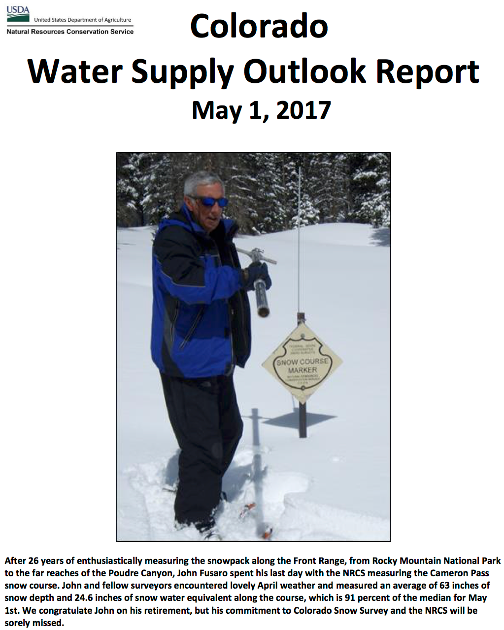
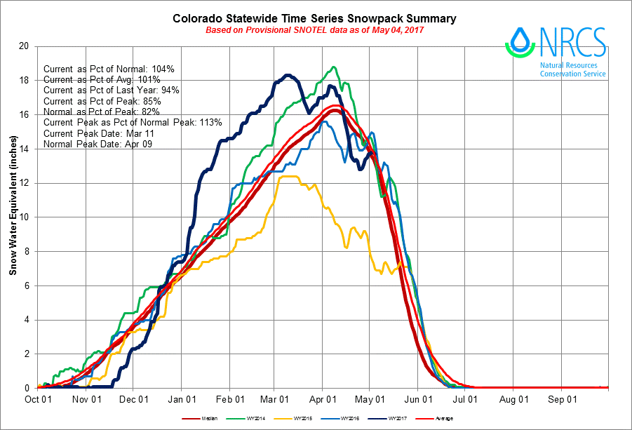
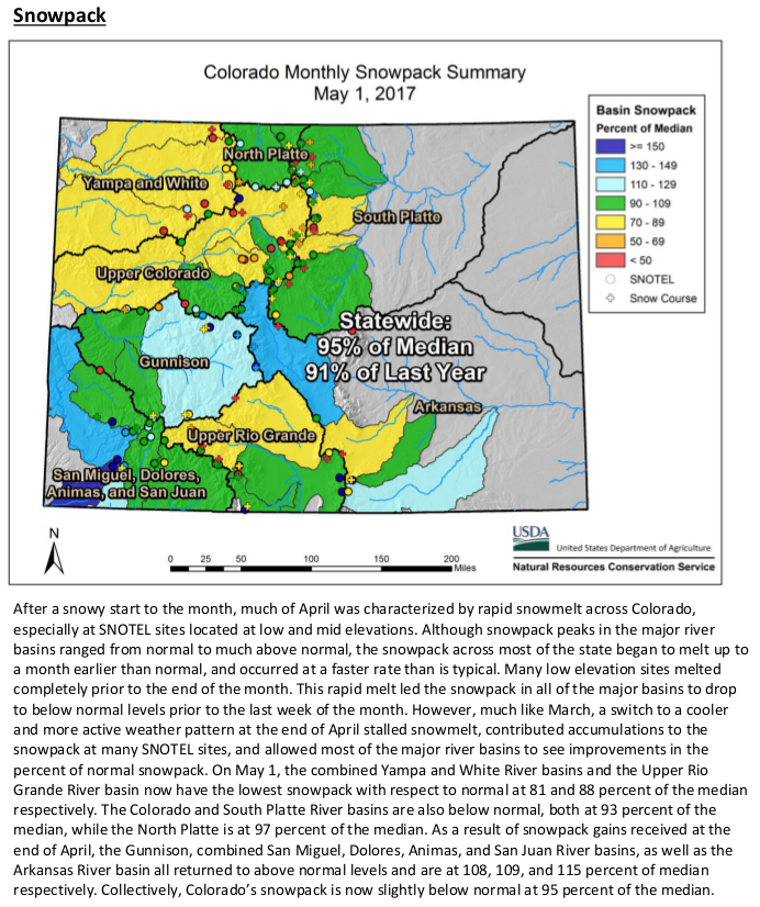
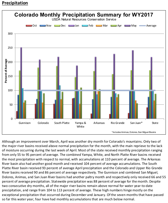
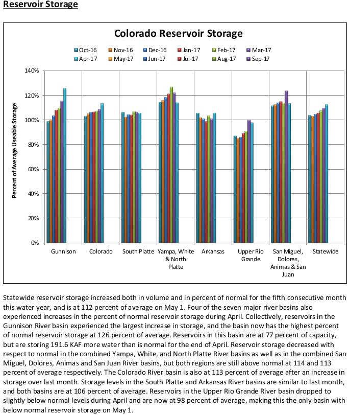
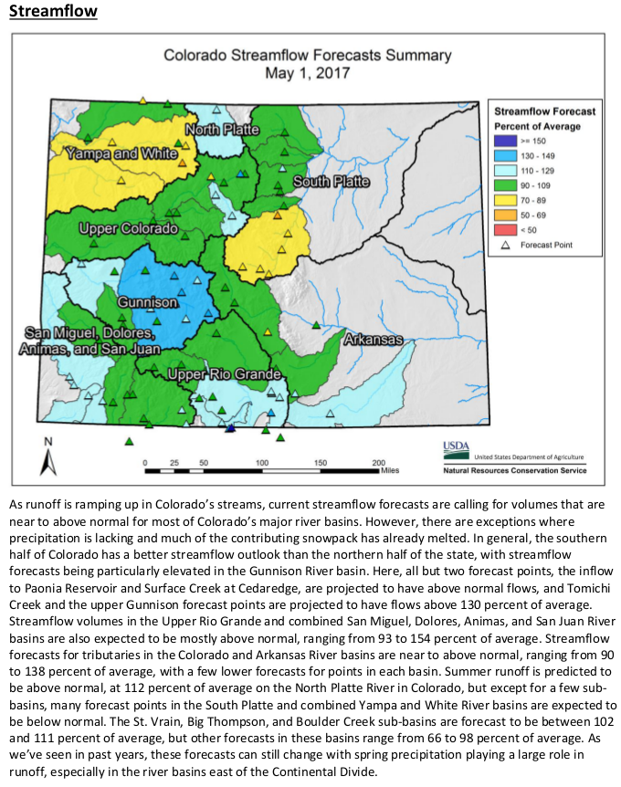
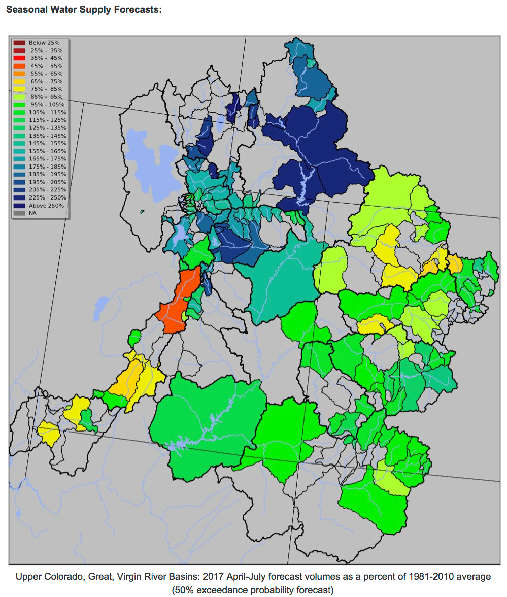
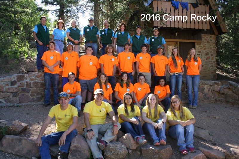
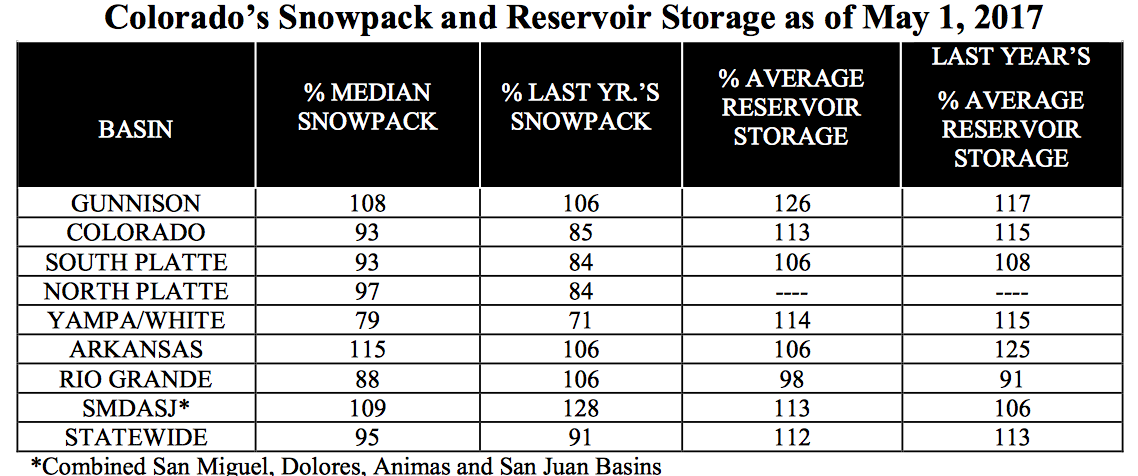
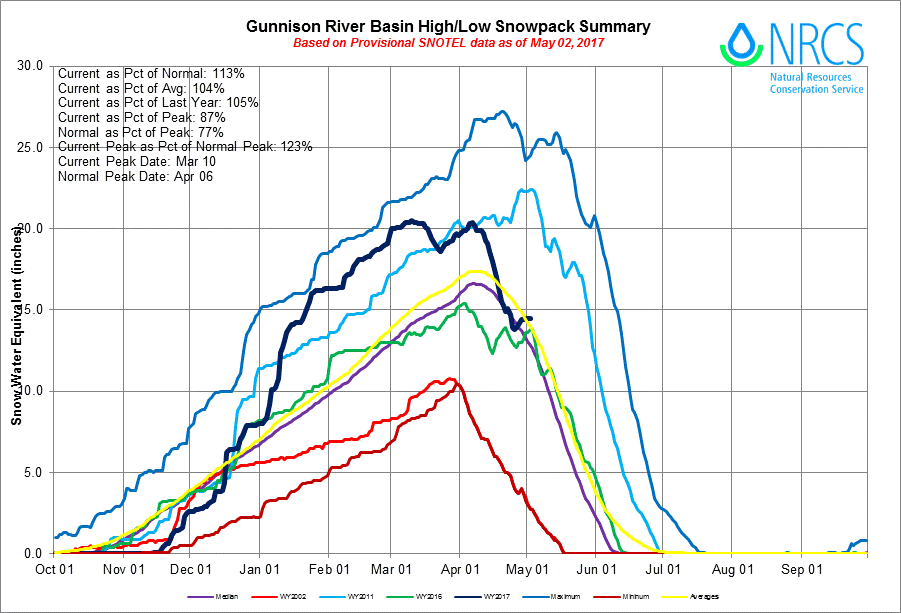
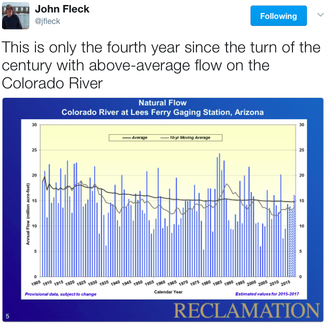


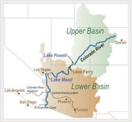


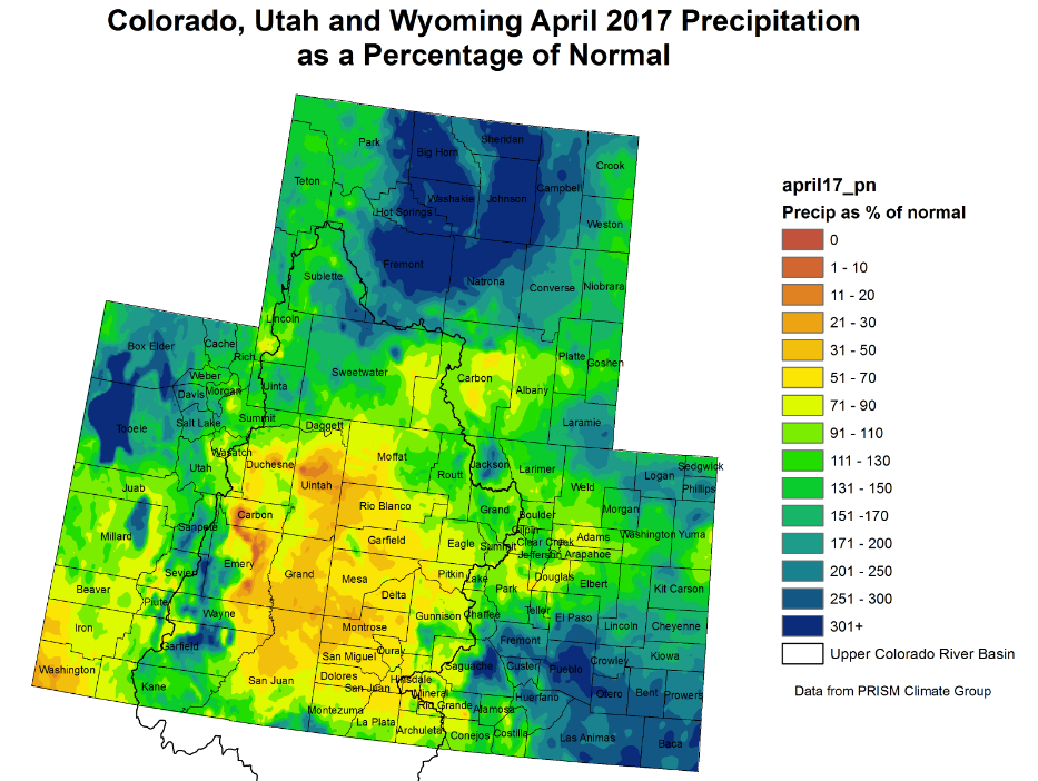


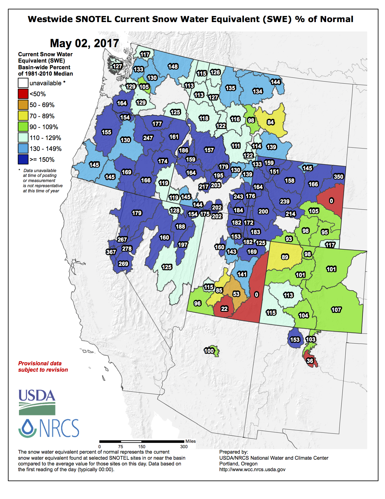


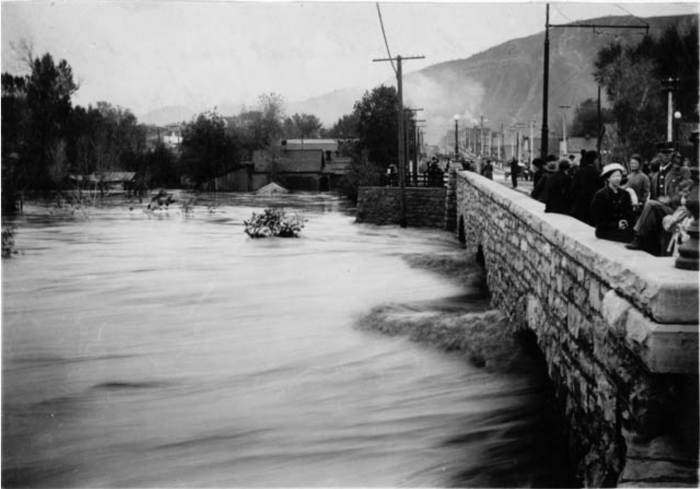
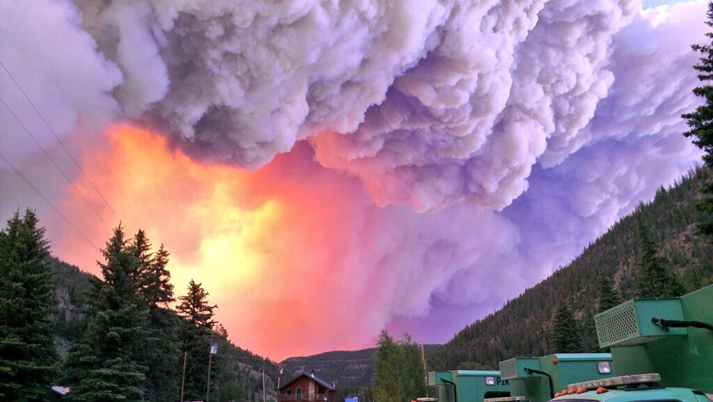


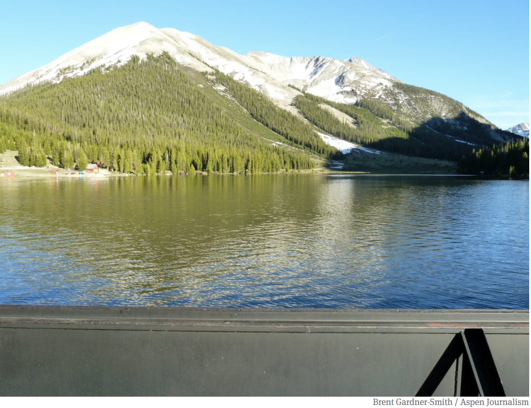
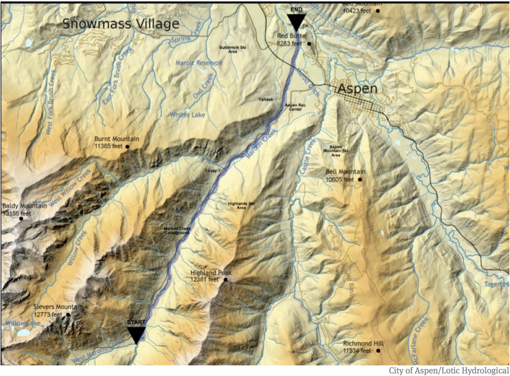
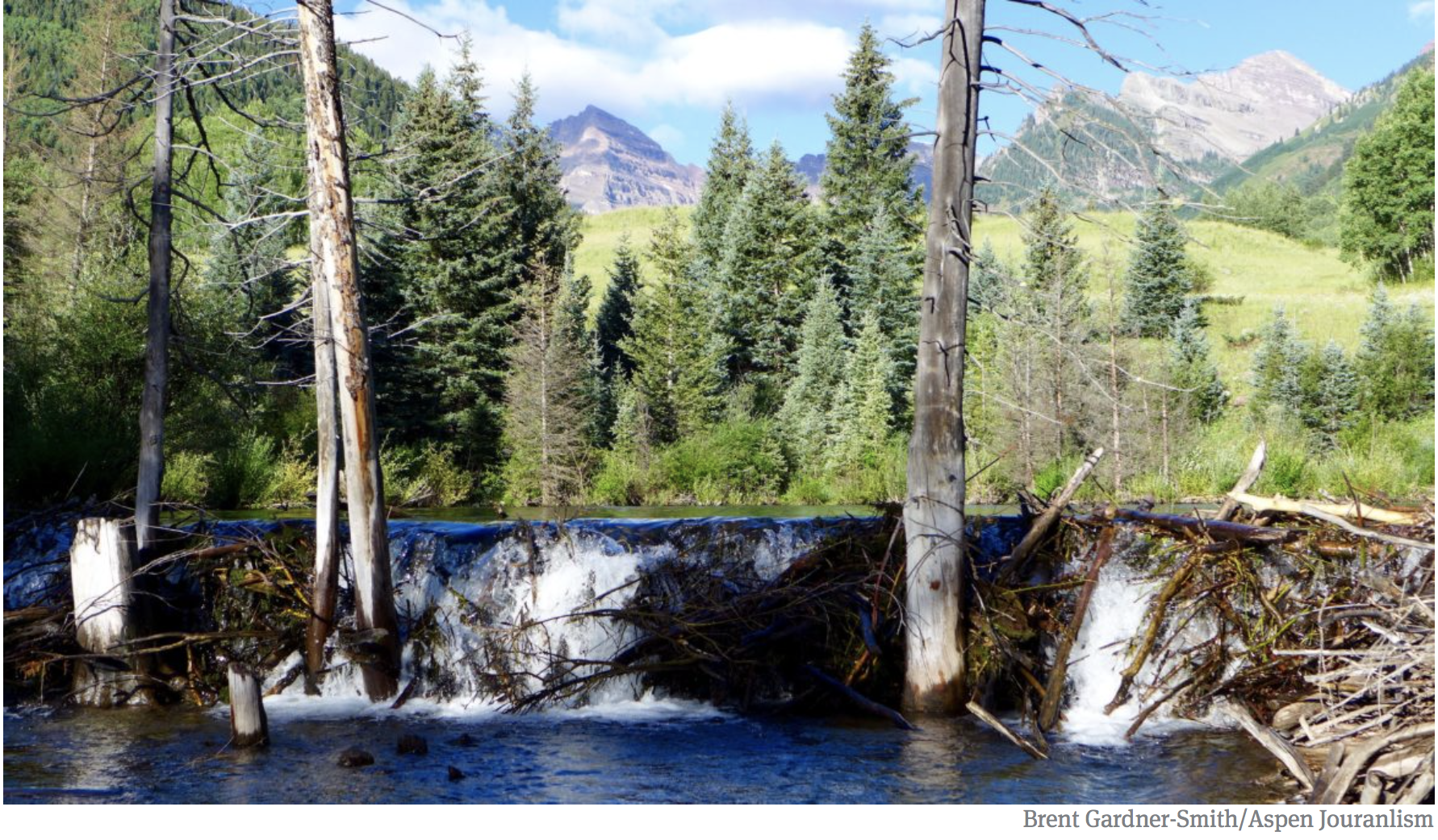
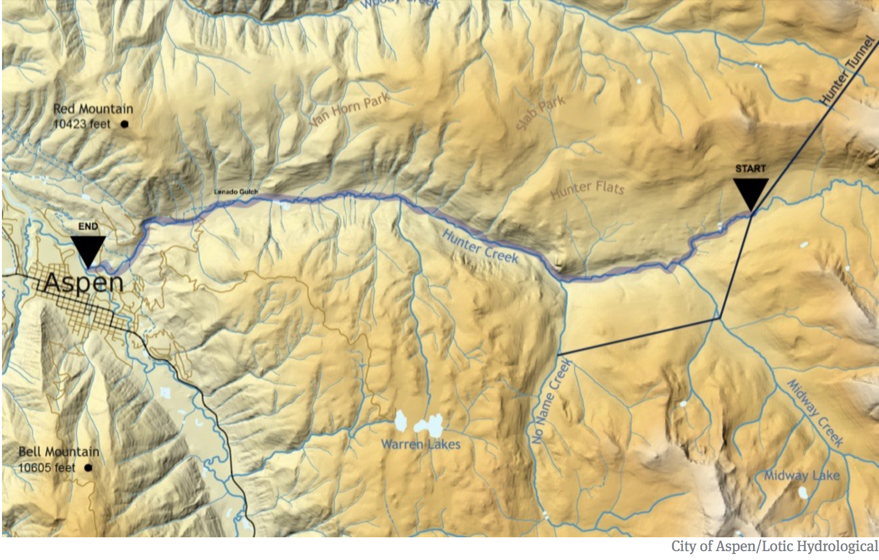

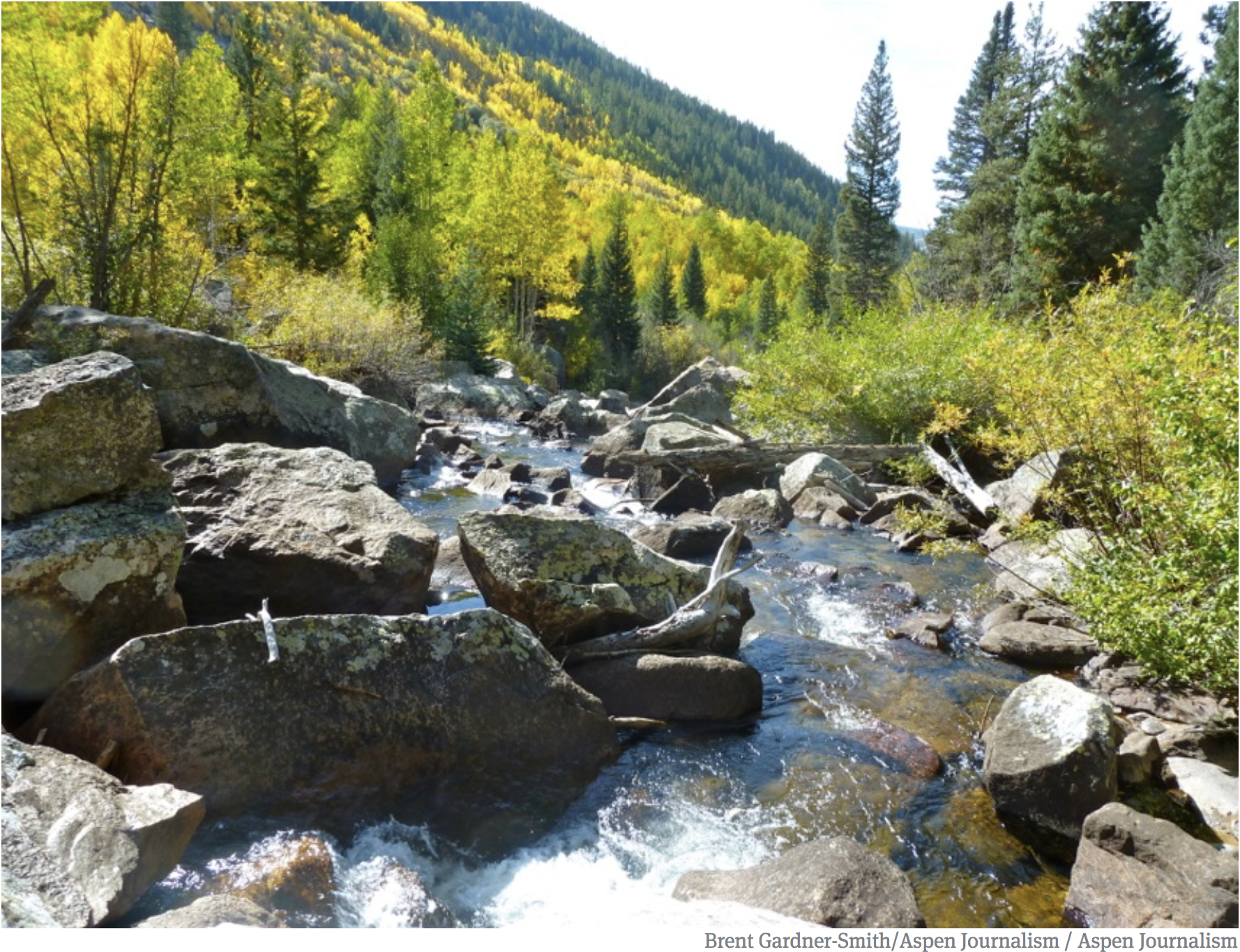
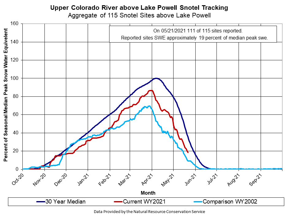