
Day: July 18, 2017
Scott Pruitt stops in #Utah for #WOTUS briefing

From The Deseret News (Amy Joi O’Donoghue):
EPA Administrator Scott Pruitt visited Utah as part of multistate tour to get input on how the agency can be more responsive to states’ needs in general and in specific how the controversial Waters of the United States rule should be retooled.
During his tour of Utah, Pruitt stopped off at the Bitner Ranch and Conservatory in Park City to get a firsthand look at a small pool of water that falls under federal regulation due to the rule, as well as a subdivision development hampered by permitting requirements…
Pruitt is acting under the direction of an executive order issued in February by President Donald Trump that called for a rollback of the so-called WOTUS rule, which inspired a firestorm of controversy when it was adopted in 2015.
Although celebrated by sportsmen’s groups and environmental organizations as the most comprehensive and significant overhaul of the Clean Water Act in more than 40 years, the rule raised the ire of states, farmers, ranchers and industry officials who complained about its scope and ambiguity.
At the time of its adoption, federal regulators insisted the rule only clarified protections for seasonal waterways that are critical to downstream communities. The EPA and Army Corps of Engineers contended the rule did not expand the scope of jurisdictional oversight — an assertion hotly contested by the National Association of Counties, which argued even ditch maintenance projects would require a Army Corps of Engineers permit.
In late June, Pruitt initiated a proposal to repeal the Waters of the United States rule and later invited states to offer their input on a new regulation that would incorporate a standard in a 2006 U.S. Supreme Court decision. That test said federal jurisdiction would only apply to “relatively permanent, standing or continuously flowing bodies of water…
Utah Farm Bureau President Ron Gibson accompanied Pruitt on the tour Tuesday and praised the EPA action.”
[…]
Environmental groups and conservation organizations that include the Theodore Roosevelt Conservation Partnership favored the regulation, citing its protection of wetlands — particularly the Prairie Pothole Region that is home to upward of 70 percent of the ducks in North America.
Seven scientific organizations that include the Society of Wetlands Scientists argued in a letter to Trump that the rule should be left intact.
In a separate announcement during his visit, Pruitt said the EPA will revisit a previous ruling on Utah’s regional haze plan, allowing the state to come up with additional visibility modeling to look at impacts from a pair of PacifCorp-owned power plants to nearby national parks.
@COWaterTrust, @CWCB_DNR, @Nature_Colorado enable Stagecoach releases to bolster Yampa River (again!)

From Steamboat Today (Tom Ross):
Once again this year, the nonprofit Colorado Water Trust and the Colorado Water Conservation Board are collaborating to arrange a release of water from Stagecoach Reservoir to boost lagging flows in the Yampa River under an agreement with dam owner, the Upper Yampa Conservancy District. New this year is the support of The Nature Conservancy.
Last year, conservation releases did not begin until mid-September, but in 2017, with the river already flowing well below normal, water releases from the dam were set at 10 cubic feet per second beginning July 11. But it can’t go on forever this way.
With this year’s release, the role of the Conservation Board, a division of the State Department of Natural Resources, has expanded to include committing to contributing up to $46,692 for water releases. At the same time, the CWCB will undertake the third, and final, approved year to release water into the Yampa. The opportunity cannot be renewed under current law, Water Trust staff attorney Zach Smith said…
This year’s program will forge a new relationship with the Nature Conservancy to carry on the effort when conditions warrant. The Nature Conservancy’s Carpenter Ranch just east of Hayden straddles the Yampa, and for 2017, the global conservation organization has agreed to bring $50,000 to the effort to purchase water releases out of Stagecoach. It will also explore sustainable funding for future years.
Smith said new efforts to bolster the flows in the river during dry seasons could range from seeking ways for the Nature Conservancy and the Water Trust to collaborate on locating new funding sources to perhaps seeking a water source with long-term legal protection.
Upper Yampa Manager Kevin McBride pointed out it’s only because there is a moderate amount of water storage in the upper reaches of the Yampa that mid-summer conservation releases are possible…
Flows in the Yampa have been supplemented with the participation of the Water Trust in 2012, 2013, 2015 and 2016. The Yampa was flowing at 128 cubic feet per second Monday afternoon, 67 cfs below the median for the date…
Water Trust water resources engineer and former Steamboat resident Mickey O’Hara said the return to healthier natural flows in the Yampa this summer “depends on if, and when the monsoons happen.”
Interview: The Search for Sustainability in the #ColoradoRiver Basin #COriver

Here’s an interview with Doug Kenney from PPIC. Click through and read the whole thing. Here’s an excerpt:
The Colorado River is a crucial water source for seven states (Wyoming, Colorado, Utah, New Mexico, Arizona, Nevada, and California) and Mexico, and like many shared rivers has its share of challenges. We talked to Doug Kenney—director of the Western Water Policy Program at the University of Colorado and a member of the PPIC Water Policy Center research network―about balancing priorities in managing the river.
PPIC: What’s the basin’s biggest challenge currently?
DOUG KENNEY: That depends on what part of the basin you’re in and what sector you work in. There’s no shortage of things to worry about. Right now, most would probably say it’s the effort to maintain the levels of water stored in the big reservoirs, Lake Mead and Lake Powell. Those reservoirs provide a lot of benefits—drought protection, recreation, and hydropower—but only if they have enough water in them. They’re about half full right now, which is about as low as they can go before mandatory cuts in water deliveries—or curtailments—kick in. It’s a math problem, essentially—managing water coming in versus what’s going out. So far in this century, people have pulled more water out than consistently flows in. Obviously, that has to change.
The more chronic issue is that the Colorado has been treated more like a plumbing system than a river, so there’s been a lot of environmental damage to the river. The big environmental concerns in the basin are a result of reduced flows and some water quality issues, such as high salinity, loss of valuable sediments, and increased water temperatures. The real challenge is to remind people we’re talking about a river—the most important ecological resource of the southwest United States.
@OWOW_MSUDenver and @botanic partner to meet #Colorado’s supply challenges
Here’s the release from Metropolitan State University at Denver (Dan Vaccaro):
Denver’s urban university and botanic garden team up to make an even bigger impact on water issues in Colorado.
The next time you’re sitting in traffic on Interstate 25 (this afternoon, probably), consider this: Colorado’s population is expected to grow by 1.5 million by 2030. And that doesn’t just mean more traffic. It means more pressure on the state’s scarcest natural resource – water.
Between the population boom and rising global temperatures, the imagination doesn’t need to wander far to see what the future of Colorado might look like. Hint: If you thought lawn-watering restrictions were bad, how about living in a world like the one imagined in the movie “Mad Max: Fury Road”?
Thankfully, there are people and organizations teaming up to tackle water issues in the state. This past spring, the Denver Botanic Gardens and the One World One Water Center at Metropolitan State University of Denver signed a partnership that will have long-term implications for the future of water education and stewardship in the Centennial State.
“Both organizations were already pursuing similar objectives,” says Jennifer Riley-Chetwynd, director of marketing and social responsibility for the Denver Botanic Gardens. “By joining forces, we can do so much more and have a bigger reach for our work.”
The plan includes stronger collaboration between MSU Denver professors and Botanic Gardens scientists, shared research projects and the pursuit of joint funding. Wherever possible, the aim is to involve students. The end goal, Riley-Chetwynd says, is to make an even bigger impact on watershed restoration and health.
As part of the agreement, Riley-Chetwynd also becomes co-director of the OWOW Center in addition to her work at the Botanic Gardens, helping to further unite the organizations. She already serves as an affiliate faculty member in the Journalism and Technical Communication Department at MSU Denver.
For Tom Cech, co-director of the OWOW Center, the partnership will help better educate future water leaders and stewards. “Our goal has always been to raise awareness of current water challenges and opportunities both in the Colorado community and among our students,” he says. “This partnership amplifies those efforts.”
While MSU Denver students have interned at the Botanic Gardens, Cech sees increased opportunities in light of the new agreement. He also imagines more events like the recent Shed ’17 water summit, co-hosted by the organizations June 29 at the Gardens.
The event brought together nearly 200 leaders from across the state and country to discuss water challenges and co-create solutions. Topics at the conference included the importance of watershed health and outdoor recreation, agriculture’s role in Colorado’s water future, and the evolution of conservation. The keynote speaker for the event was Mike Nelson, chief meteorologist at Denver7, who spoke about climate change.
Another distinctive feature of the agreement is the development of a co-branded logo, which will appear at water-related events, an aspect that Deputy Provost Sandra Haynes describes as “unique.”
“It is a testament to the breadth and depth of this collaboration between two of Denver’s most recognized institutions,” she says.
Haynes hopes the partnership will also provide more exposure for innovative university programs such as the water studies and urban agriculture minors.
This partnership comes at an important time in state history, Riley-Chetwynd says. A statewide water plan released in 2015 creates a roadmap for the future of water in Colorado. One of the main principles is removing silos to ensure that diverse groups are working efficiently and effectively.
“We need to work together to answer questions about how to deal with our population growth, where our water will come from and how we will keep urban communities viable without endangering our environment,” she says. “No one group can do all of that alone. It’s the only way forward if we’re going to make Colorado’s future sustainable.”
If all goes according to plan, the only “Fury Road” in Colorado will be I-25, particularly during rush hour.


Herman Gulch gets population of greenbacks


Milton-Seaman Reservoir expansion update

Seaman Reservoir upstream of confluence of the North Fork of the Cache la Poudre River. Photo credit Greg Hobbs.

Milton Seaman Reservoir outlet July 2011

Reservoirs NW of Fort Collins
From The Greeley Tribune (Tyler Silvy):
Expanding the 5,000-acre-foot capacity reservoir has been on Greeley officials’ to-do list for more than a decade. But the type of work the city is planning takes a lot of time, mainly because it involves the federal government.
If everything goes without a hitch, Greeley officials have circled 2030 as the year they’ll increase Seaman to 10 times its current capacity…
Here’s why:
» Greeley has never expanded any of its six reservoirs, and most have been around for nearly a century.
» Increasing Seaman to 53,000 acre-feet of water from 5,000 acre-feet will put Greeley in position to satisfy the city’s water needs for decades. (An acre foot of water is enough water for two families to use for a year). The city uses between 25,000-30,000 acre-feet of water per year: That’s expected to reach 40,000 acre-feet by 2030.
Harold Evans, chairman of the water and sewer board in Greeley, likens the Seaman’s expansion to the kind of planning that has kept water flowing from the city’s Bellvue Treatment Plant area since 1907…
Right now, Greeley is working with a consultant and in conjunction with the Army Corps of Engineers to develop an environmental impact statement.
Greeley is still about two years away from having a draft of that statement.
In the meantime, Greeley officials are working to secure more water rights. The city doesn’t have enough rights to fill the expanded Seaman Reservoir. They’re 40 percent there, and as Reckentine said, it’s an everyday process. Every year, in fact, Greeley commits millions toward purchasing water rights.
Expanding the reservoir could cost $95 million more just in construction costs, according to an estimate provided in a Colorado Water Conservation Board document.
Water rights come from a variety of places, including retiring farms.
Today, Greeley typically uses its reservoirs as drought protection.
Basically, Greeley has water rights from the Colorado, Poudre, Laramie and Big Thompson rivers. But whether Greeley is able to get all of the water it’s owed depends on the rivers’ flow levels.
In drier years, Greeley would have to do without some of that water. That’s where reservoirs come in. Evans said the first reservoirs were used to finish Greeley area crops when river flows weren’t strong enough to do so in late fall.
Snowmelt and water diverted into reservoirs could be tapped for that purpose. Evans said it’s like putting money in the bank. Pound-for-pound, water’s worth more than money, though.
If and when the Seaman Reservoir expansion is complete, Greeley will likely use some of the water from that reservoir every year.
For Evans, that’s a perfect example, among many, of an investment in the future.
Evans mentions the new pipeline from the Bellvue Water Treatment Plant being installed now, with a lifespan of 75-100 years. The Seaman Reservoir has been around since the 1940s.
ABOUT MILTON SEAMAN RESERVOIR
» Built 1941
» Storage: 5,008 acre-feet
» Elevation: 5,478 feet
» Dam height: 115 feet
» Proposed enlargement date: 2029
» Proposed storage: 53,000 acre-feet
SET FOR LIFE?
The Seaman Reservoir expansion will put Greeley in a good position, but Deputy Director of Greeley Water Eric Reckentine hesitates to call it the final answer.
Greeley has a four-point plan when it comes to water:
» Maintain what you have — Greeley has reinforced water lines with concrete and fiberglass to reduce leaks.
» Secure supply to stay ahead of demand — The Windy Gap Project, which ensured water during lean times, is an example of this.
» Build storage for the lean times — The Milton Seaman Reservoir expansion project is the best example of this.
» Conserve the water you have — Greeley has a state-approved water conservation plan, and the new water budgets are another example of conservation.
THE OTHER RESERVOIRS
Here’s a quick look at Greeley’s other five reservoirs:
» Barnes Meadow Reservoir — Built in 1922 and located across Colo. 14 from Chambers Lake in the Roosevelt National Park, Barnes Meadow Reservoir holds 2,349 acre-feet of water.
» Peterson Lake Reservoir — Built in 1922, and located southwest of Chambers Lake and adjacent to Colo. 156, Peterson Lake Reservoir holds 1,183 acre-feet of water.
» Comanche Reservoir — Built in 1924, and located along Beaver Creek and west of the Colorado State University Mountain campus, the Comanche Reservoir holds 2,628 acre-feet of water.
» Hourglass Reservoir — Built in 1898, and also located along Beaver Creek and west of the Colorado State University Mountain campus, the Hourglass Reservoir holds 1,693 acre-feet of water.
» Twin Lakes Reservoir — Built in 1924, and located southwest of Pingree Park off Colo. 14, Twin Lakes Reservoir holds 278 acre-feet of water.
From The Greeley Tribune (Tyler Silvy):
Doug Billingsley doesn’t know what he’s going to do to replicate the peace and quiet of his work when he retires and re-enters the hubbub of normal life. Greeley pays Billingsley to live at Milton Seaman Reservoir, about 15-20 minutes from the mouth of the Poudre Canyon. Billingsley lives in a city-provided house, and has lived there for the past eight years with his wife, who suffers from multiple sclerosis, and her caretaker.
Billingsley monitors the Seaman Reservoir. The reservoir is Greeley’s largest, and its water levels can rise and fall quickly. He must ensure the banks and dams are sound and functioning properly, and he’s charged with releasing water down the Poudre Canyon when necessary. Call him the water shepherd.
He’s used to the solitude, if not the quiet.
“I drove over the road truck for 18 years, and was by myself for up to 30 days at a time — I lived in a truck,” Billingsley said. “This is no biggie; this is heaven.”
The city pays him a salary as well as his living expenses. But there’s a catch: He’s on call 24 hours per day, seven days per week.
The floods of 2013 are a prime example. And Billingsley spent the better part of a week stuck at home after a bridge went out, trapping folks up the canyon. Of course, he had to monitor Seaman’s water levels during the flood, as well.
Billingsley’s wife loves having him at home every night, and he loves being there.
Apart from animals there’s nothing to bother a Seaman Reservoir caretaker. They’ve seen elk, mountain lions, bears, but none of them hurt anybody, he says.
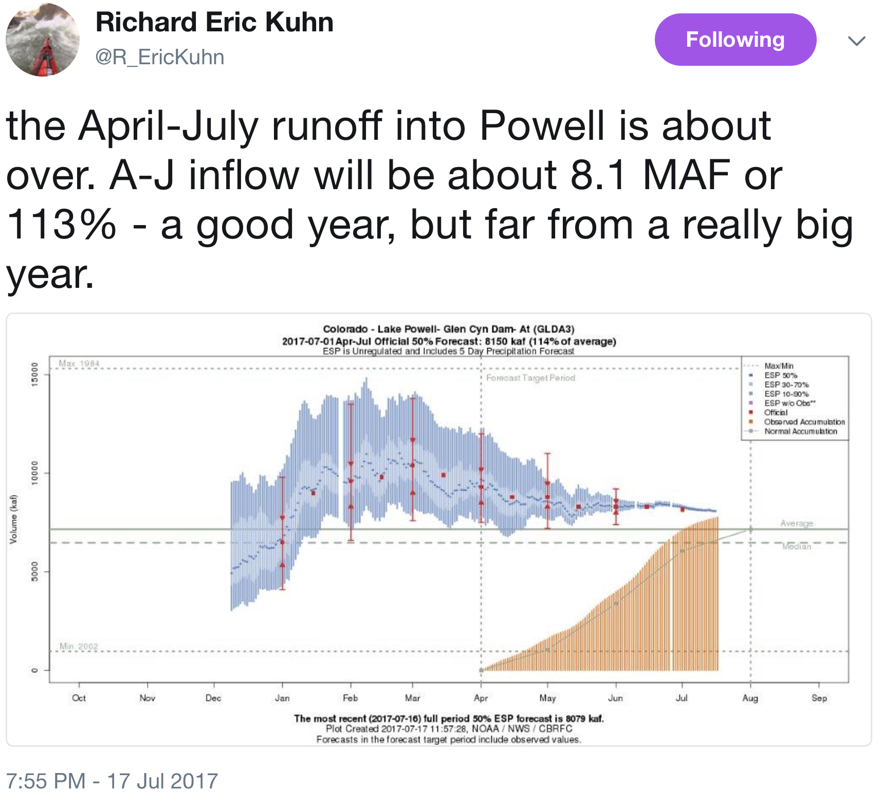
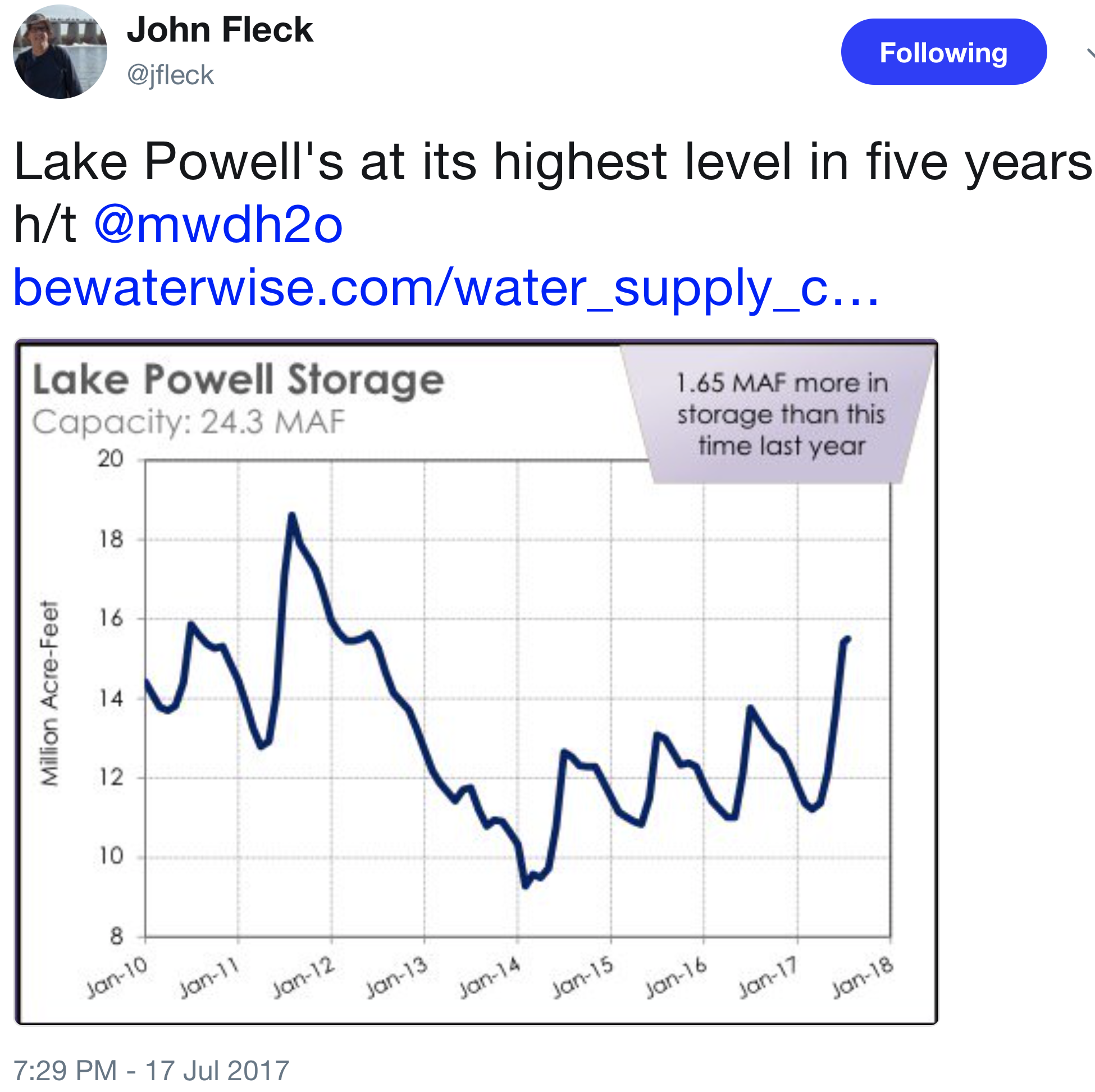
2017 #ColoradoRiver water year #runoff into #LakePowell is about over #COriver
Castle Rock #conservation goals a high priority with low Plum Creek streamflow
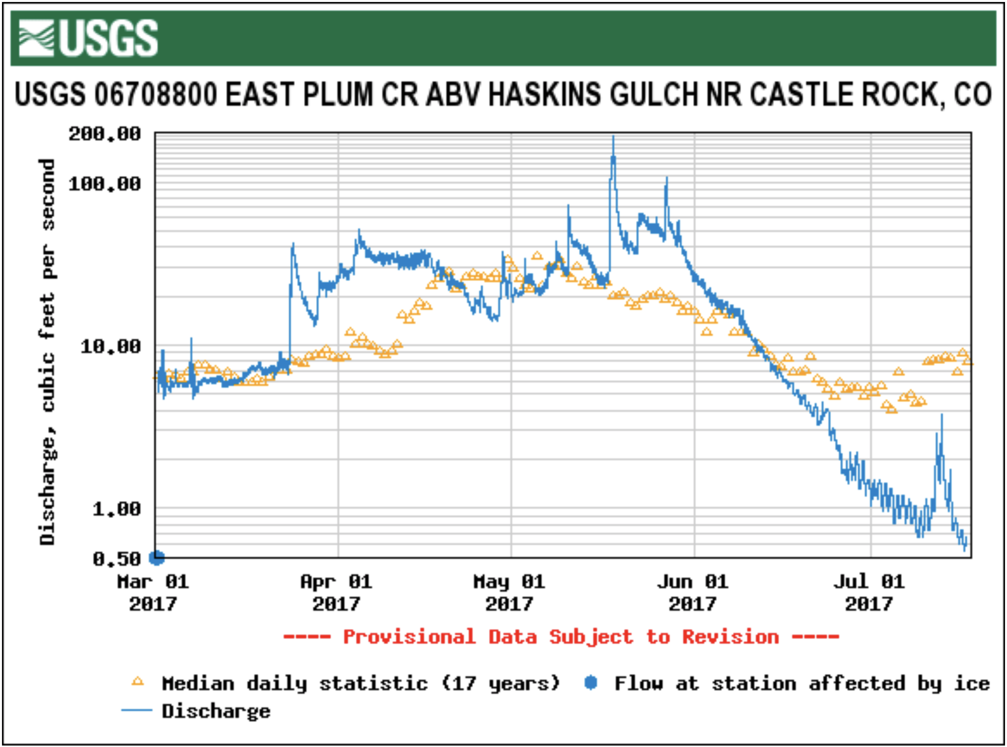
From The Castle Rock News-Press (Jessica Gibbs):
…Castle Rock recently implemented new water restrictions on homeowners associations and urged residents to amp up their conservation efforts. Prolonged dry, hot weather has left one of the town’s renewable sources, the East Plum Creek, at record lows.
The town has gathered data on the creek for 18 years, Marlowe said. The gauge on East Plum Creek nearest Castle Rock shows the area at its lowest level in that time frame.
The town also recorded water use at peak levels — although that is not uncommon during hot spells, Marlowe said.
Over the summer, Castle Rock typically sees an average use of 12.4 million gallons a day. This year, officials have seen that average reach 16.5 million gallons. Peak demand is usually related to outdoor irrigation, Marlowe said, such as the watering of lawns and landscaping.
In response, the town is now requiring homeowners associations to follow a similar watering schedule that has been required of single-family homes since the 1980s. Public spaces like parks, common areas and medians can only be watered between 10 p.m. and 5 a.m. on Sundays, Wednesdays and Fridays.
Homeowners associations were also asked to cut back on issuing violations for distressed lawns and to encourage residents to reduce outdoor watering.
Marlowe said the efforts should save millions of gallons of water.
Additionally, residents and businesses can do their part by researching proper irrigation techniques, for which the town has a number of resources and classes…
Residential water restrictions in place through August only allow watering between 8 p.m. and 8 a.m…
Kaoch explained residents needn’t worry if grass doesn’t stay perfectly green in dry times, as going temporarily dormant can actually help strengthen new root systems. Conservation is most important, Kaoch said, expressing the district’s willingness to work with town staff under the new water restrictions.
For residents who want to learn more about proper irrigation and water conservation, the town offers numerous resources through the website crconserve.com. The town also runs classes for people to learn efficient watering and conservation techniques.
South Platte Master Plan — a stream corridor evaluation – is complete

The Platte River is formed in western Nebraska east of the city of North Platte, Nebraska by the confluence of the North Platte and the South Platte Rivers, which both arise from snowmelt in the eastern Rockies east of the Continental Divide. Map via Wikimedia.


High Plains in eastern Colorado. Photo credit Bob Berwyn.

The plains around DIA were parched by the scorching 2012 drought, although groundwater pumping along the South Platte River enabled some farms to continue irrigating — photo by Bob Berwyn

Map of the South Platte River alluvial aquifer subregions — Colorado Water Conservation Board via the Colorado Water Institute

South Platte River Basin via the Colorado Geological Survey

South Platte River alluvial aquifer

Lower South Platte River

South Platte River Basin

Piping plover

Whooping Cranes

Pallid sturgeon

Least tern
From The Sterling Journal-Advocate (Jeff Rice):
The South Platte Master Plan is a study of flood mitigation and recovery possibilities along 130 miles of the South Platte River from the Morgan-Weld county line to the Nebraska State Line. Authorized and funded by the Colorado Department of Local Affairs, the plan will suggest ways to make the river more “flood resilient,” both to handle the flooding as it occurs, with minimal damage to property and structures, and to quickly recover from a flood in the aftermath.
Five big problem areas were identified in the evaluation, according to Brian Murphy, project director for CDM Smith of Denver, the contractor on the flood study. They were the amount of sediment the floods of 2013 and 2015 deposited in the study area, basically clogging the river and making flooding worse; uncontrolled water in ditches and canals, which can back up and cause damage to structures, homes, and fields; the railroad railroad right of way southwest of Messex, which contains the river along the northwest shoreline but worsens flooding on the opposite shoreline; the hunting lands along the river that provide game habitat but also blocks water flow during a flood, causing the water to spread out into neighboring cropland; and the washed-out headgates of the Henderson-Smith and Lowline ditches, which essentially turn those ditches into another channel of the river.
Stakeholders attending the meeting may have gotten some ideas of how to tackle those challenges from a 90-minute presentation by Jerry Kenny, executive director of the Platte River Recovery Implementation Program. That program comes from an agreement among Colorado, Nebraska, Wyoming, and the U.S. Department of the Interior to preserve habitat for whooping cranes, least terns, piping plovers and pallid sturgeons, four species on the endangered species list. The program maintains water at an adequate level along an 80-mile stretch of the Platte River the Nebraska cities of Lexington and Grand Island in an area call the Big Bend Area.
Kenny’s description of challenges faced in maintaining habitat for those four species brought home to the stakeholders how the river system has been affected by settlement all along its length. For instance, sediment – mostly sand – that once washed downstream past what is now Sterling and settled in the Big Bend area to create habitat for those species no longer makes it that far. Instead, repeated diversion of the river for irrigation reduces and slows down the water flow during what was once rapid spring runoff, depositing the sediment here.
That problem is exacerbated by Lake McConaughy on the North Platte near Ogallala, which traps sediment that once drifted down into Big Bend.
Kenny told the meeting that some of the challenges have been met by practices in all three of the states that have increased stream flow in the Platte River. Most notable in Colorado is the Tamarack Recharge Project near Crook, in which water is pumped into small reservoirs when there is no irrigation demand on the river, and allowed to seep back into the river so more water is available downstream.
Kenny also showed the group slides of off-stream water storage projects that have been used to create wetlands and much-needed sand islands in the project area. Presumably, some of those ideas could be used to mitigate flooding and provide some off-channel water storage in the South Platte basin as well.
After the meeting Morgan County Commissioners Jim Zwetzig and Laura Teague said they are encouraged by the “collaborative effort” shown in the PRRIP agreements…
Project manager Brian Murphy said one of the biggest challenges, once ideas and practices are identified, will be finding the dollars to do it. The PRRIP get about half of its funds from the federal government, and there is tremendous incentive in the form of a mandate to save endanger species. There is no such incentive, other than reducing unpredictable costs of recover, in flood mitigation.
“The big question is, what are the things that can bring dollars to fund this project,” Murphy said. “What are the drivers? There’s been a lot of discussion of duck habitat, open space, trails, and I think it’s going to come down to those things.”
On a more positive note, he said, the PRRIP process has broken new ground when working with the federal permitting process. Some of the techniques that project uses, such as tilling riparian areas to keep vegetation down, are considered agricultural, and so don’t need federal permits.
Monday’s meeting was the third since the plan was introduced to the public in February.