Click here to go to the website. Click through for the links and the year to date summary. Here’s an excerpt:
Graphic via NOAA June 2017.
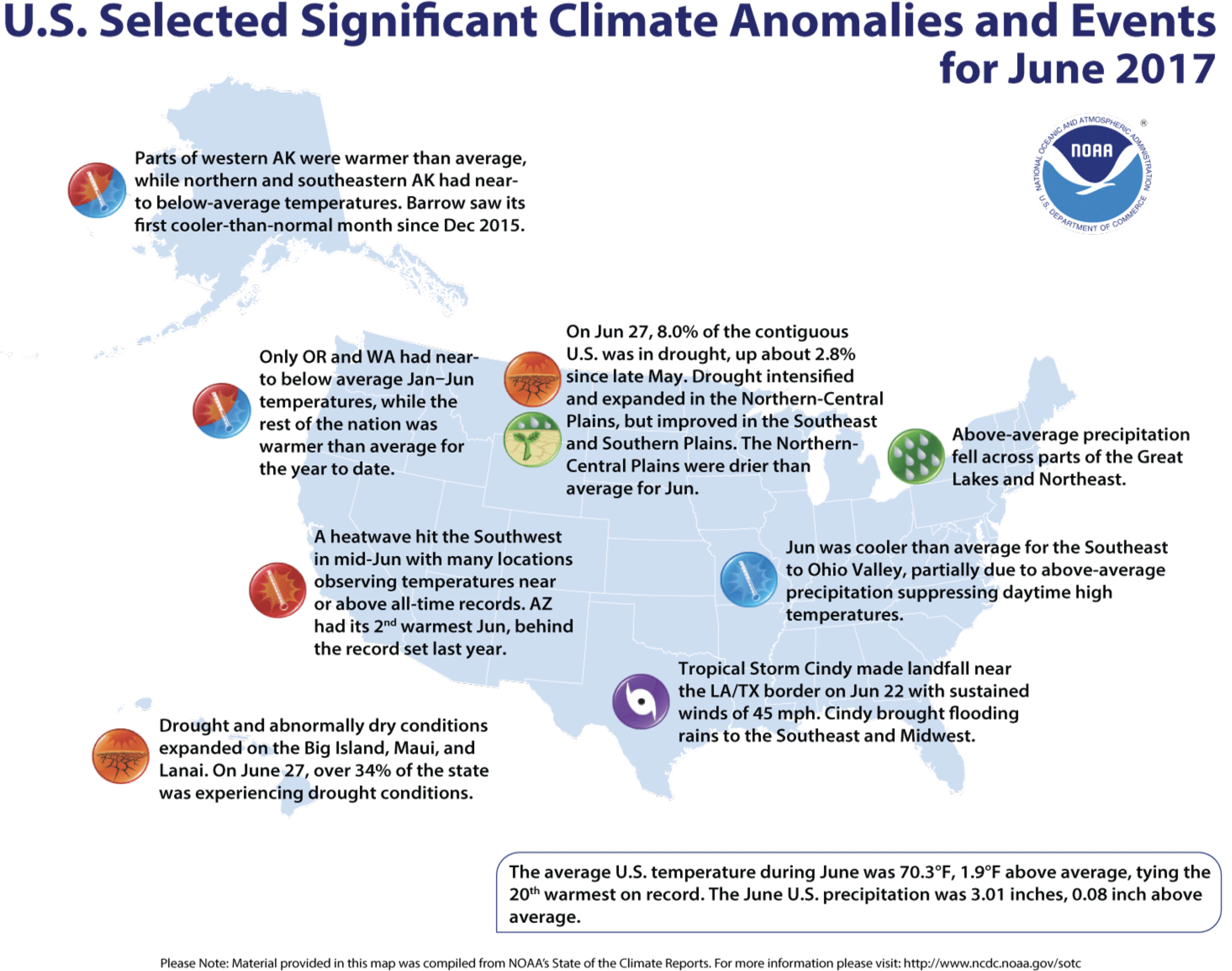
Climate Highlights — June
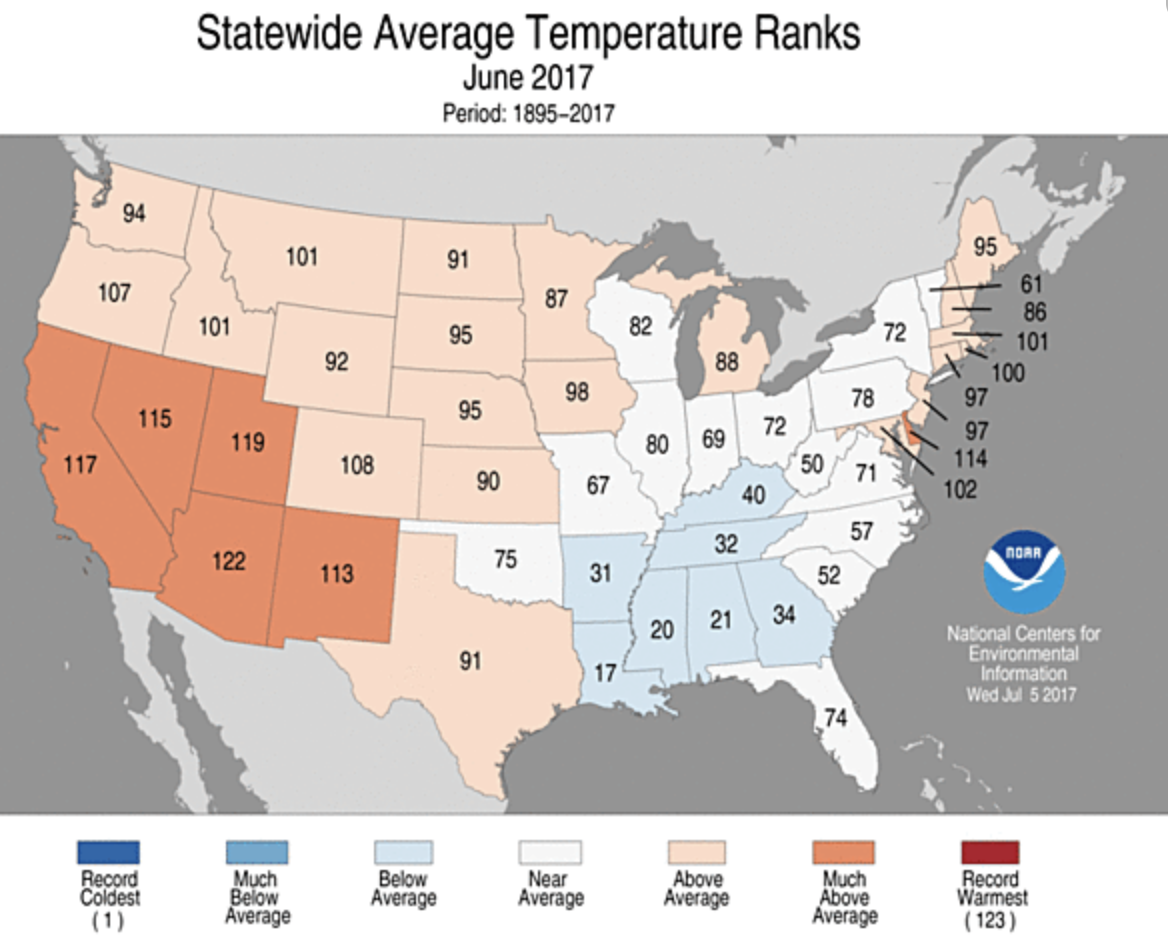
June 2017 average temperature departures.
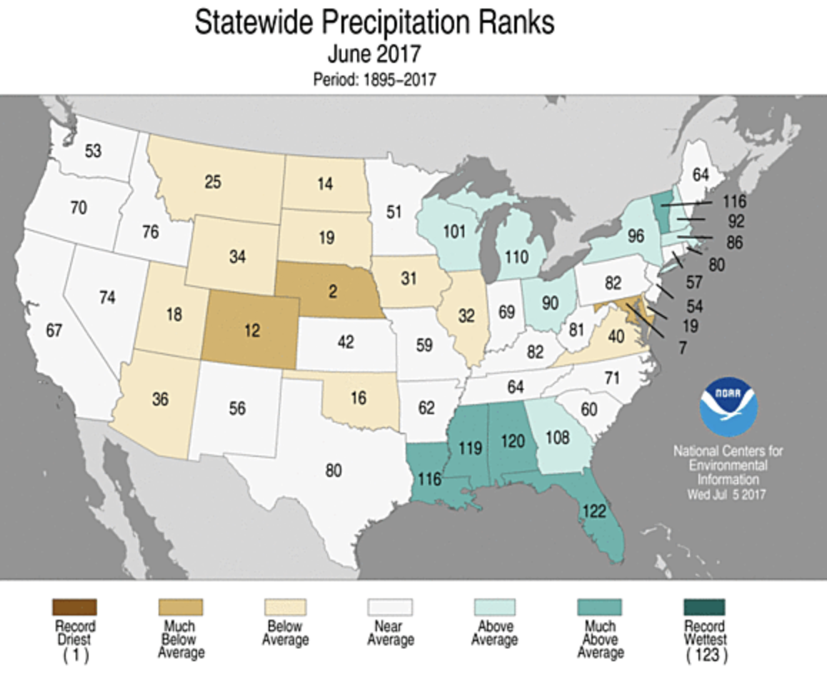
June 2017 percent of average precipitation.
Temperature
June 2017 statewide temperature ranks.
The June average temperature for the contiguous U.S. was 70.3°F, 1.9°F above the 20th century average, and tied as the 20th warmest June in 123 years of record keeping.
Above-average temperatures were observed for locations from the West Coast to Rocky Mountains, with parts of the Great Plains, Great Lakes and East Coast also warmer than average. In the Southwest, much-above-average temperatures were driven by a record-breaking heat wave in mid-June. No state was record warm, but Arizona had its second warmest June on record.
Below-average temperatures were observed in parts of the Southeast, Lower Mississippi Valley and Ohio Valley. The below-average temperatures were mostly due to much-below-average maximum temperatures, particularly along the Gulf Coast where record and near-record precipitation kept afternoon highs below average. No state was record cold.
Alaska tied its 12th warmest June in the 94-year period of record with a statewide average temperature of 51.5°F, 2.3°F above average. Western areas of the state were warmer than average, with near- to below-average temperatures along the North Slope and in southern parts of the state. Utqia’vik (Barrow) had its first cooler-than-average month since December 2015.
The contiguous U.S. average maximum (daytime) temperature during June was 83.3°F, 2.0°F above the 20th century average, and ranked as the 20th warmest on record. Above-average maximum temperatures were observed across the West, Great Plains, and Mid-Atlantic. Arizona observed its warmest June maximum temperature on record at 97.3°F, 6.4°F above average. This bested the previous record of 96.6°F in 2013. Below-average maximum temperatures were observed from the Deep South to the Ohio Valley. Five states along the Gulf Coast had much-cooler-than-average maximum temperatures, with Louisiana tying the second coolest June maximum temperature on record at 86.3°F, 3.8°F below average. The record coldest June maximum temperature for Louisiana was 85.8°F set in 1903.
The contiguous U.S. average minimum (nighttime) temperature during June was 57.3°F, 1.7°F above the 20th century average, the 14th warmest on record. Above-average minimum temperatures spanned the West, South, Great Lakes and East Coast. Below-average minimum temperatures were observed in the Ohio Valley and parts of the Great Plains. In the Northern Plains and Central Rockies, some locations observed freezing overnight temperatures in June which is an unusual but not unprecedented occurrence.
During June there were 4,343 record warm daily high (1,848) and low (2,494) temperature records, which was nearly 2.5 times the 1,752 record cold daily high (974) and low (778) temperature records.
Based on NOAA’s Residential Energy Demand Temperature Index (REDTI), the contiguous U.S. temperature-related energy demand during June was 14 percent below average and ranked near the middle of the 123-year period of record. This was due to the temperature anomaly pattern of near to below-normal temperatures in the high population centers of the South and East and above-normal temperatures in the less heavily populated West and Plains.
Precipitation
June 2017 Statewide Precipitation Ranks via NOAA.
The June precipitation total was 3.01 inches, 0.08 inch above the 20th century average, and ranked near the middle value in the 123-year period of record.
Below-average precipitation was observed across parts of the Great Basin, Northern and Central Plains, and Mid-Atlantic. Nebraska had its second driest June and Maryland had its seventh driest. Some regions in the Southwest received no precipitation in June, which is typical of early summer. No state was record dry.
Above-average precipitation fell across the Gulf Coast and from the Great Lakes to northern Northeast. Tropical Storm Cindy dropped heavy rain and caused significant flooding across parts the Southeast to Midwest as the storm tracked northward after making landfall near the Louisiana/Texas Coast on June 22. Alabama, Florida, Louisiana, Mississippi and Vermont were each much wetter than average. No state was record wet.
The Alaska June average precipitation total for June was 2.04 inches, 0.30 inch below the long-term average, and ranked as the 34th driest June since 1925. Northern and south-central parts of Alaska were drier than average with above-average precipitation in southwestern and southeastern Alaska.
According to the June 27 U.S. Drought Monitor report, 8.0 percent of the contiguous U.S. was in drought, up about 2.8 percent compared to the end of May. Drought improved across parts of the Southern Plains and Southeast. In the Southeast, drought conditions were nearly eradicated where torrential rainfall was observed over the past month, particularly along the Gulf Coast. Drought conditions expanded and worsened across the Northern to Central Plains where short-term and long-term precipitation deficits have been observed. Outside of the contiguous U.S., drought worsened for parts of Hawaii and western to central Alaska. Abnormally dry conditions improved in eastern Alaska.
Click here to listen. Here’s an excerpt from the article:
The Trump presidency has made for a jittery scientific community, and an atmosphere of anxiety — even despair — among many who feel climate change is the greatest peril facing civilization.
Their worries are shared by Katharine Hayhoe, the director of the Climate Science Center and a professor of political science at Texas Tech University.
Hayhoe is one of the most prominent climate scientists working in the United States today. She is also a Canadian — and an evangelical Christian. Her speciality is talking about climate change with people who are not already convinced of its legitimacy and urgency.
Hayhoe was named one of world’s 50 greatest leaders by Fortune magazine earlier this year, and one of Time Magazine’s 100 Most Influential People in the World in 2014. She’s also the host of a PBS online series called “Global Weirding”.
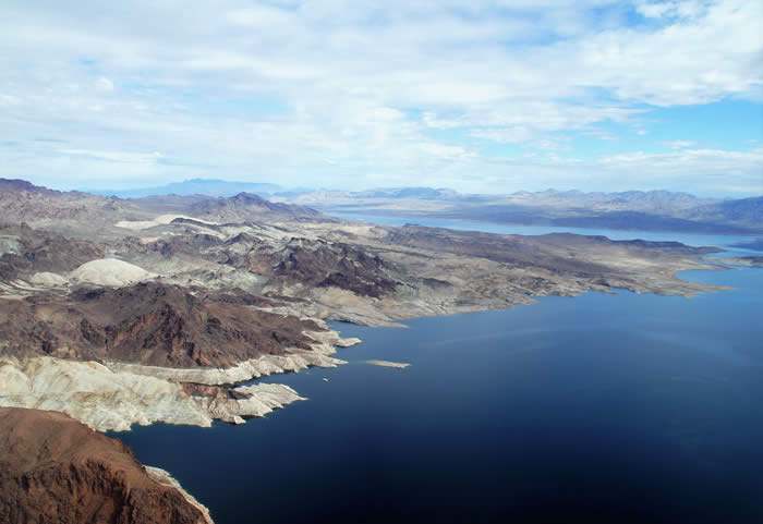
The five participants in a historic effort to help stabilize Lake Mead water levels made their agreement formal at a signing ceremony hosted by the Arizona Department of Water Resources.
As part of the $6 million partnership agreement with the Bureau of Reclamation, the State of Arizona, the City of Phoenix and the Walton Family Foundation, Inc., The Gila River Indian Community will forego delivery of 40,000 acre-feet of its 2017 Colorado River allocation.
The tribe will leave that water in Lake Mead. It will be saved in the Colorado River system rather than be tied to any defined use…
“Today’s agreement and the Community’s ongoing effort to protect the Colorado River carry immense importance for our people and our neighbors across the Southwest. Being good stewards of this most sacred resource is a part of who we are as a people and what the Gila River Indian Community has stood for across time,” said Gila River Indian Community Governor Stephen Roe Lewis.
“The first positive is that this agreement allows the Community to generate income today from water we otherwise would have stored off-reservation to create long-term credits for future marketing. This revenue will help our economy right now, in the present, without sacrificing our future or our water.
“Second, this agreement helps conserve water in Lake Mead. That conservation effort benefits our people and every resident of Arizona by helping to protect the Colorado River and our water future.”
Added Governor Lewis: “Given the central role of water in our economy and our culture, today’s agreement is truly a cause for celebration.”
The five partners effectively view the agreement as a “down payment” on an Arizona-based plan for protecting the great Colorado River-system reservoir, where water levels have been dropping rapidly in recent years as a result of long-running drought and over-allocation.
The Arizona plan – known as the “Drought Contingency Plan Plus” – represents an effort on the part of leaders in the Arizona water community to keep Lake Mead above the first shortage trigger for as long as possible…
The State of Arizona contributed $2 million to the conservation effort – part of a three-year financial commitment totaling $6 million approved this year by the Legislature and signed by Gov. Doug Ducey.
The City of Phoenix, whose mayor and council approved this agreement on June 13, provided $2 million…
The Walton Family Foundation, which believes conservation solutions that make economic sense stand the test of time, contributed $1 million…
“Today’s agreement is about coming together to forge solutions for a sustainable Colorado River that benefit people and the environment,” said Barry Gold, director of the environment program at the Walton Family Foundation.
The federal Bureau of Reclamation also contributed $1 million to this Lake Mead stabilization effort. On January 17 of this year, Reclamation provided $6 million to the Gila River Community for system conservation that resulted in the Community’s first 40,000 acre-feet stored in Lake Mead.
“We are pleased to continue to help our partners in Arizona in their efforts to conserve water in Lake Mead and to implement a Lower Basin Drought Contingency Plan with California and Nevada,” said Terry Fulp, Lower Colorado Regional Director.
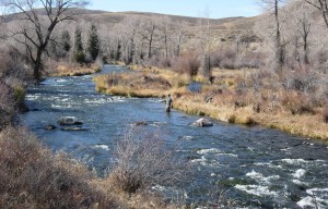
The plan includes environmental enhancements and protections to ensure the Fraser River will be better off with the Moffat Project than without it.
Here’s a guest column from Kirk Klancke that’s running in the Boulder Daily Camera:
As a long-time resident of Grand County, I’ve been disappointed by recent articles in the Camera about the Moffat Firming Project permit and especially about the west slope implications of the project. Coverage has been misleading in highlighting potential negative environmental impacts while ignoring the stream habitat improvements and flow benefits in the permit that will actually improve the health of the Upper Colorado River system.
It’s important for readers to get the total picture in weighing the environmental impacts of the project.
Trout Unlimited is also a group “dedicated to protecting and restoring the Colorado River” — and we’ve spent more than a decade closely following the proposed Moffat project and working to protect the Upper Colorado. Then, a couple years ago, TU helped negotiate a settlement with Denver Water and local stakeholders in Grand County that included tough permit requirements that we believe will best protect the Upper Colorado and Fraser Rivers.
It’s true that the Moffat project will increase total diversions from the Colorado headwaters. But the project will also provide significant help to rivers and streams currently impacted by transmountain diversions, including streams diverted to meet Boulder’s water supply (through the Windy Gap project). Under terms of their permit, Denver Water must undertake mitigation and enhancement measures that will actually improve the health of streams.
For instance, as part of its commitments, Denver Water will manage diversions to help provide needed flushing flows on the Fraser and its tributaries, complete habitat and native trout restoration work in the Williams Fork basin, and contribute funds toward projects like the Fraser Flats restoration project that is already underway to improve stream and riparian habitat.
Most significantly, Denver Water will participate in an ongoing adaptive management program called “Learning by Doing” through which Denver, Grand County, Trout Unlimited and other local stakeholders are cooperating to apply mitigation and enhancement resources, monitor river and watershed conditions and make adjustments to achieve the best results over time. These efforts were launched even before Denver received their federal approvals.
While my efforts have focused on Grand County, I know that Denver Water has looked for partnerships on the east slope as well. For example, as part of the project, they will provide 5,000 acre-feet of storage in the enlarged reservoir for Boulder and Lafayette to use in providing in-stream flows at critical times, to keep downstream stretches of South Boulder Creek healthy and flowing.
Denver Water’s plans to enlarge Gross Reservoir certainly will have significant impacts on Boulder County, including disruption to lives and property around the reservoir area during construction — but these are mostly temporary impacts. It’s important to look at the project’s long-term benefits to our rivers and streams as well as to our water security.
For years I saw Denver Water as my community’s public enemy number one. But in recent times Denver Water has demonstrated a willingness to work as a partner to keep the Upper Colorado River healthy. This collaboration among stakeholders represents the best opportunity to protect and preserve the Upper Colorado River into the future.

 June 2017 average temperature departures.
 June 2017 percent of average precipitation.