At first, they look like a mirage on the edge of the horizon of southern Colorado’s broad and sweeping San Luis Valley. Then, as you rumble south down Highway 17 through Moffat and the other barely-holding-on valley towns, their wave-like ridges reveal a unique reality.
Finally, as you turn east and head into the Great Sand Dunes National Park and Preserve, mountains of sand tower almost 800 feet over you and the valley floor.
“A piece of Arabian desert transplanted into this plain,” wrote Dr. Friedrich Adolph Wislizenus, in his remembrance of an 1848 expedition to northern New Mexico.
But this isn’t the Arabian Peninsula. Nor is it the coast. These dunes were created in this landlocked valley by prevailing winds that pick up sand and deposit it in the shadow of the Sangre De Cristo mountains. The 30-square-mile dune field offers a view unlike any other in Colorado.
“I would rather go three days around, than travel once more over the sand hills with a wagon,” Wislizenus wrote more than 150 years ago, a thought echoed by many hikers since then.
These days, most visitors will play in the cool water of adjacent Medano Creek before they climb up one or two dunes. Few venture up into the mountains on the eastern side of the dunes. And it’s there the park is investing in an ambitious project that’s symbolic of how land managers are approaching one of their biggest long-term issues: climate change.
Largely Unscathed — So Far
Earlier this summer, President Barack Obama declared that climate change is the biggest issue the 100-year-old National Park Service now faces. The effects of warmer temperatures at places like Rocky Mountain National Park are clear — once-clear lakes are now warm enough to sprout algae blooms, for example.
In Colorado’s other national parks, the effects are more subtle: warmer temperatures are complicating already difficult climbs at the Black Canyon of the Gunnison. And in Mesa Verde, scientists wonder if the changing climate is affecting the stability of ancient Pueblo ruins.
Sand Dunes appears largely unscathed — so far. The park’s average annual air temperature has held steady around 42 degrees Fahrenheit (or 6 degrees Celsius) for more than 100 years.
The annual air temperature at the Great Sand Dunes National Park and Preserve has held fairly steady since 1895. Courtesy National Park Service via Colorado Public Radio.
A recent study looked at pikas, a tiny rodent-like mammal that lives on mountain peaks and can die from overheating after just a few hours at eight national parks across the West. Researchers concluded there’s “encouraging evidence” the small mammal will be able to survive at the Sand Dunes.
But one climate model from the National Park Service says that unless the world’s carbon emissions drop by 40 to 70 percent, temperatures at the park could rise by up to 9 degrees by 2100.
Under those scenarios, invasive plants like leafy spurge could move in, streams and creeks could run dry, and wildfires could become more frequent. That has staff at the Sand Dunes thinking hard about how they can help the park adapt to a warming climate.
Which brings us to trout.
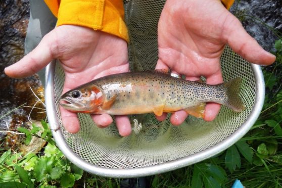
Kevin Terry, a project coordinator for Colorado Trout Unlimited, holds up a Rio Grande cutthroat trout at Upper Sand Creek Lake.
One of the park’s current projects is the restoration of the native Rio Grande cutthroat trout to the Sand Creek watershed, which tumbles down the Sangres to the north side of the dunes. Fred Bunch, resource management specialist at the park, said the park has spent about $120,000 on it so far, and plans to spend about double that before it’s all said and done.
But Bunch said the money, which comes from visitor fees, Sand Dunes is spending on the trout project is worth it. It’s park service policy to restore native species. And the Sand Creek watershed, wildlife officials believe, is an ideal place for the fish now — and they hope it will be decades from now as well.
Elevation An Ally
“It’s all a function of elevation,” Bunch said. “Higher elevation streams may be a great area for habitat for the Rio Grande cutthroat as we see this climatic variability.”
Andrew Todd, a research biologist for the U.S. Geological Survey in Lakewood, has been collecting data for the Sand Creek project for a few years now. He developed his interest in fish years ago as a kid when his dad would take him and his siblings fishing near Aspen.
For some reason, Todd said, they would always catch a ton of fish. Finally, 10 years ago, his dad ‘fessed up.
“He’d make sure we were on the water right after the stocking truck came through,” Todd said. “So our whole childhood fishing experience was based on a lie.”
These days, Todd is devoted to the plight of the Rio Grande cutthroat. The state fish of New Mexico is native to that state and southern Colorado. It was decimated first by miners who overfished it in the 19th century, then by the invasive rainbow, brook and brown trout the miners brought in as replacements.
“Over time, your cutthroat trout population will lose out,” Todd explained. “They interbreed with rainbow trout and they don’t compete well with brown and brook trout.”
Today, the Rio Grande cutthroat exists only in 10-15 percent of its historic range. It’s so rare, in fact, that the Center for Biological Diversity, an Arizona-based environmental group, sued the federal government last month because they want the fish to be protected under the Endangered Species Act.
Taylor McKinnon, public lands campaigner for the Arizona group, said he supports the NPS-led project. He just wants more projects like it.
“This lawsuit is necessary because the fish, despite efforts from a lot of people, is continuing to decline,” McKinnon said. “Endangered Species Act protections will compel a more vigorous recovery program, a more coordinated recovery program. And it will provide the agencies the resources they need to get the job done.”
The surviving fish are mostly relegated to small rivers in the Rio Grande basin. Those isolated populations are particularly susceptible to the effects of climate change — droughts and wildfires can erase them in short order.
Wildlife officials got a scare earlier this summer during the Hayden Pass Fire about 60 miles north of the Sand Dunes. They were worried that another rare cutthroat trout that only lives in one small location in that area actually went extinct because of the fire.
It turns out the fish survived, but that wildfire made the stakes clear.
“If you have a really small stream, just one stream, [with] no tributaries, and it burns you could lose that entire population,” Todd said.
That’s not the case at Sand Creek, where nearly the entire watershed is on public land. The area they are trying to restore isn’t just one small piece of water. It’s a whole self-contained system, from snowmelt-fed lakes to where the creek seeps underground on the valley floor.
“You could potentially have a fire in there that burned a good portion of the watershed,” Todd said. “As long as it doesn’t burn the whole thing, you’re well buffered against things like wildfire.”
If the project is successful, Todd said that Sand Creek and its tributaries would make up one of the largest cutthroat trout watersheds in the state.
The water temperature data Todd has collected so far shows promise for the Rio Grande cutthroat. Up at the top of the mountain range, Todd said the sun actually warms Sand Creek quite a bit. But as it falls below treeline, and its colder tributaries dump into it, it gets really, really cold.
And that’s just how the trout like it.
“Our standard for cutthroat trout is around 17 degrees [Celsius],” Todd said. “In Sand Creek, where it hits the sand it’s about 12 or 13 [Celsius]. So we’ve got a good 4- or 5-degree buffer before we start to butt up against temperatures here that would preclude trout from being here.”
Water temperatures rise more slowly than air temperatures, Todd said. So even if climate change pushes air temperatures to the higher end of the park’s estimates, the trout could theoretically still survive.
If that kind of change takes place, the Sand Dunes will have “many other problems” to deal with, he surmised.
Killing Many Fish To Save A Few
Eventually, Colorado Parks and Wildlife will remove all the non-native fish from the watershed using a natural pesticide called rotenone. It kills only fish and leaves other wildlife unharmed.
After the creek, its tributaries and the nearby lakes are cleared and restocked with Rio Grande cutthroat, the fish will need about three years to recover. That means anglers who fish the drainage will have to look elsewhere for awhile.
“It’s the consequence of restoring,” said John Alves, Colorado Parks and Wildlife’s senior aquatic biologist for the southwest region. “There’s drainages nearby that also have trout.”
It’s possible that CPW could apply rotenone in stages; a waterfall halfway up the creek provides a natural barrier. So once the top half is cleared, they don’t need to worry about non-natives in the lower part invading again.
It’s also very difficult to reach Sand Creek, which helps keep out “bucket biologists” — anglers bent on undoing the government’s work by dumping non-native fish back into a cleared waterway.
“When you go in and you try to reclaim it for the natives, not everyone is always on board,” Todd said.
The whole idea of killing off a watershed is off-putting to at least one angler. Phil Armstrong has fished there for more than decade and said while he can appreciate the desire to restore a native fish, he’s disheartened by the “heavy-handed tactics” the state will use.
“Nothing natural is left in this state. People have been everywhere. Mining has been everywhere,” he said. “We’re only taking human intervention steps to get to some approximation of that. We don’t know what that watershed was like a hundred years ago.”
Andrew Todd concedes that point. He doesn’t have proof that Sand Creek historically held Rio Grande cutthroat. But philosophical arguments aside, Todd said the important thing is to strike a balance between native and non-native fish.
“We need to decide what level of biodiversity we want to protect,” Todd said. “It’s one of the prettiest fish in Colorado. And I think it’s worth preserving.”
The project is something of a sequel for the NPS’ Fred Bunch. The park restored Rio Grande cutthroat to Medano Creek using similar tactics back in the 1980s and 90s. Bunch said he’s excited to expand anglers’ chances of catching a native trout even more — especially given that their dollars are paying for the Sand Creek project.
“If this species is restored to 12 miles of prime habitat, that is a huge victory,” he said.
Bunch said he wants anglers to be able to count on a “consistent experience” at the park and preserve. With the climate forecasted to be anything but consistent, what the National Park Service does now, in southern Colorado and elsewhere across the country, faces its real test in the decades to come.
Sandy: This shot of the Great Sand Dunes National Park in southern Colorado is another which came out on top in the crop of 2015 images
Native westslope cutthroat trout swim in the north fork of the Flathead River in northwestern Montana. However, cutthroat trout populations are threatened by hybridization from mating with rainbow trout. Photo credit Jonny Armstrong/USGS via National Public Radio.
There’s an unplanned experiment going on in the northern Rocky Mountains. What’s happening is that spring is arriving earlier, and it’s generally warmer and drier than usual. And that’s messing with some of the fish that live there.
The fish is the iconic cutthroat trout. It’s a native North American fish that thrives in cold, small streams. Explorer Meriwether Lewis of Lewis and Clark Expedition fame was among the first European-Americans to catch this spangly, spotted fish. He used deer spleen as bait.
It’s relative rarity now makes it a favorite for catch-and-release anglers. But biologists have now found that it’s in danger. The much more common rainbow trout is invading cutthroat streams and mating with the native fish. Ecologist Clint Muhlfeld says that creates hybrids.
“It jumbles up the genes that are linked to the locally adapted traits that these fish have evolved with,” says Muhlfeld, who’s with the U.S. Geological Survey and the University of Montana’s Flathead Lake Biological Station.
Those traits have allowed cutthroats to survive through millennia in cold northern streams. And cold streams were thought to protect them from rainbows, which prefer warmer water.
But climate change is warming many high-altitude streams, and they frequently have less water, another change that favors rainbows. So they’re moving in.
Muhlfeld says that when rainbows and cutthroats breed, the resulting hybrids are feeble — “less fit,” in biological terms. “They don’t survive as well as the native fish,” he says. And hybrids that do survive continue to make more hybrids; there’s no going back to making cutthroats again.
Writing in the journal Global Change Biology, Muhlfeld and a team of scientists from several research institutions studied fish in hundreds of locations in the northern Rockies. Hybridization was widespread. It was most common in places where fish and game departments have introduced rainbow trout, a practice that goes back to the 19th century.
Some states are trying to solve the problem by getting rid of rainbow trout. That might not please some anglers, but Muhlfeld says the cutthroat species could disappear otherwise.
“There are so many places around the world where you can go catch a rainbow trout,” he says; it’s been introduced all over the world. “There’s very few places where you can actually go and catch a native fish that’s been around for thousands and thousands of years.
“Extinction is permanent. Once the native genomes and adaptive traits are gone, they are gone forever.”
Agreement includes largest native trout restoration in Colorado history
The U.S. Forest Service this week finalized a litigation settlement that will allow the Water Supply and Storage Company, a northern Colorado ditch company, to continue to use Long Draw Reservoir on the Arapaho-Roosevelt National Forests, and will launch a large-scale native trout restoration program for the Cache la Poudre river headwaters within the Forests, including the Neota and Comanche Peaks Wilderness Areas, as well as in Rocky Mountain National Park.
Completion of all project elements is expected to take more than 10 years, but when completed will provide for a connected “metapopulation” of trout across the watershed – the largest such restored native trout habitat in Colorado. The native trout restoration project will span more than 40 miles of connected river and multiple lakes, as well as Long Draw Reservoir itself. To protect the watershed from invasion by non-native species, fish barriers will be established on the Grand Ditch and on the mainstem Cache la Poudre below its confluence with La Poudre Pass Creek. Within the watershed, temporary barriers will also be installed to enable fishery biologists to complete restoration of native trout one section of the basin at a time. After installing temporary barriers, biologists will remove non-native fish from the upstream areas. Once the areas are confirmed to be free of non-native trout, they will be re-stocked with native greenback cutthroat trout. Work will be done in collaboration with the USDA Forest Service, Rocky Mountain National Park, the U.S. Fish and Wildlife Service, Colorado Parks and Wildlife, and Colorado Trout Unlimited.
Under the settlement, a trust will be established with $1.25 million from the Water Supply and Storage Company for purposes of funding these restoration activities. Colorado Trout Unlimited will serve as the Trustee, while the U.S. Forest Service will be the lead agency for project implementation.
David Nickum, executive director of Colorado Trout Unlimited, issued the following statement:
“The settlement finalized today is a great example of how open dialogue and a spirit of cooperation can yield conservation solutions. After years of litigation and debate, the U.S. Forest Service, National Park Service, Water Supply and Storage Company, and Trout Unlimited have agreed to launch a collaborative restoration project for Colorado’s state fish, the greenback cutthroat trout, which will be the largest native trout restoration effort in Colorado history.
“Over the next decade, we will be restoring a true Colorado native to the Cache la Poudre headwaters in spectacular alpine wilderness within both Rocky Mountain National Park and the Arapaho and Roosevelt National Forests. The watershed will be a stronghold for native trout, helping secure this piece of Colorado’s natural heritage for generations to come.
“We are pleased that settlement efforts enabled all the parties to find a solution for the area’s natural resources that meets federal stewardship responsibilities, respects the operating needs and challenges of long-standing water users, and achieves meaningful benefits for Colorado’s environment and the millions of residents of and visitors to our state who enjoy it.”
Keith Amen, president of the Water Supply and Storage Company said:
“We are pleased to have concluded the terms necessary for us to obtain a thirty year easement agreement for the continued operation of Long Draw Reservoir, a very valuable resource that contributes a great deal to the local, state and national economies.”
CPW staff spawn unique cutthroat trout rescued from Hayden Pass fire. Photo credit Colorado Parks and Wildlife.
Here’s the release from Colorado Parks and Wildlife:
Inside Colorado Parks and Wildlife’s Roaring Judy Hatchery, the staff is working to save and breed 158 unique cutthroat trout rescued from Hayden Creek during last year’s devastating Hayden Pass wildfire, southwest of Cañon City.
Throughout June, hatchery technicians have artificially extracted milt and roe – semen and eggs – from the unique cutthroat trout, which were first discovered in Hayden Creek by CPW biologists in 1996. Today they may be the last survivors because no fish were found in an initial survey of the South Prong of Hayden Creek in the aftermath of the wildfire and subsequent flooding.
The fire erupted from a lightning strike last July 8 and roared out of control for weeks, eventually charring 16,754 acres across the Hayden Creek and Big Cottonwood Creek drainages above the Arkansas River near Coaldale.
At the time, CPW staff and U.S. Forest Service (USFS) volunteers made a desperate dash behind the fire lines and captured roughly half of the cutthroats believed to be living in a one-mile stretch of the South Prong.
Of the rescued trout,158 were taken to Roaring Judy and placed in isolation. The other 36 were released in Newlin Creek south of Cañon City with a goal that they would reproduce naturally.
Several hundred fish were left behind in hopes they would survive and the monsoon rains would spare the drainage. Heavy rain events after a fire can inundate streams with debris, ash and sediment making it difficult for fish to survive and reproduce.
Indeed, soon after the fire, fall monsoons ravaged the watershed. Biologists returned to the area with sampling gear and could not find a single fish. They plan to return to the creek this fall in hopes of finding a few hardy survivors .
The Hayden Creek cutthroat are unique and different than the famed pure greenback cutthroat residing in Bear Creek, on the western edge of Colorado Springs. Those trout, which ironically are native to the South Platte River basin, were once thought to be extinct in the 1930s. A study headed up by scientists at CU Boulder in 2012 revealed that the only true greenback cutthroat resided in Bear Creek. That information led to the propagation and eventual reintroduction of those fish into several streams and one lake in the South Platte basin.
The cutthroat trout in Hayden Creek, and now in the hatchery, are unique and contain genes matching museum specimens collected by early explorers. In 1889, ichthyologist David Starr Jordan collected a pair of trout specimens from Twin Lakes, near Leadville. Today those specimens reside at the Smithsonian Institution’s National Museum of Natural History. The Hayden Creek cutthroat trout are the only known modern fish to share their genetics.
“The coordination that occurred between the USFS staff and CPW to rescue these fish from the wild during an active fire was truly amazing,” said Josh Nehring, CPW senior aquatic biologist. “Furthermore, our staff at Roaring Judy, lead by Seth Firestone, has provided exceptional care to these fish. It is not an easy task to take a wild fish into the hatchery and get them to survive let alone reproduce. Kudos to that team!”
Their spawning efforts began June 12 in the isolation unit located along the East River, north of Gunnison.
Firestone, hatchery manager, said roe was stripped from 10 female cutthroat and mixed with milt from 10 males the first day. Action continued June 19 and the staff is hopeful for more success the week of June 26.
But the rescue is not without risk. The trout are being treated for fungus attributed to male aggression.
“It’s a concern,” Firestone said, describing how the fish are receiving weekly baths in a mild saltwater solution to combat the fungus. “We are doing our best to keep it under control.”
Here’s the release from Colorado Parks and Wildlife:
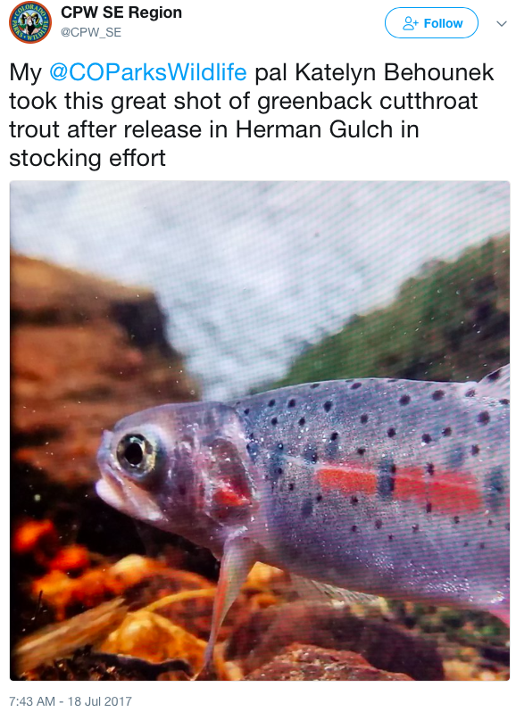
Colorado Parks and Wildlife aquatic biologists and volunteers each carried 10-pound bags of rare greenback cutthroat trout up steep Herman Gulch near Georgetown this week in a bid to permanently return the state fish to its ancestral waters in an alpine stream fed by snowmelt.
CPW biologists hope the fish, each a year old and about 4 inches long, will thrive and continue the long process of restoring the native greenback in its historic habitat of the South Platte River drainage and remove it from the U.S. Fish and Wildlife Service’s list of threatened species.
But there are no guarantees that all the hard work will succeed in rescuing the rare fish. Still, CPW and its partners at USFWS, the U.S. Bureau of Land Management, the U.S. Forest Service and the National Park Service, are determined to try to save the greenback, honored as the official state fish of Colorado.
Since discovering in 2012 the pure greenback population in a tiny ribbon of water known as Bear Creek on the southwest edge of Colorado Springs in the Arkansas River drainage, CPW staff has mounted a massive effort to walk Bear Creek, collect and spawn the fish each spring, rear them in hatcheries and now painstakingly stock them in a reservoir and two streams that the agency cleansed of other non-native fish to create the best conditions possible for their survival.
Despite all that work, the first stocking effort of 4,000 tiny, one-inch greenbacks on Herman Gulch and Dry Gulch last September was somewhat disappointing. A recent survey of the streams found no survivors. As a result, CPW decided to restock July 17 with 960 older, more robust greenbacks. The earlier release date also was designed to give the fish more time to acclimate and grow before winter. What CPW researchers know is that it takes approximately 3 years to restock and establish fish in a stream.
Presiding over the restocking effort were Boyd Wright, CPW’s Northeast Region aquatic conservation biologist and Paul Winkle, area aquatic biologist. Also assisting was Harry Crockett, CPW’s native aquatic species coordinator and chairman of the multi-agency Greenback Cutthroat Trout Recovery Team.
“This is a really big deal,” Crockett said of the effort that saw dozens of volunteers serve as fish Sherpas hauling bags up fish up four miles of steep terrain to find ideal spots along Herman Gulch where the greenbacks might take residence. “We need to get these fish in here and see them survive.”
To prepare the streams as greenback incubator sites, CPW staff in 2015 walked each, mile by mile, electroshocking about 600 hybrid cutthroat and carrying them out for relocation in Clear Creek. The streams were chemically cleansed of other species so baby greenbacks might thrive.
Then came the stocking of tiny greenbacks last September, the survey for survivors last week and finally the second restocking July 17. Though greenbacks stocked into Zimmerman Lake west of Fort Collins are thriving, biologists want to see them restored in their more typical habitat: cold, clear, alpine streams.
“This is a fish that evolved in streams over thousands of years.” Wright said. “Then it was almost wiped out in a century and a half of human interference. This is where we want to see them back and thriving again. Here in the wild.”
The long-term goal is to have greenbacks populating a network of streams like Herman, Dry Gulch and Clear Creek, for example, throughout the South Platte drainage. But for now, CPW biologists have to get them to survive a winter.
“The vision is a metapopulation with connected streams,” Crockett said. “But that’s a long way away. For now, we’ve got to maximize the genetic diversity that’s left and get them to take in these streams.”
The survey and stocking efforts will be repeated next year and biologists will be able to track the cutthroats by scanning them with a wand to read identifying tags inserted in each fish.
Among the nonprofit conservation organizations providing a small army of several dozen volunteers to assist in the restocking was Trout Unlimited and its member, Joe Haak of Castle Rock. He labored up the trail about four miles, determined to get his fish in the water in the two-hour window allotted by the scientists, because he feels so strongly about the CPW mission to save the greenback.
“It’s an honor to be a part of this important work,” Haak said as he gently coaxed his 10 greenbacks into a calm pool under two boulders, protected from the swift whitewater of Herman Gulch.
“I feel like I’m kind of a dad to these fish,” Haak said, watching with pride as his greenbacks hovered in the stream, surfacing to eat insects on the surface. “I wanted to be a part of history.”
The effort to restore Colorado River cutthroat trout in Hermosa Creek dates back to the early 1990s when wildlife managers used a natural waterfall on the creek’s east fork as a protective barrier.
Colorado Parks and Wildlife cleared out non-native species of trout – specifically brook, brown and rainbows – using a short-lived, organic poison known as rotenone. And in their place, it released Colorado River cutthroat trout, giving the waterway to the native fish for the first time in probably 100 years.
The magnitude of the cutthroat’s loss has never been truly quantified, but its range – which once spanned Colorado, New Mexico, Utah and Wyoming – was dramatically reduced, mostly because of habitat loss, overharvesting and competition with non-native species.
Clay Kampf, a fisheries biologist for the San Juan National Forest, said the best estimates show the Colorado River cutthroat trout is now found in about 14 percent of its historic natural habitat.
Facing the possibility of the U.S. Fish & Wildlife Service listing the Colorado River cutthroat trout as “endangered,” which would bring a host of restrictive protections, Colorado, Utah and Wyoming entered a three-state agreement to lead an aggressive reintroduction program.
“It works well for both parties,” said Jim White, an aquatic biologist with Colorado Parks and Wildlife. “This way, the states and local groups have more say in where and how to manage these fish. And it benefits the (Fish & Wildlife Service) because their resources are stretched pretty thin.”
[…]
In the last decade, the state of Wyoming has restored more than 60 miles of Colorado River cutthroat habitat, with most of that occurring in the upper Green River drainage by the town of Big Piney.
There, Mark Smith of the Wyoming Game and Fish Department said the population has been struggling since reintroduction. The fish haven’t spawned early enough, he said, which means they don’t grow big enough to survive winter.
“The turnaround hasn’t been as quick as we would have hoped, but we’re getting there,” Smith said. “We’re certainly making gains and going in the right direction.”
In Utah, the program has been wildly successful, with hundreds of miles of streams restored with their native species of trout, said Randy Oplinger of the Utah Division of Wildlife Resources.
Oplinger said Utah has been the most ambitious of the three states, likely because of the fact many projects are located on federal lands managed by agencies open to large-scale restoration efforts.
This year alone, the department plans to restore 75 miles of cutthroat habitat within the Colorado River basin. And Oplinger said trout populations tend to fair well throughout the river system…
Hermosa project close to completion
Once a final barrier is constructed this summer on Hermosa Creek, just below its confluence with the east fork, an effort to dedicate more than 23 miles solely to the cutthroat trout will almost be complete.
Two decades ago, Hermosa Creek was recognized as an ideal place for a restoration project because of the creek’s outstanding water quality and because of its easy accessibility through Forest Service Road 578, which runs behind Purgatory Resort.
After the waterfall near Sig Creek Campground was used as a natural blockade from non-native intrusion in the early 1990s, two more human-made barriers were built in 2007 and 2013.
This summer, the U.S. Forest Service will begin construction on the final barrier at the Hermosa-east fork confluence to safeguard the waters above the blockade for the Colorado River cutthroat.
CPW’s White said that in the segments of the creek that have already been repopulated with cutthroat, population trends are encouraging. He said a recent sweep a few years ago found about 400 to 600 fish per mile.
“Populations above 400 fish per mile are usually ranked in the good to excellent category,” White said. “We’ve seen natural reproduction … very shortly after that project on the main stem (of Hermosa) was completed.”
Protecting the cutthroat
With a successful stretch of river returned to its native species, wildlife managers are expecting Hermosa Creek to get a lot of use from excited anglers.
As a result, a strict catch-and-release policy is on that section of river, White said, and there are other measures, such as habitat improvement and limiting bank erosion, that the agencies can take to protect the fish…
The quest to set right altered habitats continues to have strong cultural and ecological justifications, said Noah Greenwald of the Centers for Biological Diversity.
“We’re taking away what makes places like Colorado unique and special,” he said. “And we’re likely impacting other species when we replace a native with a non-native. It’s part of this larger extinction crisis.”
The Hermosa Creek restoration project is a coordinated effort between the U.S. Forest Service and Colorado Parks and Wildlife, as well as Trout Unlimited, which in total have spent more than a $1 million, Kampf said.
It will take a few more years for the waters upstream of the forthcoming barrier to carry only cutthroats, as non-natives still need to be removed, but Kampf said it will be worth the wait.
As local anglers, conservationists and wildlife managers get ready to celebrate another milestone in the restoration of Colorado River cutthroat trout to the upper reaches of Hermosa Creek, it is easy to forget that the effort, which dates back to the early 1990s, has its detractors.
Some local residents, and many long-time summer visitors to the popular area tucked behind Purgatory, think all the fuss over the fish – one of three native Colorado subspecies of trout named for the distinctive crimson slashes found on each side of the lower jaw – has ruined a fine local fishing hole.
From a short-term point of view, they have a point. The periodic poisoning of the creek to remove non-native trout, the building of barriers to keep non-natives downstream, the stocking of cutthroats and the rules against taking them for the frying pan have sent those seeking a stringer of fish further downstream, or elsewhere.
In 1992, the Colorado Division of Wildlife applied rotenone above the waterfall on the East Fork; not long after, Colorado River cutthroat were planted in the stream and the fish, estimated to occupy less than 15 percent of its original range on the tributaries of the Green and Colorado rivers, had a toehold in Hermosa headwaters once again.
It was an important step in the effort to keep the U.S. Fish and Wildlife Service from listing the fish as an endangered species, and mirrored similar restoration efforts on the fish’s native range in Utah and Wyoming.
Since then, barriers have been built and the process repeated on the main stem upstream of Hotel Draw. With the pending completion this summer of a barrier at the confluence of the East Fork and the main stem, the native-cutthroat-only stretch will soon comprise the largest continuous stretch of Colorado River cutthroat habitat in the state.
It has been an impressive effort, and like its supporters, we are confident of its future success. Those who remain unimpressed may benefit from a history lesson:
The same mining and population boom that decimated the cutthroat nearly extirpated Colorado’s elk. In 1912, elk from Wyoming were reintroduced to the state in the same Hermosa Creek drainage. The area remains, as the Denver Post noted in an article three years ago, “a hunter’s paradise, where trophy elk still die of old age.”
That story, and the Hermosa area’s more recent protected status, bode well for another rebounding native.
Editor’s note: Marianne Goodland reports on water issues for this ongoing series: PARCHED, which looks at conservation, the role of agriculture and storage, as Colorado prepares for a looming water shortage brought on by population growth and climate change.
John Hickenlooper and his administration spent four years and millions of dollars working up Colorado’s first statewide water plan out of what he called an urgent imperative – a projection that water needs will exceed supply by 2050.
But those water supply projections, upon which the water plan was based, are now nine years out of date, raising questions about the current state of Colorado water, given the recent population boom and more evidence that climate change has become a larger problem for water supplies.
Mark Eiswerth, a water expert and economics professor at the University of Northern Colorado, points out that ”[e]ven if water providers are completely successful in implementing projects [already planned], state water experts predict that we will meet only about 80 percent of the forecasted needs in the municipal and industrial sectors by 2050.”
The Colorado Water Conservation Board [CWCB], the agency overseeing water supplies as well as the state water plan, won’t have new projections quantifying our water shortage until summer of 2018, despite its commitment in 2010 that it would update and refine the data “every few years.” In the meantime, Hickenlooper earlier this month appointed Becky Mitchell—the official who for the last five years has been responsible for compiling that data—to head the agency and carry his plan forward.
“Coloradans and our water communities are working like never before to solve our state’s challenges collaboratively,” Mitchell said at the time of her appointment. “The same kind of cooperation that led to Colorado’s Water Plan will fuel the long-running effort necessary to continue putting the plan into action.”
Mitchell’s appointment was welcomed by both lawmakers and environmentalists who work regularly with the state’s water board.
Mitchell “knows the plan inside out,” Kristen Green of Conservation Colorado, the state’s largest environmental advocacy group, told The Colorado Independent. “She’s great at being collaborative and reaching out to different stakeholders.”
State Sen. Jerry Sonnenberg of Sterling, who chairs the Senate Agriculture, Natural Resources and Energy Committee, said Mitchell would bring “the right balance of institutional knowledge and fresh ideas on how to meet the water demands of the state.”
The challenge ahead is immense. Sonnenberg, who also chairs a summer interim legislative committee on water, says the state needs to know what has changed over the last nine years. While, he says, he suspects supply and demand forecasts are still roughly in line with the last projections, the update “could force us to accelerate what we need to accomplish” to tackle the impending water shortage.
The population surge
Water planning is a complex numbers game that factors in current and projected population, climate patterns, water policies on the local, state and federal levels, and the competing needs of farmers, ranchers, city dwellers, businesses, oil and gas drillers, environmentalists, birders, anglers, rafters, kayakers and everyone else who relies on the health and vibrancy of Colorado’s rivers.
Hickenlooper – whose legacy as governor will be shaped largely by the unprecedented growth he has championed in the state – ordered the first statewide water strategy in 2013 out of a need for an informed, cohesive and clear plan forward.
The administration’s 540-page plan, released in November, 2015, is predicated on a 2010 report, known as the Statewide Water Supply Initiative, or SWSI, pronounced swa-zee. The first SWSI report came out in 2004 at a time when the state was in the process of developing its infrastructure around water planning. The most recent report, an update, was based on 2008 data about water supplies. Since then, Colorado’s population has surged from about 4.9 million to 5.6 million people in 2016. The state is growing by 100,000 people per year, and the population could reach close to 10 million people by 2050, according to both the water plan and the 2010 water supply report.
John Stulp, special policy advisor to the governor on water, said that population growth now appears to be slower than what the water plan and 2010 SWSI had predicted – more in line with a population of about 8.5 million rather than 10 million by 2050. That’s good news in terms of demand, but the state still needs to figure out how to provide water to the three million additional residents.
The 2010 report projected that the Front Range will continue to be the most populous area in the state, but that population on the Western Slope will double. With that kind of growth on both sides of the Continental Divide, the 2010 SWSI projected Colorado would be short about one million acre-feet of water by 2050 and cities and towns would have to at least double their water supplies. One acre-foot is about 326,000 gallons of water, or enough water to satisfy two families of four for a year.
In the nine years since the state compiled data for its 2010 report, Colorado also has weathered its most disastrous wildfires, a drought in 2012 and a 100-year flood later that same year. In 2015-16, the United States experienced the warmest winter ever recorded.
Turnover, burnout and bureaucracy
The water plan has been criticized as a “compendium of ideas” rather than an actionable plan forward. Some of Colorado’s top water experts see it as a political move to make Hickenlooper look like he’s on top of water issues, but without having to make tough decisions that could affect developers or could inflame longstanding water tensions between the east and west sides of the state. At the time the plan came out, Peter Nichols, a water attorney who sits on the Interbasin Compact Committee, a statewide water working group, said the plan had a lot of nice words but without a lot of action tied to them.
The CWCB is supposed to update policy-makers with new SWSI reports every few years. But that hasn’t happened since 2010. In 2016, the Colorado General Assembly authorized the CWCB to take $1 million out of its construction fund to update the SWSI report. At the time, the CWCB said the update would be done by mid-year 2017. Meaning now.
CWCB officials now say the report is more likely to surface around June 30 of next year.
The reason for the latest delay differs, depending upon whom you ask.
Minutes from a February 2016 meeting of a group of Denver-area water agencies, city and county officials, and representatives from agriculture, recreational, environmental and municipal water users, show that contractors had been selected for the SWSI update and “work will begin very soon.” “…Delivery targeted for mid-2017,” the minutes read. That was before the legislature had even approved the $1 million to update the report.
By Sept. 8 of that same year, progress appeared to have come to a halt. Minutes from the same working group’s meeting said that “[ e]verything with SWSI is on hold. There is no staff. No technical work has started.” According to the meeting’s minutes, those remarks came from the CWCB’s Craig Godbout, a program manager in the agency’s water supply planning section, which was then headed by Mitchell.
Mitchell disputes that work came to a standstill, stating that one of the biggest holdups has been navigating the state’s contracting rules. In attempting to put together an elaborate series of contracts to handle the SWSI update, Mitchell said, the CWCB ran into delays due to the state’s procurement rules, and the approval process was more complicated than the CWCB anticipated.
In addition to contractors, volunteer members of select groups, known as basin roundtables, are also responsible for much of what will happen with the next SWSI update.
These nine groups, set up by state law, include more than 300 representatives from counties, water providers, agricultural, municipal, industrial, environmental and recreational interests. Each roundtable covers a major river basin in the state – eight in all – plus a separate one for the Denver metro area.
The role of the roundtables, established in state law, is critical in every aspect of the state’s water planning. The roundtables are responsible for knowing the water situation in each of their nine areas and coming up with projects to satisfy water issues as well as the implementation plans for those projects. Those implementation plans formed the technical background for the state water plan.
Stulp told The Independent that roundtable members wanted to provide some of the technical expertise for the next update. Choosing who would participate slowed things up, he says, adding that he thinks the SWSI process is now “back on course.”
Mitchell and the CWCB’s former director, James Eklund, noted that the basin roundtables have seen turnover — and some burnout in membership. Once the SWSI was updated in 2010, Stulp says, the roundtables used that information to develop their own basin implementation plans. When the water plan was done, work on the SWSI update began, and once that’s done, the basin plans will in turn be updated, and the cycle repeats.
Mitchell says that despite the churn, the cycle works. SWSI is the technical piece that the basin roundtables rely on as they plan projects to solve a variety of water issues in their own areas. The water plan then is the status report, which asks “are we doing what we say we would do?” she said.
Greg Johnson, a program manager in the CWCB’s water supply planning section, is in charge of putting together the 2018 SWSI. “We wish we had more control over the timing,” he told The Independent last week. “But coming off the water plan, people, especially at the basin roundtable level, had put in thousands of hours of effort and it was hard to ask them to get back on that train for the SWSI” just three months after the water plan was rolled out.
Sonnenberg sees the delay in updating SWSI as a reflection of a lack of interest by the Hickenlooper administration and its appointees on the water board. His committee needs the update as it maps out priorities for the water plan for the next five years.
Part of the delay, he said, is due to turnover at the CWCB, which most recently included its former director. Eklund left in April to join the law firm of Squire Patton Boggs as a water law and infrastructure expert. Sonnenberg pinned the delay on Eklund, saying there during his tenure there was “a lack of interest in following through.”
Eklund chose not to respond to Sonnenberg’s criticisms, saying they had a good relationship while he was at the CWCB and that Sonnenberg had been very helpful on water issues. He noted that Sonnenberg had either been consulted on or a proponent of every major piece of water legislation.
What we learned from SWSI 2010
The 2010 report found that Colorado’s rivers generate about 16 million acre-feet of water every year—that’s 5.2 trillion gallons a year. On paper, that sounds like an abundance. But two-thirds of that water doesn’t stay in Colorado. If flows out of state under agreements drawn up decades ago with neighboring states that rely on our water.
The report pointed out that 80 percent of the state’s water is on the Western Slope while 80 percent of the population is on the Eastern Slope, including most of the state’s irrigated agricultural lands. Those farms and ranches use about 89 percent of the state’s consumed water, which doesn’t flow back to streams, rivers or aquifers.
The 2010 report also looked the state of the Colorado River – the biggest source of water for our state, and for the entire Southwest. The report included a review of environmental and recreational water supply and demand, municipal and industrial water supply and demand, and the water needs of ski resorts, breweries, and the state’s energy sector, based on electrical generation as well as oil and gas fracking.
The supply gap could be eased by changes in state water policy and efforts by the nine roundtable groups to address issues such as how the agriculture industry uses its water, additional storage from new or expanding existing dams and reservoirs, and conservation efforts, which have proven most successful during times of drought when Coloradans feel the squeeze.
Without its own data projecting the effect of climate change on water supplies, the water board drew data from experts such as the state’s climatologist and the Colorado Water Institute at Colorado State University in forming the state water plan. It warned, for example, about decreased water supply resulting from “dust on snow,” a phenomenon that occurs when wind pulls dust from deserts or other areas without vegetation and deposits it on mountain snowfields. That in turn increases solar radiation, “which speeds up snowmelt and leads to earlier spring runoff” by as much as three weeks, the water plan said.
Out of the 91 occurrences of dust-on-snow tracked since 2005, 10 took place in 2013 alone. If these dust-on-snow events continue at or near the same rate, the Colorado River alone would be short 750,000 acre-feet of water. That’s twice the amount of water used by Denver every year, the report warned.
What will the 2018 SWSI look like?
Stulp said the updated SWSI will be based more on technical data than the 2010 report, which looked at water supply gaps driven by the natural cycle of how water is generated and consumed in Colorado. The update will, instead, look at water supply and demand as a structural gap – based on the equation of how much new demand the state will face, minus the water projects already being planned statewide.
The updated report also will include updates on extreme weather conditions from drought to flooding and on the condition of Colorado’s rivers and streams. Improved water flows help both preserve fish and other wildlife habitats, as well as improved conditions for recreational activities, such as fishing or rafting.
“It’s amazing how fast six or seven years goes by,” Stulp said, referring to the 2010 SWSI.
The CWCB’s Johnson said the 2018 SWSI will rely on the roundtable expertise through four technical advisory groups, dealing with agriculture, municipal and industrial water uses, planning scenarios, and environmental and recreational water supply. The technical groups will act as peer review over the analysis provided by the contractors, who are now setting up the methodology, figuring out what models to use, how to quantify socio-economic factors, such as land use and population density, and then “crunching the numbers.” The technical groups will review that information in September.
One of the biggest differences for next year’s SWSI, Johnson added, will be its inclusion of an elaborate series of scenario planning. That planning will take into account population growth, social values and climate change. “Let’s imagine different futures and how the variables will change” that future, he said.
“We want to come up with something that is scientifically defensible. In the end we will get a better product.”
Johnson laid out a timeline for completion of the 2018 SWSI with the CWCB board at its monthly meeting last week in Crested Butte. The methodology development, which is being done by contractors, will continue through November, with technical evaluations to wrap up in late spring. A final report, according to Johnson, should be issued by June 30, 2018.
The ticking clock
When Hickenlooper issued the order for the water plan in 2013, lawmakers felt they had been left out of the process. In response, in 2014, they passed a bill that sternly claimed that the purpose of the water plan is to determine state policy on conservation and development of water resources, and that the General Assembly “is primarily responsible for guiding the development of state water policy.”
That work is left mostly to the legislature’s 10-member interim Water Resources Review Committee, which will begin its summer schedule in August.
During 2015, the water committee traveled around the state, gathering public input on drafts of the water plan and coming up with their own views on how the plan should look. Since then, lawmakers’ roles have been largely confined to passing bills to come up with the money to start implementing the plan, although those bills ($5 million in 2016 and $10 million in 2017) have said little about exactly how that money would be spent.
The late SWSI update isn’t a big deal to Rep. Diane Mitsch-Bush of Steamboat Springs, a Democrat who sits on the water committee. She said that she doesn’t think the delay would make a difference but acknowledged that the information would be important because lawmakers can’t just rely on assumptions about the state’s water supply and demand.
Sonnenberg said that during the water committee meetings in August he wants lawmakers to meet with the water board to discuss what’s going on with the SWSI.
“It’s important we have the updates so we can see if we’re on same trend or if we have drastic changes,” he said.”[But]growth in Colorado has been fairly predictable.”
This is Colorado, Sonnenberg said, and people love coming here. Between 2008, when the last SWSI update was issued, and 2016, 700,000 new residents settled in this state. By next summer, another 100,000 are expected.
This scenario is intended to represent assumptions with a combined 1 in 100 probability of occurring. Climate change is at the worst end of consideration, at 6 weeks peak, 50 percent combined flow and ET impacts. Weighted average demand growth rate is 1.2 percent, resulting in a 2065 treated water demand of approximately 6,320 acre-feet. And flow adjustment factors are at their expected values.
Climate change is at the worst end of consideration, at 6 weeks peak, 50 percent combined flow and ET impacts. Demand growth rate is zero; current treated water demand of approximately 3,500 acre-feet continues through 2065. And flow adjustment factors are at their expected values.
Climate change is at the worst end of consideration, at 6 weeks peak, 50 percent combined flow and ET impacts. Demand growth rate is zero, no outdoor usage during shortages; effective treated water demand during shortages is 2,280 acre-feet. And flow adjustment factors are at their expected values.
_
ASPEN – Whether Aspen needs to build a reservoir to meet water demands in 2065 may depend in part on whether it wants to keep irrigating its municipal golf course during an apocalyptic drought.
According to a water attorney and an economist working for the city on a risk analysis of future water shortages, Aspen may find itself unable to meet domestic water demands — including both indoor and outdoor water use — anywhere from two out of 25 years in an optimistic scenario to 19 out of 25 years in a worst-case scenario.
The most optimistic scenario can be achieved, in theory, if the city limits outdoor watering by its customers and also stops diverting water from Castle Creek to irrigate the 148-acre municipal golf course and other nearby open space.
Outdoor water use accounts for about 60 percent of current demand for city water.
The members of the Aspen City Council took a sip of such concepts Monday at a work session on the results of a water demand study.
Aspen Mayor Steve Skadron said he expects the council to now spend “several months” grappling with the city’s future water needs as part of an exercise to identify alternatives to maintaining conditional water rights for two large reservoirs on upper Castle and Maroon creeks.
Aspen trees near the site of the proposed Maroon Creek Reservoir. The City Council has acknowledged the pristine nature of the Maroon Creek location and is openly looking for water storage alternatives, including at the city golf course and Cozy Point Ranch.
Climate wildcard
Monday night, George Oamek, an economist with Headwaters Corp., presented three scenarios from a risk analysis he’s been developing for the city.
He told the council that his model is packed with uncertainties, mainly around the severity of climate change, but also around the amount of flow in Castle and Maroon creeks and the future demand from Aspen’s water customers.
“We’ve got just a tremendous amount of variability in the existing information that gets translated into our analysis,” Oamek said.
“There is so much uncertainty,” concurred council member Ann Mullins.
“Climate change is everything,” Oamek said. “And it’s the thing we know the least about.”
Oamek also said his model includes a 1-in-100 chance that the factors will line up to cause havoc, which he said is a common risk assumption for municipal water providers and in floodplain mapping with its concept of a “100-year-flood.”
“Frankly, water planners are risk adverse,” he said.
In Oamek’s “worst-case” scenario, runoff would come six weeks earlier in the spring and there would be half as much water flowing in Castle and Maroon creeks, the city’s primary sources of water.
The city of Aspen’s diversion structure on Castle Creek.
Water rights portfolio
The city owns two large senior diversion rights on Castle Creek tied to the historic Castle Creek-Midland Flume. The city has an 1892 decree allowing it to divert 60 cfs. On top of that, it has another right from 1892 for 100 cfs, giving it the ability to divert 160 cfs from Castle Creek.
The city’s streamwide diversion dam is just downstream of Midnight Mine Road and the water is sent via a pipeline to the city’s water treatment plant on a knoll above Aspen Valley Hospital.
Water from Maroon Creek is also sent via pipeline to the treatment plant and the associated 10 acre-foot Leonard M. Thomas Reservoir, which serves as a forebay to the treatment plant, holding water from both Castle and Maroon creeks.
The city owns a 3.4 cfs diversion right on Maroon Creek with an 1893 decree date and another 65 cfs diversion right with a 1949 decree date that, notably, includes an 1892 appropriation date. The city’s streamwide diversion dam on Maroon Creek is located at the T-Lazy-7 Ranch.
The water rights from Castle and Maroon creeks give the city a portfolio of “paper” rights adding up to 228.4 cfs, which is a much larger amount than the city runs through its water treatment plant, even in dry, high-demand, years.
According to a water availability study from Wilson Water adopted by the city in June 2016 as a planning document, the city in the last big drought year of 2012 brought between 2.38 and 9.4 cfs of water into its water treatment plan from Thomas Reservoir. The peak intake of 9.4 cfs was in June.
The city’s pipeline from the Castle Creek diversion limits the amount of water that can be sent from Castle Creek to the treatment plant to 25 cfs and the pipeline from Maroon Creek can move up to 27 cfs.
The city’s diversion rights are separate from its two conditional water storage rights higher on Castle and Maroon creeks.
Those rights, as currently decreed with a 1971 date, are for storing 4,567 acre-feet of water just below the confluence of East and West Maroon creeks in the Maroon Creek Reservoir, and for storing 9,062 acre-feet of water in the Castle Creek Reservoir two miles below Ashcroft.
The combined storage capacity of the potential reservoirs, as currently decreed, is 13,629 acre-feet. The reservoirs, notably, would be located above the city’s two downstream diversion dams.
And both the city’s diversion rights and its conditional storage rights are separate from rights it owns in three irrigation ditches on Castle Creek, downstream from its diversion dam. The headgates for the three ditches on Castle Creek are near the Marolt housing complex.
The city calculates the instream flow at a location below the headgate of the Marolt Ditch, as it is the lowest of the three ditches.
The city of Aspen’s Leonard M. Thomas Reservoir, next to the city’s water treatment plant, can hold water from both Castle and Maroon creeks.
Supply down, demand up
In his presentation to the City Council, Oamek said his worst-case scenario assumes that demand for treated water would be 6,320 acre-feet of water a year, up from about 3,500 acre-feet today.
The assumption includes a negligible 0.4 percent growth rate in the permanent population in Aspen’s water service area, and a 2 percent growth rate for the part-time population and commercial sector.
That assumption does seem to run counter to Aspen’s past ability, and plans, to lower water demands while the population rises, which may be why the three scenarios also include a no-growth-in-demand scenario, where demand is held flat at current levels, regardless of potential population growth.
For example, a 2014 water efficiency plan from Element Consulting and WaterDM projects the city will, by 2035, “reduce treated demand by about 583 AF — an overall 14 percent reduction in demand.”
And the city has been making solid progress on reducing water demand. In 2012, city staffers told the council the city had reduced water consumption by “over two-thirds over the last 19 years.”
But the water efficiency plan does raise a cautionary note about the city’s lack of storage.
“On an annual basis, the dry year yield of the City’s water rights appears to be more than sufficient to meet current and forecast future demands,” the plan says. “However, the city does not have storage to regulate the timing of supply to match demands, and therefore is vulnerable to peak demand shortfalls in dry years when physical streamflow conditions are limited, or in emergencies such as a fire or landslide when one or more particular water supply sources may become unavailable.”
A graphic in Aspen’s draft water efficiency plan shows that the city has generally been using less water over time.
Setting aside the downward demand trend, the most draconian scenario developed by Oamek assumes a near doubling of demand in a much hotter and drier world.
And it shows the city might not be able to meet all municipal water demands — including both indoor and outdoor use — in 19 of 25 years.
“There are frequent shortages for Aspen’s potable supply during that period,” Oamek said.
In 15 of those years, water shortages could be greater than 100 acre-feet of water.
In four of those years, water shortages could be greater than 1,000 acre-feet.
And in one of those years — think the drought year of 1977 — shortages could be greater than 2,000 acre-feet.
“Over 1,000 acre-feet … that would definitely cause some hardship,” Oamek said. “A lot of these shortages, they are not occurring during the irrigation season, or during the summer where you might be able to reduce outdoor use, or work some deals with the irrigators.
“The shortages are occurring kind of in the shoulder season, occurring in late summer, early fall, and also during the winter. And those shortages may be a little harder to mitigate through the utilization of outdoor sources.”
The well-watered Aspen golf course, which sits between Castle and Maroon creeks.
No outdoor watering
The picture gets brighter in Oamek’s “intervention scenario,” the least demanding of the three scenarios.
Runoff would still come six weeks earlier, and there would still be half as much water flowing down Castle and Maroon creeks.
But demand for city water is projected at 2,280 acre-feet a year, as the scenario assumes the city will curtail the use of treated waters for outdoor purposes during a drought.
“During times of shortages, we set outdoor usages to zero,” Oamek told the council, explaining that would drop annual demand in the model to about 2,200 acre-feet, down from 3,500 acre-feet.
In that scenario, there might be 14 years out of 25 when there are water shortages, but only in five of those years would the shortages be over 100 acre-feet, and none would produce shortages over 1,000 acre-feet.
One of the city’s irrigation ditches that carries water from Castle Creek toward the city’s golf course.
No ditch water
Cindy Covell, the city’s water attorney with Alperstein and Covell, then told the council she asked Oamek — the day of the council work session — to run another scenario where the city also stopped diverting water it controls into three irrigation ditches on lower Castle Creek, downstream of the city’s diversion dam to its treatment plant.
“I was thinking, if you were going to run a scenario that involved no outdoor irrigation – you’re telling your customers they can’t water their lawns – you probably are going to have a hard time taking irrigation water down those ditches and irrigating your golf courses and your parks,” Covell said.
Oamek ran a calculation — not a full model run — and said curtailing irrigation drove the number of years with indoor water shortages down to just two years out of 25, and in only one of those years was the shortage greater than 100 acre-feet.
In 2012, the city diverted up to a total of 20.5 cfs into the three Castle Creek irrigation ditches, with the highest diversion rate in June, according to the Wilson Water study.
The city has diversion rights in the Holden Ditch of 25.9 cfs with a 1952 decree, in the Marolt Ditch of 13.6 cfs with a 1934 decree, and in the Si Johnson Ditch of 2.55 cfs with a 1936 decree, according to an agreement with the Colorado Water Conservation Board. That adds up to a “paper” portfolio of 42.05 cfs worth of irrigation rights.
“To some extent you already have a bucket of water, which is the downstream irrigation ditches,” said water attorney Paul Noto, who represents three clients opposing the city’s conditional storage rights in water court, and was asked to comment at the work session by the mayor.
“Tonight we talked about what’s the worst-case scenario, [and] might I suggest that we look at priority irrigation under those ditches,” Noto said. “So perhaps we say, at the golf course we want to keep our fairways and greens green, but maybe we don’t irrigate the rough if the streamflows are below x.”
Noto also pointed out to the council that almost all of their municipal water comes from Castle Creek, and that the water in Maroon Creek is now primarily diverted to power the city’s small hydropower plant on the banks of Maroon Creek.
Maroon Creek, below the diversion, at about 12 cfs during a minimum stream flow demonstration in 2011.
Maintaining instream flows
Maintaining instream flows is a challenge in each of the scenarios presented, as there are dry years when it’s hard for the city to reach its goal of leaving enough water in Castle and Maroon creeks to maintain the environmental flows while also meeting all municipal water demands.
“Worst-case, maximum growth, there is a lot of damage to the instream flows,” Oamek said, noting the annual instream-flow shortages were over 10,000 acre-feet in the worst year in the model.
The city has a policy of maintaining minimum, or instream, environmental flows in Castle and Maroon Creeks.
The Colorado Water Conservation Board holds an instream flow right in Castle Creek for 12 cfs and a right in Maroon Creek for 14 cfs. The state defines that level of flow as the amount of water needed to protect the environment “to a reasonable degree.”
Both of the CWCB’s instream flow rights are junior to the city’s senior diversion rights on Maroon and Castle creeks.
The city, based on the recommendation of a consulting biologist, recently increased its minimum flow target on Castle Creek to 13.3 cfs. As such, the combined minimum instream flow level in Castle and Maroon creeks that the city seeks to maintain is 27.3 cfs.
The city’s policy of voluntarily honoring the state’s junior instream flow rights is centered on a 1997 agreement with the CWCB to protect 12 cfs of flow on Castle Creek. The agreement does not technically extend to Maroon Creek, although the city’s stated policy does.
However, the agreement with the state also includes a provision that allows the city to exempt itself from the policy during periods of “extraordinary drought,” which are not defined.
The provision gives the city latitude to meet its municipal demands and “invade,” as Oamek put it, the junior minimum instream flow rights held by the state, as necessary.
This map from 1984 is one of the few ever published that puts the Maroon and Castle creek reservoirs into the context of the city’s overall water system.
Need a bucket
Staff in the city’s Water Department continue to point out to the City Council that Aspen likely needs some amount of water storage in the future.
“In our integrated water supply system, there are alternatives to storage than can help mitigate our shortages, things like re-use, conservation, ag transfers … but even though these combined can minimize the shortages, storage is still needed because of timing issues,” Margaret Medellin, a utilities portfolio manager for the city told the council Monday night. “To really make these other mechanisms work, we still need a bucket to be able to augment and … re-time the water.”
That message has gotten the attention of Mayor Skadron.
“As we proceed, my goal would be to ensure a sufficient water supply for future generations and to ensure that their options are open,” he said.
He also asked during the meeting, “Does a scenario exist in municipal water planning where storage is not needed beyond just what nature provides?”
“Historically, that’s how Aspen has operated,” Medellin replied. “Aspen has very little storage and has historically operated as a direct-flow water provider. And in areas maybe that are wetter, back East, it is not as problematic.
“And I think the concern is as we are starting to see runoff happening earlier, the demand being extended and happening later into the system … [and] what has worked historically for Aspen, we aren’t convinced is going to work for the next 50 years.
“Even though that it is something that other communities can do, and something that Aspen has done, as we are looking into our models going forward, we’re not convinced that it’s something that is sustainable here,” Medellin said.
However, a 2016 water supply report done by Wilson Water and adopted by the City Council in June of 2016 as a planning document, painted a different picture and found that no storage was necessary – even after factoring in available climate change projections.
The Wilson Water study found that “the results of this analysis indicate the city can always provide sufficient potable and raw water supplies under these modeled demand and hydrology scenarios.
“Existing water supply infrastructure and water rights portfolio developed and managed by the City do not appear to be limiting factors in this evaluation.
“However, during drought periods, physical water supplies may limit the city from satisfying desired ISF (instream flow) bypasses. These modeled ISF deficits are forecasted to occur during drought periods in only the climate scenarios with very low late summer and winter streamflow conditions.
“Most ISF deficits occur at a frequency of 5% of the time or 1 out of 20 years. The predicted average daily ISF deficits are relatively small and can be managed utilizing the existing water supply tools the city has in place and/or is actively developing,” the Wilson Water study said.
And recently completed water-efficiency plans for Basalt, Carbondale, and Glenwood Springs found that those three nearby cities have adequate water supplies for the future without significant storage “buckets.”
A portion of the gravel pit in Woody Creek operated by Elam Construction. It’s hard to capture the scale of the gravel pit, but the little yellow speck in the back edge of the pit is a large dump truck.
Shortage into storage
Medellin also told the council one of the next steps is to convert the shortage numbers from the Headwaters risk analysis to potential storage numbers.
“It’s not a one-to-one conversion,” Medellin said, noting that the storage figure is always larger than the shortage number.
She said a “reservoir operations model” will be used to “apply a reservoir efficiency factor to account for losses and reservoir integrity.”
“What that means is all of the water that we put into a reservoir, we’re not going to get that back out,” she said. “So there is a factor that is commonly added to account for that. Then the next step is going to be to determine what volume of conditional storage rights we need to satisfy that requirement.”
Covell, the city’s water attorney, further explained the process.
“You look at your streamflows, and you say, how often can I fill up this reservoir?” she said. “And on the eastern slope, you might not be able to fill it up more than once every five years. So you say, if I need to be sure I’ve got to have 100 acre-feet of water in storage, I might have to fill up 600 acre-feet, because when I need that 100 acre-feet some of the water will have evaporated and I won’t be able to top it off again because my water right won’t be available.
“And that’s a, maybe, overly simplistic example, but when you’re trying to figure how much storage capacity you need, you have to figure out when you are going to be able to put water in, how much of it’s going to evaporate, and when you’re going to need to take it back out,” Covell said.
Medellin added that the engineering firm Deere and Ault of Longmont is now making calculations for both in-situ and surface water reservoirs, and the storage needs will be based on the representative period of years in the model being used by Headwaters.
The property next to the Elam gravel pit and the Woody Creek raceway that the city of Aspen has put under contract. The city is investigating the site as a place for potential water storage, either underground or above ground.
Settlement talks
It’s not clear yet how the scenarios presented Monday may change the city’s negotiating position with the 10 parties opposing its ongoing efforts in water court to maintain conditional water storage rights for reservoirs on Castle and Maroon creeks.
Last week, the city announced it now intends to transfer its water rights from Castle and Maroon creeks to two potential reservoir sites in Woody Creek, including on land it now has under contract near the Elam gravel pit, and the gravel pit itself.
“The impetus for the purchase is to seek a way to transfer decreed storage rights to locations other than the decreed locations on Castle Creek and Maroon Creek,” the city said in a July 19 press release titled “Aspen City Council to Purchase Land for Possible Alternate Site for Water Storage.”
“Since 1965, the city has held decreed water storage rights at sites in Maroon and Castle Creek Valleys but the nature of these pristine locations has made it a priority for the city to first seek other ways to address potential water shortages and to seek alternate locations for water storage,” the city stated.
And Skadron was quoted in the release as saying “securing Aspen’s water future is an essential task of today’s city council. It is council’s responsibility to look out for the welfare, safety, and health of the community and we take that very seriously. In addition, our commitment to protecting our environment is also a priority and this land purchase is a way to both protect the community and preserve Castle and Maroon valley wild lands.”
The city also said in the press release about the Woody Creek options that “other alternatives for water storage are still being explored, including in-situ reservoirs at the Aspen Golf Course, Cozy Point Ranch, the portion of the city-owned Maroon Creek golf course, and other upper valley locations.”
A second settlement conference with the opposing parties in the two water court cases is set for Aug. 2 and a status conference with the water court referee is Aug. 8.
Editor’s note: Aspen Journalism is collaborating with The Aspen Times on coverage of rivers and water. The Times published a version of this story on July 25, 2017.
Satellite imagery of a toxic algal bloom on Lake Erie in 2011. The image is gorgeous, but microcystis aeruginosa, the green algae pictured here, is toxic to mammals. NASA Earth Observatory via Popular Science.
When we think about how climate change will impact water, we “tend to think about droughts or flooding or extreme rainfall,” says Anna Michalak. “But the linkages between climate and water quality are potentially just as strong as climate and water quantity.”
Michalak, who heads up a lab in Department of Global Ecology at the Carnegie Institution for Science on the campus of Stanford University, published a study today in Science suggesting that because climate change will lead to more rain in some places, water quality around the world will decline.
To explain how rain can kill water quality, let’s start with a refresher on the Gulf of Mexico: an aquatic dead zone has developed there every summer for the past 32 years. In 2016, the dead zone spanned 6,000 square miles (roughly the size of the state of Connecticut). This year the National Oceanic Atmospheric Administration (NOAA) predicts it will reach the size of New Jersey, or around 8,700 square miles. The source of the Gulf’s woes is the Midwestern Corn Belt, where nitrogen from fertilizers runs off of the farms into streams and rivulets, causing what’s known as eutrophication. Eutrophication, in short, happens when there are too many nutrients in the water.
From the corn belt, the nutrients make their way to the Mississippi River and down to the Gulf. The combination of nitrogen and warm summer temperatures feeds the region’s algae, who for one brief moment become rock stars. They bloom brilliantly—then die all at once. When they die, bacteria feast upon their remains, sucking oxygen from the water in the process. Fish might not breathe air, but they do need oxygen to survive. So the speediest species leave in search of better aerated waters. Slower critters, like the Gulf Coast’s famed oyster, simply die. Their decaying remains feed the dead zone and help it grow, perpetuating the region’s loss of life. The process only slows when fall’s cooler temperatures help close that terrible feedback loop.
Along with lead study author Eve Sinha, a research student in Michalak’s lab, Michalak found is that increased rains caused by climate change will make this whole process worse. Why? Because more rain means more nutrients—the feedstock of this whole process—get washed into waterways. In the United States, this pattern will be especially strong in the corn belt and in the Northeast. Globally, this is likely to worsen eutrophication in India, China, and Southeast Asia.