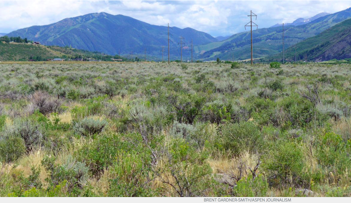
The property next to the Elam gravel pit and the Woody Creek raceway that the City of Aspen has put under contract. The city is investigating the site as a place for potential water storage, either underground or above ground.
Aspen city officials said Wednesday they plan to seek water court approval to transfer the city’s two conditional water rights to store a combined 13,629 acre-feet of water in upper Castle and Maroon creeks to other potential storage locations in the Roaring Fork River valley.
Those locations include 63 acres of land it has under contract to purchase for $2.65 million on Raceway Drive in Woody Creek, a neighboring gravel pit operated by Elam Construction Inc., the city’s golf course, portions of the Maroon Creek Club golf course owned by the city, and Cozy Point Ranch.
Aspen City Manager Steve Barwick said at a news conference the city is not walking away from its conditional water rights tied to the potential dams and reservoirs on Castle and Maroon creeks, but instead is holding on to those rights while seeking to transfer them, and their 1971 decree date, to new locations.
“We’re going to attempt to transfer the water rights down to these sites,” Barwick said. “There would not be any abandoning of water rights. It would be moving the water rights from one site to another.”
To do so, the city would have to file a new water rights application in water court and it would be up to a water court judge to determine how much of the current water rights could be transferred, and if the city can keep the 1971 decree date.
In October, the city filed two due-diligence applications for its conditional rights on Castle and Maroon creeks and is now being opposed by 10 parties.
The potential Castle Creek Reservoir would store 9,062 acre-feet of water behind a 170-foot-tall dam and the Maroon Creek Reservoir would store 4,567 acre-feet behind a 155-foot-tall dam within view of the Maroon Bells.
The city expects to put forward a settlement offer to the opposing parties next week, with the potential Woody Creek storage sites at the heart of the offer, Barwick said. A settlement meeting is slated for Aug. 2.
Paul Noto, a water attorney representing American Rivers, Colorado Trout Unlimited, and the Roaring Fork Land and Cattle Co. in the two water court cases, said Wednesday a “main issue” for his clients is whether the city will commit to “never damming” Castle and Maroon creeks.
A news release issued Wednesday by the city quoted Aspen Mayor Steve Skadron as saying the pending Woody Creek land purchase “is a way to both protect the community and preserve Castle and Maroon valley wild lands.”
Both of the dams, which the city has told the state since 1965 it intends to build someday, if necessary, would inundate portions of the Maroon Bells-Snowmass Wilderness.
“While the Castle and Maroon Creek reservoirs may have seemed like a good idea (in the 1960s), we congratulate the city for this win-win alternative that protects our iconic landscape and provides for the city’s water needs,” said Sloan Shoemaker, the executive director of Wilderness Workshop, in a press release.
(Above is audio of a press conference held at Aspen city hall on Wednesday, July 19, 2017. The audio was recorded by Elizabeth Stewart-Severy of Aspen Public Radio. The main speaker is Aspen City Manager Steve Barwick. Also present at the press conference were Curtis Wackerle, editor of the Aspen Daily News, David Krauss, editor of The Aspen Times, Elizabeth Stewart-Severy, environment reporter at Aspen Public Radio, and city staff members David Hornbacher, Margaret Medellin and Mitzi Rapkin. Aspen city council member Bert Myrin was also in the room, but did not speak. Brent Gardner-Smith of Aspen Journalism can be heard asking questions via a phone on the table in the room.).
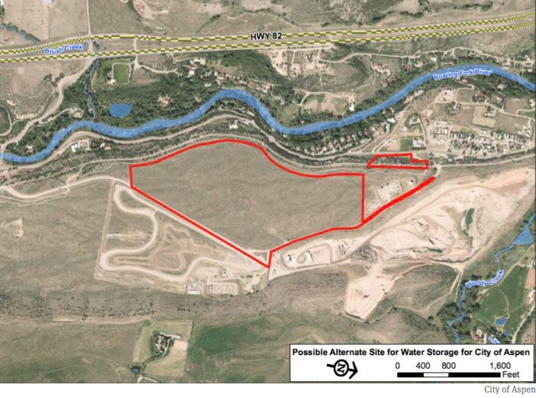
A map provided by the city of Aspen showing the two parcels in Woody Creek it has under contract. The city is investigating the possibility of building a reservoir on the site, as well as looking at the possibility of a reservoir in the neighboring Elam gravel pit.
Woody Creek options
The two Woody Creek parcels now under contract by the city include a 61-acre parcel and a 1.8-acre parcel. Both are owned by Woody Creek Development Co. of Fort Collins.
The undeveloped 61-acre parcel is valued at $2.3 million by the county assessor and the 1.8-acre parcel, also undeveloped, is valued at $100,000.
The city does not have an option to purchase the Elam gravel pit, which is visible from Highway 82, but is in discussions with the company about opportunities.
“We are interested in working with the city on its water storage project,” Russell Larsen, the chief operating officer of Elam, was quoted as saying in the news release. “There are benefits for both entities. The city can assist us with reclamation of the property into the future and we are eager to explore ways we can support Aspen’s water storage needs.”
The city also said it is researching “the environmental, hydrologic and geologic nature” of the two Woody Creek parcels, and Barwick said he expects the City Council to make a decision to purchase the land within 90 days.
The city will be studying the 63 acres for the potential to develop both above-ground storage and in-situ, or underground, storage. And Barwick said the gravel pit may present the best potential to build an above-ground reservoir, “since there is already a pit there.”
If reservoirs were developed in any of the potential locations, the stored water – if used to meet municipal water demands – would have to be pumped back up to the city’s water treatment plant, which sits on a hill behind Aspen Valley Hospital.
“Worst-case scenario, you pump water into them and then pump water back up,” Barwick said. “We would prefer someday to create a gravity-fed storage system.”
He also said the Aspen City Council must figure out how much water the city may need to store in the future. A second work session on the topic has been set for Monday evening.
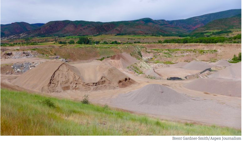
A portion of the gravel pit in Woody Creek operated by Elam Construction. It’s hard to capture the scale of the gravel pit, but the little yellow speck in the back edge of the pit is a large dump truck.
Praise from opponents
Officials from Western Resource Advocates also praised the city’s announcement.
“We’re pretty encouraged,” said Rob Harris, a senior staff attorney at Western Resource Advocates. “We’re not at the destination yet, but if you want to reach a different destination, the first concept is to change course, and it seems like the city has done that today.”
But in a news release Western Resource Advocates also included a cautionary note.
“The city’s announcement does not, in itself, end the pending water court cases considering the city’s conditional water rights,” the release said. “The city’s press release makes clear that its willingness to entirely drop the Maroon and Castle creeks dams from its water rights portfolio has preconditions.”
Noto, the water attorney for three clients in the cases, said the city’s announcement was “potentially a step in the right direction. I appreciate the fact that they are looking hard at alternatives.”
When asked about the city’s intention to try to transfer the 1971 decree date of the Castle and Maroon rights, Noto pointed out if they were successful, those rights would then be senior to the instream flow rights held on the Roaring Fork River by the Colorado Water Conservation Board and the recreational in-channel diversion rights held by Pitkin County in its new kayak park in Basalt.
“They would be jumping ahead, essentially, of two large water rights, and I’m sure that will be cause for concern,” he said.
Editor’s note: Aspen Journalism is collaborating with The Aspen Times on coverage of rivers and water. The Times published this story online on July 19 and published it in its printed edition on July 20, 2017.
From the Southeastern Colorado Water Conservancy District via The Pueblo Chieftain:
Alan Hamel has rejoined the Southeastern Colorado Water Conservancy District board as a voting member.
Hamel, 75, was appointed by Pueblo District Court Chief Judge Deborah Eyler to fill the term of Pat Edelmann on the board. Edelmann resigned because he has moved out of Pueblo County. The term will expire in April, 2018.
“This is a return to something that I love,” Hamel said. “The Southeastern District has done so much for the Arkansas River basin in the past, the present and continuing on into the future.”
Hamel served on the district board from 1988-2004, and as chairman in the final two years. Since 2004, he has served as an advisory member to the board.
Hamel retired as executive director of the Pueblo Board of Water Works in 2012, after completing a 52-year career, but remains very active in water organizations.
For the past six years, he represented the Arkansas River basin as a member of the Colorado Water Conservation Board. Gov. John Hickenlooper last month named Jack Goble, engineer with the Lower Arkansas Valley Water Conservancy District, to replace Hamel on the CWCB.
Hamel also has been a member of the Arkansas Basin Roundtable since 2005, and served in past years as chairman and as liaison to the CWCB and Interbasin Compact Committee.
Hamel is one of 15 board members for the nine-county district.
The Southeastern District is the local agency in charge of the Fryingpan-Arkansas Project. The Project brings in supplemental water from the Colorado River basin for municipal and agricultural use in the Arkansas River basin.
The district is continuing efforts to build the Arkansas Valley Conduit, which will provide fresh drinking water to 40 communities serving 50,000 people east of Pueblo.
The district’s enterprise is completing negotiations to build a hydroelectric power plant at Pueblo Dam, which could be up and running as soon as May 2018.
Here’s a retrospective about the July 28, 1997 flood from Erin Udall running in the The Fort Collins Coloradoan. Click through to read the whole article. Here’s an excerpt:
The water reached over heads, its strong current carried cars from roads and pulled people from their doorsteps or out of the grasp of loved ones.
Witnesses could hear yells for help, see trailers wash off their foundations and smell the propane that streaked the debris-filled floodwaters.
“It was emergency sensory overload,” retired Poudre Fire Authority Captain Steve Fleming said, as he recalled the night Fort Collins’ ankle-deep Spring Creek turned the small city into a scene of tragic flooding, fires and fatalities.
As July 28, 1997 ended and a new day began, Fort Collins was faced with a new city — one full of twisted debris, totaled cars and forever-changed families.
Twenty years later, walk through the events of that night with this timeline of the Spring Creek Flood. See how heavy rain turned a creek into a deadly river. Watch as a festival-like atmosphere — with people kayaking in the streets — gave way to a somber city the next morning. And revisit the places that were washed away and rebuilt.
How it started — Heavy rainfall pounded parts of Fort Collins, with isolated storms wetting the city on July 27, 1997. The following day, it was about to get worse.
Nolan Doesken — Colorado Water Foundation for Water Education President’s Award Presentation 2011
The flood moved Nolan Doesken to create CoCoRaHS. Here’s a report from Kevin Duggan from The Fort Collins Coloradoan. Here’s an excerpt:
In the wake of the flash flood, which killed five women, injured 54 people and caused $200 million in damage, Doesken wanted to understand the storm and how events played out as they did.
Through the Coloradoan and other media outlets, he asked community members to report as accurately as possible rainfall amounts at their homes and businesses. High school students went door to door looking for reliable measurements.
About 300 reports were collected.
While the official weather station at Colorado State University measured about 6 inches of rainfall, data collected from the community revealed that 10 to 14.5 inches of rain fell on the west side of the city during a 30-hour period.
During the same period, the city’s east side received about 2 inches.
The heaviest rainfall centered on the area near Drake Road and Overland Trail and the foothills. The deluge set a record for rainfall over an urban area in Colorado that still stands.
The variance in rainfall totals across the city inspired Doesken to find ways to correlate weather radar estimates of rainfall amounts with what happens on the ground. And the Community Collaborative Rain, Hail and Snow, or CoCoRaHS, network, began.
Volunteers use rain gauges, aluminum-wrapped hail pads and rulers to measure precipitation. Daily results are reported through the program’s website, maintained by the Colorado Climate Center at CSU.
Since its start in Larimer County in 1998, CoCoRaHS has spread across the country to all 50 states and the District of Columbia, Puerto Rico, Canada and the Bahamas.
Data from reports are used in a variety of areas, including weather forecasting, water management, transportation planning and mosquito control.
CoCoRaHS and other observation networks provide important information for weather forecasters, said Thomas Trunk, a meteorologist with the National Weather Service’s Office of Observations in Silver Springs, Maryland.
Click here to go to the US Drought Monitor website. Here’s an excerpt:
Summary
An upper-level ridge of high pressure dominated the western contiguous U.S. (CONUS) during this U.S. Drought Monitor (USDM) week. The ridge inhibited precipitation and kept temperatures warmer than normal across much of the West. Weekly mean temperatures were as much as 8 degrees above the long-term average from the Southwest to northern High Plains. Pacific fronts and weather systems rode over the top of the ridge, taking a northerly track which brought them across the drought-plagued northern Plains then into a trough over the eastern CONUS where they stalled out over the Southeast. Monsoon showers developed in the Southwest, bringing above-normal precipitation to some areas, and small but intense storms developed with the fronts as they moved across the northern and central Plains. But only a few of these storms brought above-normal precipitation to the Plains. Summertime convection and frontal lifting brought rain to parts of the southern Plains and areas east of the Mississippi River. The prolonged and intensifying drought ravaged crops and rangeland in the northern Plains, while soils continued to dry out across the West, Plains, and into the Mid-Atlantic region. Exceptional Drought (D4) returned to the USDM map this week as spots of D4 developed in the northern Plains where below-normal rain fell, and D0 expanded in parts of the Southwest where the monsoon precipitation was below normal. Persistent below-normal precipitation and enhanced evapotranspiration due to excessive heat expanded areas of drought and abnormal dryness in the central Plains to Midwest…
High Plains
Locally heavy rains fell in southern parts of the High Plains, with over 3 inches reported at several stations in southeast Colorado and southern Nebraska. A few stations in the Dakotas and Kansas received an inch or more of rain this week, but the showers and thunderstorms were spotty and amounts varied significantly. Most stations in the region were drier than normal this week with many receiving a tenth of an inch of rain, if any. With daily temperatures exceeding 90 degrees F, the 7-day average maximum temperature was above 90 in a band from Montana to Kansas. The excessive heat increased evapotranspiration, as reflected in the extreme ESI and EDDI values, and further dried soils which were already parched. According to July 17 USDA reports, topsoil and subsoil moisture was short to very short across 88%/80% (topsoil/subsoil) of Montana, 85%/79% of South Dakota, 65%/58% of North Dakota, 65%/57% of Nebraska, and 62%/58% of Wyoming. The heat and dryness have ravaged crops, with 61% of the spring wheat crop in poor to very poor condition in Montana and 40% in North Dakota. In South Dakota, 74% of the spring wheat was in poor to very poor condition, 38% of the corn crop, 33% of soybeans, and 45% of sorghum. The pasture and rangeland statistics (in poor to very poor condition) were 74% for North Dakota, 68% for South Dakota, 58% for Montana, and 26% for Nebraska. As noted by the North Dakota State Climatologist, the spotty rains might have been enough to green-up the vegetation, but not enough to increase the vegetative volume. Reports from the field include many reports of extensive drop damage, livestock water holes drying up, and cattle losing weight due to poor or nonexistent grazing land. The South Dakota State Climatologist reported that corn is in tasseling stage now; under drought stress, this can lead to an 8% yield loss per day, which is the highest rate of yield loss of any crop stage. The agricultural impacts were compounded by low streamflows. According to the Bureau of Indian Affairs, the Ft. Peck and Ft. Belknap Tribes in Montana declared disaster emergencies in June that remain in effect; the Rocky Boy’s reservation, south of Havre, is experiencing drastic water shortages; and several Tribes in the eastern part of Montana have enacted burn bans.
With many indicators, such as SPI, EDDI, ESI, and soil moisture, converging to exceptionally dry conditions, spots of D4 were added to the USDM depiction in Montana and North Dakota. D0-D3 were expanded in the Dakotas with collateral expansion in adjacent states (Nebraska, Iowa, and Minnesota). D0-D1 were expanded in Nebraska and Kansas, but D0-D1 were trimmed in other parts of Nebraska and Kansas where an inch to several inches of rain fell…
West
In the Southwest, several inches of rain fell with monsoon showers and thunderstorms in central to southern Arizona, with 1-2 inches in parts of northwest Arizona and parts of New Mexico. But other parts of these states had less rain, and amounts tapered off to zero farther north into the Great Basin. Pasture and rangeland conditions continued to deteriorate in spite of the rain, with poor to very poor classifications increasing from 43% last week to 53% this week in Arizona, and from 36% to 45% in New Mexico. In California, 35% of the pasture and rangeland was rated in poor to very poor condition. D0 expanded in Arizona, Utah, southern Nevada, northwest New Mexico, and southwest Colorado where precipitation was generally below normal for the week. But D0 was pulled back along the east slopes of the Rockies in central Colorado where 2-4 inches of rain was reported.
In the Northwest and northern Rockies, a few tenths of an inch of rain was recorded at coastal stations in Oregon and Washington, and at a few stations in the Rockies, but the week was essentially dry across much of the Pacific Northwest. Even though this is the dry season for much of this region, the rain that did fall was almost universally below normal. D0 was added to parts of Washington, Oregon, and Idaho, based on 90-day indicators and drying soils, and expanded in western Montana. July 17 USDA reports indicated that topsoil/subsoil moisture was short or very short across 54%/42% of Oregon, 57%/33% of Washington, and 47%/44% of Idaho…
Looking Ahead
In the 2 days since the Tuesday morning cutoff time of this week’s USDM, additional frontal storms have moved across the northern and central Plains, and monsoon showers and thunderstorms have brought additional rain to parts of the Southwest. For July 20-24, 1 to locally 4 inches of rain is forecast for the Four Corners States and from the eastern Dakotas to Northeast, and half an inch to an inch is predicted for the central to northern Plains and most of the country along and east of the Mississippi River. Areas expecting little to no rain include much of the West from California to central Montana, most of Texas, and parts of the western Carolinas. Temperatures are forecast to be above normal for most of the CONUS. Little relief from the heat can be expected as above-normal temperatures are in the outlook for most of the CONUS and Alaska for July 25-August 2, with only the Northeast and parts of the coastal Northwest maybe having cooler-than-normal temperatures. Odds favor below-normal precipitation for coastal southern Alaska, the Pacific Northwest to northern Rockies, and most of the Plains into the Midwest. Above-normal monsoon precipitation is likely to continue for the Southwest, and Alaska is expected to be wetter than normal. The Northeast may start out drier than normal, then turn wetter than normal.