#Drought news: D0 (Abnormally Dry) expanded over Front Range

Click here to go to the US Drought Monitor website. Here’s an excerpt:

Summary

An upper-level ridge of high pressure maintained its grip across the contiguous U.S. (CONUS) during this U.S. Drought Monitor (USDM) week. The ridge kept temperatures warmer than normal from coast to coast, with the highest temperature departures from the High Plains to Mid-Atlantic States. Weather systems moving in the jet stream flow rode over the top of the ridge, taking their surface lows and Pacific fronts along a northerly track into a trough over the eastern CONUS where they stalled out across the Midwest. Showers and thunderstorms developed as the fronts moved across the northern Plains and into the Midwest, but rainfall amounts were mostly below normal. Above-normal precipitation fell in places along the North Dakota/South Dakota border, from northeast South Dakota to northern Illinois, from the Ohio Valley to Mid-Atlantic States, and across parts of Nebraska and Kansas. Above-normal precipitation fell across parts of the southern Plains to Southeast as afternoon heating triggered convective storms, and a front near the end of the week sagged south. The Southwest Monsoon continued this week, bringing above-normal precipitation to much of the 4-Corners States and contracting drought and abnormal dryness. But drier-than-normal weather dominated the rest of the West, most of the Plains, much of the Midwest and South, and parts of the Mid-Atlantic and New England. Soils continued to dry out and crops suffered as drought and abnormal dryness continued to expand or intensify across the Plains, Midwest, northern Rockies, and Virginia…

High Plains

Half an inch or more of rain fell across parts of the Dakotas this week, but the rain did little to improve drought conditions, only holding off drought expansion or intensification. D0-D3 were pulled back in parts of South Dakota where rainfall amounts totaled 2 inches or more, D0 was pulled back in southeast North Dakota and southwest Minnesota, and D0-D1 were pulled back in parts of north central and south central Nebraska and north central Kansas.

But expansion occurred in other parts of the region. Much of Montana and parts of the Dakotas, Nebraska, and Kansas had no rain this week; some areas have been drier than normal for the last 2 to 3 months; and some drought indicators reflect dryness for the last 12 months. D3-D4 were expanded in northeast Montana, and D3 expanded in northwest South Dakota and was added in southeast South Dakota, where the Standardized Precipitation Index (SPI) was consistently at those dry levels for the last 1 to 9 months. D1-D4 expanded in northwest North Dakota where the SPI was consistently at those dry levels for the last 1-6 months. D0-D2 expanded across much of Nebraska, with collateral expansion of D1-D2 in adjacent South Dakota, D1 in adjacent Iowa, and D0-D1 in southeast Wyoming, and D0 expanded in parts of eastern Kansas and northeast Colorado, due to 30-90 day precipitation deficits and high evapotranspiration caused by excessive heat. Governors provided much-needed response to the dire drought impacts. Montana Gov. Steve Bullock issued an executive order declaring a drought disaster in 28 counties and five Indian reservations in the eastern part of the state. Nebraska Gov. Pete Ricketts issued an emergency proclamation, allowing the state Emergency Management Agency to address unmet drought needs, particularly those related to wildfires. According to July 23rd USDA reports, 92% of the topsoil moisture and 88% of the subsoil moisture were rated short or very short in Montana, 82%/81% of the topsoil/subsoil moisture was short or very short in South Dakota, 71%/66% in Nebraska, 67%/62% in North Dakota, 61%/58% in Wyoming, and 45%/41% in Colorado. More than half of the pasture and rangeland were rated in poor to very poor condition in North Dakota (75%), South Dakota (73%), and Montana (56%). In South Dakota, 37% of the corn crop, 34% of soybeans, 57% of sorghum, and 76% of the spring wheat were in poor to very poor condition. In North Dakota, 23% of the corn crop and 39% of the spring wheat were in poor to very poor condition. In Montana, 55% of the spring wheat was in poor to very poor condition. According to media reports, as of July 25th, the Lodgepole Complex wildfire in Montana was the largest wildfire in the CONUS…

West

In the Southwest, several inches of rain fell with monsoon showers and thunderstorms in much of Arizona and parts of New Mexico, with 1-2 inches common across parts of western Colorado. With SPI indicators in Arizona wet at several time scales from 1 to 6 months and longer, D1 in Yavapai County was deleted and D0 or D1 were pulled back in parts of the west and south. D0 or D1 were trimmed in parts of western New Mexico and southern Nevada. But other areas were not as fortunate, with below-normal precipitation common this week across parts of New Mexico, northern Nevada, and northern Utah, where D0 was expanded. USDA statistics indicate topsoil/subsoil moisture was short or very short in 62%/60% of New Mexico, 52%/42% of Utah, 35%/25% of Nevada, and 75%/75% of California, and 41% of the pasture and rangeland was in poor to very poor condition in New Mexico. No change to the depiction was made in California.

No rain fell this week across most of the Northwest and northern Rockies, with only a tenth of an inch or two tenths recorded at coastal stations in Oregon and Washington, and at a few stations in the Rockies. The continued dryness further eroded soil moisture, with USDA reports indicating topsoil/subsoil moisture short or very short across 71%/44% of Washington, 62%/51% of Oregon, and 52%/47% of Idaho. A fifth of the pasture and rangeland was rated in poor to very poor condition in Washington (22%) and Oregon (20%). D0 was added to the interior coastal area of Washington where streamflow and modeled soil moisture were below normal, and D0 expanded across western Montana and parts of north central Idaho, and D1 added to the mountains of northwestern Montana, where 2-3 month dryness was acute and growing worse. Numerous large wildfires have broken out in this area…

Looking Ahead

In the 2 days since the Tuesday morning cutoff time of this week’s USDM, heavy rains moved across parts of the northern and central Plains and Midwest, and monsoon showers and thunderstorms brought additional rain to parts of the Southwest. For July 27-31, 1-2 inches of rain is forecast for parts of the Midwest to Mid-Atlantic region, coastal Southeast, and Southwest to southern High Plains. Rainfall amounts may be locally as high as 3 inches from the Midwest to Mid-Atlantic, as high as 5 inches in the coastal Southeast, and as high as 6 inches in the central Rockies to southern High Plains. Less than an inch is predicted for much of the Plains, Northeast, Great Lakes, and Lower Mississippi Valley, while no rain is expected for most of the Far West and parts of the northern and southern Plains. Temperatures are predicted to be warmer than normal in the West and cooler than normal in the East. For August 1-9, odds favor drier-than-normal weather in the Northwest, northern Plains, and Upper Mississippi Valley, and wetter-than-normal weather across the Southwest, southern Plains, and Southeast, as well as parts of Alaska. The Northeast likely will start out drier than normal but end up wetter than normal. Odds favor warmer-than-normal temperatures for Alaska, the West, northern Plains, and parts of the East Coast, and cooler-than-normal temperatures for the southern Plains to Ohio Valley.

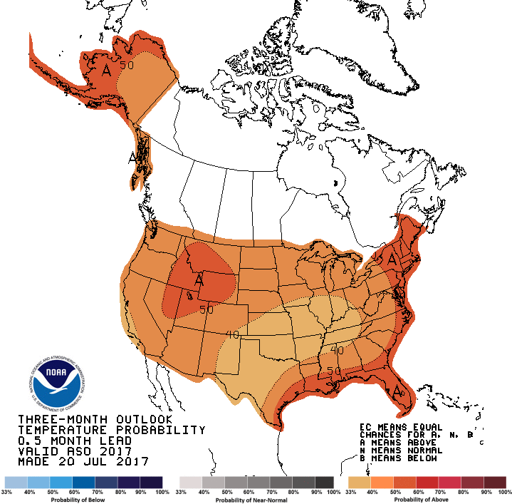
So what do the prognosticators think is in store for Colorado for the next 3 months? Hot with above average precipitation in W. Colorado and equal chances for average precipitation E. of the Great Divide.

Three month temperature outlook through October 31, 2017 via the Climate Prediction Center.
Three month precipitation outlook through October 31, 2017 via the Climate Prediction Center.

How Lakewood keeps it green when the heat is on – News on TAP

Local park district reduces water use by 28 million gallons annually after irrigation technology upgrades.

Source: How Lakewood keeps it green when the heat is on – News on TAP

Volunteers Wanted to Restore Watershed in South Park, August 2, 2017

Upper South Platte Basin

From the Public News Service:

Volunteers and U.S. Forest Service staff are headed back into South Park’s Farnum Roadless area to restore critical watershed, native plants and wildlife habitat.

Misi Ballard, Wild Connections board member and broadband leader for the group “Great Old Broads for Wilderness,” led an effort earlier this month, checking on a project south of Tarryall Reservoir, and will be helping close off national forest lands damaged by illegal motorized recreation on Aug. 2, a week from today.

“The Pike-San Isabel is basically Denver’s backyard,” she said. “Within an hour of the metropolitan area, you can be in a wilderness – and as such, it gets pounded, every weekend.”

More than 2,000 square miles in the Pike and San Isabel national forests have been set aside exclusively for motorized off-road recreation, and Ballard said people often aren’t aware they’ve entered protected areas. Volunteers will be posting signs and fencing, and reseeding to help the land heal.

Ballard noted that unauthorized “bogging” – where jeeps and other all-terrain vehicles ride around in muddy areas – not only puts fish populations at risk but also pollutes drinking water. The Upper South Platte River watershed and South Park’s North Fork Valley supply water to 60 percent of communities along the Front Range.

“Our water is only as good as our headwaters,” she said. “There is no redundancy in Denver Water’s system. Things happen in the upper reaches of the South Platte watershed, and it impacts Denver’s water.”

Once people understand why closures are important, she said, they tend to follow the rules.

“There’s been a lot of positive comments on the closures,” she said, “especially from hunters, saying that they have had bad hunts for many years because of the presence of motorized recreation.”

Ballard said helping restore wilderness areas is fun and a way for her to give back for the many years she’s enjoyed Colorado’s outdoors.

Those who’d like to join her and other Great Old Broads for Wilderness in their efforts can call 817-939-4239.

@RockiesProject: The fifth and final section of the 2017 State of the Rockies Report is now available online!

From Colorado College State of the Rockies Project:

Inclusive River Governance for a Changing West

Research undertaken by Colorado College undergraduates has always been at the core of the State of the Rockies Project. In this year’s report, the final publication stemming from our two-year focus on western water issues, our five Student Fellows investigate current policies and actions surrounding river governance and water management in the Columbia and Colorado River Basins.

From tribal water rights to shifting paradigms of environmental management and the impacts of climate change on mountain snowpack, the sections of the 2017 State of the Rockies Report focus on different ways in which management of our most critical resource is becoming increasingly sensitive to the social and ecological realities of the 21st century.

Our research this past year has taken us to Native American reservations, salmon hatcheries, the site of a massive dam removal project, and the headquarters of a large power company. In pursuit of a deeper understanding and more holistic perspective, students engaged with diverse stakeholders whose backgrounds range from natural resource law to hydrology. The results of their hard work are available below in individual sections or a combined report.

Download the 2017 State of the Rockies Report

Fort Collins takes a deep dive into @NorthernWater’s proposed NISP mitigation plan for Cache la Poudre through town

Poudre River Bike Path bridge over the river at Legacy Park photo via Fort Collins Photo Works.

From The Fort Collins Coloradoan (Kevin Duggan):

The plan proposed by Northern Water, proponent of Glade and the controversial Northern Integrated Supply Project, or NISP, contains “new, useful and encouraging mitigation measures,” according to a staff memo to the Fort Collins City Council.

However, the effort falls short of addressing the city’s long-running concerns about how reducing flows on the Poudre to store water in Glade would affect the river’s ecological health and water quality.

More needs to be done in several areas addressed by the $59 million Fish and Wildlife Mitigation and Enhancement Plan to make it adequate as far as the city is concerned, John Stokes, director of Fort Collins Natural Areas, told City Council members Tuesday.

Areas of concern include ensuring flows on the river during the spring runoff are high enough to flush sediment and protect fish and wildlife habitat. High flows also are needed to protect water quality, city officials said.

City staff members recommend establishing an annual three-day period during peak flow on the river when no water would be taken for NISP in hopes of “cleaning” the river and boosting its health.

Another issue is the amount of funding in the plan that would be set aside for mitigation and channel improvements. The $7.8 million in the plan for restoration and enhancement should be increased by $14.2 million, city staff said.

City Council members were divided on the staff’s comments and recommendations for the mitigation plan, with council member Ken Summers saying they seemed “extreme” while others said they weren’t strong enough…

Northern Water has listened to the city’s concerns and changed its plans to address them, said agency spokesman Brian Werner in a telephone interview.

Operational plans include “flushing flows” when river conditions and water rights allow, he said. Northern also has agreed to minimum flows through Fort Collins of 25 cubic feet per second, or cfs, in the summer and 18 cfs in winter to support habitat.

The mitigation plan could be changed as NISP continues through the permitting process, he said.

“We think this a great opportunity to make that river better,” Werner said.

The city’s comments on the NISP wildlife mitigation plan will be sent to the Colorado Parks and Wildlife Commission, which must approve the plan as part of the lengthy permitting process for project. So even if the wildlife mitigation plan gets approved, other agencies would still have to approve permits for NISP to become a reality.

In 2008 and 2015, the council adopted resolutions stating the city could not support NISP as described in draft environmental impact statements…

While not supporting NISP, the city’s comments and recommendations on how it might operate are based on the scenario that “if” the project is built, “then” certain steps should be taken to protect the city’s interests, Stokes said.

If the mitigation plan is approved by the Parks and Wildlife Commission, it will be submitted to the Colorado Water Conservation Board and then the Governor’s Office for approval.

Federal agencies that ultimately would permit NISP are likely to defer to the state’s position on mitigation plans, Stokes said, so communicating the city’s views on the project to the state is a critical step in the process…

What’s next

The Fort Collins City Council on Aug. 8 is scheduled to consider the city’s comments on the fish and wildlife mitigation plan for the Northern Integrated Supply Project that has been submitted to the Colorado Parks and Wildlife Commission.

The commission is scheduled to discuss the plan during its Aug. 10-11 meeting in Trinidad and its Sept. 7-8 meeting in Steamboat Springs.

Comments on the city’s proposed comments may be made at http://www.fcgov.com/nispreview through July 30.

Comments may be emailed directly to the Colorado Parks and Wildlife Commission at dnr_cpwcommission@state.co.us.

Northern Integrated Supply Project (NISP) map July 27, 2016 via Northern Water.

@ColoradoStateU: Small amount of water yields big benefits for Colorado landscapes, CSU study says

Here’s the release from Colorado State University (Jason Kosovski):

Colorado State University’s study The Hidden Value of Landscapes: Implications for Drought Planning is the first study of its kind in the state to quantify how much water landscapes use and their environmental, economic and social benefits. The study looked at the three percent of total Colorado water used for landscapes and found a significant return on investment from this water.

“The use of 3 percent of Colorado’s available water to maintain green landscapes is a legitimate allocation of water resources,” said Tony Koski, professor and Extension Turf Specialist in CSU’s Department of Horticulture and Landscape Architecture.

The study was led by Koski, Zach Johnson, associate professor in the Department of Horticulture and Landscape Architecture, and Alison O’Connor, a horticulture agent with CSU Extension in Larimer County.

“We were aware of a lot of anecdotal information about the benefits of landscapes, but this is the first time the information has been synthesized and analyzed,” said Johnson.

Environmental, economic and social landscape benefits

Some of the environmental, economic and social landscape benefits the study notes include:

  • 48 pounds of carbon dioxide are absorbed by one tree each year.
  • Trees provide air quality benefits for Colorado cities valued in the high six figures.
  • 25 percent fewer crimes occur in public housing with landscapes.
  • Every $1 invested in a home landscape yields a 135 percent return on the home value.
  • Seven percent higher rents are paid on commercial properties with attractive landscapes.
  • 45 percent cooler temps occur when cars are shaded by trees.
  • Outdoor urban spaces increase mental and physical health and children who spend time outdoors are better learners.
  • The awareness of water planning is at an all-time high in Colorado with the completion of the Colorado Water Plan, and this study can serve as a tool for water policy makers tasked with ensuring there is enough water to weather future droughts and projected population growth.

    “When water supplies diminish, it is easy to argue that irrigating landscapes is not the best use of water but there are serious consequences when urban landscapes and parks are targeted,” said Koski. “The unintended consequences from the ‘cash for grass’ buyouts in Nevada and California resulted in trees and other plants dying and succumbing to disease when deprived of regular irrigation. It’s impossible to instantly replace a 30-year-old shade tree; the cooling benefits it provides are lost forever as is the character and functionality of parks and neighborhoods.”

    Reduced water consumption

    The study notes that in the past decade, Colorado water users have reduced per capita water consumption by slightly under 20 percent through a combination of using best management practices on landscapes, improved irrigation technologies, tiered rate structures, and increased general awareness among users that they should conserve.

    “In Colorado, drought is not a matter of ‘if’ but of ‘when,’ ” added Johnson. “Increased conservation is necessary for drought planning and this study provides water planners information to adopt a holistic approach by factoring in the value of landscapes when formulating water policy.”

    More information

    The study was commissioned by the Associated Landscape Contractors of Colorado and conducted independently by the CSU research team. For more information, the full study can be found here.