Jerd Smith. Photo credit: Water Education Colorado.
I am so excited that WECO is putting this together. Water journalism will reap huge benefits from this effort. I have read a lot of content from Jerd Smith over the years. She is accurate and understands the complexities of water issues in the West. She has an accessible writing style that will help you understand and learn.
From email from Water Education Colorado:
Spring is in the air, and our team is growing! I am pleased to announce that we have hired a new staff member here at Water Education Colorado. Please welcome Jerd Smith, an award-winning editor and reporter, who will lead a news initiative designed to expand coverage of the critical water issues facing Colorado and the American West.
Jerd is a respected journalist with a deep background on water in Colorado. I am thrilled that she has joined our team to tackle this important new program offering. Our goal in bringing Jerd on is to reach a much wider audience with timely, relevant information about what is happening in Colorado water. This will round out the suite of programs we already offer to advance awareness and informed decision making statewide.
Jerd most recently served as business news editor overseeing coverage for the Boulder Daily Camera and Times-Call newspapers in Boulder County. She spent more than a decade at the Rocky Mountain News before its closure in 2009. While there, she led a drought team that won Stanford University’s first Risser Prize in environmental reporting. Her work has also been honored by the Associated Press, the Society of Professional Journalists, Scripps, and the American Planning Association, among others. Jerd has also been a regular contributor to Headwaters magazine over the past 10 years.
In her new role at Water Education Colorado, Jerd will help design and launch a weekly digital news report that includes in-depth reporting on current water issues. This content will be available at no cost to other media and news organizations that choose to carry it, as well as to Water Education Colorado members and the general public, via our website and various social media platforms.
Click here to read Jerd’s article, “Keeping It Clean: Protecting and enhancing water quality on the Colorado”, from the Summer 2011 issue of Headwaters Magazine.
In Boulder, Colorado, climate change means extreme weather and wildfires. It means worrying about water security for people and farms, and about heat waves and mosquito-borne diseases. These aren’t just future risks—they’re problems the city and its surrounding county are facing now.
On Tuesday, the city and Boulder County joined San Miguel County, home to the ski slopes of Telluride, in suing two fossil fuel companies—ExxonMobil and Suncor—over the costs of dealing with climate change.
Their lawsuit is the latest in a string of legal actions by communities that are attempting to hold fossil fuel companies accountable for the problems climate change creates. Until now, the plaintiffs had been coastal cities and counties worried primarily about sea level rise.
The new case takes climate litigation to the middle of the country, where the risks take on new shapes and high costs.
The Colorado communities are already seeing climate-related damage to property, health and safety, and “the damage will only multiply as climate change worsens,” the lawsuit says.
It points to the dwindling snowpack, which is critical for the state’s agriculture, water supply and $5 billion ski industry. (This month, the snowpack in southern Colorado was 50 percent of normal.) It also raises concerns about the loss of water flow into the Colorado River, and about extreme summer heat, wildfires and droughts. (San Miguel County, like much of the Four Corners region, is facing extreme drought conditions.)
The Colorado plaintiffs, like cities and counties suing oil companies in California, accuse ExxonMobil and the Canadian oil sands company Suncor of creating a public nuisance through the burning of fossil fuels that is costing them money and putting their residents and property at risk.
They say the fossil fuel companies “intentionally engaged in conduct that has caused and contributed to climate change, thus causing flood waters, fire, hail, rain, snow, wind and invasive species to enter plaintiffs’ property.”
And they also cite the Colorado Consumer Protection Act, claiming the companies engaged in “deceptive trade practices”—an allegation similar to the Massachusetts attorney general’s investigation currently underway into Exxon.
Boulder, Boulder County, and San Miguel County are taking ExxonMobil and Suncor Energy (Canada’s biggest oil company) to court in an effort to hold them accountable for damages caused by extreme weather — events scientists have linked to increased levels of greenhouse gases in the atmosphere. Colorado has seen a 2 degree F increase on average over the past 30 years, making it the 20th fastest warming state in the U.S. since 1970.
The three plaintiffs in the lawsuit say their communities have endured wildfires and flash floods fueled by climate change. They want ExxonMobil and Suncor to pay millions for the damage and fork over additional money to fund climate adaptation initiatives.
“Plaintiffs have taken substantial steps to reduce their own GHG emissions,” the complaint says. Meanwhile, “Defendants have acted recklessly.” Watch out, Big Oil! Colorado isn’t pulling its punches.
Most cities suing oil companies over the impact of climate change want help paying for walls to protect against rising sea levels. And then there’s Boulder, Colorado.
The politically liberal town known as the gateway to the Rocky Mountains and two counties in the same neck of the woods said Colorado’s economy depends on snow, water and cool weather when they accused Exxon Mobil Corp. and Suncor Energy Inc. of “causing and exacerbating climate change” in a state-court lawsuit filed Tuesday.
“Reducing greenhouse gas emissions is a global issue and requires global participation and actions,” Exxon spokesman Scott Silvestri said in an email. “Lawsuits like this — filed by trial attorneys against an industry that provides products we all rely upon to power the economy and enable our domestic life — simply do not do that.” Suncor didn’t immediately respond to a request for comment.
The Colorado communities said they’re facing expenses and costs related to earlier snow melt, which has increased the risk of forest fires, dried-out soil, beetle outbreaks and drought.
The lawsuit, filed Tuesday in a state district court by Boulder, Boulder County and San Miguel County, is seeking compensation for damage and adaptation costs resulting from extreme weather events.
New York City and eight coastal California cities and counties, including San Francisco and Oakland, have filed similar lawsuits against ExxonMobil and other oil and gas companies, charging that they have injured their communities under common law. The Colorado suit is the first by an inland county or municipality.
“Climate change is not just about sea level rise. It affects all of us in the middle of the country as well,” said Boulder County Commissioner Elise Jones. “In fact, Colorado is one of the fastest warming states in the nation.”
Oil Industry Knew About Threat 50 Years Ago
The 1,300-square-mile San Miguel County sits in the southwest corner of the state on the Utah border. About a third of the county’s 8,000 residents live in Telluride, a well-known ski resort town. Boulder, 25 miles northwest of Denver, is the county seat of the 740-square-mile Boulder County and home to nearly a third of the county’s 319,000 residents. The three communities have been ravaged by costly climate-related extreme weather events, including wildfires and flash floods, according to the 100-page complaint. Likewise, each community has launched initiatives to curb carbon emissions and adapt to a changing climate.
The Colorado communities contend that ExxonMobil and Suncor were aware that their products caused global warming as early as 1968, when a report commissioned by the American Petroleum Institute (API), the U.S oil and gas industry’s premier trade association, warned of the threat burning fossil fuels posed to the climate. Subsequent reports and memos prepared for API and its member companies came to similar conclusions. Regardless, ExxonMobil and Suncor not only continued to produce and market fossil fuel products without disclosing their risks, the complaint charges, they also engaged in a decades-long disinformation campaign to manufacture public doubt and confusion about the reality and seriousness of climate change.
The plaintiffs want the two oil giants to “pay their share of the damage” caused by their “intentional, reckless and negligent conduct.” That share could amount to tens of millions, if not billions, of dollars to help cover the cost of more heat waves, wildfires, droughts, intense precipitation, and floods.
“Our communities and our taxpayers should not shoulder the cost of climate change adaptation alone,” said Boulder Mayor Suzanne Jones. “These oil companies need to pay their fair share.”
Over the last four decades, wildfires in the Rockies have been happening with greater frequency. According to a 2014 study by the Union of Concerned Scientists (UCS) and the Rocky Mountain Climate Organization (RMCO), the region experienced nearly four times as many wildfires larger than 1,000 acres between 1987 and 2003 than between 1970 and 1986.
Rocky Mountain trees also are being ravaged by bark beetles. Over the last 25 years, the UCS-RMCO report found, beetles have killed trees on regional forest land nearly equal in acreage to the size of Colorado itself. Heat and drought are taking a toll, too, exacerbating tree mortality. If global warming continues unabated, the region likely will become even hotter and drier, and the consequences for its forests will be even more severe.
The average temperatures in Colorado have increased more than 2 degrees F since 1983, according to a 2014 University of Colorado Boulder study, and are projected to jump another 2.5 to 5 degrees F by mid-century. That would have a devastating effect on the Colorado economy, which relies heavily on snow, water and cool weather. A 2017 study by the Natural Resources Defense Council and Protect Our Winters found that low-snow winters and shorter seasons are already having a negative impact on the state’s $5-billion ski industry, the largest in the country. Rising temperatures and drought, meanwhile, threaten the state’s $41 billion agricultural sector.
ExxonMobil and Suncor Are Major Carbon Emitters
Both ExxonMobil and Suncor have substantial operations in Colorado. Since 1999, ExxonMobil has produced more than 1 million barrels of oil and 656 million metric cubic feet of natural gas from Colorado deposits, according to the complaint, and ExxonMobil subsidiary XTO Energy currently produces 130 million cubic feet of natural gas per day from more than 864 square miles across three Colorado counties. There are also at least 20 Exxon and Mobil gas stations in the state. All told, the company’s production and transportation activities in Colorado were responsible for more than 420,000 metric tons of global warming emissions between 2011 and 2015, according to the complaint.
Suncor gas stations, which sell Shell, Exxon and Mobil brand products, supply about 35 percent of Colorado’s gasoline and diesel demand. Suncor, whose U.S. headquarters is located in Denver, also owns the only oil refinery in the state, which produces 100,000 barrels of refined oil per day. According to the complaint, Suncor’s Colorado operations were responsible for 900,000 metric tons of carbon emissions in 2016 alone.
Besides their Colorado facilities, the two companies are partners in Syncrude Canada, the largest tar sands oil developer in Canada. Tar sands oil—a combination of clay, sand, water and bitumen—produces roughly 20 percent more carbon dioxide emissions per barrel than regular crude oil.
ExxonMobil and Suncor are among the 90 fossil fuel producers responsible for approximately 75 percent of the world’s global warming emissions from fossil fuels and cement between 1988 and 2015, according to the Climate Accountability Institute. Over that time frame, the two companies’ operations and products emitted 20.8 gigatons of carbon dioxide and methane.
“Based on the latest scientific studies, the plaintiffs in Colorado, as well as in California and New York City, can now show the direct connection between carbon emissions and climate-related damages,” said Kathryn Mulvey, climate accountability campaign director at UCS. “Given these companies’ significant contribution to climate change—and their decades of deception about climate science—it is long past time that they should be held accountable for the damage they have caused.”
The Water Quality Control Commission imposed standards for PFOS and PFOA, two types of perfluorinated chemicals (PFCs), the contaminants found in ground water as a result of Peterson Air Force Base using firefighting foam for years. The chemicals leached into the underground water supply, befouling wells and wreaking havoc on supplies in the Fountain Valley.
The standard adopted by the commission is 70 parts per trillion for PFOS and PFOA, which was proposed by the Colorado Department of Public Health and Environment’s Hazardous Materials and Waste Water Management Division.
“This will give regulators the authority they need to hold polluters accountable for cleaning up to that level,” the coalition said in a release. “It will also give them a much needed tool to better monitor discharge into the aquifer and prevent further … contamination of our drinking water.”
The coalition also noted that it argued successfully against Colorado Springs Utilities’ bid to exclude its solids handling facility from the protected site. Biosolids have been identified as a possible source of PFOS contamination and Utilities’ facility lies within the alluvial aquifer targeted for protection.
This visualization is based on the first three-dimensional numerical model of melting snowflakes in the atmosphere, developed by scientist Jussi Leinonen of NASA’s Jet Propulsion Laboratory in Pasadena, California. A better understanding of how snow melts can help scientists recognize the signature in radar signals of heavier, wetter snow — the kind that breaks power lines and tree limbs — and could be a step toward improving predictions of this hazard.
The model reproduces key features of melting snowflakes that have been observed in nature: first, meltwater gathers in any concave regions of the snowflake’s surface. These liquid-water regions merge as they grow and eventually form a shell of liquid around an ice core, finally developing into a water drop.
The visualization shows a typical snowflake less than half an inch (one centimeter) long. The snowflake is composed of individual ice crystals whose arms became entangled when they collided in the air. The extremities of the arms melt first because they are more exposed to heat from the surrounding air. Water first fills small cavities within the ice crystals, and then these overflow, allowing water to pool into droplets.
“I got interested in modeling melting snow because of the way it affects our observations with remote sensing instruments,” Leinonen said. A radar “profile” of the atmosphere from top to bottom shows a very bright, prominent layer at the altitude where falling snow and hail melt, much brighter than the layers above and below. “The reasons for this layer are still not particularly clear, and there has been a bit of debate in the community,” Leinonen explained.
Simpler models can reproduce the bright melt layer, but a more detailed model like this one can help scientists to understand it better, particularly how the type of melting snow and the radar wavelengths used to observe it relate to the brightness of the layer.
A paper on the numerical model, titled “Snowflake melting simulation using smoothed particle hydrodynamics,” recently appeared in the Journal of Geophysical Research – Atmospheres. Music: Creeping Cauldron by Benjamin James Parsons, Floating on Kisses by Lennert Busch, and Strangely Calm by Brice Davoll Complete transcript available.
This video is public domain and along with other supporting visualizations can be downloaded from the Scientific Visualization Studio at: http://svs.gsfc.nasa.gov/12908
Credit: NASA’s Goddard Space Flight Center/LK Ward
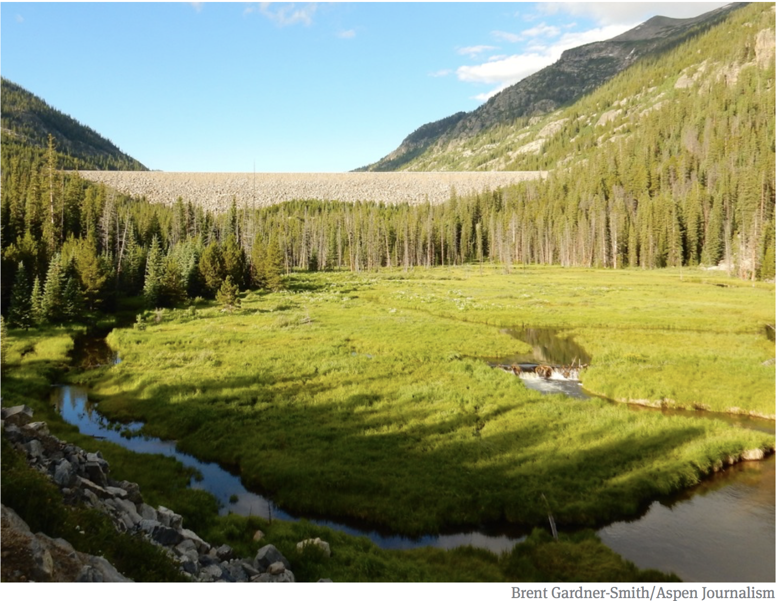
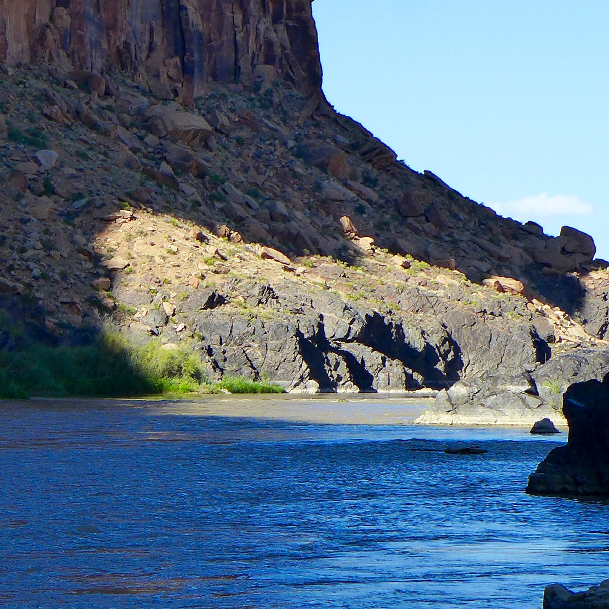
The San Miguel River near its headwaters in Telluride, Colorado. @bberwyn photo.
Tubing Boulder Creek
Here’s the release (Barb Halpin, Public Information Officer, Ben Irwin, Amy Markwell, Valentina Stackl):
Costs of climate change impacts estimated to top one hundred million dollars by 2050
Today, the Colorado communities of Boulder County, San Miguel County, and the City of Boulder—with legal support from EarthRights International, Niskanen Center, and other co-counsel—filed a lawsuit against Suncor and ExxonMobil (“Exxon”), two oil companies with significant responsibility for climate change. The communities have demanded that these companies pay their fair share of the costs associated with climate change impacts, so that the costs do not fall disproportionately on taxpayers.
Climate change affects fragile high-altitude ecosystems and hits at the heart of these communities’ local economies, affecting roads and bridges, parks and forests, buildings, farming and agriculture, the ski industry, and public open space. Adapting to such a wide range of impacts requires local governments to undertake unprecedented levels of planning and spending. Over the next three decades, these communities will face at least one hundred million dollars in costs to deal with the impacts of climate change caused by the use of fossil fuel products like those made and sold by Suncor and Exxon.
Suncor and Exxon have known about the costly consequences of fossil fuel use for more than 50 years. Yet they continued to promote and sell their products, while recklessly deceiving the public and policymakers about the dangers.
In the past year, nine coastal communities in California and New York filed climate lawsuits against fossil fuel companies. This is the first such lawsuit in Colorado—or anywhere in the U.S. interior—aimed at holding fossil fuel companies accountable for paying their fair share of the costs of climate change.
Statements
“Climate change impacts are already happening and they are only going to get worse. In fact, Colorado is one of the fastest warming states in the nation. Climate change is not just about sea level rise. It affects all of us in the middle of the country as well.” – Elise Jones, Boulder County Commissioner
“We are a small rural county dependent on tourism and farming and ranching. A natural disaster here could wipe out our reserves. Unabated fossil fuel production is already impacting our climate. These changes will grow more intense over time.” – Hilary Cooper, San Miguel County Commissioner.
“Our communities and our taxpayers should not shoulder the cost of climate change adaptation alone. These oil companies need to pay their fair share.” – Suzanne Jones, Mayor, City of Boulder
“For over 50 years, Suncor and Exxon have known that fossil fuels would cause severe climate impacts. To enhance their own profits, they concealed this knowledge and spread doubt about science they knew to be correct. Now, communities all over this country are left to foot the bill.” – Marco Simons, EarthRights International
“Future generations and those least responsible for causing climate change will bear the brunt of the impacts. We need to shift the costs back to these companies that have profited off their demands for unabated pollution in the face of global climate destabilization.” – Micah Parkin (350 Colorado)
“The fossil fuel industry has normalized oil and gas in our lives while concealing the dangers. It’s time for a cultural shift. In the future, when we talk about ‘energy,’ we should be referring to renewable energy, not fossil fuels.” – Rebecca Dickson, Sierra Club
“For hundreds of years, the common law has insisted that people who damage property should be held liable for their actions, and this case seeks no more than to protect property rights and the rule of law.” – David Bookbinder, Niskanen Center.
Background
For years, these Colorado communities have taken action to reduce their own carbon footprints. All three have adopted ambitious CO2 emission reduction targets, passed budgets for climate work, conducted greenhouse gas (GHG) inventories, and established incentive programs for residents. Despite these efforts, taxpayers already face the rising costs of adapting to a changing climate.
Suncor and Exxon are two of the world’s largest contributors to climate change and have been particularly active in Colorado. Fossil fuel combustion accounted for nearly 80 percent of all GHG emissions between 1970 and 2010.
Exxon is the largest investor-owned fossil fuel producer in history. Suncor is one of the world’s largest independent energy companies. Both are active in Colorado.
Suncor’s U.S. operations are based in Denver, Colorado; the company supplies about 35 percent of the state’s gasoline and diesel fuel demand. Suncor and Exxon work closely together in Colorado to market and sell fossil fuels.
The two companies jointly own the majority of Syncrude Canada Ltd., one of the largest developer of Canada’s tar sands.
Together, Suncor and Exxon are responsible for billions of tons of CO2 emissions. Their future carbon footprint is likely to be enormous, as well: both companies plan to expand fossil fuel production through tar sands, fracking, and other means.
For more than 50 years, these oil companies have known about the harm that their products would cause to communities, but have chosen to continue business as usual. These companies have long known about the risks of their own activities. In 1968, industry scientists warned them that “significant temperature changes are almost certain to occur by the year 2000” due to rising GHGs, and that “the potential damage to our environment could be severe.”
By the 1970s, Suncor and Exxon knew with high certainty that their products were dangerous and that inaction would cause dramatic, even catastrophic, changes to the climate. Exxon even took measures to protect itself from climate change: for example, the company adapted its own facilities to protect from sea level rise.
Summary
Boulder County, San Miguel County, and the City of Boulder have partnered together to represent communities on the Front Range and the Western Slope and require these oil companies to help pay for the costs of climate change on local communities in Colorado. Because of the magnitude of the financial impacts, these communities feel like they have little choice but to bring this litigation on behalf of their residents.
After expressing their frustration privately for weeks, negotiators for four Colorado River Basin states sent a strongly worded letter to Arizona water managers on Friday, singling out the actions of one state agency as “threaten[ing] the water supply for nearly 40 million people.”
In the letter, the Upper Colorado River Commission said those actions could threaten efforts to conserve water and prevent Lake Mead from going into shortage for as long as possible. It could, they wrote, also undermine a decade of broader collaboration intended to avoid costly litigation between Colorado River users.
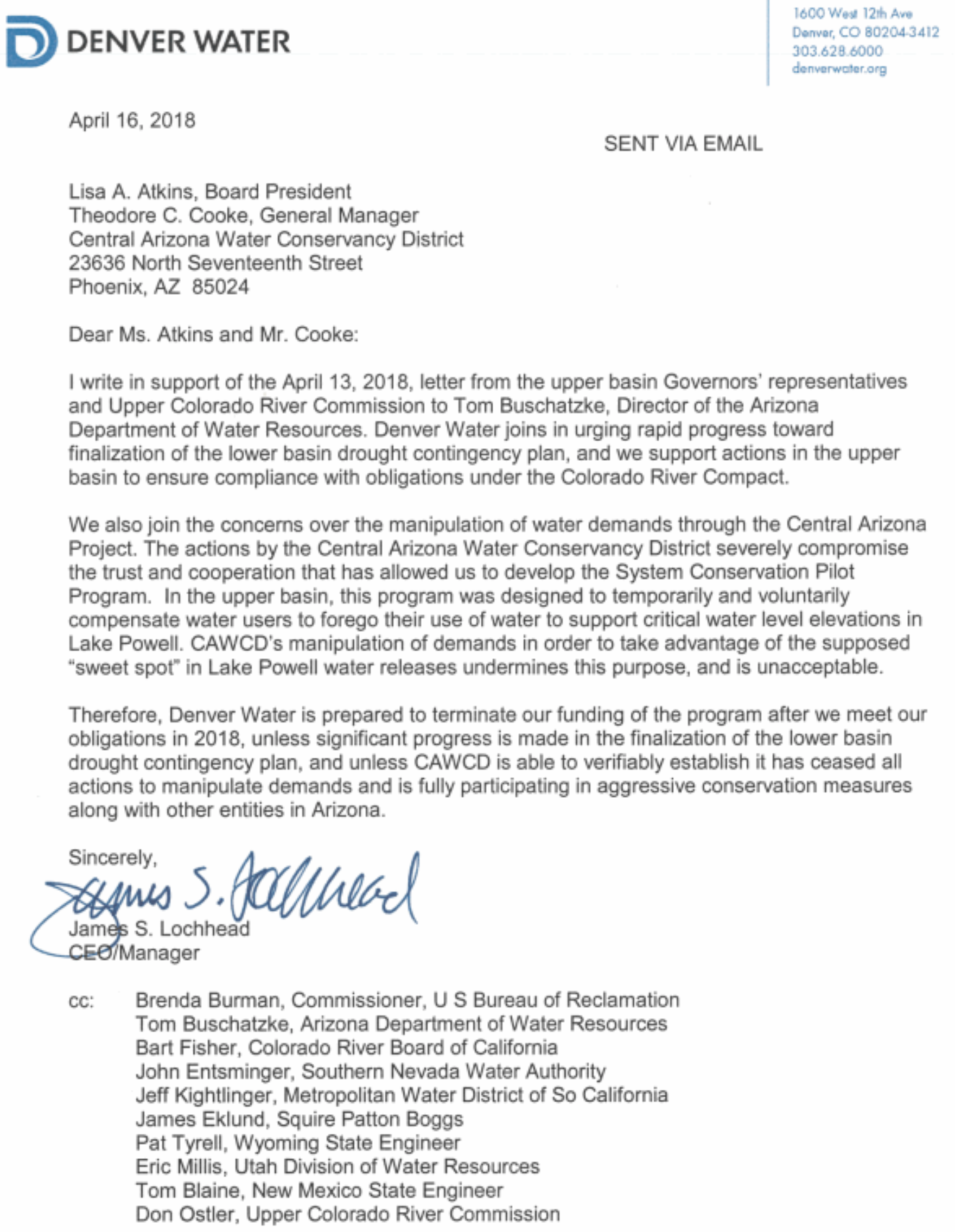
In a second letter released on Monday, Denver Water told the Arizona water agency — the Central Arizona Project — that it is prepared to pull conservation funding because CAP’s actions “severely compromise the trust and cooperation that has allowed us to develop [the program].”
The mounting pressure on CAP, which is operated by the Central Arizona Water Conservation District (CAWCD), comes as the agency is engaged in a fight within Arizona over how to manage the state’s Colorado River water. At issue is whether the Central Arizona Project, which delivers water to Tucson and Phoenix, is gaming a set of guidelines intended to balance the river’s reservoirs during times of drought. The Arizona Department of Water Resources, an arm of the governor’s office, has criticized CAP’s strategy for months and now other Colorado River users are piling on, warning the agency to stop before it jeopardizes delicate negotiations over drought planning.
In response to the letters on Monday, Arizona’s top water official doubled down on his criticism. Tom Buschatzke, who directs the Arizona Department of Water Resources, said he shared some concerns in the letter and agreed CAP was manipulating the system to get more water from the Upper Basin.
“I have huge concerns that the unilateral actions of CAWCD are threatening the regional and binational [drought] plans… that will benefit and protect Lake Mead,” Buschatzke said on Monday in response to the two letters.
In a statement, CAP said it was “surprised and disappointed to have received a letter from the Upper Colorado River Commission questioning CAWCD’s intentions in leaving water in Lake Mead. We have been reaching out to our partners in the Upper Basin, hoping to clarify apparent misunderstandings, and to facilitate in-person, collaborative discussions aimed at finding solutions that will benefit the communities and environment served by this mighty river.”
What’s going on here
The Colorado River is split into an upper and a lower basin with two main reservoirs in each division — Lake Powell and Lake Mead. Under the 1922 Colorado River Compact, the Upper Basin states of Colorado, New Mexico, Wyoming and Utah are obligated to release a certain amount of Lake Powell water for the Lower Basin states of Arizona, California and Nevada.
On top of that, the Upper Basin has agreed, in recent years, to send “bonus water” to Lake Mead if it is at a low elevation relative to Lake Powell. The dispute with CAP is about the “bonus water.” Recently, CAP has advocated in presentations for keeping Lake Mead at a “sweet spot” — high enough to avoid a shortage but low enough to get “extra water” from Lake Powell.
This creates a political issue for the Upper Basin. It wants to store water in Lake Powell and boost the reservoir’s elevations. That way it can ensure full deliveries to the Lower Basin in dry years and continue producing hydropower.
CAP is undermining efforts to keep water in Lake Powell, the letters argue, by adjusting how it orders water from Lake Mead (CAP’s general manager Ted Cooke defended this practice on Twitter last week as placing its “water order wisely”).
The letter signed by representatives for all the Upper Basin states calls CAP’s action a “strategy to intentionally maximize demands within the Central Arizona Project to induce larger than normal releases from Lake Powell.” The “goal,” they wrote on Friday, “appears to be to delay agreement on drought plans in order to take advantage of what it terms the ‘sweet spot.’”
Denver Water called it “unacceptable.” The municipal agency said that it would cancel funding for a Colorado River conservation program in the Upper Basin unless CAP “is able to verifiably establish it has ceased all actions to manipulate demands and is fully participating in aggressive conservation.”
In recent months, Cooke has defended CAP’s decisions. CAP’s supporters see the actions as a water agency acting in its own interests. Cooke argued that it would be counterproductive to store more water in Lake Mead because that could boost its elevation so much that the Lower Basin would forgo any “bonus water.” Arizona would take the steepest cuts during a shortage. He has said the best thing to do is to get as much water from Powell as the current rules allow and use it to mitigate a shortage.
The agency that runs the $4 billion Central Arizona Project is being accused of manipulating Colorado River reservoirs’ operations to suck out more water for its Tucson, Phoenix and Pinal County customers.
The accusation came in two letters in the past few days from representatives of four Upper Colorado River Basin states, the federal government and the Denver Water Dept. They say CAP’s approach threatens a Western water supply serving nearly 40 million people. It also threatens the harmony that has marked relations among the seven basin states since they approved guidelines to run the Colorado River’s reservoirs in 2007, they say.
Under criticism is CAP’s practice of limiting how much river water it conserves each year, in order to prop up Lake Mead’s declining reservoir levels. The CAP has resisted pressure from other water agencies in Arizona to boost its conservation beyond about 200,000 acre-feet a year, enough to cover that many football fields a foot deep.
CAP says that’s because as Lakes Mead and Powell are managed under the 2007 guidelines, conserving too much, or “overconserving” as CAP officials put it in the past, could reduce water releases from Powell to Mead. That would trigger shortages and cutbacks in water deliveries to Arizona users. CAP brings drinking water to Tucson and Phoenix and irrigation water to Pinal County via a 336-mile-long canal.
That stance irks the Upper Colorado commission, representing the Upper Basin states of Colorado, Utah, New Mexico and Wyoming and the U.S. government.
Last Friday, commissioners wrote that the Central Arizona Water Conservation District — a three-county water district running CAP — “intends to disregard the basin’s dire situation at the expense of Lake Powell and the other basin states.” CAP is trying to “maximize demands” to get larger water releases from Powell, said the letter to Arizona Department of Water Resources Director Tom Buschatzke.
Officials of the CAP water district responded in a statement, “We are surprised and disappointed to have received a letter from the Upper Colorado River Commission questioning CAWCD’s intentions in leaving water in Lake Mead.” On Twitter, CAP general manager Ted Cooke recently said the agency places its water order wisely, following federal guidelines…
Since 2014, CAP and its partners reduced water use enough to be able to leave more than 850,000 acre-feet in Mead, the statement said…
In its letter, the Upper Colorado commission noted that because of a high water release expected from Powell this year and continued low snowpack and poor river runoff, Powell is expected to drop 30 feet in the next year. If these conditions persist, CAP’s efforts to boost water releases from Powell could make future reservoir conditions worse and trigger more severe shortages in the long term, the letter said…
The letters were triggered by a graphic recently posted on CAP’s website, saying the agency has maintained a “sweet spot” for Lake Mead’s water levels.
By that, it means conservation has kept Lake Mead high enough to avoid a shortage, but not so high as to cause the federal government to release only 8.23 million acre-feet of water each year — the customary average annual delivery from Powell to Mead. Instead, the feds have released 9 million acre-feet each of the past four years.
The graphic, which the agency took down after it generated controversy, made Lake Mead’s level appear to be a bigger factor in determining water releases than the weather, which others disagree with.
The Upper Colorado commission and Denver Water are also concerned that this conflict threatens an interstate program in which the feds, Lower Basin water agencies and Denver Water pay farmers and other users to use less water, with the savings held in Mead.
This program has saved about 139,000 acre-feet of river water. But Denver Water is prepared to end its support of the conservation program unless, among other things, CAP can show “it has ceased all actions to manipulate demands and is fully participating in aggressive conservation measures,” Denver Water chief Jim Lochhead wrote to the CAP…
Paul Orme, an attorney for four irrigation districts in Central Arizona, said he continues to support CAP. Farmers will be the first to lose water during a shortage and they’re more interested in year-to-year releases, Orme said.
“What they are doing is permitted under the (2007) guidelines,” Orme said, referring to the CAP. “I know the Upper Basin says they’re not in the spirit of the guidelines, but they’re in the letter of the guidelines.”
Here’s what the upper basin doesn’t like: the CAWCD aims to keep Lake Mead at a so-called “sweet spot.” If the level of the lake stays in that range, then under current agreements, more water comes down from Lake Powell.
The Commissioners’ letter expressed deep concern that CAWCD “intends to disregard the basin’s dire situation at the expense of Lake Powell and all other basin states.” Don Ostler, executive director of the Upper Colorado River Commission, said bluntly in an interview. “That kind of manipulation is unacceptable to the Upper Basin.”
[…]
CAWCD also reminded people of the water the agency has conserved on behalf of Lake Mead, “at a significant cost to CAP water users in terms of water and water rates.” CAWCD runs the Central Arizona Project canal system, which delivers water to the Phoenix and Tuscon areas…
The Upper Colorado River Commissioners also urged Arizona to get its internal house in order so all seven states and Mexico can plan for long-term drought.
“The seven Colorado River Basin states and Mexico are connected at the hip in this river,” Ostler said. “And what is going on with regards to one state, its failure to make progress, is having an effect on all seven states.”
Buschatzke and Gov. Doug Ducey are trying to get big-ticket water legislation through the state Capitol this year. But time is running out on the legislative session.
Click here to read Denver Water’s letter to the Central Arizona Project:
Denver Water today joined state leaders in the Upper Colorado River Basin with a letter accusing the managers of the Central Arizona Project of manipulating water orders to get more water out of the Upper Basin’s reservoir at Lake Powell. The actions of the CAP’s managers “several compromise the trust and cooperation” needed to solve Colorado River problems, the letter from Denver Water’s Jim Lochhead said.
When early explorers Zebulon Pike and Francisco de Coronado came upon the High Plains, they described it as a desert — an impossible region to farm.
Irrigation changed that. It allowed residents to pull water from the Ogallala Aquifer, and grow crops nearly anywhere. The first irrigation wells in Kansas were drilled east of Garden City in 1908.
The Ogallala is a massive, underground sponge, spanning from South Dakota and Wyoming, down through the High Plains to west Texas and New Mexico. Over 27,000 of the total 35,000 wells with active water rights in Kansas overlie the Ogallala, with 87 percent used for irrigation.
But decades of pumping water out, with little return, has taken its toll.
After 110 years of drilling and draining, the world’s largest aquifer is drying up.
The Ogallala is the primary source of water for western Kansas farms, ranches and some communities, but projections indicate several areas that will go dry within 25 to 50 years at current usage rates. Some regions in Haskell County may have a decade or less…
The Ogallala Aquifer Summit was organized by Colorado State University’s Ogallala Water CAP Program — a coordinated agriculture project funded by the United States Department of Agriculture – National Institute of Food and Agriculture. The summit brought together scientists, government agents and producers from the eight states situated over the Ogallala to discuss shared challenges and current initiatives to preserve the aquifer.
Conversations between states had a rocky start, partly because they were spurred out of litigation regarding the Republican River basin along the Colorado, Nebraska and Kansas borders. The conflict led to monthly meetings of the Republican River Compact Administration — comprised of one member from each state — to change the approach and improve water management.
“No offense to those that are here, but I’m just excited to come to an interstate water conference that doesn’t have more lawyers than it does farmers and ranchers,” Kansas Secretary of Agriculture Jackie McClaskey said to applause from the summit crowd.
Nebraska Natural Resources Program Director Jesse Bradley and Colorado Commissioner of Agriculture Don Brown joined McClaskey for the first panel of the summit, discussing the cultivation of interstate conversations.
Brown joked that the whole problem was Nebraska’s fault — Nebraska native Frank Zybach invented center pivot irrigation while living in Colorado — and Bradley fired back that ‘you always blame the upstream state.’
She credits interstate conversations regarding the Republican River as a critical factor for changing the tone of the discussion. Instead of fighting over the water, the group is now working together to preserve water.
“The biggest way we learned this lesson is from the complete 180 we’ve done on the Republican River discussions,” McClaskey said. “In July 2014, we started meeting month-to-month and created a true, long-term agreement, and are using those lessons to expand to all the states.
“Now, I would call my colleagues from Nebraska and Colorado friends, which may not seem like a big deal, but it’s a lot easier to solve a problem with a friend than with an enemy.”
Click here to read the assessment. Here’s an excerpt:
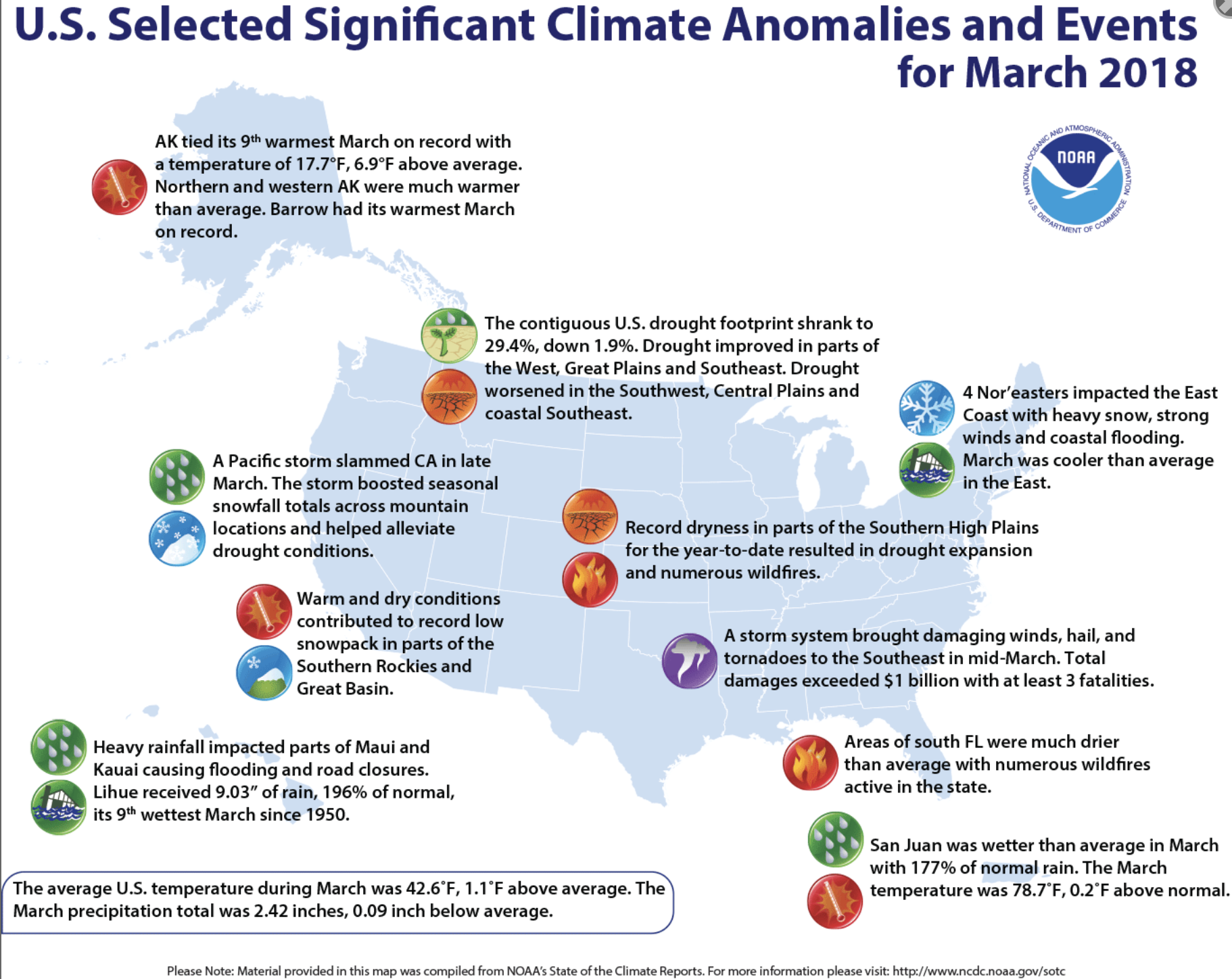
The latest monthly briefing was posted [April 10, 2018] on the Intermountain West Climate Dashboard. The highlights, also provided below, cover current snowpack and drought conditions, seasonal runoff forecasts, March precipitation and temperature, and ENSO conditions and outlooks.
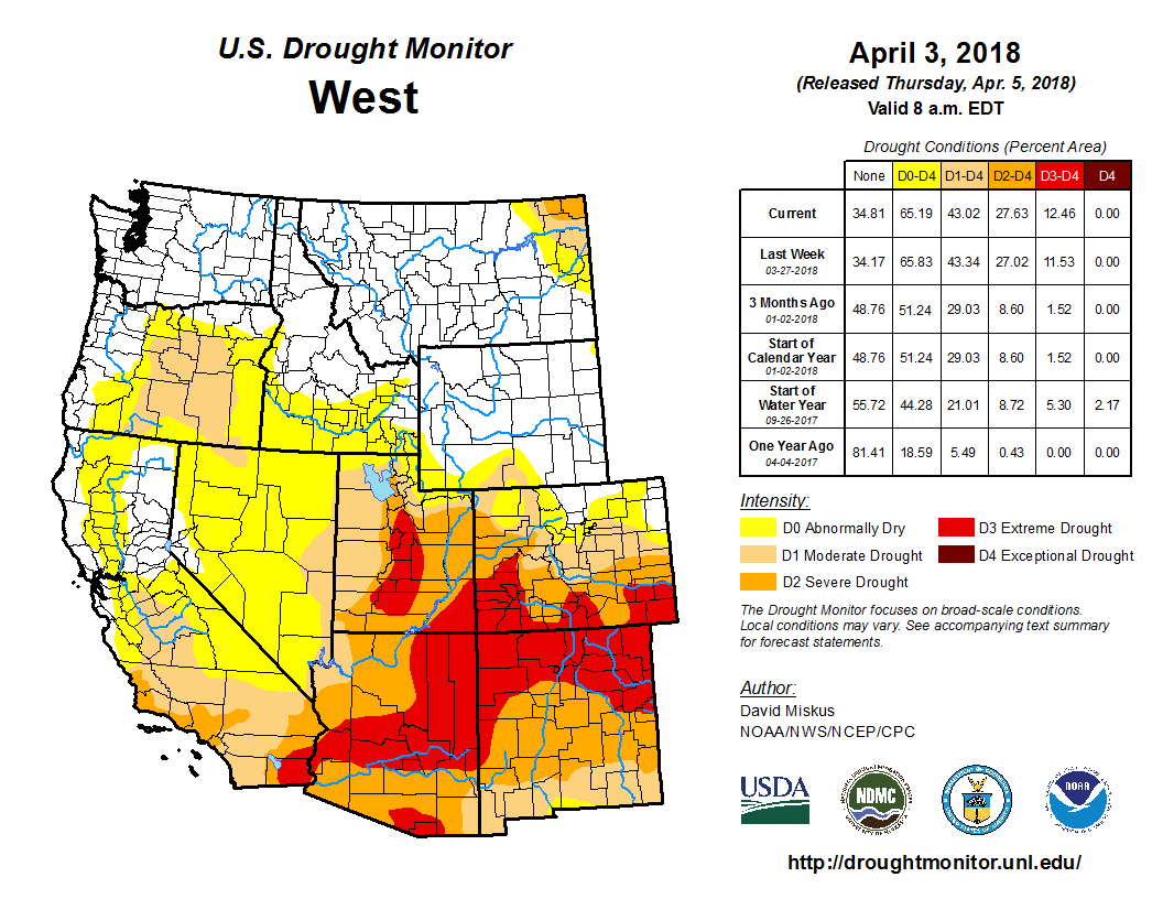
Snowpack conditions in Utah and the southern half of Colorado remain very poor after below- to near-normal March precipitation. Very low spring-summer runoff is increasingly likely in these basins. Severe to extreme drought conditions have spread and now cover more than half of both states.
In nearly all Utah basins, and in Colorado basins south of I-70, the snowpack remains at near-record-low conditions, with 30-60% of normal SWE for early April. The Bear, Upper Green (within Utah), Yampa-White, Colorado River headwaters, South Platte, and North Platte basins have held steady or improved in the past month, with 80-100% of normal SWE. In Wyoming, all but a few basins have above-normal SWE, with most basins at 110-140% of normal.
The seasonal runoff forecasts issued for April 1 by NRCS and NOAA provide a grim picture similar to previous months. The forecasted runoff for nearly all points in Utah and the southern half of Colorado is in the range of 20-65% of average, while in northern half of Colorado, the forecasted runoff is 65-90% of average. Wyoming’s outlook is much better, with most points expected to have above-average runoff, and few points below 80% of average. The April 1 NRCS and NOAA forecasts for Lake Powell inflows are down slightly from the previous month and call for 38% and 43% of average runoff, respectively.
March precipitation was overall near-normal for Utah and Wyoming, but below normal for Colorado. March temperatures were above normal in Colorado and southern Wyoming, and overall cooler than normal in Utah and northern Wyoming. The first half of this water year (October-March) was the 2nd driest and 6th warmest on record for Utah, and the 4th driest and 5th warmest on record for Colorado.
Since early March, drought conditions have worsened in central and northeastern Utah and central and southern Colorado, with D3 (extreme drought) conditions expanding in both states. As of April 3, 59% of Utah is in D2 or D3, and the remainder in D0 or D1; in Colorado, 51% is in D2-D3, and 38% in D0-D1; and in Wyoming, only 14% is in D0-D1, with no D2-D3.
Weak La Niña conditions still persist in the central tropical Pacific, with a transition back to ENSO-neutral conditions still likely by late spring. Historically, weak to moderate La Niña events carry increased odds for below-normal March-May precipitation for Utah and Colorado, which is reflected in the CPC seasonal outlook for that period.
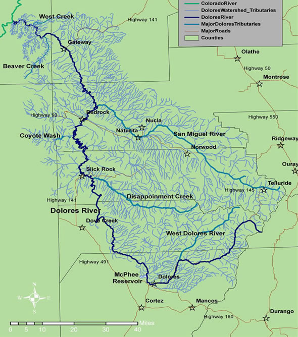
A Dolores Basin snowpack that came in at half its normal level means McPhee Reservoir will not fill to capacity, and farmers may receive 20 percent less water this season.
On Thursday, Dolores Water Conservancy District managers estimated that full-service irrigators will have 17 inches of water per acre available for their crops, down from 22 inches per acre when McPhee is full.
The shortage also will impact Ute Farm and Ranch water supplies drawn from McPhee, and the fishery pool reserved for habitat below the dam. Ute Farm and Ranch also is estimated to take about a 20 percent cut, with delivery at 18,900 acre-feet, compared with 23,300 acre-feet when there is a full supply.
The reserved fish pool, released from the dam over the year by Colorado Parks and Wildlife, dropped to 23,100 acre-feet from a supply of 29,300 acre-feet when the reservoir is full.
Municipal water supplies from McPhee serving Cortez and Towaoc do not share in the shortage and will receive full allocations.
Because of the dry winter and spring, there will be no recreational whitewater release this year below the dam.
Carryover storage of 125,500 acre-feet – active supply left in the reservoir from last winter’s above-average snowpack – is helping to buffer this winter’s lack of moisture, officials said…
The 2018 runoff forecast from the Dolores River into McPhee is comparable to the extremely dry years of 2013 and 2002, when farmers received just 6-7 inches per acre, a 72 percent shortage.
During an average winter, total runoff into the Dolores River from snowpack is 295,000 acre-feet. This year, models predict runoff of just 50,000 acre-feet…
Hurting this year’s McPhee supply is that there is no low-elevation snow. Feeders such as House and Beaver creeks are usually chock-full of rushing water this time of year, but they are now bone-dry.
Dry soil conditions left over from the fall are also negatively impacting supply.
Limited snowpack remains above 10,000 feet, but it might be absorbed into the ground before making it into the river.
The water-supply prediction is based on snowpack measurements in the mountains and runoff modeling. It is an inexact science, so final supplies could rise or fall.
Variables such as warm or cold weather, soil moisture, wind, dust on snow, spring precipitation and fall monsoons impact the final amount of water supply in myriad ways.
Farmers are closely watching supply forecasts in order to plan for the season. The amount of available water determines how many acres they will farm, and how much fertilizer, herbicide and seed they will buy.
The Bureau of Reclamation issued its preliminary summer operations plan for Taylor Park Reservoir and, while the numbers indicate low flows, water managers predict ample water for rafting and fishing enthusiasts alike.
The Bureau plans to release 250 cubic feet per second (cfs) during the month of June and then bump that up to 300 cfs for July. Flows will drop back down to 250 cfs during August…
In comparison, water managers released 757 cfs in the Taylor River during June 2017 and around 400 cfs during July and August 2017.
The release schedule is subject to change based on precipitation this spring. In May 2015, for example, the release schedule was forecast as 63 percent of normal (similar to this year), but after a month of heavy precipitation, the reservoir flows jumped to 87 percent of normal, prompting water managers to dub it a “miracle May.”
“We would love another miracle May,” says Frank Kugel, general manager of the Upper Gunnison River Water Conservancy District. “In 2015 the area received between four and seven and a half inches of precipitation for the month, which boosted the flow levels considerably.”
The Bureau’s Taylor Park Reservoir April 1 forecast estimates 62,000 acre-feet of runoff between April and July 2018. This is 63 percent of average and officially categorizes this year’s runoff as “dry.” The Bureau of Reclamation will update this estimate in May with another forecast.
Drought conditions continued to evolve in Colorado this week, with improvements for north central counties, and extreme drought continuing to encroach on areas in the south.
Extreme drought increased slightly in northeast Prowers county. Extreme conditions also spread to cover most of Archuleta county, and much of the southern half of Mineral county in southwest Colorado.
Severe conditions continued to advance northward in eastern Colorado, encompassing the eastern third of El Paso county, most of Lincoln county, and southeast Elbert county.
The north central and northwest parts of the state continued to show improvement. Jackson and Summit counties are largely drought-free for the first time since December. Moderate drought conditions across the area improved to abnormally dry for Routt county and the northern half of Park county. Severe drought also gave way to moderate conditions in Eagle county. The area is under a winter weather advisory going into the weekend, with some potential for further improvement with the next update.
Overall, more than 12 percent of the state is drought-free, up slightly from last week. Abnormally dry conditions increased by about two percent as areas shifted out of higher drought categories. Moderate drought also improved from about 22 percent of the state to just under 16 percent. Severe drought increased to a bit more than 29 percent from just under 28 percent. Extreme drought increased to nearly one quarter of the state’s area.
Some of the lowest snowpack reports on record will mean difficult decisions ahead for water managers, the Bureau of Reclamation’s Albuquerque Area Office and U.S. Army Corps of Engineers said Thursday in their annual operating plan for the Rio Grande.
The April forecast data released by the Natural Resources Conservation Service shows drought conditions throughout the state. The Jemez River Basin is at just 6 percent of average. The Chama River Basin is at 18 percent of average, and the Upper Rio Grande is at 50 percent of average. El Vado Reservoir could be nearly empty by July.
On the Rio Grande Project in southern New Mexico, the allocation to the two irrigation districts and Mexico is about 60 percent of a full allocation, the Bureau of Reclamation said. Both irrigation districts had some carryover water in storage from last year.
Little inflow is expected to Elephant Butte Reservoir this spring, and it could be left holding less than 5 percent of its capacity at the end of the irrigation season.
The federal drought map shows dry conditions have expanded in Arizona and intensified across northern New Mexico…
Some areas of Union and Colfax counties in northeastern New Mexico have received less that 5 percent of normal precipitation over the past six months, leaving wheat crops in poor shape. Many areas went over 100 days without moisture…
Overall, nearly half of New Mexico and Arizona are facing extreme drought or worse conditions while about 60 percent of Utah is under severe drought, according to the National Drought Mitigation Center.
The Bureau of Reclamation is working with its partners to implement a survival strategy for the Rio Grande silvery minnow, as outlined in the 2016 Middle Rio Grande Biological Opinion. They are coordinating with the U.S. Fish and Wildlife Service to ensure fish rescue crews are active in the areas of the river that have dried. And, they are working with the Middle Rio Grande Conservancy District, Albuquerque Water Utility Authority, and other stakeholders to facilitate silvery minnow egg collection efforts.
Drought is prevalant across the American Southwest as extreme conditions spread from Oklahoma to Utah, according to new federal data released Thursday.
On the southern high plains, Oklahoma remains ground zero for the worst drought conditions in the United States. About 20 percent of the state is facing exceptional drought conditions — the worst possible classification.
Most of Colorado also is under severe drought and almost all of the Texas Panhandle is seeing extreme drought or worse conditions.
From the New Mexico Political Report (Laura Paskus):
As high winds whipped dust, Siberian elm seeds and recycling bins around Albuquerque Thursday afternoon, dozens of people filed into the U.S. Bureau of Reclamation’s Albuquerque office to hear the agency’s 2018 forecast for water operations on the Rio Grande.
“I’ll be the bearer of bad news,” said Reclamation’s Albuquerque Area Manager Jennifer Faler. “This is the most extreme shift we’ve had from one operating plan meeting to another.”
Last year at this time, snowmelt was pouring down the river, flooding riparian restoration projects, filling out farm fields and even pressing against levees. This year, the lack of snowpack throughout the watershed’s mountain ranges has left the Rio Grande low and slow—and dry for 14 miles south of Socorro. Currently, the river is dry through the Bosque del Apache National Wildlife Refuge.
“It’s fortunate we have those dams and reservoirs up there,” Faler said, referring to reservoirs in northern New Mexico that store water for the Middle Rio Grande Conservancy District and the Albuquerque-Bernalillo County Water Utility Authority. “That’s why we have them,” she said.
But later this summer, the conservancy district’s water storage is expected to run out, as is Reclamation’s supplemental water. That refers to water the federal agency leases to boost flows in the river and protect endangered species like the Rio Grande Silvery Minnow.
“We do expect to see drying in the Albuquerque reach this year,” Faler said, of the stretch of the Rio Grande that runs through the state’s largest city.
“And misery loves company,” she said. “On the Pecos [River], we’re expecting zero runoff from snowmelt into the reservoirs this year.”
[…]
During his presentation of the 2018 operating plan for the Rio Grande, which is compiled each year by Reclamation and the U.S. Army Corps of Engineers, hydrologist Ed Kandl offered more details.
In addition to the news about the conservancy district’s stored water, and Reclamation’s supplemental water, running out, Kandl said New Mexico will likely enter into what’s called Article 7 conditions on the Rio Grande by May.
Under the Rio Grande Compact—the agreement under which Colorado, New Mexico and Texas share the river’s water—New Mexico is not allowed to store water in upstream reservoirs if Rio Grande Project storage is less than 400,000 acre feet in Elephant Butte and Caballo reservoirs. Reclamation’s Rio Grande Project supplies water to Texas, and also farmers in southern New Mexico.
Kandl shared slides forecasting flows along the Rio Grande based on the winter’s snowpack analysis. Of the Embudo gage in northern New Mexico, he said, “We’ll be flirting with 100 cfs throughout most of the year.” Already this year, that stretch of the river has been running at less than half what it normally does.
The “scariest” one, Kandl said, is the 2018 flows for the Rio Grande at the Central Avenue Bridge in Albuquerque, where the river will likely dry this spring and summer.
Kandl and Faler both said area residents should be prepared to see the dry riverbed. “The worst part is still coming,” Kandl said, “Though, maybe we’ll have a good monsoon.”
Over the next several months, Reclamation will also begin working with its stakeholders to update a basin-wide study of the impacts of climate change on the Upper Rio Grande…
The one “bright spot,” according to Reclamation officials on Thursday, is for rafters and recreationists on the Chama River. Because the agency will be releasing water from upstream reservoirs, the river’s flows will be good for rafting and kayaking.
Westwide SNOTEL basin-filled map April 16, 2018 via the NRCS.
Gunnison River Basin via the Colorado Geological Survey
Hay meadows near Gunnison
Gunnison River photo credit: HomeAway.com
Here’s the release from the Trust for Public Land:
Broad coalition protects more than 4,300 acres with help from the largest-ever GOCO grant
The Trust for Public Land today announced the final-stage closing in the protection of 4,377 acres of working ranchland in the scenic valleys of the Gunnison and East Rivers between Gunnison and Crested Butte. The protection effort, for land on the Trampe Ranch, was completed through three working-ranch conservation easements and with help from a $10 million grant from the Great Outdoors Colorado (GOCO) funding program, the largest single transaction grant in the organization’s history.
The easements prevent subdivision and development of scenic ranchlands stretching for 30 miles in one of Colorado’s most iconic landscapes. These lands are essential to agriculture, with Trampe Ranch generating 20 percent of Gunnison County’s agricultural economy. In addition, the conserved lands provide scenic views that attract tourists and visitors, include habitat for a wide variety of wildlife, and serve as research lands for scientists from the nearby Rocky Mountain Biological Laboratory.
“The lands and waters of the Trampe Ranch play such an important role in defining the character and sense of place of one of Colorado’s last, great mountain valleys,” said Jim Petterson, The Trust for Public Land’s Southwest and Colorado Director. “This project brought together a deep and broad partnership of individuals, governments and organizations, all allied around a shared commitment of helping local communities fulfill their visions for how they want to grow and what they want to preserve.”
Efforts to protect ranchlands and open space in the Gunnison Valley began in the 1980s in an alliance between local land trusts, national conservation groups, funders like GOCO, local governments, and agricultural landowners, including Trampe Ranch owner Bill Trampe, who has been a leader in encouraging ranchers to conserve their land with easements. With the completion of the most recent project, Trampe Ranch has more than 6,000 acres under easement.
“GOCO is proud to be one of the partners to help make this monumental land conservation effort possible, and our Board of Trustees and staff are eternally grateful to Bill Trampe for his vision, leadership, and generosity,” said GOCO Executive Director Chris Castilian. “Trampe Ranch received GOCO’s largest ever, single transaction grant award at $10 million, because conserving this iconic property means the protection of vital agricultural land and stunning scenic views for those who will recreate on beautiful, adjacent public lands for generations to come.”
“What this one very special place means to the Gunnison Valley and to our entire state cannot be overstated. Today we join our fellow Coloradans in celebrating Bill Trampe, his family, and all they have accomplished,” added Castilian.
In addition to the GOCO grant, funding for the project came from the Natural Resources Conservation Service, the towns of Crested Butte and Mt. Crested Butte, Gunnison County, The Rocky Mountain Biological Laboratory, Crested Butte Land Trust, and 1% for Open Space, a consortium of Gunnison County businesses that collects a voluntary donation of 1% of sales for its customers to fund open space conservation in Gunnison Valley. Additional private funding came from a multi-million dollar campaign. Trampe Ranch also donated a significant portion of the conservation easement value toward the project.
“This land has been the heart of our ranch for more than 100 years,” said Bill Trampe. “Conservation of our home place means this land is available forever for agriculture.”
Local partners cheered the completion of the conservation effort.
“We are very excited to see this critical step in the conservation of the East River Valley,” said Dr. Ian Billick, Executive Director of the Rocky Mountain Biological Laboratory. “Keeping the properties in ranching is one of the most important things we could do to leverage the nation’s large investment in the field research that helps us manage our water, air, and food.”
“Nothing is more important than the preservation of the natural state of Colorado and its heritage of ranching. Especially in this day and age when there seems to be a valid threat to open spaces throughout the West,” said Mayor Jim Schmidt from the Town of Crested Butte.
“We are very excited about the completion of this final conservation easement,” said Carlos Fernandez, Colorado State Director for The Nature Conservancy. “The Trampe Ranch is a spectacular property with some of the most outstanding scenery in Colorado. Conserving this iconic ranch leaves an amazing legacy for the Gunnison Valley, reminding us of Colorado’s history and landscape.”
One of the most significant land preservation actions in Colorado concluded Tuesday, April 10 with the closing of the last parcel of the Trampe Ranch property in Gunnison County. The final closing puts thousands of acres of prime ranchland stretching from Gunnison to Gothic into a conservation easement that is meant to keep the property free of development and focused on agriculture in perpetuity.
This multimillion-dollar deal was broken up into three parts totaling 4,377 acres. The first step took place in February 2017 when the 1,447-acre Trampe Home Ranch was preserved. That parcel, located near Gunnison, resulted in Gunnison sage grouse habitat being protected.
“This land has been the heart of our ranch for more than 100 years,” said Bill Trampe at the time. “The meadows and pastures are the resource base for ranch production, and also provide habitat for Gunnison sage grouse and other wildlife species. Conservation of our home place means this land is available forever for agriculture and for the birds.”
The second phase of the overall effort took place in October 2017 when 284 acres were preserved in the corridor between Gunnison and Crested Butte near Jack’s Cabin. And Tuesday’s 2,647-acre closing put land primarily located in the Upper East River Valley near Crested Butte into the conservation easement.
The Nature Conservancy is the holder of the Trampe Ranch conservation easement and the Trust for Pubic Land facilitated the transactions and led the public and private fundraising campaign…
While 4,377 acres were protected in these latest three closings, in sum total, the Trampe Ranch will have close to 6,000 protected acres from prior projects near Roaring Judy Fish Hatchery.
Conditions are setting up what could be the worst summer wildfire season in Colorado since the one-two punch of 2012 and 2013, officials said Friday, when devastating blazes ravaged areas across the state.
“It appears that this will probably be the worst one, forecast-wise, in quite some time,” said Mike Morgan, director of the Colorado Division of Fire Prevention and Control. “Abnormally dry weather and a dry winter has left our mountains nearly barren.”
While state fire officials hedged that it’s too early to have a hard-and-fast prediction for what fire conditions will be this summer, things aren’t looking up.
Snowpack levels, especially in the southeast and southwest parts of the state, are much lower than normal. On top of that, the U.S. Drought Monitor says as of Thursday that 87.62 percent of the state is either experiencing abnormally dry, moderate drought, severe drought or extreme drought conditions.
Only extreme northeast Colorado and the northern mountains bordering Wyoming are in the clear…
Since the 2012 and 2013 fire seasons, when the Black Forest, Waldo Canyon and High Park fires caused hundreds of millions in dollars in damage and consumed hundreds of homes, Colorado has bolstered its ability to respond to wildland blazes, spending millions of dollars to be better prepared.
That includes the purchase of two high-tech, single-engine airplanes capable of detecting hot spots and problem areas from above. The airplanes — specially outfitted Pilatus PC-12s, which cost several million dollars each — are also able to identify new fires much faster than before…
The state also is in contract negotiations to get aid from the “Global Supertanker” — a converted 747 jumbo jet capable of dropping massive loads of water and fire retardant on blazes.
Fire behavior has been mild in Colorado since 2013, meaning this summer could be the first real test for the innovations.
State lawmakers this legislative session are seeking to spend even more on prevention efforts, in addition to federal wildfire-fighting funding changes that are expected to begin bolstering the U.S. Forest Service this year.
“I think it’s safe to say that we are more prepared now than we ever have been,” said Gov. John Hickenlooper. “We are now so much better prepared.”
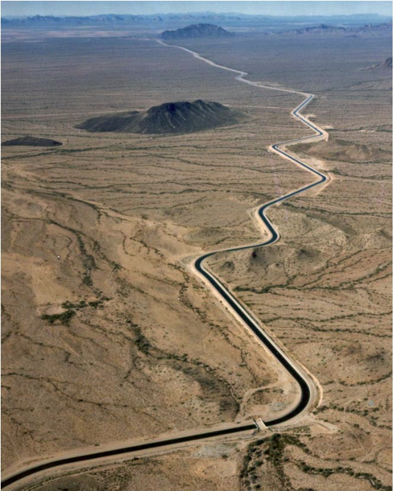
The Central Arizona Aqueduct delivers water from the Colorado River to underground aquifers in southern Arizona. UT researcher Bridget Scanlon recommends more water storage projects like the aqueduct to help protect against variability in the river’s water supply. U.S. Bureau of Reclamation.
Upper Colorado River Basin state leaders, in a letter Friday (April 13, 2018), said the water management approach being taken by the managers of the Central Arizona Project “threaten the water supply for nearly 40 million people in the United States and Mexico, and threaten the interstate relationships and good will that must be maintained if we are to find and implement collaborative solutions” to the Colorado River’s problems.
The letter accuses CAP of “disregard(ing) the basin’s dire situation”, providing more water for Arizona at the expense of the rest of the basin. In doing so, it highlights a rift within Arizona, where an internal political feud over this and related issues has pitted CAP against the state Department of Water Resources and many of CAP’s own customers. That rift, in turn, has stalled diplomacy over efforts to develop a broad new plan to cut back water use across the Colorado River basin.
The letter, using language that is striking in the normally staid interstate diplomacy of Colorado River interstate water management, takes issue with CAP’s practice of using more water than it might otherwise – avoiding “overconserving”, in CAP’s words – in order to ensure continue big releases from Lake Powell upstream. That has the effect of expanding water use in the Lower Colorado River Basin at the expense of draining Lake Powell, the critical reservoir for protecting Upper Colorado River Basin supplies. The managers of the Central Arizona Project are “disregard(ing) the (Colorado River) basin’s dire situation at the expense of Lake Powell and all the other basin states” by using more water than they need to, the letter said.
Click here to read the post from the University of Denver Water Law Review (Kristina Ellis). Here’s an excerpt:
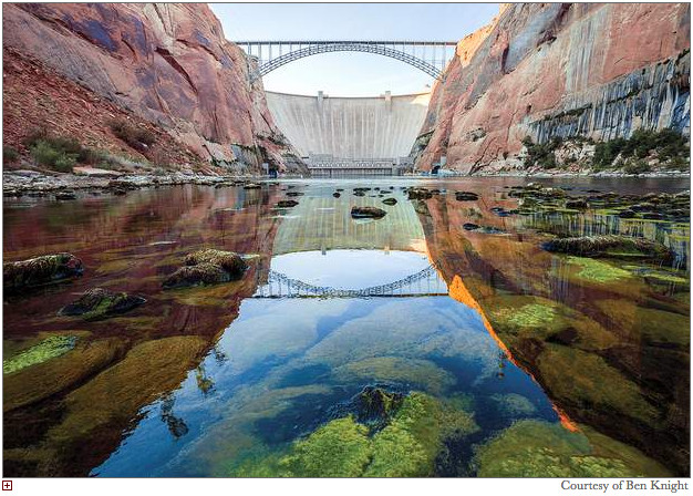
Over the past few years, voices calling for the removal of one of the West’s biggest reservoirs have gotten louder. And while proponents—including scientists, activists, journalists, and government officials—have cited everything from ecology to economics in their quest to decommission Glen Canyon Dam in northern Arizona and restore that part of the Colorado River, very little has been said about the impacts such an action would have on the house-of-cards-like network of compacts, agreements, and obligations comprising the “The Law of the River.
While many of the arguments made by proponents are worth discussion in this era of changing climates and changing values, if they want to make any progress turning this dream into a reality, they will first have to solve the Gordian knot of legal issues revolving around the Colorado Compact…
There are fifteen dams on the main stem of the Colorado River, with hundreds more on its many tributaries. Two of these dams, the Hoover Dam and the Glen Canyon Dam, hold back the nation’s two largest two reservoirs. The Glen Canyon Dam (the “Dam”) was authorized in 1956 under the Colorado Storage Act for storage and hydroelectric power, turning the once wild and flowing Colorado River into the placid Lake Powell. As part of the aforementioned agreements, the Upper Basin has an obligation to deliver a certain amount of water from its basin to the Lower Basin. Instead of relying on the natural flow of the river, this reservoir serves as a water savings account for the Upper Basin so they can store up water in wet years to make sure they meet their delivery obligations to the Lower Basin…
Articles upon articles illustrate the environmental need for letting go of the Dam, lamenting at the natural wonders lost by the plugging up of the Colorado River. One of the biggest voices calling for the dismantling of the Dam is the former Bureau of Reclamation head Daniel Beard. Beard calls the dam a “deadbeat dam,” the title of his book calling for the dismantling of dams across America. Beard writes that instead of viewing the current drought conditions and the decreased levels of both Lake Mead and Lake Powell as a doom-and-gloom situation, that the Bureau of Reclamation and the politicians for each state should look at the situation as a chance for innovative thinking. As part of this strategy, Beard calls for the removal of Glen Canyon Dam and the draining of Lake Powell: let the Colorado River fill up Lake Mead instead bypassing the no longer useful Lake Powell.
While all of these issues are worth discussing in regard to the Glen Canyon Dam coming down or being decommissioned, one thing all of these articles and books seem to overlook is the very real legal obstacles to such a major action. This includes the effect the lack of a reservoir would have on the 1922 Colorado River Compact. Additionally, removing or decommissioning the dam would likely require an impossible amount of political will in Congress. Currently the Glen Canyon Dam produces 4.5 billion kilowatt-hours annually, supplying electricity to nearly six million customers throughout the West, and brings millions of tourists who pump nearly four hundred million dollars into the region each year. But if Congress did decide to one day decommission or tear down the Glen Canyon Dam, the legal ramifications of such a decision would need to be discussed before action could be taken. This article will discuss these ramifications through the perspective of amending the Colorado River Compact of 1922…
If decommissioning or dismantling the Glen Canyon Dam occurs and the waters of the Colorado River are allowed to flow freely downstream, questions about the use and ownership of the water will surface. For example, questions may arise regarding how much water is being allowed to freely flow from one basin to the next and if that amount constitutes an over delivery by the Upper Basin to the Lower Basin based on the Compact numbers. Without a barrier or a way to pump water upstream if too much is delivered downstream, the Upper Basin, without Glen Canyon Dam, opens itself up to many legal risks. Both basins would then need to work out an agreement or a system to replenish the Upper Basin with water. Potential solutions could include a pumping system to deliver water back upstream, a series of new dams, the sharing of the Lake Mead reservoir, and/or a new distribution point between the two basins. Since creating a pumping system could become troublesome and cost millions of dollars, coupled with the call to remove dams from streams and rivers, one likely solution is to share the lower reservoir, which would then change the distribution point as listed in the Compact. In order to accomplish this, stakeholders using the Colorado River would need to amend The Law of the River in some manner. This could include amending the Colorado River Compact of 1922, which has not been amended in nearly one hundred years.
FromColorado Public Radio (Nathan Heffel). Click through to listen to the interview:
A new book puts the Gold King Mine spill within the long history of mining and pollution in Southwest Colorado.
Jonathan Thompson will be at the Book Bar tonight. I wonder if Denver is a bit of a shock to his system even though he’s a sixth-generation Coloradan?
I am so happy to finally get to finally meet Jonathan. His new book, River of Lost Souls, is an important read. Understanding the industrialization of our state over the years will help us chart a less destructive course.
I loved the passages where Jonathan reminisces about spending time around the Four Corners and in the San Juans. He transports you to those times in your life spent next to the river or exploring what sights the land has to offer. He connects you to the Four Corners in a way that only a son of the San Juans could.
Cement Creek aerial photo — Jonathan Thompson via Twitter
Several organizations have filed formal protest against a water rights application filed in January, which proposes diverting water from the Green River in Utah over the Continental Divide to Colorado’s Front Range.
The application, filed by Aaron Million’s Water Horses LLC, calls for 55,000-acre-feet of water to be used in a hydroelectric power facility, likely in Wyoming, before becoming available for consumptive use and in-stream flows on the Front Range. It proposes two pump stations on Bureau of Land Management land about 5 miles west of the state line in Dagget County, Utah, just before the river takes its 41-mile turn into Moffat County.
It would take about 500 miles of pipeline to divert the water from Utah north and east into Wyoming and the Front Range.
The location of the hydroelectric facility “will be determined at a later date, following additional project design and engineering,” according to the application.
Thirty two formal letters of protest from 27 individuals and organizations were submitted to the Utah State Engineer. Protests came from a wide swath of organizations, including a labor union on Water Horse Resources’ project team, an energy company, several environmental nonprofits, private individuals and state and federal agencies. The public protest period on the project closed April 7.
Now, the Utah Division of Water Resources will make a decision on whether to grant the water right. Once the decision comes out, it could be appealed in court.
“It’s just a disagreeable idea to have water from this side of the mountain going over to the other side of the mountain for development purposes, maybe even speculative development purposes, at that,” said Terry Carwile, a Craig resident who sent a letter of protest on the project.
Million has filed applications for Green River water before. In 2012, the Federal Energy Regulatory Commission rejected Water Horse Resource’s application to divert 240,000 acre-feet of water from Wyoming’s Flaming Gorge reservoir to the Front Range…
The project would cost about $890 million, according to a news release from Water Horse Resources LLC. The company has nicknamed it the “Grasshopper Project,” a play on the pronunciation of an acronym of the project’s full name, Green Sun Storage Hydro Power.
“The Green has numerous advantages,” Water Horse Resource’s Tom Wood said in the news release. “A huge river system, excellent water quality, and Flaming Gorge Reservoir that will double the state of Colorado’s storage availability.”
In the news release, Million said that “surpluses out of the Green River can alleviate some issues on the Front Range and take pressure off the high mountain Colorado River headwaters, like the Blue and Fraser River.” Million thinks the project would help net flows on the Colorado River.
“The Green River is one of the remaining watersheds in the Colorado River Basin — specifically in Colorado – that isn’t completely allocated. The state and management/planning entities in the water community want to be able to plan appropriately for the future use of that water,” said Zane Kessler, a spokesperson for the Colorado River District, the organization that operates Elkhead Reservoir and is largely responsible for management of water in the Colorado River Basin.
“The application that we’re looking at now, filed by Mr. Million, would essentially usurp our ability to collectively plan for the appropriate development of the remaining and dwindling water resources that we have at our disposal,” he added.
Kessler said the Colorado River District is concerned the proposal could have far-reaching impacts. The district is worried the proposal could “push us over the cliff,” in meeting obligations to send water downstream under the Colorado River Compact. Should this project over-allocate water in the Upper Colorado River Basin, Colorado water users could be forced to reduce use.
“The risk is not only borne by users on the Green River,” Kessler said. “It’s users throughout the Colorado River basin and the state.”
In Utah, state officials are concerned about impacts to Green River users, as well as the state’s ability to manage for endangered fish. In a letter of protest filed by the Utah Board of Water Resources, officials also question whether the state of Colorado would count the diversion against Colorado’s allocation under the Colorado River Compact.
FromThe Grand Junction Daily Sentinel (Gary Harmon):
The Colorado River Water Conservation District is opposing a water developer’s plan to divert water from the Green River in Utah and pipe it to growing Front Range communities.
The River District formally opposed the proposal by Aaron Million and Water Horse Resources LLC for a Utah water right to divert 55,000 acre-feet of water annually from the Green River and pipe it to the fast-growing metro area.
Million’s proposal is similar to, but smaller, than a previous proposal to pump water out of Flaming Gorge Reservoir in Wyoming and pipe it across the Continental Divide.
The River District complained in a filing with the Utah Division of Water Rights that Million’s proposal was speculative in that he had failed to specify a use or need for the water and noted that he should first obtain a Colorado water right.
Million’s project also would adversely impact the ability of the state of Colorado, the River District and other public entities to plan for the development of Colorado’s share of Colorado River water, and so his application “would be detrimental to the public welfare.”
Million called it “unfortunate that they don’t take a broader view” of how to manage water in the arid West…
Under Interior Department estimates, about 500,000 acre-feet of water remain to be appropriated in the Colorado River system and his project could reduce stress on the headwaters of the Colorado River, Million said.
The River District’s objection to a Utah water right for the project also noted that Million had not demonstrated he could operate the plan in compliance with the Colorado water plan’s conceptual framework on transmountain diversions.
The current proposal, like Million’s last one, is predicated on the idea that Colorado has a right to water from the Green River because it takes a “41-mile dogleg” into Colorado after leaving Wyoming and heading into Utah.
The River District urged the Utah agency to reject Million’s request unless he can prove the project won’t “adversely impact existing water uses in the Upper Basin” of the river and that it would not be detrimental to the public welfare.
FromThe Grand Junction Daily Sentinel (Dennis Webb):
The Utah Board of Water Resources and Division of Water Resources say in their protest letter that the proposal is “very unusual,” and that it “requests a huge amount of water” — 76 cubic-feet per second or 55,000 acre-feet a year — “from Utah’s precious water resources, for some unknown use in Colorado.”
They say the water right application, “if granted, would allow Colorado to benefit from the development, economic opportunities, and public well-being benefits that accrue from water resources at Utah’s expense.”
Aaron Million, the Fort Collins man who filed the application through the company Water Horse Resources LLC, said the protest from the water board is standard, to provide standing in the water right case if any major concerns arise for the protesters in the future…
The Utah water resources board is appointed by Utah’s governor to develop and conserve the state’s water. The decision on Million’s water right proposal will be made by Utah’s state engineer, who heads the state’s Division of Water Rights.
Million is proposing piping the water east in Wyoming and then south into Colorado…
The river district filed a protest against Million’s new proposal. So did the U.S. Bureau of Reclamation, several conservation groups, and several local water conservancy districts and water users associations in Utah.
The Utah water resources board and division say in their letter that the current application “will have huge impacts in Utah,” affecting water supply and quality in the state even as its population is growing and its water needs are increasing, and impacting public recreation and the stream environment along the Green River.
They question the physical and economic feasibility of piping the water “over or around the Rocky Mountains” for use on the Front Range, and say the application was filed for speculative purposes.
“Nothing in the vague application outlines actual beneficial uses in Colorado. No contracts or other types of agreements are provided demonstrating that Colorado can beneficially use the water, or for what beneficial uses it would be employed,” the letter says.
Million says he had subscribed interest for 400,000 acre-feet of water for the previous project, and demand for water has gone up since then.
He estimates that the project could cost up to $1 billion, down from an estimated $2.8 billion for the previous one, and says a tripling in the cost of water on the Front Range helps make the project economic.
The Utah water resource officials, in their letter, also question what authorizations the project has from the state of Colorado to ensure the diversion would count against Colorado’s allocation under an interstate compact divvying up water among states in the Upper Colorado River Basin…
Million said other similar projects already exist in the Upper Colorado River Basin, and he noted that Utah is pursuing a project that would involve diverting water out of the Arizona portion of Lake Powell and piping it into Utah.
From the Center for Biological Diversity (Taylor McKinnon):
The Center for Biological Diversity filed a protest today with Utah’s state engineer challenging a water-rights application from Water Horse Resources to pump nearly 18 billion gallons of water each year from Utah’s Green River over the Rocky Mountains to Colorado’s Front Range.
The plan is the second attempt by would-be water developer Aaron Million to pump water from the Green River to the Front Range. Million’s first plan was rejected twice by the Federal Energy Regulatory Commission in 2012 following challenges by conservation groups and others.
“This is another private water-mining boondoggle that hurts everyone but water barons,” said the Center’s Taylor McKinnon. “It’s bad for people who depend on the Green River, it’s bad for endangered fish, and it’s bad for the state of Utah. We’ve given the state engineer a long list of reasons to reject this application and that’s exactly what he should do.”
Today’s protest states that the application violates state law by failing to identify beneficial uses of the water and by exacerbating water shortages. The withdrawal would overallocate water in the Green River, a tributary of the Colorado River, and add to climate-driven flow declines. The application is predicated on using Colorado’s apportionment under the Upper Colorado River Compact, but provides no evidence that Colorado has agreed, or will agree, to this.
The water withdrawals would occur below Flaming Gorge Dam in a part of the Green River that is critical to the recovery of Colorado pikeminnow and other endangered fish. The withdrawal would reduce river flows designed to help increase the fish population at a time when failure to meet recovery flows already imperils the fish. Drought is expected to cause low river flows throughout the Upper Colorado River Basin this year.
Click here to go to the website. Here’s an excerpt:
SWCD’s 36th Annual Water Seminar, “Weathering the Weather: Resilience in Managing Our Water Resources Today,” was attended by almost 200 people, and highlighted lessons for our local communities in preparing for and responding to sudden challenges. Experts discussed how wildfire impacts water supplies, the state’s response to emergencies such as the 2013 front range flooding, the western slope’s risk in the context of Colorado River obligations and drought, as well as avoiding devastating infrastructure failure, among other related topics. Hear an interview about the seminar with Executive Director Bruce Whitehead or read coverage of the event in the Durango Herald.
From the Associated Press via Colorado Public Radio:
On the southern high plains, Oklahoma remains ground zero for the worst drought conditions in the United States. About 20 percent of the state is facing exceptional drought conditions — the worst possible classification.
Most of Colorado also is under severe drought and almost all of the Texas Panhandle is seeing extreme drought or worse conditions.
The federal drought map shows dry conditions have intensified across northern New Mexico and expanded in Arizona.
Nearly half of New Mexico and Arizona are facing extreme drought or worse conditions while about 60 percent of Utah is under severe drought. according to the National Drought Mitigation Center.
Along the Rio Grande in New Mexico, the irrigation allotment will be less than half of what farmers received last year due to subpar snowmelt from the mountains.
Like other states, Utah’s drought can be traced to a 12-week stretch of low precipitation this winter, when the mountains saw some of the lowest snow totals in recent history — also an ominous sign for the state’s renowned skiing sites…
Much of Utah’s water reserves were replenished last winter, after a bruising period from 2012 to 2016 that nearly depleted the state’s water reserves.
As a result, lack of water isn’t a concern now, McInerney said.
But danger of forest fires will be elevated as the hot summer edges closer, he said.
Map of the Colorado-Big Thompson Project via Northern Water
Here’s the release from the Northern Colorado Water Conservancy District (Jeff Stahla):
Strong regional water storage coupled with below-average precipitation prompted the Northern Water Board of Directors to increase its 2018 quota allocation for the Colorado-Big Thompson Project to 80 percent.
The Board unanimously approved the allocation at its meeting Thursday at Northern Water’s Berthoud headquarters.
Sarah Smith, a water resources engineer at Northern Water, said total storage in the region was above average for the fifth-straight year. While Colorado precipitation has been below average this winter, recent storms boosted the snowpack in the northern portion of the state.
“The Poudre basin did benefit quite a bit from those storms,” she said.
Water Resources Manager Andy Pineda recommended the 80 percent quota to the Board based on the existing snowpack totals, runoff projections, regional water storage and input from water users.
The 80 percent quota increases available C-BT Project water supplies by 93,000 acre-feet from the initial 50 percent quota made available in November.
Water from the C-BT Project supplements other sources for 33 cities and towns, 120 agricultural irrigation companies, various industries and other water users within Northern Water’s 1.6 million-acre service area. According to recent Census figures, 960,000 residents now live inside Northern Water’s boundaries.
While much of the state is facing drastic water shortages, shareholders in the Colorado Big Thompson project will see better than average return on their investment this year, according to a Northern Colorado Water Conservancy District news release…
The quota this year is 80 percent, up from the average of 70 percent, a jump that represents 93,000 extra acre feet for the year.
Greeley is one of 33 cities that uses Colorado Big Thompson water, and Greeley Water and Sewer Board Chairman Harold Evans said the quota looks good for Greeley…
Northern Water got a bump thanks to a fifth-straight year of above-average reservoir storage, as well as recent storms that have boosted snowpack in the state’s northern regions. Reservoir storage this year is 25 percent higher than normal, according to the United States Department of Agriculture Natural Resources Conservation Service snowpack report released this past week.
Colorado Big Thompson water is used by 33 cities and towns, as well as 120 agricultural irrigation companies, various industries and other water users, according to the release. Nearly one million residents live within Northern Water’s service area.
The announcement will help farmers and municipalities plan water use for the year. About 70 percent of the contracts for Colorado Big Thompson water are owned by municipalities, but the usage is about 50 percent for farmers versus municipalities, as farmers often lease some water from municipalities, including Greeley.
Burt Knight, Greeley’s Water and Sewer director, said the higher quota will allow Greeley to lease some water to some of its agriculture partners.
The Greeley Water and Sewer Board will meet next week for its annual declaration regarding the snowpack and how it impacts Greeley.
The members of the Rio Grande Basin roundtable got a disheartening report this week about this year’s snowpack and likely runoff in the Rio Grande River basin, as well as an update on a 30-year warming and drying trend.
“We’re going to have low stream flows,” Craig Cotten, the division engineer for the Colorado Division of Water Resources in the basin, told the roundtable Tuesday at its monthly meeting in Alamosa, just a few blocks from the river. “I’m sure we’re going to dry up the Conejos (River) and maybe the Rio Grande, in some spots.”
Cotten shared snowpack data taken from snow telemetry, or SNOTEL sites, around Colorado, which measure the amount, and weight, of the snowpack at specific locations around the state.
The data this week showed a decline in snowpack from north to south in Colorado.
The North Platte River basin, to the northeast of Steamboat Springs, was at 102 percent of the median level for that date.
The South Platte River basin, which includes Denver, was at 93 percent.
The Yampa and White river basins, north of Interstate-70, were at 89 percent.
The Colorado River basin, which includes Glenwood Springs and Aspen, was at 86 percent.
The Gunnison River basin, further south, was at 60 percent.
The Rio Grande River basin was at 40 percent.
And the San Miguel, Dolores, Animas and San Juan river basin, in the southwest corner of the state, was at 39 percent.
So while water managers and river users in the northern and eastern part of the state may have more water than their southern counterparts, it’s a bit like passengers in a lifeboat having more drinking water in their end of the boat than the passengers in the other end — it’s nothing to gloat about.
Jeff Derry is the executive director of the Center for Snow and Avalanche Studies in Silverton, which studies the “dust on snow” phenomenon and how it affects the state’s snowpack.
Derry focuses on information from “snow course” sites, in addition to SNOTEL sites, as the snow course sites measure the snow water equivalent, or moisture levels in the snow, across broader landscape areas and have often done so over longer periods of time than SNOTEL sites.
He showed the roundtable graphs that indicate the snowpack in the southern part of the state, as of April 1, was tracking right at the same level as the very dry years of 1977 and 2002, while the whole of the state, on average, was tracking just above those drastically low years.
The avalanche center’s website has a graph that takes the average of 81 snow course sites across Colorado.
“Water year 2018 is comparable to 1966, 1981, 1999, 2004, (and) 2012,” Derry wrote. “We are faring just very slightly better than 1977 and 2002.”
Derry’s graphs also included long-term trend lines dating back 30 to 80 years, which clearly indicate Colorado’s snowpack has been shrinking and temperatures have been rising, especially on the colder end of the spectrum, meaning the lowest temperatures in winter are not as low as they used to be, especially over the past 30 years.
“It’s getting warmer and we’re seeing less precipitation in the wintertime,” Derry told the roundtable members.
Aspen Journalism is covering rivers and water in collaboration with The Aspen Times. More at http://www.aspenjournalism.org.
FromThe Grand Junction Daily Sentinel (Dennis Webb):
State weather experts say the snowpack in the Gunnison River Basin and farther south will likely melt out a month earlier than normal this spring even as snow levels farther north continue to fare better, thanks in part to a recent storm.
“Things are getting better in the areas that are just slightly below normal, and still getting worse in the areas that are way below normal,” Peter Goble, climatologist and drought specialist at the Colorado Climate Center, said Tuesday in a webinar on drought conditions.
The update came at a time when snowpack levels in river basins typically reach their peaks and spring runoff begins. Assistant State Climatologist Becky Bolinger said the San Juan River Basin area in southwest Colorado already likely has peaked at 50 percent of normal seasonal peak accumulation, and the Gunnison basin, which is at 58 percent of seasonal median peak, also may have peaked…
She said the same goes for the San Juan area, while Goble said the Upper Rio Grande Basin is melting out even faster. He said he recently visited southern Colorado and the snowpack looked “heartbreaking” in the San Juan area and “pretty miserable” in the Sangre de Cristo mountains.
Many snow-measurement sites are recording the lowest snowpacks on record in southern Colorado. Sites on Grand Mesa are showing snowpacks at less than half of average, and at or near record low levels.
Meanwhile, the storm that hit northern Colorado watersheds several days ago brought up to 2½ feet of snow, the Colorado Climate Center says. In terms of water content, Bolinger said the storm brought two to three inches of precipitation to some higher-elevation areas and more widespread precipitation ranging from a half-inch to an inch.
Yampa River Basin snowpack is at 80 percent of seasonal peak levels, and the Upper Colorado River Basin in Colorado is at 77 percent of peak. Bolinger hopes to see more accumulation in the Upper Colorado Basin, but she said peak accumulation there usually arrives by mid-April…
Colorado’s statewide snowpack was at 72 percent of median Tuesday, up from 68 percent at the start of the month. The snowpack is now where it stood March 1 before falling due to March precipitation that was only 65 percent of normal, according to the Natural Resources Conservation Service.
Some streams already are running below average levels, and the NRCS said last week that spring and summer streamflows in Colorado will be between 30 and 70 percent of normal.
It said the Gunnison River at Grand Junction is forecast to have only 33 percent of average streamflow, and the Colorado River at Cameo is expected to flow at 64 percent of average. The Gunnison’s flow will be affected by the U.S. Bureau of Reclamation’s efforts to hold back as much water as it can in Blue Mesa Reservoir, which it expects will fill to about three-quarters of capacity.
Goble said while it doesn’t appear that McPhee Reservoir in southwest Colorado will fill this year, it sounds like farmers in the Four Corners area are being promised their full irrigation allotment. While the reservoir may be drawn down some this year, “we’re not in miserable shape there,” he said.
Reservoir storage that is at 114 percent of average statewide and is above average even in southwestern Colorado continues to ease the sting of this winter’s poor snowfall. Bolinger said she’s not hearing a huge concern from water providers this year…
She said areas that rely only on streamflow will have more of a concern, as will growers of some dryland crops.
She said water officials will be watching how much reservoir levels can be built up this spring. Southern reservoirs aren’t likely to be able to store additional water due to low runoff and increased drawing down due to drought. That will mean that next winter a more normal snowpack will be needed to help those reservoir levels recover.
If next winter is similar to this year, “that’s when we’re really looking at having to make some hard decisions … and really feeling the effects of drought,” she said.
A heavy storm last weekend did more than put smiles on the faces of local powder hounds. That storm, by itself, put down 18 percent of Vail Mountain’s current snowpack.
According to the vail.com website, Vail Mountain has received 23 inches of snow in the past seven days, virtually all of it from that weekend storm.
Elsewhere on Vail Mountain, the U.S. Department of Agriculture’s snow-measurement site recorded 14.6 inches of “snow water equivalent,” enough to finally surpass the record-low snow season of 2011-12.
Still, the site is recording a total well below the 30-year median — just 70 percent.
The news is better at the measurement sites at Copper Mountain and Fremont Pass. Those sites are the closest ones to the headwaters of Gore Creek and the Eagle River, respectively.
At Copper Mountain, the measurement site is at 95 percent of the 30-year average. At Fremont Pass, the total is 111 percent of average…
Last weekend’s storms were still more than welcome. [Peter] Goble called the storm a “game-changer” in terms of snowpack. While snowpack is still well below normal through most of the state, Goble said the next drought map from his office will have some changes. Locally, some of the areas in Eagle County will drop back one level in its classification. Areas that most recently were in “severe” drought will drop back to “moderate,” while the area around Vail may revert to the lowest classification, “abnormally dry.”
As of April 10, snowpack in the Yampa and White River Basin was at 89 percent of normal, which is nearly the highest it’s been this water year, said National Weather Service meteorologist Jeff Colton. To the north, Wyoming’s Green River Basin is at 91 percent of median.
The Stagecoach, Elkhead and Yamcolo Reservoirs are expected to fill or nearly fill…
Now, timing is key. Availability of water through the course of the season is dependent on the timing and amount of spring precipitation and melting snowpack.
Currently, water managers are bypassing water from rain and snowmelt through Stagecoach Reservoir, because it can’t be filled until the ice on top of the water has melted; ice flowing through the dam’s spillway would damage the infrastructure of the reservoir.
On the Yampa, managers don’t want to see too much too soon. Gray said the Yampa typically hits the high water mark around June 1 in Moffat County…
As long as the area gets more spring moisture — and warm temperatures don’t melt snowpack in the Park Mountains too early — Gray said irrigation in the area is expected to be “a little short,” but water is not anticipated to be as scarce as it appeared it might be earlier this year…
For now, Northwest Colorado still faces drought conditions, according to the United States Drought Monitor. The eastern half of the county and a sliver in the northwest corner of the county are in abnormally dry conditions. Most of western Moffat County is in a moderate drought, while the Dinosaur and Massadona areas face severe drought conditions.
Not without good reason, the nation’s media have been focusing on the dramatically thin snowpack of the Upper Colorado River Basin, which portends a meager amount of runoff into the Colorado River system.
As of April 2, the basin snowpack stood at just 72 percent of normal, heralding a runoff season that may be the sixth driest in the 55 years that Glen Canyon Dam and Lake Powell have been in place to capture the runoff.
On average, the in-flow into Lake Powell is 7.1 million acre-feet per season. Although the figure may change, this year’s projection currently stands at less than half that amount – 3.1 million acre-feet.
Bad news? Oh, yes. But where Arizona’s renewable water supplies are concerned, the 2018 story gets still worse. As opposed to the Colorado River system, the in-state river systems are setting records.
The Salt River Project is reporting that, according to provisional data for runoff in the Salt and Verde reservoir systems, the January – March runoff totals are “the lowest amounts on record dating back to 1913.”
Water Year precipitation for the State’s two major watersheds (Oct. 1 – Mar. 31) stood at just 2.88 inches, a figure that unsurprisingly graded out as “Well Below Normal.”
As a result, runoff in the watershed has been extremely poor. SRP data indicate that runoff into the Salt and Verde reservoirs in March stood at just 14 percent of median – the second-lowest amount on record.
In the wake of a December – February snowpack season that produced next to nothing in the two Arizona watersheds, three small storms after mid-March produced a snow-water equivalent of just 22,000 acre-feet, most of it at the highest elevations of the region.
Overall, total watershed streamflow this runoff season (January -May) is forecast to be near the lowest on record, which stood at 106,000 acre-feet in 2002.
SNOTEL data produced by the Natural Resource Conservation Service depict snowpack values as high as 40 percent of normal and as low as zero percent of normal.
If you seek to frolic in the snow in Arizona, you’ll be hard-pressed to find white stuff for your skis: According to satellite data, just 0.3 percent of the watershed had snow coverage as of April 1.
If winter in Arizona proved dry, early spring doesn’t hold out much hope for moisture here, either. Reports indicate that Arizona should anticipate warmer, drier weather through the first half of April, at least.
Forty-five percent of Arizona is now in extreme drought according to the Arizona Drought Monitoring Technical Committee.
The committee released a report last week showing statewide drought conditions worsened during March. The continued dryness led to drought declarations on the Navajo Nation and in Yuma County.
Though a series of weak storms passed through Arizona, they left only insignificant snow, according to the report. The southern half of the state remained dry and northern Arizona received only scattered light precipitation. The committee noted rangeland conditions are very poor with little forage, and water hauling for both livestock and wildlife has begun in many parts of the state…
U.S. Bureau of Reclamation reports as of Tuesday showed Lake Powell is 56 percent full and Lake Mead is at 41 percent, with an 1,087 foot elevation, roughly 12 feet above the 1,075 elevation that would trigger automatic first tier shortages for Central Arizona Project deliveries.
BuRec does not anticipate any level of shortage in Lake Mead for 2018, but increased the probability of shortage in 2019 from 15 percent in August 2017 to 17 percent probability now. BuRec’s Colorado River Simulation System model also increased the probability of shortage in 2020 by 7 percent, in 2021 by 13 percent and in 2022 by 11 percent.
Worse, ADWR officials said, in-state river systems are historically low; provisional data for runoff in the Salt and Verde reservoir systems show the January through March runoff totals are “the lowest amounts on record dating back to 1913.”
Click here to go to the US Drought Monitor website. Here’s an excerpt:
Summary
A series of storms systems with varying amounts of precipitation swept across most of the lower 48 States this week, including the Far West which was mostly dry last week. After a very dry February, normally one of the wettest months of the year in California, repeated storms have brought welcome precipitation to most of the state, gradually increasing WYTD precipitation and Sierra snows closer to normal. Decent precipitation (2-6 inches, locally to 10 inches) also fell on western Oregon and Washington and in the Cascades. In the Southwest, however, storms have generally bypassed this region this winter (and this week), and after a disappointing 2017 summer monsoon, drought conditions expanded and worsened. To the east, light to moderate precipitation fell on the northern and central Rockies, north-central Plains, the western Corn Belt, and most locations in the eastern third of the Nation. The greatest amounts (1.5-4 inches) fell on the lower Mississippi and eastern Ohio Valleys, eastern Carolinas, and north-central Florida. Subnormal temperatures prevailed across much of the contiguous U.S. east of the Rockies (except Florida), and averaged above-normal in the Southwest. Showery weather continued across Hawaii and Puerto Rico (where no drought existed) while drier weather occurred across Alaska…
Like last week (and many other recent weeks), significant precipitation fell mainly on non-drought areas of Arkansas, Mississippi, Tennessee, Louisiana, and eastern sections of Oklahoma and Texas, and bypassed the drought in western Texas and Oklahoma. With the early October rains falling out of the most recent 6-month period, SPIs plunged to D3 and D4 levels across northern new Mexico, northern Texas, western Oklahoma, southern Colorado, and southwest Kansas. The early October rains seemed like a long-faded memory as most non-irrigated winter wheat fields and pastures in the panhandles of Texas and Oklahoma were in very poor or dead condition. According to NASS/USDA April 8 reports, 61%, 57%, 44%, and 19% of Texas, Oklahoma, Kansas, and Colorado winter wheat was in poor or very poor condition, respectively, and 41%, 40%, 37%, and 26% of Colorado, New Mexico, Oklahoma, and Texas pastures and ranges were in similar condition (Kansas N/A). In parts of northern Texas, soils were dry down to 1-3 feet, whereas other locations were dry in the upper 12-18 inches, and Level 2 water restrictions were in place for Canyon, TX. While some areas benefited from the early October rains and were kept at D3, D4 was expanded into northeastern New Mexico, northern Texas,, western Oklahoma, and southwestern Kansas where the impacts matched the indices. In contrast, with additional light rains in central and southern Texas, plus heavier rains from last week, minor adjustments (mostly improvements) were made to the D0-D2 areas, except for some D2 expansion north of Del Rio that missed out on the rains during the past 2 weeks. In southern Louisiana, light showers (0.5-1.5 inches) fell on the D0 area, but the heaviest rains fell north and south (offshore), thus no changes were made…
Another week of light precipitation (snow) and subnormal temperatures enveloped the northern Plains, with some heavier amounts (0.5-1 inch) falling on northern and eastern South Dakota and the Black Hills. In east-central South Dakota, 4-8 inches of snow fell from Aberdeen southeastward past Watertown, and with this moisture, a slight D0 removal was made where indices out to 6-months were wet, and since this D0 was short-term, it was easier to justify its removal; however, the D0 was kept where frost depths were deeper (down to 2-4 feet) in the northeast. After several weeks of gradual improvements in eastern Montana and the western Dakotas, no changes were made this week as precipitation was lighter. In northern Colorado, some decent precipitation fell on the central Rockies, finally allowing for some small 1-category improvements in northwestern and north-central sections of the state as WYTD indicators climbed above various D0-D2 percentile thresholds. Farther south, similar to other south-central Plain states, Kansas saw little or no precipitation (less than 0.25 inches) as not only short-term indices (6-months or less) but also longer-term tools (9- and 12-months) indicated drier conditions than depicted. Accordingly, the D4, D3, D2, and D1 borders were slightly extended northward to reflect the severe conditions and growing deficits (8-14 inches at 12-months in central Kansas). The April 8 NASS/USDA winter wheat rating for Kansas stood at 44% in poor or very poor condition, with Kansas the top state for winter wheat production. No changes were made between the border of Nebraska and Kansas as a few extra snow events this year across this area have contributed enough moisture to prevent deterioration, at least for now…
After experiencing rather tranquil weather last week, stormy weather returned to the Far West as has thankfully been the case since early March – after a near-record dry February (third driest February in California since 1895, according to NCEI). With the continued train of spring storms providing badly-needed moisture to California, additional improvements were made to areas with the greatest weekly totals (3-8 inches) that have also neared their normal WYTD precipitation. With most major reservoirs above their April 10 historic average and stream flows nearing 7-day record highs due to the combination of heavy rains and some snow melt, D0 was removed from northern and central coastal and Sierra Nevada locations, while D1 was improved to D0 near and south of Fresno to near Bakersfield. Although WYTD deficits remained, this latest storm caused flooding, and coupled with last winter’s surplus precipitation, conditions have improved with the spring storms. April 10 snow water equivalents (SWE), however, remained below normal, with northern (36%), central (51%), and southern (39%) Sierras seeing some snow melt from lower elevation rains. Statewide, the SWE summary stood at 11.7 inches, or 43% of normal for April 10. Likewise, additional precipitation over northeastern Nevada (D0 to nothing hole) and along the Nevada-Oregon border (D1 to D0) warranted a 1-category improvement.
In contrast, another week of disappointing dry and warm weather in the Southwest led to additional deterioration. In southern California, after reassessing reservoir conditions at Lakes Cachuma, Casitas, and Piru in Santa Barbara and Ventura counties, the earlier March rains did little to increase their levels, thus D2 was returned to those counties. While higher terrains in California’s Owen Valley and eastward into Nevada did fairly well with March storms, the lower elevations did not, and when combined with a poor fall and winter, D1conditions were expanded into southern Nevada. In addition, D2 was increased in east-central Colorado with 6-month SPIs between -1 and -2.5. D3 now covered southeastern Utah, southwest Colorado, and central New Mexico as another dry and warm week dropped WYTD basin average precipitation to 50, 43, and 19-27% of normal, respectively, while the mountain snows have completely melted in eastern Arizona and most of New Mexico (0% SWE). In southeastern Utah and northeastern Arizona, D4 areas were added to reflect both the poor winter conditions and the weak and early ending summer monsoon of last year (12-month indices at D4). In northeastern New Mexico, D4 was extended into Union and Colfax counties as near- or record dry 6-month precipitation, above-normal temperatures, low humidity, and strong winds combined to produce very poor irrigated winter wheat, along with bare, dead, or very poor pasture and range conditions according to field observations…
Looking Ahead
During April 12-16, 2018, more precipitation is expected for the Pacific Northwest southward into northern California and the Sierra Nevada, and then eastward across the northern sections of the Rockies and Plains. Widespread moderate precipitation (0.5-2 inches) is anticipated for most of the eastern third of the Nation, with the greatest totals (2-4 inches) targeting the lower Mississippi and Tennessee Valleys, the north-central Great Plains, and the upper Mississippi Valley and Great Lakes region. Heavy snow should blanket the north-central Plains and upper Midwest. Unfortunately, the Southwest and southern half of the Plains is expected to remain dry. Temperatures should average below normal across much of the lower 48 States, especially in the northern Plains and upper Midwest, while the mid-Atlantic and Ohio Valley experience unseasonable warmth for a change.
For the ensuing 5 days (April 17-21), odds favor above-median precipitation across much of the West, Rockies, and Plains, except near to below-median totals in southern Arizona and most of New Mexico and Texas. The upper and middle Mississippi Valleys, Great Lakes region, northern New England, and southern half of Alaska also favor above-median precipitation chances, while sub-median totals are likely for the Southeast, Appalachians, and mid-Atlantic. Subnormal temperatures are a good bet across much of the lower 48 States except in the southern Plains and extreme southern Florida, with Alaska tilting toward above-normal readings in the west and below-normal in the east.
The White-Rumped Vulture (Gyps bengalensis) is an Old World vulture native to South and Southeast Asia. It has been listed as Critically Endangered on the IUCN Red List since 2000, as the population severely declined. White-rumped vultures die of renal failure caused by diclofenac poisoning. In the 1980s, the global population was estimated at several million individuals, and it was thought to be “the most abundant large bird of prey in the world”. As of 2016, the global population was estimated at less than 10,000 mature individuals. Photo credit: Wikimedia
Large numbers of pharmaceuticals found at levels dangerous for wildlife and the environment
River systems around the world are coursing with over-the-counter and prescription drugs waste which harms the environment, researchers have found.
If trends persist, the amount of pharmaceutical effluence leaching into waterways could increase by two-thirds before 2050, scientists told the European Geosciences Union conference in Vienna on Tuesday.
“A large part of the freshwater ecosystems is potentially endangered by the high concentration of pharmaceuticals,” said Francesco Bregoli, a researcher at the IHE Delft Institute for Water Education in the Netherlands, and leader of an international team that developed a method for tracking drug pollution “hotspots”.
A large number of drugs – analgesics, antibiotics, anti-platelet agents, hormones, psychiatric drugs, antihistamines – have been found at levels dangerous for wildlife.
Endocrine disruptors, for example, have induced sex changes in fish and amphibians.
Bregoli and his team used a common anti-inflammation drug, diclofenac, as a proxy to estimate the presence and spread of other medications in freshwater ecosystems.
Both the European Union and the US Environmental Protection Agency have identified diclofenac as an environmental threat. Veterinary use of it has driven a sub-species of vultures on the Indian subcontinent to the brink of extinction.
More than 10,000km of rivers around the world have concentrations of diclofenac above the EU “watch list” limit of 100 nanograms a litre, the new research found.
“Diclofenac emissions are similar to any of thousands of pharmaceuticals and personal care products,” said Bregoli.
Global consumption of diclofenac tops 2,400 tonnes a year. Several hundred tonnes remain in human waste, and only a small fraction – about 7% – of that is filtered out by treatment plants.
Another 20% is absorbed by ecosystems, and the rest go into oceans.
Bregoli and his team developed a computer model to predict current and future pharma pollution based on criteria such as population densities, sewage systems and drugs sales.
They compared the results to data gathered from 1,400 spot measurements of diclofenac toxicity taken from around the world. Most of the data points were in Europe and North America.
Pollution levels are likely to be substantially higher in much of Latin America, Africa and Asia where less than a quarter of waste water is treated, and with technology unable to filter out most pharmaceuticals.
Technology alone cannot solve the problem, said Bregoli.
“We need a substantial reduction in consumption,” he said.
In other research presented at the conference, scientists found that the rapid expansion of sewage systems in large urban areas has sharply raised river pollution because much of it is not adequately treated.
“In 2000, sewage was a source of pollution in about 50% of the rivers in the world,” said Maryna Strokal, a scientist at Wageningen University and Research in the Netherlands.
“By 2010, sewage was a source of pollution in almost all rivers worldwide.”
Antibiotics and chemicals waste is also driving the evolution of drug-resistant bacteria, UN Environment warned in a study in December.
Between 70% and 80% of all antibiotics consumed by humans and farm animals – thousands of tonnes – find their way into natural environments, it said.
The Atlantic Ocean circulation that carries warmth into the Northern Hemisphere’s high latitudes is slowing down because of climate change, a team of scientists asserted Wednesday, suggesting one of the most feared consequences is already coming to pass.
The Atlantic meridional overturning circulation has declined in strength by 15 percent since the mid-20th century to a “new record low,” the scientists conclude in a peer-reviewed study published in the journal Nature. That’s a decrease of 3 million cubic meters of water per second, the equivalent of nearly 15 Amazon rivers.
The AMOC brings warm water from the equator up toward the Atlantic’s northern reaches and cold water back down through the deep ocean. The current is partly why Western Europe enjoys temperate weather, and meteorologists are linking changes in North Atlantic Ocean temperatures to recent summer heat waves.
The circulation is also critical for fisheries off the U.S. Atlantic coast, a key part of New England’s economy that have seen changes in recent years, with the cod fishery collapsing as lobster populations have boomed off the Maine coast.
Some of the AMOC’s disruption may be driven by the melting ice sheet of Greenland, another consequence of climate change that is altering the region’s water composition and interrupts the natural processes.
This is “something that climate models have predicted for a long time, but we weren’t sure it was really happening. I think it is happening,” said one of the study’s authors, Stefan Rahmstorf of the Potsdam Institute for Climate Impact Research in Germany. “And I think it’s bad news.”
But the full role of climate change in the slowing ocean current is not fully understood, and another study released Wednesday drew somewhat different conclusions.
This study, which was also published in the journal Nature, found that the AMOC has slowed over the past 150 years and similarly found that it is now weaker than at any time in more than a millennium.
“The last 100 years has been its lowest point for the last few thousand years,” said Jon Robson, a researcher at the University of Reading and one of the study’s authors. (The study’s lead author was David Thornalley of the University College London.)
The two studies have their differences: The second suggests the slowdown probably began for natural reasons around the time of the Industrial Revolution in 1850, rather than being spurred by human-caused climate change, which fully kicked in later.
But like the first study, the second finds that the circulation has remained weak, or even weakened further, through the present era of warming.
Sharp changes off the coast of Maine
The authors of the first study believe the shift in the circulation may already having a big impact along the U.S. coastline.
“Of all the U.S. waters, this region has definitely warmed the fastest in the last decade,” said Vincent Saba, a marine biologist at the National Oceanic and Atmospheric Administration and one of its co-authors.
And that has had major effects on fisheries. The Gulf of Maine, for instance, has seen a giant boom in the local lobster industry and crash of the cod fishery.
“A lot of these changes are happening relatively fast, and our fisheries management is unable to keep up,” Saba said. “We’re trying to figure out how to deal with some of these species shifts that we’re seeing.”
It’s not just fisheries: If the slowdown trend continues, it is expected to drive strong sea-level rise against the Eastern Seaboard. Previous research has already shown that from 2009 to 2010, sea level in the region suddenly shot up five inches, thanks in part to a brief slowdown of the circulation.
This occurs, Rahmstorf explains, because the northward flow of the Gulf Stream pushes waters to its right — which means that the ocean piles up against the coast of Europe. But as the current weakens, some of the water flows back toward the United States’ East Coast instead.
As for the future, Rahmstorf predicts the circulation will only weaken further as climate change advances. It may not be slow and steady: There is great fear that there may be a “tipping point” where the circulation comes to an abrupt halt.
This is one of the most infamous scenarios for abrupt climate change, as it is known: Studies from the planet’s history suggest that such a sudden change in the North Atlantic has occurred many times in Earth’s past, perhaps as recently as about 13,000 years ago. But it’s not clear how close the tipping point might be.
“I think in the long run … Greenland will start melting even faster, so I think the long-term prospect for that ocean circulation system is that it will weaken further,” Rahmstorf said. “And I think that’s going to affect all of us, basically, in a negative way.”
During March, the average contiguous U.S. temperature was 42.6°F, 1.1°F above the 20th century average. This ranked near the median value in the 124-year period of record.
Below-average temperatures were observed along parts of the East Coast, Northern High Plains and West. In the East, the cooler-than-average March was preceded by a record and near-record warm February. Some locations observed March temperatures that were cooler than February, an unusual but not unprecedented occurrence.
Above-average temperatures were observed across the south-central U.S., stretching from the Central Rockies through the Southwest and the Southern Plains. Above-average temperatures were also observed in parts of New England and the Upper Midwest.
The contiguous U.S. average maximum (daytime) temperature during March was 53.9°F, 0.9°F above the 20th century average, ranking near the median value. Below-average maximum temperatures were observed across much of the East with much-below-average temperatures in the mid-Atlantic. Above-average maximum temperatures were observed in the Southwest, Central Rockies and Southern Plains.
The contiguous U.S. average minimum (nighttime) temperature during March was 31.4°F, 1.4°F above the 20th century average, ranking in the warmest third of the record. Above-average conditions were observed in the Southwest, New England, and parts of the Rockies and Great Plains. Below-average minimum temperatures were observed across the East Coast from the Mid-Atlantic to Florida and for parts of the Northern High Plains and West.
The Alaska March temperature was 17.7°F, 6.9°F above the long-term average. This tied the ninth warmest March in the 94-year period of record for the state. Northern and western Alaska were much warmer than average, with near-average temperatures in southern Alaska. Utqia’vik (Barrow) had its warmest March on record, while Kotzebue had its second warmest and St. Paul its third warmest.
During March there were 1,515 record warm daily high (620) and low (985) temperature records, which was about 46 percent more than the 1,031 record cold daily high (663) and low (368) temperature records.
Based on NOAA’s Residential Energy Demand Temperature Index (REDTI), the contiguous U.S. temperature-related energy demand during March was 2 percent above average and ranked near the median value in the 124-year period of record.
March 2018 Statewide Precipitation Ranks
Precipitation
The March precipitation total for the contiguous U.S. was 2.42 inches, 0.09 inch below average, and ranked near the median value in the 124-year period of record.
During March, four strong winter storms known as Nor’easters impacted the East, bringing heavy snow across parts of the Midwest and from the Southern Appalachians to New England. Some locations in the East had more snow during March than during the preceding winter months combined. Numerous locations had a top five March snowfall total during 2018, including Boston, Massachusetts; Albany, New York; and Philadelphia, Pennsylvania.
Above-average precipitation was observed across parts of the West, Northern Rockies and Plains, Midwest and South. The beneficial precipitation helped to boost snowpack totals in parts of the Sierra Nevada, which were below-average during much of their wet season. However, snowpack totals remained below average in the region.
Below-average precipitation was observed across parts of Northwest, Southwest, Great Lakes, Southeast and East Coast. The general lack of precipitation and above-average temperatures in the Southwest contributed to a continuation of very low snowpack in the Southern Rockies and parts of the Great Basin.
According to the April 3 U.S. Drought Monitor report, 29.4 percent of the contiguous U.S. was in drought, down from 31.3 percent at the end of February. Drought conditions improved in California, the Northwest, Northern Plains, and parts of the Southern Plains, Mid-Mississippi Valley and interior Southeast. Drought conditions worsened across parts of the Southwest, Central Plains, southern Texas and the coastal Southeast. Drought also developed in the Alaska Panhandle due to several months of below-average precipitation.
According to NOAA data analyzed by Rutgers Global Snow Lab, the March snow cover extent was 303,860 square miles above the 1981-2010 average and ranked as the sixth highest value in the 52-year period of record. This was the highest March snow cover extent since 1979. Above-average snow cover was observed across parts of the West, Northern Rockies, Northern Plains, Midwest and Northeast. Below-average snow cover was observed in parts of the Southern Rockies, Central Plains and Great Lakes.
Here’s the release from MWD (Rebecca Kimitch/Bob Muir):
METROPOLITAN BOARD APPROVES ADDITIONAL FUNDING FOR FULL-SCALE, TWO-TUNNEL CALIFORNIA WATERFIX
The board of directors of the Metropolitan Water District of Southern California voted today to provide the additional financing necessary to allow for the construction of the full California WaterFix project.
The board authorized $10.8 billion for the project to modernize the state’s aging water delivery system, making Metropolitan the primary investor in the project and more than doubling the agency’s initially planned investment to ensure the project is completed as originally proposed and studied.
“For decades, we have sought a solution to the problems of the Bay Delta, problems that put Southern California’s water supply at risk,” Metropolitan board Chairman Randy Record said. “We finally have that solution, California WaterFix. We simply could not jeopardize the opportunity to move this long-sought and much-needed project forward.”
WaterFix will be paid for by the people and businesses that use the water it helps deliver via the retail water agencies and cities that serve those customers. Metropolitan’s financing of the full project is expected to cost households on average up to $4.80 a month, though that average cost would be reduced as Metropolitan recoups some of its investments from the agricultural sector. Metropolitan will be selling or leasing capacity in the tunnels to allow water deliveries or exchanges for other parties.
About 30 percent of the water that flows out of taps in Southern California comes from Northern California via the Sacramento-San Joaquin Delta. But the Delta’s delivery system is badly outdated, its ecosystem is in decline and its 1,100-mile levee system is increasingly vulnerable to earthquakes, flooding, saltwater intrusion, sea level rise and environmental degradation.
Attempts to help the Delta have led to regulatory restrictions that have reduced water exports from the region. California WaterFix would modernize the state’s water delivery system by building three new water intakes in the northern Delta and two tunnels to carry the water under the Delta to the existing aqueduct systems in the southern Delta that deliver water to cities and farms.
In October 2017, Metropolitan’s board initially voted to participate in WaterFix and contribute up to 26 percent of its $17 billion cost, or about $4.3 billion.
But the majority of federal agricultural contractors who also import supplies via the Delta have yet to commit to investing in the project, leaving part of the project’s costs unfunded. In February, the state proposed building the project in stages instead–starting with two intakes and one tunnel, with a capacity of 6,000 cubic feet per second. An additional intake and tunnel would be added when funding allowed.
In today’s action, Metropolitan’s board chose between supporting this staged construction of the project or helping finance the full 9,000 cfs project all at once, with the hope of recouping the investment from agricultural interests once the project is completed. Staging the project also would result in potential permitting delays associated with the change in approach.
Under the staged approach, the cost of building one tunnel would be about $11.1 billion, with Metropolitan’s share of those capital costs coming in at $5.2 billion. The board ultimately voted to support building the full project all at once at an estimated cost of $16.7 billion, with Metropolitan’s investment at about $10.8 billion in today’s dollars.
“Two tunnels better accomplishes WaterFix’s co-equal goals of improving the environment and securing supply reliability,” said Metropolitan General Manager Jeffrey Kightlinger. “With them, we’re better able to capture the high flows of big storms that climate change is expected to bring. We’ll better address the reverse flows that disrupt the Delta’s ecology. And we’ll have more flexibility to operate the water delivery system.”
Kightlinger added that investing in WaterFix does not change Metropolitan’s commitment to local supply development and conservation.
“This investment is just one part of ensuring Southern California and its $1.3 trillion economy has a reliable water supply in the age of climate change,” he said. “We need a diverse portfolio, including water recycling, storm-water capture, and increased conservation. We will continue to work hard and invest in those projects.”
The Metropolitan Water District of Southern California voted Tuesday to shoulder most of the cost of revamping the system that delivers water from the Sacramento-San Joaquin delta to the Southland, committing nearly $11 billion to building two massive tunnels.
The approval, by a surprisingly strong margin, pushes ahead a controversial infrastructure project that has dominated discussions of how to halt the delta’s steep ecological decline — a decline that has threatened water deliveries to Los Angeles and other parts of the state’s most populous region.
A top priority of Gov. Jerry Brown’s administration, the tunnels project has been in the planning stages for more than a decade.
The MWD vote does not assure that it will be built. The project has yet to obtain key permits and faces years of legal challenges by opponents who consider it a costly diversion from more-sustainable water development projects such as recycling and storm water capture.
But it helps clear the path for an overhaul that MWD’s influential staff has insisted is vital to sustaining deliveries that make up roughly a third of the Southland’s water supply.
The vote capped months of back and forth over tunnel financing, which emerged as a make-or-break issue for one of the most ambitious water projects proposed in California in decades…
Ultimately two options emerged: Build a cheaper, one-tunnel version that would be financed by MWD and the mostly urban districts that get delta water deliveries from the State Water Project. Or have MWD pay for roughly two-thirds of the twin tunnel project, with other districts supplying the rest.
The funding debate inevitably reflected the conflicts over California’s water use and the environment.
The project — known as California WaterFix — is fundamentally an attempt to maintain a robust level of deliveries to San Joaquin Valley agribusiness and Southern California cities. Those deliveries have been subject to growing limits triggered by the harmful effects of water exports on the delta environment.
By modifying the way some supplies are routed through the delta, the tunnels are designed to lessen those impacts and thus avert further export restrictions. Proponents also say the tunnels will make a key part of the state’s water system less vulnerable to earthquakes and rising sea levels.
Opponents — primarily delta interests and major environmental groups — argue that the twin tunnels would inevitably be used to rob the delta of more fresh water. The answer to the delta’s problems is to reduce exports and develop more local supplies, they say.
Agriculture’s unwillingness to help pay for a project that it arguably needs more than urban districts — which have more diverse water sources — highlighted the degree to which the state’s fruit-and-vegetable garden depends on federal water projects that provide cheap supplies subsidized by taxpayers.
The conflicts were evident in the fractious board debate leading up to Tuesday’s vote.
Delegations from Los Angeles and the San Diego County Water Authority, both of which are working to reduce reliance on imported supplies and develop more local sources, led the fight against MWD taking on most of the two-tunnel bill.
An $11-billion tunnel bill was financially risky, they argued. Since an MWD analysis concluded that two tunnels wouldn’t send any more water to the Southland than one tunnel, they also insisted that Southern California shouldn’t have to foot the bill for the extra capacity…
MWD has projected that investing roughly $11 billion in the tunnels would raise residential rates by $60 a year. Opponents contend the increase could be far greater.
The board’s twin-tunnel proponents, led by the Municipal Water District of Orange County, argued that building the full project would give water managers more flexibility in running delta operations, provide greater capacity to divert water during high flows and ultimately do a better job of sustaining delta deliveries that the Southland can’t do without.
They also predicted that MWD could recoup its extra investment by selling tunnel supplies to growers once the project was finished.
FromThe Sacramento Bee (Dale Kasler and Ryan Sabalow):
In a historic decision, the wealthy Metropolitan Water District of Southern California voted to take a majority stake in the $16.7 billion twin-tunnels project, a plan championed by Gov. Jerry Brown as a way of protecting the water supply for more than 25 million Southern California and Bay Area residents.
Metropolitan’s breakthrough vote put the tunnels on the brink of full funding after years of struggle.
The project was opposed by most environmentalists, Delta landowners and Sacramento-area elected officials. Wary of the cost, most San Joaquin Valley farmers haven’t been willing to contribute to the project, which left a gap of about $5.6 billion.
Metropolitan agreed Tuesday to bankroll the farmers’ share, putting its total contribution to the project at $10.8 billion. The Southern California agency hopes to sell some of the tunnels’ capacity to the farmers to recoup its additional investment.
“In 15 years, our ratepayers won’t be left holding the bag,” said Board Chairman Randy Record. “They’ll be holding a really valuable piece of infrastructure.”
With vast financial resources and the ability to spread the costs among 19 million residents, Metropolitan was willing to take on the risk even though it hasn’t been able yet to make any deals with valley farmers. The cost will inflate the average residential water bill in Southern California by up to $4.80 a month if the farmers don’t pitch in, according to Metropolitan’s staff.
The vote was 61-39 percent under Metropolitan’s unusual voting system, which is weighted by assessed property values. San Diego and Los Angeles’ board members voted against the project, but were overcome by a group led by directors from Orange County and elsewhere.
“This is the cheapest source of water that is available to us currently,” said Steve Blois, a board member from Thousand Oaks.
But vice chairman John W. Murray Jr., a Los Angeles representative, said it was folly “to take on the risk and the burden and the responsibility … with no assurance that at this point the Central Valley (agricultural) agencies are going to contribute.” Los Angeles board member Mark Gold blasted the idea of moving ahead on a project “that the two largest cities in the state don’t support,” a reference to L.A. and San Diego.
Southern California business leaders lined up strongly in support of the project, saying the tunnels are needed to secure future water supplies. The region relies on water pumped out of the Delta for about 30 percent of its supplies.
Last fall, Metropolitan committed to spending about $4 billion for its share of the twin tunnels. But with the valley farmers refusing to get on board, Brown’s administration in February backed a more modest approach: Consider building a single tunnel first for about $11 billion and a second tunnel later if more dollars became available.
Metropolitan originally was set to vote on increasing its contribution by about $1 billion, to a total of $5.2 billion, for its roughly 50 percent share of the first tunnel, with the backing of the agency’s executive staff. But late last week several board members began pushing for a plan the Southern California agency had pondered but then scrapped: Paying $10.8 billion for 65 percent of the full, twin-tunnel project. Board members said it was unlikely that a second tunnel would ever materialize under the “phased” approach.
Why does a second tunnel matter? Brown and his allies say the twin pipes would do a far more effective job of fixing the Sacramento-San Joaquin Delta’s fragile ecosystem while allowing water to move to the south state more reliably. He urged Metropolitan on Monday to approve the two-tunnel funding plan and applauded the vote late Tuesday.
Agriculture Secretary Sonny Perdue today signed a Memorandum of Understanding (MOU) with other Trump Administration cabinet secretaries and leaders of federal agencies, committing to following the President’s One Federal Decision framework for processing environmental reviews and permits for major infrastructure projects. Under the direction of President Donald J. Trump, One Federal Decision will drive infrastructure projects to meet environmental standards, but complete the review and permitting process in a reasonable amount of time.
“This MOU will eliminate the potential for conflicting decisions, so that project sponsors don’t get one answer from agency and another answer from another agency. In agriculture, we’ve gotten some of those mixed signals before, and they’re very frustrating,” Secretary Perdue said. “President Trump is making good on his promise to free our economy from needless regulations and bureaucratic delays, and One Federal Decision is another example.”
Many of the major projects the U.S. Department of Agriculture is involved in can be very complex and require input and decisions from many other federal agencies. Projects like the Atlantic Coast and Mountain Valley Pipelines, which require extensive research and inter-agency coordination, are challenging under the old system. Those challenges force agencies to wait extended periods for multiple redundant reviews before making decisions which, in some cases, are unrelated to the information being gathered, causing costly project delays, confusion about who is responsible for making decisions, and conflicting outcomes from multiple agency decisions.
President Trump established the policy of One Federal Decision for the federal government’s processing of environmental reviews and permits for major infrastructure projects in Executive Order 13807. Under One Federal Decision, Executive Order 13807 requires that each major infrastructure project have a lead federal agency that is responsible for navigating the project through the process, all Federal agencies to sign one “Record of Decision” (for purposes of complying with the National Environmental Policy Act), and relevant Federal agencies to issue the necessary permits for the project within 90 days of the signing of the Record of Decision. Executive Order 13807 established a 2-year goal for the completion of the environmental review and permitting processes for the signature of the Record of Decision and issuance of the necessary permits.
In signing the MOU, Perdue joined Interior Secretary Ryan Zinke, Commerce Secretary Wilbur Ross, Housing and Urban Development Secretary Dr. Ben Carson, Transportation Secretary Elaine Chao, Energy Secretary Rick Perry, Homeland Security Secretary Kirstjen Nielsen, Environmental Protection Agency Administrator Scott Pruitt, and Secretary of the Army Mark Esper. Additional signatories to the MOU including the Chairman of the Federal Energy Regulatory Commission, Chairman of the Advisory Council on Historic Preservation, and the Acting Executive Director of the Federal Permitting Improvement Steering Council. These officials signed the MOU pursuant to a joint memorandum issued by Mick Mulvaney, Director of the Office of Management and Budget, and Mary Neumayr, the Acting Chair of the Council on Environmental Quality.
Under the MOU, the agencies commit to working together to make the necessary environmental and permitting decisions for major infrastructure projects with a goal to complete the entire process within 2 years. In general, the MOU commits agencies to processing their reviews in accordance with the following 4 principles:
Establish a Lead Federal Agency for the Complete Process. Under the current process, project sponsors are responsible for navigating the decision-making processes of multiple Federal agencies. Under the MOU, Federal agencies agree to establish one Lead Federal Agency that will navigate the Federal environmental review and permitting process.
Commitment to Meeting the Lead Federal Agency’s Permitting Timetable. Under the current process, agencies are not generally required to follow a comprehensive permitting timetable. Under the MOU, Federal agencies agree to follow the permitting timetables established by the Lead Federal Agency with the goal of completing the process to 2 years.
Commitment to Conduct the Necessary Review Processes Concurrently. Under the current process, agencies may conduct their own environmental review and permitting processes sequentially resulting in unnecessary delay, redundant analysis, and revisiting of decisions. Under the MOU, Federal agencies agree to conducting their processes at the same time and relying on the analysis prepared by the Lead Federal Agency to the maximum extent possible.
Automatic Elevation of Interagency Disputes. Under the current process, interagency disputes sometimes linger for years in agency field offices before being elevated and resolved. Under the MOU, Federal agencies agree that interagency disputes will be automatically elevated and expeditiously resolved.
Gugliemone explained that the price tag is a “conservative” (aka “likely high”) estimate, and the engineering team is looking into alternative wastewater-treatment technologies that could possibly cut the cost by $20 million. (“That would be nice,” she said about the possible price reduction during her presentation.)
Stantec Inc. — a design and consulting company headquartered in Edmonton, Alberta — is the engineer under contract, Gugliemone said. The company’s slogan is “We design with community in mind,” according to its official website (stantec.com).
Gugliemone added that the towns of Telluride and Mountain Village recently tabbed Financial Consulting Services to complete a financial analysis, along with a Financial Analysis Task Force and the town councils. The analysis will “lay out how the community might best meet the financial obligations before us,” she said.
Water and wastewater projects are covered through separate enterprise funds, which use taxes and service fees to raise capital. At a June 2017 wastewater treatment plant update, Telluride Councilman Todd Brown theorized there most likely would be a utility rate increase to help with project costs.
At Monday’s meeting, Mountain Village Mayor Laila Benitez pondered whether setting up a special taxing district for the treatment plant would be another funding option. Gugliemone said the financial consulting company is looking into that, but nothing has been suggested — let alone decided — yet.
The current wastewater treatment plant at Society Turn serves the communities of Telluride, Mountain Village, Eider Creek, Sunset Ridge, Aldasoro and Lawson Hill.
The plant is reaching its originally designed capacity, officials have explained. Plus, Department of Public Health and Environment regulations through the Colorado Discharge Permit System have been altered over the years. (Colorado Water Quality Control Division stipulations regarding acceptable metal levels in the water also changed in 2017.)
Those variables, in conjunction with an increased waste stream and new treatment options, make updating and eventually expanding the current plant paramount within the next decade. (A 1.5-percent annual population growth has been used to calculate increased wastewater loads until 2047. Basically, if the plant isn’t expanded, the San Miguel River would run with waste, which is a disgusting, vile thought.)
The Colorado River, flowing west at the wave in Glenwood Springs. The river, from Dotsero at the upper edge of Glenwood Canyon to DeBeque Canyon, is being studied as part of an integrated water management plan being prepared by the Middle Colorado Watershed Council. Photo credit: Brent Gardner-Smith
Five water plans or projects concerning the Roaring Fork, Colorado and Eagle rivers are on track to receive $337,000 in state funds to study water users’ needs, plan for future water use and restore river ecosystems.
The efforts include a web-based information system about the Roaring Fork River watershed, restoration work on the Crystal River near Carbondale, an agricultural-water study in Garfield County and funding for two integrated water management plans for the Eagle River basin and a section of the Colorado River.
All five of the projects are part of a bigger effort toward stream management planning and list that goal in their grant applications. An objective of the 2015 Colorado Water Plan is to cover 80 percent of rivers with stream management plans.
Such plans already exist, or are in process, for the Poudre River, the Crystal River, the North Fork of the Gunnison, the Upper Gunnison Basin and the San Miguel River and have been proposed on the Eagle, Yampa, Upper San Juan and Middle Colorado rivers.
Looking upstream toward the confluence of the Roaring Fork River, left, and the Crystal River, right, just below Carbondale. More information about these and other rivers will be made available to the public with the help of a recent $37,000 state grant to the Roaring Fork Conservancy. Photo credit: Brent Gardner-Smith
Roaring info, Crystal headgate
Last month the Colorado River basin roundtable, which meets in Glenwood Springs and reviews and votes on water-project grant requests before sending them to the Colorado Water Conservation Board, approved a $37,000 request from the Roaring Fork Conservancy to create a $50,000 public interactive map and information system.
Anyone from school kids to scientists would be able to access, search and sort data about the Roaring Fork. The project will organize the information contained in the 145-page Roaring Fork Watershed Plan so it’s easier for the public to find and understand.
In March, the CWCB approved a $20,700 grant from the town of Carbondale to restore and enhance a half-mile stretch of the Crystal River near the state fish hatchery, as well as make improvements to the town-owned Weaver Ditch headgate and diversion structure.
The project aims to restore ecological health by reconnecting the river with its flood plain, improve river channel stability and enhance a riverfront park with signs and trails. The project, at a total cost of $200,000, also is being funded by the town, Great Outdoors Colorado, and Aspen Skiing Co.’s environmental fund.
The CWCB also approved grants last month to the Eagle River Watershed Council and the Middle Colorado Watershed Council. Both groups received funding for their respective stream management plans, which emphasize collaboration among water users. Eagle received approval for $75,000 and the Middle Colorado for $103,800.
A rafter on the Colorado River looking upstream toward Glenwood Springs. The Middle Colorado Watershed Council has recently received a $104,000 state grant for its $415,000 integrated water management plan for the Colorado River between Dotsero and DeBeque. It will look at recreational and environmental flows, as well as consumptive use of water by ag and cities. Photo credit: Brent Gardner-Smith
The Middle reach
The Middle Colorado stream management plan will cover the main stem of the Colorado River from Dotsero to DeBeque. It will identify water needs for non-consumptive uses, like the environment and recreation, which depend on sufficient water left in a river or stream.
The state funding will be used to evaluate ecosystem health and water quality, and to develop hydrologic flow models.
“The question is if we see any issues that are flow-related and what additional flows do we need to attain a healthier ecosystem,” said Laurie Rink, executive director of the Middle Colorado Watershed Council.
Rink will soon be moving into a project management position so she can devote more time to developing the stream management plan, and the watershed council will hire a new executive director.
In addition to $103,800 from the state, the council is seeking funding from Garfield County, Rifle, Glenwood Springs, the Colorado River District, and the Tamarisk Coalition for a project total of about $415,000.
An irrigation ditch south of Silt, and the Colorado River, moves water toward a field. The state of irrigated agriculture in Garfield County is expected to get a closer look as part of an integrated water management plan being prepared by the Middle Colorado Watershed Council. Photo credit: Brent Gardner-Smith
Ag water
A key to understanding the Middle Colorado River and its tributaries is also understanding agriculture’s use of water from the river system. But the ag community has historically been hesitant to participate in studies that focus on recreation and environmental concerns. This study aims to bring them into the fold of stream management planning.
To help get consumptive users involved, three regional conservation districts, the Bookcliff, South Side and Mount Sopris districts, have teamed up to do their own study of ag’s use of water.
“We really want to understand for our watershed both the consumptive and non-consumptive uses we have and what gaps exist,” Rink said.
At its March meeting the Colorado basin roundtable approved a $100,000 grant request for the three conservation districts to create an “agriculture water plan” for Garfield County that will inform the stream management plan being done by the Middle Colorado council.
“The dry year is the immediate impetus, and the future of our water rights,” said Liz Chandler, program coordinator of the ag-water study. “With the looming prospect of a compact call, the agriculture community needed to get much more involved with a planning process to make sure agriculture’s voice is heard loudly and clearly.”
The ag-water study would focus on ag lands between Glenwood Springs and DeBeque, and aims to determine the current irrigated acreage and to conduct an inventory of irrigation ditches.
The study also would determine water needs for the crops and develop a plan to protect agriculture water.
A sprinkler irrigating a pasture north of New Castle. Three conservation districts have secured a $100,000 grant from the Colorado River basin roundtable to study consumptive use of water by ag, and cities, between Glenwood and DeBeque. Photo credit: Brent Gardner-Smith
“100 percent public”
In 2016, the Eagle County Conservation District completed a similar irrigation asset inventory, the results of which officials said should remain private, although the study was paid for with public funds.
But unlike that study, Chandler said the results of the Garfield County study will be “100 percent public information.”
“The end goal of our project is very different from Eagle,” Chandler said. “They wanted to get shovel-ready projects for their diverters. We want to create an integrated water plan. And we have so much more agriculture down here than Eagle does.”
The dam in the Eagle River headwaters that forms Homestake Reservoir, which diverts water to the Front Range. The Eagle River Watershed Council was granted $75,000 from the CWCB last month toward an integrated water management plan for the Eagle River basin, which faces more transmountain diversions. Photo credit Brent Gardner-Smith
Eagle River Watershed
A few miles upstream, the Eagle River Watershed Council is developing its own stream-management plan.
Its plan aims to develop water management recommendations based on three factors the watershed will face in the coming years: increased municipal demand for water that comes from population growth, climate change, and still-to-be-developed projects related to the “Eagle River MOU” project, which could include new or expanded reservoirs and transmountain diversions to the Front Range.
“Collaboration is absolutely critical to this plan,” said Holly Loff, executive director of the Eagle River Watershed Council. “In creating the scope of work, we reached out to all the people we thought should be participating as a stakeholder and clumped them together in six different groups: local government, agriculture, recreation, conservation, federal and state agencies, East Slope water interests and West Slope water interests.”
Loff said she expects the entire stream-management planning process will take three years to complete.
In addition to the $75,000 from the state, the Eagle River Watershed Council also expects to receive money and in-kind donations from Vail Resorts, Homestake Water Project Partners (Aurora and Colorado Springs), the towns of Avon, Gypsum, Vail and Minturn, Eagle Park Reservoir Company, Climax Mine, Eagle County, and the Colorado River District for a combined total project cost of nearly $390,000.
Editor’s note: Aspen Journalism is collaborating on coverage of rivers and water with the Vail Daily, the Summit Daily, the Glenwood Springs Post Independent, and The Aspen Times. The Times and the Post Independent published this story on Monday, April 9, 2018.
Released today, America’s Most Endangered Rivers® of 2018 spotlights the battery of threats from the Trump administration and its allies in Congress to clean water and rivers nationwide. Take action today on behalf of this year’s endangered rivers.
Is your favorite river endangered? Check out the list below of the 2018 America’s Most Endangered Rivers®.
On this year’s list, zombie projects abound. From draining critical wetlands on Mississippi’s Big Sunflower River to mining in Minnesota’s Boundary Waters and the rivers of Alaska’s Bristol Bay, to building a border wall on the Lower Rio Grande, America’s Most Endangered Rivers® of 2018 illustrates the recurring attacks by the Trump administration and Congress on clean water, people and wildlife.
This is the kind of destruction that will be difficult and, in some cases, impossible to reverse. If the Trump administration and its supporters in Congress succeed in rolling back bedrock environmental protections and handing over our rivers to polluters, the health, well-being and natural heritage of our nation’s families and communities will be impoverished for generations to come.
This is the kind of destruction that will be difficult and, in some cases, impossible to reverse. If the Trump administration and its supporters in Congress succeed in rolling back bedrock environmental protections and handing over our rivers to polluters, the health, well-being and natural heritage of our nation’s families and communities will be impoverished for generations to come.
The following rivers on this year’s list will be directly impacted by decisions from the Trump administration and Congress:
Big Sunflower River (Mississippi), threatened by revival of the Army Corps of Engineers Yazoo Pumps project that would drain critical wetlands at enormous taxpayer expense.
Rivers of Bristol Bay (Alaska), threatened by the world’s biggest open pit mine that could devastate a $1.5 billion salmon fishery.
Boundary Waters (Minnesota), threatened by mining that would pollute pristine waters and harm a thriving recreation economy.
Lower Rio Grande (Texas), threatened by a border wall that would cut off people and communities from the river, exacerbate flooding, and destroy wildlife habitat.
South Fork Salmon River (Idaho), threatened by mining that could have lasting consequences for clean water and the Wild and Scenic mainstem Salmon River.
Mississippi River Gorge (Minnesota), threatened by obsolete locks and dams preventing revitalization of river health and recreation in downtown Minneapolis.
Colville River (Alaska), threatened by oil and gas development that imperils clean water and habitat for polar bears, wolves and caribou.
“Healthy rivers are essential to public health, our economy, and the well-being of our nation. We must insist that those tasked with managing our water resources have the best interests of the public in mind. America’s Most Endangered Rivers of 2018 highlights critical upcoming decisions and paints a stark picture of what’s at stake. It’s an important call to action that we must amplify nationwide,” said Jo-Ellen Darcy, former Assistant Secretary of the Army (Civil Works) and American Rivers board member.
On the #1 river on this year’s list, the Big Sunflower in Mississippi, members of Congress are pushing to undermine the Clean Water Act to resurrect the Yazoo Pumps, one of the most environmentally damaging projects ever proposed by the U.S. Army Corps of Engineers. If allowed to advance, it would be the first time ever that an EPA veto of a Corps project (the George W. Bush EPA stopped the project in 2008) was overturned by Congress, undermining the authority of the EPA to enforce the Clean Water Act.
The Yazoo Pumps Project would damage more than 200,000 acres of wetlands in the Big Sunflower River watershed in the heart of the Mississippi River Flyway. More than 450 species of fish and wildlife, including the Louisiana black bear, rely on the wetlands habitat that would be drained by the project.
The Lower Rio Grande, #4 on this year’s list, is threatened by border wall construction that would cut the Rio Grande off from its floodplain, potentially exacerbating flooding and erosion and blocking access to this life-giving resource for people and wildlife.
“There is nothing American about building a border wall that threatens a great river and its wildlife and tears communities apart. This wall is wholly contrary to our nation’s values. Echoing President Reagan in West Berlin in 1987: Mr. Trump, tear down this wall,” said Theodore Roosevelt IV. “Water and rivers are an essential part of our life and if we don’t preserve them we’ll be doing an infinite amount of damage to future generations.”
Threats facing many of America’s Most Endangered Rivers® of 2018 would have a significant impact on indigenous, Latinx, and African American communities. Destroying the Big Sunflower’s wetlands would impact subsistence fishing for low-income families and communities of color. Mining in Bristol Bay and the South Fork Salmon would harm wild salmon runs, which are central to the cultures and livelihoods of Alaska Natives and Native American tribes respectively. A wall along the Rio Grande would prevent people from accessing the river and create additional flood risks and other challenges for border communities.
In its 33rd year, the annual America’s Most Endangered Rivers® report is a list of rivers at a crossroads, where key decisions in the coming months will determine the rivers’ fates. Rivers are chosen for the list based on the following criteria: 1) The magnitude of the threat, 2) The significance of the river to people and nature, and 3) A critical decision-point in the coming year.
Over the years, the report has helped spur many successes including the removal of outdated dams and the prevention of harmful development and pollution.
In 2015, the state water board appropriated an in-stream flow standard of 900 cubic feet per second on the Dolores River during spring, between the confluence of the San Miguel River and Gateway.
It is intended to support river health including three species of native fish: the flannelmouth sucker, bluehead sucker and roundtail chub.
The Southwestern Water Conservation District filed a legal challenge to the new minimum flow standard, arguing that the flows were too high and could not be met in drought conditions. They further claimed that Colorado Water Conservation Board improperly concluded it could not adopt a 1 percent depletion allowance on the in-stream flow to accommodate future developments as a condition.
But the Colorado water court rejected the lawsuit claims, and confirmed the newly designated in-stream flow for the Dolores in a ruling Thursday.
District Court Judge J. Steven Patrick said the water board has the authority to appropriate in-stream flows and that it followed proper procedures.
“The Court finds nothing in the record to support a finding that CWCB’s action was unreasonable,” the judge wrote in the decision. “The CWCB did not abuse its discretion in refusing to consider … the proposed depletion allowance.”
Environmental groups applauded the decision. Durango-based San Juan Citizen’s Alliance, Western Resource Advocates and Conservation Colorado had joined the water board in defending the board’s new Dolores in-stream flows.
“We believe this decision not only protects the beautiful Dolores River, but affirms the use of in-stream flow water rights as a vital tool to leave a legacy of healthy rivers throughout Colorado,” said Jimbo Buickerood, land and forest protection manager for San Juan Citizen’s Alliance.
The court ruling secures up to 900 cubic feet per second of water during spring peak flows, as well as essential winter flows, for a 33-mile stretch of the river. Environmentalists say the flows will help prevent at-risk native fish species from becoming listed as endangered or threatened under the Endangered Species Act. The river anchors a remote desert oasis and has plentiful recreation opportunities, they said…
The reach slated for the largest in-stream flow protection on the Dolores River is near the Unaweep-Tabeguache Scenic and Historic Byway between Gateway and Uravan, Colorado.
New in-stream flows are junior to existing water rights, but senior to future water right claims.
The Dolores Water Conservancy District also objected to the new Dolores in-stream flow, and urged that it should at least have a condition to allow for some future development needs. The district manages McPhee Reservoir and dam, which are upstream from the new appropriation.
During a previous hearing on the matter, DWCD attorney Barry Spear, said the proposed 1 percent depletion proposal was to “set aside an amount that the small water developer could use to keep the water in the state.”
[…]
The new in-stream flows for lower Dolores River begin below the San Miguel confluence are as follows: minimum flows of 200 cfs from March 16 to April 14; 900 cfs from April 15 to June 14; 400 cfs from June 15 to July 15; 200 cfs from July 16 to Aug. 14; and 100 cfs from Aug. 15 to March 15.
The Colorado Smelter processed silver and lead for 25 years before it closed in 1908, leaving behind a toxic footprint that spilled out into the surrounding neighborhoods of Pueblo in southeastern Colorado.
However, it wasn’t until more than a century later that an inspection found lead and arsenic levels posed a risk to residents. An early study area included more than 1,900 potentially affected homes.
The need for a cleanup project was clear, but the community of Pueblo was torn.
Some residents were truly worried about the health effects from lead and arsenic poisoning, while others felt the problem was overblown and a major cleanup project would further strain the community’s struggling economy.
With seemingly no other options, it became apparent the only true path to cleaning up this legacy of pollution was through the Environmental Protection Agency’s hazardous cleanup project – Superfund.
One of the community’s demands from the outset was to have a seat at the table with the EPA and other partners at key moments of decision-making, so the community could guide that process from its perspective.
The people of Pueblo accomplished that by creating, through the EPA’s process, a Community Advisory Group made up of a variety of interested people, residents, landlords, environmental groups and locally elected officials.
‘A need to get diverse interests together’
The situation in Pueblo is eerily similar to Silverton’s and its connection to hard-rock mining, which defined the community a century ago but ultimately left behind a complicated mess.
The small mountain town north of Durango, with a population of about 600, largely opposed a Superfund listing for two decades, fearing it would deter future mining in the region and adversely affect tourism.
However, the path toward a Superfund designation became inevitable after the August 2015 Gold King Mine spill, when an EPA-caused mine blowout released a torrent of waste into the Animas and San Juan rivers, turning them orange.
One of the major selling points in getting Silverton’s support for the Superfund listing was a promise from the EPA that the community, filled with old miners with extensive institutional knowledge, would have a seat at the table.
Scott Fetchenheir, a geologist, former miner and San Juan County commissioner, said that since the Bonita Peak Mining District Superfund was declared in fall 2016, the EPA has made good on this promise…
How CAGs work
For a CAG to be formed, a community simply needs to let EPA employees know they are interested in creating a group.
Then, it’s really up to the residents to decide how many people are in the group (the average CAG has about 15 people) and how often they want to meet.
“It’s community driven, and EPA wouldn’t want to influence how a CAG might organize or represent itself,” said Cynthia Peterson, an EPA spokeswoman who works with the Superfund site near Silverton.
Kristi Celico, an organizer and facilitator for CAGs throughout the country, says the groups are usually effective in walking the line of the variety of demands coming from a community.
“It helps put all those people in a room to help bridge those interests,” she said. “It’s a slow, painful process, but I’ve set up hundreds of (CAGs), and nine out of 10 times, it has a huge impact over time.”
The “Bonita Peak Mining District” superfund site. Map via the Environmental Protection Agency
Location map for abandoned mine near Silverton. The Silver Wing is in the upper right corner of the aerial.
The Missionary Ridge Fire in 2002 and the Gold King Mine spill in 2015 brought home just how painful disruptions in the water cycle from drought to human-made hazards can be.
Cathy Metz, director of Parks and Recreation for the city of Durango, voiced that message Friday before about 200 people at the Southwestern Water Conservation District’s annual Water Seminar at the DoubleTree Hotel.
Both the 72,000-acre fire and the spill that tinted the river orange with mine wastewater put the brakes on the whitewater rafting and river recreation economy, which, she said, was estimated in a 2006 study to bring in $19 million annually to Durango’s economy…
Even after the blaze, which destroyed 56 homes and killed a firefighter, the watersheds got hit again after rains funneled debris from the denuded burn area into streams, creeks and rivers.
She noted the snowpack this year remains dangerously similar to conditions in 2002.
On Friday, snowpack in the Dolores, San Miguel, Animas and San Juan river basins was at 44 percent of the 30-year average, according to Colorado SNOTEL.
In August 2015, the city again suffered a blow to its water economy when an Environmental Protection Agency subcontracted crew breached the Gold King Mine, sending 3 million gallons of mine wastewater laced with heavy metals into the Animas River.
“The thing we learned from the spill,” Metz said, “is that this had been occurring for a hundred years, but we didn’t pay attention to it because it wasn’t obvious to us.”
The spill, painful as it was, led to action to begin cleaning the legacy of 19th-century hard-rock mining in the San Juan Mountains that still threatens Southwest Colorado’s watersheds.
A Superfund site, Bonita Peak Mining District, has been established to begin cleanup of mine waste…
Lake Nighthorse, the latest enhancement to quality of life in Southwest Colorado, also directly depends on the health of the water cycle, Metz said.
Recreation on the reservoir, which is about 2 miles southwest of downtown Durango, is expected to generate $12 million annually for Durango’s economy, she said. On Sunday, opening day, she said, the lake attracted 800 people, overburdening the parking lot.
Reclamation Issues Snowmelt Forecast for North Platte River Basin
MILLS, Wyoming — The Wyoming Area Office of the Bureau of Reclamation has prepared the April snowmelt runoff forecasts and operating plans for the North Platte River Basin. “We anticipate the North Platte Basin water contractors will have a full water supply this year,” said Wyoming Area Manager, Carlie Ronca.
The April forecasts indicate the spring snowmelt runoff will be below average. Total April through July runoff in the North Platte River Basin above Glendo Dam is expected to be 715,000 acre-feet (AF) which is 78% of the 30-year average.
As of March 31, 2018, storage content in the North Platte Reservoirs amounts to 2,190,053 AF, which is 132% of the 30-year average. The total conservation storage capacity of the North Platte Reservoir System is approximately 2.8 million AF.
Current releases are 2,700 cubic feet per second (cfs) from Seminoe Reservoir through the Miracle Mile, 1,000 cfs out of Gray Reef, and the release out of Guernsey Reservoir is expected to begin on April 23. Based on current projections, for the months of April, May, June, and July the releases out of Seminoe Reservoir are not expected to exceed 3,000 cfs, flows out of Gray Reef are expected to be in the range of approximately 1,000 to 3,000 cfs and releases from Guernsey will be in the 3,000 to 5,300 cfs range. Pathfinder Reservoir is not expected to spill this spring.
For most of the season, the snowpack, from Tahoe to the Rockies, the source of almost all of Las Vegas’ water, was well below average. Since snowpack typically peaks around April, the dynamic set up March as a make-or-break month for water supply.
Water managers hoped for a turnaround similar to a “Miracle March” in 1991 that brought so much late-season snow it ended a massive California drought. This year, what Mother Nature brought water managers depended on what part of the state they were watching.
With cold snowstorms through March, the water picture around Tahoe and many parts of Northwest Nevada improved considerably, enough that some hydrologists have been calling it a “Miracle March.” From Tahoe to the Great Basin in Eastern Nevada, snowpack started the month of March near historical lows and ended the month closer to the average.
That said, the results, even in Northern Nevada, were varied. There are still many basins, especially outside of the Reno-Tahoe area, with snowpacks that remain well below average. Still, 2018 could have been much worse, said Jeff Anderson, who surveys Northern Nevada snow for the U.S. Department of Agriculture’s Natural Resources Conservation Services…
Southern Nevada and the Southwest were not as lucky.
Not only did the region, at the edge of the Colorado River Basin, remain abnormally dry but with only a few exceptions, little snow fell on much of the basin…
By the end of March, things had improved, especially for the basins around Tahoe. In fact, many of these basins saw significant increases in snowpack in March — the Lake Tahoe, Truckee, Carson and Walker basins saw increases of more than 39 to 45 percent of snowpack…
The answer might seem counter-intuitive. But despite a dry year — snowpack remains lower than average in almost all of the basins — Nevada’s short-term water outlook is solid for many users, Anderson said. Because last year was such a good hydrological year, ample water is stored in reservoirs throughout the state…
The lower-than-average snowpack will have the most immediate effect on water users that are not connected to the reservoir and draw their water from streams. For instance, streamflow forecasts for the lower Humboldt River, according to Anderson’s report, range from 35 to 55 percent below the average.
The key word is forecast. Nothing is set in stone. There could be more snow and other factors, such as rain falling on snow, could affect how much water ends up in streams.
And it’s important to note, said Dan McEvoy, a climatologist at the Desert Research Institute and Western Regional Climate Center, that while there was recovery, 2018 was still a dry year…
Despite the hopes of many water managers in the seven states served by the Colorado River, snowpack in the Colorado River Basin did not improve much in March. Flows into Lake Powell, the first large reservoir that captures and stores Colorado River runoff is expected to be 43 percent of the average, according to a federal forecast released April 4…
When there is low runoff into Lake Powell, federal water managers can reduce the amount of water that flows into Lake Mead, which would increase the likelihood of a shortage. Water managers across the West are still in the process of negotiating a difficult deal that would help stabilize Lake Mead, which runs at a deficit. Even in good hydrological years, more water leaves the lake than enters the lake. Nevada is ready to sign on, but the process is being slowed by internal conflicts within Arizona and California.
A cutback in Central Arizona Project deliveries in 2019 is considered highly unlikely at best. But shortage risks increase dramatically in the following years, the U.S. Bureau of Reclamation says.
Federal forecasters predicted last week that the spring-summer runoff into Lake Powell will be only 43 percent of normal this year. That’s due in part to a poor winter snowpack season and an expectation that the next two months’ weather will be about normal.
If the forecast pans out, it will be the sixth worst runoff into the lake from the river’s Upper Basin over 54 years of record-keeping.
The odds of a normal runoff season are only 3 percent today, said Greg Smith, a hydrologist for the federal Colorado Basin River Forecast Center…
Last year, spring-summer runoff into Powell was 114 percent of normal, following three years of runoff exceeding 90 percent. The high runoff provided the river enough water to survive this year’s very low runoff with minimal chances of shortage for 2019.
But overall, river flows have generally declined steadily since 2000. Lake Mead has dropped from nearly 1,214 feet in elevation at the end of 1999 to 1,082 feet at the end of 2017.
That’s due partly to continuing drought, and partly to a structural deficit between the amount of water people take from the river and what nature provides, state and CAP officials have said. A shortage will happen if Mead drops below 1,075 feet at the end of a year…
CAP manager Chuck Cullom offered a more optimistic picture. Because of continued conservation by water project users, “we expect to avoid shortage in 2019 and likely in 2020” if the weather and river runoff are favorable, he said in a written statement. Project officials expect to conserve up to 180,000 acre feet of river water this year.
The low runoff forecast comes after CAP and Arizona Department of Water Resources officials have been at odds for well over a year over how to manage the lake and river. Their disagreements dimmed hope for a three-state Drought Contingency Plan agreement to force additional conservation of river water beyond what’s already planned. Gov. Doug Ducey’s efforts to secure more state authority to conserve more water in Lake Mead have so far gone nowhere in the Legislature.
FromThe Greeley Tribune (Tyler Silvy) via Windsor Now:
The United States Department of Agriculture Natural Resources Conservation Service snowpack report for March, released Thursday, shows forecast streamflows between 30-70 percent of normal across the state. That’s persistently low precipitation throughout the winter — 65 percent of normal for the state…
Weld County farmers and Front Range municipalities that rely on Colorado River transbasin diversions will be in better shape, as the Colorado River Headwaters and the South Platte River basins show forecasts for precipitation 80-100 percent of normal…
Brian Werner, spokesman for the Northern Colorado Water Conservancy District, said municipalities served by the Colorado Big Thompson transbasin diversion should be in good shape. Werner said much oft that credit goes to the large amounts of water in storage. Norther Water, for example, is at 25 percent above normal…
All but the Rio Grande Basin show higher than normal reservoir storage reserves, with the South Platte at 108 percent of normal.
Not without good reason, the nation’s media have been focusing on the dramatically thin snowpack of the Upper Colorado River Basin, which portends a meager amount of runoff into the Colorado River system.
As of April 2, the basin snowpack stood at just 72 percent of normal, heralding a runoff season that may be the sixth driest in the 55 years that Glen Canyon Dam and Lake Powell have been in place to capture the runoff.
On average, the in-flow into Lake Powell is 7.1 million acre-feet per season. Although the figure may change, this year’s projection currently stands at less than half that amount – 3.1 million acre-feet.
Bad news? Oh, yes. But where Arizona’s renewable water supplies are concerned, the 2018 story gets still worse. As opposed to the Colorado River system, the in-state river systems are setting records.
The Salt River Project is reporting that, according to provisional data for runoff in the Salt and Verde reservoir systems, the January – March runoff totals are “the lowest amounts on record dating back to 1913.”
Water Year precipitation for the State’s two major watersheds (Oct. 1 – Mar. 31) stood at just 2.88 inches, a figure that unsurprisingly graded out as “Well Below Normal.”
As a result, runoff in the watershed has been extremely poor. SRP data indicate that runoff into the Salt and Verde reservoirs in March stood at just 14 percent of median – the second-lowest amount on record.
In the wake of a December – February snowpack season that produced next to nothing in the two Arizona watersheds, three small storms after mid-March produced a snow-water equivalent of just 22,000 acre-feet, most of it at the highest elevations of the region.
Overall, total watershed streamflow this runoff season (January -May) is forecast to be near the lowest on record, which stood at 106,000 acre-feet in 2002.
SNOTEL data produced by the Natural Resource Conservation Service depict snowpack values as high as 40 percent of normal and as low as zero percent of normal.
If you seek to frolic in the snow in Arizona, you’ll be hard-pressed to find white stuff for your skis: According to satellite data, just 0.3 percent of the watershed had snow coverage as of April 1.
If winter in Arizona proved dry, early spring doesn’t hold out much hope for moisture here, either. Reports indicate that Arizona should anticipate warmer, drier weather through the first half of April, at least.
Westwide SNOTEL basin-filled map April 9 2018 via the NRCS.
This image was taken during the peak outflow from the Gold King Mine spill at 10:57 a.m. Aug. 5. The waste-rock dump can be seen eroding on the right. Federal investigators placed blame for the blowout squarely on engineering errors made by the Environmental Protection Agency’s-contracted company in a 132-page report released Thursday [October 22, 2015]
A federal judge has centralized four of the lawsuits stemming from the Gold King Mine spill for hearing before a federal court in Albuquerque against the wishes of the state of New Mexico and the Navajo Nation.
Three of the suits were already seated in New Mexico, including those brought by New Mexico, residents of New Mexico and the Navajo Nation. The fourth suit was brought by the state of Utah, which hoped to delay a decision on running all of the lawsuits through the same federal judge.
The New Mexico residents, part of the McDaniel lawsuit, told the U.S. Judicial Panel on Multidistrict Litigation they supported the centralization, according to the panels order issued Wednesday.
“Given the apparent complexity of the factual issues, as well as the potential for significant tag-along activity” centralization is warranted, federal Judge Sarah Vance, chair of the panel, wrote in the order.
The lawsuits target Environmental Restoration LLC, the company working on contract with the Environmental Protection Agency at the Gold King Mine near Silverton, Colo., in 2015 when the mine’s containment system burst and flooded the Animas River with more than 3 million gallons of toxic wastewater, including more than 500 tons of heavy metals.
The company sought to have all of the lawsuits streamlined through one jurisdiction.
But New Mexico and the Navajo Nation had hoped “informal coordination and cooperation” would suffice to keep the lawsuits moving…
The order says the four lawsuits will be heard before Chief Judge William P. Johnson’s federal court in Albuquerque in order to streamline the lawsuits by avoiding “duplicative, complex discovery” and “eliminate the potential for inconsistent ruling on sovereign immunity, government-contractor immunity, and other issues.”
Colorado’s legislature has approved legal action against the company and federal government, but an official lawsuit has not been filed.
Researchers from University of Wyoming, U.S. Geological Survey, and the Canadian Light Source conducted experiments at the CLS on the fine dust that is deposited to the Rocky Mountains to learn more about how the alpine lakes could be affected by climate change. They looked specifically at phosphorus in dust and how it is made available to the organisms in the cold lakes and streams, because phosphorus is one of the major limiting nutrients, and its availability could affect the functions and properties of alpine lake ecosystems.
Phosphorus is an essential nutrient for all life forms and the lack of it is one of the reasons the aquatic life of these alpine lakes is limited. Because phosphorus is not readily available from surrounding watersheds, aeolian dust (dust that is blown by the wind) becomes an important source of phosphorus to alpine lakes and can substantially affect aquatic ecosystems. Much of the dust deposited to the Rockies is generated from the Colorado Plateau Desert, where high aridity and recent land-use changes promote wind erosion of soils to produce dust. Dust emission is expected to increase from the warming and drying deserts and plains of the American West. Such additional dust will likely deliver phosphorus concentrations to mountain ecosystems beyond amounts documented for recent decades.
Using the SXRMB beamline at the CLS, the researchers were able to characterize the type of phosphorus in the dust and dust-source soils on the Colorado Plateau. Their work showed that the phosphorus in the dust is mainly bound to calcium. This form of phosphorus is unstable and will dissolve in acidified lakes. Considering the increasing dust input due to changes in the climate and land use and the acidification of these alpine lakes, this study suggests that the alpine lakes may not be limited in phosphorus in the future. An accumulation of phosphorous could result in more algal growth in alpine lakes. Such growth can decrease available oxygen for fish. This would adversely impact population of alpine lake fish, such as trout that require cold, well-oxygenated water, environmental conditions maintained only in oligotrophic lakes.
A cooperative that serves four Western states could soon be losing customers amid concerns it’s not moving away from coal quickly enough.
Colorado-based Tri-State Generation & Transmission boasts of having the most solar generation of any G&T in the United States.
But whether it’s shifting to renewables quickly enough from its coal-heavy portfolio — and flexible enough to accommodate locally-generated electricity — has become a central issue with several of the 43 member cooperatives.
Directors of one of those member co-ops, La Plata Electric Association, voted in January to study alternatives during the next 10 to 15 years. The decision was made by the Durango, Colorado-based co-op after a petition was signed by 1,000 people and 100 businesses calling for 100 percent renewables with deeper penetration from local sources.
“We are buying our electricity from one of the dirtiest sources in the United States and paying well above market prices,” says Guinn Unger Jr., a La Plata director who favors a study of the co-op’s alternatives. “Why wouldn’t we want to explore our options?”
Colorado’s Delta-Montrose Electric Association began negotiating a buy-out with Tri-State last year with much the same goal: greater development of local renewable resources.
A template for both Colorado co-ops was established in 2016 when a New Mexico co-op, Taos-based Kit Carson, left Tri-State and signed an all-requirements contract with Guzman Renewable Energy Partners, a wholesale broker. Guzman paid the $37.5 million exit fee to Tri-State. It also promised to work with Kit Carson to develop 35 megawatts of solar arrays in Kit Carson’s three-county service area until 2023, when federal investment tax credit is set to expire. Kit Carson and Guzman are also planning to add battery storage.
Luis Reyes Jr., chief executive of Kit Carson, says consultants to his co-op concluded that ratepayers would save $50 million to $70 million over the life of the 10-year contract. The plan includes rapid construction of local solar farms and robust purchases of wind generation likely combined with battery storage.
Bob Bresnahan, a Kit Carson director and retired executive from Nike, says he believes solar will meet a third of residential electrical demand by 2022. He also contends the co-op can make deep inroads in its goal of 100 percent renewable generation by 2030.
La Plata’s contract commits it to getting 95 percent of its wholesale electricity from Tri-State Generation & Transmission through 2050. This commits La Plata to paying Tri-State 7.3 cents a kilowatt-hour even as wind and solar prices continue to tumble. Elsewhere in Colorado, Xcel Energy has received bids from wind developers at less than 2 cents a kWh and solar plus storage far below what Tri-State is charging La Plata.
Member cooperatives of Tri-State can produce more than 5 percent of their total electrical use, the result of a 2015 ruling by the Federal Energy Regulatory Commission. Still in question are the terms. Tri-State, in an appeal to FERC, wants a ruling that says that member co-ops must pay for what Tri-State calls its fixed costs related to power production. FERC has not ruled on that case, which was filed in early 2016.
‘We’re bullish on renewable energy’
Tri-State’s 43 member cooperatives collectively deliver electricity to 200,000 square miles in New Mexico, Colorado, Nebraska and Wyoming. Their 615,000 metered members/customers include Telluride and other ski areas in Colorado and giant circles of corn on the Great Plains, oil-and-gas fields in New Mexico and some of Denver’s fastest-growing suburbs.
Co-ops created Tri-State in 1952 to deliver electricity from new giant dams being built in the Missouri and Colorado River basins. Hydro still provides about half of Tri-State’s 1,115 megawatts of renewable generation. Wind constitutes the largest share of the new renewables, but the 85 megawatts of contracted solar are tops in the nation among G&Ts. Member renewable projects total 98 megawatts.
“We are bullish on renewable energy,” says Tri-State spokesman Lee Boughey.
In 2005, with demand still rising sharply, Tri-State was bullish on coal. Wanting to build a major new coal-fired power plant in Kansas, it asked member co-ops to extend their all-requirements contracts by a decade, to 2050, the presumed lifespan of the plant. Kit Carson and Delta-Montrose refused.
Finally, in March 2017, Tri-State got permits from Kansas to build the plant but has indicated it will not do so. Instead, it is shedding coal-fired generation. In December, the association lost its 40-megawatt stake in a unit at New Mexico’s San Juan Generating Station. It’ll lose another 100 megawatts of part-time generating capacity at Nucla, Colorado, by 2023 and then 102 additional megawatts of generation at Craig, Colorado, before 2026. All are the result of settlements under the Clean Air Act to reduce regional haze.
Unger, the La Plata board member, says 60 percent of Tri-State’s electrical generation still comes from coal. Tri-State will only confirm 49 percent for 2017, but also reports 19 percent of its electricity comes from contract purchases.
In Durango, La Plata’s subcommittee has met several times, but Unger says it’s still not clear to him that La Plata should, like Kit Carson, leave Tri-State. He’s disturbed that nearly half the board members didn’t want to evaluate the co-op’s options.
“We should be asking ourselves, what are the facts?” he says. “People are not willing to look at it.”
Unger is also annoyed by implications that Kit Carson was forced to increase rates after it left Tri-State to pay the exit fee. “News articles indicate that the rate increase was to help the co-op with unprofitable affiliates, but the timing is a concern,” wrote Mike Dreyspring, chief executive of La Plata Electric, in an op-ed published in the Durango Herald.
Kit Carson’s rates, responded CEO Reyes, “have not increased one cent due to the buyout.”
‘Coal is no longer the lowest cost fuel’
Directors of Delta-Montrose were unanimous in January 2017 in approving exit negotiations. Neither DMEA representatives nor Tri-State will comment on the talks, citing a non-disclosure contract.
“What our board members want most is the flexibility to be able to diversify generation resources,” says Jim Heneghan, DMEA’s renewable energy engineer. Directors, he says, see local renewable generation as a vehicle for economic development.
Delta-Montrose began pursuing this vision of local generation about a decade ago. it’s in a region of organic apple farms and other agriculture production along with one remaining coal mine. Scores of high-paying coal mining jobs have been shed and the region still lags the economic vigor found in more urban areas.
South Canal hydroelectric site — via The Watch
A diversion project east of Montrose completed in 1909 contains a major fall before delivering water to farms. In harnessing that falling water to produce electricity, Delta-Montrose hit Tri-State’s 5 percent cap on local generation. When an outside developer proposed a third hydro plant to Delta-Montrose, the co-op took the proposal to FERC. In 2015, FERC agreed that the co-op was required, under the Public Utility Regulatory Act of 1978, to negotiate purchase of power generated by what PURPA calls a qualifying facility.
Tri-State concedes that it cannot interfere with a member’s purchase of energy from a qualifying facility. But it wants to be able to assess the co-ops for the fixed-cost portion of sales it has lost above the 5 percent threshold.
“It’s a question of how members relate to each other within their association,” explains Tri-State spokesman Boughey. “Each association member agreed to equitably share costs, and that if members self-supply in excess of the 5 percent provision they would not be paying their fair share of the association’s fixed costs. These costs would have to be made up by other members.”
In Durango, Mark Pearson sees a different equity issue. The director of the San Juan Citizens Alliance, an advocacy group, he says the tens of millions of dollars exported from the local economy to Craig and other coal-mining towns would be better kept at home. Of La Plata’s revenues, 67 percent goes to Tri-State for electrical production elsewhere.
“This is great for Craig to have this money raining down on their community, but we should have that money circulating in our community. If we can keep the money local, it’s better economically for us,” he says.
Taking the long view, DMEA director John Gavan sees community choice aggregation coming, where consumers will have the choice of many power suppliers.
Unlike electrical generation even today, he foresees changes driven from the grassroots that pose questions about Tri-State’s one-member, one-vote setup. He contends smaller co-ops have been more easily influenced by the expertise of Tri-State’s coal-minded officials. “Tri-State is a Senate without a House of Representatives,” he says.
Both Pearson and Gavan see resistance to change being the fundamental issue. “It’s just hard for the old guard to change as quickly as the world is changing, to realize that coal is no longer the lowest cost fuel,” says Pearson.
ABOUT ALLEN BEST
Allen Best writes about energy, water and other topics from a base in metropolitan Denver. He began writing about energy, the climate, and their relationship in 2005. He can be found at http://mountaintownnews.net
Created by Imgur user Fejetlenfej , a geographer and GIS analyst with a ‘lifelong passion for beautiful maps,’ it highlights the massive expanse of river basins across the country – in particular, those which feed the Mississippi River, in pink. FromWired (Adam Rogers):
Basically, the Mississippi meanders. Sometimes the river curves around so tightly that it just pinches off, cutting across the peninsula and leaving the bigger curve high, if not dry. That parenthesis of water alongside the main channel is an oxbow. In a flood, water churns up chunks of sediment and spreads into the oxbow. When the flood waters recede, the layer of coarse sediment sinks to the oxbow’s bottom, where it remains.
So Muñoz’s team humped their pontoon boat all the way from Woods Hole, Massachusetts to three oxbows whose birthdates they knew—one from about 1500, one from 1722, and one from 1776—and jammed pipe into the lakebed with a concrete mixer. “It vibrates so hard, your hands fall asleep,” Muñoz says. “And then you have 300 or 400 pounds of mud you’re trying to get back up.” But it worked.
The cores were a map of time, with today at the top and the oxbow’s birthday at the bottom. In between: A peak of the radioactive isotope cesium-137 marked 1963, when humans started testing nuclear bombs. Using technique called optically stimulated luminescence to date, roughly, when a layer was last exposed to sunlight, they spotted classic floods, like 2011, which caused $3.2 billion in damages, and 1937, which required the largest rescue deployment the US Coast Guard had ever undertaken.
The important part, though, was that the characteristics of the layers for floods they had numbers on could tell them about the magnitude of floods they didn’t. They got 1851, 1543, and on and on…
AFTER A PARTICULARLY devastating flood in 1927—637,000 people lost their homes, perhaps up to 1,000 killed, $14 billion in period-adjusted damage—human beings deployed the US Army Corps of Engineers to wage all-out war on nature to protect industry, farms, and trade. People tried to warn the government even as construction began on the Mississippi’s infrastructure—channelization, dredging, dams in the upper stretch, and along the middle and lower levees, concrete mats along the banks called revetments, and gates.
“All that increases the amount of water and the speed that water goes during a flood. What we’re saying is, we can’t explain the increase we’re seeing with climate alone,” Muñoz says. “But for the first time, we can go back further, to a state in which the river wasn’t dominated by human activities. We can really show that the way the river behaves today is not natural.”
Even that look at the prelapsarian Mississippi may not change much. Warnings that flood control would lead to uncontrolled floods date back to at least 1852, when a famous engineer named Charles Ellet warned in a report to Congress that the whole idea was going to lead to disaster. Yet the US Army Corps of Engineers’ Mississippi River and Tributaries Project remains in full, multi-billion-dollar effect. (Representatives for the Corps of Engineers did not return multiple requests for comment.)
Now, Muñoz’s inferential datasets don’t convince every river researcher. Bob Criss, a hydrogeologist at Washington University at St. Louis, says he doesn’t completely buy Muñoz’s team’s particle-size correlations and tree-ring cell biology. “It’s just a bunch of voodoo and sound bites,” Criss says. “I certainly don’t object to his conclusion. But I don’t think it’s robust.”
Criss definitely does buy the idea that engineering has made flooding worse, though. He says straight-ahead numbers like stage measurement (the height of the river) are enough to tell you that. Levees upriver send more water downriver. Revetments move that water faster. What might have been slow-spreading floodwaters when they were unconstrained turn into neighborhood-destroying mini-tsunamis when they burst all at once from behind failing levees…
And [Victor] Baker buys what Muñoz has come up with. “Levees protect against little floods. If you have a super-big flood that exceeds the capacity of the levee, the levees make that worse.” he says. There have been bigger floods than people remember—but the landscape recorded them. And if humans learn to play those recordings back, maybe we can find a new way to get ready for the waters yet to come.
Oklahoma farmer Alan Mindemann describes the soil as his business’ most important asset. After over 20 years of continuous no-till, his soil health and crop yields have never been better.
From email from the Uncompahgre Watershed Partnership (Tanya Ishikawa):
Watershed group’s study confirms high arsenic levels in Uncompahgre River
Uncompahgre Watershed Partnership releases sediment release study results
RIDGWAY, COLO.– A recently released study by the Uncompahgre Watershed Partnership (UWP) confirmed that arsenic levels in the Uncompahgre River in Ouray County continue to exceed state water quality standards for human health. Though not a direct source of drinking water for homes and businesses in Ouray, Ridgway, Loghill and other downstream neighborhoods, the river is used for agriculture and recreation and may be connected to underground sources that feed nearby wells.
UWP Board Member Dennis Murphy, who volunteered on the study, will make a presentation of the report’s findings to the Ouray County Board of Commissioners on Tuesday, Jan. 30. The nonprofit watershed group has secured $1,000 from the county and $500 from Ridgway to partially fund a followup hydrodam sediment release study, and has discussed the possibility of collaborating with the county on a study of well water on properties along the Uncompahgre River between Ouray and Ridgway.
The Uncompahgre River is known to have relatively high concentrations of several heavy metals such as manganese, aluminum and iron, since it has many tributaries that pass through both naturally high mineral content in the mountains as well as minerals exposed by past mining activity. The water flowing through the river between Red Mountain Pass and Ridgway Reservoir turns various shades of green, yellow and orange at different times throughout the year, due to human-caused and natural events that increase the flows of heavy metals.
For years, the Ouray County government has fielded calls from concerned people when the river’s color was brightest. One annual event that elicits such a public response is the sluicing of the Ouray Hydrodam, when a gate at the bottom of the dam is opened to release sediment from the reservoir. The sediment flows into and builds up in the reservoir each year, and must be released to improve operations. This release, usually once a year, sends an orange plume down the river.
“The hydrodam has a storage capacity of less than one acre-foot, which fills quickly with sediment and precipitated metals from the inflow. The annual sluice event releases accumulated sediment and metals in hours rather than slowly, over the period of a year,” said Murphy, a retired Bureau of Land Management hydrologist.
Some community members have wondered if the plume with its higher concentrations of metals has negative impacts on the Uncompahgre River. Last March, UWP studied the plume by taking water and sediment samples before, during and after the dam release at three locations along the river by a group of volunteers with hydrology expertise, led by UWP Project Manager Agnieszka Przeszlowska.
Analysis of the sampling data showed that the water and sediment released from the hydrodam raised water levels in the river for a short period. The stream flow in the Uncompahgre River near Ouray increased from 141 cfs (cubic feet per second) to 174 cfs for less than 30 minutes. Downstream near Ridgway, the streamflow peaked at 170 cfs for approximately three hours and 30 minutes, only 2 cfs higher from the 168 cfs peak the previous day.
During the release, measurements showed substantially raised total metal concentrations, including manganese, aluminum, arsenic, cadmium, copper, iron, lead, nickel, selenium, silver, and zinc. All metal concentrations met aquatic life standards and most metals met human health standards, according to state water quality criteria.
However, both manganese and arsenic were at unsafe levels. The release is not suspected to be an original source of the manganese and arsenic concentrations, so UWP recommends additional study to better understand sources and concentrations within the watershed.
Manganese exceeded water safety standards before, during, and after the release at the sampling location below the dam, but attained levels within safety standards at the other two sampling locations at certain times around the release. No drinking water sources including wells are located near the dam, and the overall manganese concentrations were considered relatively benign.
However, the arsenic concentrations, which exceeded the human-health criterion before, during and after the sediment release at all three sampling locations, are considered more of a concern. “The EPA classifies arsenic as a Class A carcinogen, meaning it may pose the highest risk of cancer. This classification results in a very low human-health standard (0.02 microgram per liter of total arsenic),” according to the report produced for UWP by Ashley Bembenek and Julia Nave of Alpine Environmental Consultants in Crested Butte.
The arsenic concentrations are not new in the Uncompahgre River near Ouray and Ridgway, which have occasionally exceeded the human-health and raw water supply criteria in other measurements taken over the past 15 years.
The UWP study did not directly investigate the potential effect of the sediment release on public water supplies. The raw source waters for local utilities are all upstream from the Uncompahgre River and do not receive any flows from the releases. While those supplies would be unaffected by the sediment release, wells in the area may be affected. They were not studied in 2017, but plans are being considered to study them in 2018.
Murphy concluded, “This initial study was conducted under significant time, labor, and financial constraints, so did not provide as complete a picture as we had hoped. However, using what we learned from this study will be beneficial to better design future studies and monitor potential water quality issues in the Upper Uncompahgre Valley. As an example, the metal arsenic, a class A carcinogen, shows to be elevated at times in the Uncompahgre River. Sampling the water quality of domestic wells in the valley bottom, that may be pumping water connected to the river, might expose some potential health issues previously undetected.”
As far as the health impacts of arsenic on recreational users of the Uncompahgre River, the Colorado Department of Public Health and Environment put out an advisory after the 2015 Gold King Mine spill into the Animas River, stating that it “does not anticipate adverse health effects from exposure to contaminants detected in the sediment during typical recreational activities or through incidental contact with the sediment.”
The CDPHE recommends prudent public health practices when coming into contact with sediment and surface water containing heavy metals: 1. Don’t drink untreated water from the river. 2. Wash hands thoroughly with soap and water after contact. 3. Avoid contact in areas where there is visible discoloration in sediment or river water. 4. Wash clothes after contact. 5. Supervise young children to make sure they follow these recommendations.
The Colorado River, not far below the Utah-Colorado state line, and flowing toward the lower basin. Photo credit: Aspen Journalism.
Here’s a series from the Walton Family Foundation:
Working Together for a Healthier Colorado River Basin
For millions across the West, the Colorado River is life. This magnificent river and its tributaries supply drinking water to communities big and small, keep thousands of ranches and farms in business and provide critical habitat for fish and wildlife. But the Colorado is a river at risk.
Water in the West is a series of stories about the people working to address threats to water supply in the Colorado River Basin and find conservation solutions that make economic sense for people and communities. The Walton Family Foundation is working with partners throughout the basin, in the U.S. and Mexico, to ensure healthy rivers by restoring riparian areas, encouraging water efficiency and pursuing flexible, market-based solutions that improve water management.
Barr Lake State Park photo via Colorado Parks and Wildlife.
From the University of Denver Water Law Review (Julia Bowman). Click through and read the whole article. Here’s an excerpt:
HB 17-1291, 71st Gen. Assemb., 1st Reg. Sess. (Colo. 2017) – (allowing water users to store water in a place of storage not listed on the decree if the historical consumptive use of the water right has been quantified in a previous change).
House Bill 1291 (HB 1291) has also been called the “Another Reservoir on the Ditch” bill. Co-sponsored by House Representatives J. Arndt, J. Becker, and Senator D. Coram, the bill was introduced to the House on March 24, 2017, and signed into law by Governor Hickenlooper on June 5, 2017. Without any lobbyists or other organizations involved in its preparation, the bill was recognized by legislators and the public alike as a “common-sense” piece of legislation. The bill allows water users to store previously quantified water in an alternate place of storage not listed on their decree without going through water court in certain circumstances.
The benefits of HB 1291 are only available to water users who want to store their decreed water in alternate storage on the same ditch or diversion system (including in nontributary aquifers). The water that qualifies under the bill is limited. It must be attributable to a water right that: (i) has gone through a judicially approved change; (ii) has been decreed for storage; and (iii) has a quantified historical consumptive use. Additionally, the water must be diverted at a point of diversion already decreed for that water right—it cannot be imported from another division—and any applicable transit and ditch losses must be assessed against the water right.