Arizona is a renowned leader in water management thanks to more than a century of careful planning and effective leadership. But, with drought and declining water levels in the state’s key water supplies, Arizona must do more.
View of Lake Mead and Hoover dam. Photo credit BBC.
In this episode of We Are Rivers, we discuss the collaborative efforts Arizona and other Lower Basin states and water users are taking to address challenges facing the Colorado River and solutions, including the Drought Contingency Plan.
This blog was co-authored by Jeffrey Odefey & Kathryn Sorensen, Director of Phoenix Water Services
Arizona is a renowned leader in water management thanks to more than a century of careful planning and effective leadership. But, with drought and declining water levels in the state’s key water supplies, Arizona must do more.
Lake Mead December 2017. Photo credit: Greg Hobbs
Nearly half of Arizona’s water is provided by the Colorado River via the Central Arizona Project (CAP) canal. However, the Colorado River is over-allocated. Over the past decade, the Colorado River has been the subject of a series of high-profile planning efforts and negotiations, including the recently proposed Drought Contingency Plan. These efforts reflect the widespread recognition of significant legal over-allocation and physical overuse of water in the Colorado River Basin, as well as a more accurate understanding of historic hydrology in the Colorado River Basin and the likely near-term impacts of climate change.
Due to both drought and the basic problem of over-allocation of the river, Lake Mead levels have dropped quickly, leaving Arizona at risk of a shortage declaration that will diminish the amount of Colorado River water available to Central Arizona.
System conservation is an innovative and extremely promising approach to reducing risk and building resiliency and certainty into Colorado River Basin operations. Willing funders compensate water users who are willing to voluntarily reduce their water use. Voluntary system conservation allows Colorado River users to collaborate on ways to use less water in the lower basin so that it can be stored in Lake Mead to benefit the system as a whole. This storage benefits people and communities because a model that sustains Lake Mead’s water levels will allow people and communities to predict and understand the long-term management of the Colorado River.
The Colorado Basin states have inherited this problem, and it is our inherent duty to work together to fix it. Public health, economic development, and quality of life here in Arizona are contingent upon a reliable and safe water supply. We must be committed to building resiliency and implementing innovative water management strategies to ensure dependable water supplies for generations to come.
The Colorado River Basin is likely to see one of its driest spring runoff seasons on record this year, according to federal forecasters.
Scientists at the Salt Lake City-based Colorado Basin River Forecast Center say current snowpack conditions are set to yield the sixth-lowest recorded runoff into Lake Powell since the lake was filled more than 50 years ago.
The April forecast projects inflow to Lake Powell, the first major reservoir that impounds the river’s water as it flows from the Rocky Mountains to Mexico, to be 43 percent of average.
As the winter progressed, water managers, farmers and cities hoped for a “miracle” month to boost dwindling snowpack. Those storms never quite materialized. Now, a few days into the historic runoff period, forecasts are less of an educated guess about the far off future and more a reflection of the almost present…
Climate and weather records give little hope of spring weather robust enough to make a difference, according to Smith. At this point, the Colorado River Basin has less than a 3 percent chance of catching up to an average year.
This pattern will feel familiar to those who watch the Colorado River closely. Of the 15 driest years on record in the river’s Upper Basin, which includes the mountains of Colorado, Wyoming, Utah and a small portion of New Mexico, nine of those years have occurred since 2000. Of the top five driest, three have been since 2002.
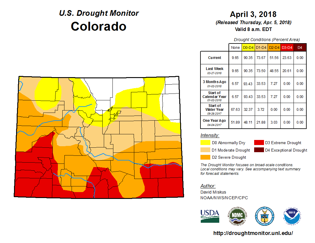
To be short and sweet… both the drought monitor and snowpack aren’t in great shape. The drought monitor shows at least 90% of the state is suffering from at least some form of drought ranging from abnormally dry to extreme drought. The snowpack, thanks to a few decent March snows, is below normal, but just under one quarter below normal.
Colorado Drought Monitor April 3, 2018.
Surprisingly, the water supply is pretty great! Colorado Springs Utilities is reporting that the Pikes Peak reservoir is at 68% capacity, the Rampart reservoir is at 75%, and the system total is at 81% capacity. 80% capacity is generally considered full capacity as they always leave room at the top for overflow or unexpected heavy rain/snow. Colorado Springs Utilities is also reporting they have more than 3 years of water demand in storage. The Pueblo reservoir is also showing great results with a current capacity right near 80%. This is high enough that the Pueblo reservoir is going to release over half a million gallons on April 15th to compensate for upcoming mountain snow melt…
Southern Colorado is for sure in a drought, and the blame for that drought can be placed on a La Nina pattern that brought very dry conditions to our Fall and Winter. At the same time, we did so well last Spring and Summer than our water supply is actually in terrific shape, so we really don’t have to worry a water shortage any time soon. Do we still need to worry, for some things absolutely we do. The plains and higher terrain are dry from the lack of moisture and the rest of April through early July will probably continue to be warmer and drier than normal. Our La Nina pattern should return to a neutral pattern by the end of May, and that will hopefully lead to a normal, thirst quenching monsoon season.
Three levels of water conservation are being contemplated and will be discussed at an upcoming Aspen City Council meeting, Long said.
The first phase of water restrictions would be a 10 percent reduction in use and almost all of it is voluntary. The second phase involves a 15 or 20 percent reduction and requires mandatory restrictions, like when homeowners can water their lawns. Restrictions ratchet up from there.
Long said water conservation will be inevitable this season.
“We will be acting on it in some form,” she said.
Also discussed is the snowpack and how it will affect the city’s storage and drinking water supply, trans basin diversions and why they are necessary and Aspen’s new landscape ordinance.
The council is expected to discuss water conservation and possible restrictions April 24.
Over the past week, extreme drought has increased to cover the eastern third of Las Animas county, along with most of the eastern half of Otero county and all of Bent county south from the Arkansas river.
Pueblo county, which had been experiencing moderate drought conditions has almost completely moved into severe drought. The southeast corners of Fremont and El Paso counties also moved into the severe category.
Overall, slightly less than 10 percent of the state – mainly parts of the northeast plains and north central mountains – is drought-free. About 22 percent of the state is in moderate drought, down three percent from the prior week as drought conditions deteriorated. Nearly 28 percent of the state is in severe drought, unchanged from the previous week, while about 24 percent is experiencing extreme drought, up three percent.
San Juan Water Commission Director Aaron Chavez has warned commission members that the region could experience extreme drought this year…
The mountains that feed the Animas River are at 47 percent of normal snowpack, according to the U.S. Bureau of Reclamation. The San Juan River watershed is in slightly better condition at 53 percent…
The U.S. Drought Monitor, which is run by the University of Nebraska, has classified all of San Juan County as being in extreme drought. The Palmer Drought Severity Index, which the city of Farmington uses to gauge drought conditions, has San Juan County in a moderate drought.
In addition to the low snowpack, the river levels are also lower than normal. The U.S. Geological Survey stream flow gauges are showing the Animas River at 29 percent of the average flow for this time of year in Cedar Hill. In Farmington, the stream flow in the Animas River was down to 47.2 cubic feet per second, which is less than 10 percent of normal, according to the U.S. Geological Survey…
Chevez said the U.S. Bureau of Reclamation has been releasing water from Navajo Dam to increase the flow in the San Juan River from 400 cubic feet per second to 500 cubic feet per second.
During its meeting Wednesday, the San Juan Water Commission unanimously approved its budget for fiscal year 2019, which starts July 1.
Drought has basically divided the Mountain West into two separate regions this year.
Storms kept Idaho, Montana and Wyoming wet over the winter, and the national Drought Monitor shows no drought in those states.
But high pressure dogged Utah and most of Colorado this winter. Now the ground is dry and the snowpack is lean, even though March was stormy…
Utah and Colorado have endured about a year of unusually dry weather, thanks to high-pressure systems that acted like storm barriers.
Brian McInerney, a hydrologist for the National Weather Service in Salt Lake City, said a wet winter last year helped top off the reservoirs that store water for drinking and irrigation.
Colorado River forecasters say the Southwest should brace for the sixth-driest runoff season into Lake Powell since the government erected Glen Canyon Dam there 55 years ago.
Winter snowfall failed to measure up across most of the basin that supplies meltwater to the river, with the exception of Wyoming’s Green River watershed. The result is a projected April-July runoff season supplying just 43 percent of what Lake Powell receives in an average year…
But snowpack is so scant this year it would take something more miraculous than that to approach normal river flows, said Greg Smith, senior hydrologist at the Colorado Basin River Forecast Center.
There’s now just a 3 percent chance there will be enough precipitation to get the river back to its norm.
“It would take kind of a record spring,” he said. “We’ve just kind of run out of time.”
Forecasters project 3.1 million acre-feet will flow into Lake Powell this season…
The worst year on record was 2002, when the reservoir collected less than 1 million acre-feet.
As of the end of last month, the Upper Arkansas River Basin is at 88 percent of its average snowpack. Local rafting operations, such as Performance Tours Whitewater Rafting — which has an office in Breckenridge — offer several whitewater rafting trip options off of the Arkansas River, namely out of Buena Vista.
The source for the Arkansas River, which is a major eastward tributary of the Mississippi River, is at an elevation above 11,000 feet, on the east side of Freemont Pass, near Leadville…
Based on the end of March snowpack reports from the United States Geological Survey, Performance Tours believes that the stretches of the Upper Arkansas River that flow through Chaffee County where the company drops in will have some of the best rafting in Colorado this spring and summer.
The mountain snowpack that feeds Northern Colorado’s water supply is ending the snow season on the same tune that has persisted for months: Worse than usual, but better than most of Colorado.
Snowpack in the Upper Colorado and South Platte river basins typically peaks in early to late April. As of April 3, those basins had 78 percent and 84 percent of the normal snow-water equivalent for this time of year, according to the Natural Resources Conservation Service. The Laramie and North Platte River basins, which have some influence on Fort Collins water supply, top the state with 92 percent of normal.
“The South Platte and Upper Colorado basins are below average, but they are certainly in better shape than the southwestern and southern parts of the state,” where snowpack is barely half the normal amount, said Jeff Stahla, Northern Water public information coordinator…
Despite the lack of snowfall, Northern Water’s water storage sat at about 120 percent of the normal amount in March because of heavier snowpack in recent years, Stahla said. The Northern Water board will set the Colorado-Big Thompson project quota next week, a move that largely determines how much water is delivered to agricultural and municipal users…
Larimer County is one of the few exceptions to a widespread curtain of drought and drought-like conditions across Colorado, according to the U.S. Drought Monitor.
Here’s the release from the NRCS (Brian Domonkos):
The beginning of April typically marks the turning point in the year when snowpack across the majority of the state begins to runoff from the mountains of Colorado. With each day, increased temperatures and solar radiation warm the snowpack melting the shallower, often lower elevation snowpacks first, and progressively impacting higher elevations. Gradually, snowmelt is now starting to ramp up in the southern mountains such as the San Juan Range and Sangre De Cristo mountains. “No considerable basin-wide snowpack losses have yet been observed,” said Brian Domonkos Colorado Snow Survey Supervisor. He added, “However there were a number of individual low elevation sites which recorded significant snowmelt, a trend which is beginning to spread across much of the lower elevations and to move to some mid-elevation sites.” According to SNOTEL and snow course data from April 1, Colorado snowpack is 68 percent of normal down from 72 percent last month.k
Statewide Basin High/Low graph April 4, 2018 via the NRCS.
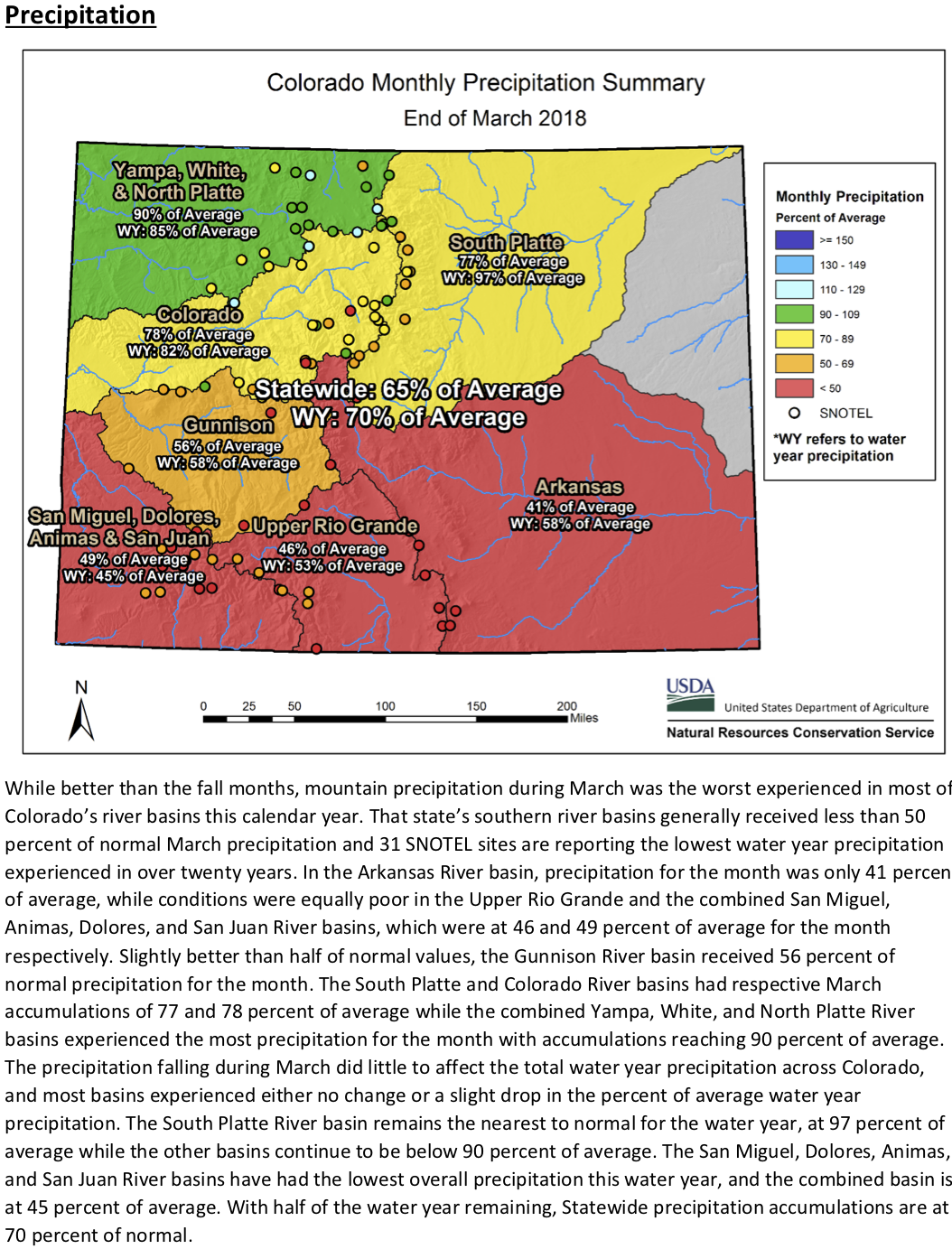
Looking back over the course of March, precipitation in the mountains of Colorado was only 65 percent of normal, following the current general weather pattern of poor accumulations in the southern half of the state. The southern river basins are around 50 percent of normal for water year precipitation or slightly better but still below normal, and in the northern half of the state March precipitation ranged from 77 to 90 percent of normal. This drove year-to-date mountain precipitation to fall only slightly by month’s end to 70 percent of normal.
The anticipated result from this general weather trend indicate spring and summer forecasted streamflows will generally be between 30 and 70 percent of normal across the state. More positive exceptions exist in the Colorado River Headwaters and South Platte River basins where a few forecasts extend in the 80 to near 100 percent of normal range. Conversely, a number of forecast locations in the southern half of the state dip below 30 percent of normal. Refer to individual streamflow forecasts for the most specific water resource information for use in decision making. Above normal reservoir storage may provide some help in offsetting the low snowpack, but reservoir outflow is highly dependent on the watershed and specific location therein.
The three-month National Weather Service Climate Prediction Center forecast predicts dry and warm conditions through the spring suggesting little reprieve from the current conditions. More information about April 1st snowpack, mountain precipitation, reservoirs levels and streamflow forecasts can be found in the April 1, 2018 Colorado Water Supply Outlook Report.
For more detailed and the most up to date information about Colorado snowpack and supporting water supply related information, refer to the Colorado Snow Survey website. Or contact Brian Domonkos – Brian.Domonkos@co.usda.gov – 720-544-2852.
Click here to go to the US Drought Monitor website. Here’s an excerpt:
Summary
With a blocking ridge of high pressure anchored over the Southwest, a series of cold fronts tracked across the eastern two-thirds of the Nation. The fronts, however, slowed their southeastward advance across the South and Southeast, and after picking up Gulf moisture, produced numerous and widespread showers and thunderstorms with heavy precipitation (more than 2 inches) from the southern Great Plains northeastward into the northern Appalachians. This was similar to the weather pattern back in mid- to late February when the lower Mississippi, Tennessee, and Ohio Valleys were deluged. Lighter precipitation also occurred across the northern halves of the Rockies and Plains, the upper Midwest, Great Lakes region, western New England, the central Gulf Coast States, and along the Pacific Northwest Coast. Little or no precipitation fell on the remainder of the Far West, Southwest, southern halves of the Rockies and High Plains, western Corn Belt, along the eastern Gulf and Atlantic Coasts, and most of Alaska. Weekly temperatures averaged below normal in the northern Rockies, northern and central Plains, Midwest, mid-Atlantic, and Carolinas, and above-normal in the Far West, Southwest, southern Plains, along the Gulf Coast, and in northern New England. In Alaska, readings were much-above normal in western and northern sections and near to below normal in southern and eastern portions. Most of Hawaii and Puerto Rico observed showery weather…
South
Similar to mid-February when heavy rains inundated the south-central Great Plains, lower Mississippi, Tennessee, and Ohio Valleys and provided instant relief from drought, heavy rains fell along an identical track, except this time south-central Texas received more precipitation than 6 weeks ago, and Arkansas saw less. Eerily similar was the demarcation line of minimal rain versus decent rain in central Oklahoma where western sections of the state yet again missed out on the moisture. Luckily, this was not the case in western Texas where areas between Lamesa and Lubbock finally received 0.5-1.5” of rain. Lubbock’s 0.77” of rain on Mar. 27 exceeded their Oct. 7-Mar. 26 total of 0.40”. Amarillo’s 0.24” on Mar. 27 was even more than their Oct. 7-Mar. 26 amount of 0.07”. Take away an extremely wet early October (2.14” from Oct. 3-6) and Amarillo’s conditions would have been even worse. From south-central Texas northeastward into western Louisiana, a swath of 3-8” of rain provided 1-2 categories of drought improvement, while more scattered bands of moderate to heavy rain allowed limited 1-category improvement in parts of southern and central Texas. The aforementioned rains in west Texas were responsible for a D3 to D2 upgrade as most tools responded. Some slight westward adjustments (improvements) of the D0 edge in north-central Texas and central Oklahoma were made as the cutoff between decent and scanty rains occurred. Unfortunately, another week with little or no precipitation in northern Texas, western half of Oklahoma, and Kansas led to additional deterioration as D4 spread into parts of the Oklahoma and northern Texas Panhandles as gusty winds produced sand storms in the area…
High Plains
The persistent fall and winter pattern of above-normal precipitation and subnormal temperatures continued this week across Montana, Wyoming, and the western Dakotas, building up the existing snow cover and gradually providing additional relief from long-term drought. In eastern Montana, SPIs out to 9-months were wet except in the extreme northeastern part of the state (Daniels and Sheridan counties) where D2 lingered. Similarly in extreme western Dakotas and northeastern Wyoming, additional precipitation allowed for a slight nudge of the D0-D2 areas to the east (improvement). However, since this drought goes back to 12-15 months ago, it will take more precipitation to remove these long-term deficits (6-10 inches) and subsoil impacts where D1 and D2 are currently depicted, hopefully during the upcoming wet season (April-July). In central and eastern North Dakota where the drought was short-term, snow totals of 1-2” in the central and 4-6” in the east added to 90-day surpluses. Even though soil moisture conditions are less than desired (ground barely frozen at 4” depth), 90-day percent of normal precipitation has shown significant improvement. Therefore, some D1 was improved to D0 in central parts of the state while D0 was erased from eastern areas. In Nebraska, moderate snows fell across southern sections of the state, but D0 was kept as subsoil dryness lingered due to frozen ground earlier in the year that limited infiltration of melting snow or rain. As conditions thaw and additional storms occur, infiltration should increase. Farther south in Kansas, little or no precipitation meant another week of growing deficits, and based upon indices going out to a year, D3 conditions were common in central and northeastern portions of the state; therefore D3 was expanded northeastward…
West
After a very wet March and prior week in California, tranquil weather (mild and dry) enveloped the state and much of the West, with only light precipitation falling on western Washington and Oregon, northern Idaho, most of Montana, northern and eastern Wyoming, and northern Colorado. Fortunately for California, March provided several welcome slugs of moisture to the Sierra Nevada snow pack after one of the driest Februarys on record, bumping April 1 statewide SWE readings to 52% of normal, up from 23% on March 1, but still below the average. Major state reservoirs were at or above normal April 1 averages largely due to last winter’s bountiful precipitation. In Oregon, last week’s precipitation was also enough to keep status-quo during this week’s dry weather, although April 1 NRCS average basin numbers were still below normal (75-87% precipitation, 44-64% SWE). WYTD precipitation and SWE statistics are better toward the north and east, with northern Oregon, Washington, most of Idaho, northeastern Nevada, Montana, and Wyoming at or above normal.
Unfortunately, the trend of the Southwest missing significant precipitation during the winter has extended into the spring, with NRCS average basin (especially the Four Corners region states) precipitation and SWE running at 20-70% and 0-60% of normal, respectively. With most WYTD tools depicting D2-D4 conditions, along with reported impacts, some deterioration was made in northwest Arizona (D2 expansion in Mohave County); north-central Utah (D2 into Salt Lake County, D3 increase in Utah County); southern Colorado (D2 in Pueblo County, D3 into eastern Las Animas, eastern Otero, and western Bent Counties); and a slight southward extension of D3 into west-central and east-central New Mexico. As the spring season continues, temperatures will rise and precipitation normally decreases, so the short-term outlook is not favorable for any improvement based strictly on climatology…
Looking Ahead
During April 5-9, 2018, unseasonably heavy precipitation (2-6 inches) is expected in western sections of Washington, Oregon, and the northern half of California, plus the Cascades and Sierra Nevada, with lesser amounts in the remainder of the Northwest and northern and central Rockies. Unfortunately, a sharp cutoff of precipitation (dry) is forecast for southern California, southern Nevada, and much of Arizona, New Mexico, and west Texas. Light precipitation (less than half an inch) is predicted across the northern half of the Plains, Midwest, and southern Great Plains, with greater totals (1-3 inches) in the lower Mississippi Valley, Southeast, mid-Atlantic, and New England. Temperatures will average above-normal west of the Rockies, southern Texas, and Florida, and below-normal east of the Rockies except along the Gulf Coast.
For the ensuing 5 days (April 10-14), odds favor above-median precipitation for much of the Far West, northern thirds of the Rockies and Plains, Midwest, lower Mississippi Valley, New England, and southern Florida, with sub-median totals in the Southwest and south-central High Plains, Southeast, and northern Alaska. Chances for sub-median temperatures are likely across the northern half of the Nation, but especially in the upper Midwest and along the Northeast Coast. A tilt toward above-median readings are expected in the Southwest, southern Rockies, southern half of the Plains, southern Florida, and southern Alaska.
In recent years there has been mounting concern about the presence of chemicals from pharmaceuticals and personal care products, such as cosmetics, in the nation’s streams and rivers.
There is no question that these chemicals are present in the nation’s waterways. The USGS conducted the first major investigation in 2002 and found, on average, seven chemical compounds in the streams they surveyed.
In 2008, the Associated Press found an array of pharmaceuticals, from pain killers to antibiotics to mood stabilizers, in the drinking water of 24 major metropolitan water suppliers. Further, 34 of the 62 water suppliers contacted by the AP couldn’t provide results as they had never tested for pharmaceutical compounds.
This problem won’t go away anytime soon.
American drug consumption has increased rapidly in recent years, and Americans fill 3.7 billion prescriptions every year. The chemicals in these drugs end up in waterways after being excreted from the body or when unused medication is flushed down the toilet.
Most municipal sewage treatment facilities do not remove the pharmaceutical compounds from your water, and major upgrades would be required to do so. The federal government hasn’t stepped in to require testing or set safety limits, leaving many questions unanswered.
HOW DOES THIS IMPACT MY HEALTH?
Pharmaceutical compounds are found at much lower concentrations in rivers and streams than the normally prescribed doses, but there is concern that chronic exposure to numerous compounds could cause serious health problems and that compounds can act synergistically to cause adverse health effects.
Of particular concern is the presence of endocrine disruptors, which come from a variety of agricultural, industrial, and domestic sources, including pharmaceuticals.
These compounds disrupt internal biological processes such as development, growth, and reproduction that are regulated by hormones.
Whether these compounds are present in sufficient levels in our waterways to affect human health remains a topic of serious concern and ongoing research…
While scientists have yet to pinpoint the cause of this mutation, it’s thought that a group of compounds known as endocrine disruptors are responsible.
These chemicals affect key biological processes regulated by hormones, such as growth, development and reproduction, and include common medications including birth control pills.
Whatever the cause, it’s unknown what effects these compounds are having on us when we drink or swim in the same waters. Like the canary in the coal mine, the story of intersex fish may be an early warning of the effects that pharmaceuticals are having on the health of our waterways and on the people and organisms that depend on them.
WHAT CAN WE DO?
Use the following steps to reduce the risk of long-term human health effects of pharmaceuticals in your water supply:
PROPER DRUG DISPOSAL
The cheapest and easiest way to limit pharmaceutical contamination is to keep drugs from entering our waterways in the first place. Drug take back programs, public education on proper disposal, and regulations to limit large-scale medicine flushing at hospitals and nursing facilities are important first steps that can greatly reduce the amount of contaminants entering our waterways. Some states and counties have begun to experiment with take-back programs. For example, Washington State collected and disposed of over 15,000 pounds of unwanted medications during a two year pilot program.
RESEARCH
Additional research is needed to assess potential human health effects and identify the best methods for removing pharmaceutical compounds at treatment plants. If there is a significant long-term risk to public health, more aggressive efforts to control the problem may be needed.
LONG-TERM SOLUTIONS
While proper disposal can limit pharmaceutical contamination, more work on source control will ultimately be needed in addition to upgrading treatment infrastructure and reassessing our approach to use and dispose of pharmaceuticals and personal care products.
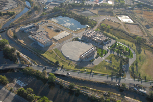
Colorado’s next big source of drinking water may be recycling and reusing what customers flush down the drain.
That’s the idea behind a cutting-edge demonstration project set up at Denver Water’s recycling plant on York Street in north Denver.
A group of engineering companies and water policy groups set up the project, which has been running since January, to show that metro-area water that normally would be treated and sent down the South Platte River could be captured and cleaned to the point where it’s safe to drink…
Some of Colorado’s water providers have recycled water for reuse — mostly for irrigation purposes — for more than 50 years, said Laura Belanger, a water engineer with Boulder-based Western Resource Advocates, a policy group.
But the demonstration project takes the recycling to the next step — treating water via a five-step process to a level where it’s safe to drink.
The equipment, which can treat up to 15 gallons per minute, mimics nature’s water-cleaning ability but does it much, much faster. A gallon can pass through the system in less than 30 minutes, said Austa Parker, a water reuse technologist with Carollo.
Water that’s passed through the Metro Waste Water treatment plant and destined for the South Platte River is passed through the system.
The system involves using ozone, filters and microfilters that are 100 narrower than a human hair. Activated charcoal and ultraviolet light also are part of the process at the demonstration plant…
The demonstration system is unique in that it doesn’t produce an extremely salty brine that requires its own disposal process, she said.
Interest in recycling water and using it inside homes is growing across Colorado, Belanger said.
The Colorado Water Plan, adopted in 2015, called for recycling more water.
And a group of utilities, state health officials and water recycling enthusiasts are exploring issues around using and drinking recycled water with an eye toward crafting new state-level regulations, Belanger said.
The cost of building and equipping such a treatment plant depends on many variables, including the quality of the source water and the type of treatment it needs, she said.
But a recycling plant is cost-competitive when compared to the costs of obtaining and transporting new water supplies, she said.
Xylem Inc. (NYSE: XYL) has been engaged as a water technology solutions provider to the PureWater Colorado Demonstration Project, which aims to demonstrate direct potable reuse (DPR) as a safe, reliable and sustainable drinking water source. Denver Water has partnered with Carollo Engineers, WateReuse Colorado (WRCO) and Xylem on the project which is located at the Denver Water Recycling Plant and will run during the month of April this year. Some of the water produced will be used to brew beer to raise awareness among the general public about this water purification process.
Water reuse is part of Colorado’s Water Plan to reduce the amount of water diverted from rivers and streams, creating a sustainable, efficient way to extend the state’s water supplies.
Steve Green, Business Development Manager, Xylem said, “We are very excited to be part of this forward-looking, important project that aims to promote a sustainable, reliable and safe drinking water treatment process. It is crucial that we implement sustainable solutions, like water reuse, to meet future water needs. We hope that this demonstration will help to raise awareness and understanding among the local population and community leaders about how DPR can help to provide for their water needs now and in the future.”
A range of Xylem’s solutions including a Wedeco MiPRO advanced oxidation process (AOP) pilot system and a Leopold granulated activated carbon (GAC) filter pilot will be used in the project which features a unique treatment train that avoids the use of reverse-osmosis (RO) membranes and their associated high capital and operating costs as well as brine disposal.
John Rehring, Vice President, Carollo Engineers said, “As national leaders in water reuse, we were happy to partner with Xylem to demonstrate the use of advanced technologies – an extension of our efforts to develop a regulatory framework, and public outreach activities specific to Colorado.”
Xylem is a frontrunner in the field of water reuse technology, providing advanced solutions and expertise to reuse applications across the US, as well as globally. In California for example, Xylem’s Wedeco MiPRO advanced oxidation processes (AOP) is operating at Los Angeles Sanitation’s Terminal Island Water Reclamation Plant. The customized solution is the first greenfield AOP design using ultraviolet light with chlorine – a significant innovation to make water reuse more sustainable and cost-effective.
Last year Xylem signed a multi-year commitment (2017-2019) to support Water Environment Research Foundation (WE&RF) research into water reuse, building on a previous three-year research partnership and solidifying Xylem’s commitment to advancing the use of recycled water. Internationally, Xylem works together with the IVL Swedish Environmental Research Institute and the Singapore Public Utilities Board (PUB) to progress water reuse.
Across Colorado, snowpack figures range from a low of 51 percent in the San Juan River Basin to a high of 93 percent in the North Platte. Statewide Colorado’s snowpack stands at 70 percent of average with the northern portions of the state seeing higher snowpack figures.
“We were at 103 percent last year and only 58 percent back in the drought year of 2012,” stated Natural Resources Conservation Service officials in a recent press release announcing the April snowpack figures.
The Kremmling field office of the NRCS, a division within the federal Department of Agriculture, tabulates snowpack figures in Grand County. While all snowpack calculations provide valuable data the April 1 count is considered the most critical data set for predicting spring runoff figures and summer water supplies, according to Volt.
“Lack of snowfall and warm weather during March, which is usually our snowiest month, has melted all of the valley snow and most of the mid-elevation snow up to 8,500 feet,” stated NRCS officials. “Snow density is averaging 30 percent, which means that for every foot of snow there are 3.6 inches of water and that’s about normal for April 1.”
Officials said additional spring runoff will depend heavily on melting conditions such as temperature and wind as well as an additional spring snowfall or rainfall.
“It would take several good snowstorms to put us back up to average at this point in time,” officials stated. “Irrigators, water users and river runners should anticipate lower stream and river flows for the upcoming summer.”
Around Grand County the specific snowpack figures vary.
The Berthoud Summit SNOTEL site currently stands at 78 percent of average while Willow Creek Pass, north of Granby, stood at 88 percent. The Williams Fork River basin was among the lowest snowpack figures found in the Upper Colorado River Basin on April 1 with the SNOTEL site near the USFS’s South Fork Campground showing snowpack at just 55 percent of average.
The NRCS uses a 30-year average to calculate percentage totals. Currently averages are based on snowpack figures from 1980 through 2010. In 2020 the NRCS will shift their data set and will begin using the years 1990 through 2020 as their data set for determining 30-year averages.
[Emily] Hunt said she considers three things when making forecasts for summer water — snowpack, water supply in the city’s reservoirs and customer use trends.
“All of that stuff for us right now, is looking pretty good — with the exception of snowpack,” Hunt said. “Thornton’s reservoirs are in good shape, slightly above average, and our customers are using water they way we expect them to.”
The March reports for Colorado’s Front Range put snow pack depth at between 77 and 100 percent of annual averages in Colorado’s northern river basins, according to the National Resources Conservation Service. That includes the South Platte, Big Thompson, Boulder Creek and Clear Creek basins.
It’s one of several measurements local water officials monitor all year long as they prepare for the summer. The most important data comes from the April 1 stream flow projection, which has not yet been released by the state.
“It basically takes all the snow pack information, soil moisture reports and reservoir storage across the state and gives us a very specific basin by basin outlook,” Hunt said.
In Westminster, the city is not expecting as heavy runoff but they’ve compensated by keeping the Standley Lake Reservoir full. That should fulfill the city’s needs this summer, as long as the weather doesn’t get especially hot and dry early or residents don’t change their habits, according to Sarah Borgers, Westminster’s Water Resources and Quality Manager.
“It means we are little less reliant on what that snow is doing up in the mountains,” Borgers said. “We are not so dependent on the spring runoff.”
Westminster, Thornton, Northglenn and the Farmer’s Reservoir and Irrigation Company all rely on Standley Lake as one of their main water supplies, but each city has a number of other reservoirs and canals that feed municipal water treatment plants.
Currently, municipal reservoirs are more full than they were last year at this time. Borgers said Standley Lake is close to 100 percent of its capacity.
“We are not expecting to implement drought restriction, but we are keeping a super close eye on the how the rest of the season develops,” Borgers said.
Hunt said Thornton’s reservoirs — which includes smaller reservoirs and retention ponds along the South Platte River — are at about 72 percent. That’s ample room for the spring Thornton expects , Hunt said.
“In addition to Standley Lake, we have about 12 reservoirs along the South Platte as it goes through Thornton,” Hunt said. “They are all in pretty good shape and we should be able to store some water when it comes along in runoff. We are higher than we were last year, but from a supply standpoint we are in pretty good shape.”
Local water officials do have their eyes on the summer of 2019, however. Southern basins are dipping as low as 29 percent of average according to the NRCS statistics, leading to worries of drought in the rest of the state.
“If it stays extremely dry through the summer, we’ll start thinking about our next year,” Borgers said. “We’ll be watching what happens next winter very carefully.”
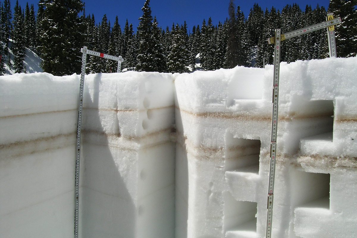
Layers of dust stripe the sides of a pit dug into the snow in Colorado. Dust deposited or exposed on the surface of the snowpack contributes to faster warming and melting. Center for Snow and Avalanche Studies
Jeff Derry, executive director of the Center for Snow and Avalanche Studies, tracks the amount of dust deposited on snow across the state. He and his assistants snowshoe and ski to 11 high country sites where they measure how much dust there is on the snow surface.
Dust pulls more solar energy into the snowpack, which is essentially a reservoir of water for managers across the West. In dusty years, snow melts earlier. The rate of runoff can increase substantially compared to low dust-on-snow years.
It’s important data for scientists across the West.
“In an extreme dust year, we can see the snowpack disappear on the order of 2 months early,” said research scientist Jeff Deems at the University of Colorado at Boulder’s National Snow and Ice Data Center.
Deems said dust on snow will become an important issue as the West moves toward a future with tighter water supplies.
“Demand is going up and it looks like supply is going down for a number of reasons,” said Deems. “We need to keep the snow on the mountain for as long as possible to allow that water to be available for use in the dry summer months. If it melts off [too early] then all we have are our surface reservoirs which don’t store that much [compared to the volume of water in the snowpack].”
A dozen New Mexico counties have been designated by federal agriculture officials as primary natural disaster areas due to drought.
The U.S. Department of Agriculture made the announcement Tuesday.
The designation allows farmers and ranchers in many areas of the state — from Rio Arriba and Taos counties south to Lea County — to get assistance for losses and damages caused by the dry conditions.
Officials say those in another 15 contiguous counties also qualify for natural disaster assistance.
In all, 27 of New Mexico’s 33 counties are affected by the designations.
The seasonal outlook shows drought conditions are expected to persist in New Mexico and much of the Southwest through June.
The Court of Appeals decision, in sometimes scathing terms, rejected numerous arguments against the historic water settlement in a case that dates back to 1975.
The opinion written by Judge Bruce D. Black says that the entire appeal made by non-Indian water users, including acequia and ditch associations, was “based on a failure to understand the nature of the relationship between Indian nations and the United States.”
The approved settlement, set to become a major piece of the New Mexico water picture, increases the Navajo Nation’s share of the state’s water from 6 percent to 10 percent, according to a 2013 Journal analysis.
Opponents, who apparently could appeal further to the state Supreme Court, emphasize that the deal allows the Navajo Nation to use more than six times as much water as the city of Albuquerque. The agreement’s defenders call that an apples-to-oranges comparison, because all of New Mexico’s agricultural water agencies use substantially more water for irrigation than is used by cities.
In affirming the 2013 decision in favor of the tribal-state settlement by former appeals court Judge James Wechsler, the court panel rejected a recent motion by Victor Marshall of Albuquerque, the non-Indian water users’ attorney, seeking to overturn Wechsler’s ruling on conflict of interest grounds.
Marshall maintained that Wechsler improperly had failed to disclose that he had worked in the 1970s on the Navajo reservation as an attorney for a non-profit legal aid group that Marshall contended was “an agency and instrumentality of the Navajo Nation,” a party in the water rights case.
Lawyers for the Navajo Nation and state government have called Marshall’s argument “reckless” and “defamatory” because DNA Legal Services is independent from tribal government and often sues the Navajo Nation on issues such as prison conditions and housing evictions.
In a separate order written by Judge Linda Vanzi, the appeals court panel on Tuesday called Marshall’s motion against Wechsler “frivolous” and said that “basic inquiry and simple investigation” would have shown that the motion “was without factual foundation.”
[…]
Wechsler, who was sitting as presiding judge in state District Court for the water rights case, retired last year after 22 years on the Court of Appeals.
2013 ruling
His 2013 ruling recognized the Navajo Nation’s right to divert 635,729 acre-feet of water per year, which translates to consumption of 325,756 acre-feet annually. Consumption is defined under state law as the total amount of water diverted, minus the amount returned for use by others downstream.
Supporters of the settlement said it removes major uncertainties over water availability for non-Indians in the San Juan basin, because of the risk that the Navajo Nation might have gone to court and won a substantially larger amount of water.
The Navajo Nation agreed to forgo larger water claims in return for federal support for construction of a water pipeline to water-scarce Navajo country in the deserts of northwest New Mexico.
The appeals court on Tuesday rejected the non-Indian water users’ argument that the settlement should have gone to the Legislature for approval. Congress approved the settlement, preempting any state considerations, the opinion says. But the Legislature did approve $50 million as the state’s share of the cost of the settlement, Black’s opinion notes.
The $1 billion Navajo-Gallup water pipeline will take 12 years to build and could serve as many as 250,000 people a year by 2040, officials say. Image via Cronkite News.
Personal-care product company Tom’s of Maine will donate a million dollars to preserve and restore the nation’s water supply by working with the Nature Conservancy on a three out of four possible projects. Why three of four potentials? The company is asking the public to vote for their favorite water protection project. the top three will receive $25,000, $15,000 and $10,000 in funding, in addition to a guaranteed base level of support for each.
Remaining funds from Tom’s of Maine will go to support the Conservancy’s North American freshwater program, including on-the-ground projects along rivers and in river basins as well as water use and management projects to ensure that more of our natural waterways are protected.
Potential project areas include:
The Mississippi River Basin: Restoring key floodplains to reduce nutrient pollution in a basin that covers (or drains) 41% of the US;
East Coast Dam Removal: Freeing miles of river from Maine to Maryland by removing dams and improving habitat connections;
Sustainable Rivers Program: Working with the Army Corps of Engineers to better balance what people and rivers need to thrive;
The Colorado River Basin: Restoring and protecting water supplies.
The Colorado River Basin covers areas of Arizona, California, Colorado, Nevada, New Mexico, Utah, and Wyoming, and irrigates nearly 4 million acres of cropland in the US and Mexico. It also supplies hydropower plants that generate more than 10 billion kilowatt-hours annually, according to the USGS. Like many areas of the country, the river basin suffers from supply and demand imbalances. The USGS is conducting a reclamation study that will define the extent of those imbalances and develop and analyze strategies to resolve those imbalances under a range of conditions that could occur during the next 50 years.
University of Denver Sturm College of Law. Photo credit: Wikimedia
From email from Josh Boissevain:
Two law students at the University of Denver College of Law are conducting research into the experience of self represented parties in Colorado’s Water Courts and are looking for input from water rights holders and attorneys around the state.
Students Lindsey Ratcliff and Josh Boissevain (both originally from Colorado) hope to learn more about the issues and obstacles that water rights holders encounter as they file water rights applications or statements of opposition.
“We know that, in Colorado, trying to do anything with a water right can be expensive and time consuming, and water law itself isn’t exactly the simplest to wrap your head around,” said Boissevain. “So we are really trying to better understand what that is like for people who’ve gone though the process without the help of an attorney.”
Boissevain said they are also curious about water rights holders who have maybe wanted to represent themselves but because of the cost or difficulty decided not to participate at all.
Ratcliff and Boissevain also hope to learn about the experiences of water attorneys who have been in the same cases with parties representing themselves to learn how the court process changes.
“We’re really looking at two aspects here,” said Ratcliff. “First are there any identifiable access-to-justice issues, and second are there any judicial-efficiency issues?”
The two have set up a couple of websites with anonymous surveys to collect these personal experiences from around the state. They request that water rights holders who have had experience in water court as self-represented parties fill out the survey at https://watercourtresearch-srp.weebly.com/. And they request that attorneys who wish to share their experiences fill out a different survey at https://watercourtresearch-aty.weebly.com/.
Both websites include more information about the project and include ways of getting in touch with the researchers directly.
Drought has basically divided the Mountain West into two separate regions this year.
Storms kept Idaho, Montana and Wyoming wet over the winter, and the national Drought Monitor shows no drought in those states.
But high pressure dogged Utah and most of Colorado this winter. Now the ground is dry and the snowpack is lean, even though March was stormy…
Brian McInerney, a hydrologist for the National Weather Service in Salt Lake City, said a wet winter last year helped top off the reservoirs that store water for drinking and irrigation.
“I think we’re okay this year,” he said. “I think if we look at the 2018 water year, what we’ll find is low snowpack but adequate reservoir storage.”
The National Climate Prediction Center is forecasting that the drought will persist this spring in both Utah and Colorado.
Snowmelt from the Colorado River Basin contributes about 70 percent of total water supplies for more than half of Southern California and most of southern Nevada, according to the California-Nevada Climate Applications Program. Its low salt content makes snowmelt a useful fresh water source of drinking supplies.
With increasingly warmer winters and a diminishing snowpack in recent years, the lack of snowmelt might pose problems for the communities that need it.
Measurements of the Sierra Nevada snowpack in early spring 2018 revealed that the snowpack remained below normal.
“We’ve seen the typical elevation at which rain transitions into snow, on average, go up over the past decade,” said Nina Oakley, a regional climatologist at the Desert Research Institute’s Western Regional Climate Center in Reno, Nevada.
“Now, we’re seeing less snowpack building, and it’s been observed in the West that with warmer spring temperatures, we’re seeing earlier spring snowmelt runoff,” Oakley said.
A 2017 report from the National Center for Atmospheric Research showed that warmer winters are causing mountain snowpack to melt both earlier and slower. This is due to less thawing occurring during the lengthier nights and weak sunlight of early spring, according to Colorado Public Radio News.
University of Nevada researchers have reported that the cause of less efficient snowmelt runoff is that “slower snowmelt reduces the amount of moisture being pushed deep into the subsurface, where it is less likely to evaporate.”
Researchers believe one effect of slower snowmelt on water supply and hydropower production could be that the snowmelt will move less efficiently downstream to reservoirs at times when it’s especially needed, such as during drier periods.
From the Associated Press via US News & World Report:
The median amount of water contained within New Mexico’s snowpack statewide for the start of April is the lowest on record since at least 2000.
Officials with the National Weather Service in Albuquerque say the measurement — known as the snow-water equivalent — at the Hopewell site in Rio Arriba County had the lowest value since records began in 1980.
They also say the snowpack in southern Colorado is at about 50 percent now and just trace amounts remain in New Mexico’s basins.
The grim statistics come as more than one-third of the state contends with extreme drought.
A couple standout powder days were not enough to help the Steamboat Ski Area reach its average March snowfall.
The ski area received 36.25 inches of snow in March compared to the 20-year average of 48.39 inches.
As of Sunday, the snow total for this season stood at 229 inches. On average, the ski area receives 327 inches of snow each season.
The ski area during the month of April gets an average of 14.66 inches of snow, and two inches of new snow was reported at 1 p.m. Sunday for the first day of April.
In Summit, snowpack is at a relatively healthy 88 percent of average. However, Wineland noted that in southern Colorado, some places are seeing 60 to even 30 percent of average snowpack. That will mean more water usage downriver this summer, which affects water rights and availability in the northern and central parts of the state.
Wineland then presented this winter’s butcher’s bill by referring to a precipitation and temperature chart for Summit over the past few months.
“November, higher than average temperatures, lower than average precipitation,” Wineland said. “December, higher than average temperatures, lower than average precipitation. January, the same.”
February, on the other hand, saw cooler temperatures and higher precipitation, which offered some, but far from enough moisture to raise the “fuel-moisture index,” a tool that determines how much moisture is present in fuel sources — such as grass, brush and trees — to mitigate the chances of wildfire. The higher the fuel moisture, the less chance for wildfire. On the converse, lower- or no-fuel moisture may lead to larger, hotter forest fires burning out of control.
Wineland then dropped the sobering bombshell that offered the best insight into the danger presented by this upcoming wildfire season.
“2002 and 2012 were Colorado’s driest winters on record,” Wineland said, “and this will be Colorado’s third driest winter on record.”
Wineland complicated the picture by noting how Colorado was in a weather band between the warmer El Nino phenomena in the eastern Pacific ocean and the cooler La Nina; a period colloquially known as “La Nada.” During this unpredictable “neutral” period, it is extremely tough to properly forecast regional temperature and precipitation, and thus tougher to know how bad the wildfires will be this summer.
FromAspen Journalism (Brent Gardner-Smith) via The Aspen Times:
Federal officials told regional water managers last week not to plan on coordinated reservoir releases this spring to help endangered fish in the Colorado River near Grand Junction as there’s likely not going to be enough water.
“It’s difficult for me to find the water in my forecast,” said Victor Lee, a hydraulic engineer with the Bureau of Reclamation during a conference call March 27 with regional water managers.
For the past three years, 29,400 to 35,700 acre-feet of “surplus” water has been released out of various combinations of Ruedi, Wolford, Williams Fork, Green Mountain, Homestake, Willow Creek and Granby reservoirs to bolster spring flows.
The water is released in early June to help maintain critical habitat in a 15-mile stretch of the Colorado River between Palisade and Grand Junction, above the river’s confluence with the Gunnison River.
Big peak flows clean the cobble on the river bottom where endangered fish lay their eggs. And the high flows frustrate non-native fish species that prey on young native fish, a major obstacle to growing the endangered fish populations.
The coordinated release of reservoir water is meant to offset the immediate impact of two large water diversion structures with senior water rights at the top of the 15-mile reach that send irrigation water to the Grand Valley.
It also offsets the extensive series of transmountain diversions that occur at the top of the system for Front Range use, and the irrigation diversions from the river system on the Western Slope.
Keeping the endangered fish populations stable matters to regional water managers because it allows current and future water uses to occur. If the fish populations continue to decline, the rules in the Endangered Species Act could produce a much different regulatory climate.
To avoid that, water managers work together through the Upper Colorado River Endangered Fish Recovery Program, which is managed by personnel at the U.S. Fish and Wildlife Service.
The coordinated releases of water from upstream reservoirs in the spring are part of the effort.
Last year the effort increased the peak flow in the 15-mile reach from more than 12,000 cubic feet per second to over 14,000 cfs on about June 10.
The coordinated releases from the reservoirs have happened in 10 out of 20 years since 1997. In wet years such as 2011, spring flows are judged to be high enough.
And in low years, as this one is expected to be, it can be hard for water managers to find water to spare for the endangered fish.
“It just doesn’t look like we’re going to have the coordinated reservoir releases from the reservoir this year, it being such a dry year,” said Tim Miller, a Reclamation hydrologist who manages water in Ruedi Reservoir on the Fryingpan River above Basalt. “And we need to make sure we fill, that’s the No. 1 priority.”
Last year, as part of the spring release program, Ruedi Reservoir sent 4,501 acre-feet into the lower Fryingpan River toward the 15-mile reach, causing flows to rise June 2 from 200 cfs to 600 cfs on June 7, before stepping back down to 200 cfs by June 14.
Miller’s March 1 forecast this year showed a water-supply forecast, which is based on snowpack, of 69 percent in the upper Fryingpan River basin above the reservoir.
And like other regional water managers, he doesn’t expect this week’s forecast to look any better.
Miller still expects to fill up the 100,000 acre-foot Ruedi Reservoir by early July as usual, there’s not much “wiggle room” in the forecast, or the snowpack.
A slow-fill of Ruedi means the Fryingpan below the reservoir also will see a low and steady flow of water — probably not more than 150 cfs and perhaps less — from May 1 until late July or early August, when late summer releases begin, Miller said.
Other reservoir managers in the upper Colorado River basin are facing similar challenges, and Don Anderson, the instream flow coordinator for the endangered fish recovery program, understands they don’t have “fish water” to release every spring.
“It’s an operational call that they make based on their comfort level of either bypassing or releasing inflows with the confidence that they are not jeopardizing their storage conditions later in the season,” Anderson said.
CHUB LIFE
The coordinated high spring releases are meant to benefit four species of endangered fish that still eek out a living in the Colorado River between Rifle and Westwater Canyon.
The humpback chub and Colorado pikeminnow populations are still wild, while the bonytail and razorback sucker populations are stocked.
And the chub has recently been in the spotlight, as the U.S. Fish and Wildlife service announced March 22 that a five-year study has shown the chub could soon be downlisted from “endangered” to “threatened.”
At the core of that recommendation was the relatively stable population of about 12,000 adult humpback chub that live in the Little Colorado River in the Grand Canyon, where the muscular torpedo-shaped fish evolved 3 million to 5 million years ago.
There also are about 400 adult humpback chubs living in the Black Rocks section of the Colorado River, just west of Loma. And there are another 2,000 to 3,500 adults in Westwater Canyon just over the state line.
Both population groups appear relatively stable, but their future is uncertain. A similar population group in the Yampa River, last seen in 2004, is now considered “extirpated,” meaning eliminated.
The biggest challenges for the remaining humpback chubs are lack of adequate stream flow and the spread of non-native predatory fish.
“What we really have to worry about in these low-flow years are critters like smallmouth bass that have not shown up yet in Black Rocks and Westwater in any kind of numbers,” said Tom Chart, the director of the endangered fish recovery program. “These low-flow years do seem to benefit the non-native species preferentially over the native fish.”
LOW-FLOW TARGET
Regional water managers like Miller at Ruedi Reservoir also work together in late summer to release water to boost low flows in the 15-mile reach in the late summer.
Last year, 79,000 acre-feet of late-season fish water was released from participating reservoirs. The water kept the river closer to the targeted-flow of 1,240 cfs instead of the 500-cfs-levels it was dropping to in August.
Of that 79,000 acre-feet released from the reservoirs last year for late-season flows in the 15-mile reach, Ruedi contributed 21,413 acre-feet of water, sending it downstream between Aug. 7 and Oct. 16.
But it’s expected that there will be less late-season fish water this year, both out of Ruedi and in general.
On last week’s conference call, officials with the fish recovery program said they intend to set a low-flow target of just 810 cubic feet per second for late summer flows in the 15-mile reach, instead of last year’s target of 1,240 cfs.
The decision could change if spring snows come. But if the low-flow target is definitively set this year as expected, it will be the first time since 2012.
Anderson said that given the dry conditions and the challenges that reservoir operators are facing it is “smart and prudent to look at the lower target.”
“It’s just looking at what’s really going to be feasibly achievable given the actual wet water we have to work with,” Anderson said.
And even the low-flow target of 810 cfs could be hard to hit this year.
“We can’t always get there sometimes with the water that is available, but we can at least do the best we can to close that gap,” he said.
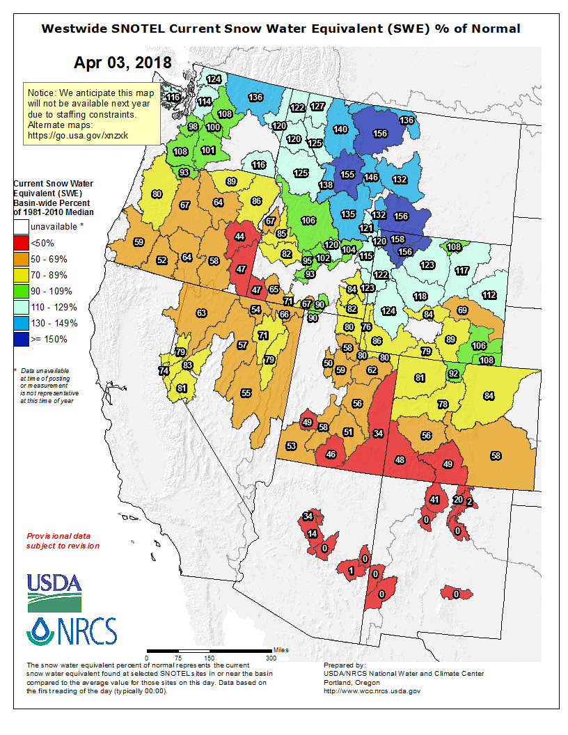
Westwide SNOTEL basin-filled map April 3, 2018 via the NRCS.
Click here to listen to the podcast. Here’s an excerpt:
The eastern plains of Colorado are a world away from the Rocky Mountains for which the state is famous. It’s flat, wide-open grassland, and if there is a tree on the horizon it was probably planted there by a human to offer respite. It’s an unforgiving place to do agriculture—but many do—practicing something called “dryland farming,” in which people like [Nate] McCaffrey’s family grow wheat, millet, sunflowers, and corn using only what falls from the sky.
“Mother Nature only provides a certain amount of moisture, and we have to use it to the best of our ability and be creative,” McCaffrey says. Because water is so scarce on the high plains, being “creative” means that most farmers there have adopted the practice of fallowing their fields to bank the rain that does fall to save it in the soil for the next year’s crop. After harvest, the soils are tilled and then left to “rest,” so to speak, and often sprayed with herbicides to suppress weeds. The result: for over a year the ground is virtually bare and lifeless. Fallowing was stressful. McCaffrey said, “Growing up on a farm all my life, all I ever knew was going out during that fallow period and stressing about trying to kill every weed out there and keep the ground as bare and clean as you could keep it because you were using moisture.”
Not to mention, the soil was getting hot. There was no groundcover, so every time it rained much of the water would evaporate. Research shows that fallowing land only retains about 25 percent of the moisture that falls in a given year, but to farmers in this area, it was the only realistic way to grow the next cash crop in such a water-starved region.
To Till, or Not to Till—That Is the Question
So when it was time for McCaffrey to go out on his own, he was conflicted about sticking with the so-called “conventional” way of farming, which required tilling and a fallow rotation. It got to a point after being out in his fields night and day tilling the ground, that he’d ask himself, “What good am I doing? Am I just out here trying to raise a crop? Am I just out here trying to create revenue? Or am I actually working toward something that somebody is going to care about in the future?”
The answer was metaphorically blowing in the wind—the soil that was being lost from erosion had to be protected, he determined. To accomplish that, the first thing McCaffrey decided to do was go “no-till.”
Tillage is what you picture when you imagine a farmer on a tractor pulling a plow. It’s meant to prepare the ground for the next season by burying residue from the previous crop, leveling the soil, and killing weeds by cutting them off at the knees.
However, research shows that tillage has some serious downsides. It compacts the soil, and by tearing up the ground it breaks apart soil structure, which can lead to erosion. McCaffrey says it also disrupts soil microbes and other beneficial organisms like earthworms, which he says help with water retention and water infiltration because as the creatures make their burrows, water follows them down into the root zone.
So McCaffrey jumped in with both feet. Not only did he sell his conventional machinery, (so he couldn’t waffle on his decision), he bought new no-till equipment that sows his crop by opening up a small slot in the soil and dropping in a seed. This method leaves most of the ground undisturbed, and one immediate bonus was saving money on fuel costs and labor because he would no longer need to spend endless hours on his tractor tilling.
The Platte River is formed in western Nebraska east of the city of North Platte, Nebraska by the confluence of the North Platte and the South Platte Rivers, which both arise from snowmelt in the eastern Rockies east of the Continental Divide. Map via Wikimedia.
From email from Reclamation:
The Bureau of Reclamation has scheduled a North Platte River Water Information Meeting in Scottsbluff, Nebraska.
The meeting will be held at 10:00 a.m., on Wednesday, April 11, at the Scottsbluff Panhandle Station Auditorium, Scottsbluff, Nebraska. The meeting is being held to apprise water users and other interested parties of the reservoir storage and current water supply conditions. Information regarding snowmelt runoff and expected reservoir operations for water year 2018 will be presented.
Pitkin County is now the second county in Colorado that can issue permits for graywater systems that allow some household water to be reused to irrigate lawns and flush toilets.
Graywater is defined by both the county and the state as water coming from bathtubs, showers, bathroom sinks and washing machines. It does not include water from toilets, urinals, kitchen sinks, dishwashers or non-laundry utility sinks, which is often called blackwater.
The city and county of Denver was the first to adopt a similar permitting process in 2016, and did so after the state approved guiding regulations in 2015.
The Pitkin County commissioners unanimously approved an ordinance last week that sets up the county’s permitting process, which is voluntary.
The city of Aspen also is considering adopting a graywater permitting system to complement its recently adopted water-efficient landscaping regulations.
Kurt Dahl, the county’s environmental health manager, said a 1999 statewide study found that typical indoor residential uses amounted to 69 gallons of water per person per day, and of that 28 gallons is graywater as defined by the state.
Graywater systems work by diverting household water away from its normal course — toward septic tanks and sewage systems — and into another set of pipes and storage tanks, where it sits until it is reused.
If the water is used for irrigation, the water must be filtered before storage and then, optimally, pumped out into a subsurface drip irrigation system. It cannot be applied via sprinklers.
If graywater is used to flush toilets, it must be disinfected and dyed before being sent to a toilet.
Single-family households can store up to 400 gallons of water a day in a tank for either irrigation or toilet flushing, and multi-family and commercial entities can store up to 2,000 gallons a day.
Graywater systems require double-piping of plumbing systems, which can be expensive to install in existing homes, and so may be better suited, at least economically, to new construction projects.
Brett Icenogle, the engineering section manager at the Colorado Department of Public Health, said Friday he was happy to see Pitkin County adopt a graywater permitting process, and he hopes other jurisdictions follow suit, even if current public demand seems low today.
“We don’t want to wait until there is a water shortage to put regulations in place,” Icenogle said.
The local permitting process begins with the county’s environmental health department, and also requires plumbing and building permits. If used for irrigation, it may also require a state water right.
Dahl served on a group that developed the state’s regulations, and he’d like to see other uses added to the state’s list, such as fire suppression.
“I want to get this to the point where using graywater is an option for everyone,” Dahl said.
Severance tax revenues have fallen off dramatically in the past three years, down from nearly $300 million in 2014-15 to about $57 million in 2016-17. That’s due partly to lower oil and gas drilling activity and to additional property tax deductions awarded to the oil and gas companies, the result of the state losing a lawsuit two years ago to oil giant BP.
As a result, the state doesn’t have enough severance tax money to cover some of those obligations, and the Joint Budget Committee decided to put $30 million in general funds (income and sales tax) into the main severance tax fund to ensure those operations and activities are covered.
Sonnenberg’s idea is to amend House Bill 1338 to start paying back some of the hundreds of millions of dollars in severance tax money that state borrowed to shore up the budget in recession years. Sonnenberg’s amendment will deal with more than just that money; he also wants to be sure there’s enough in the fund to avoid charging boat owners a fee for inspections for zebra mussels. That’s another measure — House Bill 1008 — that’s awaiting final debate and a vote in the Senate.
The measure would charge boaters between $25 and $50 for a stamp that would cover the cost of inspections at state waterways, such as Green Mountain Reservoir in Summit County, where a zebra mussel was found last year.
Sonnenberg considers the zebra mussel problem one of statewide interest, hence his desire to fund the inspection program out of severance tax dollars rather than requiring boaters to pay for it. Sonnenberg is a co-sponsor of House Bill 1008 but voted against it in the Senate Appropriations Committee because of its funding source. “With a $1.3 billion surplus we can pay back severance tax dollars” and cover the cost of the program, estimated at around $2.2 million, he said.
A boost to severance tax dollars might also help out the state water plan. Last week, the annual CWCB projects bill came out, with $7 million targeted toward water plan projects. That’s $3 million less than what the water plan got last year, and that’s because of the lack of severance tax dollars, sources told this reporter. “We have to live within our budget,” Sonnenberg said.
The projects bill devotes $3 million out of the water plan’s $7 million planned appropriation to storage, which Sonnenberg applauds.
The United States Department of Agriculture has declared four southern Colorado counties to be primary natural disaster areas due to losses and damages caused by ongoing drought conditions in the area.
This week, Bent, Custer, Huerfano and Prowers counties joined Baca and Las Animas Counties, which were declared earlier this month, in qualifying for assistance from the USDA. Adjoining counties, including Alamosa, Costilla, Fremont, Kiowa, and Saguache, also qualify for disaster assistance. Other counties adjoining the four new designees were already qualified in the previous declarations. Farmers and ranchers in Greeley, Hamilton and Stanton county, Kansas, are also eligible.
Qualified producers in the designated areas and adjoining counties can apply for emergency loans through the Farm Service Agency. Those who are eligible have eight months from the date of a declaration – March 29, 2018 – to apply for loans to cover part of their losses. Farmers and ranchers can contact their local USDA service center for additional information about the application process, or check http://disaster.fsa.usda.gov.
Releases from the Aspinall Unit have been increasing over the last couple weeks as diversions to the Gunnison Tunnel have begun. So far these release changes have kept the flows in the Gunnison River through the Black Canyon around 630 cfs. Diversions into the Gunnison Tunnel are expected to increase again this week. This time releases from Crystal Dam will remain unchanged and Gunnison River flows will decrease accordingly. It is expected that river flows will decrease by 100-200 cfs this week. Currently snowpack in the Upper Gunnison Basin is at 72% of normal. The latest runoff volume forecast for Blue Mesa Reservoir projects 360,000 AF of inflow between April and July, which is 53% of average.
Flows in the lower Gunnison River are currently above the baseflow target of 890 cfs. River flows are expected to stay above the baseflow target for the foreseeable future.
Pursuant to the Aspinall Unit Operations Record of Decision (ROD), the baseflow target in the lower Gunnison River, as measured at the Whitewater gage, is 890 cfs for April and May.
Currently, diversions into the Gunnison Tunnel are 620 cfs and flows in the Gunnison River through the Black Canyon are around 630 cfs. By the end of the week Gunnison Tunnel diversions could be in the 700 to 800 cfs range and river flows could be in the 400 to 500 cfs range. Current flow information is obtained from provisional data that may undergo revision subsequent to review.
In an effort to prevent the remnants of hard-rock mining from tainting the region’s waterways in the future, Rep. Barbara McLachlan, D-Durango, along with co-sponsors Reps. Dylan Roberts, D-Eagle, and Jeni Arndt, D-Fort Collins, introduced HB 18-1301 last week.
Conservation groups, like San Juan Citizens Alliance and Conservation Colorado, lauded the bill’s introduction.
“It’s simple: our drinking water should be clean,” Kristin Green, water advocate for Conservation Colorado, said in a press release. “That’s why (this bill) is so critical. Our state’s mining laws are in dire need of an update.”
The bill is meant to be just that – an update to the Colorado Mined Land Reclamation Act, or CMLRA. Under the act, mining companies are required to reclaim and clean up the land they mine, but those same protections don’t extend to water quality. This new bill, which only applies to new mining permits, would make water as much of a priority as land is under the CMLRA.
First, it would require water quality – including treatment and monitoring – be a part of the calculations used to determine how much funding in the form of bonds needs to be set aside for cleanup. The bill also eliminates self-bonding, which is when the bond is backed only by the mining company itself. The concern with self-bonding is if the company goes bankrupt, Colorado taxpayers would be stuck with the bill. Finally, HB 18-1301 requires mining companies submit a plan for water-quality treatment and set an end date for operations.
“These common-sense updates to existing policy would move Colorado toward a more sustainable and responsible mining future,” Marcel Gaztambide, Animas Riverkeeper for the San Juan Citizens Alliance, said in a press release.
The next step for the bill is review by the Colorado House Agriculture, Livestock and Natural Resources Committee on Mon., April 2.
Arkansas River Basin via The Encyclopedia of Earth
From the Arkansas River Basin Water Forum via The Pueblo Chieftain:
Streams of funding will become important to keep streams of water flowing in Colorado in the coming decades, Gov. John Hickenlooper’s top water adviser says.
“We are looking at the appropriate revenue streams,” said John Stulp, the governor’s adviser. “One of the key questions is: How do you build certainty that new methods don’t dry up agriculture?”
Stulp, whose home base is a farm-ranch operation in Prowers County, will speak at the 2018 Arkansas River Basin Water Forum, April 11-12 in La Junta. This year’s forum is dedicated to the issues facing the Lower Arkansas Valley. Water lawyer David Robbins, who defended state interests in the Kansas v. Colorado case before the U.S. Supreme Court, will open the conference, while Stulp will offer closing remarks.
Colorado’s Water Plan, completed in 2015, calls for $3 billion of new state investment in water projects from 2020-50, or about $100 million annually. Much of Stulp’s time working with the state Interbasin Compact Committee has been spent figuring out just how to do that.
“We looked at 110 possibilities, then narrowed that to about 12. About four of those rose to the top,” Stulp said.
Those ideas included:
An excise tax on water activities, including recreation.
A tap fee on all water users’ bills.
A bottle fee on beverage containers.
A one-time tap fee on new construction.
In addition, a bill introduced late in the 2017 legislative session proposed a 0.1 percent sales tax to fund water.
“None of the ideas have been implemented,” Stulp said. “It’s been a very general discussion.”
Funding is also a very real issue at present. The Colorado Water Conservation Board has borrowed $10 million from its construction fund to fund Basin Roundtable projects that formerly would have been funded through mineral severance fees, which were curtailed by a court decision. Roundtables have been more selective in choosing projects that adhere to the Water Plan.
“I think it’s been a good refresher for the roundtables to look at their Basin Implementation Plans and decide which projects to fund at the local level and which to take to the state level,” Stulp said. “The Arkansas Basin Roundtable has been very active and has come up with good ideas for the valley and to take back to the rest of the state.”
[The] water forum at Otero Junior College in La Junta will include a series of presentations on agriculture, municipal water supply, environmental concerns, water quality and watershed restoration. For information, go to http://rbwf.com.
Investigators with the Colorado School of Public Health and the Colorado School of Mines are looking for volunteers who were exposed to tainted water in the Fountain, Security and Widefield area back in 2015…
“The compounds are persistent so they are still in people’s bodies, likely if they were exposed,” said Dr. John Adgate, principal investigator at the Colorado School of Public Health.
In order to know for sure, for their sake and the sake of those affected, researchers will need to look at blood samples.
“It’s important for individuals because they’ll get to know what their body burden is, what their levels are,” Dr. Adgate added.
Investigators will use those blood samples to see whether immune function, liver function and cholesterol levels changed because of the previous exposure to those chemicals.
These blood samples, along with samples from private wells in Fountain and Security, will also help researchers figure out how long the contamination was occurring prior to 2015.
Liz Rosenbaum, founder of the Fountain Valley Clean Water Coalition, says it’s important the community learn more about these possible health effects.
“We need to be aware of what we’ve been exposed to, potential health effects later on in our lives so we can deal with it so it’s not a surprise,” she said.
A $275,000 grant from the National Institute of Environmental Health Sciences is helping fund the study.
Right now, researchers need more than 200 volunteers to sign up and they plan to follow up with 50 volunteers again the following year so see how these compounds are changing over time…
Volunteers will also have to fill out a questionnaire and they’ll receive a gift card for participating.
In order to qualify for this study you must meet the following criteria:
be 18 years old or older
live within the affected area for at least 3 years
be a non-smoker (tobacco and marijuana within the past 12 months)
cannot be pregnant
cannot have certain serious chronic diseases like cancer, diabetes or lupus
You can find out out how sign up for the study here.
Citing the success of Denver Water’s conservation efforts since it first issued its “purpose and need” statement for the project, and the fact that no service shortfall has yet materialized for its 1.4 million customers in the metro area, Boulder County Attorney Ben Pearlman said that based on prior environmental reviews, “Boulder County does not believe Denver Water has shown that the project’s purpose and need have been met and the FERC must deny Denver Water’s application to amend its permit.”
[…]
“We don’t think they have undertaken the duty they have (under federal environmental law) to analyze this problem thoroughly,” [Conrad] Lattes said…
Denver Water officials on Friday answered back by reasserting the project’s merits.
“The Gross Reservoir Expansion project represents an enormous amount of work, input and collaboration to ensure it is done in the most responsible way possible,” Jim Lochhead, Denver Water CEO/manager said in a statement. “And Denver Water will continue to develop noise, transportation and tree removal plans with input from stakeholders to minimize the impacts to Boulder County and its residents.”