President Donald Trump has unveiled a $1.5 trillion plan to rebuild our nation’s crumbling infrastructure, including the pipes and treatment plants that keep clean water flowing from our taps. But if you read the fine print, his plan offers just $200 billion in federal funds; the remaining $1.3 trillion is expected to come from other sources, including private investors.
Private investment in water systems might look like a good deal to those who want to limit federal spending; it certainly appeals to cash-strapped cities and towns. And the need is great: The American Society of Civil Engineers gives our nation’s drinking water facilities a “D” grade, and says $1 trillion will be needed to fix them over the next 25 years.
But private investment comes at a cost. Fundamentally, it means handing over our most essential resource to those who put profits before the public interest. That’s what we learned here in Missoula, Montana, where we recently wrested control of our water system away from a multinational corporation.
Missoula is unusual in that our water system was privately owned since the town’s founding in the 1870s. Our first water entrepreneur was “One-Eyed Riley,” whose delivery method involved a yoke and two buckets. Since then, the system passed through many hands, but was never well managed. Compared to neighboring towns with public utilities, Missoulians endured high rates and poor service. Necessary capital improvements were not made, and the system steadily deteriorated.
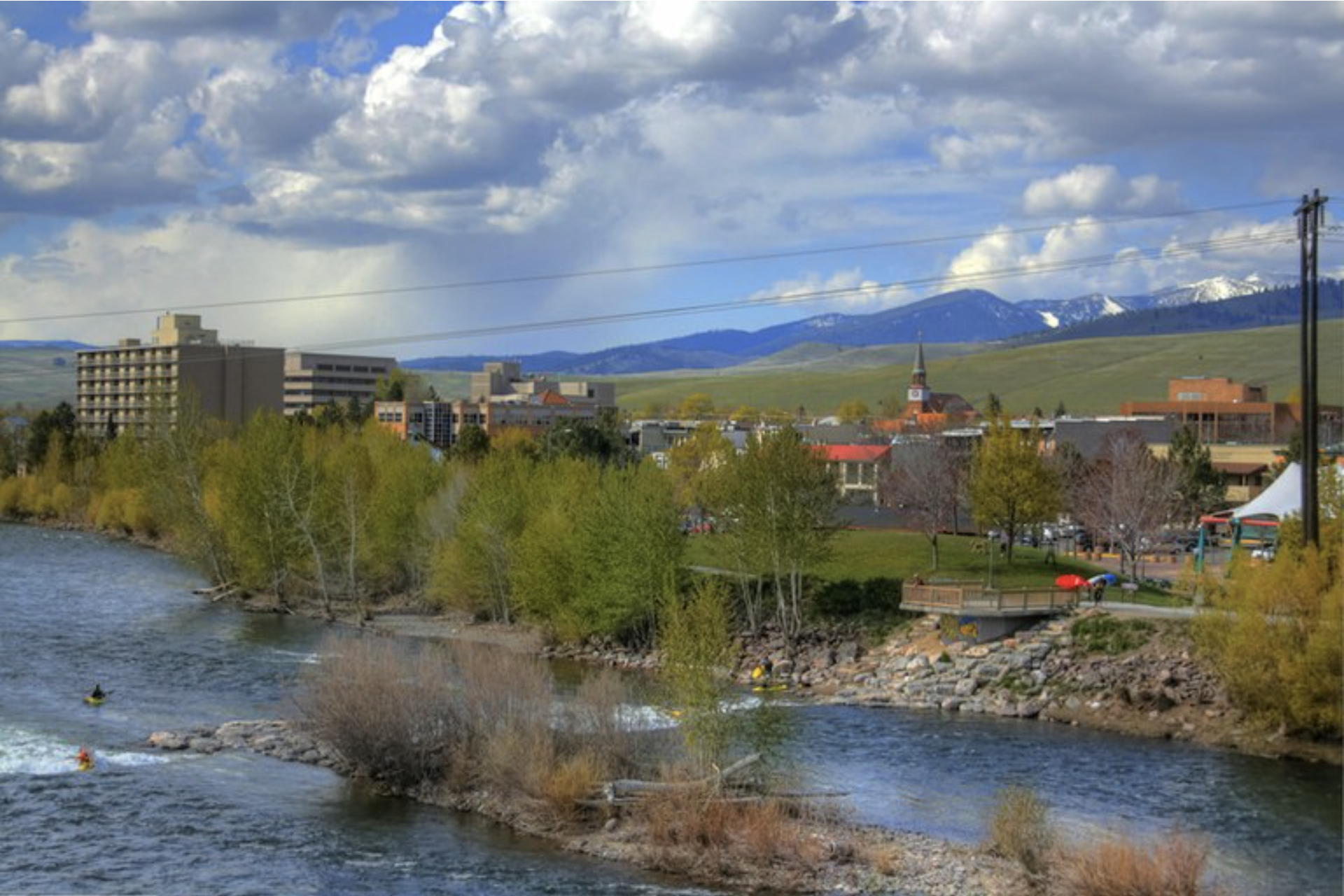
Kayakers enjoy the Clark Fork River next to downtown Missoula, Montana. Photo credit: Micah Sheldon/Flickr
When the Carlyle Group purchased our water system in 2011, we hoped the situation would improve. But we soon realized the fundamental tension that lay between Carlyle’s goal of generating a short-term profit and Missoulians’ need for safe, clean water over the long haul. After a four-year court battle, we purchased our water system from Carlyle for $84 million. Now, for the first time in our town’s history, ownership of our water system — its pipes, pumps, wells, water rights, wilderness lakes and dams — has landed where it belongs, in the hands of the people, where it can be managed for the public good, for all time.
Unfortunately, other cities seem headed the other way, seeking private financing as the answer to their water woes. Many will be disappointed: Private investors require high rates of return, so they are unlikely to support projects that won’t pay off sufficiently.
If there is money to be made from water, look out. Population, pollution and climate change are squeezing global drinking water supplies, so investors — including commercial bottling plants — are rushing in. There are disturbing accounts of bottling plants targeting a town’s good water source, only to deplete local water wells, dry up wetlands and drain streams.
Some people assume that private management means greater efficiency and lower rates. Yet the reverse is often true. The New York Times analyzed three communities where private equity firms manage water or sewer services. In all three places — Bayonne, New Jersey, and Rialto and Santa Paula in California — rates rose more quickly than in comparable towns. In Bayonne, the price of water skyrocketed by nearly 28 percent after the private equity giant Kohlberg Kravis Roberts took charge of the city’s system.
That’s why some cities that had gone private — from Ojai, California to Fort Wayne, Indiana — have seized their water systems back from private ownership.
While the price tag can be daunting, public investment is the better option. State and local governments already provide the lion’s share of money for water infrastructure, and federal funding is available through the Clean Water and Drinking Water State Revolving Funds (though those funds are flat-lined in the president’s proposed 2019 budget). There are also collateral benefits from public investment. The Economic Policy Institute found that spending $188.4 billion on water infrastructure would yield $265 billion in economic activity and create 1.9 million jobs.
In Missoula, we are reaping the benefits from public ownership of our priceless water assets. Decisions about our water are made right here in town, not in a distant boardroom. Instead of short-term profits, our priority is long-term water security, a critical concern in the era of climate change. We don’t have to worry about rates going up to fatten investors’ wallets, and there are less tangible benefits, including a more intimate connection to the resource on which all life depends.
So here’s our advice: If your community hopes Trump’s infrastructure bill will fix your water system, be sure to read the fine print. And if you’re lucky enough to control your own water, never give it up without a fight.
Karen Knudsen is a contributor to Writers on the Range, the opinion service of High Country News. She is the director of the Clark Coalition, based in Missoula, Montana.
Colorado’s hardworking rivers provide economic and environmental bounty. The value of West Slope water reaches all four corners of Colorado and flows beyond the Stateline. As we close out an extremely dry water year and look toward a new water year, water users in the Colorado River Basin grapple with how to react to looming shortages and meeting demands.
However, collaborative work is underway aimed at reducing the risk of shortage while supporting Colorado’s flowing rivers and working lands.
We all play a role in Colorado’s sustainable water solution. Join Audubon Rockies, Black Canyon Audubon Society, Trout Unlimited, the Business for Water Stewardship, Mayfly Outdoors, and the Colorado River District for an evening of community, food and discussion about charting Colorado’s water future.
The district, which has boundaries that stretch through parts of Weld, Adam and Morgan counties, serves about 550 farmers who operate about 1,000 irrigation wells. As part of the ballot question, proposed through Central’s Groundwater Management Subdistrict, the district is planning for long-term projects officials said would give farmers and ranchers a reliable source of water, even during drought conditions.
According to the district, taxpayers living in a $500,000 home would pay $1.90 per month or $22.80 per year.
If approved, the money would go three places:
Construction of 5,000 acre-feet of additional reservoir storage near Fort Lupton, Greeley and Kersey.
Purchasing additional senior water rights, including those currently leased by the district.
Construction of the Robert W. Walker Recharge project in Wiggins, near the Weld and Morgan county line.
In September, executive director Randy Ray said the recharge project, the biggest of the three, would claim $15 million of the funding to divert water from the South Platte River and send flows to groundwater basins about 5 miles away from the river. Officials said the storage would increase drought resiliency for the district’s water users.
In 2007, years into a record-breaking drought throughout the southwestern U.S., officials along the Colorado River finally came to an agreement on how they’d deal with future water shortages — and then quietly hoped that wet weather would return.
But it didn’t.
Those states are now back at the negotiating table to hammer out new deals to avoid a slow-moving crisis on the river system that supports 40 million people in seven Western states…
The canyon beyond the dam is stained with a stark white ring. For the past 20 years, Pitt says, demands for water have outstripped the supply, meaning Lake Powell and its sister reservoir — Lake Mead further downstream — continue to drop. Both are less than half full.
Pitt says without changes to how the two human-made lakes are managed, they could plummet to levels where no water can be released, referred to as “dead pool.”
“If that happened, that would be a catastrophe for this region’s economy, for all of the people who depend on the Colorado River, and for all of the wildlife that depends on it as well,” Pitt says…
It’s not about blame
That dystopian future of shuttered farms, dried up streams and water-stressed cities is one water managers, like the Upper Colorado River Commission’s James Eklund, are attempting to avoid.
“Take Lake Mead,” Eklund says. “More is being taken out than comes into it. Like your bank account, if you do that over a sustained period you will run a deficit, and if you’re talking about water for 40 million people and economies that are massive — fifth largest economy in the world, the Colorado River Basin represents — then that’s significant.”
They’re attempting to boost reservoir levels with a suite of agreements under the umbrella of “drought contingency planning.” The premise is simple: Cut water use now, use that saved water to bump up Powell and Mead, and doing so will help to avoid bigger problems in the future, when supplies are likely to be even tighter.
Water officials in Colorado, Utah, New Mexico and Wyoming are working on a plan that covers the river’s Upper Basin and focuses on boosting snowpack with weather modification, better managing existing reservoirs and creating a water bank in Lake Powell.
The Lower Basin plan, being worked on by officials in Arizona, California and Nevada, is meant to create new incentives for water users like farmers and cities to conserve water in Lake Mead and to agree to earlier, deeper cuts to water use so the reservoir can avoid dropping to dead pool levels.
“There is clearly enough evidence that if we were to have another 2000 to 2004 kind of a multi-year drought, the system is in very serious trouble,” says Eric Kuhn, the former general manager of the Colorado River District, a Glenwood Springs, Colorado-based water agency.
When the current guidelines for river management were written back in 2007, he says people were feeling optimistic.
“Historically we’ve always said, ‘Well, next year will be better,’” Kuhn says. “And that’s the easy way out.”
After just finishing one of the driest and hottest water years on record, much of that optimism is gone.
Kuhn says Arizona has had the hardest time coming to an agreement due to intrastate battles over who will take cuts to water allocations and when they’ll take them. But states in the river’s Upper Basin — like Colorado — have had issues, too.
Like with the concept of demand management.
“It’s the difficult one,” Kuhn says. “Somebody’s going to have to use less.”
[…]
Climate change is just one factor to get these deals done quickly. Another is pressure from the federal government. Officials with the U.S. Department of the Interior have given states an end-of-year deadline to get things done. If not, the assumption is the feds will step in and do it for them.
“That’s I think a fear of everybody on the river especially in the Upper Basin,” says Jennifer Gimbel, a former Interior undersecretary, now with Colorado State University. “And the last thing we want is interference by the federal government in that role.”
Gimbel says the fate of the entire region hangs in the balance.
Back at Glen Canyon Dam, the National Audubon Society’s Jennifer Pitt says it’s more than just the fates of people and economies tied up in river politics. An entire ecosystem is at stake.
“I think a lot of people who care about wildlife in this region are concerned,” she says. “And it’s not just birds. Seventy percent of all wildlife in the arid West rely on rivers at some point in their life cycle. So it has outsized importance for anyone who appreciates nature in this part of the country.”
This story is part of a project covering the Colorado River, produced by KUNC and supported through a Walton Family Foundation grant. KUNC is solely responsible for its editorial content.
In order to avoid that shortage, which has never been declared before, the Bureau asked the seven basin states to come together in 2018 to form drought contingency plans that will avoid triggering shortages. This past Wednesday, the Bureau released a draft plan formed by the Upper Basin and Lower Basin states.
The draft contingency plan would see Lower Basin states agree to conserve more water and curtail use and keep more water in storage if Lake Mead reaches the critical level. The Upper Basin states agreed to keep Lake Powell at least 30 feet above the 3,525 feet trigger level and gain the ability to keep a certain amount of excess water in storage, instead of losing it to Lower Basin states.
In a joint statement, the Bureau’s Lower Colorado Regional Director Terry Fulp and Upper Colorado Regional Director Brent Rhees lauded the landmark draft agreements.
“The seven Colorado River Basin States have taken an important step forward by releasing draft drought contingency plans for the Upper and Lower Basins,” the statement read. “The Bureau of Reclamation commends the work of the many partners in the Basin. We are encouraged by their progress in responding to ongoing drought conditions that continue to threaten reservoir elevations at an unprecedented rate.”
The statement goes on to say that the Bureau hopes the draft agreements will be finalized and adopted by the end of 2018. However, states will need to have a framework for how to distribute water cuts, which may require dealing with painful realities while tightening belts.
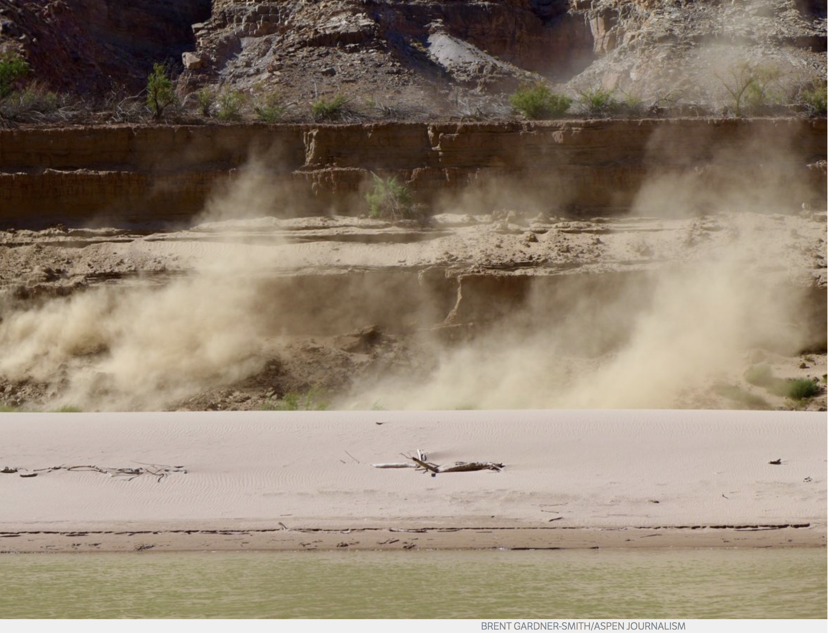
Drying in process on the Colorado River, where Lake Powell once stood, in early October 2018. Photo credit: Aspen Journalism/Brent Gardner-Smith
FromAspen Journalism (Brent Gardner-Smith) via The Aspen Times:
How Colorado may respond to a growing call to reduce water uses on the Colorado River system will be the subject of a robust discussion today in Glenwood Springs as the Colorado River District board gathers for its fall quarterly meeting.
Andy Mueller, the district’s general manager, said he expects the prospect of the state developing a mandatory program to reduce water use to generate “a very lively and upfront discussion” among the district’s board members, who represent 15 Western Slope counties, including Pitkin, Eagle and Garfield.
Last week, four draft agreements were unveiled by various entities that provide the basis for drought contingency plans being developed in the upper and lower Colorado River basins.
The upper basin’s plans include seeking federal approval to store water in Lake Powell to bolster the reservoir’s dropping water level without the water being released to the lower basin under existing guidelines and regulations.
The ability to develop a secure “demand management pool” of water in Lake Powell and other upper basin reservoirs is seen as a key element by water managers working to create a program in Colorado that would pay water users to reduce the amount of water they use on a “voluntary, temporary and compensated” basis.
However, such storage also is key to developing a demand management program that is mandatory and uncompensated, which Front Range water users recently told the state they expect may be necessary in the face of declining natural water supplies due to global carbon burning.
To date, officials at the state’s Colorado Water Conservation Board who are working on a demand management program insist they are only considering a voluntary, temporary and compensated program. They are reluctant to discuss the possibility of a mandatory program.
But there is increasing recognition on both sides of the Continental Divide that a mandatory program may, in fact, be necessary if the ongoing drought persists.
“While our district has opposed the mandatory demand management model without a proper public discussion and consensus, we recognize that the overuse in the lower basin, coupled with the continuation of extremely poor hydrology, may in the future cause us all to support or at least be willing to endure an anticipatory mandatory curtailment,” Mueller said in a Oct. 5 memo to the district’s board of directors.
He also said in his memo that officials with various Front Range water providers recently told the Colorado Water Conservation Board “a voluntary program was a fine goal but that they believed the state needed to roll out a program which includes rules and requirements for mandatory anticipatory curtailment.”
John McClow, a former CWCB member, the general counsel for the Upper Gunnison Water Conservancy District in Gunnison and an alternate representative from Colorado on the Upper Colorado River Commission, said in an interview last week that the view of the Front Range water providers about the potential necessity of a mandatory program has some merit.
“The temporary, voluntary, compensated reduction in consumptive use is the way we have looked at since 2014, and that’s what the public is accustomed to,” McClow said. “And most of us think that’s a good idea. The problem we have, though, is what if it isn’t enough? What if it doesn’t work? There has to be a backup.
“Many people who are experienced and competent water managers are saying, ‘Look, it’s just not possible to make up the amount of the deficit through this voluntary program,'” McClow said. “There just aren’t players out there, and there isn’t enough money.”
But Mueller and McClow feel that the state, via the conservation board, has an obligation to try to reduce water use in the Colorado River system in a way that is equitable to agriculture and cities, on both sides of the Continental Divide.
“They have an obligation to work toward protecting all water users, East Slope, West Slope, etc.,” McClow said. “That’s the responsibility of the state.”
Mueller said last week he was heartened that the directors of the conservation board agreed Oct. 4 to draft a policy shaping a potential demand management program for Colorado that may address the River District’s concerns.
“I view that as a positive outcome and appreciate them taking that step,” Mueller said. “If we allow that (demand management) pool to be set up without a commitment by our state to stand by those principles that their staff has been out there talking about and endorsing, it gives great concern.”
Editor’s note: Aspen Journalism is collaborating with The Aspen Times on coverage of rivers and water in the Colorado River basin. More at http://www.aspenjournalism.org.
Click here to read the discussion. Here’s an excerpt:
ENSO Alert System Status: El Niño Watch
Synopsis: El Niño is favored to form in the next couple of months and continue through the Northern Hemisphere winter 2018-19 (70-75% chance).
ENSO-neutral continued during September, but with increasingly more widespread regions of above-average sea surface temperatures (SSTs) across the equatorial Pacific Ocean. Over the last month, all four Niño index values increased, with the latest weekly values in each region near +0.7C. Positive subsurface temperature anomalies (averaged across 180°-100°W) also increased during the last month, due to the expansion and strengthening of above-average temperatures at depth across the equatorial Pacific. Convection was increasingly suppressed over Indonesia and around the Date Line. Low-level westerly wind anomalies were evident over the western and east-central Pacific, with some of the strongest anomalies occurring over the eastern Pacific during the past week. Upper-level wind anomalies were easterly over the east-central Pacific. Overall, the oceanic and atmospheric conditions reflected ENSO-neutral, but with recent trends indicative of a developing El Niño.
The majority of models in the IRI/CPC plume predict El Niño to form during the fall and continue through the winter. The official forecast favors the formation of a weak El Niño, consistent with the recent strengthening of westerly wind anomalies and positive temperature trends in the surface and subsurface ocean. In summary, El Niño is favored to form in the next couple of months and continue through the Northern Hemisphere winter 2018-19 (70-75% chance; click CPC/IRI consensus forecast for the chance of each outcome for each 3-month period).
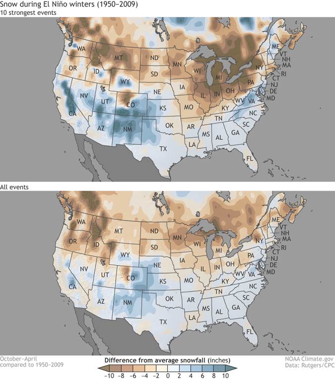
Impacts of NIÑOs that form in winter on the CONUS, 1950 through 2009 via NOAA.
Click here to read the dashboard. Here’s an excerpt:
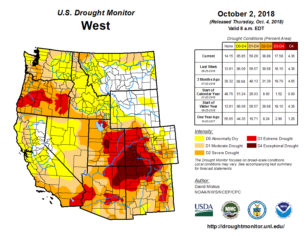
Water Year 2018 ended with a whimper, as extremely dry and very warm conditions prevailed over the region in September. Water-year precipitation and streamflows ended up at record- or near-record-low levels across most of Utah and Colorado, accompanied by record- or near-record-high average temperatures and evaporative demand. The cool and wet start to October dampened wildfire danger and raised hopes for the new water year, but deep deficits in soil moisture and water supply persist.
Dozens of stream gages in the Upper and Lower Green, White, Yampa, Colorado headwaters, Gunnison, Uncompahgre, Dolores, and San Juan basins saw their lowest September monthly flows on record. In late September, the Animas River ran below 100 cfs at Durango for the first time in 107 years of record. Water-year total streamflows were the lowest or 2nd-lowest on record at many gages in southwest Colorado, and at several gages in southern and eastern Utah. Unregulated water-year inflows to Lake Powell were the 3rd-lowest on record, after 1977 and 2002.
Statewide, Utah is at 54% of average reservoir storage for this time of year, versus 70% one year ago; Colorado is at 46% of average, versus 68% one year ago. As of October 9th, Blue Mesa Reservoir had dropped to its lowest level, 263 KAF, since 1987. Lake Powell held 11.0 MAF as of October 9th, the lowest level since 2014, and per the September 24-Month Study, the most-probable forecast for April 2019 is 9.0 MAF, which would be Powell’s lowest level since 2005.
September was an extremely dry month for the region, capping off a historically dry water year for most of Utah, Colorado, and southern Wyoming. Statewide, Water Year 2018 was the driest on record (since 1896) for Utah, while it was the 2nd-driest on record for Colorado, just ahead of 2002. September was much warmer than average for Utah, Colorado, and southern Wyoming, cinching a historically warm water year. For Colorado statewide, Water Year 2018 tied with 1934 and 2000 as the warmest on record, while for Utah, it was the 2nd-warmest on record, just behind 1934. Both states were 2.8 degrees F above the 1981-2010 normal.
Drought conditions emerged or worsened in multiple areas in Utah, Wyoming and Colorado during September. D3 and D4 conditions now cover virtually all of eastern Utah and Colorado’s Western Slope. As of October 2, 88% of Utah is in D2 or worse, and the remainder in D0 or D1; in Colorado, 64% is in D2 or worse, and 22% in D0-D1; and in Wyoming, 3% is in D2 or D3, and 37% in D0-D1. The 12-month EDDI map shows that relative to previous water years, evaporative demand over Water Year 2018 was the highest (ED4) or 2nd-highest (ED3) on record (since 1980) for much of the region.
The CPC seasonal precipitation outlooks for the month of October shows very strongly enhanced chances for above-normal precipitation for the region, largely reflecting the wet short-term forecasts as of October 1, i.e., precipitation that now has already fallen as of the 11th. The precipitation outlook for the October-December period shows slightly enhanced chances for above-normal precipitation for Colorado and southern Utah, consistent with the elevated odds of El Nino development by winter. Those odds are still at about 70%, per the IRI/CPC Probabilistic ENSO Forecast.
Colorado water managers are saying good riddance to water year 2018. It enters the history books alongside 2002 and 1977 as one of the driest on record for the Upper Colorado River Basin.
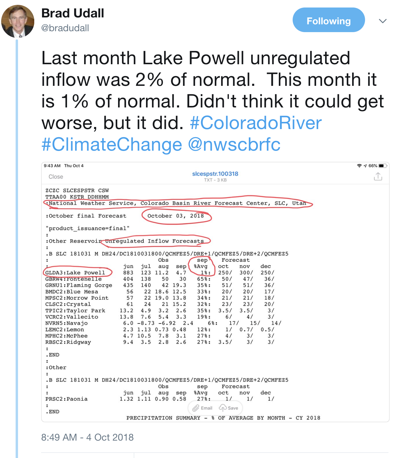
According to preliminary numbers from the Bureau of Reclamation, water year 2018, which ended Sept. 30, had the third-lowest unregulated inflow into Lake Powell at 4.62 million acre-feet. That’s just 43 percent of average.
Only 1977 and 2002 saw less water flow into Lake Powell from the upper basin, at 3.53 million acre-feet and 2.64 million acre-feet, respectively.
The average yearly inflow is 10.8 million acre-feet.
The months of August and September 2018 were the third- and fourth-worst months for unregulated inflows into Lake Powell behind only July and August of 2002.
The unregulated flow in August was just 2 percent of average. Lake Powell is currently 46 percent full.
“We know if we have another drought, the risk of draining Lake Powell is real,” said Jim Pokrandt, director of community affairs for the Colorado River Water Conservation District and chairman of the Colorado Basin Roundtable. “If we have another year as bad as this one, you’re going to see lots of discussions about who’s going to take reductions. We really need three, four, several years of average or above-average snow years to get us out of this pickle.”
Low flows in the Roaring Fork River just above Rio Grande Park, in July 2012. Water year 2018 surpassed 2012 as third driest in terms of inflow into Lake Powell from the Upper Colorado River Basin. Photo credit: Aspen Journalism/Brent Gardner-Smith
Roaring Fork conditions
Locally, the Roaring Fork watershed was extremely dry this water year. The region was plagued by record-low snowpack — the lowest snow-water equivalent ever recorded for some dates at the McClure Pass and Independence Pass SNOTEL sites — sparse runoff, record-low streamflows and a hot, dry summer.
Low flows were prevalent across Colorado during the last two weeks of the water year, which runs from October through September. According to the National Oceanic and Atmospheric Administration’s drought information system, 30 percent of U.S. Geological Survey stream gauges in the intermountain West reported record-low seven-day-average stream flows for the last two weeks of September, including some in the Roaring Fork watershed.
On Sunday, the last day of the water year, the USGS river gauge on the Roaring Fork at Stillwater Road just east of Aspen showed the river flowing at 19 cubic feet per second, beating the previous minimum flow of 21 cfs in 1977.
Flows on the Crystal River were similarly low. Above Avalanche Creek and above a series of diversion structures, the river was running at nearly 46 cfs, lower than the previous record low of 48 cfs in 1977.
At the river gauge near the state fish hatchery and downstream from several diversion structures just outside of Carbondale, flows dribbled down at just under 7 cfs Sunday.
Colorado Department of Water Resources Engineer for Division 5 Alan Martellaro said the summer’s weak monsoons exacerbated conditions caused by little snowfall.
“We had a bad snowpack,” Martellaro said. “It was not the worst, but then we have had an incredibly dry summer, a total lack of rain. I think when we start analyzing it, we are going to find the flows in late summer are unprecedented. We have done some things we have never done before.”
Martellaro is referring to curtailment on the lower Crystal in late July. Amid rapidly dropping flows, the district 38 water commissioner turned down the headgate of the Lowline Ditch, which he determined was diverting too much water. The ditch diversion did not exceed its legally decreed amount; the problem was that it was violating new state guidelines regarding wasting water.
According to data from the Natural Resources Conservation Service, many sites around western Colorado rank as the driest since recording began for water-year precipitation, including McClure Pass, Schofield Pass and Independence Pass.
Statewide, the water year precipitation average at all SNOTEL sites measured just 21.4 inches, which is 64 percent of average — the second-lowest on record behind only 2002.
“It was pretty consistently dry throughout the entire year,” said Karl Wetlaufer, a hydrologist with the NRCS Colorado Snow Survey. “February may have been the only month where we had near-normal precipitation across the state.”
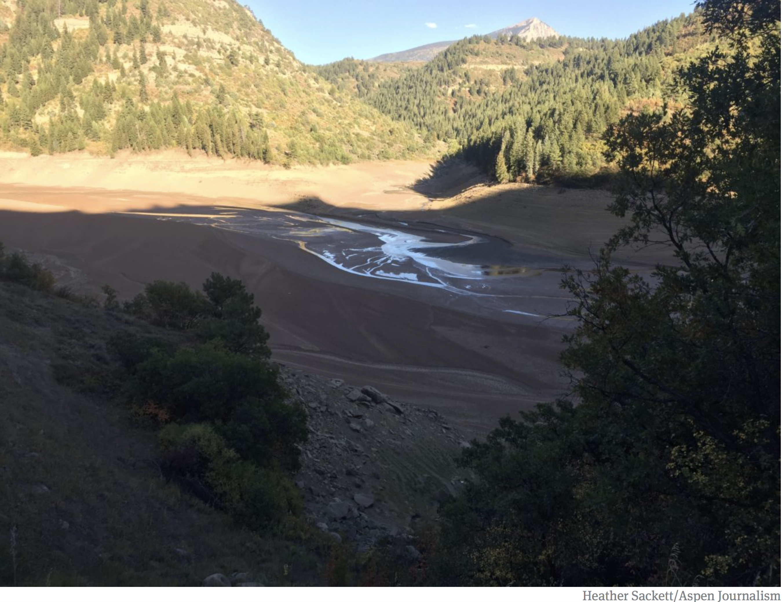
Paonia Reservoir was at 7 percent full at the end of September. Water year 2018 ranked as the third driest in the Colorado River Basin. Photo credit: Heather Sackett/Aspen Journalism
Reservoirs low
In some instances, reservoir releases have come to the rescue of downstream anglers, fish and ecosystems.
Releases from Ruedi Reservoir will continue through October to bolster flows for endangered fish in what’s known as the 15-mile reach, a notoriously dry section of the Colorado River between the Palisade area and the confluence with the Gunnison River in Grand Junction.
[Reclamation has been releasing water from] Ruedi Reservoir.
Periodic releases from Green Mountain Reservoir near Kremmling also boosted summer flows in the Colorado River. But that water will need to be replaced this winter by snowfall, Martellaro said. Ruedi Reservoir is currently 63 percent full while Green Mountain Reservoir is nearly 46 percent full.
“Where we have large reservoirs that can supplement the flows, yeah, we’ve gotten by,” Martellaro said. “But even that is coming to an end. We are running out. It remains to be seen what the snowpack is like to refill these large holes we’ve put in these reservoirs.”
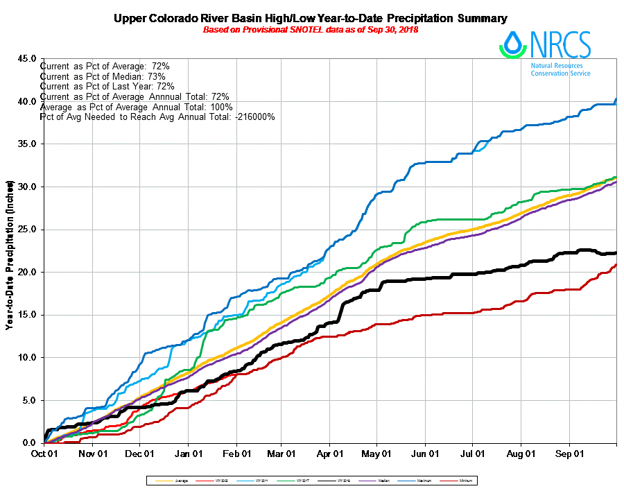
Water year 2018 Upper Colorado River Basin precipitation accumulation via the NRCS.
The Santa Fe-based organization [Wild Earth Guardians] filed notice that it wants the New Mexico Court of Appeals to review a district judge’s refusal to force the Office of the State Engineer to prove that the Middle Rio Grande Conservancy District is entitled to water it uses under permit.
“The appeal looks to compel the State Engineer to require the District actually prove it has used the large quantity of water it claimed upon receiving its permits from the State in 1925,” WildEarth Guardians said in a news release. “Despite the clear mandate under its permits, the District has long avoided confirming its use with the hope of continuing to control and divert the entire flow over the river in perpetuity.”
The district’s diversion of water from the Rio Grande for hundreds of farmers has been a source of contention, especially in dry years when the riverbed has gone mostly dry below the Albuquerque area, threatening the survival of species such as the Rio Grande silvery minnow…
“The days of water abundance are gone,” Jen Pelz of WildEarth Guardians said in a statement. “The reality of these times demands that the basic limitations on water use are met. Our litigation seeks just that, to enforce key provisions of state water law to safeguard and conserve water for our rivers.”
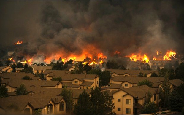
Wildfire smoke is creating a public health crisis. Last year, nearly every county in Montana was declared a disaster area. As wildfires raged, respiratory-related visits to emergency rooms spiked (“Montana’s tough summer,” HCN, 12/11/17). In Lolo, Montana, officials installed new air filters in schools to improve air quality. But without dedicated government programs to combat smoke, Western communities could be taxed by the impacts of future fire seasons, which are projected to worsen with climate change.
FOLLOWUP
This year, scientists from Colorado State University and other institutions analyzed the situation and made a grim prediction. A study published in August in the journal GeoHealth estimates that the number of deaths related to wildfire smoke in the United States could be as high as 44,000 per year by 2100 — more than double the current rate of about 17,000 deaths per year. Even as humanity reins in similar pollution from industry and car emissions, climate change will further boost wildfires’ deadly smoke.
Carl Segerstrom is an editorial fellow at High Country News. Email him at carls@hcn.org.
Illustration shows water availability, in blue circles, compared with demand at various places along the South Platte River. The yellow area is the study area. (Illustration by Stantec).
The Lower South Platte Water Conservancy District’s board of directors tentatively accepted the 2019 budget. Technically, the district’s budget will soar to $1.35 million next year, but like the 2018 budget, much of that is in the form of grants for specific water study projects.
The district will manage almost $350,000 in Colorado Water Conservation Board grant funds to create the South Platte Regional Development Concept. The project, being done by the South Platte Regional Opportunities Working Group, would help identify viable water storage projects in the South Platte basin.
Another grant, this one for $236,245 from the U.S. Bureau of Reclamation, would be used by the Northeast Colorado Water Cooperative to find ways to develop infrastructure for water exchanges, primarily when water augmentation plans are involved.
The $1.35 million figure also includes $316,312 in leftover funds from the 2018 budget. Actual operating expenses for the conservancy district are budgeted at just under $760,000 for 2019.
Arizona’s efforts to deal with the effects of drought on the Colorado River hit a rough patch Wednesday, after the Central Arizona Project shared updated and previously undisclosed data indicating that possible water cuts would be more extensive and severe than expected.
Farmers and ranchers remain first in line to lose water, but tribal communities and cities, which were slated previously to lose some water from the Non-Indian Agriculture, or NIA, pool, would now likely lose much more under Arizona’s Drought Contingency Plan.
Based on the new numbers, “a Drought Contingency Plan would cut about half of the NIA pool,” said Cynthia Campbell, water resource manager adviser for the city of Phoenix, who is an alternate on the steering committee and was present at Wednesday’s meeting. “Not a small sliver. A big chunk.”
As water levels at Lake Mead continue to decline, the federal Bureau of Reclamation gives it a 52 percent chance of slipping below 1,075 feet — that is, hit an official shortage — by 2020. Arizona is part of a multistate effort to negotiate water cuts that would prevent reservoir levels from falling further.
Within Arizona, these contentious Drought Contingency Plan talks have centered around figuring out ways to lessen the impacts of water cuts, especially on agriculture. These negotiations, in turn, are based on a list of water orders provided by the Central Arizona Project that shows how much water CAP’s customers plan to buy.
Those water orders matter because the amount of water that’s distributed to agriculture depends on how much water other users, who get priority, consume first. The more water they use, the less remains for agriculture and the NIA pool, which is next in line. But the order numbers weren’t all there until this week…
By using numbers from previous years, when customers ordered less water, CAP had been understating the impact of drought cuts on the NIA category, from which many cities, including Phoenix, draw water, Campbell added.
It all became clear at a working group meeting Wednesday, when CAP revealed the new numbers.
Broken down by year, the numbers showed that water orders for 2019, which were finalized just last week, are slated to rise in the coming year. CAP also shared the figures for water orders in 2016, 2017, and 2018, previously undisclosed, showing that these orders steadily have ticked upward in recent years. Those numbers, shown below in photocopies, were presented during the closed working group meeting. They were also shown on screens during the steering group meeting, which is open to the public, but they were not made available online with other materials from the open meeting.
In 2016, users in two priority categories, Indian and Municipal/Industrial, ordered a total of 807,000 acre-feet of water from CAP; in 2017, 882,000 acre-feet, and in 2018, 907,000 acre-feet…
Draft numbers for next year sit at 933,000 acre-feet for users in the two categories. If orders for water remained around 2017 and 2018 levels, water cuts under the Drought Contingency Plan would take out just a splash of the NIA pool. Using the projected 2019 numbers, they would gobble up more than half of the pool — and the overall trend is that usage is rising…
So the Drought Contingency Plan is supposed to bridge the gap between the 2007 guidelines and the year 2026, the year those guidelines end. But negotiations over the rights to water from the Colorado River are beyond contentious, and they are excruciatingly complex…
Imagine a pitcher of water and five cups. Which cups are filled first and how much water each one receives is dictated by a pecking order, defined by an amalgam of laws, rules, negotiations, and lawsuits.
Now imagine that the source of the water starts to dry up, and you’re not going to have as much water as you expected. The cups that are first in line are ordering more water than ever, as is their legal right. What do you do? Do you try to make sure all five glasses still get some water? Or do you let the last cups in line run dry? If the people drinking from the first-filled cups don’t drink everything, should you pour that excess into a separate pitcher and redistribute it among the glasses that are last in line? What about using excess water you stored away over the course of years?
That is the simplified version of what the Drought Contingency Plan is trying to figure out. The pitcher of water is the Colorado River, and the five glasses are groups that include, in order of priority, tribal communities and municipalities/industries, non-Indian agriculture, and agriculture, which gets whatever is left over after the others have quenched their thirst.
The newly revealed numbers prompted fierce comments on Wednesday. Steering committee members and other stakeholders argued over the ramifications of the number and vowed to protect their access to water.
Some suggested that the new numbers showed that an agriculture mitigation pool, already a point of contention, would grant farmers more water than they would have received under the 2007 guidelines.
“I think the principle of mitigation is to mitigate, not to ameliorate,” said Don Pongrace, an attorney for the Gila River Indian Community, who spoke at but does not sit on the steering committee. He suggested that the new numbers indicated that creating a mitigation pool for agriculture under the DCP would give them more water than they would have received under the 2007 guidelines and thus undermine the entire point of the DCP.
Agricultural interests vehemently disagreed.
“That would be the end of the agricultural economy in Pinal County,” Paul Orme, representing Pinal County agriculture, declared during the meeting. “In 2019, we have for some reason, some drastic change in these water orders that has some potentially devastating impacts on the ag pool. We should drill down. … Why were those orders made in 2019, and what is those extra water going to be used for?”
It’s not clear why CAP made these detailed numbers public only on Wednesday, and an explanation from CAP about the numbers it had been using was not clear. DeEtte Person, a spokesperson for CAP, told Phoenix New Times that CAP had been providing numbers from 2018, and that it was only last week that CAP finalized orders for 2019.
“The question was raised, ‘Oh, are you now using the numbers from your most current numbers you just got last week?’” Person said. “The answer was, ‘No, we’ve been using the numbers we’ve been using all along.’ And so I think that just confused people.”
In late August, as reservoirs levels declined across the American Southwest, Erin Light issued something common in most river basins of Colorado but which had never been done on the Yampa River. She issued a “call.”
When a call is issued, those with newer or younger water rights must cease their diversions from the river and its tributaries until the older or more senior rights are satisfied. This system is called prior appropriation. Eighteen states in the West use aspects of prior appropriation to sort out who gets how much water and when.
Light, as the division engineer for Colorado Division of Water Resources, administers the labyrinth of water rights in the Yampa River Valley. Water goes to ranches, a power plant, and other purposes, each occupying a specific place in the pecking order as determined by volumes, locations and, above all, date of adjudication. That’s the way it works when a river is under administration. Some Colorado rivers have been under administration since the late 1800s.
Until this summer, the Yampa was different. Those with legally adjudicated water rights took what they thought was theirs. Calls had been placed on tributaries, but not the river itself.
Then in late August, Light announced that those with water rights on the rivers’ main stem awarded since 1951 would have to cease diversions until those older, or seniors, had been satisfied. By mid-September, as irrigators slowed their demands and cooler temperatures eased losses from evaporation and transpiration, Light edged the call back to those rights junior to 1960. Last week, she suspended the call altogether.
Droughts hit the Yampa and many other river basins in Colorado hard this year. But this drought may best be viewed as part of an extended 21st century drought caused more by temperature increases than precipitation declines. It’s part of a clear trend of a warming and more erratic climate.
Ted Kowalski says the water call on the Yampa should be understood within the context of these hotter, drier times in the American Southwest. A former Colorado water official who is now senior program officer for the Walton Family Foundation’s Colorado River Initiative, Kowalski calls the Yampa River the first domino to fall.
Lower streamflows in all the rivers of the Colorado River Basin that produce declining reservoir levels represent the additional dominoes.
This is starkly demonstrated, says Kowalski, by the fact that reservoir storage in the Colorado River Basin has reached its lowest level since the late 1960s. That’s when the newly created Glen Canyon Dam was starting to create Lake Powell.
“All of this underscores the importance of developing and adopting and agreeing to drought contingency plans so that we can effectively manage if and when there is less water in the system,” says Kowalski. The work begins, he says, with conservation.
Conserving water in the 20th century
Far into the 20th century, conservation had a different connotation in the West. Managing water in the Colorado River Basin meant building dams and creating reservoirs, all with the intent of ensuring none of the water was “wasted” by flowing into the ocean.
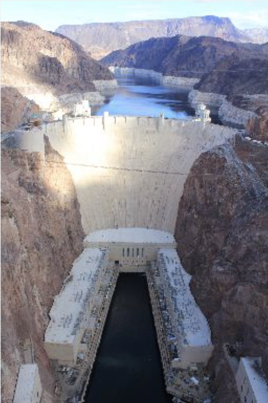
Hoover Dam plugs the Colorado River on the Nevada-Arizona border. Photo December 2012/Allen Best
Nearly all this major hydraulic engineering was done on the tab of the federal government. Downstream, first Powell and then Mead, the second largest and largest reservoirs in the nation, respectively, provide most of the storage. If separated by 300 miles and the Grand Canyon National Park, the two reservoirs fundamentally operate in tandem, as a Colorado River Research Group report in August noted. They are “essentially one giant reservoir (bisected by a glorious ditch),” the report said in a nod to the Grand Canyon.
Reservoir levels rise after big snow years, but in the 21st century the more common trend has been decline.
Evidence emerging in recent years suggests the Colorado River’s decline can best be explained by rising temperatures instead of reduced precipitation. In a 2017 paper, Brad Udall, a senior water and climate research scientist at Colorado State University, and Jonathan Overpeck, the dean of the School for Environment and Sustainability, attributed two-thirds of water declines to temperature rather than precipitation. Not only is more water evaporating, they said, but plants have been transpiring more water.
“This is the kind of drought we will have to deal with in the future,” Overpeck said at a water conference in Santa Fe during April.
Doug Monger testifies to the warmer weather. A native of the Yampa Valley, he remembers 45-below temperatures, once in the 1980s for two days straight. Down the valley in Maybell, the temperature in that same cold spell hit 61 below. (It had also hit that same low in 1979.)
“I always prayed for climate change and global warming,” he jokes.
Now, he’s getting that warming. “We never had 90 degrees, and now it’s nothing to have 90-plus days for five or six days in a row.”
That heat has been taking a toll on the snow. About three-quarters of the precipitation in the Colorado River Basin originates as snow. Colorado itself provides 70 percent of the water in the river.
In the Yampa Basin, most of the snow collects in an elevation band of between 8,000 to 10,000 feet. The river originates on the flanks of the Flattops Wilderness Area as the Bear River, gurgles playfully along at the foot of the Gore Range and then, drawing more water from the usually snow-laden Park Range, hooks westward at Steamboat Springs for a 100-mile journey to Dinosaur National Monument.
Beyond Dinosaur, the Yampa’s water eventually flows into the Utah desert and Lake Powell.
The Park Range has a reputation as the snowiest place in Colorado. A gauge at 10,285-foot Buffalo Pass, located northeast of Steamboat Springs, reported 80 inches of water contained in the much deeper snowpack by early May on a recent, snow year.
When spring arrives in years such as that, the Yampa gushes through Steamboat Springs well into summer. Flows needed for commercial tubing during summer represent one measure of winter’s legacy. Tubers are not allowed to use the river until flows drop below 700 cubic feet per second. That commonly isn’t possible until after the Fourth of July.
This year, snowpack was better than in Southwest Colorado. Still, it came weeks early and was altogether modest in its surge. Tubing season in Steamboat began June 11. Commercial tubing season ended a month later, when it is usually starting. City and state wildlife officials asked all tubers and others river users to stay out. The river was dropping to 85 cfs, considered a critical threshold, and warming as it did, hitting 75 degrees, reported the Steamboat Pilot at the time.
“If the river’s getting above 75 degrees Fahrenheit, the aquatic life is severely stressed, and this is the time of year when they’re feeding, and they’re getting ready for winter,” said Kelly Romero-Heaney, the city water resources manager for Steamboat Springs.
No relief came with summer, hot and dry. Clouds produced just a few drops.
Water infrastructure in 21st century
Light, the water engineer on the Yampa since 2006, tells a complicated story of why the first call was made this year and not during prior years. Water rights always get complicated. The immediate repercussion will be that investments will necessarily be made in the devices that assure flows. In the Yampa River it was a point of pride that there was no call, unlike places like the South Platte Basin. But almost everybody agrees it was inevitable.
The Yampa River had almost no flows at Deerlodge Park, at the entrance to Dinosaur National Park, when this photo was taken in mid-August. Photo/Erin Light via The Mountain Town News
That inevitably stems in large part to trends in hydrology. In 20th century hydrologic records, three drought years stand out: 1935, 1955, and 1977. Now, in this still young century, there have been three more: 2002, 2012 and 2018.
“When you look at temperatures that were 5 to 10 degrees above average every day, that has to raise eyebrows about what the climate is saying,” she says.
Changes in the Yampa River Basin have not been well documented, but anecdotally at least comport with statewide trends reported in a 2015 report to the Colorado Water Conservation Board. That report, “Climate Change in Colorado,” says statewide average temperatures had increased 2 degrees F during the previous 30 years, with daily minimum temperatures warming more than maximum temperatures. Timing of snowmelt and peak runoff had shifted earlier in spring by one to four weeks. Snowpack as measured by April readings had been mainly below-average since 2000.
Anecdotal evidence of this abounds around Steamboat. Local ranchers long measured a winter’s severity by how deep it accumulated on their barbed wire fences. The 20th century produced many three-wire winters, enough snow to hit the top strand. Three-wire winters seldom come anymore. Last winter snow failed to reach the bottom wire. In some places, the was no snow at all on the ground, says Ken Brenner, who grew up on a ranch south of Steamboat Springs and is now president of the Upper Yampa River Water Conservancy District Board of Directors.
Light says the Snotel automated snowpack measuring sites fail to tell the full story. The stations maintained by the federal government’s Natural Resources Conservation Service record snow and water content at 8,000 to 10,000 feet. Some years, they report robust snow that cannot be seen in snow depths on the valley floor. This leaves locals wondering how this snowpack could be anywhere near normal. The rising levels for snowpack argue for a different monitoring system, says Light, one that captures dynamics of the low-elevation snowpack.
Water infrastructure for 21st century climate
Climate change models predict sharply increased temperatures in coming decades, Models also predict greater variability of precipitation, more extremes of both wet and dry. That could provide an argument for more reservoirs. The Yampa River has just 2 percent of Colorado’s reservoir capacity, but the river provides a much larger percentage of the state’s overall flows. The Gunnison River, with about the same runoff on average, has three giant federal dams, part of the same Congressional authorization in 1956 that created Lake Powell.
The Yampa, White, and Green Basin Roundtable, a decision-making body created by the Colorado Legislature, agree that instead of giant reservoirs, the basin could benefit from smaller reservoirs, discretely located, such as on tributaries, to serve specific needs, reports Light, the state’s liaison to the roundtable.
Monger does see the need for storage on the Yampa River. It could help Colorado manage its water so as to ensure it can meet its commitments to other states in the Colorado River Basin. “Let’s keep it in my backyard rather than sending it down to Lake Powell and have it be subject to the Bureau of Reclamation and the Department of Interior,” says Monger, a Routt County commissioner as well as a delegate to the Colorado River Water Conservation District. Higher elevation storage, he says, will reduce evaporative losses from Lake Powell, about six and a half feet a year off the surface.
About 90 percent of the Yampa’s total annual flows go downstream out of Colorado, ultimately to Lake Powell. That reservoir provides Colorado and other upper-basin states in the Colorado River Basin the ability to meet requirements for delivery of 8.3 million acre-feet annually to Arizona, California, and Nevada at Lake Mead.
That obligation of 7.5 million acre-feet plus the upper basin’s share for Mexico was derived by negotiators who met at a resort near Santa Fe in 1922. Disregarding contrary evidence, they assumed at least 16.5 million acre-feet average annual flows in the river and probably more. That rarely has been the case. In the hotter, drier 21st century, flows have been just 12.4 million acre-feet, say Eric Kuhn, former general manager of the Colorado River Water Conservation District.
At a recent conference called “Risky Business on the Colorado River,” Kuhn warned against overdrawing Lake Powell, Lake Mead, and other reservoirs.
“When you build reservoirs, you have to have some water. You have to have a little bit of money in the bank. We can’t bankrupt the system. We have to find ways to cut back before we bankrupt the system.”
In Vail on Wednesday, Kuhn took his vision of difficulty for the Colorado River a step further. As long as greenhouse gas emissions go untamed, he said, “there is no bottom” to how hot and how dry the Colorado River Basin could become.
It’s not that the past hasn’t also been drier. Kuhn looks to the past to warn against even more difficult times on the Yampa River and in the Colorado River Basin altogether. The evidence comes from examinations of batches of trees at eight different sites in the Colorado River Basin above Lee Ferry, located just above the Grand Canyon and below Lake Powell.
Dendrochronologists can estimate precipitation by the growth of tree rings. Using that technique, they have charted wet and dry periods since 1434.
Tree-ring research indicates there have been much more severe 19-year droughts in the Colorado River Basin than the current one—and without the impact of human-induced higher temperatures. Graphic via The Mountain Town News
“A number of folks claim that the current 19-year period of 2000-2018 is the driest 19 year period on the Colorado River. That’s nonsense,” says Kuhn, pointing to the graph. In the past there have been droughts both longer and deeper. (Above, see estimated river flows at Lee Ferry, at the top end of the Grand Canyon, from 1434 to 2018. For underlying data, see http://treeflow.org).
Those droughts occurred without the rising temperatures of today. “If these past 19-year droughts were to happen with today’s temperatures,” he adds, “things could be much worse.”
This article was published in the Oct. 4 issue of Mountain Town News, a weekly e-magazine. To subscribe, see options in the red boxes in the top-right corner of the http://mountaintownnews.net webpage.
This week, the Bureau of Reclamation released the draft Colorado River Drought Contingency Plan, drawn up by the states within the river’s watershed.
The seven states that rely on Colorado River water are nearing completion of an ambitious two-part plan to protect water in the West, as the already over-allocated Colorado River faces further shrinking due to drought and climate change. The draft plan could spread the burden of exceptionally dry years across all communities that draw from the overtaxed river — if only warring factions inside Arizona could finalize their own portion of the agreement.
The plan aims to conserve more water and store it in Lake Powell so that the Colorado River system, which supports the water needs of more than 40 million people, doesn’t collapse. Seven states plus Mexico need to agree to the plan. Documents released this week lay out two drought-contingency plan proposals. One is from the Upper Basin states — Colorado, New Mexico, Utah and Wyoming— which has already been signed. The second part of the agreement is the proposal from the Lower Basin states: Arizona, Nevada and California. Those states still need to finish hammering out an agreement.
While the release of the draft plan signifies a step toward a final agreement, Arizona remains mired in within-state negotiations. The plan requires cutbacks in water use, and Arizona water managers are still negotiating to determine how cities, farming districts and tribes could spread around the impacts of the deal.
Glen Canyon Dam June 2013 — Photo / Brad Udall
The most difficult hurdle the state has yet to clear is the fate of a relatively small group of farmers in central Arizona, who share some of the lowest priority water rights in the Lower Colorado River Basin. In 2004, Pinal County farmers signed an agreement that gave up permanent contracts for Colorado River water in return for temporary access at a steep discount. As a result, they stand to lose their water if there is a shortage, which could be declared as soon as 2020. Now, those farmers hope to negotiate for stipulations in the final agreement that will prevent them from losing their water supplies all together.
Despite the delay, local water managers who have been meeting regularly to hash out plan details feel optimistic that by January, Arizona will be able to sign off on the agreement. Tom Buschatzke, the director of the state Department of Water Resources, told the Arizona Republic that the idea is to reach a compromise that “more equitably spreads around the pain and the benefits” of the proposed Drought Contingency Plan. “I think the vast majority of people are trying to find ways to make this happen,” Buschatzke said.
Paige Blankenbuehler is an assistant editor for High Country News. Email her at paigeb@hcn.org or submit a letter to the editor.
After more than three years of negotiations, Southwest water managers this week released the first public draft of their short-term plan to manage the Colorado River as overuse and drought continue to strain a water supply that supports 40 million people from Wyoming to Nevada.
The complex plan is meant to defer more severe shortage conditions on the river as negotiators in the seven-state Colorado River Basin work out an even more complex long-term framework for a century-old system challenged by higher temperatures and changes in precipitation.
Infighting and a wet start to 2017 had put the plans on hold, but discussions resumed again this year with abysmal snowpack across the basin and forecasts of a shortage as early as 2020 led federal water managers at the Bureau of Reclamation to call for a plan by the end of the year.
The Southern Nevada Water Authority’s board will consider the plan and vote on it next month.
The plan asks Colorado River water users to make cuts to their supply in an effort to store more water in reservoirs like Lake Mead, the country’s largest storage pool and a symbol of drought across the West. The reservoir, impounded behind the Hoover Dam outside of Las Vegas, is lined by an eerie bathtub ring that shows where the water line used to be, about 140 feet higher.
“I think it shows that we are on track to try to get [a drought plan] done by the end of the year,” said John Entsminger, the general manager of the Southern Nevada Water Authority. “The [drought plan] is an incredibly important set of documents. It demonstrates that the seven states are still capable of coming together and managing this river in the case of changing conditions.”
No easy way to conserve
During a prolonged drought, the plan requires water users to double down on voluntary cuts as a way to keep more water in Lake Mead and Lake Powell, the system’s second-largest reservoir upstream of Lake Mead. If the reservoirs dry up, the seven states risk running afoul of multiple laws that govern the river — the incentive driving everyone to come up with a proactive plan.
If Lake Mead drops another 55 feet, the federal government could throw out the playbook and force even deeper cuts. Most water users want to avoid the uncertainty that comes with that…
If Lake Powell drops even lower, Glen Canyon Dam will produce less hydropower, the revenue of which supports operations and endangered species compliance. More importantly, low levels at Lake Powell put the Upper Basin (Colorado, New Mexico, Utah and Wyoming) in a precarious long-term position. The river’s upper division is required to send a certain amount of water from Powell to Lake Mead every year to fulfill their obligations under the 1922 Colorado River Compact. If they don’t, downstream users in the Lower Basin (Arizona, California, Nevada) can force the Upper Basin to curtail water use. This tool is referred to as a “Compact Call.”
Without steps like the drought plan, “the system is going to crash,” said Andy Mueller, who runs the Colorado River District, which focuses on protecting river water in Western Colorado…
But as Mueller also concedes, the devil is in the details. Asking users to conserve more water — and in turn, use less — is a challenging, expensive, and often unpopular proposition. Now that a public draft of the plan is out in public, water districts across the basin must review the plans and sign off on them. Even though Nevada is ready to sign off on the plan and has been ready for more than a year, other water users still have concerns about the conservation measures.
In Arizona, where the cuts would be steepest, state officials are still working on an intra-state agreement that would be palatable for its state legislature, which must approve the plan. To get there, Arizona officials are looking to find ways to mitigate cuts that would disproportionately fall on low-priority agricultural users in Pinal County outside of Phoenix. Paul Orme, a lawyer for the farming community, said that Arizona officials presented a mitigation plan on Wednesday, but it faded corners from other water users — cities and tribes — that would have to sacrifice their water.
“I can’t really answer your question: Where do we go from there?” said Orme.
But he added that Pinal County farmers have significant leverage in the state’s legislature.
“There are folks in the Arizona legislature who are very much interested in seeing Pinal County agriculture survive,” Orme said.
California is also working toward an intra-state agreement between the Metropolitan Water District and agricultural users over how the cuts would work. Kightlinger said there had been some back-and-forth over what percentage Metropolitan and each agricultural district would conserve to boost Lake Mead’s elevation, but the parties are close to a tentative agreement.
“There’s a high likelihood we are going to complete this,” he said.
There are still key details to work out in Colorado too. Although Mueller agrees with the concept of sending more water to Lake Powell, he said conservation should not fall disproportionately on the backs of farms, ranches and orchards in Western Colorado. Mueller said he wants to see a commitment from cities that they contribute an equal amount to boost reservoir levels at Powell.
“[Conservation] water should come equally from both,” he said.
The arid state’s counterintuitive role
Although Las Vegas gets 90 percent of its water supply from the Colorado River, Entsminger said the utility will be able to easily absorb the cuts, which kick in once the lake dips below a certain elevation. The region, Entsminger argues, has a more secure supply than other water users because it can access water through a pumping system, even if the lake falls so low that no water can be delivered out of the Hoover Dam to Arizona or California.
In drought negotiations, that puts Nevada in a unique situation. Even though it is the most arid state in the country’s most arid region, it has less to lose than others. In a recent podcast with The Nevada Independent, Entsminger likened the state’s position to that of Switzerland.
In these negotiations, Entsminger said Nevada helped bridge a divide between the Upper Basin and the Lower Basin. The agreement Nevada helped hammer out is a key part of the drought plan. It allows states like Colorado to “bank” conserved water in Lake Powell without sending it to Lake Mead under the reservoir’s current operating rules; it avoids the weird situation in which the benefit of the Upper Basin’s conserved water is enjoyed by the Lower Basin.
That was at the crux of a disagreement earlier this year, when the Upper Basin states released a letter to the Central Arizona Project, which controls Arizona’s Colorado River canal, of placing water orders to manipulate in such a way that they could take more water from Lake Powell.
“We saw that the water that was being saved was pulled down the river by convenient timing of orders from the Central Arizona Project,” Mueller said. “We weren’t very happy with that.”
The recent deal, Entsminger said, could go a long way in improving the historically tense relationship between an Upper Basin that has the right to use more water than it does and a Lower Basin that operates with a “structural deficit,” using more water than it takes each year.
“It’s very big from an Upper Basin, Lower Basin relationship perspective that we are going to set aside some of the dogma of the river,” Entsminger said during an interview this week…
But creating a “bank” in the Upper Basin comes with its own legal and funding challenges. Who pays to incentivize conservation? Who gets title to the conserved water? How do you account for it? And how do you shepherd it to Lake Powell without other users diverting it along the way?
[…]
On second thought, it’s not “drought plan”
How complicated is all of this?
The drought plan is so complex and involves so many side agreements that it has come to mean something different to different groups. Almost everyone agrees that it is a short-term fix to a long-term problem — climate change and overuse mean there is less water to go around.
Water managers are not even sure what to call it.
It’s about drought, yes. But some take issue with that word because it suggests that the system will recover from the conditions that have drawn down Lake Mead to its lowest elevation since it was fully filled. Eklund said that a more suitable name could be the “Climate Contingency Plan.”
[…]
Eric Kuhn, a former general manager of the Colorado River District who is working on a book about the history of Colorado River hydrology, agreed that using the term “drought” is flawed.
He asked: “Is this a Drought Contingency Plan or is this thing what we need to do for the rest of our lives? I personally think it’s kind of a joke to call it a Drought Contingency Plan.”
In many ways, the drought plan is a first step. For conservation groups, it is a way to create the reliability needed to tackle other important issues, like habitat and the general health of the river.
“Reliability of the Colorado River water supply is important both to people and to nature,” said Jennifer Pitt, who works on river issues for the Audubon Society. “We are very encouraged to see the progress that is being made toward adopting this [plan] and we know that is not the end of the story. That’s the beginning of the story. There’s more work to do.”
For others, it’s a prelude to future negotiations. Once the conservation plan is finalized, the conversation will shift to long-term planning. Right now, water managers are operating under a set of guidelines completed in 2007. Those expire in 2026 but negotiations for new guidelines begin in 2020. The plans will likely go through an extensive environmental review. The purpose of the drought plan, Entsminger and others said, is to ensure water users can get to 2026 without severe shortages.
Precipitation has been generally above normal in the Dakotas for a few months (extending into Minnesota), and 1.5 to 3.0 inches fell this past week on central and eastern North Dakota, with light to moderate totals reported elsewhere. Much of these states are covered by dryness and drought of varying intensities. Precipitation was insufficient to bring any changes to South Dakota, but most of the dry areas in North Dakota, ranging from D0 to a small area of D3, all retracted a bit.\
Farther south, existing areas of dryness and drought in east-central and northeastern Kansas were inundated by the heavy to excessive rainfall from the same system that impacted Missouri. And, also like Missouri, the areas of dryness and drought improved dramatically, with 2-category Drought Monitor improvements common.
Looking westward, areas of moderate precipitation were observed in Colorado and Wyoming, most notably in western Colorado (1.5 to locally 3.5 inches). A more broken pattern of moderate to heavy precipitation existed elsewhere; light precipitation was most prevalent in northern and eastern Wyoming.
The precipitation was beneficial in the Upper Colorado River Basin and in southeastern Colorado, where a good hydrologic response to the precipitation was observed. Dry soils were recharged somewhat, and streamflows notably increase. The large, intractable areas of extreme to exceptional drought remain entrenched, but a few areas showed mild improvement, and this is reflected in parts of the D3 to D4 areas in the Drought Monitor. Adjacent D0 to D2 areas, where dryness is less protracted and intense, showed a bit more recovery…
Unsettled weather dominated the region. Outside southern California and adjacent Nevada, most areas recorded at least a few tenths of an inch of rain, with scattered locations reporting multiple inches. Heavier precipitation was most prevalent in western Washington and much of Utah, but especially in much of Arizona. There, the remains of Hurricane Rosa brought unseasonably heavy precipitation (1.5 inches to locally over one-half foot) to a large region centered on the middle of the state. Most other sections of Arizona recorded 0.5 to 1.5 inches.
Drought usually changes slowly in the west, but this past week in Arizona is a marked exception. Broadscale 1-category improvements were made almost statewide, with a few small spots of 2-category improvements introduced where the heaviest rains fell.
In other parts of the West, conditions almost universally persisted or improved, with only isolated deterioration observed. Numerous areas of improvement (the size of one to a few counties) were made across New Mexico as well as western Washington, as the rainy season finally got underway in the form of one to several inches of precipitation, particularly in orographically-favored areas. A few spots in Utah experienced notable improvement from recent precipitation, and farther north, a number of improvements were made in Montana and adjacent Idaho. Improved areas have surpluses accumulated over the course of at least a few months…
Little precipitation fell on Tennessee, Arkansas, Mississippi, and Louisiana this week. As a result, most of the D0 and D1 patches were unchanged, but isolated areas (from one to a few counties in size) in northeastern Mississippi, south-central Tennessee, and northern Arkansas did deteriorate. In most cases, D0 expanded into the region.
Western Louisiana, the southeastern half of Texas, and eastern Oklahoma saw more precipitation than the states farther east, but only scattered small areas recorded over 1.5 inches of rain, insufficient to bring any notable improvement to the D0-D2 areas in that part of Texas.
Farther west, a strong upper-level trough and frontal system brought heavy rain to western Texas and much of Oklahoma. Areas just east of the Texas Panhandle recorded the most rainfall (5 to 10 inches prevailed), but most locations saw recorded over two inches. This substantially alleviated dryness and drought across the region, and most areas of dryness and drought improved from last week by one category. D0-D1 conditions now prevail, with a few areas of D2-D3 remaining in the central Texas Panhandle and west-central Texas…
Looking Ahead
During the next 5 days (October 11-15), Tropical Storm Michael is forecast to rapidly track northeast from Georgia to the southern mid-Atlantic on October 11.Michael is then likely to move away from the East Coast on October 12. A swath of heavy to excessive rainfall (locally more than 5 inches) is expected to occur across the flood prone areas of the Carolinas that received extremely heavy rainfall from Hurricane Florence. Meanwhile, Tropical Storm Sergio is forecast to track northeast towards the California Baja Peninsula with its remnant low merging with a strong cold front. Moderate to heavy rainfall (0.5 to 2 inches) is expected from southeast Arizona northeast to the southern Great Plains and Ozarks region. An amplifying upper-level ridge is likely to result in dry weather across the Pacific Northwest during this period.
For the CPC 6-10 day extended range outlook (October 16-20), indicates that a high amplitude pattern is likely to persist through mid-October. An upper-level ridge (trough) is forecast over western (eastern) North America. This predicted upper-level pattern yields an increased chance for below-normal temperatures across the central and southern Rockies, Great Plains, Mississippi Valley, Corn Belt, and Northeast. Increased chances of above-normal temperatures are forecast across the Pacific Northwest and California, while above-normal temperatures are expected to persist over Florida. A drier pattern is likely over much of the continental U.S. due to the high amplitude ridge. However, a slight tilt in the odds for above-normal precipitation is forecast across the Southwest and along the East Coast. Enhanced odds for above-normal precipitation and above-normal temperatures are forecast throughout Alaska.
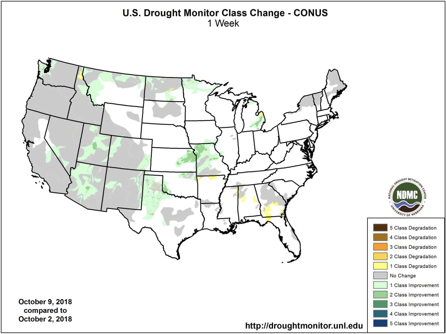
One week US Drought Monitor change map October 9, 2018.
Here’s the release from the Bureau of Reclamation:
Colorado River Basin States make important progress towards adopting effective Drought Contingency Plans in 2018
In December 2017, Reclamation Commissioner Brenda Burman called on the seven Colorado River Basin States and water entitlement holders in the Lower Colorado Basin to continue developing Drought Contingency Plans (DCPs) in response to ongoing historic drought conditions in the Basin and reduce the likelihood of Colorado River reservoirs – particularly Lake Powell and Lake Mead – further declining to critical elevations. All seven Colorado River Basin States have been working diligently throughout 2018 on a set of draft DCP agreements that would implement Drought Contingency Plans in the Upper and Lower Basins. The agreements include an Upper Colorado River Basin Drought Contingency Plan and a Lower Colorado River Basin Drought Contingency Plan.
The Upper Basin DCP is designed to: a) protect critical elevations at Lake Powell and help assure continued compliance with the 1922 Colorado River Compact, and b) authorize storage of conserved water in the Upper Basin that could help establish the foundation for a Demand Management Program that may be developed in the future.
The Lower Basin DCP is designed to: a) require Arizona, California and Nevada to contribute additional water to Lake Mead storage at predetermined elevations, and b) create additional flexibility to incentivize additional voluntary conservation of water to be stored in Lake Mead.
The Upper and Lower Basin DCPs contain actions in addition to the provisions of the December 2007 Colorado River Interim Guidelines for Lower Basin Shortages and the Coordinated Operations for Lake Powell and Lake Mead. The Upper and Lower Basin DCPs are available for download here: Upper and Lower Basin DCPs – Final Review Draft. (PDF – 668 KB)
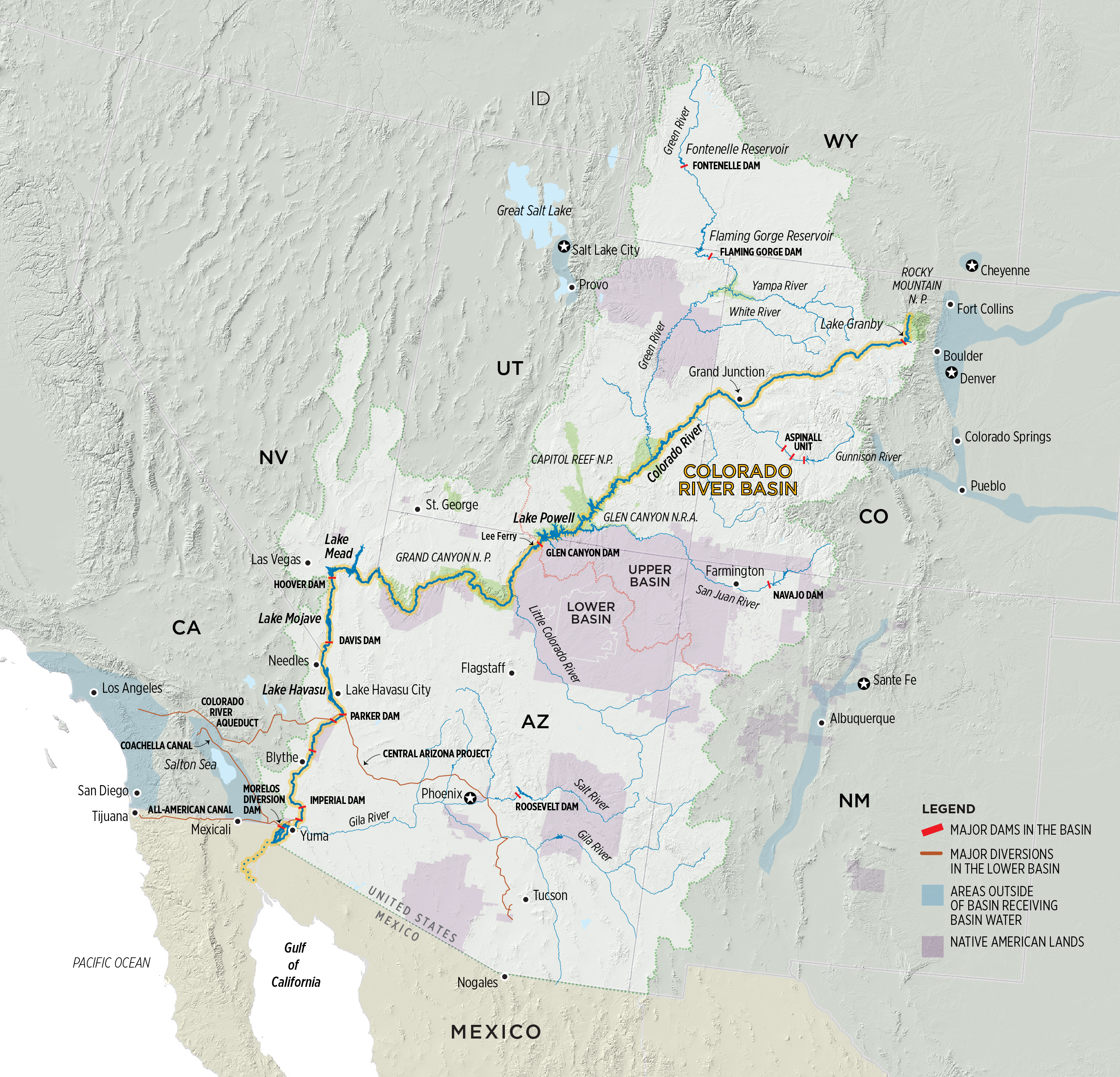
Detailed Colorado River Basin map via the U.S. Bureau of Reclamation.
After years of stop-and-go talks, California and two other states that take water from the lower Colorado River are nearing an agreement on how to share delivery cuts if a formal shortage is declared on the drought-plagued waterway.
Under the proposed pact, California — the river’s largest user — would reduce diversions earlier in a shortage than it would if the lower-basin states strictly adhered to a water-rights pecking order. California’s huge river take would drop 4.5% to 8% as the shortage progressed.
With occasional years of relief, the river that greens farm fields and fills faucets from Colorado to California has been stuck in drought since 2000. A shortage declaration has been looming over the seven-state basin for more than a decade, only to be narrowly averted time and again when rain and snow in the upper basin pushed reservoir levels above the trigger point.
But flows into Lake Powell — one of the Colorado’s two massive reservoirs — fell to a little more than a third of the average for the April-through-July period this year. And September’s inflow was negligible, less than 1% of the average. Looking at those numbers, federal officials say the U.S. Interior Department could declare a shortage in 2020.
“It’s pretty clear we’re in a deepening long-term drought cycle,” said Jeffrey Kightlinger, general manager of the Metropolitan Water District of Southern California, which has been importing Colorado River water to the region since the early 1940s. “It’s in everybody’s interest to prevent the system from cratering.”
The basin’s entire storage system is 47% full. Lake Powell, which stores runoff from the upper basin and releases it to Lake Mead, is 45% full. Mead, the source of Southern California’s river water, is 38% full.
The Interior secretary has never declared a shortage on the Colorado. But it has been known for years that the river is over-allocated. The basin states divvied up the flows in the early 20th century — a period that in hindsight was unusually wet and presented an unrealistic picture of what the Colorado could produce year in and year out.
Diversions are regulated by a complicated system of river compacts and water rights that call for Arizona and Nevada to take the first cuts in times of a lower-basin shortage. California, with some of the oldest river rights, is further down the line.
The sprawling Imperial Irrigation District and other farm districts in southeastern California control roughly 75% of California’s 4.4 million-acre-foot share. Imperial is the single largest user on the entire length of the river, which starts at the Continental Divide in the Colorado Rockies and has an average annual flow of roughly 15 million acre-feet.
Metropolitan has nearly doubled its base allocation of 550,000 acre-feet through agreements with Imperial and other irrigation districts that fallow crop land and sell their unused river supplies. Those deals would help cushion Metropolitan, which serves Southern California, if a shortage is declared. (An acre-foot is enough to supply more than two households for a year.)
Metropolitan would also benefit from water it has been able to bank in Lake Mead under 2007 drought guidelines that have allowed states to leave unused portions of their river allocations in the reservoir. Under the previous use-it-or-lose-it rules, states had to take their full allocation every year.
The 2007 framework specified that the Department of the Interior would declare a shortage when Lake Mead’s elevation hit 1,075 feet. Nevada and Arizona, which have rights junior to California, would then start delivery reductions.
Under the proposed drought contingency plan, Arizona and Nevada would continue to take the first cuts, which would be deeper than outlined in 2007. At the same time, California would reduce its river diversions when Mead levels hit 1,045 feet — earlier in the shortage than previously envisioned.
California’s cuts, shared by Imperial and Metropolitan, would increase as the lake level dropped but be no greater than 350,000 acre-feet a year.
Arizona is still working out the details of how to apportion its cuts among in-state users. And the lower-basin water districts have yet to approve the drought plan, which parties are hoping to finalize by December.
Colorado and three other states could set aside up to 500,000 acre-feet of water in Lake Powell in coming years, enough to serve 1 million homes, under a far-reaching agreement to protect the drought-stricken Colorado River and water supplies for 40 million people in the American West.
“We are in a very dire situation in the Colorado River Basin and it could be more dire if this year’s snowpack looks like last year’s snowpack,” said James Eklund, who represents Colorado on the Upper Colorado River Commission.
Eklund’s comments came Tuesday in a conference call with more than 200 people, including water officials from across the Colorado Basin and members of the public. The call unveiled a series of agreements that will, if formally approved by Congress and others, constitute a first-ever basin-wide drought plan designed to avoid mandatory water cutbacks among those who rely on the Colorado River.
Seven states comprise the Colorado River Basin: Wyoming, Colorado, Utah, New Mexico, Arizona, Nevada and California.
Among the agreements is a drought plan covering the Lower Basin states, which include Nevada, Arizona and California. A second drought plan covers the Upper Basin States, which include Colorado, Wyoming, Utah and New Mexico. Additional agreements that involve collaboration among all seven states, Mexico, Indian tribes with claims to the river, and the federal government are also included.
In the announcement Tuesday, the Lower Basin and Upper Basin states agreed to one another’s drought plans and to take steps to begin implementing them. The announcement has been months in the making, stalled at various times by political disputes.
“The Lower Basin has taken off any hold that it had in the negotiations, and we have done the same with them,” Eklund said. “We’ve progressed to the point where we’re holding hands now and moving forward together.”
The Upper Basin Drought Contingency Plan has two components: The first involves new storage in Powell and an aggressive 500,000-acre-foot water savings plan, in which water users in each of the four Upper Basin states would voluntarily agree to reduce water use. Their saved water would then be stored in a protected pool in Lake Powell. Any farmer or city that contributes to the drought pool would be paid.
How those water savings would be achieved and who would pay for them has yet to be determined and each Upper Basin state would have to agree to participate, said Karen Kwon, an attorney with the Colorado Attorney General’s Federal and Interstate Water Unit who has been helping write and negotiate the agreements.
The second component involves a new operating agreement that would allow water to be released from Blue Mesa Reservoir in Colorado, Navajo Reservoir in New Mexico and part of Colorado, and Flaming Gorge Reservoir in Wyoming and Utah and sent down to Powell in times when it is needed.
Officials hope the agreements can be approved by water users, the states and Congress and finalized next year, Kwon said.
“I think this is really hopeful,” said Melinda Kassen, senior counsel at the Theodore Roosevelt Conservation Trust who also sits on Colorado’s Interbasin Compact Committee, a group that monitors water issues within the state and between its major river basins.
“We’ve been talking about this kind of account in Lake Powell for a number of years, but the Lower Basin would never consider it. They didn’t want us to be able to store water in Powell that wasn’t subject to [use by the Lower Basin]. That position has changed now. That’s what makes this announcement so important,” Kassen said.
The agreements come after a devastating year in which Colorado and other states saw some of the lowest snowpacks and streamflows on record. Flows into Lake Powell were roughly one-third of average and Powell and Mead are now just 44 percent full on a combined basis.
Since 2007, the Colorado River Basin has been operating under a set of interim rules designed to protect Powell and Mead from dropping so low that either power production or expected water deliveries would be impacted.
But those rules were based on much higher projected river flows than have materialized since then.
“The drought we’re in is actually drier than we had anticipated under the 2007 guidelines,” Kwon said.
As water levels in Powell and Mead have dropped, alarm among water officials has been rising.
Colorado and other Upper Basin states are legally required to deliver 8.23 million acre-feet of water from Lake Powell in any given year. Because this year was so dry, even more was needed, and under the 2007 interim guidelines the Upper Basin states had to release 9 maf from their dwindling supplies in Powell.
At the same time, Lower Basin states have watched supplies in Lake Mead decline as well. Under the plan unveiled Tuesday, these states would have to take additional steps to use less water and leave more in Lake Mead. All told, they hope to store an additional 100,000 acre-feet of water in Mead, an amount they hope will keep the giant reservoir operational.
Kwon describes the drought agreements as a Band-Aid designed to keep the river system functioning until a new set of interim guidelines are written in 2026 that better reflect the lower snowpacks the region is now routinely seeing.
How successful Colorado will be in creating a water-saving program is unknown. The trick will be getting Front Range and West Slope water interests on the same page. The state’s Western Slope interests have been concerned for years that they would be the first forced to give up water in a situation such as the one the state faces now.
Andy Mueller, general manager of the Colorado River Water Conservation District in Glenwood Springs, said he’s grateful the process is moving forward. But he said the West Slope would have to see the state formally adopt a policy that would, in effect, guarantee that any water conservation plan is voluntary, that users are paid, that it is temporary in nature, and that it draws water equally from the Front Range and the West Slope. Without such a policy, Mueller said it would be difficult to support Colorado’s drought contingency plan.
Jerd Smith is editor of Fresh Water News. She can be reached at 720-398-6474, via email at jerd@wateredco.org or @jerd_smith.
Today, Western Resource Advocates welcomed the release of tentative agreements shared by the seven states in the Colorado River Basin, an effort to provide water security to the 40 million people who rely on the river.
According to the latest hydrologic reports, 2018 has been one of the driest years on record, adding to the stresses on the river, which supplies water to some of the fastest-growing communities in the United States. In August, the Bureau of Reclamation reported that water levels in Lake Mead are falling so fast that mandatory cutbacks of the water delivered to Arizona and Nevada could be required by 2020.
Western Resource Advocates is among the group of businesses, water experts, local governments, and conservation organizations working together to find the best ways to protect the health of the Colorado River while meeting the needs of cities, farms, and businesses.
Bart Miller, Healthy Rivers Program Director for Western Resource Advocates, issued the following statement about the progress:
“The proposed Drought Contingency Plans shared this week are a significant step in the right direction for the farmers, communities, and businesses who depend on the Colorado River for drinking water, recreation, and irrigation. While much work remains to be done, we applaud the progress that has been made so far, and we encourage all of the major parties to stay at the negotiating table and continue to be transparent as the documents move toward becoming final.
“After years of drought and over-use, the Colorado River is at a crisis point. We must take decisive, proactive steps now, or states across the West will lose water they rely on. We believe that collaborative solutions can be found to mitigate impacts to water users, protect our communities, encourage appropriate economic growth, and preserve the iconic rivers, habitat, and species of the American West.”
The WaterSense® program, a voluntary public-private partnership that has saved American consumers more than $46 billion on their water and energy bills since 2006, is about to become part of federal law for the first time ever.
That important change is included in America’s Water Infrastructure Act of 2018, which has now passed in both the House and Senate and is on its way to the President for his expected signature into law. This legislation lifts WaterSense from its status as a “discretionary” program at the Environmental Protection Agency (EPA) to federal legal status.
The Alliance for Water Efficiency (AWE) was instrumental in the creation of the WaterSense program and has been a major supporter of the program ever since. Along with its members and partners, AWE has been a leader in urging Congress to make WaterSense part of federal law.
When signed by the President, the water infrastructure bill will incorporate WaterSense into the federal Energy Policy and Conservation Act. (42 U.S.C. 6201) as a new Section 324b. It will then qualify for annual appropriations rather than having to rely on the EPA administrator’s discretionary funds each year. Until separate funding measures are enacted, both the House and Senate have included instructions in the pending EPA spending bills directing the EPA to continue funding WaterSense from available funds.
“We are ecstatic that Congress is giving its stamp of approval to WaterSense,” said Mary Ann Dickinson, AWE president and CEO. “We continue to believe that this successful public/private partnership is the most effective and efficient way to help Americans save water by choosing water efficient products and services certified to carry the WaterSense label.”
The 1972 Clean Water Act has driven significant improvements in U.S. water quality, according to the first comprehensive study of water pollution over the past several decades, by researchers at UC Berkeley and Iowa State University.
The team analyzed data from 50 million water quality measurements collected at 240,000 monitoring sites throughout the U.S. between 1962 and 2001. Most of 25 water pollution measures showed improvement, including an increase in dissolved oxygen concentrations and a decrease in fecal coliform bacteria. The share of rivers safe for fishing increased by 12 percent between 1972 and 2001.
Confluence of the Cimmaron and Gunnison rivers. Photo: Brent Gardner-Smith/Aspen Journalism
Despite clear improvements in water quality, almost all of 20 recent economic analyses estimate that the costs of the Clean Water Act consistently outweigh the benefits, the team found in work also coauthored with researchers from Cornell University. These numbers are at odds with other environmental regulations like the Clean Air Act, which show much higher benefits compared to costs.
“Water pollution has declined dramatically, and the Clean Water Act contributed substantially to these declines,” said Joseph Shapiro, an associate professor of agricultural and resource economics in the College of Natural Resources at UC Berkeley. “So we were shocked to find that the measured benefit numbers were so low compared to the costs.”
The researchers propose that these studies may be discounting certain benefits, including improvements to public health or a reduction in industrial chemicals not included in current water quality testing.
The analyses appear in a pair of studies published in the Quarterly Journal of Economics and the Proceedings of the National Academy of Sciences.
Cleaning up our streams and rivers
Americans are worried about clean water. In Gallup polls, water pollution is consistently ranked as Americans’ top environmental concern – higher than air pollution and climate change.
Since its inception, the Clean Water Act has imposed environmental regulations on individuals and industries that dump waste into waterways, and has led to $650 billion in expenditure due to grants the federal government provided municipalities to build sewage treatment plants or improve upon existing facilities.
However, comprehensive analyses of water quality have been hindered by the sheer diversity of data sources, with many measurements coming from local agencies rather than national organizations.
To perform their analysis, Shapiro and David Keiser, an assistant professor of economics at Iowa State University, had to compile data from three national water quality data repositories. They also tracked down the date and location of each municipal grant, an undertaking that required three Freedom of Information Act requests.
“Air pollution and greenhouse gas measurements are typically automated and standard, while water pollution is more often a person going out in a boat and dipping something in the water.” Shapiro said. “It was an incredibly data and time-intensive project to get all of these water pollution measures together and then analyze them in a way that was comparable over time and space.”
In addition to the overall decrease in water pollution, the team found that water quality downstream of sewage treatment plants improved significantly after municipalities received grants to improve wastewater treatment. They also calculated that it costs approximately $1.5 million to make one mile of river fishable for one year.
Comparing costs and benefits
Adding up all the costs and benefits — both monetary and non-monetary — of a policy is one way to value its effectiveness. The costs of an environmental policy like the Clean Water Act can include direct expenditures, such as the $650 billion in spending due to grants to municipalities, and indirect investments, such as the costs to companies to improve wastewater treatment. Benefits can include increases in waterfront housing prices or decreases in the travel to find a good fishing or swimming spot.
The researchers conducted their own cost-benefit analysis of the Clean Water Act municipal grants, and combined it with 19 other recent analyses carried out by hydrologists and the EPA. They found that, on average, the measured economic benefits of the legislation were less than half of the total costs. However, these numbers might not paint the whole picture, Shapiro said.
“Many of these studies count little or no benefit of cleaning up rivers, lakes, and streams for human health because they assume that if we drink the water, it goes through a separate purification process, and no matter how dirty the water in the river is, it’s not going to affect people’s health,” Shapiro said. “The recent controversy in Flint, MI, recently seems contrary to that view.”
“Similarly, drinking water treatment plants test for a few hundred different chemicals and U.S. industry produces closer to 70,000, and so it is possible there are chemicals that existing studies don’t measure that have important consequences for well-being,” Shapiro said.
Even if the costs outweigh the benefits, Shapiro stresses that Americans should not have to compromise their passion for clean water — or give up on the Clean Water Act.
“There are many ways to improve water quality, and it is quite plausible that some of them are excellent investments, and some of them are not great investments,” Shapiro said. “So it is plausible both that it is important and valuable to improve water quality, and that some investments that the U.S. has made in recent years don’t pass a benefit-cost test.”
Catherine L. Kling, professor of agricultural and life sciences and environmental economics and Cornell University, is a co-author on the Proceedings of the National Academy of Sciences paper.
Research funding was provided by the U.S. Department of Agriculture through the National Institute of Food and Agriculture Hatch Project IOW03909 and Award 2014-51130- 22494 and a National Science Foundation Award SES-1530494. Much of the research was completed while Shapiro was at Yale University.
The documents, which were released Tuesday, lay out a framework for cuts in water deliveries to prop up the levels of the river’s two biggest reservoirs, Lake Mead and Lake Powell.
The documents included proposed drought-contingency plans for the Upper Basin states — Colorado, New Mexico, Utah and Wyoming — as well as the Lower Basin states — Arizona, Nevada and California.
The details of how much water each state would leave in Lake Mead have been negotiated over the past couple of years, and the proposed numbers haven’t changed since the outlines of an agreement were circulated earlier this year.
Negotiations are still underway in Arizona to determine how cities, farming districts and tribes could share in the cutbacks to spread around the impacts of the deal.
Jennifer Pitt, the Colorado River program director for the National Audubon Society, expressed optimism about the states reaching the agreements.
“This news puts us closer than we’ve ever been to a more secure water future for the Colorado River,” Pitt said in a statement. “Arizona is the last piece of the puzzle before the Drought Contingency Plan is a done deal.”
Pitt noted that once the Lower Basin states sign an agreement, it will trigger parallel efforts by Mexico under a deal signed last year for the country to also store more water in Lake Mead.
“More water in Lake Mead means reduced risk of severe water shortage declarations,” Pitt said. Plus, she said, having a deal in place would allow for more of a focus on efforts to direct some water toward environmental purposes, including habitat restoration efforts in the dry Colorado River Delta and the shrinking Salton Sea.
The agreements are tentative and must be approved by multiple states and agencies as well as the U.S. government. But they are seen as a milestone in the effort to preserve the river, which supports 40 million people and 6,300 square miles (16,300 square kilometers) of farmland in the U.S. and Mexico.
“I think it’s a critical step,” said Pat Mulroy, former manager of the Southern Nevada Water Authority, which serves Las Vegas and other cities, and now a senior fellow at the University of Nevada-Las Vegas law school.
The agreements create a collection of drought contingency plans designed to manage and minimize the effects of declining flows in the Colorado and its tributaries. Some plans were made public Tuesday. The U.S. Bureau of Reclamation, which manages major reservoirs across the West, is expected to release others Wednesday.
A nearly two-decade-long drought has drained the river’s two largest reservoirs, Lake Mead and Lake Powell, to alarmingly low levels. The Bureau of Reclamation says the chances of a shortfall in Lake Mead are 57 percent by 2020. If that happens, mandatory cutbacks would hit Arizona, Nevada and Mexico first.
The reservoir never has fallen low enough to trigger a shortage.
California agreed to soften the blow by voluntarily reducing its Colorado River use by about 6 percent if conditions are bad enough, said Jeffrey Kightlinger, general manager of the Metropolitan Water District of Southern California, a wholesaler serving 19 million people.
Kightlinger said California wanted to avoid having Congress or the U.S. Department of Interior step in and dictate a solution. “We wanted to control our own destiny and not leave things up to a political process,” he said.
Even with the plans in place, the impacts will be painful for some.
“We’ve been letting farms know they are undoubtedly going to have to change their irrigation practices,” said Paul Orme, an attorney who represents four Arizona irrigation districts in that state’s internal discussions on drought planning. “Irrigate less land with less water.”
Orme said farmers in the districts fear they will be affected disproportionately under the plan…
The two major components of the plans cover the Upper Basin, where most of the water originates as Rocky Mountain snowfall, and the Lower Basin, which consumes more of the water because it has more people and farms.
Colorado, New Mexico, Utah and Wyoming are in the Upper Basin. Arizona, California and Nevada are in the Lower Basin.
It will likely be next year before all seven states and the U.S. government approve the plans, said Karen Kwon, Colorado’s assistant attorney general. Mexico agreed last year to participate in drought planning…
Water managers have warned for months that a shortage could have catastrophic effects on agriculture and the economy of the Southwest. But the states were always expected to reach agreements on drought plans because of their history of cooperating on Colorado River issues.
“This is the way things should be done,” said Ted Kowalski, who heads the Colorado River Program for the Walton Family Foundation, which has funded river restoration projects in the U.S. and Mexico.
“It’s a much preferred method of solving water management decisions than litigation or politics,” he said…
The drought plans rolled out this week are a first step, but the states must find ways to put water back into the river, said Mulroy, the former southern Nevada utility chief.
Desalinizing seawater and recycling wastewater are possibilities, she said.
“As important as the drought contingency plan is, it’s a tourniquet, it’s a Band-Aid, it is not the be-all and end-all that would solve the structural deficit that exists in the river,” Mulroy said.
The most interesting bit now seems to be the halting progress toward a new set of rules that allows the states of the Upper Colorado River Basin – Wyoming, Colorado, Utah, and New Mexico – to create a conservation storage pool in Lake Powell. One of the sticking points in planning for water reductions up here (in the Upper Basin) is that if we conserve water and prop up Lake Powell in the process, under the current rules, we risk simply increasing the release to Lake Mead. We risk losing a chunk of the water we conserve.
The idea under DCP would be to create a separate accounting category in Powell for conserved water that’s “invisible” (the word people have been using) to the Powell->Mead water sharing rules. The details here are hairy, in terms of ensuring that conservation is really happening and accounting for it in a way that’s transparent and agreeable to the states of the Lower Basin.
But the fact that we seem to be getting something of this sort, or at least an agreement on the general outline of how it might work, is a big deal.
FromThe Grand Junction Daily Sentinel (Dennis Webb):
Officials on Tuesday released draft agreements that include a drought contingency plan for Upper Colorado River Basin states, including Colorado and another such plan for Lower Basin states.
They come as the Colorado River Basin is in a drought dating back nearly two decades, including one of the driest years on record in the 2018 water year, which ended Sept. 30.
For Upper Basin states, the agreements they are seeking to reach are intended to assure water levels don’t fall too low in Lake Powell. Low levels in the reservoir would threaten hydropower production and raise the threat of a curtailment of Upper Basin water use to avoid reducing flows to the Lower Basin below levels allowed under the 1922 Colorado River Compact.
The agreements involving the Upper Basin focus on operating the Blue Mesa, Flaming Gorge and Navajo reservoirs in a way to help shore up water levels in Powell, and on addressing the need for a place to store any water conserved through demand-management efforts. Crucially, such water would be released from Lake Powell downstream only for interstate compact compliance, and couldn’t just be released to meet the terms of an existing agreement that coordinates operations between Powell and Lake Mead in the Lower Basin.
In a webinar by state water officials Tuesday, James Eklund, Colorado’s representative on the Upper Colorado River Commission, said doing nothing would mean there would be no way to protect conserved water, and Upper Basin officials have been working hard to get Lower Basin agreements on the matter.
“Here we are. We have a suite of agreements they have indeed agreed to, and we are on this path to getting this win for the Upper Colorado River Basin and state of Colorado,” he said.
The drought contingency plan negotiations altogether include seven basin states and involve other entities including the Department of Interior. Officials hope to finalize the agreements early next year and also plan to pursue companion federal legislation that will be required.
The negotiations also have produced a draft agreement among Lower Basin states aimed at boosting water levels in Lake Mead, including through additional voluntary water conservation…
The work to finalize the agreements has led to some tensions within Colorado. The Western Slope’s Colorado River District has been concerned that by reaching an interstate agreement on storage, Colorado could be facilitating creation of a demand management program in the state that lacks the criteria the river district thinks it should contain.
The river district wants any such program to be voluntary, compensated and temporary, with the impacts not disproportionately burdening any part of the state. Some Front Range water interests have raised the prospect of it possibly including mandatory curtailment of uses.
Last week, the Colorado Water Conservation Board directed its staff to work on developing a draft policy guiding development of any demand management program in the state.
Becky Mitchell, director of the CWCB, told the roughly 250 participants in Tuesday’s webinar that all state efforts at this point are geared toward assessing the capability of a temporary, voluntary, compensated program.
“We plan to continue to work with stakeholders on how such a program could be operated,” she said.
That work involves an ongoing, extensive outreach effort, including at an Oct. 23 workshop in Grand Junction hosted by the Grand Valley Water Users Association, she said.
Colorado River District General Manager Andy Mueller hopes the Colorado Water Conservation Board will adopt a demand management program policy in November with the criteria the Western Slope has been seeking. If it doesn’t, the river district may have to oppose the interstate drought contingency planning documents and associated legislation, he said.
Speaking at a water forum in Grand Junction in September, Mueller voiced concerns that the state appeared to be headed toward finalizing interstate drought contingency documents within a matter of weeks, without having released them for public review. He’s been glad to see instead that the process is moving more slowly, with the opportunity to provide comment…
Mueller said the river district is reviewing the documents released Tuesday and will be submitting comments on them, but they contained no surprises based on an initial reading of them.
Meanwhile, Mueller said the river district understands a time may come when drought conditions become so horrendous the state might need to consider looking at mandatory, uncompensated curtailment of water uses in Colorado to avoid curtailment under the interstate compact.
“But it should only happen after that concept has been subject to very clear public discussion and very informed public discussion,” he said.
Here’s the release from The Rocky Mountain Collegian (Julia Trowbridge):
With the “Arid West” experiencing climate change and a growing population, it’s time to look at water rights. Colorado State University professors are joining up with researchers across universities and disciplines in Colorado, Nevada and Arizona to do just that.
In partnership with the University of Nevada Reno, Arizona State University, Northern Arizona University and the Desert Research Institute, CSU researchers received a $4.9 million grant from the United States Department of Agriculture in order to create an economic model of how water rights should be allocated in the long term.
This topic has come up due to changes in population growth and climate change, especially in sustaining and increasing agricultural productivity, according to the research proposal.
The research centers around the concept of water rights. Water rights refer to a business’s right to irrigate water. Dale Manning, an agricultural and resource economics professor at CSU, said the longer the business has had the water right, the more secure the business’s water supply claim is. This is important because people with more secure rights get priority access to water resources.
“What happens is, if you’re a senior water right and can’t get the water you’ve historically used, you can tell all the people who are more junior to you, who started diverting water after you, to stop diverting,” Manning said.
The research project focuses on the water basins that the researchers are around: the South Platte river basin, the Verde River basin and the Walker river basin. Although the economic models are being designed around these basins, the research team wants these models to be tailored to any area that relies on surface water, Manning said.
Agriculture diverts the most water in the west, and it diverts anywhere from 70 to 90 percent of the water supply each year, said Christopher Goemans, an agricultural and resource economics professor at CSU. With the expansion of population, agricultural, municipal and industrial areas are forced to compete for the water resources available.
“Any institution that we come up with is tricky because you want to have reliability built into the system so that if I’m a city or a group of cities … I know what my rights are to certain amounts of water,” Goemans said. “But at the same time, we also want fluidity, no pun intended, in the system because as conditions change, whether on the demand or the supply, we want the system to be adaptable to those conditions.”
The demand for water changes in relation to population changes in an area. Manning said through potential options like conservation and reservoirs, the research team is looking into how in the future the amount of water needed can be best maintained.
“Having those different options is actually good, we aren’t limited to one thing to adapt,” Goemans said. “It’s not only building infrastructure, it’s not only telling people to use less, but it’s a combination of all that.”
The side of demand not only involves economic thought, but also social sciences and hydrology engineers. This is where the importance of interdisciplinary work comes in, Manning said.
“You can’t really do this without doing interdisciplinary work,” Manning said. “We don’t model hydrology, but somebody on this project will, and that’ll help us create the supply side of our economic model.”
The research group aims to make a long-lasting impact on how water resources are allocated in the future. With the increased uncertainty of the supply of water, they want to create a reliable yet fluid system for the balance between agricultural, municipal and industrial water needs.
“It’s not just academics and it’s not just one state,” Goemans said. “There’s this huge outreach component. We’re working with local water authorities and each of the states to try to make sure (the research) is as useful for them as possible.”
Collegian reporter Julia Trowbridge can be reached at news@collegian.com or on twitter @chapin_jules.
If you’ve been reading Climate.gov’s ENSO blog, then you’ve heard by now that forecasters think the tropical Pacific climate phenomenon known as El Niño is likely to visit this winter. One of El Niño’s common “downstream” impacts is above-average winter precipitation across the southern United States, the result of a stronger than usual Pacific jet stream.
When it comes to winter precipitation, of course, what most of us are really curious about is the snow. Is El Niño likely to mean or less of it where you live? These maps provide a hint. They show the difference from average snowfall during the cold season (October-April) during the ten strongest El Niño winters from 1950-51 through 2008-09 (top) and during all El Niño winters (21 events, bottom). Places where cold season snowfall was above average are colored blue, while places where snowfall was below average are shades of brown.
Most of the areas that experienced snowier-than-average cold seasons during strong El Niño years are in the southern half of the country, with the biggest departures from average west of the Mississippi: California, Nevada, Utah, Colorado, New Mexico, and Arizona. That north-south split is consistent with the influence of a strong Pacific jet stream driving winter storms across the southern United States. In the region’s high country—California’s Sierra Nevadas, Arizona’s Colorado Plataea, New Mexico’s Sangre de Cristos and Sacramento Range—precipitation carried by those storms will often fall as snow.
The tricky thing about using El Niño to forecast winter climate impacts is that El Niño doesn’t guarantee a given snow or temperature pattern; it’s just tilts the odds that way. Another wrinkle is that the strength of the El Niño event doesn’t really predict the strength of the impacts. A strong El Niño makes it more likely that there will be a snowier than average winter in the northern Colorado Front Range and eastern plains, for example, but whether that means a little snowier or a lot isn’t predictable based on the strength of El Niño alone.
Another thing we have to remember is that statistically speaking, the 20 or so El Niño events that we have to work with are not all that many, especially when we further sort them into “strong” and “weak” categories. With only ten years to analyze, even one unusual winter storm during a strong El Niño year could leave a confusing fingerprint on the overall pattern. Meanwhile, during weak El Niño years, other natural variability may drown out the El Niño signal.
The most reliable impacts of El Niño on U.S. snowfall, therefore, may not necessarily be the biggest ones on the “strong events” map, but rather any of the above- or below-average patterns that show up on both maps, regardless of their strength. That would include patterns such as the below-average snowfall from the Pacific Northwest to the Great Lakes, for example, and the snowier-than-average conditions across the high plains of eastern Colorado, Nebraska, Kansas, and northern Texas, as well as in the Mid-Atlantic and the southern Appalachians of West Virginia, Virginia, and North Carolina.
The analysis was done by Stephen Baxter of NOAA’s Climate Prediction Center, using satellite-based snow data from the Rutgers Snow Lab. (It’s an encore to a similar analysis he did for the ENSO blog, showing snow patterns during La Niña winters.) He and his colleagues are working to expand the seasonal snow anomaly datasets to include measurements up through last winter. The more events scientists have for their analysis, the more confident they can be that the patterns they find are really connected to El Nino, and are not just due to chance. Baxter thinks the update may prove particularly interesting for teasing out possible connections between El Niño and snowfall in the Northeast: it will incorporate two prominent El Niño events (2009-10 and 2015-16) during which there were also major winter storms in the Northeast.
The fossil fuel-friendly Trump administration has been busy rolling back environmental regulations and opening millions of acres of public land to oil and gas drilling. Just last week, the Interior Department announced plans to gut an Obama-era methane pollution rule, giving natural gas producers more leeway to emit the powerful greenhouse gas.
With the GOP controlling the executive branch and Congress, that means state-level ballot initiatives are one of the few tools progressives have left to advance their own energy agendas. Twenty-four states, including most Western ones, permit this type of “direct democracy,” which allows citizens who gather enough petition signatures to put new laws and regulations to a vote in general elections.
“In general, the process is used — and advocated for — by those not in power,” explains Josh Altic, the ballot measure project director for the website Ballotpedia. Nationwide, 64 citizen-driven initiatives will appear on state ballots this November, and in the West, many aim to encourage renewable energy development — and reduce reliance on fossil fuels.
Proposition 127 would require utility companies to get half their energy from renewable energy sources like the Sandstone Solar project in Florence, AZ, by 2030. Photo credit: Stephen Mellentine/Flickr CC
Arizona
Proposition 127, known as the Renewable Energy Standards Initiative, would require electric utilities to get half of their power from renewable sources like wind and solar — though not nuclear — by 2030. California billionaire Tom Steyer has contributed over $8 million to the campaign through his political action organization, NextGen Climate Action, which is funding a similar initiative in Nevada.
The parent company of Arizona Public Service, the state’s largest utility, tried to sabotage the initiative with a lawsuit arguing that over 300,000 petition signatures were invalid and that the petition language may have confused signers into thinking the mandate includes nuclear energy. APS gets most of its energy from the Palo Verde nuclear plant, and the initiative could hurt its revenue.
Colorado
The progressive group Colorado Rising gathered enough signatures to put Proposition 112 — the Safer Setbacks for Fracking Initiative — to a vote this year. It would prohibit new oil and gas wells and production facilities within 2,500 feet of schools, houses, playgrounds, parks, drinking water sources and more. State law currently requires setbacks of at least 500 feet from homes and 1,000 feet from schools. It’s opposed by the industry-backed group Protect Colorado, whose largest funder, Anadarko Petroleum Corporation, attracted scrutiny last year after two people died in a home explosion linked to a leaking gas flow line from a nearby Anadarko well.
Amendment 74, sponsored by the Colorado Farm Bureau, would allow citizens to file claims for lost property value due to government action. It is largely seen as a response to Proposition 112, which the Colorado Oil and Gas Conservation Commission says would block development on 85 percent of state and private lands. The Farm Bureau’s Chad Vorthmann says Amendment 74 would amend the state Constitution to protect farmers and ranchers who wish to lease their land for oil and gas from “random” setbacks.
Critics argue that the amendment could lead to unintended consequences. In Oregon, for example, a similar amendment passed in 2004, resulting in over 7,000 claims — totaling billions of dollars — filed against local governments, according to the Colorado Independent. Voters then amended the constitution in 2007 to overturn most aspects of the amendment and invalidate many of these claims.
Nevada
Two energy-related questions will appear on Nevada’s ballot: Question 6, known as the Renewable Energy Promotion Initiative, and Question 3, the Energy Choice Initiative. Funded by Steyer’s NextGen Climate Action, Question 6, which would require utilities to get 50 percent of their electricity from renewable sources by 2030, faces little formal opposition.
Question 3, however, has attracted more attention — and controversy. The initiative was approved in 2016, but because it would amend the state constitution, voters must approve it a second time. It would allow consumers to choose who they buy power from. It’s spearheaded by big energy consumers, including Switch, a large data company, and luxury resort developer Las Vegas Sands Corporation, which want the freedom to buy cheaper power on the open market without penalty. But environmental organizations, including the Sierra Club and Western Resource Advocates, say the initiative threatens clean energy development. NV Energy, the regulated monopoly that provides 90 percent of Nevada’s electricity, has several solar projects planned but has said it would abandon some of these projects if the initiative passes due to costs.
Washington
Washington could become the first state to pass a so-called “carbon fee.” Initiative 1631 would create funding for investments in clean energy and pollution programs through a fee paid for by high carbon emitters like utilities and oil companies. In 2016, a similar initiative lost by almost 10 points. However, many former opponents are now supporters.
What changed? The 2016 initiative would have imposed a revenue-neutral tax instead of a fee, meaning the money generated by the tax would have been offset by a sales tax cut. Environmental groups felt that the initiative didn’t do enough to promote clean energy or to address the impacts of climate change on vulnerable communities. But the new fee would bankroll clean energy projects, as well as help polluted communities. The oil and gas industry is funding the opposition campaign, with Phillips 66 contributing $7.2 million so far.
Jessica Kutz is an editorial fellow at High Country News. Email her at jessicak@hcn.org
Colorado River Basin in Colorado via the Colorado Geological Survey
FromThe Grand Junction Daily Sentinel (Dennis Webb):
A shift in the weather pattern in the West has made for a welcome dose of moisture locally, with Grand Junction getting 1.72 inches of rain for the first seven days of October and snow showing up in the high country, including on Grand Mesa.
The Grand Junction precipitation is more than the 1.56 inches the city received for all of May through September, said Chris Cuoco, a senior forecaster at the National Weather Service in Grand Junction.
“We’ve had over 10 percent — well over 10 percent — of our annual precipitation average just in the first seven days of October,” he said…
He said the moist weather is expected to linger, with a chance of showers each day through Thursday.
Then, after a forecasted brief break with the possible exception of a few mountain showers, potentially more moisture could arrive if the eventual remnants of Hurricane Sergio, now off the Baja California coast, push far enough north, Cuoco said.
Cuoco said the weather change has occurred because a big high-pressure ridge in the West that kept moisture from moving into the area during the summer was pushed off the West Coast and a low-pressure trough has taken its place.
“Most of these storms are riding through that trough and that trough is staying there,” he said.
He said storms that had been going through Montana and into the Midwest are now plunging down into the Great Basin, Utah and Colorado…
Numerous entities have stepped up to contribute water from Ruedi Reservoir above Basalt for downstream late-season agricultural needs and to help endangered fish in the Colorado River in Mesa County. The donors include the river district, Ute Water Conservancy District in Mesa County, ExxonMobil, Carbondale, Palisade, Aspen, Garfield County and the Snowmass Water & Sanitation District.
The contribution agreements included a contingency that if a change in weather makes some of the water releases unnecessary, it will be kept in the reservoir for future needs.
“This moisture right now has taken some pressure off the reservoirs for sure, both Ruedi and Green Mountain,” Pokrandt said.
The Ruedi water donations have been designed to substitute for water that typically comes from what’s called a historic users pool in Green Mountain Reservoir outside Kremmling and is used to meet the needs of those holding senior water rights in the valley.
Pokrandt said western Colorado reservoirs “got used for what they’re supposed to be” during the dry water year that has just ended.
“We really do need a good water year to replenish them,” he said.
A snowpack season that will continue into next spring is only getting started, but it’s hard to ask for much better of a start.
Mike Wenner, owner of the Grand Mesa Lodge, said about a foot of snow has fallen there, with about eight inches on the ground as the snow has settled and melted…
The National Weather Service Climate Prediction Center is forecasting an above-average chance of precipitation in Colorado through December, but also an even better chance of higher-than-normal temperatures in the state during that same time frame.
If the latter forecast holds, “that raises the snow line,” Pokrandt said.
Lower-elevation precipitation would fall as rain rather than as snow that is stored until next year when it melts and is released in the form of runoff.
Still, Pokrandt said, rain going into winter can boost soil moisture, meaning that soil absorbs less moisture during spring runoff and more water makes it to streams.
Upper Colorado River Endangered Fish Recovery Program FromKUNC (Luke Runyon):
The temperature is hovering right around 90 degrees the day Dale Ryden and I float down the Colorado River near Grand Junction, Colorado. The water looks so inviting, a cool reprieve from the heat, but if either of us jumped in we’d be electrocuted.
“It can actually probably be lethal to people if you get in there,” Ryden, a fish biologist with the U.S. Fish and Wildlife Service, says.
Next to us, Ryden’s coworkers cruise by in grey and blue inflatable rafts, outfitted with a metal sphere — the size of a disco ball — hanging off the front. A generator on the back of the raft sends an electric charge through the ball into the turbid water. Ryden compares the color to a glass of Ovaltine. What lies beneath the surface of the sediment-laden water is a mystery.
“To get at the animal we’re studying we have to actually find ways to capture them and take them out of their natural habitat,” Ryden says. “And so one of the ways we can do that is electrofishing.”
The fish that venture near the electrified rafts are momentarily stunned and pulled out of the water with nets. Today’s mission is to remove nonnative fish — like small mouth bass — which feed on the young progeny of the four endangered species found in the river. The bass will be collected, measured, weighed, stored in bags and eventually discarded in a local landfill.
Meanwhile, any of the four endangered species — bonytail, razorback sucker, Colorado pikeminnow, and humpback chub — we encounter will be treated with care and released back into the river.
Ryden has a tough, and some would say impossible, job. Everyday he tries to find ways to help the fish that evolved to live only in this river system — one of the most engineered ecosystems in the world — survive.
Ancient species
Fish in the Colorado River are a product of harsh conditions.
Over millions of years the rushing, sediment-laden water sculpted their bodies with characteristic ridges and bumps, making them well-equipped to handle its highs and lows. But human interference in the rivers they call home has caused a few to nearly go extinct.
“They’ve survived three explosions of the Yellowstone supervolcano. They were here when mastodons and woolly mammoths went extinct,” Ryden says.
He ticks off the historical events that upended human civilization while the fish just kept swimming. The razorbacks and humpback chubs didn’t bat an eye while Roman and Egyptian empires collapsed, while America was colonized, while soldiers fought the Civil War.
It was the era of big dam building that fundamentally altered the fish species’ home. Within the last 100 years or so, Ryden says, dams and other water diversions have made life close to impossible for these fish. Then people started adding in toxic chemicals, pharmaceuticals and a suite of invasive fish.
“Call it the death by a thousand cuts,” Ryden says. “So they could survive any one of those problems probably fairly well. When you start throwing them all on top of them, then it becomes a lot more problematic.”
In Huerfano County, Colorado. Rivers, streams and reservoirs are also low. Some living in rural areas fear it will not be long before they have no near-by access to water.
There are homes in the area without hook-ups to city water infrastructure. The solution is tanks on trucks and trailers. People pull up, punch in a code and fill tanks with hundreds of gallons of water. In the town of Walsenburg city leaders are cracking down on who can get water from the town water haul station. Kancilia is not happy with fees raised last year and the tighter restrictions. “They give the marijuana people all the water they want, but people that have houses and kids and going to school they want to cut them off if they’re more than ten miles out of town.” City leaders say they are abiding by rules dictated by the city’s water rights. Water is for people within the town’s zip code or who live within10 miles of the city’s boundary.
Enforcement of water rules is likely part of growing drought concerns. Reservoirs supplying water to Walsenburg are low. It is the same for reservoirs holding water for the town of La Veta. The mayor of La Veta, Doug Brgoch is also the Colorado Water Commissioner for the region. “What we’ve got to really realize here is that this area of Colorado hasn’t received a significant amount of moisture, wide spread moisture since May of last year, 2017.” It is pushing 18 months of little to no snow or rain.
Brgoch has 30 years experience in this region and says there’s no doubt it is why wells are going dry. “It’s a bad, bad situation.” Many make the mistake of thinking their well water comes from an aquifer. He says there is not an aquifer for most of Huerfano County. Instead underground water is from rivulets. They are the underground equivalent of a stream.
They are hard to tap and so narrow they are rarely shared with other wells. “It’s water that’s generated in mountains, gathered at higher elevations that are seeping into the ground, traveling rather rapidly through the ground,” said Brgoch.
The Cucharas River through La Veta is running at just two cubic feet a second. More than low, it is nearly dry. Reservoir storage is best at two to three years of available water. In La Veta it is at one year. “Those numbers are probably at an all time low. They’re as low as I’ve ever seen them in the last 30 years,” said Brgoch.
The town of La Veta is on restrictions. Walsenburg is getting tougher about rules. Town leaders have an obligation within their borders to make sure there is water for homes, business, fire protection and sewer systems. “There’s going to come a time when they’re just going to have to say to all external customers that we can no longer service you until times get better,” said Brgoch. It means people in unincorporated parts of the county will have few options for water.
It is a tough situation. Local resident, Larry Bailey knows what caused the problem and he knows the solution. He closely monitors snow and rainfall. “I got 22 inches of snow. I keep track of it and usually we’ll get 100 inches. I’m hoping we’ll get 150 inches.” Brgoch agrees, “We need a winter, we need a wet winter.” It is a resolution no one can predict or control.
Click through and read the whole article from The New York Times (Auden Schendler and Andrew P. Jones). Here’s an excerpt:
Mr. Schendler is a climate activist and businessman. Mr. Jones creates climate simulations for the nonprofit Climate Interactive.
On Monday, the world’s leading climate scientists are expected to release a report on how to protect civilization by limiting global warming to 1.5 degrees Celsius, or 2.7 degrees Fahrenheit. Given the rise already in the global temperature average, this critical goal is 50 percent more stringent than the current target of 2 degrees Celsius, which many scientists were already skeptical we could meet. So we’re going to have to really want it, and even then it will be tough.
The world would need to reduce greenhouse gas emissions faster than has ever been achieved, and do it everywhere, for 50 years. Northern European countries reduced emissions about 4 to 5 percent per year in the 1970s. We’d need reductions of 6 to 9 percent. Every year, in every country, for half a century.
We’d need to spread the world’s best climate practices globally — like electric cars in Norway, energy efficiency in California, land protection in Costa Rica, solar and wind power in China, vegetarianism in India, bicycle use in the Netherlands.
We’d face opposition the whole way. To have a prayer of 1.5 degrees Celsius, we would need to leave most of the remaining coal, oil and gas underground, compelling the Exxon Mobils and Saudi Aramcos to forgo anticipated revenues of over $33 trillion over the next 25 years.
Left: Fossil fuel emissions 1850 to 2010 and since 2000. Right: Amount of fossil fuel emissions to keep warming under 2 C, vs. potential emissions from proven reserves. Fossil fuel companies know that they cannot compete with renewable energy v. cost. The competitive cost advantage will be advanced if the fossil fuel companies are compelled to pay a cost for their pollution.
It takes a tremendous amount of energy to get water to your tap. Click here estimate your footprint and then learn ways to cut into each wedge of the pie.
At the end of last month, Congress let the Land and Water Conservation Fund lapse. First authorized by Congress in 1964, the fund directs revenue from oil and gas drilling toward projects that conserve land and water. The idea is that as the nation depletes some natural resources, it conserves others. And the money is used for all sorts of projects in national parks and forests, state and local parks and also for drinking water and water quality projects across the country. For decades, the fund enjoyed widespread bipartisan support. (Probably because states and local governments all benefit from the fund.) But this year? Congress couldn’t agree on its reauthorization and let the fund die.
In New Mexico, the fund has invested more than $300 million, said U.S. Sen. Tom Udall, a Democrat. The failure of Congress to reauthorize it will hurt tourism and the outdoor recreation economy, he said, and leave important conservation projects in limbo.
And this is part of a trend. Congressional Republicans continue to wage attacks on bedrock environmental laws such as Endangered Species Act and the Antiquities Act of 1906, while the White House directs federal agencies like the U.S. Environmental Protection Agency and the U.S. Department of the Interior to weaken public health protections and prioritize energy development over other uses of public lands.
“The administration’s attack on public lands—from rolling back monuments which are sacred to pueblos and tribes in New Mexico, to leasing oil and gas near Chaco Canyon without public input or tribal consultation—will do irreparable damage to our most treasured open spaces and breathtaking natural landscapes,” Udall said. “Taken together, all these actions threaten our economy, our landscape, our health—and our way of life in the West.”
Udall also said New Mexico is on the “frontlines in the fight against climate.”
“In recent years, New Mexico has had a front row seat to the damage inflicted by anti-environment policies: We’ve seen more severe droughts, reduced snowpack, raging wildfires, and hotter temperatures devastate our way of life,” Udall said. “The administration’s policies undermining our efforts to fight climate change will disproportionately affect rural, border and Native communities that are particularly vulnerable to the impact these changes will have on water resources, agriculture, air pollution and public health.”
Despite mocking the idea of climate change, and referring to it as a “hoax” perpetrated by the Chinese government, Trump’s own administration recently acknowledged climate change.
To justify the president’s decision to halt federal fuel-efficiency standards for vehicles, a draft environmental impact statement acknowledges human-caused climate change and its inevitable impacts. As reported by the Washington Post, “The document projects that global temperature will rise by nearly 3.5 degrees Celsius above the average temperature between 1986 and 2005 regardless of whether Obama-era tailpipe standards take effect or are frozen for six years, as the Trump administration has proposed.”
In other words, the impacts of climate change, and a seven degree Fahrenheit temperature increase, are inevitable. Trying to curtail greenhouse gas emissions from vehicles is irrelevant.
Climate change is the “greatest threat our nation and world now confront,” Udall said, and the “moral test of our age.”
“The fact that those in positions of power understand that climate change is occurring yet refuse to take action is an absolute disgrace,” Udall said. “They have placed extreme ideology and profit over scientific evidence, sacrificing the well-being of current and future generations in the process.” He called the emissions standards issue “especially baffling,” given that most of the auto industry doesn’t support the rollbacks.
Meanwhile, the U.S. Southwest is among the regions of the world warming most quickly. And that is already affecting water resources.
Here’s the release from the Bureau of Reclamation (Justyn Liff, Ernie Rheaume):
The Bureau of Reclamation has released a draft Finding of No Significant Impact and Environmental Assessment for the Animas Water Quality and Resilience Improvement Project. The proposed project would implement riparian and streambank restoration activities at three sites identified in the Lower Animas River Watershed Based Plan, including the Flora Vista River and Riparian Restoration; Ruins Road Riparian Pasture Improvement; and Road 3133 Riparian Revegetation.
The project would improve water quality and resilience of the river. The project includes: river bank restoration, removal of Russian olive, reestablishment of native riparian species, river bank re-sloping to decrease sedimentation and fencing to exclude livestock access.
The draft FONSI and EA is available by contacting Reclamation at jliff@usbr.gov or erheaume@usbr.gov.
Reclamation will consider all comments received by Monday, October 22, 2018. Submit comments by email to erheaume@usbr.gov or to: Ed Warner, Area Manager, Bureau of Reclamation, 185 Suttle Street, Suite 2, Durango, CO 81303.
A class action lawsuit against 3M, DuPont, and Chemours was filed this week on behalf of everyone in the United States who has been exposed to PFAS chemicals. The suit was brought by Kevin Hardwick, an Ohio firefighter, but “seeks relief on behalf of a nationwide class of everyone in the United States who has a detectable level of PFAS chemicals in their blood.” Hardwick is represented by attorney Robert Bilott, who successfully sued DuPont on behalf of people in West Virginia and Ohio who had been exposed to PFOA from a plant in Parkersburg, West Virginia.
In addition to 3M, DuPont, and its spinoff, Chemours, the suit names eight other companies that produce the toxic chemicals, which are used to make firefighting foam, nonstick cookware, waterproof clothing, and many other products. While much of the litigation around PFAS has focused on PFOA and PFOS, this suit targets the entire class of PFAS chemicals, including “the newer ‘replacement’ chemicals, such as GenX.”
Rather than suing for cash penalties, the suit seeks to force the companies to create an independent panel of scientists “tasked with thoroughly studying and confirming the health effects that can be caused by contamination of human blood with multiple PFAS materials.” Such a panel would parallel the C8 Science Panel, which was created by the earlier class action litigation in West Virginia. That panel, overseen by epidemiologists approved by lawyers from both sides in the suit, found six diseases to be linked with PFOA exposure, including testicular cancer and kidney cancer.
“With multiple PFAS chemicals now contaminating the blood of people all over this country, it should be possible to build upon and expand the C8 Science Panel model to encompass a comprehensive, nationwide investigation of the impact of multiple PFAS chemicals,” Bilott said in a press release.
Critically, the settlement creating the C8 Science Panel stipulated that DuPont was unable to contest the links found by the C8 Science Panel in court, which helped lead to multiple verdicts in which the company was held liable. To date, DuPont has paid more than $1 billion in penalties as a result of the earlier PFOA litigation. The primary goal of the new lawsuit is the creation of a national study that would be similarly binding.
“The hope is it would go a long way to resolving the PFAS crisis by providing scientific answers that everybody involved would commit to,” said Bilott in an interview. “Otherwise there’s the potential for endless litigation and fighting over the meaning of the science.”
If water were priced according to demand, many Westerners would be smelly and thirsty. But water is a necessity, and demand-based pricing would be unethical. Instead, many cities rely on block pricing for residential use, charging different amounts for essential water and for additional water. Done right, block pricing should encourage conservation while still letting everyone meet their needs: The cost of essential water, used for basics such as clothes washing, staying hydrated, bathing or cooking, is low, while additional water — say, for growing a lush lawn in the desert — costs more. But according to new research, that’s not the reality across the West.
Economists and a public policy expert at the University of Minnesota who looked into block pricing for water in the nation’s largest urban areas, including 11 Western cities, discovered a pattern they conclude is neither sustainable nor just: Many of the driest cities have the cheapest water prices. What’s more, for households across the West, the average price of water goes down as use goes up.
In many Western cities, using under 6,000 gallons of water a month has a higher price tag for households than the next nonessential 6,000 to 12,000 gallons they might use. Source: Ian H. Luby, Stephan Polasky, Deborah L. Swackhamer. Infographic by Luna Anna Archey
The researchers used the Natural Resources Defense Council’s 2010 Water Sustainability Index rankings — which combine factors such as climate change projections, drought vulnerability and future demand — to predict water scarcity for the biggest cities in the nation’s 35 most populous metropolitan areas. They used approximately 6,000 gallons as a “generous” estimate of how much water a family of four in one home needs each month for basics. (Across the nation, Americans in this category actually use, on average, almost 9,000 gallons each month.)
Phoenix, a region facing extreme risk for water scarcity, charges $27 for the first 6,000 gallons per month, the lowest price for essential residential water. Meanwhile, the most expensive water prices are in some of the West’s wettest cities, including Seattle, which charges about $150 for the same amount.
As alarming as it may be for water to cost so little in a desert city with an average rainfall of just eight inches a year, Phoenix’s water management policy is arguably more just, because necessary water is cheap, while additional water is more expensive. Phoenix charges 55 percent more for additional water use, more than any other Western city, and per capita water use has fallen in recent decades even as the city has grown. Still, the West overall has catching up to do: The greatest charge for additional water use nationally is in Miami, where nonessential water costs 73 percent more than essential water.
Indeed, in almost all of the Western cities studied, water costs less on average when used more. For example, in Sacramento, a northern California city with an extreme water scarcity risk, nonessential water costs 75 percent less to use than essential water.
Regulations can create a hurdle for Western cities hoping to use block pricing to make water access both sustainable and fair. In California, for example, state law Proposition 218 outlaws water prices that are higher than the cost of providing water. That rule effectively stops block pricing from being a sustainability tool, because high prices on nonessential water can’t be used to encourage conservation or to keep the price of essential water low. Meanwhile, as Western cities struggle to solve their water pricing dilemma, it’s only getting worse: Climate change is making water shortages ever more likely in the West’s most populous places, but with current policies, future water shortages will be difficult to meet in a way that’s fair.
Maya L. Kapoor is an associate editor at High Country News. Email her at mayak@hcn.org.
Click here to go to the The Water Information Program website to view the presentations:
Thanks to an engaged audience and expert speakers, the 2018 Water 101 – 201 Seminar was a success! Thanks to all who attended. This years seminar took place in Nucla, CO on September 18 – 19, 2018. Our presenters have generously provided their presentations for review on the WIP website.
Friend of Coyote Gulch, Greg Hobbs, made the trek to Nucla and kindly provided the photo record below.
Water 101-102 Southwestern Colorado September 17-19, 2018
Dolores and San Miguel Rivers, Paradox Valley at Bedrock, Hanging Flume, Dallas Divide, Ute Indian Museum Montrose, Blue Mesa Reservoir
The 416 Fire near Durango, Colorado, ignited on June 1, 2018. By June 21, the wildfire covered more than 34,000 acres and was 37 percent contained. Photo credit USFS via The High Country News
The U.S. Forest Service declared the 416 Fire “controlled” at 3 p.m. Friday.
Remnants of Hurricane Rosa helped douse lingering flames burning within the 416 Fire containment lines, according to a news release issued Friday afternoon by the U.S. Forest Service.
The 54,000-acre fire started June 1 about 10 miles north of Durango and was declared fully contained 61 days later on July 31, meaning fire crews had the blaze contained within a certain boundary. Controlled means there is no active fire within containment lines and no hot spots near the containment lines.
But the Forest Service said the fire continues to smolder in spots, and smoke could occasionally rise from the burn area, according to the release.
It may be months before the fire is completely extinguished.
Snow, freezing temperatures or consecutive days of heavy rain may be needed to completely extinguish the fire.
Much of the 416 Fire burn area is closed and will remain closed for months to come, according to the news release.
The Forest Service, which is responsible for investigating the cause of the 416 Fire, has not determined what started the blaze. The agency intends to issue a ruling in late fall or early winter.
Early next year Colorado lawmakers will consider a bill that expands the Republican River Water Conservation District, helping the district pay for a program that ensures the state delivers enough water to Kansas and Nebraska to meet its legal obligations.
Colorado has spent millions of dollars battling lawsuits over the problem and earlier this year agreed to pay Kansas and Nebraska another $4 million in damages.
Last week, the Colorado General Assembly’s Water Resources Review Committee recommended a bill that would redraw the boundary of the Republican River district to include several hundred additional wells whose pumping is reducing the flow of the river.
The bill would allow the district to assess the same fee on those well owners that it does on all irrigators in the district in order to pay for a pipeline that transports additional water to the river.
FromAspen Journalism (Heather Sackett) via the Vail Daily:
Colorado water managers are saying good riddance to water year 2018. It enters the history books alongside 2002 and 1977 as one of the driest on record for the Upper Colorado River Basin.
According to preliminary numbers from the Bureau of Reclamation, water year 2018, which ended Sept. 30, had the third-lowest unregulated inflow into Lake Powell at 4.62 million acre-feet. That’s just 43 percent of average.
Only 1977 and 2002 saw less water flow into Lake Powell from the upper basin, at 3.53 million acre-feet and 2.64 million acre-feet, respectively.
The average yearly inflow is 10.8 million acre-feet.
The months of August and September 2018 were the third- and fourth-worst months for unregulated inflows into Lake Powell behind only July and August of 2002.
The unregulated flow in August was just 2 percent of average. Lake Powell is currently 46 percent full.
“We know if we have another drought, the risk of draining Lake Powell is real,” said Jim Pokrandt, director of community affairs for the Colorado River Water Conservation District and chairman of the Colorado Basin Roundtable. “If we have another year as bad as this one, you’re going to see lots of discussions about who’s going to take reductions. We really need three, four, several years of average or above-average snow years to get us out of this pickle.”
Locally, the Roaring Fork watershed was extremely dry this water year. The region was plagued by record-low snowpack — the lowest snow-water equivalent ever recorded for some dates at the McClure Pass and Independence Pass SNOTEL sites — sparse runoff, record-low streamflows and a hot, dry summer.
Low flows were prevalent across Colorado during the last two weeks of the water year, which runs from October through September. According to the National Oceanic and Atmospheric Administration’s drought information system, 30 percent of U.S. Geological Survey stream gauges in the intermountain West reported record-low seven-day-average stream flows for the last two weeks of September, including some in the Roaring Fork watershed.
On Sunday, the last day of the water year, the USGS river gauge on the Roaring Fork at Stillwater Road just east of Aspen showed the river flowing at 19 cubic feet per second, beating the previous minimum flow of 21 cfs in 1977.
Flows on the Crystal River were similarly low. Above Avalanche Creek and above a series of diversion structures, the river was running at nearly 46 cfs, lower than the previous record low of 48 cfs in 1977.
At the river gauge near the state fish hatchery and downstream from several diversion structures just outside of Carbondale, flows dribbled down at just under 7 cfs Sunday.
Colorado Department of Water Resources Engineer for Division 5 Alan Martellaro said the summer’s weak monsoons exacerbated conditions caused by little snowfall.
“We had a bad snowpack,” Martellaro said. “It was not the worst, but then we have had an incredibly dry summer, a total lack of rain. I think when we start analyzing it, we are going to find the flows in late summer are unprecedented. We have done some things we have never done before.”
Martellaro is referring to curtailment on the lower Crystal in late July. Amid rapidly dropping flows, the district 38 water commissioner turned down the headgate of the Lowline Ditch, which he determined was diverting too much water. The ditch diversion did not exceed its legally decreed amount; the problem was that it was violating new state guidelines regarding wasting water.
According to data from the Natural Resources Conservation Service, many sites around western Colorado rank as the driest since recording began for water-year precipitation, including McClure Pass, Schofield Pass and Independence Pass.
Statewide, the water year precipitation average at all SNOTEL sites measured just 21.4 inches, which is 64 percent of average — the second-lowest on record behind only 2002.
“It was pretty consistently dry throughout the entire year,” said Karl Wetlaufer, a hydrologist with the NRCS Colorado Snow Survey. “February may have been the only month where we had near-normal precipitation across the state.”
In some instances, reservoir releases have come to the rescue of downstream anglers, fish and ecosystems.
Releases from Ruedi Reservoir will continue through October to bolster flows for endangered fish in what’s known as the 15-mile reach, a notoriously dry section of the Colorado River between the Palisade area and the confluence with the Gunnison River in Grand Junction.
As of Sunday, Ruedi Reservoir was discharging roughly 300 cfs and the Colorado River below Glenwood Springs was running at 1,360 cfs, meaning Ruedi releases accounted for just over 20 percent of the volume in the Colorado at that location.
Periodic releases from Green Mountain Reservoir near Kremmling also boosted summer flows in the Colorado River. But that water will need to be replaced this winter by snowfall, Martellaro said. Ruedi Reservoir is currently 63 percent full while Green Mountain Reservoir is nearly 46 percent full.
“Where we have large reservoirs that can supplement the flows, yeah, we’ve gotten by,” Martellaro said. “But even that is coming to an end. We are running out. It remains to be seen what the snowpack is like to refill these large holes we’ve put in these reservoirs.”
Editor’s note: Aspen Journalism is collaborating with The Aspen Times on coverage of rivers and water. For more information, go to http://www.aspenjournalism.com.
Ron Rogers biologist with Bio-West Inc., holds a large razorback sucker captured in Lake Mead near the Colorado River inflow area
Razorback sucker
Razorback sucker
Populations are stabilized due to an off stream hatchery program. From the Associated Press (Dan Elliot) via The Glenwood Springs Post Independent:
The U.S. Fish and Wildlife Service recommended reclassifying the ancient and odd-looking razorback sucker from endangered to threatened, meaning it is still at risk of extinction, but the danger is no longer immediate.
The Associated Press was briefed on the plans before the official announcement.
Hundreds of thousands of razorbacks once thrived in the Colorado River and its tributaries, which flow across seven states and Mexico.
By the 1980s they had dwindled to about 100. Researchers blame non-native predator fish that attacked and ate the razorbacks and dams that disrupted their habitat.
Their numbers have bounced back to between 54,000 and 59,000 today, thanks to a multimillion-dollar effort that enlisted the help of hatcheries, dam operators, landowners, native American tribes and state and federal agencies.
“It’s a work in progress,” said Tom Chart, director of the Upper Colorado River Endangered Fish Recovery Program. “We get more fish out in the system, they’re showing up in more places, they’re spawning in more locations.”
Chart’s program oversees the campaign to restore the razorback sucker and three other fish, all of them found only in the Colorado River system.
In March, the Fish and Wildlife Service recommended changing the humpback chub from endangered to threatened. It takes 18 to 24 months to complete the process, including a public comment period.
The razorback sucker’s name comes from a sharp-edge, keel-like ridge along its back behind its head. Chart thinks the ridge may have evolved to help the fish stay stable in the turbulent waters of the Colorado.
It can grow up to 3 feet (1 meter) long and live up to 40 years.
Razorbacks have been around for between 3 million and 5 million years, but trouble arrived as the population expanded in the Southwest. State and federal agencies began introducing game fish into the Colorado without realizing they would devour the native fish, Chart said. A spurt of dam-building was a boon to cities and farms but interrupted the natural springtime surge of melting snow, which in turn shrank the floodplains that provided a safe nursery for young razorbacks.
Dams also made parts of the rivers too cold for razorbacks, because they release water from the chilly depths of reservoirs. And they blocked the natural migration of the fish.
By the late 1980s, most of the wild razorbacks were old, an ominous sign they were no longer reproducing, Chart said. The Fish and Wildlife Service began capturing the remaining wild razorbacks and moving them to hatcheries to begin rebuilding the population.
The agency designated razorbacks an endangered species in 1991, although Utah and Colorado enacted state protections earlier.
Biologists began restocking rivers with hatchery-raised razorbacks in 1995. Now, about 55,000 are released into the Colorado and its tributaries annually.
The Fish and Wildlife Service began working with dam operators to time water releases to help razorbacks spawn and restore flood plains for them to mature. Some dams were modified to help razorbacks to get by…
Drought, climate change and increasing human demand are straining the rivers, which makes it harder for fish to survive.
McAbee said the Fish and Wildlife Service took the river’s uncertain future into account before recommending the change for the razorbacks. Their long lifespan helps them endure low-water years when few young fish survive, he said.
Cooperation among water users in 2018, a year of devastating drought in much of the Southwest, shows the razorbacks’ needs can be accommodated, McAbee said.
“Things could have been catastrophic,” he said.
Taylor McKinnon of the Center for Biological Diversity is doubtful about how healthy the razorbacks really are.
The government’s reliance on hatcheries to boost the population shows they are not self-sustaining, he said, and he worries about their future in the overtaxed Colorado River.
“I think the elephant in the room right now with regard to recovery is climate change and river flows and regional aridification,” he said.
“We’re skeptical of the merits of this,” McKinnon said.
Here’s the release from the Water Education Federation via Water Online:
The Water Environment Federation (WEF) proudly announces students from the University of British Columbia and University of Colorado as winners of the 2018 Student Design Competition. The 17th annual competition took place during WEFTEC 2018, WEF’s 91st annual technical exhibition and conference.
The University of British Colombia team’s project, “Ellis Creek Remediation,” won in the Environmental Design category, and the University of Colorado – Boulder team’s project, “Enhancing Nutrient Removal at Boulder’s 75th Street Wastewater Treatment Facility,” won in the Wastewater Design category. This was the third win for the University of British Columbia (British Columbia Water & Waste Association) and the fourth win for University of Colorado – Boulder (Rocky Mountain Water Environment Association).
As a program of WEF’s Students & Young Professionals Committee, the competition promotes real-world design experience for students interested in pursuing an education and/or career in water/wastewater engineering and sciences. It tasks individuals or teams of students within a WEF student chapter to prepare a design to help solve a local water quality issue. Teams evaluate alternatives, perform calculations, and recommend the most practical solution based on experience, economics, and feasibility.
Members of the University of British Columbia team included James Craxton, Johnson Li, Steven Rintoul, Luthfi Subagio, and their faculty adviser, Dr. Noboru Yonemitsu. Members of the University of Colorado – Boulder team included Katie McQuie, Mercedes Kindler, Debbie Cevallos, Feng Xiang, Dome Cevallos, Jackie Kingdom, and their faculty adviser, Dr. Christopher Corwin. Both teams received certificates and their respective member associations will receive a $2,500 award.
Greeley and Hansen, Black & Veatch, CDM Smith, and Wisconsin Economic Development Corporation sponsored this year’s competition. Click here to learn more about the WEF Student Design Competition.
About WEF
The Water Environment Federation (WEF) is a not-for-profit technical and educational organization of 35,000 individual members and 75 affiliated Member Associations representing water quality professionals around the world. Since 1928, WEF and its members have protected public health and the environment. As a global water sector leader, our mission is to connect water professionals; enrich the expertise of water professionals; increase the awareness of the impact and value of water and provide a platform for water sector innovation. For more information, visit http://www.wef.org.
To learn more about USGS’ role providing science to decision makers before, during and after #Florence, visit the #USGS Hurricane Florence page at https://www.usgs.gov/florence
The floodwaters that covered wide swaths of the Carolinas’ coastal plain are finally receding, more than two weeks after Hurricane Florence made landfall Sept. 14 near Wrightsville Beach, North Carolina, and U.S. Geological Survey hydrographers are moving in rapidly to the areas where the flooding lingered longest. About 30 flood experts are in the second week of a high water mark campaign, traveling from one hard-hit community to the next, searching neighborhood by neighborhood and sometimes door to door for physical evidence of flooding.
Double-checking a high water mark on a church door near Maxton, NC September 2018 via USGS.
The USGS experts are looking for telltale lines of seeds, leaves, grass blades and other debris left behind on buildings, bridges, other structures and even tree trunks as floodwaters recede. Once they find these high water marks, they label them, photograph them, survey them, and record crucial details about them.
The USGS flood experts’ field work is highly skilled and time-sensitive, because high water marks can be obliterated by weather and by property owners’ cleanup efforts. Hydrographers have been in the field collecting high water marks each day since Sept. 18, working mostly in two-person teams and moving as quickly as receding waters and the scope of the work permits. The teams from the USGS South Atlantic Water Science Center, which covers the Carolinas and Georgia, have recorded more than 600 high water marks in North and South Carolina and surveyed at least 365 of those. Field crews expect to record many more as they move into communities like Conway, South Carolina, where the floodwaters have not yet finished their retreat. You can see some preliminary results of their work at the USGS Flood Event Viewer for Hurricane Florence: https://stn.wim.usgs.gov/FEV/#FlorenceSep2018
Why is this fieldwork important? The physical signs of flooding provide valuable information that can confirm or correct other lines of evidence. Among these are measurements from a network of about 475 permanent and temporary river and streamgages that were in place in North and South Carolina when Florence struck; more than 175 stream and river flow measurements taken by field crews after the storm on flood-swollen rivers, streams and even roads; satellite photos and imagery from unmanned aerial vehicles (or drones); and computer modelled flood projections. Taken together, all this evidence will allow USGS experts to reconstruct precisely where, when, at what depth, and in what volume floodwaters inundated the region.
USGS hydrologic technician Rob Forde flags a high water mark above the eaves at Presbyterian Church of the Covenant in Spring Hill, NC in the wake of flooding brought on by Hurricane Florence. Credit: Kagho Asongu, USGS. Public domain.
Right after the storm, the USGS’ early information from high water marks can help emergency managers decide where to locate relief centers, so that aid can reach the most severely affected communities quickly, and can help the U.S. Army Corps of Engineers manage flood control.
In the coming weeks USGS flood information can help the Federal Emergency Management Agency to discern the difference between wind and water damage – important information for property owners and insurers. Over the long term, it can help emergency managers plan better for future floods; improve the computer models used by the National Weather Service to forecast flooding; and provide information used by FEMA to update the nationwide flood zone maps that underpin the federal flood insurance program.
“I am proud of the USGS staff’s speed, thoroughness and accuracy as they do this essential work in difficult conditions, and under the pressure of time,” said USGS South Atlantic Water Science Center director Eric Strom. “The team began working well before Florence made landfall, when field crews began installing storm-tide sensors along the coast. Right after the storm passed, we mobilized as many as 60 people at a time to fix or relocate streamgages that were damaged or destroyed, monitor the flooding, and work with forecasters and emergency managers to get them the up-to-date flood information they needed. And now, because the rivers have receded so slowly, we’re in the midst of a long high water mark campaign in two states.
“It’s been a sustained, coordinated effort in response to a hurricane that triggered record-setting floods.”
Preliminary USGS data indicates that Florence’s heavy rains resulted in 19 water level records on rivers and streams in North Carolina and 10 records in South Carolina. Rivers that reached or exceeded the major flood stage heights forecast by the National Weather Service included the Cape Fear, Northeast Cape Fear, Neuse, Lumber, Waccamaw, Pee Dee, Little Pee Dee, Black and Lynches rivers.
This flood event viewer, dated Oct. 3, 2018, shows the extent and type of information collected by USGS hydrologists in North and South Carolina in the wake of historic flooding brought on by Hurricane Florence. Credit: USGS. Public domain.
The flooding in the Carolinas was long-lasting, with several rivers experiencing two peaks of high water flow or flood stage. The first one happened as local rainfall flowed into rivers and streams, and the second one came as rain that fell near the rivers’ headwaters worked its way downstream. In Goldsboro, North Carolina, about 100 miles inland from Florence’s landfall, the Neuse River escaped from its banks, crested at 27.6 feet on September 18, and lingered above the 18-foot flood stage mark for almost a week. The last two rivers to peak were both in South Carolina: the Little Pee Dee on Sept. 25 and the Waccamaw River on Sept. 26.
“Unfortunately, our experience dating back to the 1940s shows that the Carolina coastal plain is a flood-prone region,” said the center’s South Carolina-based associate director John Shelton, who was the on-site coordinator for much of the USGS response. “The scientific knowledge we’re gaining now will be put to good use helping to protect lives and property if and when floods strike this area again.”
For more than 125 years, the USGS has monitored flow in selected streams and rivers across the U.S. The information is routinely used for water supply and management, monitoring floods and droughts, bridge and road design, determination of flood risk and for many recreational activities.
Click here to go to the US Drought Monitor Website. Here’s an excerpt:
Summary
Multiple cold fronts, associated with an amplified upper-level trough, resulted in heavy rainfall across the eastern third of the continental U.S. during the final week of September. A widespread area of 2 to 4 inches, locally to 10 inches, was observed from the Tennessee Valley northeast to southern New England. A strong subtropical ridge maintained below normal precipitation and above normal temperatures (6 to 8 degrees F) across the Coastal Plain of Georgia south to the Atlantic coastal areas of Florida during the past week. A pair of strong surface highs shifted south from Canada into the north-central U.S. where below-normal temperatures were observed at the end of September through the beginning of October. Hurricane Rosa, in the East Pacific, turned northeast and made landfall as a tropical depression in the northern Baja Peninsula at the beginning of October. Heavy rainfall associated with Rosa spread northward from northwestern Mexico and triggered flash flooding across southern Arizona during October 1-2…
Light precipitation (0.5-1 inch) and 7-day temperatures averaging 5 to 10 degF below normal was enough to provide some improvements to the drought across the Dakotas as autumn is an ideal time of year for soil moisture recharge due to the lack of evaporation and minimal plant growth. Based upon a combination of various tools, the cool, wet weather warranted improvement in northwestern and southwestern ND and northeastern SD (D2 to D1), central SD (D1 to D0), and east-central and south-central ND, north-central and southwestern SD, and northeastern WY (D0 to nothing). Elsewhere, the light precipitation and subnormal temperatures were enough to keep conditions from deteriorating, but not wet enough for any improvement. Although it has been dry for the past 60-days in western Nebraska and northwestern Kansas, the cool weather delayed the introduction of D0 for now, but rain will be needed soon to prevent deterioration. In addition, as explained in the Midwest and South summaries, D0 was expanded into southeastern Kansas with respect to the large Midwestern drought area as 30-day deficits had accumulated there…
Remnant moisture and showers from former Hurricane Rosa in the East Pacific began to spread north into the desert Southwest by the end the valid period (12Z Oct. 2). South-central Arizona received 1-3 inches of rainfall, locally to 6 inches, which resulted in a 1 to 2 category improvement and included reports of flash flooding and a dam failure in western Pima County. Since more heavy rainfall with the remnants of Rosa occurred after 12Z Tuesday, additional improvements are anticipated across the Southwest next week. Onshore flow with a Pacific storm brought 0.5 to 2 inches of rainfall to coastal Washington and northwest Oregon where slight improvements were made as USGS 7-day stream flows rose to near-normal levels. Additionally, slight improvements were made in extreme east-central New Mexico due to changes in neighboring west Texas and recent rains (see South summary). However, further expansion of D3 was made in west-central Oregon (Deschutes, Crook, and Jefferson Counties) due to numerous months through September (out to 18-months) where the Standardized Precipitation Evapotranspiration Index (SPEI) was less than -1.5, along with corresponding drought impact reports that included surface water tributaries used for stock watering that dried up by early August, hay crops were reduced 50%, and remaining forage was of poor quality. Elsewhere, drought coverage and intensity remained unchanged throughout the remainder of the West…
Looking Ahead
During the next 5 days (October 4-8), a highly amplified upper-level pattern is likely to become established across the middle latitudes of the North Pacific and North America. A highly amplified upper-level trough are forecast to result in widespread above-normal precipitation throughout the Great Basin and north-central Rockies. The first major snowfall of the season is likely to blanket the Rocky Mountains with the higher elevations forecast to receive more than a foot. Accumulating snow, with locally high amounts, is probable for parts of the northern and central high Plains. As the upper-level trough amplifies over the West, maximum temperatures are forecast to average as much as 20 to 30 degrees F below normal across the north-central Rockies and adjacent high Plains on Oct 7 and 8. Multiple waves of low pressure are likely to emerge from the upper-level trough over the western U.S. and bring widespread heavy to excessive rainfall (3 to 7 inches, locally more) from the southern Great Plains northeast to the upper Mississippi Valley. The strong ridge aloft is likely to result in little to no rainfall along with much above-normal temperatures across the increasingly dry areas of Georgia.
For the CPC 6-10 day extended range outlook (October 9-13), indicates that the high amplitude pattern is likely to persist, resulting in a high confidence forecast with very high odds (above 80 percent)of below normal temperatures forecast for the northern Great Plains, northern/central Rockies, and Great Basin. Very high odds (above 80 percent) of above normal temperatures are forecast across the eastern third of the continental U.S. (CONUS). Above-normal precipitation is favored for much of the CONUS with the highest odds across the north-central Rockies, Great Plains, and middle to upper Mississippi Valley. Above-normal temperatures are likely throughout Alaska except for the Alaska Panhandle. Enhanced odds for above-normal precipitation are forecast for the Aleutians and mainland Alaska, while below-normal precipitation is favored to continue across the Alaska Panhandle.