U.S. Governors Detail Water Priorities for 2019 — Circle of Blue

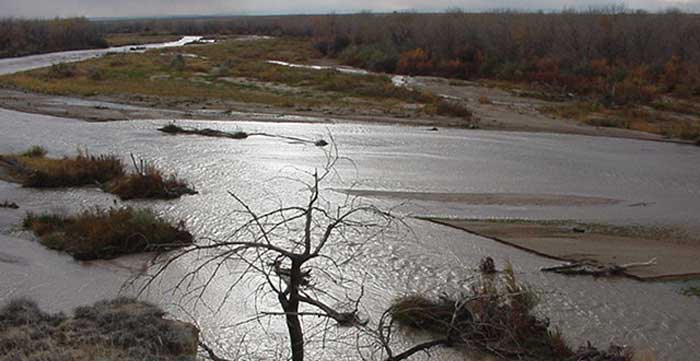
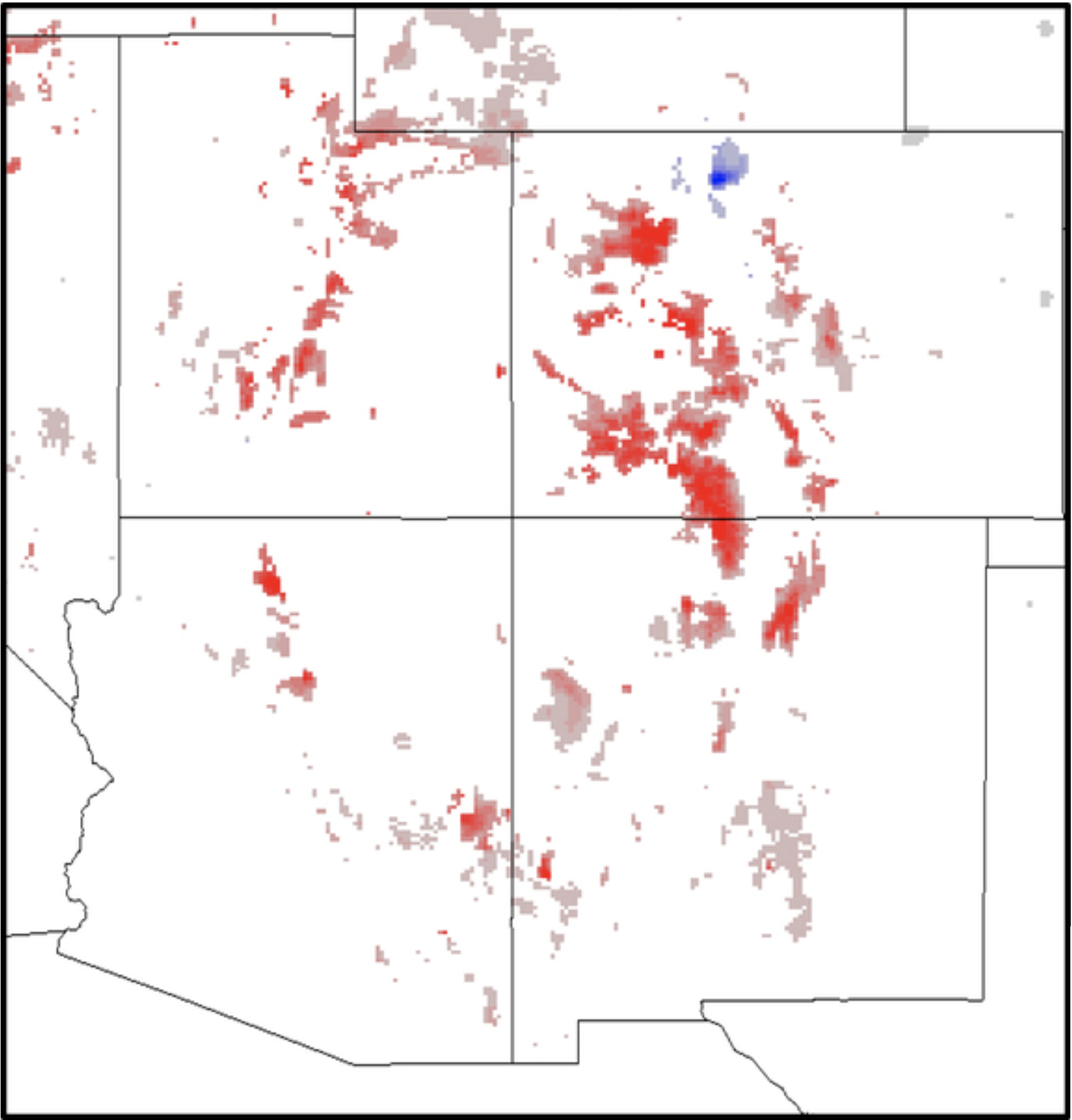
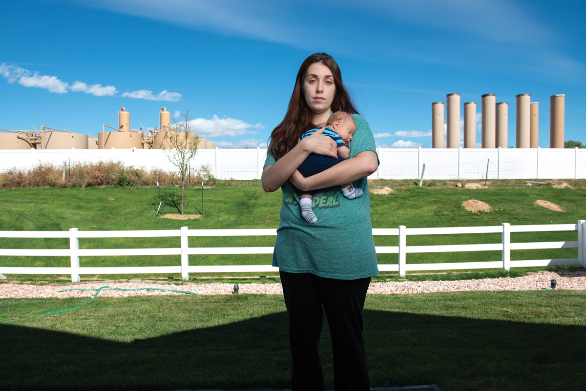
Oil and gas well sites near the Roan Plateau

From Circle of Blue (Brett Walton):

Colorado

Gov. Jared Polis, a first-term Democrat who was elected in November, listed a range of water issues that the state faces: declining irrigation supplies for farms and ranches, less snowpack for the ski industry, and pollution from the energy industry.

A ballot initiative that would have restricted the location of oil and gas infrastructure failed last November. Polis opposed Proposition 112, which would have established a 2,500-foot setback distance from homes, schools, drinking water sources, and other vulnerable areas. Current law is 500 feet.

“It’s time for us to take meaningful action to address the conflicts between oil-and-gas drilling operations and the neighborhoods they impact, and to make sure that all of our communities have clean air and water,” Polis said, without going into more detail.

Polis reiterated his goal of powering the state with 100 percent renewable electricity by 2040, and advocated for a nascent industrial hemp industry. Proponents argue that hemp, which Congress legalized in the 2018 farm bill, could be a water-saving crop for dry states.

Polis also endorsed the state water plan, negotiated by his predecessor, John Hickenlooper.

“Now we’re going to do our part in implementing it,” he said, asking the Legislature for funding.

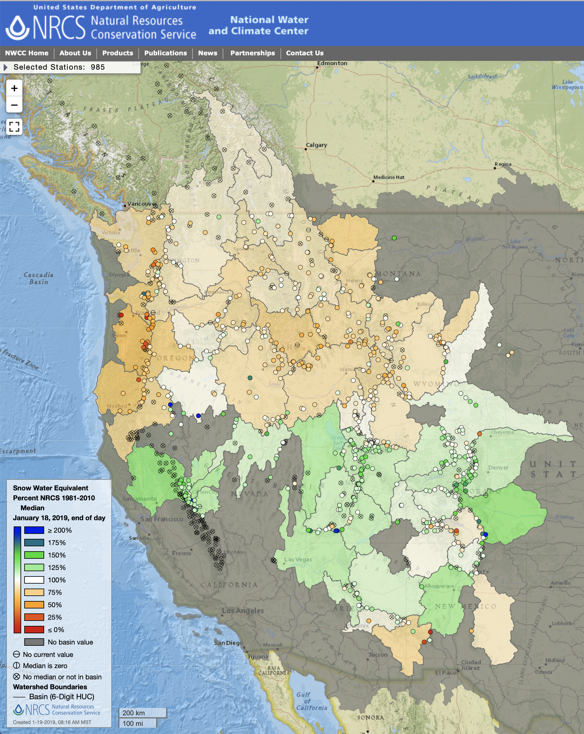
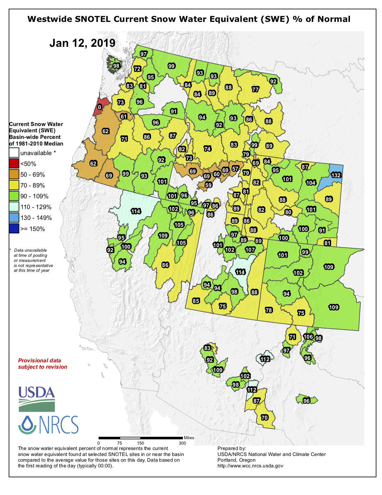
#Snowpack news: Arkansas Basin = 131% of normal (best in state), Gunnison = 109%

Click on a thumbnail graphic to view a gallery of snowpack data from the NRCS.

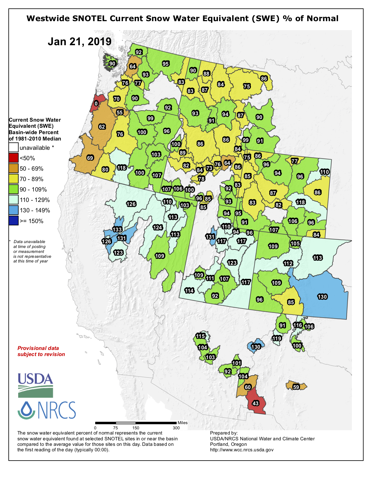
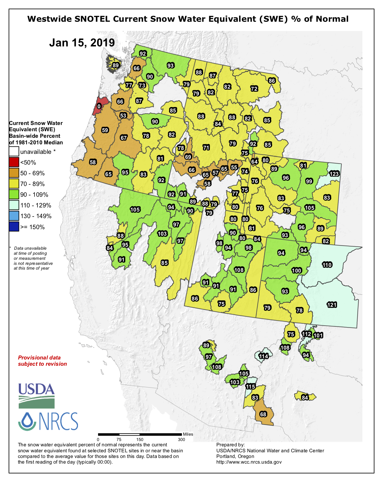
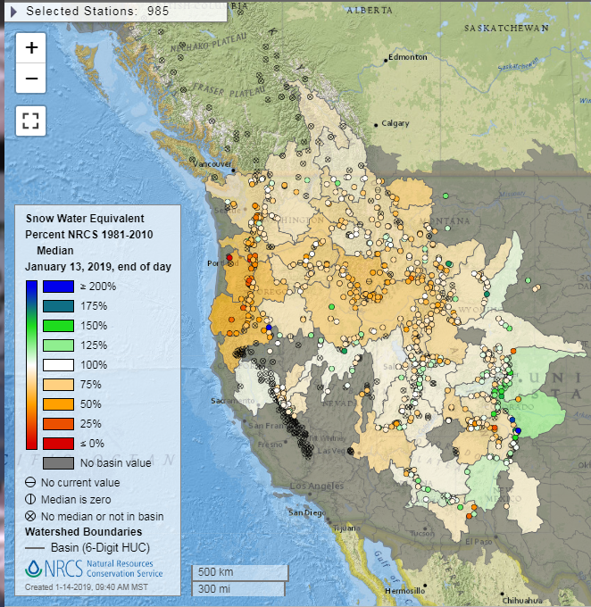
And here’s the Westwide basin-filled snowpack map for January 21, 2019 from the NRCS.

Westwide SNOTEL basin-filled map January 21. 2019 via the NRCS.

Happy Martin Luther King Day #MLKDay

Martin Luther King, Jr. riding back in the day. Photo credit: Bicycle Lobby

Paper: Permafrost is warming at a global scale — Nature #ActOnClimate

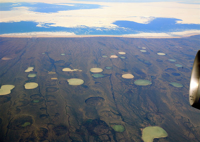
Photo (Steve Jurvetson) shows what appears to be permafrost thaw ponds in Hudson Bay, Canada, near Greenland. (By inspection this photo appears to match a location at 66°11′10″N 73°26′42″W in Dewey Soper Migratory Bird Sanctuary on Baffin Island, overlooking the waters of the Hudson Bay near Greenland): https://www.flickr.com/photos/44124348109@N01/2661598702

Click here to read the paper. Here’s the abstract:

Permafrost warming has the potential to amplify global climate change, because when frozen sediments thaw it unlocks soil organic carbon. Yet to date, no globally consistent assessment of permafrost temperature change has been compiled. Here we use a global data set of permafrost temperature time series from the Global Terrestrial Network for Permafrost to evaluate temperature change across permafrost regions for the period since the International Polar Year (2007–2009). During the reference decade between 2007 and 2016, ground temperature near the depth of zero annual amplitude in the continuous permafrost zone increased by 0.39 ± 0.15 °C. Over the same period, discontinuous permafrost warmed by 0.20 ± 0.10 °C. Permafrost in mountains warmed by 0.19 ± 0.05 °C and in Antarctica by 0.37 ± 0.10 °C. Globally, permafrost temperature increased by 0.29 ± 0.12 °C. The observed trend follows the Arctic amplification of air temperature increase in the Northern Hemisphere. In the discontinuous zone, however, ground warming occurred due to increased snow thickness while air temperature remained statistically unchanged.

Bison are back, and that benefits many other species on the Great Plains — The Conversation

From The Conversation (Matthew D. Moran):

Near extinction

It was not always certain that bison could rebound. Once numbering in the tens of millions, they dominated the Great Plains landscape until the late 1800s, anchoring a remarkable ecosystem that contained perhaps the greatest concentration of mammals on Earth. That abundance was wiped out as settlers and the U.S. government engaged in a brutally effective campaign to eradicate the ecosystem and the native cultures that relied on it.

Bison were shot by the millions, sometimes for “sport,” sometimes for profit, and ultimately to deprive Native Americans of vital resources. By 1890 fewer than 1,000 bison were left, and the outlook for them was bleak. Two small wild populations remained, in Yellowstone National Park and northern Alberta, Canada; and a few individuals survived in zoos and on private ranches.

Recovery

Remarkably, a movement developed to save the bison and ultimately became a conservation success story. Some former bison hunters, including prominent figures like William “Buffalo Bill” Cody and future President Theodore Roosevelt, gathered the few surviving animals, promoted captive breeding and eventually reintroduced them to the natural landscape.

With the establishment of additional populations on public and private lands across the Great Plains, the species was saved from immediate extinction. By 1920 it numbered about 12,000.

Bison remained out of sight and out of mind for most Americans over the next half-century, but in the 1960s diverse groups began to consider the species’ place on the landscape. Native Americans wanted bison back on their ancestral lands. Conservationists wanted to restore parts of the Plains ecosystems. And ranchers started to view bison as an alternative to cattle production.

More ranches began raising bison, and Native American tribes started their own herds. Federal, state, tribal and private organizations established new conservation areas focusing in part on bison restoration, a process that continues today in locations such as the Tallgrass Prairie National Preserve in Kansas and the Fort Peck Reservation in Montana.

By the early 2000s, the total North American population had expanded to 500,000, with about 90 percent being raised as livestock – but often in relatively natural conditions – and the rest in public parks and preserves. For scientists, this process has been an opportunity to learn how bison interact with their habitat.

Improving prairie landscapes

Bison feed almost exclusively on grasses, which, because they grow rapidly, tend to out-compete other plants. Bison’s selective grazing behavior produces higher biodiversity because it helps plants that normally are dominated by grasses to coexist.

Because they tend to graze intensively on recently burned zones and leave other areas relatively untouched, bison create a diverse mosaic of habitats. They also like to move, spreading their impacts over large areas. The variety they produce is key to the survival of imperiled species such as the greater prairie chicken (Tympanuchus cupido) that prefer to use different patches for different behaviors, such as mating and nesting.

Bison impacts don’t stop there. They often kill woody vegetation by rubbing their bodies and horns on it. And by digesting vegetation and excreting their waste across large areas, they spread nutrients over the landscape. This can produce higher-quality vegetation that benefits other animals.

“The first thing is listening” — Kate Greenberg

Colorado’s diverse landscape has a rich natural and agricultural heritage that fuels the economy. Photo: Michael Menefee

From The Montrose Press (Katharhynn Heidelberg):

“The first thing is listening,” Greenberg said Friday, as Week 1 of her new role drew to a close.

“I’m planning to get out into the field as much as possible to understand what people are up against and to build out our game plan. I see this work as being highly collaborative. It’s my role to bring as many people together as possible to come up with what we need to do down the road.”

Greenberg, appointed by Gov. Jared Polis, oversees the state ag department’s daily operations and its divisions: animal health, brand inspection, Colorado State Fair, conservation services, inspection and consumer services, laboratory services, markets and plant industry.

She is no stranger to the Western Slope and its agri-issues, having served as the western program director for the National Young Farmers Coalition in Durango. Her duties there entailed working with basin roundtables, working on the state’s water plan and Colorado River basin water policy…

“I am excited about Western Slope agriculture. I see so much creativity and perseverance from folks doing it for generations and people coming in now and starting their own businesses…

“With Western Colorado being so rural, and a vast majority of people being on the Front Range and the vast majority of water on the Western Slope, we are going to depend on that creativity to keep agriculture thriving out there and rural agriculture alive.”

[…]

Water is the lifeblood for the entire state and that creates challenges for all producers.

“I think producers know that better than anyone, in terms of how precious water is and how important it is that we find solutions that allow agriculture to continue to thrive in Colorado,” Greenberg said.

Montrose’s upcoming Western Food and Farm Forum helps grow agriculture by connecting producers, indicated Greenberg, who is set to address the conference on Jan. 26. She previously helped organize the annual forum and worked with steering committees.

From The Fence Post (Rachel Gabel):

Greenberg, in her first media interview as commissioner, said she grew up split between Minneapolis and in Minnesota’s farm country near Mankato, before moving to Washington where she began farming, working on small-scale, mixed vegetable operations that direct marketed to consumers. Her day job during that time, she said, involved visiting operations of all sizes and types across the West. She said her work has woven between agriculture and conservation, two worlds she said that are one in the same.

Greenberg has spent the past six years based in Durango, Colo., with the National Young Farmers Coalition, building the organization’s staff and the membership. She traveled throughout the intermountain West, including Colorado, working with farmers and ranchers to help young producers return to the land.

“I worked finding ways, through policy, through business services, and through network building to get more young people out in ag,” she said.

To this end, she said she worked with farmers of all ages on the issue of succession, their options to keep operations in business, and working with the next generation. Her other concentration has been getting elected officials onto farms and ranches to give policymakers a better understanding of the challenges agriculture producers face. She said this is meant to ensure policymakers are making decisions based on practice rather than theory after seeing the boots on the ground. Working to give farmers a seat at the table, she said, is vital for agriculture in Colorado.

“Since coming to Colorado to Durango, I have been serving in the role of advocate for farmers and ranchers, connecting producers with their policymakers and ensuring that we have folks standing up for family ag in Colorado,” she said.

From intern to Denver Water pipe saver – News on TAP

Antonio Flori embraced career opportunities to grow into his current role as a corrosion control engineer.

Source: From intern to Denver Water pipe saver – News on TAP

Denver Water construction project to generate $405 million in economic benefit – News on TAP

Hundreds of workers will help build new treatment plant and water pipeline as part of water system upgrade.

Source: Denver Water construction project to generate $405 million in economic benefit – News on TAP

#Idaho’s new governor: ‘#ClimateChange is real’ — @HighCountryNews #ActOnClimate

From The High Country News (Emily Benson):

Environmentalists hope action will follow new state stance on climate.

Less than two weeks after being sworn in as the 33rd governor of Idaho, Gov. Brad Little, a Republican, has broken with national party leaders on climate change, declaring unequivocally that the phenomenon is real.

In an address Jan. 16 at an event organized by the Idaho Environmental Forum, an association focused on discussing environmental policy in the state, Little bluntly told the gathered crowd, “Climate change is real.” In the stunned silence that followed his unexpected pronouncement, he went on to discuss how he’d seen Idaho’s seasons shift over his lifetime: “I mean, I’m old enough that I remember feeding cows all winter long in deep snow … boy, back in the old days when I was a kid, we had winters.”

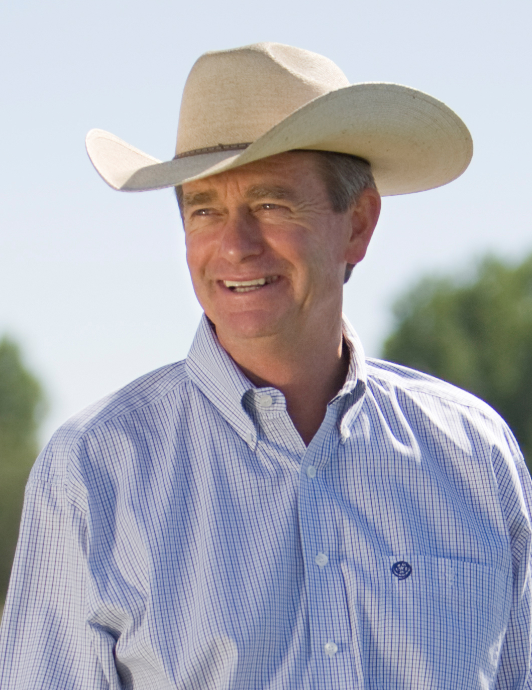
Idaho Governor Brad Little. From Wikimedia Emmett, Idaho, United States of America – Brad Little – 7/1/09, CC BY 2.0, https://commons.wikimedia.org/w/index.php?curid=65933573

In response to an audience question on how Idaho is adapting to climate change, Little, the leader of one of the West’s most conservative states, said that change can come from regulation, but also from market forces. (Full disclosure: Little served on the High Country News board in the late 1990s.)

“These ecosystems are changing,” Little said. He highlighted the importance of biological diversity so that landscapes can adapt, and the need to figure out how to cope with the issue. “Climate’s changing, there’s no question about it.”

His comments came as the issue of a warming world becomes central, once again, in national discourse: Recent polls indicate two-thirds of voters are concerned about climate change and support action on the issue; Democratic hopefuls for president are signaling their commitment to aggressive action; and the idea of a Green New Deal that would transform the U.S. into a renewable-energy based economy continues to make headlines. And Little’s stance is a stark deviation from the Trump administration, which has minimized the effects of climate change and muzzled scientists.

“That’s the first time I’ve ever heard (Little) mention those words,” said Becca Aceto, the Idaho Wildlife Federation’s communications and outreach coordinator, who attended the event. “That was very direct, and that was very black and white.”

Such straightforward statements could have significant effects on state politics and policy. About 220 people attended the event, a forecast of the environmental issues that may surface during the 2019 Idaho legislative session. The governor also discussed the intricacies of wildfire management and forest planning processes, the importance of aquifer recharge and other issues. Marie Kellner, the president of the Idaho Environmental Forum board and the Idaho Conservation League’s water expert, said the top-down support for climate science could empower state agencies and environmental groups alike to talk about and plan for climate change and its impacts. “This allows people to acknowledge it, and frame things in terms of climate,” she said.

Kellner’s colleague Ben Otto, who works on energy issues at the Idaho Conservation League, echoed the importance of statewide leadership on climate change. “There hasn’t been a clear energy or climate policy in this state for a long time,” Otto said. “To have the governor say, ‘no, this is happening, we actually have to work on this, we need to fix it,’ is just — finally, we’re going to be wrestling with some incredibly impactful things.”

That’s a hope shared by Democratic state Rep. Rob Mason, who also works for The Wilderness Society. “I’m certainly glad to hear that the governor’s interested in looking at climate change,” Mason said. “It’s something we need to think hard about in this state and address, and I’m eager to find out more about what the governor would like to do and how we can work together.”

Little’s unambiguous statements were in sharp contrast to those of President Trump, who has repeatedly ignored or diminished the catastrophic threats posed by climate change: “I don’t believe it,” he said in response to a major national report on the costs of climate change in November. Little’s comments were also, apparently, a surprise to Idaho state House Speaker Scott Bedke, also a Republican, who presented after Little at the Boise event. While Bedke is “more comfortable calling it variability,” he also discussed the risks to Idaho’s water resources that come with a changing climate, particularly shifts in the timing of precipitation and whether it falls as snow or rain. “That’s going to force change when we get around to getting our minds around that,” Bedke said, a conversation that may have been jumpstarted by Little’s remarks. To laughter from the audience, Bedke acknowledged the remarks were groundbreaking: “I think that — well, you saw the earth move earlier.”

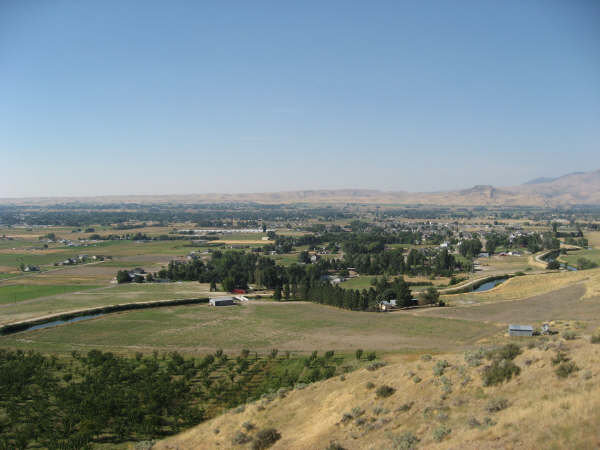
Emmett, Idaho. Public Domain, https://commons.wikimedia.org/w/index.php?curid=2452226

Emily Benson is an assistant editor at High Country News, covering the northwest, the northern Rockies and Alaska. Email her at emilyb@hcn.org or submit a letter to the editor.

#Snowpack news: Big bump in #Colorado’s SW basins, we’ve had a “parade of storms” #ColoradoRiver #COriver #aridification

Click on a thumbnail graphic to view a gallery of snowpack data from the NRCS.

From CBS Denver:

For the first time in several weeks Colorado’s average snowpack is back over 100% and that is some great news. Numbers are even up in the two driest river basins in the southwestern part of the state…

The most recent parade of storms have dropped more than two feet of snow on Steamboat Springs in just a matter of days. Similar totals have been recorded is parts of the San Juan Mountains.

And here’s a screen shot of the NRCS interactive snowpack map from this morning.

NRCS interactive snowpack map screen shot January 19, 2019.

Beetle infestations widespread across #Colorado #ActOnClimate

From Colorado Public Radio (Michael Sakas):

The State Forest Service does a yearly flyover to track and map the damage. Dan West is an entomologist with the state, and said one notable finding from the 2018 survey is the continued spread of the spruce beetle. ..

The bug is different from the mountain pine beetle, known for its damage to lodgepole pine. West said the spruce beetle has been the most widespread and destructive forest pest in Colorado for seven consecutive years.

“About 40 percent of our spruce fir forests have been affected by spruce beetle since the year 2000,” West said.

The most damaged areas are in and around Rocky Mountain National Park, and parts of the San Juan Mountains, West Elk Mountains and the Sawatch Range. West said record-warm temperatures and record-low precipitation help the beetle thrive.

“That means there’s much fewer water resources that are available to these trees, which they use as a defense mechanism against attacking bark beetles,” West said. “So if it’s warmer and dryer in the near future, those prolonged drought events and warm periods cause these bark beetles to emerge earlier, have longer periods to be able to attack trees, and have fewer defenses that they’re fighting.”

From TheDenverChannel.com (Jackie Crea):

Currently, it’s the spruce beetle hitting the trees the worst. The spruce beetle is responsible for the death of more spruce trees in North America than any other natural agent. Lester and his team just finished studying the health of our forests and mapping out how much bark beetles have gotten to. He told Denver7 more than 5 million acres have been damaged.

“If you look at these beetles, most of them are native. And what kept them in check historically, is really cold weather,” said Lester.

Warming temperatures keep more bark beetles alive, he said. They burrow inside the trunks, blocking water from the tree, ultimately killing it. The problem multiplies because more dead brush leads to more wildfire fuel.

“…When they do burn, they’re really hard to manage and hard to predict their fire behavior,” said Lester.

Wildfires, in turn, bring other dangers, as they can move the soil, affecting our resources.

“If you’re a water utility, you’re gonna be filling your reservoir with silt instead of water, so we need to look at the areas that are more susceptible and focus our efforts there,” said Lester.

So how do we manage them? Lester told Denver7 it starts with this study, then spreading the word. They also help private landowners take care of their own trees, too, because the forest service can’t do it all alone.

El Paso County water master plan warns about Denver Basin Aquifer depletions

Denver Basin Aquifer System graphic credit USGS.

Click here to go to the El Paso County website for the project.

From The Colorado Springs Gazette (Rachel Riley):

The document says the county’s current water supply is about 146,000 acre-feet per year, but demand is expected to increase to about 160,000 acre-feet per year by 2040 and 206,000 acre-feet per year by 2060…

The plan, prepared by Englewood-based engineering firm Forsgren Associates Inc., makes a variety of recommendations for closing the gap, including monitoring groundwater well levels, exploring ways to reuse water, finding new water sources and considering changes to the county’s land use approval process.

The county is home to more than 21,300 permitted groundwater wells and roughly 70 water providers, from small districts to municipal departments, according to the plan.

Water providers in once rural parts of the county, such as Monument, face mounting concerns about how to ensure that residents have enough water as the population continues to rise.

The primary water source for areas that are not served by Colorado Springs Utilities is the Denver Basin. Experts say it’s hard to pinpoint the rate at which water levels are falling in the system of aquifers, which were filled by precipitation over many years.

By 2060, the county’s current annual supply would be enough to serve a little more than half of the projected population, according to the plan. More residents could potentially be served by Denver Basin groundwater, but only if it’s still economical to pump, the plan states.

Per state law, county commissioners generally decide if there’s sufficient water to serve a new development during final platting, the stage of the land use approval process in which lots are created, said Mark Gebhart, deputy director of the county Planning and Community Development Department.

But the plan suggests that the county consider changing its rules so that determination can be made earlier, such as when a preliminary plan or zoning change is approved, to help ensure that new developments are planned with water supply in mind.

The plan also recommends that the county re-evaluate a subdivision regulation that requires developers to prove that they have a 300 years’ supply of water. The requirement, three times as stringent as a state standard that requires proof of 100 years’ supply, could be waived if developers agree to conservation-minded practices, such as reuse of captured wastewater to offset demands, the plan suggests…

The plan also advises that the county encourage water providers to find more reliable water sources that are replenished regularly by precipitation, rather than deep groundwater sources that are slow to recharge. One possibility might be importing water from the Arkansas River, the plan states.

Lower Ark board meeting recap

Fountain Creek photo via the Fountain Creek Watershed Flood Control and Greenway District

From The La Junta Tribune-Democrat (Bette McFarren):

Peter Nichols, an attorney for the Lower Arkansas Valley Water Conservancy District, at the agency’s meeting Wednesday, updated the board on the long-standing controversy with Colorado Springs concerning water quality in Fountain Creek…

A lawsuit filed by the Environmental Protection Agency in November 2017 alleges the City of Colorado Springs’ stormwater system degraded the creek on its way to Pueblo and, eventually, the Arkansas River. The Pueblo Board of County Commissioners and the LAVWCD were permitted to intervene in the case, on the side of the environmental agency.

On Nov. 9, Senior Judge Richard P. Matsch ruled that Colorado Springs violated its permit that regulates stormwater discharges into Fountain Creek.

Following Matsch’s decision, the parties asked the judge to put the litigation on hold for three months, to see if they could agree how to remedy the city’s violations. That request was granted.

The post-trial settlement conferences were scheduled for Dec. 6, 2018; Jan. 10 (which was cancelled because of the federal government shutdown); Feb. 7, March 7, April 11 and May 9.

Republican River Rules filed in water court — The Yuma Pioneer

Republican River Basin. By Kansas Department of Agriculture – Kansas Department of Agriculture, Public Domain, https://commons.wikimedia.org/w/index.php?curid=7123610

From The Yuma Pioneer:

The Office of the State Engineer has filed the proposed Republican River Compact Water Use Rules with Water Court Division 1 in Greeley.

The filing was made last Friday, January 11.

The process for developing the rules included several public meetings with a special advisory committee. It was comprised of volunteers representing users and interests throughout the Republican River Basin. The meetings took place within the basin, and the last one was last August.

As drafted, the rules allow the state to administer surface water and groundwater wells for compliance with the 1942 Republican River Compact.

It includes the state engineer’s ability to curtail wells, which means issuing a cease and desist.

However, Deb Daniel, the general manager for the Republican River Water Conservation District, noted that wells that are within the Republican River Domain and have an augmentation plan are protected from curtailment.

That means all wells located with the Republican River Water Conservation District are protected, due to the district’s augmentation efforts such as the compact compliance pipeline, purchasing surface water rights, and providing financial incentives for well owners to voluntarily retire their wells, such as through CREP and EQIP conservation programs.

However, the Republican River Domain boundary is different than the RRWCD boundary, so there are some wells that currently are not protected from the potential curtailment. There is legislation currently before the Colorado State Legislature that will expand the RRWCD’s boundary to including all of the Republican River Domain.

Division 1 Water Court will have to rule on the proposed rules before they go into effect.

Well owners can make filings for or against the proposed rules with the water court. The case number is 2019CW 3002.

One can learn more about the rules at the Colorado Division of Water Resources website, http://water.state.co.us.

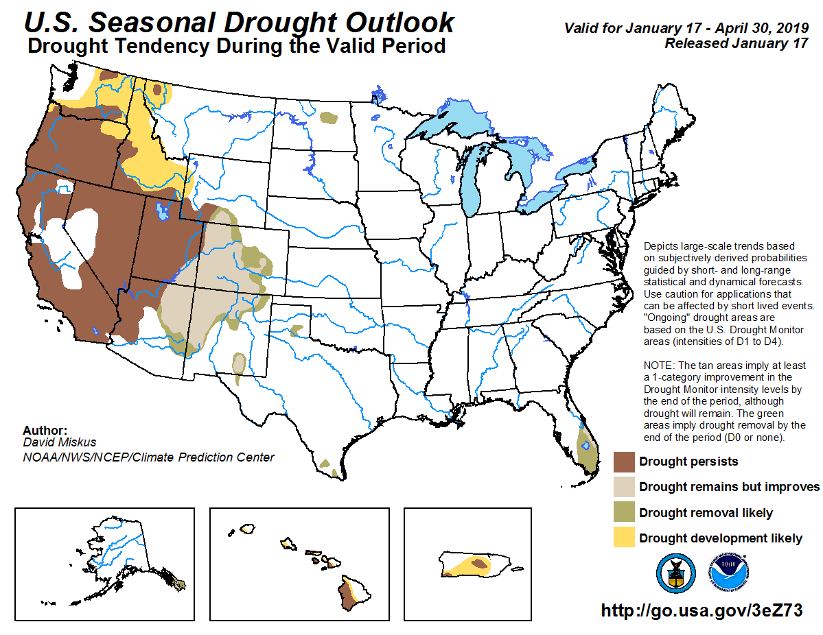
The latest seasonal outlooks are hot off the presses from the Climate Prediction Center

Seasonal Temperature Outlook through April 30, 2019 via the CPC.
Seasonal Precipitation Outlook through April 30, 2019 via the CPC.
Seasonal Drought Outlook through April 30, 2019 via the CPC.

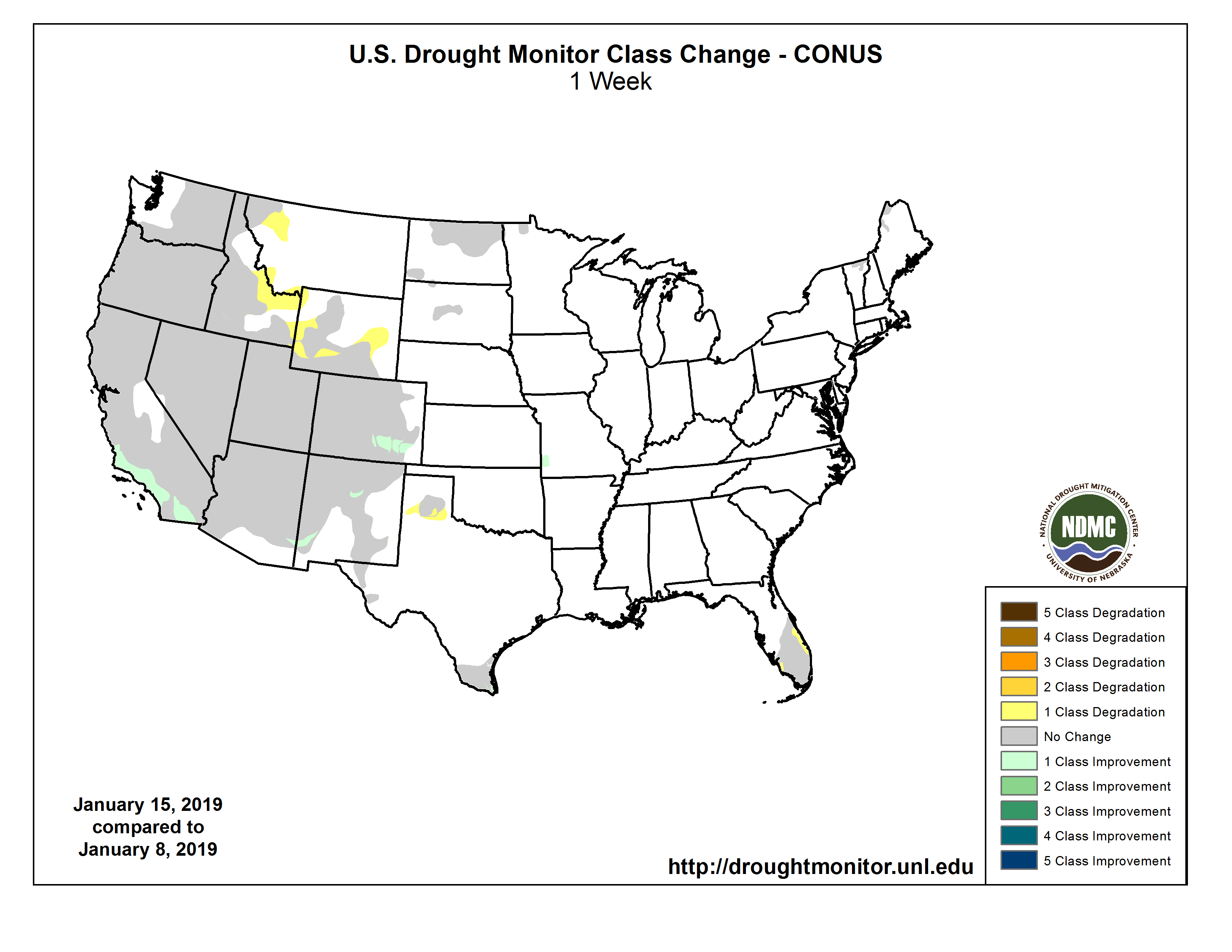
#Drought news: One-category improvement to drought conditions over south-central to southeast #Colorado

Click on a thumbnail graphic to view a gallery of drought data from the US Drought Monitor website.

Here’s an excerpt:

Summary

A mixture of rain and snow accompanied a low pressure system from the Great Lakes to New England during early January. An upper-level low and its associated surface low tracked across the central and eastern U.S. from January 11 to 13. More than 4 inches of snow blanketed areas from Kansas east to the middle Mississippi Valley, Ohio Valley, and mid-Atlantic. Snowfall reports of up to 20 inches were reported from northern Missouri, while 8 to 13 inches of snow occurred in the Washington, D.C. metro area. Periods of onshore flow continued to affect the West Coast although precipitation generally averaged below normal across the Pacific Northwest during the past week. A vigorous upper-level low approached southern California on January 14, bringing heavy snow (6 to 12 inches) to elevations above 5,000 feet and locally heavy rain (more than 1 inch) from the Los Angeles area south to San Diego…

High Plains

A lack of snowfall this winter resulted in an increase in the coverage of abnormal dryness (D0) and moderate drought (D1) across parts of Wyoming. Basin snowpack is running below average in the Wind River Range and SPI values in western Wyoming are below -1 on timescales from 30-days to 6-months. Heavy precipitation (over 0.5 inch, liquid equivalent) for this time of year prompted a 1-category improvement to drought conditions over south-central to southeast Colorado, including the counties of Pueblo, Otero, and Bent. This past week’s precipitation is more than their monthly average for January. Crop reports from this region indicate that winter wheat was successfully planted. Although no additional improvements were made to southwest Colorado this week, the Sangre de Cristos and San Luis Valley will be reassessed next week.

Moderate to heavy snow (more than 0.5 inch, liquid equivalent) blanketed much of Kansas and southeast Nebraska. Snow also occurred across the Colorado Rockies and along the Front Range, but precipitation was generally lighter east across the high Plains. Despite mostly dry weather across the Dakotas this past week, no changes were made to the existing D0 and D1 areas since it is a relatively dry time of year and soils are frozen…

West

Locally heavy precipitation (more than 2 inches) fell across southern California for the second consecutive week. Precipitation amounts have ranged from 2 to 5 inches, liquid equivalent, during the past two weeks from Lompoc south to the Los Angeles area. 1 to 2 inches of precipitation has generally been observed from Los Angeles south to San Diego during the past two weeks. The recent and ongoing heavy precipitation has triggered mud slides along burn-scarred hillsides. Based on near to above average precipitation during the 2018-19 water year to date, a continued increase in water storage on Lake Cachuma, and 12 to 24-month SPIs, the D3 area was upgraded to D2. Recent heavy precipitation and 12 to 24-month SPIs also support an upgrade from D2 to D1 across southern California. Additional improvement may be needed across southern California in next week’s USDM with heavy precipitation occurring after 7am EST on Tuesday.

Drought coverage and intensity remained steady this week across the Pacific Northwest. However, precipitation deficits of 5 to 10 inches exist for the water year to date (October 1, 2018 to January 15, 2019) across western Oregon and southwest Washington. Also, basin average snow water content is running below 60 percent of normal across the southern Cascades. Due to these factors, the Pacific Northwest will be closely monitored during the remainder of the 2018-19 water year.

Abnormal dryness (D0) was expanded across northwest Montana, Idaho, and western Wyoming where ACIS indicates that precipitation has averaged less than 50 percent of normal during the past 30 to 90 days. Soil moisture ranking percentiles are in the lowest 30th percentile across northwest Montana. Low snow levels this winter along with favorable ground water levels precluded a further expansion of D0 across the Snake River Plain. Although snow water content is running between 50 to 75 percent of normal across western Idaho, it is too early in the 2018-19 winter to expand coverage of moderate drought (D1). Central and eastern Montana remains snow-free as temperatures have averaged near 10 degrees F above normal during the past 30 days. If a lack of snow cover persists, then abnormal dryness may be needed in later releases.

Beneficial rain and high-elevation snow continues to prompt minor improvements to the intensity of drought across New Mexico. Based on the latest indicators, moderate drought (D1) was reduced in Grant and Hidalgo counties in southwest New Mexico, while a slight decrease in severe drought (D2) was made to the southern Sangre de Cristo Mountains of northern New Mexico. Heavy precipitation (rain and high-elevation snow) shifted east to Arizona after 7am EST on Tuesday. This heavy precipitation may result in minor improvement in next week’s USDM, but 6- to 1- month percent of normal precipitation remains well below normal…

South

Widespread precipitation (more than 0.5 inch, locally more) was observed across the eastern two-thirds of Oklahoma, Arkansas, northern Louisiana, and eastern Texas. This precipitation maintained high soil moisture and streamflows throughout much of the southern Great Plains and lower Mississippi Valley. A slight reduction in the D0 and D1 areas was made to Cameron County in extreme southern Texas as more than 0.5 inch of rainfall occurred in the eastern part of that county. Persistent, dry weather along with periods of enhanced winds resulted in a slight expansion of abnormal dryness across the Texas Panhandle…

Looking Ahead

During the next 5 days (January 17-21, 2019), a low pressure system is forecast to develop across the southern Great Plains and then track northeast to the Ohio Valley. This low pressure system is expected to become a strong coastal low near southern New England. A swath of moderate to heavy snow and freezing rain is likely to accompany the winter storm from the middle Mississippi Valley northeast to the northern mid-Atlantic and Northeast. Although mostly dry weather is forecast across ongoing drought areas of southern Texas, light rainfall is anticipated across southern Florida during the next five days. Widespread rain and high-elevation snow are forecast throughout the western U.S. through early next week with heavy snow likely across the Cascades, Sierra Nevada, and Rockies. In the wake of the central and eastern U.S. winter storm this weekend, arctic high pressure is forecast to shift south from Canada and bring the coldest temperatures so far this winter to the northern Great Plains, Midwest, and Northeast. Periods of rainfall are expected across the western Hawaiian Islands during the next five days.

The CPC 6-10 day extended range outlook (January 22-26, 2019) indicates enhanced odds for below normal temperatures across much of the eastern two-thirds of the continental U.S .along with the central Rockies, Great Basin, and Southwest. Above-normal precipitation is favored from the Mississippi Valley to the East Coast and also across the northern and central Great Plains. High odds for below-normal precipitation are forecast across the Pacific Northwest, Great Basin, and California. Above normal precipitation is favored throughout Alaska, while above normal temperatures are most likely across southern mainland Alaska and the Alaska Panhandle.

US Drought Monitor one week change map through January 15, 2019.

[Governor] Polis on Water — Floyd Ciruli

Colorado Water Plan website screen shot November 1, 2013

From Ciruli and Associates (Floyd Ciruli):

Newly inaugurated Governor Jared Polis had a low-key and positive start on water. His natural resource transition included Hickenlooper’s in-house water expert, John Stulp. Water policy in his State of the State address was only one paragraph, but it succinctly supported the State Water Plan and advocated getting it funded. He linked Colorado’s water to its agricultural needs, which is one of the key principles of the plan. That is, preserving agriculture in Colorado requires intelligent and prudent water management.

State of the State on Water

“The lifeblood of our agriculture industry is water – which is why we must commit to a bipartisan and sustainable funding source for the Colorado Water Plan. Governor Hickenlooper, along with the leadership of John Stulp, did extraordinary work bringing together a coalition of Coloradans from all corners of our state to create the Water Plan. Now we’re going to do our part by implementing it.” State of the State address, Jan. 10, 2019

Dealing with the water gap that is well identified in the State Plan is essential to protect irrigated agriculture and support the state’s quality of life and economy. The largest number of residential, business and agricultural water users are in the Arkansas and Platte basins. Their needs must be balanced with other users and uses, including recreation, wildlife and aesthetics.

Soil moisture probe pilot project coming to the [San Luis Valley]

San Luis Valley via National Geographic

From the San Luis Valley Water Conservancy District via The Monte Vista Journal:

The San Luis Valley Water Conservancy District (SLVWCD) is seeking farmers for a pilot project in 2019 to cost-share on the purchase and installation of soil moisture probes. The project will include soil mapping and placement of probes that will give farmers immediate access to soil moisture data in their fields through an online portal and smartphone app. The goal of the effort is to determine if this data can help farmers with their irrigation decisions and lead to water conservation.

The project is open to farmers in parts of Alamosa, Conejos, Rio Grande and Saguache counties. The SLVWCD will contribute up to $2,000 per quarter section of land. The financial cost to the farmer will vary, depending on the selected vendor. Farmers are allowed to leverage other incentive programs such as RCPP to meet their cost-share requirement.

Participating farmers will select a vendor who is able to complete detailed soil mapping of each field. The vendor will then install soil moisture probes in accordance with the recommendations from the soil mapping. The vendor will also provide software that will allow farmers to access real-time weather information and soil moisture data from either a cell-phone application or a web-site portal.

Participants will be required to share the following data with the SLVWCD: The Water District Structure Identification (WDID) of the well or diversion structure used to irrigate the field; the annual quantity of water applied in water years 2013-2018 by the WDID structure and other water sources; the quantity of water applied on a minimum of a monthly basis for any year(s) enrolled in the pilot program; and soil mapping and soil moisture probe data.

At the end of the program’s first year, the average water application data will be compared to 2013-2018 in an effort to determine if use of the soil moisture probes improved water conservation.

Funding for the project was provided by the San Luis Valley Conservation and Connection Initiative and the Colorado Water Conservation Board Colorado Water Plan Grant Program.

To apply for the program contact Matt at the SLVWCD at 589-2230 or matt@slvwcd.org by Feb, 28.

@ColoradoClimate: Weekly Climate, Water and #Drought Assessment of the Intermountain West

Click here to read the current assessment. Click here to go to the NIDIS website hosted by the Colorado Climate Center.

Preventing deep pocket dry ups on the Western Slope is front and center in developing the Upper #ColoradoRiver Basin #Drought Contingency Plan #COriver #aridification

Photo credit: Jonathan Thompson

From The Crested Butte News (Cayla Vidmar):

As water levels in Colorado decline, the long-term impact on the Western Slope are concerning to area water experts. The worry is that water demands down river and on the Front Range will dry up the Western Slope and change the character of this area of Colorado.

Last fall the Colorado Water Conservation Board (CWCB) released a policy statement on water demand management and compact administration, which addresses the way in which water in Colorado will be managed to meet downriver demand requirements. The document is a response to the “worst hydrologic cycle in the historic record,” which began in the year 2000, and a need for drought contingency plans to meet Colorado water compact demands, according to the policy statement.

This work comes at a time when the local reservoir, Blue Mesa, which serves as a storage for meeting downstream water demands, has remained steady at the lowest point it’s been at all year, coming in at 7,438 feet, or just eight feet above the 1977 record low.

Bill Trampe, board member for the Colorado River Water Conservation District (CRWCD), shared concerns with the Gunnison Board of County Commissioners last month about demand management for the Western Slope, and potential implications for all industries that utilize water on this side of the Rocky Mountains—especially in the face of Front Range expansion and its financial abundance.

Chief of these concerns was the threat of involuntary, uncompensated demand management—Front Range entities buying up water rights on the Western Slope or municipal condemnation of Western Slope agricultural operations, both of which would “change Western Colorado,” according to Jim Pokrandt, community affairs director for the CRWCD.

The CWCB policy statement explains that “continued drought or worsening water supply conditions in the Upper Colorado River Basin could increase the risk” of Lake Powell storage declining below critical levels for operation, and “mandated curtailment of the exercise of water rights to maintain compliance with the Upper Colorado River Basin and Colorado River Compacts.”

In response to this risk, the CWCB worked with myriad stakeholders and government entities to develop a “drought contingency plan that can help minimize and mitigate the risks associated with consistently below-average water supplies in the Colorado River Basin.”

“What the West Slope is adamant about is that a voluntary, compensated, temporary demand management plan be created,” Pokrandt says. “The alternative is uncompensated, forced curtailment [for water users].” The biggest concern facing voluntary, compensated, temporary demand management is a lack of funding.

An example of voluntary, compensated demand management is paying ranchers to fallow hay fields for a season or more, but as previously reported in the Crested Butte News, this isn’t a great deal for ranchers because it can take years for the quality of hay to return to what it was pre-fallow.

But as Pokrandt says, “Colorado will need to find a source for demand management compensation.” He explains that without compensation, “We would see many current agricultural [entities] go out of business and their water rights sold. In other words, we would have a massive shift in water rights ownership that would not be in the best interest of western Colorado.” However, Pokrandt writes that the Gates Family Foundation, a philanthropic foundation contributing to the quality of life in Colorado, “just funded and facilitated a discussion on dedicated Colorado Water Plan funding to cover this subject.”

The point Pokrandt makes is that Front Range utilities can “wave around their checkbooks and buy out Western Slope producers who could not resist the money,” which as he explained previously, would cause a shift in water rights ownership on the Western Slope. For those who do resist, Pokrandt says, the “Colorado Constitution allows for municipal condemnation of agriculture,” meaning a government agency can forcibly buy property for fair market value for a public purpose, according to the law of eminent domain.

“This would change the face of western Colorado from an economic, landscape, cultural, recreational and environmental perspective,” says Pokrandt…

This work will involve organizing stakeholders, water entities and the public in tackling specific problems, including: federal legislation to create a demand management pool in Lake Powell where saved water can be stored; finding money to pay producers to not use water that can be sent to Lake Powell; legal protections to make sure water is actually getting to Lake Powell, also known as “shepherding,” a way to account for the water so amounts are known and recognized; and understanding what temporary fallowing does to the economy, particularly secondary impacts from producers earning money without paying for seed purchases, equipment, etc.

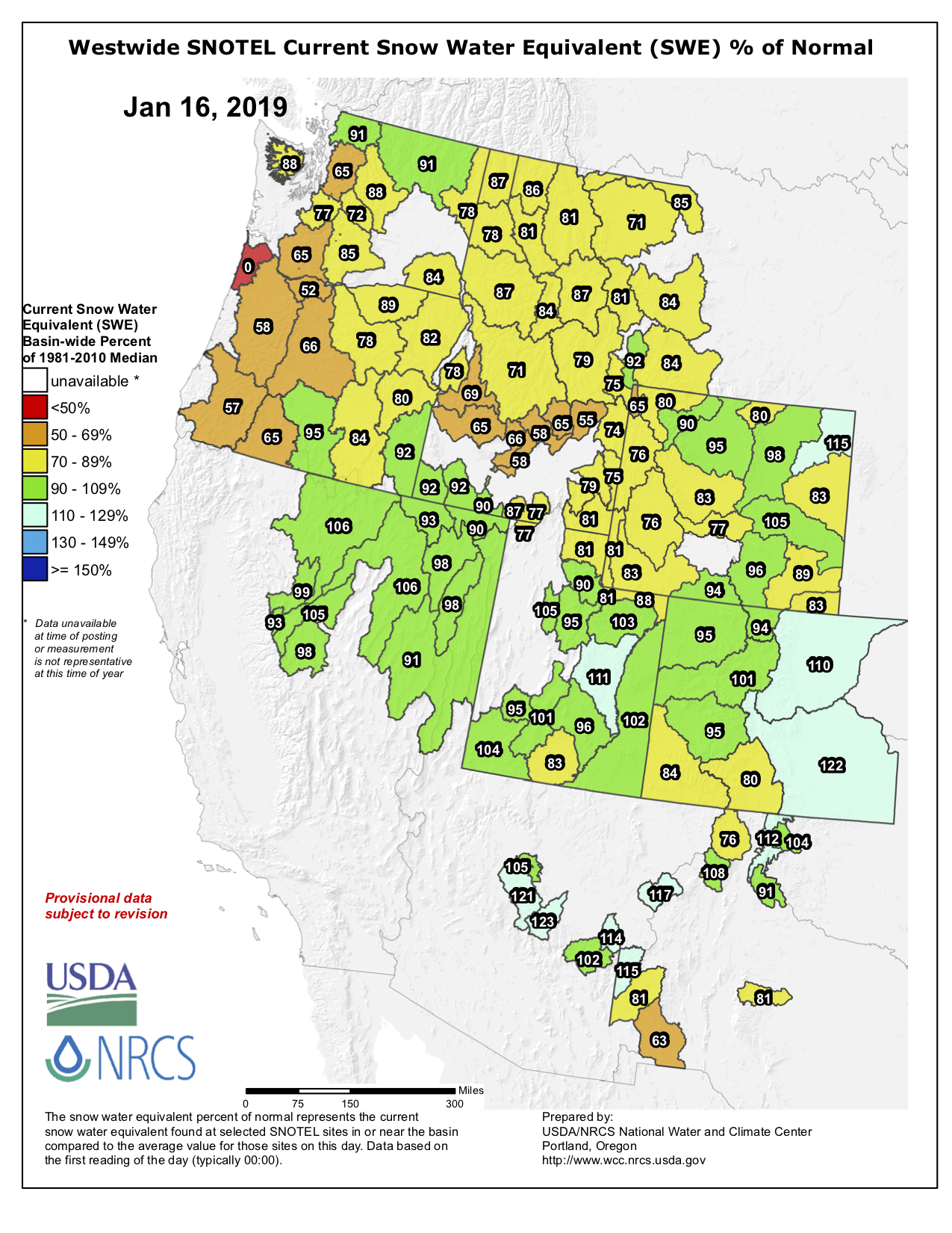
#Snowpack/#Runoff news: “You see a spring pulse that is not as big and that comes earlier” — Jeff Lukas

Westwide SNOTEL basin-filled map January 16, 2019 via the NRCS.
d

From The Colorado Springs Gazette (Liz Forster):

A forecast published this week by the National Oceanic and Atmospheric Administration calls for much-below-average — 50 percent to 70 percent — to below-average — 70 percent to 90 percent — spring runoff across most basins in Colorado. Several points in north-central Colorado and in the Arkansas Basin could fare better, with predictions of near-average or 90 percent to 110 percent of runoff.

“What we’re seeing is a lot better than what we observed last year,” said Greg Smith, a senior hydrologist with NOAA’s Colorado Basin River Forecast Center. “We have a long way to go, though, because we have a moisture deficit from last year to make up for.

Last year’s drought, the second worst in 124 years, parched soils across the state. Before entering rivers and streams, snow and runoff first must satiate a very thirsty ground.

“You see a spring pulse that is not as big and that comes earlier,” said Jeff Lukas, a research integration specialist for Colorado and Wyoming for the Western Water Assessment.

Farmers using diversion systems to irrigate and wildlife and fish that need stream depth for spawning and shelter are primarily hurt by smaller and earlier runoff, Lukas said.

Municipal water suppliers tend not to feel the impacts of low runoff as immediately because of the storage capacity of reservoirs, Lukas said.

Colorado Springs Utilities’ systemwide storage, for example, is at 75 percent capacity compared with last year’s 84 percent and the 1981 to 2010 average of 72 percent, according to data presented at Wednesday’s Utilities board meeting. Furthermore, systemwide storage levels are expected to remain fairly steady over the next couple of months…

Utilities’ Water Conveyance team estimates its summer yield in February using snowpack data and NOAA’s runoff forecasts. Because of a wet 2017, runoffs in 2018 were less affected by soil moisture deficits, but were dragged down by the sheer lack of snow. At this time last year, statewide snowpack was at about 50 percent of normal and only 0.59 percent of the state was not in drought.

NOAA forecasters expected below-average or much-below-average runoff for nearly all forecast points in Colorado, with many areas expected to see less than 50 percent. Snowpack continued to deteriorate into the spring, leading to the fifth-worst runoff season since 1964 in the Upper Colorado River Basin.

Say hello to River Watch of #Colorado

Screen shot from the River Watch of Colorado website (https://coloradoriverwatch.org) January 17, 2019.

From the Uncompahgre Watershed Partnership (Tanya Ishikawa) via The Telluride Daily Planet:

Local volunteers sample waterways throughout the year

Once a month you can find Ethan Funk kneeling down at the edge of Red Mountain Creek with a few bottles at his side. The bottles start out empty, but within a few moments they are filled with water tinted red from the high level of iron in it. After taking temperature readings of the water and air, he gathers up his supplies and heads back to his 2003 Toyota Tacoma truck, where he places the samples in the flatbed, records the time and temperatures, sets the paperwork aside, turns on the engine, and heads back down the mountain towards Ouray.

But Funk is not heading home yet. Before returning, he will visit five more streamside sites to gather more water samples. Then, he will head back to his lab in the back of his office, where he will analyze some samples for pH/alkalinity and hardness levels. Others he will package up to send to a laboratory in Denver, where they will be tested for heavy metals.

He is a citizen scientist for the River Watch program. Though he modestly claims not to be a water expert, the electrical engineer by day and radio DJ by evening has been volunteering to sample water in local creeks and rivers for nearly 13 years. The hydrological data Funk has gathered over the years adds up to thousands of points of data that help characterize water quality in Ouray County.

“I’m not doing this for people today. I’m doing this for people 100 years from now,” Funk said. “If we had information like this from 100 years ago, we would know how much of an impact that all the mining in our area has had on the watershed. But, we don’t, so we have to make estimates. With the data from the samples I take, now people 100 years in the future will understand what has happened to their water quality.”

Photo via TellurideValleyFloor.org

“Real people doing real science for a real purpose” is the tagline for the statewide River Watch program, which has multiple purposes. Its mission is “to work with voluntary stewards to monitor water quality and other indicators of watershed health and utilize this high quality data to educate citizens and inform decision makers about the condition of Colorado’s waters. This data is also used in the Clean Water Act decision-making process,” according to the group’s website (http://coloradoriverwatch.org).

Colorado Parks and Wildlife biologist Barb Horn started River Watch in 1989, modeled after monthly water sampling programs on Clear Creek and the Eagle River. Both streams were impacted by heavy metals flowing from shut down mines and tailings, which became EPA Superfund sites. Regulators, as well as stakeholders, needed a way to monitor the success of the cleanups.

“The Idarado Mine had just been declared a CERCLA (superfund) site, and I found ways to start River Watch,” recalled Horn, who is part of a five-person team that oversees the program throughout the state.

Starting with five school groups collecting samples at five sites on the Yampa River in 1989, the program grew to include more than 1,200 sampling sites called stations on 700 rivers across the state. Though all of those stations provided samples at some point, not all are actively being sampled today, due to a shortage of volunteers.

The national nonprofit Earth Force, in cooperation with Colorado Parks and Wildlife (CPW), operates the program. Neither group has the funds to pay hundreds of people to monitor water quality monthly at more than 1,000 sites. CPW uses a mix of federal funds and Colorado Lottery funds to finance the program’s organization, database, heavy metals analysis, shipping cost and other administration.

“Volunteer monitoring produces data that is not free, but cheap,” Horn said.

Besides volunteer time, producing data from the hundreds of water samples each month takes additional time. While volunteers enter pH/alkalinity and hardness monthly numbers every month, data for the heavy metals takes up to six months for professionals to enter into the database.

“There’s a funny disconnect in this world right now: wanting all this accountability and wanting all this clean air and water, but not understanding that it costs money to get it,” she said. “What each taxpayer is paying to have clean water via the Clean Water Act is practically nothing.”

Horn describes the results of River Watch monitoring as baseline data — similar to when a person goes in for a physical at the doctor’s office.

“We are doing the same thing for our rivers and that kind of monitoring takes a lot of time. It’s not glamorous. We’re not putting out fires. We want to know what preexisting conditions are,” she said. “The public believes that somebody is doing that but it’s expensive. The limited budgets that agencies have get used up for those (metaphorical) fires.”

The Colorado Department of Public Health and Environment implements the Clean Water Act in Colorado and does water quality monitoring. Due to limited funds, the agency cannot monitor the whole state every year, so they divide the state into four sections that align with major river basins. They have funds to monitor between 40-60 sites annually, 10 or so are monitored every year, the others every five years. When each site is monitored, data is gathered four to six times per year, not monthly.

River Watch data is much more comprehensive and long-term for rivers where the program consistently has volunteers.

“If we sample monthly, think of it as if we are writing a ‘War and Peace’ novel. If the state health department sampled at 40 sites two times a year, while we sample at 600 stations monthly, it’s like they are writing the abridged version of ‘War and Peace’ that you use to cram for the test. But they actually sample each site only twice in five years, which is like ripping a page out of that book and only having that much information,” she explained.

All River Watch data is public information available on its website, as well as on the Colorado Data Sharing Network (coloradowaterdate.org) and National Water Quality Portal (waterqualitydata.us). The data is also delivered to the state Water Quality Control Division annually.

In Ouray County, River Watch data has helped organizations like the Colorado Division of Reclamation, Mining and Safety and the nonprofit Uncompahgre Watershed Partnership (UWP) make decisions about which reclamation and water quality improvement projects to pursue. It has also helped them analyze and understand the success of projects.

“Water quality data will become more and more important as climate change worsens,” Horn added.

Besides gathering this significant data, the other primary goal of River Watch is to give people hands-on science experiences, and an understanding of the value and function of Colorado’s river and water ecosystems. That’s why the program originated with teachers volunteering to do the sampling with their classes. Currently, teacher-led groups are estimated to make up approximately 80 percent of the sampling volunteers. The remaining 20 percent are a mix of individuals and adult groups.

Some volunteers have been sampling for the program for up to three decades, while others only last a couple years. Some have one site to sample, but others like Funk have six or more. The time commitment is usually about 15 minutes at each site, plus driving time. Both can take longer during the winter, when snow makes the roads more difficult to navigate and some riversides are only accessible by snowshoes. Sometimes it is even necessary to break through ice to get samples.

It typically takes around 30 minutes to analyze and record the pH/alkalinity and hardness data for each site; the paperwork, computer input and shipping of samples can take an additional 30-plus minutes for each site. A volunteer responsible for one site commits to around two hours a month, while those doing four or six sites pledge six-plus hours. Other annual requirements include a multi-day training, a half-day of demonstrating procedures with Horn, and sampling for habitat and possibly microinvertabrates, plus an extra sample of nutrients quarterly.

“It’s a rigorous program that produces high quality data. Field and lab methods align with the health department’s, so data is comparable. When River Watch goals match a volunteer’s interests, they get really excited about making an impact,” Horn said. “Volunteers are happy to be a cog in this big wheel that delivers data to organizations that can use it to make a difference.”

In Ouray County, Funk was preceded by student volunteers led by a Ouray High School science teacher. The other four sites in Ouray County, all downstream on the Uncompahgre River, started out with volunteers from Ridgway High School. Volunteers from the UWP took over the sites almost a decade ago, including Dudley and Sharon Case, most recently.

The Cases had previously volunteered to sample and test water for 10 years with their Sierra Club group in Illinois. For the past five years, the retired couple could be seen once a month, driving in their Jeep through Ridgway en route to Pa-Co-Chu Puk, north of the Ridgway Reservoir. They methodically stopped at spots along the Uncompahgre River. They found their way through willows, down boulders, under bridges and over mud and snow to get to the river banks — he with a handful of water bottles and she with a clipboard and thermometer.

“I was volunteering with the UWP river cleanups and plantings in Ridgway, and I mentioned to Agnieszka (the former UWP coordinator) that Sharon and I might be interested in River Watch,” said Dudley, who added that curiosity was the driving force behind his volunteering

“I had heard so much about the mines and mining in the San Juans that I was curious to find out how the mining had and was still effecting the Uncompahgre River each year,” he explained. “I am hoping that future generations will be able to use the data I have collected over my five years of doing it to help eventually clean up the mines and thus the river. I might have volunteered longer if we hadn’t decided to move away.”

UWP is currently looking for volunteers to take over the four sites that are no longer sampled by the Cases. For more information, visit coloradoriverwatch.org. If you’re interested in volunteering in Ouray, Montrose or San Miguel counties, email uwpcoordinator@gmail.com.

Editor’s note: Tanya Ishikawa is a public relations professional for the Uncompahgre Watershed Partnership.

Flood, fire preparations could save U.S. billions of dollars — @CUBoulderNews #ActOnClimate

Air search for flood victims September 2013 via Pediment Publishing

Here’s the release from the University of Colorado (Daniel Strain):

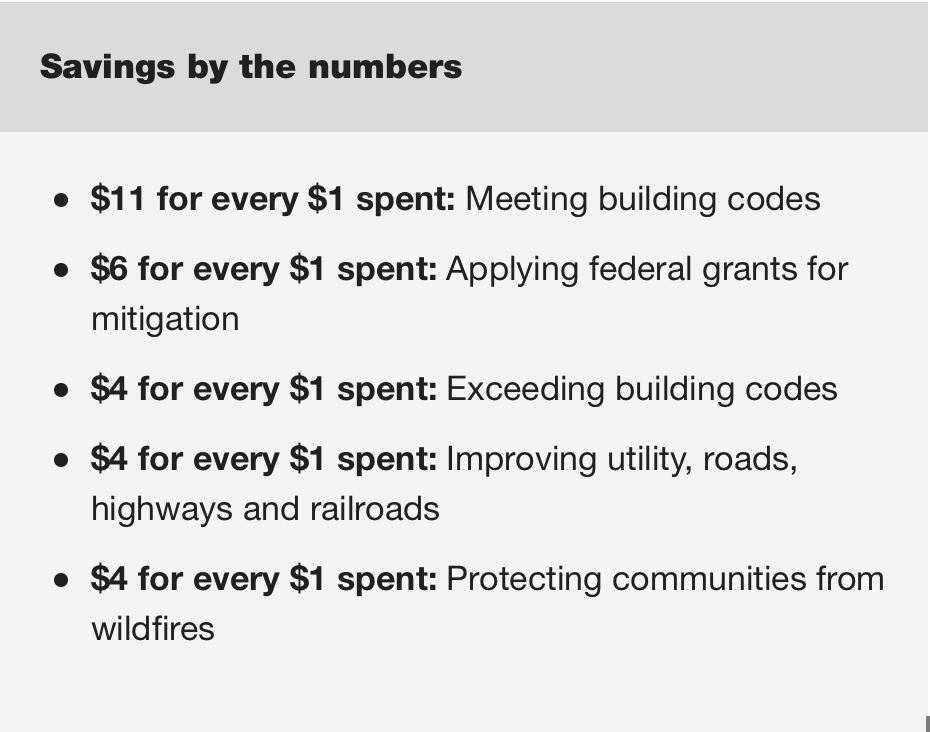
Communities that act now to protect themselves from future hazards like earthquakes, hurricanes, floods and wildfires can save themselves as much as $11 for every $1 that they initially invest, according to recent research.

The findings are part of an update to “Natural Hazard Mitigation Saves.” This landmark report was first published in 2005 by the National Institute of Building Sciences and was led by CU Boulder’s Keith Porter, who also spearheaded the most recent findings.

The report examines how homeowners, developers and municipalities might save lives and money in the long term by implementing a variety of mitigation efforts before a disaster strikes. That might mean raising houses above floodplains or strengthening office buildings against earthquakes.

There’s a lot to be gained from that kind of forward thinking, said Porter, a research professor in the Department of Civil, Environmental and Architectural Engineering.

“Natural hazard mitigation saves,” Porter said. “Mitigation can be a costly decision, but this study should help people to make a more informed choice about how to save their property and their wellbeing.”

His research shows that communities in the United States stand to save billions of dollars by making sure that new structures meet, or exceed, the International Building Code—a set of widely-adopted recommendations for designing safe buildings. Such measures could also prevent an estimated 600 deaths and one million injuries at the same time.

Porter and his colleagues released their findings this week at the Building Innovation 2019 conference in Washington, D.C.

Staying safe
The report comes after a record-breaking wildfire season in California. This year, one blaze alone—the Camp Fire—killed more than 80 people and consumed roughly 14,000 homes in the northern part of the state.

It also matters for Colorado, where large numbers of residents are vulnerable to wildfires and flooding. Wildfires burned hundreds of thousands of acres of land in Colorado in 2018—one of the worst fire years on record for the state. Historic flash floods in September 2013 destroyed or damaged thousands of homes across the Front Range.

More stringent codes can limit some of the biggest losses from such events, Porter said. Most states and communities in the U.S. have requirements for how buildings weather natural hazards. But research suggest that they may not go far enough, and many older buildings still fall short of these codes.

Porter pointed to the case of existing codes that require homes to sit a foot above the 100-year flood level…

“That doesn’t make your house floodproof. There’s still a significant chance that a flood would be higher than that,” Porter said. “It’s actually cost-effective in many places to build up to 5 feet above the base flood elevation.”

Saving money
To put numbers on the benefits from such mitigation efforts, Porter and his colleagues turned to a wide range of data to write their 2005 report. That includes records from past disasters and computer simulations that test how buildings might respond to future floods, hurricanes, earthquakes and wildfires.

What they found in the most recent update was staggering: While the benefits vary from place to place, communities in the U.S. on average may save $11 in the decades ahead for every $1 they spend now to meet current building codes. Going beyond those codes, too, can bring an extra $4 for every $1 spent.

Those gains come in a variety of forms. When buildings are built to better withstand earthquakes, for example, more stores stay open after a big tremor and fewer people go to the hospital for injuries.

The new round of numbers, together with a related report published last year, were also the first to look at the benefits that come from safeguarding buildings against wildfires. According to the team’s calculations, communities living at the edges of forests can save $4 for every $1 they spend to plan ahead for flames. Common recommendations include creating “defensible” spaces free of brush and other flammable material around homes.

“As we saw from the California wildfires last year, that’s crucial,” Porter said. “If you don’t build for fire resistance, you run a much higher risk of having your home burn down.”

He acknowledges that those sorts of measures can be costly in the short term. But Porter hopes that his group’s findings will motivate governments and other entities to do more to help home and business owners plan for the inevitable.

“You can spend money up front to better prepare for a disaster, and that should save you in the long run,” Porter said.

Democrats are divided over the #GreenNewDeal — @HighCountryNews #ActOnClimate

Alexandria Ocasio-Cortez.
By US House of Representatives – https://ocasio-cortez.house.gov/about, Public Domain, https://commons.wikimedia.org/w/index.php?curid=75556027

From The High Country News (Maya L. Kapoor):

Last fall, on Nov. 13, more than 200 activists protested on Capitol Hill, demanding a Green New Deal — a massive economic stimulus package designed to create jobs, remake the U.S. energy system and fight climate change. Rep.-elect Alexandria Ocasio-Cortez, D-N.Y., waded into their midst, vaulting the movement to national prominence. As determined young protesters in matching brown T-shirts hunkered in front of the unoccupied desk of Rep. Nancy Pelosi, D-Calif., holding signs reading “Step Up or Step Aside” and “Green Jobs for All,” Ocasio-Cortez addressed them.

“I just want to let you all know how proud I am of each and every single one of you for putting yourselves and your bodies and everything on the line to save our planet, our generation and our future,” she said, as cameras rolled. Indeed, by day’s end, many protesters were arrested.

The Green New Deal is popular: According to a recent poll by Yale University and George Mason University, more than 80 percent of registered voters support the concept. But it’s also vague about details, and Democratic leaders are divided on how to respond. Even as newly elected progressives and activists push for sweeping policy change, the party’s established powerbrokers favor caution. How the party resolves this discord could determine whether climate change becomes a prominent issue in the 2020 elections — and what action Democrats are prepared to take on it, should their power expand.

efore taking office, Ocasio-Cortez pressed Pelosi to create a Green New Deal select committee, which would have one year to design a job-creating solution to climate change. Ocasio-Cortez’s proposal — crafted in partnership with the Sunrise Movement and Justice Democrats, a progressive political action committee working to get corporate money out of politics — calls the transition away from fossil fuels “a historic opportunity to virtually eliminate poverty in the United States.” A Green New Deal would include job training programs in renewable energy and guaranteed employment for all Americans.

“Climate change is an urgent issue,” said Rep. Deb Haaland, D-N.M., who campaigned on getting the country to 100 percent renewable energy and was an early supporter of the Green New Deal. “We have to do something now.”

The Green New Deal’s massive scope and ambition — to wean the entire country from fossil fuels in just over a decade — comes in response to scientists’ ever more urgent warnings. According to the Intergovernmental Panel on Climate Change, nations must reduce greenhouse gas emissions to net-zero by 2050, or face increasingly catastrophic consequences. Yet the politics of climate change remain fraught — even among Democrats.

Democratic House leaders firmly rejected Ocasio-Cortez’s proposal for a select committee. According to E&E News, the Democratic chairs of existing committees bristled at the possibility of a new select committee usurping some of their own powers. Instead, House Speaker Pelosi reinstated the defunct Climate Crisis Select Committee, which is charged with investigating and recommending climate change solutions. However, it lacks authority to craft legislation, and its members will be allowed to accept campaign donations from the fossil fuel industry, something Ocasio-Cortez wanted to ban.

“The title is the only thing about the committee that begins to acknowledge the magnitude and urgency of the crisis we are in,” said Benjamin Finegan, an organizer with the Sunrise Movement.

University of Oregon law professor Greg Dotson, who worked on climate policy for former Rep. Henry Waxman, D-Calif., believes the party’s internal disagreement is a symptom of the growing pains it’s experiencing as it regains power. “We are in an interesting situation where the Democratic Party agrees on the most important things, which are climate change is happening, it’s caused by humans, and we have to take action to address it,” Dotson said. “Because they’re coming out of the minority, how exactly to do that, they’re still working on.”

Although the Green New Deal select committee would have a new and specific mission, there are other ways to advance its goals. Democrats on House committees like Transportation and Energy and Environment have expertise on key climate issues, and could do similar work. “Advocates should understand that there’s a tremendous amount of institutional history and expertise on all the committees,” for even the most far-reaching goals of a Green New Deal, Dotson said.

But a new generation of climate change activists, including Finegan, dismisses the idea that the existing power structure can address the climate crisis. “I think that argument is politicians being politicians,” Finegan said. After all, for decades, politicians have known climate change was happening, but they’ve done little to stop it. It’s a frustration with the old guard that some early-career Democrats, like Ocasio-Cortez and Haaland, seem to share. “We should have done something decades ago,” Haaland said.

To be clear, even if a new committee were created, Green New Deal legislation would have a snowball’s chance in Phoenix of passing the Republican-controlled Senate, never mind being signed into law by President Donald J. Trump. Still, the debate matters: “For the next two years, the most successful outcome would be for the Democratic Party to come to a view on how to address climate change and the equity issues that the Green New Deal points to,” Dotson said.

The sooner that happens, the better. Leadership has never been more needed: In 2018, after years of decline, carbon dioxide emissions again surged in the United States, even as climate change’s impacts became harder to ignore.

Maya Kapoor is an associate editor at High Country News, overseeing California, the American Southwest, the U.S.-Mexico Borderlands and the Southern Rockies. Email her at mayak@hcn.org or submit a letter to the editor.

The West’s Great River Hits Its Limits: Will the #ColoradoRiver Run Dry? — Yale360 #COriver #aridification

Grand River Ditch

Here’s Part I of a series about the Colorado River from Jim Robbins writing for Yale360. Click through and read the whole article (and enjoy the beautiful photographs). Here’s an excerpt:

As the Southwest faces rapid growth and unrelenting drought, the Colorado River is in crisis, with too many demands on its diminishing flow. Now those who depend on the river must confront the hard reality that their supply of Colorado water may be cut off.

The Never Summer Mountains tower over the the valley to the west. Cut across the face of these glacier-etched peaks is the Grand Ditch, an incision visible just above the timber line. The ditch collects water as the snow melts and, because it is higher in elevation than La Poudre Pass, funnels it 14 miles back across the Continental Divide, where it empties it into the headwaters of the Cache La Poudre River, which flows on to alfalfa and row crop farmers in eastern Colorado. Hand dug in the late 19th century with shovels and picks by Japanese crews, it was the first trans-basin diversion of the Colorado.

Many more trans-basin diversions of water from the west side of the divide to the east would follow. That’s because 80 percent of the water that falls as snow in the Rockies here drains to the west, while 80 percent of the population resides on the east side of the divide.

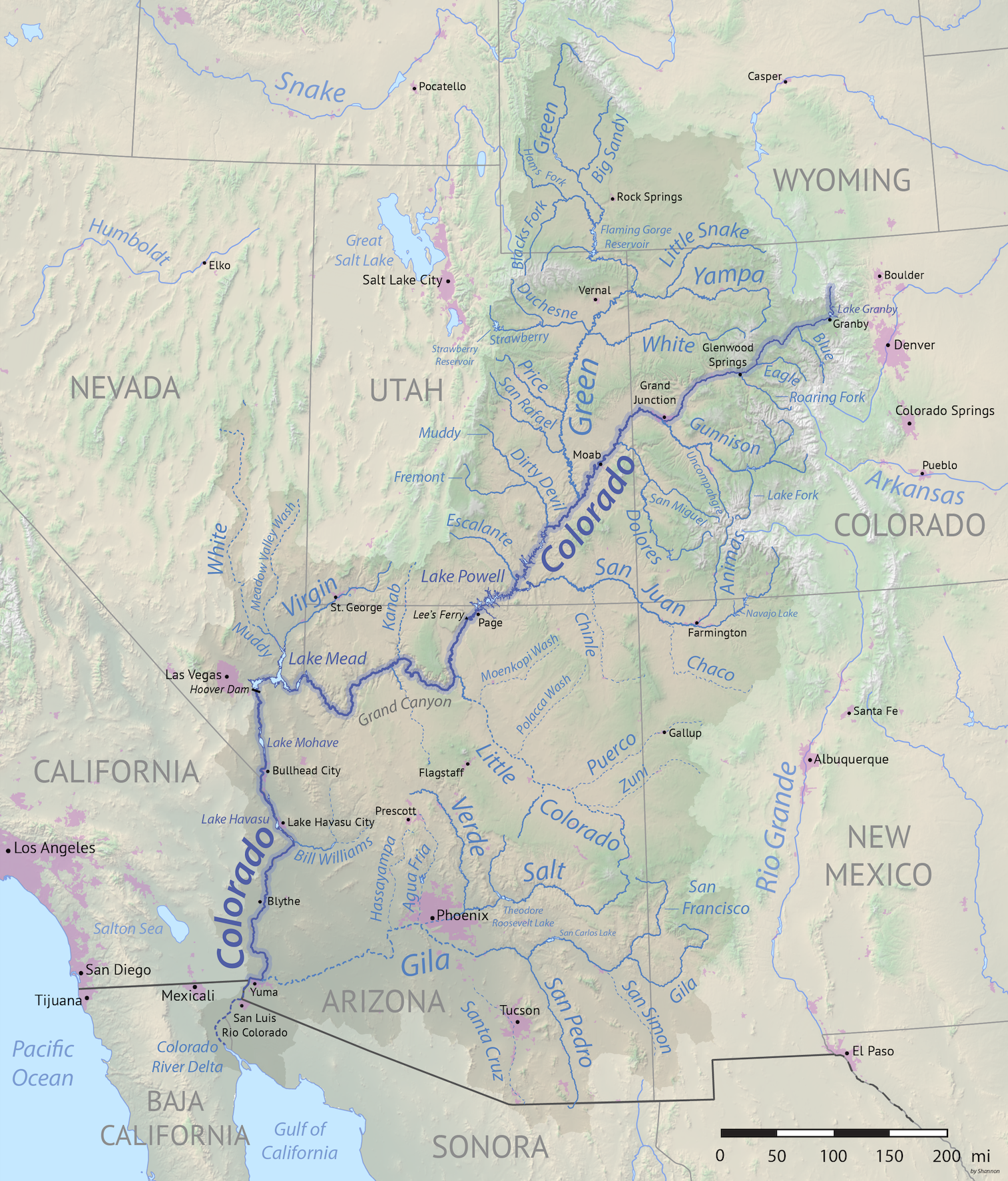
The Colorado River gathers momentum in western Colorado, sea-green and picking up a good deal of steam in its confluence with the Fraser, Eagle, and Gunnison rivers. As it leaves Colorado and flows through Utah, it joins forces with the Green River, a major tributary, which has its origins in the dwindling glaciers atop Wyoming’s Wind River Mountains, the second largest glacier field in the lower 48 states.

The now sediment-laden Colorado (“too thick to drink, too thin to plow” was the adage about such rivers) gets reddish here, and earns its name – Colorado means “reddish.” It heads in a southwestern direction through the slick rock of Utah and northern Arizona, including its spectacular run through the nearly 280-mile-long Grand Canyon, and then on to Las Vegas where it makes a sharp turn south, first forming the border of Nevada and Arizona and then the border of California and Arizona until it reaches the Mexican border. There the Morelos Dam — half of it in Mexico and half in the United States — captures the last drops of the Colorado’s flow, and sends it off to Mexican farmers to irrigate alfalfa, cotton, and asparagus, and to supply Mexicali, Tecate, and other cities and towns with water.

While there are verdant farm fields south of the border here, it comes at a cost. The expansive Colorado River Delta — once a bird- and wildlife-rich oasis nourished by the river that Aldo Leopold described as a land of “a hundred green lagoons” — goes begging for water. And there is not a drop left to flow to the historic finish line at the Gulf of California, into which, long ago, the Colorado used to empty.

Credit: Wikipedia.org

Nature, in fact, has been given short shrift all along the 1,450-mile-long Colorado. In order to support human life in the desert and near-desert through which it runs, the river is one of the most heavily engineered waterways in the world. Along its route, water is stored and siphoned, routed and piped, with a multi-billion dollar plumbing system — a “Cadillac Desert,” as Marc Reisner put it in the title of his landmark 1986 book. There are 15 large dams on the main stem of the river, and hundreds more on the tributaries.

The era of tapping the Colorado River, though, is coming to a close. This muddy river is one of the most contentious in the country — and growing more so by the day. It serves some 40 million people, and far more of its water is promised to users than flows between its banks — even in the best water years. And millions more people are projected to be added to the population served by the Colorado by 2050.

The hard lesson being learned is that even with the Colorado’s elaborate plumbing system, nature cannot be defied. If the over-allocation of the river weren’t problem enough, its best flow years appear to be behind it. The Colorado River Basin has been locked in the grip of a nearly unrelenting drought since 2000, and the two great water savings accounts on the river — Lake Mead and Lake Powell — are at all-time lows. An officially announced crisis could be at hand in the coming months…

Most of the water in the Colorado comes from snow that falls in the Rockies and is slowly released, a natural reservoir that disperses its bounty gradually, over months. But since 2000, the Colorado River Basin has been locked in what experts say is a long-term drought exacerbated by climate change, the most severe drought in the last 1,250 years, tree ring data shows. Snowfall since 2000 has been sketchy — last year it was just two-thirds of normal, tied for its record low. With warmer temperatures, more of the precipitation arrives as rain, which quickly runs off rather than being stored as mountain snow. Many water experts are deeply worried about the growing shortage of water from this combination of over-allocation and diminishing supply.

There is tree ring data to show that multi-decadal mega-droughts have occurred before, one that lasted, during Roman Empire times, for more than half a century. The term drought, though, implies that someday the water shortage will be over. Some scientists believe a long-term, climate change-driven aridification may be taking place, a permanent drying of the West. That renders the uncertainty of water flow in the Colorado off the charts. While not ruling out all hope, experts have abandoned terms like “concerned” and “worrisome” and routinely use words like “dire” and “scary.”

“These conditions could mean a hell of a lot less water in the river,” said Jonathan Overpeck, an interdisciplinary climate scientist at the University of Michigan who has extensively studied the impacts of climate on the flow of the Colorado. “We’ve seen declines in flow of 20 percent, but it could get up to 50 percent or worse later in this century.”

Even in rock-ribbed conservative areas, those who use the water of the Colorado say they are already seeing things they have never seen before — this year state officials in Colorado cut off lower-priority irrigators on the Yampa River, a tributary of the Green, and recreation had to be halted, for example — and have grudgingly come to believe “there is something going on with the climate.”

#Snowpack news: The #ColoradoRiver and tributary streamflow likely won’t recover this water year #COriver #aridification

From KUNC (Luke Runyon):

Jeff Lukas, who authored the [Western Water Assessment] briefing, says water managers throughout the Colorado River watershed should brace themselves for diminished streams and the decreasing likelihood of filling the reservoirs left depleted at the end of 2018.

That dire prognosis comes even as much of the southern Rocky Mountains have seen a regular stream of snow storms this winter.

“The snowpack conditions for Colorado and much of the intermountain West don’t look too bad,” Lukas says. “They range from ‘meh’ to ‘OK.’”

Snowpack in river basins that feed the Colorado River range from 75 percent to 105 percent of normal. The entire Upper Colorado River Basin’s snowpack is sitting at about 90 percent of normal for this time of year.

So with an ‘OK’ snowpack in the mountains we should be in the clear, right? Not necessarily. If you’re just looking at snowpack to gauge how well a winter is going — you’re doing it wrong, according to Lukas.

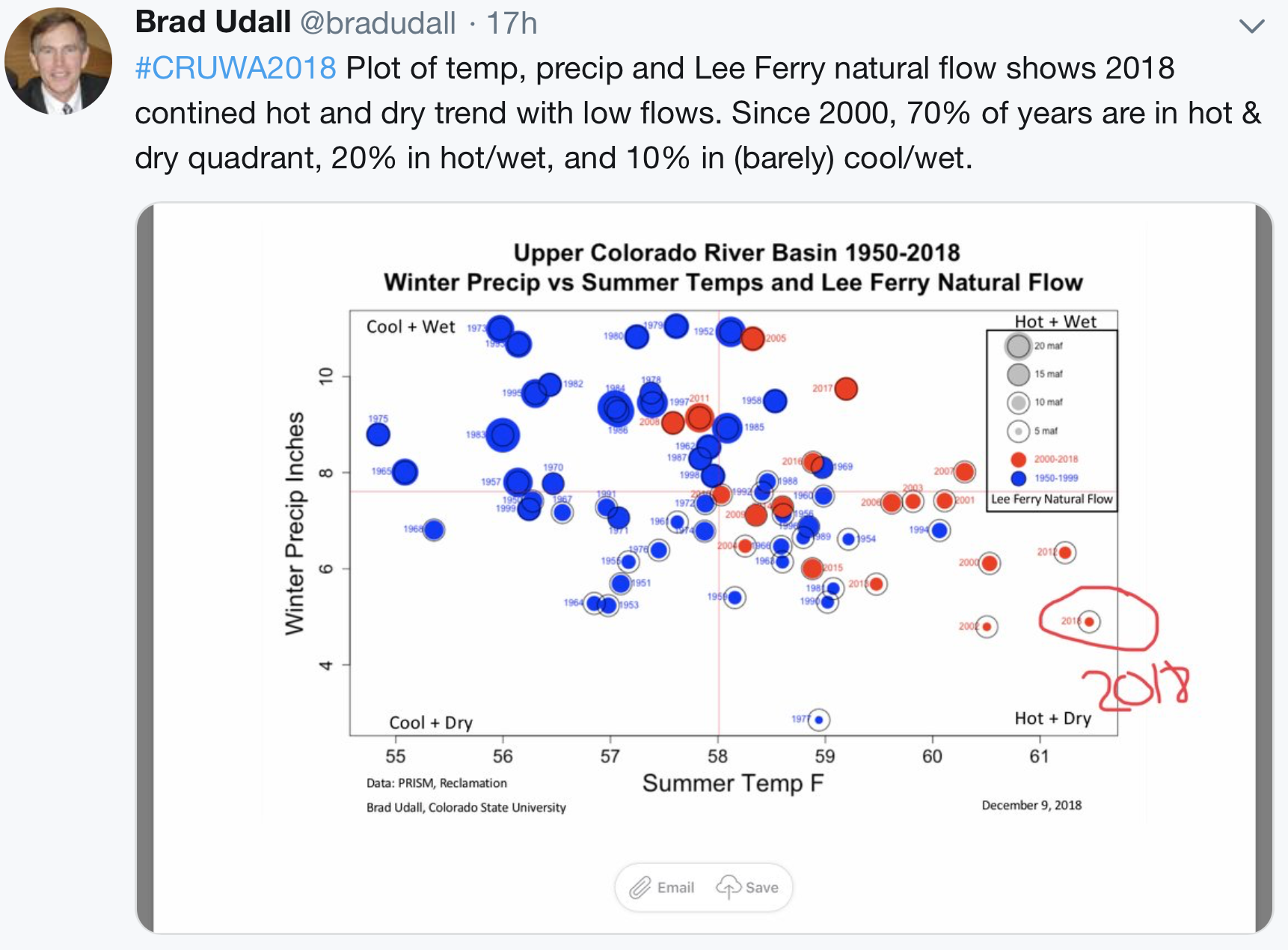
The record hot and dry conditions throughout 2018 sapped the ground of its moisture. Leading into this winter, “that puts us in a deep hole,” Lukas says.

Put another way, throughout the southwest, we’re living in a drought hangover. And it’s going to take a lot more snow to pull us out of it.

Lake Powell, the first major reservoir the Colorado River hits on its journey throughout the southwest, is currently projected to see 64 percent of its average inflow. That translates to a one-year deficit of more than 5 million acre-feet of water. One acre-foot is enough water to supply roughly one to two households for a year.

“That’s not as bad as what happened last year, but it’s pretty close,” Lukas says. “That’s going to just drain the big reservoirs — [Lakes] Powell and Mead — even further.”

Border security will always be elusive — @HighCountryNews

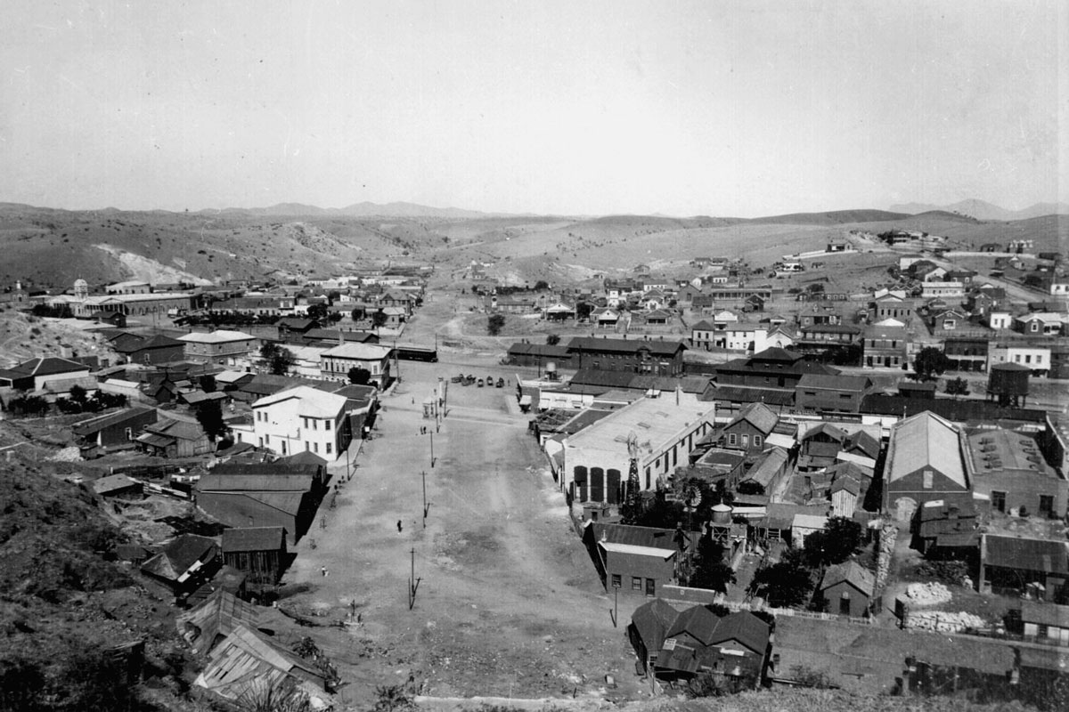
The border between Nogales, Arizona, and Mexico around 1898.
“Nogales, Santa Cruz Co. Showing boundary line between Arizona and Mexico.” General view of center of town from hillside, looking west along International Street, ca. 1898~99
Photo credit: Wikimedia Commons

From The High Country News (Adam M. Sowards):

Reckoning with History is an ongoing series that seeks to understand the legacies of the past and to put the West’s present moment in perspective.

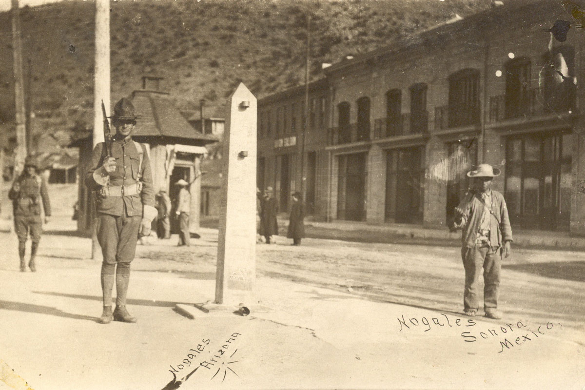
With their armed guards and imposing structures, American border crossings symbolize permanent frontiers. Boundaries are definitional places, lines that demarcate this side as different from that side. From a longer view, though, they look surprisingly transitory, governed by shifting policies and constantly modified and breached. Today’s incessant nationalist rhetoric concerning the border wall imagines a permanently secured boundary, but actual historical borders and policies have proven impermanent over time, a fact that should dampen expectations.

U.S. borders shifted regularly from American independence in 1783 through the first half of the 19th century, as the young, grasping nation bought, conquered and manipulated its way across much of the continent. The imperialist, racist ideology of Manifest Destiny fueled this constant border redrawing, a reminder that boundaries are neither natural nor permanent. The 1854 Gadsden Purchase added southern Arizona and a sliver of New Mexico and established the continental borders of the United States. They have remained the same ever since, though a waterway between Washington state and Vancouver Island remained in dispute until resolved in favor of the United States in 1872. Although the United States gained overseas acquisitions in the 1898 Spanish-American War, few Americans sought to extend continental territory during the last quarter of the 19th century. Once the boundaries seemed stable, Congress moved to restrict immigration, a process that changed the very nature and meaning of those borders.

The 1882 Chinese Exclusion Act symbolized this shift. The law was the first to restrict immigration based on racial, or national, categories, in line with resurgent segregation in the American South and reservation policies in the West. The exclusion act all but stopped emigration from China. It also made deportation a policy enforcement option and led to racialized policing, a practice that hung over all Chinese communities here and created a “shadow of exclusion” or a “shadowed existence” for Chinese in the United States, according to historian Erika Lee.

By enacting this law, the U.S. government created illegal immigration and the resulting market for doctored papers and guides for illicit movement. Most illegal border crossings happened in the Northwest, sometimes through the same waters that caused the dispute between Washington and British Columbia, as members of Canada’s substantial Chinese immigrant population crossed over. By 1890, government agents estimated that 2,500 laborers a year were illegally moving from Canada into the United States. But surreptitious migration quickly grew along the southern border as well, as historian Patrick Ettinger has shown, as migrants adapted to changing conditions. Chinese laborers in Mexico learned how to cross with false papers or sneak over the border and quietly blend in. The few U.S. officials managing the southern border called for more money, more people and more technology, initiating a strategy and mantra that continues more than a century later. The federal government bulked up its border personnel and turned back many people, but by the 1920s, officials recognized their basic failure to stop illegal migrations.

During the Mexican Revolution, 1910-1920, American and Mexican soldiers guard International Street in Nogales. The border marker still stands today.
Photo credit: Wikimedia Commons

The U.S. did not build its first border fence to keep the fugitive crossers out, though; it built it to stop tick-infected cattle. Ticks had infested the Western cattle industry for decades. Northern states aimed to confine the problem to the Southwest by halting infected cattle, but the insects persisted, spreading Texas fever among cattle who had not developed immunity from exposure as calves. In 1906, the U.S. Department of Agriculture launched a massive eradication campaign and began quarantining cattle from Mexico. In 1911, the first fence funded by the federal government went up to stop “Mexican” cattle from infecting “American” cattle. As the historian Mary E. Mendoza, who unearthed this episode, has pointed out, it took no great leap for discourse to shift from pestilential animals to pestilential people, feeding on the common rhetoric that associated foreigners with dirtiness and disease. The fences grew and changed in their purpose. “Fences previously used for cattle became tools used to control and herd humans,” explained Mendoza. By the mid-20th century, American officials saw the border as a biological barrier, a place to stop both diseased animals and people perceived as a threat. Racism and indifference fed this formula. As a result, migrants shifted to more dangerous routes, resulting in greater risks and higher death totals. The ramifications are ongoing: Over time, fences designed to prevent cattle from dying became barriers that increased human mortality.

The first border fences built in 1911 were constructed to curb tick infestations of cattle. Pictured, cattle in Pie Town, New Mexico.
http://hdl.loc.gov/loc.pnp/fsa.8b25350
Photo credit: Wikimedia Commons

The 1965 Immigration and Nationality Act further transformed the legal regime for the border. Although it widened opportunities for immigration from much of the world, the law, for the first time, established quotas from within the Western Hemisphere. As a result, Congress produced a system that guaranteed more immigrants flowing outside legal channels. Immigration policy in the 20th century followed narrow nationalist frameworks and generally failed to reckon with larger contexts, according to historian Mae Ngai’s brilliant book Impossible Subjects: Illegal Aliens and the Making of Modern America (2004). “That nationalism,” she wrote, “resists humanitarianism and remains blind to the causal connections between the United States’ global projections and the conditions abroad that impel emigration.” Ngai points out how deeply entwined the past and present of the United States are with the rest of the world, especially with Latin America, where the U.S. has protected its own material interests for two centuries

Occasionally, American officials have recognized the folly of border control. In 1927, an exasperated secretary of Labor, James Davis, declared, “Not even a Chinese wall, 9,000 miles in length and built over rivers and deserts and mountains and along the seashores, would seem to permit a permanent solution.” His remarks stand as a prescient assessment of the futility of “securing” the border by physical obstacles. Trying to stop movement there is much like clenching a handful of sand: The harder you squeeze, the more sand escapes. National lines of exclusion and control — represented today by steel walls — seem destined to fail in a world where capital, labor, ideas and cultural influence ping across boundaries as easily as opening an app on a smartphone. Entrenching those national(ist) walls can only lead to more dangerous and inhumane results.

Adam M. Sowards is an environmental historian, professor and writer. He lives in Pullman, Washington.

The latest briefing is hot off the presses from the Western Water Assessment #snowpack

Westwide SNOTEL basin-filled map January 15, 2019 via the NRCS.

Click here to read the briefing (scroll down):

Latest Briefing – January 14, 2019 (UT, WY, CO)

  • With below-normal or near-normal snowpack conditions and very low antecedent soil moisture, NOAA’s January 1 forecasts call for much-below-average (50-70%) or below-average (70-90%) spring-summer runoff across nearly all of the region’s basins. Unless there is significant improvement in snowpack conditions, most of the basins in Colorado and Utah that saw very low runoff in 2018 will face another year of hydrological drought.
  • After a mostly dry December, and a somewhat better start to January, snowpack conditions are overall slightly below normal for the region and for each state. As of January 14, most basins in Colorado, Utah, and Wyoming are reporting between 85-105% of normal SWE Western US Seasonal Precipitation. Southwestern Colorado is still the driest area with 75-80% of normal SWE, though this is improved from mid-December. The SNOTEL basin average for the Upper Colorado River Basin is at 90% of normal.
  • NOAA CBRFC’s official January 1 seasonal runoff forecasts, along with those of the neighboring RFCs, call for much-below-average (50-70%) or below-average (70-89%) spring-summer runoff for the vast majority of forecast points in Colorado, Utah, and Wyoming. Near-average (90-110%) runoff is forecasted for several points in north-central Colorado, and in the Arkansas Basin. The CBRFC January 1 forecast for Lake Powell April-July inflows is for 64% of average (4.55 MAF). The outlook for forecasted flow across the region is worse than the snowpack conditions alone would indicate, which mainly reflects the very low antecedent soil moisture in fall 2018 in most basins. (NRCS did not produce January 1 runoff forecasts due to staffing constraints.)
  • December was generally drier than normal across the region, aside from well-above-average precipitation in parts of central Utah, southwestern Colorado, and northeastern Wyoming Western US Seasonal Precipitation, with near-normal temperatures prevailing over the region Western US Seasonal Precipitation. In the first two weeks of January, a series of storms have left wetter-than-normal conditions over southern and central Colorado, southeastern Utah, and central and northeastern Wyoming, with dry conditions elsewhere.
  • Since early December, drought conditions have seen little change across the region WY Drought Monitor. The area of exceptional drought (D4) in the Four Corners region saw a smidgen of improvement. Abnormally dry (D0) conditions expanded slightly in northeastern Colorado after the very dry December there.
  • El Niño-ish? ENSO indicators have almost reached the multi-month thresholds for declaration of El Niño conditions, though the warm anomalies in the tropical Pacific have weakened in the last month ENSO Nino Regions Sea Surface Temperature Anomalies. If an El Niño event does officially and finally emerge, as is still likely, it will be weak and unlikely to persist past the spring. The CPC seasonal precipitation outlooks for the January-March 3-mo precip forecast, 1.5-mo lead and February-April 3-mo precip forecast, 1.5-mo lead periods still show slightly enhanced chances for above-normal precipitation for Colorado and adjoining states, consistent with historical tendencies during El Niño events.
  • Registration is open for the 2019 Governor’s Ag Forum

    Photo credit: Allen Best

    Click here for all the inside skinny:

    Registration Includes:

  • Pre-Forum Reception at Governor’s Mansion
  • Continental Breakfast
  • Breaks (light snacks and beverages)
  • Lunch
  • Access to presentations
  • Forum Directory
  • Discounted Hotel Room
  • Questions? Contact us: info@governorsagforum.com

    “If you look at the projections for the [#ColoradoRiver’s] flow, modified by, exacerbated by #climatechange, it’s perfectly clear that #DCP is just an interim solution” — Bruce Babbit #COriver #aridification

    Verde River near Clarkdale along Sycamore Canyon Road. Photo credit: Wikimedia

    From The Arizona Daily Star (Tony Davis):

    After Gov. Doug Ducey urged legislators to “do the heavy lifting” and pass the proposed drought-contingency plan for the Colorado, Babbitt said Monday that authorities will have to start discussing a much longer-term plan immediately after it’s approved.

    “If you look at the projections for the river’s flow, modified by, exacerbated by climate change, it’s perfectly clear that DCP is just an interim solution,” Babbitt, who is also a former U.S. Interior secretary, told reporters Monday after Ducey finished his State of the State speech.

    Nearly 40 years ago, then-Gov. Babbitt helped push through the pioneering Arizona Groundwater Management Act by muscling a bipartisan group of legislators to approve it after years of inaction. That law set a 2025 deadline for Arizona’s largest cities to balance the pumping of groundwater with the recharge of rainfall and runoff into the aquifer.

    Monday, he and former U.S. Sen. Jon Kyl sat in the front row of the State House chambers as Ducey exhorted legislators to pass the drought plan in time to meet a Jan. 31 federal deadline. U.S. Reclamation Commissioner Brenda Burman has warned she’ll move to take over management of the Colorado River if Arizona and other states don’t approve drought plans by that date.

    Babbitt said he was there at Ducey’s invitation. The Republican governor told legislators that Democrat Babbitt and Republican Kyl were examples of how you can succeed with water issues by “working with others, setting aside differences and putting our state and the greater good first.”

    Babbitt said he saw clear parallels between the passage of the 1980 groundwater law and the current struggle to pass the drought plan. That year, the Legislature enacted the law only after then-Interior Secretary Cecil Andrus threatened to halt work on the Central Arizona Project if it didn’t — a threat Babbitt has since admitted having secretly orchestrated with Andrus.

    “The parallel is that you reach a point at which you’re out of time and something must happen” Babbitt said. “That has an awakening effect on people.”

    Now, however, the seven river basin states face “a very difficult pathway” — a continued future of declining river supplies and increasing demand fueled by continued population growth, Babbitt said…

    The lengthy debate over the drought plan is a proxy for the much bigger questions about the dynamics between the river’s upper and lower basins, Babbitt said.

    “We’re taking more than our share” in the Lower Basin, while the Upper Basin hasn’t started taking all the water it’s entitled to use, he said.

    But he declined to discuss if the state can continue growing in population and economically in the face of decreasing flows on the Colorado. It supplies 40 percent of Arizona’s total water supply.

    “That’s a subject for another lengthy discussion,” after this drought plan is approved, Babbitt said…

    Babbitt said he’s increasingly confident that the drought plan will pass the Legislature, given that it’s become “front and center” in both the governor and legislators’ public statements.

    From The Voice of San Diego (Ry Rivard):

    The Colorado River may not look like it, but it’s one of the world’s largest banks.

    The river is not only the source of much of the American West’s economic productivity – San Diego, Phoenix and Denver would hardly exist without it – but its water is now the central commodity in a complex accounting system used by major farmers and entire states.

    Now, when talking about the river, water officials across the West use terms like bank, payback and surplus. Often the analogies to finance don’t stop there – they put money behind deals that dictate who gets water and who does not.

    This month, the nation’s largest water agency, the Metropolitan Water District, began what amounts to a run on the bank.

    The district – which delivers water across Southern California, including to San Diego – started rapidly withdrawing water from the river, which is stored behind Hoover Dam in Lake Mead.

    Metropolitan officials are worried that the federal government is about to step in to ration the river, which 40 million people depend on as it flows some 1,300 miles from its headwaters in Wyoming and Colorado to the Sea of Cortez in Mexico…

    Metropolitan’s immediate concern is that it will lose the ability to withdraw 600,000 acre feet of banked water from Lake Mead – enough water for roughly 7 million people. The district can only get half of that out this year, meaning it is in danger of losing lots of water…

    At last count, Lake Mead stood just six feet away from falling into shortage, the first step toward rationing water. There was already about a 50-50 chance the river would fall that far this year. The chances are even higher now, because Metropolitan’s plan to withdraw as much water as it can may cause the lake to drop four or five feet – though the lake will rise again as snow melts this spring.

    Once there’s a shortage, Arizona is supposed to be in trouble. At least on paper, California’s rights to the river’s water are so secure that Arizona’s water supply would have to run dry before California loses a single drop.

    That’s politically impossible since 7 million people live in Arizona and need water. So for several years, Metropolitan and a clutch of power-players across seven states have been trying to reach a different, more realistic deal. Their efforts have repeatedly stalled, mostly because of squabbling within Arizona, which is ironic because the state stands to lose so much unless something changes.

    The Arizona Chamber Foundation, a nonprofit business group, said without a deal the state’s access to water “could be caught up in the courts for decades or managed from Washington, D.C. Such uncertainty could be a drag on Arizona’s historic economic resurgence.”

    The deal would allow Metropolitan to withdraw banked water even during an official shortage. But now Metropolitan is preparing for the worst-case scenario, which is a combination of uncertainty and a banking freeze. Still, district officials hopes Arizona signs a deal in coming weeks.

    “We’re not at the point of no return,” said ​Bill Hasencamp, the district’s manager of Colorado River resources.

    Tom Buschatzke, the director of the Arizona Department of Water Resources, said in a statement that he knew Metropolitan would begin trying to get its water out as quickly as possible…

    Last year, the agency that runs Arizona’s water system, the Central Arizona Project, got busted using water accounting quirks to get more water from the upper basin than it needed. Officials in the upper basin accused Arizona of threatening the water supply for 40 million people.

    For decades, water officials across the region have alternated between working together to share the river and fighting like hell to horde it.

    Following a long-running Supreme Court battle between California and Arizona, the Bureau of Reclamation in the mid-1960s created a modern accounting system to track who was using how much of the river from year to year.

    For the past two decades, the river has been in drought. Partly to cope with that, states and water agencies began to use that tracking system to create increasingly complex transactions. The original laws governing the river don’t anticipate users would save water one year and claim the right to use that water in future years, the practice known as banking. The old laws also don’t anticipate or even allow the sale of water across state lines.

    That has fallen by the wayside as a series of sophisticated transactions have proliferated, where states bank and transfer water.

    The Southern Nevada Water Authority, for instance, has sent enough water for several million of its residents to Arizona, where it is stored underground.

    When Nevada wants its water back, it won’t actually pump that water up from the ground. Arizona will curb its use of the Colorado River and let Nevada take water otherwise earmarked for Arizona.

    Likewise, if the new river-sharing deal happens, Nevada has promised to lend water to Metropolitan that, in turn, will help Arizona avoid devastating cuts.

    “It’s creative ways to live within the existing law of the river,” Hasencamp said.

    Indian tribes saw it another way. They complained early on that transactions would rely on water that actually belongs to tribes. On paper the tribe have rights to lots of water, even though they currently lack a real way to get most of that water from the river to their land. So other states are essentially banking on tribes not getting that water anytime soon.

    “It is logical to expect that the current water users will have even more incentive to resist the development of Colorado River water by the Navajo Nation in order to minimize their risk of shortage,” the tribe wrote in a 2007 letter to federal officials.

    A federal appeals court disagreed with the tribes’ arguments on legal grounds, though didn’t quite deny they had a point…

    There are two ways to get people to use less water. The first is to forbid them from using it, the regulatory approach. The second is to pay them not to, the market approach.

    Because regulations often end up in court, some water officials think throwing money at the problem is easier. Most Colorado River water is still used for farming. So when push comes to shove in a drought, cities will end up paying farmers to use less water.

    Over the past several years, cities from Los Angeles to Phoenix to Denver pooled their money to pay farmers to use less water.

    These payouts happened up and down both basins: In 2017, cities paid $635,000 to a New Mexican farmer who stopped growing corn, potatoes, alfalfa and beans along the San Juan River, one of the Colorado’s far-flung tributaries. They paid several farmers along the Price River in Utah about $370,000 to idle their fields or change how they water them. Several farmers along Fontenelle Creek in Wyoming changed how they watered their pastures and got a few hundred thousand dollars in return.

    These projects didn’t amount to much, a few million dollars to save about 11,000 acre feet of water…

    The biggest transaction of all is between the San Diego County Water Authority and the Imperial Irrigation District. The irrigation district, which provides water to farmers in Imperial County, holds rights to as much Colorado River water as the states of Arizona and Nevada combined.

    In exchange for billions of dollars, the Water Authority can use some of Imperial’s high-priority water rights for decades to come.

    For now, that deal insulates San Diego from some of the drama on the Colorado, but Water Authority officials have actually wanted to get in the mix.

    For several months, the Water Authority has said it would like to leave some of the water it buys from Imperial in the river. In doing so, San Diego water officials would forgo using water they spent a quarter century trying to get and fighting over in court.

    Dan Denham, the Water Authority’s assistant general manager, said San Diego could leave enough of that water in Lake Mead to raise its elevation by three feet…

    When the California drought left those northern rivers empty, Metropolitan began drawing as much water as it could from the Colorado. But when the drought ended here but continued on the Colorado River, Metropolitan began using as much Northern California water as it could and leaving water in Lake Mead. That’s some of the banked water it could now lose.

    Recently, Metropolitan projected how much it would cost to replace some of its Colorado River supplies in coming years. Depending on the scenario, that could cost between $80 million and $954 million, though those numbers are pretty rough and would be divided up among 19 million people who get water from the district.

    Denver: Heron Pond redevelopment poses environmental challenges

    Proposed Heron Pond Park via the City of Denver.

    Click here to read the master plan.

    From The Denver Post (Bruce Finley):

    The 2-foot-deep pond holds toxic sludge laced with lead, arsenic and cadmium. Contaminated stormwater runoff from surrounding work yards worsens the brew…

    Denver’s willingness to embrace such a site for future parkland reflects the increasingly difficult challenge of establishing enough public green space to keep pace with population growth and development. Denver has fallen behind other U.S. cities in urban parks and open space. This is causing discomfort, hurting public health, exacerbating heat waves and risking costly problems with stormwater runoff.

    City officials interviewed by The Denver Post said they see establishing new green space as essential but, perhaps, impossible given the rising price of land. Yet voters recently ordered a sales-tax hike that will raise $45 million a year for parks and open space. This has compelled planners to pore over thousands of acres that could be preserved as green space.

    The problem, city officials said, is competing with private developers for land. Developers since 1998 have installed buildings, paved over natural terrain and otherwise overhauled vast tracts of the city — profiting from shopping plazas and upmarket apartments that eventually sell as condominiums. They’ve built higher, lot-line-to-lot-line in some areas, leaving less space to even plant trees.

    Turning to marginal industrial land, city officials said, may be Denver’s best hope for stabilizing a decline in green space per capita.

    Chief parks planner Mark Tabor said that, after establishing the new green space around Heron Pond, Denver officials could try to purchase the land around the Arapaho power plant south of downtown and in the rail yards northwest of downtown for preservation as large green space where natural ecosystems could be restored.

    This approach hinges on cleanup.

    It can be done, not just by excavating and hauling away contaminated soil but by using modern cleanup methods that remove acidity and toxic metals, said Fonda Apostopoulos, a Colorado Department of Public Health and Environment engineer who managed decontamination of the Asarco smelters and 862 residential properties near Heron Pond.

    “The low-lying fruit of clean property in Denver is few and far between. ‘Brownfields’ are pretty much the only property people are developing,” Apostopoulos said.

    “It is all about exposure pathways” — the ways contamination can reach people, he said.

    Around Heron Pond, cleanup included excavation and replacement of soil around homes. Nine new monitoring wells will be installed between the smelter site and the South Platte River to make sure toxic metals no longer contaminate groundwater, Apostopoulos said, pronouncing the area safe for at least passive recreational activity.

    While cleaning up industrial wasteland costs hundreds of millions of dollars, “there are a lot of private-public partnerships that could do that,” he said. “Denver could get extra federal funding. They could get cleanup grants.”

    Proposed Heron Pond boundary via the City of Denver.

    Ice loss from Antarctica has sextupled since the 1970s, new research finds — The Washington Post #ActOnClimate

    From The Washington Post (Chris Mooney and Brady Dennis):

    An alarming study shows massive East Antarctic ice sheet already is a significant contributor to sea-level rise

    The Antarctic lost 40 billion tons of melting ice to the ocean each year from 1979 to 1989. That figure rose to 252 billion tons lost per year beginning in 2009, according to a study published Monday in the Proceedings of the National Academy of Sciences. That means the region is losing six times as much ice as it was four decades ago, an unprecedented pace in the era of modern measurements. (It takes about 360 billion tons of ice to produce one millimeter of global sea-level rise.)

    “I don’t want to be alarmist,” said Eric Rignot, an Earth-systems scientist for the University of California at Irvine and NASA who led the work. But he said the weaknesses that researchers have detected in East Antarctica — home to the largest ice sheet on the planet — deserve deeper study.

    “The places undergoing changes in Antarctica are not limited to just a couple places,” Rignot said. “They seem to be more extensive than what we thought. That, to me, seems to be reason for concern.”

    The findings are the latest sign that the world could face catastrophic consequences if climate change continues unabated. In addition to more-frequent droughts, heat waves, severe storms and other extreme weather that could come with a continually warming Earth, scientists already have predicted that seas could rise nearly three feet globally by 2100 if the world does not sharply decrease its carbon output. But in recent years, there has been growing concern that the Antarctic could push that even higher.

    That kind of sea-level rise would result in the inundation of island communities around the globe, devastating wildlife habitats and threatening drinking-water supplies. Global sea levels have already risen seven to eight inches since 1900.

    The ice of Antarctica contains 57.2 meters, or 187.66 feet, of potential sea-level rise. This massive body of ice flows out into the ocean through a complex array of partially submerged glaciers and thick floating expanses of ice called ice shelves. The glaciers themselves, as well as the ice shelves, can be as large as American states or entire countries.

    The outward ice flow is normal and natural, and it is typically offset by some 2 trillion tons of snowfall atop Antarctica each year, a process that on its own would leave Earth’s sea level relatively unchanged. However, if the ice flow speeds up, the ice sheet’s losses can outpace snowfall volume. When that happens, seas rise.

    That’s what the new research says is happening. Scientists came to that conclusion after systematically computing gains and losses across 65 sectors of Antarctica where large glaciers — or glaciers flowing into an ice shelf — reach the sea.

    West Antarctica is the continent’s major ice loser. Monday’s research affirms that finding, detailing how a single glacier, Pine Island, has lost more than a trillion tons of ice since 1979. Thwaites Glacier, the biggest and potentially most vulnerable in the region, has lost 634 billion. The entire West Antarctic ice sheet is capable of driving a sea-level rise of 5.28 meters, or 17.32 feet, and is now losing 159 billion tons every year.

    The most striking finding in Monday’s study is the assertion that East Antarctica, which contains by far the continent’s most ice — a vast sheet capable of nearly 170 feet of potential sea-level rise — is also experiencing serious melting.

    The new research highlights how some massive glaciers, ones that to this point have been studied relatively little, are losing significant amounts of ice. That includes Cook and Ninnis, which are the gateway to the massive Wilkes Subglacial Basin, and other glaciers known as Dibble, Frost, Holmes and Denman…

    “It has been known for some time that the West Antarctic and Antarctic Peninsula have been losing mass, but discovering that significant mass loss is also occurring in the East Antarctic is really important because there’s such a large volume of sea-level equivalent contained in those basins,” said Christine Dow, a glacier expert at the University of Waterloo in Canada. “It shows that we can’t ignore the East Antarctic and need to focus in on the areas that are losing mass most quickly, particularly those with reverse bed slopes that could result in rapid ice disintegration and sea-level rise.”

    Neglected pastures thrive under solar panels — Anthropocene Magazine #ActOnClimate

    Photo credit: U.S. Department of Energy via Flickr

    From Anthropocene Magazine (Prachi Patel):

    Solar panels could increase productivity on pastures that are not irrigated and even water-stressed, a new study finds. The new study published in PLOS One by researchers at Oregon State College finds that grasses and plants flourish in the shade underneath solar panels because of a significant change in moisture. The results bolster the argument for agrovoltaics, the concept of using the same area of land for solar arrays and farming. The idea is to grow food and produce clean energy at the same time.

    Tests of the agrovoltaics concept are now underway at several spots around the world. Researchers behind these large-scale experiments are testing whether crops can grow just as prolifically in the shade of solar panels as they would under full sun, and are figuring out the best solar panel tilt and arrangements.

    The OSU team happened upon their findings by accident. Walking past one of the solar arrays on campus one day, biological and ecological engineering professor Chad Higgins saw that green grass was growing in the array’s shade. So they installed instruments to measure air temperature, relative humidity, wind speeds, and soil moisture in the areas under panels and under direct sunlight. They conducted these measurements between May and August of 2015. At the end of that period, they also weighed the above-ground biomass in the different areas.

    They found that areas under the solar panels had a different microclimate than exposed areas. Shaded areas were 328 percent more water efficient, and maintained higher soil moisture throughout the heat of summer. That led to twice as much grass under the arrays as in the unshaded areas. The plants also had more nutritional value. And the researchers also found a 90 percent increase in late-season plant mass in areas under PV panels.

    Higgins explains that plants in full sun use their water as quickly as possible and then die, while those in shade are less stressed and use their water slowly. “Not all crops will be amenable to solar management, and the economics of active solar management with PV panels needs further study,” the researchers write. “But, semi-arid pastures with wet winters may be ideal candidates for agrivoltaic systems as supported by the dramatic gains in productivity.”

    Source: Elnaz Hassanpour Adeh, John S. Selker, Chad W. Higgins. Remarkable agrivoltaic influence on soil moisture, micrometeorology and water-use efficiency. PLOS One, 2018.

    Abstract

    Power demands are set to increase by two-fold within the current century and a high fraction of that demand should be met by carbon free sources. Among the renewable energies, solar energy is among the fastest growing; therefore, a comprehensive and accurate design methodology for solar systems and how they interact with the local environment is vital. This paper addresses the environmental effects of solar panels on an unirrigated pasture that often experiences water stress. Changes to the microclimatology, soil moisture, water usage, and biomass productivity due to the presence of solar panels were quantified. The goal of this study was to show that the impacts of these factors should be considered in designing the solar farms to take advantage of potential net gains in agricultural and power production. Microclimatological stations were placed in the Rabbit Hills agrivoltaic solar arrays, located in Oregon State campus, two years after the solar array was installed. Soil moisture was quantified using neutron probe readings. Significant differences in mean air temperature, relative humidity, wind speed, wind direction, and soil moisture were observed. Areas under PV solar panels maintained higher soil moisture throughout the period of observation. A significant increase in late season biomass was also observed for areas under the PV panels (90% more biomass), and areas under PV panels were significantly more water efficient (328% more efficient).

    #Snowpack news: Arkansas Basin best in state (120% of normal)

    Click on a thumbnail graphic to view a gallery of snowpack data from the NRCS.

    And here is a screen shot from the interactive SNOTEL map from January 14, 2019.

    Interactive SNOTEL map screen shot January 14, 2019 via the NRCS.

    Cache la Poudre: Fish ladder coming to the Poudre River at Watson Lake — #Colorado Parks and Wildlife

    Construction begins on Cache la Poudre River for fish ladder near Watson Lake. Photo credit: Jason Clay/Colorado Parks and Wildlife

    Here’s the release from Colorado Parks and Wildlife:

    CPW partners with noosa yoghurt, Northern Water and Morning Fresh Dairy on project

    [In December 2018] a project [broke ground] that will help reconnect a fragmented Poudre River.

    In a collaborative effort, Morning Fresh Dairy, Northern Water and noosa yoghurt are partnering with Colorado Parks and Wildlife (CPW) to put in a fish ladder at the Watson Lake Diversion. They hope this will be one of many ladders along the Poudre River that will allow fish to travel freely, improving the health of the fishery and the ecosystem.

    This Watson Lake fish ladder will reconnect over two river miles. The stretch contains important spawning habitat and deep pools that provide refuge for aquatic life.

    Watson Lake Diversion Structure is a channel spanning structure that represents a complete barrier to all upstream fish movement in the Poudre River. The structure delivers water to Watson State Fish Hatchery and is owned and operated by CPW.

    “We appreciate the collaboration from the project partners on this important fishway that will reconnect over two miles of stream habitat for the aquatic species,” said Kyle Battige, aquatic biologist for CPW. “Supporting fish passage at Watson Lake aligns with CPW’s goal through improving several facets: ecosystem health, angler access, public safety and public education.”

    Designed by OneFish Engineering, the fish ladder will provide upstream fish movement through the diversion structure for all species present within the river reach including longnose dace, longnose suckers, white suckers, brown trout and rainbow trout. The State Wildlife Area and Hatchery, where this project is located, receives a lot of visitors whether they are fishermen, birders, or families enjoying nature. Onsite educational material discussing fish passage will be an important component of the project providing a learning experience for school children and all other visitors.

    “The Poudre River has been an integral part of our family farm for over 100 years. We would like to be part of the solution for fish passage along the Poudre River, starting at Watson Lake,” says Rob Graves, owner of Morning Fresh Dairy and co-founder of noosa yoghurt. “We would like to find additional community partners and reconnect the river from Fort Collins all the way up through the Poudre Canyon.”

    The new fish ladder also fulfills one of the promises made by the participants of the Northern Integrated Supply Project to improve the Poudre River, outlined in the NISP Fish and Wildlife Mitigation and Enhancement Plan.

    “This project shows the commitment of project participants to address the overall health of the Poudre River,” said spokesman Jeff Stahla. He noted that participants have committed to spending $50 million on a state of Colorado Fish and Wildlife Mitigation and Enhancement Plan that includes minimum daily flows on the Poudre River through downtown Fort Collins, the construction of fish bypasses and other measures throughout the area

    The project started in December 2018 and will be completed in March 2019 before spring runoff begins on the Poudre River. One of the goals is to help move other fish passage projects forward on the Poudre River. Local ditch companies will be able to observe one of these projects first-hand and see that there is no negative impact to water delivery. This will be an important resource to move fish passage initiatives forward with other diversion structures.

    MEDIA CONTACTS

    Morning Fresh Dairy
    Stephanie Giard
    970.402.8982
    Stephanie@ForwardComs.com

    Northern Water
    Brian Werner
    970-622-2229
    bwerner@northernwater.org

    Colorado Parks & Wildlife
    Jason Clay
    303-829-7143
    jason.clay@state.co.us

    noosa yoghuer
    Stephanie Giard
    970.402.8982
    Stephanie@ForwardComs.com

    Northern Integrated Supply Project (NISP) map July 27, 2016 via Northern Water.

    #Colorado Open Lands and Morgan County rancher ink conservation easement deal for 1,218 acres

    A view of Washington Avenue in Orchard, Colorado. Orchard is in Morgan County. Photo credit: Jeffrey Beall, This file is licensed under the Creative Commons Attribution 3.0 Unported license.

    From The Fort Morgan Times (Kara Morgan):

    Morgan County resident John Yocam and Colorado Open Lands ended 2018 with a deal.

    Yocam decided about a year ago that he wanted to conserve his family’s ranchland to make sure it stayed the thriving ranch land and habitat site that they had worked for many years to maintain. He approached Colorado Open Lands, a nonprofit land trust, to figure out how best to ensure the land would continue on as it has…

    Yocam said in the past his land has been a site of interest by outside parties, and he wanted to ensure that it stayed the ranchland it has been. As both Yocam and Farmer explain, the land is both ranchland and an important habitat site for local and migrating wildlife…

    Yocam explained some of the history of his land and why a conservation easement made sense for him.

    “It’s been a long time coming actually. It started back in the ’70s when they were going to put in Centennial Wildlife Refuge here,” he said.

    Yocam said the land has been in his family for about 70 years or so, since the mid-1950s, and he himself has lived there since 1976.

    “Pressure has just got to so much here from different water projects, recharge projects. I’ve been in court about three times and so I just got tired of fighting off everybody,” he explained. “So I donated it into a land trust.”

    […]

    ‘Rare and Unusual’

    Describing the recently conserved land, Yocam said with some pride, “It was deemed rare and unusual and must be protected, was the rating they gave it.”

    Farmer explained how this land is valuable in many ways, more than ranchland.

    “In addition to being highly productive, the ranch also provides excellent waterfowl habitat with its wetland and upland features,” she said.

    The land is located outside of the town of Orchard, Farmer said, and it plays an important role for the wildlife living in the area, especially birds.

    “Occurring within the ‘Golden Triangle,’ an area in Morgan and Weld counties defined by Empire Reservoir, Jackson Reservoir and Riverside Reservoir, the ranch and surrounding agricultural lands provide populations of ducks and geese with important upland/agricultural foraging grounds during their migration and over-wintering in the South Platte Basin,” Farmer explained.

    For bird migration in the area, this location is critical, she said.

    “This region is one of the most important wetland complexes in the South Platte Basin along the Central Flyway Migration Corridor,” Farmer said.

    Yocam painted a picture of the land diversity across his property: “It’s river bottom, into a riparian habitat. I’ve got a large sub-irrigated meadow. It’s got a big chunk of wetlands on it and then it goes into the uplands.”

    Credit Wikimedia.com.

    Aspinall Unit operations meeting January 17, 2019

    From email from Reclamation (Erik Knight):

    The next Aspinall Operations meeting will be held on January 17th in Montrose at the Holiday Inn Express. The meeting will start at 1:00.

    Aspinall Unit

    Meeker: Water Expo and White River Conservation District Annual Meeting, January 17, 2019

    The White River, in the vicinity of the proposed Wolf Creek Reservoir. Photo by Brent Gardner-Smith/Aspen Journalism.

    Click here to go to the website to RSVP and read the agenda.

    From the White River Water Conservation District via The Craig Daily Press:

    The public is invited to attend the Water Expo and White River Conservation District Annual Meeting to hear and engage in discussions with speakers about the Colorado River Water Compact, Prior Appropriations Doctrine, Demand Management, Protecting your Water Rights, and Integrated Water Management Plans.

    The Expo is set for Thursday, Jan. 17, in Meeker and is hosted by the White River Conservation District, Colorado Ag Water Alliance, and Rio Blanco Water Conservancy District

    Speakers include Colorado River District General Manager Andy Mueller, Colorado Water Conservation Board’s Interstate, Federal, and Water Information Section Chief Brent Newman, Division 5 Water Referee Susan Ryan, and several water rights attorneys, who will discuss these topics with Rio Blanco citizens.

    See the full agenda at the White River and Douglas Creek Conservation Districts’ website, http://whiterivercd.com. Registration is at 9:30 a.m., and the expo is expected to wrap up by 4 p.m. Lunch will be provided by the Colorado Ag Water Alliance with an RSVP.

    To RSVP or for more information, contact the Conservation District Office at 970-878-9838 or whiterivercd@gmail.com.

    Update: The decline of Western snowpack is real — @HighCountryNews

    The pink-to-red areas on this map of the Four Corners region shows statistically significant decreases in annual snow mass since 1982. Those areas correspond to many of the region’s highest mountain ranges. Darker colors represent larger trends. (Image: Patrick Broxton, ©2018)

    From The High Country News (Jodi Peterson):

    BACKSTORY

    More than 700 SNOTEL telemetry stations — run by the federal government — sit in high-mountain watersheds in 13 Western states, delivering vital data about water supply (“Taking water’s measure,” HCN, 6/13/16). Climate models using SNOTEL data predict a decline in Western snowpack, with earlier melting in spring – together increasing the risk of floods, droughts and severe wildfires.

    FOLLOWUP

    In December, University of Arizona researchers presented new on-the-ground findings supporting these predictions. Using SNOTEL data and other tools, the scientists laid out a grid of squares, 2.5 mile on a side, across the U.S. — a much finer resolution than previous 40-mile squares — and studied snow records between 1982 and 2016. In parts of the West, annual snow mass has declined by 41 percent, and the snow season is 34 days shorter. Scripps Institute of Oceanography climatologist Amato Evan told the San Diego Union-Tribune that “climate change in the Western U.S. is not something we will see in the next 50 years. We can see it right now.”

    After a year of water challenges, will this be the year for a solution? — Hannah Holm #snowpack #ColoradoRiver #COriver #aridification

    Westwide SNOTEL basin-filled map January 12, 2019 via the NRCS.

    From the Hutchins Water Center (Hannah Holm) via The Grand Junction Daily Sentinel:

    Last year was a bad water year in Colorado and the Colorado River Basin. A record-low snowpack on the Grand Mesa and the rest of our high country was followed by low streamflows, stressed fish, and thin hay harvests. The Grand Valley was spared the worst, thanks to senior water rights and upstream reservoir storage, but the city of Grand Junction got nervous enough to impose outdoor watering restrictions for the first time. In the Colorado River Basin, the combined storage in all Colorado River Basin reservoirs dropped to 47 percent of capacity last year. Runoff into Lake Powell was only 43 percent of average.

    In 2018, we also heard scientists saying that we weren’t just experiencing a drought, but a long-term process of aridification. With drought, you can expect that better days lie ahead. With aridification, not so much.

    Water leaders in the states that share the Colorado River seemed to be coming to terms with its limits, as draft “drought contingency plan” (DCP) documents were circulated. The draft DCP sets out a plan for water delivery cuts in the lower basin states of Arizona, California and Nevada and the authorization for a special pool in Lake Powell to save voluntarily conserved water from the upper basin states of Colorado, Utah, Wyoming and New Mexico. This pool would help keep lake levels high enough to generate hydropower and ensure that the upper basin states stay in compliance with downstream delivery obligations.

    Approval of the plan got hung up in Arizona, however, which faces the twin challenges of having to take the only immediate, severe cuts under the plan and the need to get approval from its state legislature. This led the Commissioner of Reclamation to issue a stern warning that if all the Colorado River Basin states don’t approve the DCP by Jan. 31, she will initiate federal action to make the delivery cuts necessary to keep reservoir levels from crashing. So, 2018 wasn’t exactly a banner year for water decision-making, any more than it was for snow.

    How is 2019 looking? Hydrologically much better, although not quite better enough to rid the region of drought. Locally, we have a normal amount of snow on the Grand Mesa. The mainstem Colorado River Basin in Colorado, on which most Grand Valley agriculture depends, is even a hair above average for this time of year. The Gunnison Basin is at about 96 percent. The southwestern Colorado river basins have about three times the water in their snowpack that they did at this time last year, but it’s still only 78 percent of average. Long-range forecasts show continued drought, and spring runoff into Lake Powell is forecast to be just 66 percent of average. There’s a lot of dry soil out there to soak up snowmelt before it can reach rivers and streams.

    In terms of water decision-making, it’s way too early to make any judgments on how 2019 will stack up. We don’t yet know if stemming overuse in the lower basin will be done collaboratively or only through top-down federal action.

    Closer to home, our decent snowpack is giving us time to carefully and deliberately make the kinds of water decisions that can help our communities stay ahead of crisis. Promising work is underway on many fronts.

    The Colorado Water Conservation Board will be working to develop a voluntary, compensated “demand management” program to cut water use and protect water levels in Lake Powell.

    The board will be seeking input, and it will be up to us to provide it in order to make sure any such program doesn’t hurt more than it helps. Stakeholder groups are working to better understand their water supply vulnerabilities through integrated water planning projects, in hopes of identifying ways to improve resilience. Ditch companies and individual farmers continue to move forward with efficiency projects to make the best use of every drop, and many residential property owners are replacing lawns with native plants.

    Whether these efforts will add up to enough to keep us out of trouble with our downstream obligations and keep our communities vibrant remains to be seen. It will depend in part on our luck with the snow, and in part on how much energy and careful thought we put into the kinds of efforts described above.

    Hannah Holm coordinates the Hutchins Water Center at Colorado Mesa University, which promotes research, education and dialogue to address the water issues facing the Upper Colorado River Basin. Support for Hutchins Water Center articles is provided by a grant from the Walton Family Foundation. You can learn more at http://www.coloradomesa.edu/water-center.

    From The Albuquerque Journal (Steve Knight):

    Holiday storms that dumped snow across the state have built the snowpack in the northern mountains of New Mexico to normal or near-normal levels. The U.S. Bureau of Reclamation on Friday reported that snowpack in the Sangre de Cristo Mountains, which feeds the Rio Grande, was 106 percent of its median level over a period of 30 years and snowpack in the Jemez River Basin was 97 percent of normal.

    However, according to Royce Fontenot, senior hydrologist with the Albuquerque office of the National Weather Service, more snow is needed in the Four Corners area and in the large headwater basins in southern Colorado…

    Snowpack in the Rio Chama Basin near the Colorado state line was 71 percent of normal, and the Animas River Basin was about 85 percent.

    The San Juan River Basin in Colorado and New Mexico has about 73 percent of its median snowpack. The Upper Rio Grande Basin was also at 73 percent of normal.

    Snowpack in New Mexico and southern Colorado feeds New Mexico’s reservoirs, rivers and streams during spring runoff and provides water for irrigation and recreation. It’s measured in snow-water equivalent, which reflects the amount of water contained in the snowpack at a location if the entire snowpack were to melt.

    New septic system rules for Montezuma County

    Septic system

    From The Cortez Journal (Jim Mimiaga):

    New septic system regulations under the Montezuma County Health Department kicked in Jan. 1.

    Under the Transfer of Title program, when a residential or commercial property meets certain criteria, an inspection of its on-site wastewater septic system will take place when the property is being sold, and repairs or replacement may be required.

    The new rules are intended to prevent pollution from failing septic systems and protect the public and water resources, said Melissa Mathews, environmental health specialist for the health department.

    The criteria triggering a septic system inspection when a title is transfered include: Structures older than 1974 that do not have a on-site waste water permit; properties that had a permit issued 20 years ago or longer; properties that have a higher level treatment system; properties that have had a previous septic system failure; properties that have a valid septic permit but no structure.

    #RioGrande Roundtable meeting recap

    Map of the Rio Grande watershed. Graphic credit: WikiMedia

    From The Valley Courier (Ruth Heide):

    Roundtable member Judy Lopez and her boss Sarah Parmar with Colorado Open Lands (COL) talked with the Roundtable members on Tuesday about providing more options for farmers and ranchers considering conservation easements on their properties. The Roundtable is a group of San Luis Valley residents representing a variety of water uses throughout the Valley.

    Parmar said COL has protected half a million acres across the state through conservation easements. “Conservation easements are still the only permanent tool to keep land and water in agriculture,” she said.

    Parmar explained that conservation easements originated on the East Coast, and when they were introduced in Colorado, “water was an afterthought.” The focus was on land protection. However, as they evolved, conservation easements also focused on protecting the water rights associated with the land, not allowing the water rights to be sold but requiring them to remain in their historical use, Parmar explained.

    Up to this point, conservation easement agreements were very restrictive regarding water use, she said. To meet current conditions and needs, however, COL brought together a team to look at more flexibility with water rights under conservation easements while still protecting the investment of those funding such easements. The efforts began with the South Platte Roundtable, which was concerned that about one third of irrigated land and water would be transferred to municipal use by 2050 through “buy and dry” purchases. “Buy and dry is the easiest way for municipalities to get water,” Parmar said.

    To prevent permanent loss of the water, COL began looking at ways in which property owners could lease their water rights for a certain number of years, like seven out of 10, to municipalities like Castle Rock, while retaining some agricultural use of the water. During the years their water was going to municipalities, farmers could fallow their land, deficit irrigate, irrigate for less than a full season or use a crop that used less water, Parmar explained.

    Parmar said South Platte Basin water users who were surveyed on the issue were interested in the concept, with nearly 60 percent saying they would be interested in a lease situation.

    Parmar said their choices were to preserve the water rights through conservation easements or sell them off entirely, the latter being more profitable. A leasing option provided farmers and ranchers with another alternative, she said. The water would remain with the land but could be involved in a long-term lease with a municipality, which would give that municipality some assurances as well, Parmar explained.

    Parmar said attorneys working with COL have developed easements that would accomplish these goals and meet IRS codes for conservation easements and the tax benefits associated with them.

    Lopez said the way this would likely work in the San Luis Valley would be agriculture-to-agriculture leasing, not agriculture-to-municipality leasing. This might help with some of the challenges facing the Valley now from water export threats to state regulations, she said. It might also allow some folks to keep their properties that might not have been able to, she added.

    Lopez said the water portions of conservation easements would be evaluated on a case-by-case basis.

    Roundtable member Ronda Lobato asked about the possibility of changing existing conservation easements. Parmar said she did not think that was out of the realm of possibility. She said there are about two million acres under conservation easements through various organizations across the state, a lot of it in the San Luis Valley.

    Roundtable member Mike Gibson was very opposed to changing existing conservation easements. He said the roundtable had approved funding for conservation easements on the basis the water would stay on the land and be used for historical purposes. He said the people who entered those agreements for their land also did so with the understanding the water would remain protected, and to change that would affect other factors like habitat.

    Roundtable Chairman Nathan Coombs, who is the manager of the Conejos Water Conservancy District, said he understood that conservation easements already in place were created with some options off the table, but with the current situation in the Rio Grande Basin, it might be time to look at more flexibility.

    “The state of our state is solid. It is strong. It is successful. It is daring. And it is bold” — Governor Jared Polis #COleg

    Colorado’s diverse landscape has a rich natural and agricultural heritage that fuels the economy. Photo: Michael Menefee

    Click here to read Governor Jared Polis’ State of the State Address.

    From The Sterling Journal Advocate (Marianne Goodland):

    Tuesday, Gov. Jared Polis took the oath of office, in a ceremony that included poets and blessings from a variety of faith leaders. Thursday, the state’s 43rd governor presented his first state of the state address under a theme of “A Colorado for All.”

    “The state of our state is solid. It is strong. It is successful. It is daring. And it is bold,” one of Polis’ favorite watchwords and one that he repeated eight times during the speech….

    On agriculture, Polis pointed out that “volatile commodities markets, a damaging trade war from Washington” and an increasingly serious water shortage are making life harder for those in the ag industry. He said his pick for ag commissioner — Kate Greenberg, formerly of the National Young Farmers Coalition — will focus on the future of farming.

    Polis also pledged to a “bipartisan and sustainable funding source” for the state water plan, and to partner with groups like the Rocky Mountain Farmers’ Union to “reduce barriers to employee ownerships and to grow wages in the ag sector,” as well as expanding access to capital for the next generation of farmers.

    Polis emphasized his commitment to renewable energy and addressing climate change, both which will require less dependence on fossil fuels. But he also pledged to find ways to take care of those who work in the energy industry. “Some of the hardest-working people in Colorado today work in the coal and oil-and-gas industries and we will not leave them behind,” he pledged. That means transitioning to good-paying jobs that take advantage of the skills and experience of those workers…

    Polis later told reporters he would favor a 3 to 5 percent reduction in the income tax rate, a proposal contained in a bill introduced in the state Senate on Thursday.

    Senate Bill 55 is sponsored by northeastern Colorado lawmakers Sen. Jerry Sonnenberg of Sterling and Rep. Rod Pelton of Cheyenne Wells. Polis said he had not yet seen the bill as of Thursday, but it appears to match his proposal from the speech.

    SB 55 would reduce the individual and the corporate state income tax rate from 4.63 percent to 4.49 percent; and reduces the state alternative minimum tax by 0.14 percent. It has been assigned to the Senate Finance Committee; no hearing date has yet been set…

    “While it is important to look towards the future of agriculture, it’s vital not to forget the lessons the past has taught us,” said Colorado Farm Bureau president Don Shawcroft. “Support of all farmers and ranchers across the state is key, whether they are big or small, organic or conventional, young or old.”

    As to the water plan, Shawcroft added that agriculture “is most profitable and most productive when farmers and ranchers have access to the water resources they need. Those resources can’t be tied up on the Front Range.”

    […]

    On Monday, that committee is scheduled to review House Bill 1029, which would redraw the boundaries of the Republican River District. Democratic Rep. Jeni Arndt of Fort Collins is sponsoring the bill on behalf of the interim Water Resources Review Committee, and told this reporter that new boundaries will pull in well owners whose groundwater pumping is depleting the flow of the Republican as well as interfering with compact compliance. The district was drawn by the legislature in 2004 along a geographic ridge and now must be modified to include these additional well owners. Arndt said that those in the district pay $14.85 per irrigated acre for compact compliance; the well owners brought in under HB 1029 will also pay that fee.

    The largest group of well owners to be brought into the district are located in Kit Carson and Cheyenne counties. The redrawn boundaries also would bring in a small portion of Washington County.

    Karley Robinson with newborn son Quill on their back proch in Windsor, CO. A multi-well oil and gas site sits less than 100 feet from their back door, with holding tanks and combustor towers that burn off excess gases. Quill was born 4 weeks premature. Pictured here at 6 weeks old.

    From The Grand Junction Daily Sentinel:

    Polis’ uber-reasonable tone had a disarming effect. Who would profess to be against early childhood education or lower health-care costs? The new governor artfully framed long-contentious issues as solvable so long as lawmakers have the state’s best interests at heart…

    Other items that resonated with rural communities: supporting the outdoor recreation economy, but “doubling down” on supporting the state’s agricultural producers. That means protecting the industry’s lifeblood — water. “We must commit to a bipartisan and sustainable funding source for the Colorado Water Plan,” Polis said…

    Infastructure — broadband, roads, public transit — all need investment and funding sources. Polis’ framed his call for 100 percent renewable energy as “not just about climate change,” but saving money for consumers withe cheaper energy and “making sure the good-paying green jobs of the future are created right here in Colorado.”

    The governor’s speech hit on all the points meaningful for his supporters without causing undue fear for the rest of the state — with the possible exception of oil and gas companies and “influential” corporations. Polis indicated he wants to let communities have more say about industrial activities withing their borders and he wants to make the tax code more fair. That means closing loopholes that benefit corporations.

    Photo credit The Climate Reality Project.

    From TheDenverChannel.com (Blair Miller):

    In his first major policy speech in office, Colorado Gov. Jared Polis outlined an optimistic and ambitious plan for his first year in office and promised to work to make law his lofty goals regarding education, climate change, health care, infrastructure and energy and to work to keep Colorado “the best state in the nation.”

    […]

    He won applause early in his speech when he acknowledged the “record-setting number of women” now serving in the General Assembly – second in the U.S. to Utah. And he received another standing ovation for a thinly-veiled dig at the Trump administration.

    “Here in Colorado, we treat each other with respect. We reject efforts to intimidate immigrant families, or tear children from their parents’ arms,” Polis said. “We don’t tolerate bigotry or discrimination of any kind. And we don’t accept hostage-taking as a form of governance. … So, in the spirit of putting problem-solving over partisanship, let’s work together.”

    […]

    Regarding energy, Polis reiterated his commitment to Colorado using 100 percent renewable energy by 2040 and said there would be no more doubting the effects of climate change.

    “Climate change is a scientific reality. It’s real. There’s no pretending otherwise for farmers and ranchers wo are facing historic water shortages. There’s no pretending otherwise for the 46,000 men and women who work in Colorado’s ski industry and see their jobs threatened by decreased snowpack,” Polis said. “And there will be no pretending otherwise in this administration.”

    He said that his administration would also “do right by all the men and women in today’s energy workforce” and acknowledge the state’s coal and oil and gas workers, saying, “We will not leave them behind.”

    “We will embrace the skills and experience these Coloradans bring to the table. Their help will be needed and rewarded at every single step of this transition,” Polis said. “And we will support the communities these jobs have sustained, to ensure they can continue to thrive in the renewable-energy economy.”

    But at the same time, Polis hinted that he would allow for local control over some industries, like oil and gas, which several Front Range communities have called for in the face of new fracking development.

    “Just as we stand up for workers and good jobs, so too must we stand up for our communities and their right to have a voice when it comes to industrial activities within their borders,” he said. “It’s time for us to take meaningful action to address the conflicts between oil-and-gas drilling operations and the neighborhoods they impact, and to make sure that all of our communities have clean air and water.”

    #Utah: 2018 State of the Environment Report

    Excess nitrogen and phosphorus in waterbodies, known as nutrient pollution, is a growing problem in Utah and across the country. Nutrients are linked to cyanobacterial growth, including harmful algal blooms, and can lower dissolved-oxygen levels in waterbodies, adversely affecting aquatic life. This pollution comes from a variety of sources, including wastewater treatment plants, nonpoint source pollution from agricultural operations, and residential and municipal stormwater runoff. Nutrient pollution poses a significant threat to Utah’s economic growth and quality of life, leading to substantial costs to the state and taxpayers if left unaddressed.

    Click here to go to the State of Utah website.

    Here’s a report from Amy Joi O’Donoghue writing for The Deseret News. Here’s an excerpt:

    On Wednesday [January 2, 2019], the Utah Department of Environmental Quality released its annual State of the Environment Report, featuring a message from Executive Director Alan Matheson and a comprehensive examination of challenges faced and milestones achieved in 2018.

    The report examines agency actions through its five divisions, including water quality, air quality, and environmental response and remediation of contaminated land.

    New this year is an online link to some of the agency’s most popular blogs informing residents of snowblower exchanges to cut wintertime emissions, wood stove exchange grants and tips on recycling the right way…

    Matheson noted efforts by divisions to address ozone emissions in the oil- and gas-producing region of eastern Utah, boost wastewater improvements in cities like Logan and Salem, help areas with drinking water problems in the aftermath of wildfires and remediation of the Sharon Steel Superfund site.

    #Arizona lawmakers under pressure to approve Lower Basin #Dought Contingency Plan before federal deadline — The #Colorado Sun #ColoradoRiver #COriver #aridification

    Russian thistle in dry former Lake Powell along the Colorado River in Hite, October 2018. (Photo by John Herrick)

    From The Colorado Sun (Jason Blevins):

    With a federal deadline of Jan. 31 for the states to forge a collaborative Drought Contingency Plan, Arizona remains the lone holdout. The plans for each of the states — California, Arizona and Nevada in the Lower Basin, and Utah, Colorado, New Mexico and Wyoming in the Upper Basin — outline strategies for reducing demands on the Colorado River before water storage in the already record-low Lake Mead and Lake Powell drop to catastrophically low levels.

    If Arizona lawmakers — who convene on Jan. 14 — fail to approve a not-yet-finalized drought plan intended to buoy Lake Mead, now only 39 percent full, the federal Bureau of Reclamation said it will step in on Jan. 31 and take action to prop up it and Lake Powell. And no one wants that, especially after the states have spent several years hammering out plans to help the Colorado River during a drought that has lasted nearly two decades.

    With climate change drying the West, the drought appears to be more of a permanent situation than something that will fade away with a few snowy winters. So water managers are no longer praying for precipitation. They are looking for ways to reduce demand.

    Arizona’s water-saving plan is close, said James Eklund, a commissioner of the Upper Colorado River Water Commission, which in October unveiled the four-state Upper Colorado River Basin Drought Contingency Plan.

    “California has its ducks in a row. We are really waiting on Arizona right now,” Eklund said. “When they meet next week, we are hoping that they tee this up right out of the gate, and ratify essentially what we understand that most of the stakeholders, if not all the stakeholders, are behind.”

    The Upper Basin’s plan tweaks how Colorado, Utah, Wyoming and New Mexico store and allot water. The plan creates a conservation bank water from Upper Basin reservoirs in Lake Powell, before it reaches Lake Mead.

    This would allow Upper Basin states to store water they have conserved through demand-reduction measures, shifting water from Flaming Gorge in Wyoming, Blue Mesa in Colorado and Navajo in New Mexico. Flaming Gorge is the most robust right now, at 87 percent full while Blue Mesa, near Gunnison, filled only to is parched, 30 percent of its capacity.

    California is making moves in case Arizona fails to reach agreement. On Jan. 6, California water managers started pulling more than 600,000 acre-feet of its excess water out of Lake Mead. The state is relocating its excess water in Lake Mead to storage in Southern California

  • in case Arizona fails to approve a plan and the federal government steps in with an emergency shortage plan that locks the state’s water in the Nevada impoundment.

    Eklund said California’s Plan B drawdown on the already beleaguered Lake Mead is not irreversible.

    “If we get the contingency plans across the finish line then California can essentially back water up into Mead to undo their contingency-contingency withdrawal out of the bucket,” he said…

    “Failure it not an option. If we don’t get this across, there will be disappointment all around,” [James Eklund] said. “We are so close. Tantalizingly close.”

  • Credit: Wikipedia.org

    The Green New Deal Is a Great Deal for the Outdoors — Outside Online #ActOnClimate

    From Outside Online (Cameron Fenton):

    The initiative, led by Alexandria Ocasio-Cortez, is ambitious, but some in the outdoor industry argue it’s the only hope for saving wild places from climate change

    When 27-year-old climate activist Evan Weber thinks about climate change, he thinks about his childhood in Hawaii. He spent those years in the mountains, on beaches, and in the ocean. “Now the beaches that I grew up on don’t exist anymore,” he says. “Sea-level rise has swallowed them into the ocean. The mountains are green for much less of the year. The coral reefs are dying from ocean acidification killing both marine life and surf breaks.”

    That’s what brought him, on November 13, to march on soon-to-be House Majority Leader Nancy Pelosi’s Capitol Hill office with around 150 other activists from a progressive group he cofounded called Sunrise Movement. They were demonstrating for a sweeping policy plan championed by congresswoman Alexandria Ocasio-Cortez called the Green New Deal. It is pitched as an economy-wide climate mobilization to connect environmental, social, and economic policies through legislation and would create everything from investment in federal green jobs for all who want them to a massive green-infrastructure program. The end result would be an overhauled national economy run on 100 percent renewable energy.

    While these are lofty goals, and many are skeptical of the plan’s feasibility, advocates see it as setting the bar for a sufficient response to climate change that politicians can be held to. And the proposal is already gaining steam in Washington, D.C., as a platform to rally around heading into 2020: more than 40 lawmakers have endorsed Ocasio-Cortez’s call for a congressional select committee to map out the Green New Deal. Many in the outdoor industry are also paying attention to what could be the best hope to save our ski seasons and protect our public lands.

    “It’s an approach that’s so comprehensive that it could be a way for the United States to lead in the direction of stabilizing the climate at two degrees Celsius,” says Mario Molina, executive director of the advocacy group Protect Our Winters. According to a climate assessment put out by the federal government last month, warming above that threshold (35.6 degrees Fahrenheit) could shorten ski seasons by half in some parts of the U.S. before 2050.

    Climate change is already impacting snowpack, and ski resorts across America are scrambling to adapt. This past year, Aspen Snowmass launched a political campaign called Give a Flake to get its customers engaged in climate action, Squaw Valley spent $10 million on snowmaking equipment in 2017, and Vail is pursuing a sweeping program to weatherproof its operations. But, Molina explains, there’s a long way to go to address the ski industry’s fossil-fuel-intensive operations. He believes that something like the economy-wide transition to renewable energy proposed in the Green New Deal is the best way ski resorts will be able to significantly lower their carbon footprints. It would allow them, for example, to hook their resorts up to a central power grid that would spin their lifts with renewable energy and create more sustainable transit options to and from the slopes.

    Amy Roberts, executive director of the Outdoor Industry Association (OIA), also sees the opportunity to link this kind of large-scale climate action with the outdoor economy, especially when it comes to public lands. An economy powered on 100 percent renewables would obviously erase any incentive for fossil-fuel companies to drill in places like the Arctic National Wildlife Refuge and Bears Ears National Monument. But the OIA is still watching to see how the politics around the Green New Deal shape up. The early support from lawmakers is encouraging, but they’re mostly Democrats. Roberts insists that policies to protect the climate and public lands need bipartisan support, but she thinks that the outdoor industry can help make that happen. “When you look at who takes part in our activities, whether it’s hiking, camping, hunting, or fishing, there are both Republicans and Democrats,” she says. “That’s an opportunity to unite and bring a compelling message that’s separate and apart from what the environmental community is doing.”

    As proof, she points to the Georgia Outdoor Stewardship Act. In November, Peach State voters passed the measure, in which sales tax from sporting goods and outdoor equipment is used to fund parks and trails, with 83 percent support. In the same election, the governor’s race was so divided that it went to a recount.

    Even with glimpses of bipartisan support for the environment, Molina worries that the main hurdle Green New Deal legislation will face is influence from the fossil-fuel industry. Its lobbyists donated more than $100 million to campaigns in the 2016 election, and in 2018 raised $30 million to defeat a Washington State ballot measure that would have added a modest carbon tax on emissions and used the revenue to fund environmental and social programs. Additionally, former oil lobbyist David Bernhardt was tapped to replace Ryan Zinke as interior secretary in December.

    But activists like Weber are not giving up. As part of their push for a Green New Deal, they have called for members of the Democratic leadership to reject campaign contributions from fossil-fuel interests. And a few weeks after Weber was in Nancy Pelosi’s office, he and more than 1,000 young people were back in Washington, D.C., this time storming Capitol Hill in a daylong push to get lawmakers to endorse the Green New Deal, an effort that resulted in nearly 150 arrests. They remain unfazed by claims that the plan’s goals are too large. “A Green New Deal is the only proposal put forth by an American politician that’s in line with what the latest science says is necessary to prevent irreversible climate change,” Weber says. “It could mean the difference between whether future generations around the world get to have the same formative experiences in nature that I did—or not.”

    From Grist (Justine Calma):

    Alexandria Ocasio-Cortez. Elizabeth Warren. Beto O’Rourke. Those are just a few of the high-profile names either leading the development of or jumping to endorse today’s environmental cause célèbre, the Green New Deal. Inside congressional halls, at street protests, and, of course, on climate Twitter — it’s hard to avoid the idea, which aims to re-package ambitious climate actions into a single, wide-ranging stimulus program.

    The Green New Deal is being promoted as a kind of progressive beacon of a greener America, promising jobs and social justice for all on top of a shift away from fossil fuels. It’s a proposal largely driven by newcomers to politics and environmental activism (and supported, however tentatively, by several potential presidential candidates and members of the Democratic political establishment). The plan aspires to bring together the needs of people and the environment, outlining “a historic opportunity to virtually eliminate poverty.”

    But within the broader environmental movement, not everyone was initially gung-ho on the Green New Deal — at least not without some stipulations.

    To understand the debate surrounding the Green New Deal, you need to look beyond its recent prominence in Beltway political circles to the on-the-ground organizations that make up the environmental justice movement. Newcomers like Ocasio-Cortez may be leading the charge, but grassroots leaders who have spent years advocating for low-income families and neighborhoods of color most impacted by fossil fuels say their communities weren’t consulted when the idea first took shape.

    For all the fanfare, there isn’t a package of policies that make up a Green New Deal just yet. And that’s why community-level activists are clamoring to get involved, help shape the effort, and ensure the deal leaves no one behind.

    Something Old, Something New

    Although the term “Green New Deal” has evolved over time, its current embodiment as a complete overhaul of U.S. energy infrastructure was spearheaded by two high profile entities: progressive darling and first-term Representative Alexandria Ocasio-Cortez, and the Sunrise Movement, an organization formed in 2017 by young people hellbent on making climate change the “it” issue.

    In November 2018, Ocasio-Cortez, with support from Sunrise, called for a House select committee to formulate the package of policies. More than 40 lawmakers signed on to support the draft text. Then shortly before the end of the year, Nancy Pelosi, now the speaker of the House, announced the formation instead of a “Select Committee on the Climate Crisis.”

    It wasn’t exactly a win for the leaders of the new environmental vanguard. Sunrise tweeted its displeasure at the committee’s pared-down ambition, taking umbrage with its lack of power to subpoena (a condition for which Ocasio-Cortez had advocated) and the fact that politicians who take money from fossil fuel interests would not be excluded from sitting on it.

    The fuss over who gets a say in the formation of the Green New Deal goes back further than Ocasio-Cortez’s or Sunrise’s friendly-ish feud with establishment Democrats. The Climate Justice Alliance, a network of groups representing indigenous peoples, workers, and frontline communities, says its gut reaction to the Green New Deal was that it had been crafted at the “grasstops” (as opposed to the grassroots).

    Shortly after Ocasio-Cortez put out her proposal for a select committee, the alliance released a statement largely in support of the concept, but with a “word of caution”: “When we consulted with many of our own communities, they were neither aware of, nor had they been consulted about, the launch of the GND.”

    Leaders at the alliance surveyed its member organizations — there are more than 60 across the U.S. — and put together a list of their concerns. Unless the Green New Deal addresses those key points, the alliance says, the plan won’t meet its proponents’ lofty goal of tackling poverty and injustice. Nor will the deal gain the grassroots support it will likely need to become a reality.

    “What we want to do is strengthen and center the Green New Deal in environmental justice communities that have both experience and lived history of confronting the struggle against fossil fuel industries,” Angela Adrar, executive director of the alliance, told Grist.

    Grist asked several indigenous and environmental justice leaders: If the Green New Deal is going to make good on its promises, what will it take? Here’s what they said.

    A more inclusive and democratic process that respects tribal sovereignty

    As details get hashed out on what a Green New Deal would actually include, longtime environmental justice organizers say their communities need to be the ones guiding the way forward. “The way that the plan was developed and shared is one of its greatest weaknesses,” Adrar says. “We want to be able to act quickly, but we also want to act democratically.”

    She adds that involving the grassroots is especially important in the wake of the 2018 midterm elections, which ushered in many new congressional members pledging to focus on the underrepresented communities they come from. The Climate Justice Alliance is calling for town halls (with interpreters for several languages) to allow communities to help flesh out policies to include in the Green New Deal.

    Some of the disconnect could be generational, says Tom Goldtooth, executive director of the Indigenous Environmental Network. Many of the leaders espousing the Green New Deal are young people. He says that he and his colleagues were caught off-guard when they saw the plan on social media and that when his network reached out to its members, there was little familiarity or understanding of the Green New Deal.

    “Maybe the way of communication of youth is different than what we’ve found in the environmental justice movement and our native movement around the value of human contact — face-to-face human contact,” he says. “We’re asking that leadership of the Green New Deal meet with us and have a discussion how we can strengthen this campaign with the participation of the communities most impacted.”

    Any retooling of America’s energy infrastructure will undoubtedly venture into Native American tribes’ lands, where there are already long-standing battles over existing and proposed pipeline expansions, as well as fossil fuel facilities. The United Nations Declaration on the Rights of Indigenous Peoples calls for “free, prior, and informed consent” from tribes before developers begin any project on their land. So indigenous environmental groups say there needs to be respect for tribal sovereignty and buy-in from tribes for a Green New Deal to fulfill its promise of being just and equitable.

    Green jobs should be great jobs

    There has been a lot of talk in Green New Deal circles about uplifting poor and working-class communities. Advocates have floated ideas ranging from a job-guarantee program offering a living wage to anyone who wants one to explicitly ensuring the rights of workers to form a union.

    But as workers’ rights organizations point out, energy and extractive industries have provided unionized, high-paying jobs for a long time — and they want to make sure workers can have the same or a better quality of life within green industries.

    “There’s been a long history of workers that have been left hanging in transition in the past,” says Michael Leon Guerrero, executive director of the Labor Network for Sustainability, which has been working to bridge divides between labor and environmental issues. “For that reason, there’s quite a bit of skepticism in the labor sector.”

    Joseph Uehlein, who founded the Labor Network for Sustainability, adds that there needs to be more than just the promise of jobs to entice labor to support a Green New Deal. “Every presidential candidate in my lifetime talks about job creation as their top priority,” he says. “Over the last 40 years, those jobs have gotten worse and worse. A lot of jobs are not so good, requiring two or three breadwinners to do what one used to be able to do.”

    Uehlein hopes an eventual Green New Deal will ensure not just jobs that guarantee a living wage, but will go one step further. “We always talk about family-supporting jobs,” he says. “It’s not just about living, it’s about supporting families.”

    Do No Harm

    Any version of a Green New Deal would likely ensure that the U.S. transitions away from fossil fuels and toward renewable sources of energy — with Ocasio-Cortez setting the bold target of the nation getting 100 percent of its energy from renewables within 10 years.

    But defining what exactly counts as “renewable energy” has been tricky. There are plenty of sources of energy that aren’t in danger of running out and don’t put out as many greenhouse gases as coal or oil, but are still disruptive to frontline communities. Garbage incineration is considered a renewable energy in some states, but it still emits harmful pollutants. And when it comes to nuclear energy or large-scale hydropower, the associated uranium extraction and dam construction have destroyed indigenous peoples’ homes and flooded their lands.

    The Climate Justice Alliance is also pushing to exclude global warming interventions like geoengineering and carbon capture and sequestration, which they believe don’t do enough to address the root causes of global warming. Both technologies have to do with re-trapping or curbing the effects of greenhouse gases after they’ve been produced. “Carbon capture and sequestration, it’s a false solution from our analysis,” Goldtooth says. The focus needs to be on stopping greenhouse gases from getting into the atmosphere in the first place, he and other critics argue.

    As the alliance sees it, a future in which the planet survives requires a complete transition away from fossil fuels and an extractive economy, and toward a regenerative economy with less consumption and more ecological resilience.

    Goldtooth and his colleagues are calling for solutions that rein in damaging co-pollutants on top of greenhouse gases. And they support scalable solutions — like community solar projects — that are are popping up in some of the neighborhoods that are most affected by climate change.

    A good start

    Even though the Green New Deal faces many political obstacles, its proponents are still pushing forward at full speed. “We are calling for a wartime-level, just economic mobilization plan to get to 100% renewable energy ASAP,” Ocasio-Cortez tweeted on New Year’s Day.

    Scientists recently estimated that the world has only 12 years to keep average global temperatures from increasing beyond 1.5 degrees Celsius (2.7 degrees Fahrenheit) — the upper limit which many agree we can’t surpass if we want to avoid a climate crisis. The urgency around the latest climate change timeline has brought a lot of new advocates to the table.

    According to John Harrity, chair of the Connecticut Roundtable on Climate and Jobs and a board member at the Labor Network for Sustainability, the labor movement is becoming more willing to engage on ways to address climate change. “I think the Green New Deal becomes a really good way to put all of that together in a package,” he says. “That evokes for a lot of people the image of a time when people did all pull together for the common good.”

    Elizabeth Yeampierre, steering committee co-chair of the Climate Justice Alliance and executive director of the Brooklyn-based grassroots organization, UPROSE, which works on issues cutting across climate change and racial justice, calls the Green New Deal “a good beginning for developing something that could really have lasting impacts and transformation in local communities and nationwide.”

    Since the alliance put out its recommendations, Yeampierre says she’s been in regular contact with both the Sunrise Movement and Ocasio-Cortez’s office. “To their credit they were responsive and have made themselves available to figure out how we move forward in a way that doesn’t really step over the people,” she explains.

    The language in Ocasio-Cortez’ draft proposal has already changed — it now includes clauses to “protect and enforce sovereign rights and land rights of tribal nations” and “recognize the rights of workers to organize and unionize.” The document has doubled in length since it was put out in November (at time of publication, it is 11 pages long) and will likely include new edits in the coming days.

    Varshini Prakash, a founding member of the Sunrise Movement (and a 2018 Grist 50 Fixer), says she agrees with the Climate Justice Alliance’s recommendation that a Green New Deal prioritize the needs of workers, frontline communities, communities of color, and low-income communities. “Their critiques,” Prakash tells Grist, “are fully valid, and I appreciate what they’re bringing.”

    The broad overview of a Green New Deal in Ocasio-Cortez’s proposal for a select committee, Prakash says, was hashed out quickly after the representative’s team approached Sunrise late last year. (Ocasio-Cortez did not immediately respond to Grist’s inquiry). “This was very rapid fire, it happened on an extremely tight timescale,” she says. “We didn’t have a lot of time to do the broad consultation we wanted.”

    But Prakash, Yeampierre, and other leaders in the movements for environmental and climate justice are working to make sure there are more folks on board moving forward.

    “Climate change isn’t just going to threaten our communities — it’s also going to test our solidarity, it’s going to test how we build relationships with each other,” Yeampierre says. “So I think the Green New Deal can be used as an opportunity to show that we can pass that test.”

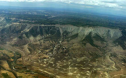
    Floating solar in U.S. reservoirs could produce 10 percent of the nation’s electricity #ActOnClimate

    Photo credit: CleanTechnica.com

    From EUCI.com:

    Floating solar panels on 24,000 man-made reservoirs in the U.S. could generate 10 percent of the nation’s electricity and avoid gobbling up 8,100 square miles of land with ground installations.

    One of the challenges with large-scale deployment of wind and solar generation is the land requirements but shifting to floating photovoltaics (PV) could offer one solution, according to researchers at the National Renewable Energy Laboratory (NREL).

    “In the United States, it’s been a niche application, where in other places, it’s really been a necessity,” said Jordan Macknick, the lead energy-water-land analyst for NREL and principal investigator on the project. “We’re expecting it to take off in the United States, especially in areas that are land-constrained and where there’s a major conflict between solar encroaching on farmland.”
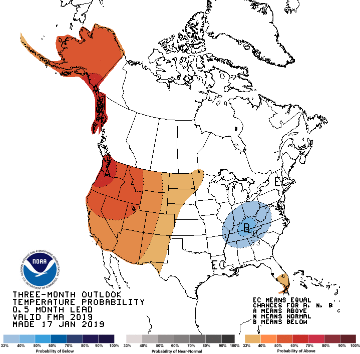
    The findings of the researchers appeared in the journal, Environmental Science & Technology.

    The 24,000 reservoirs identified as suitable for floating solar represent 27 percent of the reservoirs and 12 percent of the area of all man-made bodies of water in the contiguous U.S., the study said.

    Floating PV systems covering just 27 percent of the bodies of water identified as suitable could produce 10 percent of the country’s current electric generation…

    While the idea has not been widely adopted here, as of December 2017, there were seven floating PV sites in the U.S.—Japan has 56 of the 70 largest floating installations in the world. There are more than 100 worldwide.

    The floating PV comes with added benefits, including reduced water evaporation and algae growth in the reservoirs, the researchers said.

    The NREL team also found that operating floating PV alongside hydroelectric facilities yields increased energy output and cost savings because of existing transmission infrastructure.

    “Floating solar is a new industry enabled by the rapid drop in the price of solar PV modules,” Adam Warren, director of NREL’s Integrated Applications Center, said in a statement. “The cost of acquiring and developing land is becoming a larger part of the cost of a solar project. In some places, like islands, the price of land is quite high, and we are seeing a rapid adoption of floating solar.”
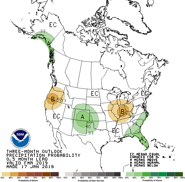

    Eagle whitewater park ready for #runoff

    From The Vaily Daily (Randy Wyrick) via The Aspen Times:

    The river part of Eagle’s ambitious river park is done, and even the fish appear to be happy about it.

    Hobbs Excavating crews recently finished the fourth of four in-river features.

    S2O Design, one of the world’s premier river engineering and whitewater design companies, designed the in-river features.

    “This setting matches the river’s natural morphology and utilizes the existing river channel really well,” said Scott Shipley, the founder and president of S2O Design. “It will surely be a new focal point for the town.”

    […]

    The in-river part of the project took two years to build, but the process started long before that with a feasibility study, then design and a detailed hydraulic modeling. The first two features were built last winter and spring when the water was low.

    Crews were back in the water last fall, and finished the other two river features in late December. The features create waves, eddies, chutes, and drops to play in for anything from tubes to surfing, standup-up paddling and kayaking.

    The park was the first built with S2O’s RapidBlocs that allows the features to be fine-tuned depending on water flows. That will lengthen the boating season in the park…

    S2O also designed the riverbank improvements, and included a bypass channel around the two upper features serving as a recreational safe route and a fish migration pathway, and mid-stream fish channels in the lower section so fish can migrate upstream.

    After Colorado Parks and Wildlife expressed some concerns about fish migration, the two features built this winter were modified, with crews installing concrete half hemispheres to make it easier for the fish to move…

    In 2016 Eagle voters approved a 0.5 percent sales tax to pay for the park and trail improvements. The entire park is scheduled for completion later this spring.

    The latest #ElNiño/Southern Oscillation (#ENSO) diagnostic discussion is hot off the presses from the CPC

    December 2018 ENSO model predictions.

    Click here to read the discussion:

    ENSO Alert System Status: El Niño Watch

    Synopsis: El Niño is expected to form and continue through the Northern Hemisphere spring 2019 (~65% chance).

    ENSO-neutral continued during December 2018, despite widespread above-average sea surface temperatures (SSTs) across the equatorial Pacific Ocean. In the last couple of weeks, all four Niño indices decreased, with the latest weekly values at +0.2°C in the Niño-1+2 region and near +0.7°C in the other regions. Positive subsurface temperature anomalies (averaged across 180°-100°W) also weakened, but above-average temperatures continued at depth across most of the equatorial Pacific Ocean. The atmospheric anomalies largely reflected intra-seasonal variability related to the Madden-Julian Oscillation, and have not yet shown a clear coupling to the above-average ocean temperatures. Equatorial convection was generally enhanced west of the Date Line and suppressed east of the Date Line, while anomalies were weak or near average over Indonesia. Low-level winds were near average, while upper-level wind anomalies were westerly over the eastern Pacific. The traditional Southern Oscillation index was positive, while the equatorial Southern Oscillation index was slightly negative. Despite the above-average ocean temperatures across the equatorial Pacific Ocean, the overall coupled ocean-atmosphere system continued to reflect ENSO-neutral.

    The majority of models in the IRI/CPC plume predict a Niño3.4 index of +0.5C or greater to continue through at least the Northern Hemisphere spring 2019. Regardless of the above-average SSTs, the atmospheric circulation over the tropical Pacific has not yet shown clear evidence of coupling to the ocean. The late winter and early spring tend to be the most favorable months for coupling, so forecasters still believe weak El Niño conditions will emerge shortly. However, given the timing and that a weak event is favored, significant global impacts are not anticipated during the remainder of winter, even if conditions were to form. In summary, El Niño is expected to form and continue through the Northern Hemisphere spring 2019 (~65% chance; click CPC/IRI consensus forecast for the chance of each outcome for each 3-month period).