Click on a thumbnail graphic to view a gallery of drought data from the US Drought Monitor.
US Drought Monitor January 8, 2019.
West Drought Monitor January 8, 2019.
Colorado Drought Monitor January 8, 2019.
Click here to go to the US Drought Monitor website. Here’s an excerpt:
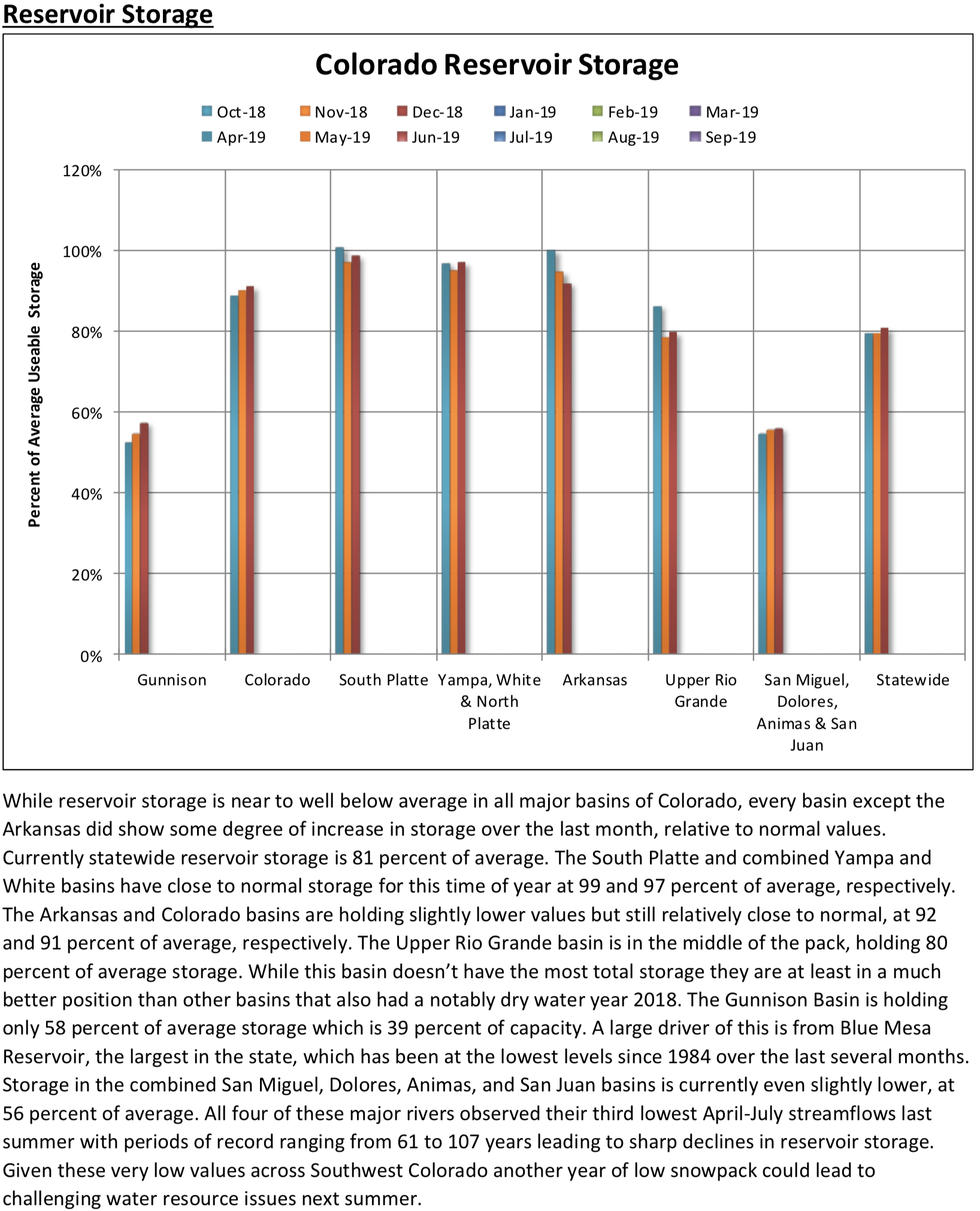
Summary
A strong upper-level low resulted in surface low development along the western Gulf Coast on January 3. This low pressure system then tracked northeast to the mid-Atlantic by January 5, maintaining excessive wetness across much of the lower Mississippi Valley and Southeast. However, southern Florida remained mostly dry as short-term dryness worsened. Onshore flow returned to the West Coast by January 5, resulting in rain and high-elevation snow. Although widespread precipitation occurred across coastal areas of Washington, Oregon, and northern California, 7-day amounts averaged below normal north of Eureka, California. Above-average precipitation amounts were observed across the southern half of California and the Southwest. According to the Natural Resources Conservation Service (WYTD), snow water equivalent (as of January 7) is at or slightly below normal across Arizona and New Mexico basin-wide for the water year. As an area of upper-level low pressure shifted east across the western U.S., a surface low and associated warm front crossed the Midwest and Great Lakes on January 7. The heaviest weekly amounts (more than 1 inch, liquid equivalent) were recorded from Wisconsin north to the upper peninsula of Michigan…
Following a week of widespread snowfall, mostly dry weather prevailed across the northern and central Great Plains. Based on a reassessment of departure from normal precipitation at varying time ranges (60 days to 6 months), moderate drought was reduced in coverage across North Dakota and limited to areas with the largest deficits. Elsewhere, across the Dakotas, no changes were made to the ongoing D0 areas…
Beneficial precipitation, with locally heavy high-elevation snow, continued across the Four Corners region into the first week of the New Year. Based on recent precipitation, near to above-average precipitation during the past 6 months, and SPI values near normal, abnormal dryness was removed from southeast Arizona with a slight reduction in the coverage of D1 and D2 where recent amounts were heaviest. Small areas of improvement also were made across southwest Colorado. Cortez in Montezuma County has received about an inch above normal precipitation since the beginning of the water year, supporting an upgrade from D4 to D3. In the San Luis Valley, recent precipitation prompted an improvement from D3 to D2. These areas of improvement are limited to the lower elevations since snowpack remains slightly below normal at the higher elevations. During the past week, local precipitation amounts exceeded 1 inch (liquid equivalent) in Unitah County, Utah where D3 was improved to D2. Farther to the north and east, little to no precipitation and above-average temperatures resulted in an increase in D1 across Adams and El Paso counties of north-central Colorado and an expansion of D0 from north-central Colorado into southern Wyoming. Abnormal dryness (DO) was removed from north-central Montana in early December. However, it has remained dry since that time and D0 may need to be reintroduced in the coming weeks.
Onshore flow continued to bring widespread rain and high-elevation snow to the West Coast during the first week of the New Year. However, ACIS indicates that precipitation has averaged below normal during the past 30 days across a majority of the Pacific Northwest and California. Santa Barbara and Ventura counties received another round of heavy precipitation (locally more than 2 inches) this past week, producing mud slides in burn-scarred hillsides. An increase in water storage on Cachuma Reservoir was noted. Based on recent precipitation and 12 to 24-month SPIs, a decrease in the coverage of D3 was made to these counties in southern California. According to SNOTEL, basin snow water content (SWE) remains below 75 percent of normal across the southern Cascades where D2 to D3 is designated. Recent heavy precipitation and only small precipitation deficits at 60 days prompted removal of abnormal dryness across parts of western Washington…
Widespread moderate to heavy precipitation (0.5 to 2.5 inches, liquid equivalent) fell across the lower Mississippi Valley and parts of the southern Great Plains for the second consecutive week. The recent precipitation during an ideal time of year for soil moisture recharge resulted in the removal of any lingering abnormal dryness (D0) across northeast Oklahoma and northwest Arkansas. However, the long-term drought area in the Texas Panhandle remained mostly west of the heavier precipitation and south Texas remained dry during the past week. Short-term abnormal dryness (D0) and moderate drought (D1) were expanded in southern Texas where 90-day deficits ranged from 1 to 4 inches.
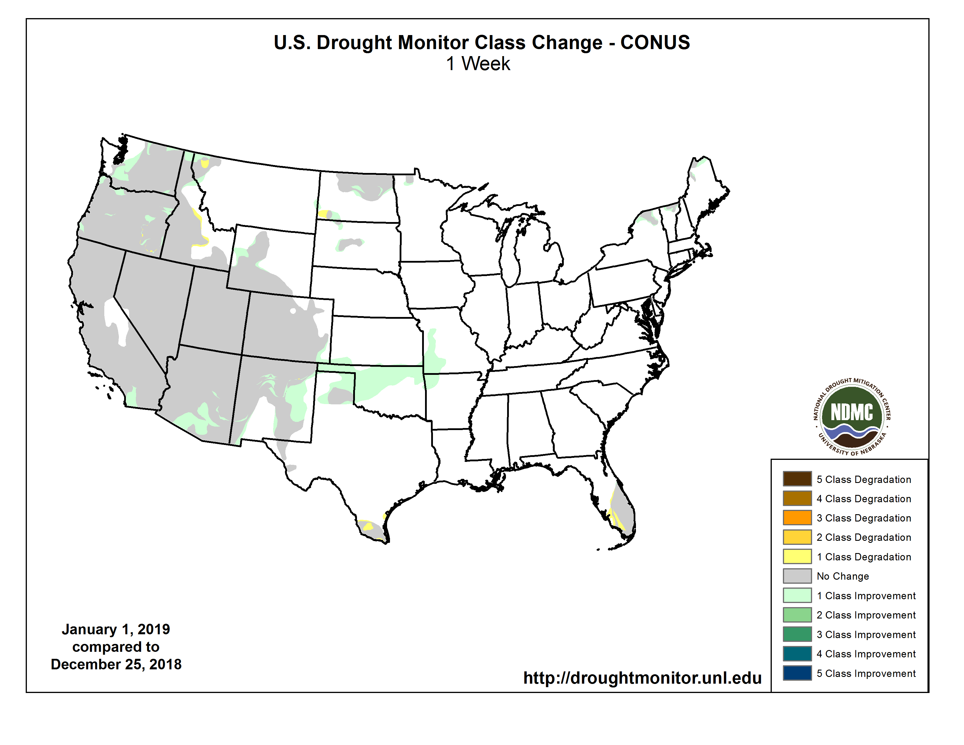
One week drought change map through January 8, 2019.
Graphic credit Cliff Vancura via The Durango Herald and Rocky Mountain PBS.
FromThe Durango Herald (Jonathan Romeo) via The Cortez Journal:
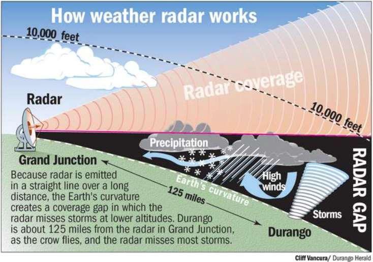
It’s official: A permanent weather radar system for Southwest Colorado and the Four Corners is on its way.
Recently, the Colorado Department of Local Affairs awarded $1.7 million in funding for permanent radar system, clearing the biggest obstacle in the project’s path.
“Funding was the big piece, and the state has been incredibly committed to and generous with this project because they recognize the need and value for all of Southwest Colorado, and beyond,” Megan Graham, spokeswoman for La Plata County.
The Four Corners has long been known as a blind spot when it comes to weather and radar modeling, as major hubs in Albuquerque, Grand Junction and Flagstaff take in data at elevations too high to accurately hone in on areas around Durango.
In Grand Junction, for instance, the radar system on Grand Mesa can’t pick up storms that come into the Four Corners at elevations below 28,000 feet, which causes weather forecasters to miss a good amount of incoming storms.
For years, there has been a desire to bring in a radar system for the region. But the need became critical after the 416 Fire last summer created unprecedented flood danger when storms hit fire’s burn scar.
DOLA recognized this need in granting the money.
“It’s very important for you guys to be able to know with radar what’s coming,” said Natriece Bryant, a spokeswoman for DOLA, “because notification is key to be able to prepare and recover when necessary.”
Chuck Stevens, interim La Plata County manager, said there’s no set timeline for when the radar system will be functional, but those invested in the project would like to break ground this spring…
The next big hurdle is finding the right spot for the radar system, Graham said.
The radar system needs to be set up in a location that both maximizes coverage while at the same time, is near infrastructure and utilities…
A group was formed, comprised of members of the Colorado Water Conservation Board, La Plata County, and the Southern Ute Indian Tribe, to select a location that makes the most sense, Graham said.
Gov. Jared Polis announced Wednesday that current Summit County Commissioner Dan Gibbs will serve in his cabinet as the next executive director of the Colorado Department of Natural Resources. The announcement was made a day after Gibbs was formally sworn in for his third term as commissioner.
In the coming weeks, Gibbs will sit for a confirmation hearing before the state Senate’s Agriculture and Natural Resources Committee. If the committee approves the appointment, Gibbs’ nomination will go before the full state Senate for confirmation.
If confirmed, Gibbs would head one of the state’s most important departments. The Department of Natural Resources oversees the Colorado Avalanche Information Center; the Division of Forestry; the Division of Reclamation, Mining and Safety; the Colorado Oil and Gas Conservation Commission; Colorado Parks and Wildlife; the State Land Board; the Colorado Water Conservation Board; and the Division of Water Resources…
Gibbs said that he plans to implement the governor’s vision for protecting and enhancing the state’s natural resources. As a certified wildland firefighter who has guided the county’s effective fire mitigation efforts, Gibbs plans to make wildfire mitigation a priority at the state level, along with other duties vested in a position that oversees a huge chunk of the state’s economy and cultural heritage.
The outstanding issues, some of which are proving contentious, range from developers’ concerns about securing future water supplies to lining up funding for Pinal County farmers to drill wells and begin to pump more groundwater.
A disagreement has also flared up over the terms of an “offset” provision that involves leaving water in Lake Mead to boost the levels of the dwindling reservoir.
These complications will force more talks geared toward achieving a consensus as the state Legislature begins session Monday and starts working on legislation that would authorize Arizona’s participation in a Drought Contingency Plan, or DCP, with Nevada and California.
Gov. Doug Ducey has called for the parties to quickly wrap up a deal, saying that with a critical shortfall imminent on the river, “we cannot kick the can any further.”
But at a meeting of the state’s steering committee Tuesday, the to-do list still appeared long. And several members of the committee voiced pointed disagreements on provisions that have yet to be finalized.
Last month, federal Reclamation Commissioner Brenda Burman set a Jan. 31 deadline for Arizona and California to finish their agreements and sign on. She said if the states fail to meet that deadline, the federal government will get involved and step in to prevent reservoirs from falling to critically low levels…
[Tom Buschatzke] and other water managers began the meeting Tuesday with an overview of where water levels stand in the river’s main reservoirs. Lake Powell is now 41 percent full, while Lake Mead is 39 percent full, just above a level that would trigger a first-ever declaration of a shortage.
They also reviewed a list of issues that have yet to be resolved, some of which relate to concerns of farmers in Pinal County, who have the lowest priority and face the biggest cuts in water deliveries.
The farmers had expressed worries about taking especially large cuts in the scenario of a more serious “tier 2” shortage at Lake Mead, and Tucson city officials have proposed to help in that scenario by providing the farmers up to 35,000 acre-feet of water per year for two years. (An acre-foot is 325,851 gallons, enough to cover a football field with a foot of water.)
“We believe it’s a prudent thing to do to give the certainty to Pinal agriculture that they’re seeking on volume in the first three years,” said Timothy Thomure, director of Tucson Water. He said city officials will help finish the Colorado River deal while presenting no risks to the city.
To make the deal possible, the city would ask that water credits in the Tucson groundwater management area be transferred to the city in exchange for credits it would get in Pinal County.
He said Tucson is also asking for reforms affecting how treated sewage effluent figures in the state’s framework of water laws. One of the changes, Thomure said, would be to eliminate a 2025 “sunset” provision on water agencies’ ability to get storage credits for effluent. The city is also seeking more long-term storage credit when effluent is used to replenish groundwater.
Buschatzke called it a “very creative proposal” and said he expects more talks will be needed to work out the specifics…
Representatives of developers have been pressing for a provision conditionally granting them a certain amount of water — 7,000 acre-feet per year — for the first three years of a shortage. Ted Cooke, general manager of the Central Arizona Project, supported the idea and said this provision for an additional water supply would go away if the Drought Contingency Plan is signed.
As the developers have proposed it, the conditional water supply would be included to backstop a larger deal that’s already set to free up more water for future development — just in case the plan isn’t signed in the end.
In that larger $95 million deal, the council of the Gila River Indian Community agreed last month to sell up to 33,185 acre-feet annually to the Central Arizona Groundwater Replenishment District for 25 years starting in 2020 — enough to supply more than 99,000 homes based on the average water use in the area. The transfer would take effect once Arizona signs the Colorado River deal.
That Gila River Indian Community’s water deal was welcomed by developers because it secures water supplies for more growth into the 2030s, said Spencer Kamps, vice president of legislative affairs for the Home Builders Association of Central Arizona.
“But having said that, like everybody around the table, we’re seeking certainty. And there is uncertainty on the DCP plan going through the legislative process,” Kamps said. “My members are seeking certainty as it relates to investment from, you know, our corporate offices.”
He said developers want to be sure that when a shortage is triggered “that there is a reliable supply.”
“The concern from us is the uncertainty if anything were to happen, obviously, moving forward with the DCP plan, and it wasn’t satisfactory to either the governor or whomever,” Kamps said. “And I think that’s a reasonable request, to ensure that development can move forward regardless of the conditions on the lake during this 7-year program.”
The developers’ proposal was firmly opposed by Buschatzke, who said adding that amount of water for three years would upset the “delicate balance” that has been negotiated in the plan. Buschatzke also said: “I’m not sure where that water would come from.”
Cynthia Campbell, a water adviser for Phoenix, called the developers’ proposal “unthinkable” and said the city won’t support it.
“We don’t have enough water to go around for all the contract holders,” Campbell said. “Why would you start talking about adding new parties to the dole? That’s crazy.”
Gov. Stephen Roe Lewis of the Gila River Indian Community said he thought the issue of future water supplies for development had been dealt with already. He said the council’s resolution approving the water deal is “self-executing” once Arizona signs the Drought Contingency Plan. He offered to consult with his council and send a letter clarifying the point.
Donald Pongrace, a lawyer for the Gila River Indian Community, said after the meeting that the developers’ proposal “would create a precedent of providing water out of priority that we and all other CAP contract holders would find objectionable.”
Lewis’ offer of sending a letter to clarify that the signing of the Colorado River agreement will trigger the water transfer should be sufficient to resolve the issue, Pongrace said, though he said it’s “unnecessary and somewhat insulting to the community’s integrity and overall participation in the process.”
[…]
Another issue that drew opposition from Lewis and Buschatzke was a proposal by CAP officials regarding the “offset” component of Arizona’s plan, which involves deducting some water supplies from a Lake Mead storage account and replacing those supplies on paper with water from other sources.
Originally the idea had been a water exchange between CAP and Salt River Project, but CAP officials have instead proposed an alternative in which their agency would keep the stored water in their account. Pongrace said that’s likely a nonstarter for the Gila River Indian Community because it would give the CAP board discretion to use the water as it sees fit, and potentially take the water out.
“It’s basically calling something conservation that isn’t,” Pongrace said. “It’s the equivalent of financial gimmickry, and we will not accept it.”
Despite the disagreements and the short timetable for drafting legislation, Cooke and Buschatzke both expressed optimism about finishing a deal.
“We’re going to work on things between now and when the legislature starts, and we’re going to work on things after the legislature starts,” Cooke said. “I think we’re closer than we’ve ever been, and I think we’re in closure range, definitely.”
Cooke said CAP and state water officials will work with legislative staffers to draft the package of legislation, and the idea is to keep it simple. The legislation is to include a resolution approving Arizona’s participation in the Drought Contingency Plan together with California and Arizona, as well as other measures outlining funding for the plan and several other changes that will be necessary to make it work.
An Arizona committee looking for ways to divvy up cuts from the Colorado River water supply says it has about a handful of issues to settle…
Farmers, cities, tribes, home builders, state agencies and others on the committee met Tuesday. Their goal is to save up to 700,000 acre-feet of water over seven years.
The Arizona Daily Star reports that farmers in Pinal County want more water and certainty in funding for groundwater wells.
Homebuilders also want extra water until a deal with a tribe is finalized.
Two Arizona water utilities remain at odds over water stored in Lake Mead.
The Arizona Legislature must approve the complex plan.
From the Cañon City Daily Record (Carie Canterbury):
During the Cañon City General Government Committee meeting Wednesday, Councilman John Hamrick said ratepayers need to understand that the council is looking at two different issues, the first being EPA compliance.
“We are required by the federal government to have a stormwater permit, to comply with that permit that requires us to spend money on certain actions, including establishing our own permitting program,” he said. “Right now, our stormwater fees are just taking care of that problem.”
On top of that, the city has a stormwater quantity problem.
“The monies to fix that problem is in a different bucket than the stormwater compliance problem,” he said. “The solutions for each problem are different and need to be developed differently.”
Councilman Jim Meisner recommended a two-fee approach, one for quantity and one for compliance, or quality…
Additionally, [Mayor Preston Troutman] said he’s in favor of the council considering credits that can be given for best management practices for detention facilities or for activities that go above and beyond the stormwater program requirements to reduce stormwater discharge, make improvements to water quality, develop low impact development practices and voluntary retrofit of existing best management practices.
The city staff will bring back more information on a credit system relative to quantity, the transfer fund and possible fees that are quantity and quality based at the end of February.
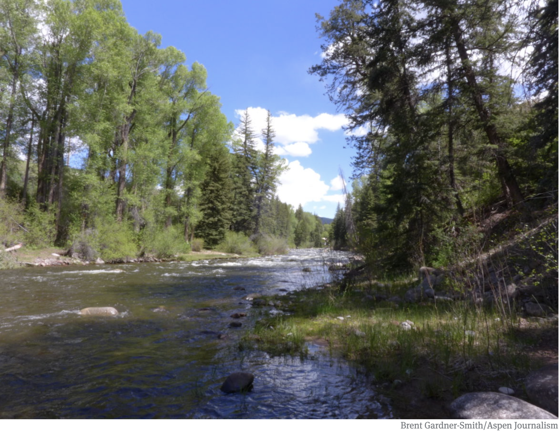
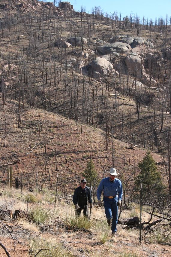
The upper South Platte River, above the confluence with the North Fork of the South Platte. Photo: Brent Gardner-Smith/Aspen Journalism
Click here to apply. From email from DWR (Michael Hein):
This job opportunity is for a vacant Colorado Division of Water Resources Augmentation Plan Auditor & Accounting Operations Specialist Team Lead for Division 1 located in our Greeley, CO office. This position is at the Physical Science Researcher/Scientist IV level (PSRS-IV) and is currently open to the public for application through January 25, 2019 or until 50 applications are received, whichever comes first.
This position provides leadership, guidance and oversight as a work leader to the Division 1 operations group responsible for Augmentation Plan coordination and administration. This group supports water rights administration by developing methodologies to collect and analyze water diversion and delivery data to verify augmentation plans and water diversions are operated in compliance with all applicable court decrees, statutes, rules and regulations. This position identifies and determines applicable professional standards and concepts incorporated into governing water court decrees and provide written protocol and guidance to staff regarding proper analysis of Augmentation Plan operation in accordance with water court decree requirements. This position, when necessary, provides recommendations for new process and procedures to collect, report, analyze and coordinate practices to allow compliance of these plans with the applicable decrees. This position prepares expert reports and expert testimony in Water Court trials not related to enforcement actions. Position is the work leader of three or more full-time positions.
Feds don’t want to gamble on risky water future—and give new urgency to complete the Colorado River Drought Contingency Plan.
Coming off the Colorado River Water Users Association conference in Las Vegas, southwest states have been issued a new deadline to complete the Drought Contingency Plan; otherwise, the federal government will step in.
Remember, this Drought Contingency Plan is a suite of agreements detailing proactive actions designed to reduce water use to stave off precipitous declines in water levels in the reservoirs on the Colorado River.
The Commissioner of the U.S. Bureau of Reclamation (USBR), Brenda Burman, said that Arizona and the other lower basin states have until January 31, 2019 to approve their respective commitments to the Drought Contingency Plan (DCP). After that, the Feds say they will act by opening up a notice in the Federal Register, where they will solicit comments from the seven Colorado River Basin states on what federal actions can best reduce the “unacceptably high” risk to Lakes Mead and Powell and the Colorado River. The comment period will be open for 30 days. After that, USBR will determine how it will protect the system ahead of their August 24-month study (where USBR determines what the following year’s water operations will be—namely what level of shortage Lake Mead is likely to be in, and the cuts each state will receive).
While Arizona and California may be close to the completion of DCP, Burman commented “close isn’t done” and “only done will protect this Basin.” She elaborated with sobering statistics on the bad hydrology, and the need for action in the form of DCP completion. This push for action by our federal government is a big deal.
As the Arizona Legislature opens up its 2019 session on January 14, there is much work to accomplish in a short amount of time. The Arizona Legislature must authorize the Arizona Department of Water Resource’s participation in the DCP.
Jennifer Pitt, National Audubon Society’s Colorado River Program Director, recently stated, “The Drought Contingency Plan is the key to avoiding really catastrophic problems for people and wildlife and birds in the Colorado River Basin.”
Audubon supports the passage of the DCP because it builds on a collaborative framework decided by the affected water stakeholders and it gives us a chance to adapt to these long-term changes in our water supply. If the collaborative approach fails, decisions on how to manage Colorado River water could become more disruptive, potentially decided through the courts or by federal officials. The DCP is key to avoid more catastrophic shortages in Lake Mead if the hydrology continues on its current trajectory.
The current way that Arizona envisions engaging in the DCP is through what Arizona stakeholders are calling the Implementation Plan. In general, the Implementation Plan allows for certain water users to be mitigated for the losses they would experience under DCP’s water cuts by temporarily providing them with water that has been stored in Lake Mead. This mitigation, delivering actual water to lower priority water users, is what Central Arizona water stakeholders have asked for in return for accepting the DCP. Should the states not meet the January 31 deadline, as water master in the Lower Colorado River Basin, the Feds could mandate shortage volumes without this kind of “soft landing” deal for water users.
Lake Mead is at its lowest point since the Hoover Dam was built, meaning there is less water to go around. To reduce water withdrawals from the Lake, as part of Arizona’s Implementation Plan, water users in the Lower Colorado River Basin would be financially compensated to reduce their water use. The water they don’t use will remain in Lake Mead, ensuring we contribute more water to the Lake than we take out. That reduces the chances the Lake declines beyond the point it can deliver water. Given the state of our hydrology, this is currently the best bet to avoid the risk of catastrophic water shortages that impact people and birds across the entire river basin.
Stay tuned as the deal comes together and start of the Arizona Legislative session nears.
First, the good news: The negotiators of Arizona’s Drought Contingency Plan have crafted the most detailed, concrete proposal to date laying out how Arizona will deal with expected cutbacks to its supply of Colorado River.
“We’re closer than we’ve ever been, and I think we’re in closure range,” said Ted Cooke, co-chair of the steering committee of the Drought Contingency Plan and general manager of the Central Arizona Project, after a three-and-a-half-hour meeting Tuesday.
Now, the bad: The partial shutdown of the federal government is squeezing these negotiators. A January 31 deadline set by the government approaches inexorably. Meanwhile, a last-minute push on Tuesday by homebuilders to receive more water in the plan threatens the precarious balance of the existing proposal.
“Right now, not having [our legal counsel] at work is very difficult, for us. It’s hard to move forward,” Leslie Meyers, Phoenix area manager for the Bureau of Reclamation, told reporters on Tuesday. “It’s hard to get some of the agreements done.”
The bureau, which is under the Department of the Interior, remains funded during the shutdown because it’s funded through energy and water appropriations. But the Office of the Field Solicitor, which does legal work for the Department of Interior, is not. If the shutdown continues, Meyers said, it was possible that their legal counsel would be brought back to work, albeit with no pay…
The Arizona Legislature and Governor Doug Ducey must also approve the plan and authorize Buschatzke to sign it before January 31. The legislative session begins January 14…
On Tuesday, homebuilder representatives brought talks to a boil again by reiterating a demand for water that generated sharp rebukes from some participants.
Their demand is one of the few remaining outstanding issues of Arizona’s Drought Contingency Plan: They want 7,000 acre-feet of water per year to go to developers and homebuilders. The Central Arizona Project, which is putting $65 million into the Drought Contingency Plan, supports the idea. The Arizona Department of Water Resources, along with the city of Phoenix, the private water company EPCOR, the development group Valley Partnership, and several others are against it.
They point out that through a recent agreement for the Gila River Indian Community to supply water to the Central Arizona Groundwater Replenishment District for the next 25 years, developers and homebuilders have plenty of water for the future.
However, that deal requires the Drought Contingency Plan to go through.
Spencer Kamps, vice president of legislative affairs for the Home Builders Association of Central Arizona and a steering committee member, said that homebuilders wanted more certainty than that, given that the Legislature has to approve of the Drought Contingency Plan…
What befuddled the members, however, was his demand for more water. Kamps asked, as developers have requested before, for 7,000 acre-feet to be included in the Drought Contingency Plan. This, he said, would be a backstop, just in case the Drought Contingency Plan, and thus the deal with Gila River Indian Community, did not go through…
Governor Stephen Roe Lewis of the Gila River Indian Community pointed out that the deal signed with the Central Arizona Groundwater Replenishment District was “self-executing.” Once the Drought Contingency Plan went through, he would sign it; he was authorized to do so by the tribal council in December.
Sounding strained, he said he thought this matter had been taken care of in December. He added, “I hoped that we wouldn’t still be talking about this issue as we’re doing today.”
Cynthia Campbell, water resources adviser for the city of Phoenix, said that including water for developers was “quizzical at best.”
“It’s hard to understand how this even works,” she said, adding that a major flaw in the request was that it wasn’t clear where the additional water would come from. “The city of Phoenix will not support a DCP that includes that,” she said flatly.
Doug Dunham, of the private water provide EPCOR, echoed Campbell’s comments before Cooke quietly suggested that this issue would not be resolved that day.
Four key issues remain unsettled as negotiators for a Colorado River drought-adaptation plan wrap up discussions and prepare to send a complex package of water-saving proposals to the Arizona Legislature.
Farmers, developers and officials of the $4 billion Central Arizona Project said Tuesday they still aren’t satisfied with various provisions in a proposed drought contingency plan aimed at propping up imperiled Lake Mead. Because of that, negotiations over details will probably have to continue even when the Legislature starts debating the plan next week.
But leaders of the prolonged effort to produce a drought contingency plan for Arizona say they’re optimistic of getting the issues resolved and a legislative sign-off in time to meet a federally imposed Jan. 31 deadline to adopt the plan.
Tuesday, during the eighth meeting of an advisory committee working on the plan, members groped for solutions and compromises but those remained elusive, although progress was made.
“There are only four issues left. We have 82 things that we’ve solved,” CAP general manager Ted Cooke said at a news briefing after the meeting of the 40-member advisory committee that’s worked since July on the drought plan…
But at Tuesday’s advisory committee meeting, these unsettled issues emerged:
Pinal farmers are scheduled to get 105,000 acre-feet of CAP water in both 2020 and 2021 if shortages are declared for 2020, less than half what they get now. In 2022, that supply will be whittled to 70,000 acre-feet a year if the river is running low due to dry weather.
Farmers, however, want 105,000 acre-feet of CAP water for 2022 as well, and it’s uncertain where that extra water would come from.
Tim Thomure, a committee member and Tucson Water’s director, said he would be prepared to offer 35,000 acre-feet annually for two years, water that would be placed on Pinal County farm fields.
But making that offer will require four changes in state law to make it easier for the city of Tucson to use or sell “credits” it would gain from storing the water on those fields to allow it to pump additional groundwater elsewhere, he said. State Water Resources Director Tom Buschatzke praised Thomure’s proposals as “creative,” but said some other interests whom he didn’t name might not support more water for farmers out of concern that it wouldn’t be fair to other water users.
Paul Orme, lobbyist for four irrigation districts, wants more “certainty” about getting federal funding to help pay for the farms’ new groundwater wells, whose expected cost has escalated from $30 million to $50 million. The state and CAP have agreed to pay or support future legislation to provide close to half those costs. But Orme noted that competition for the federal funds with farmers in other states will be fierce, although Bureau of Reclamation officials in Arizona will support the Pinal farmers’ quest.
The Central and Southern Arizona Home Builders Associations want 7,000 acre-feet of “mitigation” CAP water set aside to serve future suburban development, although officials say there is no alternative source of water to fulfill that request. The Gila River Indian Community has already agreed to lease 33,000 acre-feet of its CAP water for future suburban growth — once it’s certain that the drought plan will pass the Legislature.
The homebuilders groups say they want the extra 7,000 acre-feet included in the plan as a matter of “certainty,” and that pool of water could be removed once it’s clear the Gila Indian deal will go through. A Phoenix-based developer group, the Valley Partnership, disagrees, with its director Cheryl Lombard saying its members see no need for the extra 7,000 acre-feet.
CAP and the Salt River Project utility are at odds over a plan for the utility to replace some water now stored in Lake Mead, which CAP wants to remove from the lake to help mitigate farm water losses. As the plan would work, the utility would supply CAP 50,000 acre-feet from 2021 to 2025. Cooke said his agency has legal, contractual and hydrological concerns with the idea.
He acknowledged that, currently, that issue is “the only one I don’t know how to (solve). But we’ll figure out a way to solve that.”
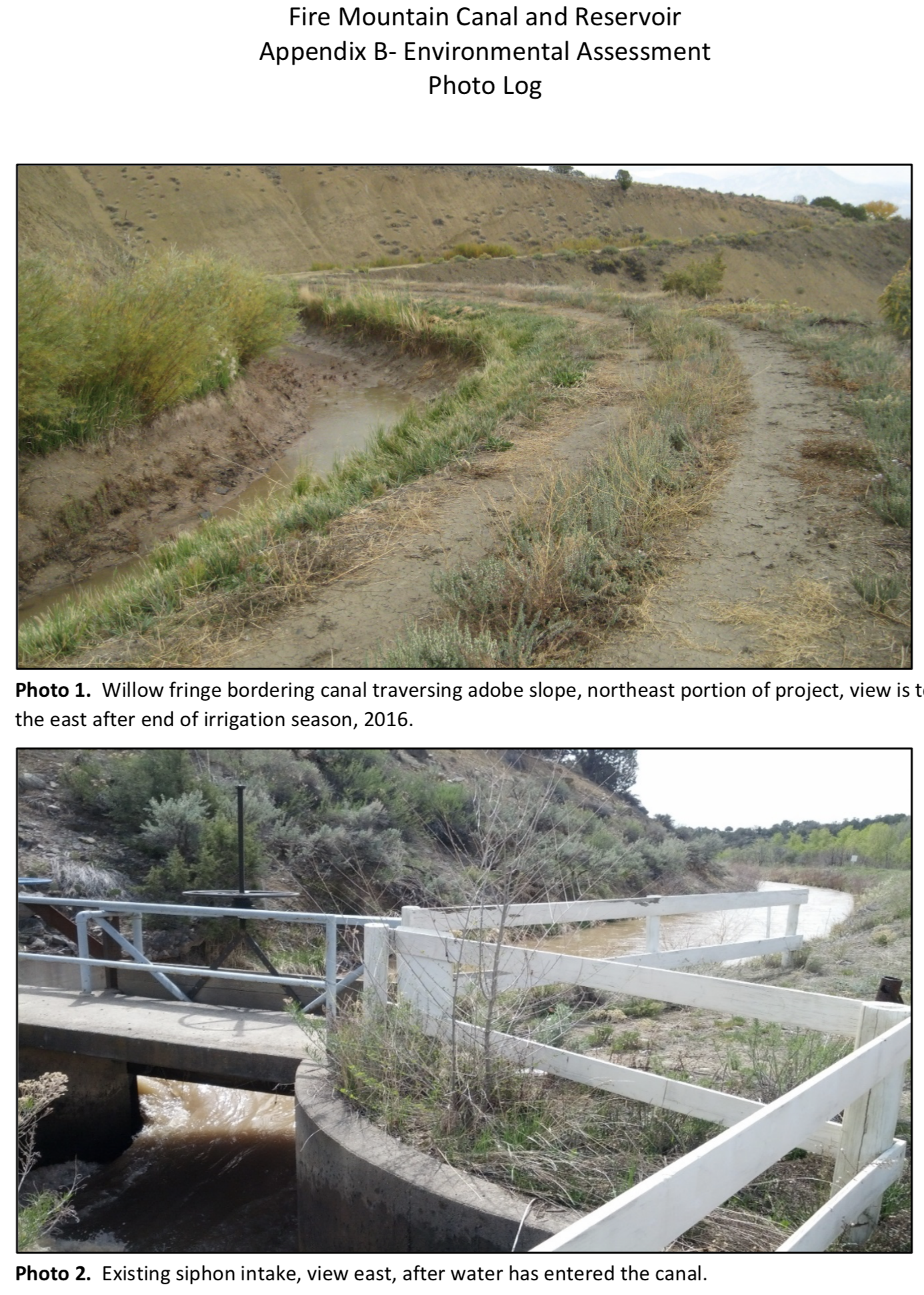
Colorado U.S. Senator Michael Bennet today applauded the groundbreaking of the Fire Mountain Canal Improvement Project in the North Fork of the Gunnison River.
“Because our parents and grandparents made necessary investments in water infrastructure, agriculture has thrived on the Western Slope,” Bennet said. “We need to make these same investments for future generations. The demands on our rivers are greater than ever as we face the challenges of climate change and a growing population. Collaborative efforts like the Fire Mountain Canal Improvement project are critical to making irrigation systems more efficient to support our agricultural economy.
“Congratulations to all of the local, state, and federal partners who collaborated to make this project a reality. Our work to secure the Critical Conservation Area designation, and federal funding through the Farm Bill, are the first of many actions we can take to invest in Colorado’s water security,” Bennet concluded.
In 2014, Bennet secured the Critical Conservation Area (CCA) designation for the Colorado River Basin, making the lower Gunnison basin eligible for federal funding. As a member of the Senate Agriculture Committee, Bennet then helped craft a new Regional Conservation Partnership Program (RCPP) in the 2014 Farm Bill, which secured $8 million for the Colorado River District project in the Lower Gunnison River Basin. In the 2018 Farm Bill, Bennet worked to reauthorize and increase funding for the RCPP and direct more funding toward water infrastructure and drought resilience across Colorado and the West.
The $4.6 million Fire Mountain Canal Improvement Project will build a buried, large-diameter pipeline along four miles of currently unlined canal. The project is part of the $50 million Lower Gunnison River Basin Project, spearheaded by the Colorado River District, with combined funding from the Natural Resources Conservation Service, the U.S. Bureau of Reclamation, the Colorado Water Conservation Board, local water conservancy and conservation districts, and local irrigation companies such as the Fire Mountain Canal and Reservoir Company.
FromThe Grand Junction Daily Sentinel (Dennis Webb):
A sweeping, multi-entity effort in the lower Gunnison River Basin to boost irrigation efficiency and help the environment is marking a milestone with the start of work on a pipeline project in the North Fork Valley.
A groundbreaking celebration Tuesday marked the beginning of the Fire Mountain Canal Improvement Project. The $4.6 million undertaking, which is expected to take two years to complete, is part of the larger, $50 million Lower Gunnison Project.
The Fire Mountain work involves converting more than four miles of open, unlined, earthen canal to a buried, large-diameter pipeline.
That will eliminate water loss along the canal route and also result in a pressurized supply reaching irrigators who can then use methods such as sprinklers or drip systems to water crops more efficiently than with flood irrigation…
Dave Kanzer, deputy chief engineer with the Colorado River District, which is managing the Lower Gunnison Project, said the Fire Mountain project will benefit some 5,000 acres of irrigated ground.
The potential benefits to the Fire Mountain system were made evident last summer when drought taxed its water supply. Kanzer said Fire Mountain is what’s called a “water-short” system.
It has a brief, limited water supply season, relying on water from Paonia Reservoir and unable to tap supplies from the Gunnison River mainstem.
Kanzer said converting to sprinklers allows for switching to minimum- or low-till agriculture, which allows for carbon capture and accumulation of organic matter in soil, as an alternative to using chemical fertilizers.
These changes in irrigation approaches also mean less concentration of salts and other chemicals in soil, less salt and selenium in waterways and improved river flows, which benefit wildlife, including endangered fish downstream.
While several projects in the lower Gunnison basin have gotten underway as part of the umbrella Lower Gunnison Project, Kanzer said the Fire Mountain project is the first large one. A $5 million pipeline project in the Uncompahgre River Valley also is going forward this year, he said.
The Lower Gunnison Project incorporates funding from the U.S. Department of Agriculture, the federal Bureau of Reclamation, the Colorado Water Conservation Board, local water conservancy and conservation districts, and irrigation companies including the Fire Mountain Canal and Reservoir Co.
The project is the product of a diverse partnership and is focusing on improving agricultural water use efficiency in areas covered by the North Fork Water Conservancy District, Bostwick Park Water Conservancy District near Montrose, the Crawford Water Conservancy District and the Uncompahgre Valley Water Users Association.
Here’s the release from the NRCS (Brian Domonkos):
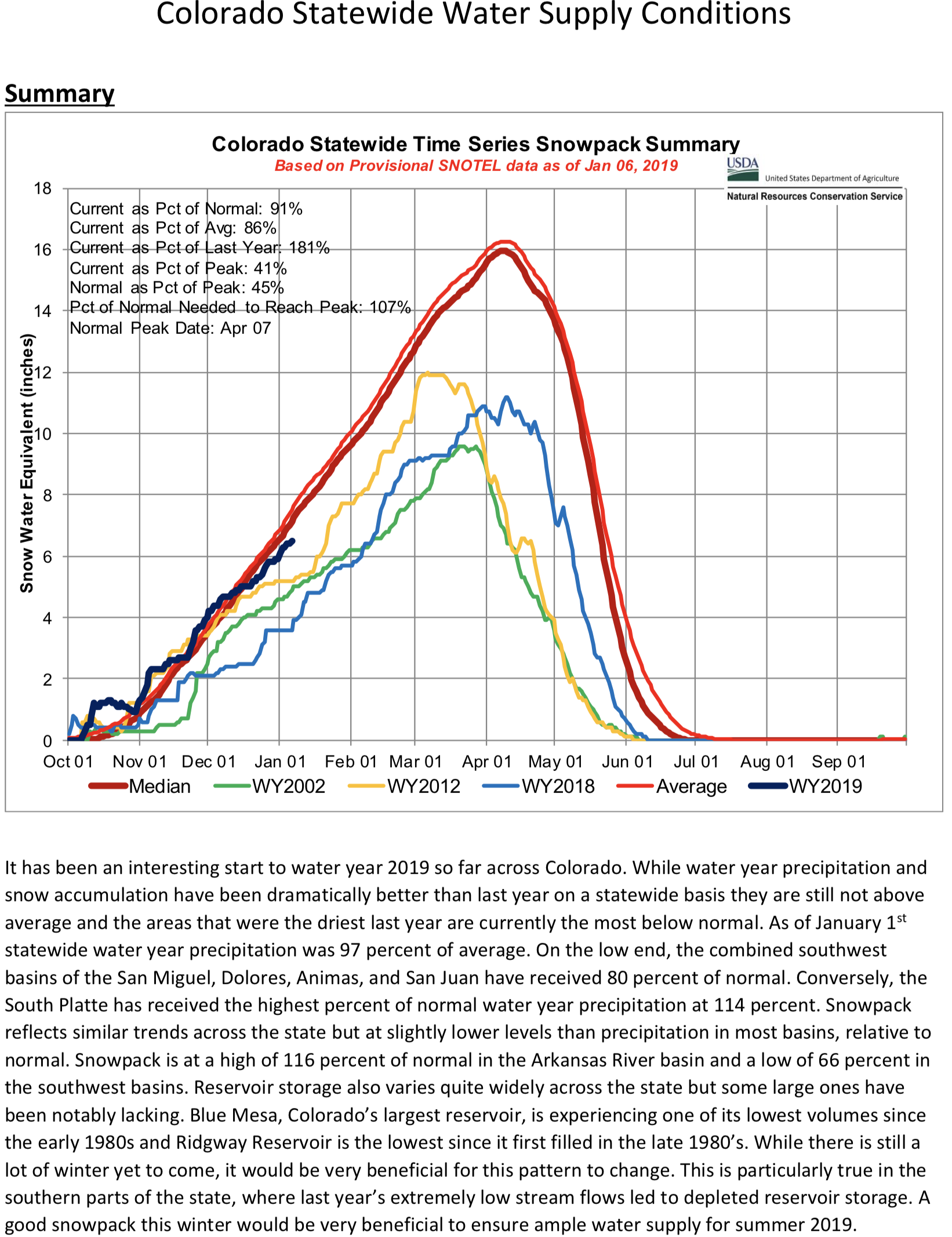
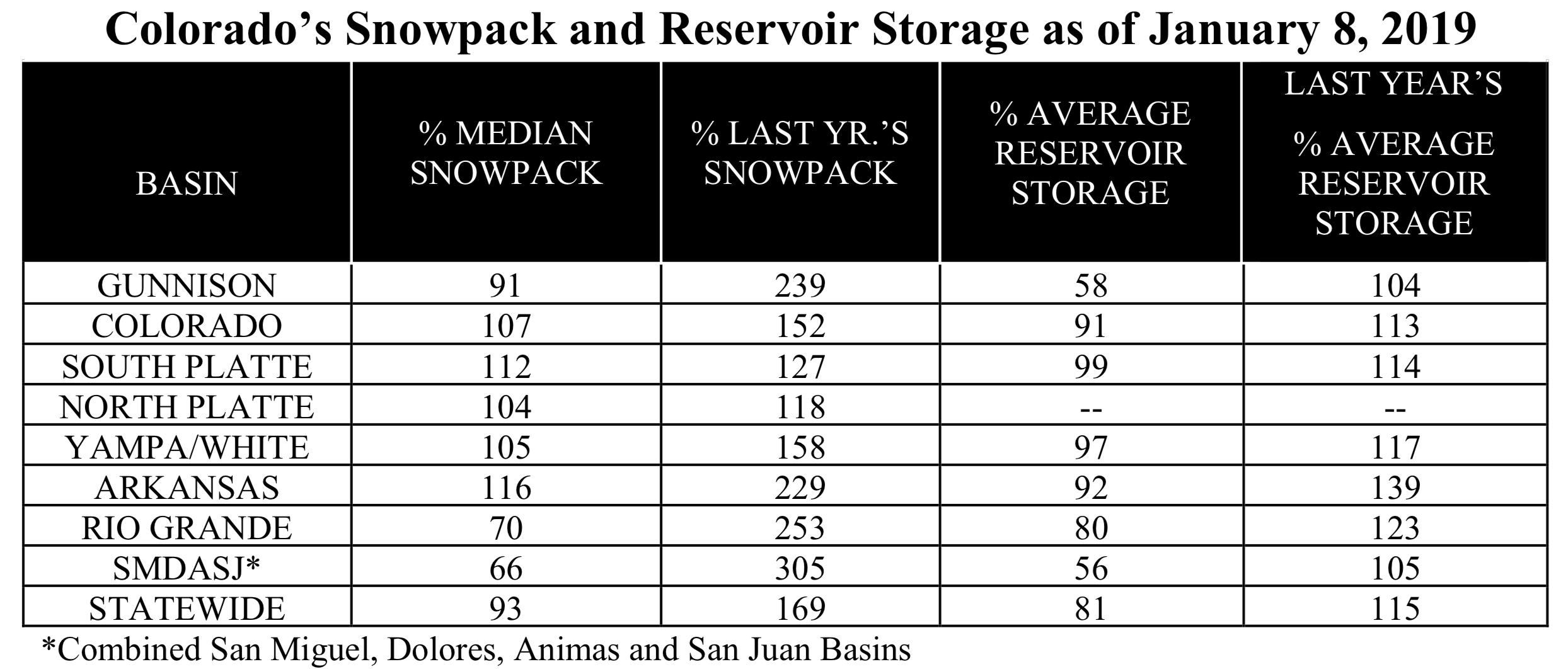
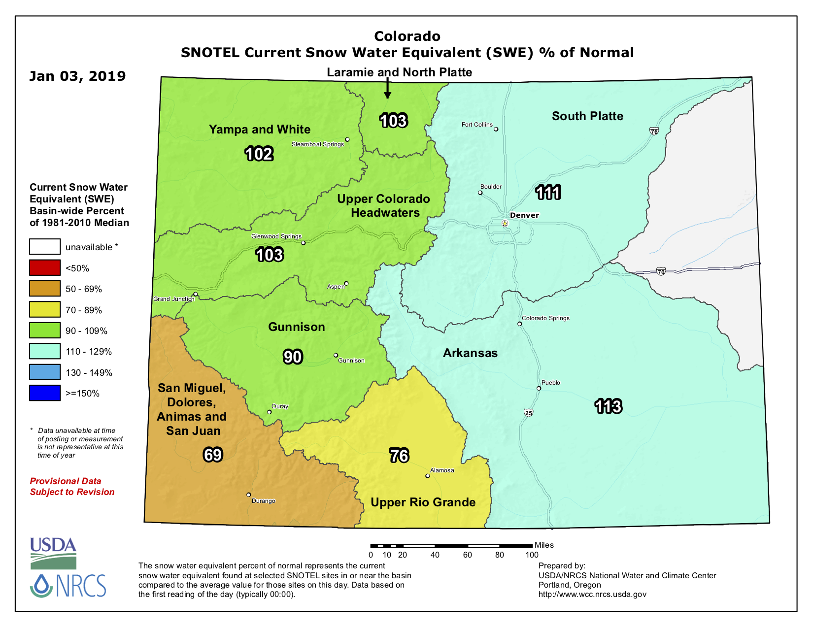
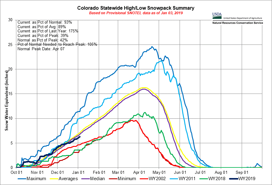
The new water year began with promise last October, but the promise for an abundant water supply waned by the end of December. The San Miguel, Dolores, Animas & San Juan, Colorado, and Upper Rio Grande basins all showed October precipitation totals of 140% of normal or better. Other basins also received above normal precipitation for the month with much of the state’s precipitation falling in the form of early season snow. November precipitation totals continued the above normal trend across the state in all but the San Juan Mountain Range and on the Grand Mesa where snowfall was less prevalent. But ultimately October’s precipitation boom was outweighed by the bust of December. Last month the Gunnison River basin experienced the state’s best monthly basin-wide precipitation totals at a meager 74% of normal. Summarizing the state’s totals, “On January 1, 2019 precipitation is currently at 97% of normal and snowpack is at 93% of normal, considerably better than this time last year when totals were 50% and 54% of normal respectively,” comments Brian Domonkos, Hydrologist with the USDA’s Colorado Natural Resources Conservation Service.
At the watershed level, current snowpack conditions are also much improved compared to last year. For example, this year snowpack in the Upper Rio Grande is currently at 70% of normal where last year at this time snowpack was 29% of normal. Similarly, snowpack in the combined San Miguel, Dolores, Animas & San Juan basins is currently 66% of normal where last year snowpack was 22% of normal.
After a below normal December, Colorado’s snowpack is approaching a pivotal point during the winter. Domonkos continues, “The middle of January typically marks the midpoint of reaching the annual snowpack peak across the state of Colorado.” The state is little more than a week away from the halfway mark meaning recent snowfall rates will need to pick up considerably for all of Colorado’s river basins to come close to a normal snowpack for streamflow runoff. In particular, southwestern Colorado needs to make up deficits from last year’s shortage of snowpack and depleted reservoir storage.
Statewide reservoir levels are below normal for this time of year at 81% of normal. Reservoir deficits from last year in the Gunnison and San Miguel, Dolores, Animas & San Juan basins continue to persist after an unusually dry winter last year.
From Stanford University Water in the West News (Devon Ryan):
A new report shows environmental water transactions are happening more and more in the U.S., particularly short-term deals that allow irrigators to conserve or forgo water use for short periods of time.
Use it or lose it. Historically, that was the prevailing understanding amongst water rights holders throughout the Western United States. Farmers, ranchers and other water right holders had to use all of their allocation or risk forfeiting their rights, which could endanger their operations in the future should they run into a dry year. Thus, there was no incentive or even ability in some cases to leave water instream for recreation, fish populations, ecological restoration, or other positive environmental uses. However, over the last 30 years, state laws have relaxed to allow voluntary transfers of water for environmental uses (also known as environmental water transactions) without risking the farm.
A new report released today by Stanford’s Water in the West program takes a detailed look at these transactions in five states in the Colorado River Basin: Arizona, Colorado, New Mexico, Utah and Wyoming. A previous study showed that Colorado River Basin states lag behind some other western states in laws that facilitate changing water rights to environmental uses for extended periods of time. The new report shows that irrigators and conservation groups are using short term deals that require no administrative participation by the state.
“What was most surprising is how many short-term deals set up by water right holders and conservation groups were happening in the Basin,” said Leon Szeptycki, Executive Director of Water in the West and lead author on the report. “These deals don’t involve a formal change in water right but they nonetheless accomplish the goal of conserving water and leaving more instream.”
While they don’t legally protect water instream, flexible approaches, such as split-season leases where water right holders agree not to irrigate during the latter part of the growing season, enhance local water security and farming and ranching flexibility, while benefiting the environment with more water for fish, aquatic habitat, and recreation.
The most notable program for informal water transactions was the System Conservation Pilot Program (SCPP). Ending this year after a four-year operation period, the program was designed to test the feasibility of enhancing conservation and water security by compensating ranchers and farmers for reducing their water use. Improving instream flow for the environment turned out to be a positive co-benefit and helped Wyoming have the highest number of transactions out of the five states researched with 47 from 2014 to 2018. Conservation organizations such as Trout Unlimited and The Nature Conservancy helped facilitate many of these transactions and worked with landowners to develop eligible projects.
“What we found is that transactions in the Basin are increasing and it seems mostly due to increased funding through programs like SCPP,” said Szeptycki. “There’s also a greater willingness on the part of landowners to experiment with short term options that don’t commit them to these decisions in the longer term.”
The work follows a previous report which analyzed the laws and policies regarding formal transfers of water rights to environmental uses in Colorado River Basin states and compared them, along with Oregon, considered a policy leader in this field. That report showed that the Colorado River Basin states were lagging behind those in the Columbia River Basin which had more developed mechanisms and policies for transferring water to the environment.
“There’s a natural connection between water conservation, water security and stream flow,” said David Pilz, Director at AMP Insights and co-author on the report. “Embracing flexible and creative approaches to increasing flow instream is potentially a win-win-win.”
This report is part of a series undertaken by Stanford’s Water in the West Program in collaboration with AMP Insights and other experts and was funded by the Walton Family Foundation. More on this series can be found here.
Media Contact
Leon Szeptycki
leonsz@stanford.edu, 650-721-3047
Devon Ryan
devonr@stanford.edu, 650-497-0444
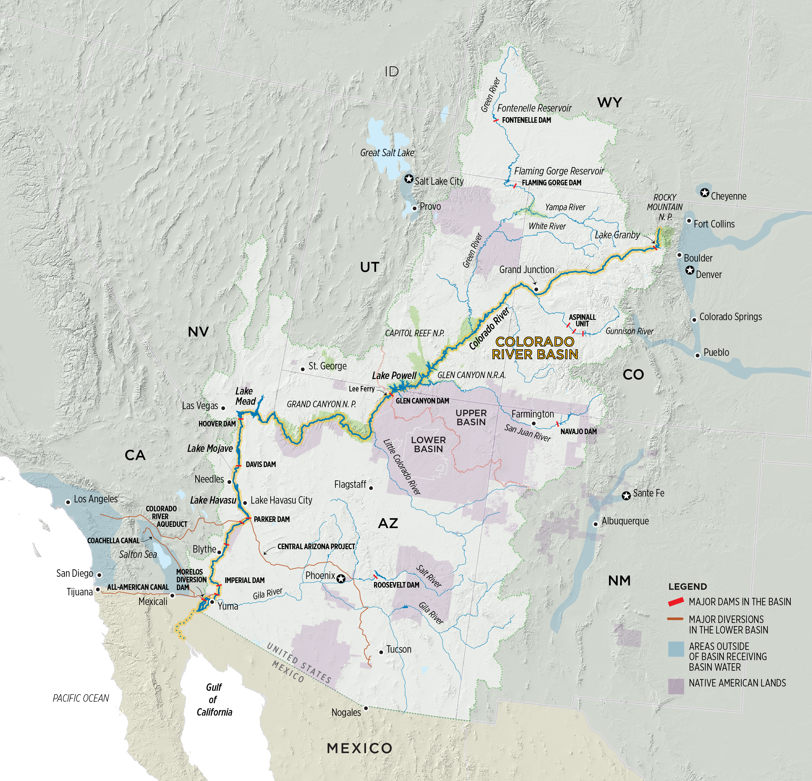
Colorado River Basin. Graphic credit: Water Education Colorado
As predecessors before them, Renewable Water Resources spokesmen on Thursday outlined plans for a 22,000-acre-foot water export project stemming from the northern San Luis Valley to customers in the south metro Denver area.
“This will be a win-win,” Sean Tonner told the Rio Grande Water Conservation District (RGWCD) board during a special meeting Thursday morning.
Tonner is a managing partner with Renewable Water Resources (RWR), a Colorado company with support from former Governor Bill Owens (for whom Tonner worked as deputy chief of staff when he was governor), former State Senator Greg Brophy, Greg Kolomitz and others. Tonner said he purchased the former Gary Boyce holdings encompassing 11,500 acres in the northern part of the Valley. Boyce, who died of cancer in 2016, had proposed a similar water export project.
Accompanying Tonner were RWR attorney Kevin Kinnear and Jerry Berry, who manages the RWR property and has been farming in the northern part of the Valley since 1996. Berry said he has been part of the Moffat community most of his life, serving on the school board there and on the RGWCD Sub-district #4 board.
Tonner said RWR wants to partner with the water district in identifying the best sources of water to provide the one-for-one replacement for the 22,000-acre-foot export while meeting the water district’s goals of reducing irrigated acreage and bringing balance to the hydrology of the Valley. The project would budget $60 million for that water acquisition.
Tonner said RWR estimates water could be purchased at about $2,000 an acre foot, depending on the water rights. RWR will be purchasing both surface water and groundwater, he said.
Berry said there are local residents interested in selling their water.
RGWCD Board Member Peggy Godfrey added she would not be surprised that there were people in the northern part of the Valley willing to sell their water, because they have not been able to use it to the full extent they should have been able to, and what RWR could offer them might help them afford to continue doing what they love to do.
Tonner said RWR would rather work with the water district than have an adversarial relationship. He said this project would return “one for one plus”, making up for the 22,000 acre feet that would be exported, “plus” for a total of 30,000-35,000 acre feet. In addition, RWR would set up a $50 million community fund…
Water would be piped from the Valley, with the buyers footing the bill for that pipeline, Tonner said. He added that RWR was requiring the buyers to limit the size of the pipe to no more capacity than the 22,000 acre feet.
He said currently the estimated cost of building the pipeline is $550-600 million.
RGWCD Board President Greg Higel said he doubted that Aurora and Castle Rock would want to build a pipeline just for 22,000 acre feet of water, and if it were constructed for more water, “that’s the beginning of the end.”
Tonner said the partners have been clear about the pipeline restrictions and the sellers are fine with it.
“Honestly, that’s hard for me to believe,” Higel said.
RGWCD Board Member Cory Off, who extensively questioned the RWR representatives, asked how long it would take to capitalize a project of this magnitude, and Tonner said “roughly five years.”
Regarding the project timeline, Tonner estimated close to 10 years “start to finish.”
Tonner said partners have been working on this proposal for about four years and hope to file something in water court in 2019 but would be fine with it taking longer if necessary. He said those involved have been working with individuals on both sides of the hill — potential waters sellers in the San Luis Valley and potential water buyers in the Denver metro area.
Every March, thousands of Sandhill cranes stop in #GreatSandDunes National Park & Preserve on their way to their northern breeding grounds. The fields and wetlands of #Colorado’s San Luis Valley provide excellent habitat for these majestic #birds. With the dunes and mountains nearby, they dance and call to each other. It’s one of nature’s great spectacles. Photo @greatsanddunesnps by #NationalPark Service.
From Audubon (Karyn Stockdale). Here’s an excerpt:
This year, despite another year of extraordinary drought and policy challenges, we had a tremendous year for Audubon’s Western Water work. Together, with your support, bird-watchers engaged in our first Western Rivers Bird Count and worked with conservation NGOs, government agencies, hunter/angler partners, and others in order to avoid catastrophic water shortages on the Colorado River…
CU Boulder researchers harness 35 years of data to uncover responses of a high-elevation reservoir to a warming world
The surface waters of Lake Dillon, a mountain reservoir that supplies water to the the Denver area, have warmed by nearly 5 degrees Fahrenheit (2.5 degrees Celsius) in the last 35 years, which is twice the average warming rate for global lakes. Yet surprisingly, Dillon does not show adverse environmental changes, such as nuisance algal blooms, often associated with warming of lakes. Researchers at the CIRES Center for Limnology, who have just published a multi-decadal study of Lake Dillon, conclude that the lake’s rapid warming and its lack of ecological response to warming are explained by the high elevation of the lake.
“The warming of Lake Dillon is a result of climate change but, in contrast with warm lakes, which respond in undesirable ways to warming, Lake Dillon shows no environmental response to warming, said William Lewis, Director of the CIRES Center for Limnology and lead author of the new paper published today in AGU’s Water Resources Research. “The explanation for the lake’s ecological stability lies in its low temperature, which serves as a buffer against ecological effects of warming.”
Since 1981, Lewis and colleagues in the CIRES Center for Limnology have collected detailed information not only on Lake Dillon’s temperature, but also on its water quality and aquatic life. Full vertical profiles of water temperature document changes in vertical distribution of heat over time. The record shows that warming of tributary water contributes to warming of the lake’s deepest waters.
“The 35-year data set allows us to see the complete warming pattern of the lake,” said James McCutchan, associate director of the Center. Natural events, including droughts and floods, create interannual variation that obscures the effects of climate change over short intervals, whereas multidecadal data sets can show more clearly the effects of climatic warming.
Dillon is the highest lake yet studied for full water column warming, as Lewis and his colleagues note in their paper. The study also is the first to analyze warming in a reservoir, rather than a natural lake.
“Reservoirs can differ fundamentally from other lakes in their response to warming because they often release water from the bottom as well as the top of the water column,” said Lewis. “They can warm not only from the top, in response to solar radiation reaching the surface, but also from the bottom, as tributaries subject to climatic warming replace cold bottom water with progressively warmer tributary water.”
The Lake Dillon study program is sponsored by Denver Water, which uses the water for treatment and delivery to Denver residents, and by the Summit Water Quality Committee, which represents the interests of local residents in preservation of Lake Dillon’s water quality.
Denver received only 8.53 inches of precipitation (rain and snow-equivalent rainfall) in 2018, making it the sixth-driest year in the city’s recorded history. That’s a striking number for a bunch of reasons, but the main one is that it’s less than 60 percent of Denver’s average annual precipitation of 14.30 inches.
Here’s another way to think about it: Denver saw less rain in 2018 than true desert climates like Phoenix and Tucson, and Denver saw a rain total closer to America’s driest major city, Las Vegas (4.19 inches) than our average annual rainfall. Denver saw about 12 percent of Atlanta’s annual precipitation, 13 percent of New York’s and 17 percent of Chicago’s…
…only two months last year produced above-average moisture (January and March). The worst of the drought came in June (22 percent of average rainfall), July (48 percent), August (55 percent) and September (19 percent).
Why did 2018 lean on the drier side? When you’re measuring a full year’s worth of moisture, there are several factors to consider, but one thing stands out: an exceptionally dry late spring and summer, which is usually Denver’s wettest season. Summer storms usually help soak the ground. Droughts are often exacerbated by a positive-feedback loop, meaning dry soils and a lack of moisture in the air can suppress future rain and snow chances.
There was also a striking lack of snowfall in Denver for the second consecutive winter. DIA and Stapleton recorded less than half of Denver’s typical annual snowfall of about 57 inches. After the 2016-’17 winter produced the second-lowest snow total in Denver’s recorded history, the 25.7 inches DIA registered in 2018 was a slight improvement, amounting to the fifth-lowest snow total in the city’s recorded history.
On the third Thursday of each month, the International Research Institute for Climate and Society holds a climate briefing, where it releases updated global seasonal climate forecasts as well as its forecast on the El Niño-Southern Oscillation. In this video, IRI’s Tony Barnston summarizes the key points from that briefing. For more, visit iri.columbia.edu/enso and follow #IRIForecast on Twitter.
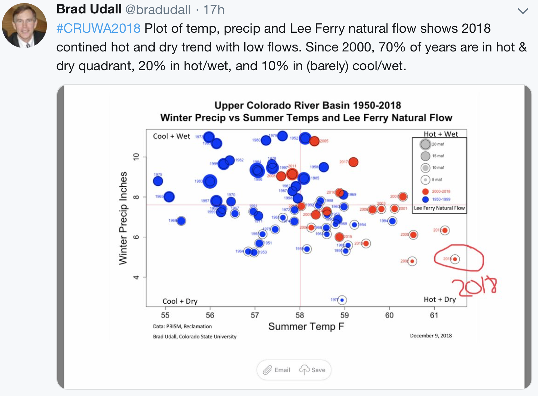
The Colorado River — Tucson’s drinking water supply — carries nearly 20 percent less water than in 2000. Bark beetles are chomping away at our forests and killing off ponderosa pines. Wildfires are rapidly growing in intensity.
These problems have been linked to a drought that has stretched 19 years with no respite.
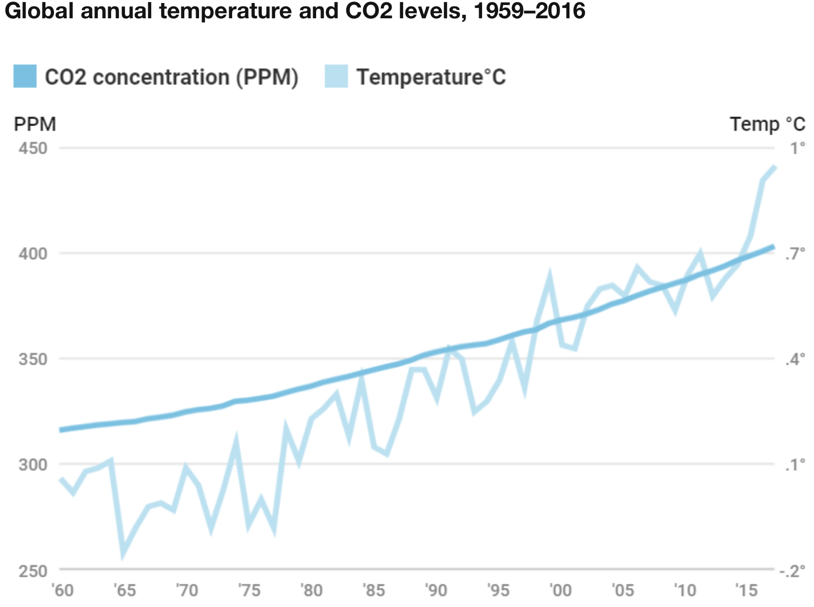
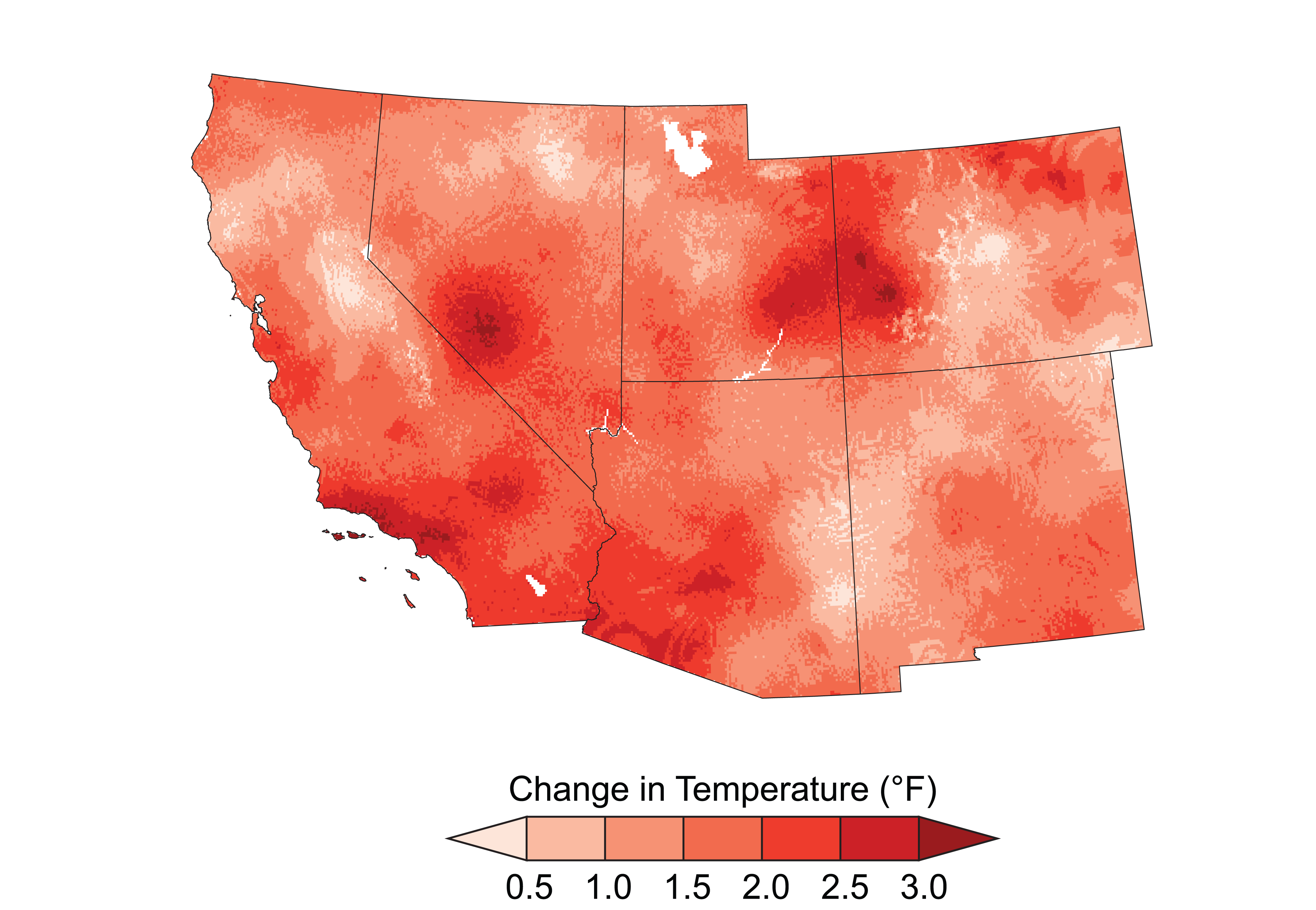
Now, a team of researchers concludes that the ongoing drought across the western U.S. rivals most past “megadroughts” dating as far back as 800 A.D. — and that this region is currently in a megadrought.
Using tree ring data as a proxy for drought conditions, the researchers say the current drought ranks fourth worst among comparable 19-year periods of megadroughts of the past 1,200 years.
A significant factor in this ranking is global warming triggered by human-caused climate change, says Park Williams, the study’s lead author and an associate research professor at Columbia University’s Lamont-Doherty Earth Observatory.
“The drought severity of the last 19 years is almost as bad as the worst 19-year period of the worst megadrought. It indicates that it’s very important that we develop more sustainable ways of dealing with water and allocating water across the western U.S.,” Williams said in a blog posted by Columbia’s Earth Institute…
The idea that this drought is among the worst compared to past megadroughts draws support from other researchers. There’s disagreement, however, as to whether the West is actually in a megadrought now.
It’s going to take more drought years before researchers Connie Woodhouse of the University of Arizona and Toby Ault of Cornell University — who also have studied megadroughts — are willing to use that term this go-around.
Ault’s threshold for a megadrought is 35 years, although he acknowledges that many researchers use 20 years. Woodhouse, a tree ring researcher who co-authored a pioneering study on megadroughts 20 years ago, said she hasn’t used a specific period to define megadroughts but that this drought hasn’t lasted long enough to qualify.
“The definition of megadrought technically is open to debate,” Jonathan Overpeck recently told The Atlantic in an article on Williams’ study. Overpeck is a University of Michigan climate scientist who formerly ran UA’s Institute for the Environment.
“The drought in the Southwest is right on the cusp of technically being a megadrought,” said Overpeck, who co-authored the 1998 study with Woodhouse and gets credit from her for coining the term…
One difference between this drought and most past megadroughts is that this one’s effects have been spread over the entire West, whereas the earlier droughts were more heavily concentrated in parts of the region, Williams told the conference.
Not a lot of places in the West are experiencing their worst droughts on record today, “but instead, a lot of places are experiencing pretty severe droughts,” Williams said.
Today’s drought pattern could have the fingerprints of human-caused climate change, he said. By using computer-based climate models, the Columbia researchers calculated that climate change has made the current drought 38 percent more severe…
Either way, the study said, “Water managers in the Southwest should plan for the possibility of a megadrought before the end of this century.”
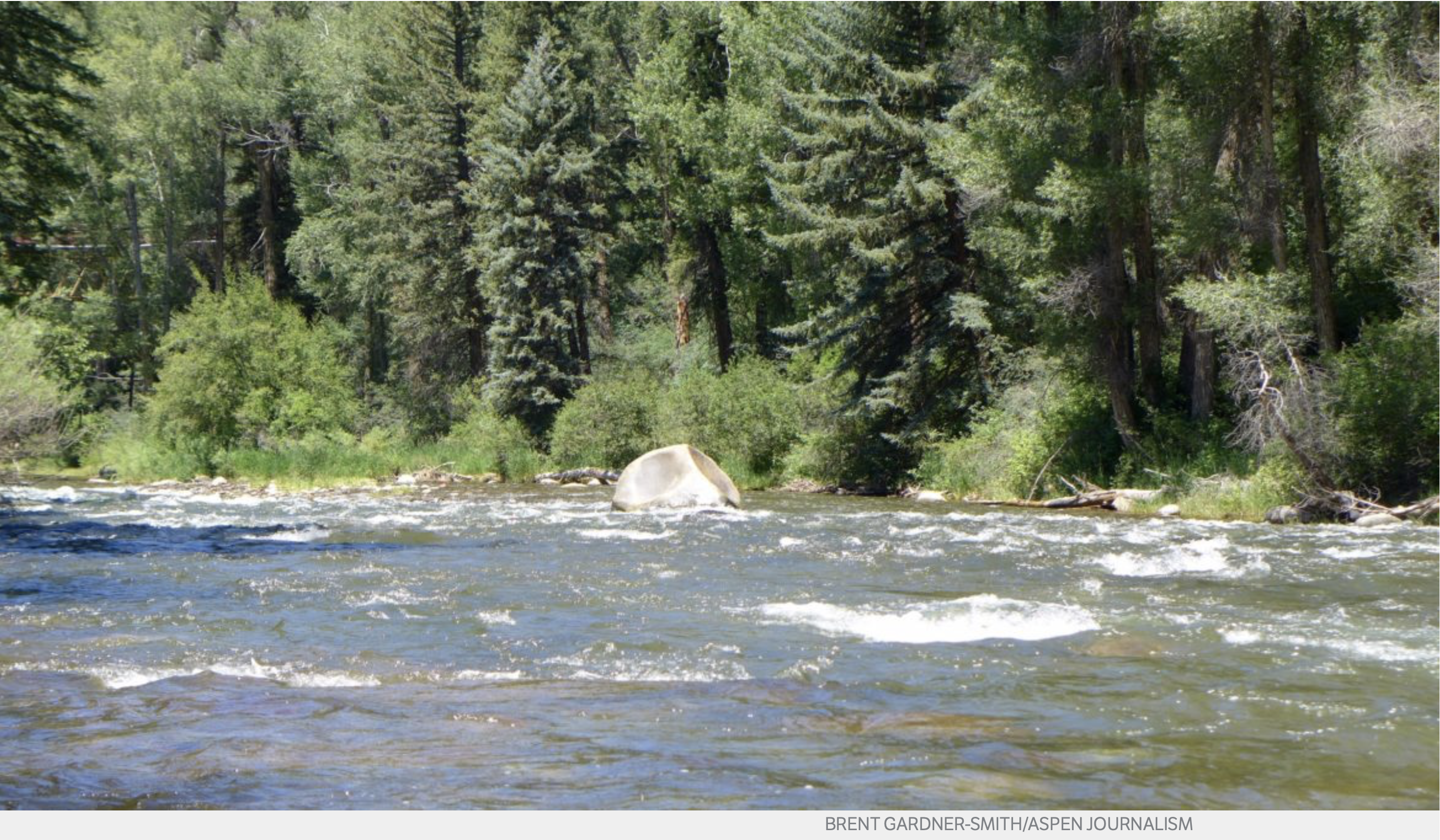
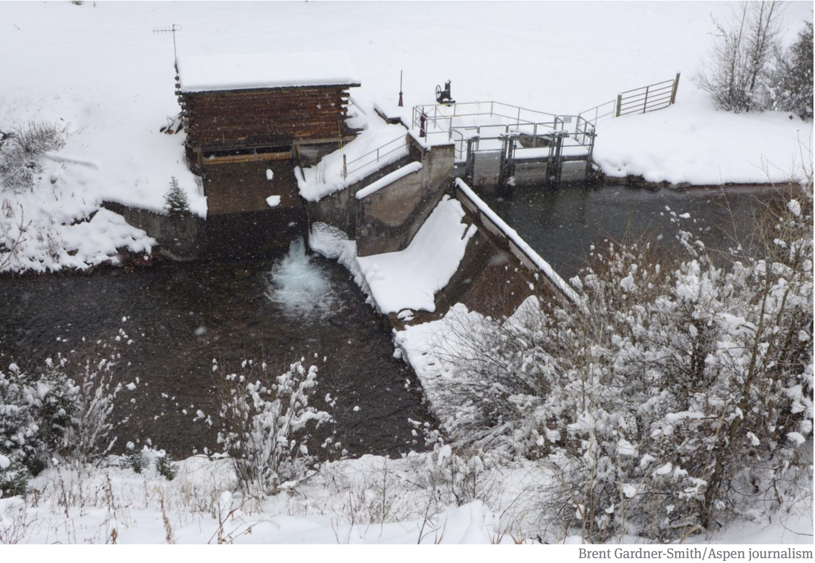
The Roaring Fork River in Woody Creek, not far below where the Snowmass Water and Sanitation District is seeking the right to divert up to 500 acre-feet of water a year for use in Snowmass Village. Photo credit: Brent Gardner-Smith/Aspen Journalism
The Snowmass Water and Sanitation District is seeking a new water right to divert as much as 500 acre-feet of water a year from the Roaring Fork River as backup in case something happens to its primary water sources on East Snowmass Creek and Snowmass Creek.
Under the proposed right, the district could divert, at a point just downstream from Jaffee Park, as much as 9 cubic feet per second of water from the Roaring Fork and pump it up to Snowmass Village via a roughly 6-mile pipeline running along the Brush Creek valley.
The district calls the project the “Roaring Fork intake pipeline.”
“This is an insurance policy for the district,” district manager Kit Hamby said.
The district, whose service area includes the town of Snowmass Village, filed an application for the water right in Division 5 water court in Glenwood Springs on Dec. 31, 2017.
The proposed diversion point will allow the district to capture and reuse water that has flowed down Brush Creek from the district’s wastewater-treatment plant on the Snowmass golf course.
The diversion would deliver water from the river to a pumphouse located “river right” a few hundred yards below the put-in for the popular Toothache run on the Roaring Fork and about a mile above Woody Creek’s post office.
The project’s initial pump station would be built on what is now private land, and the pipeline would come up along the river, cross it and then head up the Brush Creek valley, where other pump stations would be used to move the water.
The Roaring Fork water would be sent either to the district’s wastewater-treatment plant, which sits under the Village Express chairlift at the Snowmass Ski Area, or to Ziegler Reservoir, which holds 252 acre-feet of water.
From Ziegler, which sits on the divide between the Snowmass Creek and the Brush Creek basins, the district can gravity-feed the water to the rest of its system.
“This is a project that probably won’t happen for years, maybe even decades, and it may never happen,” Hamby said, noting it’s in the category of “long-term resiliency planning.”
“We’d have to have some catastrophic event in Snowmass Creek to move forward with this,” he said, referencing a drought, landslide or wildfire. “If we were to lose that source of water, we’d need to go to another source of water, and we wouldn’t want that source of water to be in Snowmass Creek.”
Hamby said there is no current cost estimate on the project.
Given the project’s long-range nature, he said, “In today’s dollars, (an estimate is) just about meaningless.”
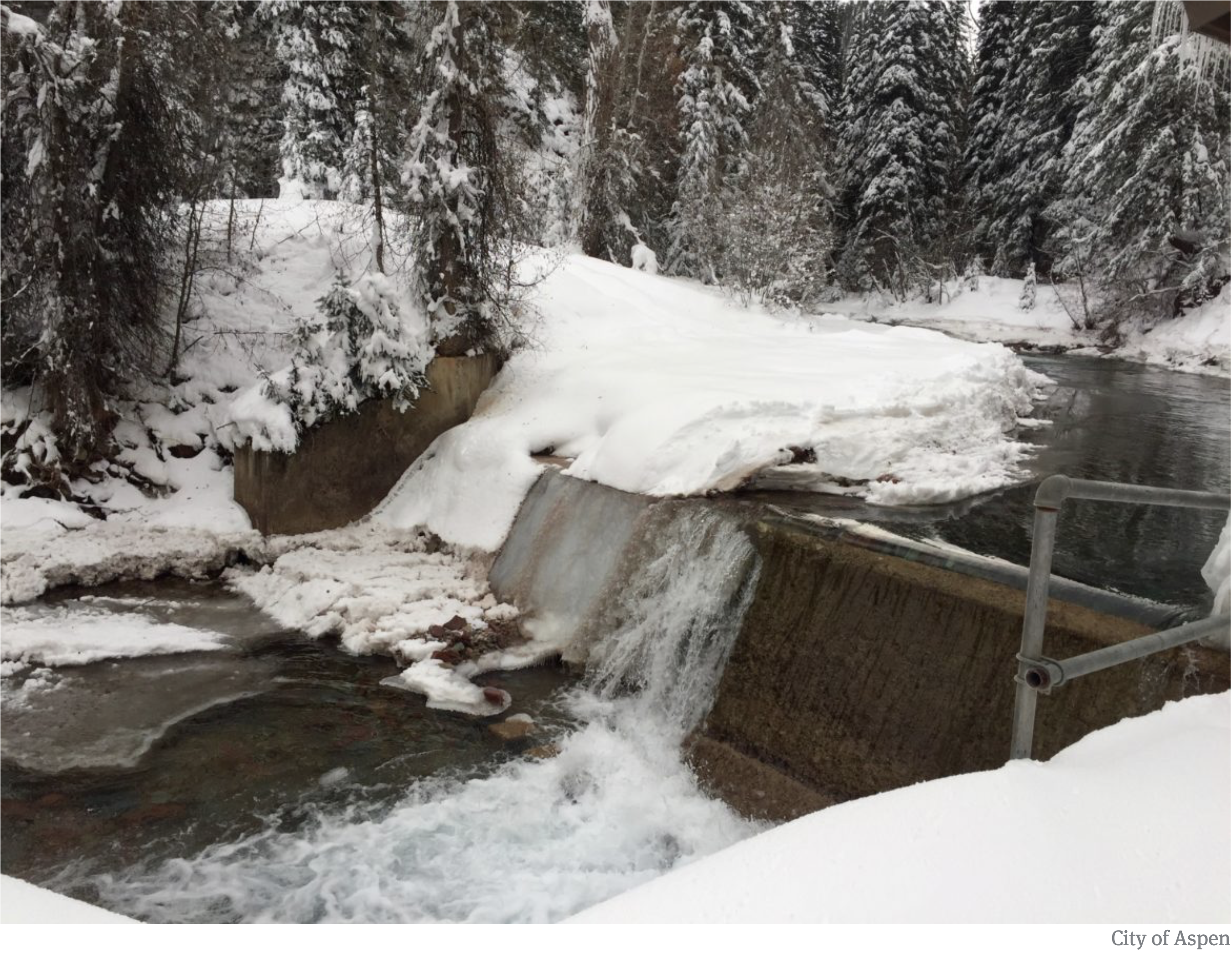
The Roaring Fork River, in Woody Creek, below the confluence with Brush Creek. Photo credit: Brent Gardner-Smity/Aspen Journalism
Instream flows
The Colorado Water Conservation Board, which filed a statement of opposition in the district’s water-court case, holds a series of “instream flow” rights in the Roaring Fork meant to leave water in the river to benefit the environment.
The state agency’s rights include a 1985 right in the section between Maroon Creek and the Fryingpan River of 30 cfs from Oct. 1 to March 31 and 55 cfs from April 1 to Sept. 30, and Hamby said the district intends to honor those instream flow rights, and won’t divert if the river is too low.
The district also plans to use the 500 acre-feet of water it owns in Ruedi Reservoir, on the Fryingpan River above Basalt, as a backup supply water so that the new water right does not get “called,” or turned off, by senior downstream water rights on the Colorado River above Grand Junction.
If the senior water rights call out upstream junior water rights, instead of turning of the diversion into its new pipeline, the district would release the water it owns in Ruedi to flow down the Fryingpan through Basalt and onto the Colorado River.
The district has existing water rights to divert out of East Snowmass Creek as many as 5 cfs, which the district can gravity-feed down a pipeline to Ziegler Reservoir.
Hamby said about 96 percent of the water used daily in the resort town comes from the East Snowmass Creek diversion point, at a steady flow of about 2 cfs.
The district also has a right to divert as much as 6 cfs out of Snowmass Creek, just downstream from the Campground lift. It can then pump that water uphill to Ziegler.
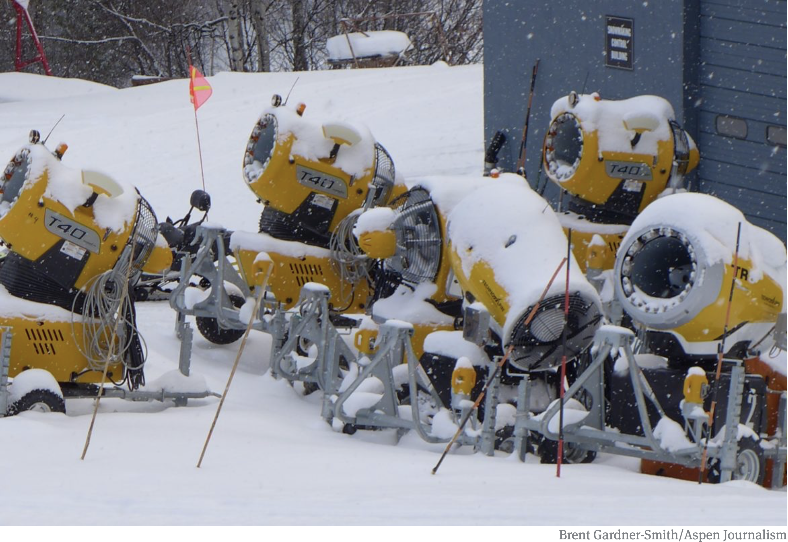
Hamby said about 2 percent of the water used by the district now comes from Snowmass Creek, and most of that is used for snowmaking.
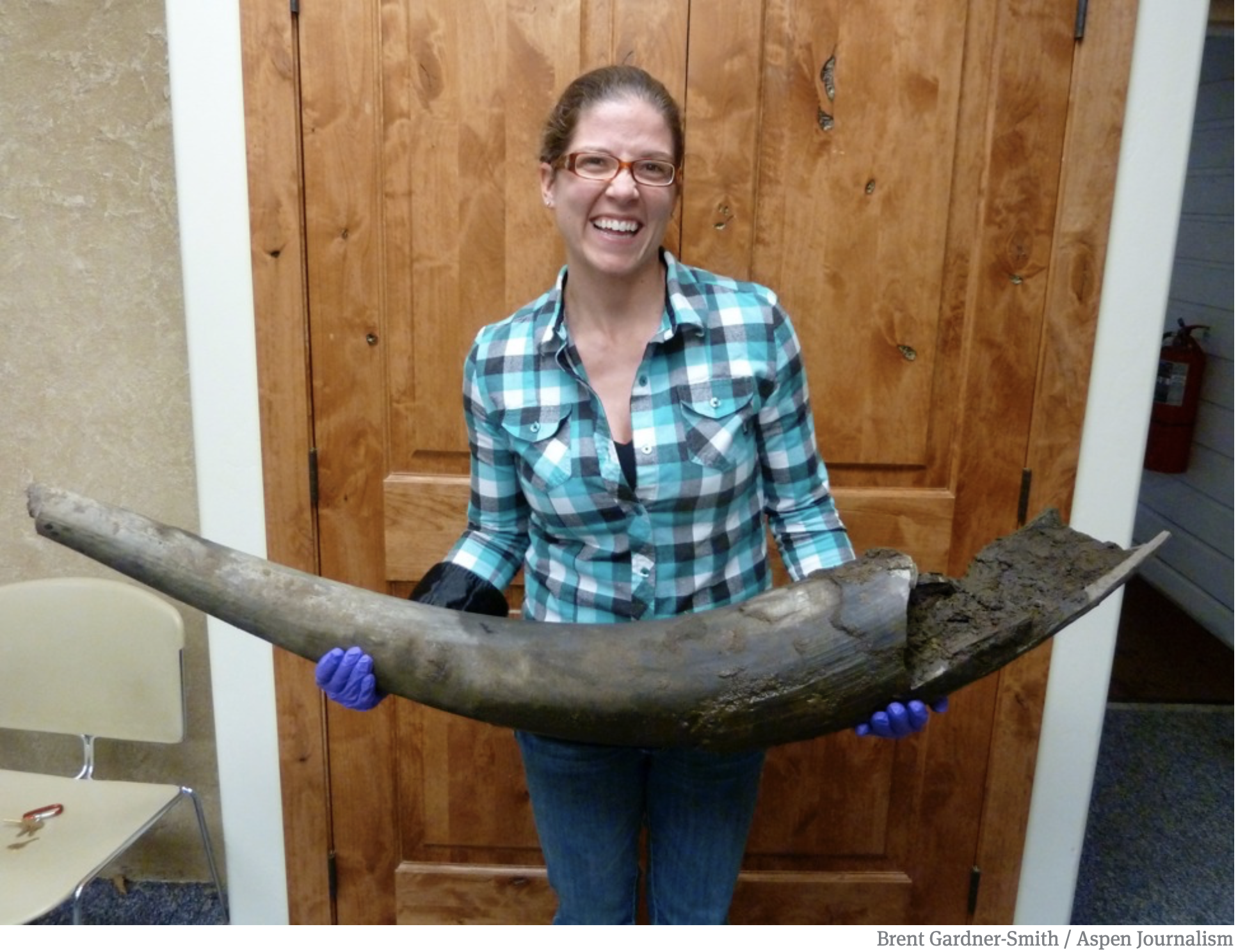
Christie Duckett, an employee of the Snowmass Water and Sanitation District, with an ancient 50-pound tusk in the district’s office, shortly after it had been dug out of the ground by construction workers in 2011 at what is now an expanded Ziegler Reservoir. Photo credit: Brent Gardner-Smith/Aspen Journalism
The Ziegler effect
Until 2013, the district provided water for snowmaking directly from Snowmass Creek, but a complex instream-flow right held by the CWCB limited the amount of water available.
Now, the district provides water for snowmaking directly out of Ziegler Reservoir, buffering the creek and allowing the ski area’s snowmaking system to turn on and go all out.
Expansion of Ziegler Reservoir started in 2011, and was delayed when the bones,tusks and horns of prehistoric animals started emerging from the bottom of the reservoir during excavation. The reservoir started holding water in 2013. According to Hamby, Aspen Skiing Co. put $3.75 million into the project, which cost $10.7 million.
The district also has a right to divert .77 cfs of water out of West Fork Brush Creek, a tributary of Brush Creek that forms Garrett Gulch at the ski area.
Hamby says the project is not meant to simply allow the district to use more water or to allow the town of Snowmass to grow more than it has to date.
He said he’s proud the district has driven down the amount of water used by it and town residents, adding that Roaring Fork water is truly seen as backup.
In 2002, the district was annually providing 660 million gallons, or 2,025 acre-feet, of water. Today, the district is annually providing 425 million gallons, or 1,304 acre-feet.
Hamby credits the reductions to the district’s aggressive leak-detection and repair program and high-tech smart meters, which let homeowners closely track their indoor- and outdoor-water use.
A status conference in the ongoing water-court case is set for Jan. 3.
Editor’s note: Aspen Journalism collaborated on this story with the Snowmass Sun, which published the story on Wednesday, Dec. 2, 2019.
JW: Are there any signs that public opinion is shifting in the US and elsewhere?
KH: We haven’t yet reached the tipping point to motivate sufficient action. But there has been a change. Ten years ago, few people felt personally affected by climate change. It seemed very distant. Today, most people can point to a specific way climate affects their daily lives. This is important because the three key steps to action are accepting that climate change is real, recognising it affects us, and being motivated to do something to fix it. Opinion polls in the US show 70% of people agree the climate is changing, but a majority still say it won’t affect them.
A map of the Aqueduct route from the Colorado River to the Coastal Plain of Southern California and the thirteen cities via the Metropolitan Water District of Southern California.
So far this winter, snowpack numbers at area snow-measurement sites are running close to historic averages. Compared to last year’s snow-short winters that’s a lot…
Diane Johnson, the communications and public affairs manager for the Eagle River Water & Sanitation District, said that last winter the snow-measurement sites at Copper Mountain — the closest to Vail Pass — and Fremont Pass — the closest to the Eagle River’s headwaters — showed above-average snowfall virtually all winter. Those sites are located higher than the one at Vail…
“I’m so glad it’s cold,” Johnson said, adding that she often surprises people who complain about frigid temperatures.
“People will say, ‘It’s so cold,'” Johnson said. “I tell them, ‘yeah, that’s great.'”
As of Dec. 31, 2018, the Yampa and White River basin had 107 percent of the median snow water equivalent, which is a measurement of how much water is contained within snowpack. At the same time last year, the valley had received 65 percent of the median.
“It’s refreshing to see our snowpack levels kick off at average,” said Kelly Romero-Heaney, water resources manager for the city of Steamboat Springs and a Routt County representative on the Yampa-White-Green River Basin Roundtable…
Steamboat Resort has more snow days than not, with snow falling on 37 of the 63 days the resort has been open. Fifteen of those days were powder days, according to Steamboat Ski and Resort Corp. Senior Communications Manager Loryn Kasten.
In Routt County, the Natural Resource Conservation Service’s snow telemetry sites have received an average of 34 inches of snow. The thickest snowpack is at the Tower site on Buffalo Pass, with 64 inches. The thinnest snowpack is at the Bear River and Lynx Pass sites in South Routt, both with 25 inches.
“Keep doing your snow water equivalency dance,” [Kelly] Romero-Heaney said with a laugh.
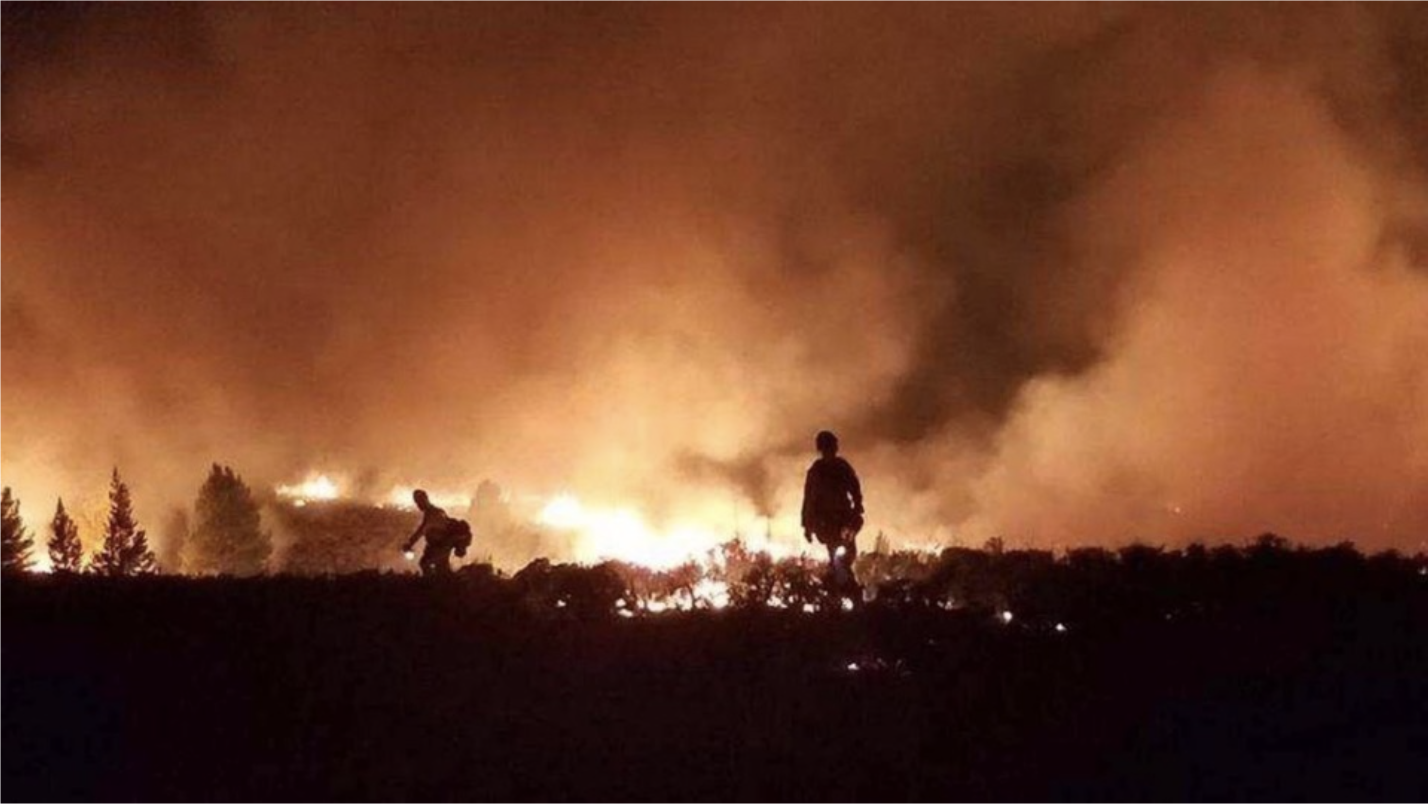
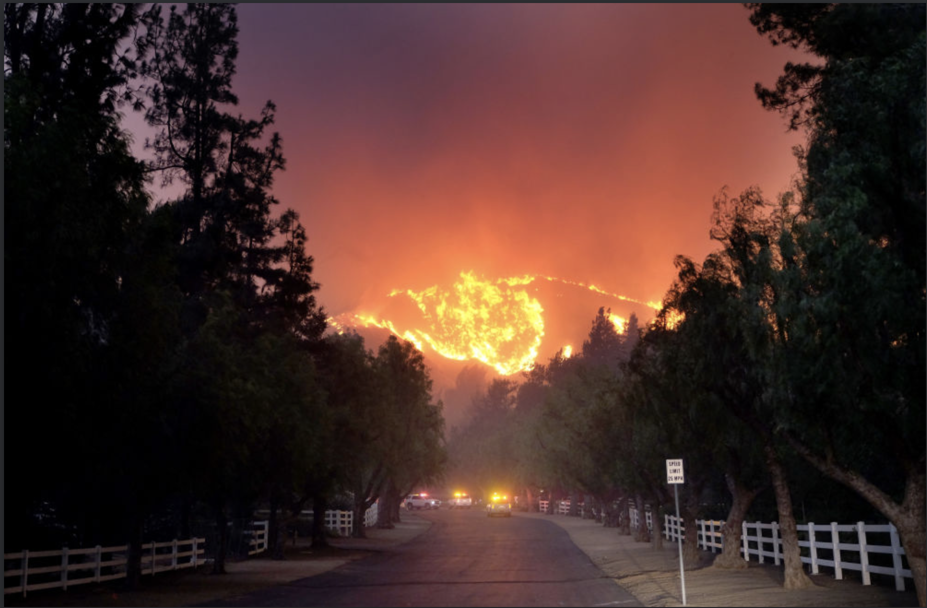
As more people build homes in fire-prone areas, and as climate change and other factors increase the frequency of fires, there is a growing risk to life and property throughout the West — and a lesser known risk to the region’s already endangered water supply. At least 65 percent of the public water supply in the Western U.S. comes from fire-prone areas.
Blazes like the Tubb Fire and 2018’s massive Camp and Carr wildfires can expose the drinking water for millions of people to the risk of contamination by toxic chemicals and parasites. Experts are concerned the new scale of wildfires torching urban areas could cause damage to public water supply that isn’t immediately apparent.
“Lots of structures, vehicles, and man-made materials were involved in the Camp and Carr fires and there isn’t a lot of information on how the environment is affected when these materials burn,” said Clint Snyder, assistant executive officer of California’s Central Valley Water Board.
The concern is prompting more intensive water testing programs following wildfires and spurring utility companies to invest in wildfire mitigation projects across the West.
HOUSES IN THE WOODS
One-third of U.S. homes are now built in what’s called wildland-urban interface (WUI) areas, areas near or on land prone to wildfire. It’s the fastest-growing land use type in the continental U.S.
According to U.S. Forest Service data, in just 20 years, new WUI areas grew by more than 46 million acres, covering an area larger than Washington State.
When these homes become wildfire tinder, insulation, roofing and home furnishings release toxins as they go up in flames, creating new sources of water contamination.
In addition to releasing toxins into the water supply, fires kill healthy tree roots. Without the roots, contaminating sediment and ash are flushed by rain into the reservoirs, rivers and lakes that supply cities with drinkable water.
In 2017 the U.S. Geological Survey published a study that predicted wildfires could double the amount of sediment in a third of the largest western watersheds by 2050. In some areas, sediment could increase 1,000 percent, potentially carrying parasites and harmful metals and chemicals with it.
According to representatives at the California State Water Resources Control Board, bacteria and parasite contamination, rather than chemical contamination, are the main worries in the wake of the Camp Fire, which burned 153,000 acres and 19,000 structures north of Sacramento, killing at least 86 people.
In Paradise, the town most affected by the Camp Fire, 22 out of 24 water systems were tested for contamination and cleared at the time of writing this article, but until the remaining two can be confirmed as uncontaminated, a Boil Water Notice, first released on Nov. 9, will remain in effect.
Solomon’s biggest concern is a parasite called cryptosporidium. When bare soil is exposed because vegetation has burned, the sediment that is flushed into water sources often contains spores of the intestinal infection-causing parasite. While a discomfort to healthy people, cryptosporidium can become life-threatening to people who are undergoing chemotherapy, have AIDS, or are elderly.
“Cryptosporidium form spores and that’s a problem because spores are like armored tanks, encasing the pathogen in a way that allows it to invade even significant amounts of chlorine,” said Solomon.
The increased sediment also creates a costly problem for water treatment plants.
Sediment clogs the microfiltration systems that filter parasites in large water treatment systems, requiring expensive clean-ups.
Slopes above Cheesman Reservoir after the Hayman fire photo credit Denver Water.
In 2002, the Hayman Fire cost Colorado utility company Denver Water $27 million, when heavy rains following the fires washed sediment, fallen trees, and man-made debris into the Stronita Springs and Cheeseman Reservoirs. The contaminants had to be filtered out before the water was safe for consumers.
To date, the Tubb Fire is one of California’s starkest examples of post-wildfire water contamination.
Before last year’s larger, deadlier Camp Fire, it was the most destructive California wildfire ever recorded. It burned nearly 37,000 acres, 5,636 homes and businesses, and killed 22 people.
But despite the scope of the blaze, it took a phone call from Gerald Buhrz to alert local authorities to the possibility of water contamination.
“If [he] hadn’t called in to report a chemical smell in the water, we may never have known about it,” said Bennett Horenstein, who was director of Santa Rosa Water during the fire. “It makes me wonder how many times this has happened and gone unreported.”
In total, the City of Santa Rosa had to spend $8 million replacing hydrants, valves, and other water system components in 352 properties, including 1,265 feet of water main.
“What happened in Fountaingrove should be a learning opportunity for water systems nationally,” Horenstein said…
Denver Water, which manages 12 water storage facilities throughout Colorado, announced in January that it’s pledging $16.5 million to the From Forest to Faucets Project, a partnership with the U.S. Forest Service that will protect crucial watersheds from wildfire. Colorado has more than 14 million acres of U.S. National Forest land and almost 90 percent of it is located in watersheds that feed public water supplies.
Officials in Arizona enacted a plan in July that prescribes tree thinning and controlled burns for the three watersheds that feed the C.C. Cragin Reservoir. The project is funded in part by a local utility company called Salt River Project…
“Fire mitigation projects are not just urgent because of the fact that people live near these forests, but the fact that people live downstream from these watersheds,” [Linda Wadleigh] said.
Two shadows slipped across the frozen landscape and away from a freshly killed elk. Their movements quick and light as they navigated a maze of sagebrush, the pair of wolves made their way toward me. The darker one led the other, a younger wolf in the pack, just as she had done during the hunt.
As I watched, they moved closer, their warm breath momentarily visible in the cold air. Soon, I could hear their rhythmic footfalls on crunching snow.
It was my third trip to Yellowstone National Park, my second as a natural sounds recordist, and my first in search of wolves. I’d come to document the sounds of these animals in January 2016, in order to preserve their voices for the park archives and for use in displays and stories for the public.
If the pair I watched knew I was present, they gave no sign of it. Instead, they greeted a third individual off to my right with brief sniffing and posturing. Then, as the light faded and darkness slowly overtook the day, these three members of the Lamar Canyon wolf pack spent the next 20 minutes in what can best be described as play. Just as I have seen my own domestic dogs do countless times before, these three very wild dogs ran, jumped and wrestled with each other, tails wagging as they brought the day to a close. Though millennia of evolution separate our domestic dogs from these wild ones, I saw the evolutionary links between them in their evening play.
Had it ended there, it would have been the memory of a lifetime. But as evening fully set in, the three broke off their play. They stood still in the darkness and, along with the rest of the pack hidden in the hills, sang out in a prolonged chorus which hung impossibly long in the cold night air. Luckily, I’d hit “record.”
I work as a natural sounds recordist for moments like these. My mission is to create an aural history of the sounds of our wild lands, in sad anticipation of the future loss of species and the changes to ecological communities caused by human impact on the planet. At best, these recordings help inspire support for the conservation of species and ecosystems. At worst, I create acoustic fossils of animals and landscapes that are gone too soon. I believe in the importance of my work, but sometimes I wish it wasn’t so damn necessary.
That January sighting was my very first glimpse of a wolf pack, and a remarkable one at that. The dark leader was the famous alpha female known to park biologists as 926F — affectionately named “Spitfire” by wolf watchers. In the two years since, this memory had faded, the details blurring, leaving me with just the unforgettable outlines.
In November, 926F was legally killed by a hunter just outside park boundaries in Montana. When I first saw the story, it was just another headline noting the loss of another famous animal at the hands of a trophy hunter. Her even more famous mother had met the same fate six years prior. But then, a note of recognition rang, and my stomach slowly sank.
I scrambled around, searching through old pictures and leafing through my field notes. It was her: my first wolf, and a prominent figure in my first field recording of a truly wild and iconic predator. She was gone and her voice silenced. I sat alone in disbelief in my basement office, everything still except the humming of the ventilation system. I’d listened to her howl hundreds of times from this same spot, fondly reliving our encounter.
In my recordings, 926F’s voice is forever preserved. I wanted to be upset at the hunter and angry at the hunting laws that allowed her death, but I couldn’t move past grief. For comfort, I put her recording on repeat. As howls filled the room, I drifted back to that January day in the park where our paths first crossed, and I remembered the sounds of a group of wild creatures at play.
In Episode 14 of We Are Rivers, we explore what potential effects a “Compact Call” could have for communities within the Colorado River states and what we can do to avoid a crisis.
In mid-December, stakeholders from across the Colorado River basin gathered in Las Vegas for the annual Colorado River Water Users Association (CRUWA) conference to discuss the future across the basin. Every year, important information about the Colorado River is discussed in Vegas, but this year’s conference was particularly important. The seven states that comprise the Colorado Basin have been negotiating Drought Contingency Plans (one for the Upper Basin and one for the Lower Basin) to deal with the very real possibility of water supply shortages from the Colorado River. At CRUWA, the Upper Basin States of Colorado, New Mexico, Utah and Wyoming agreed to move forward toward the completion of a Drought Contingency Plan (DCP,) as did the Lower Basin States of Arizona, California and Nevada.
The driving force behind the interstate Upper Basin DCP is the need to reduce the increasing risk of a compact driven curtailment, or “Compact Call” which could cut water to users across the Upper Basin States. A compact call would occur if the Upper Basin States are unable to deliver the water they are required to send through Lake Powell under the rules of the 1922 Colorado River Compact to the Lower Basin States. Overuse of water, aridification of the West due to climate change, and growing populations throughout the basin are putting extreme pressure on the Colorado River.
The DCP is a critical step for the Upper Basin to secure reliable water for agriculture, cities, industry, and the environment and to avoid the disruption and chaos that would follow a compact call. To learn more about what curtailment means for people and the environment, how it could happen, and why the DCP is so important – please listen as Jim Lochhead, CEO of Denver Water and Andy Mueller, General Manager of the Colorado River Conservation District, discuss what it could mean for Colorado.
Listen today to Colorado River Compact Call Part 1 – What Could a Call Mean; and stay tuned for the second part in the series, Colorado River Compact Call Part 2 – How Can We Mitigate Risks, discussing how the Upper Basin states are working together to reduce the possibility of a compact call.
Please note that throughout this episode all referenced reservoir water levels are specific to the time this episode was recorded during the summer of 2018. For updated reservoir levels, you can directly visit a reservoir’s website.
From the Republican River Water Conservation District (Tim Davis) via The Julesberg Advocate:
The Republican River Water Conservation District (RRWCD) acting through its Water Activity Enterprise (RRWCD-WAE) will again partner with NRCS to encourage water conservation and provide incentives to producers that voluntarily implement water conservation measures.
Since the Ogallaa Aquifer Initiative (OAI) sunset with the end of the 2014 Farm Bill, the RRWCD will partner with NRCS through the Environmental Quality Incentives Program (EQIP) to help producers transition from irrigated to drylands agriculture or grassland. The RRWCD founding will augment NRCS funding to producers that voluntarily agree to permanently retire irrigation wells and convert the irrigated cropland to drylands farming or grazing land.
NRCS will provide approximately two hundred fifty dollars ($250.00) per acre to producers that enroll in the permanent water retirement program. The RRWCD will provide additional incentives of between six hundred ($600.00) and one thousand five hundred dollars ($1,500) per acre depending on the location of the well within the District boundary.
Additional conservation practices may be appropriate on the converted acts. These practices will provide substantial water conservation and will help sustain the life of the aquifer. Recent research has suggested that in some cases higher capacity wells can reduce water consumption by as as much as twenty percent (20%) with little or no effect on the overall profitability…
Water conservation measures such as weather stations, soil moisture monitoring and conversion from sprinkler irrigation to a more efficient irrigation system can contribute substantially to prolonging the life of the quiver, while maintaining a strong irrigated agricultural economy. The EQIP program also provides these additional voluntary incentive based tools that all producers can use to prolong the life of this aquifer.
The RRWCD has consulted with groundwater management districts, the Water Preservation Partnership, and others to develop strategies to assist producers through financial incentives to voluntarily reduce water consumption. Several surveys distributed throughout the District to producers have indicated that voluntary, incentive based programs were preferred over regulatory water restrictions. It is important that each and every irrigated agriculture producer evaluate their individual irrigation practices to determine if they can help reduce the impact on the aquifer by implementing one or more of these conservations practices.
The deadline for application for EQIP is January 18, 2019 so please contact your local NRCS office at https://www.nrcs.usda.gov/wps/portal/nrcs/site/co/home/ or the RRWCD office in Wray, Colorado, at 970-332-3552 as soon as possible if you wish to apply for conservation funding through this program.
The Republican River Water Conservation District Board of Directors will have a public hearing on the proposed new water use fee policy during its regular quarterly meeting, Thursday, January 10, in Burlington.
The meeting will be held at the Burlington Community and Educational Center, 340 S. 14th St., beginning at 10 a.m.
The public hearing on the proposed new water use fee policy will be at 1 p.m.
RRWCD General Manager Deb Daniel said the proposed policy would not change the fee for irrigation, while municipal and commercial wells would have a minimal reduction in the fee per acre feet pumped.
Junior surface water right fees would be based on comparing the impact on compact compliance of diversions of surface water for irrigation as compared to the impact of groundwater withdrawals.
Daniel said the proposed policy addresses the fees charged by the RRWCD for compact compliance, based on the impact each type of use and consumption has on the determination of Colorado’s compliance with the Republican River Compact as determined by the RRCA Accounting Procedures.
Public comment will be heard immediately following the water use fee public hearing.
Besides the regular reports, the board will hear a presentation from Mark Lengel about concerns on the South Fork. The board also will discuss South Fork Water Rights.
For more information, please contact Daniel at 332-3552 or email her at deb.daniel@rrwcd.com.
The [CAP] board voted to authorize up to $5 million during its monthly board meeting on Thursday. At that meeting, officials from the Central Arizona Project and the Arizona Department of Water Resources also shared that Ducey would request $5 million in his executive budget.
The $10 million put forward Thursday would help match $15 million the federal government is kicking in for building pumps, wells, and other structures that farmers could use to tap into groundwater. The federal funds were given on the condition that local entities in Arizona match it, Suzanne Ticknor, water policy director for the Central Arizona Project, told the board.
The additional funding comes at a critical time for Arizona. It has until the federally set deadline of January 31 to agree on a plan to deal with looming shortages on the Colorado River. One of the major concerns with that plan has been that it requires farmers to rapidly transition from surface water to groundwater, a process with a hefty price tag.
Pinal County irrigation districts initially estimated that the groundwater infrastructure would cost $30 million to $35 million to build. On Thursday, it turned out that projected costs had been revised to as much as $50 million…
Brian Betcher, the general manager for the Maricopa Stanfield Irrigation and Drainage District, explained that in its initial cost analysis, the district had looked at brand-new wells generating water 11 months of the year. Members realized that farmers really use water only about seven months each year, starting around April.
“We missed that in the analysis,” Betcher said at Thursday’s meeting.
But, he and others were quick to point out, farmers in Pinal County were not the only ones who might use those new pipes, pumps, and wells to pull water from below ground. The Central Arizona Project and other users could also use them, though they’re only allowed to recover water they had previously stored underground…
The funds that the CAP board authorized — almost unanimously — would come from ad valorem taxes, which the board is authorized to levy on property owners in Maricopa, Pima, and Pinal Counties. Board members made that funding contingent upon other groups’ helping to match federal funding, and upon the development of a program that includes infrastructure for recovering stored groundwater.
The sole dissenting vote came from Jennifer Martin, one of the board’s new members, who said she was concerned about the negative consequences of increasing groundwater pumping. In parts of Arizona, groundwater over-pumping has caused land to sink and giant fissures to open up in the ground.
The $5 million Ducey pledged would be in addition to $30 million he committed in November to Arizona’s Drought Contingency Plan, which would not count toward the federal matching program for groundwater. That $30 million would go toward paying water users to leave water in Lake Mead, the reservoir on the Colorado River that supplies Arizona, in order to prevent it from dropping to catastrophically low levels.
The Drought Contingency Plan spells out how Arizona cities, tribes, industries, and farmers will share cuts amounting to at least 512,000 acre-feet from the 2.8 million acre-feet of water they take from the Colorado River each year. (An acre-foot is about 326,000 gallons.) Those cuts are expected to start in 2020, when the Bureau of Reclamation gives the Colorado River a 57 percent of falling into shortage.
The plan weans farmers, who gave up their rights to Colorado River water in the 2004 Water Settlement Act, off of that surface water and onto groundwater instead. According to the plan, farmers will need to pump 16,500 acre-feet of groundwater in 2022, the last year they’ll still receive some Colorado River water. The following year, their pumping will increase to 70,000 acre-feet.
The governor’s office also supports repurposing a groundwater withdrawal fee to go toward groundwater infrastructure, said Tom Buschatzke, director of the Arizona Department of Water Resources, during Thursday’s meeting. The withdrawal fee is paid by farmers in Pinal County and generates about $1.2 million a year.
Statewide Basin High/Low graph January 3, 2019 via the NRCS.
FromThe Grand Junction Daily Sentinel (Dennis Webb):
Snowpack was at 94 percent of median statewide Thursday, according to a daily map on the Natural Resources Conservation Service’s Colorado Snow Survey Program website. That compares to 117 percent about a month ago.
Snowpack in the Arkansas and South Platte river basins is more than 110 percent of median, while levels in the Colorado and Yampa/White basins are at 102 percent. But the Gunnison River Basin is at 90 percent, the Upper Rio Grande, 76 percent, and the San Miguel/Dolores/Animas/San Juan basins in the Four Corners region are at just 69 percent.
“Really again the one sore spot is the San Juan Mountains,” which also fared worse than the rest of Colorado last year, said Becky Bolinger, the assistant state climatologist…
Following a poor snowpack season a year ago and limited summer rain, western Colorado remains in drought, with the worst conditions in the southwest part of the state. Bolinger said that even if the rest of the state has good snowpack that translates to good runoff and improved reservoir levels, it still will feel the impact if southwest Colorado’s snow levels are poor, due to the state’s interstate obligations for making sure enough Colorado River water leaves the state…
The San Juan Mountains did benefit more than the rest of the state from two recent storms, Fowler said. Bolinger said that region needs storms every week to start making real improvements…
Bolinger said that cold temperatures also have helped out so far this year when compared to last year, when warm spells made it hard for lower and middle elevations to keep their snowpack, affecting spring runoff.
The federal Climate Prediction Center has forecast above-average chances for higher-than-normal temperatures and precipitation levels in Colorado through March.
Westwide SNOTEL basin-filled map January 2, 2019 via the NRCS.
Click here to go to the US Drought Monitor website. Here’s an excerpt:
Summary
A series of storm systems traversed across the lower 48 States this week, dropping precipitation on most section of the contiguous U.S. The exceptions to this included most of California, northern Montana, the central High Plains, and southern sections of Texas and Florida. In contrast, light to moderate precipitation fell on the Northwest, parts of the Southwest, most of the Plains, Midwest, Northeast, and Southeast. Widespread heavy precipitation (more than 2 inches) inundated coastal Washington and the Cascades, the southern Great Plains, lower Missouri, lower and middle Mississippi, and Tennessee Valleys, parts of the mid-Atlantic, and the Deep South (Mississippi, Alabama, and Georgia). With dozens of stations measuring their wettest year on record in the East and Southeast (e.g. Wilmington, NC, 102.26 inches, old record 83.65 inches in 1877), it was not surprising that very little drought existed east of the Rockies. With subnormal weekly temperatures in the western half of the Nation and above-normal readings in the eastern half, the precipitation fell as snow in the southern Rockies, central and northern Plains, and upper Midwest. Snow also fell on most of the interior West, boosting WYTD basin average Snow Water Content (SWC) and precipitation closer to or above normal as of Jan. 1, according to the NRCS SNOTEL data…
In the Dakotas and eastern Montana, light to moderate precipitation (0.2-1 inch) and subnormal temperatures created a snow cover of 4-20 inches which increased the short-term precipitation surplus while reducing longer-term deficiencies. As a result, the three small D0 areas in eastern Montana, southwestern North Dakota, and central South Dakota were either erased or shrunk (improvement), while some of the southern edges of the D0 and D1 areas in northern North Dakota were also trimmed. The D0 in southern Kansas was eliminated due to moderate precipitation there (see South). The slight D0 improvements in northwestern Wyoming and southeastern Colorado will be covered in the West narrative…
Storm systems affected the Northwest and Southwest this week. In the north, the system dropped beneficial precipitation along the Washington and Oregon coasts, on the Cascades, Bitter Roots, and northern Rockies. In the south, localized rain fell around the San Diego area, and precipitation spread into Arizona, New Mexico, parts of Utah, and southwestern Colorado. Much of California, Nevada, northwestern Arizona, northern Montana, southern Wyoming, and northeastern Colorado saw little or no precipitation, while temperatures generally averaged below-normal for most of the West.
The January 1, 2019 NRCS SNOTEL WYTD basin average precipitation and SWC [Snow water content] generally improved this week with the storm systems. Basin average SWC was close to normal (85-120% of normal) in most Western basins except (less than 85%) in the northern Sierras, western Oregon, south-central Idaho, southern Utah, central Arizona, and southwestern Colorado. Basin average precipitation was similar to SWC, with WYTD average precipitation close to normal in most basins (75-125%); however, southern Oregon, northern California, and south-central Idaho basins were less than 75% of normal. As a result, some slight 1-category improvements were made in western Washington and northwestern Oregon, northeastern Washington, northern Idaho, and northwestern Montana. Some D0 was trimmed from western Wyoming with the recent precipitation, and some slight improvement and smoothing of the D3 area of eastern Oregon was made. In contrast, a slight expansion of D0 into south-central Idaho was necessary due to the poor WYTD so far. In-between the northern and southern systems, no changes were made.
In southern California near San Diego, 0.5-2 inches of rain, coupled with an unseasonably wet fall (from Sergio moisture) and early winter, was enough to reduce long-term deficits and SPIs, thus D2 went to D1 where the rains fell this week. In southern and eastern Arizona where 0.5-2 inches of precipitation fell (snow in higher elevations), additional improvements were warranted due to the decent summer and fall monsoon rains and wet winter. In southern and eastern New Mexico, 0.5-3 inches of precipitation (snow at higher elevations) was reported, allowing for small reductions in D0 and D1 areas, while slightly improving D1-D4 in north-central New Mexico (near Albuquerque and Santa Fe) where 1-2 inches occurred. In southeastern Colorado, another round of 0.5-1 inch of precipitation has pushed most tools into the wet category, thus D0 was removed from Baca County. Although the core D3-D4 area in the Four Corners Region finally received overdue precipitation (0.5-2 inches), it had been so dry for the past 1-2 years that SPI values were still at D3-D4 at 6-months and beyond. With such large 12-month deficits (8-16 inches) in this semi-arid region, it will take more storms to finally pare down the long-term deficiencies and improve the SPI values. As a result, no changes were made in the Four Corners Region.
Heavy rains (3-8 inches, locally to 12 inches) soaked much of eastern Texas, eastern Oklahoma, western and southern Arkansas, and most of Louisiana, Mississippi, and Tennessee, with light to moderate totals (1-3 inches) falling on the central and northern Texas and the remainder of Oklahoma and Arkansas. Only western and southern Texas missed out on the plentiful precipitation. Accordingly, a general 1-category improvement was made to the D0 and D1 areas of Oklahoma, most of northern Texas, northwestern Arkansas, southern Kansas, and southwestern Missouri. In northern Texas, however, the small D1 area and the surrounding D0 was left since it was longer-term (>6-months), and the 0.25-1.5 inches of rain this week were not enough to alleviate the deficits. In extreme southern Texas, no rain increased 90-day deficits of 1-4 inches, thus the existing D0 area was expanded slightly northward, a new D0 area added to near Corpus Christi, and two new D1 areas were drawn where the biggest deficiencies were found in southern Texas…
Looking Ahead
During the next 5 days (January 3-7, 2019), a storm system will track across the South, bringing another round of moderate to heavy rain (1.5-4 inches) to the southern Great Plains, lower Mississippi Valley, and Deep South, with lighter totals in the mid-Atlantic and coastal New England. Unfortunately, it appears as though central and southern Florida will miss out on the rains. Pacific storm systems should drop decent precipitation along the West Coast and on the Cascades and Sierra Nevada. Light precipitation is also forecast for parts of Arizona, western New Mexico, southern Utah, and southwestern Colorado. Elsewhere, little or no precipitation will occur in the Great Basin, Plains, and Midwest. Temperatures should average above to much-above normal across the lower 48 States, with subnormal readings limited to the Southwest.
The CPC 6-10 day extended range outlook (January 8-12, 2019) showed enhanced chances for above-normal precipitation in the Northwest, Southwest, southern and central Plains, middle Mississippi and Ohio Valleys, Northeast, and southern Alaska. Subnormal precipitation was likely in the northern Plains, Southeast, and northern Alaska. Unseasonably mild weather is expected to continue throughout the lower 48 States with the exception of northern New England. Subnormal readings are favored in western Alaska, with near-normal temperatures in southeastern sections of the state.
US Drought Monitor one week change map ending January 1, 2019.
Ten days and several nights of snowstorms in the past 51 days has put Cortez above normal snowfall for the 2018-19 winter season.
But because of an abnormally dry 2017-18 winter, Southwest Colorado remains in the worst drought category of “exceptional,” according to the U.S. Drought Monitor.
“We’re off to a good start, but we are still playing catch-up,” said Jim Andrus, local weather observer for the National Weather Service. “It will take more generous months of precipitation to get us out of the exceptional drought.”
Since the beginning of the winter season on Nov. 1, Cortez has received 23.6 inches of snowfall, Andrus said. The average winter snowfall through January is 21.2 inches of snowfall, so Cortez is already at 111 percent of normal as of Jan. 2.
For all of last winter season, Cortez only recorded a total of 8 inches of snowfall, or 22 percent of average…
December 2018 was a very wet month, with total snow water equivalent measured at 1.8 inches, or 207 percent of the average .88 inches, Andrus said…
Precipitation for 2018 was 10.09 inches, or 80 percent of the average of 12.75 inches…
An El Niño weather pattern, indicated by increasing Equatorial Pacific temperatures, is developing and increasing the probability that winter storms will continue to track more south and hit the Four Corners area.
Recent storms have been dipping more southward, an indication the El Niño effect is kicking in, said Kris Sanders, a meteorologist with the National Weather Service in Grand Junction…
In the Dolores Basin of the San Juan Mountains, snowpack is at 84 percent of average as of Jan. 2, according to Snotel devices that measure snowfall at different elevations. A dry November contributed to the below-average tally.
Last year at this time, the Dolores Basin snowpack was just 26 percent of average, and ended the winter season at 50 percent of average, according to Snotel reports. Last year was a drier La Niña weather pattern, indicated by cooling Equatorial Pacific temperatures, which increases probability that winter storms will take a more northerly route that miss the Four Corners area.
In the 2016-17 winter, the Dolores Basin snowpack was 124 percent of average for the season, a banner year that filled all the reservoirs and led to an 85-day whitewater boating release in the Dolores River below McPhee Dam…
The Four Corners and Southwest Colorado remain in the worst category of exceptional drought, according to the U.S. Drought Monitor’s latest posting, on Dec. 25. But the area of exceptional drought has been shrinking the past two months.
With consistent snowfall on New Year’s Eve and New Year’s Day, local snowpack levels, as of Jan. 2, have shown an 8 percent increase since last week, according to data from the Natural Resources Conservation Services (NRCS).
The San Miguel, Dolores, Animas and San Juan River basins are currently 71 percent of median, up from 63 percent of median last week.
The Upper Rio Grande Basin has also seen an increase in levels, with a current total of 76 percent of median, compared to last week’s total of 67 percent of median.
Snowpack levels remain the same for the Gunnison River Basin, staying at 91 percent of median.
The Yampa and White River basins saw a drop from last week, going from 110 percent of median to 102 percent of median this week.
Another fall in snowpack levels is recorded at the Laramie and North Platte basins, with current levels sitting at 103 percent of median, compared to last week’s total of 108 percent of median.
For the Upper Colorado River Basin, snowpack levels are 104 percent of median, when last week they were 112 percent of median.
The South Platte River Basin saw a drop in its snowpack levels as well, going from 118 percent of median to 112 percent of median.
Rounding out the snowpack totals, the Arkansas River Basin sits at 114 percent of median, when last week that total was 110 percent of median.
We also see an increase in individual snowpack levels for the Wolf Creek summit. This week, the summit is 74 percent of the Jan. 2 median and 31 percent of the median peak. Last week, the Wolf Creek summit was 66 percent of peak and 25 percent of median peak.
However, locally, the National Weather Service (NWS) does not predict a chance of snow until Sunday, with a “slight chance” of snow showers that day.
For Wolf Creek Pass, the NWS indicates a 20 percent chance of snowfall on Saturday night and a 50 percent chance of snow on Sunday.
“I feel better, absolutely. But, we’re still not where we want to be,” NRCS District Conservationist Jerry Archuleta explained.
Two projects to increase snowmaking on Aspen Mountain and the Snowmass Ski Area have received initial approvals from the U.S. Forest Service, but any potential effects of drawing more water from the local watershed for the additional snowmaking remain unclear.
Aspen Skiing Co. is planning to use an additional 82 acre-feet — 26.7 million gallons — of water per season as part of its two snowmaking expansion projects, with most of the water coming out of Castle, Maroon, Snowmass and East Snowmass creeks.
Aspen Mountain will use an additional 57 acre-feet of water per season for new snowmaking infrastructure on 53 acres near the summit to create reliable and consistent snow coverage, according to a hydrology report that Glenwood Springs-based Resource Engineering prepared for the U.S. Forest Service.
Snowmass will use an additional 25 acre-feet of water per season to cover 33 acres of terrain on the Lodgepole, Lunkerville and Adams Avenue trails, according to an environmental assessment by the Forest Service.
The additional 82 acre-feet of water combined from both the Aspen Mountain and Snowmass expansions will be on top of the 821 acre-feet that Skico currently uses on average each season across its four ski areas, bringing the total seasonal average to 903 acre-feet, according to Rich Burkley, Skico’s senior vice president of strategy and business development.
To put that much water into perspective, Wildcat Reservoir, visible from the Snowmass Ski Area, holds 1,100 acre-feet of water.
Burkley said snowmaking has historically been used to connect natural snowfall to the lifts and base areas. The company’s snowmaking philosophy, he said, is to limit it to the bare minimum needed to open the trails, host events and reach the end of the season. Mountain managers hope increased snowmaking will help avoid a repeat of the bare, rocky slopes of the early 2017-18 season.
“We don’t want to increase snowmaking, but we have to,” Burkley said. “Our snowmaking doesn’t go to the top of any of our mountains and we’ve always relied on natural snowfall to open the mountains. Bringing snowmaking to the summit of Aspen will help ensure a Thanksgiving opening. In a year like this, it wouldn’t be necessary, but it would have helped a bunch last season.”
Although there are fewer other water users pulling from local streams — outdoor irrigation season is over — when Skico fires up its snowmaking operations in November and December, it is using water during a time of year when streamflows are at some of their lowest points of the year. Despite a close read of two recent Forest Service environmental assessments on the snowmaking expansions, it is still not easy to determine exactly what might be the impact of drawing more water from Castle, Maroon, Snowmass and East Snowmass creeks, the four streams that provide most of the water for snowmaking at Skico’s four ski areas.
The diversion dam on Maroon Creek operated by the City of Aspen, which gets its water supply mainly from Castle Creek, but also from Maroon Creek. Below this diversion is another diversion, for the Stapleton Ditch, that SkiCo uses to divert water for the snowmaking system on Buttermilk Mountain. Photo credit: Brent Gardner-Smith/Aspen Journalism
Environmental Concerns
In June, Pitkin County submitted to the Forest Service a comment encouraging the agency to consider the impacts of increased snowmaking on stream health and the overall watershed, including the potential violation of state minimum instream-flow requirements on Castle and Maroon creeks.
“Ultimately, we’ve found that the range of change for peak flows and watershed yields associated with the snowmaking SkiCo is proposing are within the natural annual variability of water yield and peak flow,” he said.
The Forest Service issued a draft decision notice approving the Aspen Mountain project Nov. 28 and the Snowmass project Dec. 17. Both reviews were in the form of “environmental assessments,” and both projects are currently in their respective 45-day objection period.
But those assurances from the Forest Service may not be enough for some local river advocates, especially after a hot, dry year that saw some streamflows in the Roaring Fork basin plummet to all-time lows and the city of Aspen implement Stage 2 water restrictions for the first time in history.
Ken Neubecker, associate director of American Rivers’ Colorado Basin Program and a member of the Pitkin County Healthy Rivers Board, has concerns about taking more water out of the streams in winter. Although most of the snowpack makes it back into the river as spring runoff, that doesn’t help the winter aquatic environment, he said. Also, while snowmaking may not require as much water as other consumptive uses such as irrigation, those relatively small depletions add up.
“Twenty-five additional acre-feet taken out over the whole season is not much water, but again, what are the cumulative impacts?” Neubecker said, referring to the Snowmass project. “When are we going to reach the straw that breaks the camel’s back, especially in a dry year when there may only be 2 (cubic feet per second) running in the stream?”
Kate Hudson, a Pitkin County resident and professional environmental advocate focused on water, agrees. Hudson, who is also a member of the county’s streams board, said that because the two projects are being considered separately, it’s hard to measure what the overall impacts might be to the Roaring Fork watershed.
“It’s just one more cut of many, but one of the many that may ultimately tip the balance,” she said. “What we are seeing now globally and locally in our environment with water is death by 1,000 cuts.”
The Forest Service review did consider the total depletions of water in the Roaring Fork River watershed from the additional snowmaking, but found they were anticipated, and covered by, an environmental review previously conducted by the U.S. Fish and Wildlife Service on potential future diversions upstream of a key reach of the Colorado River near Grand Junction. The Roaring Fork flows into the Colorado in Glenwood Springs.
A snowcat smooths out a mixture of machine-made and natural snow at the base of Little Nell in December. Securing a good base on Little Nell is critical to Aspen Mountain operations, and machine-made snow is often critical to get the job done.
Aspen Mountain
Aspen Mountain began making snow this season Nov. 1. Its primary snowmaking pump station, located at the base of the mountain, draws water from the city of Aspen’s treated municipal supply, which originates in Castle and Maroon creeks.
According to Burkley, Aspen Mountain uses an average of 199 acre-feet of water per season for snowmaking.
The new project would add about 57 acre-feet of diversions each season, for a total of 256 acre-feet, or 83 million gallons used for snowmaking on Aspen Mountain, according to figures supplied by Burkley.
While Skico has water rights for snowmaking uses from springs on the upper mountain, the hydrology reports says it is “expected that the water supply necessary to support the proposed snowmaking will also be provided by the city.”
In terms of overall impact, it’s important to note that not all of the water used for snowmaking is taken out of the watershed permanently. The snow acts as an on-mountain, frozen reservoir.
According to the hydrology report, about 74 percent of Aspen Mountain’s water used for snowmaking makes it back into the Roaring Fork River as spring runoff. The other 26 percent is lost to evaporation or sublimation or is sucked up by thirsty plants.
The diversion dam on Maroon Creek operated by the City of Aspen, which gets its water supply mainly from Castle Creek, but also from Maroon Creek. Below this diversion is another diversion, for the Stapleton Ditch, that SkiCo uses to divert water for the snowmaking system on Buttermilk Mountain. Photo credit: Brent Gardner-Smith/Aspen Journalism
Instream flows
The environmental assessment from the Forest Service also warns about instream flows, which are water rights owned by the Colorado Water Conservation Board, and are designed to keep water in the river to preserve natural ecosystems and fish health. The conservation board has 12 cfs of instream flow rights on the segment of Castle Creek where the City of Aspen’s diversion is located. The conservation board has 14 cfs of instream flow rights downstream from the city’s diversion on Maroon Creek.
Although streamflows in Maroon and Castle creeks are predicted to more than satisfy the three demands — snowmaking, municipal uses and instream flows — the study warns that snowmaking shortages are possible during drought conditions in the peak snowmaking month of December.
According to Margaret Medellin, utilities portfolio manager for the city of Aspen, the city will not divert if instream flows are threatened. The city has sensors on both its Maroon and Castle Creek headgates and employees manage them daily to preserve the minimum instream flows. For example, Medellin said the city shut down the Maroon Creek hydro facility last summer to protect the instream flows.
Streamflows, however, can be hard to verify. There is no public gauge on Castle Creek, and although there is a new U.S. Geological Survey gauge on Maroon Creek, the reading simply said “Ice” for several days in late December.
Snowmaking guns sit on Aspen Mountain in late December, after much of their work was done for the season. The water that is forced through the guns to make snow on Aspen Mountain comes from Castle and Maroon creeks, often at their lowest levels in late fall and early winter, which is prime snowmaking season.
Snowmass
Snowmass currently uses an average of 383 acre-feet of water per season for snowmaking from the Snowmass Creek watershed.
The water is provided to Skico by the Snowmass Water and Sanitation District, which serves all of Snowmass Village and the ski area.
The district both diverts water from East Snowmass Creek, and also pumps water up from Snowmass Creek, to fill Zeigler Reservoir, which holds 252 acre-feet of water, according district manager to Kit Hamby.
The water is then sent to the ski area’s snowmaking system when it’s time to make snow. The reservoir, home to “Snomastadon,” was put into service in 2013 and provides a buffer from direct drawdowns from Snowmass Creek, where the conservation board also holds an instream flow right.
The ski area also uses another 46 acre-feet from a few ponds that start the season naturally charged.
Each season, the new project would draw an additional 25 acre-feet, or 8 million gallons, from the Snowmass Creek watershed.
As for Skico’s other two ski areas, Aspen Highlands 55 acre-feet a season on average from the city of Aspen’s municipal supply and Buttermilk uses an average of 184 acre-feet a season from Maroon Creek, according to Burkley. Including the new projects, the total seasonal-average use on all four mountains for snowmaking is expected to be 903 acre-feet of water.
Skico works hard to remain an industry leader in sustainability and the environment. Its “Give a Flake” campaign encourages skiers to take action on climate change.
Burkley admits any expansion of terrain or snowmaking contradicts the company’s sustainability message, but he adds that snowmaking is necessary. And last season’s dry and warm conditions brought to the forefront how crucial it is to have snowmaking at higher elevations.
“It definitely undercuts (the sustainability message),” Burkley said. “But we would not be in business without snowmaking so we try to minimize the impacts of it.”
Editor’s note: Aspen Journalism is covering rivers and water with The Aspen Times. The Times published this story on Wednesday, Jan. 2, 2018.
Colorado River drought planning as well as the funding dilemma behind the state’s ambitious water plan, are among the water issues likely to win stage time at the Colorado State Capitol this year.
When the session opens Friday, Democrats will control both chambers, having retained the majority in the House of Representatives and taken control of the Senate as a result of the November elections.
The two committees where most water bills originate have new leadership as a result of the political shift. Sen. Kerry Donovan (D-Vail) is now chair of the Senate Agriculture and Natural Resources Committee, and Rep. Dylan Thomas (D-Avon) is now chair of the House Rural Affairs Committee.
800-Pound Gorilla in the Room
There is one major issue that will loom over this session even without legislation—the Colorado River drought. In November, the Colorado Water Conservation Board, the state’s lead water policy and planning agency, adopted a critical policy statement supporting a Colorado River Drought Contingency Plan (DCP). Once the plan is finalized, a process that could take months, it may require lawmakers to act.
The policy comes in response to a 19-year drought in the Colorado River Basin that has seen storage in its two largest reservoirs—Lake Powell and Lake Mead—drop below 50 percent of capacity. Continued drought could lead to water cutbacks in the Upper and Lower Colorado River Basins in order to comply with the 1922 Colorado River Compact and related agreements. The Upper Basin comprises Colorado, New Mexico, Utah and Wyoming, while the Lower Basin states include Arizona, California and Nevada.
Included in the DCP is discussion of a far-reaching conservation effort in Colorado and the other Upper Basin states that would free more water for storage in a protected pool in Lake Powell to ensure Lower Basin states receive their legal allotment.
Under the new policy adopted by all four Upper Basin states and the Upper Colorado River Commission, any demand management program would emphasize voluntary, temporary and compensated reductions in water use, and would not be implemented without an extensive public review process.
If it comes to actual cutbacks, water users across the state would share the pain, including Front Range communities, under the new policy.
Despite these assurances, there is a great deal of legislative concern, especially over the potential role of the federal government in deciding if and when to release water from Upper Basin reservoirs to replenish Lake Powell. Sen. Don Coram (R-Montrose) likened it to “depositing money into a bank account [Lake Powell] and authorizing someone else [the Bureau of Reclamation] to make withdrawals.”
The crisis on the Colorado River is likely to serve as context for several water policy discussions this session, though Rep. Roberts said, “There won’t be any rush to legislation.”
Donovan said lawmakers would be fully briefed on the drought plan, “and then we will be able to proceed to consider appropriate actions to put the state in the best position to comply with the Colorado River Compact.”
Colorado Water Plan website screen shot November 1, 2013
Colorado’s Water Plan
Another high priority will be examining ways to fund Colorado’s Water Plan (CWP). The CWP was prepared by the Colorado Water Conservation Board (CWCB) at the direction of Governor John Hickenlooper and adopted in 2015. It contains eight measurable objectives—including new water storage, maintaining agricultural productivity, and improving watershed health. It also includes critical actions to achieve them.
The plan cites a need to raise $100 million annually over 30 years—or $3 billion from 2020-2050—to sustainably fund its implementation. It suggests a loan repayment guarantee fund and “green” bonds for environment, recreation, conservation, agriculture and education activities. Not all funding would come from the state; storage projects often rely on ratepayers to cover the costs of water development and delivery.
Legislators are expected to explore funding options for structural and nonstructural projects. The CWCB has included $20 million for CWP implementation in the 2019 “Projects Bill” that will be submitted to the legislature for approval. That is $9 million more than in 2018.
North Fork Republican River via the National Science Foundation.
Republican River Compact
Another bill that has been forwarded to lawmakers from the 2018 interim Water Resources Review Committee would redraw the boundary of the Republican River Water Conservation District in eastern Colorado to include more wells that reduce the flow of the Republican in violation of a compact with Kansas and Nebraska. The bill would allow the district to assess the same fee on those well owners that it does on all irrigators in the district to pay for a pipeline that transports water to the river to ensure compact compliance. The district borrowed $62 million to buy water rights and build the pipeline, and has assessed farmers $14.50 per acre to repay the loan.
Oil and gas development on the Roan via Airphotona
Severance Taxes
Lawmakers will also consider a bill that would change the timing of severance tax allocations for several CWCB water programs, to allow for better planning. The state collects severance taxes from oil and gas producers and other extractive industries, some of which is used to support water-related activities.
Currently the state’s severance tax revenue is transferred three times a year to the CWCB based on revenue forecasts; if the actual tax collections are below forecasts (which is often the case), funds are “clawed” back. This bill would base allocations on the amount collected in the previous fiscal year and consolidate three payments into one for the following year. Because tax collections in fiscal year 2018 exceeded forecasts, “it gives us a moment in time to do this,” Donovan said, avoiding any gap in funding.
Photo credit: AgriExpo.com.
Deficit Irrigation
Still another issue likely to surface is how to encourage more deficit irrigation, a strategy that applies less water than optimally needed by a crop in order to free up water for other uses. One proposal that did not make it out of the summer interim water committee would have added deficit irrigation to land fallowing as a type of pilot project the CWCB could approve, with the conserved water being available for short-term lease. Although the bill received support from a majority of committee members, it did not garner the two-thirds necessary to advance as a committee-sponsored bill. It may be considered again this year. (A similar bill—HB 1151—passed the House in 2018 but was withdrawn by its senate sponsor for additional study.)
The lower Crystal River was running at 8 cfs near the state fish hatchery on Aug. 1, 2018. Lows flows on the Crystal have spurred action from the state, including curtailment and a call for instream flows. Photo credit: Heather Sackett via Aspen Journalism
Instream Flows
There is also interest in legislation that could expand the state’s instream flow pilot program, where water right holders forego diversions, instead leaving their water in the stream on a short-term basis for fish and habitat protection without jeopardizing their water right. The program is voluntary, temporary, and can provide financial compensation. It may involve “split-season” use, where a farmer irrigates his or her crops early in the season and then leases the water to a nonprofit (in partnership with CWCB) to maintain instream flows later in the year. Although the committee did not report out a bill on this issue, there is reportedly interest in legislation that would encourage additional voluntary leasing while protecting agricultural water use.
Bonita Mine acid mine drainage. Photo via the Animas River Stakeholders Group.
Water Quality and Hard-rock Mining
And last but not least, the General Assembly is expected to renew consideration of a measure it rejected in 2018. Lawmakers considered HB 1301, which would have required reclamation plans for new or amended hard-rock mining permits to demonstrate an “end date” for water quality treatment to ensure compliance with water quality standards. The bill also would have eliminated the option of “self-bonding”—an audited financial statement that the mine operator has sufficient assets to meet reclamation responsibilities—and required a bond or other financial assurance to guarantee adequate funds to protect water quality, including treatment and monitoring costs. It passed the House but was defeated in a Senate committee. Rep. Roberts, the primary sponsor last year, expects a bill on the same topic this session.
Larry Morandi was formerly director of State Policy Research with the National Conference of State Legislatures in Denver, and is a frequent contributor to Fresh Water News. He can be reached at larrymorandi@comcast.net
Fresh Water News is an independent, non-partisan news initiative of Water Education Colorado. WEco is funded by multiple donors. Our editorial policy and donor list can be viewed here.
Winter in Colorado marks an exciting time of year. It means skiing, snowboarding, ice skating, snowshoeing, and ice fishing. But winter can also mean dangerous driving conditions.
What we do to help mitigate dangerous road conditions can take a toll on our natural resources if we are not careful. What we put on our roads and driveways today may end up in our lakes, rivers, and streams tomorrow. Salt, sand, and deicers make their way into storm sewer systems and travel into local water bodies. Concentrated doses of chloride-based deicers are potentially lethal to aquatic plants and invertebrates. The introduction of sand to waterways can increase turbidity and degrade both the aesthetics and quality of the water.
Consider these best practices during the winter to help reduce pollution in our local bodies of water.
Shovel your driveway early during a snowfall and maintain it throughout. This will reduce the need for salt, sand, and other deicing agents by preventing ice from build-up on your driveway.
Use deicers according to manufacturer’s recommendations and use salt and sand sparingly, and only as needed.
Sweep up excess sand, salt, and deicers.
Consider environmentally friendly alternatives like calcium magnesium acetate (CMA), or cracked corn for traction.
For more information on Stormwater, visit Greeleygov.com/Stormwater
Under the Trump administration, the U.S. Environmental Protection Agency is more likely to give polluters a pass when they violate laws intended to keep the air healthy and water clean, according to recent reporting by the Environmental Data and Governance Initiative (EDGI), a watchdog group.
By analyzing public data and interviewing past and current EPA employees, EDGI documented notable declines in agency law enforcement this year, particularly in EPA Region 8, which includes Colorado, Utah, Wyoming, Montana, the Dakotas and 27 Indigenous nations. According to an internal EPA report, by mid-year Region 8 had opened 53 percent fewer enforcement cases in 2018 than in 2017. And it concluded only 53 civil cases in 2018, less than half the number in any year since at least 2006. Nationally, EDGI found a 38 percent drop in the number of orders requiring polluters to comply with the law, and a 50 percent drop in the number of fines.
Karley Robinson with newborn son Quill on their back proch in Windsor, CO. A multi-well oil and gas site sits less than 100 feet from their back door, with holding tanks and combustor towers that burn off excess gases. Quill was born 4 weeks premature. Pictured here at 6 weeks old.
EDGI’s analyses are based on provisional numbers, which the EPA routinely cleans up at the end of each year, so the exact figures could change when the agency’s annual enforcement report is released. Still, EDGI expects the general trend to hold.
“It’s another iteration of EPA’s industry-friendly approach,” said EDGI member Marianne Sullivan, a public health expert at William Paterson University. “It says we’re prioritizing industry’s needs and desires over the health of our environment and the health of our communities.”
In the short term, dialing back enforcement could be a particularly effective way to relieve industry of the burdens of environmental protections. Donald Trump’s EPA appointees have tried to formally roll back regulations, such as the Clean Power Plan and a rule safeguarding water from toxic coal ash. But it’s a slow and public process that invites lawsuits. Simply declining to enforce the law, however, can subtly accomplish the same thing, because it happens largely out of public view, and EPA administrators have wide discretion over it.
EPA officials deny ignoring violations of the law. “There has been no retreat from working with states, communities, and regulated entities to ensure compliance with our environmental laws,” spokesperson Maggie Sauerhage wrote in an email. “Focusing only on the number of federal lawsuits filed or the amount of penalties collected fails to capture the full range of compliance tools we use.”
Still, the agency acknowledges a shift in focus from “enforcement” to “compliance.” That means it’s likely to work less as a cop than an adviser with the companies it regulates, an approach critics say could incentivize companies to cut corners.
“Focusing on compliance instead of enforcement is a way of saying, ‘We might make people get back into compliance, but we’re resistant to the idea of punishment,’ ” explained David Janik, an attorney who managed Region 8’s legal enforcement program until 2011. But punishment helps you achieve compliance, Janik added. It deters polluters from spoiling the air and water in the first place, just as traffic tickets make drivers think twice about speeding. “If I go 90 and I get caught, I’m paying $200 for punishment,” he said. “If one chemical company has a big case and they pay $40 million to settle it, other companies will say, ‘Maybe I should hire another guy to make sure we don’t slip into noncompliance.’ ”
In some cases, lackluster enforcement since Trump took office appears to have been a boon to corporate pocketbooks, while the environmental benefits remain murky. Consider the difference in how a series of oil and gas cases were handled under President Barack Obama.
In 2015, the EPA and the state of Colorado jointly entered into a landmark settlement agreement with Noble Energy covering thousands of gas storage tanks that were leaking volatile organic compounds. VOCs are part of the toxic soup that contributes to smog levels on Colorado’s Front Range that exceed federal limits, exacerbating asthma and other respiratory diseases.
Drilling rig and production pad near Erie school via WaterDefense.org
The settlement required Noble to pay a nearly $5 million fine, spend $60 million to reduce VOC emissions, and report its progress to the public. Two parallel cases resulted in smaller, but still substantial costs to companies in Colorado and North Dakota.
But under EPA Administrator Scott Pruitt, three similar cases came with remarkably cushier terms, according to the nonprofit Environmental Integrity Project. In all three, the EPA declined to assess fines for the violations at all. And it’s unclear what, if anything, the companies were required to do to fix the problems. The companies were all Oklahoma-based, raising questions of favoritism from Pruitt, a pro-oil-and-gas Oklahoman.
The Noble case was part of an Obama-era National Enforcement Initiatives program focused on air pollution from oil and gas drilling. National initiatives historically targeted problems particular to certain industries and they’re where big enforcement cases were often made. But in August, Susan Bodine, EPA’s current head of enforcement, announced that the program was being renamed “National Compliance Initiatives,” and that the agency would discontinue the campaign on oil and gas in 2019, a move industry pushed for.
“It’s really about who’s going to benefit,” Sullivan said. “If industry doesn’t have to capture as much pollution, that may be good for their bottom line. But it puts the burden on the public. You can’t pollute for free. Either industry pays to capture it, or people pay with their health.”
Contributing Editor Cally Carswell writes from Santa Fe, New Mexico. Follow @callycarswell. Email High Country News at editor@hcn.org or submit a letter to the editor.
George Washington addresses the Continental Congress via Son of the South
FromThe Grand Junction Daily Sentinel (Charles Ashby):
Sen. Don Coram, R-Montrose, along with others, are looking for ways to fund the Colorado Water Plan, the product of a collaborative effort during Gov. John Hickenlooper’s term in office designed to assess and meet the state’s water needs for years to come.
That plan calls for doing many things over the years, not the least of which is to create about 400,000 acre-feet of additional water storage, and save another 400,000 acre-feet through conservation efforts. Estimates to achieve all of its goals, however, have been as high as $20 billion.
As a result, Coram says there’s no time like the present to find long-term funding sources to pay for it, and he doesn’t believe that it can come from severance taxes, which are collected by companies that extract natural resources, such as oil and gas drilling.
Not only are severance taxes subject to huge swings in how much the state can collect because of market forces, but Front Range legislators are always quick to dip into that money when the economy goes sour, he said.
To date, they’ve done that to the tune of more than $400 million in recent years, money the Legislature has yet to pay back.
“The fact is, if we are going to meet our needs, the Colorado River is certainly overallocated and everybody’s got their eye on it,” Coram said. “We’ve got to come up with a sustainable funding source and not rely on severance taxes, which the General Assembly goes in and robs when it feels like it.”
Estimates project that about $100 million a year would be needed to implement the water plan.
Though Coram said he’s not yet sure what funding source to turn to, he’s heard talk of special taxes to pay for it all, such as a surcharge on all water users and a special bottle fee. He predicted that there is no single source that could raise the money needed to implement the plan.
If a new tax is to be a source, it will have to be placed before the voters as required by the Taxpayer’s Bill of Rights.
“We’ve got to create a designated funding mechanism for water infrastructure, conservation and storage, and every piece to the puzzle has to be a part of it,” Coram said.
“My concern is the Front Range wants us to change our life so they don’t have to change theirs. We’ve got to move slowly, but we’ve got to put some cash in the till to do these things.”
Meanwhile, Rep. Don Catlin, R-Montrose, expects to be working on a water-related measure of his own.
Catlin plans to introduce a bill to strengthen easements for irrigation ditches. He says a problem is reoccurring all around Colorado as various areas of the state become more urbanized.
He said an increasing number of city dwellers are buying property in rural areas that include easements for irrigation ditches, but they don’t fully understand why those easements exist.
As a result, some of those new property owners are treating the ditches as their own private streams, even placing cobblestones in them as part of their landscaping, Catlin said.
When ditch riders try to access their systems, they’re running into conflicts with these homeowners, including being sued.
“It’s an urban versus rural issue, but I think one of the big problems is a lot of people don’t understand water needs,” Catlin said. “This would be a way of sharpening up that right. A lot of these urban people move in, they don’t want you to walk up the easement to check your ditch. That can’t be right.”
[…]
Rep.-elect Matt Soper, R-Delta, who also is looking for ways to fund the water plan, is considering a bill to expand the state’s grant program for school construction and infrastructure. He’s also working on measures to crack down on sexually explicit electronic messages that are sent to juveniles, and a measure to require all local governments to post meeting notices online.
Environmental activists and lawmakers insist there’s a mandate for aggressive action. They point to Gov.-elect Jared Polis’ huge win on a platform that included a goal of 100 percent renewable energy, and to the 1.1 million votes for Proposition 112 that would have limited oil and gas drilling near neighborhoods. But the political right and energy interests see it differently, suggesting the overwhelming defeat of the proposition is justification for the status quo.
In the middle, the new Democratic governor and legislative majorities in the House and Senate are wary about pushing too far outside the mainstream — as the party did in 2014, the last time it held the trifecta at the statehouse – and losing its support from voters in the next election.
As a result, the early mood among policymakers seems to favor incremental progress this legislative session rather than the more aggressive approach that experts say is needed to avert catastrophic impacts from climate change. A national climate assessment released in November by the federal government concluded that time is running out to prevent widespread natural disasters that could cost the United States a tenth of its economic production by 2100.
Still, the fact that climate change is atop the legislative agenda at all marks a dramatic shift in Colorado, where the oil and gas industry’s influence as an economic driver in the state also has given it considerable power to blunt tougher regulations.
“We have about 10 to 12 years to address this or we are looking at serious catastrophic impacts. And Colorado, because of our geography and the importance of water with longer summers and less snowpack, we are at the tip of that spear,” said House Speaker-elect KC Becker, a Boulder Democrat who supported Proposition 112 and called climate change her top priority entering the legislative session.
“I don’t know the approach yet, but I know I want to engage various industries in figuring it out,” she added.
A push to limit carbon
For Conservation Colorado, step one is clear: the state should treat carbon dioxide the way it does other harmful air pollutants.
“Carbon’s a pollutant,” said Kelly Nordini, the environmental advocacy group’s executive director. “We need to set a limit on that pollution and say as a state how we’re going to limit that carbon pollution.”
If the state does that, the question becomes how aggressively do regulators move to limit emissions. The “Climate Blueprint,” published by Conservation Colorado and Western Resource Advocates, recommends a market-based solution, such as a “cap-and-trade” program or a tax that would make it costly for industries that don’t take steps to reduce carbon emissions on their own.
But while Polis supported the idea of a carbon tax in the election, it’s not clear that the administration or state lawmakers have the appetite to install the first one in the nation.
Instead, State Sen.-elect Faith Winter, a Westminster Democrat and incoming chairwoman of the transportation and energy committee, says to expect legislation to address a lot of “small things that add up to something big” in combating climate change.
Swim class on the San Juan River. Photo: Brent Gardner-Smith/Aspen Journalism
From the The Upper San Juan Watershed Enhancement Partnership (Al Pfister) via The Pagosa Sun:
The Upper San Juan Watershed Enhancement Partnership (WEP) is coordinating an effort to identify opportunities to optimize the use of our water resources in the face of a drier and warmer climate.
Rivers and streams provide a bounty of beneficial uses — agricultural, municipal, industrial, recreational and environmental. The WEP’s goal is to promote cooperative efforts to ensure that all uses are met.
The geographic area of focus includes the Upper San Juan River watershed, to include the San Juan, Piedra, Navajo and Chama rivers and their tributaries.
The WEP wants to work with all water users to identify opportunities for cooperative projects that will enhance our ability to use our water resources in recognition of the “prior appropriation doctrine” of water use in Colorado. This is a locally driven effort supported by funding from the Colorado Water Plan.
Over the past few months, the WEP has formed a steering committee comprised of representatives from the agricultural, municipal and industrial, recreational and environmental communities. The committee has developed a proposed framework for moving forward. Goals and objectives have been drafted and are awaiting stakeholder input, involvement and refinement. More details can be found at http://www.mountainstudies.org/sanjuan/smp.
We want to secure input from the public to make sure our efforts adequately address the concerns of the community. A public meeting will be held with the goal of informing all stakeholders interested in the future of our water resources. The meeting is Jan. 10, 2019, at the CSU Extension Office from 6 to 8 p.m. Light snacks will be provided.
The group is also offering the opportunity to offer input through a survey. You can find it on the website. We hope you can attend and provide your input on this important topic for our community.
Temperatures increased across almost all of the Southwest region from 1901 to 2016, with the greatest increases in southern California and western Colorado. This map shows the difference between 1986–2016 average temperature and 1901–1960 average temperature.23 Source: adapted from Vose et al. 2017.23. Map credit: The National Climate Assessment 2018
The Río Nuevo flows north from Mexico into the United States, passing through a gap in the border fence.
The murky green water reeks of sewage and carries soapsuds, pieces of trash and a load of toxic chemicals from Mexicali, a city filled with factories that manufacture products from electronics to auto parts.
For people trying to cross illegally into the United States, the river offers a route to try to slip past Border Patrol agents. But the water is so polluted that people who wade in get itchy rashes or sores, and anyone who gets even a splash in the mouth becomes violently ill.
Just north of the border in Calexico, the New River is treated like a toxic waste site. On the edge of its trash-strewn ravine, a yellow sign is planted in the dusty soil with a skull-and-crossbones symbol and the warning: “CONTAMINATED SOIL AND NEW RIVER WATER, KEEP OUT!!”
For people who live next to the river, the odor can be so overpowering that it gives them headaches. Their eyes water and their nasal passages sting. To escape the stench, residents avoid spending time outdoors in their yards.
“All the chemicals, all the waste that comes from the factories there in Mexicali, I can’t tell you what it contains because I don’t know,” said Ernestina Calderón, who lives on a street next to the river in Calexico. “But I’m 100 percent sure that they’re chemicals that are harmful for your health.”
A decade ago, Calderón survived a fight with stomach cancer. Her adult son had cancer in his lymph nodes and survived.
Several of Calderón’s neighbors — she counted six people — have died over the years of different types of cancer, including lung, pancreatic and stomach cancer. Other neighbors suffer from illnesses including asthma and thyroid disorders, which can be triggered or worsened by pollution.
Residents have been complaining for years that living next to the river is making them sick. They’ve demanded government agencies clean up the sewage and industrial waste. Yet despite those calls for help, the river is still filled with high levels of bacteria and toxic chemicals.
In an investigation into the pollution that afflicts the city of Mexicali and nearby border communities, The Desert Sun found that the New River is plagued by harmful chemicals and heavy metals, increasingly frequent sewage spills and a lack of funding to fix those problems — despite recognition among government regulators on both sides of the border that the river requires bigger cleanup efforts.
During the past two decades, the U.S. and Mexican governments have spent more than $91 million on jointly funded upgrades of Mexicali’s sewer system. But the rapid growth of the city, with its proliferating maquiladoras, has outpaced the sewer infrastructure. Spills of raw sewage into the river are on the rise and becoming a major problem, and the wastewater plant that discharges into the New River doesn’t disinfect the water or remove chemicals or heavy metals.
Mexican government agencies are charged with regulating releases of industrial waste from the maquiladoras, and companies are supposed to treat wastewater to meet the country’s standards before discharging it into the sewer system. But the factories face questionable oversight and minimal enforcement. And Mexican government records show companies reported discharging wastewater containing some of the same toxic pollutants that are turning up in water tests in the New River.
I hope that in 2019 you will step up and reverse any actions you take that contribute to air and water degradation, including the threat of the climate crisis. Remember, the same folks that would do this to our neighbors would do it in a flash to your neighborhood if U.S. environmental laws were not on the books.
Please watch the videos below and listen to youthful voices speaking the truth and reaching out to the powerful.