Click here to go to the US Drought Monitor website. Here’s an excerpt:
This Week’s Drought Summary
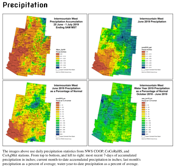
It was a mixed picture for the dry areas across the country. Widespread rainfall totals exceeding 2 inches fell from northeast Montana to north-central North Dakota, with a swath of 4 to 6 inches soaking part of northwest North Dakota. Farther east, generally under an inch fell on northeastern North Dakota and northern Minnesota near the Canadian border, with amounts increasing to the south. Between 0.5 and 2.0 inches of rain fell on the climatologically-wetter areas of the Pacific Northwest on the west side of the Cascades and along the immediate coast, and 0.5 to 1.0 inch fell on northwestern Montana and part of adjacent Idaho. Other parts of the Northwest recorded less than 0.5 inch, with only a few tenths of an inch falling on most of interior Washington and Oregon. Very little, if any, precipitation fell farther to the south, from central Oregon and Idaho southward through the Far West, and roughly the western half of the Four Corners region. Rainfall was highly variable through south Texas and the Southeast (not uncommon during summer). Several small areas from south Georgia, north Florida, and Alabama westward received over 2 inches of rain, with isolated amounts reaching nearly 6 inches in south Texas. Rainfall was considerably sparser from central and north Georgia through the Carolinas, where most sites recorded only a few tenths of an inch. Outside the contiguous states, light to moderate rains fell on north-central and central Puerto Rico while little or none was observed along the southern tier of the Commonwealth. Historically heavy out-of-season rains soaked parts of the leeward areas across Hawaii, with over 4 inches soaking Honolulu within 24 hours – more than any prior full month of June on record brought…
Another week of moderate to heavy rain in northeast Montana eliminated any residual abnormal dryness there. Conditions also improved in southwestern Montana, but dryness and drought persisted or intensified from the Northwest coast through west-central Montana. Recent dryness prompted D0 expansion through west-central Montana and adjacent Idaho, east-central Washington, and part of southwest Oregon while moderate drought was extended slightly farther south in coastal western Oregon. Moderate to severe drought, with subnormal weekly precipitation, persisted from north Idaho westward through northern and western Washington and northwestern Oregon. The drought is becoming fairly entrenched in parts of the Pacific Northwest, but no increase in D1 or D2 coverage seemed appropriate at this time…
Looking Ahead
During the next 5 days (July 3 – 7, 2019), much of Florida, southeastern Georgia, and the eastern Carolinas are expecting between 1 and 2 inches of rain, and over an inch is also anticipated in central and eastern sections of northern Minnesota. But other areas of dryness and drought across the contiguous 48 states should receive less, likely providing little if any benefit. Areas of North Dakota and western Minnesota along the Canadian border anticipate a few tenths of an inch, as do most areas from Texas eastward through central and north Georgia. Little precipitation, if any, is forecast for the dry areas from west Montana and the Pacific Northwest southward through the Far West, Great Basin, and Four Corners region. Unusually mild weather from the north Intermountain West through the northern Plains should at least slow any tendency toward increasing dryness there, but hotter-than-normal conditions in the Southeast may temper benefits that might result from moderate rainfall.
The CPC 6-10 day outlook (July 8-12, 2019) favors wetter-than-normal weather in the Southeast, the northern Plains, north and west Texas, the northern Intermountain West, and the Alaska Panhandle. Meanwhile, enhanced chances for abnormally dry weather exist in south Texas and in parts of western Washington and Oregon. The mild temperatures expected during the first week of July should continue in east Montana and the western Dakotas, but abnormally warm weather is favored in the West Coast states, the Intermountain West, the southern Plains, and the southeastern quarter of the country.
Just for grins take a journey back in time with early July US Drought Monitor maps back to 2010.