#Platte River Recovery Implementation Program water project completion expected by October 15, 2019

From The Kearney Hub (Lori Potter):

A wet 2019 delayed construction work throughout Nebraska, including a Platte River Recovery Implementation Program water project southwest of Elm Creek.

At Tuesday’s PRRIP Governance Committee meeting in Kearney, program civil engineer Kevin Werbylo said the completion date for the project on the south side of the Platte River was moved from May 1 to Aug. 1 to Oct. 15.

“Given the conditions the contractor had to deal with, they did a nice job and the engineers did a nice job,” Werbylo said.

The project fits program goals to reduce depletions to Central Platte target flows and to protect, restore or maintain land used as habitat by threatened and endangered species — least terns, piping plovers and whooping cranes.

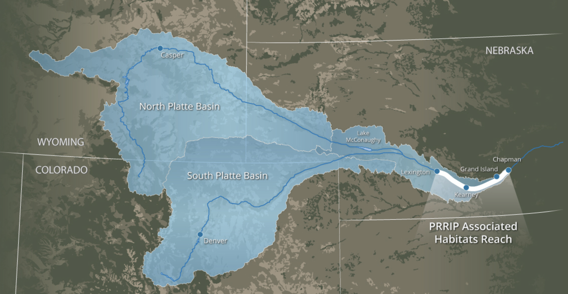
The basinwide plan allows entities in Nebraska, Colorado and Wyoming with federal licenses, permits and/or funding to comply with the Endangered Species Act. The U.S. Department of Interior is the other major participant.

The Elm Creek project will help meet an immediate goal to reduce by 120,000 acre-feet the annual depletions to target river flows set by the U.S. Fish and Wildlife Service for the protected species. Water held in shallow detention cells on the broad-scale site will seep into the groundwater that eventually reaches the adjacent Platte River.

Platte water will be diverted into Central Nebraska Public Power and Irrigation District’s Phelps Canal at times when flows exceed targets. According to PRRIP 1995-2017 data, that most commonly occurs in December and January.

A new pipeline built as part of the project links the canal to the 416-acre site where earthen berms up to 6 feet tall create eight shallow cells to temporarily hold water at depths of 12 inches or less.

Werbylo said the project budget is $4.3 million and there is $480,000 left to pay.

Dirt work needs to settle and vegetation is being established, he said, so it will be late spring to mid-summer 2020 before any water deliveries are made to the broad-scale project site.

PRRIP Executive Director Jason Farnsworth told the Hub that even if the original construction schedule had allowed the project’s use this fall, there would have been no diversions because of already high groundwater.

#Climate Lawsuit Targets 130 Oil Leases on #PublicLands in #Utah — @CenterForBioDiv #ActOnClimate #KeepItInTheGround

Here’s the release from the Center for Biological Diversity (Steve Bloch, Landon Newell, Diana Dascalu-Joffe):

Conservation groups sued the Trump administration today for failing to consider the climate pollution from 130 oil and gas leases spanning 175,500 acres of public lands in Utah.

Today’s complaint, filed in U.S. District Court in Salt Lake City, says the Bureau of Land Management violated the National Environmental Policy Act by approving five lease sales from 2014 to 2018 without accounting for the climate pollution that would result from oil and gas development. It asks the court to invalidate all five approvals and their 130 leases.

The lawsuit comes as climate scientists urge drastic cuts to greenhouse gas pollution over the coming decade. New oil and gas leases, whose production can last decades, commit public lands to more pollution. Nearly a quarter of all U.S. greenhouse gas pollution results from fossil fuel development on public lands.

“The climate crisis is being exacerbated by the BLM’s reckless and uninformed oil and gas leasing and development on public lands,” said Landon Newell, staff attorney with the Southern Utah Wilderness Alliance. “The development of these leases will push us closer to the point of no return on climate, while sacrificing some of the most wild, scenic and culturally significant public lands in America.”

Most of the challenged leases resulted from the Trump administration’s “energy dominance” agenda. In addition to slashing environmental reviews to hasten oil and gas leasing, the administration has attacked federal development and reliance on climate science in agency decisions and reports.

“Each new oil and gas lease commits us to more greenhouse gas pollution that our planet can’t afford,” said Diana Dascalu-Joffe, an attorney at the Center for Biological Diversity. “There are already more fossil fuels under development in the world than can be safely burned. New leases dangerously disregard urgent climate warnings from scientists. These leases were irresponsible and illegal, and we’re hopeful that a court will agree.”

The leases also threaten public lands and endangered species, including the Colorado pikeminnow and razorback sucker. Fracking sucks up enormous amounts of water and threatens to pollute the Colorado River and tributaries where the fish live.

“Several accidents involving water pollution have already happened on the Green River and its tributaries,” said John Weisheit, a professional river guide in eastern Utah and a representative of Living Rivers and Colorado Riverkeeper. “Combined with diminished flow volumes for these rivers, the multimillion-dollar investment already made to ensure a successful endangered fish program must not be further compromised.”

Background

Federal fossil fuel production causes about a quarter of all U.S. greenhouse gas emissions. Peer-reviewed science estimates that a federal fossil fuel leasing ban would reduce CO2 emissions by 280 million tons per year, ranking it among the most ambitious federal climate policy proposals in recent years.

Federal fossil fuels that have not yet been leased to the industry contain up to 450 billion tons of potential climate pollution. Those already leased contain up to 43 billion tons.

Existing laws provide executive authority to stop federal leasing on public lands and oceans. Hundreds of organizations have petitioned the federal government to end new onshore and offshore federal fossil fuel leasing.

Map of challenged oil and gas leases. Credit: Southern Utah Wilderness Alliance/Esri ArcMap 10.6.1.9270

How do we sustain the #ColoradoRiver past 2026? Here’s how #Arizona intends to find out — Arizona Central #DCP #COriver #aridification #conservation

Here’s a guest column from Tom Buschatzke and Ted Cooke that’s running in Arizona Central:

The Drought Contingency Plan is working, but it’s just the beginning. Here’s how we move forward.

It didn’t take long for the completion of the Drought Contingency Plan to create value to Arizona and the Colorado River Basin. Its focus on stabilizing Lake Mead and creating incentives to “bank” water in the reservoir already are paying dividends.

We can say with confidence that DCP is already a success.

DCP is providing a safe harbor while we work on important issues leading up to 2026, when the existing guidelines for the operation of the Colorado River system expire.

We now have an opportunity to build on the successful Arizona process that led to the DCP signing. Arizona is Stronger Together. And that will serve us well as we work toward the next step – maintaining a stable, healthy Colorado River system as we face a hotter and drier future.

Lake Mead is 22 feet higher than expected

A year ago, many of us were immersed in the details of Arizona’s Drought Contingency Implementation Plan, which benefited from the cooperative spirit of its participants, including elected leaders and representatives from every sector of the state’s water-using community.

In 2020 and likely 2021, we will be operating under DCP’s Tier Zero, a reduction of 192,000 acre-feet to Arizona. The estimated impact of contributing this water is more than $40 million, but the investment is worth it to protect the Colorado River system.

DCP’s incentives allow for greater storage in Lake Mead this year. That, coupled with a lot of snow from the Rocky Mountains and additional tributary flow, increased storage in Lake Mead by more than 22 feet from what was initially projected.

An excellent winter snowpack in the Rockies helped Lake Mead a lot. But here is the kicker: Almost half of that 22-foot rise in Lake Mead was due to storage and contributions to system conservation.

And conservation and storing water in the reservoir is a trend that will continue. Arizonans are doing our share, with more than 20 water users, agencies and the state having signed agreements to contribute to implementing the DCP.

But DCP won’t hold us forever

The term used for the coming negotiations on the system’s new guidelines is “reconsultation” of the “Colorado River Interim Guidelines for Lower Basin Shortages and the Coordinated Operations for Lake Powell and Lake Mead.”

The emphasis is on “interim.” The 2007 guidelines expire in 2026. So, when people ask “What’s next?” for Colorado River management, that’s it: The difficult challenge of assessing the effectiveness of the current guidelines, with the DCP overlay, and exploring new approaches for the next iteration of the guidelines.

As we learned on Jan. 31 when the state Legislature passed and Gov. Doug Ducey signed Arizona’s DCP, we achieved success because we worked together. We intend to bring the steering committee process back to life, reviving that spirit of cooperation that so infused negotiations.

To that end, we are embarking on a listening and data-collecting effort. It is our plan to meet first with the elected leaders who contributed so much time and effort to the successful steering committee process. Then we plan to sit down with other delegates, including those representing Arizona tribes, cities, agriculture, mining, development and the nonprofi community.

Our goal: To develop a shared vision

Our new goal? Gather our stakeholders’ thoughts and develop a shared vision as we plan for Arizona’s Colorado River water supply.

This will ensure Arizona is a strong voice among the Colorado River Basin states and the federal government as we hammer out the next set of agreements for managing the Colorado River Basin beyond 2026.

That is our “next step.” It’s a big one and we must be prepared. And we will be, because Arizona truly is Stronger Together.

Tom Buschatzke is director of the Arizona Department of Water Resources. Ted Cooke is general manager of the Central Arizona Project. Together, they co-chaired the steering committee that helped finalize the state’s Drought Contingency Plan signed May 20. Reach them at tbuschatzke@azwater.gov and tcooke@cap-az.com.

Pawnee Buttes Grass Tour recap

Pawnee Buttes. Photo credit Greg Hobbs.

From The Fence Post (Rachel Gabel):

The Pawnee Buttes Seeds grass tour met Aug. 15-16 at the Lonesome Pines Land and Cattle Company in Grover, Colo., an area firmly in grazing country. The program concentrated on what rancher Jim Sturrock has deemed the five dimensions of ranching: landscape, time, animals, forage resources and the unexpected…

Soil health, mycorrhizal fungi, the geology of the land, CO2, photosynthetic cycles, weed identification and control, and biodiversity were all on the slate. The group traveled to neighboring properties to study control methods with varying degrees of success including winter grazing and differently timed applications of herbicide. Plant encroachment discussed included Fringed Sage, Juniper, Cheat Grass, cacti, skunk bush and toad flax. The group was able to study land management in action, see the effects of grazing cycles, and soil health in action.

“When external factors act upon an ecosystem, the living relationship between all things in that environment are at risk of changing,” he said. “A change or reduction in biodiversity can have negative impacts on plants and animals, both wild and domesticated, which depend on that habitat.”

Overgrazing can cause forage to die off and be displaced by competing shrubs and ungrazed grasses at a lower nutritional value. These encroaching plants, he said, often use more water, impacting the local watershed as well as impacting soil fertility and erosion rates.

@EPA finalizes repeal of #WOTUS rule, promises new definitions in December

A wetland along Castle Creek. Photo credit: Brent Gardner-Smith/Aspen Journalism

From KOAA.com (Colette Bordelon):

The 2015 rule expanded the types of waterways that can receive federal protection under the Clean Water Act. Now, WOTUS will go back to it’s form before 2015. A member of the local Sierra Club disagrees with the decision. “Would allow people to pollute much more easily, there’s no longer a permit requirement, and because of that they can carry on activities without the government oversight,” said Jim Lockhart, the Conservation Chair of the Pikes Peak Group of the Sierra Club.

Lockhart said the 2015 rule defined what waterways should be protected more specifically, and now he’s interested to see what the new definition will be. “Rescinded the rule and promised new definitions, they could have waited and created the new definitions and then let the public see them and then let the public decide,” said Lockhart.

EPA Administrator Andrew Wheeler said the new definition will come in December, and would mean farmers, landowners, and businesses will spend less time and money determining whether they need a federal permit.

Arizona Rivers Map via Geology.com.

From The Cronkite News (Kailey Broussard) via KOAA.com:

…while some welcomed the end of the “Waters of the United States” rule, environmental groups warned that the change would mean virtually no environmental protection for the nation’s waterways – particularly in the West.

“We know where we are going, and that is going to be a world where wetlands, especially in the arid West, get almost no protection,” said Brett Hartl, government affairs director for the Tucson-based Center for Biological Diversity.

A 2018 report by the center estimated that more than 3,000 U.S. watersheds would lose Clean Water Act protections under the replacement plan proposed by the Trump administration. That, in turn, could accelerate the extinction of more than 75 endangered species, the report said.

Critics of the Obama-era rule – known as WOTUS – disagree, saying the full range of federal pollution regulations does more than enough to protect waterways…

In the meantime, federal officials are developing and presenting a new plan. That process has garnered more than 621,000 comments on the federal regulations website…

…Sandy Bahr, president of the Sierra Club’s Grand Canyon chapter, said the EPA is “not being honest” about the change’s impact. WOTUS protected arterial waterways, she said, by protecting the less-obvious waters.

“If you take a very narrow view of that and say, ‘Oh, only waters that are navigable,’ then you’re not even going to be protecting those navigable waters,” she said.

Bahr and others have pointed to the San Pedro River, a ribbon-like stream that meanders some 140 miles through southern Arizona and part of Mexico. The stream’s limited navigability means it most likely would not receive protection under the repeal.

“You can talk about these things in the abstract, but when you look at what is happening on the ground already, we’re struggling to protect rivers like the San Pedro River, which is so important ecologically and economically,” Bahr said. “Something like this rollback makes it so much more difficult to do.”

Hartl said that, except for the Colorado River, the change would mean most of Arizona would not be protected. A map included with the center’s study showed much of the Southwest losing Clean Water Act protection without WOTUS…

Meanwhile, Bahr is certain the proposed rule will be challenged.

“We need to have the most stringent requirements possible to protect what we have left because we have lost so much,” she said.