Click here to read the current assessment. Click here to go to the NIDIS website hosted by the Colorado Climate Center. Here’s the summary:
Summary: October 29, 2019
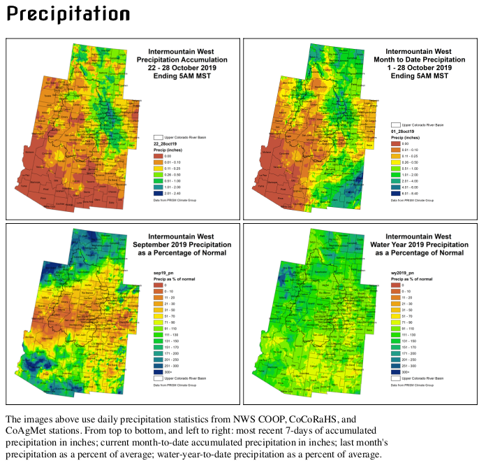
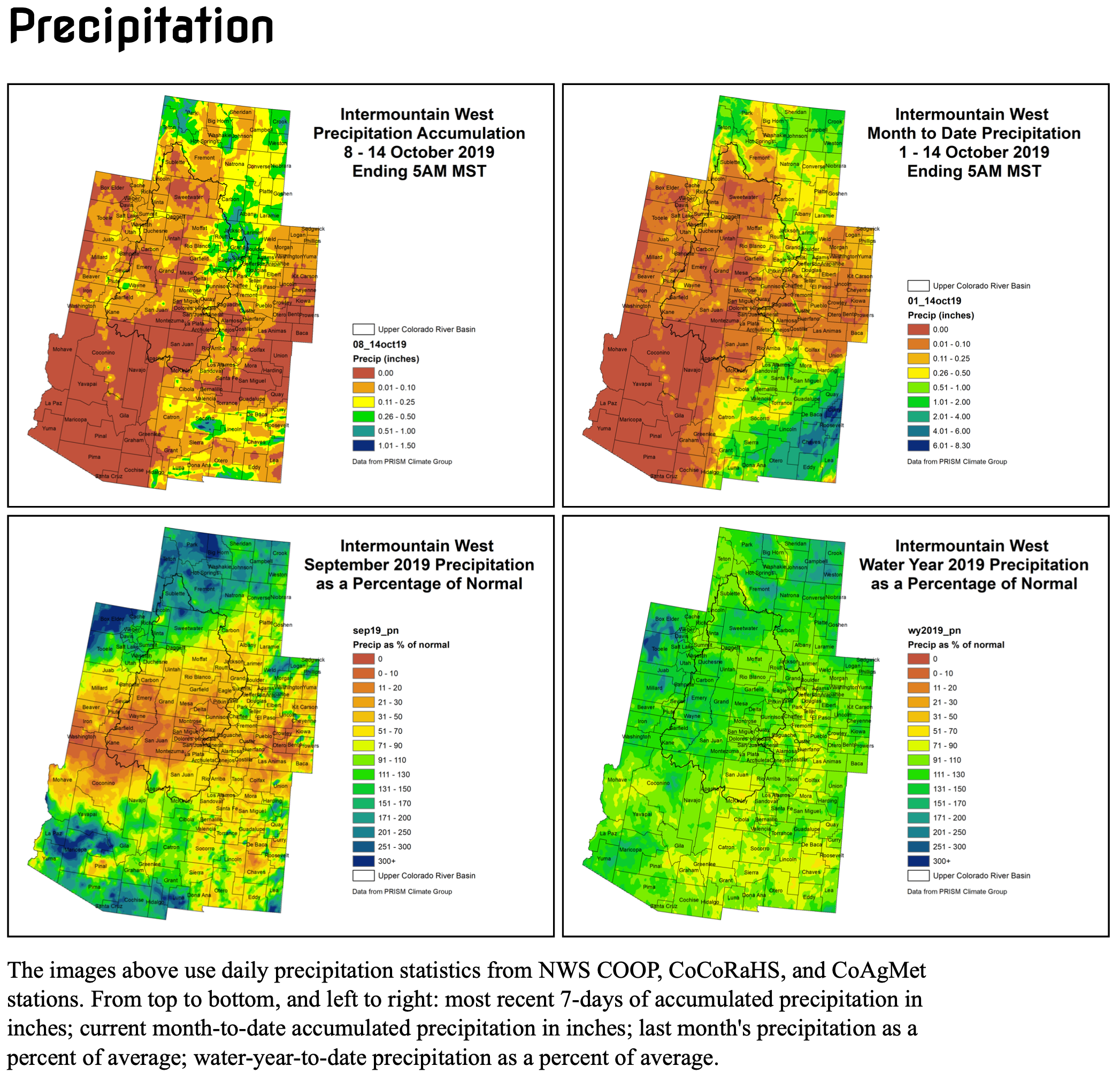
While the majority of the Intermountain West experienced below average temperatures last week, many spots remained dry. Most of Utah, Arizona, and New Mexico received less than a tenth of an inch of moisture last week, with larger accumulations focused over the Continental Divide and mountains in Colorado, the I-25 corridor, and many locations throughout Wyoming. Month-to-date, the Four Corners region has mostly missed out on the moisture. Monthly climatological contributions indicate that October is an important precipitation month for eastern Utah, and unfortunately, they have not received much.
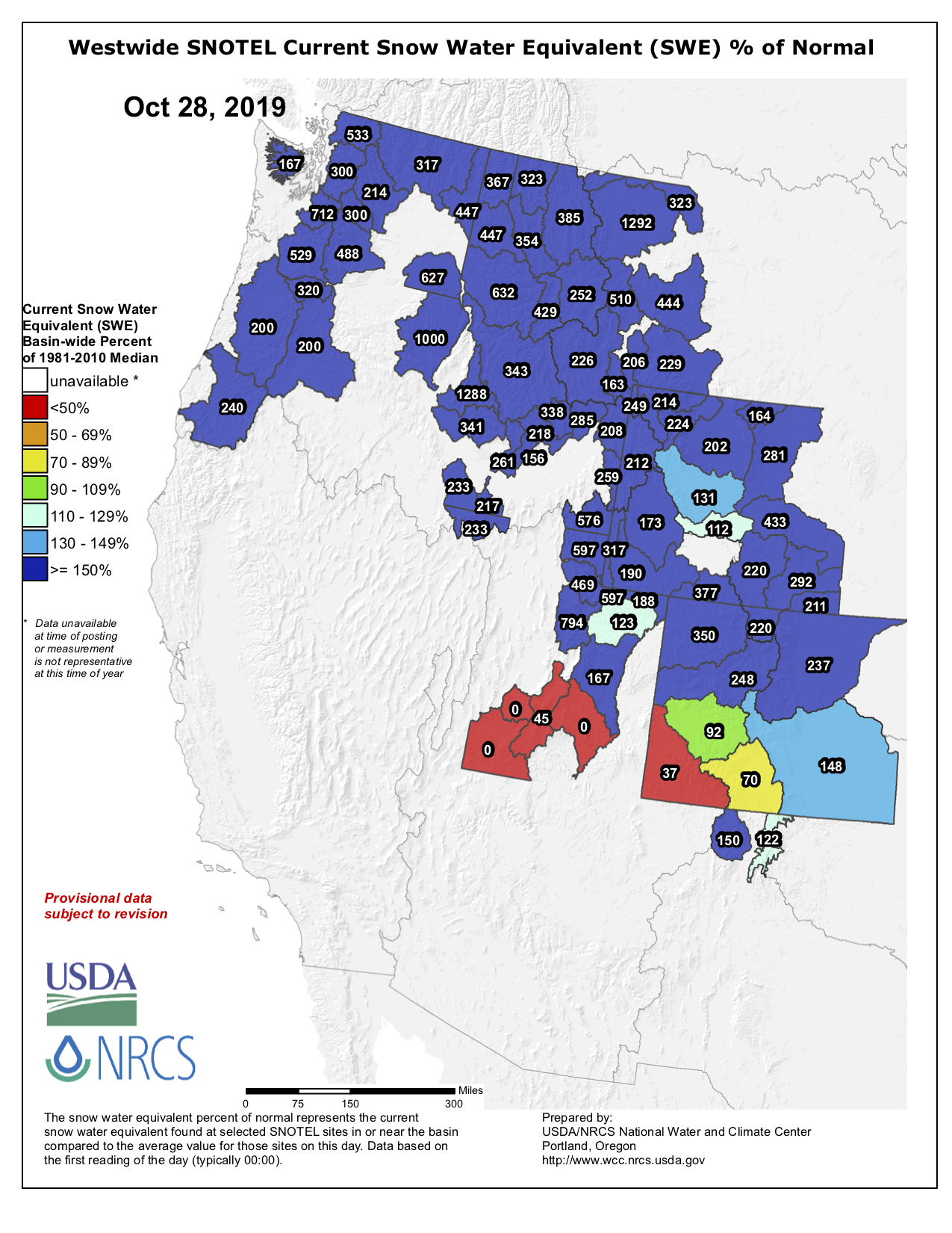
On a positive note, we’ve had a solid start to the snowpack accumulating season. Although early, it is promising to see percentiles near and above the median for snowpack throughout the IMW as of October 28. The lowest percentiles (which are closer to 50, or near average) are scattered along the central UT mountains and the San Juans in southwest CO.
Streamflows are still in okay condition in the Upper Colorado River Basin as they remain near baseflow. Expect many of the gages to go “offline” as they become ice affected over the coming days and weeks. Soil moisture is showing quite a bit of drying, thanks to a hot and dry summer and lack of monsoon. Since the soils will be freezing and not thawing for the rest of the cold season, moisture doesn’t matter much now. But those dry soils will come into play again during the spring thaw.
Cold conditions will continue over much of the region this week, but warming will return to the southern part of the IMW in early November. While some more precipitation accumulations are expected (mostly over Colorado) this week, there is an increased chance for drier than average conditions returning to the region.
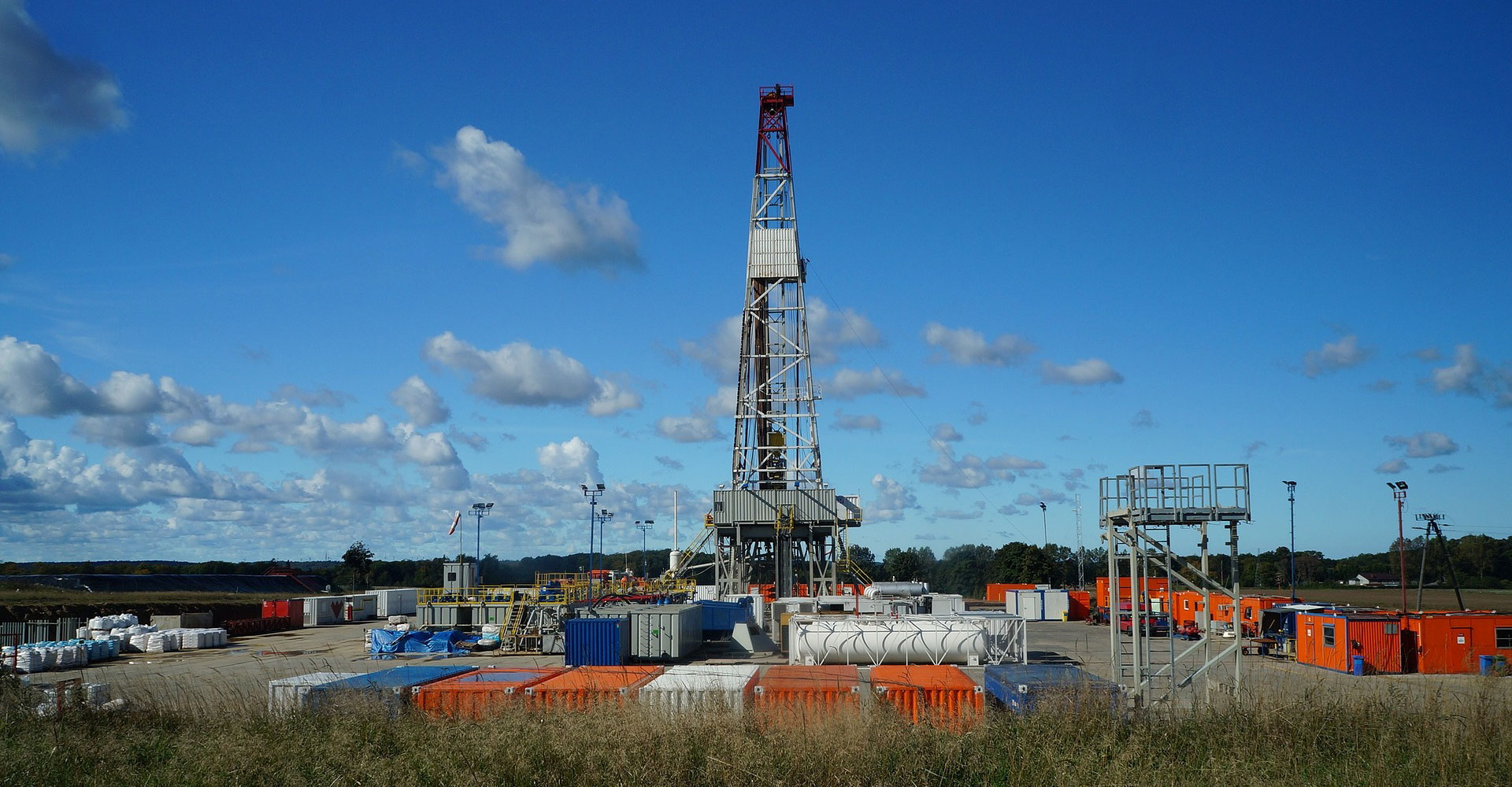
The horizontal drilling method called hydraulic fracturing helps the United States produce close to 4 billion barrels of oil per year, rocketing the U.S. to the top of oil-producing nations in the world.
The highly profitable practice comes with a steep price: For every barrel of oil, oil and gas extraction also produces about seven barrels of wastewater, consisting mainly of naturally occurring subsurface water extracted along with the fossil fuels. That’s about 2 billion gallons of wastewater a day. Companies, policymakers and scientists are on the lookout for new strategies for dealing with that wastewater. Among the most tantalizing ideas is recycling it to irrigate food crops, given water scarcity issues in the West.
A new Colorado State University study gives pause to that idea. The team led by Professor Thomas Borch of the Department of Soil and Crop Sciences conducted a greenhouse study using produced water from oil and gas extraction to irrigate common wheat crops. Their study, published in Environmental Science and Technology Letters, showed that these crops had weakened immune systems, leading to the question of whether using such wastewater for irrigation would leave crop systems more vulnerable to bacterial and fungal pathogens.
“The big question is, is it safe?” said Borch, a biogeochemist who has joint academic appointments in the Department of Chemistry and Department of Civil and Environmental Engineering. “Have we considered every single thing we need to consider before we do this?”
Produced water experiments
Typically, oil and gas wastewater, also known as produced water, is trucked away from drilling sites and reinjected into the Earth via deep disposal wells. Such practices have been documented to induce earthquakes and may lead to contamination of surface water and groundwater aquifers.
The idea for using such water for irrigation has prompted studies testing things like crop yield, soil health, and contaminant uptake by plants, especially since produced water is often high in salts, and its chemistry varies greatly from region to region. Borch, who has conducted numerous oil and gas-related studies, including how soils fare during accidental spills, wondered if anyone had tried to determine whether irrigation water quality impacts crops’ inherent ability to protect themselves from disease.
The experiments were conducted in collaboration with plant microbiome expert Pankaj Trivedi, a CSU assistant professor in the Department of Bioagricultural Sciences and Pest Management, and researchers at Colorado School of Mines. The team irrigated wheat plants with tap water, two dilutions of produced water, and a salt water control. They exposed the plants to common bacterial and fungal pathogens and sampled the leaves after the pathogens were verified to have taken hold.
Using state-of-the-art quantitative genetic sequencing, the scientists determined that the plants watered with the highest concentration of produced water had significant changes in expression of genes plants normally use to fight infections. Their study didn’t determine exactly which substances in the produced water correlated with suppressed immunity. But they hypothesized that a combination of contaminants like boron, petroleum hydrocarbons and salt caused the plants to reallocate metabolic resources to fight stress, making it more challenging for them to produce disease-fighting genes.
“Findings from this work suggest that plant immune response impacts must be assessed before reusing treated oil and gas wastewater for agricultural irrigation,” the study authors wrote.
Water from the Roaring Fork River basin heading east out of the end of the Twin Lakes Tunnel (June 2016), which is operated by the Twin Lakes Reservoir and Canal Co., a member of the Front Range Water Council. The FRWC recently declined to meet with members of a Colorado Basin Roundtable group about demand management. Photo: Brent Gardner-Smith/Aspen Journalism
The state of Colorado’s investigation into the feasibility of a demand-management program has spawned the spinoff of several additional groups to study the issue, underscoring persistent tensions between the Western Slope and Front Range water managers.
In June, the Colorado Water Conservation Board named 74 people — most of them experts in their fields — to nine workgroups charged with helping the state study whether a water-use reduction plan is right for Colorado. Now, some roundtables and conservation districts are forming their own grassroots stakeholder groups to study demand management outside of the state’s formal process.
One of those is the Colorado River Basin Roundtable. The stakeholder group, chaired by Kirsten Kurath, who is general counsel for the Grand Valley Water Users Association, invited Front Range water providers to an informal meeting on Monday to discuss demand management and address some assumptions about the contentious topic.
Although representatives from Northern Water and Aurora Water initially accepted the invitation, a subsequent letter from the Front Range Water Council made it clear that Front Range water interests were circling the wagons and closing ranks. The FRWC is an ad-hoc group made up of representatives from Front Range urban water providers.
In a letter signed by FRWC chair and Denver Water CEO James Lochhead, the group declined Kurath’s invitation to the meeting.
“We feel it is best at this point not to have ‘official’ side meetings regarding demand management and what a demand management process/program may look like because, particularly with press present, such conversations may lead to confusion and may undermine the state process,” the letter reads.
“It seemed like a great opportunity as part of our workgroup to invite folks from the Front Range Water Council and chat with them about what we are thinking about demand management,” Kurath said. “We do need to work at relationship-building between these historically adverse parties.”
This field is irrigated with water from the Roaring Fork River, under a senior water right. Some on the Western Slope worry that water savings from a water-use-reduction plan known as demand management could fall disproportionately to the agriculture sector. Photo credit: Brent Gardner-Smith/Aspen Journalism
Contentious topic
So, why is demand management a touchy subject that highlights tensions between Colorado’s West Slope and Front Range? It may be because some in Western Slope agriculture worry that Front Range water providers, backed by a reliable pot of money from their rate-paying customers, can simply pay ranchers to fallow fields without having to reduce their own water consumption. Some Western Slope agricultural water users have voiced concerns about how to create a demand-management program that reduces water use equitably across all sectors, not just agriculture.
On top of that, some fear that if fields are no longer producing crops, a cascade of unintended consequences for the local economy could be the result. The Colorado River Water Conservation District and the Southwestern Water Conservation District are studying the secondary economic impacts of demand management.
“What are the economic impacts should someone decide not to grow a crop?” said Frank Kugel, executive director of the Durango-based Southwestern Water Conservation District. “What about the tractor-supply store, the feed stores, the restaurants and the workers that work on those farms?”
Adding to the controversial nature of demand management is Colorado’s social and cultural backdrop. At the heart of a demand-management program is a reduction in water use on a temporary, voluntary and compensated basis in an effort to send as much as 500,000 acre-feet of water downstream to Lake Powell to bolster water levels in the giant reservoir and, indirectly, to meet Colorado River Compact obligations. Under such a program, ranchers and farmers could get paid to leave more water in the river.
But Andy Mueller, general manager of the CRWCD, said the concept of intentionally saving water goes against the age-old Western water adage of “Use it or lose it.” Some irrigators believe their water right, which is seen as a property right, could be considered abandoned if they don’t use their entire share of the water all the time, although it is rare in Colorado for this aspect of the law to be enforced by the state.
“We are asking people to change 150 years of cultural, family, political traditions,” Mueller said. “What we need to do in the water-policy world is help provide people with security and confidence they are not unintentionally damaging themselves for the future and that they are protected and have economic certainty.”
To this end, the river district also is forming a demand-management stakeholder group of its own. Mueller said the goal is to convene a group of roughly 30 water users to figure out how their interests would be protected if a demand-management plan is implemented.
“It’s a really critical thing for our actual water users to be driving the train because they know how their farms work,” Mueller said. “If you get ideas from them, they are much more likely to work in the long run.”
The Government Highline Canal, near Grand Junction, delivers water from the Colorado River, and is managed by the Grand Valley Water Users Association. Representatives from the Grand Valley Water Users Association invited members of the Front Range Water Council to discuss demand management, but the FRWC declined. Photo credit: Brent Gardner-Smith/Aspen Journalism
Water from ag?
Although some might assume that the easiest way to save a large amount of water in a demand-management program is to take it from Western Slope agriculture, Front Range water providers say that isn’t the case. Lochhead said that Denver Water would participate in a demand-management program along with everyone else using “wet water,” not just by throwing money at the problem.
Brad Wind, general manager of Northern Water, agreed that water savings solely from Western Slope agriculture isn’t the solution.
“I get the impression from some West Slope entities … that they think the whole burden of demand management is going to come on the backs of the West Slope,” he said, “and honestly, I don’t think anybody on the Front Range Water Council is saying that.”
These were some of the issues Kurath was hoping to clear up in a meeting with her stakeholder group and Front Range water providers.
“We just wanted to explore that with folks,” she said. “It was a real disappointment to me to have them decide they didn’t want to participate.”
Editor’s note: Aspen Journalism collaborates with the Aspen Times and other Swift Communications newspapers on coverage of rivers and water. This story ran in the Oct. 30 edition of the Times.
Click on a thumbnail graphic to view a gallery of drought data from the US Drought Monitor.
US Drought Monitor October 29, 2019.
West Drought Monitor October 29, 2019.
Colorado Drought Monitor October 29, 2019.
Click here to go to the US Drought Monitor website. Here’s an excerpt:
This Week’s Drought Summary
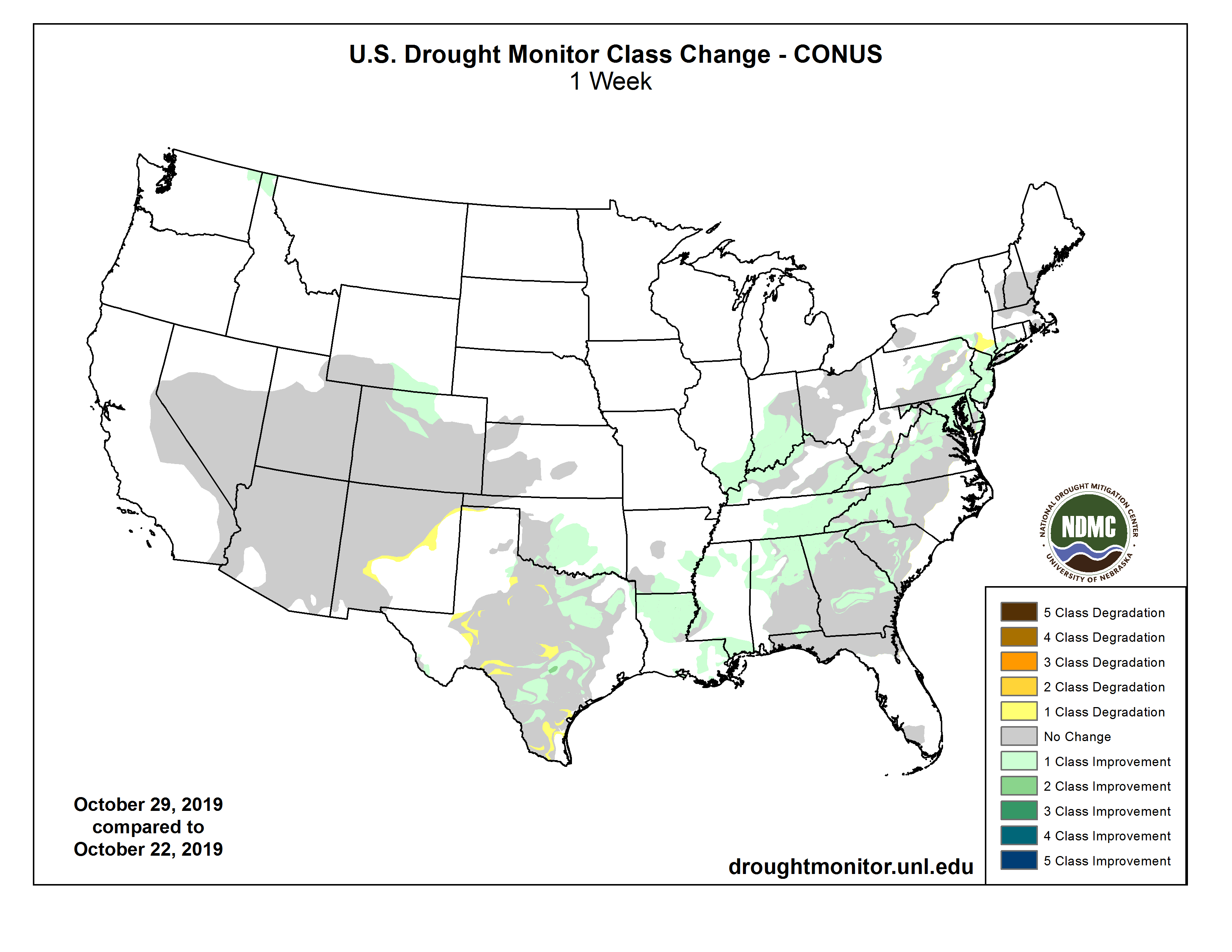
This U.S. Drought Monitor week saw widespread improvements in drought-stricken areas across portions of the South, Southeast, and Mid-Atlantic, as moderate-to-heavy rainfall accumulations were observed associated with storm systems fueled by residual moisture from Tropical Storm Olga. Across these areas, precipitation accumulations ranged from 2-to-10 inches leading to improvements on the map in Louisiana, Mississippi, Tennessee, Alabama, Georgia, South Carolina, North Carolina, and Virginia. In California, numerous wildfires are burning across northern and southern portions of the state, including the Kincaide Fire (the state’s largest active fire) in Sonoma County that has burned approximately 76,000 acres. In southern California, firefighting efforts have been hampered by strong Santa Ana winds that are causing extreme fire behavior…
On this week’s map, no changes were made across the region. According to the October 25th North American Land Data Assimilation System (NLDAS), the current total column soil moisture percentiles were at 70% or greater across North and South Dakota while some dry soil pockets were present in eastern Colorado. Average temperatures for the week were 3-to-15+ degrees below normal with the greatest negative anomalies observed in the plains of Colorado and Wyoming…
Across most of the region, dry conditions prevailed with the exception of some snowfall activity in the central and northern Rockies, as well as in the Uinta and Wasatch ranges of Utah. According to the NRCS SNOTEL network, snow water equivalent (SWE) levels are above normal across all of the major drainage basins in the northern half of the region. In California, numerous wildfires are burning across the state including the Kincade Fire near the northern California community of Geyserville where approximately 76,000 acres have burned, according to the October 30th National Interagency Coordination Center’s Incident Management Situation Report. In southern California, low humidity and strong Santa Ana winds have led to extreme fire weather conditions that have exacerbated fire-fighting efforts in the greater Los Angeles area. During the past week, average temperatures were below normal across most of the region with the exception of California where temperatures were 3-to-9 degrees above normal. Further inland, well-below normal temperatures were observed across the eastern Great Basin and Intermountain West with average temperatures ranging from 6-to-15 degrees below normal…
Widespread showers and thunderstorms were observed during the past week in the Deep South in association with post-tropical cyclone Olga, which made landfall Saturday along the central Louisiana coast. Across the region, rainfall accumulations ranged from 2-to-10 inches across Louisiana and Mississippi—leading to one-category improvements in areas of Severe Drought (D2), Moderate Drought (D1), and Abnormally Dry (D0). Likewise, improvements were made across eastern Tennessee in areas of Extreme Drought (D3), Severe Drought (D2), and Moderate Drought (D1) where rainfall accumulations ranged from 1-to-3 inches. In Texas, bands of heavy rainfall (2-to-4 inch accumulations) were observed in the Hill Country, Gulf Coast, and North Texas leading to one-category improvements; areas in the western part of the state were generally dry leading to expansion of areas of Moderate Drought (D1) and Abnormally Dry (D0). According to the USDA for the week ending October 27, the percent of subsoil by state rated short to very short was as follows: Mississippi 12%, Arkansas 16%, Louisiana 3%, Tennessee 39%, Oklahoma 38%, and Texas 55%. Average temperatures were mainly below normal across the region with the greatest negative anomalies observed across the Oklahoma and Texas Panhandles where temperatures were 10-to-15 degrees below normal…
Looking Ahead
The NWS WPC 7-Day Quantitative Precipitation Forecast (QPF) calls for moderate-to-heavy accumulations ranging from 2-to-5+ inches across portions of the South, Southeast, Mid-Atlantic, and Northeast. Lower accumulations (<2 inches) are expected across a swath extending from eastern Texas northward across most of the Plains states and Upper Midwest. Out West, liquid accumulations of generally less than 1 inch are expected across the Rockies and North Cascades of Washington state. The CPC 6–10-day Outlook calls for a high probability of above-normal temperatures across the Far West, Great Basin, and Southwest while areas east of the Rockies are expected to be below normal with the exception of Florida. In terms of precipitation, there is a high probability of below-normal precipitation across the Pacific Northwest, northern California, northern Great Basin, and the Intermountain West as well as in the central and southern Plains, lower Midwest, South, and Mid-Atlantic. Conversely, the northern Plains, Upper Midwest, southern Texas, and Florida are expected to have above-normal precipitation.
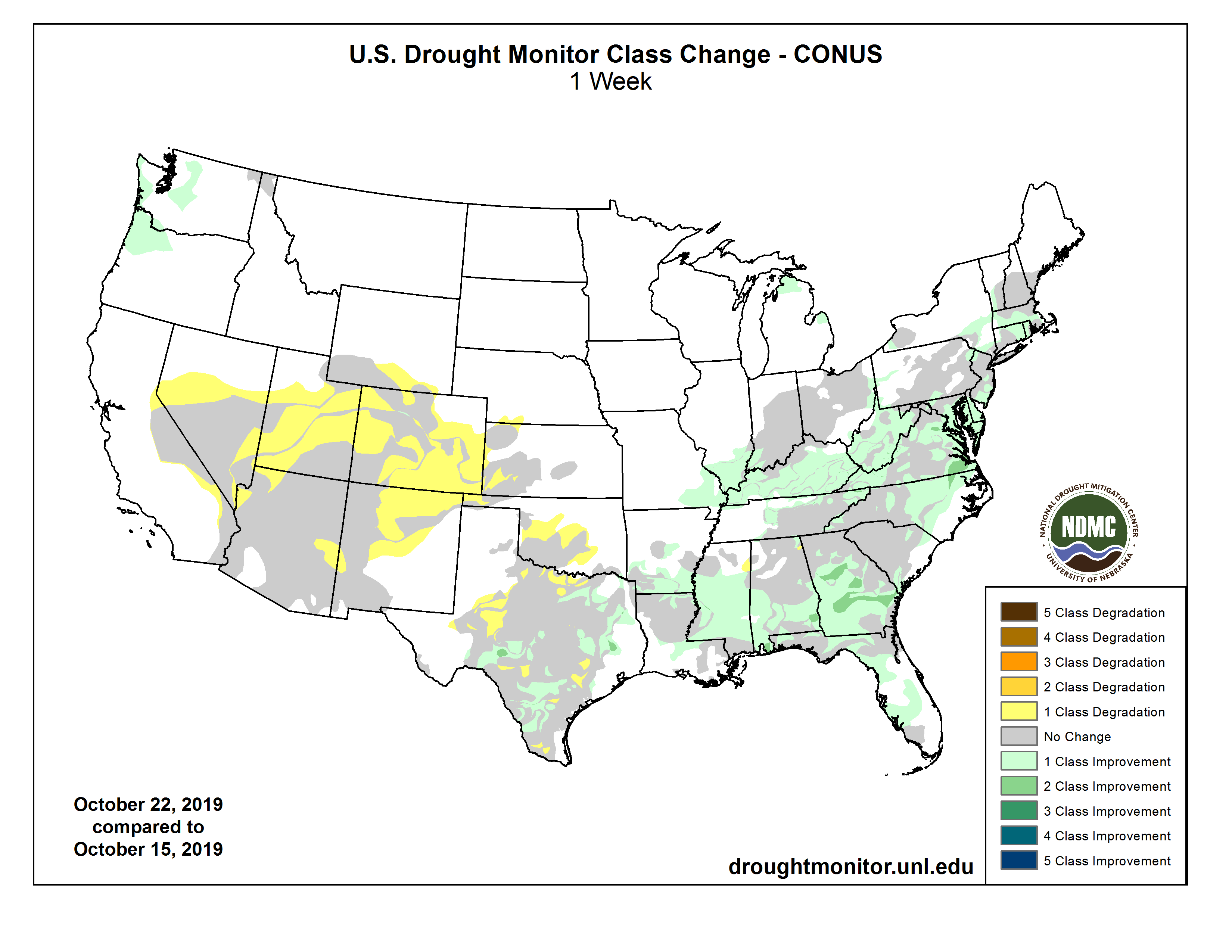
US Drought Monitor one week change map ending October 27, 2019.
From the Colorado Springs Independent (Pam Zubeck):
Utilities plans water and wastewater rate increases, effective Jan. 1, that would drive up the typical residential bill by $5.71 a month, a commercial bill by $7.90, and an industrial bill by $99.55.
From the Colorado River Water Conservation District via The Aspen Times:
The Colorado River District recently received special recognition from the Special District Association of Colorado.
The Glenwood Springs-based Colorado River District was named the 2019 J. Evan Goulding District of the Year by the association. The award is given annually to single out a district that demonstrates exceptional leadership and community spirit.
The Colorado River Water Conservation District, commonly known as the Colorado River District, was created in 1937 to oversee conservation, use and development of water resources of the Colorado River and its principal tributaries in the state of Colorado.
The river district is composed of 15 Western Slope counties with about 500,000 residents. The district covers about 29,000 square miles or roughly 28 percent of the land area of the state. It works to protect 70 percent of the water resources in the state. One way it fulfills its mission is through water storage and operational solutions that ensure economic, agricultural and environmental health of western Colorado. It also undertakes legislative and regulatory advocacy at the state and federal levels.
The district is overseen by a board of directors with one appointed representative from each of the 15 counties.
Anschutz Medical Campus. Photo credit. CU Center for Bioethics and Humanities
From the Agency for Toxic Substances and Disease Registry:
CDC/ATSDR announced on September 23 that they established cooperative agreements with seven partners to study the human health effects of exposures to per- and polyfluoroalkyl substances (PFAS) through drinking water at locations across the nation.
This draft protocol representing the core research is undergoing review. All recipients must follow the final protocol to conduct the research at their sites. The final protocol will be posted on this site at a later date.
The seven partners awarded the cooperative agreement to conduct the Multi-site Study and the location where they each will conduct their work are as follows:
Colorado School of Public Health, University of Colorado Anschutz Medical Campus, to look at exposures in El Paso County, CO
Michigan State Department of Health and Human Services to look at exposures in Parchment/Cooper Township, MI, and North Kent County, MI
RTI International and the Pennsylvania Department of Health to look at exposures in Montgomery and Bucks Counties, PA
Rutgers Biomedical and Health Sciences – School of Public Health to look at exposures in Gloucester County, NJ
Silent Spring Institute to look at exposures in Hyannis, MA, and Ayer, MA
University at Albany, SUNY and New York State Department of Health to look at exposures in Hoosick Falls, NY, and Newburgh, NY
University of California – Irvine to look at exposures in communities near the UC Irvine Medical Center
The multi-site health study was authorized by the National Defense Authorization Acts of 2018 and 2019 to provide information to communities about the health effects of PFAS exposure. The information learned from the multi-site study will help all communities in the U.S. with PFAS exposures, including those that were not part of the study.
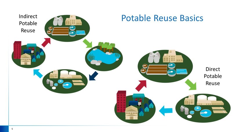
Indirect potable reuse, or IPR: releasing highly treated reclaimed water into an environmental buffer such as a surface water reservoir or an aquifer—that is later withdrawn and treated for potable use. This also arguably includes de facto IPR, where source waters are impacted by upstream wastewater discharges from other utilities. Since many cities are downstream of other cities along rivers, de facto IPR is very common. Direct potable reuse, or DPR: drawing highly treated effluent from a water reclamation facility and sending it directly to a drinking water plant for treatment. This differs from IPR by not having the environmental buffer, like an aquifer or reservoir, between the wastewater discharge and the drinking water intake.
Click here to read the paper (Caroline E. Scruggs, Claudia B. Pratesi & John R. Fleck). Here’s the abstract:
Direct potable reuse (DPR) can improve reliability of water supplies by generating drinking water from wastewater, but communities have consistently opposed DPR more than other forms of reuse. Using interview data regarding DPR projects in five inland communities, this study fills gaps in the literature with an analysis of factors influencing acceptance of DPR. While scholars have recommended public processes used to implement non-potable and indirect potable reuse projects, there is little-to-no documentation about whether and how they have been used to implement DPR projects. Further, previous research has focused on large coastal cities. Counter to previous recommendations, we found minimal public deliberation of reuse options and public education/outreach occurring post-project conception. Findings suggest that direct experience with water scarcity, community smallness, and governance strongly influence DPR acceptance. With few DPR facilities worldwide, this new knowledge is useful to water planners who are interested in the feasibility of DPR in inland areas.
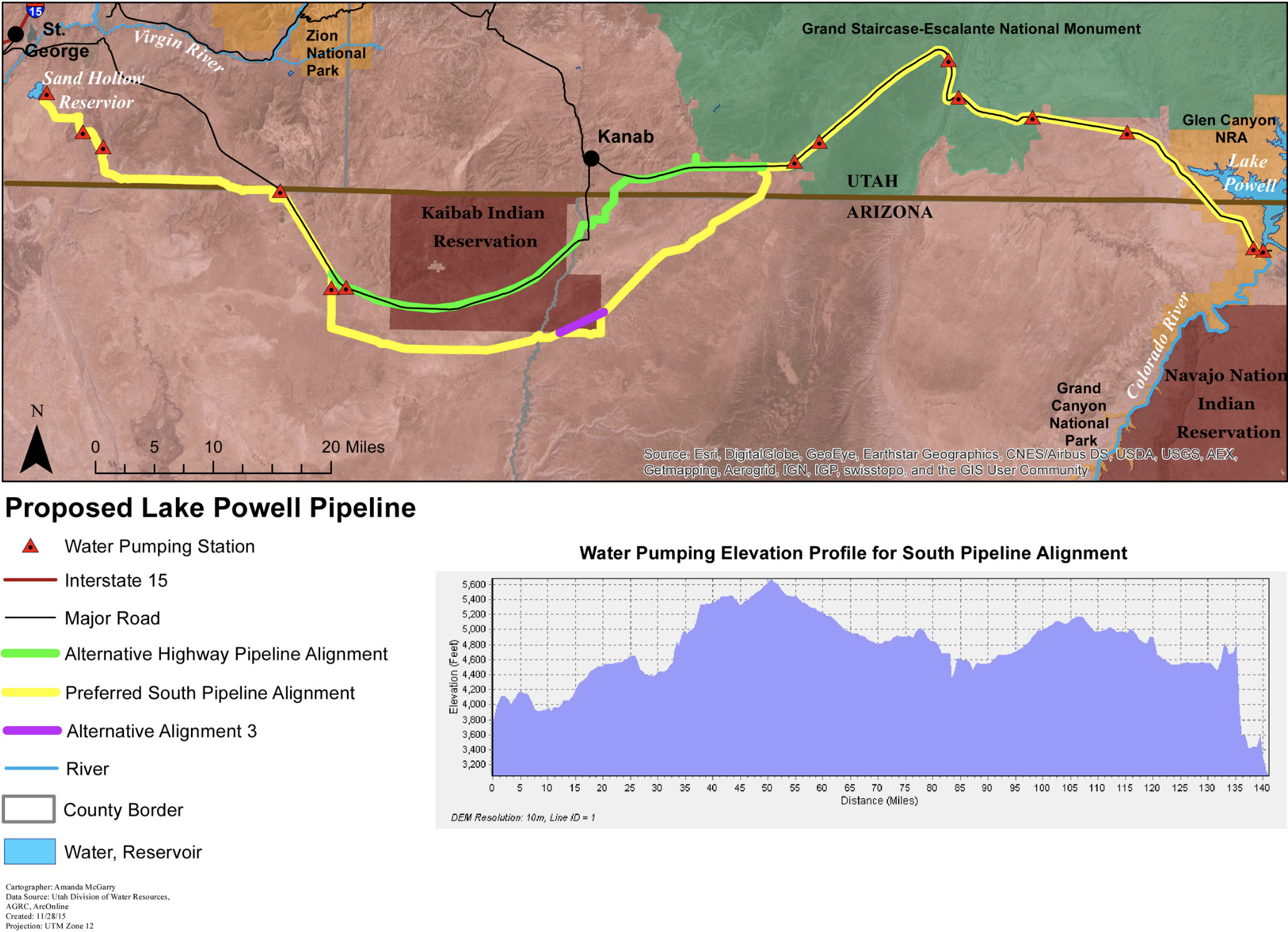
This $2+ billion project would pump 28 billion gallons of water 2,000 feet uphill across 140 miles of desert to provide just 160,000 residents in Southwest Utah with more water. Graphic credit: Utah Rivers Council
The elimination of the major hydropower components of the proposed Lake Powell Pipeline means a new federal agency will review the project and determine if it is environmentally sound to move forward.
“The division looks forward to working with reclamation on updating the timeline and cost estimate for the project and completing the environmental impact statement,” Eric Millis, director of the Utah Division of Water Resources, announced Tuesday
The Federal Energy Regulatory Commission had been the reviewing agency. After a September decision by the Utah Board of Water Resources to eliminate two reservoirs for the generation of electricity during peak demand, that entity was no longer the appropriate reviewing agency…
Project proponents say the pipeline is necessary to meet the needs of a growing population and to diversify water supply resources. Most of southern Utah residents rely on a single and volatile source of water — the Virgin River — which has been challenged by drought conditions.
Construction of the pipeline won’t begin until 70% of the water is under contract.
Karry Rathje, with the Washington County Water Conservancy District, said the shift to another federal agency to review the project should not result in any delays.
Auraria Campus. (Photo by Casey A. Cass/University of Colorado)
From email from Paul Lander:
In one week, on November 5th, at 1pm on the Metro State Campus in downtown Denver (Student Success Building, Room 440A) there will be a meeting of the budding Colorado Delegation to the US Water Summit. PLEASE join us.
Delegations have an opportunity to create a framework for facilitating deeper engagement among water professionals, and also with the communities they serve, working toward an equitable water future.
This is a completely all-volunteer effort. To focus the first year’s work, in our 1 previous meeting, we have looked at following the process of the city and county of Denver as they craft a ‘One Water’ future, where all water providers more regularly, and effectively, interact, to deliver more service, and more resiliency.
The Lamar City Council took steps to help improve a problem with groundwater infiltration in the area of Rancher’s Lift Station behind Rancher’s Supply on East Olive Street in Lamar. Groundwater (inflow and infiltration) is entering the sewer system negatively impacting the city’s Wastewater Treatment Plant. The excess groundwater affects electricity costs, unnecessary equipment wear and tear on lift station pumps and the Wastewater Treatment Plant and influences the amount of wastewater permitted by the State of Colorado. The current permit allows for 1.16 million gallons per day, but in the summer when ground infiltration increases, the Plant consistently exceeds that number by at least 50to 60%. The lift station at Rancher’s Supply is a major contributor to the problem and if not corrected, state compliance and future growth will become major issues.
The council approved the hiring of Granite Inliner to line the sewer with an inner pipe in the impacted area at a cost of $65,160. The firm has been employed by the city to line parts of the stormwater drainage system in the Northwest Stormwater Drainage Project with more than satisfactory results. It was noted that there was only $47,000 remaining in the fund, but the balance should be made up from the 2020 budget, perhaps using a grant from the Colorado Department of Health and Environment expected later this year.
A public hearing was held to begin the process of updating the city’s Water Conservation Plan through a Colorado Water Conservation Board grant. The council voted to adopt the plan which dictates that communities in the state develop and implement a water conservation plan and revise it as conditions alter for a community. The CWCB has the authority to without grants for any community which have not adopted the required plan. A new, draft plan was completed by the city using a grant for the engineering study in 2015. However, the city’s Water Enterprise management team was not satisfied with the quality of the plan and the engineer is no longer available. City staff eventually hired the water engineering firm, Helton & Williamsen to produce a supplement to the Plan which corrected the areas of concern to city staff. The Plan was approved by the council during its regular meeting on Monday, October 28th.
The proclamation No. 19-07, “November 8, 2019 as Zonta International Centennial Day in the City of Lamar, Colorado” was approved by the council. The Prowers County chapter joined other chapters around the world to celebrate the 100th anniversary of the founding of Zonta. Local activities included displays by members in numerous parades, gathering books about strong females to donate to local school libraries and a pubic proclamation with week of November 8th will culminate in the lighting of the Prowers County Courthouse in anniversary teal colors. Zonta was founded on November 9, 1919 in Buffalo, NY and has since expanded into an international service and advocacy organization with 29,000 members in 63 countries on six continents. Since 1923 Zonta has contributed more than $41 million U.S. dollars to empower women through improved education, health care, economic opportunities and safe living conditions…
…[increases in] water usage rates which are recommended to go up by $1.00 each for in-city water connections and $2.00 per service for those residents who are outside the city boundaries.
In an ongoing conservation project, CPW recently released 1,700 boreal toad toadlets in a wetland in the San Juan mountains. Photo credit: Colorado Parks & Wildlife
Here’s the release from Colorado Parks and Wildlife:
In mid-September Biologist Dan Cammack walked slowly along the edge of a boggy pond in the San Juan Mountains high above the San Luis Valley and peered into the mud and black water looking for a camouflaged critter the size of a dime.
After just a couple minutes, he saw the jumping movements of tiny boreal toads. The amphibians, colored a brownish-black, sat in the mud, on rocks, in the grass or moved on the top of the water attempting to stay clear of danger. Cammack had placed the toads in the ponds for the first time a few weeks earlier.
“Watch where you step,” Cammack said, “We don’t want to step on them.”
The toads are precious. Twenty years ago, they were abundant throughout Colorado’s high country. Today, however, they are scarce as they battle the mysterious chytrid fungus that is threatening amphibians throughout the world. CPW biologists are working statewide to revive populations of these high-altitude amphibians that live from 8,000 to 13,000 feet. But as is the nature of wildlife research, biologists will not know for at least three years if the work will help toads survive.
To start the process, Cammack and his crew collected eggs from two wetlands in the Triangle Pass area near Crested Butte. The fertilized eggs, collected in early summer, were then taken to CPW’s Native Aquatic Species Hatchery in Alamosa where they were hatched in captivity. By late summer, they grew into tadpoles and were ready for stocking in the San Juans.
In the high country above the San Luis Valley, the West Fork fire in 2013 burned through 100,000 acres of forest. Paul Jones, a now retired CPW biologist, had seen research that suggested burned areas might prevent development of the chytrid fungus. He also knew, based on historic records, that toads had once inhabited the area. So he worked with the Rio Grande National Forest, U.S. Fish and Wildlife Service, Rio Grande Headwaters Restoration Project and the San Luis Valley Water Conservation District to build small levies in a wetland area to enhance and enlarge optimal reproductive boreal toad habit. The area mimics wetlands created by beaver ponds ‒ favorite breeding areas for toads.
In late August, Cammack and his crew released about 2,700 tadpoles for the first time into the ponds. He traveled back to the area in mid-September to check if the tadpoles had transitioned to toadlets. All along the edge of the five-acre pond, he saw toadlets moving, swimming and hiding.
“It looks like we have a lot of survival,” Cammack said. “The next critical test comes when we come back next spring to see if they survived the winter and hibernation.”
What is particularly challenging for the biologists is that young toads are less likely than adults to contract the fungus. So biologists have to wait to know if toads are affected.
“Making a determination about whether the site is positive for chytrid will not be established for about three years,” Cammack explained. “And reproductive maturity is not reached for five or six years, so it will take patience to see if the toads will breed in these ponds.”
Until then, Cammack and his crew will continue to collect eggs and release tadpoles into the ponds. The ongoing work is needed to maintain multiple “age classes” of the amphibians.
Cammack noted that he has found a few boreal toads at various locations in the mountains. However, outside of the Triangle Pass area, breeding in the wild has been unsuccessful.
“While each sighting is encouraging, the numbers are a mere shadow of the past when toads were once thriving in the region,” Cammack said. “We hope that careful management and novel approaches to encourage reproduction will keep boreal toads from disappearing.”
CPW biologists throughout the state are working on a variety of boreal toad conservation projects.
“We’re working on creative ideas to help bring these toads back. Building these ponds in this burn area is one idea. Hopefully, one of them will work; but it will take time,” Cammack said.
And he’s hopeful: “With wildlife we have to manage with optimism.”
Link to this video to see how CPW biologists are working on boreal toad restoration.
Here’s the release from the Bureau of Reclamation (Justyn Liff, Lesley McWhirter):
The Bureau of Reclamation is reducing salinity and improving water quality in the Colorado River Basin by reducing salt loading into the river from the Crawford Clipper Center Lateral in Delta County and the Gould Canal in Delta and Montrose Counties. Naturally-occurring salts in the sediment along the canals are picked up by water leaching from the earthen ditches and entering the Colorado River system. The resulting reduction in water quality creates a negative economic impact to downstream infrastructure and crops. The purpose of the projects is to prevent seepage and reduce salinity loading in the Colorado River Basin.
The Crawford Clipper Center Lateral Pipeline Project will replace approximately 4.3 miles of open irrigation ditch with buried pipe. The Gould Canal Improvement Project will convert 12.4 miles of the canal to pipeline and geomembrane lining. These improvements will reduce seepage along the canals, enhancing water supply and improving water quality by preventing approximately 8,303 tons of salt per year from entering the Colorado River.
“Reducing salt along the Clipper Center Lateral and the Gould Canal will help improve the water quality, crop production and wildlife habitat in the Colorado River Basin,” said Ed Warner, area manager for Reclamation’s Western Colorado Area Office.
In 2016, the CWCB launched an update and upgrade of the state’s supply and demand projection data and tools underpinning Colorado’s Water Plan. The process has come to be known as the Analysis and Technical Update to Colorado’s Water Plan (or simply, Technical Update, formerly “SWSI”). This statewide supply study serves two primary purposes to: (1) provide a consistent statewide framework for examining future water supply and demand under different scenarios and (2) provide tools and data for Basin Roundtables to update their Basin Implementation Plans and develop detailed local solutions to supply and demand gaps.
The July 2019 CWCB Board and IBCC joint meeting marked the preliminary release of the Techincal Update. The final report was presented to the Board September 2019. The full July presentation was recorded and remains available for viewing on the CWCB YouTube channel.
The 2019 Technical Update replaces the document known as the Statewide Water Supply Initiative 2010 (SWSI).
The broad priorities of the Colorado Water Plan as put forward by Becky Mitchell in a June 20, 2017 presentation to three Front Range roundtables. The slide reflects the competing priorities in Colorado when it comes to water and rivers.
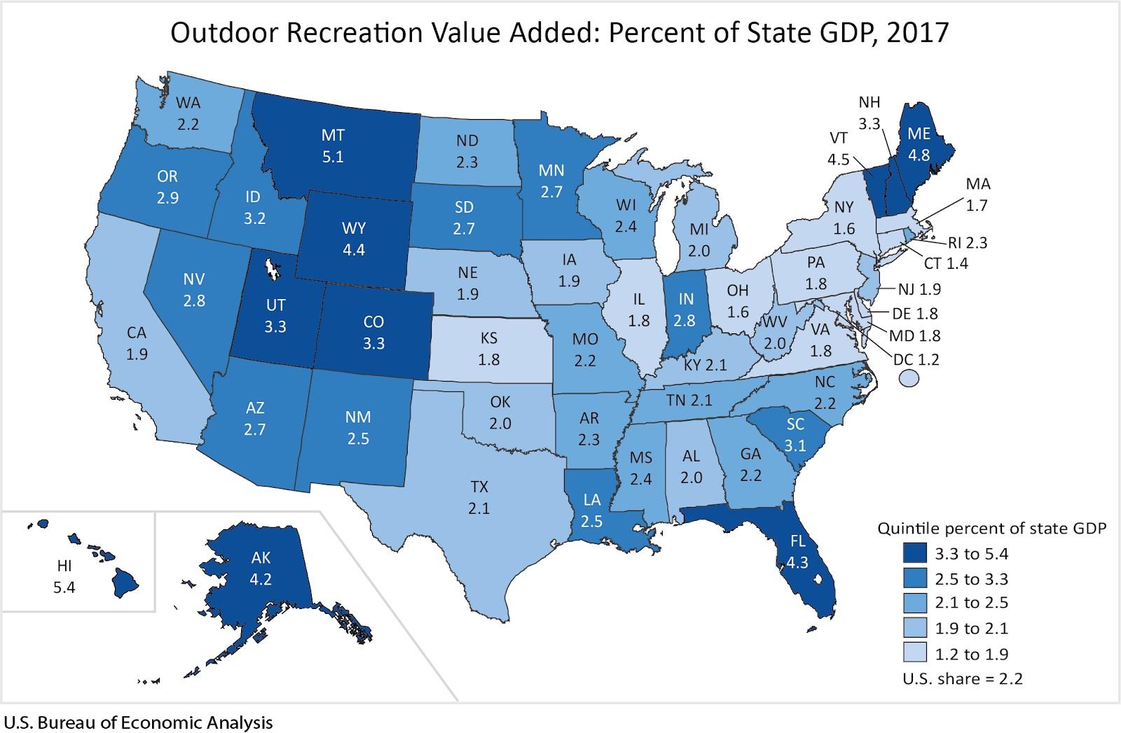
A new analysis from the Bozeman-based non-profit Headwaters Economics shows that the outdoor recreation industry is growing more than twice as fast as the overall economy, and the industry has an especially outsized role in the Mountain West.
The analysis, based on a recent report from the U.S. Bureau of Economic Analysis, details how our region’s public lands, national parks and hunting and fishing opportunities, among other assets, are fueling a booming outdoor recreation industry. In the Mountain West, the industry’s contributions to state economies grew by an average of nearly 25% between 2012 and 2017, compared to 16.6% growth nationwide.
Glen Canyon Dam on the Colorado River in April 2017. The dam is 15 miles upstream from Lees Ferry, Arizona. Photo by Alexander Stephens/courtesy Bureau of Reclamation.
Republicans worry the process has been too ‘secretive’ and could hurt the agriculture industry
by John Herrick, The Colorado Independent October 29, 2019
Colorado lawmakers want a greater say in how the state manages its Colorado River water supplies.
The legislative Water Resources Review Committee has endorsed a bill proposal that requires the Colorado Water Conservation Board (CWCB) to consider the committee’s feedback before finalizing a plan to slash the state’s water use in order to send more of it downstream. The Republican-backed proposal won bipartisan support last week from all 10 committee members.
Overuse and climate change is causing a decline in the flow of the Colorado River, which 40 million people, not to mention a major agricultural industry, depend on. The seven states that share Colorado River water supplies are working to ensure enough water makes it downstream to satisfy legal obligations under the 1922 Colorado River Water Compact.
Here in Colorado, water managers are creating a so-called “demand management” plan to reduce the amount of water siphoned off from the river so that more can be stored in Arizona’s Lake Powell and sent downstream during dry years.
But where that water will come from is yet to be decided and figuring it out has been controversial from the start. The water cuts are intended to be equitable, but agriculture accounts for more than 80% of the state’s water use and part of the state’s demand management plan will include paying farmers to irrigate less. Lawmakers worry land will be leased and permanently taken offline for farming, a process dubbed “lease and cease.”
“A lot of us that are still out there running a shovel are concerned that we are going to have to change the way we live so that people that just run a sprinkler head and try to grow more sidewalks in town don’t have to change theirs,” said Rep. Marc Catlin, a Republican from Montrose, during a committee hearing last week.
Volunteers are no longer required to sign non-disclosure agreements. The tension over the plan is illustrative of a much larger and longer tug-of-war between the executive and the state legislature over how to manage the state’s water supplies in the coming years. GOP Sen. Don Coram, a Republican from Montrose, was visibly steamed at last week’s meeting and his distrust resulted in the drafting of a bill that explicitly requires the CWCB to gather public feedback before coming up with a plan. The proposed bill also requires the Water Resources Review Committee to tour the state and gather feedback on CWCB’s draft of a plan.
“We have to develop trust among the general public. And when we started hearing early on (about) non-disclosure agreements and everything else, it kinda reminded me of … the Colorado Water Plan. It was called the ‘governor’s water plan,'” Coram told the committee. He continued, “It is imperative that the general public be involved in this most important process.”
Water managers are concerned such involvement could slow down critical and urgent multi-state negotiations. Arizona lawmakers almost derailed a major agreement on how to share water cuts earlier this year. A deal was struck just hours before the Bureau of Reclamation said it would step in an issue mandatory water cuts.
James Eklund, a former CWCB director who represented Colorado on the Upper Colorado River Commission during last year’s drought negotiations, said climate change is forcing managers to act more swiftly. Efforts by lawmakers to gather more public input, he told The Colorado Independent, could make acting quickly more difficult.
“If there’s another 2002- or 2003-type drought this year or next year, the [demand management] program is going need to be stood up very quickly,” Eklund said. “It’s hard for me to see that happening if you’re scheduling outreach meetings.”
CWCB Director Mitchell was not available for comment. The CWCB declined to comment on how the proposed bill would affect drought contingency planning. Sara Leonard, the marketing and communications director for the CWCB, said the board recognizes the importance of public comments and is committed to stakeholder engagement.
Coram dismissed concerns his bill will slow down multi-state negotiations. “Bullshit,” he responded. He told The Colorado Independent the process fits within the timelines already suggested by the CWCB. There is no hard deadline for finalizing the demand management program. The CWCB plans to issue a status update in July 2020.
The committee also approved a bill that would make it harder to speculate on the state’s water supplies — buying up water rights with the intention of selling them at a profit later — and another dealing with new technologies.
The proposed bills still require committee approval, a vote in the House and Senate, and the signature of Gov. Jared Polis. The legislative session begins Jan. 8.
Straight line diagram of the Lower Arkansas Valley ditches via Headwaters
FromThe La Junta Tribune-Democrat (Bette McFarren):
The Lower Arkansas Valley Water Conservancy District held a workshop on Wednesday night at their Rocky Ford office entitled, “How to protect your water rights without an attorney.” Even though snow was about to start, 15 farmers attended.
“Some people think their ditch company will protect their water rights,” said district Manager Jay Winner, “but that’s not the case. When the water courts were established, they put in a provision for the owners of water rights to stay informed by filing a statement of opposition. It costs only $200, and gives the farmer a seat at the table. He can tell what’s going on with everybody’s information. There weren’t as many water attorneys in those days.
“A farmer knows his water better than the engineers,” continued Winner.
Another presentation of this information will take place as part of the conference with the Ditch and Reservoir Companies Alliance in Lamar at the Colorado Parks and Wildlife building, 2500 So. Main St., on Nov. 7. The meeting will begin at 8 a.m. and will go all day, but this presentation will be at 9:40 a.m. The meeting ends at 2 p.m. with a tour of John Martin Reservoir.
Neighborhoods in a network. It is very difficult to develop more than general conceptions of such large networks based on visualized topology, and aggregated statistics tend to be the better route.
On October 29, 1969, the internet era began as UCLA Computer Science Professor Len Kleinrock sent the first message on ARPANET, a network of computers that would evolve to become the internet.
Five decades later, and 30 years since the World Wide Web brought the internet into the mainstream, global digital connectivity has fundamentally changed our world.
Marking the anniversary, our founder and inventor of the web, Sir Tim Berners-Lee, said:
“It’s astonishing to think the internet is already half a century old. But its birthday is not altogether a happy one. The internet — and the World Wide Web it enabled — have changed our lives for the better and have the power to transform millions more in the future. But increasingly we’re seeing that power for good being subverted, whether by scammers, people spreading hatred or vested interests threatening democracy.
“A year ago, I called for a new Contract for the Web, bringing together governments, companies and citizen groups to come up with a clear plan of action to protect the web as a force for good. In a month’s time that plan will be ready. This birthday must mark the moment we take on the fight for the web we want.”
We urgently need an ambitious, coordinated effort to tackle the threats facing the internet and the web, and make sure that everyone is able to access the benefits of digital technology. Next month, we’ll publish the Contract for the Web — a plan created by experts and individuals from across the world to make sure our online world is safe, empowering and genuinely for everyone.
…the one on Jicarita Peak, where water is being diverted from the Rio Grande over a mountain ridgeline eastward to the Rio Canadian watershed, is quite unique, with undercurrents of Indian lore, Spanish land grants and even ripples of the old Santa Fe Ring.
Robert Templeton is former chair of the Embudo Valley Regional Acequia Association and a parciante, or member, of one of the ditches that flows to his field in Dixon where he grows corn and vegetables. He has been studying the diversions for several years and has shared some of what he’s learned with Picuris Pueblo.
“In the history of the diversions, more than a half million acre-feet of water has gone over the divide,” he said, adding that’s a conservative estimate. “If you take that and divide it by the annual flow at the Picuris gauge, the amount is equal to 22 years of the annual flow.”
Templeton knows much of the history of the diversions, the first of which dates back to somewhere between 1819 and 1835. “That’s the one at Alamitos Creek,” he said. “A half-mile ditch takes all the water from Alamitos Creek and puts it in the ditch, and over the divide and to Cleveland (N.M.).”
The second diversion, the Acequia de la Presa, was built about 1865, he said. It directs water from the Rio de la Presa in La Junta Canyon and sends it to Chacón, also on the east side of the mountains.
The third diversion, located at 10,800 feet, takes water from two creeks and directs it to Angostura Creek where, after about 3.5 miles, it is channeled over the divide in waterfall fashion.
It’s that diversion, the Acequia de la Sierra de Holman, completed about 1882, that led Picuris Pueblo to file a lawsuit that members of the infamous Santa Fe Ring, a group of powerful lawyers and speculators, was able quash during New Mexico’s territorial days.
According to an article by Malcolm Ebright that was published in the New Mexico Historical Review in 2017, Thomas B. Catron and Stephen Elkins were among the people who started buying interest in the Mora Land Grant about 1866, “and, soon, residents of the Mora Grant realized that speculators were buying the grant common lands from under them,” Ebright wrote.
A lawsuit was filed on behalf of Picuris Pueblo in 1882, after the third of the diversions was built, due largely to efforts of Juan Bautisa Guerín, Mora’s parish priest. By then, Catron owned the northern portion of the Mora Grant.
“Picuris Pueblo was up against the Mora parish priest and the most powerful member of the Santa Fe Ring,” Ebright wrote. “This might explain why it was almost impossible to move the lawsuit forward after it was filed.”
Any chance of the matter being resolved early on died when an attorney representing the pueblo failed to show up for a court hearing, despite being given several days to do so. Catron was then successful in having the case dismissed on an oral motion. “Thus, Catron was able to dispose of the case without filing any documents to the benefit of the Mora irrigators, while at the same time attempting to partition and sell the common lands of the Mora Land Grant,” according to Ebright.
By that time, thousands of Spanish and Anglo settlers had moved into the area, increasing the demand for water. The pueblo, which then and now is made up of just a few hundred tribal members, was outnumbered and carried little clout.
Changing nature of Colorado River droughts, Udall/Overpeck 2017. FromThe Catalyst (Emily Kressley):
Think about a restless night of sleep, where you toss and turn and wake up in a sweat. Not only are you uncomfortable, you’re also dehydrated — you reach for a big glass of water. And now think back to a big night out, where maybe you had one too many and you really need that glass of water, or several, to assuage that headache. In a similar fashion, our Earth is also overheating, wrapped in a blanket that traps warmth. Unfortunately for the Southwest, when it “sweats,” or evapotranspiration occurs, there is no glass of water by its bedside table. And when it’s really dehydrated, just one good winter isn’t going to solve the drought.
A 2017 study by Brad Udall and Jonathan Overpeck called “The Twenty-First Century Colorado River Hot Drought and Implications for the Future” published some terrifying news about the impacts of warming within the last century. Within your lifetime, you’ve experienced this warming in some capacity. If you’re based here in Colorado, you or your family likely remember what drought looked like in 2002 or 2012. The basis of the study is that the flow of the Colorado River was 19.3% below average 2000 to 2014, as compared to the 1906 to 1999 average, making it “the worst 15 year drought on record.”
It’s not a coincidence that news headlines have consistently ranked recent droughts at the top of the list. About one third of this flow loss comes from the unprecedented temperature rise: 0.9 degrees Celsius above the 1900s average. Yes, temperatures have risen before, but never so much, so fast. And there has never been a roaring civilization quite like our current society based in what should be a desert. “Previous comparable droughts were caused by a lack of precipitation, not high temperatures,” according to Udall and Overpeck.
The region’s hydrology is a mixed bag of modeling — we can’t be positive about what’s going to happen. But we are positive that warmer temperatures lead to a decline in stream flow. This decline can be linked to droughts that have lasted decades, rather than a single year. Coloradans, especially those who work in agricultural or ranching occupations, are familiar with drought and what it’s like to operate under a water deficit. But mega-droughts? This amount of uncertainty? Droughts that were previously classified as moderate are predicted to become more severe. That’s when your sleep gets restless.
Because the Earth is wrapped in a thick down comforter, rising temperatures and water scarcity are not isolated phenomena; they affect the entire system. When temperatures warm, the snowpack is diminished. Even if precipitation levels remained the same, the change to rain from snow removes the storage mechanism nature had in place. With rainfall occurring more frequently and earlier on in the year, the growing season starts prematurely, sucking up greater amounts of moisture from the soil. As a result, runoff is reduced and does not replenish already depleted reservoir levels. Increased temperatures also cause more water to evaporate from the soil, creating longer fire seasons. With diminished snowpack and reduced runoff, the hottest months of the summer become even drier, intensifying drought effects.
The study predicts that as warming continues to increase at its current rate, there will be a 20–30% flow loss by mid-century, and a 35–55% loss by the end of the century. And while the Colorado River reservoir system can store four times the annual flow of the river, longer droughts and higher demands in these periods will deplete that quickly, according to Udall and Overpeck. To put this into perspective, 40 million people rely on the river in seven different states for their survival. If we were to cut the water supply in half and only serve 20 million people, 3.5 times the population of the entire state of Colorado would be left dry, according to Bureau of Reclamation. That’s almost 263 packed Denver Broncos stadiums, accordig to Empower Field at Mile High. And as we’ve seen in 2019, one good year is not going to solve the issue — much of the state is now back in a drought. If water levels drop too low in Lake Powell and Lake Mead, imperative storage reservoirs, the hydropower turbines will no longer be effective. Energy prices will skyrocket, as will the risk of a compact call, which is a restriction on water consumption in the Upper Basin until the lower basin water allocations are delivered.
We know that temperatures are rising, water levels are decreasing, and risk and uncertainty are mounting. While the future looks grim, there is still time to avoid the worst by ringing the alarm and staying politically active. Talk about how climate change is personally affecting us now with friends and family, stay up to date on the news, put pressure on your state’s representatives. Drought contingency negotiations have already been in the works, with the 2007 interim guidelines slated for revision in 2026. We’ve seen drought before, and we’ll see it again. Climate change is water change, and while it’s a phenomenon bigger than any of us, we are not powerless in combatting it.
Emily Kressley Emily, class of 2020, is an environmental policy major originally from Essex, Conn. While she is drawn to Colorado for its mountains and skiing, she has found strong communities within the CC Cutthroat rugby team, Kappa Kappa Gamma sorority and, of course, The Catalyst staff.
Theodore Roosevelt around 1904. By Pach Bros. – This image is available from the United States Library of Congress’s Prints and Photographs divisionunder the digital ID ppmsca.35645. See Commons:Licensing for more information., Public Domain, https://commons.wikimedia.org/w/index.php?curid=71136734
Theodore Roosevelt and John Muir at Glacier Point. By Underwood & Underwood – This image is available from the United States Library of Congress’s Prints and Photographs division under the digital ID cph.3g04698. See Commons:Licensing for more information., Public Domain, https://commons.wikimedia.org/w/index.php?curid=3517191
Of all Roosevelt’s achievements, he was proudest of his work in conservation of natural resources and extending federal protection to land and wildlife. Roosevelt worked closely with Interior Secretary James Rudolph Garfield and Chief of the United States Forest Service Gifford Pinchot to enact a series of conservation programs that often met with resistance from Western members of Congress, such as Charles William Fulton. Nonetheless, Roosevelt established the United States Forest Service, signed into law the creation of five National Parks, and signed the 1906 Antiquities Act, under which he proclaimed 18 new U.S. National Monuments. He also established the first 51 bird reserves, four game preserves, and 150 National Forests. The area of the United States that he placed under public protection totals approximately 230,000,000 acres (930,000 km2).
Roosevelt extensively used executive orders on a number of occasions to protect forest and wildlife lands during his tenure as President. By the end of his second term in office, Roosevelt used executive orders to establish 150 million acres of reserved forestry land. Roosevelt was unapologetic about his extensive use of executive orders to protect the environment, despite the perception in Congress that he was encroaching on too many lands. Eventually, Senator Charles Fulton (R-OR) attached an amendment to an agricultural appropriations bill that effectively prevented the president from reserving any further land. Before signing that bill into law, Roosevelt used executive orders to establish an additional 21 forest reserves, waiting until the last minute to sign the bill into law. In total, Roosevelt used executive orders to establish 121 forest reserves in 31 states. Prior to Roosevelt, only one president had issued over 200 executive orders, Grover Cleveland. The first 25 presidents issued a total of 1,262 executive orders; Roosevelt issued 1,081.
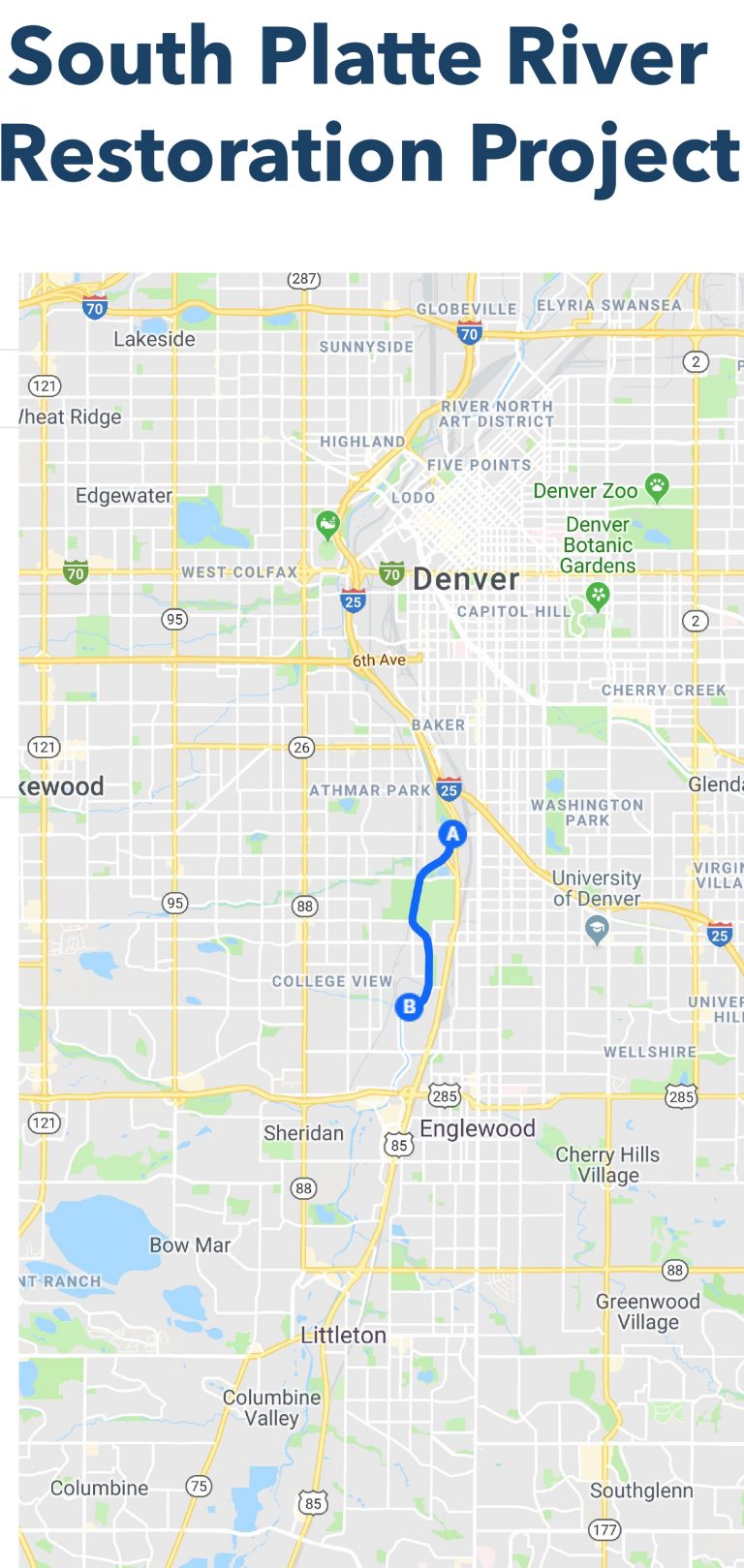
A stretch of the South Platte River that has been hampered for years by construction, pollution and debris has been approved for a major face lift, thanks to a new agreement between the City of Denver and U.S. Army Corps of Engineers.
The 2.4-mile, $11 million project was approved by the agencies in mid-September. The idea is to offset damage to the river caused by Bear Creek Lake and Chatfield dams, as well as urbanization, according to Jennifer Williams, who leads the project for Denver Public Works.
The Southern Platte Valley Project will restore natural flows and habitat in a stretch from West Yale Ave. to West Mississippi Ave., Williams said.
Natural river flows support conditions that provide shelter for fish and breeding grounds for organisms that feed them. They also help keep the river cool. Plants along the banks help filter trash and sediments from runoff before it flows back into the South Platte.
But rivers that thread their way through cities battle for the room and the flows they need to remain healthy.
“We’ve just encroached on the river and made it less efficient as a hospitable place for animals,” Williams said.
The new rehab project comes as Denver voters and politicos have vowed to improve and expand the city’s natural areas. In 2018, voters said yes to a new sales tax that will raise an additional $46 million a year, part of which will be used to restore waterways in the city.
This project is especially exciting, Williams said, because it will stitch together other scattered restoration projects along the Denver reach of the South Platte.
“This will tie all the projects together and really leverage that previous investment we’ve made and turn it into a great corridor for birds and fish,” she said.
The project will restore 22 acres of aquatic habitat and 11 acres of riparian habitat, Williams said. The area is along the Central Flyway, and visited by more than 400 bird species every year, including 14 that are of special concern in the eyes of the federal government, which means they may receive special management considerations but not yet formal protections under the Endangered Species Act.
Perhaps just as importantly, the project could make residents proud and more willing to keep the river clean.
“Our goal is to get people living there connected to the river,” said John Davenport, a member of Trout Unlimited Denver, who keeps a close eye on the South Platte.
Studies show that perception, more than the economic welfare of an area and its residents, tends to determine whether a natural area stays clean: Once people recognize it as a special place, they try to keep it that way, he said.
The project will take roughly three years to complete, Williams said, and she is cautiously optimistic that there will be enough money to begin the design this year, with hopes of starting construction in 2021.
Davenport is satisfied with the way the South Platte looks now, but he believes it has room for improvement.
“We have a river that could really be something,” he said.
Dan England is a freelance writer who lives in Greeley and the media adviser for Laramie County Community College in Cheyenne, Wyo.
Click here to read the newsletter. Here’s an excerpt:
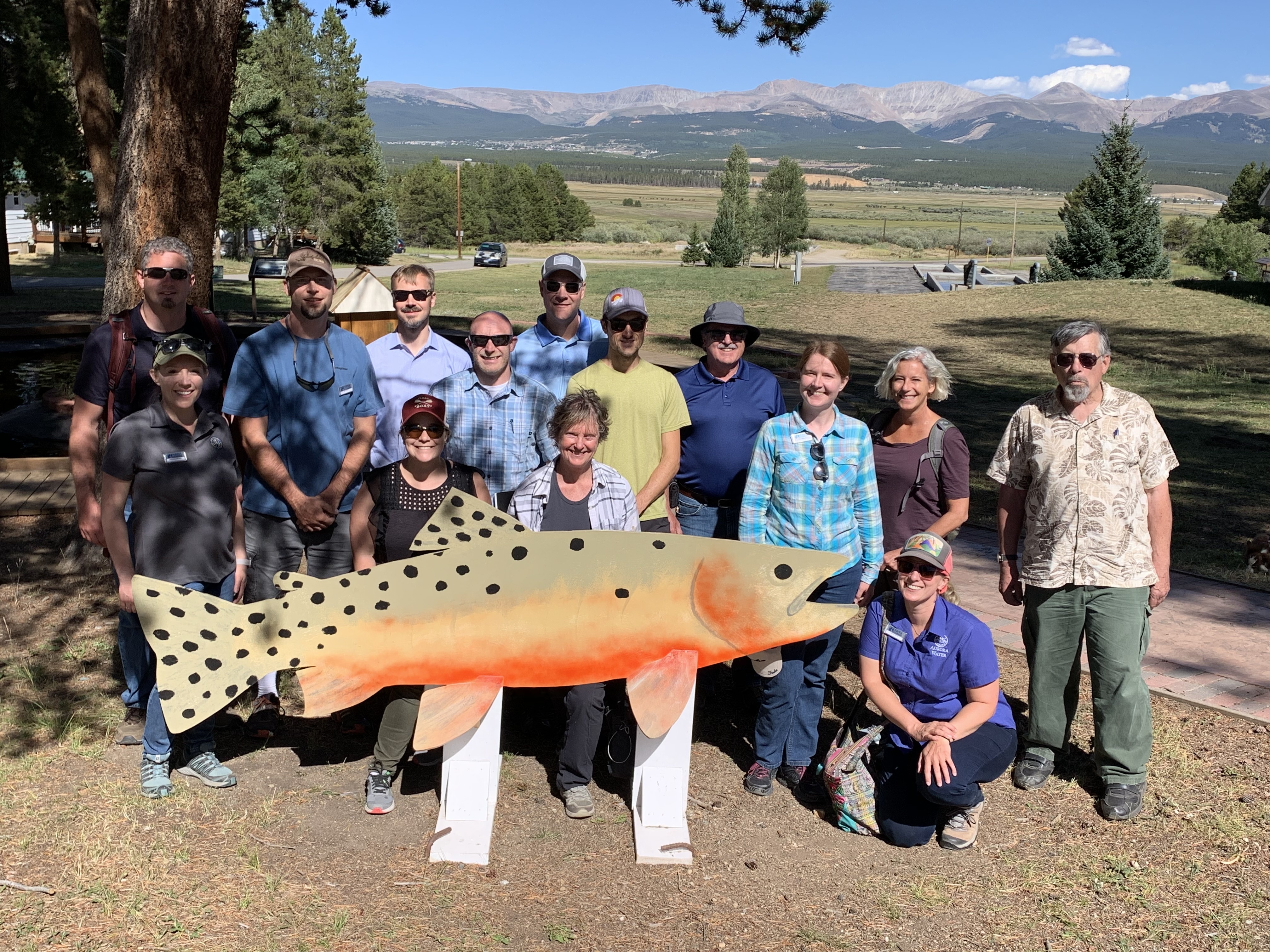
Summer Tour of the Upper Arkansas Basin
In August, AWRA-CO hosted a tour of the Upper Arkansas River Basin. Attendees learned about water use, creative partnerships, and other unique aspects of the Upper Arkansas Basin through a variety of site visits. Photo credit: ARWA Colorado Section
Otero Pump Station:
In the 1960’s Aurora Water partnered with Colorado Springs Utilities on the Homestake Water Project. The project collects water into Homestake Reservoir, pipes it to Turquoise Lake, and then pipes it down to Twin Lakes Reservoir, and eventually pipes the water through the Otero Pump Station. The water is pumped to the front range through the Homestake Pipeline to Spinney Reservoir for use by Aurora Water and to Rampart Reservoir for use by Colorado Springs. Tour attendees had the opportunity to tour the Otero Pump station, which pumps 114 MGD through eight pumps at 2,250 horsepower (HP), one pump at 900 HP and one at 450 HP. The project is an impressive engineering feat.
Arkansas River Diversion Project:
The next stop on the tour was the Arkansas River Diversion Project, which is a replacement of the diversion from the Arkansas River to the Otero Pump Station. Tour attendees got a first look at the diversion in mid-construction. The re-design of this diversion involved experts in recreational hydraulics, river intakes structures, fishery biology, and experience with the Arkansas River. The design included 1-D and 2-D modelling, and a 1/12th scale prototype 3D model was built to test the functionality of the design. Furthermore, the project received funding from multiple agencies including the CWCB and CPW to cover the added incremental cost of the components for recreation and fisheries. The project is anticipated to finish in 2020, and it will have three channels comprised of a fish ladder, spillway and recreational boat chute. This multi-agency project will not only improve the functionality of the diversion structure for water supply, but it will also open the upper river to new recreation opportunities and provides fish passage.
Rocky Mountain Fen Research Project:
The Rocky Mountain Fen Research Project has successfully performed the first fen transplant. The project has many partners, including several local municipalities, state agencies, federal agencies, and the Colorado Mountain College. Fens are a unique type of wetland that are found at high elevations. Fens have three unique characteristics: they have at least 16 inches of organic soil, they have plants that have adapted to nutrient rich water sources and saturation, and have a nutrient rich groundwater supply. Organic soils can take thousands of years to form, making it impossible to create from scratch on human time-scales. The Fish and Wildlife Service has classified fens as Category I Resources and has determined that fens are unmitigable. As a result of this policy, projects may be deemed infeasible if fens are located in potential areas of disturbance, such as on lands for proposed reservoirs or recreation facilities. The purpose of the research project was to demonstrate one possible method that could replicate the form and function of a naturally occurring fen. The project design was to transplant relic soil and vegetation to a spot that previously had hosted a fen, but was harvested for peat back in the early 1940s. We got to see first-hand how well the transplanted fen is taking to its new home. It looks beautiful and full of life. We even got to feel how squishy the soil is! Brad Johnson, the project’s professional wetland scientist, shared the results of his vegetation survey with us and everything seems to be working better than expected. The project is currently in monitoring, which will continue for several more years. The federal agencies and other partners have visited the site several times since construction and continue to be involved.
US Fish and Wildlife Fish Hatchery:
Our bus pulled up to the stately historical building, something you might expect to see as a proud town hall or hotel building. Inside, however, it is full of row after row of fish tanks! The USFWS has operated the Leadville Fish Hatchery since 1889. They raise sport fish, endangered fish, and Laramie Toads. And since we are a water-focused group, our tour included a sneak peak into the water treatment facility specifically designed to kill the whirling disease. The double filtration system, combined with UV lights, has kept the facility disease free. It is impressive to learn about how the genetic variations of the fish are considered before breeding, how the eggs are collected, and how much effort goes into the keeping everything flowing smoothly. They are open to the public and it is worth the drive to check it out yourself!
Arkansas River Basin via The Encyclopedia of Earth
From email from the Arkansas River Compact Administration (Kevin Salter):
This is the preliminary notice for the upcoming Arkansas River Compact Administration Annual and Committee Meetings. The meeting specifics and draft agendas will be provided at a later date. Please note that the meeting dates and location were changed at the ARCA Annual Meeting held in December 2018.
These meetings will be held in La Junta, Colorado, at the Otero Junior College.
The 2019 Annual Meeting of the Arkansas River Compact Administration (ARCA) will be held on Thursday, December 5, 2019.
The Engineering, Operations, and Administrative/Legal Committees of ARCA will meet on Wednesday, December 4, 2019.
Meetings of ARCA are operated in compliance with the federal Americans with Disabilities Act. If you need a special accommodation as a result of a disability please contact Stephanie Gonzales at (719) 688-0799 at least three days before the meeting.
This information will be updated on ARCA’s website:
Governor Mark Gordon announced today he has appointed Greg Lanning Wyoming State Engineer. Lanning takes over for Pat Tyrrell, who retired in January after serving as State Engineer for 18 years.
The State Engineer is a position established by the Wyoming Constitution and has a term of six years. The State Engineer serves as the chief water official in the state and is responsible for the general supervision of Wyoming’s waters, including technical, policy and regulatory matters concerning its beneficial use. The search process involved numerous stakeholders including experienced water industry professionals and representatives of rural water users; agriculture; the mining, oil and gas industries; and environmental organizations.
“Finding the right State Engineer was a challenging process, as the position requires a unique set of technical, policy and political skills,” Governor Gordon said. “Greg’s background expertly balances these requirements and I can think of no one better to hit the ground running to lead the way in managing Wyoming’s water. I look forward to welcoming Greg back to his home state of Wyoming.”
A Casper, Wyoming native, Lanning previously served as Deputy State Engineer under Tyrrell from 2012 to 2014. His broad background in civil engineering and water resource management includes time spent as Public Works Director for communities both in Wyoming as well as neighboring states. He earned his Bachelor of Science in Civil Engineering and his Masters in Business Administration degrees at the University of Wyoming. He holds a Masters in Civil Engineering from Colorado State University and is a registered Professional Engineer.
“It is an honor to once again serve this great state,” Lanning said. “I look forward to re-introducing myself to our Wyoming water users and stakeholders and returning to our dedicated team of more than 120 employees at the State Engineer’s Office.”
Following a presentation earlier in the day, the San Juan Water Conservancy District (SJWCD) Board of Directors opted to see if ef- forts from cloud seeding could produce any re- sults that could be seen locally before providing funding to cloud seeding efforts.
The cloud seeding presentation was given to the board during a work session on Tuesday by Eric and Mike Hjermstad from Western Weather Consultants LLC, and following the work ses- sion, the board had a possible action item on whether or not to fund cloud seeding efforts for the southwest basin.
In the draft budget, the SJWCD has $1,000 set aside for potential cloud seeding funding…
The effectiveness and amount of extra moisture that is produced by cloud seeding ef- forts has been debated for years, SJWCD board member Al Pfister noted…
[Bill] Hudson later made a motion that suggested the SJWCD look into whether or not it could help finance the research of cloud seeding operations in the district’s watershed and would task SJWCD consultant Renee Lewis to conduct this project. The motion passed unanimously.
From the Environmental Defense Fund (Pablo Garza/Ronna Kelly):
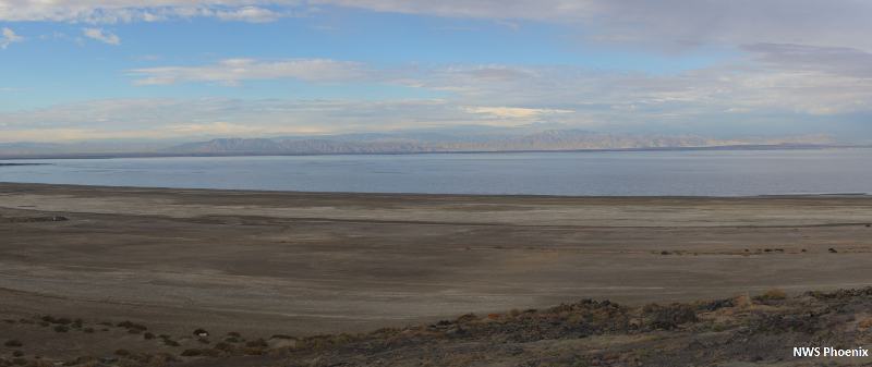
The Salton Sea is California’s largest lake, but it’s hard to grasp its immense size – and beauty – until you see it with you own eyes. Last week, roughly 200 people gathered in this unique area – both residents and leaders from around the Salton Sea and from outside the region – for the Salton Sea Summit, a conference that explored the many challenges and solutions facing the Salton Sea region.
The summit was important because, as California Secretary for Natural Resources Wade Crowfoot noted during his keynote on the first day, the Salton Sea has “major problems.”
Chief among these: The Salton Sea is receding.
The shrinking of the Salton Sea is a longer-term trend that was exacerbated by the largest rural-urban water transfer in the U.S., finalized in 2003. Under the transfer, the Imperial Irrigation District agreed to send up to 300,000 acre-feet of Colorado River water per year to Los Angeles and San Diego. Since 2003, the Sea has receded more rapidly, exposing some 40 acres of new shoreline and toxic dust. This dust, in turn, is contributing to already poor air quality and high rates of respiratory illnesses in the region.
As part of the transfer agreement, the state committed to thousands of acres of dust suppression and habitat restoration projects, and state lawmakers and voters have approved $365 million in funding for such projects. But action has long been stalled, and local residents and leaders are fed up.
This frustration was evident at the summit and reached a boiling point on Tuesday when the Imperial County Board of Supervisors voted unanimously to declare a local emergency for air pollution at the Salton Sea. The vote came just days after state leaders stressed efforts to jump-start long-delayed projects at the summit.
The Salton Sea is California’s largest lake, covering 330 square miles, and a major drop along the Pacific Flyway for migratory birds. But it is receding, threatening to create a public health and ecological crisis. By NWSPhoenix – Own work, CC BY-SA 4.0, https://commons.wikimedia.org/w/index.php?curid=56724223
From popular destination to ecological tragedy
It is easy to understand why residents are frustrated and want to see more action to restore and protect this sometimes otherworldly place. As Crowfoot noted, the Salton Sea is like putting Lake Tahoe in the desert with dramatic mountains as the backdrop.
The Sea is also a critical stopping point along the Pacific Flyway for nearly 400 bird species. And, not that long ago, it was a popular recreation spot for residents and tourists alike.
More recently the Sea has made news headlines for massive bird die-offs as it shrinks and salinity increases.
The state needs to step up quickly to make up for lost time. The Newsom administration has gotten off to a good start, but much more is required. Still, there are some signs of hope.
Will promises finally be fulfilled?
Crowfoot noted that he has visited the Salton Sea “four or five times” since becoming secretary in January. “Our focus now is not making more promises but getting projects done on the ground,” he said. “I’m really optimistic.”
He highlighted the upcoming milestones:
By year-end, ground will be breaking on a 200-acre dust suppression pilot project that Crowfoot said would “catalyze treating many more acres for dust suppression.” (The state’s 10-year plan calls for 15,000 acres of dust suppression projects completed by 2028.)
By year-end, a community meeting will be held for input on the 9,000 acres of dust suppression projects.
By early 2020, permits will be acquired for the 9,000 acres of dust suppression projects.
By summer 2020, ground will be broken on a nearly 3,800-acre, design-build habitat restoration project.
The upcoming community meeting is a positive development and signal the state is responding to criticism that it has inadequately engaged and informed residents about Salton Sea plans. The state will also create a new Salton Sea website and email newsletter to update residents.
However, these efforts may not be enough, as other engagement challenges remain for communicating with residents around the Sea, including disadvantaged communities.
During a community engagement forum at the summit, panelists noted that many residents don’t have Internet access or computers, or know how to use a computer. “The digital divide is very real,” said Karen Borja, a former community organizer and now director of community affairs at Planned Parenthood in Riverside County. “That website will not be accessible to everyone.”
The Newsom administration would be wise to follow advice offered at the summit. Panelists suggested hiring a community organizer, holding meetings after 5 p.m. in Spanish and English, and providing child care and food.
Significant challenges remain for the Salton Sea region, but the Newsom administration appears to be listening and acting. Hopefully, by the next Salton Sea Summit, stakeholders and panelists will be discussing their successes and offering lessons learned.
Read or download “Salton Sea Vision 2025,” a vision for the Salton Sea created by EDF and partners Alianza, Audubon California, KDI, Pacific Institute and the Sierra Club.
FromThe Grand Junction Daily Sentinel (Charles Ashby):
The Legislature’s Water Resources Review Committee approved introducing four bills on [October 24, 2019], two of which are aimed at protecting and improving the state’s water supply.
“We have an incredible opportunity to pilot and deploy new technologies that could revolutionize and improve how we manage and consume Colorado’s most essential natural resource,” said Rep. Dylan Roberts, D-Avon, vice chairman of the 10-member committee, which also includes Rep. Marc Catlin, R-Montrose, and Sens. Kerry Donovan, D-Vail, and Don Coram, R-Montrose.
The water speculation measure, which Donovan and Coram are to introduce in the Senate, calls on the Colorado Department of Natural Resources to convene a special work group to study the extent of water speculation in the state, and report back to the committee by 2021…
The new technology measure, which Donovan also is to help introduce, calls on the University of Colorado and the Colorado Water Institute at Colorado State University to conduct feasibility studies on such things as using sensors to monitor surface and groundwater use and quality, and using aerial and satellite technologies to help monitor water supplies.
The other two measures call on the Colorado Water Conservation Board to broaden its public comment rules for its water resources demand management program, and requiring the Colorado Division of Water Resources to hire more well inspectors.
The Water Resources Review Committee advanced Bill 5, which would set a minimum number of six well inspectors during the next fiscal year. The price tag is estimated at $279,000 in the first year, with the original bill tentatively tying funding to whether voters pass Proposition DD in November. The initiative would legalize sports betting, with tax money going to the state’s water plan.
If DD were to fail, the legislature would have to raise well permit fees by 45%. However, the committee approved an amendment to remove the funding alternatives from the legislation until further consideration. The bill would also prioritize high-risk wells for inspection.
Currently, there are two full-time inspectors and a chief inspector who has duties other than inspections…
Earlier this year, the Colorado Office of the State Auditor found that 4,000 wells were constructed in fiscal year 2018. However, only 310 were inspected—and fewer than 10% of the high-risk wells…
Bill 6 would require the executive director of the Department of Natural Resources to recommend changes to the state’s water anti-speculation law. A spokesperson for the House Democrats said that committee members have heard about people purchasing Western Slope water rights, holding them while the price appreciates, and then selling the rights for a profit.
“I don’t think a hedge fund invests in anything without an expectation of making money off of it. Do we know if that’s speculation? We don’t,” said Sen. Kerry Donovan, D-Vail. “Do we have the needed laws in place to prosecute what could be water speculation under the expectation of demand management? That’s some of what we need to look at.”
The committee also advanced Bill 2, which clarifies public comment procedures for any changes to a program for demand management, as well as Bill 3, which directs the University of Colorado and other state agencies to study the feasibility of new water management and monitoring technologies. These include sensors, aerial observation platforms and satellite-based remote sensors.
Sandhill cranes. Photo: Scott Helfrich/Audubon Photography Awards
From Audubon’s Western Water Initiative (Karyn Stockdale):
Audubon just released a new scientific report, Survival by Degrees, showing that 64 percent (389 out of 604) of North American bird species are at risk of extinction from climate change. The good news is our science also shows that if we take action now we can help improve the chances for 76 percent of species at risk. We know what to do to protect the birds we love and the places we all need now and in the future.
Climate and Water in the West
In the West, we’re already dealing with a multi-decade historic drought and longer, more intense fire seasons. Climate change threatens western water resources and some researchers are calling our new reality “aridification.” Overall, the West has experienced increases in the severity and length of droughts over the past 50 years, taking a toll on water supplies.
Climate change not only alters the quantity of flows, but also the timing. Rising temperatures in the winter cause more precipitation to fall as rain rather than snow in mountainous areas from Colorado to California. Furthermore, warming temperatures are causing snow to melt earlier in the spring, altering the timing of streamflow in headwaters rivers.
The Colorado River’s water supply is stretched thin—due to diversions, over-allocation and climate change—and further increases in temperature will reduce snowpack and river flows harming the river and the 40 million people and 400 species of birds that rely on it. By mid-century, climate warming is projected to decrease total Colorado River flows by 20 percent from the observed historic average.
Likewise, across the network of saline lakes that dot the West—including Great Salt Lake—we see reduced water levels that can negatively impact millions of shorebirds, waterbirds, and waterfowl. These drying lake beds can cause health and economic problems as well as a decrease in food and habitat for birds.
It’s essential that we curb carbon emissions to limit temperature increases and work proactively, doubling down on conservation practices, so that these already stressed water ecosystems can sustain life in the arid West for decades to come.
How were the species evaluated?
Audubon scientists analyzed 140 million bird records, including observational data from bird lovers and field biologists across the country, to assess vulnerability for species based on the amount of a species’ range that may be gained or lost with climate change. Audubon designated species that may lose much more range across North America than they have potential to gain as climate vulnerable. Sources for this report include eBird, U.S. Geological Survey, North American Breeding Bird Survey, and Global Biodiversity Information Facility.
What does this mean for bird species in the arid West?
It should come as no surprise that western forests are one of habitat groups with the most threatened bird species in warming scenarios. As temperatures increase, drought, extreme heat, and fire will become more intense, more widespread, and more devastating across the West. This has implications for water quality and watershed health and will affect both birds and people.
Two examples of birds associated with Western Water priority freshwater and saline lakes habitats that are highlight climate vulnerable in Audubon’s report are Yellow Warbler and Long-billed Curlew. The bright, sweet song of the Yellow Warbler is a familiar sound in streamside willows across the West. Long-billed Curlews are often found around the Great Basin of Utah around emergent wetlands and marsh, as well as using agricultural fields where nesting and brood-rearing take place in pastures and hay meadows.
Of all the birds listed as vulnerable, there are distinctions between those that would respond favorably if we limit warming to 1.5 degrees Celsius (versus 3 degrees C) and would benefit from our actions. For instance, if we keep the rise in temperature to less than 3 degrees C, we can protect birds like the Yellow Warbler and Long-billed Curlew in their summer range.
Birds associated with Western Water priority habitats that are highly climate vulnerable include:
Yellow Warbler (High vulnerability in 3 degrees C warming scenario especially in Oregon, Nevada, Utah, and Arizona. Moderate in summer at both 2 and 3 C)
Sandhill Crane (Moderate vulnerability in summer at 2 and 3 C with species projected to shift north and mostly out of the contiguous U.S. range)
Long-billed Curlew (High vulnerability rangewide in summer at 3 C including in Colorado, Utah, California, New Mexico. Moderate at 1.5 and 2 C)
American Dipper (High vulnerability in winter at 3 C particularly in Colorado, Wyoming, Utah, California, and Arizona. Moderate in summer and at 1.5 and 2 C)
Other vulnerable species associated with Western Water and mentioned in the report:
Eared Grebe
Western Sandpiper
Marbled Godwit
Mountain Plover
Summer Tanager
Willow Flycatcher
Ridgway’s Rail and Clapper Rail
This is not an exhaustive species list and there’s much more information in the report on the 389 species vulnerable to a changing climate. One key takeaway is that if we reduce emissions by 2050 and hold warming to 1.5 C, we expect 38 percent of the species would come off the climate vulnerable list.
What are the best ways to help birds (and people) in the West?
Improve resiliency for healthy watersheds (rivers, wetlands, and lakes);
Increase reliability of our water supply (now and in the future) through planning and cooperative, multi-benefit agreements among stakeholders;
Fund conservation and clean energy measures at the local, state, and federal levels (ask your elected officials to expand conservation funding and clean energy development in your community);
Restore and protect priority habitats;
Manage water comprehensively with an understanding of the connections between surface water and groundwater, and more;
Sign up for the Western Water newsletter to stay in touch and look for opportunities to help.
Since Oct. 8, the U.S. Drought Monitor has shown the Four Corners at level D2, or severe drought, the third-worst category out of five levels.
The lack of moisture has been extraordinary, said Jim Andrus, a Cortez-based weather observer for the National Weather Service.
July, August and September were way below normal precipitation levels.
“The monsoon rains failed us. They never arrived because a consistent high-pressure ridge blocked them,” Andrus said…
July saw just .45 inches of rain, or 35% of the normal 1.28 inches. August had .57 inches, or 39% of the normal 1.48 inches. September came in at .15, just 10% of the normal average of 1.55 inches…
Poor soil moisture this fall is impacting the dryland winter wheat crop, said Gus Westerman, of the Dolores County agriculture extension office…
During average precipitation years, soil moisture is 6 inches to a foot down, ideal conditions for planting winter wheat so it will sprout before the dormant stage. This year, soil moisture level has basically zeroed out for dryland farmers, he said.
Not all is lost, though. When the snows come and the soil is replenished, the crop will still come up in the spring, but potentially with smaller yields. For farmers planting winter wheat now, a higher seed rate is recommended.
Thanks to a 140% of average snowpack for 2018-19 winter and a wet spring, Cortez is still at 122% of normal for total precipitation. On Oct. 1, there was 11.36 inches of precipitation for the year so far, and the normal average is 9.33 inches. Average precipitation for the year is 12.57 inches. Also, McPhee Reservoir had strong carryover, and managers report that even a 50% winter snowpack will refill it.
Southern Utah also is experiencing a severe dry spell. On Oct. 17, St. George, Utah, reported 122 days without measurable precipitation. That breaks the previous record of 121 days set in 1930, according to the National Weather Service.
In 2018, from April to December, the Four Corners was in exceptional drought, the highest level at D4, and the hardest-hit region in the nation.
Click here to read the current assessment. Click here to go to the NIDIS website hosted by the Colorado Climate Center. Here’s the summary for this week:
Summary: October 22 2019
The last seven day period started out warm and dry across the IMW [Intermountain West], but another dose of winter has hit in the northern half of the region. The Tetons, northern Wasatch, and northern Colorado Rockies received 0.50-1.50″ of precipitation in the last several days, mostly in the form of snow. Totals in the valleys, were mostly below 0.25″. Southern mountains did not fair as favorably. The San Juans, La Sals, and Sangre de Cristos received little to no precipitation.
In general, the IMW is balancing the impacts of a hot, dry July-September against a remarkably cool and wet February through June. Results may vary by exact location. From an impacts standpoint, this dichotomy manifests itself as normal to above normal streamflows and reservoir storage, but below normal root zone soil moisture, and above normal plant stress. The wettest areas in winter, such as high elevations on Colorado’s west slopes, are most likely to have holdover soil moisture from winter/spring, and are showing less plant stress via satellite metrics, such as ESI. Areas that are climatologically drier in winter, and benefit from monsoon season rains have been hit hard.
Having had our second round of below freezing temperatures, the growing season is now mostly over for the IMW. However, from an agricultural standpoint, recent dryness has had an adverse and important impacts on pasture range conditions, and winter wheat planting. New Mexico (Arizona) pasture range conditions are ranked as 33% (40%) poor, and 9% (20%) very poor respectively. Percent of area poor and very poor is lower in Utah and Colorado, and much lower in Wyoming. Colorado winter wheat has mostly been planted, though it needed to be drilled over SE CO due to dry conditions. Winter wheat planted in the latter half of the planting season has not emerged, and recent dry, windy conditions may lead to subpar emergence.
A cold frontal passage diving out of the north on Wednesday and Thursday will bring a big temperature drop, and mostly light precipitation, to eastern Wyoming and Colorado. After that, the area will warm back up briefly. The CPC is predicting an increased chance of below normal temperatures for the 8-14 day period, but cooler air entering the region will be low in moisture content. The western IMW has an increased chance of below normal precipitation. The southeast portion of the IMW has an increased chance of above normal precipitation.
FromThe High Country News (Jolene Yazzie and Helen Santoro):
New rules would weaken protections for plants and animals listed as threatened under the Endangered Species Act
Jolene Yazzie/High Country News, Source: U.S. Fish and Wildlife Service
The Trump administration is proposing several changes to the way the Endangered Species Act is implemented that would weaken the rules governing protections. One change targets species newly listed as “threatened,” or those that are likely to become endangered within the foreseeable future. Under the new rules, the Fish and Wildlife Service will have to create individual regulations for each species based on its conservation needs, rather than simply extending the same level of protection that endangered species receive. Environmental groups worry this will strain the agency’s workload and put animals and plants at risk of extinction. While this change will not impact the species currently listed as threatened, any future additions to their ranks would be subject to the new rules.
Here are the 167 threatened species the U.S. Fish and Wildlife Service is responsible for overseeing in the West; this list does not include marine and anadromous species that are the sole responsibility of the National Ocean and Atmospheric Administration:
Note: This story has been updated to add the northern spotted owl, San Ana sucker, Arkansas River shiner, gypsum wild-buckwheat and southern sea otter; and to reflect that the Little Colorado Spinedace is found in Arizona, the Oregon spotted frog is found in Washington, the bull trout is found in Montana, the Warner sucker is found in California and Nevada, the piping plover is found in New Mexico, and that the Canada lynx is threatened in New Mexico but not Alaska. Spelling errors have also been corrected. Seals have been removed from this list, which reflects U.S. Fish and Wildlife Service data; it does not include species solely overseen by the National Oceanic and Atmospheric Administration.
Helen Santoro and Jolene Yazzie are editorial interns at High Country News. Email them at helensantoro@hcn.org and joleneyazzie@hcn.org.
New treatment plant, water main upgrades and more make up 5-year capital plan. The post $1.3 billion investment on tap for water system appeared first on News on TAP.
How we’re keeping our commitment to providing an affordable and reliable drinking water supply. The post New water rates to be slightly higher in 2020… 6 more words
To avoid Colorado River shortages, we must embrace new ideas to protect water supply.
What will it take to ensure long-term water security in the West?
Over the past two years, we’ve learned the power of collaboration – among water users across state lines and international boundaries – to lower the risk of a severe water crisis in the Colorado River basin.
The Drought Contingency Plan (DCP), signed in May 2019, will save up to 1.1 million acre-feet of river water – enough to fill 500,000 Olympic-sized swimming pools –annually across seven U.S. states. And it triggers additional water savings, agreed to by Mexico.
Young girl enjoying the river restored temporarily by the pulse flow March 2014 via National Geographic
The DCP showed how much can be accomplished when communities recognize they can protect their own interests while working to ensure their neighbors’ needs are also met.
We learned a similar lesson in 2017 when the U.S. and Mexico – at a time of severely strained bilateral relations – renewed a water-sharing agreement that committed both countries to voluntary cutbacks during times of shortage.
Neither of these agreements would have been possible without stakeholders – state and federals governments, conservation NGOs, water managers, farmers, ranchers and native tribes – learning to trust each other to serve the collective best interest.
The lessons of the past three years make me optimistic about the future of the Colorado River and the 40 million people who depend on it for their survival and livelihoods.
But we must always strive to better.
At a global water summit this summer, I was proud to share the successes achieved on the Colorado River. And I gained valuable insights from colleagues around the world that can help us ensure a stable water supply for the Colorado River and its communities.
Lesson #1. Water is a human right, and we need to recognize that across sectors and borders to succeed. Because rivers belong to all of us, even as we recognize existing water rights and allocations, we must recognize we will make more progress by working together as a basin to ensure a healthy river and a water-secure future for all the communities that depend upon it.
We need to see ‘the other side’ as humans first. In the foundation’s work with partners in the U.S. and Mexico, we shared meals with one another and learned about each other’s families and goals and challenges. The importance of developing relationships and friendships cannot be overstated.
Lesson #2. We need to place a higher priority on protecting and acknowledging the environment. The health of the river itself is critically important – and the river should not have to settle for the leftovers in water-use negotiations. While the 2017 U.S. Mexico agreement included specific measures to restore the Colorado River Delta in Mexico, and the System Conservation Pilot Program incidentally and indirectly provided some environmental flow benefits in the upper basin, we need to do better. We must consider the environmental health of the river to be as important as the needs for hydro power or agricultural and municipal uses.
Morelos Dam. Photo credit American Rivers.
Lesson #3. The Colorado River basin will continue to face water shortages over the next several decades due to future droughts and changes in climate. Water and climate are inextricably linked. If you care about climate change, you care about water issues. We need to recognize their connection. We must find ways to use watershed health work to mitigate for climate change by, for example, assisting landowners to protect and restore forests and rangeland. We cannot solve the water and climate change issues in a vacuum. We need to solve them together.
Wyoming rancher Freddie Botur walking across rocks that form the diversion structure at his headgate on Cottonwood Creek, a tributary of the Green River. Botur was paid to let water flow past these headgates and down the river system toward Lake Powell as part of the System Conservation Pilot Program. Photo credit: Jim Paussa via Aspen Journalism
Lesson #4. We need all hands on deck to solve the problems we’re facing on the Colorado River. At 2019 World Water Week conference, I was struck by the incredible diversity of participants and the remarkable number of young professionals working on water issues.
This is most welcome. We need the energy, creativity and hope that young people can bring to solving problems. We also we need to do better at including underrepresented voices in decisions about the future of the Colorado River.
In the U.S., native American tribes have not always had a seat at the water table. We need their strong voices to find water solutions that can allow us to thrive, not just now, but for generations. We need their traditional ecological knowledge to better manage this river for sustainability and for the health of the river.
Many Indian reservations are located in or near contentious river basins where demand for water outstrips supply. Map courtesy of the Bureau of Reclamation.
And we need to extend invitations to other under-represented and diverse voices – from rural communities, Latinx communities, and others. We cannot succeed without them.
Despite the water challenges facing us in the Colorado River basin and literally all over this globe, I’m looking forward to the future with great hope and renewed energy. We cannot fail to rise up to these challenges. Success, together, is the only option.
The fourth annual Rocky Mountain Farmers Union Innovation Fair will take place Nov. 21 at the DoubleTree Hotel in Greeley.
Serving as the kickoff to the 2019 RMFU annual convention, the Innovation Fair is a series of short-form presentations intended to inspire and educate anyone interested in agriculture, food systems or community activism, according to a news release.
The event begins at 12:30 p.m. with farm business workshops covering succession and farm finances, presented by CSU Extension, RMFU and American Ag. Credit.
Following the workshops, the Innovation Fair presenters will take the stage. Each presentation will last 5-7 minutes.
Registration for the Innovation Fair is free for students and Farmers Union members and $15 for non-members. Registration is available at http://rmfu.org/what-we-do/upcoming-events/2019-convention or participants can register at the door, 919 7th St.
It was a great forum again this year. The last speaker yesterday presented his project Platte Basin Timelapse: A Watershed in Motion and most of the folks that stuck around were moved and inspired. Click on the screenshot below to go to the website.
Click here to view the Tweets from the hash tag #spforum. Click here to view my Twitter feed @CoyoteGulch.
As usual the forum program was well thought out and the presenters were informative and interesting.
Two Logan County men were recognized Wednesday as Friends of the South Platte during the 30th Annual South Platte Forum in Westminster.
Joe Frank, general manager of the Lower South Platte Water Conservancy District, and Jim Yahn, manager of the North Sterling Irrigation District and Prewitt Reservoir, received the awards during the first day of the two-day conference.
Don Ament, former Colorado Agriculture Commissioner and long-time friend of both men, said he was honored to introduce Frank and Yahn, and asked that those in attendance think about the hours of volunteer work the two men have put in on behalf of water users in the South Platte Valley.
“When people volunteer, just think about the time they spend away from their jobs, the time away from their families, from their communities,” Ament said. “These guys give a lot, all the time, in service of those of us who live and work and farm along the South Platte River.”
Frank told the conference it was an honor just to get to work with Yahn…
Yahn joked that, because people in the water community often confuse the two men, the selection committee probably gave the award to both, just to be safe.
Click on a thumbnail graphic below to view a gallery of drought data from the US Drought Monitor.
US Drought Monitor October 22, 2019.
West Drought Monitor October 22, 2019.
Colorado Drought Monitor October 22, 2019.
Click here to go the US Drought Monitor Website. Here’s an excerpt:
This Week’s Drought Summary
The discussion in the Looking Ahead section is a description of what the official national guidance from the National Weather Service (NWS) National Centers for Environmental Prediction is depicting for current areas of dryness and drought. The utilized NWS forecast products include the WPC 5-day QPF and 5-day Mean Temperature progs, the 6–10 Day Outlooks of Temperature and Precipitation Probability, and the 8–14 Day Outlooks of Temperature and Precipitation Probability – valid as of late Wednesday afternoon of the USDM release week. The NWS forecast Web page used for this section is http://www.cpc.ncep.noaa.gov/products/forecasts/.
This U.S. Drought Monitor (USDM) week began with a low pressure and frontal system draped across the Gulf and East Coasts. Tropical Storm Nestor and its remnants moved across the Southeast then up the East Coast at mid-week. Another front moved across the South and approached the East Coast as the week ended. This combination of synoptic systems dropped several inches of rain across the drought areas of eastern Texas and from the Mississippi River to the East Coast. Meanwhile, several Pacific frontal systems brought precipitation to the Pacific Northwest while the Southwest to southern High Plains continued dry. Drought and abnormal dryness contracted across parts of the Pacific Northwest and southern Plains, and much of the Southeast, Ohio Valley, and Mid-Atlantic to Northeast. Drought and abnormal dryness expanded in the Southwest and parts of the southern and central Plains, as well as northeast Puerto Rico…
One to locally over 2 inches of precipitation fell across the Dakotas, but southern parts of the region were dry. Abnormal dryness and drought expanded in Colorado, Kansas, and Wyoming, and abnormal dryness established a toehold in southwestern Nebraska…
The abnormally dry (D0) areas of western Washington and Oregon received 2 to locally over 5 inches of precipitation this week, which was enough to end the D0 in those areas. But abnormal dryness and drought expanded from New Mexico to Nevada, with D0 inching a little further into eastern California. In southwest Utah, St. George (as of October 17) reported 122 days without measurable precipitation. As noted by the National Weather Service, this breaks the previous record of 121 days set in 1930. The Colorado Climate Center notes that this is only the fourth time since the site started reporting data in the late 19th century that the streak of consecutive rain-free days has topped 100, and not since the 1970s has that happened—until now. The last time St. George reported measurable precipitation was June 17, 2019…
Drought and abnormal dryness expanded across parts of Texas and Oklahoma where precipitation deficits continued to mount. But other parts of Texas, and parts of Arkansas, Louisiana, Mississippi, and Tennessee experienced a reduction of drought and abnormal dryness…
Looking Ahead
For October 24-29, another low pressure/frontal system will spread heavy precipitation across eastern Texas and Oklahoma, and the Lower Mississippi Valley to southern New England, with 2 or more inches expected across much of this area. Half an inch to 2 inches can be expected from this band to the East Coast, except parts of northern Florida to coastal South Carolina which likely will receive less than half an inch of rain. Up to an inch of precipitation is forecast along the Rocky Mountain Chain and in parts of the Washington coastal range. Otherwise, little to no precipitation is in the forecast for the rest of the West, the central to northern Plains, and western Great Lakes. Below-normal temperatures are predicted for the central contiguous U.S. (CONUS) and warmer-than-normal temperatures for the East and West coasts. For October 29-November 2, a huge trough in the upper atmosphere will continue to funnel cold air into the central part of the country, resulting in below-normal temperatures for most of the CONUS. Odds favor above-normal temperatures only along the East Coast and parts of northern California, as well as all of Alaska. Above-normal precipitation is favored across most of Alaska and across the CONUS mostly east of the Mississippi River, while below-normal precipitation is expected from the Rockies to the West Coast as well as the southern High Plains.
US Drought Monitor one week change map ending October 22, 2019.
Joe Frank and Jim Yahn received the “Friend of the South Platte” award from the forum committee. Don Ament had a bit of fun gently roasting both recipients.
Yesterday’s presentations were informative and entertaining. I especially liked Mary Powell’s explanation of current stream restoration techniques. She walked us through the history of Interstate 70 construction from above Dillon through Vail Pass and ending in Glenwood Canyon demonstrating how construction impacts evolved over time. Then she showed the same type of evolution on Little Dry Creek in the Denver suburbs.
A new project by the Colorado Ag Water Alliance highlights how various water users in the state came together to restore Left Hand Creek in Boulder County after the devastating 2013 flood.
The Alliance’s project involves a series of stories like the Left Hand Creek’s restoration. The Boulder County restoration is first to go up in a video and shows how working together made the creek better for all users. And Colorado Ag Water Alliance’s Executive Director Greg Peterson says that includes improvements for irrigators.
One of the people behind the years-long restoration is Jesse Olson, Executive Director of the Left Hand Watershed Center.
Olsen: “This project wasn’t just a great win for the environment it was a great win for the landowners and the ag producers as well. Examples of that include protection of the diversion structure, also improving the water delivery efficiency and reducing the amount of sediment flowing downstream and clogging the diversion structures. It also provided cattle access for the cattle to safely get to the water source which was the creek. It also stabilized the land and allowed for more land to be used for grazing by stabilizing the banks. There were also environmental benefits for fish and bugs and improved water quality with the reconstruction of flood plains and improving the wetland vegetation along the creek.”
The CAWA’s Peterson says collaborations with multiple groups often is slow and sometimes just don’t happen. The Left Hand Creek example shows how farmers, ranchers, ditch companies, conservancy districts, environmental groups and private citizens all played a vital role. To see the video, go to http://www.coagwater.org.
Governor Mark Gordon announced today he has appointed Brandon Gebhart as Director of the Wyoming Water Development Office (WWDO).
In his new position, Gebhart will serve as chief executive officer to the Water Development Commission. He will oversee the WWDO’s planning and construction of new water supply projects and the rehabilitation of existing water supply projects.
“Brandon’s technical engineering background and project management expertise, as well as his understanding of the Water Development Office that stems from years of working with WWDO as a consultant, make him an excellent fit for this position,” Governor Gordon said. “I look forward to having him at the helm of the WWDO.”
A native of Wheatland, Wyoming, Gebhart has spent more than 20 years in consulting engineering, primarily working in the field of water resources. His background includes working on planning, design and construction management on a variety of projects for the WWDO. He holds a Civil Engineering degree from the University of Wyoming and is a licensed Professional Engineer.
“My background and experience have provided insights into the needs and responsibilities of water users, providers, as well as state and federal agencies,” Gebhart said. “It’s important to understand how all parties interact to put Wyoming’s water to use, as well as recognize the common respect that each has for this valuable resource.”
Many may not care to think about what goes on in the Loveland Wastewater Treatment Plant, but the facility had plenty to brag about Tuesday, as officials showed off the fruits of a $41.02 million improvement project that wrapped up this fall.
The plant is responsible for reclaiming and returning the water used by Loveland residents to the Big Thompson River, while disposing of other waste.
Water and Power Director Joe Bernosky, who delivered one of the speeches at Tuesday’s “grand opening” and ribbon-cutting ceremony, described the plant as a crucial link in the water cycle that all of Loveland participates in.
“Water is a cycle — it’s not created, it’s recycled,” he said. “What this is doing is not necessarily treating wastewater. It’s reclaiming the water we’ve used.”
The improvements allowed the plant to be rerated to handle 12 million gallons of wastewater per day, an increase of 2 million gallons. Staff hope that increase will allow the plant to keep up with growth for an additional 10-15 years.
Bernosky added that the city’s partnership with Garney Construction was one of the most significant in Loveland’s history. Construction of the improvements alone cost $35.06 million, and the project finished under budget…
Improvements made to the facility include:
Installation of a new and reconfigured sewer collection system at the head of the plant.
Screening improvements with the addition of step screen technology, to remove pieces of trash such as wet wipes and hygiene products from the wastewater.
Mixing and aeration improvements to all six existing aeration basins.
A new and upsized digester facility.
The addition of a new return activated sludge anoxic tank.
Replacing pumps at the return activated sludge pump station.
Ultraviolet disinfection hydraulic improvements.
A new, 2,000 square foot maintenance building.
[…]
Project design began in March 2015 and construction started in April 2017. According to a city factsheet, over 2 million working hours were spent on the project.
Niche ag, along the Yampa River. Photo: Brent Gardner-Smith/Aspen Journalism
From the Community Agriculture Alliance (Patrick Stanko and Mark Williams) via Steamboat Today:
The Yampa-White-Green Basin Roundtable is one of nine basin roundtables in Colorado established to address the ever-increasing water challenges facing our state.
As part of its mission and to meet the Colorado Water Plan, the roundtable is developing an Integrated Water Management Plan for the Yampa River Basin that best represents the interests and needs of all water users. These interests include agricultural, recreational, environmental, municipal, industrial and water providers. The first phase of the Management Plan focuses on the Yampa River main stem and the Elk River basin.
In order to make the Management Plan a success, the roundtable seeks to provide the community with meaningful opportunities to participate and provide valuable input for the Management Plan. To do this, two subcommittees where formed — stakeholder and technical — to complete related tasks.
The stakeholder subcommittee is working to implement a community outreach program designed to listen and learn in an open communication process. This subcommittee will provide a forum for dialogue on water related issues for all water users, including agriculture, recreational, municipal and environmental aspects of a healthy river.
The technical subcommittee was formed to look at the science-based river health for each of the identified geographic segments. One of the many related tasks is working with a private engineering contractor to conduct 40 to 50 voluntary water diversion assessments within the Yampa River Basin.
The goal is to learn more about the diversion effectiveness and incorporated environment aspects at the diversion site. Ultimately, this may help identify water projects that have positive impacts for the water diversion and broader river health.
The Management Plan recognizes the importance of agriculture to the Yampa River Basin. One of the roundtable priorities is to protect and maintain agricultural water rights in the region in consideration of increasing water demands and water availability fluctuations. Another goal is to help identify potential funding for water infrastructures that have multiple benefits and are in need of improvement for interested and volunteering agricultural stakeholders.
Two segment coordinators, Gena Hinkemeyer and Jerry Albers, are working as contractors on this project to listen, learn and seek input from agricultural stakeholders. Hinkemeyer has lived in the Yampa Valley for most of her life and will be working in the lower and middle Yampa River regions. Albers has lived in Stagecoach for the last 15 years and will be working in the Upper Yampa and the Elk River Basin.
We will be reaching out to members of the agricultural community to better understand water related issues confronting agriculture and seek input on planning efforts. If you are interested and would like to learn more visit the Yampa-White-Green Basin Roundtable site at http://yampawhitegreen.com.
Patrick Stanko and Mark Williams are with the Community Agriculture Alliance.
In a park, nestled in a red rock canyon outside Moab, Utah — a short drive from a giant pile of uranium tailings — a crowd gathered for a celebration. Elected officials and community members mingled, and enjoyed refreshments.
Volunteers placed pieces of yellow cake in small paper bowls.
It was a facetious nod to the gathering’s purpose: to celebrate the removal of 10 million tons of toxic uranium tailings from the banks of the Colorado River.
“You never would have thought you would have all these people congratulating themselves in the community on moving 10 million tons,” said Sarah Fields, executive director of the nonprofit Uranium Watch. “They seem to be really dedicated to getting this done.”
[…]
Before cleanup efforts began about 10 years ago, elevated levels of uranium and ammonia were showing up in the river’s water near Moab. The contamination alarmed officials downstream in Nevada and California, and they called for the Department of Energy to step in.
Getting the pile out of the floodplain became a community rallying cry as well, Fields said.
“The (Department of Energy) pretty much from the beginning realized that if they decided to leave it in place they would be standing alone because the town, the city, most of the members of the community, the state, the EPA all said, ‘Move the pile,’” Fields said.
Workers began moving the pile in 2009. The tailings are loaded into train cars, and sent 30 miles north where they’re stored away from the river in the middle of the desert. With the 10 millionth ton moved, more than 62% of the pile is gone, which means many Moabites could see completion in their lifetimes.
Moab tailings site with Spanish Valley to the south