Nearly every mature spruce tree has been killed by spruce beetle in this area of the Rio Grande National Forest in southwest Colorado. (Credit: U.S. Forest Service; photo: Brian Howell)
From the Univesity of Arizona Arizona Wildcat (Gabriella Cobian):
Matt Dannenberg, assistant professor in the Department of Geographical and Sustainability Sciences at the University of Iowa and lead author on the study, explained the research process.
“A warmer atmosphere can hold more water vapor, which intensifies our water cycle,” Dannenberg said in an email interview. “Based on precipitation data from 1901-present, year-to-year precipitation variability has increased quite substantially in many parts of the U.S., particularly in the Southwest.”
The purpose of the research was to find the effects of the rise in variability for the sake of American forests. To conduct the study, researchers used tree ring widths from over 1,300 sites throughout the U.S. to observe the linear and nonlinear forms of the correlation among precipitation and growth. Researchers also observed the tree growth response particularly to exceedingly dry and wet years.
Researchers found the growth of numerous tree types, such as ponderosa pine, Douglas-fir and piñon pine located in the Southwest and bur oak located in the Midwest react more intensely to dry years compared to wet years. Drops in tree growth during drought are not entirely offset by rises in wet years.
This means rising precipitation variability may result in long-lasting growth declines, even if there’s no difference in regular precipitation.
Throughout the previous 100 years in the Southwest, it’s estimated about a two-fold rise in the probability of years with extremely little growth, yet no difference in probability of high growth.
Dannenberg thinks the next step as climate change persists is to comprehend the other aspects of climate change to manage forests. These aspects include warmer temperatures, increased carbon dioxide concentrations (which could possibly stimulate photosynthesis and/or water-use efficiency), reduced snowpack and changes in the lifecycles of forest pests. It’s still unclear how these changes will affect forests.
William Smith, assistant professor in the School of Natural Resources and the Environment at the UA and senior author of the study, provided insight on the study.
“We first worked with the long-term climate observations,” Smith said over email. “Using computer programming that allows us to quickly process large datasets, we explored how rainfall variability has changed over the last 100 years over the full U.S. region. We then worked with thousands of tree-ring records to determine whether or not trees exhibit any sensitivity to changes in precipitation variability.”
The study found that precipitation variability altered drastically through the southwest region, particular dominant tree species are vulnerable to these alterations.
According to Smith, the work integrated long-term climate records, model projections and a large synthesis of tree-ring observations.
Smith said he believed the next step is to incorporate satellite observations of tree, grassland and shrub growth to affirm the study’s original findings and to observe different sensitivities to changing precipitation extremes across these functional types. This can give insight on how these systems will shift with climate change.
More experiments are still being conducted, according to Smith.
“We are starting a large experimental manipulation in the Santa Rita Experimental Range so that we can experimental increase precipitation variability and then measure how the ecosystem changes,” Smith said in an email interview.
Smith advised more research to be conducted in order to prevent harmful results of climate change.
Faced with an inadequate filtration system and a $1.2 million estimate to fix it, the community of 55 people got creative. And it paid off.
For a while, it looked like tiny Branson, home to 55 souls in the southernmost part of the state, might almost literally dry up and blow away, becoming a footnote to history.
Not surprisingly in the arid West, water loomed as the culprit. Not that the town ever lacked abundance. Springs in the nearby hills quenched the locals’ thirst for generations. But when the state health department tightened groundwater safety regulations, then found Branson’s purification system out of compliance, the news threatened its very existence.
One engineering report put the cost of fixing the problem, which stemmed from E. coli detection and the determination that the spring water was subject to contamination by surface water, at $1.2 million. Even with loans to cover a new water system that would serve the existing 29 customers, the debt burden promised to crush Branson into the dust, even though locals note that no one has ever reported a water-borne illness.
So, just about a year later, how can the town be planning a celebration?
Last week, Branson learned that that it will receive a state grant that pushes its own unconventional efforts — including a crowdsourcing campaign to raise funds — over the finish line. Only a few bureaucratic hurdles remain before the town begins construction of a new filtration system it discovered through a company just a couple hours away in Rocky Ford. The new system will both satisfy health department standards for purity and cost a tiny fraction of the original estimate.
By embracing the narrative of the rural underdog and adopting an unrelenting bootstrap mentality, Branson found a way, starting last April when it created a web site and began its appeal for contributions from current and former area residents, as well as anyone sympathetic to the plight of diminishing rural towns.
And, as Mayor Rachel Snyder readily admits, a strong element of serendipity also figured into the equation.
The Colorado Department of Public Affairs grant used a point system to determine who would receive money, and Branson’s individual efforts and circumstances aligned to check off a lot of the boxes. Then there was the discovery of Jack Barker’s Innovative Water Technologies, the small company right up the highway that specializes in inexpensive but effective water purification systems, primarily for third-world countries.
Timing also played a significant role: If Branson had applied for the round of grant funding prior to Gov. Jared Polis taking office, it would have missed out on some significant additional savings.
It all added up to a stunning victory for the once-bustling railroad stop that has receded to a quiet outpost whose only bustling activity occurs in the four-day school that serves families in the wide-open rangeland tucked between picturesque mesas and the distant Spanish Peaks.
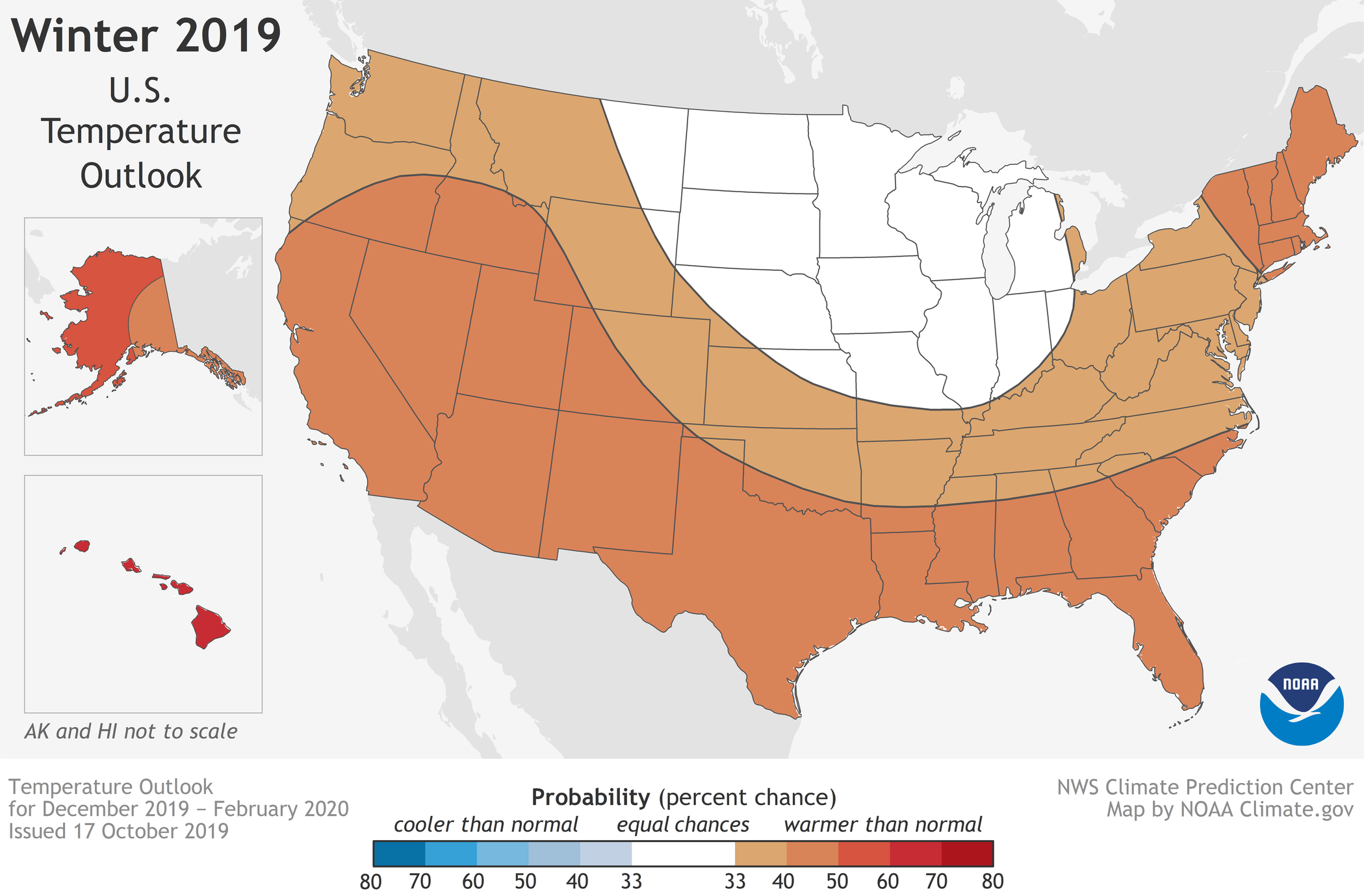
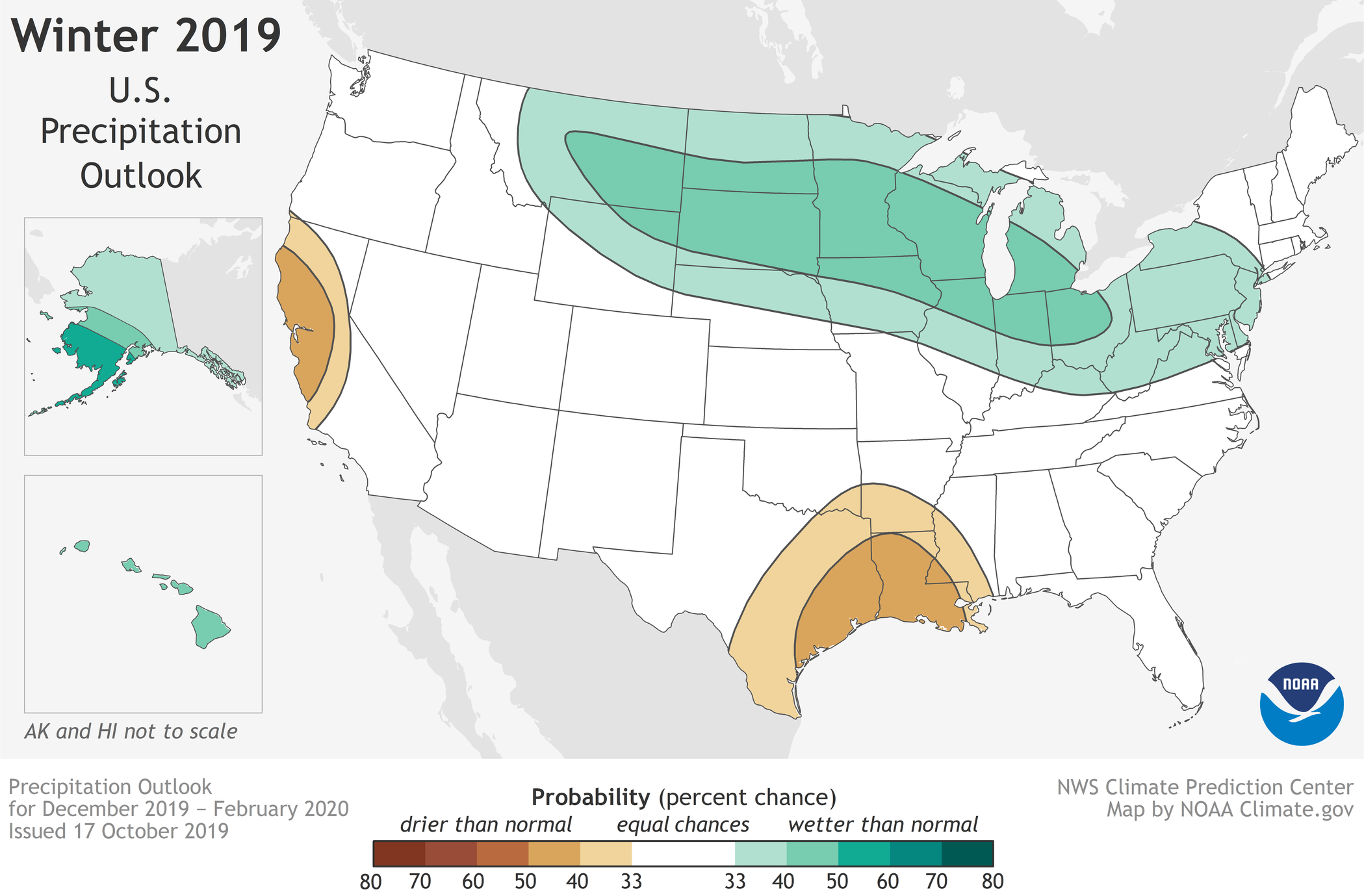
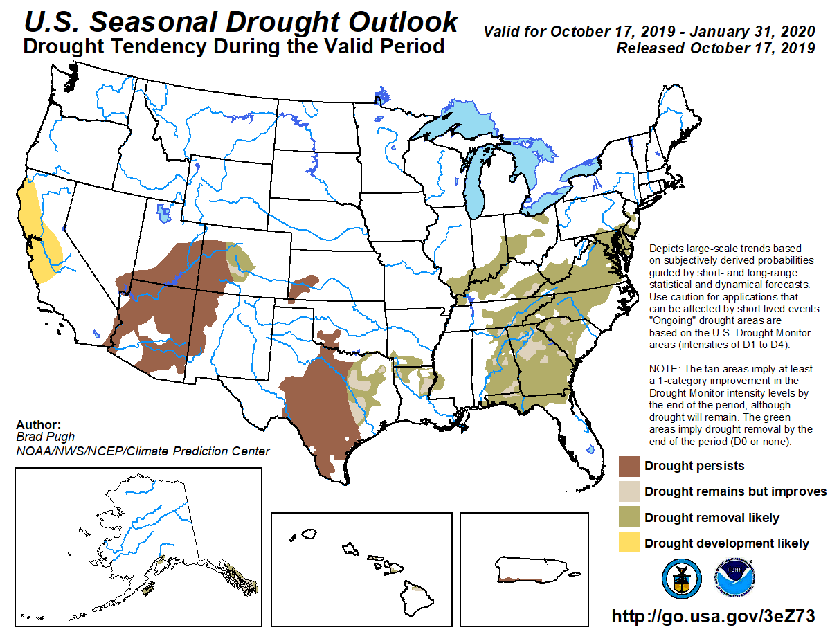
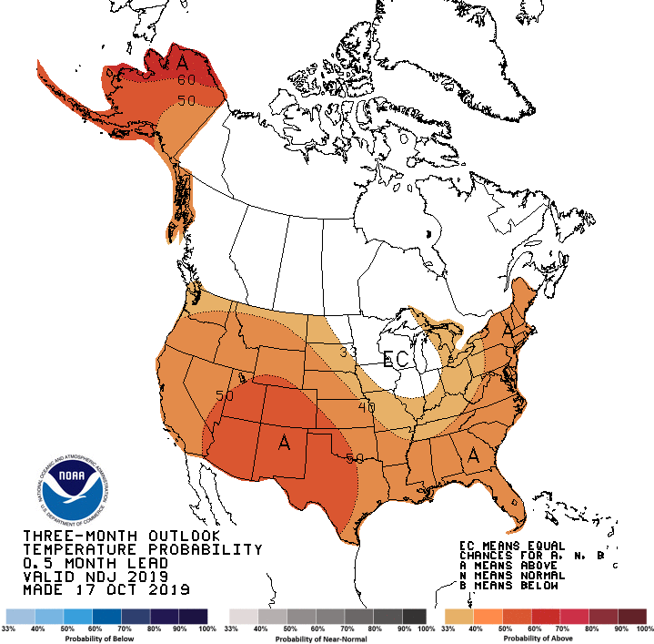
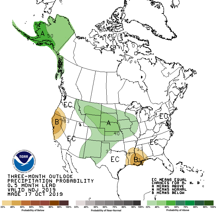
Warmer-than-average temperatures are forecast for much of the U.S. this winter according to NOAA’s Climate Prediction Center. Although below-average temperatures are not favored, cold weather is anticipated and some areas could still experience a colder-than-average winter. Wetter-than-average weather is most likely across the Northern Tier of the U.S. during winter, which extends from December through February.
While the El Nino Southern Oscillation (ENSO) climate pattern often influences the winter, neutral conditions are in place this year and expected to persist into the spring. In the absence of El Nino or La Nina, long-term trends become a key predictor for the outlook, while other climate patterns, such as the Madden-Julian Oscillation and Arctic Oscillation (AO), will likely play a larger role in determining winter weather. For example, the AO influences the number of arctic air masses that intrude into the U.S., but its predictability is limited to a couple weeks.
(Video summary of NOAA’s 2019-2020 Winter Outlook issued October 17, 2019. This video discusses climate conditions favored for the U.S., including Hawaii and Alaska. To download forecast maps and/or a standalone version of this video, visit https://www.climate.gov/winter2019-20. NOAA Climate.gov)
“Without either El Nino or La Nina conditions, short-term climate patterns like the Arctic Oscillation will drive winter weather and could result in large swings in temperature and precipitation,” said Mike Halpert, deputy director of NOAA’s Climate Prediction Center.
This spring saw significant and historic flooding across the central U.S. that impacted nearly 17 million people. However, during the summer and early fall, drought rapidly developed across much of the South, with drought conditions now present across approximately 20% of the country.
The 2019-20 U.S. Winter Outlook | December through February Temperature
The greatest likelihood for warmer-than-normal conditions are in Alaska and Hawaii, with more modest probabilities for above-average temperatures spanning large parts of the remaining lower 48 from the West across the South and up the eastern seaboard.
The Northern Plains, Upper Mississippi Valley, and the western Great Lakes have equal chances for below-, near- or above-average temperatures.
No part of the U.S. is favored to have below-average temperatures this winter.
This 2019-20 Winter Outlook map for temperature shows warmer-than-average temperatures are likely for much of the U.S. this winter.
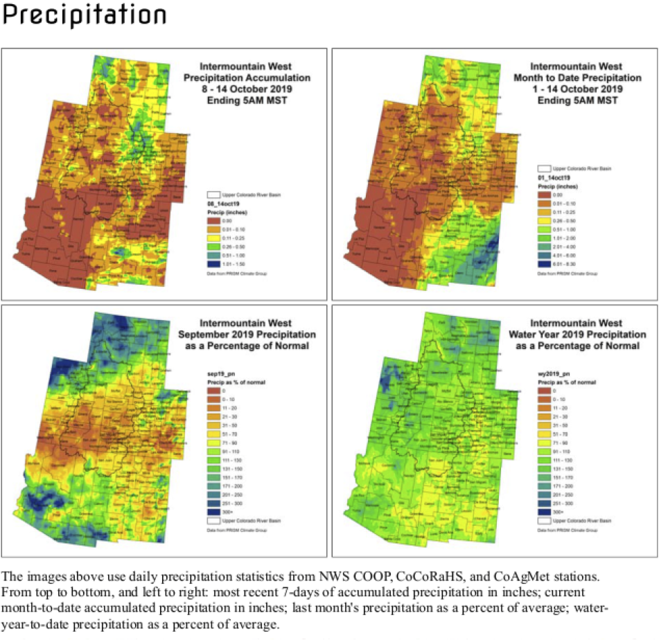
Precipitation
Wetter-than-average conditions are most likely in Alaska and Hawaii this winter, along with portions of the Northern Plains, Upper Mississippi Valley, the Great Lakes and parts of the Mid-Atlantic and Northeast.
Drier-than-average conditions are most likely for Louisiana, parts of Texas, Mississippi, Arkansas and Oklahoma as well areas of northern and central California.
The remainder of the U.S. falls into the category of equal chances for below-, near-, or above-average precipitation.
This 2019-20 Winter Outlook map for precipitation shows wetter-than-average weather is most likely across the Northern Tier of the U.S. this coming winter.
Drought
Abnormally dry conditions are present across much of the Southern U.S., with areas of the most severe drought in the Four Corners region of the Southwest, central Texas and parts of the Southeast.
Drought is expected to improve in portions of the Southeast, Mid-Atlantic, Alaska and Hawaii, while persisting in central Texas and the Southwest.
Drought development is expected to occur in parts of central California.
NOAA’s seasonal outlooks provide the likelihood that temperatures and total precipitation amounts will be above-, near- or below-average, and how drought conditions are favored to change. The outlook does not project seasonal snowfall accumulations as snow forecasts are generally not predictable more than a week in advance. Even during a warmer-than-average winter, periods of cold temperatures and snowfall are expected.
NOAA’s Climate Prediction Center updates the three-month outlook each month. The next update will be available November 21.
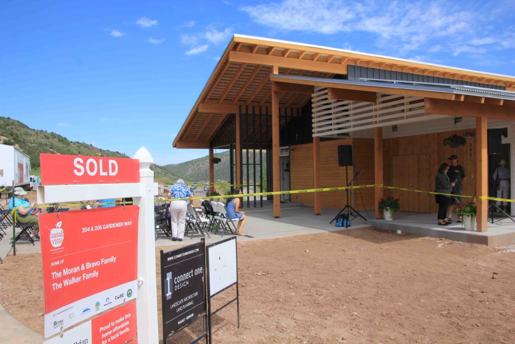
Huddled in a construction trailer last year, a team overseeing development of an affordable housing complex in the Colorado mountain town of Basalt agreed to make a bold statement about future energy use.
No natural gas lines were to be laid through the red soil to Basalt Vista, an affordable housing project. Electricity instead fuels kitchen stoves and delivers hot showers. Electricity, not gas, warms chilled autumn air. All units also have charging equipment for electric cars.
Beneficial electrification, the concept in play, has been defined as the application of electricity to end uses that would otherwise consume fossil fuels. That includes both transportation but also buildings. The U.S. Energy Information Administration says residential and commercial buildings sectors account for about 40% of total U.S. energy consumption.
Basalt Vista serves as a demonstration of building electrification but also as a living laboratory with national implications. New technology designed in a partnership with the National Renewable Energy Laboratory allows homeowners greater decision-making in energy allocations. Holy Cross Energy, the local electrical utility, also has been using the all-electric units to understand implications for its operation as it shifts toward increased renewables. The co-op expects to be at 70% renewable by 2021 and has ambitions to go higher.
While multiple California cities are considering bans on new natural gas connections, building electrification remains an infant concept. Natural gas remains the go-to fuel source for heating and other purposes in new construction in most places. In Colorado, legislators and other state officials have begun considering how to reduce use of natural gas as they plan how to achieve the goal adopted earlier this year of 90% reduction in economy-wide carbon emissions below 2005 levels by 2040.
Of the 27 units, 14 will be available for purchase by school district employees. Employees within Pitkin County will have dibs on the other 13 units based on a lottery. Photo/Allen Best
Existing buildings pose a major challenge, as they often cannot be readily reconfigured. But even new construction in Colorado’s colder climate zones will test the application of existing technology. Basalt Vista, located 18 miles down-valley from Aspen, ranks at the edge.
Grading of the site had begun in June 2018 when Auden Schendler, a member of the Basalt Town Council and also vice president of sustainability for the Aspen Skiing Co., made his case for electrification of the units. The concept, a crucial strategy for solving the challenge of climate change, needed to be demonstrated, he told the development partners.
“We know how to decarbonize the utility grid, we know how to decarbonize transportation mostly, but the big challenge is how to heat buildings without combusting fossil fuels,” he says. “Electrification combined with an eventually renewable grid is one way to do that.”
A year after that construction trailer huddle, the first duplex had been completed. “This is my house!” 13-year-old Isabel “Izzy” Walker beamed at the grand opening as she led her grandfather by the hand.
Her mother teaches preschool in the local Roaring Fork School District, which provided the land adjacent to Basalt High School. Of the 27 units, 14 will be available for purchase by school district employees. Employees within Pitkin County will have dibs on the other 13 units based on a lottery and subject to income restrictions. Completion is expected by early 2021.
As for saving money, Schendler’s second motivation, the first electric bills for summer came in at $12.65 and then $12.61. Habitat for Humanity Roaring Fork Valley, the developer, projects Basalt Vista homeowners can expect annual savings of $2,000 in utility costs.
Colorado Gov. Jared Polis got explanations from Scott Gilbert, of the Roaring Fork chapter of Habitat for Humanity, during his tour of Basalt Vista…as former State Sen. Gail Schwartz listened. Photo/Habitat for Humanity Roaring Fork Valley
Like much of the affordable housing in the Aspen area, Basalt Vista is heavily subsidized, most prominently $3.2 million in land donated by the school district and $3 million in infrastructure work by Pitkin County. Habitat for Humanity is also subsidizing each home by over $100,000, as home prices are based on what buyers can afford to pay: 28% of their gross monthly income for mortgage, insurance and taxes.
Energy improvements also are receiving more than $300,000 in help, including smart inverters and other assistance from electrical supplier Holy Cross Energy, discounted solar photovoltaic costs, and $107,500 from the Community Office for Resource Efficiency, a local nonprofit, for photovoltaic panels and heat pumps.
Crucial technology
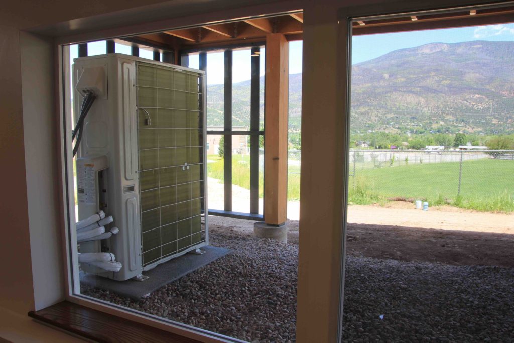
High-efficiency cold-climate air-source heat pumps provide the crucial technology at Basalt Vista. Heat in the outside air is absorbed and stored in a refrigerant as latent heat. Temperature of the refrigerant gas rises when compressed by an electric pump, providing the heat that can then be transferred to indoor water or air. Electricity facilitates the heat transfers.
Dramatic improvements in recent years have made air-source heat pumps useful in cold weather climates. Heat can be extracted from outdoor air as low as 22 degrees below Fahrenheit. Basalt normally can expect temperatures of 10 to 15 below zero in winter, a notch or two colder than Denver.
“A thousand feet higher and colder, I’m not sure we would have done it, to be honest with you,” said Scott Gilbert, president of the Habitat for Humanity chapter. Aspen is 18 miles away and 1,000 feet higher.
Megan Gilman, a zero-emissions building consultant from Edwards, says electric buildings in cold climates must be paired with on-site solar to produce the lowest long-term operating costs. Without that on-site production, electrification struggles to compete with natural gas, which has been cheap in Colorado for the last decade and is likely to remain so. Even more efficient equipment, including heat pumps, can help narrow this gap, she said.
An air-source heat pump can deliver 1.5 to 3 times more energy in the form of heat than the electrical energy it consumes. In the Basalt Vista homes, the heat is distributed from ceiling units, which do so more efficiently than the radiant base-board electric heaters installed in homes during the 1970s.
Basalt Vista constitutes a microgrid. A microgrid remains part of the broader electrical grid but has resources to remain functional at some reduced level if the grid connection is severed — particularly beneficial in a mountain area vulnerable to wildfires. Hospitals and military bases commonly have backup diesel generators or other resources to provide power in case grid electricity ceases.
Four units at Basalt Vista (so far) have battery storage units, helping Basalt Vista be a microgrid. Photo/Allen Best
All 27 units at Basalt Vista will have photovoltaic solar panels on the roofs and at least 7 units will have $15,000 lithium-ion battery packs, good for 10 years and 10,000 cycles. One battery can run the full load of two houses. With sparse use — refrigerator, microwave, and lighting — a battery can run a house for four days.
“If you have a certain amount of solar and storage in a microgrid area, you can separate from the bigger grid,” explained Steve Beuning, vice president for power and supplies at Holy Cross Energy. “You just have to rely upon those local resources. You might have some high priority loads you want to supply, but not other, non-essential demands.”
Research project
Greater flexibility while integrating higher levels of renewables in the electrical grid is another goal at Basalt Vista in a $1.65 million study sponsored by the Department of Energy and the National Renewable Energy Laboratory.
In the old utility model, centralized generation was designed to meet maximum demand. In most places, that demand occurs on hot summer afternoons and evenings. In the Basalt area, demand peaks during winter. The model being created at Basalt seeks to provide more interplay between generation and supply, modulating the demand to better correspond with local supply.
Chris Bilby, research and programs engineer for Holy Cross Energy, said the utility wants to avoid building excess generation, whether solar farms near Basalt or giant wind farms on the Great Plains.
Air-source heat pumps provide the crucial building electrification technology at Basalt Vista. Photo/Allen Best
“For most of the utility world, it’s all about managing the supply to meet the demand,” he said. That requires transmission and distribution, all of it costly. “What we’re trying to do is maybe ask, ‘Can we dim the lights’ — that’s an analogy — ‘to meet the supply, or shift use of members to times when there is surplus?’ That’s what we’re trying to get done.”
Router-sized devices in this experiment prioritize uses and also function as in-house — literally — moderators between supply and demand. This sorting of electrical uses will occur not just in time of crisis, but also in everyday life at Basalt Vista.
The control solution, designed to meet needs of Holy Cross, comes from a novel algorithm developed by researchers at the National Renewable Energy Laboratory. The algorithm, called real-time optimal power, optimally schedules flexible uses, such as hot water heaters or charging and discharging of batteries, based on real-time voltage and power measurements. The first four duplex units at Basalt Vista have 20 such controllers to manage the photovoltaic panels, batteries, electric vehicle charging, heating and cooling.
For example, can the charging rate of an electric vehicle be slowed or deferred altogether until supplies have become more plentiful? Heating water might also be juggled. “So maybe you don’t get a 40-minute shower, but you get a 20-minute shower,” Bilby said. This increased flexibility of customer use may yield higher levels of lower-cost renewables.
The devices have been produced by Heila Technology, a company founded by Massachusetts Institute of Technology alumni. Heila’s vision is to build a futuristic grid with bolstered resilience that that meets consumer energy needs while maximizing reliance on renewable energy. It has applied the electrical controls — the brains that prioritizes uses — used in large applications, such as factories, and crafted them for use in small settings, like a house. In effect, they can make a house in Basalt Vista a microgrid of its own. Not coincidentally, the company’s name of Heila is Swedish for brains.
Francisco Morocz, the chief executive of Heila, said Basalt Vista is a pilot project, trying to demonstrate how granular the control systems can be. The next step would be to optimize use of on-site battery storage and help make it a resource within the broader energy system.
The National Renewable Energy Laboratory believes the results will have implications for utilities, particularly municipalities and cooperatives, around the world, delivering results that can be scaled to hundreds of homes while significantly improving grid operations.
Scaling building electrification
Can all-electric homes such as those being built in Basalt be scaled? Costs of the Basalt Vista duplex and triplex units have been coming in at 15% per unit, roughly $40,000 to $50,000, more than conventional units. Technology is part of the increment. A heat pump water heater costs $1,800, compared to $600 for a 96% efficiency gas water heater, which is more expensive than the 85% efficiency models commonly found at big-box hardware stores.
Too, the construction trades have not geared up for all-electric homes. “Contractors were very wary of this. Bids were coming in at $10,000 more per unit than gas,” said Marty Treadway, program director for the Community Office for Resource Efficiency, or CORE. The local nonprofit donated $107,500 for photovoltaic panels and heat pumps.
“A prototype for affordable housing and a net-zero energy neighborhood makes a ton of sense for CORE,” Treadyway said. CORE has awarded $8.2 million in rebates and grants since 2011 to reduce emissions caused by buildings. The group’s primary funding comes from the Renewable Energy Mitigation Program, which exacts fees on large homes with high energy use in Aspen and Pitkin County if the homeowner or builder opts not to mitigate with on-site renewable energy.
Transportation constitutes Colorado’s second-largest source of greenhouse emissions, but buildings follow. For Colorado to slash emissions, it must figure out buildings. As Holy Cross’s Bilby points out, “You can’t do zero emissions with natural gas.”
On Tuesday, Oct. 8, an informational meeting was held to inform residents along the South Platte River of the changes in the floodplain maps used by community officials, insurance providers and mortgage lenders.
This meeting was hosted by Morgan County Floodplain Administrator Pam Cherry. It was held in the Founders Room at Morgan Community College. Also present was Diana Herrera, Federal Emergency Management Agency (FEMA) Region 8 senior insurance specialist…
Herrera spoke some about the impacts of changes to the floodplain maps to insurance rates.
“Mainly what we’re talking about is the map changes that are coming along the South Platte River,” she said, with the goal being “to let the property owners know what their risk is and how they can protect their financial interests.
There are some changes coming, she said.
“The cost of insurance outside the special flood area is about $500 a year for $250,000 on buildings and $100,000 on contents,” Herrera said. “Inside the high-risk area, there are a number of factors, how was it built, number of floors and age among other factors.”
She also said that there are changes coming to the National Flood insurance Program and for how flood insurance and risk for flood is factored…
“We are modernizing the National Flood Insurance Program, and sometime at the end of next year we are hopeful that we will be able to do an individual risk for flood,” Herrera said…
To learn more about the NFIP and flood insurance, call 1-800-427-4661 or contact an insurance company or agent.
…the river is dammed [by Mexico’s Morelos Dam] at the US-Mexico border, and on the other side the river channel is empty. Locals are now battling to bring it back to life.
There are few more striking examples of what has come to be known as “environmental injustice” – the inequitable access to clean land, air and water, and disproportionate exposure to hazards and climate disasters. Water in particular has emerged as a flash point as global heating renders vast swaths of the planet ever drier…
Currently the river flow in Mexico is 0.5 cubic metres per second, a fraction of what it once was. Another pulse flow to help restore the river’s estuary and wetlands could happen in 2021/22…
Because the 1944 treaty did not allocate Mexico any water for the river itself, the channel is mostly dry. The loss of the river in Mexico has has been devastating…
At the Morelos dam, located between Los Algodones, Baja California and Yuma, Arizona, the river is diverted to a complex system of irrigation canals which nourish fields of cotton, wheat, alfalfa, asparagus, watermelons and date palms in the vast surrounding desert valley. This is good for farmers – and less so for ordinary Mexicans.
Following the dry riverbed south towards the Gulf of California evokes an eerie sadness. The sound of gunfire in one wide, dusty section led to a couple from San Diego hunting wild pigeons, and a bucketful of feathered corpses. A few miles west along dirt farm roads, dozens of herons, egrets and ducks were staking out a wonderfully lush wetland – though it is only an accidental byproduct created by agricultural runoff from surrounding wheat and alfalfa fields.
Martha Gomez-Sapiens, a monitoring team member and postdoctoral research associate in the UA Department of Geosciences, stands on a riverbank next to willows and cottonwoods that germinated as a result of the pulse flow. (Photo: Karl W. Flessa/UA Department of Geosciences)
This essay appeared in Adventure Journal on Aug. 5, 2019. I stood up to admire my haul, and for the first time, paused to look around. I had been so hyper-focused on the forest floor, which was blooming with glorious eruptions of chanterelles, that I hadn’t stopped to look up in … 30 minutes? An […]
From the Chinese Academy of Sciences via Phys.org:
Flash drought is a new phenomenon with increasing prominence due to global warming. Drought develops rapidly without sufficient early warning, and has stricken the world with severe impacts during recent years, such as the droughts over central USA in 2012 that caused billions of dollars of economic losses; southern China in 2013 that affected 2 million hectares of crops in Guizhou and Hunan provinces alone; and those in southern Africa in 2015, and northern USA in 2017. There is hence an urgent need to investigate flash drought risk and its underlying drivers in a changing climate.
“Still, how will the flash drought risk change in a warming future climate remains unknown for a number of reasons,” said Xing Yuan from the Nanjing University of Information Science & Technology, “for example, there’s a diversity of flash drought definitions that scientists haven’t agreed upon, the role of anthropogenic fingerprints is not clear, and we are not sure of future socioeconomic scenarios.”
Yuan and his Ph.D. students Linying Wang, Peng Ji, and Miao Zhang from the Institute of Atmospheric Physics at Chinese Academy of Sciences, Dr. Peili Wu from the UK Met Office and Prof. Justin Sheffield from the University of Southampton, address the above issues in a recently published study in Nature Communications.
Their study focuses on China where rapid industrialization and urbanization have significantly increased environmental vulnerability under global warming. They proposed a new definition of flash drought based on rapid decline rate of soil moisture and the dry persistency. The new definition captures both the “flash” and “drought” characteristics, and the duration constraint gives enough time for a flash drought event to cause ecological impacts.
“We carried out land surface ensemble simulations driven by multiple climate models under different external forcings, such as greenhouse gases,” said Yuan.
Results show a significant increasing trend of flash drought frequency in China during 1961-2005, with a clear 77% footprint from anthropogenic greenhouse gas emissions. Under moderate emission scenarios, the exposure risk in China will increase by 23% in the middle of this century. This increase can reach up to 40% in the southern provinces with humid climates (such as Guizhou, Guangxi, Guangdong, Zhejiang, etc.), while the exposure risk in semi-arid northern areas will decrease.
“This indicates that anthropogenic climate change has changed the traditional arid areas, and more attention should be paid to deal with flash drought risks in humid and semi-humid areas.” Said Yuan.
Here’s an interview with Becky Mitchell Director of the Colorado Water Conservation Board, from Abby Burk, that’s running on the Audubon Rockies website:
Interview with Becky Mitchell, director of the Colorado Water Conservation Board and Colorado commissioner on the Upper Colorado River Commission.
Rebecca Mitchell was named to the Colorado Water Conservation Board on July 5, 2017. Photo credit the Colorado Independent.
October 1st kicked off the new water year. This is when water managers and water wonks focus on existing water supplies and precipitation predictions. Water years run from October 1st through the following September 30th, and Water Year 2020 is poised to be one we will all be talking about for years to come. During it, we’ll see the start of discussions around the agreement that needs to be reached in 2026 to replace the Colorado River Interim Operating Guidelines, further investigation of a potential Upper Colorado River Basin demand management program after the adoption of the Drought Contingency Plans in 2019, and the launch of the first update to Colorado’s Water Plan. It’s a dynamic time for both Colorado River and Colorado water management!
Abby Burk, western rivers regional program manager for Audubon Rockies, reached out to Becky Mitchell—director of the Colorado Water Conservation Board (CWCB) and Colorado commissioner on the Upper Colorado River Commission—to ask six key questions and learn how she’s leading Colorado through these water milestone moments.
Q: Water is such a broad issue that connects all of us. Colorado’s Water Plan, completed in 2015, is four years old. What have been the plan’s successes and challenges? What is your most celebrated Water Plan implementation project?
A: At the CWCB, we work every day to implement the Water Plan, and because of that, I would call the plan’s biggest success its ability to bring all of the important projects and programs that the agency does into better focus with a cohesive whole. In fact, far beyond the CWCB, the Water Plan continually helps to unite countless efforts occurring throughout the state at every level of the public, private, and nongovernmental sphere. While it will always be an ongoing and iterative process, the concrete goals and objectives of the Water Plan have really helped to motivate our community to collectively address our (many) water challenges, which include maintaining momentum, coordinating efforts at every level, and continually funding the innovative and effective projects.
While it’s hard to pick just one example of a celebrated project, the first one that comes to mind is the Homestake Arkansas River Diversion Project. Currently under construction, this project is managed by the City of Aurora and Colorado Springs Utilities to improve the reliability of a major aging diversion structure while at the same time removing the last critical barrier to boat and fish passage on the Upper Arkansas River and restoring important habitat. The CWCB contributed $700,000 to help fund the project, along with funding from Colorado Parks and Wildlife, various other project supporters, and donated easements from the Pueblo Board of Water Works, totaling $7.7 million.
Q: Water is a critical issue for all Coloradans. Whether you play in/around our world class rivers, irrigate your crops, or take a sip of our abundant clean drinking water, our valuable and limited water supply impacts each of us every day. How will the Water Plan keep pace with a growing Colorado and protect what makes Colorado so special: our rivers?
A: From day one, the Water Plan has been a living document. The plan is fundamentally a broad ongoing effort to collectively meet our state’s evolving water challenges in the most effective and mutually beneficial ways. To keep pace with a growing Colorado, Chapter 11 of the plan sets the process for continually refreshing the plan. We have now unified all of the Water Plan components into three main pillars: the main Water Plan (the primary policy document), the Basin Implementation Plans (the local application of the plan), and the Analysis and Tech Update (the plan’s technical foundation). In summer 2019, we finalized the Tech Update and are now updating the Basin Implementation Plans and the Water Plan to support the Tech Update.
A critical aspect of all of these efforts is protecting our special rivers. The Tech Update included the development of an environmental flow tool to help interpret how potential future stream conditions may change, and how to plan for those impacts. We hope this tool and the wealth of other data in the Tech Update will better inform local efforts to address environmental needs, starting with updated analyses in the Basin Implementation Plans.
Q: This is an exciting time for Colorado River water management with the passage of the Drought Contingency Plan (DCP) and the ramp up to the renegotiation of the 2007 interim guidelines in 2026. Considering the DCP, how are you leading Colorado’s place in exploring a possible demand management program? How is Colorado working with other Upper Basin states in looking at options for demand management?
A: The CWCB has taken two major policy actions regarding a potential demand management program. First, the board passed a support and policy statement back in November, 2018. This statement took into account public comments, stakeholder and water user concerns, as well as board guidance and support for the draft DCPs. This was aimed at guiding the assessment of demand management feasibility.
The board also adopted the 2019 Work Plan in March of this year. This Work Plan represents the first steps toward assessing demand management feasibility as identified in the support and policy statement. The Work Plan tasks CWCB with setting up workgroups to help identify priority issues regarding demand management and holding public regional workshops to garner input and discussion. It also directs the legal, technical, and policy investigations that will inform the Board’s next moves in determining whether a demand management program is appropriate for Colorado.
We communicate regularly with our Upper Basin state partners on their own intrastate efforts to assess demand management feasibility, who are all engaged in similar processes within their borders. As the intrastate investigations continue, the Upper Basin states will share information through the auspices of the Upper Colorado River Commission and their committees to further assess the feasibility of demand management across borders and throughout the Upper Basin.
Q: We have to acknowledge that storage is a part of our water portfolio future. However, none of us have an appetite for big new reservoirs. What are ways that storage can be leveraged for fulfilling the growing needs of water certainty while still supporting Colorado’s healthy rivers?
A: Without sufficient water storage, the vast majority of our current population could not live in this environment; and with a growing population, we will very likely need some additional storage. However, we also need to more effectively manage our existing infrastructure to support healthy rivers.
Examples of this include iterative efforts to re-operate the Ruedi and Chatfield Reservoirs to meet multiple needs, and in the case of Chatfield, to increase storage without raising the dam. Another example is the South Platte Regional Opportunities Water Group, which is currently conducting a feasibility study to examine aquifer storage and recharge, off channel reservoirs, and storage of municipal reuse water, among other things.
Q: What’s your message for people who care about Colorado’s rivers, and the birds and wildlife they support? How will the state take care of its rivers as climate change increases the frequency and intensity of droughts?
A: The takeaway message here is healthy rivers are vital to Colorado’s conservation efforts and quality of life, and the CWCB is committed to maintaining those stream flows for all fish and wildlife that depend on them as well as for the enjoyment of our outdoor recreationists.
More specifically, the CWCB works with partners on appropriating new instream flow water rights to maintain stream flows that support Colorado’s fish, birds, and wildlife and the food and habitat that they need. Particularly in dry years, we work with the Colorado Water Trust, other nonprofit organizations, and water rights owners on leases and other mechanisms for providing and protecting stream flows.
The Tomichi Water Conservation Program involves regional coordination between six water users on lower Tomichi Creek to reduce consumptive use on irrigated meadows as a watershed drought management tool. The project will use water supply as a trigger for water conservation measures during one year in the three-year period. During implementation, participating water users would cease irrigation during dry months. Water not diverted will improve environmental and recreational flows through the Tomichi State Wildlife Area and be available to water users below the project area. Photo credit: Business for Water.
In last year’s example of the Coats Brothers Ditch temporary lease on Tomichi Creek, the ditch owners used the water right for irrigation until July 1, when the CWCB started using it for the Tomichi Creek instream flow water right. This lease provided approximately 202 acre-feet of water to the stream during low flow conditions while providing an economic benefit to the ditch owners. This type of flexible tool is very effective at addressing low flow conditions.
In the face of climate change, which we know will present unique challenges to protecting our rivers and streams, we are committed to finding ways to address those challenges, including working with groups who have identified needs and opportunities in their stream management plans to implement additional stream protection.
Q: What is the one thing that gives you the most hope about where we are heading with water in Colorado?
A: We have engaged stakeholders who care deeply about maintaining the Colorado way of life and the values in the Colorado Water Plan. These stakeholders work with the CWCB, the basin roundtables and communities every day to collaboratively plan for our future and implement projects that drive the Colorado Water Plan forward. These efforts forge partnerships, remove barriers, inspire new generations and encourage a spirit of cooperation that is so important to building multi-purpose, multi-benefit initiatives that meet multiple water needs for farms, urban communities and the environment.
For the Water Plan to be successful, we need to balance all of these needs. Our stakeholders are the lifeblood of Colorado water planning and they serve as a shining example of what public engagement can accomplish.
Imperial County is seeking to declare a public health emergency at the Salton Sea, The Desert Sun has learned, aiming to force Gov. Gavin Newsom and federal officials to free up emergency funds and take immediate action to tamp down dangerous dust.
County supervisors will vote Tuesday on an urgent action item to proclaim a local air pollution emergency due to airpollution at the state’s largest lake, which is rapidly shrinking and exposing shoreline that is potentially loaded with contaminants from decades of agricultural runoff and military testing.
The county air pollution control board is “aware of harmful dust and pollution at the Salton Sea that is harming Imperial County citizens,” according to agenda materials. “This is a peril to human life and a crisis beyond the control of the local County of Imperial.”
County Supervisor Ryan Kelley, who chairs the board, said he proposed the drastic action and it had the full support of fellow supervisors in public discussion two weeks ago.
Just above the horizon here, a haboob (dust storm) can be seen heading north. This was shot at what remains of the Salton Sea Naval Test Station. Photo credit: slworking2/Flickr
Click here to read the newsletter. Here’s an excerpt:
The Future of Fountain Creek: Frost Ranch Owner Takes the Long View
Here in the Pikes Peak region, many of us play in the Fountain Creek Watershed, whether we’re aware of it or not. We might hike or ride our bikes along Fountain Creek and its tributaries. We might fish or paddle our kayak in the creeks or lakes. But most of us don’t work the land – and we rarely witness Fountain Creek’s tempestuous nature.
Jay Frost. Photo credit: Frost Ranch
But Jay Frost, third-generation owner of Frost Ranch south of Fountain, Colorado, has endured the creek’s unruly temperament for decades. “I’ve been watching the creek all my life,” he says. “We make a living here. We try to deal with its unpredictable nature.”
Frost Ranch has deep roots in local ranching and farming traditions. The Frost family raises grass-fed and grass-finished lamb and beef in its irrigated meadows. They grow non-certified organic vegetables and grass/alfalfa hay in the irrigated parts of the farm. The Frost family takes pride in growing healthy, sustainable food. The lamb and beef are free of hormones, antibiotics, and corn; fields are never sprayed; and vegetable planting, irrigating, weeding, and harvesting are all done using holistic and traditional methods.
Fountain Creek’s erosion and sedimentation issues are vexing. How does this impact Frost Ranch?
Photo credit: Frost Ranch
“The creek is flashy,” Jay says. “If there’s a little sniffle of rain in Colorado Springs, here comes the water! We can go from a base flow of 60 cubic feet per second (cfs) to 22,000 cfs. When the water calms down, all the sediment drops. The sediment load in Fountain Creek is crazy!”
Simultaneously, the ranch is literally losing property from erosion. “We have a big cut bank – we refer to it as the Great Wall,” Jay notes. “It’s 60 feet deep and at least a quarter of a mile long. It’s sloughing off soil all the time.”
Jay adds that floodwater can wash away fences and irrigation pipes, and sedimentation can damage irrigation infrastructure. The Frost family no longer grazes livestock near the creek due to the invasion of non-native plants. “Parts of the creek are choked with trees and exotic species like salt cedar [tamarisk] and Russian olive trees,” he says. “You can’t fence the dang thing. It’s just gnarly.”
That’s why, nearly three decades ago, Jay helped to form a coalition to begin focusing on the Fountain Creek Watershed – and begin addressing its many issues regarding flooding, erosion, and sedimentation.
This early initiative helped to pave the way for the formation of the Fountain Creek Watershed Flood Control & Greenway District. Soon after the District was formed, Frost Ranch collaborated with District engineers to address a serious erosion issue on the ranch. According to the Project Summary, the lack of vegetation along approximately 400 feet of the creek’s bank allowed soil to be readily removed during high-flow events, resulting in flood damage, bank erosion, and increased downstream sedimentation.
Unfortunately, the repair project didn’t hold – a flooding incident washed it away. But Jay isn’t completely surprised, due to the turbulent nature of the creek. “Fountain Creek is normally a dribble, but it’s prone to flooding,” he says. “It can be wilder than hell when it’s really rolling.”
A Comprehensive Solution is the Best Way Forward
Bank stabilization Fountain Creek. Photo credit: Frost Ranch
When it comes to Fountain Creek, Jay Frost takes the long view. “I believe we can find a comprehensive solution – a silver bullet – that will address the entire Fountain Creek Watershed,” he says. “A comprehensive solution – an absolutely engineered approach – is always better than just taking a stab at the issues, project by project.”
This is one of the benefits of the Fountain Creek Watershed Flood Control and Greenway District, which is addressing the watershed comprehensively. In fact, since 2009, the District has planned and/or implemented more than a dozen construction projects to address critical erosion and sedimentation issues throughout the watershed. Various project aspects involve restoring the main channel, realigning the creek, stabilizing steep cut banks, revegetating, protecting wetlands, and restoring riparian habitat. At the end of the day, if Fountain Creek has less erosion, less sedimentation, better quality and accessible water, we all benefit.
I n the conversation with Jay, it was noted that ranchers and farmers are on the front lines of water issues, fighting the good fight. “Yeah,” Jay replies, “but it’s so worth it.”
Click here to read the newsletter. Here’s an excerpt:
Funding opportunities in the Gunnison River Basin
Funding opportunities for water projects that help improve and conserve water and land resources can be found on http://gunnisonriverbasin.org, including:
US Department of Agriculture federal grants and loans
Colorado Water Conservation Board state grants and loans
Additional Grant Funding Opportunities
Click here to view a table of grand funding opportunities.
Upper Gunnison watershed May 2019. Photo credit: Greg Hobbs
District 5 State Sen. Kerry Donovan, left, speaks on a panel with other lawmakers at the Colorado Water Congress legislative session in Steamboat Springs in August. Photo credit: Heather Sackett/Aspen Journalism
As demand and prices for Colorado water rise, state lawmakers are concerned that Wall Street investment firms and even local finance groups may seek to circumvent state laws designed to prevent water profiteering.
Last month, the Colorado Legislature’s Interim Water Resources Review Committee initially approved a bill authorizing a study to determine whether the state’s anti-speculation laws, already considered among the strongest in the West, need to be further strengthened.
“The reason I drafted it is because I’m hearing stories from the West Slope and the San Luis Valley of outside groups coming in and buying water rights. While we’re not entirely sure if this is speculation, some of these companies are more like financial and hedge fund institutions instead of agricultural interests. That seems to have the color of water speculation,” said Sen. Kerry Donovan, a Democrat who represents several West Slope counties and who is chair of the interim committee. (Editor’s note: Sen. Donovan sits on the board of Water Education Colorado, which sponsors Fresh Water News.)
Under Colorado law, water is considered a public resource, but the legal right to take it and use it toward some beneficial purpose must be approved in water court. Once obtained, water rights are considered a private property right, one that can be bought and sold as long as water courts approve the transaction.
Water has always been a scarce resource in Colorado and in the 1800s, as miners and farmers were moving in, the courts developed a system so that no one could hoard water and profit from its sale. To combat the problem, they required that water rights be granted only to those who could put them to beneficial use, whether in farm fields or mines, or in people’s homes and businesses.
The anti-speculation laws have been challenged and upheld many times in water court, leading several water experts to question the need to amend them.
Dave Taussig, a Denver water attorney, said he was surprised to see lawmakers move in this direction.
“This is one of the few areas of Colorado [water] law that is pretty well defined and established,” Taussig said. “I don’t see the need for this.”
For many transactions, as long as the water is being put to use, the deal is not considered speculative.
On the West Slope for instance, New York City-based Water Asset Management has purchased ranches with valuable, senior water rights. Right now, the company continues to operate the farms and the water is still being used as it had been before the purchase, so it is not considered speculative. That’s because, under existing law, there is nothing to prevent someone from buying water rights with an eye toward a future sale, where the interim use is just a placeholder.
Water Asset Management could not be reached for comment. But its website spells out a clear investment strategy that includes acquiring Western farm water and holding onto it until it appreciates in value, at which point it could be leased or sold for a profit.
Closer to home, Denver-based Renewable Water Resources has assembled an investment group which intends to purchase farm water in the San Luis Valley and pipe it to the Front Range.
Sean Tonner, a principal in RWR, said the proposal isn’t a buy-low, sell-high proposition because his company is offering $2,500 to $2,800 an acre-foot for the farm water, which normally sells locally for much less, around $65 to $200 an acre-foot, according to San Luis Valley water officials.
Tonner declined to provide a sales price, but Front Range developers routinely pay $20,000 an acre-foot and more for water.
RWR has not yet identified an end-user for the project, but has committed to do so before it seeks approval from state water court.
“Colorado has great anti-speculation laws. If there is a way to make them stronger, I’m all for it,” Tonner said. “But I would disagree with the assertion that what we’re doing is buy-low, sell-high.”
Still lawmakers are concerned. Sen. Don Coram, R-Montrose, is also on the interim water committee and said the state needs to be vigilant about how its agricultural water rights are being bought and sold.
“Yes we do have strong anti-speculation laws,” Coram said, “but hedge funds also have very good attorneys. There are ways to work around [the laws].”
According to the initial bill draft, the Colorado Department of Natural Resources would form a work group next year to examine what the state can do to ensure its market-based water management system isn’t manipulated by moneyed interests. The bill directs the group to report back to lawmakers in August of 2021.
The committee will vote Oct. 24 on whether the bill should advance further. If approved, it will be introduced during the regular session that opens Jan. 8, 2020.
Donovan is hopeful the process will uncover new tools, even beyond the anti-speculation laws, to help the state prevent profiteering.
“Water speculation is something we need to ensure we have a firm grip on as a state. I expect there will be a lot of conversations in upcoming years about how we make sure that water isn’t exploited and doesn’t become a way for people to make a quick dollar,” Donovan said.
Jerd Smith is editor of Fresh Water News. She can be reached at 720-398-6474, via email at jerd@wateredco.org or @jerd_smith.
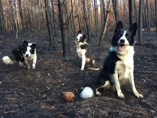
Last year, forest fires in central Chile wreaked havoc in the El Maule region with more than 100 different wildfires sweeping through the area and destroying over a million acres of forest land. It was the worst wildfire season in the country’s history, taking several lives and created an estimated $333 million of dollars worth of damages. The animals were forced to flee to safer areas.
The job to replant endless acres of forests seemed like a daunting endeavor. That is until three unusual workers took up the task. Six-year-old Das and her two daughters, Olivia and Summer are three Border Collies who have been trained to run through the damaged forests with special backpacks that release native plant seeds. Once they take root, these seeds will help regrow the destroyed area.
Border collies Olivia, Summer and Das in the woods on a non-working day. (Photo: Francisca Torres)/Mother Nature Network
It turns out that Border Collies are an ideal breed for this specific type of job. Bounding through miles of forest terrain requires not only speed, intelligence, and endurance, but also a willingness to stay focused and not get distracted by wildlife. Border Collies were bred to herd sheep, so they’re not as likely to run after or hurt other animals in the forest.
The sisters who own and train the dogs, Francisca and Constanza Torres, say the furry trio have a fun time jumping and bounding through nature. Francisca, told Mother Nature Network, “They reeeeeally love [it]!! It’s a country trip, where they can run as fast as they can and have a great time.”
This system is also more efficient than having people spread the seeds manually. These speedy canines can race through a forest and cover up to 18 miles a day. Humans, on the other hand, can only cover a few miles each day. These pups can scatter over 20 pounds of seeds, depending on the terrain. While robots or drones might be able to disperse seeds too, dogs aren’t as pricey to handle. Most importantly, they leave a lighter carbon footprint.
Francisca and Constanza put special backpacks on the dogs, fill them with native seeds and then it’s off to the races. Once the dogs have emptied out their bags, Francisca and Constanza give them plenty of treats, refill their bags, and release them again to dash around the destroyed forest, sprinkling more seeds in their wake. The end goal of all this, of course, is to restore the damaged ecosystem and have the wildlife return to the forests.
For Francisca, bringing trained dogs into the forest made sense. She runs a dog training facility and community called Pewos. While they receive some donations, she and Constanza pay for most of the seeds, supplies, and transportation themselves. Despite the hard work, their labor of love is already paying off.
According to Mother Nature Network, Francisca said, “We have seen many results in flora and fauna coming back to the burned forest!” While the dogs have already worked in 15 forests in the El Maule region, Francisca and Constanza plan to keep spreading seeds to bring back the forests with the canine trio.
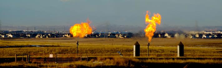
Study says drilling can increase risks of short-term health problems under worst-case scenarios.
Natural gas flares near a community in Colorado. Federal rules aim to lower risks of natural gas development. Photo credit the Environmental Defense Fund.
Rep. Sonya Jaquez Lewis, a pharmacist and organic farmer from unincorporated Boulder County, said she can see oil and gas companies burning off excess gas into the air across the county line.
“You can smell it. You get a burning sensation,” Jaquez Lewis told The Colorado Independent.
She suspects the emissions from these oil and gas operations have caused the nosebleeds, nausea, headaches and respiratory issues her neighbors experience. Some have had their blood tested to find high levels of toxic chemicals, such as benzene, she said.
Residents living atop Colorado’s reserves of oil and gas have for years contacted state health officials to report these ailments. And now, a study published Thursday further bolsters what they have long argued: Living near oil and gas drilling could put their health at risk.
The $600,000 study conducted by the consulting firm ICF International showed people living within 2,000 feet of oil and gas drilling could be exposed to short-term health risks under worst-case scenario conditions, such as in the early stages of drilling when emissions are highest or when the wind blows toward a home.
The study estimated the risk and potential health impacts of exposures based on emissions data. The estimates are used to predict, or “model,” how pollutants might move through air.
Oil and gas operations emit volatile organic compounds, including benzene, a known human carcinogen. The study found cancer risks fall within acceptable federal exposure limits.
In response to the peer-reviewed, 380-page study, which former Gov. John Hickenlooper commissioned, state health officials and oil and gas regulators said more monitoring is needed to determine a causal relationship between exposure to oil and gas emissions and health impacts. A key limitation, state officials said, is that the study used data dating back to 2014, prior to Colorado’s adoption of limits on methane emissions. The study also did not measure health impacts near multiple well pads.
“The study indicated the possibility for short-term health impacts,” Jeff Robbins, the director for the Colorado Oil and Gas Conservation Commission, told reporters in Denver Thursday. “We will undertake efforts to determine causation.”
Robbins said he would put in place “stricter review measures” for all drilling location permit applications that fall within 2,000 feet of an occupied structure. Robbins also wants to ramp up monitoring of current drilling activity to test emissions.
Regulators made clear that they do not plan to halt drilling in light of the new study. In the near term, it remains unclear what will change for residents living near oil and gas operations.
“I think today’s study is at least an acknowledgment by the state of what people living with oil and gas already knew,” said Sara Loflin, the executive director for the League of Oil and Gas Impacted Citizens (LOGIC), a nonprofit organization representing residents near oil and gas drilling.
In 2018, residents filed 548 complaints over drilling near their homes, citing noise, odor and air quality concerns, according to state data. There are more than 53,000 active wells in Colorado, and the state has approved more than 1,800 drilling permits so far this year.
Several environmental groups have been advocating for a drilling permit timeout until the state updates its rules for issuing permits to reflect new protections for public health, safety, welfare and the environment, as required by Senate Bill 181, which was signed into law in April. The rulemaking process is expected to take until the summer of 2020.
In light of the report, Colorado Rising, the Sierra Club and Earthworks called for drilling permits to be put on hold.
“If more research is needed to determine the level of harm how can Jeff Robbins ensure new permits are ‘sufficiently protective?’” Anne Lee Foster, communications for Colorado Rising, said in a statement. “This study also highlights the insufficiencies of oversight and enforcement of oil and gas extraction in Colorado.”
Lawmakers who wrote Senate Bill 181 responded to the study by calling for more monitoring and studies.
“This new CDPHE study is valuable, but what we really need is a comprehensive epidemiological study that looks at real health impacts on real people who live near oil and gas wells,” said Majority Leader Steve Fenberg of Boulder.
Environmental groups and some Democratic lawmakers, including Fenberg and Jaquez Lewis, want to see permits that fall within 2,000 feet of a home delayed until new rules for permitting are completed.
Jaquez Lewis stopped short of calling for greater setbacks.
“I think many of us are watching this issue closely and waiting to see the final rulemaking. Then we will be making some final decisions,” she said.
That neither lawmakers nor state officials pitched the possibility of increasing the state’s current setbacks for drilling rigs, currently at 500 feet from occupied buildings, speaks to how politically dicey the subject is. The industry touts its $30 billion contribution to the state’s economy.
Environmental groups attempted in 2014, 2016 and 2018 to pass ballot measures to increase setbacks up to 2,500 feet. All were voted down. Protect Colorado, an industry-backed political campaign committee, has spent about $60 million on advertisements and messaging in order to defeat the measures.
Such an outcome at the ballot box has likely spoiled any prospects of lawmakers passing setbacks at the state Capitol anytime soon. When lawmakers were writing new oil and gas laws earlier this year, oil and gas representatives said they were usurping the will of voters.
The study is a follow up to a 2017 health impacts study that concluded there is a low risk of harmful health impacts when living more than 500 feet from a well. That study was not peer-reviewed.
A separate 2018 peer-reviewed study by researchers with Colorado School of Public Health at the University of Colorado Anschutz Medical Campus found that people living in the Front Range within 500 feet of an oil and gas were at risk of cancer. When lawmakers were hearing testimony on Senate Bill 181, a representative of an oil and gas trade group cast doubt on the 2018 study, criticizing its sample size.
The oil and gas industry likewise has concerns about the study published Thursday. Lynn Granger, executive director of the Colorado Petroleum Council, said the group will evaluate the results.
“Thorough review of existing scientific research shows that the current, robust standards and stringent state and federal regulations are in place to protect public health,” Granger said. “Using modeled exposures instead of measured air quality data introduces uncertainties and limitations that may result in erroneous estimates of risk for a population.”
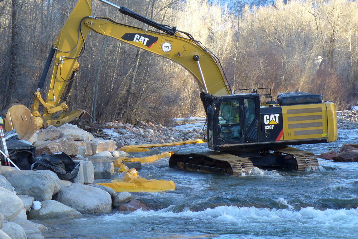
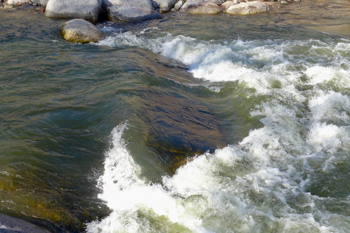
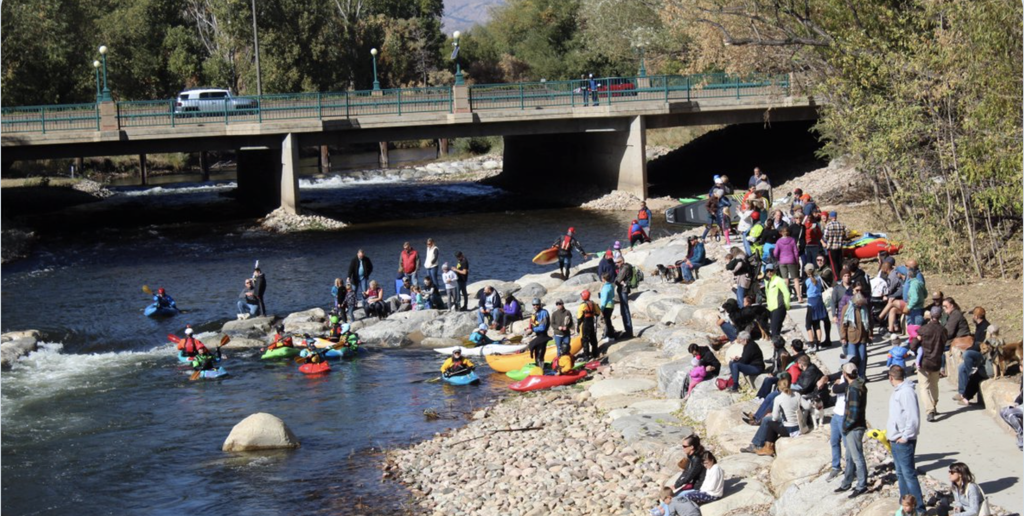
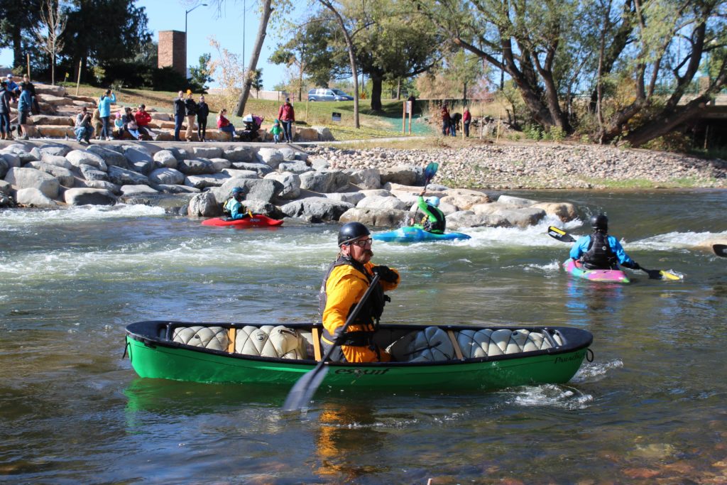
The second wave in the Basalt whitewater park, on June 19, 2019. There is a small sneak far river left, but otherwise, it’s just churning foam. Photo credit: Brent Gardner-Smith/Aspen Journalism
Pitkin County needs to make Basalt’s whitewater park safer. That was the refrain from most of those who spoke at Wednesday night’s public meeting.
“We are not asking for a big change to the kayak park,” said Glenwood Springs resident Elizabeth Bailey. “What we are asking for is a way to get through these monster features.”
Bailey was among those boaters whose rafts were flipped by the lower wave during some of the Roaring Fork River’s highest flows of the season. Bailey, an experienced rafter, said that because the river pushes boats to the right-hand side of the lower wave feature, there needs to be a boat chute to the right, between the hydraulic that forms at high flows and the river bank.
Currently, the only way around the wave is a narrow, hard-to-spot “sneak” on the left side.
The injuries Bailey sustained June 16 sent her to the hospital.
“For that to happen in a manmade park, there needs to be some responsibility,” she said.
Pitkin County Healthy Rivers and Streams hosted Wednesday’s meeting at the Basalt Town Hall to gather public comment about the whitewater park’s two consecutive wave features, which some say became dangerous during this year’s high runoff. The lower of the two waves seemed to present the bigger challenge, even for experienced boaters.
The two structures, built with concrete during the winter of 2016-17, were re-engineered the following winter after complaints that the artificial waves were dangerous. But the low flows of the spring and summer of 2018 did not provide a fair test to see whether the problems had been fixed.
The features are supposed to create fun, recreational play waves at flows between 240 and 1,350 cfs. The river was flowing at about 2,500 cfs the day Bailey was thrown from her boat.
An excavator works at low water in the Roaring Fork River to modify the structures in the Basalt whitewater park. Photo credit: Brent Gardner-Smith/Aspen Journalism
County committed
Healthy Rivers Chair Andre Wille said the county’s ultimate goal is to make the best whitewater park they can.
“We are pretty committed to getting it right,” he said.
Quinn Donnelly of Carbondale-based River Restoration, the firm that designed the park, led the public meeting and presented a few options for making the lower wave safer. Crews could lower the “wings” on both features, creating a path around the wave on either side, or a channel could be created around the left side of the wave.
Another idea was to create a “catcher’s mitt” eddy just below the second wave so that boaters who get tossed from their crafts can more easily swim to shore.
But some said creating a way for boaters to get around the waves didn’t go far enough — the waves themselves need to be made safer.
“Here you have two terrifying holes,” Kirk Baker said. Baker is the founder of the Aspen Kayak School and is an expert kayaker. “You should not have to go around. You should be able to go through. … You have to fix the hazard you created.”
Royal Laybourn agreed. Laybourn was also the victim of a flipped boat — he said the wave put him in the hospital.
“You can’t create a hazard and it doesn’t matter what water level it is,” he said. “You’re under a mandate to correct that. … Let’s just make it so any dummy can roll down through there.”
The concrete blocks that form the wave in the Basalt whitewater park are visible during low-to-moderate flows. Boaters are asking Pitkin County to make the waves safer after several rafts flipped during 2019’s high water. Photo credit: Brent Gardner-Smith/Aspen Journalism
Safety first
Pitkin County chose the site for the whitewater park, which is just upstream from downtown Basalt, in part because it is just above the Roaring Fork’s confluence with the Fryingpan River. That made it a good place to establish a recreational in-channel diversion water right.
But that part of the river is also steep, Donnelly said, meaning hydraulics will not wash out, but, rather, become bigger as flows increase.
Any new modifications to the wave features that the county and River Restoration decide on will probably come this winter.
“We want it to be as safe as possible,” Donnelly said. “It is a river and there are hazards, but this was put in by people and it’s held to a higher standard.”
Editor’s note: Aspen Journalism collaborates with The Aspen Times and other Swift Communications on coverage of water and rivers. This story ran in the Oct. 17 edition of the Times, as well as in the Glenwood Springs Post Independent.
Photo credit from report “A Preliminary Evaluation of Seasonal Water Levels Necessary to Sustain Mount Emmons Fen: Grand Mesa, Uncompahgre and Gunnison National Forests,” David J. Cooper, Ph.D, December 2003. From Western State University via The Crested Butte News:
Monitoring and protecting an important part of the local ecosystem
by Tobias Nickel, Nick Catmur, Christopher Kittle, Heather Reineking and Justin Sanchez—graduate students in the Master in Environmental Management program at Western Colorado University
In front of us, Bureau of Land Management (BLM) hydrologist Andrew Breibart slogs across what from afar might be mistaken for an alpine meadow full of sedges, willow and spruce saplings. A closer look reveals that our group of Western Colorado University (WCU) students stands on neither solid ground nor water, but something in-between. The ground moves under our feet, and with every step we sink deeper into a thick, mucky substance. Protected by rubber boots, we follow Breibart across the Butterfly Fen, located 30 miles southwest of Gunnison in the San Juan Mountains near the mountain community of Arrowhead.
“I have been visiting this special place since 2015,” says Breibart, “when I first learned about the threats and impacts to this unique ecosystem.”
After a short trudge across the fen, we unload our field equipment and get to work. With direction from our professor, Dr. Jennie DeMarco, we lay out transects, fixed paths along which we take vegetation measurements and collect soil samples.
“The goal of our research is to better understand the ability of fen ecosystems to store carbon and retain soil moisture,” explains Master in Environmental Management (MEM) student Heather Reineking.
Breibart adds, “Carbon sequestration and maintenance of soil moisture are key issues in building resilience to a changing climate.”
But what are fens and why do they matter?
Fens are ancient wetlands found in different parts of the world. In the Rocky Mountains, fens started to form after the last ice age around 12,000 years ago. What distinguishes fens from other wetlands is their strong connection to groundwater as well as a thick layer (16-plus inches) of peat. Peat is an accumulation of dead and decomposing plant matter that forms over hundreds, even thousands, of years, in permanently saturated, nearly oxygen-free soils. Peat is also what lends fens their spongy characteristic, so if you have ever experienced that wet and springy sensation under your feet while hiking across the alpine, you yourself have likely stood atop a fen.
Because peat is primarily composed of plant matter, it typically has a carbon content of over 50 percent. The slow but constant accumulation of peat makes fens globally important as carbon sinks. In fact, despite covering only 3 percent of the Earth’s surface, fens and other peatlands are second only to oceans in carbon storage. However, when a fen is dried out, the peat is exposed to air and the carbon is released in the form of CO2, making them powerful greenhouse gas emitters.
While it can take thousands of years for peat to build up in fens, degradation of these ancient ecosystems can reverse this sequestration in only a few years.
Beyond their role in the global carbon cycle, fens support biodiversity and provide an ecological refuge for rare plant species. Additionally, fens are important habitat for elk, moose, amphibians and migratory birds.
Fens provide other critical ecological functions as well, including filtering large volumes of water and maintaining base flows to streams year-round.
Breibart explains, “With climate change and prolonged droughts, fens play an increasingly vital role for maintaining flows in our headwater streams and the Colorado River Basin. Fens in the San Juan Mountains and closer to home at the Iron Fen outside of Crested Butte maintain a high water table during drought years such as the ones in 2002, 2012 and 2018.”
Considering the numerous societal and ecological benefits of fens, the BLM strives to protect and restore these little-known ecosystems on the lands that the agency has been entrusted with. Threats to fens include trailing by domestic and wild ungulates (cows and elk), logging operations, water diversions, road building and climate change.
In the face of these threats, the need to study these often-overlooked ecosystems to inform their restoration is critical. This is the reason why our group of students is measuring vegetation and collecting soil cores at the Butterfly Fen. “We are collecting baseline data so that we can compare current conditions to future conditions and learn if restoration measures are effective in maintaining or even improving the ecological function of the fen,” explains MEM student Justin Sanchez.
Meanwhile, the sounds of drills and chainsaws can be heard nearby as a youth crew from the Western Colorado Conservation Corps (WCCC) is hard at work constructing a buck and pole fence to prevent cattle from trailing through the fen.
“These lands are managed for multiple uses,” says Breibart. “We have a timber sale for spruce bark beetle, livestock grazing, hunting and snowmobiling, but we also need to take into consideration the impacts on these sensitive ecosystems.”
The BLM is seeking a win-win solution by fencing off the delicate fen area and creating an alternative water source, so that livestock can still graze the surrounding meadows.
Furthermore, in partnering with students at WCU, the BLM is using the best available science to inform fen restoration measures. MEM student Chris Kittle says, “We hope that our research will support the BLM in protecting these rare ecosystems, so that the benefits fens bring to natural and human communities do not dry up.”
Breibart is elated, saying, “After four years, the BLM Gunnison Field Office finally has the resources to protect and preserve the Butterfly Fen, and I look forward to more collaborative fen restoration projects in the future.”
Here’s the release from the Environmental Protection Agency (Lisa McClain-Vanderpool):
EPA and the state partner with the agriculture industry to restore watersheds
The U.S. Environmental Protection Agency (EPA) has awarded $1,170,000 to the Colorado Department of Public Health and Environment (CDPHE) to improve water quality in streams, rivers and lakes. The funding comes through a Nonpoint Source Program Clean Water Act (Section 319) grant, which is given to states to implement programs that address various sources of pollution in surface and groundwater to meet and maintain water quality standards.
“EPA is partnering with CDPHE to restore water quality in two critical river basins, the Lower Arkansas and the Lower Gunnison,” said EPA Regional Administrator Gregory Sopkin. “These rivers are important environmental, economic and recreational resources for the state of Colorado. By working together to reduce pollutants, we will continue to improve these beautiful, natural resources well into the future.”
These watershed projects will result in a significant reduction of pollutants such as selenium, metals and nutrients. CDPHE will use the grant money to support the Lower Arkansas Valley Water Conservancy District to implement agricultural best management practices that improve water quality in the Arkansas River. In addition, work on the Lower Aspen Canal pipeline and interconnect will be carried out in partnership with the Crawford Water Conservancy District to address water quality issues in the Gunnison River basin. The grant will also fund outreach, education and planning.
Funding for this project is one part of EPA’s overall effort to ensure that America’s waters are clean and safe. This year, EPA is distributing more than $165 million in section 319 grants to states, territories, and tribes to reduce nonpoint runoff in urban and rural settings, including efforts to reduce excess nutrients that can enter our waters and cause public health and environmental challenges. Over the last two years, states restored over 80 waters and reduced over 17 million pounds of nitrogen, nearly 4 million pounds of phosphorus, and 3.5 million tons of excess sediment through section 319 projects. This 319 grant received by Colorado complements the $12.7 million Clean Water State Revolving Fund grant Colorado received this year.
The Crawford Water Conservancy District provides supplemental irrigation water supplies for approximately 8,200 acres and full water supplies for 1,423 acres in Delta and Montrose counties, according to its website.
It has operated the Smith Fork Project for the Bureau of Reclamation, which includes the Aspen Canal, since 1964.
The Smith Fork Project utilizes flows from the Smith Fork, Iron, Muddy, and Alkali Creeks…
Over the last two years, states restored more than 80 waters and reduced more than 17 million pounds of nitrogen, nearly 4 million pounds of phosphorus, and 3.5 million tons of excess sediment through section 319 projects, according to the EPA.
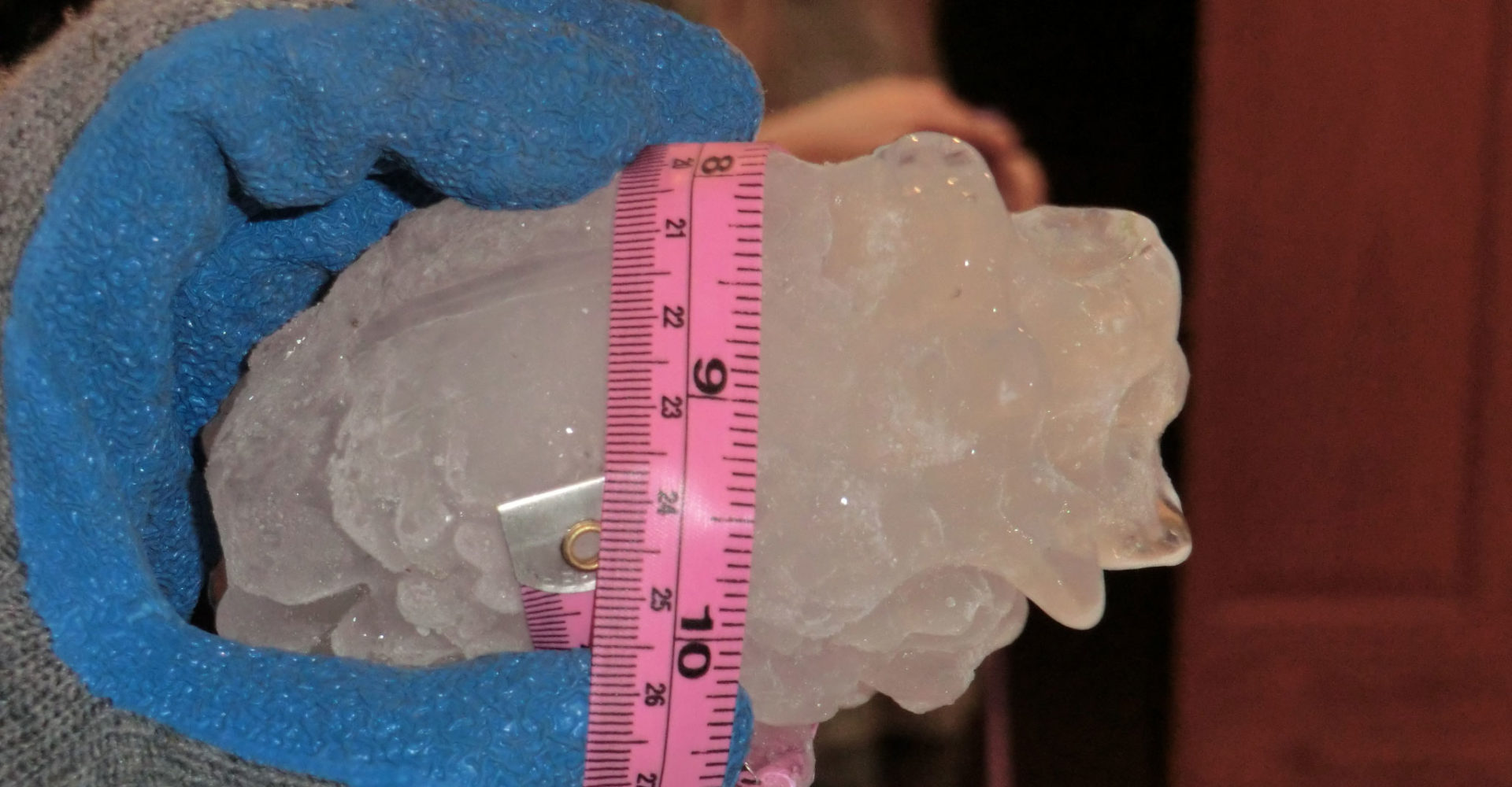
The largest hailstone recorded in Colorado state history fell Aug. 13 near Bethune. Credit: Colorado Climate Center
Here’s the release from Colorado State University (Anne Manning):
The weather and climate experts at the Colorado Climate Center occasionally get the exciting task of marking a new state record. This past year was a triple threat: Climatologists have just certified the largest hailstone, highest temperature, and lowest atmospheric pressure ever recorded in the state’s record-keeping history, which goes back to the 1870s.
Thanks to careful vetting by a “State Climate Extremes Committee” convened by Colorado State Climatologist Russ Schumacher earlier this year, the three records are in the books as of last week. The Colorado Climate Center, part of CSU’s Department of Atmospheric Science, is the state’s designated climate office that collects data, monitors climate, conducts research and provides public-facing expertise to scientists, educators, the media and the general public.
Largest hailstone
According to now-official Colorado Climate Center records, the largest-ever recorded hailstone fell Aug. 13 near Bethune, Colorado. It measured 4.83 inches in diameter and weighed 8.5 ounces. The old record, though unofficial, stood at 4.5 inches in diameter.
“There’s a bit of luck that goes into capturing these records,” said Schumacher, an associate professor in atmospheric science who researches extreme weather. “Someone has to find it, and preserve it by putting it in the freezer, like this family did.” It is all but certain larger hail has fallen at other times and places but melted before anyone could collect it, he added.
The new hail record for Colorado has been certified by the National Centers for Environmental Information, which is the National Weather Service and National Oceanic and Atmospheric Administration’s official repository for climatic data.
Back in August, the family on whose property the hailstone fell invited the State Weather Extremes Committee to their home to make measurements. Schumacher, Assistant State Climatologist Becky Bolinger, and representatives from NOAA were among those to make the trek, calipers and tape measures in tow.
The hailstone is now in a freezer at the National Center for Atmospheric Research in Boulder.
Hottest day
The highest temperature record – 115 degrees Fahrenheit – observed at the John Martin Reservoir near Las Animas, was recorded on July 20. It beat the previous record, which had stood since 1933, by 1 degree. Making the new record stick took a little more doing, according to Schumacher.
That’s because the thermograph that made the original measurement only records up to 110 degrees, though observers reported a 115-degree day. “It was literally off the charts,” Schumacher said. So he and others at the climate center borrowed the thermograph and used an oven in CSU’s Engineering Building to recreate the temperature conditions, ensuring the device could accurately read 115 degrees.
“We’re confident the instrument was working properly,” Schumacher said.
Bomb cyclone
The lowest atmospheric pressure record, 970.4 millibars, was observed in Lamar on March 13 during the famed “bomb cyclone.” It beat the previous record of 975 millibars, also recorded in Lamar, back in March 1973. The National Centers for Environmental Information don’t keep records for atmospheric pressure – at least not yet – so the bomb cyclone pressure drop will remain a state record only.
On October 17th, NOAA issued its December through February outlook for temperature, precipitation, and drought. Temperatures are favored to be above average across most of the western, southern, and eastern U.S., as well as in Alaska and Hawaii, with no parts favored to be colder than average.
This doesn’t mean below-average winter temperatures won’t occur. For every point on these maps, there exists the possibility that there will be a near, or above-average outcome. The maps show only the most likely category, with higher probabilities indicating greater confidence.
Wetter-than-average conditions are favored for Hawaii, Alaska, much of the Northern Plains, the Upper Mississippi and Ohio Valleys, and parts of the mid-Atlantic and Northeast. Below-average precipitation is favored over the western Gulf states and much of California.
The temperature and precipitation outlooks have parts of the country labeled “EC” for “equal chances,” which means there is no tilt in the odds toward any outcome.
A very warm and dry September rapidly increased drought across the Southeast, Southwest, and Texas. Improvement is likely during the next few months across the East and South, the Alaskan Panhandle, and in Hawaii. Drought is likely to continue or worsen in parts of Texas and most of the Southwest and to develop in parts of central California.
Even during a warmer-than-average winter, cold temperatures and snowfall are still likely to occur. Stay tuned to NOAA to be weather-ready and climate-smart.
Click on a thumbnail graphic below to view a gallery of data from the US Drought Monitor.
US Drought Monitor October 15, 2019.
West Drought Monitor October 15, 2019.
Colorado Drought Monitor October 15, 2019.
Click here to go to the US Drought Monitor website. Here’s an excerpt:
This Week’s Drought Summary
The discussion in the Looking Ahead section is a description of what the official national guidance from the National Weather Service (NWS) National Centers for Environmental Prediction is depicting for current areas of dryness and drought. The utilized NWS forecast products include the WPC 5-day QPF and 5-day Mean Temperature progs, the 6–10 Day Outlooks of Temperature and Precipitation Probability, and the 8–14 Day Outlooks of Temperature and Precipitation Probability – valid as of late Wednesday afternoon of the USDM release week. The NWS forecast Web page used for this section is http://www.cpc.ncep.noaa.gov/products/forecasts/.
A large upper-level low pressure system moved in the jet stream flow across the contiguous U.S. (CONUS) during this U.S. Drought Monitor (USDM) week, dragging surface lows and cold fronts along with it. Cooler air followed the fronts, bringing a colder-than-normal week to most of the country west of the Appalachians. Temperatures still averaged warmer than normal across the Southeast and parts of the Northeast. Above-normal precipitation accompanied the fronts and lows across the northern Plains, the central Plains to Mid-Mississippi Valley, and parts of Texas, the Great Lakes, and Southeast. Rain was moving along a stationary front across parts of the Southeast as the USDM week ended. Any rain that falls after the 12Z (7:00 a.m. EST) cutoff for this week’s USDM will be considered for next week’s map. Most of the West, parts of the central to southern Plains, and most of the Tennessee Valley to New England was drier than normal as the USDM week ended, with many of these areas receiving no precipitation. Soils continued to dry out in the Southwest, southern Plains, Ohio Valley, and East, and crops, pasture, and rangeland was in poor to very poor condition in more than 50% of the area in states in these regions. Streamflow was very low or near record low levels across the Southeast to southern New England. Precipitation deficits for the last 4 months of more than 10 inches below normal were common across the Southeast and parts of Texas, and 4-month deficits of 6 inches or more were evident across the Mid-Atlantic and Northeast regions. The dry conditions, coupled with increased evapotranspiration caused by unusually hot temperatures of the last couple months, resulted in very low values for drought indices such as the Standardized Precipitation Index (SPI) and Standardized Precipitation Evapotranspiration Index (SPEI). The streamflow, soil moisture, vegetation conditions, SPI, and SPEI were the basis for changes on this week’s USDM map…
In the High Plains region, the week was wetter than normal in the north and drier than normal in the south. There was no change in drought status in Colorado or Wyoming, but abnormal dryness and moderate drought expanded in Kansas with pockets of severe drought developing in southwest Kansas. Nebraska and the Dakotas continued free of drought and abnormal dryness…
Another week of no precipitation compounded dryness which has been developing over the last 6 months across Nevada and California, where abnormal dryness (D0) expanded. Intensifying dryness over the last 3 months prompted the expansion of D0 in the Pecos region of northeast New Mexico. Severe drought (D2) expanded in north central Arizona and adjacent south central Utah…
Parts of Texas, Oklahoma, Arkansas, and Louisiana received over 2 inches of rain this week, which resulted in contraction of drought and abnormal dryness. Contraction also occurred in western Tennessee. But other areas continued dry, with expansion of drought and abnormal dryness occurring. Severe (D2) to extreme (D3) drought expanded in Texas and eastern Tennessee…
Looking Ahead
Since the Tuesday morning cutoff for this week’s USDM, several inches of rain have fallen along the frontal zone in the Southeast, a low pressure and frontal system was bringing rain to the Northeast, and another system was bringing precipitation to the Pacific Northwest. This precipitation will be incorporated into next week’s USDM. For October 17-22, Pacific frontal systems will bring 3 or more inches of rain to the western mountain ranges of Oregon and Washington with an inch or more to the northern Rockies and half an inch from the Pacific Northwest to Montana and Wyoming. A large area of an inch or more of precipitation is forecast to fall along the Mississippi River to eastern portions of Kansas, Oklahoma, and Texas, and into the western Great Lakes and northern Plains. Half an inch to an inch and a half of rain may fall in the Ohio and Tennessee Valleys, 2 or more inches in much of the Northeast, and 1-2 inches across the Southeast, with up to half an inch across the rest of the Great Lakes. But the Southwest into the southern and central High Plains are forecast to get no precipitation. Temperatures are expected to moderate, forecast to be near to above normal across most of the CONUS. For October 22-30, odds favor above-normal precipitation across the East Coast into the Great Lakes, and for part of the period along the northern Rockies to northern Great Plains. The period will likely be drier than normal across the Southwest into the southern and central Plains, eventually extending to the Mississippi Valley later in the period. Odds favor drier-than-normal weather in western Alaska with wetter-than-normal weather in the south and east. The temperature outlook for October 22-30 is warmer-than-normal along the West Coast and East Coast, with colder-than-normal weather from the Rockies to Appalachians. The period is expected to be warmer than normal along western and southern Alaska.
US Drought Monitor one week change map ending October 15. 2019.
Here’s a report from Chase Woodruff that’s running in Westword. Click through and read the whole article. Here’s an excerpt:
The history of environmental contamination in north Denver neighborhoods like Globeville and Elyria-Swansea stretches back more than a century, to the gilded age of smelting plants that spewed arsenic, lead and other hazardous chemicals into the air, water and soil nearby. Today these “fenceline” communities, along with neighboring areas in Commerce City, Thornton and unincorporated Adams County, lie in the shadow of major industrial facilities like the Suncor oil refinery, one of the state’s largest stationary sources of air pollution. Residents still suffer from elevated levels of asthma and other health problems.
This toxic legacy is a textbook example of environmental racism, activists say — and as a new wave of organizing around climate and environmental issues reshapes politics from Denver City Council chambers to the 2020 presidential debate stage, Latino activists are determined to be a big part of the conversation.
“I don’t think you can be talking about climate change without talking about environmental justice,” says Ean Tafoya, a Denver activist with the group Green Latinos. “I don’t think we can be talking about the solutions unless our people are included, especially because our people are being made the most sick.”
Climate change is a global problem, but it’s wrapped up in many of the same local pollution issues that north Denver has been dealing with for decades. The Suncor refinery, along with the tens of thousands of cars that travel the expanding Interstate 70 every day, are part of the fossil-fuel infrastructure driving greenhouse gas emissions around the world.
And these communities aren’t just on the front line of the industrial causes of climate change; they’re also some of the first to be dealing with its effects. Studies have shown that rising temperatures are leading to higher levels of ozone pollution, which forms in the air above cities on hot, sunny days, especially in heavily industrial areas like north Denver and Commerce City.
In a decision reflecting the complicated process of renewing a Colorado 1041 Permit, the Board of Chaffee County Commissioners moved to direct staff to extend the Nestlé Water (NWNA) permit and set a hearing six months down the road, due to the need for proper public notification. The six month time frame was requested by Nestlé to prepare for the required public hearing.
The hearing to consider renewal of the permit under which Nestlé has operated since 2009 had been initially scheduled based on the county’s standard 15 day public hearing notice requirements. But the process of renewing a Colorado 1041 permit requires at least a 30 day notice of public hearing, which did not occur in this case. Nestlé is requesting a 10-year extension.
“The extension is the simplest for us and the county,”said Nestlé Western U.S. Director Larry Lawrence, who attended the Oct. 15 meeting. “ We have been in good standing for the past ten years. When we reviewed our 1041 permit we had a couple different methods we could do: modify it [the agreement], or extend for 10 years. The process as I understood it was simply, all we had to do was file a formal written request, which we did on Sept. 16. We’re happy to work on other modifications as allowed.”
[…]
In 2009, after a comprehensive two-year permitting process that included significant stakeholder input, Nestlé was given unanimous approval by the Board of Chaffee County Commissioners to operate and source water from the Ruby Mountain Springs site in Chaffee County. At that time, the county required two permits in order for NWNA to operate in Chaffee County:
a Special Land Use Permit (SLUP) to develop a water supply in an area currently zoned as rural or commercial and,
a 1041 Permit to identify and mitigate any potential impacts from the proposed project.
The last-minute discovery that the scheduling of the Nestlé 1041 permit process was made in error, required formal action. While the BoCC initially discussed continuing the matter to its Nov. 19 regular meeting, “This does require notice to the public and public comment,” said Tom…
A motion was made by Commissioner Keith Baker to extend the current Nestlé permit for six months, to the time of the public hearing regarding the 1041 permit, which should occur in April, 2020. Commissioner Rusty Granzella seconded and it passed unanimously.
Not everyone who lives in Colorado’s resort communities has the means to get involved in the outdoor sports that help define the region. That’s why Brett Donelson founded The Cycle Effect, a nonprofit designed to improve access and develop skills and character that will stick with girls throughout their lives.
“I live in an area where there’s extreme wealth, and a whole bunch of lower-income people that don’t get to just enjoy the outdoors,” Donelson says. “Can we do this kind of model of this year-round training with athletes for kids that generally can’t afford it or don’t have those opportunities?”
Since 2013, 40 girls have graduated from The Cycle Effect, with many more participating for shorter periods. The nonprofit says all the girls who stuck with the program for at least two years graduated from high school and went on to college — and 75% of them were the first in their families to do so.
This year, 175 girls have been organized into four teams in Edwards and in Eagle and Summit counties. Each participant pays $140 for access to a bike and gear, coaching, and race fees. In 2018, The Cycle Effect says, 75% of participants were from minority or low income families — and that’s good news for Development Director Vikki Flynn.
“There weren’t a lot of Hispanic girls in the bike races and in the biking community,” [Vikki] Flynn says. “And so to see that now is pretty awesome.”
The Cycle Effect works to keep costs low to attract kids from every background, and counts on teachers and word-of-mouth marketing to generate interest in the program. The fee also covers after-school programs, summer coaching and race fees for girls who typically range from fifth to 12th grades.
While Donelson thinks getting someone out mountain biking can change lives on its own, he says the coaches use the sport to teach resilience. Essentially, toughness translates.
“I think we’re teaching them in a way to dream big, and realize, ‘Wow, I can do this.’ And then to go out and do it,” Flynn says.
Click here to read the current assessment. Click here to go to the NIDIS website hosted by the Colorado Climate Center. Here’s the summary:
Last week for the Intermountain West region was dry with the exception of spotty precipitation in northern/central Wyoming, along the Front Range of northern Colorado, and southern New Mexico. Wyoming saw up to 0.25″ in most areas except for the northwest corner where counties such as Park saw up to 1.0” of precipitation and a dry spot with little to no precipitation over the southwest corner. Northern Colorado Front Range, Larimer, Grand, and Eagle counties, received 0.26-1.00” of precipitation. Southern New Mexico saw some spotty precipitation, with much of the area seeing 0.01 to 0.25” and Socorro county seeing over 1.00”. North New Mexico missed out on the moisture this week, along with the rest of the IMW region, receiving less than 0.10″ of precipitation.
Despite the dryness, temperatures were below average for the much of the IMW region. The exception is southern NM/AZ where some counties experienced near normal temperatures. However, most of NM/AZ experienced cooler than average temperatures, some northern counties such as Rio Arriba in NM and Navajo in AZ saw temperature departures of 6 to 9 degrees cooler than average. CO/UT/WY was even cooler with the entire area seeing temperature departures of at least 3 to 9 degrees below average while some areas such as western UT and northern WY were even cooler still with temperature departures of 9 to 15 degrees. This was a nice change from the past few months when the IMW experienced temperatures much above normal with Colorado and New Mexico seeing the warmest September on record.
Streamflows in the UCRB are starting to show the recent dryness with an increasing number of stream gauges showing below normal flows. The driest of the gauges are showing up in the headwaters of the Colorado River. The Basin as a whole is still in good shape with the key gauges seeing flows in the normal region.
Outlook is showing low precipitation probability over the whole IMW for the next couple weeks with below average temperatures in WY/CO/NM. UT and AZ are expected to see above average temperatures. A lack of precipitation and above average temperatures in southern UT and northern AZ is something to keep an eye on in the upcoming weeks.
The additional discharge from the Silver Wing Mine into the Animas River did not have a negative impact on water quality, according to the New Mexico Environment Department.
The Silver Wing Mine discharged a larger amount of water than usual last week, causing some discoloration in the Animas River near Silverton, Colorado.
However, the discoloration was not visible downstream, and NMED does not see any evidence of negative impacts to water quality…
NMED has been monitoring water quality data for both turbidity and pH in the Animas River in Colorado and New Mexico. According to the slides, the Silver Wing Mine has not, to date, caused potentially harmful changes in turbidity or pH in the Animas River as it flows from Colorado into New Mexico at Cedar Hill.
Sliver Wing Mine: Photo credit: San Juan County Sheriff Bruce Conrad
Here’s the release from the Bureau of Reclamation (Peter Soeth):
The Bureau of Reclamation is providing $8.9 million to 27 new research projects and 114 continuing research projects through its Science and Technology Program. The funding from Reclamation is being matched by $10.9 million in partner contributions. The research findings will then be applied throughout Reclamation for the benefit of its water and power facility managers, customers and stakeholders.
“Reclamation faces many technical and complex challenges in managing water and generating power for the West,” said Reclamation Commissioner Brenda Burman. “These new research projects will help Reclamation and its partners today, and also ensure that water and power demands will be met for future generations.”
Research proposals were sought in the following areas:
water infrastructure
power and energy
environmental issues for water delivery and management
water operations and planning
developing water supplies
The type of projects selected includes studies on invasive quagga and zebra mussel control, developing condition monitoring technologies to extend the life of water and power infrastructure, mitigating reservoir water quality impacts from harmful algal blooms, and new water operations and decision-support tools.
Reclamation identified the research projects through an internal competitive call for proposals throughout the organization. The proposals were reviewed and ranked based on technical merit and relevance to Reclamation’s mission. Many of these projects partner with internal and/or external entities to produce robust and comprehensive solutions. Partners include entities from the federal government, state government, tribes, universities, private and local organizations.
These new projects address research needs identified in the S&T Programs Science Strategy Implementation Plan that is published annually. This includes needs identified by Reclamation’s regional directors, which informs the development and selection of research projects to meet those needs.
This research supports the President’s Memorandum on Promoting the Reliable Supply and Delivery of Water in the West by improving the use of technology to increase water reliability and improving forecasts of water availability.
Join Alpine Bank, the Town of Silt, and the Middle Colorado Watershed Council at Silt Island Park for a River Restoration and Cleanup Saturday morning.
Registration at 9:30.
Restoration and cleanup starts at 10.
Meet back at the park at 1 p.m. for lunch and awards.
Here’s the release from the Southeastern Colorado Water Conservancy District (Chris Woodka):
District Supports Sports Betting for Water Projects
The Southeastern Colorado Water Conservancy District Board of Directors [September 17, 2019] voted to support a measure that would allow sports betting in Colorado as a revenue source for water projects.
Proposition DD would provide money for water projects by collecting a tax of 10 percent on net proceeds from sports betting operations at casinos in Central City, Black Hawk and Cripple Creek. Proponents say this could amount to $10 million to $16 million annually. The money would be part of the funding package for Colorado’s Water Plan.
“It ties into the water plan, but would be just one of the methods to generate revenues,” said Alan Hamel, a member of the Southeastern board.
The board voted 10-3 to support Proposition DD.
The water plan calls for $3 billion in new revenue for water projects over a 30-year period beginning in 2020.
Proposition DD was placed on the Nov. 5 ballot as a referendum by the Colorado General Assembly under HB1327.
The Southeastern District is the sponsor for one of the state’s largest pending water projects, the Arkansas Valley Conduit, a pipeline project that will provide clean drinking water to 50,000 people in 40 communities east of Pueblo. The Bureau of Reclamation estimates the AVC will cost $600 million, of which 35 percent will be paid by sources within Colorado.
Sometimes I’m asked whether I hold out any hope concerning the fate of humanity and climate change. I have a hard time answering. I have no doubt that things are going to get hotter before they get better; Denver, for example, just broke its heat record for September, hitting 100 degrees Fahrenheit. Do I doubt that humans will somehow figure out a way to survive? Not really, at least for a few hundred years — maybe a few thousand, even. What ought to worry us about climate change is not the fate of humanity, or even of the Earth; after all, this planet has another 800 million to 1.2 billion years for life on it to re-evolve, wherever it leads. Rather, a climate in flux is a major challenge to our happiness right now. We have barely started to grapple with the despair of the modern age, and an unstable climate brings the prospect of increasingly conflict-driven lives.
Take the cover story for this issue, in which editorial fellow Nick Bowlin reports from Colorado’s San Luis Valley, a high-altitude community of ranchers and farmers that is finding it hard to conserve water. The state has warned the locals that if their current experiment in self-governance fails, it will step in to manage their water for them. That means they will lose some of their freedom. Yet it’s not always easy to do the right thing. Last year, severe drought squeezed the community pretty hard. When this year brought heavy snow and plenty of runoff, farmers felt driven to make up for their losses — pumping water to grow hay and crops instead of recharging the groundwater. In a less volatile climate, people would have a better chance of succeeding and sharing water. But faced with extremes, humans falter. Conservation yields to self-preservation.
The ticking clock of climate change, in other words, makes it harder to do the right thing. Our health and happiness are threatened across the globe. The leading thinkers who gathered in Stockholm last month for World Water Week warned of increased global conflict over water, citing erratic rainfall and food shortages in South Sudan and Syria as examples.
From the San Luis Valley to South Sudan, climate change is challenging our values, forcing us to advance our ethics faster than the temperatures rise. And because the American West is more sensitive to this kind of change than much of the country, we who live here face the pointy end of this ethical challenge. But that’s where my hope lies. My hope is that people who care about the West, who read this magazine, will help guide the world through the challenges ahead. That means starting now and working steadily — thinking big, showing up and doing good.
The 37th Annual Water Seminar will be kicked off by SWCD’s new executive director, Frank Kugel. He has a strong track record of building partnerships and leveraging local resources for collaborative water solutions. Frank will speak to some of the challenges SWCD sees facing water management in southwestern Colorado, and opportunities for our communities to proactively address them.
Anxious for winter storms? First, we’ll hear about the forecast from KKTV meteorologist Brian Bledsoe, and cutting-edge methods for snowpack measurement from Jeff Deems of the National Snow & Ice Data Center.
No water seminar in 2019 would be complete without a discussion of the state’s current feasibility investigation of a demand management program. Mark Harris, Grand Valley Water Users Association, will moderate a panel of heavy hitters on the topic: Colorado Water Conservation Board Director Becky Mitchell, The Nature Conservancy Water Projects Director Aaron Derwingson, and Colorado River District General Manager Andy Mueller.
Further expanding on the subject, we’ll hear a proposal from local economist Steve Ruddell and consultant Dave Stiller which challenges the notion that a successful *and* voluntary, temporary, compensated demand management program would be impossible. State Senator Don Coram and State Representative Marc Catlin will react to this proposal and provide their thoughts more generally on funding water management in Colorado.
And if you haven’t heard the latest results of the West Slope Risk Assessment, John Currier, Colorado River District, will be summarizing the report for southwestern Colorado and taking questions. Jayla Poppleton, Water Education Colorado, will also preview several exciting programs and content making waves across the state. Watch your inbox for the final program, coming soon!
Reserve your seat now. Registration includes catered breakfast and lunch. Click here to register or call 970-247-1302.
Southwestern Water Conservation District Area Map. Credit: SWCD
Colorado Master Irrigator is an intensive, 4-day, 32-hour educational course for Republican River Basin irrigators.
The Colorado Master Irrigator program is focused on offering advanced training in conservation-oriented, irrigation management practices for farmers and farm managers. Area producers from the Republican River Basin have led the curriculum development of this program.
Topic experts including University Extension specialists will serve as instructors for this course. The in-depth and interactive class format will encourage peer-to-peer exchange among participants and instructors.
The goal of Colorado Master Irrigator is for producers to graduate from program equipped with examples and insights on how they might potentially increase or maintain profitability by implementing different tools and strategies on their operations to improve:
– water use efficiency
– energy-use efficiency
– water conservation
– soil health
From Colorado Master Irrigator (Brandi Baquera) via The Julesberg Advocate:
How to improve agricultural water management to increase water and energy use efficiency, water conservation, and overall farm profitability is the focus of a new, annual four-day educational program called “Colorado Master Irrigator” that will be available to Republican River Basin irrigators next year.
The Colorado Master Irrigator program curriculum will be taught by topic experts from Colorado and from other Ogallala states. The program’s interactive course format will encourage peer-to-peer exchange among farmers, including with some farmer instructors who will share insights they’ve gained through taking steps to increase water and energy-use efficiency and conservation on their operations. The main goal of the Colorado Master Irrigator program is to serve today’s farmers while benefitting the Ogallala aquifer resource that is so important for irrigators and the region’s communities.
A ~35-member advisory committee has met monthly throughout 2019 to design and prepare the program for launch in early 2020. The advisory committee is made up of producers from across the Republican River Basin along with agricultural consultants, local landowners, Colorado State University Extension, state and federal agency staff, and others.
The Colorado Master Irrigator program will cover practical and economic aspects related to the adoption of a wide range of agricultural water management tools, technologies, and strategies. “Colorado Master Irrigator is about helping us farmers figure out how we can get the perfect amount of water on our crops,” said Brian Lengel, a Burlington-area producer who serves on the program’s advisory committee.
On September 18, 2019, Colorado Master Irrigator was awarded a Water Reserve Supply Fund (WSRF) grant that will help support the program’s continued development over the next three years. Several local grants, along with funds awarded by CSU’s Water Center, served as matching funds required in applying for this state-level funding.
“Significant amounts of time and creativity, contributed by area farmers in particular, has been crucial in terms of developing the Colorado Master Irrigator program and attracting the support necessary to successfully establish this program,” said Brandi Baquera, Colorado Master Irrigator’s program coordinator.
The four-day course, which will cost $100, will take place in Wray over four consecutive weeks: February 12, February 17, February 26, and March 4, 2020. To graduate, participants must complete all 32 course hours, engage with classmates and instructors, and consider committing to using certain agricultural water management strategies and tools covered by the program.
For more information, visit http://www.comasterirrigator.org. Colorado Master Irrigator is also on Twitter (@COIrrigator) and Facebook (@comasterirrigator).
Procrastinators beware: Winter’s grizzly ghouls are coming soon to terrorize your yards and pipes. The post Now playing: The Untitled Fall Water Tips Project appeared first on News on TAP.
A light coating of compost this fall will boost your lawn come spring — and save water next summer. The post This Halloween, dress your lawn in compost appeared first on News on TAP.
Utility recognized for a decade of work to closely track, and reduce, its emissions. The post Denver Water goes ‘Gold’ for its work to cut climate impacts appeared first on News on TAP.
Sounds of the Poudre River rolling over rocks, children and adults laughing and screaming and live music could be heard just north of Old Town at the Poudre River Whitewater Park Saturday.
An ongoing project since 2014, the Poudre River Whitewater Park was finally opened to the public [October 23, 2019].
A number of people spoke at the ribbon-cutting event, including Fort Collins Mayor Wade Troxell, Councilmember Susan Gutowsky, local business owner and project donor Jack Graham and City Manager Darin Atteberry.
“This is really a gem now in Fort Collins, and I’m really excited to be here today and to appreciate all the things this great City can do for the people of Fort Collins,” Troxell said. “The Poudre River is indeed a treasure, and we must guard it, and we must protect it and we must also enjoy it.”
Alex Mcintosh, a Fort Collins resident and kayaker, said the construction of the Whitewater Park in Fort Collins means a lot to him as a kayaker.
“I think it will bring a bunch of different subcultures and communities together: fishermen, rafters and people during the summer for tubing,” Mcintosh said. “It’s nice to see they’ve taken the initiative to create something in town for everyone to enjoy and learn and educate themselves about the river.”
Fort Collins community members kayak and sit on the shore of the Poudre River during the grand opening of the Poudre River Whitewater Park off of North College and Vine Drive Oct. 12. (Alyssa Uhl | The Collegian)
Troxell said the Poudre River has been a working river for a long time, so a lot of diversions, irrigation ditches and canals have already been built into the river. He said this particular part of the river already had a lot of man-made additions to it, which makes the river uninhabitable and inaccessible.
The goal of the Poudre River master plan is to reclaim the river for natural habitat and create accessibility for the people of Fort Collins, and the completion of the Whitewater Park marks the beginning of that process.
“When I was growing up here, the river was the back door,” Troxell said. “It had the riff-raff, it had the old cars and now, today, it’s our front door.”
Gutowsky said the Heritage Trail Program plans to add signs throughout the river corridors, along with viewing areas that will allow visitors to understand the messages of history and the environment of the Poudre River.
“Here we are today celebrating the Poudre River, and it is the jewel of our City,” Gutowsky said. “Over the decades, our river has seen great drama and interesting characters. It has many interesting stories to share. Not only will our Whitewater Park be a recreational phenomenon, but it will also serve as a heritage gateway: a physical and informational gateway created through a funding partnership.”
Graham said there was a massive amount of people who contributed to the project, and nothing could have been accomplished without the support of Fort Collins citizens who voted for and donated to the park.
“We should point to the success of this park as a great example of how investing in our community works, and we should continue to invest wisely,” Graham said. “People will be attracted to come to Fort Collins to see the Whitewater Park and the River District. New businesses will be formed, and the help of our community to even higher levels of economic strength are going to occur. The park is going to be a great asset to our City.”
Atteberry said the park is only the beginning, and new ideas and projects are already in motion for the Poudre River. He also said the main goals of the Whitewater Park were recreation for citizens of Fort Collins, river safety and the juxtaposition between the man-made and the natural environment.
Fort Collins community members kayak and sit on the shore of the Poudre River during the grand opening of the Poudre River Whitewater Park off of North College and Vine Drive Oct. 12. (Alyssa Uhl | The Collegian)
“Recreation matters to this town, not only because it’s fun, but because we want to be a healthy community, and this is forwarding that strategic objective,” Atteberry said. “Safety matters. There are going to be fewer properties that are flooding because of this project. It’s not just a pretty face. It has a deep function to it, and that is it helps take properties out of the floodplain.”
Kurt Friesen, director of the Park Planning and Development department for the City of Fort Collins, said the construction of the park wasn’t easy, and seeing it open was so rewarding because he knew the process it went through.
Friesen said the project underwent a number of obstacles, including the limited timeframe given to get the work done in the river. He said a series of very old manholes were found in the river that were used to direct flows into the old power plant.
Friesen said that, normally, this wouldn’t be a big deal, but since the team was racing against the clock to get the work done before the snowmelt in April, it was a problem.
However, the contractors and their team were able to get the manholes removed quickly, and the project was able to continue.
“I just want to say thank you to those that committed themselves,” Friesen said. “I believe this will be Fort Collins’ next great place largely because of that commitment.”
Click here to read the newsletter. Here’s an excerpt:
What does this have to do with climate?
Indian Country is on the front lines of the climate crisis currently unfolding in the United States, and has been for some time. Thus, if America’s most influential news institutions are not adequately informing their readers about what’s happening in Indian Country, they’re not adequately informing Americans about the climate crisis.
Beyond that, there are so many opportunities for solutions-focused stories in Native American communities, Martin noted.
”The United Nations recently put out a report reiterating that indigenous people—their understanding of land management, of protecting and nurturing the resources that everybody needs to survive—are crucial to the process of moving forward,” he said. “If we want this planet to survive, we have to lean on the people who know the land best. The people who have fostered the land for thousands of years.”
“That’s not to say anyone else can’t be part of the solution,” [Nick Martin] continued. “It’s just to say we’ve not centered ourselves around indigenous perspectives of how land and natural resources should be used and taken care of. And I think as an American culture, it’s going to be important for us to adapt to more of that way of thinking.”
[…]
HOT ACTION: Follow some journalists!
Right before we got off the phone, I asked Martin if he could quickly suggest some journalists and/or media institutions to follow for quality coverage of indigenous climate issues. He recommended:
Click here to read the newsletter. Here’s an excerpt:
A Happy Hour for Water: Event for The Water Resources Archive
Competition for urban, agricultural, and ecological water needs create challenges for policy and research. The Colorado State University Water Resources Archive is the go-to source for water references. Learn about the extensive collections from individuals and organizations to jump knowledge gaps and enhance your water work at this week’s event. Enjoy wine and cheese on Thursday, October 17 from 3-5 p.m., in the Morgan Library Event Hall while you mingle with water-related faculty, staff, students, organizations, and centers.
The Water Resources Archive is a collaboration with the Morgan Library Archives & Special Collections and the Colorado Water Center. The Rocky Mountains of Colorado hold the headwaters of four major rivers: the Colorado, Rio Grande, Arkansas, and Platte. Colorado is responsible for sustainably managing our water resources to ensure our arid neighbor states receive their fair share of flowing rivers. Academic research at CSU and across the state and region contribute to reaching our water goals. Discover the resources missing from your research.
Click here to read the newsletter. Here’s an excerpt:
RIVER DISTRICT SEMINAR TALKS
The Colorado River District’s annual seminar drew a big crowd and featured speakers with provocative ideas, like a “grand bargain” to cap upper basin uses in exchange for lifting the threat of a compact call by the lower basin. You can access video of the talks and the slides presented here.
Click here to view the Twitter storm from the seminar.
The EPA Annual Meeting reporting on activities at the Superfund site will be from 6 to 8 p.m. Thursday at the Abbots Room, Abbey Conference Center. Colorado Department of Public Health and Environment and Environmental Protection Agency officials will be present as well as representatives of Colorado Legacy Land to answer questions and take comments from Fremont County residents. The Lincoln Park neighborhood and the site of the former Cotter uranium mill south of Cañon City were declared a Superfund site in 1984 due to the widespread groundwater and soils contamination from the operation of the mill.
The September meeting of the Community Advisory Group for the Lincoln Park Cotter Superfund site was held Sept. 19 at the Garden Park Room.
Updates on early cleanup actions included the TCE (trichloroethylene) plume near the Shadow Hills Golf Club. The Work Plan was approved in July 2019 by the agencies. Testing of all the soil borings is complete and installation of monitoring wells began Sept. 26.
The Soil Excavation Evaporation Pond Construction Plan is out for comment. This plan is proposed to speed the dewatering of the radioactive tailings located at the former Cotter mill site. The CDPHE and EPA, as well as the community, have an opportunity to review the plan. The deadline for comments is 5 p.m. Oct. 15 to Dustin McNeil at dustin.mcneil@state.co.us. A link to the work plan and other documents is available at: https://sites.google.com/state.co.us/cotter-uranium-mill/documents-available-for-public-review-and-comment.
Emily Tracy, chairperson of the Community Advisory Group, states “Now that early actions toward the cleanup of the Lincoln Park Site are moving forward under the ownership of Colorado Legacy Land, the community will be able to have critical input in the process. At the meeting, you will be able to ask why these actions are being taken and how the physical action of removal, moving soils, pumping water from the primary impoundment will move the cleanup toward the Remedial Investigation of the site. That is the next step in the EPA CERCLA process which may be proposed as early as next year.”
Tracy continued: “It should be remembered that 5-6 million tons of toxic materials sit in the 157-acre impoundment ponds. According to past estimates, 1.5 million gallons of contaminated water and 1.5 million tons of contaminated soils sit waiting for cleanup, and still threaten our community if anything goes wrong.”
“If a Lincoln Park resident has a well, they are advised not to use it because of contamination from the uranium mill. Wouldn’t it be great to have the use of that water?” asks CAG member Sharyn Cunningham, who had to stop using her wells many years ago. “If there is any hope for cleaning up our Lincoln Park wells, we all need to make sure it is done and done right!”
With traditional business models for local journalism near collapse in the digital age dominated by Facebook and Google, more Colorado communities are becoming “local news deserts” with very little original, independent, local news.
Research shows that civic impacts abound when local news outlets close or reduce coverage – the public lacks independent information about important issues, voter turnout lags, local officials have fewer avenues to inform voters and residents, and the perception of reduced government transparency has been linked to higher municipal bond rates and other costs.
What strategies exist for local communities and elected officials to address these issues? How might existing institutions like libraries and higher education expand their roles in addressing community information needs? What new opportunities exist for public-private partnership in this space?
This panel and audience discussion will include a summary of research findings and recommendations from a October 2019 report by the Colorado Media Project, which convened national, state, and local leaders in journalism, government, libraries, higher education, technology, and law to study Colorado public policy pathways for sustaining local news and civic information.
Upper Basin States vs. Lower Basin circa 1925 via CSU Water Resources Archives
From the Water Education Foundation (Gary Pitzer):
WESTERN WATER NOTEBOOK: A UC BERKELEY SYMPOSIUM EXPLORES APPROACHES AND CHALLENGES TO MANAGED AQUIFER RECHARGE AROUND THE WEST
A water recharge basin in Southern California’s Coachella Valley. Source: California Department of Water Resources
To survive the next drought and meet the looming demands of the state’s groundwater sustainability law, California is going to have to put more water back in the ground. But as other Western states have found, recharging overpumped aquifers is no easy task.
Successfully recharging aquifers could bring multiple benefits for farms and wildlife and help restore the vital interconnection between groundwater and rivers or streams. As local areas around California draft their groundwater sustainability plans, though, landowners in the hardest hit regions of the state know they will have to reduce pumping to address the chronic overdraft in which millions of acre-feet more are withdrawn than are naturally recharged.
It’s not a new problem, but one that is emblematic of California’s long-standing separation of surface water and groundwater in its management oversight. Some say it’s a problem the state should have been working on long ago as other states around the West have done.
“We are so far behind everybody else,” said Felicia Marcus, former chair of the State Water Resources Control Board. “As we get to the point where managed aquifer recharge is the obvious answer to a regular person, a regular person would assume we’re already doing this.”
UC Berkeley groundwater symposium panelists (from left) Dave Owen with UC Hastings School of the Law, former State Water Resources Control Board Chair Felicia Marcus and Bill Blomquist, with Indiana University Purdue University Indianapolis. Source: University of California, Berkeley
Marcus was among the panelists from across the West at a Sept. 10 groundwater recharge symposium presented by the University of California, Berkeley’s Center for Law, Energy & the Environment. Panelists discussed a variety of approaches and challenges to getting water back in the ground to aid depleted aquifers.
Until the passage of the Sustainable Groundwater Management Act (SGMA) in 2014, there was no statewide governance regulating groundwater pumping. California was the last state in the West to address its groundwater crisis with regulation.
Landowners could take as much as they wanted, if it was put to a beneficial use. In good times, with stable imported water deliveries and relatively healthy aquifers, pumping is not a problem. But decades of overdraft have put a significant dent in parts of the San Joaquin Valley. The land surface has literally sunk in certain areas because of the large-scale pumping of water. Finally, in 2014, lawmakers sought to put the brakes on the problem with SGMA. Sustainability plans required under SGMA for the most overdrafted areas are due in January 2020.
Heavily opposed during its introduction and still facing resistance today, SGMA emphasizes a ground-up approach that requires local leaders to devise the means to bring the most severely depleted aquifers into balance in the next 20 years.
This schematic illustrates different ways managed aquifer recharge can be accomplished. Source: California Department of Water Resources
One way to do that is by managed aquifer recharge, or MAR. Surface water or flows from storm-swollen rivers are steered onto land where the water percolates into the ground. It is a straightforward process that works within the right parameters, experts say.
On average, aquifers provide about 40 percent of the water used by California’s farms and cities in a normal rain year, and significantly more in dry years. There’s a growing recognition that surface water and groundwater are connected: Surface waters gain volume from the inflow of groundwater through the streambed. That volume is lost when groundwater pumping rates exceed natural recharge.
Managed aquifer recharge projects strive to replicate the natural process in which winter rains soak into the ground and replenish water above and below ground. However, projects require extensive monitoring and management to be successful. Farmers for years inadvertently recharged their aquifers through flood irrigation of certain crops and orchards. If they’re asked to act intentionally to recharge, they want assurances they can reap the benefit.
“If we put water in, we want to retain the right to take it out,” Don Cameron, vice president and general manager of Terranova Ranch, 25 miles southwest of Fresno, said at the Berkeley symposium. Terranova has been a leader in using winter runoff to flood its fields for groundwater recharge. “To me that’s the incentive for a grower to do groundwater recharge. I want water security just as much as anyone else does.”
In the West, managed aquifer recharge projects in Colorado, Idaho and Washington state are looking to boost depleted aquifers while at the same time strengthening streamflow and benefiting the environment. “Any time you have more water in the river, it’s good for everyone,” said Jennifer Johnson, hydrologic engineer with the U.S. Bureau of Reclamation’s Pacific Northwest Region’s Water Management Group, which is working to replenish aquifers in the Yakima River Valley in south central Washington.
Leaving Water in the Ground
In California, every drop of surface water is accounted for, even the bonus flows that come during very wet years.
In the strict, defined world of the state’s water rights, quantity, beneficial use and avoiding wasteful use is paramount. Beneficial use means exactly that. It’s the water people use at home each day, the irrigation that raises crops and the hydroelectric power so crucial as a renewable energy source.
It’s also the water that pulses through major waterways, keeping fish like salmon alive and healthy as they migrate to and from the ocean.
Don Cameron, vice president and general manager of Terranova Ranch, near Fresno. Terranova has been a leader in using winter runoff to flood its fields for groundwater recharge. Source: University of California, Berkeley
While helpful, the act of storing water to recharge aquifers is not a designated beneficial use, according to the State Water Board. Obtaining a water right to divert water to underground storage means identifying the eventual beneficial use of that water, the board says. That could include uses that allow for water to remain in the aquifer, such as to prevent land subsidence.
That process is not as difficult as it sounds because a wide interpretation exists for beneficial uses, especially as it relates to avoiding some of the undesirable results identified in SGMA.
Managed aquifer recharge and groundwater banking are essentially the same practice with different outcomes. Managed aquifer recharge boosts overall health of aquifers and nearby rivers and streams. In some instances, some of the water can be pumped back up. In groundwater banking, water is intentionally injected or percolated strictly for later withdrawal. Groundwater banks such as those in the southern San Joaquin Valley store vast quantities of imported water that faraway partners use through a complicated exchange process.
The key is having the available water to get into the ground — not always an easy task. “We’ve had two very wet years recently, but in most years, we don’t really have excess surface flows that can be recharged to groundwater, at least not in significant amounts,” said Dave Owen, professor at UC Hastings College of the Law. “And even when we do have flood flows, they aren’t always in the places that most need” the water.
Incremental Implementation – Colorado and Idaho
The South Platte River Basin is shaded in yellow. Source: Tom Cech, One World One Water Center, Metropolitan State University of Denver.
Managed aquifer recharge is instrumental in preserving the health of the South Platte River in northeastern Colorado, where groundwater pumping has been depleting flows in the river. There, well owners have been paying taxes and annual assessments since 1973, in part to construct groundwater recharge sites.
In 2006, due to a drought and changing legal parameters, the annual assessments were increased 400 percent and about $100 million of bonds have been approved since then by voters. Some of those funds were used to construct recharge projects, said Cech with Metropolitan State University in Denver.
In Idaho, about a third of the state’s economy relies on the agricultural products from the region known as the Eastern Snake River Plain Aquifer in southern Idaho. A decade ago, with the water table dropping, lawmakers saw the coming crisis and adopted a comprehensive water management plan for the area.
“The declining spring river flows as a result of the declining aquifer would have resulted in curtailing most of the groundwater users in the area,” said Wesley Hipke, recharge program manager with the Idaho Department of Water Resources. “This would not only have affected agriculture, but also the cities and towns and related industries that are currently in place.”
Idaho decided to tackle managed aquifer recharge from a state perspective because of the scale of the project (10,000 square miles), the aversion to a new tax and the realization that the cost of doing nothing was not acceptable, Hipke said.
“Obviously without a stable water supply, the prospect of future growth is slim,” he said.
The state’s plan outlined the means to manage overall water demand while increasing aquifer recharge and reducing withdrawals. Grabbing as much natural flow as possible, the plan’s aim is to reach 250,000 acre-feet of annual recharge by 2024.
Challenges and Potential for MAR in California
Tom Cech, co-director of the One World One Water Center at Metropolitan State University of Denver. Source: University of California, Berkeley
As vital as groundwater is to California’s water supply, the extent of expanded managed aquifer recharge remains to be seen. Aquifers are recharged naturally every time it rains and snows, but carefully managed recharge is happening on a limited basis.
“There’s no question it can expand. The question is by how much,” said Owen with UC Hastings.
In its review of groundwater recharge, the Public Policy Institute of California noted in September that a key challenge is inadequate conveyance for moving storm flows to suitable recharge locations. There is “significant potential” to increase MAR on farmland if local agencies adopt better incentive systems and water accounting, PPIC wrote.
Getting water in and out of aquifers using MAR is a big challenge, from an infrastructure standpoint of getting the water when it’s available and moving it to where it can sink into the ground, Owen said in an interview. In addition, there’s not a perfect accounting process for tracking those water molecules. Even in cases where groundwater is being banked, getting the water back out that someone has put in can be complicated in aquifers with “unrestrained, poorly regulated” pumping.
“If you put water into a bank, you may have a legal right to withdraw it,” Owen said, “but that legal right does you no good if someone else has pumped out the physical water.”
Reach Gary Pitzer: gpitzer@watereducation.org, Twitter: @gary_wef
Know someone else who wants to stay connected with water in the West? Encourage them to sign up for Western Water, and follow us on Facebook and Twitter.
Prairie Festival events are concentrated in an unpainted barn, the summer roots of Kernza perennial grain unfurled side by side with those of wheat. Photo/Allen Best
Big ideas about energy and agriculture on the Kansas prairie and the hard deadline of climate change
Bill McKibben didn’t always make a habit of getting arrested. He was a wunderkind, a Harvard graduate who became a staff writer at the New Yorker at the age of 25 but also was a competitive cross-country skier, ran a homeless shelter, and taught Sunday school at a Methodist church.
One Sunday morning in late September, the 58-year-old McKibben was at The Land institute in the middle of Kansas farm country, preaching about the imminent crisis of climate change. It is, he said at the Prairie Festival, a cause of such existential importance to civilization that some people, especially those who are older, with less to risk, should join him in civil protests that will likely cause them to be jailed, as McKibben had been the month prior to his Kansas visit.
McKibben’s 1989 book, “The End of Nature,” was arguably the first general circulation call to curb greenhouse gas emissions caused primarily, but not exclusively, by the burning of fossil fuels. Since that book came out 30 years ago, atmospheric concentrations of carbon dioxide have increased 65 parts per million. That compares with the estimated increase of 70 ppm during the first two centuries after the industrial revolution. Climate scientists for several decades have warned that greenhouse gases could trigger wild climatic gyrations and, of course, rising temperatures.
It was getting hot on the Sunday morning he spoke, the temperature in nearby Salina, a farm town of 47,000 people, approaching the low 90s and humidity close behind. It wasn’t a record, but it has been a year for record heat, each year now seeming to surpass the previous one.
Heat and a sinister beauty
Humans can do 10% less work outside on a given day now as compared in the past, but productivity will decline 30% a half-century from now, he said.
In this record-setting spree of heat, some places have struggled more than others. He cited new individual marks of 129 degrees F on the Asian subcontinent.
“The human body can survive at 129 degrees for a few hours, but after that, your ability to cool off disappears. You just can’t do it. On the trajectory we’re on — scientists are clear — that kind of temperature will not become record-breaking and rare, but will become normal across much of the Asian subcontinent and central China plain. If that happens, it really means that people won’t be able to live there any more than they will be able to live in the cities along our coasts that are already beginning to see the rise of sea level.”
Seas have been rising, in part, because of melting glaciers. McKibben described seeing chunks of ice the size of 12-story skyscrapers calving off glaciers in Greenland last year. The waves, 60 to 70 feet high, had a “kind of sinister beauty,” he said. Those melting glaciers raise ocean levels some tiny degree.
If all of Greenland’s ice melts, however, oceans will rise 23 feet, submerging low-lying places like the Marshall Islands in the Pacific Ocean.
The Prairie Festival is the Land Institute’s signature annual event, this year drawing upwards of 900 people who assembled on chairs in an unpainted barn, its floors still of dirt, the overflow crowd spilling out to sit on portable lawn chairs and on hay bales placed under trees and around grain bins.
The institute was formed in 1976 by Wes Jackson with the goal of developing perennial grains that mimic the ways of nature. Civilization in the last 10,000 years has hewed to annuals such as corn and wheat and, in the last century, application of massive doses of petrochemicals. The institute’s motto is “transforming agricultural, perennially.”
Jackson and his crew in recent years have given talks at Crested Butte, Aspen and, in Vail, at the Betty Ford Alpine Gardens. The latter has an exhibit about roots that will be on until Nov. 2. It was created in a collaboration of Jim Richardson, a National Geographic photographer, and The Land institute.
The idea of perennials is a big one, with implications for the carbon cycle. Perennials do a better job of leaving carbon in the ground.
Organic carbon compounds also compose a third of human bodies. “We take carbon in every day, and we breath carbon out every second,” said Fred Iutzi, president of The Land Institute. “It’s ironic that we have managed to get ourselves into a situation where the word ‘carbon’ is fraught.”
Was Keystone XL defeat a success?
McKibben writes often for such magazines as Rolling Stone, Nation, and Time about the fraught state of the planet. He also leads a frantic speaking schedule. I’ve heard him three times in just the last year, once in a Denver bookstore where there were fewer than 30 of us. It’s a wonder when he finds time to write much less spend time in jail.
In 2007, he and students at Vermont’s Middlebury College, where he teaches, formed 350.org, now a powerful agent at fomenting protests directed at fossil fuel interests. The group had a role in President Barack Obama’s veto of the Keystone XL pipeline, which was proposed to transport bitumen from Alberta’s oil/tar sands to the United States. That veto has been reversed by Presidential Donald Trump, but Keystone XL remains unbuilt.
The effort was a triumph, showing that “it was possible to stand up to big energy,” said McKibben. “A lot of the time you win. That’s the thing about movements. When you fight, you often win.”
(U.S. Senator Michael Bennet, a Democrat from Colorado, in his book “The Land of Flickering Lights,” has a different take on the Keystone XL fight. He voted for the pipeline not because we don’t need to take dramatic action on climate change, he says, but rather because the consequence of the pipeline is negligible and sent the wrong message. It galvanized environmental activists but not the general public, whose understood the defeat as a rejection of economic growth.)
McKibben and others have also had success with the divestment campaign, which in September passed the $11 trillion mark. Peabody Coal, when it declared bankruptcy, blamed the divestment campaign for its woes, he said. Shell calls it a “material risk to its business.”
Now comes an effort to alter lending practices of major financiers of fossil fuel extraction. “The oxygen on which the fires of global warming burns is the money of the banks and insurance and asset managers,” said McKibben. Soon, he said, his organization will call for people to cut up their Chase credit card. And, he added, if that succeeds in altering investments by Chase, the world’s largest lender for expansion of fossil fuel extraction, it will have a tidal wave effect on Wall Street within hours.
Responsibilities of ‘experienced Americans’
In Kansas this year, McKibben’s audience consisted of people in their 20s and 30s, devoted to agrarian reform, but as many or more older people, gray-headed, as is McKibben.
In speaking to such crowds of what he calls “experienced Americans,” McKibben calls for civil disobedience similar to his own. He often cites the words of Dr. Martin Luther King, another non-violent revolutionary whose most famous writing was “Letter from Birmingham Jail.”
Amory Lovins has been a revolutionary, too, but of a different sort. He was only 28 when his seminal work advocating a “soft path” for energy was published in Foreign Affairs in 1976. The 10,000-word bundle of big ideas was titled “Energy Strategy: The Road Not Taken.” His arguments weren’t immediately embraced, but his young genius is becoming more evident each year.
A mountaineer then, Lovins relocated to a Colorado where, in 1983 he co-founded the Rocky Mountain Institute, a now influential think tank. Lovins still lives in the house he built then in a secluded valley only 10 or 15 minutes on an unpaved road from Snowmass, the ski area where most people who “ski Aspen” actually ski.
There, Lovins raises tropical fruits without aid of fossil fuels. He even lacks a fireplace or stove, such as might be used to combust old energy studies—the only useful purpose of old energy studies, he cracked. Tours are available, he advised. “Just ask for the banana farm.”
In Kansas, Lovins mentioned arrest only once, during his explanation of concept he calls integrative design. He called it “arrestingly simple.” The example he used was in pipes, fans, motors, and ductwork. Creating designs at the outset that result in fatter, shorter and straighter pipes instead of skinny, long and crooked — the usual method, he said — can reduce friction 80% to 90%, dramatically reducing the energy required for electric motors and fans.
“If everybody did that it would save a fifth of the world’s electricity,” he said. His team at the Rocky Mountain Institute observed a payback within a year on retrofits. In new construction, of course, the payback would be instantaneous.
Solar panels, such these at the Garfield County Airport near Rifle, Colo., need virtually no water, once they are manufactured. Photo/Allen Best
LEDs are an example of improved technology, as distinct from design. They’re 30 times more efficient, 20 times brighter, and 10 times cheaper, he said. He’s not asking for personal privation, just smarter thinking.
Lovins’s first wife, Hunter, once described Lovins as being like a fire hydrant of information. In his public presentations, he always spits out facts and figures with practiced precision, sometimes with a witty jab at those who fail to understand the obviousness of his insights.
The 10,000-word piece published in 1976 began with the key lines from Robert Frost’s poem about roads not taken then neatly laid out the choices: continued expansion of centralized energy supplies, especially in the form of electricity, or a new path. That new path emphasized energy efficiency and deployment of renewable energy “matched in scale and in energy quality to end-use needs.”
It took a long time for Lovins’s ideas to get traction. They have now. But energy efficiency still has yet to be fully realized.
“The energy we have saved in this country since 1975 is 30 times the increase in renewable supply,” he said. “Yet the headline ratio-and the hit ratio is pretty much the opposite because renewables you can see on the skyline or on the roof, but energy is invisible, and the energy you don’t use is almost unimaginable.”
On the weekend that Lovins spoke in Kansas, the local newspaper in Salina had an op-ed by syndicated columnist Cal Thomas Jr. that echoed old tropes about the fears in the 1960s and 1970s were about a return of the ice age.
In his 1976 essay, Lovins said a commitment to a “long-term coal economy many times the scale of today’s makes the doubling of atmospheric carbon dioxide concentration early in the next century virtually unavoidable, with the prospect then or soon thereafter of substantial and perhaps irreversible changes in global climate. Only the exact date of such changes is in question.”
Neither despair nor complacency
The United States continued to build coal plants at a furious pace into the 1980s. Asian countries still are. In 2004, a task force overseen by former Vice President Dick Cheney called for a vast fleet of new coal-fired power plants. But in fact, energy efficiency has become a giant driver in the energy world. Utilities in many areas are seeing flat and even declining demand. Economic growth has been decoupled from energy consumption and, according to Lovins, the decoupling has only started.
“Our climate models have conservatively understated the speed and the runway potential of climate change,” he said, “and climate policy model have similarly underestimated what we can do to stop climate change.”
Despair and complacency, he added, are equally unwarranted.
Lovins has often simplified his message to the argument that energy efficiency and now renewable energy should appeal to all good capitalists because it saves money. In response to a question at the Prairie Festival, he admitted it’s more complex than that, pointing to something that he wrote with Paul Hawken 20 years ago.
“We pointed out that markets make a splendid servant but bad master and a worse religion. Markets are very good at what they do: short-term allocation of scarce resources, but they are no substitute for politic, or ethics, or faith. And a society that thinks markets can do those things is in serious trouble.”
Kernza perennial grains have much deeper roots than wheat, an annual, during all seasons of the year.
In 1976, the same year that Lovins’s essay was published, Jackson left behind the security and benefits of a university job in California, conveniently close to the hiking trials of the Sierra Nevada and the cool breezes of Lake Tahoe, to pursue his vision of perennial grains.
One result is Kernza, a perennial grain with roots as long as an elephant is tall. You can now buy Kernza flour, such was used to make pancakes at this year’s Prairie Festival. You can also buy a Kernza-based beer, Long Root Pale Ale, which is brewed by Patagonia, the outdoor apparel. It’s tasty.
But Jackson’s ambition remains largely unfulfilled. At 83, he walks with a limp. Lovins’s big idea remains under-appreciated. The one-time mountaineer now tends toward portliness. And McKibben’s hair is turning gray and white. Like elephants, with their 95-week pregnancies, big ideas often take a long time to get vigorous traction. Now, those big ideas about agriculture, energy, and carbon are running smack into the immediacy of climate change.
About Allen Best
Allen Best is a Colorado-based journalist. He publishes a subscription-based e-zine called Mountain Town News, portions of which are published on the website of the same name, and also writes for a variety of newspapers and magazines.
A coalition of agricultural groups announced their support [October 13, 2019] for Proposition DD, which asks voters this fall to tax casinos’ sports-betting profits to help conserve and protect the state’s water supplies.
The coalition includes the Colorado Association of Wheat Growers, the Colorado Cattlemen’s Association, the Colorado Corn Growers Association, Colorado Dairy Farmers, the Colorado Farm Bureau, Colorado Pork Producers, and the Rocky Mountain Farmers Union…
“The Farm Bureau and farmers across Colorado are proud to support Proposition DD. Most farmers and ranchers could care less about sports betting. But this is a smart way to pay for the critical water infrastructure that Colorado’s future needs,” said Chad Vorthmann, Executive Vice President of the Colorado Farm Bureau.
“With dedicated funding through Proposition DD, we can ensure that Colorado’s Water Plan is implemented to secure a water future for the benefit of our businesses, our communities and our rivers and streams,” said Brad Erker, Executive Director of the Colorado Wheat Growers.
“This measure is an important step to ensuring adequate water supplies for agriculture amid our state’s growing population,” said David Eckhardt, Colorado farmer, and President of the Colorado Corn Growers Association.
“The common denominator linking all of agriculture in Colorado is water. Colorado’s dairy farmers support Proposition DD because it will provide funding for critical water projects in our state helping to ensure we maximize the use of this precious natural resource,” said Chris Craft, Chairman of the Board of the Colorado Dairy Farmers.
“We’re pleased to endorse Proposition DD, which is a dedicated funding stream for water storage and conservation in Colorado in the face of increased population and growing demands for this limited resource,” said Joyce Kelly, Executive Director of the Colorado Pork Producers.
A view of the headgate on the Robinson Ditch and the boulder structure in the Roaring Fork River that maintains the grade of the river so water can reach the headgate. Pitkin County has received a water-plan grant to help repair the diversion structure and improve boating passage. Photo credit: Brent Gardner-Smith/Aspen Journalism
The Casa Grande Dispatch/Pinal Central today published a column by Arizona Department of Water Resources Director Tom Buschatzke extolling the values that decades ago made the state a leader in groundwater management. Those values, he observed, including stakeholder involvement in decision-making and a commitment to consumer protection. Those values will be on display in coming […]
The “2019 Pinal Model and 100-year Assured Water Supply Projection Technical Memorandum” — an analysis of the Pinal County area’s groundwater conditions, performed by the Arizona Department of Water Resources, is now complete and available for viewing. The model can be viewed here. # # #
Click here to read the newsletter. Here’s an excerpt:
The Fire Mountain Canal Improvement Project (“Segment 47”; 22,400 feet or 4.2 miles, large diameter pipe; including new Leroux Creek siphon; Total Cost Estimated at $4.6MM). Phase 1 of this two-year piping project is completed and is delivering irrigation water. The project is cooperatively funded by the Fire Mountain Canal and Reservoir Company (approximately $200K), RCPP Watershed Authority ($1.15M – managed by the River District), Reclamation Salinity Control ($2.95M), and Colorado Water Conservation Board ($191K).
The RCPP portion, with fiscal management by the Colorado River District, involves piping a total of approximately 2 miles of the Lower Fire Mountain Canal ‘extension’. Approximately 80% of this RCPP-funded project component was installed from November 2018 to April 2019. The balance of the two-mile segment along with the salinity-funded large diameter pipe and siphon is scheduled to be completed in time for the 2020 irrigation season. It was designed by the Applegate Group and constructed by Telluride Gravel.
From the Water Education Foundation (Gary Pitzer):
WESTERN WATER NOTEBOOK: SCIENTISTS SAY A WARMING PLANET INCREASES ODDS OF EXTREME DROUGHT AND FLOOD; OFFICIALS SAY THEY’RE TRYING TO INCLUDE THOSE POSSIBILITIES IN THEIR PLANS
Runoff from what some describe as an “epic flood” or “black swan” event in 1983 strained the capacity of Glen Canyon Dam to convey water fast enough. Source: Bureau of Reclamation via the Water Education Foundation
The Colorado River Basin’s 20 years of drought and the dramatic decline in water levels at the river’s key reservoirs have pressed water managers to adapt to challenging conditions. But even more extreme — albeit rare — droughts or floods that could overwhelm water managers may lie ahead in the Basin as the effects of climate change take hold, say a group of scientists. They argue that stakeholders who are preparing to rewrite the operating rules of the river should plan now for how to handle these so-called “black swan” events so they’re not blindsided.
Drought and flood are not uncommon in the volatile Colorado River Basin, which drains 246,000 square miles covering parts of seven states. What’s changed, however, is the variability climate change brings to the Basin’s hydrology.
“There is the sense that we will see things that aren’t in the historical or paleo record and that’s disturbing because it means unprecedented types of events could occur that our systems aren’t designed for,” said Brad Udall, senior research scientist at Colorado State University’s Colorado Water Institute and a member of the Colorado River Research Group, a team of 10 veteran Colorado River scholars.
Brad Udall, senior research scientist at Colorado State University’s Colorado Water Institute and co-author of the “Thinking About Risk” report on “black swan” events in the Colorado River Basin. Source: Water Education Foundation
Udall co-authored the research group’s May publication, Thinking About Risk on the Colorado River. It says an optimum scientific and planning framework is needed to meet the “black swan.” Failing to account for megadroughts and catastrophic flooding “is both foolish and unnecessary.”
Colorado River water users by the end of 2020 will begin crucial renegotiations on the 2007 Interim Guidelines for shortage sharing and river operations that expire in 2026. Major water users in the Lower Basin say those new guidelines will include the likelihood of “black swan” events. They believe the past 20 years of adaptive management on the river have them well positioned to bear the brunt of the worst-case scenarios.
“The Colorado River is better prepared than any river in the nation, maybe even the world, because of our storage, for these extreme events,” said Bill Hasencamp, Colorado River Resources Program manager with the Metropolitan Water District of Southern California, which pulls as much as 1.3 million acre-feet annually from its Colorado River Aqueduct. “If you ever wanted to prepare for megadrought and megaflows, the Colorado is in good shape there.”
Chuck Cullom, Colorado River Programs manager with the Central Arizona Project (CAP), which takes 1.5 million acre-feet annually from the river, said his agency prepares for a range of hydrologic scenarios. While unforeseen events have the potential to cause trouble, stakeholders in the Colorado River system are moving toward a more resiliency-based approach in their planning.
Chuck Cullom, Colorado River Programs manager with the Central Arizona Project, which takes 1.5 million acre-feet annually from the river. Source: Central Arizona Project
Triggers in existing guidelines for river operations require development of new tools if the risk of Lake Mead falling below critical elevations increases dramatically. Meanwhile, CAP is looking at a wider range of water supply scenarios to facilitate a rapid response to changing conditions, Cullom said.
The Bureau of Reclamation’s 2012 Colorado River Basin Study said the median of the mean natural flow at Lee Ferry — the dividing point between the Colorado River’s Upper and Lower basins — could decrease by as much as 9 percent during the next 50 years, combined with a projected increase in drought frequency and duration.
Reclamation in 2005-2006 assessed the possibility of Lake Mead reaching critically low elevations through 2026 at about 5 percent. Using more recent information, including climate models, the risk was estimated to be as much as four to five times greater, said Terry Fulp, director of Reclamation’s Lower Colorado Region, which oversees water and power operations along the lower Colorado River from Nevada and Arizona to the Mexican border.
Hoover Dam, straddling the border between Nevada and Arizona, holds back the waters of the Colorado River in Lake Mead. In 2016, Lake Mead declined to its lowest level since the reservoir was filled in the 1930s. Source: Bureau of Reclamation
“The whole idea of risk in the easiest form to understand is probability times impact and cost,” he said. “Low-probability, high-impact events can be relatively high risk. The best example would be Lake Mead crashing.”
Water managers for years have dodged and weaved as the Colorado River system has thrown them constant hydrologic curveballs, pushing them to forge new agreements and water conservation measures. Hasencamp, who has served as Metropolitan’s Colorado River manager for 17 years, said the proof of success is that Lake Mead’s water elevation has not dropped to critically low levels that could jeopardize the water supply for more than 23 million people and 2.5 million acres of farmland.
Assessing Risks of Megaflood and Megadrought
Colorado River Basin stakeholders are familiar with drought, having endured a spate of dryness that has rewritten the historic record. Of the 15 driest years in the Upper Basin’s historic record, nine of those years have occurred since 2000, and three of the top five driest have occurred since 2002, according to the Colorado Basin River Forecast Center.
Thinking About Risk notes that it’s unknown whether the current drought could be the beginning of a new megadrought or a result of the aridification trend associated with rising temperatures. Furthermore, there is the risk that natural variability could trigger megadroughts in the future.
“Megadroughts lasting as long as 50 years have occurred in the shared headwaters of the Colorado River and Rio Grande,” according to Udall’s group. “The odds of such extreme drought happening again only go up as the planet warms.”
During the 1983 Colorado River flood, described by some as an example of a “black swan” event, sheets of plywood (visible just above the steel barrier) were installed to prevent Glen Canyon Dam from overflowing. Source: Bureau of Reclamation
At the other extreme is flood. In late spring 1983, an epic-sized flood Udall described as a “black swan” event roared through the Basin, straining the capacity of Glen Canyon Dam to convey water fast enough (the force of the water tore apart portions of the spillway). A repeat of the flood today would be absorbed by ample reservoir storage space, but the question of spillway capability remains.
Udall pointed to the crisis that occurred in 2017 at Northern California’s Lake Oroville as proof of what can happen in a crunch. At Oroville, pounding flows from a torrential storm damaged the main and emergency spillways, prompting the evacuation of more than 180,000 downstream residents.
“The problem … is those [spillways] need to work perfectly when they are called upon, but they aren’t called upon very often,” he said.
Reclamation has expanded its research capacity regarding climate change and hydrology, but the range of the climate models is wide, Fulp said.
“Some models show no change in precipitation but changes in runoff due to temperature,” he said. “If you just look at the temperature increases and how that maps into what happens with the hydrology on the Colorado River, particularly at Lake Powell, there is a lot uncertainty in it.”
Hard Decisions Ahead
Anticipating “black swan” events requires a sharpened skill set that uses the latest science, Cullom said, adding that better near-term (1 to 5 years) forecasting is needed that incorporates climate signals such as El Niño. Current El Niño forecasting for Colorado River runoff “is only slightly better than using averages,” he said.
Colorado River Basin. Map credit: The Water Education Foundation
Metropolitan’s Hasencamp believes there is absolutely room for improving forecast data.
“That’s a question I’ve been asking for a long time,” he said. “What’s a good planning model, recognizing the next 20 years is a reasonable time frame for which to plan. What should we assume?”
Udall praised Metropolitan as having “probably the most diversified large-scale water system in the world.” He noted that Las Vegas’ water supply is in better shape after the Southern Nevada Water Authority’s recent $1 billion investment in a third, deeper intake to Lake Mead.
That said, hard decisions await Colorado River Basin stakeholders, including how to address the overallocation of the river’s water in the Lower Basin.
“You’ve got to solve the overuse problem in the Lower Basin and get ready for extended or unprecedented low flows,” Udall said. “We need to look at long-standing assumptions about how the river is managed, including Upper Basin delivery obligations [and] the reality there is not enough water for users in the Upper Basin to continue to export more water to cities like St. George [Utah] and Colorado’s Front Range.”
Terry Fulp, director of the Bureau of Reclamation’s Lower Colorado Region, which oversees water and power operations along the lower Colorado River to the Mexican border. Source: Bureau of Reclamation
CAP’s Cullom said management tools and operating regimes eventually will be tested to assess how well they address a range of futures including low-probability, high-impact events. However, until water managers and stakeholders develop a shared vision of the Colorado River system, proposing solutions “serves only to advocate for one approach against another.”
Reclamation’s Fulp said the legacy of cooperation and trust in the Basin is important as stakeholders prepare to hash out the details of future river management, including incorporating “black swans.” Reclamation’s Colorado River Basin Research-to-Operations Program is using a variety of scientists on projects that address that very issue.
“We need to continue this research so that our knowledge is always increasing,” Fulp said. “By the time we get to where we are ready to start this renegotiation, we will be smarter than we are today.”