Here’s the release from Fort Collins Utilities (Eileen Dornfest):
Fort Collins Utilities has updated the cost estimate for the Halligan Water Supply Project (Halligan Project). Based on information known at this time, current estimates indicate a probable cost of $120 million. However, costs could vary between $100 million to $150 million as the project scope and schedule are more clearly defined.
The project will be paid for primarily by fees related to new development and redevelopment. The updated cost is not expected to significantly change Utilities’ water rate forecast. Future rate increases are not expected to change from the current rate adjustment strategy.
To date, $19 million have been spent, mainly on environmental studies for both the Halligan Project and several other water storage alternatives that have been considered as part of the federal permitting process and on real estate acquisition.
While the cost of water continues to rise in Northern Colorado, the Halligan Project remains the most cost-effective alternative to provide a safe and reliable water supply for Utilities’ existing and future customers. Other water supply options available to the City of Fort Collins cost seven times or more per acre-foot (approximately 326,000 gallons) of firm yield.
Without the Halligan Reservoir expansion, customers could be vulnerable to future service interruptions during prolonged drought and emergency situations.
Since entering the federal permitting process in 2006, project costs have been updated periodically. The last estimate was developed in 2017 and indicated a total cost of $75 million. Since then, Utilities has learned more about the future schedule and cost of federal, state and county permitting processes; real estate acquisition needs; evolving best practices in dam design and construction; and opportunities for environmental enhancements. Additionally, the cost increases $4 million for every year that construction is delayed due to permitting or other circumstances.
In the past, the estimate was presented as one value – a best approximation of total project costs. In the future, the cost will be presented as a range of costs to reflect the evolving nature of a project of this size and complexity.
Expected to be completed around 2026, the project will raise the height of the existing Halligan dam by 25 feet and increase the reservoir’s water storage by approximately 8,100 acre-feet. In addition to providing a safe, reliable water supply, the project will rehabilitate a 110-year-old dam that will need repairs in the future and enhance stream flows downstream of the reservoir, improving habitat and the ecosystem.
A draft Environmental Impact Statement is anticipated to be released by the U.S. Army Corps of Engineers later this year, followed by a public comment period.
Advocates are looking for new ways to combat this problem. On February 26, 2019, Toledo citizens passed the Lake Erie Bill of Rights, which gives the lake the right to “exist, flourish, and naturally evolve” and awards citizens the right to a “clean and healthy environment.” They join a growing movement – referred to as “Rights of Nature” – providing legal personhood to natural entities.
Lake Erie harmful algal bloom forecasts since 2002. NOAA
In theory, this action could make it possible to hold corporations and governments liable for polluting the lake. But while the concept is finding support abroad, it faces hurdles in the U.S. The Lake Erie law was immediately challenged in court by an Ohio farm and has yet to take effect.
My work focuses on international and comparative law related to environmental justice and human rights. I recently spent time in New Zealand researching the impacts of a 2017 law giving the Whanganui River its own legal identity. What I saw there convinced me that providing legal standing to a natural entity is a viable method of environmental protection. In my view, however, the processes that advocates use to enact Rights of Nature law critically influence whether these efforts will succeed.
A new conservation strategy
Rights of Nature laws generally are designed to improve environmental protection and encourage people to rethink their relationship to the environment. Instead of viewing nature as a commodity that exists for humans to use, and abuse, these statutes consider nature as important for its own sake.
Measures awarding legal status to nature have been adopted in Ecuador, Bolivia, Colombia, New Zealand and Bangladesh, and by several Native American nations, including the Ho Chunk and White Earth. Other efforts are underway across the country, including in Oklahoma and Oregon.
Maumee Bay Brewing Co. in Toledo, Ohio is making green, murky beer to draw attention to Lake Erie’s algae problems. AP Photo/John Seewer via The Conversation
The Lake Erie Bill of Rights is the latest phase of citizen-led efforts to address chronic nutrient pollution and the resulting dangerous algae blooms. In 2018 Toledoans for Safe Water collected enough signatures for the Lake Erie Bill of Rights to appear on the ballot.
How effective are Rights of Nature laws elsewhere? One of the most detailed examples is the 2017 Whanganui River Settlement Agreement, which resulted from years of negotiations between the Maori and New Zealand’s government. Known by its Maori name, Te Awa Tupua, it recognizes legal personhood for the Whanganui, the country’s third-longest river.
The Whanganui is a major river on the North Island of New Zealand. Dana Zartner, CC BY-ND via The Conversation
The Whanganui has been an important source of food and transportation for centuries, and has great spiritual importance for the Maori, who view it as a living being. Te Awa Tupua recognizes that the river possesses all the “rights, powers, duties, and liabilities of a legal person.” The Whanganui is represented by two Guardians, known as Te Pou Tupua, who are jointly appointed by the national government and local Maori.
Under the law, any activity that might affect the river must go through a consultation process and receive approval from Te Pou Tupua. One early test occurred in March 2019, when construction of a new bike bridge over the river was halted so that the required consultations could take place. Bigger issues will arise in the future, particularly in regards to renewal of concessions for energy companies diverting portions of the river for power generation.
(The local Maori tribe of Whanganui fought for recognition of their river as an ancestor for 140 years.)
Lake Erie and the law
Unlike Te Awa Tupua, the Lake Erie law does not include much detail regarding its requirements or specific mechanisms to guide implementation. Ultimately courts may strike the measure down based on these omissions and potential conflicts with state and federal regulations.
Lake Erie is governed by treaty law between the U.S. and Canada, so the Drewes Farm lawsuit asserts that the Bill of Rights infringes upon U.S. government authority. Similarly, because the lake touches four U.S. states, the lawsuit argues that any new law related to Lake Erie should be adopted by states, not individual cities.
Drewes Farm also claims that the Bill of Rights violates its 14th Amendment rights to equal protection, since the law mentions only corporations and governments, and conflicts with Fifth Amendment prohibitions on law that is too vague.
On July 22, 2019, Ohio Gov. Mike DeWine signed a budget bill which includes a provision stating that “Nature or any ecosystem does not have standing to participate in or bring an action in any court.” The bill creates a new fund called H2Ohio, purportedly to provide US$172 million to address pollution in Lake Erie, but critics want more proactive measures.
But I believe that it is still worth trying, and that passage of the Lake Erie Bill of Rights is significant, even if it is ultimately struck down. Widespread coverage of the issue has already increased awareness of the idea of legal personhood for nature in the U.S.
I see learning from the negotiation and implementation of more developed Rights of Nature laws like Te Awa Tupua as the next step. As measures like this become more common, a new view of our relationship to nature may develop. I expect that recognizing the legal standing of natural entities will become a significant legal tool in the fight for better environmental protections, including addressing toxic algae blooms in Lake Erie.
In July 2019, a severe bloom of blue-green algae began spreading across the western half of Lake Erie. The dominant organism—a Microcystis cyanobacteria—produces the toxin microcystin, which can cause liver damage, numbness, dizziness, and vomiting. On July 29, the National Oceanic Atmospheric Administration (NOAA) reported unsafe toxin concentrations in Lake Erie and have since advised people (and their pets) to stay away from areas where scum is forming on the water surface.
This image shows the bloom on July 30, 2019, as observed by the Operational Land Imager on the Landsat 8 satellite. Green patches show where the bloom was most dense and where toxicity levels were unsafe for recreational activities. Around the time of this image, the bloom covered about 300 square miles of Lake Erie’s surface, according to news reports; by August 13, the algae had spread across 620 square miles.
While blooms in Lake Erie are a regular occurrence in the summer, NOAA researchers forecasted that 2019 could bring some of the most abundant blooms in recent years.
Bloom conditions this year were influenced by calm winds and rainfall. Calm winds in July allowed algal toxins to accumulate at the surface (instead of being dispersed). Strong winds in August have since mixed some surface algae to deeper depths. Heavy rains carry excess nutrients (often fertilizer) from farms into the lake. However, such nutrient runoff may have been less than anticipated this year because heavy spring rains and flooding prevented many farmers from planting crops.
NOAA researchers will continue to monitor the bloom, producing weekly bulletins of the location and concentration of algae growth and predictions about where it is headed. The team integrates several data sets, including NASA’s MODIS-derived cyanobacteria index, NOAA water temperature measurements, and wind conditions. NOAA will also collect and process water samples with an unmanned underwater vehicle.
The public can stay informed about harmful algal blooms using a new mobile app that sends alerts when harmful algal bloom may be forming. The app relies on satellite observations of changes in the color of the water.
From the San Juan County Sheriff’s office via The Durango Herald:
The Environmental Protection Agency said Friday it would continue to monitor a mine that spilled wastewater into the Animas River and added sampling results should be available next week.
Crews with the Bureau of Land Management notified the EPA on Wednesday night the Silver Wing Mine, north of Eureka, was releasing mine wastewater into the Animas River, discoloring the waterway.
The mine is in the Bonita Peak Mining District Superfund, but the EPA has not begun cleanup work there, agency officials said. The Silver Wing Mine historically has discharged wastewater, but the spill is thought to have released more wastewater than normal.
Andrew Mutter, a spokesman for the EPA, said field crews that visited the site Thursday reported the discharge flow rate from the Silver Wing Mine was similar to past flow rates and the water in the Animas River downstream of the Silver Wing was running clear.
Sliver Wing Mine: Photo credit: San Juan County Sheriff Bruce Conrad
Click here to read the newsletter. Here’s an excerpt:
Leaders Across the 9 Colorado Basins Collaborate on Water Plan in Winter Park
On September 25 – 26, the Colorado Water Conservation Board (CWCB) hosted a statewide summit of Colorado’s nine basin roundtables (the C-9 Summit) at the Headwaters Center in Winter Park, which brought together over 200 water stakeholders to discuss the process for updating each basins’ implementation plans and, ultimately, the Colorado Water Plan.
CWCB recently released the Analysis and Technical Update to the Colorado Water Plan (Technical Update), which includes state of the art approaches to analyzing state water needs and includes impacts from climate change. The C-9 Summit provided a forum for sharing Technical Update findings and highlighting key goals for the upcoming Basin Implementation Plans.
Prior to the panel presentations and discussions, the CWCB organized three water project tours for attendees, which featured Fraser River enhancements, watershed health research in the Experimental Forest, and an innovative education and outreach exhibit called the Headwaters Center River Journey.
Additionally, the C-9 Summit served as a platform to present Basin Water Hero Awards to peer-nominated individuals who have shown continued commitment for water initiatives in their basins. Congratulations to the following winners:
Arkansas: Chelsey Nutter, Colorado: Paul Bruchez, Gunnison: Julie Nania, Metro: Emily Hunt, North Platte: Kent Crowder, Rio Grande: Emma Reesor, South Platte: Mike Shimmin, Southwest: Mike Preston, Yampa-White-Green: Jackie Brown
Sen. John Barrasso, R-Wyo., argued in a recent op-ed that fossil fuels, like the coal processed at this Wyoming plant, will continue to power the world for decades, and that the solution to climate change is “investment, invention and innovation,” not regulation. Photo credit: BLM Wyoming
FromThe Washington Post (Chris Mooney and Andrew Freedman):
The international organization suggests a cost of $75 per ton by 2030.
The group found that a global tax of $75 per ton by the year 2030 could limit the planet’s warming to 2 degrees Celsius (3.6 degrees Fahrenheit), or roughly double what it is now. That would greatly increase the price of fossil-fuel-based energy — especially from the burning of coal — but the economic disruption could be offset by routing the money raised straight back to citizens…
The IMF report comes out as financial institutions increasingly grapple with the risks associated with climate change, including damage from sea-level rise, extreme weather events and billions in fossil fuel reserves that might be in excess of what can be burned while also limiting warming. The Federal Reserve, for example, is taking a closer look at how climate change may pose a risk to economic stability.
In the United States, a $75 tax would cut emissions by nearly 30 percent but would cause on average a 53 percent increase in electricity costs and a 20 percent rise for gasoline at projected 2030 prices, the analysis in the IMF’s Fiscal Monitor found.
But it would also generate revenue equivalent to 1 percent of gross domestic product, an enormous amount of money that could be redistributed and, if spread equally, would end up being a fiscally progressive policy, rather than one disproportionately targeting the poor.
The impact of a $75-per-ton tax would also hit countries differently depending on burning or exporting coal, which produces the most carbon emissions per unit of energy generated when it is burned.
In developing nations such as China, India and South Africa, a $75 carbon tax reduces emissions even more — by as much as 45 percent — and generates proportionately more revenue, as high as 3.5 percent of GDP in South Africa’s case, the IMF found.
The idea of making it expensive to produce greenhouse gas emissions is hardly new, and has been widely embraced by economists despite the immense political difficulties involved in imposing such taxes…
But several experts said that the IMF stance was important even as they noted that the carbon price may need to be a lot higher, rendering an already gigantic lift even more difficult.
Last week for the Intermountain West region was dry with the exception of northern Wyoming and much of New Mexico. Northern Wyoming saw up to 1″ in most areas except for a dry spot in Big Horn and Park counties. New Mexico saw some widespread precipitation, with amounts ranging from 0.5″ up to 6″+, mainly in the southeastern part of the state. Because of varying topography, there is a lot of variation with precipitation amounts, but overall the precipitation was widespread. Northwest New Mexico missed out on the precipitation along with the rest of the region, with precipitation amounts less than 0.10″ through most of the region.
Despite the dryness, temperatures were near to below average for the northern and western part of the IMW region. Southern Colorado and all of New Mexico saw above average temperatures. This was a nice change from the past few months which saw much above normal temperatures with Colorado and New Mexico seeing the warmest September on record.
The warm dry weather has made an impact on ranching in much of southern Utah where water supplies are limited. Most of southwestern Colorado, having ample water supplies from a great runoff, haven’t see as bad of impacts thanks much of the area being irrigated. That said, SPIs in the area out to 4 months are showing D3 and D4 levels. Even with the west spring, this brings expansion of drought conditions.
Warm and dry weather has also impacted eastern Colorado, zapping the moisture in the soil making planting winter wheat difficult. Folks in southeast Colorado are hoping for a nice shot of precipitation before winter arrives. These impacts thanks to the dryness will bring some additional D0 expansion.
Streamflows in the UCRB are starting to show the dryness of late with an increasing number of streamgages showing below normal flows. The driest of the gages are showing up in the headwaters of the Colorado River. The Basin as a whole is still in good shape with the key gages seeing flows in the normal region.
Here’s a report from The Julesberg Advocate. Click through and read the whole thing and to view the photos. Here’s an excerpt:
Once again, the Town of Julesburg hosted the annual Water Festival. The event was held at the Sedgwick County Fairgrounds with approximately 300 students from area schools attending. Schools attending were Peetz, Fleming, Holyoke, Revere, and Julesburg. Presenting programs were CSU. Extension Golden Plains, Colorado Rural Water Association, Highline Electric Associates, and USDA-NRCS of Julesburg with educational presentations of “To the Last Drop,” “Incredible Journey,” “High Voltage Demonstration,” and “Soil Health.”
Presenter Jennifer Sharpe, Executive Director of the Colorado Foundation for Agriculture, challenged students to guess how much water it took to produce everyday foods. How many gallons does it take to produce one pound of lettuce? Answer: 28 gallons. How many gallons does it take to produce one pound of steak? Answer: 411 gallons. How many gallons does it take to produce one pound of peaches? Answer: 109 gallons.
Both the New Mexico Environment Department and the San Juan County Office of Emergency Management reported today that they were notified by the U.S. Environmental Protection Agency of a wastewater spill from the Silver Wing Mine in the area of Eureka Gulch, north of Silverton, Colorado, which occurred Wednesday afternoon.
According to the San Juan OEM, the spill was the result of a “burp” from the mine and is unrelated to either the Gold King Mine or the Bonita Peak Superfund site.
The source is 10 miles from the Animas River and the spill was expected to dilute by the time it reached Silverton. The spill was moving slowly and was expected to reach the San Juan River.
So far, “Data do not currently indicate any evidence of water quality impacts that could affect human health and the environment,” stated NMED in a press release, adding that the department will continue to monitor the situation.
Although the EPA has not issued a notice to close municipal drinking water supplies, the cities of Farmington and Aztec, New Mexico and the Lower Valley Water Users Association have shut off water intakes to municipal drinking water supplies “out of an abundance of caution.”
Neither the volume of the spill nor the contents of the water were known as of 4 p.m. Thursday. EPA officials were conducting tests to learn more.
Yolanda Barney, program manager for the Navajo Nation Environmental Protection Agency’s Public Water Supply Program, said Thursday NNEPA is aware of spill and is still gathering information.
Sources in Durango, Colorado, reported Thursday the river appears normal.
The Colorado River near the Colorado/Utah state line. Proposition DD could allocate tax revenue to a demand management program with the aim of leaving more water in the river. Photo credit: Brent Gardner-Smith/Aspen Journalism
Proposition DD’s supporters — including environmental organizations, agriculture interests, conservation districts and Aspen Skiing Co. — say the measure will be used to close a $3 billion state funding gap in implementing the Colorado Water Plan. The frequently cited figure of a $100 million annual shortfall for 30 years is written in the water plan itself.
But where did the authors of the water plan get this number and what kinds of projects and programs might the measure fund? According to the legislation, money raised from Prop DD could go toward an agricultural water-use reduction program that doesn’t yet exist.
In the following explainer, Aspen Journalism unpacks the ballot question, which will be posed to voters Nov. 5, and what the tax revenue may actually end up funding.
The Colorado River in fall light. Proposition DD allows for tax revenue raised through sports betting to fund a future demand management program, which would pay agricultural water users to leave more water in the river. Photo credit: Brent Gardner-Smith/Aspen Journalism
How will Proposition DD work?
Gov. Jared Polis signed House Bill 19-1327 into law in May. But voters must still pass Proposition DD for it to take effect.
According to the 2019 State Ballot Information Booklet, Proposition DD would authorize the state to collect a 10% tax up to $29 million a year (but the projected average amount is $16 million) from casinos’ sports-betting proceeds. The Colorado Division of Gaming and the Colorado Limited Gaming Control Commission will be responsible for regulating sports betting operations.
Of the money raised, a projected $130,000 would go to gambling addiction services and $960,000 would go into a “hold harmless” fund. Entities that receive tax revenue from traditional gambling such as horse racing could apply for funding from the hold harmless fund if they can prove they lost money due to the legalization of sports betting.
The remaining projected average annual $14.9 million (but up to $27.2 million) in tax revenue would go to funding projects that align with the goals outlined in the water plan, as well as toward meeting interstate obligations such as the Colorado River Compact. Under the compact, the Upper Basin states, which include Colorado, must deliver 7.5 million acre-feet of water annually to Lake Powell.
If voters pass Proposition DD, it will take effect May 1.
The orange machine is a combine used to harvest grains. The yellow machine in front is a land plane used to level fields, clarification via Larry Vickerman. Photo credit: Brent Gardner-Smity/Aspen Journalism
What does the legislation say?
The legislation creates a special Water Plan Implementation Cash Fund, which would be administered by the Colorado Water Conservation Board, a statewide agency charged with managing Colorado’s water supply. The money could be spent on water-plan grants, but may also be spent “to ensure compliance with interstate water allocation compacts … including … compensation to water users for temporary and voluntary reductions in consumptive use.”
A hayfield near Grand Junction, irrigated with water from the Colorado River. Under demand management pilot programs, the state could pay irrigators to fallow fields in an effort to leave more water in the river. Photo credit: Brent Gardner-Smith/Aspen Journalism
What is demand management?
At the heart of a demand-management program is a reduction in water use by agriculture on a voluntary, temporary and compensated basis, all in an effort to send up to 500,000 acre-feet of water downstream to bolster water levels in Lake Powell to meet potential obligations under the Colorado River Compact. Under pilot programs the state could pay ranchers and farmers to leave more water in the river.
District 5 State Sen. Kerry Donovan, whose district includes Aspen and who was a sponsor of the bill, acknowledged that as Colorado gets a handle on demand management, money from Proposition DD could go toward funding a future program.
“Most water experts would say demand management in some form will be part of addressing the Colorado River Compact obligations,” Donovan said. “Maybe in five years, maybe in the next generation, but somewhere in the long-term planning strategy of the Colorado River, demand management will be part of the puzzle.”
District 5 State Sen. Kerry Donovan, left, speaks on a panel with other lawmakers at the Colorado Water Congress legislative session in Steamboat Springs in August. Donovan asked water managers for their support of Proposition DD, which would fund water projects grants and, potentially, a demand management program. Photo credit: Heather Sackett/Aspen Journalism
At the behest of then-Gov. John Hickenlooper, water managers from across Colorado collaboratively created the water plan, which was unveiled in 2015. The plan, which is more of a policy document, says Colorado faces a looming water “gap” across all sectors — municipal, industrial, agriculture, recreation and environment — because of the state’s growing population and increasing water demands.
The 567-page plan does not prescribe or endorse specific projects but instead sets Colorado’s water values, goals and measurable objectives, which are set out in a critical action plan. For example, the plan sets a measurable objective of storing an additional 400,000 acre-feet of water in reservoirs by 2050 and covering 80% of local rivers with stream-management plans by 2030, but it does not say how water managers should go about doing this.
The Colorado Water Conservation Board, after unveiling the Colorado Water Plan in Denver in November 2015. Revenue from Prop DD could go toward funding water plan grants. Photo credit: Colorado River District
What about water plan grants?
According to the legislation, revenue from Proposition DD will also go toward water-plan grants. Local water managers apply to the CWCB’s Water Plan Grant Program to fund projects that advance critical actions laid out in the water plan from the following categories: agricultural, engagement and innovation, environmental and recreation, water conservation and land-use planning, or water storage and supply.
Water-plan grants are a 50% matching grant, meaning that the local entities applying for the grant must match from their own coffers the amount they are requesting in state funds.
For fiscal year 2019-20, $10 million will be available for the Water Plan Grant Program. Funding from Proposition DD could add roughly $15 million a year to this grant program.
Many of the projects that the water-plan grants fund come from each of the nine basin roundtables’ Basin Implementation Plans. The BIPs identify how each basin’s water needs will be met through existing or new projects, policies and processes. But many of the local water projects included in the BIPs don’t specify how much funding is needed to implement them and many roundtables’ projects lists have only partial and inconsistent information.
For example, 14 of the 31 top projects outlined in the Colorado BIP have “TBD” in the Funding Needs column.
“In the Basin Implementation Plans, some of those projects are pretty rough and it was a best guess at the time with limited information,” said CWCB Deputy Director Lauren Ris.
Roundtables will soon embark on an update to their BIPs, with the goal of refining project details, including cost.
A view of the headgate on the Robinson Ditch and the boulder structure in the Roaring Fork River that maintains the grade of the river so water can reach the headgate. Pitkin County has received a water-plan grant to help repair the diversion structure and improve boating passage. Photo credit: Brent Gardner-Smith/Aspen Journalism
What is the funding gap?
According to the water plan, there is an estimated funding gap of $100 million per year over 30 years. These figures, according to Ris, came from data in the 2010 Statewide Water Supply Initiative. That technical analysis found that Colorado needed $20 billion worth of water projects to meet the water supply gap by 2050. Of that $20 billion, $17 billion is expected to be paid for by existing funding sources, including rate payers of water utilities and federal money.
The state is investigating options to fund the remaining $3 billion gap. Proposition DD is one of these options. But the $3 billion figure, based on decade-old data, is not precise.
“($100 million per year over 30 years) was an estimate,” Ris said. “I don’t think it was ever really intended to be an exact figure. It’s more to say, we know there’s going to be a big need and we will work to refine that estimate going forward … We are just trying to point out it’s an expensive endeavor going forward.”
Supporters of Proposition DD say they realize that the estimated $15 million raised per year is still a far cry from the estimated $100 million needed per year, instead calling the money a “down payment” on implementing the water plan.
The 2015 Colorado Water Plan, on a shelf, at the CU law library. Photo: Brent Gardner-Smith/Aspen Journalism
Who is endorsing Proposition DD?
Proposition DD has received broad endorsement from environmental groups such as Conservation Colorado and American Rivers, agriculture organizations such as the Colorado Cattlemen’s Association and the Colorado Corn Growers Association, and several chambers of commerce.
Matt Rice of American Rivers said his organization is endorsing the measure because it wants to see some projects fully funded, including stream-management plans, urban water-conservation programs and modernization of agriculture irrigation infrastructure.
Rice said American Rivers “unabashedly and unequivocally” supports a demand-management program in Colorado, which Proposition DD could help fund.
“We deeply believe a demand-management program needs to be one of the tools that we have in our toolbox as we plan for water scarcity or prolonged drought because of climate change,” Rice said.
A river project, partially funded by the CWCB on the Arkansas River at Granite. The project was removing a river-wide diversion structure and replacing it with a new diversion structure that will allow unimpeded boating through Granite. Photo credit: Brent Gardner-Smith/Aspen Journalism
Who is opposed to Proposition DD?
Environmental group Save the Colorado and the political action committee Coloradans for Climate Justice oppose the measure. According to the Coloradans for Climate Justice Facebook page, the group believes fossil fuel companies should pay for the damage to water-supply systems caused by climate change. So far, the group has not filed any reports for contributions or expenditures.
The Colorado River in fall near Loma. Proposition DD could allocate tax revenue to a demand management program with the aim of leaving more water in the river. Photo credit: Brent Gardner-Smith/Aspen Journalism
Who is funding Proposition DD?
Despite broad support from many organizations, the political action committee Yes on Prop DD is funded primarily by the gambling industry. According to filings with the Secretary of State, as of Sept. 30, casinos and online sports betting organizations have spent nearly $1 million to support the measure. The Colorado Farm Bureau and the Environmental Defense Fund have contributed $10,000 each.
Editor’s note: Aspen Journalism is collaborating with The Aspen Times, Vail Daily, Summit Daily, Glenwood Springs Post-Independent and other Swift Communications newspapers on coverage of water and rivers. This story appeared in the Oct. 10, 2019 edition of the above papers or on their websites.
Click on a thumbnail graphic to view a gallery of drought data from the US Drought Monitor.
Colorado Drought Monitor October 8, 2019.
West Drought Monitor October 8, 2019.
US Drought Monitor October 8, 2019.
Click here to go to the US Drought Monitor website. Here’s an excerpt:
This Week’s Drought Summary
The flash drought in the southern portions of the United States, especially over the Southeast and Texas, remains the prominent feature this week. As conditions continue to dry out coinciding with record warmth, deteriorations are widespread and rapidly occurring. Temperatures were varied over the United States this week, and much of the West, upper Midwest, and central and northern Plains were cooler than normal, with temperatures 3 to 6 below normal widespread. It was even cooler over Great Basin with temperatures 6 to 9 degrees below normal. In contrast, temperatures over the Southeast were generally 9 to 12 degrees above normal coming off a month when many locations set records for the warmest September on record. Temperatures were generally 6 to 9 degrees above normal in Texas and into the Midwest as well. Two prominent rain events came through the country in the last week. The first occurred at the beginning of the period when much of eastern New Mexico, west Texas and the Texas panhandle received rain and thunderstorms. A significant rain event moved through the southern Midwest and into the South, not only putting a stop to further drought development but also allowing for widespread improvements. Unfortunately, these rains did not get into the Southeast, where another hot and dry week continues to raise havoc on the region, especially to those involved in agriculture…
Cooler than normal temperatures and the first freeze for the season were widespread throughout the region. Temperatures were 3 to 6 degrees below normal for most of the area. Above-normal precipitation was recorded over much of the Dakotas, eastern Nebraska and most of Kansas. Drier than normal conditions were reported over Colorado, western Nebraska, and southwest South Dakota. The region had abnormally dry conditions expand over eastern Colorado and slight improvement to the abnormally dry conditions over western Wyoming…
Cooler than normal temperatures dominated the region, with areas of Idaho, Nevada, Oregon, and Utah having temperatures 6-9 degrees below normal. Warmer than normal temperatures were experienced in New Mexico, where departures were 3 to 6 degrees above normal. Precipitation was widespread through central and eastern New Mexico and spotty throughout the Pacific Northwest and northern Rocky Mountains. The precipitation in New Mexico did allow for a full category improvement to the abnormally dry conditions in the southeast, east, and southwest portions of the state. In Arizona, further assessment of last week’s rain was done, with some further improvements made. Moderate drought and severe drought conditions were improved slightly in the central to south central portions of the state where the greatest impacts of the previous rains were observed. Due to a recent wet pattern, moderate drought and abnormally dry conditions were improved over the panhandle of Idaho, northeast Washington and northwest Montana…
Mississippi had their driest September on record and Tennessee had their second driest while Texas and Louisiana had their warmest Septembers. Oklahoma, Arkansas, and Mississippi had their second warmest. Significant rains over portions of west Texas and into the panhandle, northern Arkansas, southern Arkansas and northern Louisiana as well as much of western Tennessee allowed for some improvements in the region. Abnormally dry conditions were removed over much of the Texas panhandle and into west Texas. Moderate drought was also improved upon over the far northeast portion of the Texas panhandle and into western Oklahoma. A full category improvement was made over southern Arkansas and into northern Louisiana. A full category improvement was made in western Tennessee, northern Mississippi, and northern Alabama where the greatest rains fell. In the areas not impacted by rain, the warmer than normal temperatures along with dry conditions allowed for the flash drought to continue. Widespread degradations were made over Texas where areas of severe and extreme drought were expanded greatly. In central and southern Louisiana, abnormally dry conditions spread southward while a new area of moderate drought was introduced over eastern Mississippi.
Looking Ahead
Over the next 5-7 days, precipitation chances look to be greatest over the Plains and Midwest and into the Mississippi Valley. The greatest chances of precipitation are in North Dakota and through Missouri into Oklahoma. Conditions are expected to remain dry over much of the West, Southwest, and Mid-Atlantic into the Southeast. Cooler than normal temperatures are projected over most of the country with the greatest departures expected over the High Plains, where departures could be over 20 degrees below normal. Warmer than normal temperatures are expected over the Southeast and New England with departures of up to 3 degrees above normal.
The 6-10 day outlooks show above-normal chances for cooler than normal temperatures over the High Plains and into the Midwest while the best chance for above-normal temperatures is along the southern portions of the country from the Southwest into the southern Plains and into the Southeast. The best chances for recording above-normal precipitation are over the eastern portions of the country, especially the Southeast, as well as over the Pacific Northwest and into the Great Basin. The best chance for below-normal precipitation is over the central Plains.
US Drought Monitor one week change map ending October 8, 2019.
From the Eagle River Watershed Council (James Dilzell) via The Vail Daily:
One hundred and 28 percent.
That’s the average snowpack the Upper Colorado River Basin saw for the 2019 winter season, which comprises the Western Slope of Colorado, eastern Utah, and parts of Wyoming, Arizona and New Mexico.
In Colorado, our local watersheds experienced snowpack at 134% of average through the season, and many late-season storms contributed to areas in the state being above 400% for the month of June. Though, we don’t need numbers to confirm what we already knew — 2019 brought a ton of snow and with that a fantastic ski season. The powder came early and stayed late, allowing for turns at Thanksgiving and on the Fourth of July.
The gift of powder last winter came in part from the El Niño-Southern Oscillation, a climate cycle connected to the Pacific Ocean. El Niño occurs when the ocean’s surface has a warm-year cycle, creating a low-pressure zone in the Pacific. This event pushes and extends the Pacific jet stream down, creating the path for amplified storms across the southern United States. That said, the winter we experienced last year wasn’t guaranteed, the El Nino-Southern Oscillation merely increased the probability.
2019’s El Niño event was paired with randomness, transporting warm, wet air from the Pacific Northwest inland to Utah and Colorado. When that arrived in the high country, it was met with near-normal cold temperatures. This combination allowed for storm after storm and precipitated into a lot of snow midseason. SNOTEL sites throughout the state showed record-setting precipitation in February and March. Overall, 2019 was the second wettest season since 1900.
One hundred and 20 percent.
That’s the peak flow of rivers in the upper basin compared to average. Here in the Eagle River Valley, we saw high flows and a late-season peak when the Eagle River reached 7,490 cubic feet per second on July 1. The second highest in recent years was in 2012 when the river peaked just above 6,000 cfs in early June. Again, we don’t need numbers to tell us about the incredible summer the river had. But what the numbers can tell us is that we are not in the clear when it comes to the water in our western rivers.
While 120% is a strong runoff, the complete story is that we are not seeing the same efficiencies in snowmelt reaching the rivers. At the Water Seminar in Grand Junction, hosted by the Colorado River District, it was repeated over and over that runoff efficiencies are far lower now than in the 1950s and 60s. This is due to the extended drying of the west, the lack of consistent precipitation to bring the soil moisture up, and the increasing average temperatures.
This winter did allow for a moisture recharge, pulling Colorado out of a 19-year drought, but we are not in the clear. Our winter was the second wettest, but June through August was the eighth-driest on record, and our summer fell into the top 10 of warmest on record.
The Winter 2019 feast after the famine was welcomed and needed, but it is a part of the increasingly unpredictable, unsteady and inconsistent hydroclimate. As climate cycles alter and average temperatures increase, we don’t know what the future of water in the West is. Uncertainty is the only thing we can count on — and it is up to us to stay ahead of the changes in our climate. Consider writing a letter to the current administration to stand up for rivers or join the Watershed Council in local planning efforts to ensure the future of water for our community.
James Dilzell is the Education & Outreach Coordinator for Eagle River Watershed Council. The Watershed Council has a mission to advocate for the health and conservation of the Upper Colorado and Eagle River basins through research, education, and projects. Contact the Watershed Council at (970) 827-5406.
Communities in the Four Corners — where the borders of Colorado, Utah, New Mexico and Arizona meet — have been bouncing between desperately dry and record-breaking moisture since the winter of 2017, forcing people dependent on the reliability and predictability of water to adapt…
If you want a sense of what climate change is doing to agriculture in the Southwest, and how individuals are reacting to unprecedented weather, this is a good place to see those effects on a small scale.
“We’ve set records almost every year, good or bad,” [Dustin] Stein said. “So hot, so dry. So much snow, the river’s too high. It’s just incredibly bipolar.”
The winter of 2017-2018 was one of the driest ever recorded in parts of the Four Corners, kicking off the latest intensification of a prolonged dry period that’s stretched nearly two decades. Rivers ran at some of their lowest flows ever recorded during their annual spring runoff in 2018.
That summer was the hottest on record across most of the Colorado Plateau. From October 2017 to September 2018, the region recorded its driest weather in more than a century of recordkeeping…
Stein draws irrigation water to grow forage for his cattle from the Mancos River, a tributary of the San Juan River. It’s a key water source for the ranchers and farmers in this agricultural valley. The river used to be reliable, Stein said.
“We’ve got fairly senior water rights in the Mancos Valley. Our water hadn’t gone off until 2002. Since 2002 it’s gone off almost every year at some point in the year,” Stein said.
With irrigation water tapped out in the summer of 2018, and his pastures turning brown, Stein made the expensive decision to send all his cows and their calves to high mountain pastures owned by a custom grazing operation 200 miles to the north, near Gunnison…
Stein thought he was out of the woods as this snow started flying at the start of this past winter. At its height in the spring, snowpack in some parts of the nearby San Juan mountains was at its highest level ever, compelling parched communities to quickly prepare for flooding…
The spigot turned off this again summer, when the above-average heat and below-average moisture trend returned. Drought conditions have been slowly worsening in the Four Corners region since late July…
This feeling that Stein is talking about, of being jerked around, lurching from one small weather-related crisis to the next, has a name, according to Gregg Garfin, climatologist and researcher at the University of Arizona.
“Some scientists and practitioners have referred to this as climate whiplash,” Garfin said…
They found strong evidence of rising temperatures. That finding alone causes a sort of domino effect, where the warmer temperatures upend the accumulation and timing of snowpack melting. That can then lead to a mismatch between a runoff period and when water users, like cities and ranchers, need it. The higher temperatures also sap more moisture from the region’s already arid soil, and pull more water from rivers and reservoirs in the form of evaporation. When precipitation does arrive, it’s less effective than it used to be.
“Then if you combine that with some kinds of disturbances, such as tree mortality like we’ve seen, mortality in ponderosa pine, piñon-juniper woodlands, and also fires,” Garfin said. “Those things can reset ecosystems.”
A woodland might come back as a shrubland. Or a shrubland might return as a grassland. Or a grassland might turn into a desert.
No corner of the globe is spared from the impacts of climate change, including the Southwest and Colorado River Basin.
Lake Mead. Photo credit: Bureau of Reclamation
Join us for Episode 22 of We Are Rivers, Climate Change Part 2: Climate Change is Water Change, where we build upon our knowledge of climate change science to explore changes affecting the already parched American Southwest.
2019 was a wild weather year around the globe with temperatures breaking records and extreme weather events like hurricanes, massive flooding and wildfires impacting communities, people, and ecosystems. No corner of the globe was spared from its impacts, including the Southwest and Colorado River Basin. Join us for Episode 22 of We Are Rivers, which builds on our understanding of the science behind climate change.
The Upper Colorado River Basin had record precipitation during the 2018 – 2019 winter, it was the second highest amount of precipitation recorded since 1900. At the annual Colorado River District Water Seminar, Jeff Lukas with the Western Water Assessment noted that not only did we experience a tremendous amount of precipitation but this winter was the coldest winter since 2010. The cold, wet winter built a significant snowpack in the mountains (130% of average snowpack in the Upper Colorado River Basin). Snowpack is essential for the region as the Colorado River and most other rivers in the region are primarily driven by runoff that melts throughout the spring and summer. Runoff provides rivers with flushing, peak flows and a firm baseline heading into fall. A wet, cold winter was welcome after one of the worst drought years in 2018, and this year’s snowpack pushed the state of Colorado out of a statewide drought conditions for the first time in 20 years.
The American Canal carries water from the Colorado River to farms in California’s Imperial Valley. Photo credit: Adam Dubrowa, FEMA/Wikipedia.
However, winter wasn’t the only season in the record books this year. The Southwest experienced extreme heat and lack of precipitation in the later months of the summer. In his Colorado River District seminar presentation, Jeff Lukas noted that June – August 2019 was the 8th driest year since 1900, with July and August being the 6th warmest. Despite the significant snowpack, the hot summer temps coupled with dry soils and reduced late summer flows resulted in a smaller runoff that might have been anticipated. This year’s runoff was 118% of average at Lee’s Ferry versus the 130% of average snowpack for the Upper Colorado River Basin.
Warmer winter temperatures hold more moisture in the air – in turn, the warmer summer temperatures increase evaporation and dry the region out much faster than in the past. This not only reduces soil moisture but also river flows. Between 2000 and 2014, the Colorado River experienced a 20% reduction in flows when compared to the period of 1906-1999. According to Brad Udall and Jonathan Overpeck, one-third of this reduction is linked to warming temperatures and it’s likely that flows will only continue to decline as temperatures continue to rise.
The Upper Colorado River meanders through the high plateau around Kremmling, Colorado. (Source: Russell Schnitzer, used with permission via the Water Education Foundation)
“Weather whiplash,” a term coined by climatologist Dan Swain, can best describe our new normal in the Colorado River Basin. The whiplash of temperatures, precipitation, and extreme weather attributed to climate change affects all corners of the globe. Regions like the Southwest that are already dry will experience increased vulnerability in the form of higher temperatures, variable precipitation, earlier runoff, more intense wildfires and punctuated flooding events. These events will only intensify over time and will vary depend on the specific location within the region – some areas will get hotter and drier while other will experience more precipitation in the winter months. As Brad Udall says in the podcast, in the Colorado River Basin, climate change is water change.
One thing everyone can do to address the climate crisis is to call your representative and let them know it’s time to take action on climate change! We must reduce greenhouse gases and make our communities and ecosystems more resilient to a changing climate. We need to use more renewable energy sources, improve renewable portfolio standards, ensure regulations are in place to reduce greenhouse gases, and develop new technologies utilizing renewable energies. Let your representatives know that along with slowing global warming (by reducing greenhouse gases), we must adapt to the changes we are already experiencing. This includes protecting and restoring the wetlands, forests, and riverside lands that slow floods and provide clean water is essential to help us adapt to the new normal. Together, we can use water more efficiently and install green infrastructure to decrease polluted runoff, improve air quality, and lower temperatures. Make your voice heard today – do your part.
“Water Year 2019 ended in an unfortunate whimper,” read an advisory from the Colorado Climate Center issued October 1. “What started out with a bang (cooler than average temperatures, above average snow, wet spring into early summer) shifted to hot and dry conditions for much of the Intermountain West, ending with an underperforming monsoon season.”
For hydrologists and water managers, each October 1 marks the start of a new “water year,” and in Colorado and across much of the Southwest, Water Year 2020 is off to a dry start. After several drought-free months earlier this calendar year, nearly a third of Colorado is now experiencing drought conditions, and 70 percent of the state is considered “abnormally dry,” according to the U.S. Drought Monitor. The quick reversal is part of a long-term trend toward hotter, drier conditions in the state, particularly on the Western Slope…
The reduced stream flows, snowpack and reservoir levels experienced by communities across the West in recent years are here to stay, experts warn, and these drought conditions can’t be easily reversed by one year of high precipitation. After a good 2019 snow year, drought designations have returned to Colorado in large part because the North American Monsoon, a weather pattern that typically brings precipitation to the Southwest in late summer, was a no-show this year…
Scientists with the Colorado River Research Group suggested a new word for what the West is experiencing in a 2018 paper: “Perhaps the best available term is aridification, which describes a period of transition to an increasingly water scarce environment — an evolving new baseline around which future extreme events (droughts and floods) will occur,” the report’s authors wrote. “Aridification, not drought, is the contingency that should guide the refinement of Colorado River management practices.”
[…]
Better management of drought conditions — and ultimately, halting climate change — is a top policy priority for many Coloradans, from the farmers and ranchers who bear the brunt of water shortages and communities facing increased wildfire risks to resort towns that rely on good snowpack in the winter and healthy stream flows in the summer. Rice says that policymakers and members of the public should remember that — even in the good years.
“We lose our urgency when we have years like 2019,” he says.
Local environmental activists and state lawmakers gathered near Colorado Springs on Tuesday to call for more federal support in cleaning up toxic PFAS chemical contamination near some of the state’s military bases, most recently including the U.S. Air Force Academy.
Firefighting foams used regularly on military bases for decades leached chemicals into local groundwater supplies. In 2016, the Environmental Protection Agency issued a health advisory warning of a connection between PFAS and certain types of cancer.
The military has spent hundreds of millions of dollars on cleanup nationwide, including $50 million at Peterson Air Force Base alone.
But speakers at the event organized by the nonprofit Environment Colorado said much more funding is still needed.
Fountain Valley Clean Water Coalition founder Liz Rosenbaum urged Colorado’s congressional delegation to fight for more PFAS cleanup funds in next year’s National Defense Authorization Act (NDAA).
“We have done everything that we can possibly do from the local level, from our city, the county and the state,” Rosenbaum said. “This is a national contamination because it has been done by the department of defense. So we have to look to Congress and our elected officials in D.C.”
Republican Rep. Doug Lamborn sits on the conference committee which is working out differences between Senate and House versions of the NDAA. Lamborn’s office did not send a representative to the press conference.
Republican state Sen. Dennis Hisey said he doesn’t think it matters where the money comes from, as long as Congressional leaders work to raise awareness of how much is left to do in cleaning up these so-called “forever chemicals.”
One day in mid-July [2019], Colorado state engineer Kevin Rein stood before a packed room of farmers and ranchers and admitted that he might be forced to ruin their lives. Rein, a middle-aged man with wavy gray hair, spoke in the measured tones of a technocrat, but his message was dire: If the valley’s residents cannot figure out how to sustainably manage their water use, the state would do it for them. And though he stressed, time and again, his office’s dedication to working with them, and though he praised their efforts, his goodwill fell flat in the hot, poorly ventilated room, where more than 120 people were crammed, worried about their future.
For most of the 20th century, water use in this southern Colorado basin outstripped water supply. The people of the valley came up with an uncommon solution to this not-uncommon problem: an experiment in communal water management. And what they’ve found is that self-governance is hard. Rein not only has the authority, but a legal mandate, to end this experiment if its failure becomes assured. If or when it becomes clear that the San Luis Valley’s water system cannot reach a sustainable level by the year 2031, then, yes, he said, his office would shut off irrigation for a substantial part of the area. That would mean no water for many fields, which could mean foreclosures, bankruptcies and family farms sold.
The stifling room went silent for a full 10 seconds. When the questions resumed, they came without outrage. Rein was not the villain. Most people present must have known that, in the end, they themselves represented both the cause of the problem and its only possible solution.
Cleave Simpson, bottom right, converses with other water users following a Subdistrict 1 budget meeting. Photo credit: Luna Anna Archey/High Country News
THE SAN LUIS VALLEY is a high-mountain desert ringed by the Southern Rockies and blessed with unusual water resources. From its headwaters in the San Juan Mountains, the Rio Grande traces southeast down to the valley floor, beneath which lie two enormous stores of water, one just belowground, the other deeper and enclosed by clay. The river and these aquifers sustain more than 1,500 farms and ranches — and the towns that rely on them — in harsh conditions generally inhospitable to agriculture. Center, a small town with a predictable location relative to the rest of the valley, registers some of Colorado’s coldest temperatures and lowest rainfall. Farming at almost 8,000 feet means long winters and a three-month growing season, accompanied by regular dry spells and occasional July killing frosts. But the sandy soil and near-constant sun are great for potatoes, making the valley the nation’s second-largest producer of “fresh” spuds — as in produce found in a store, not French fries. Other crops include barley, which often goes to the Coors Brewing Company, and alfalfa.
When morning comes to the valley, the Sangre de Cristo (“Blood of Christ”) Mountains earn their name, burning blood-red as the sun summits the sawtooth peaks. On high, snowpack endures for most of the year, watched daily by the farmers below, whose yearly water supply depends on the runoff. A drought that began in 2002 and continues today — recent rainfall notwithstanding — made the valley’s water deficit even more acute. In response to this new aridity, the people of the valley sought authority to regulate their own water use, which the state granted in 2004. In 2012, local governing bodies made up of water users across the valley began to tax commercial irrigation, replace water removed from rivers and streams, and pay farmers to fallow their land.
Western water wonks mostly view this attempt at self-management with hope, as a possible model for other communities facing water crises. But on the ground in the valley, the situation is grim. Last year, the snowpack was low and little rain fell; the Rio Grande’s flow in 2018 was one of the lowest ever recorded. The U.S. Department of Agriculture designated the valley a drought disaster area. With little surface water, farmers had to rely on water pumped from belowground, wiping out years of steady accretion to the shallower, or unconfined, aquifer. Last year’s dry spell put the valley back where it started: about 800,000 acre-feet below the aquifer’s legally mandated recovery level. Seven years gone and no net gains. In December, Rein sent the valley a warning letter. If, he wrote, it is “undeniable that the sustainability goals” will not be met by the 2031 deadline, irrigation shutdowns would follow. Rein would repeat this message in July. This threat now haunts thousands of water users, an ever-present doom on the horizon.
Kyler Brown rides along the Rio Grande River, where headgates divert water into irrigation canals. Coming up with a plan to reduce water use is the easy part, he says. Changing peoples’ behavior is trickier. Photo credit: Luna Anna Archey/High Country News
DROUGHTS BELONG TO THE CHAOTIC FORCES OF CLIMATE, and markets to invisible hands. But the San Luis Valley’s experiment in self-governance means that its agricultural producers control their own fate. Among them is Kyler Brown, who farms barley and potatoes a few miles north of Monte Vista. On a windy, warm day, Brown drove me through his family fields. The farm belongs to his father-in-law; Brown married into the valley. He is 36, tall and sturdy, and sports a black beard and a wide-brimmed hat. Brown laughs often in loud bursts and treats the valley’s struggles to moderate water use with a black humor. To him, the valley is suffering from old habits that die hard.
“It hasn’t led to violence yet,” he said with a grin, as the truck bounced down a two-wheel dirt track. The San Luis Valley is occasionally called “the Kumbaya basin” for its collaborative spirit, but Brown dislikes this description. For decades, the locals lived beyond nature’s limits. Now, water is scarce.
It was late March, and the snow still sat heavy on the surrounding peaks. The irrigation ditch adjoining the fields was overgrown with weeds. Soon, the scrub would be burned clean, the gates connecting Brown’s fields to the Rio Grande Canal open, and his water allotment flowing. Brown steered with one square tanned hand and gestured with the other. If the valley’s farms and ranches, its towns and economies, are to survive, he said, their relationship to water must change, and yet Brown does not think the local governance system, as it stands now, is up to the challenge. “People thought the (water management system) was the miracle, that was the amazing thing,” he said. But implementing the system, forming committees and boards, that’s the easy part, Brown went on. Changing how people act, that’s the real work.
This is especially true when water suddenly appears plentiful, as it did this spring. As if in response to Rein’s letter, southwestern Colorado had one of its snowiest winters in decades. In the mountains above the valley, the season-to-date snowpack average stayed above 300% for most of the spring. The Rio Grande, snow-fed, ran fast and full across the heart of the valley. Grazing meadows flooded in places. Ditches and canals, the vascular system that carries the lifeblood of the valley, filled.
This, then, was the challenge the valley faced, after the disastrous drought and Rein’s letter: 2019’s abundant water, set against 2018’s drought, offered yet another test of the farmers’ habits. Could they use the welcome, unexpected snowpack to refill the aquifers? This is a hard ask: Last year’s drought strained farmers financially. This year, the resource is plentiful.
Brown wants to take on this clash between individual and communal interest. Over the winter, he proposed a “consensus-building” plan to the local water management authority — something that would bring farmers, ranchers and community members together to build agreement on a few key conservation points. As Brown sees it, the people of the valley need to accept that the problem is not principally, or only, water scarcity. People’s water habits, the crops they grow, the decisions they make on the farm: All of these need to be held up and examined under the new arid realities.
“Everyone needs to think every time they turn on a pump,” he said.
Kyler Brown rides along a section of pooled water on the land where he runs his cattle. There hasn’t been so much standing water at summer’s end in years. Photo credit: Luna Anna Archey/High Country News
Brown took me to a small meadow near the Rio Grande, where he runs a few dozen cattle on the cottonwood flats. The river was full to its banks, running dark and cold. Seeing so much water makes scarcity hard to imagine. It’s easy to think that way when the river is full.
Perhaps that’s been the problem all along. The valley’s system of water rights dates back to the 1850s, following the Mexican-American War. The Rio Grande supported the area’s early farms and ranches. Acequias, community water channels, shared the resource at the valley’s southern end. Founded in 1852, the San Luis People’s Ditch in Culebra Creek is the oldest continuously used water right in the state. These waterways created thousands of acres of marshy terrain in the low country, grown over with stands of cottonwood and willow that shaded native wildflowers. By 1900, the entire flow of the Rio Grande was allocated via surface water rights.
The well that Kyler Brown uses for irrigation was drilled in 1978. Photo credit: Luna Anna Archey/High Country News
After World War II, electrification enabled farmers to pump water from wells tapped deep into the aquifers. By the second half of the 20th century, surface-water users had to curb irrigation, thanks to river compacts formed with downstream states. Well users faced no such restrictions. They pumped away, which impacted stream flows, since ground- and surface water interact. For a time, this was not a problem; there was enough water to go around for both surface and groundwater users. (In fact, the water table was so high that valley houses built in the early 20th century don’t have basements.)
The development of center-pivot sprinklers in the 1970s brought big changes, expanding agricultural capacity by allowing more efficient irrigation, no matter what the river was doing. Water use and farm size increased. Before this pumping technology, fields were flooded from the irrigation ditches, and the runoff helped replenish groundwater. But now, the combination of pumps and sprinklers drained the groundwater without replenishing it. Few questioned what this technology allowed. The water table dropped, and the rivers and creeks thinned. The pheasants that once thrived in the thickets and woodlands disappeared.
Center, Colorado, is surrounded by center-pivot-irrigated farms that draw water from shrinking aquifers below the San Luis Valley. Photo credit: Google Earth
TODAY, MORE THAN 14,000 PERMITTED WELLS puncture the valley floor. On a map, they appear as a tightly packed confederation of crop circles, laid out like thousands of green sundials set against the dusty waste of the desert. Many of these wells pump within the valley’s first water management “subdistrict,” which began the experiment in self-governance eight years ago. Two more subdistricts became active this year, on May 1. If all goes according to plan, there will be seven of these, distinguished by differences in geography and hydrology.
The actual work of shared governance takes place through the taxpayer-funded Rio Grande Water Conservation District, which includes the subdistricts. In practice, this involves committee meetings, lots of them. Each subdistrict’s board is made up of water users — farmers and ranchers. (Board members are mostly, but not uniformly, older, white and male. The valley is not — about half the population is Hispanic or Latino.) The meetings take place in a drab, reddish stucco building outside Alamosa. Committee members show up in stiff jeans, flannel shirts and seed caps that are removed for the Pledge of Allegiance, which begins each meeting, revealing pale foreheads above weather-beaten faces. The audience resembles the boards. Most people seem to know each other. Before an April session, I heard a farmer in a hat that proclaimed “compost done right” confide to the man next to him that “we’re going to be doing more quinoa this year, for sure.”
The meetings themselves tend to be dry affairs. In April, Subdistrict 2 board members went page-by-page through the annual water plan, discussed a few water leases, and solemnly approved a $78.22 refund to a ranch for a water fee overcharge. Someone cracked a joke about “counting every penny.” But these sessions, however mundane, are where the water management work gets done, amid a patchwork of interests, values and preoccupations.
Board and community members gather at a Rio Grande Water Conservation District’s Subdistrict 1 budget meeting in August. The subdistrict voted to raise pumping fees from $90 per acre-foot to $150 per acre-foot. They also discussed the fallow field program and ways to make it more accessible for farmers, such as allowing half fields to be fallowed. Photo credit: Luna Anna Archey/High Country News
Cattle ranchers sit next to barley and alfalfa producers. Big operators who own thousands of acres farmed with the newest in GPS-driven tractor technology rub shoulders with smallholders who supplement their agricultural income with a second job in one of the scattered towns. Some have water wells and some have river rights, and many have both. There are disagreements and digressions, punishingly long budget sessions, personal gripes, and episodic displays of resourcefulness and democratic good sense. In the middle of all this is Cleave Simpson, the water district manager, a fourth-generation farmer who tends about 800 acres of hay. Tall, thick-shouldered with sun-narrowed eyes, Simpson has a remarkable ability to explain water policy minutiae in clear, everyday language. People remark on his steady presence and decent conduct in an uncertain time. Even people who disagree with him tell me this.
Simpson believes that the valley can fix its water imbalance, but he admits the difficulty. Cutting water use is unpleasant, he told me, “but we can either wait on Mother Nature — or we can give it a shot ourselves.”
For eight years, the first subdistrict has given it a shot, and the results are uneven. Farmers within its borders must comply with the subdistrict’s water plan or get their own through state water court. Some early resistance aside, most chose the first option. Subdistrict 1 has several tools at hand to curb pumping. The primary one is a fee on pumped water; the current rate is $90 per acre-foot. Those with excess water can sell it to those who want more, via a credit system. There is also a program that pays farmers to take land out of production. About 10,000 acres of farmland have been retired this way, only about a quarter of the expected figure by this point.
Though the system is complicated, the aquifer is not. The aquifer responds to two things: recharge from the surface and reduced pumping. The effects are so obvious that locals sometimes refer to the aquifer as “the bathtub.” The amount of surface recharge each year is limited, so replenishing the aquifer effectively means less groundwater pumping for irrigation. That’s the hard part.
Subdistrict 1 sits atop the unconfined aquifer, so in many ways it is the most important. Many of the largest and most lucrative farms are here, in the heart of the valley. The subdistrict stops just before the Rio Grande to the south and stretches into the valley’s northern reaches, where smaller farms and ranches sit amid the sage and chico brush. Most of the farmers here grow barley, alfalfa or potatoes. Almost all of them rely on wells that pump from the aquifer. When Rein threatened a pumping shut-off, he was referring to Subdistrict 1’s more than 3,000 wells.
Rein’s letter woke people up, said Erin Nissen, who plants potatoes and barley with her father, Lyle, outside the small town of Mosca. At a special meeting after the letter ran in the local paper, several dozen people were expected to show. Hundreds came, filling the room and spilling out the door. “The letter was good,” she told me over the phone. “Scary, but good. There was talk from the beginning: ‘Oh, it’s fine, they won’t come and shut off the wells.’ ”
People are realizing now that the state might, indeed, shut off the wells. Part of the problem, according to Nissen, is an inability to require water-use cutbacks. When the subdistrict system was formed after the 2002 drought — the mention of which still makes valley farmers shiver — the architects thought market mechanisms would be enough, given commodity prices, and the hydraulic and climactic data available.
While sound at the time, this model could not account for the realities of a changing climate, and the subdistrict has proven unable to discourage enough farmers from pumping. “There’s a really sad mindset of, ‘I can pay for it, so it’s my neighbor’s problem,’ ” Nissen said.
Dale Bartee checks the soil in his field of organic flax seed. The plant requires less water than crops like alfalfa and barley. Photo credit: Luna Anna Archey/High Country News
IN PRACTICE, THE SUBDISTRICT’S POLICIES cannot account for the valley’s unequal water distribution. Farmers with good surface water rights take what they need from the river and sell the extra as credits, while wealthier farmers and operations owned by corporations and other outside entities pay the pumping fee and buy up credits. In both cases, there is no behavior change. Hiking the pumping fee will eventually hurt large water users, but it would also devastate small, poorer farms and ranches. It doesn’t take much to break them. For some, the cost is already too high.
That was the case for Dale Bartee’s neighbors, in the northern part of Subdistrict 1 near Center. In the past few years, he said, three locally owned farms nearby sold, in part due to the ever-rising pumping fee, with most of the land going to out-of-state investment firms.
“We used to see all our neighbors on the road, and we’d stop and visit with them,” he said. “Not anymore; now, it’s just haul by and never see them.
“It’s really hurt this area,” he added, sitting at his kitchen table in mid-August. He and his 8-year-old son, Kolby, had been out in the fields, and Bartee made sure Kolby washed his hands and arms before sitting down to talk. A laconic man with a horseshoe mustache, Bartee is the fourth generation of his family to work the farm and hopes to make it five. He runs a cow-calf herd, puts up hay and grows small grains. Kolby and his brother run a herd of 57 sheep. Bartee’s operation has middling surface rights, so he does all he can to limit pumping costs.
Kolby Bartee, age 8, drives as his brother, Tyler, 12, feeds hay to sheep on their farm. The boys run their own sheep herd as part of their family’s fourth-generation farm. Photo credit: Luna Anna Archey/High Country News
All summer, farmers discussed a pumping fee increase as if it were a certainty. They were right. At a budget meeting in late August, Subdistrict 1’s board confirmed a $150-acre-foot rate for next year’s irrigation season. In the public comment period, many argued that the fee would drive farmers from the land. Others said an increase was the only choice, given the aquifer’s level. Several board members spoke about the rate hike as a grim necessity. To Bartee, the new fee means that “the big guys and the ones with the surface credits are just going to get bigger.”
The other subdistricts seem to have learned a few things. LeRoy Salazar, the president of Subdistrict 3 near the Conejos River, which flows wide and shallow down from the San Juan Mountains and east across the valley’s southern end, said that his board can mandate water use restrictions during a dry spell. Simpson agrees, but obtaining this capacity for Subdistrict 1 would require an arduous return to water court. A small farmer himself, Simpson said that a $150-acre-foot fee could make his operation untenable.
Without enforcement authority, Subdistrict 1 has minimal tools besides higher taxes to restrain pumping or manage competition between members. As Brown sees it, this sustains incentive structures that are geared toward use, not conservation and replenishment. “I have a decreed right to that water on paper, and I’m going to pump as much as I can, for as long as I can.”
The instinct is understandable. Most farmers operate on tight financial margins and will pump all they can to bring their crops to market. But when it comes to creating a sustainable system for the valley as a whole, these private instincts run afoul of public considerations.
By April, as snowmelt accelerated on the peaks and farmers prepared to plant potatoes, Brown was already souring on the prospects for his consensus-building plan, proposed to address the public-private push-and-pull. The response, he said at the time, had been pretty quiet. At an April presentation of the proposal by one of Brown’s friends, the skepticism was tangible. Brown said he understands public hesitation. The community has already tightened its belt, but it has not been enough. He likened the water challenge to a family budget.
“Every family has a hard time living within its means,” he said. “Not because there aren’t externalities, like going to the emergency room or no Christmas bonus. But it’s about behavior.”
Farmer Erin Nissen with some of her cattle. Under Subdistrict 1’s fallowed field program, she is still able to utilize the land for grazing. Photo credit: Luna Anna Archey/High Country News
IF THE VALLEY IS TO MEET WATER DEMANDS, inherited habits from wetter times will need to change. Right now, for example, many farmers pump to their legal limit, whether or not the crops need water. In a year like 2018, when the rivers and ditches ran low, heavy well pumping is the only option for many. And in a wet year, the economics of farming and the demands of thirsty crops like alfalfa and wheat prevail. If the water is there, alfalfa will keep drinking. Of the crops that grow in the valley, alfalfa uses the most water per acre. It is also extremely lucrative: The valley exports bales by the truckload to dairies and stockyards all over the West, and in a good year like this one, a farmer can get three cuttings.
In Subdistrict 1, it falls to the ranchers and farmers themselves to break these inherited habits. On the ground, this looks something like what Erin Nissen is up to. Nissen, who is in her late 20s, grew up on her family’s farm. She has a calm demeanor, a direct gaze and innovative ideas on how to manage water use.
Her family operation consists of 11 fields, with each 120-acre section divided into 40-acre plots. Each plot is farmed independently, with crops that rotate each year. They currently grow 240 acres of potatoes and 60 acres of barley. Other fields are planted with cover crops, which are chopped up and turned back into the soil. Also in the rotation are fields of sorghum-sudangrass that are grazed by cattle, fertilizing the fields and thereby reducing the need for chemical inputs. All of this is done with an eye towards building up organic material and promoting healthier, more resilient soil, which acts as a sponge and better retains water. Once rare in the valley, crop rotation has become more common, its benefits for the soil now widely recognized.
Erin Nissen shows the quinoa crop she planted to help decrease water use on her family’s farm. Photo credit: Luna Anna Archey/High Country News
For irrigation, Nissen uses evaporation models to predict the precise amount of water her crops will need. If the afternoon turns cloudy, for instance, she’ll reduce irrigation by a few percent. Even the sprinklers have been modified — anything to shave water use down to the minimum. Newly installed nozzles spray water in droplets, like rain. Older models distribute a mist that is more likely to blow away. Nissen has also reduced the total number of acres she cultivates and voluntarily limits her pumping.
Many farmers use some of these techniques, but few use them all. It can be hard to introduce crop rotations, let alone a full switch to less thirsty crops like quinoa and hemp. Habits are durable things, especially successful ones. Barley and potatoes, planted on the same fields every year — and irrigated in the same ways — have made and sustained many livelihoods in the valley.
I asked Nissen why she has introduced so many changes, and her first answer was: necessity. The family has lower-priority surface water rights, so they depend on taxed water that is pumped from belowground. Cutbacks save money, and healthier soil means higher crop yields. But Nissen also called it an ethical move. Like so many young people who grow up on farms, she went away for college, graduating from Texas Tech University with a degree in agricultural and applied economics. After graduating, she returned, the fourth generation of her family on the farm. It’s not just any future she wants for the valley, but this one, where family farms of moderate size endure, where children work the same land their parents and grandparents tilled. Attaining that future, though, Nissen said, demands that she change her farm’s water habits. “It’s important that farmers cut back for the good of the valley,” she said.
Kyler Brown’s five-year-old son, Elijah, plays at the family breakfast table with a swather that he made. Photo credit: Luna Anna Archey/High Country News
THIS COMMUNAL VIEW was what Brown wanted to encourage with the consensus-building plan, breaking away from the system that brought on the current water crisis. In early June, the Subdistrict 1 board gave the proposal a muted response. For now, the idea has little life.
Like Nissen, Brown’s ultimate hope is for people to face up to the conditions at hand and then consider what sort of future they want for the valley, before it’s too late. For both of them, the point of the subdistrict system, this experiment in self-governance, is not simply to guarantee the valley’s economic future, but, crucially, to sustain a certain sort of life on the land and the communities this life supports. “If we want as many people, as many families, working the land as possible, that’s a value we need to be working towards,” Brown said.
Even while family farms and smaller operations endure in the San Luis Valley, many people describe a trend towards consolidation — larger farms growing at the expense of smaller operations, while outside dollars buy up land as investments or tax write-offs. Department of Agriculture census records show an increase in the number of large, rich farms in recent decades.
The side of a farm building north of Center, Colorado. The farms in the San Luis Valley are known for their fresh potatoes. Photo credit: Luna Anna Archey/High Country News
Some of the valley’s larger operations, such as North Star Farm, which is owned by a California-based trust, and Natural Prairie from Texas, are backed by outside money, as are many of the new hemp operations. Without the strong community ties and commitment to family farms that have inspired Nissen to overhaul her farming practices and conserve water, these deep-pocketed operations have little reason to limit their water use beyond the legal mandate.
The San Luis Valley depends on agriculture. Along any of the valley’s highways, most of the storefronts and signs advertise this dependence, from engine shops and welders, to potato warehouses and irrigation engineers, to the shiny new combines that crouch in waiting along the bar ditch. People, too, rely on agriculture. Farm dollars fund a public school system and several hospitals. Monte Vista has more than a dozen churches. Alamosa boasts a small university, Adams State, which offers an agriculture degree tailored to local students.
There is a divide between the valley’s majority-Hispanic towns and the farms that surround them, according Flora Archuleta, director of the San Luis Valley Immigrant Resource Center. “The people in control are white, the farmers,” she said. “They own the land.” Even so, she went on, Alamosa, Monte Vista and Center would likely not exist without agriculture. The resource center sits on a storefront strip down a gravel side street in Alamosa. Across the street, passenger train cars sit humped and rusting in an old railyard. The office is constantly busy — something different every day. In May, Immigration and Customs Enforcement (ICE) invaded a nearby Mexican restaurant, taking five people. Decades ago, more than 10,000 migrant workers staffed the farms each year. Some farmworkers, mainly Mexican and Guatemalan, still come up through New Mexico and Arizona for planting season, but fewer now, Archuleta said, due to the ever-increasing mechanization of industrial agriculture and tightening immigration policies over the past decade. “The valley is a farming community,” she said, “and that’s what people rely on.”
As Heather Dutton, a fifth-generation valley resident and manager of the San Luis Valley Water Conservancy District, put it, even Alamosa’s mountain-bike stores — in a town of fewer than 10,000 people — exist because there are enough people with enough money to ride on weekends. “There’s this huge chain of people who are all able to live here because of farming in one way or another,” she said, sitting in a craft beer and coffee shop in Alamosa. When we got up to leave, Dutton stopped to say hello to several diners she knew. Like her, all of them rely in some way on the success of those farms for a livelihood.
Alamosa, Colorado, in the San Luis Valley, is heavily dependent on the farm economy. Photo credit: Luna Anna Archey/High Country News
A major downturn in agriculture — whether it happens over time, due to climate change and consolidating market forces, or immediately, should the state order well closures — would hurt Alamosa and the other towns. And the valley is already struggling, despite the presence of so many large, wealthy farms. Commodity prices have not been healthy in more than a decade, and the six counties that constitute the valley are among Colorado’s poorest. Shuttered storefronts dot Alamosa’s main street. A recent casualty is a J.C. Penney, which anchored the block for more than a century. Locals took this closure particularly hard, even petitioning the company to keep the store open. Explaining the closure in a statement, the company said it is shutting locations that do not meet financial targets.
Archuleta’s family has lived in the area since before it was part of the U.S. If farming collapses, she predicts, “the valley would become a ghost town.”
Water from an aquifer that lies below Colorado’s San Luis Valley flows through a center-pivot irrigation system, one of some 14,000 that draw water from below. Photo credit:Luna Anna Archey/High Country News
IN FEBRUARY, MANY PEOPLE SPECULATED that, with a large river and some luck with snowmelt, the valley could regain what was lost last year and maybe substantially more. The first part came to pass: The Rio Grande is projected to have its highest annual flow in more than two decades. The second part did not. As of September, the aquifer had gained about 140,000 acre-feet, less than what had been lost in 2018 and not even the largest yearly recharge since 2002. The water level by summer’s end tends to be the replenishment for the year. It is enough to stay the threat of well shutdowns for now, but next year is as likely to return to drought as it is to resemble 2019. Rein’s warning endures. Did the valley take advantage of this year’s snowpack? As with most things, the result is mixed — not exactly a failure, but not all it could have been.
During a Subdistrict 1 meeting, Cleave Simpson consults with a farmer in the audience. Photo credit: Luna Anna Archey/High Country News
The valley’s people know that the subdistrict system may well fail, yet many continue to act on behalf of a project that asks them to place their trust in each other. Simpson was born here, left for the Colorado School of Mines, and spent more than a decade working as an engineer before coming back and buying a farm with his wife, Cathy, who is also a local. This tracks a pattern in Simpson’s family history; his great-grandfather was the first in the family to arrive in the valley. His grandfather left for a time, then came back, as did his father. His son, Jared, left for college. Now 27, he works the farm with his father. Simpson told me he does the often-thankless task of running the valley’s water governance system for his son. “I love agriculture,” he said. “My son loves agriculture. He has a college degree, he doesn’t have to do this. I do wonder why we keep beating our heads against the wall. But this is home.”
And if it fails, this experiment in self-governance, why should people outside the valley, beyond these homes, care? I put this question to Brown in March. We were driving out along the dirt track through the low country that cradles the river. Snow was visible high above, and spring was coming on. He thought about this for a moment. The valley’s inhabitants produce food, and their livelihood depends upon a thriving agricultural economy, he said. Most of the country does not live this way. And failure to address the water crisis would threaten this way of life, another instance of the decades-long economic abandonment of rural America. But then, after a pause, he added something more. Here in the Colorado mountains, there exists a community, one with a past full of mistakes and a future dark with uncertainty — yet a community all the same. “People who live here aren’t any more special than people anywhere else,” he said, “but they also aren’t any less special than anyone else.”
Kyler Brown carries his three-year-old daughter, Olivia, to the truck to drive her to daycare. Photo credit: Luna Anna Archey/High Country News
Nick Bowlin is an editorial fellow at High Country News. Email him at nickbowlin@hcn.org.
Here’s the release from the University of Colorado:
The Water Desk, a journalism initiative at the University of Colorado Boulder’s Center for Environmental Journalism, has awarded its first grants to support journalists and media outlets covering Western water issues and the Colorado River Basin.
Grantees will delve into a wide range of issues throughout the region, including biodiversity, pollution, groundwater, climate change, public lands, energy development and tribal water rights. The journalists and outlets will use a variety of media—newspapers, magazines, websites, television, radio—to explore critical challenges facing the West’s water.
The recipients of The Water Desk’s 2019 standard grants (in alphabetical order):
Arizona Public Media: Vanessa Barchfield and Ariana Brocious
Bob Berwyn, independent journalist
CalMatters: Alastair Bland
Food & Environment Reporting Network: Tim Folger
KFFR 88.3 FM Community Radio: Denis Moynihan
Mark Olalde, independent journalist
National Parks Traveler: Kurt Repanshek
New Mexico PBS (KNME-TV): Laura Paskus
The Story Group: Ted Wood; and Jim Robbins, independent journalist
The Colorado Independent: Susan Greene
The Nevada Independent: Daniel Rothberg
USA Today Network: Greg Burton, Josh Susong, Ian James, Eric Larsen, Sarah Kyle and Jacy Marmaduke
“We’re at a watershed moment for both water issues and the journalism industry, so we’re excited to be supporting these important projects,” said Mitch Tobin, director of The Water Desk. “We were impressed by the quality of the applications, the diversity of topics proposed and the mix of approaches that the journalists will pursue.”
The Water Desk’s standard grants award up to $10,000 to journalists and media outlets covering water issues involving the seven states of the Colorado River Basin—Arizona, California, Colorado, Nevada, New Mexico, Utah and Wyoming—as well as the borderlands of Northwest Mexico.
For the 12 standard grants, The Water Desk has approved a total of $112,888 in funding for journalists.
In addition to the standard grants, The Water Desk has also approved 10 micro-grants, up to $1,000 each, to support travel expenses, multimedia content and professional development for water journalists.
Applications for the standard grants were reviewed and approved by a selection committee consisting of: Mitch Tobin, director of The Water Desk; Tom Yulsman, director of the Center for Environmental Journalism; Hillary Rosner, scholar-in-residence at the Center for Environmental Journalism; and Amanda Clark, a recent graduate of CU Boulder’s master’s program in journalism who worked for The Water Desk.
The Water Desk will be running a similar program for standard grants in 2020 and is still accepting applications for 2019 micro-grants. Details about the grantmaking program are at https://www.colorado.edu/cej/waterdesk/grants
Upper Basin States vs. Lower Basin circa 1925 via CSU Water Resources Archives
From the Wyoming Water Development Commission (Anne MacKinnon) via The Rock Springs Rocket Miner:
The Wyoming Water Association is holding a conference in Casper over three days, from the afternoon of Wednesday, Oct. 16, to mid-day Friday, Oct. 18. Titled “Currents in Wyoming Water,” the conference will provide detail on an array of important water issues.
Water ties us all together – and makes us interdependent in ways we may not always recognize – as it moves through our landscape and our lives.
Towns, agriculture, power plants, oil and gas production, trona processing plants, coal mines, recreation and tourism all involve water. Sessions at this conference will introduce newcomers and update old hands on issues such as how to work with an irrigation district that has landowners with small acreage, how to get drought information, and how cities put together their water supply portfolio.
Thursday morning, there will be a panel discussing how the right to water is sometimes moved from one use to another in Wyoming – often, only temporarily, and sometimes quite informally. Many considerations are required in such a change, since other users up and down a stream could be affected. People with experience in such arrangements will lay out a variety of examples for the audience.
Agriculture uses most of the water used in Wyoming, but a good portion of the water in our streams flows to and supports people and economies in other states. That means Wyoming works with other states on the rivers we share.
Issues on the Colorado River, whose headwaters include the Green and Little Snake Rivers in Wyoming, are increasingly intriguing these days. The portion of the river in the southwestern U.S., in particularly, has seen nearly 20-year drought. Problems due to drought can ripple back up the river to headwaters states like Wyoming. Colorado River issues will get a whole afternoon of discussion on Wednesday from the Wyoming Commissioner to the Upper Colorado River Commission, former State Engineer Pat Tyrrell.
Gov. Mark Gordon will address the water issues he finds most important at a luncheon Thursday, and former Wyoming Water Development Director Mike Purcell (now a member of the Water Development Commission), will provide his long-term perspective on water at the conference banquet Thursday evening.
Friday morning will close the conference with updates by a roster of representatives from many of the agencies, state and federal, that deal with water in Wyoming: the Wyoming State Engineer’s Office, the Wyoming Water Development Office, the Wyoming Department of Environmental Quality, the Wyoming Game and Fish Department, the Wyoming Oil and Gas Commission, the Wyoming State Geologic Survey, the U.S. Bureau of Reclamation, and the U.S. Bureau of Land Management.
The conference presents a wide range of issues that will help us all understand more about water in Wyoming. Registration is available at http://www.wyomingwater.org. There’s a significant fee for the conference; lawyers and engineers who attend can get continuing education credits. College classes or individual college students can attend for free, except for meals.
For those who want to hear more detail about Colorado River issues, University of Wyoming Extension in assistance to the Wyoming State Engineer’s Office is putting on a series of free and open public meetings on evenings in early November in locations central to the various Wyoming communities that use Colorado River water. Each meeting runs from 6 to 8 pm:
— Monday, Nov. 4, Pinedale, Rendezvous Pointe Senior Center
— Tuesday, Nov. 5, Green River, Sweetwater County Library
— Wednesday, Nov. 6, Baggs, Little Snake River Conservation District Office
Anne MacKinnon is a former member of the Wyoming Water Development Commission, and an adjunct professor at the University of Wyoming where she is currently part of an extension team assisting the Wyoming State Engineer’s Office with public outreach on Colorado River issues.
Ralph Parshall squats next to the flume he designed at the Bellevue Hydrology Lab using water from the Cache la Poudre River. 1946. Photo Credit: Water Resource Archive, Colorado State University, via Legacy Water News.
Erin Light is the division engineer for the Yampa, White and North Platte River basins for the Colorado Division of Water Resources, the state agency that manages water rights. Light said she’s sent orders requiring 575 water users to install headgates and measuring devices as required by Colorado law. Most of these orders went to users in the Yampa River basin, though Light estimated about 100 of them went to users in the North Platte River basin in North Park.
In March, water rights holders received notice that they would be required to install headgates and measuring devices. Light estimated fewer than 25% of the users who received notices actually installed the required infrastructure.
Now, those water rights owners have been sent an order to install these devices by Nov. 30. After that date, they’ll be required to either have devices in place or stop using their water.
“If you choose to not divert water and say ‘Fine, I only have a headgate, I’m shutting it. Again, I’m shutting it. I’m not going to put a measuring device in.’ That’s fine, as long as you don’t divert water,” Light said. “But if you have a headgate, no measuring device and choose to divert water contrary to that order after Nov. 30, next spring, May or whenever you turn on (your water), and we see that, we’re going to shut the headgate, and if necessary, we’ll lock the headgate.”
If users break the lock or open the gate, the division could pursue enforcement actions with the Colorado Attorney General’s Office, Light said.
Without a headgate, users and engineers can’t shut off water. For users who divert water without a headgate, Light said the fine for diverting water contrary to the order is $500 each day water is flowing.
Colorado water rights are a “use-it or lose-it” commodity. If a person is not using all of their water right, they can lose part or all of their water right through the abandonment process. Every 10 years, division engineers are required to provide the water court with a list of water rights they believe are abandoned partially or entirely. Light’s office is working through this process now. A preliminary list will be published on July 1, 2020.
“We’re talking to people about the fact that their water right is being considered for abandonment, because we do have an initial list that we’ve developed,” Light said. “Our water commissioners are inspecting structures with water rights on the list and talking to water users, and there’s a lot of frustration (from users) about ‘How could my water right be on the abandonment list?’”
Light said some users don’t realize they can lose part of their water right, but statute says water rights can be abandoned “in whole or in part.”
Keeping accurate records can help. Light encourages water rights owners to track the water they’re using as her office works through the abandonment process. Light said water users should keep note when and at what flow they turn their diversions on or off, any time they adjust flows or anytime water levels in streams and ditches significantly fluctuate.
“Maybe they did divert their water right, but we never got a record of it,” she said. “We observe something less because we weren’t out there at peak flow, and if water users would provide us accurate records of their water use, it’s possible that some of these water rights wouldn’t be included on the list. … It’s really critical that people start taking on that responsibility to protect their water right and keep records. It’s critical in many instances, but one of them is abandonment.”
Colorado’s water utilities, seeking environmental street cred and pushed by citizens, are slashing energy use and carbon emissions.
Denver Water, the state’s largest water utility, uses lots, and lots, and lots of energy every year, some 56 million kilowatt hours. That’s roughly the same amount of power that 6,900 homes would use during that same period, according to the U.S. EPA.
Brian Good, the utility’s chief administrative officer, can cite, almost without limit, one energy use statistic after another. That’s because it is his job to take the utility into a new uber sustainable world, one in which it produces as much clean energy as it uses, a quest in the energy world known as “net zero.”
The utility is on track to hit that mark, system-wide, by the end of next year, according to Good.
The heart of the initiative is the utility’s new headquarters on the west side of central Denver. When it is finished it will generate the electricity it needs and will be able to capture rainwater and wastewater on site, treating it so that it can be reused.
Good and others believe the facility will be the most sustainable facility in Colorado. By operating in a way that reduces climate-damaging greenhouse gas emissions, Good said the utility is helping protect the watersheds that are threatened by a warming climate.
“Our water comes from the environment,” Good said, “so we have to demonstrate that we are doing our part to take care of it.”
Large industrial users, such as water utilities and wastewater treatment plants, are among the biggest users of electricity and, as a result, among the biggest emitters of greenhouse gases.
But that may be changing. Utilities from Grand Junction to Englewood, from Colorado Springs to Boulder and Longmont, are investing heavily in climate-friendly technology.
According to a report by the Colorado Energy Office, industrial operations account for one-third of total energy consumption in the United States.
The state is working hard to change that with new laws and emissions goals. By 2050, Colorado plans to have greenhouse gas emissions slashed to the same levels as 2005, according to Michael Turner, director of commercial and industrial energy services for the Governor’s Energy Office.
Water and wastewater utilities are key players in that initiative, according to Turner. He is leading an effort to help major industrial sectors across the state become more sustainable, and he said water and wastewater utilities, as well as large breweries, are poised to make major contributions to the greenhouse gas reduction effort.
“Denver Water has demonstrated that they want to be at the forefront of the conversation,” Turner said. “But a lot of [utilities] have expansive industrial complexes and they have invested in significant reduction goals and projects.”
Net zero is a sort of holy grail in the sustainability world and Denver Water has been chasing it since 2014.
In 18 months, by the end of 2020, the agency will have replaced its 40-year-old, administration building with a new structure that is net zero and whose inner workings include the ability to use carefully constructed interior wetlands to process rainwater from the roof and wastewater generated on-site so that it all can be reused on the campus. The entire seven-building complex will use nearly 60 percent less energy than the old complex, according to Denver Water spokesman Todd Hartman, dropping from 6.25 million kilowatt hours annually to 2.5 million.
“We need to demonstrate the future of sustainable urban water use but also demonstrate that it is not just water. It’s energy as well,” Good said.
Brian Good, chief administrative officer at Denver Water, is leading the effort to help the utility achieve “net zero,” meaning it produces as much clean energy as it uses. July 17, 2019 Credit: Jerd Smith
Once the complex opens, it will have one of the smallest eco footprints possible with existing technologies, Good said. Several of the buildings will be at least partially buried to help reduce heating and cooling loads. Electricity use will be offset by an extensive solar grid and by the utility’s seven hydroelectric plants. All told, the $204 million project is expected to save about $4 million a year in energy costs.
In some parts of the project, Denver Water has pushed out ahead of technologies and the regulators who oversee them.
One Denver building inspector visited the site several months ago to examine its hyper-sophisticated plumbing system for wastewater reuse, only to leave early because he had never seen the technology being deployed and could not render a decision on whether it had been properly installed, according to Good.
The effort to reuse wastewater has been particularly challenging with state regulations still being written for on-site wastewater reuse systems.
“We thought it would be great to capture the rainwater off our roof before it hits the ground. We also thought it would be great to capture our wastewater and use it to flush our toilets. Neither of these was legal at the time [planning began],” Good said.
Since then the utility secured a water right to capture the rainwater, but regulations governing how wastewater can be treated on-site and reused have yet to be finalized, though Denver Water is working with the Colorado Department of Public Health and Environment to develop them.
“We eventually got a permit to build the [wastewater] system,” Good said. “But we still don’t have a permit to run it.”
Denver Water’s net-zero initiative comes as concerns over climate change and rising greenhouse gas emissions grow.
But it isn’t the only large utility spending big bucks to slash emissions.
South Platte Water Renewal Partners, which processes wastewater for Englewood, Littleton and several small water districts, next month will become the first wastewater utility in the state to capture the biogas emitted from its waste treatment facility, converting it to natural gas, and injecting it into a pipeline for Xcel Energy. The program benefits the environment by reducing the amount of methane, a highly damaging greenhouse gas, released into the atmosphere. It also allows SPWRP to earn a climate credit, which it then sells in a climate exchange marketplace.
Grand Junction was the leader in biogas capture and conversion, using the natural gas to fuel its fleet operations.
The City of Boulder’s utility division too is preparing to capture and convert its biogas, rather than flaring it off, and will likely sell it to Western Disposal, a regional trash hauler, according to Cole Sigmon, the project engineer overseeing the program. Western will use the gas to power 15 of its trucks as part of a fleet conversion from diesel to natural gas.
Longmont is close to finalizing its own biogas recapture facility and Colorado Springs is in the midst of a feasibility study.
In addition, when the new National Western Center is completed in 2025, it will be heated with waste heat captured from the Metropolitan Wastewater Reclamation District’s wastewater collection system.
At SPWRP, much of the work has been driven by the cities, their citizenry, and their joint quest for sustainability, said Dan DeLaughter, data and regulatory program manager.
“Water and wastewater [operations] account for 35 percent of municipal energy bills,” DeLaughter said. “So we are continuously looking for ways to reduce energy use.”
As the solar panels go up at Denver Water’s new complex and the high-tech interior wetlands are built, Good continues to watch the electric meter reports.
Two years ago, he said, even before the complex was complete, the utility almost hit net zero, thanks to the large amounts of power its hydroelectric plants were able to produce that year.
By the end of 2020, Good believes the utility should be able to fully hit the net zero mark.
“It’s going to be close, but we set a stretch goal. If we miss, we’ll keep plugging away. If we hit it, we will set a new goal,” he said.
Jerd Smith is editor of Fresh Water News. She can be reached at 720-398-6474, via email at jerd@wateredco.org.
The Minnie Lynch Mine, near Bonanza, left this drainage due to contaminated soils and water. Photo credit. Trout Unlimited
Restored drainage near the Minnie Lynch mine. Photo credit: Trout Unlimited
The Akron Mine cleanup near the headwaters of Tomichi Creek moved 8 acres of mine waste before restoration. Photo credit: Trout Unlimited
The Akron Mine cleanup near the headwaters of Tomichi Creek after restoration. Photo credit: Trout Unlimited
From Trout Unlimited (Jason Willis) via The Chaffee County Times:
The exclamation I hear most often from the general public, industry or federal/state partner organizations is “I didn’t know Trout Unlimited did that.”
That refers to abandoned mine land clean-up projects. TU has had an AML program for over 10 years, I’ve been part of it for the last 7.
The scope, complexity and budget of our projects have grown a lot in the past 4-5 years.
A cleanup will commonly consist of targeting an abandoned hardrock mine, 23,000 of which exist in Colorado, that has acidic, heavy metal-laden water, waste-rock or tailings (processed ore) on site.
Our staff will then characterize a site through water or soil chemistry testing to attain baseline metal concentration levels. This data can then be used in a reclamation design/plan that best suits a certain location.
The characterization part of the work is important. There is no one-size-fits-all type solution at many of these sites due variations in contamination, elevation, aspect, water and historical properties.
My program in TU has taken on a larger cradle-to-grave project management role in the recent past since we have the expertise to do most of this characterization and design ourselves.
This helps cut down on costs that ultimately can go into the ground to accomplish more work at a site.
The work most commonly focuses on revegetating barren and discolored waste rock or tailings areas, as well as managing water around those areas to keep it clean. I’m simplifying these techniques quite a bit. The pictures tell the story best.
The first two photos were taken from a project TU completed in partnership with the U.S. Forest Service near Bonanza. Previous activity in the Bonanza Mining District at the Minnie Lynch Mine left this drainage dead due to contaminated soils and water.
Our work focused on confining the flow of Minnie Lynch Gulch into a sustainable stream channel while also incorporating soil amendments into the barren floodplain to establish native vegetation.
The two photos were taken 1 year apart showing impressive results. The native vegetation has continued to thrive 3 years after implementation with local cattle even being observed enjoying the fruits of our labor.
Another local project TU completed in partnership with USFS was the Akron Mine cleanup, which is in the headwaters of Tomichi Creek near the town of Whitepine.
This nationally award-winning project moved over 120,000 cubic yards of mine wastes out of the floodplain and into two large on-site repositories.
The wastes exhibited high levels of lead and zinc, making ecological and human health a priority for clean-up actions. By moving the wastes, a 60-foot wide floodplain was established along an 1,100-foot section of Tomichi Creek. The entire 8-acre footprint was revegetated using native seed. A large culvert was also removed that was acting as a fish barrier to local brown and brook trout populations.
These are just two example projects of the “I didn’t know TU did that” category of work. Over the past 3-4 years, the TU Colorado AML program has spent $500,000 to $1.2 million annually on construction towards these types of projects that protect the state’s water quality.
That is no small task given the increased scrutiny from federal agencies, legal hurdles, lack of funding and varied site complexities.
Fortunately, federal agencies have been recently motivated to facilitate these types of clean-ups with existing Good Samaritan protections while also exploring legislative fixes that will help protect third party organizations like TU from potential legal ramifications.
With over 25 projects under the program’s belt over the last 7 years in Colorado, TU looks to continue to build capacity and chip away at our state’s water quality issues stemming from abandoned mines.
With increased climate variability, overallocation and increased population influx in Colorado, this type of work will become more significant when it comes to protecting our water resources.
Now that you know more of what TU does, I can end with the assurance that our membership and staff will continue to protect our Nation’s Coldwater Resources across Colorado and the U.S.
For more information about Collegiate Peaks Chapter our events and projects visit our website http://collegiatepeaksTU.org
Jason Willis is a former board director for the Collegiate Peaks Chapter and is currently abandoned Mine Program manager for NTU.
More than 100 people carrying “Agree” and “Disagree” signs came to hear Senate hopefuls’ views on climate change and their solutions during the Planet in Peril forum.
Eight Democrats, Angela Williams, Trish Zornio, Andrew Romanoff, Diana Bray, Lorena Garcia, Michelle Ferrigno Warren, Alice Madden and Stephany Rose Spaulding, and two Unity Party candidates, Joshua Rodriguez and Gary Swing, shared their positions with the audience.
Attendees showed their displeasure with Hickenlooper, who entered the Senate race after dropping out of the Democratic scrum for president, by chanting, “Where is Hick?”
One sign read, “Hey Hiding Hick, our future is at stake!” The Sunrise Movement of Colorado, one of the forum sponsors, said in a tweet that it was disappointed Gardner chose not to attend.
The forum, sponsored by environmental and progressive organizations, focused on addressing climate change through eliminating fracking, reforestation, fostering biodiversity and renewable resources and protecting groundwater.
All of the candidates agreed on the need for immediate climate change action — most used their rebuttal minute to agree with previous speakers. Some rebuked the Trump administration for retreating on environmental protections…
Candidates discussed carbon sequestration, reducing greenhouse gases and training the American workforce to transition to renewable energy jobs.
Mountain snowpack is shrinking and melting earlier in the spring. Warmer and longer summers dry out vegetation and increase the threat of wildfires in western mountain forests, where the fire season has lengthened by at least a month since 1979.
The growing wildfire risk is just part of an accelerating cycle of global warming impacts in the world’s mountain regions, according to a new Intergovernmental Panel on Climate Change report that includes a section focused on mountains for the first time in more than 20 years.
“Snow cover duration has declined in nearly all regions, especially at lower elevations, on average by five days per decade,” the mountain chapter of the IPCC report says. On average across Western North America, the European Alps and High Mountain Asia, temperatures are warming by 0.54 degrees Fahrenheit per decade.
That’s melting glaciers and changing mountain river flows, disrupting plants and wildlife, and increasing the risk of extreme rockslides, avalanches and mountain floods caused by rain falling on snow.
Taken together, global warming impacts represent an existential threat to millions of people in the Andes, the Himalaya, the European Alps, and the U.S. Mountain West including Alaska, said Heidi Steltzer, a biologist at Fort Lewis College in Durango, Colorado, and a lead author of the mountain chapter.
Will Water Reliability Break Down?
In Crested Butte, about 100 miles southwest of Leadville, hydrologist and physicist Rosemary Carroll studies how disruptions to the water cycle will affect local ranchers and ski areas, as well as drinking and agricultural water supplies hundreds of miles away.
The IPCC assessment found that global warming will change the timing and amount of runoff, “affecting water storage and delivery infrastructure around the world,” a finding backed by research focusing on the West.
A 2016 study in six Western mountain ranges showed rising temperatures will shift the snow accumulation zone and runoff timing enough to have significant impacts on water cycles. And some towns in the Rockies and Sierra Nevada are at risk from dangerous flash floods as global warming brings rain, rather than snow, to some mountain regions.
Carroll pointed out her living room window to a craggy ridgeline where she measures how water from melted snow trickles through rocks and meadows down to the East River, on to the Gunnison River and finally into the mighty Colorado.
“The new normal is that the snowpack is melting earlier and we have earlier runoff, and that’s a fact. There’s going to be less water for a given snowpack,” she said. Even in average snowfall years, global warming is reducing the amount of available water for irrigation and storage, she said.
Her research for the University of Nevada’s Desert Research Institute and the U.S. Department of Energy will help communities adapt as global warming disrupts flows from mountain streams. Around Crested Butte, the ski industry and local ranchers will feel the changes first.
But addressing those impacts isn’t as easy as just throwing a new report on the table. Translating science into action requires working with stakeholders from the start.
“Ranchers know what’s happening, they know that things are shifting, but they’re afraid the policy will shift in a way that they will carry the burden of the change. Since they have most of the water, they fear they will have to give up the most, and that it won’t be equitable,” she said.
The states that get their water from the Colorado River are already restructuring water-sharing agreements to stave off shortages and trying to develop new storage plans to account for extreme wet and dry years.
One proposal…a diversion to run more water to farms in the Cliff-Gila Valley, has persisted to this year, and the deadline for its review by the Bureau of Reclamation is looming. Opponents argue the diversion will reduce the Gila from a trickle to a dry streambed, as it is in Arizona, where Phoenix and Tucson siphon so much water the Gila runs dry for nearly 300 miles. But there’s staying power to the notion that with a diversion will come more opportunity, more investors, more entrepreneurs, more business — plus more security in the face of climate change.
After all, arid Western cities and towns need more water. And diversion boosters say the water can be stored and utilized without significantly compromising river ecology. Plus, once that unencumbered New Mexico Gila water crosses the state border, Arizona uses it up anyway. Might as well get your fair share.
Both sides come back to the same point: This work is about what to leave the next generation. Those fighting for a free-flowing Gila, though, are doing so, for the first time in decades, without Salmon, who died in March at age 73 after a bout of pneumonia. His death came at a moment when it seemed the combined forces of Gila advocates’ work and a shifting political climate would put an end, at last, to the battle that he fought for half a lifetime. What happens this year could secure the fate of the river as forever wild, or forever changed. It’s a choice about what the next generation will need most: more water, or more wild…
The Gila River pours from its namesake wilderness area, its path dictated by rock walls before it fans out over polished stones where the canyons relent. It threads downed trees and churns past hot springs. Nothing out here competes with the moon and stars, so the Milky Way runs its own strong current across the night sky.
Hike the surrounding plateaus covered in pine trunks blackened by wildfires and knots of pinyon and juniper, and the river is invisible. “The one thing about the Gila is that you can’t really see it until you’re on it,” said Cherie Salmon, Dutch’s widow. “Once you get down in the canyons, you get the real flavor of it, and it’s those very canyons where, if you dam a river, they’re gone.”
In 1968, the bill that authorized the Central Arizona Project, which today funnels Colorado River water to Phoenix and surrounding areas, also permitted New Mexico to pull 18,000 acre-feet of Gila water. The first proposal was the Hooker Dam, which was to sit just inside the Gila National Forest boundary and would have backed up the river into the Gila Wilderness. Conservationists were aghast at the idea of the country’s first wilderness area, set aside in 1924, being violated with a reservoir. They were offered a string of buoys across the water to mark the wilderness boundary so motorboats wouldn’t cross it. People were unappeased. The dam idea languished another 14 years, then died.
But the bill authorizing it allowed for the Hooker “or suitable alternative.” “That ‘suitable alternative’ language was really critical, and haunts us to this day,” Schulke said. Next up, in the 1980s, was the Connor Dam proposal to pour concrete 20 miles downstream, in Middle Box Canyon.
The impact of a dam can be difficult to comprehend. So while Connor was still being debated (some locals, Salmon included, spelled it “Conner”), Salmon packed up and started for the headwaters of the Gila River, beginning a 200-mile journey from its highest tributaries and ending in Arizona. At some point, he swapped his hiking boots for a canoe, and added to the load both his dog Rojo and a nameless tomcat, who’d been water-tested when Salmon plunged the cat into a reservoir and raced him back to shore…
On a Tuesday in early September, blue jeans, button-up shirts, and cowboy boots abounded at the Grant County Administration Center in Silver City. The occasion was a meeting of the New Mexico Central Arizona Project Entity, the organization working to secure the additional Gila water allocated to the state in the 1968 Central Arizona Project legislation. Two people stood for the public comment period that kicks off the meeting, both voicing objections to the money being spent on a diversion when it could be funneled to projects that improve water efficiency and conservation.
Entity chair Darr Shannon had a simple counter: “If we’re not allowed to divert some of this water, then Arizona continues to get it all, and they become wealthier and wealthier as time goes by.”
The current framework stems from the federal 2004 Arizona Water Settlements Act, which for the first time allocated money for any diversion or storage project to serve the 60,000 people in four rural counties in southwestern New Mexico. It also adjusted New Mexico’s share to 14,000 acre-feet of water (if downstream commitments to the Gila River Indian Community are met), a figure lower than the original 1968 allocation, but still a significant increase to what farmers are currently able to funnel off the river for irrigation via homemade dams. The state was promised $100 million from the federal government — two-thirds of it for water conservation projects, and one-third for the construction of a diversion.
Since New Mexico was first allocated its share of Gila water in 1968, some 900,000 acre-feet of water entitled to southwest New Mexico has run downstream to Arizona, Vance Lee, vice chair of the New Mexico Central Arizona Project Entity, told the state legislative finance committee last September.
“At a time when other regions of the state are struggling to get enough water to meet their needs and in consideration of potential future needs of water in our arid southwest corner of the state, it only takes a little common sense to realize that, if we have the available water and we have the funds to develop it, that we keep every legally available drop of water in New Mexico,” the bullet points of Lee’s comments to the state finance committee read. (Multiple members of New Mexico CAP entity, including executive director Anthony Gutierrez, declined requests for an interview.)
Roughly $14 million of the $66 million the feds initially allocated for water conservation projects has been spent on planning the diversion. If New Mexico were freed from pursuing a diversion, the rest of that money could be spent on other water conservation projects to serve broader swaths of the region, rather than just the cluster of farmers near the river. But in that case, the state would forgo the $34 million originally earmarked for diversion construction.
Per the 2004 legislation, the Bureau of Reclamation must sign off on a diversion plan by the end of 2019, but the Entity’s legal counsel, Pete Domenici, Jr. — whose father ushered the Arizona Water Settlements Act as a U.S. senator for New Mexico — has asked Reclamation for an extension. As late as July, in the midst of the environmental reviews required under the National Environmental Policy Act, the plan was still shifting, shedding storage ponds and small dams.
“My opinion is, we’ve got to have control of our own destiny, and control of the water,” said Joe Runyan, who serves on the CAP Entity and runs a farm at the end of one of the ditches the diversion would feed. Then, he said, “when we go to the table with the rest of the people on the Colorado River, we’ve got a little leverage.”
If New Mexico had access to more water, maybe that would bring growth to this sleepy valley, the thinking of diversion proponents goes. And, while the first 4,000 acre-feet diverted from the river would go to farmers, the remaining 10,000 could go to municipalities or industry.
“I just think it’s a pretty good idea,” Runyan said of the diversion. “To me it would be totally irresponsible to deny the future generation in New Mexico access to that 14,000 acre-feet.”
Look southwest from a promontory at the edge of the Mogollon Mountains, and the Gila River lays down a dense ribbon of cottonwoods, their emerald color bleeding into the surrounding irrigated fields and pastures spotted with cattle, horses, and, occasionally, goats. That shade fades out to tan hills knotted with mesquite, pinyon, and yucca topped with towering blossoms. The river supplies agricultural fields, the lifeblood for small farming communities that don’t seem to have a tighter hold on the place than by their fingernails. The towns of Cliff and Gila consist of a few loosely clustered houses, a gift shop, a post office, and a café…
I was observing this scene with Schulke and Allyson Siwik, the Gila Conservation Coalition’s executive director. The pair donned broad-brimmed hats and lightweight, pale, long-sleeved shirts — standard-issue defense against the desert sun — and narrated the landscape. On the far horizon, where the Gila River drops into the Middle Box, is where the Connor Dam would have flooded habitat for some 300 species of birds on a list of boggling biodiversity where the mountains meet desert. The ditches through the floodplain are rimmed in green, a corridor of habitat for the endangered southwestern willow flycatcher and yellow-billed cuckoo. Cuckoos spend winter in Central or South America, but have such fidelity to their nest sites that a single pair was tracked returning to the same tree by the river in repeat years. Where the river flattens and slows into riffles, loach minnow like to tuck in. The Gila trout seeks out the bubblier, faster moving sections.
“This area is the only place in the Lower Colorado River Basin that still has its full complement of native fish,” Siwik said.
Some of the river’s bends, even from miles away, are visibly dry. That’s in part because the monsoon that typically refills it in the mid-summer months has been absent, but also because of “push-up” dams farmers create by bulldozing small earthen walls in the river. The proposed diversion would replace these mud and rock dams, which the river eventually breaks down, with concrete, and take from one spot four times as much water as what’s currently withdrawn in three push-up dams. Taking more water from one place, Schulke and Siwik worry, would increase both the length of dry stretches and their duration, which could devastate aquatic and riparian species and the rest of an ecosystem that relies on flooding rivers to recharge nutrients and groundwater and sprout seeds.
Looking upstream from that same ridge, the Gila River vanishes into peaks where ponderosas shade clusters of lupine and penstemon. Up there, the Gila’s no placid irrigator — it’s a wild mountain river whose rapids form a 40-mile classic stretch of whitewater. That’s if you can catch it; some years, the river is runnable by raft, kayak, or canoe for just a few days during spring snowmelt, then maybe again in late summer or early fall if the monsoon comes. Search and rescue crews are routinely called by stranded hikers who underestimate the swiftness and depth of the water, the steepness of the cliffs around it, and the remoteness of their undertakings in a national forest that covers 3.3 million acres, 792,584 of which are federally designated wilderness…
With the canyons safe from a dam, the fight now is less about the landscape and more about the water itself. The cropland the diverted water would reach currently grows pasture grass, a low-cost, drought-tolerant, low-maintenance crop. Whether any farmers in the valley could afford to purchase water made available through the diversion, however, trends toward speculation. That’s in part because the water doesn’t come free and clear: For every acre-foot of Gila water New Mexico diverts, the state would have to pay Arizona to purchase a corresponding amount of Colorado River water.
With the water, though, might come entrepreneurs, people who want to build greenhouses and grow produce. Runyan, the farmer on the CAP Entity committee, said that among the 10 farmers on the Gila Farm Irrigation Association, he’s “heard from some members” that they would plant additional winter crops, including winter wheat, oats, peas, turnips or garlic.
But if farmers switch to high-value crops to cover the cost of more expensive water, those crops would rely on a constant supply of water, and former Interstate Stream Commission chair and career engineer Norman Gaume said that’s not a guarantee. During eight of the last 81 years, he said, there wouldn’t have been enough water in the Gila to divert. In short, he said, “the [environmental impact statement] says there’s dependable water, but there’s not.”
Climate change has already reduced winter snowpack that feeds this river, and research from the Intergovernmental Panel on Climate Change estimates that, perhaps as early as mid-century, the Gila will cease to be a snowpack-fed river.
“The desert mountain areas of the Southwest are ground zero for climate change, and the Gila is evidence of that,” said Sinjin Eberle, communications director and executive producer with American Rivers, which named the Gila the most endangered river of 2019 due to the diversion proposal. “How I think about it is, do we have to dam and divert every river that we have, and do we have to dam and divert every tributary that we have, just because it happens to be wild? … The Gila is too valuable to continue slicing away at it.”
Governor Michelle Lujan Grisham announced during her campaign last year she planned to abandon the diversion, and vetoed state funding for it. But the New Mexico Central Arizona Project Entity has enough federal funds to continue its work, and the state’s members of the Interstate Stream Commission have not yet moved to halt the diversion. If the diversion proceeds, Eberle said, it would be met with a legal challenge.
Just 37 percent of the 246 longest rivers in the world flow freely their entire length, and most of those are confined to the remote regions of the Arctic, Amazon, and Congo basins, according to research published earlier this year in Nature. Only 23 percent of those run without impediment all the way to the ocean…
In the western United States, a rare few show what a river can do when left to its own: the Yellowstone in Montana, the John Day in Oregon, all three forks of the Salmon in Idaho, and the Yampa in Colorado. The Yampa came perilously close to a dam during the 1950s. But still, on spring days after a snowy winter, you can paddle down the dam-moderated and appropriately emerald Green River into Echo Park, where the Yampa comes in strong, its surge seeming to shove the Green’s water back upstream. Progress slows to a drift as the muddy Yampa water appears like blossoms underneath the clearer Green’s flows.
What we are beginning to understand is that ecosystems work like tapestries, and that losing one river is like pulling at a thread. It can unravel the whole system, taking with it a curtain filled with birds, insects, fish, frogs, snakes, coatis, wolves, coyotes, and jaguars. That the native fish remain in the Gila river is testament to this particular weave holding, and that here, the systems still function largely as they have for thousands of years, which is rare enough to consider guarding well, or so goes the point Salmon and the advocates he mentored have long been making…
“[Aldo] Leopold,” he continued, “says wilderness is the raw material out of which we’ve hammered the artifact we call civilization, so to save a portion of that country is probably the most fundamentally conservative thing you can do. In other words, saving the Gila is a patriotic act.
This article first appeared on New Mexico In Depth and is republished here under a Creative Commons license.
Greg Hobbs was once again traipsing around Colorado, photographing, educating, and story telling.
Adams State University Hosts Salazar Center Public Water Forum and State Water Officials Association Water Program October 2-3, 2019!
Highway 285 over Kenosha Pass through Poncha Pass into the Valley and Alamosa (passing by the Decker fire in the Sangres).
Decker Fire October 2019. Photo credit: Greg Hobbs
COLORADANS
To each of us
the land, the air, the water,
mountain, canyon, mesa, plain,
lightning bolts, clear days with no rain,
At the source of all thirst,
at the source of all thirst-quenching hope,
at the root and core of time and no-time,
the Great Divide community
Stands astride the backbone of the continent,
gathering, draining, reflecting, sending forth
a flow so powerful it seeps rhythmically
from within,
Alive to each of us,
to drink, to swim, to grow corn ears,
to listen to our children float the streams
of their own magnificence,
Out of their seeping dreams,
out of their useful silliness,
out of their source-mouths
high and pure,
The Great Divide,
you and I, all that lives
and floats and flies and passes through
all we know of why.
DIVIDE
The mystery of a divide
is this, you can stand on opposites
and not lose your balance.
Draw a straight line from the sky
through the middle of your forehead,
half of you belongs to the other ocean.
Half your mind and half your heart,
you share downstream equally
and never drift apart.
COLORADO
MOTHER OF RIVERS
When I was young the waters sang
of being here before I am,
of falling sweet and soft and slow
to berry bog and high meadow.
And held me in her lap and cooed
the willow roots, the gaining pools,
and called me through bright dappled grass
and called me O, My Shining One;
And shaped a bed to lay me on
and played the flute so high and clear.
And shape the stones to carry me,
when I am young and full of fight
for roaring here and roaring there,
for pouring torrents in the air.
When I am young as mountain snow
in crag and cleft and cracked window;
I call the green-backed cutthroat trout,
I call the nymph and hellgrammite,
I call the hatch to catch a wind,
I call upon the mountain track;
I call the scarlet to the jaw
as morning calls her own hatchlings,
call Yampa, White, the Rio Grande,
San Juan, the Platte, the Arkansas.
The Arapaho Glacier is the largest in Colorado and a key component of Boulder’s water supply. Over the last 100 years, it has receded dramatically, and climate researcher P. Thompson Davis worries it could disappear completely. Photo credit: American Alpine Club via the Colorado Sun
For the first time since 1996, the United Nations’ Intergovernmental Panel on Climate Change, or IPCC, has dedicated a chapter to mountains in one of its reports.
One of the lead authors of the report is Heidi Steltzer, a member of the Department of Energy’s Watershed Function Scientific Focus Area at Lawrence Berkeley National Laboratory and professor of biology at Fort Lewis College in Colorado. According to her, the chapter in the report focuses on where and how the cryosphere — any part of the planet with a significant amount of frozen water — in mountains is changing.
Steltzer said she has been explaining the language of her study on social media, and Merriam-Webster posted an article that said it is watching the word “cryosphere” and is considering adding the word to the dictionary. Steltzer added that the IPCC made a “bold move” to use “cryosphere” in the name of the report, because most people are not familiar with the term.
“We can now start to talk holistically about one of the spheres of our planet,” Steltzer said. “The frozen parts of our world where there’s frozen water … that’s a huge move forward, because language can sometimes limit our understanding of something.”
Melting glaciers, snow and permafrost morph the cryosphere in mountains because of climate change. This reduced snowpack occurs in the habitats of ice-dependent species and in watershed sources for humans. With less snow, there is less water available on an annual basis.
The population of the western United States is reliant on water from melting snow to fill reservoirs that are used for the remainder of the year, according to Kenneth Williams, the deputy director of the Watershed Function Scientific Focus Area at Berkeley Lab. He added that people view mountain snowpacks as the “water towers of the world.”
“Decisions need to be made about water utilization, because that annual water tower will not be filling up the same way it once did,” Williams said.
Steltzer said she wants to continue studying and understanding the climate systems. She added that we are seeing impacts due to climate change that we can feel and that are in the media.
“We don’t need to look to the future, climate change is here, it’s happening now, and we can start to ask questions and understand it better,” Steltzer said. “We need to act now to adapt and mitigate for climate change more than we need more data.”
Research by the DOE Watershed Function SFA project team takes place year-round in a research area along the East River catchment near the Upper Colorado River headwaters. One of the busiest times for sampling is during peak snow. (Photo courtesy Watershed Function SFA)
From the Lawrence Berkeley National Laboratory (Christina Procopiou):
The image of huge chunks of ice breaking away from glaciers and ice sheets, then floating out to sea in Earth’s most remote places, may be the most iconic symbol of a warming planet. And while most people will never see these familiar phenomena up close, what’s happening within some of the iciest settings still affects people and regions thousands of miles away.
Ecologist Heidi Steltzer, a Fort Lewis College professor and member of the Department of Energy’s Watershed Function Scientific Focus Area (SFA) project led by Lawrence Berkeley National Laboratory, studies how reduced snowpack and earlier snowmelt caused by climate change impact water supply in high-mountain areas. She is a lead author of a new report by the Intergovernmental Panel on Climate Change (IPCC), the United Nations body for assessing the science related to climate change. The Special Report on the Ocean and Cryosphere in a Changing Climate (SROCC) assesses the latest scientific literature to describe the impacts of climate change on the ocean and cryosphere – water in its solid state, which in mountains includes glaciers, permafrost, and snow.
Steltzer drew upon experience working in the Rocky Mountains of Colorado near the headwaters of the Colorado River in co-authoring the report’s chapter on high mountains. This marks the first time since 1996 that the IPCC has featured a chapter on mountains within one of its reports.
“Mountain systems provide water to people – water that is essential for drinking, growing food, industry, and energy systems. Available water depends not just on how big a glacier is or how much snow falls or how fast melting happens, but also on how the ice and snow affect plants, microbes, and soils,” said Steltzer.
Ecologist Heidi Steltzer evaluates the site of a 2018 wildfire within 10 miles of her Colorado home. Changes in snow affect the disturbance regime of U.S. mountain regions. (Credit: Joel Dyar)
The power to move mountains
The IPCC invites select scientific experts to evaluate thousands of scientific papers published each year in order to provide policymakers with regular assessments of the scientific basis of climate change, its impacts and future risks, and options for adaptation and mitigation. Authors of the content on mountainous regions scoured the scientific literature for articles covering all high-mountain regions where the cryosphere is present year round or seasonally.
The SROCC adds to knowledge of glacier mass loss, thawing permafrost, and decreasing snow cover and snow duration, which affect mountain ecosystems, water supply, disturbances, and hazards. Authors of the chapter on high mountains assert that multiple hazards and risks stem from changes in the mountain environment, including impacts of variability and trends in water supply on hydropower production and implications for energy policy and water governance.
The report describes a lengthening of the growing season and more plant growth in some regions, such as the Qinghai-Tibet Plateau, due to shorter duration of snow cover. Yet, in other regions, such as the U.S. Rocky Mountains where Steltzer and the Berkeley Lab Watershed Function team are working, plants aren’t growing more even though the growing season is longer.
Susan Hubbard is lead of the DOE Watershed Function SFA project and Associate Laboratory Director for the Earth & Environmental Sciences Area at Berkeley Lab. According to Hubbard, “The multidisciplinary approach of the Watershed Function SFA aims to understand how disturbances such as earlier snowmelt influence interactions between bedrock, soil, microbes, and vegetation across changes in elevation and gradients and how this in turn affects downstream water supply and water quality.”
“Heidi’s expertise in mountain ecology is invaluable to this project, as is her understanding about how different mountainous watersheds across the world are responding to changing conditions.”
Filling the gaps
Recent SFA findings will help fill gaps identified in the SROCC report and serve as a resource for future IPCC reports. For example, the report explores the huge change in the amount of snowfall from year to year over the past three years across Colorado and many regions of the Western U.S. Also, during low-snow, early melt years, plant growth is increasingly synchronized across different elevations. Under climate change, the timing of plant growth is changing, which will affect water availability and nutrient retention and loss through plant interactions with microbes.
According to Eoin Brodie, Deputy Director of Climate and Ecosystem Sciences at Berkeley Lab and Watershed Function SFA project member, “The timing of snowfall and rate of snowmelt control microbial processes that appear to exert a significant control on nitrogen export from hillslopes to the river.”
Here’s the September 2019 Drought Update from the Colorado Water Conservation Board and Colorado Division of Water Resources (Ben Wade, Tracy Kosloff):
August and September to date have both been warm, although the water year as a whole is the coldest since 2010. Above normal temperatures are predicted to continue in October. Recent months have also been dry although for the water year as a whole, precipitation ranges from average to above average statewide. The North American monsoon season was disappointing in Colorado and other parts of the Southwestern U.S. The monsoon season sometimes results in beneficial rainfall for Colorado, particularly in the southern portion of the state.
The map of Snotel precipitation for the last 90 days (June 27- September 24) compared to the average for that time period shows how dry the summer has been in Colorado’s mountain areas.
Colorado Drought Monitor October 1, 2019.
● The weak El Niño has officially ended in favor of neutral conditions. The long term ENSO forecasts are trending toward neutral conditions remaining through the winter.
● Reservoir storage across the state (as of the end of August) is 116% of average and 70% of capacity. At this time last year, statewide reservoir storage was at 82% of average.
● According to the U.S. Drought Monitor, released September 24, D0, abnormally dry, and D1, moderate drought, now cover 66 percent of Colorado.
● Water providers reported their systems are in good shape but water demand was high in August and September and they hope for beneficial moisture over the winter to avoid high demand next spring before runoff has refilled storage supplies.
Only a few months removed from a rare and mostly drought-less summer, more than a quarter of Colorado (27.5%) is officially in a drought, according to the United States Drought Monitor’s weekly update, released on Thursday. In addition to the drought conditions, about 70% of the state is now also considered to be “abnormally dry”, as a recent summer dry spell continues. Abnormally dry conditions are the step just below an official drought.
In Denver, August, September and October (so far) have each seen below average precipitation. Since Aug. 1, Denver’s total rainfall of just 1.08 inches is less than half of the average 2.19 inches for that time period. Similar numbers were observed throughout the Front Range, as a dominating ridge of high pressure suppressed and reduced rain chances, and boosted September temperatures. A lackluster monsoon season is also contributing to the growing drought.
It’s also the lack of a monsoon season that has mainly Southern Colorado feeling the greatest pinch of drought. And it’s not just Colorado; drought conditions are worse in neighboring New Mexico, Utah and Arizona. Pockets of severe drought are now in place in parts of Arizona and New Mexico, based on this week’s drought monitor update.
In southwestern Colorado, precipitation deficits are greater here than those along the Front Range and the rest of the state. Since Sept. 1, Cortez, Grand Junction, Montrose and Aspen have all received less than a quarter of their typical precipitation for that time period.
The State of Colorado began its 2019-2020 study of our drought situation this past Tuesday, October 1st noting that nearly 70% of Colorado is in the lowest level of drought classification, D-0 or ‘abnormally dry’. This classification registers for 596,000 residents in the state or 12% and covers 42.4% of Colorado. The only other classification now indicated, D-1, or ‘moderate drought’ impacts 2,712,000 residents and makes up 54% of the state’s population and covers 27.5% of the state.
South central and southwestern Colorado have moved into the D1 moderate level and is where the drought can be most severe.
The D-0 or abnormally dry classification describes short-term dryness slowing planting and growth of crops, shows some lingering water deficits and pastures or crops are not fully recovered. The D-1 or moderate drought classification describes conditions showing some damage to crops and pastures, some water shortages are developing and voluntary water-use restrictions are requested.
Baker lived in Parker, Colorado between 1993 and 1999, in part due to his passion for polo. Baker not only participated in polo events at the Salisbury Equestrian Park, but he also sponsored an ongoing series of jam sessions and concerts at the equestrian centre on weekends.
14) Cream: “Sunshine of Your Love” From the 1967 breakout album Disraeli Gears but released as a single in ’68, “Sunshine of Your Love” is driven by Cream’s blend of poetry and pure power -trio sonics. As a band whose members always seemed to be working with — and against — one another in a web of dynamic tension, the amalgam of Eric Clapton, Jack Bruce and Ginger Baker still sounds fresh decades later. “Sunshine of Your Love” breaks the aesthetic down to its true nitty gritty.
Ginger Baker, who helped redefine the role of the drums in rock and became a superstar in the process, died on Sunday in a hospital in southeastern England. He was 80.
His family confirmed his death in a post on his official Twitter account.
Mr. Baker drew worldwide attention for his approach to the drums, as sophisticated as it was forceful, when he teamed with the guitarist Eric Clapton and the bassist Jack Bruce in the hugely successful British band Cream in 1966.
Keith Moon of the Who was more uninhibited; John Bonham of Led Zeppelin — a band formed in 1968, the year Cream broke up — was slicker. But Mr. Baker brought a new level of artistry to his instrument, and he was the first rock drummer to be prominently featured as a soloist and to become a star in his own right. Mr. Clapton praised him as “a fully formed musician” whose “musical capabilities are the full spectrum.”
Both as a member of the ensemble and as a soloist, Mr. Baker captivated audiences and earned the respect of his fellow percussionists with playing that was, as Neil Peart, the drummer with the band Rush, once said, “extrovert, primal and inventive.” Mr. Baker, Mr. Peart added, “set the bar for what rock drumming could be.”
But Mr. Baker, who got his start in jazz combos and cited the likes of Max Roach and Elvin Jones as influences, bristled when the word “rock” was applied to his playing. “I’m a jazz drummer,” he told the British newspaper The Telegraph in 2013. “You have to swing. There are hardly any rock drummers I know who can do that.”
Mr. Baker’s appearance behind the drum kit — flaming red hair, flailing arms, eyes bulging with enthusiasm or shut tight in concentration — made an indelible impression…
Drawn to the drums at an early age, Mr. Baker talked his way into a job with a traditional-jazz combo when he was 16 despite his lack of professional experience. Before long, he was well established on the London jazz scene…
n 1962 Mr. Baker joined Blues Incorporated, one of the earliest British rhythm-and-blues bands, beginning his contentious but musically rewarding association with Mr. Bruce. When the organist and saxophonist Graham Bond left that band in 1964 to form his own group, the Graham Bond Organisation, Mr. Baker and Mr. Bruce went with him.
Two years later they teamed with Mr. Clapton, whose work with the Yardbirds and John Mayall’s Bluesbreakers had made him one of Britain’s most celebrated guitarists, to form Cream…
Mr. Baker’s next band was, on paper, even bigger than Cream: Blind Faith, in which he and Mr. Clapton joined forces with the singer, keyboardist and guitarist Steve Winwood, known for his work with the Spencer Davis Group and Traffic. (The less famous Ric Grech was the bassist.) Hopes were high, but Blind Faith imploded after one album and one tour, the victim of excessive hype and conflicting egos…
Mr. Baker and the other members of Cream were inducted into the Rock & Roll Hall of Fame in 1993. The band reunited for concerts in London and New York in 2005 and received a Grammy Award for lifetime achievement in 2006…
Asked in [an] interview how he would like to be remembered, he paused for a moment and then gave a one-word answer:
Loaf ‘N Jug Presents the Chile & Frijoles Festival (2015), Historic Downtown Pueblo, CO. Photo Credit: Extremeshots Photography
Here’s a guest column from Alan Hamel that’s running in the La Junta Tribune Democrat:
There are two six-year term board seats and one two-year term seat to be filled on the Pueblo Board of Water Works. One incumbent and three new candidates are running for the two six-year seats, and one short-term incumbent and a new candidate are running for the two-year seat.
This election could be historic, in that, in a short two-year time span, the board could have four new members. A major part of the organization’s success in serving Pueblo with high quality water in a sufficient supply and at a reasonable cost, supported by a highly qualified leadership team and dedicated and qualified employees, is having a tenured board of highly motivated business men and women committed to that mission.
Not only must they look at today, but 50 years out. That is why this election is so crucial to our future.
Let’s for a moment reflect on a just few of Pueblo Water’s major successes. First, water supply. Pueblo Water is currently the completing the acquisition of 28 percent of the Bessemer Irrigating Ditch Company. With this addition to Pueblo’s supply, the system can serve a population of 200,000 and through the year 2070.
Second, water treatment and quality. The system’s water treatment equipment and laboratories are state of the art, meeting or exceeding all state and federal which continually are becoming more demanding. Pueblo Water continually adopts the newest and best methods to deliver the highest quality water to its customers. The water treatment plant capacity is 84 million gallons per day. With Pueblo’s current maximum day usage in the low 50 million gallons per day, the plant is capable of serving Pueblo’s needs well into the future.
Third, water rates. Pueblo continues to have the lowest rates for potable water of any major utility along the Front Range. Pueblo water rates are 33 percent below the average and 67 percent below the top. This is being done while having an ample supply of water and a modern, dependable and well-maintained system.
Fourth, long range planning. Pueblo Water has been a leader in its implementation of long range planning, dating back to the 1970s. Over the years, it has enhanced those efforts greatly. Currently in place are plans that span the next 30 years, and in the case of water supply, 50 years.
This has been a direct result of having a strong and committed elected board, supported by an exceedingly qualified leadership team and backed by highly component and trained employees. The elected board, leadership and employees are all dedicated to serving the customers/citizens of Pueblo.
With all this in mind, I truly believe it is imperative we re-elect Mike Cafasso to another term to the Pueblo water board. He has served the citizens of Pueblo with distinction and strong leadership in this position for the last 12 years and will provide strong leadership in this historic period in Pueblo Water’s history and in our future.
He has served as the board president for a total three years during his tenure. His private sector experience is extensive. He is the current chief executive officer at St. Mary-Corwin Medical Center and during his career in banking, he has been president and CEO of two banks in Pueblo.
Along with his comprehensive experience as an administrator and in finance, he has taken extensive leadership, customer service and innovation practice training over the years. And now he applies that in his everyday life. Pueblo Water and their customers have benefited from his service and training.
I now want to make one more recommendation for the other six-year seat. I would recommend Chris Woodka, who has been involved for more than 34 years in water supply issues and would be able to transition quickly into a position as a Pueblo water board member. Currently, he is the senior policy and issues manager for the Southeastern Colorado Water Conservancy District, a position he has held for three years.
For the previous 31 years, Woodka worked in various positions at The Pueblo Chieftain. He wrote and researched water issues during his entire career. From 2004 to 2016, his primary emphasis was on water reporting. During that period I got to know him well. In my opinion, he was the most knowledgeable water reporter in Colorado, covering the complex world of water. He thoroughly understands all aspects of Pueblo Water.
In closing, Pueblo would be well served by electing Mike Cafasso and Chris Woodka to the Board of Water Works.
Alan Hamel retired from the Pueblo Board of Water Works after 52 years, including 30 years as executive director. He now serves as a board member for the Southeastern Colorado Water Conservancy District and a volunteer in the Pueblo mayor’s office.
Here’s the release from the Center for Biological Diversity (Robin Silver):
Three environmental groups launched a legal battle this week to force the required examination of climate change science in the federal management of Glen Canyon Dam and the Colorado River.
Save The Colorado, Center for Biological Diversity and Living Rivers filed a lawsuit in U.S. District Court in Prescott, Arizona, asserting that the U.S. Bureau of Reclamation and the Department of the Interior illegally ignored established climate science in their December 2016 Record of Decision on the Glen Canyon Dam Long-Term Experimental and Management Plan Final Environmental Impact Statement.
Since that decision, which functions as a 20-year operations plan for the dam, the federal government’s management of the dam and the Colorado River has continued to ignore climate science and has relied on ineffective incremental solutions — such as the “drought contingency plan” — rather than the systemic change that is needed to protect the river in a climate-changed world.
The lawsuit alleges that the federal agencies failed to comply with federal law, specifically the National Environmental Policy Act. It demands that the agencies fix these shortcomings by redoing the alternatives analysis in the operations plan, including a full range of alternatives based on predicted climate change-related impacts on the flow of water in the Colorado River. Such a full range must include an alternative that incorporates the decommissioning and removal of Glen Canyon Dam because the projections from the best available climate science indicate there likely will not be sufficient flow in the Colorado River to keep Lake Powell and Glen Canyon Dam operational.
“Glen Canyon Dam’s life is close to being over,” said Robin Silver, a cofounder of the Center for Biological Diversity. “It has no function anymore. Lake Powell dropped to within about 40 feet of the water level too low to produce power already this year. Dead pool is not too far behind. It’s time that Bureau of Reclamation plans for the dam’s removal.”
“The federal government violated the National Environmental Policy Act with their decision in 2016 and has continued to ignore climate science in Colorado River management,” said Gary Wockner, director of Save The Colorado, the lead co-plaintiff. “As we begin the 2020 water year and more seriously plan for the future, we must throw ‘incrementalism’ out of the toolbox, take climate science seriously, and plan for so-called ‘Black Swan’ drought events on the Colorado River.”
A Black Swan event is an outlier with severe consequences that has been overlooked by the standard process.
“Glen Canyon Dam is the dinosaur of the dam world,” said Dan Beard, former commissioner of the Bureau of Reclamation. “We need to prepare for unprecedented low-flow conditions on the Colorado River in the coming years that would drain Lake Powell. The time has come for the dam to be decommissioned and torn down.”
“One of my mentors, Eliot Porter, called Glen Canyon the ‘Place No One Knew,’ ” said John Fielder, a renowned Colorado nature photographer. “The best available climate science requires that the federal government prepare for the rebirth of Glen Canyon and the razing of Glen Canyon Dam.”
“Edward Abbey and his friends had it right, and climate science requires that their vision become real,” said Terry Odendahl, president and CEO of Global Greengrants Fund. “The federal government must prepare an alternative that includes the decommissioning of Glen Canyon Dam.”
An effort to convert a portion of the Big Dry Creek from a steep canal through Thornton’s open space into a meandering stream should wrap up this winter.
“The intent is to improve wildlife habitat and make it more of a sustainable creek during large runoff event,” said Paula Schulte, Thornton’s parks and open space project manager. “The water will be able to spread into the flood plain, versus going like a roller coaster down that chute.”
Work reshaping the creek’s path through Thornton’s open space between E-470 and 152nd Parkway and west of York Street should be completed before the year’s end, Schulte said. Landscaping and planting along the creek’s banks should wrap up in May…
The Big Dry Creek is a tributary that covers about 110 square-miles between Golden’s Coal Creek Canyon and Fort Lupton in Weld County, where it meets up with the South Platte River…
Water treatment plants in Westminster and Broomfield feed the stream, too.
“So, now there’s water in it all the time,” she said. “And when you get a storm event on top of everything, it just digs down.”
[…]
The project is costing about $1.5 million, paid for by grants from Great Outdoors Colorado and Adams County Open Space…
Over the next few months, crews from Mile High Flood District will be cutting the stream’s sides, creating tiers and steps down to the water. They shouldn’t change the path of the stream much, but some change will be inevitable.
“In order to spread the creek out, it will change things a little bit,” Schulte said. “The Army Corps of Engineers gave it a permit but that’s just because we needed to room to do it.”
Once the channel is set, crews will begin planting native plants along the area, removing plants like the Russian Olive Trees, a non-native plant that’s considered invasive.
“These are wetland, riparian trees and shrubs — and this according to the Army Corps of Engineer’s permit,” she said. “The goal is to make it all more gorgeous and healthy, with more habitat and much more plant material. Right now, it’s so steep not much can grow there.”
Both the flood district and the Army Corps of Engineers will monitor the area for five years.
Ahead of the start of the waterfowl migration into Colorado, Colorado Parks and Wildlife technicians and officers are finishing up construction for a habitat improvement project at the Jackson Lake State Wildlife Area (SWA).
The habitat improvement project starts by being more efficient with its water.
Crews are installing 2,750 feet of piping – which is greater than the length of nine football fields – for the water delivery system into the managed wetlands. The addition of the infrastructure will be highly more efficient and hands off than the old ditch system that required nearly daily maintenance and clearing when the irrigation season is open.
“It is a big-scale project, but the idea is to make it simpler while saving time and money,” said Wildlife Technician Cory Bullen. “If we can get the water directly into the wetlands without all that loss we were having it saves the ditch company water and saves our water.”
Crews were able to secure a 2018 Colorado Parks and Wildlife Wetland Grant Award to the tune of $120,000 to pay for the vast majority of the $143,000 project bill. The remaining $23,000 was funded out of the local CPW area budget and the U.S. Department of Agriculture Natural Resource Conservation Service.
The Jackson Lake SWA, located just to the north of Jackson Lake State Park in Morgan County, is 394 acres that is open to dove, rabbit and waterfowl hunting. The waterfowl is the main attraction of hunters, and in the Central Flyway first season that runs Oct. 12 through Dec. 2, the SWA averages around 650 waterfowl hunters with another 200-plus participating in the second season, Dec. 19-Jan. 31.
The majority of the first season hunters used to be in the first three weeks of the season before the irrigated wetlands, which at Jackson Lake SWA there are six of them on eight huntable areas, would begin to skim, or freeze over, by mid-November.
With the infrastructure in place, there is the ability to put a lot more water into the shallow wetlands earlier, not lose as much, and still have water within our rights available to use later in the season. Previously all the water would go out at once.
“A project like this will benefit the habitat and gives us the potential for more options on when we can irrigate,” said Wildlife Officer Todd Cozad. “We should be able to make it better for the waterfowl by having the ability to provide more open water for them. Hunters will be able to benefit from this as well with enhanced opportunities.”
On Tuesday, Oct. 1, the west head gate was turned on and water reached the furthest pond in just five minutes. In years past, that used to take 1-2 days to get there with the old ditch system.
Other species aside from waterfowl that will reap the benefits from the project include greater sandhill cranes and the northern leopard frog.
Additional state wildlife areas in Morgan County with quality waterfowl hunting include Andrick Ponds, Brush Prairie Ponds and Elliott.
Drone footage is one type of free content we’ll be offering in our multimedia library.
This page features drone-captured footage and photos of the Colorado River, near Radium, Colorado.
The imagery shows the Colorado River after it emerges from Gore Canyon, a popular whitewater rafting location that includes some Class V rapids.
Date: August 13, 2019
Location: Gore Canyon and the Colorado River, near Radium, Colorado. (map)
Photographer: Mitch Tobin, FAA Remote Pilot Certificate #4002345
Organization: The Water Desk at the University of Colorado Boulder
Rights: Free to reuse under Creative Commons license, with credit to “Mitch Tobin/WaterDesk.org”
Colorado River Drone Footage August 13 2019 Edit 1: Aerial footage of the Colorado River emerging from Gore Canyon, near Radium, Colorado. Video by Mitch Tobin/The Water Desk.
Colorado River Drone August 13 2019 Edit 2: Aerial footage of the Colorado River downstream from Gore Canyon, near Radium, Colorado. Video by Mitch Tobin/The Water Desk.
Researchers build a model of Gross Dam to study new spillway design. The post Indoor ‘waterfall’ puts water to the test at CSU appeared first on News on TAP.
Modern society relies on metals like copper, gold and nickel for uses ranging from medicine to electronics. Most of these elements are rare in Earth’s crust, so mining them requires displacing vast volumes of dirt and rock. Hard rock mining – so called because it refers to excavating hard minerals, not softer materials like coal or tar sands – generated US$600 billion in revenues worldwide in 2017.
I study human-altered landscapes, including areas impacted by mines. Mining operations are major water pollution sources and can cause problems that persist for generations. Their global footprints also directly reshape significant portions of Earth’s topography, leaving indelible evidence of human presence.
Digging deep and wide
In most locations, concentrations of copper, gold and other elements are too low to be extracted profitably. But in some spots they occur in seams of mineable, high-concentration minerals called ores. The economically viable concentration of a mineral depends largely on its market price. Gold ore can be viable at concentrations as low as 0.0001%, while copper becomes uneconomic below 0.5%.
To reach these deposits underground, miners tunnel, dig open pits or scrape through the Earth’s surface. The choice of technique depends on factors including how consolidated the ore is, the geologic setting and the depth of the ore.
Deep mines disturb the smallest amount of surface land, but are inherently more dangerous for miners. Far below the Earth’s surface, crews constantly risk encountering toxic gas fumes or stale air with no life-giving oxygen. Other dangers include earthquakes and equipment failures. In 2010, 33 Chilean miners spent over two months trapped underground in a copper-gold mine after a ramp collapsed, but ultimately were rescued.
Growing international emphasis on mine safety and changes in technology and ore quality have prompted a shift from deep mining to pit mines or surface mines, which access ores from the open air. Pit mines can be up to three-quarters of a mile deep, but typically cover less than 20 square miles. In contrast, surface mines typically extend less than 1,000 feet into the Earth’s crust, but can extend over hundreds of square miles.
Along with metals such as gold, silver and iron, mines also produce materials including sand and gravel, crushed stone and Portland cement. USGS
Acidic waters
Accessing ore typically involves blowing apart bedrock, removing it from the shaft or pit and storing waste materials nearby after extracting the ore. In these heaps of loose rock, known as spoil piles, previously buried raw minerals are exposed to air or water. Sulfur-rich compounds in the rock react with oxygen and water, producing sulfuric acid, which can lower the pH of nearby streams to levels comparable to lemon juice or vinegar.
At its worst this process, known as acid mine drainage, can kill most native aquatic life. If acid drainage reaches groundwater, it may persist for decades or centuries and start a cascade of other impacts that impair water quality throughout local river networks.
When acid mine drainage lowers a stream’s pH, other metals can also start to melt out of minerals in spoil piles, mine shafts or adjacent soils, leaching into soil and groundwater that intersects these areas. This creates waters with increased levels of cadmium, copper, lead and other heavy metals, which are harmful to aquatic insects, fish and human health.
These effects can be transported far downstream and last for generations. Old and abandoned mines around the world have harmed water quality long after mining has ceased. Their impacts can come as long-term slow leakage, or as sudden discharges like the 2015 Gold King spill near Silverton, Colorado, which released three million gallons of mine wastewater and debris into the Animas River.
According to the U.S. Government Accountability Office, there are at least 161,000 abandoned hardrock mining sites in the U.S. West and Alaska. Of these, at least 33,000 have contaminated water supplies or left piles of mine waste contaminated with arsenic behind.
Water from the 2015 Gold King mine spill flows through retention ponds built to contain and filter out heavy metals and chemicals. AP Photo/Brennan Linsley via Colorado State University
Altering the planet’s shape
Mining operations have also left thousands of square miles of land altered. In some cases, particularly mountaintop removal mining, entire land forms are permanently reshaped. For millennia the planet’s surface was configured by the slow geologic processes of wind and rain. In contrast, mining alters the very geology, topography, hydrology and ecology of sites within years or decades.
These earth-moving activities represent the kind of effect that has led many environmental scientists to argue that our planet has entered a new geologic epoch – the Anthropocene – where human choices have a greater impact on the Earth than purely natural processes. Landscape evolution moves in very slow cycles, so these topographic and geologic impacts may last far longer than mining’s effects on water quality. And because geologic processes are slow, scientists don’t know how these landscapes will diverge or converge in their future evolution.
Rapidly expanding green energy will require extracting vast quantities of rare earth metals to power wind turbines, electric vehicle batteries and solar panels. Cellphones, computers, camera lenses and other goods also contain these materials.
Economic imperatives lead companies to continue to push for new mines, either in the U.S. or abroad, where environmental controls may be weaker And new projects are likely to move more rock, consume more energy and have longer-lasting impacts than those that preceded them.
Ensuring that mining operations are subject to effective oversight and long-term monitoring, and that companies are held accountable for environmental damages, is a long-term challenge wherever mining takes place. The best way to completely avoid the complications that come from mining more minerals is to reduce consumption of them, make mining processes more efficient and make it more economic to recycle industrial materials and rare earth metals.
This water year was marked by above-average snowpack, a spring of precipitation at or near average and a summer that turned drier and, at least anecdotally, windier than average late in the season.
Cool spring temperatures melted snowpack off slowly, giving irrigators time to use that water before it flowed passed. The river ran high and fast at about 1,000 cubic feet per second through Steamboat Springs from the time the snow started melting in late April until early July, according to U.S. Geological Survey data recorded at the Fifth Street stream gauge. A mix of rain and summer snow on the summer solstice brought the river one of its latest peaks on record at the Fifth Street gauge in downtown Steamboat, flowing at 4,180 cfs on June 21.
This extended the rafting season on the stretch of river through town, but it delayed tubing season until July 15. The river also closed for only a day this summer, when flows fell below 85 cfs on Aug. 29. The city of Steamboat Springs and Tri-State Generation and Transmission released water to increase hydropower production at the dam at Stagecoach Reservoir and boosted flows through town, allowing the river to reopen the following day…
The late runoff was a boon for [Jeff] Meyers, though Erin Light, the Colorado Division of Water Resource’s Division 6 Engineer, said that wasn’t the case across the entire Yampa River basin.
“Some areas did really well, and other areas seemed like all the snow just soaked right into the ground,” Light said. “It would certainly make sense that would occur, given how dry we were the previous year, that a lot of snow just soaked right into the ground. That definitely was a factor in some areas.”
Meyers said the snow-soaked ground helped his pastures recoup from a hot, dry summer in 2018.
“Of course, it’s not just the hay crop, but it’s also the pastures,” he said. “After 2018, they really needed a break, and they got one. This year was really great that way.”
A winter thick with snow and a spring full of rain broke a 20-year streak of drought conditions in the state of Colorado, though slight rainfall in late summer brought back abnormally dry conditions in late July, according to the U.S. Drought Monitor. Routt and Moffat counties are currently in abnormally dry conditions, according to the Drought Monitor.
Here’s a guest column that’s running in the Colorado Springs Gazette:
Proposition DD isn’t a tax increase on citizens or most businesses. DD requires that casinos pay a tax on the profits from sports betting in a similar way they pay taxes on other casino earnings. It allows Colorado Mountain Casinos to offer sports betting, which is something they aren’t able to participate in.
In 1992, Congress gave Las Vegas a monopoly on sports betting, through an ill-conceived measure in an omnibus package. Thankfully, the Supreme Court overturned this ridiculous law, last year, in the case of Murphy v. The National Collegiate Athletic Association. Justice Alito wrote in the majority opinion that the regulation of sports betting should be left to the states. Our response to this opportunity: Proposition DD.
Proposition DD authorizes operating mountain casinos to offer sports betting, so Las Vegas doesn’t maintain their monopoly. It also allows for a small tax on these same casinos’ profits. The revenue from this tax goes to regulation costs, gambling addiction services, and the Colorado Water Plan.
While Colorado’s population continues to explode, competition for water is reaching a fevered pitch. It’s time for Colorado to take action to preserve the future of our water. Proposition DD will address water infrastructure needs.
Proposition DD would provide an estimated $29 million in funding to expand reservoirs, invest in water quality, manage watersheds decimated by wildfires, and protect access to flowing rivers and streams for fishermen and rafters. Conservatives and citizens who recognize the importance of water to the future of our great state — should vote yes.
DD will provide the funding necessary to protect Colorado’s water. It addresses core challenges like the need for water infrastructure with targeted approaches that do not increase taxes on the general public. By doing this, we keep the pressure for new taxes off the taxpayers in our great state.
Colorado must seek ways to address infrastructure needs without resorting to major tax hikes or the weakening of your Taxpayer Bill of Rights. There is zero need to resort to these measures to fix Colorado’s infrastructure needs. That is why Proposition DD is a reasonable proposal that engages our needs while maintaining low taxes.
Sports betting would be a new enterprise for Colorado, but Proposition DD would limit this enterprise to existing casinos and gambling establishments. It is a modest approach to the gambling industry, while still being viable enough to address our state’s obligations. If the voters approve Proposition DD in November, it is a win for agriculture, a win for the environment, and a win for all Coloradoans.
That’s why, as conservative Republicans, we are proud to join the Colorado Cattlemen’s Association, the Farm Bureau, the Colorado Dairy Farmers, the Colorado River Water Conservation District, the Colorado Water Trust, Club 20, Action 22, the Grand Junction, Rangeley, and Denver Chambers, and dozens of key water leaders in rural, urban and suburban Colorado in supporting Proposition DD.
The following Colorado legislators contributed to this column: Senate: John Cooke, Owen Hill, Rob Woodward, Don Coram. House: Patrick Neville, Mark Catlin, Matt Soper, Janice Rich, Dave Williams, Kevin Van Winkle, Rod Pelton, Shane Sandridge, Colin Larson.
Left hand creek restoration. Photo credit: Colorado Ag Water Alliance
From the Colorado Ag Water Alliance (Marilyn Bay Drake):
Those of us who lived in Colorado in September 2013 likely remember the days of hard rain that are so uncharacteristic of Colorado, especially this time of year. We watched in horror as television footage showed rivers overflowing their banks and houses, barns and livestock being washed away. Aerial shots showed entire farms under water.
Rural communities came together to salvage what they could and make sure neighbors and livestock were safe. Six years later, another story is being told. The Colorado Agriculture Water Alliance is showcasing how farmers, ranchers, ditch companies, conservancy districts, environmental groups and other entities came together to improve river health, irrigation efficiency and environmental and recreational use of Colorado’s limited water supplies.
The story of how different users united to restore Left Hand Creek after the 2013 flood shows how working together can make the creek better for all users, including improving the efficiency of irrigators.
“(The 2013 flood) was the third flood I’ve seen come through here, but it was by far the most destructive,” said cow-calf operator Ron Sutherland, Twin Lakes Ranch, Niwot, Colo. Sutherland’s ranch has been designated a Colorado Centennial Farm and has been operated by his family since 1881.
“There was 11-15 feet of water, canyon wall to canyon wall,” said Terry Plummer, Left Hand Ditch Company, which provides irrigation water for 30,000 acres of farmland as well as providing water to Left Hand Water District to make drinking water for towns and cities.
“The water jumped the banks and created four rivers coming down,” explained Plummer.
Farmers and ranchers along the creek had to deal with washouts that were 30 feet long and eight to ten feet deep. The flooding on Sutherland’s property washed out Left Hand Creek, eroding pastureland and making the creek difficult for his cattle to access for water.
According to Jessica Olson, Left Hand Watershed Center, Longmont, Colo., the the flood was the catalyst that brought together farmers, the ditch company and municipal and environmental groups to decide on a plan that would restore what the flood destroyed. The group worked with the state and federal governments to secure funding to help implement the plan.
The plan included stabilizing the creek bed to protect agriculture infrastructure and restoring creek banks for both aesthetic and practical reasons. It also included reconnecting floodplains and grading low flow channels in the creek bottom. On Sutherland’s ranch, ramps were created to allow cattle to access water at a designated location along the creek, while also protecting newly planted vegetation.
“The low flow channels sped up the water (in the creek), and when we get past the run-off and the river shrinks, the water is concentrated over several feet instead of ten to 15 feet, said Plummer. “This enables us to get the irrigation water where it needs to go faster and more efficiently.”
“That (his ranch land) has all been filled in and reseeded,” said Sutherland. “I’m glad to see them come in and restore it.”
Olson added that the project also incorporated bank stabilization, which reduces the amount of sediment flowing into the creek, which reduces the need for irrigation users to clean clogged creek beds and diversion areas.
“This work was a win-win,” said Olson. “We were able to return the river to a more natural and beautiful state, improve fish habitat and increase the efficiency and quality of water used by agriculture. Improving our watersheds requires understanding all users. Multi-benefit projects require collaboration; we really do need to work with each other.”
Grants to help fund stream management planning, such as those used by the Left Hand Creek project, are available through the Colorado Water Conservation Board. The deadline for the next round of funding is Nov. 1, 2019. For more information on stream management planning in your area or for resources available to assist agriculture with irrigation infrastructure visit http://coloradosmp.org., or contact Alyssa Clarida with the Colorado Department of Agriculture State Conservation Board at alyssa.clarida@state.co.us or Greg Peterson with the Colorado Ag Water Alliance at coagwater@gmail.com
No cropping system is drought proof, but there are things that farmers can do to mitigate the effects of a dry year. North Carolina State University’s Dr. Chris Reberg-Horton discusses how cover crops affect water dynamics through the life-cycle of the cash crop.
In its simplest form, flash drought is the rapid onset of drought. In contrast with conventional drought, which is mainly driven by lack of precipitation, flash drought usually includes abnormally high temperatures, winds, and/or incoming radiation that leads to abnormally high evapotranspiration (ET) rates. Flash droughts occur more often than perceived and can cause major agricultural losses if they are not predicted and detected in a timely manner. In fact, flash drought has recently developed in the Mid-Atlantic and Southeast regions. The prediction of flash droughts on subseasonal timescales is of critical importance for impact assessment, disaster mitigation, and loss prevention.
Researchers from the NOAA/NWS/NCEP Climate Prediction Center undertook a study to increase our understanding of the characteristics of flash drought events with the goal of further predicting the onset of such events on subseasonal timescales. The study, titled, “Flash Drought Characteristics Based on U.S. Drought Monitor” and published in the journal Atmosphere, defined a flash drought as an event with greater than or equal to two categories degradation in a four-week period based on the U.S. Drought Monitor.
The research team analyzed the conditions and evolution of five selected flash droughts using North American Land Data Assimilation System-2 (NLDAS-2) data. NLDAS-2, a collaboration between NASA, NOAA, and others, are land-surface model (LSM) datasets from the best available observations and model outputs to support modeling activities. The researchers selected the following flash droughts to study: 2000 Southern US, 2003 Midwest, 2006 Northern Plains, 2007 Northern Rocky Mountains, and the 2012 Midwest.
Overall, the research team found that all five droughts had sudden decreases in ET anomaly over the drought regions before onset. That means that soil moisture was plentiful prior to the drought, but rapidly evaporated due to heat/wind/radiation. The researchers noticed sharp declines in soil moisture anomaly associated with the sudden decreases in ET anomaly. Temperatures during the development periods were warmer than normal, due to heatwaves in the regions, and the three-month Standardized Precipitation Indexes were negative for all five droughts.
These results are consistent with other studies on flash droughts. This suggests that closely monitoring rapid changes in ET (a responding variable to temperature), along with soil moisture and precipitation conditions, can provide early warnings of flash drought development. The authors also plan to utilize the knowledge gained from this study to develop a flash drought prediction tool to advance our ability to forecast these events.
Click on a thumbnail graphic to view a gallery of drought data from the US Drought Monitor.
US Drought Monitor October 1, 2019.
West Drought Monitor October 1, 2019.
Colorado Drought Monitor October 1, 2019.
Click here to go to the US Drought Monitor website. Here’s an excerpt:
This Week’s Drought Summary
Warmer than normal temperatures dominated the eastern two-thirds of the country, with many areas having temperatures that were 9 to 15 degrees above normal. Cooler than normal temperatures dominated the western portions of the country into the northern Rocky Mountains. Very dry conditions also dominated regions in the southern Plains, southern Midwest and along most of the east coast. The heat and dryness have continued setting the stage for rapidly developing drought, impacting mainly agricultural sectors right now…
Temperatures were warmest over the southern portion of the area and were actually below normal over the northern. Much of Kansas and Nebraska were 6-12 degrees above normal while North Dakota and portions of northern South Dakota were 3-6 degrees below normal. Precipitation was just as varied over the region with much of North Dakota, eastern Nebraska, and eastern Kansas recording over 200 percent of normal precipitation. Conditions were dry in western Kansas, Colorado, western Nebraska and southeast South Dakota. Some of these areas welcomed the drier weather while dryness and drought are becoming a concern in southwest Kansas and into Colorado. Abnormally dry conditions were expanded over southeast Colorado in response to the recent dryness…
An active weather pattern was evident over the West this week with 4 to 5 feet of snow over portions of Montana, rain and snow in the Pacific Northwest, and rains over portions of the southwest. Areas from the Great Basin to the northern Rocky Mountains recorded over 400 percent of normal precipitation, with several feet of snow in portions of Montana. Rain was also observed in areas of southern California, southern Arizona and New Mexico. Improvements were made to the moderate drought in the Pacific Northwest, eliminating it from the region. The long-term dryness is still evident, but the short-term precipitation has allowed for the improvements. Abnormally dry conditions were also improved in western Washington and into western Oregon. In Arizona, the rains allowed for moderate drought to be improved in the central portion of the state and for the removal of abnormally dry conditions in the southeast portion of the state. Abnormally dry conditions were also removed from most of southern California…
Warmer than normal temperatures dominated the region, with most areas 6 to 12 degrees warmer than normal for the week. The warmest temperatures were in central Oklahoma to central Texas. Most areas were precipitation free this week with only portions of the Texas panhandle, northern Arkansas, and eastern Oklahoma having recorded significant precipitation. Most of the rain in the Texas panhandle was observed right at the data cutoff for this week with some improvements being made to moderate drought, but the area will be looked at again and drought will be assessed next week. Improvements were made in far northeast Texas in response to recent rains. Degradations were widespread in Texas with several new areas of extreme drought in central to eastern portions of the state and more severe drought being represented in the state. Drought was also expanded in portions of southern Arkansas, northern Louisiana and all of Mississippi…
Looking Ahead
Over the next 5-7 days, precipitation is anticipated to continue over the Midwest, Plains and areas of the Southwest, with the greatest amounts anticipated over Kansas and Missouri. Precipitation tries to work farther south, with areas of Kentucky and Tennessee and West Virginia being at the center of the greatest precipitation totals of 1 to 2 inches. Dry conditions are expected over much of the West as well as from the Mid-Atlantic to Florida. Temperatures during this time are forecast to be above normal over the Southeast and Southwest, with departures of 3 to 6 degrees above normal. Cooler than normal conditions are expected over the Plains and Pacific Northwest with temperatures 3 to 6 degrees below normal.
The 6-10 day outlooks show that the Plains, upper Midwest, and Southwest, including western Alaska, has above-normal chances of observing above-normal temperatures, with the greatest chances over the Southwest and Southeast. The Pacific Northwest and southeast Alaska have above-normal chances of below-normal temperatures. The areas that have the greatest chances of above-normal precipitation during this time are along the east coast, Alaska, and the Pacific Northwest. Much of the Plains, Midwest, South, and Rocky Mountains have the greatest chances of below-normal precipitation.
US Drought Monitor one week change map ending October 1, 2019.
L to R: Ted Cooke, Grady Gammage, Jr., Tom Buschatzke, and Anni Foster. Photo credit: Arizona Department of Water Resources From the Arizona Department of Water Resources:
In several respects, the big environmental winner this year in the Southwest has been in the realm of water.
The Rocky Mountains snowpack last winter was deep and cold, resulting in an excellent runoff into the Colorado River system. Likewise, California largely shrugged off its terrible struggle with drought as wave after wave of “atmospheric rivers” delivered deep moisture to the Sierra Nevada.
In terms of water-resource management, meanwhile, the Colorado River Basin States and the Department of the Interior signed the long-sought Drought Contingency Plans on May 20, a huge step forward for Colorado River system management.
Nowhere was the pursuit of a DCP more front and center than in Arizona, the only one of the seven Colorado River states that required legislative authorization to join in signing onto the DCP.
Following more than eight months of debate and negotiation, Arizona’s water-using community turned to the state Legislature, which quickly responded with legislation authorizing Arizona’s standard-bearer – Arizona Department of Water Resources Director Tom Buschatzke – to sign the DCP on the State’s behalf. Governor Ducey signed the authorizing legislation on January 31, the same day lawmakers passed it.
On the evening of September 21, at a black-tie gala at the Arizona Biltmore Resort, all that hard work by Arizona’s water-user community and its elected officials received a great nod of appreciation.
A panel of officials from the lower basin states at the Colorado River Water Users Association in Las Vegas, on Dec. 13, 2018. From left, Thomas Buschatzke, director of the Arizona Department of Water Resources; Ted Cooke, General Manager, Central Arizona Project;Peter Nelson, chairman, Colorado River Board of California; and John Entsminger, General Manager, Southern Nevada Water Authority.
With over 650 people in attendance, Arizona Forward – one of the State’s leaders in promoting quality of life issues and sustainability – presented the Governor’s Award for Arizona’s Future to Arizona’s Drought Contingency Plan Process and the co-chairs of the effort, ADWR’s Director Buschatzke and Ted Cooke, General Manager of the Central Arizona Project.
In accepting his award, Director Buschatzke observed that Arizona’s Drought Contingency Plan process “was one built on collaboration, compromise and consensus and its success was the direct result of the tireless efforts of many in this room.”
He noted, too, that the DCP already was proving its value: “Its focus on stabilizing Lake Mead and creating incentives to “bank” water in the reservoir are already proving that DCP is already a success.”
Stephen Roe Lewis via the Gila River Indian Community.
The evening’s most prestigious award – the President’s Award, the top honor of all of the competition’s 93 submissions – went to the MAR 5 Gila River Indian Community Interpretive Trail.
The spectacular MAR 5 project combined the Tribe’s Managed Aquifer Recharge Site 5 and an interpretive trail that provides the community with a sustainable way to provide water for farming, materials for artisans to carry on their crafts, and educational classes to teach future generations, rejuvenating land that for decades had languished.
“It is an honor to have our Community recognized as a leader in Arizona for innovative water management and sustainability practices, as we are focused on addressing the ongoing drought and climate change,” said Gila River Indian Community Governor Stephen Roe Lewis.
FromThe Grand Junction Daily Sentinel (Dennis Webb):
This week the Colorado Climate Center at Colorado State University recommended expanding the U.S. Drought Monitor drought designation now mostly limited to the far-southwest corner of the state to include generally all of the southern half of western Colorado. The recommendation, expected to be adopted by the Drought Monitor today, would include all of southern Mesa County, where only the far-southwest corner of the county previously had officially gone into drought. It also would take in Delta County and western Gunnison County, which already had moderate drought conditions in its eastern half.
Moderate drought is the mildest of four drought designations. Farther south into the San Juan Mountains, some areas were recommended for possible revision from moderate drought to severe drought, the next step up on the drought scale…
Becky Bolinger, assistant state climatologist at the center, said it appears that most areas of the West Slope will end up at near- to above-average for precipitation for the just-finished water year, meaning the dryout this summer doesn’t show up when looking back at the last 12 months as a whole, even if the recent trend is a concern.
Matthew Aleksa, a meteorologist for the National Weather Service in Grand Junction, said the city ended the 2019 water year with 11.01 inches of precipitation. That ranks 16th-highest in data going back to 1893, and compares to a historical average of 8.74 inches and a record 15.01 inches during the 1929 water year…
Aleksa said the city’s wettest month during the last water year was last October, with 2.76 inches of moisture, followed by March with 2.29 inches. While the city was on a pace earlier this year to have a record water year, July produced only a measly 0.12 inches of rain. August did little better, with just 0.14 inches. And in September 0.26 inches of rain fell, much of that in one storm on Sept. 10. That compares to 1.19 inches in an average September…
Longer term, Bolinger said the federal Climate Prediction Center is showing a slightly above-average chance of precipitation over the next three months. But she said there appears to be a stronger chance of a continued warmer-than-average fall, which can be problematic from a snowpack standpoint.
“It makes it harder for the snow season to begin and when it does start snowing it makes it harder for the snow to stay,” she said.
She said it’s easier to get out of a precipitation deficit that is short-term, as is currently the case, but there’s not a lot of promise in the seasonal forecast of things changing.
Click here to read the current assessment. Click here to go to the NIDIS website hosted by the Colorado Climate Center. Here’s the summary for this week:
Summary: October 1, 2019
Water Year 2019 ended in an unfortunate whimper. What started out with a bang (cooler than average temperatures, above average snow, wet spring into early summer) shifted to hot and dry conditions for much of the Intermountain West, ending with an underperforming monsoon season.
The result of this sudden shift is evident in SPIs, where short-term out to 120 days are very negative for the southern half of the IMW, and then positive on the longer timescales for most of the IMW. Wyoming has fared the best, with closer to average conditions throughout the water year. New Mexico has struggled the most.
The hydrology of the region still holds up, with streamflows near average and water supplies in good condition. Rainfall fed agriculture this summer has struggled, but irrigated ag has been fine and winter crops did well. Short-term indicators such as soil moisture and evaporative demand show the stress in the region, and reports of struggling corn crops support those indicators.
The outlook points to more dry conditions over the next two weeks. Temperatures will be more seasonal this week, but a return to the warmer than average pattern is probable after that.
Fort Lewis College is now home to a new collaboration between regional water leaders and academics. The Four Corners Water Resources Center, housed in Reed Library under the leadership of Director Gigi Richard, will be a space where students and community members can work together to address water issues in the Four Corners.
Richard has been a visiting instructor in Geosciences for the last year at FLC, and prior to that was a professor of Geosciences at Colorado Mesa University, where she taught for 16 years and co-founded and directed the Ruth Powell Hutchins Water Center. Most colleges in Colorado have a water center with a specific geographic focus. The Four Corners Water Resources Center will have a Southwest and Tribal focus, with collaborations with other colleges possible.
“A water center at FLC creates an exciting opportunity for the college to be a part of solutions to some of the challenging issues facing the region and to help develop the next generation of water leaders,” says Richard. “Water underpins everything in the Southwest, including our agriculture, economy, ecosystems, recreation, spiritual values, and cultural history.”
Students across all majors will be able to engage with the center, from courses to campus projects and events. The center will connect students to the broader water community and expand student opportunities for internships and careers. As Richard states, water touches everything and everyone, and the greatest global challenge is having both clean water and enough water.
“Students are interested in water! So many aspects of water are urgent for present and future grand societal challenges in the Southwest and globally. The new water center will strive to leverage FLC’s existing strengths to develop coherent water-related curricular and co-curricular opportunities for students,” says Richard.
The water center serves as an interdisciplinary information hub to harness the expertise of faculty and enhance or facilitate new relationships between campus and the region. Water leaders, professionals, and other entities will be able to bring data and initiatives under one roof, to generate greater impact and access to regional water issues.
“Fort Lewis is uniquely poised to play a leadership role in facilitating the development of solutions to the challenging water issues facing the Southwest,” says President Tom Stritikus. “FLC already possesses faculty expertise in water-related fields across disciplines, from science, policy and engineering, to the humanities.”
Located in the middle of the San Juan River basin, which is a major tributary to the Colorado River, the water center will be able to engage with both major Western water issues and local water issues. The first undertaking for the center will be to form an advisory council of local and regional water leaders to develop the mission of the center. Richard will be focused on developing an online database of the rivers of the Four Corners, beginning with the Dolores River. The interface will be user-friendly to the general public, and those who are interested can dig in for more technical information, too.
“Many opportunities for partnerships exist both on campus and in the local and regional community. We are looking forward to collaborating with existing groups and building new connections for Fort Lewis students and faculty,” says Richard.
Community events, public talks and tours, and more information about the water center are at https://www.fortlewis.edu/water.
Here’s the release from Governor Gordon’s office (Michael Pearlman):
Reflecting his goal of making Wyoming a national leader on combating invasive species, Governor Mark Gordon announced today he has launched an initiative to address terrestrial invasive plants in the state.
The initiative will be comprised of two teams– a Policy Team and a Technical Team, each comprised of local, state and federal government representatives, private citizens representing industry and agricultural groups, as well as scientists and practitioners.
The two teams will work cooperatively to develop recommendations for the Governor in the context of a large-scale strategy for invasive species management. Terrestrial invasive species represent a significant threat to Wyoming’s forests, rangelands and agricultural lands with varying levels of impact.
“Wyoming is faced with threats from multiple invasives species, both on land and in our waters,” Governor Gordon said. “I have specifically asked these groups to address terrestrial plants and provide recommendations on how to take the first step towards tackling some of the toughest questions. Our best efforts should begin close to home.”
The first meeting of the two teams will take be held at 9:30 am on October 10 at the NRCS Building, located at 100 East B. Street, room 3002 in Casper.
Policy Team members are Steve Meadows (chair), Wyatt Agar, Brian Boner, Jacque Buchanan, Josh Coursey, Jessica Crowder, John Elliot, Jack Engstrom, Colleen Faber, Jamie Flitner, Slade Franklin, Rob Hendry, Mark Hogan, Matt Hoobler, Astrid Martinez and Tom Walters.
The Technical Team includes Justin Derner (chair), Bob Budd, Ben Bump, Todd Caltrider, Justin Caudill, Scott Gamo, Lindy Garner, Ken Henke, Brian Jensen, Julie Kraft, Rod Litzel, Brian Mealor, Dwayne Rice, Pete Stahl, Amanda Thimmayya and Mahonri Williams.
Click through to check out the slider comparing the upper sections of Lake Powell in April 2012 and May 2019 from NASA Earth:
Heavy snowfall in the Rocky Mountains in the winter and spring of 2019 provided a much-needed pulse of meltwater into Lake Powell, the second largest reservoir (by maximum water capacity) in the United States. Still, the effects of long-term droughts and rising air temperatures, combined with increasing demands for water in the American Southwest, mean the lake is still nowhere near its highs from the 1980s and 90s.
Lake Powell stretches across southeastern Utah and northeastern Arizona. Water managers first started filling the reservoir in 1963, when the Glen Canyon Dam was completed along the Colorado River. By the mid-1980s, the lake approached its full capacity. Water levels dropped due to drought and then rose again in the late 1990s. Lake levels have been mostly dropping over the past 20 years, punctuated by a few strong water years like 2019.
The images above, which also appear in our World of Change series, show Lake Powell in 2012 and 2019. The first (left) image was acquired by the Thematic Mapper on the Landsat 5 satellite on April 20, 2012, when then lake was near its highest spring level since 2000 because of an abundance of precipitation in 2011. The second image was acquired by the Operational Land Imager on Landsat 8 on May 2, 2019. A third image (below) shows the lake on August 31, 2019, near its peak level this year.
August 31, 2019. Photo credit: NASA
As of September 29, 2019, the water elevation level at Glen Canyon Dam was 3615.49 feet, and the lake stored 13.29 million acre-feet (maf) of water, about 55 percent of capacity and more than 100 feet below “full pool.” On May 1, 2019, before the abundant snow cover started melting, the lake stood at 3584.65 feet and held 10.34 million acre-feet of water. In May 2012 (comparison image), Lake Powell stood at 3636.83 feet and held 15.63 maf. (One acre-foot equals about 326,000 gallons.)
Snow came late in the 2018-19 winter, but when it arrived, it was heavy and frequent. Spring temperatures in the Rocky Mountains remained cooler than normal, keeping snow cover from melting quickly. A major snowfall in late June in Colorado raised snow water equivalents—a measure of the amount of water in the snowpack on the mountains—to 40 times the norm for June in the state. The Upper Colorado River basin as a whole reached snow water equivalent levels about 130 percent of the long-term median.
The abundance of snow in 2019 ended a severe drought that kept water flows into the river at 43 percent of normal in 2018. According to the Bureau of Reclamation (USBR), which manages Lake Powell, “the total water year 2019 unregulated inflow to Lake Powell is projected to be 13.19 million acre-feet (122 percent of average).”
Lake Powell volumes January 1999 – August 2019. Graphic credit: Reclamation
The boom in 2019 will help stabilize water storage in the lake. However, it will take several more years of abundant snow and rain to offset the steady decline since 1999, as shown in the graph above. Lake Powell was around 94 percent capacity in 2000. It sank to an all-time low in 2005.
USBR reported in September 2019: “During the 19-year period 2000 to 2018, the unregulated inflow to Lake Powell, which is a good measure of hydrologic conditions in the Colorado River Basin, was above average in only 4 out of the past 19 years. The period 2000-2018 is the lowest 19-year period since the closure of Glen Canyon Dam in 1963, with an average unregulated inflow of 8.54 maf, or 79 percent of the 30-year average (1981-2010). (For comparison, the 1981-2010 total water year average is 10.83 maf.)”
A century of river flow records and several centuries of tree-ring data show that there is some precedent for the dry years of the past few decades; extended droughts have been part of the long-term climate variability of the American Southwest. However, global warming is expected to make droughts more severe. For a long view, see the Earth Observatory feature World of Change: Water Level in Lake Powell, which documents changes in lake levels each spring since 1999.
NASA Earth Observatory images by Lauren Dauphin and Joshua Stevens, using Landsat data from the U.S. Geological Survey and water storage data from the Bureau of Reclamation. Story by Michael Carlowicz.
FromThe Durango Herald (Jonathan Romeo) via The Cortez Journal:
Last week, the Zinks officially announced they received approval from a consortium of government agencies – including the U.S. Army Corps of Engineers, the Environmental Protection Agency, La Plata County government, among others – to expand the wetlands project by 15 acres…
Before Western settlement reached Colorado, the best estimates show there were probably around 2 million acres – about 3% – of wetlands across the state, which provide some of the most biologically diverse habitats for wildlife and serve as a natural filter for water.
It’s estimated that about 80% to 90% of all wildlife rely on wetland habitats.
But development and other human-related impacts over the decades have caused many wetlands, about half, to disappear. In recent years, though, there has been a push for restoration projects to bring back the instrumental ecosystems when possible.
At the Zinks’ ranch, for instance, a bird count in 2009 tallied 26 species. This year, after more acres of wetlands have returned, that number has jumped to more than 110 species. Patti Zink, Ed’s wife, said other wildlife, too, like deer, are frequenters on the property.
And though the Zinks’ effort is voluntary and self-funded, it is likely they will see some returns for their project, Ed Zink said.
The Clean Water Act of 1974 requires any new development that will destroy wetlands to find new land to restore back to a wetland.
Zink said his property could be used for this purpose.
As an example, he said if the Colorado Department of Transportation ever sought to expand U.S. Highway 160 between Durango and Bayfield, about 20 acres of wetlands could be affected. In turn, CDOT could reimburse the Zinks for their restoration project…
[Patti Zink] said the wetlands will enhance the environment, as well as conserve the land forever as open space.
“We’re really glad we’ve done it,” she said. “It will be a family legacy for us.”
Ed Zink said he has heard some of his neighbors express interest in wetland projects, which would provide more robust and expanded habitat for wildlife and improving water quality.
Ed Zink Animas River wetlands. Photo credit: The Durango Herald (Deep link not working)
Coloradoans are being asked to decide two statewide ballot issues this fall, and we encourage voters to approve both measures, which have garnered widespread bipartisan support.
Proposition CC
Proposition CC proposes to eliminate the state’s revenue cap and reallocate that excess revenue to fund transportation and education. It is not a new tax but instead, would allow the state to retain tax revenue rather than refunding it back to taxpayers. The retained revenue would be equally divided and specifically spent on public schools, higher education and transportation projects.
The proposition mandates that the third of the revenue earmarked for transportation be divided between the Colorado Department of Transportation, counties and cities. According to Steamboat Springs City Council member Kathi Meyer, who serves on the executive board of the Colorado Municipal League, which has endorsed Proposition CC, Steamboat and Routt County stand to gain millions of dollars in revenue that can be spent on local roads and bridges during years when there is a Taxpayers Bill of Rights — or TABOR — excess.
In addition to helping to fund Colorado’s crumbling transportation infrastructure, Proposition CC would also boost funding for education, which we think is crucial to the future of our state, which currently ranks in the bottom third of the nation when it comes to per-pupil funding at the K-12 level.
Proposition CC also requires an annual audit of funding, which ensures transparency and allows taxpayers to know exactly how money is being spent.
We realize that Proposition CC is a De-Brucing at the state level, but we believe TABOR needs to be addressed due to the unintended consequences it has had on the state’s ability to fund core services. Proposition CC provides a mechanism to address TABOR’s flaws, and that is one of the reasons why we believe it deserves voter support.
Proposition DD
With broad support from across the state and at the capitol, Proposition DD seems like a no-brainer. The proposition is asking voters to legalize casino sports betting and tax profits to fund the Colorado Water Plan, and we think the measure deserves a resounding “yes” vote.
DD, if approved, will provide a dedicated, predictable revenue stream to help address Colorado’s future water needs. Funding from DD will help keep water in rural Colorado through the support of projects that are prioritized by the state’s various basin roundtables. And with the Yampa River flowing through downtown Steamboat, our communities know first-hand how important water and water quality are to recreation and our local agriculture community.
Sports betting is going to happen whether DD is approved or not, and we believe it’s smart for Colorado to tax it and use that revenue to fund water projects. The proposition also will create a regulated betting market as opposed to the black market, and a small portion of the revenue will be used to support resources to combat gambling addiction — an amount that was established with input from key stakeholders.
Supporters of Proposition DD offer a great analogy for how they believe the proposition will impact Colorado. They think DD will do for water what Great Outdoors Colorado, funded by the Colorado Lottery, did for open space across the state.
DD won’t provide the $20 billion needed to meet all of Colorado’s water demands, but it does create a significant down payment that can be leveraged in a big way.
Ninety percent of the revenue will be placed in a cash fund for Colorado Water Plan implementation. This fund will support the allocation of grants to support projects that focus on water storage, supply, water conservation, land use, agriculture, the environment and recreational uses, which all have the potential to positively affect our local community.
A screenshot from the website for Colorado’s Water Plan.
The group Yes on Proposition DD said the coalition of ag interests in support includes the Colorado Association of Wheat Growers, the Colorado Cattlemen’s Association, the Colorado Corn Growers Association, Colorado Dairy Farmers, the Colorado Farm Bureau, Colorado Pork Producers and the Rocky Mountain Farmers Union…
“Most farmers and ranchers could care less about sports betting. But this is a smart way to pay for the critical water infrastructure that Colorado’s future needs,” Chad Vorthmann, the executive vice president of the Colorado Farm Bureau, said in a statement.


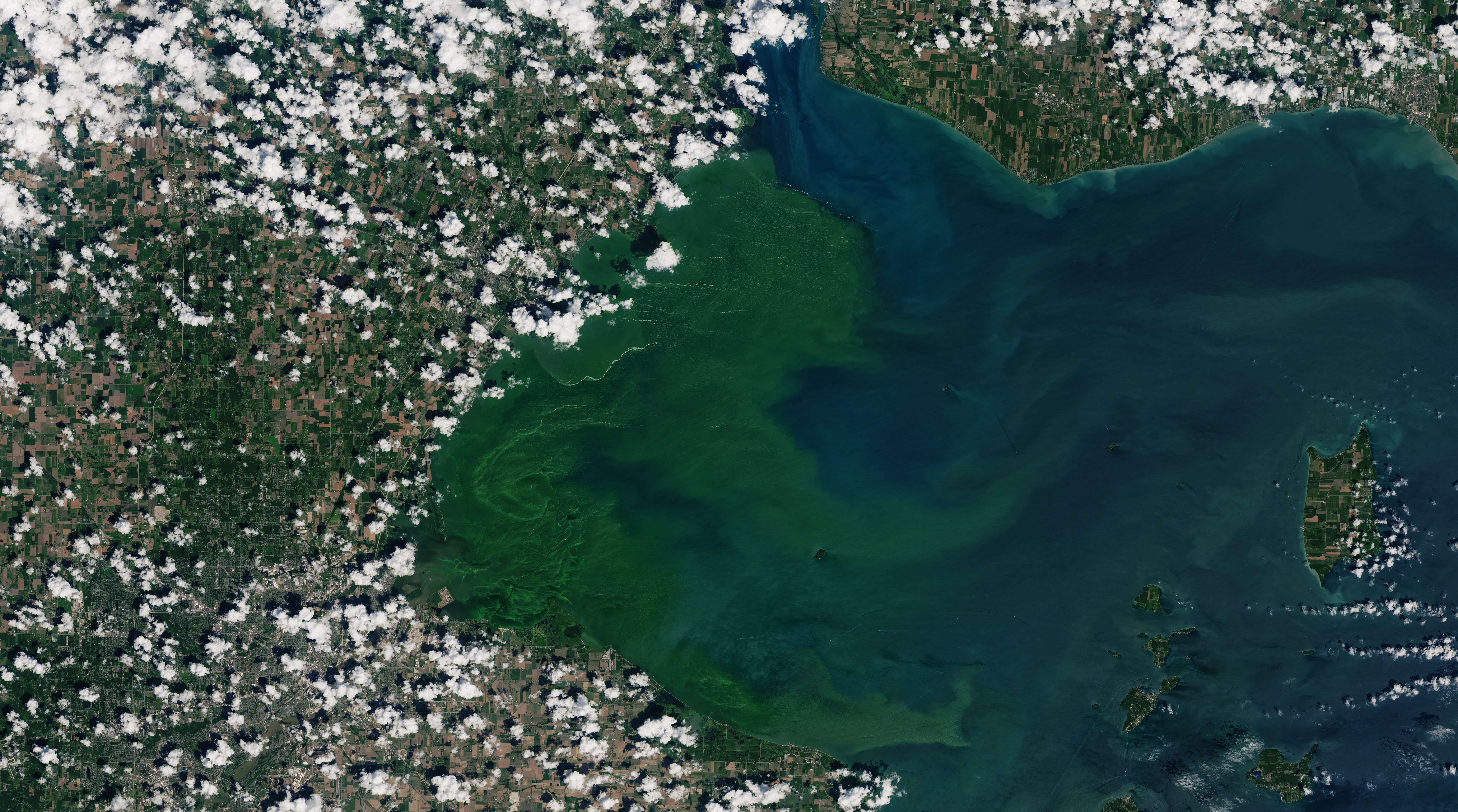
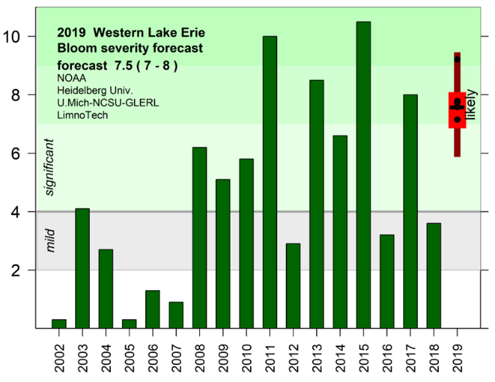
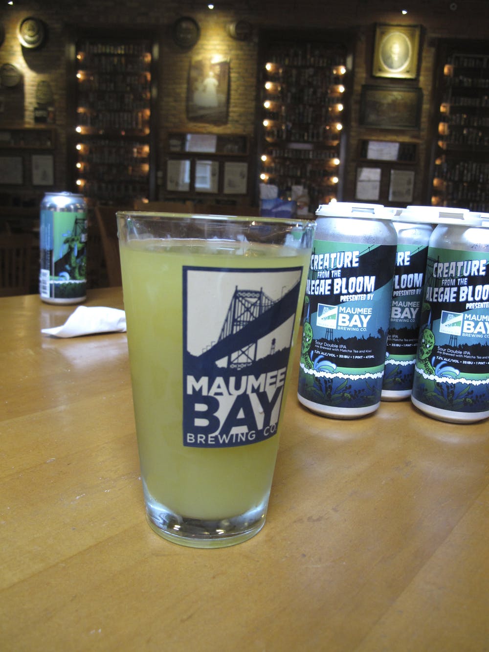
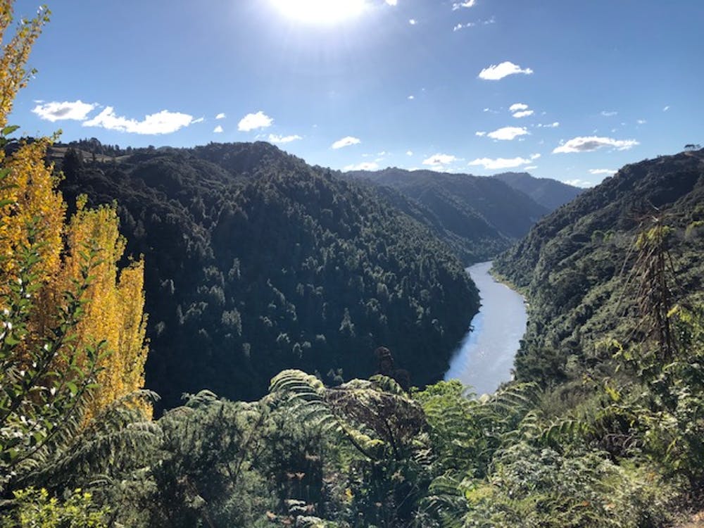
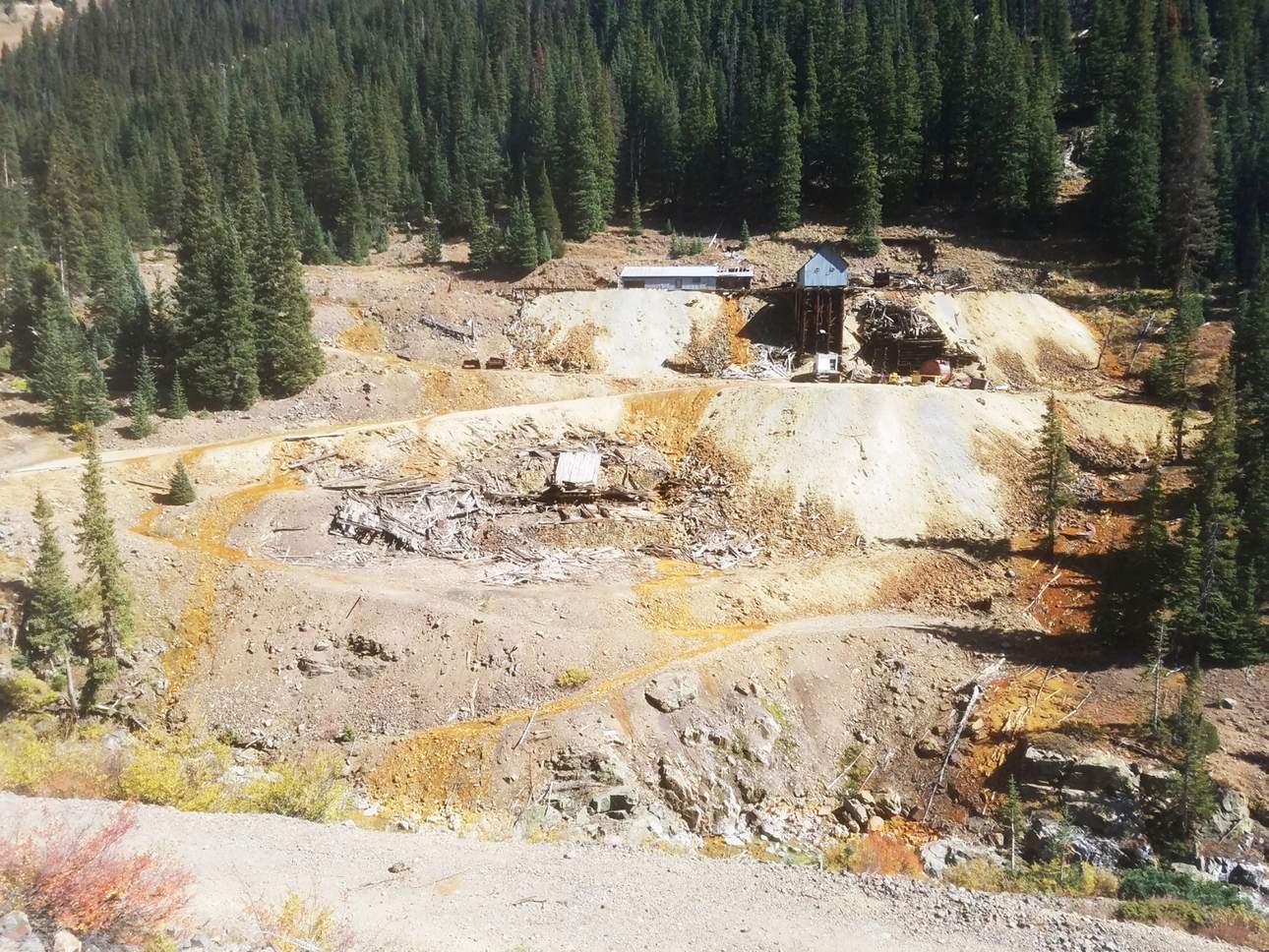
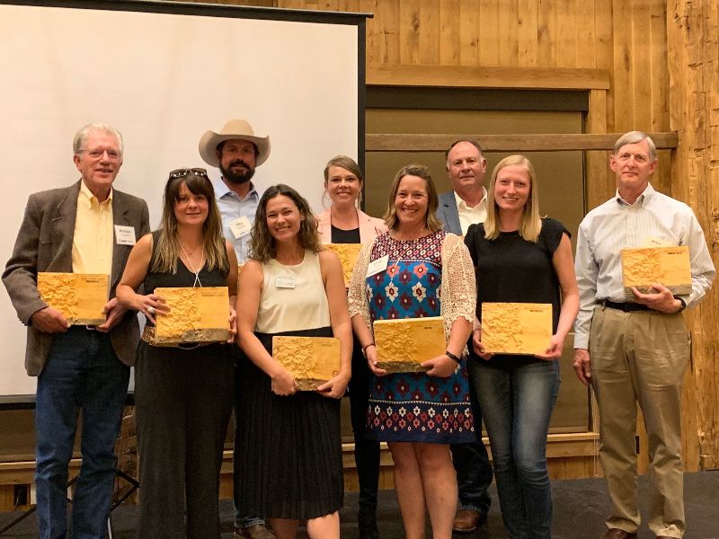
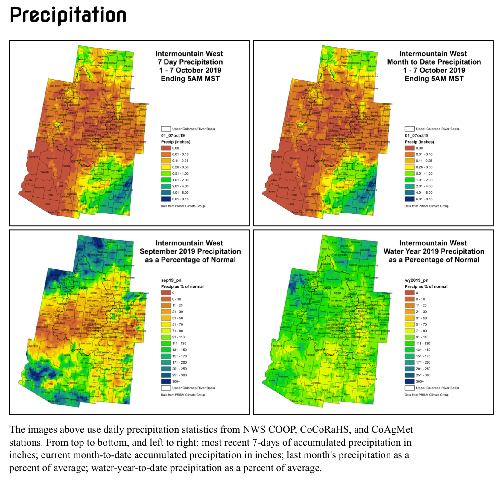

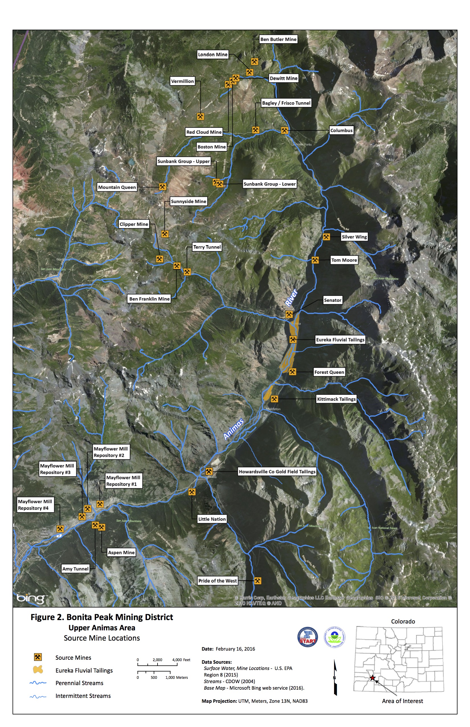


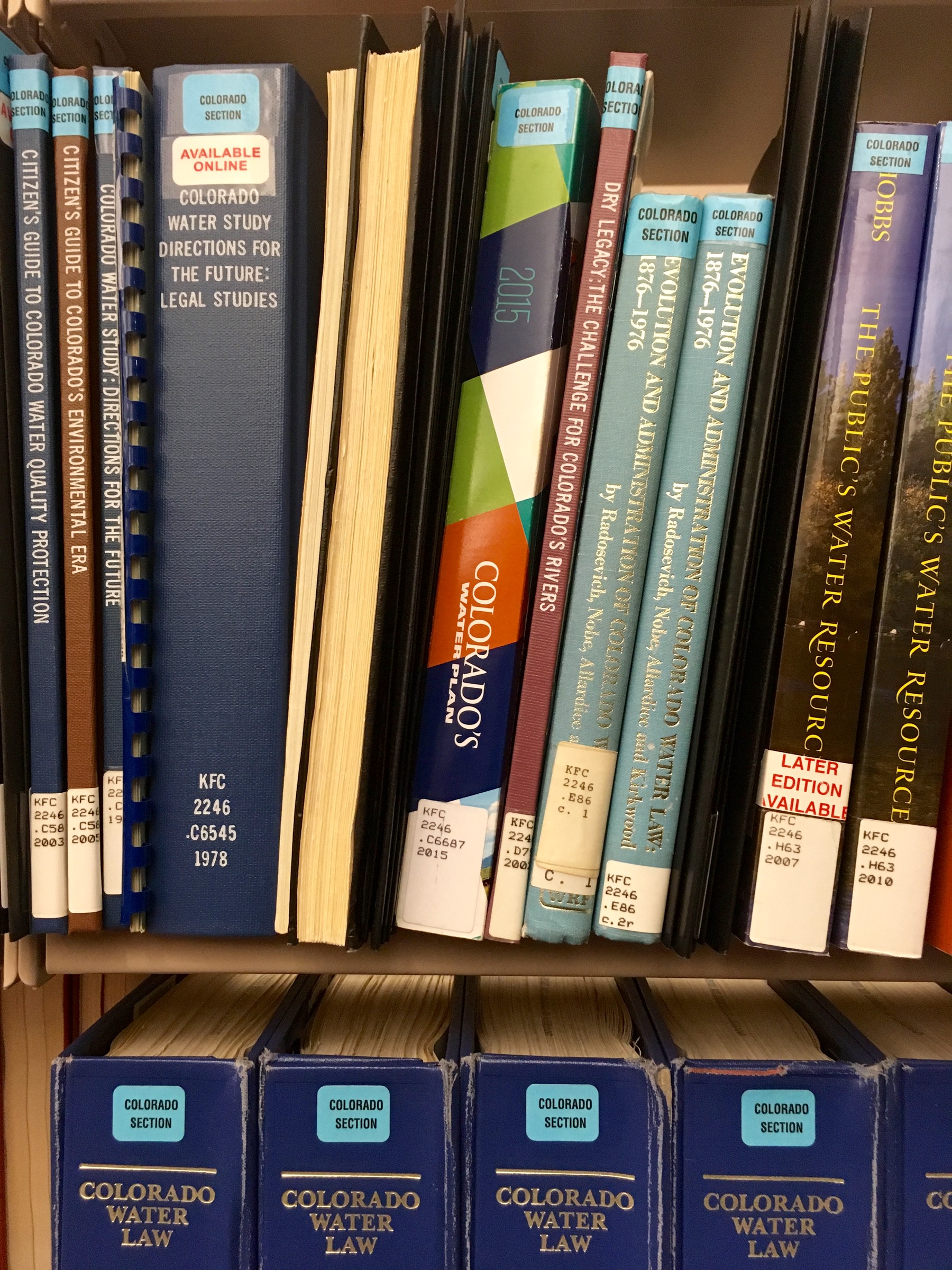


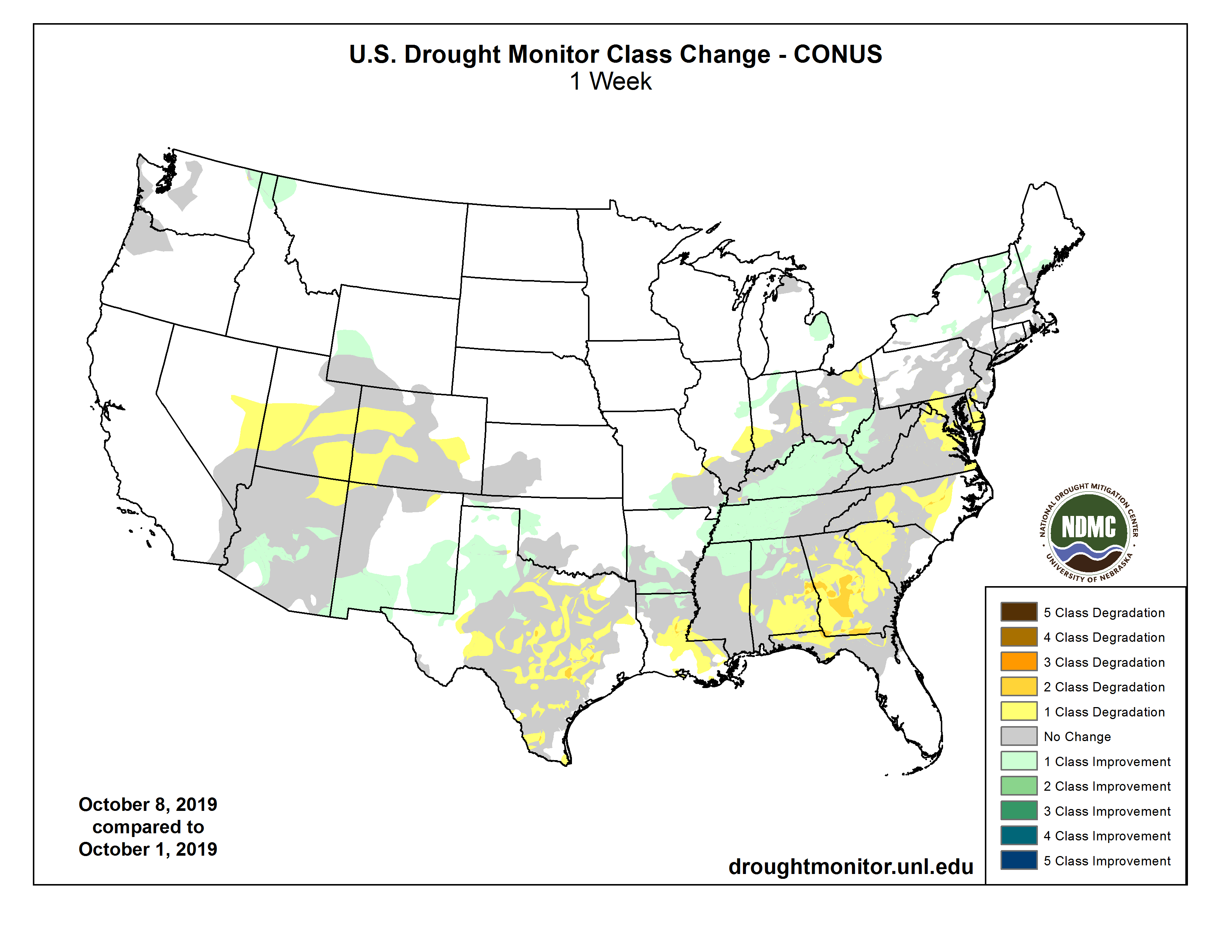


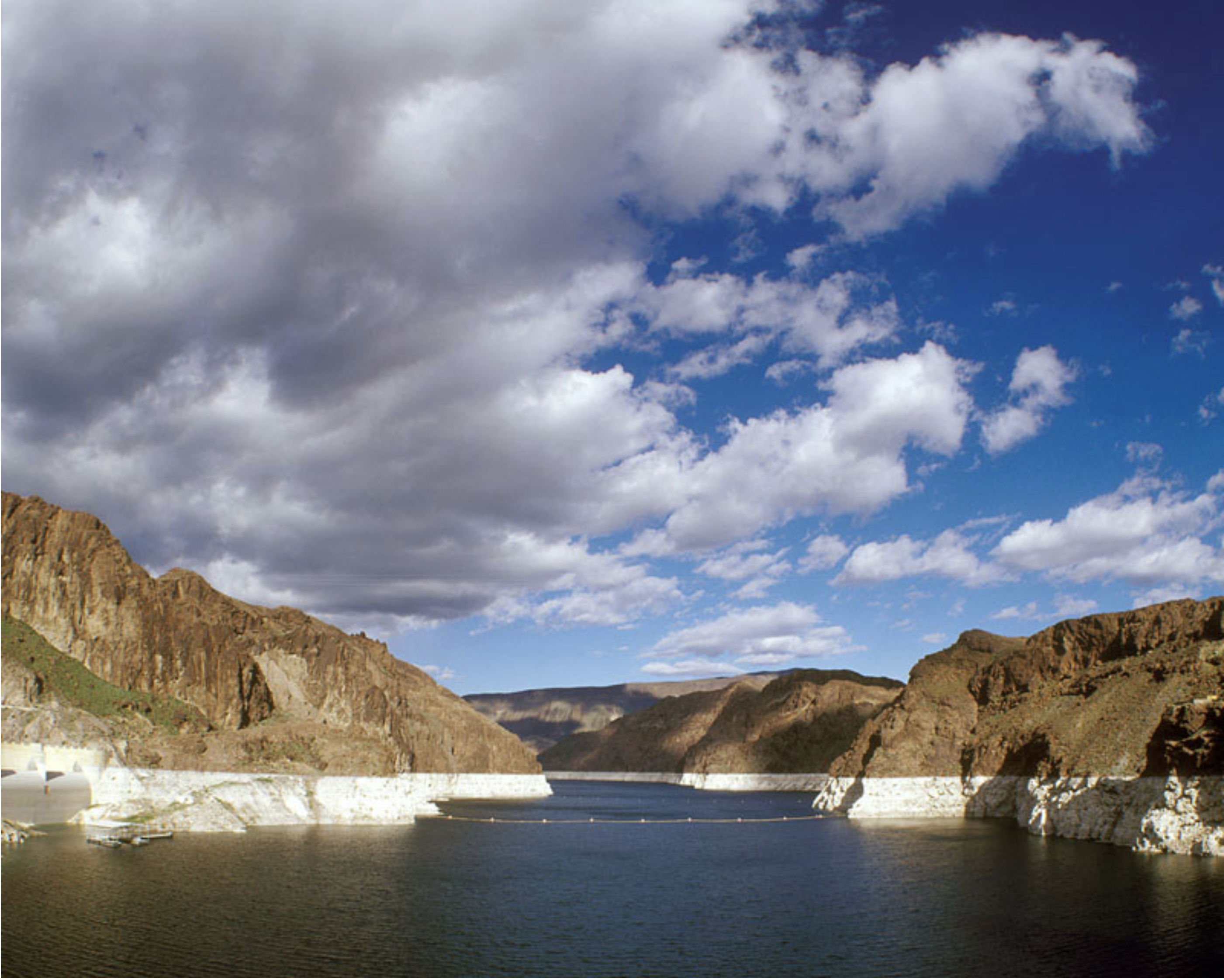


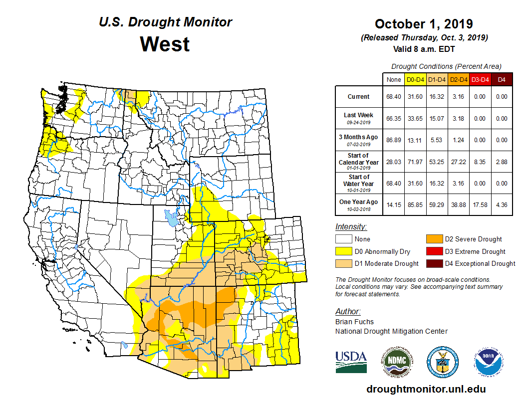

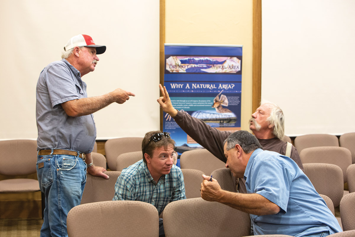
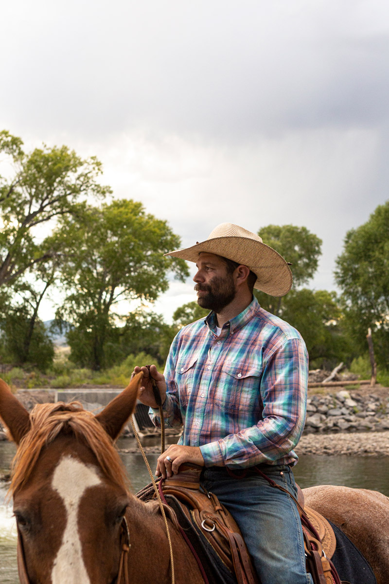
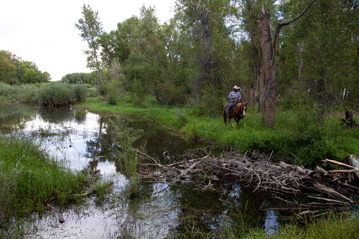

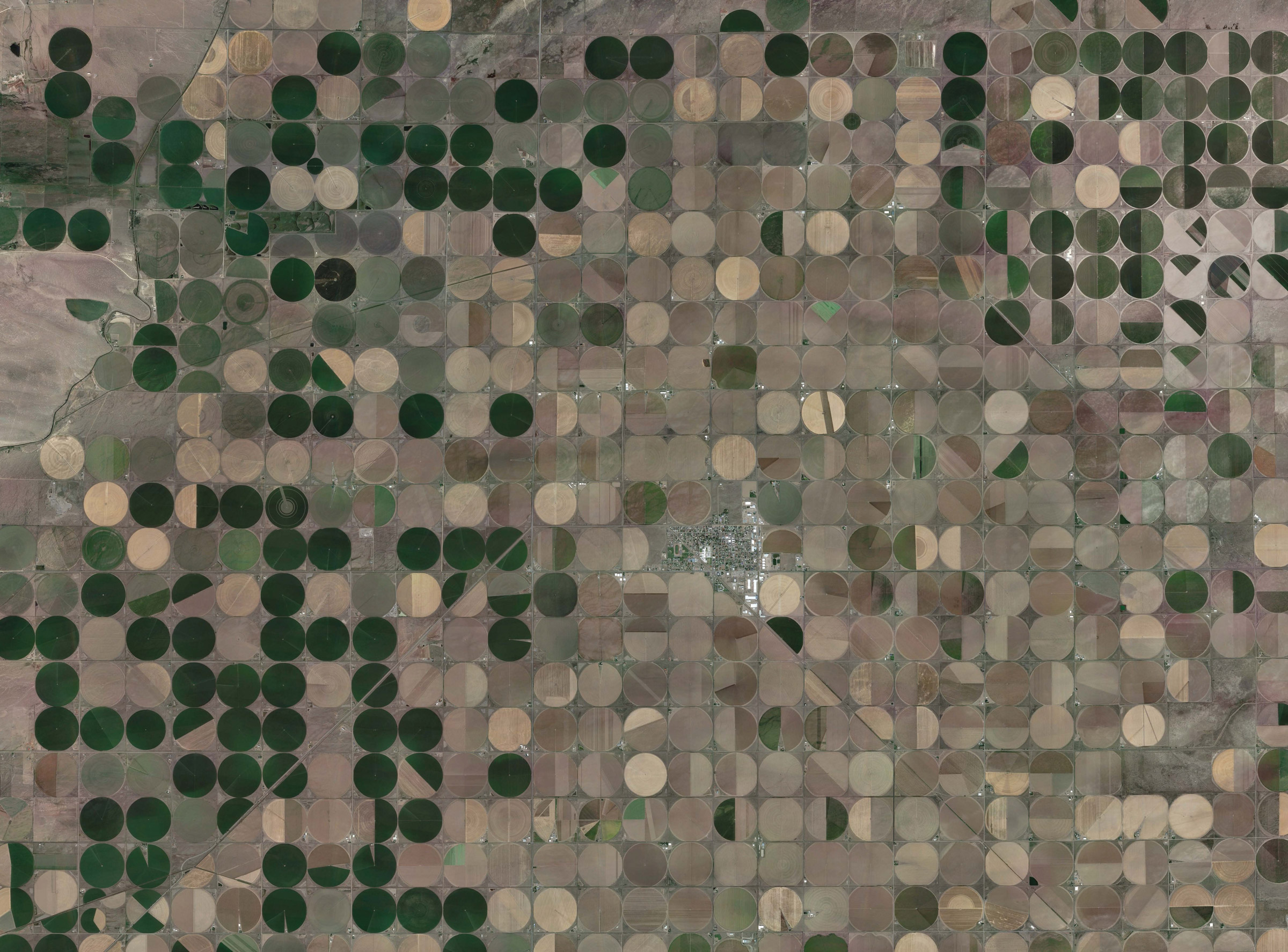


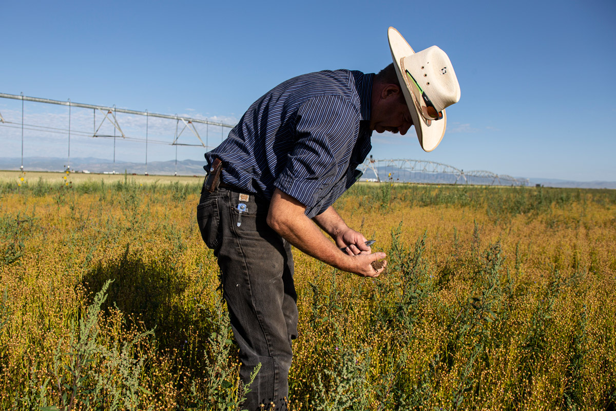


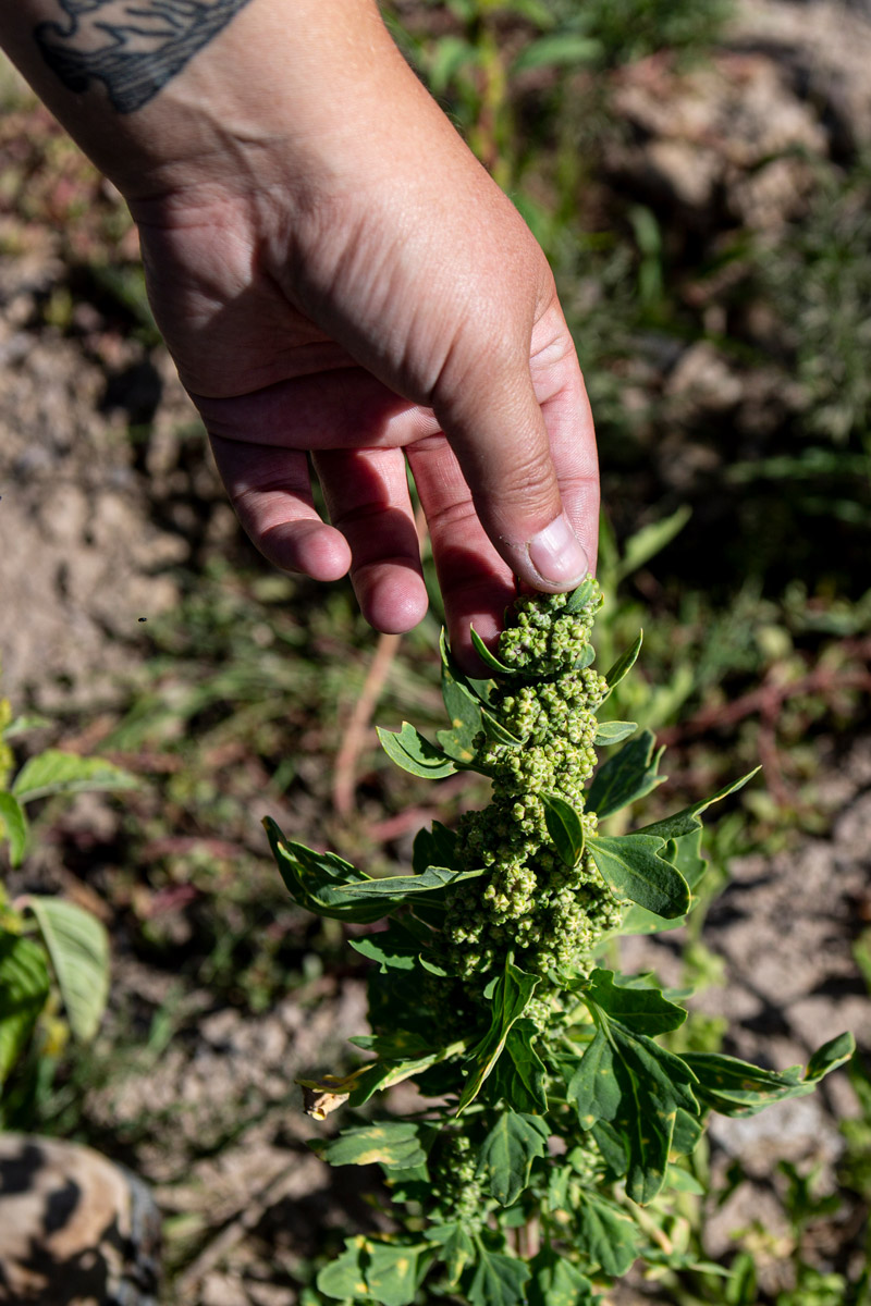


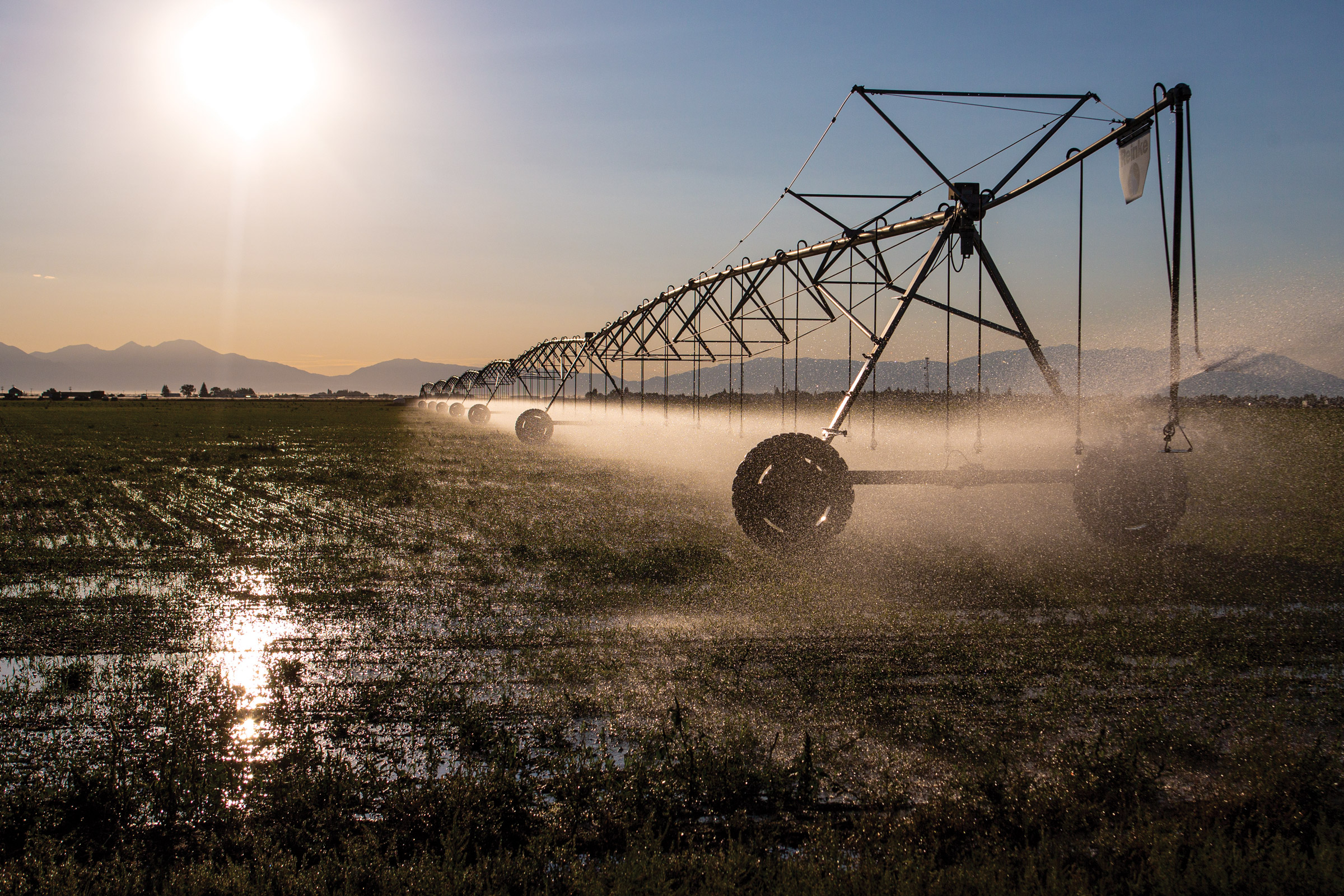


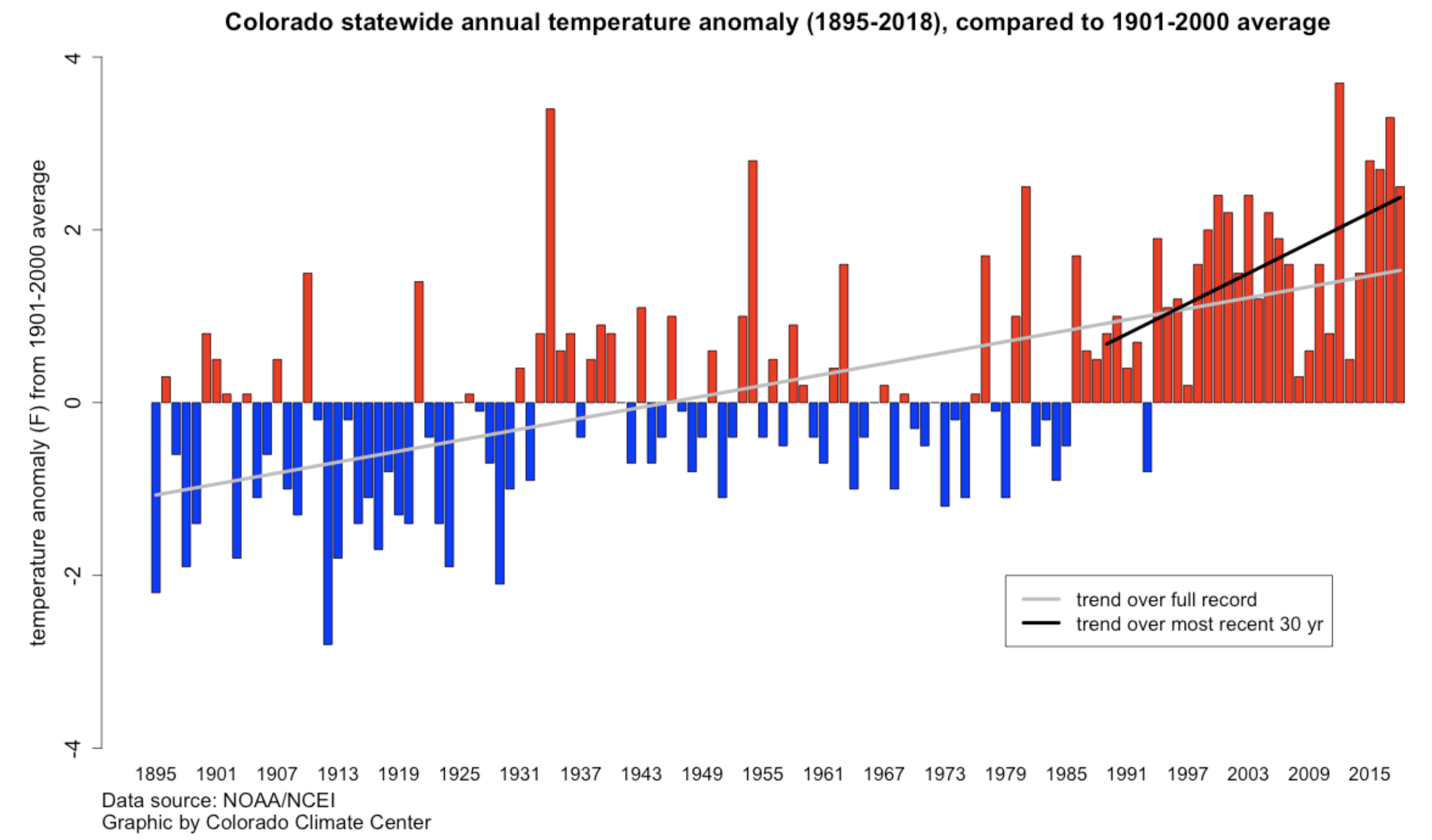


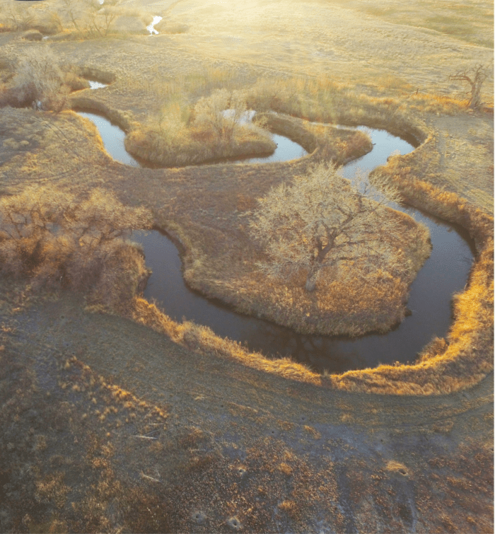


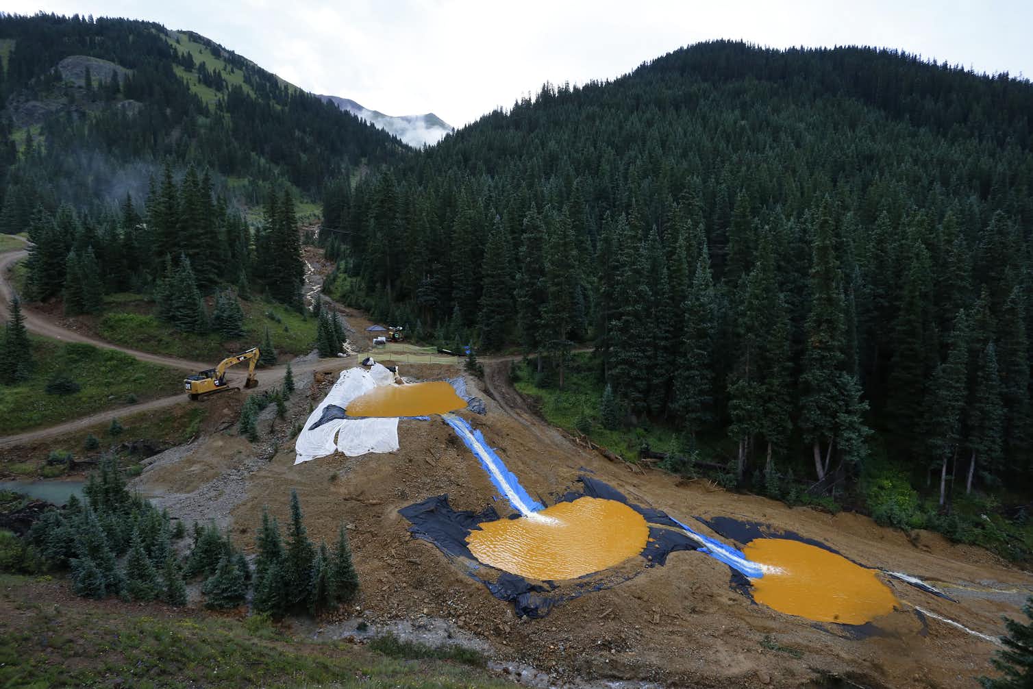


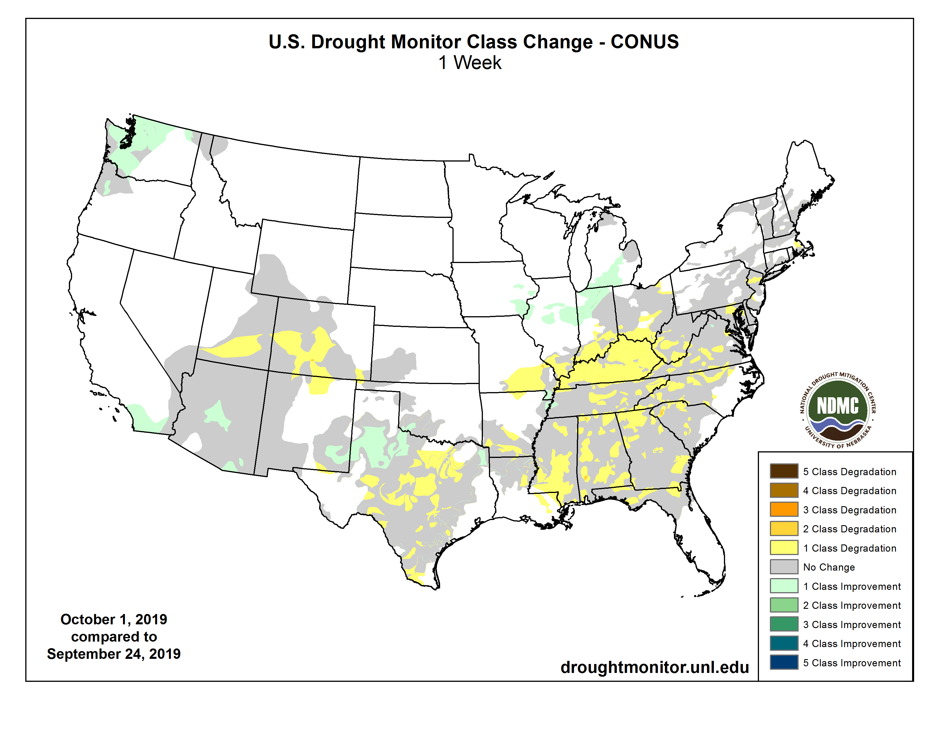


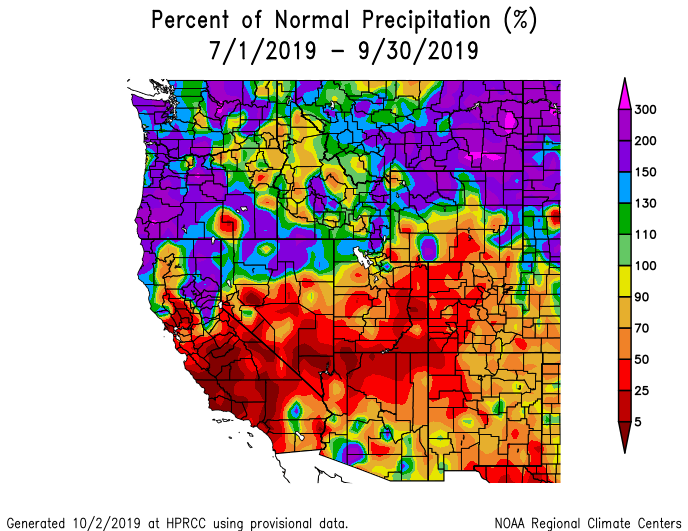
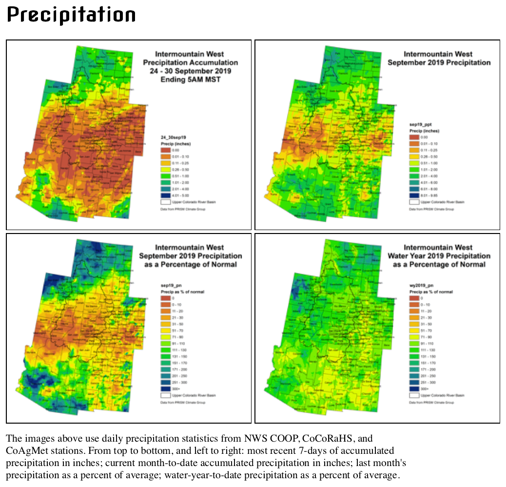


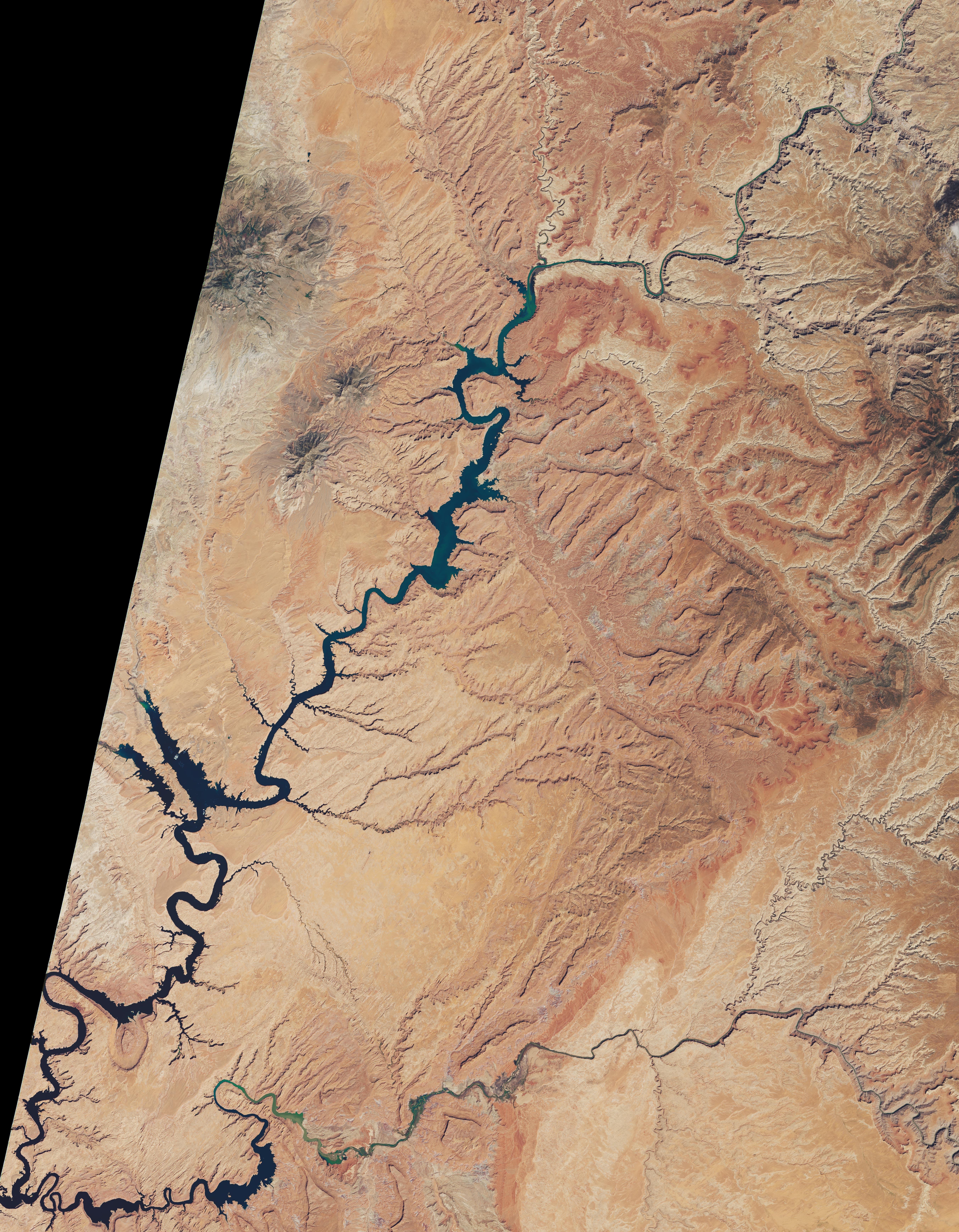
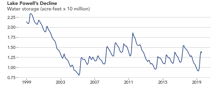
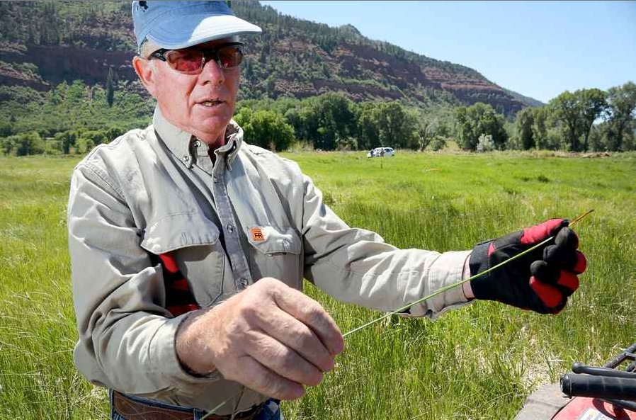
