Click on a thumbnail graphic to view a gallery of drought data from the US Drought Monitor.


Click here to go to the US Drought Monitor website. Here’s an excerpt:
This Week’s Drought Summary
Rapidly intensifying “flash drought” — attributed in part to extreme late-summer heat — continued to afflict many areas from the lower Midwest and Mid-Atlantic States to the Gulf Coast. Conversely, heavy to excessive rainfall associated with the remnants of Tropical Storm Imelda eradicated drought but caused locally catastrophic flooding in southeastern Texas and western Louisiana. Farther west, late-season showers on the heels of an abysmal Southwestern monsoon (to-date) helped stem drought increases in the Four Corners region, while rain and mountain snow further reduced lingering drought in the northwestern quarter of the nation. Meanwhile, additional moderate to heavy rain eased or alleviated dryness and drought from the Northwest into the Great Lakes. Outside of the lower 48, additional heavy rainfall eased lingering drought and dryness in south-central Alaska. Elsewhere, short-term drought persisted across the Hawaiian Islands, while Puerto Rico was mostly dry; rain arrived in Puerto Rico after the monitoring period ended (Tuesday morning)…
Most of the region remained free of drought, as above-normal temperatures in the east contrasted with cool albeit dry conditions in the west. However, Abnormal Dryness (D0) and Moderate Drought (D1) were increased in parts of southwestern Kansas as well as south-central and western Colorado due to increasingly dry conditions over the past 90 days (30-50 percent of normal)…
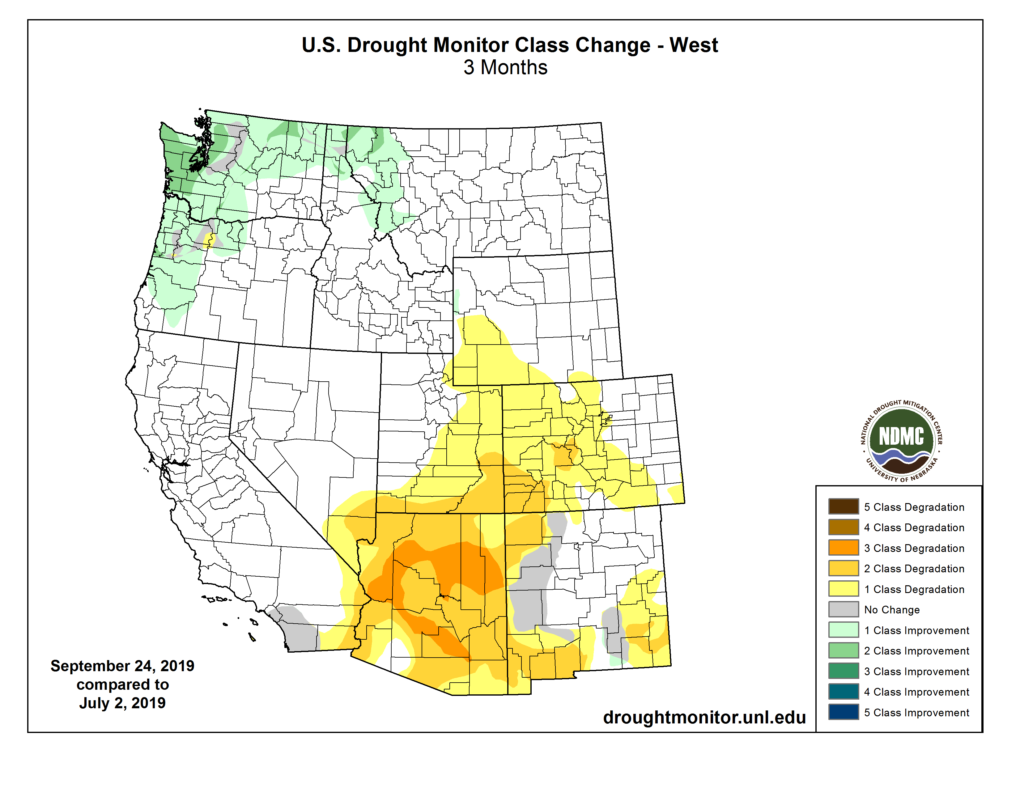
Moderate to heavy showers arrived in the Southwest, while unsettled, cool conditions continued across the Northwest.
Showers and thunderstorms (1-4 inches, locally more) associated in part with moisture from the remnants of Hurricane Lorena arrived in central Arizona, helping to stem further drought increases (at least temporarily) from the abysmal Southwestern monsoon season-to-date. Despite this week’s showers, 6-month rainfall has totaled a meager 10 to 50 percent of normal, with higher totals (70-100 percent of normal) noted in the mountains of central Arizona. The Southwestern monsoon typically runs from June 15-September 30 and accounts for up to half the total annual precipitation in some parts of the Southwest.
Farther north, near- to below-normal temperatures as well as another round of moderate to heavy rain (1-3 inches) from the Pacific Northwest into the northern Rockies spurred additional reductions of Abnormal Dryness (D0) and Moderate Drought (D1). At week’s end, D0 and D1 were limited to locales still reporting longer-term precipitation deficits (12-month precipitation averaging near 75 percent of normal or less)…
Highly variable conditions were observed across the South, with intense late-summer heat and acute short-term dryness in southwestern and northeastern portions of the region contrasting with heavy to excessive rainfall across the west-central Gulf Coast and from western Texas northeastward into central and southern Oklahoma. Tropical Storm Imelda moved slowly ashore near Freeport, Texas, drifting northward while producing prodigious rainfall totals (20-30 inches, locally more) south and east of Houston. Heavy rain (2-8 inches) was also noted further inland across eastern Texas, western Louisiana, and southeastern Oklahoma, easing or alleviating Abnormal Dryness (D0) as well as Moderate to Severe Drought (D1 and D2). Farther west, widespread heavy showers (1-5 inches, locally more) from Texas’ Big Bend northeastward into central and southeastern Oklahoma (a peak value of 7.66 inches was noted in Antlers, OK) likewise supported aggressive reductions to drought intensity and coverage.
Conversely, excessive heat (daytime highs approaching or topping 100°F) and pronounced short-term dryness (60-day rainfall totaling locally less than 20 percent of normal) heightened evapotranspiration rates and soil moisture losses, resulting in quickly escalating drought impacts (often referred to as a “flash drought”.) It should be noted that “flash drought” impacts often arise more quickly than the rainfall data would suggest due to the accompanying heat. For this week’s analysis, the expansion of D0 (Abnormal Dryness) as well as Moderate (D1) to Extreme Drought (D3) was driven by guidance from local experts, impact reports from observers, as well as temperature- and rainfall-driven data products which focused on the past 60 to 90 days. Increases in drought were most pronounced from the Rio Grande toward Dallas, Texas, and from the central Delta into Tennessee. State-wide average topsoil moisture was rated more than 70 percent short to very short (according to USDA-NASS) as of September 22 in Arkansas (78 percent poor to very poor), Mississippi (83 percent), and Tennessee (89 percent, a 14-point jump over last week)…
Looking Ahead
The overall theme of a persistent and stagnant weather pattern will continue into next week. High pressure will maintain dryness and drought from New England to the Gulf Coast Region, though a series of weak cold fronts may provide chances for much-needed shower activity from eastern portions of Kentucky and Tennessee to the central Atlantic Coast. Likewise, mostly dry weather is expected from the Southwest into the central Rockies and Great Plains. In contrast, wet weather will continue from the Northwest into the northern Plains and upper Midwest, with another ribbon of moderate to heavy rain (locally more than 2 inches) possible from the southern High Plains into the Great lakes Region. The NWS 6- to 10-day outlook for October 1–4 calls for above-normal temperatures across the eastern half of the nation in addition to the southern Plains and western Gulf Coast region, while cooler-than-normal weather prevails from the Pacific Coast into the upper Midwest. Near- to above-normal precipitation across much of the nation will contrast with drier-than-normal conditions across the southeastern quarter of the nation.
Here’s the 90-day change map for the West.