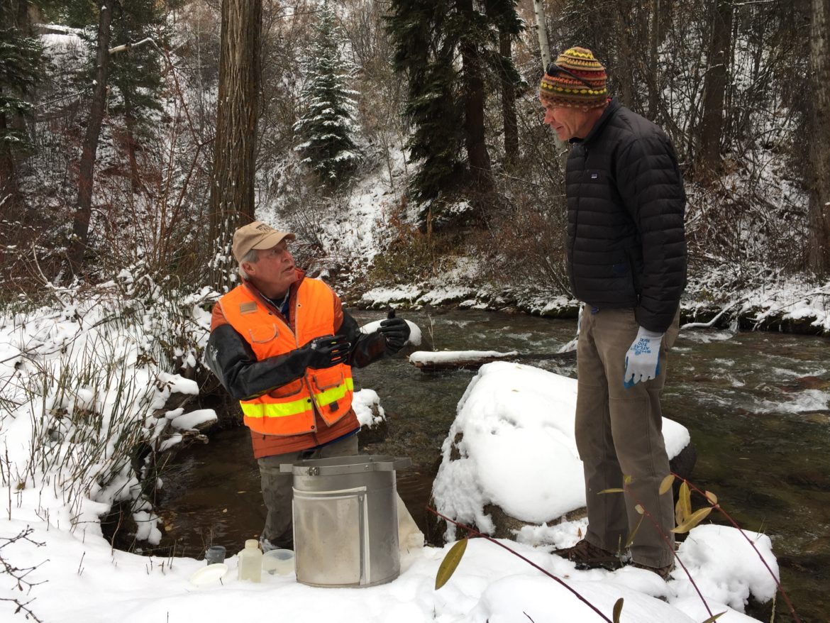
Aquatic ecologist Bill Miller, left, and chair of the Pitkin County Healthy Streams Board Andre Wille stand on the banks of Castle Creek as Miller prepares to take macro-invertebrate samples. The county hired Miller to collect baseline data to ensure increased snowmaking on Aspen Mountain won’t harm the health of the stream. Photo credit: Heather Sackett/Aspen Journalism
On a recent snowy morning, aquatic ecologist Bill Miller dipped what’s known as a Hess sampler into the frigid waters of Castle Creek near Aspen.
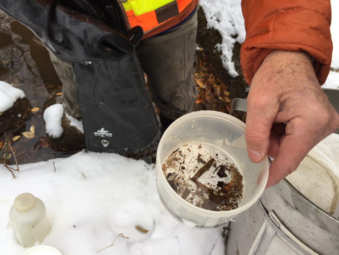
Miller stirred up the streambed with his hands, funneling the rocks, sediment and leaves — along with macro-invertebrates such as insects and worms — into the collection container.
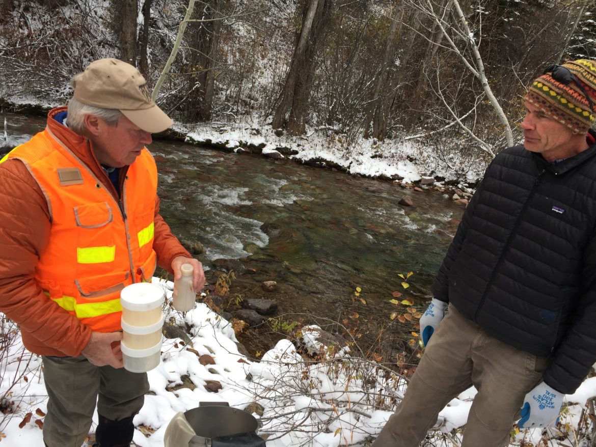
After putting the organic material into smaller jars and giving each one a squirt of alcohol as a preservative, heferried them to a lab in Fort Collins. Scientists there will count the number and types of bugs in each sample.
“By the different species that are there, you can get a good indication of stream and water quality, and overall ecological function,” Miller said.
Miller’s work is part of a program that will monitor the health of Castle and Maroon creeks, ensuring that Aspen Skiing Co.’s increased water use for snowmaking on Aspen Mountain won’t harm the aquatic environment of the creeks. The stream-monitoring program was set out in September as a condition of Pitkin County’s approval of Skico’s Aspen Mountain Ski Area Master Plan.
“I think the idea of this is we don’t want the snowmaking to cause significant harm to the creeks,” said Andre Wille, chairman of Pitkin County Healthy Rivers board.
Aquatic ecologist Bill Miller shows the bugs and worms from Castle Creek that he collected with a Hess sampler. Starting in the 2020-21 season, Aspen Mountain will use an additional 57 acre-feet of water from city supplies, which come from Castle and Maroon creeks, for snowmaking per season. Photo credit: Heather Sackett/Aspen Journalism
Aspen Mountain expansion
As part of its planned expansion, Aspen Mountain will use an additional 57 acre-feet of water per season, bringing the total average snowmaking water use to roughly 257 acre-feet. For context, Wildcat Reservoir, which is visible from the Snowmass Ski Area, holds about 1,100 acre-feet of water.
Skico is expanding its snowmaking for the 2020-21 season on 53 acres near the summit of Aspen Mountain, which will make it easier to have reliable and consistent snow coverage to ensure a Thanksgiving opening. Skico draws its water for snowmaking on Aspen Mountain from the city’s treated municipal supply, which is from Castle and Maroon creeks.
When Skico makes snow in November and December, the upside is there are fewer municipal water users pulling from local streams — outdoor irrigation season is over and holiday crowds have yet to arrive —but snowmaking uses water when natural streamflows are at some of their lowest points of the year.
“We were definitely concerned with the possibility of too much water being taken out in those early months of the winter,” Wille said.
Miller collected samples from above and below the city’s diversion dams on both lower Castle and Maroon creeks. His samples will act as a baseline against which the condition of the streams in future — and perhaps drier — years will be measured.
According to the resolution approving Aspen Mountain’s master plan, if the county’s aquatic ecologist determines, in future years, that the additional water usage is having a negative effect on stream health, the county could limit Skico’s water use to historical levels — about 200 acre-feet a year.
Aquatic ecologist Bill Miller, left, shows chair of Pitkin County Healthy Streams Board Andre Wille the three samples of macro-invertebrates he collected from Castle Creek. Some say the instream flow water rights held by the Colorado Water Conservation Board don’t necessarily go far enough to protect stream health. Photo credit: Heather Sackett/Aspen Journalism
Instream flows
There is another safeguard to keep water in the river, but some say it may not go far enough to ensure stream health.
The Colorado Water Conservation Board, a state agency, holds instream-flow water rights on both Castle and Maroon creeks. And the state has determined that it requires at least 12 cubic feet per second of flowing water to protect the environment to “a reasonable degree” on lower Castle Creek and 14 cfs on lower Maroon Creek.
“We don’t feel it’s advisable to look at what the CWCB may have decreed in the past for a minimum instream flow,” said John Ely, Pitkin County attorney. “That’s not necessarily indicative from a scientific point of view of what is actually needed to maintain a healthy stream.”
That’s why the county hired Miller — who also is the longtime consulting biologist for the city of Aspen — to do its own assessment of stream health.
Ely said stream samples may not need to be taken every year — just in dry years when snowmaking could exacerbate already low flows. He estimated the annual cost of the monitoring program at about $5,000 to $10,000.
Jeff Hanle, Skico’s vice president of communications, said the company is taking steps to increase the efficiency of its on-mountain storage for snowmaking, such as adding two new ponds on Gent’s Ridge, so it won’t need to pull as much water from the city’s supply during the early season.
Although Skico and Pitkin County still need to work out the details of the stream-monitoring program, Hanle said the company is on board with preserving the ecological health of Castle and Maroon creeks.
“We would not make snow if it’s harming the stream, even if it could shorten a season,” he said. “We aren’t going to damage our home.”
Aspen Journalism collaborates with The Aspen Times and other Swift Communications newspapers on coverage of rivers and water. This story ran in the Nov. 11 edition of The Aspen Times.
Click through and read the whole article: FromOutside Online (Philip Kiefer):
Water shortages are a two-part equation: undersupply and overuse. A study from the World Resource Institute early this summer pointed out that places in the American West are on par with Israel and Qatar for water stress—the gap between the amount a region has available versus the amount it consumes—and as snowpack declines with climate change, the shortage will only get worse. Despite a wet winter in 2018–19, Lake Powell is almost half empty, and the states that depend on that reservoir will be subject to dramatic cuts in water usage if levels fall much lower.
But right now, five of the seven water-stressed western states along the Colorado River—Arizona, California, Nevada, New Mexico, and Wyoming—don’t yet track how they use their limited water in any kind of systematic, accessible way, teeing up potential shortages as the region dries. (Colorado’s Divison of Water Resources, which publishes both water rights and availability data online, is ahead of the pack.) [ed. emphasis mine]
A Nature Conservancy report from last year found that 86 percent of California’s streams are undermonitored. Kathleen Miller, a Wheeler Water Institute research fellow at UC Berkeley’s Center for Law, Energy, and the Environment, says that means water managers must make decisions in a drought based on snowpack estimates from high in the mountains rather than from water that’s actually in the stream. It’s akin to “driving with gauze pulled over our eyes,” she wrote in an editorial this spring.
It matters whether or not a state’s water data is accessible, says Michael Kiparsky, director of the Wheeler Water Institute, because it can be used by states to help adapt to a drier future. “We don’t actually care generally about the amount of water we have,” he says. “What we care about, ultimately, is what we do with that water.”
It might seem like an obvious point, but it has big implications for water development and conservation. “You can’t develop creative solutions without understanding all the moving parts—rural, urban, and agricultural,” Kiparsky says.
The city council voted unanimously Tuesday to hire Wright Water Engineers out of Durango $50,000 to design a data collection system.
The city is required to collect continuous temperature data on the Uncompahgre River upstream from the treatment plant found north of town, said City of Montrose utilities manager David Bries. This is needed as part of the National Pollutant Discharge Elimination System permit — which was provided by the EPA — that the city recently received, he added.
Bries said that as part of a review, staffers discovered a lack of good, low-measurement near or at the river, as well as the treatment plant discharge location…
With this design in place, it’ll be the first time the city will collect data of the river flow and temperature of the discharge of the treatment plant, Bries said.
He also said this process will “capture that data” so decisions can be made for the river.
“We felt it was very valuable and imperative to have both flow relationships and temperature relationships,” Bries said. “We can make sure we are doing what is environmentally the right thing to do.”
Ken Nordstrom, the environmental health director for the Delta County Health Department, looks at a physical version of the map. Photo credit: University of Colorado at Boulder
Prior to this study, there was no data on private drinking water quality in this six-county area, and the findings have proven to be relevant to many residents. Of the 457 wells analyzed in the survey, 11% have arsenic concentrations exceeding the Colorado primary drinking water standard maximum contaminant level. Additionally, 15% of the well water that was tested exceeded at least one primary drinking water contaminant standard from the state.
Residents can explore results through an interactive online map created by Holly Miller as part of her recently completed master’s degree in the Environmental Engineering Program at CU Boulder. The site shows locations for all the tested wells, provides links to request free testing kits and houses detailed water-quality information.
Samples for the survey came from volunteers in those communities. Miller’s work was done under Professor Joe Ryan, who said the database was an important step toward public awareness. That is because water quality is an important factor in overall health, but privately owned wells are unregulated and mostly untested for things like arsenic. Putting the survey results online gives residents, many of whom rely on well water, information about their home’s water quality and that of their neighbors so they can make informed health decisions.
Arsenic in groundwater can occur naturally, or it can come from human sources like agriculture, where it was used as a pesticide, or mining operations. Ingestion can have short-term effects, including nausea and fatigue, as well as long-term effects like skin thickening and discoloration. Ryan said that more testing was needed, but the source of the higher levels in this case was likely geologic. He added that better understanding of that aspect would be valuable when making decisions about new wells and development needs in those communities.
Ken Nordstrom, the environmental health director for the Delta County Health Department, said that without a healthy drinking water source, you cannot have a healthy community.
“CU Boulder has helped us develop this resource for individual homeowners to ensure that they have a healthy drinking water supply,” he said.
Holly Miller. Photo credit University of Colorado at Boulder
“Collaborating with Delta County has been a great asset for my professional career. I gained valuable research and outreach skills, which ultimately created the foundation for my current position where I work as the project manager for my program’s geographical information systems database used to map information about abandoned mine-land sites across the state,” she said.
The project is nearing completion, and sample kits have now been sent to approximately 1,000 volunteers. From that group, results have been returned to over 750 of them. Miller said the plan is to update the interactive map by the end of the year, and the Delta County Environmental Health Department staff is planning to survey residents in the counties to identify the impacts this project has had on helping private well owners keep their water safe.
Ryan said this type of work was just as important for students in his lab starting their careers as it is to the communities they are serving.
“This type of work is important because I can bring students into it – but it isn’t just having them take samples and analyzing them. It’s a good case where we are getting them into a mode where they are trying to find out the client’s problem and the best way to address it,” he said. “This kind of work provides extra opportunities for students and real benefits to communities we work with.”
This map shows estimates of how many private domestic well users in each county may be drinking water with high levels of arsenic. An estimated 2.1 million people throughout the U.S. may be drinking domestic well water high in arsenic
The Delta County Health Department (DCHD) paired up with the University of Colorado to study water quality in private wells. They said they got definitive data that shows not everyone can trust the water they are drinking.
DCHD oversees six counties: Delta, Gunnison, Hinsdale, Montrose, Ouray and San Miguel.
Approximately 36,000 people, or 60% of the population, in this area drink water from private wells that aren’t regulated because they’re privately owned, according to the department’s director, Ken Nordstrom.
Nordstrom said there are around 10,000 private drinking water wells in the six-county region his department oversees and that until this point there was no information readily available to the public about the quality of water in those wells…
So with the help of a Centers for Disease Control and Prevention (CDC) grant, the DCHD started taking a closer look at gathering data and CU Boulder joined in 2016.