In what could be a major blow to the Durango & Silverton Narrow Gauge Railroad, a federal judge has recommended a district court throw out the train’s motion to dismiss a lawsuit in which the U.S. government is seeking $25 million for fighting the 416 Fire.
In July, the U.S. government named the D&SNG as the cause of the 416 Fire, which started along the train’s tracks north of Durango in summer 2018 and went on to burn more than 54,000 acres of mostly national forest lands in the Hermosa Creek watershed.
After eyewitness accounts and months of speculation, federal investigators determined a cinder emitted from a smokestack from a D&SNG coal-burning locomotive, which was running at a time of extreme drought in Southwest Colorado, sparked the fire.
At the same time, U.S. officials said the D&SNG denied starting the fire, prompting a lawsuit that seeks $25 million from the railroad for damages and fire-suppression costs.
In September, the D&SNG filed a motion to dismiss the lawsuit, saying there is no federal law that allows claims to recover fire suppression costs, and the only Colorado law on the issue allows for recovering actual damages from a fire on property – but not firefighting costs.
The judge overseeing the case – U.S. District Court Judge Robert E. Blackburn – asked for a recommendation from U.S. Magistrate Judge N. Reid Neureiter on interpreting the law and on whether to dismiss the case.
On Friday, Neureiter filed his recommendation, which supported the U.S. government.
“First, I reject the (D&SNG’s) argument that, as a public entity providing a civic service by fighting a forest fire, the United States is not entitled to recover fire suppression costs,” he wrote.
“The United States was protecting its own property, the National Forest, and acting like a property owner in fighting and attempting to suppress the fire … the United States is entitled to whatever protection is afforded to other landowners in Colorado – including entitlement to recovery of fire suppression costs.”
The 416 Fire near Durango, Colorado, ignited on June 1, 2018. By June 21, the wildfire covered more than 34,000 acres and was 37 percent contained. Photo credit USFS via The High Country News
The 416 Fire started at about 10 a.m. on June 1, 2018, approximately 10 miles north of Durango, CO. Rocky Mountain Type 1 Incident Management Team is managing the fire. The fire is burning on the west side of State Highway 550 on some private land and on the San Juan National Forest. The fire is burning in grass, brush, and timber. The Weather conditions remain critical and fuels are ideal for significant fire growth. The fire has been very active and continues to burn in rough and inaccessible terrain. Many homes have been evacuated and structure protection is in place. Map via Inciweb
Screen shot of Animas River debris flow July 2018 aftermath of 416 Fire (CBS Denver).
Debris flow from 416 Fire. Photo credit: Twitter #416Fire hash tag
Water in Loveland comes from the Colorado-Big Thompson Project, which diverts water over the Continental Divide to the Front Range. Over the past several years, units of water from the project have soared in price as Northern Colorado’s population has grown and development increases.
From 2010 to 2019, the average price of C-BT units rose from $7,000 to $55,000. The amount of water in a C-BT unit is set yearly by the Northern Colorado Water Conservancy District — Northern Water — and fluctuates based on the amount of snowpack and forecast streamflows for that year. In 2019, it was set at 70 percent of an acre-foot…
The city of Loveland requires developers to bring their own water rights to a project or to purchase water from the city. The city’s cash-in-lieu price for water rights is pegged to the market value and has steadily risen alongside it.
At the Loveland Utilities Commission meeting Dec. 18, the city approved raising the cash-in-lieu price of C-BT units to $47,640. It last raised the price in July to $39,330.
The city asks developers to pay their own way so that they don’t cut into the city’s water resources for the future, said Joe Bernosky, the director of Loveland Water and Power.
“What we’re doing is we’re to trying to make them pay their own way so the existing citizens don’t have to pay or we don’t kick the can down the road,” Bernosky said. “And that’s not a good way to do business when you’re a utility.”
Cash-in-lieu money the city receives from developers all goes toward firming up the city’s water portfolio, said Larry Howard, a senior civil engineer in the Water and Power utility.
There’s no profit incentive to increasing the cash-in-lieu price, Howard stressed. The city is just reacting to market conditions and doesn’t have a lot of options.
The rising cost of water is making it harder to build more affordable housing in Loveland, something the city badly needs. Jeff Feneis, director of the Loveland Housing Authority, said water rights are one of the organization’s biggest challenges.
In order to help mitigate the increasing cost of water, the city recently recalculated the water rights necessary per building unit. The change, which went into effect this September, applies only to residential buildings.
Due to more efficient building practices such as more efficient appliances, new houses require less water than older ones do. In light of this, the city reduced the required amount of water for a single-family dwelling from about one-quarter of an acre-foot to about one-tenth.
FromThe La Junta Tribune-Democrat (Bette McFarren):
Issues with clean water supply going back to the settlement of the Arkansas Valley will be aided by the Colorado Water Conservation Board’s approval of a $100 million packet for the Arkansas Valley Conduit.
“The Southeastern District and Reclamation are working to reduce project costs and the need for up-front federal funding in order to begin construction of the Arkansas Valley Conduit project. About $30 million has been invested in planning since 2011,” wrote Chris Woodka in a recent article about the CWCB’s action.
“Most of the issues of water quality in the Arkansas Valley are dealing with nucleides,” said Tom Seaba, water and wastewater director for the City of La Junta. “Our new Waste Water Treatment Plan will reduce the contaminants going back into the river, and we will need time and accurate readings to see how effective it is. I don’t think of Selenium as a contaminant, but as a naturally occurring element in our area. We hope to install some other type of treatment to bring us into complete compliance. We are working under a discharge specific variance that is good for five years, and may be renewed for five years. All other elements are under control. We are in year two of the variance.
“Many of the smaller systems, such as South Swink and May Valley, are in much worse condition. A cleaner water source from the Pueblo Water Reservoir would make compliance with clean water standards a non-issue.” Seaba said 15 of the 24 public water systems in Otero County have state water violations for naturally occurring radioactive contaminations.
Swink and four other small systems are currently importing water from La Junta because of La Junta’s reverse osmosis water treatment plant. For smaller water companies, the improvements La Junta has made are not financially possible.
Arkansas Valley Conduit Comanche North route via Reclamation
From Stanford University Water in the West (Megan Glatzel):
New research finds one drought can amplify or cause another. Decreased moisture recycling and transport impacts how droughts form and move across continents.
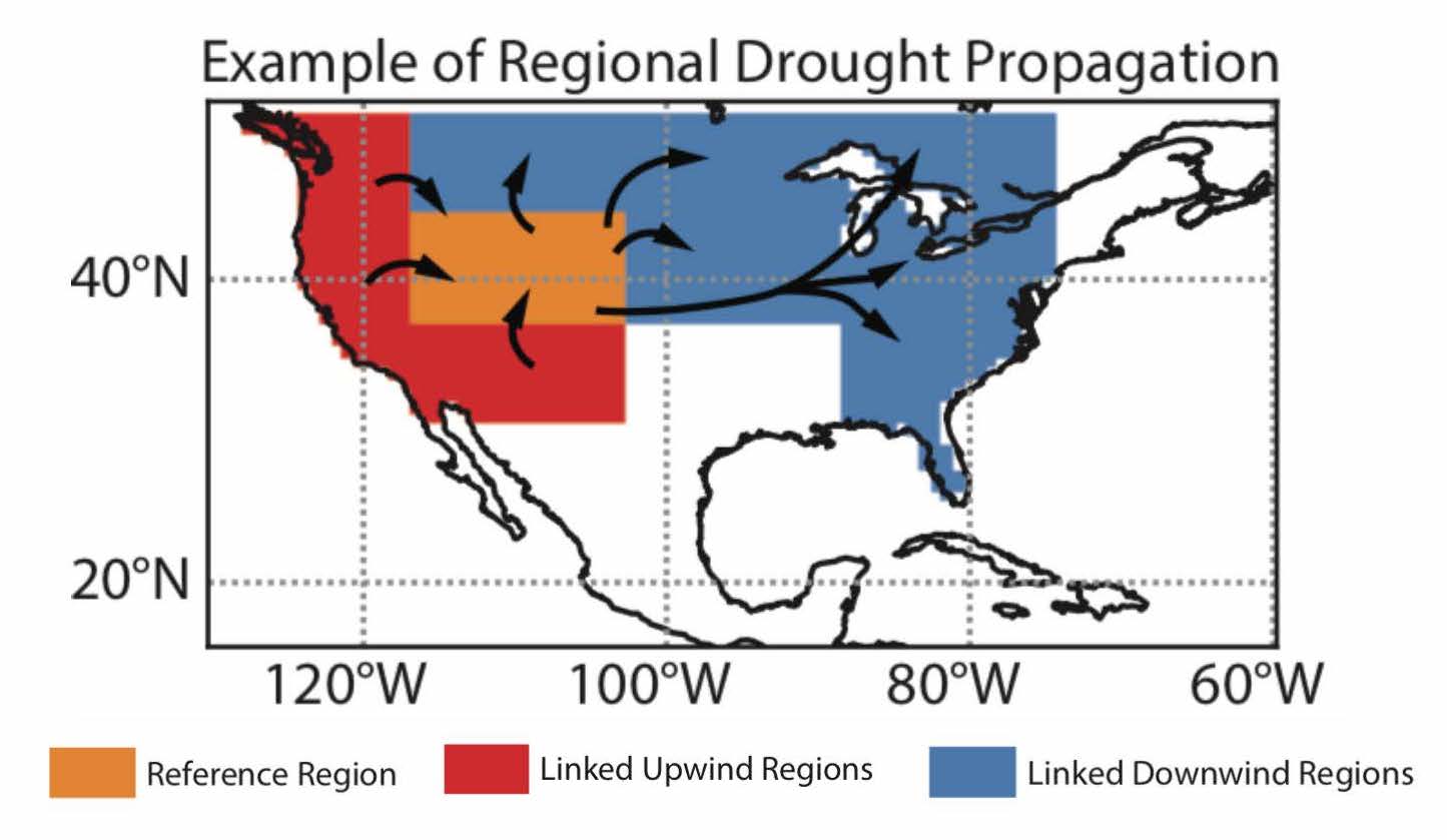
Could a drought in California be linked to a drought in the Midwest? A recent Stanford-led study [Reduced Moisture Transport Linked to Drought Propagation Across North America] published in Geophysical Research Letters finds that regions may fall victim to water scarcity like dominos toppling down a line.
“We know droughts can travel thousands of miles across continents, but it has not been clear exactly how,” said lead author Julio E. Herrera Estrada, a postdoctoral scholar with the Stanford Water in the West program and the Stanford Department of Earth System Science.
Droughts occur when a lack of precipitation causes a water shortage. Continents receive most of their precipitation from water vapor transported by wind from other land and ocean areas as well as from moisture that evaporates from a region and falls in the same area – a process known as recycling.
In this study, researchers looked at how decreased moisture from recycling and transport amplified the 2012 drought in the Midwest, which resulted in losses of over $33 billion. Using a complex, mathematical, moisture tracking model combined with state-of-the-art data on precipitation, evaporation and moisture fluxes in the atmosphere, they found that reduced precipitation from recycling and transport from upwind land areas made up 62 percent of the total precipitation deficit experienced by the Midwest. Diminishing moisture transported directly from oceans made up only 38 percent of this deficit.
An example from the study of upwind and downwind regions in North America between which droughts have propagated through reduced moisture transport. Credit: Stanford University
Like most of the U.S., the Midwest relies on moisture imported from other regions. When a drought occurred in the western U.S. that same year, it resulted in less evaporation and drier air. Transported by wind, this drier air likely resulted in less rainfall over the Midwest, according to the researchers. As less moisture arrived in the Midwest, precipitation recycling shut down, further intensifying the drought. This sequence can reinforce itself and lead to new or more severe droughts. The study found that the Midwest eventually recovered from drought when more moisture was imported directly from the ocean, restarting the precipitation recycling process in the region.
“We show that multiple droughts over a continent may not necessarily be a coincidence,” said Herrera Estrada. “There may be important feedbacks between and within land areas that can propagate and intensify droughts, helping them travel across continents.”
As the U.S. faces more intense climactic events, understanding how droughts form and move will be increasingly important. While there is still a great deal to be learned, it is imperative for water managers and policymakers to prepare for future droughts. Being able to better predict where and when droughts occur and how long they last will be key. To slow the potential domino effect of droughts, the researchers urge the adoption of sustainable land management practices to prevent soil erosion and degradation and recommend preventing deforestation and desertification. These practices ensure more vegetation and better soil which will help keep up the supply of moisture for recycling and to be exported to regions downwind.
“It will also be crucial to take a regional approach to drought risk management and facilitate coordination between upwind and downwind communities to reduce the severity and impacts of future droughts,” concluded Herrera Estrada. “In many instances, this will require international cooperation.”
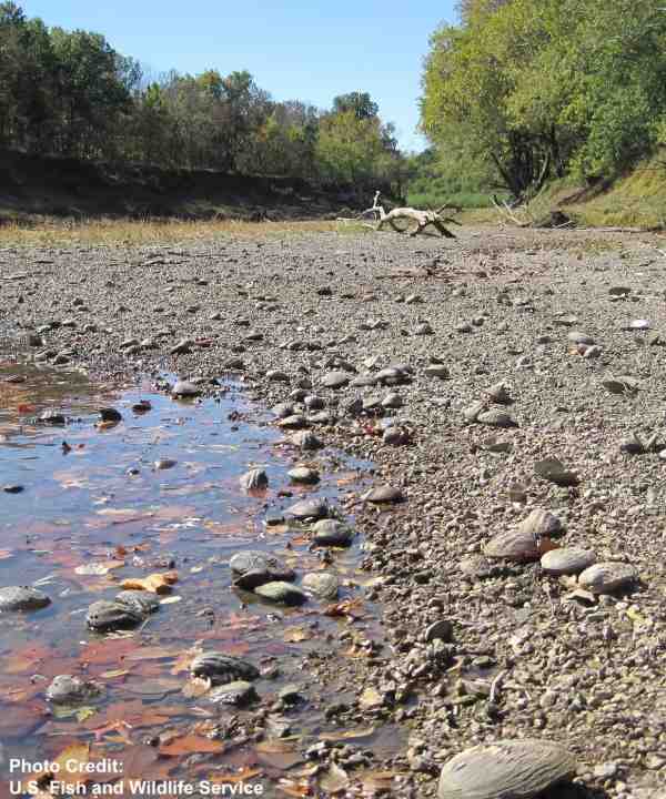
Dry Kansas riverbed via USFWS.
This paper was co-authored by J. Alejandro Martinez, Adjunct Instructor at the Escuela Ambiental, Universidad de Antioquia in Colombia; Francina Dominguez, Associate Professor and Richard and Margaret Romano Professional Scholar at the Department of Atmospheric Sciences, University of Illinois at Urbana-Champaign; Kristen L. Findell, Research Physical Scientist at the Geophysical Fluid Dynamic Laboratory; Eric F. Wood, Susan Dod Brown Professor of Civil and Environmental Engineering at Princeton University; and Justin Sheffield Professor of Hydrology and Remote Sensing at the University of Southampton in the United Kingdom.
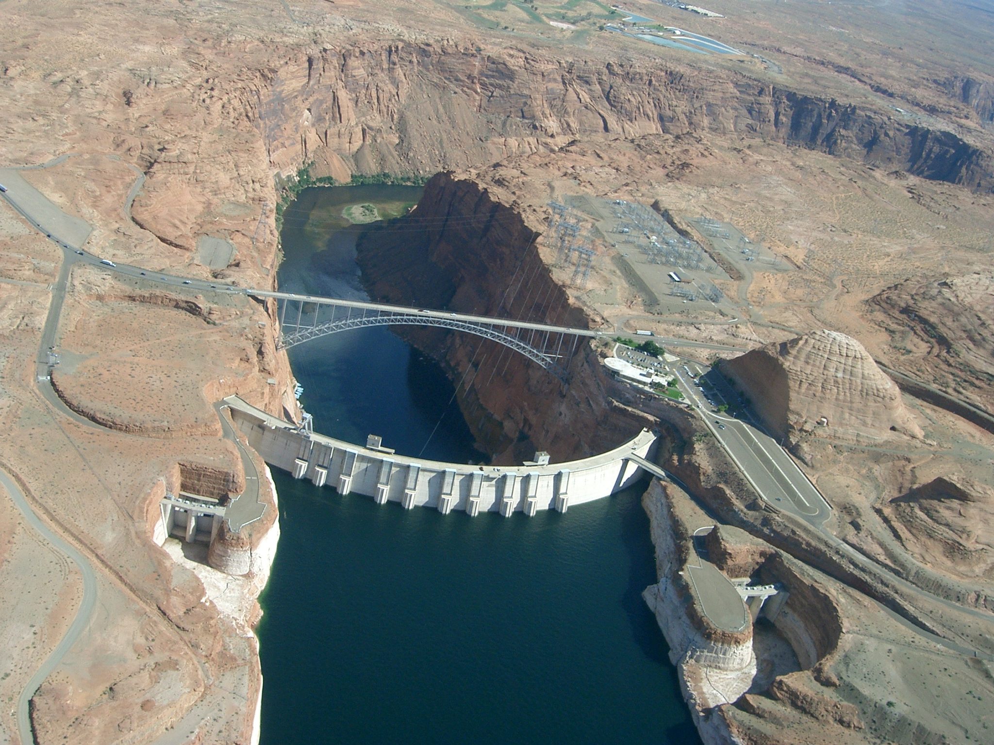
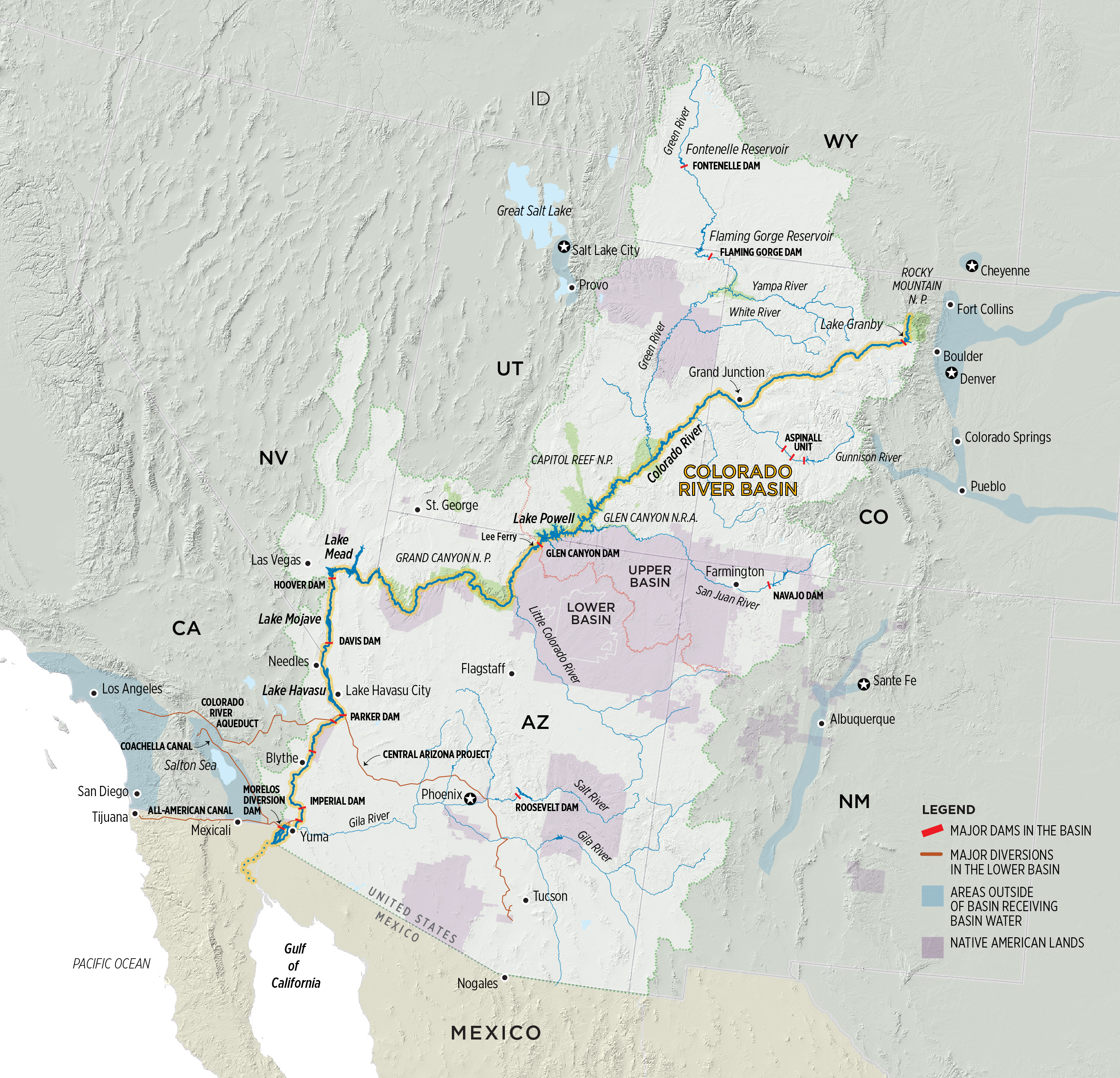
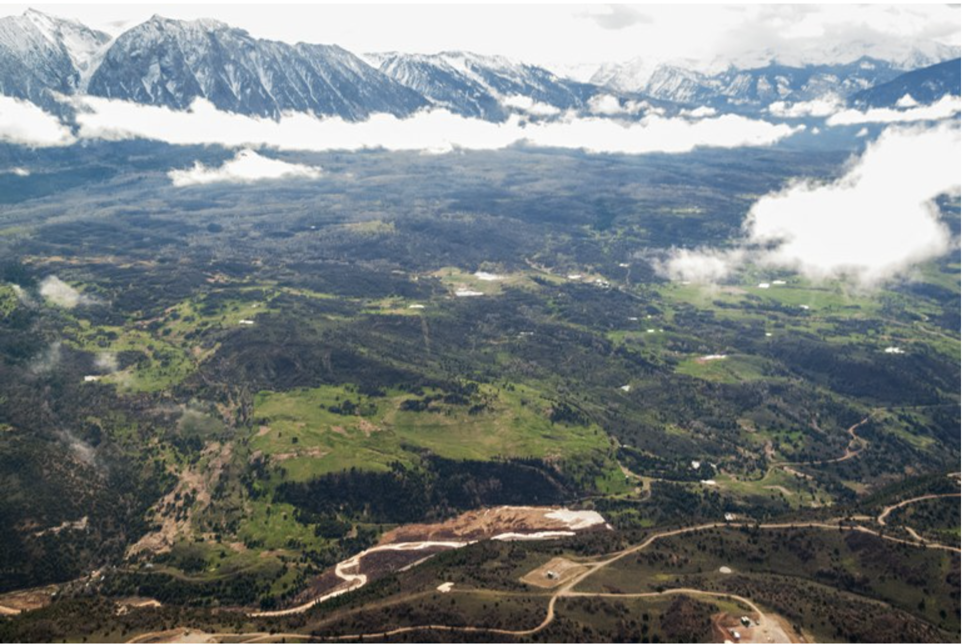
Seen from the air, Glen Canyon Dam holds back the Colorado River to form Lake Powell. The state of Colorado is looking into how to fund a program that would pay irrigators to reduce their consumptive use in order to send water downstream to a savings account in Lake Powell. Photo credit: Brent Gardner-Smith/Aspen Journalism
Water managers from throughout the Colorado River Basin took the stage at the Colorado River Water Users Association conference earlier this month to talk about conserving water in the face of the twin threats to the river: increasing demand and climate change.
The state of Colorado is currently exploring a water-use-reduction program that is largely designed to pay farmers and ranchers on the Western Slope to voluntarily conserve water. While there’s still debate whether such a program should be implemented, the first question many ask is how to pay for such a program. In recent months, some water managers have come up with innovative ways to fund the controversial water-use-reduction plan — known as demand management — that wouldn’t rely entirely on taxpayers.
The drought contingency plan, which water leaders inked at last year’s annual CRWUA meeting, set up a reserve account of 500,000 acre-feet of water that the Upper Basin — Colorado, Wyoming, Utah and New Mexico — could use to store water in Lake Powell as an insurance policy against dwindling reservoir levels.
In November, Colorado voters passed Proposition DD, which is projected to funnel roughly $16 million a year to the Colorado Water Conservation Board, or CWCB, by taxing sports betting. Demand management is one of the two things money from Proposition DD could fund (the other is Water Plan grants).
However, it’s widely accepted that $16 million is not enough to fund either of those things in their entirety. Demand management needs other sources of money.
Although the Glenwood Springs-based Colorado River Water Conservation District still isn’t convinced that a demand-management program is the right approach for the Western Slope, general manager Andy Mueller told the Las Vegas crowd that the Upper Basin has to reduce its water consumption — and explore creative solutions to accomplish that.
“I often talk about the Lower Basin overuse and how that’s driving the problem, and I will say they in the Lower Basin need to fix that problem,” Mueller said. “I will also say we in the Upper Basin … need to reduce our use. The science is pretty clear. Water we all thought was there even 15 years ago is not going be there. You can’t have water for the environment and the people if we are not reducing consumptive use throughout the basin.”
General Manager of the Colorado River Water Conservation District Andy Mueller speaks at the district’s annual seminar in 2018. Mueller told the audience the Upper Basin needs to reduce its consumptive use at the Colorado River Water Users Association conference in Las Vegas earlier this month. Photo credit: Brent Gardner-Smith/Aspen Journalism
Who should pay?
So, if nearly all water users on the Colorado River, including those in the Lower Basin — California, Nevada and Arizona — would stand to benefit from a demand-management program, who should pay for it?
Not Colorado taxpayers, Mueller said, at least not entirely.
“Eighty million (dollars) a year would need to be out there in payments to get the appropriate amount of water in Lake Powell,” he said. “That cost to taxpayers is too high. So you turn to: Who else benefits from us creating a storage account in Lake Powell?”
One answer: power providers in both the Upper and Lower Basin states, who all need Lake Powell to remain above 3,525 feet, the minimum level required to continue generating hydropower. Some Upper Basin power cooperatives such as Western Area Power Administration, which sell power to local communities, including Aspen and Glenwood Springs, purchase hydropower generated at Lake Powell. Adding a small demand-management surcharge to customers’ bills is something that should be explored, Mueller said.
“Power customers should share in the costs of us storing for demand management,” Mueller said.
Another potential source of funds could be nonprofit environmental groups, since sending more water downstream to Lake Powell would also benefit stream health. The federal government, whose Bureau of Reclamation operates Lake Powell and Lake Mead, also has a role to play, Mueller said.
But no matter where the money comes from, Mueller said it must be channeled through the CWCB in a heavily regulated market to prevent speculation by private buyers.
“We have been very clear it needs to be a guided market if it’s going to happen, with lots of thoughtful, proactive rules to prevent lots of serious consequences,” he said.
This field in lower Woody Creek is irrigated with water that eventually flows into the Colorado River. The state of Colorado is exploring how to fund a program that would pay irrigators to reduce their consumptive use in order to send water downstream to a savings account in Lake Powell. Photo credit: Brent Gardner-Smith/Aspen Journalism
State-led exploration
The CWCB currently has a workgroup devoted to exploring how to fund demand management. The group has met twice so far, but CWCB facilitator Anna Mauss said the two biggest questions the group is grappling with are these: how much water is needed and what would the cost be. The workgroup, she said, will dive deeper into funding strategies at the next meeting, scheduled for the end of January.
“We are baby-stepping into this, trying to be diligent,” Mauss said. “It’s really just looking at scenarios at this point.”
The state is also encouraging innovative ideas from the private sector. The CWCB recently awarded $72,000 to 10.10.10, a Colorado Nonprofit Development Center project that aims to tackle “wicked problems” in water and climate. Under the program, 10 entrepreneurs will, over 10 days, attempt to tackle 10 systemic issues that are not adequately addressed by government, organizations or institutions.
“Yes, we are looking at demand management, and it could be one of the wicked problems we address,” said Jeffrey Nathanson, president of 10.10.10.
Water from the Colorado River irrigates farmland in the Grand Valley. The state of Colorado is looking into how to fund a program that would pay irrigators to reduce their consumptive use in order to send water downstream to a savings account in Lake Powell. Photo credit: Brent Gardner-Smith/Aspen Journalism
Platform for payment?
While some people work on finding sources of funding, others are already creating a platform to pay irrigators once the money is in place. Southwest Colorado water managers Steven Ruddell and David Stiller think a reverse auction to compensate water users for using less is the best way to go.
A reverse auction, which features many sellers (farmers and ranchers) and one buyer (the state of Colorado through the CWCB), would allow water-rights holders to set the lowest price they are willing to accept to voluntarily send their water downstream. According to Ruddell and Stiller’s paper on the subject, a reverse auction would remove paying for demand management from a political process and move it into a market-based process that lets water-rights holders bid the fair-market value of their water. It would also keep costs down for the CWCB.
Ruddell and Stiller presented their reverse-auction idea at the Upper Colorado River Basin Forum at Colorado Mesa University last month.
“We’ve tried to bite off a small piece of demand management by suggesting we use an auction that people are familiar with,” Ruddell said. “It’s used to determine the value of something, especially in the ag world.”
There are still many questions surrounding how a demand-management program might be paid for.
“There are all sorts of options,” Mueller said. “We shouldn’t just focus on raising taxes in our state.”
Aspen Journalism collaborates with The Aspen Times and other Swift Communications newspapers on coverage of water and rivers. This story appeared in the Dec. 30 edition of The Aspen Times.
Click here to view the Twitter hashtag #CRWUA2019 from the conference.
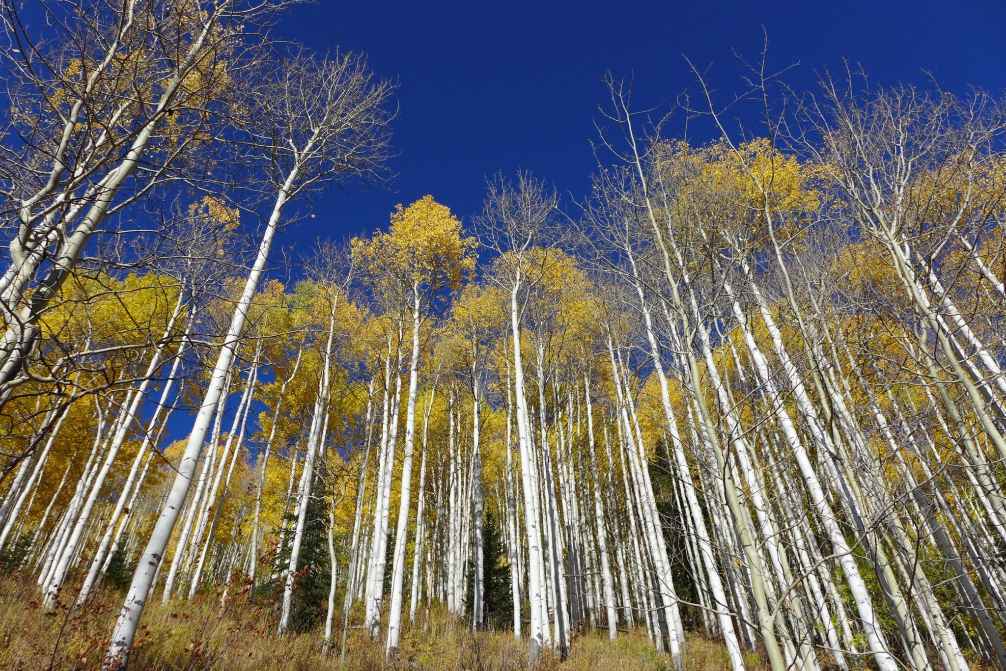
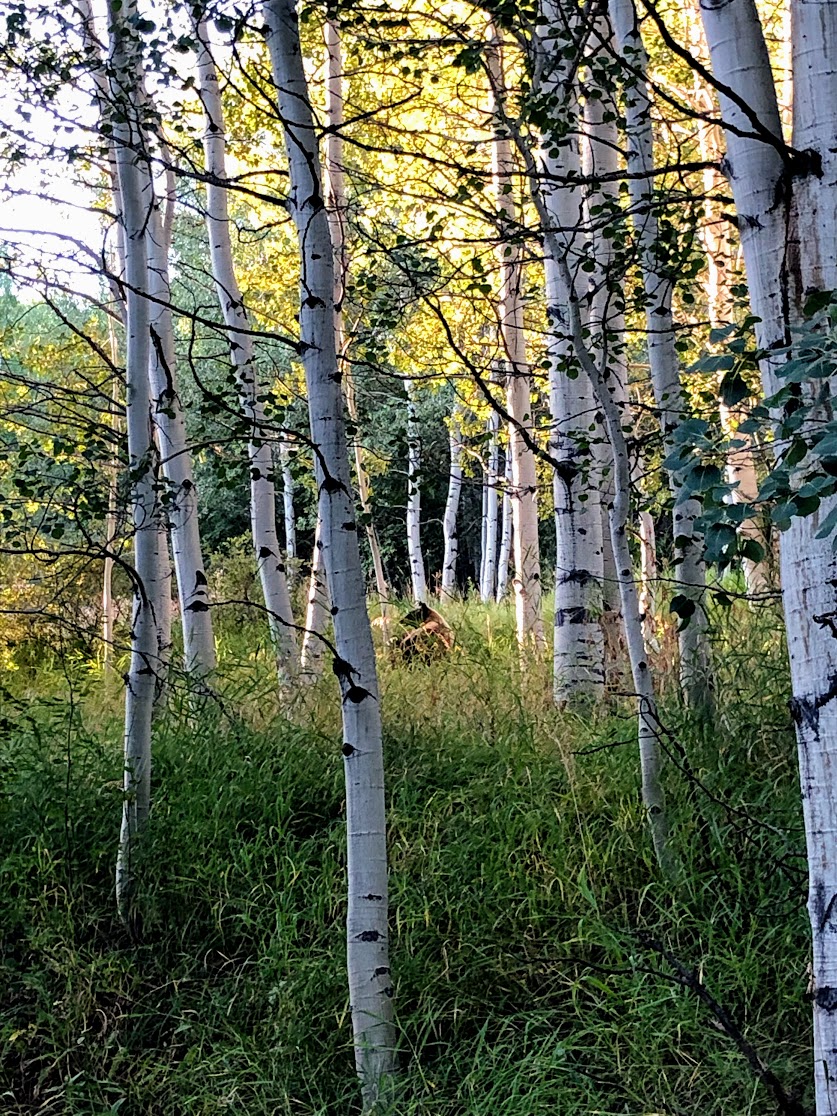
Aspen’s namesake trees, the quaking aspen, acts as a keystone species that sustains hundreds of other plants and animals. Aspens are also under stress from drier conditions, increased temperatures and over-browsing by large herbivores. Photo credit: Brent Gardner-Smith/Aspen Journalism
Just as new research shows that aspen forests are a fountain of biodiversity, Aspen’s namesake trees in the Roaring Fork River watershed are battling warming temperatures, drier conditions, climate disruption, and unchecked herds of deer and elk. Although local aspen forests are currently faring OK, they face serious challenges.
There are a few small aspen groves in Pitkin County’s Sky Mountain Park, tucked in valleys where there’s more moisture than what the surrounding oak brush needs— and Elise Osenga, a researcher at the Aspen Global Change Institute, keeps a close eye on these groves. Osenga leads a program that monitors soil moisture as part of efforts to better understand climate conditions in the Roaring Fork River watershed. Two of the monitoring stations — one at Sky Mountain and the other at North Star Nature Preserve — are in aspen groves.
“We are interested in seeing,” Osenga said, “if soils are consistently drier over time, are the aspen able to survive?”
There is not yet a long history of local soil conditions, but Osenga recently completed an assessment of the health of aspens near the two research stations.
“The good news of what we found is we didn’t actually find many dead trees at this point,” she said. But Osenga noted that aspens can die off in sustained droughts or even after just one or two really dry years. Additionally, as temperatures rise with a changing climate, the rain that does fall evaporates more quickly, further drying out soils.
Elise Osenga, a researcher with the Aspen Global Change Institute, walks among the aspens on the Airline Trail in Pitkin County’s Sky Mountain Park. She heads up a program to monitor soil moisture and climate conditions. Photo credit: Elizabeth Stewart-Severy/Aspen Journalism
Aspens thrive on disruption
Other local experts have found that there are local aspen groves that are struggling.
“It’s really those south-facing, dry slopes where the aspen decline is pretty evident,” said Adam McCurdy, forest programs director at the Aspen Center for Environmental Studies.
But overall, the local forests are faring pretty well, McCurdy said. In fact, aspens thrive on disruptions.
Dry conditions can mean increased risk of wildfire and bark-beetle infestations in evergreens, which thin forests and create openings for aspens to reproduce.
In the mountains around Aspen, avalanches have cleared paths for aspen trees to peek through evergreen forests, creating landscape-level diversity that benefits the local ecosystem.
“This really serves to break up the large stretches of what would otherwise be just spruce-fir forests and makes our forests more resilient to beetles and fire and all sorts of other disturbance,” McCurdy said.
Young aspen trees with massive leaves poke up through avalanche wreckage in Maroon Creek Valley in the summer of 2019. Aspens take advantage of sunlight to grow after disruptions like avalanches, wildfire or beetle outbreaks. Photo credit: Elizabeth Stewart-Severy/Aspen Journalism
Sunlight and moisture bring diverse life
Young aspens are already taking root in the paths cleared by last spring’s historic avalanche cycle — and creating space for all kinds of forest life.
Quaking aspen leaves let sunlight through the canopy, and the deep, rich soils under aspen communities hold more moisture than those in conifer forests. Such a combination of moisture and sunlight is the magic ticket for diverse life.
“Under aspen communities, there might be up to a hundred different plant species, and then some people have made tabulations of 50, 60 or more animals using aspen on a daily basis,” said Paul Rogers, director of Western Aspen Alliance, which coordinates research and management of aspen ecosystems across western North America.
A bear walks through an aspen grove in Snowmass Village this past fall. Bears are among dozens of animal species who use aspen communities. Photo credit: Elizabeth Stewart-Severy/Aspen Journalism
Research shows biodiversity benefits of aspen forests
Rogers co-authored a recent review of aspen research that contends that conservation of aspen ecosystems can benefit global biodiversity. Rogers and more than a dozen fellow researchers argue for a “mega-conservation” strategy: By sustaining the keystone aspen forests, a wide range of species would also be protected.
But, in addition to drier soils, aspen forests across the world are under stress from human activities such as mining, logging and urban development — as well as from some of the very wildlife they help support. Young trees are particularly nutritious and attractive to elk and deer, and herds sometimes stay in one spot for days, eating all the new shoots.
This results in an aging forest, and when the old trees start to die off, “you have a real problem,” Rogers said. “And so, if you combine that with drought, which is happening throughout Colorado, throughout the Western states, that is the biggest threat to aspen ecosystems.”
Reintroducing predators, such as wolves, could help — especially because when predators are in the area, herbivores can’t stay in one place long enough to overeat young trees, Rogers said. The reintroduction of wolves in Colorado is a contentious issue that is likely to be on the ballot in the fall of 2020.
Rogers also noted that Colorado Parks and Wildlife managers have increased the targeted size of elk herds over decades. The population goal for the Avalanche Creek elk herd, for example, increased from 3,300 in 1988 to a range of 3,600-5,400 in 2013.
“We’ve taken away predators, for the most part, that are going to keep those populations in check, but we’ve also managed those big herbivore populations for economics, quite frankly,” Rogers said. “Every state sells hunting licenses, and so to keep those revenues up, they keep those populations high. And those high populations have an impact on ecosystems.”
Editor’s note: Aspen Journalism collaborates with Aspen Public Radio and The Aspen Times on coverage of the environment. A version of this story aired on APR on Dec. 27 and this story ran in the Dec. 29 edition of The Aspen Times.
From the Associated Press via The Colorado Sun (Jesse Paul):
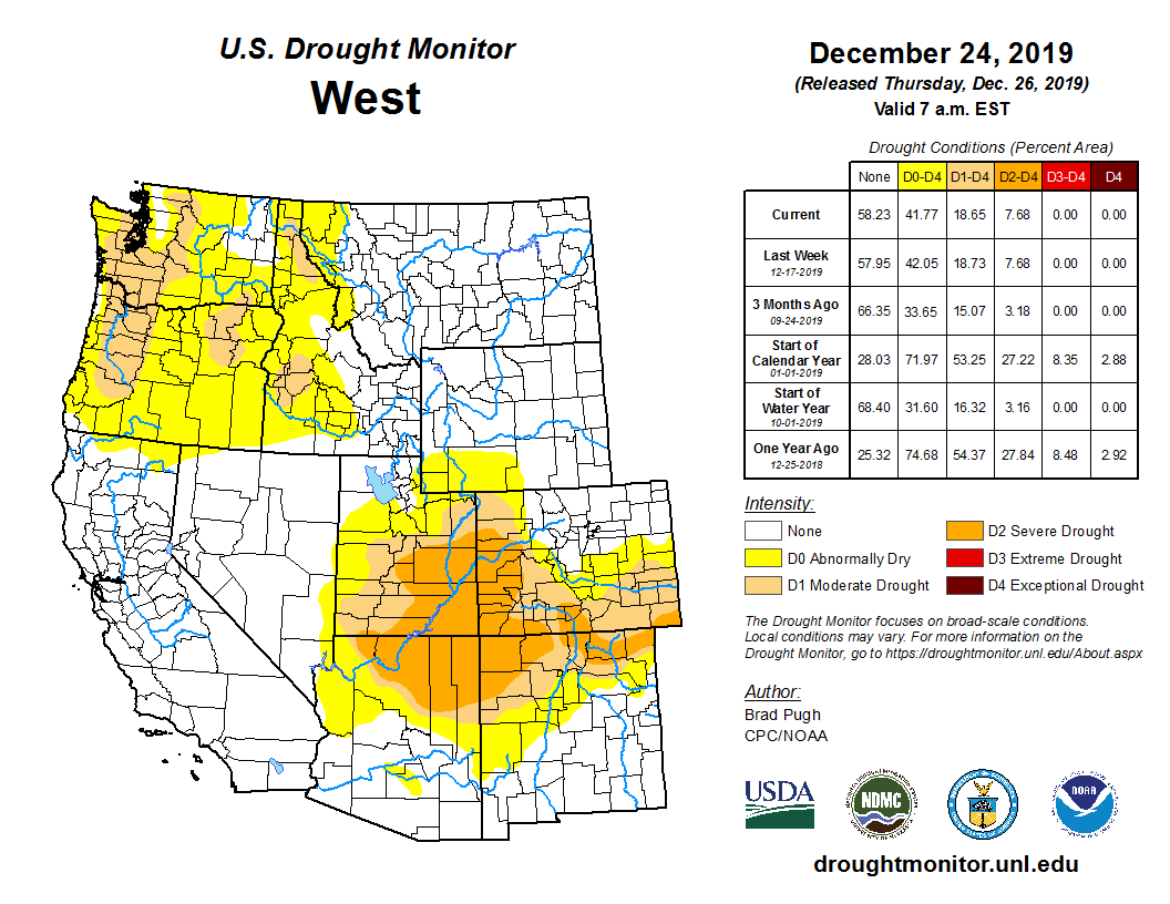
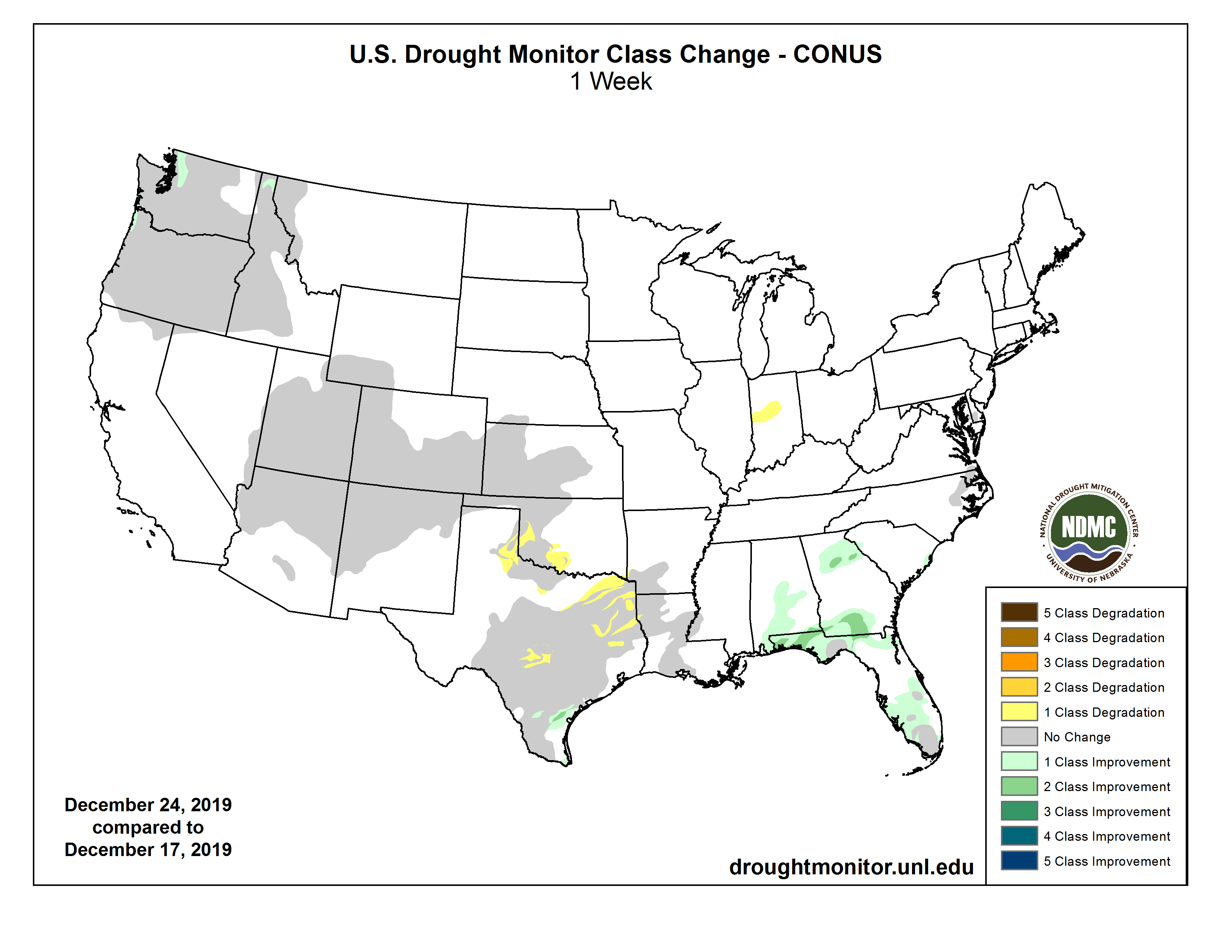
The latest federal map shows a pocket of moderate and severe drought centered over the Four Corners region — where Arizona, New Mexico, Colorado and Utah meet.
A large part of Colorado’s western slope, including much of the southwestern part of the state, were listed Thursday by the U.S. Drought Monitor as being in severe or moderate drought.
In fact, only the northeast section of the state, including the Denver metro area and the northern mountains around Steamboat Springs, are not under some kind of drought listing.
In all, nearly 70% of Colorado is abnormally dry or in moderate or severe drought, according to the U.S. Drought Monitor. A year ago, roughly 85% of the state had some kind of drought status, including 11% that was listed as being in exceptional drought…
Overall, officials say average moisture levels resulting from snowfall are above normal across Arizona, New Mexico and Utah despite precipitation deficits that have accumulated over the last six months.
Across the metro area, a widespread 2-5 inches of snow fell on Friday night and Saturday, including an official total of 2.8 inches at Denver’s official climate site at Denver International Airport.
A few spots picked up above five inches of snow, mainly along the typically snowier Palmer Divide, and in the foothills. One 12-inch snow total was reported near Conifer, by far the highest across the area.
With 2.8 inches of snowfall, though, Denver’s seasonal snowfall is now up to 29 inches, which means that the city will now close out December over six inches above average so far this season. Those figures are based on official observations taken at Denver International Airport.
At the more centrally-located old Stapleton Airport climate site, 2 inches of snow fell between Friday night and Saturday, bringing that climate site’s seasonal snowfall total to 32.2 inches so far this season. That’s closer to 10 inches above average so far this season, despite an overall slow December.
Most of this season’s Front Range snowfall, of course, came during an unusually busy October and November. Denver officially saw 26.2 inches of snow between October and November, making it the fastest start to a winter season in a decade. Most of December along the Front Range has, however, been dominated by a dry and mild weather pattern, though the mountains have continued to pile up big snow totals throughout the winter season.
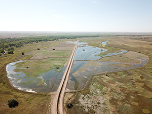
Photo of wetlands at Eliott State Wildlife Area courtesy of Ducks Unlimited via Colorado Parks & Wildlife.
Here’s the release from Colorado Parks & Wildlife (Travis Duncan):
Colorado Parks and Wildlife is celebrating 30 years of the North American Wetlands Conservation Act this month. NAWCA, signed in December 1989, provides financial support for waterfowl habitat that also supports a multitude of other wetland-related wildlife species. NAWCA provides matching grants to wetlands conservation projects in the United States, Canada, and Mexico. Over the past three decades, the acquisition and restoration of wetland habitat have provided healthy wetlands where:
waterfowl populations have grown,
waterways and water sources are cleaner,
and recreation opportunities (birding, hunting, hiking and boating) have all increased.
NAWCA grants increase bird populations and wetland habitat, while supporting local economies and American traditions such as hunting, fishing, bird watching, family farming, and cattle ranching. Wetlands protected by NAWCA provide valuable benefits such as flood control, reducing coastal erosion, improving water and air quality, and recharging groundwater.
In the past two decades alone, NAWCA has funded over 2,950 projects totaling $1.73 billion in grants. More than 6,200 partners have contributed another $3.57 billion in matching funds to affect 30 million acres of habitat.
Since it began 30 years ago, NAWCA funds have contributed $25 million to Colorado’s wetlands.
“Colorado Parks and Wildlife’s Colorado Wetlands for Wildlife Program has been able to leverage annual grant funding from Great Outdoors Colorado to expand the scope of projects in Colorado that are eligible for matching grant funding under NAWCA,” said CPW Wetlands Program Coordinator Brian Sullivan. “These funds are critical to our ability to conserve wetlands in Colorado.”
“Funding from the North American Wetland Conservation Act was critical to the success of our Rio Grande Initiative to protect 25,000 acres of private ranchland along the Rio Grande and its tributaries,” said Allen Law, Executive Director of the Rio Grande Headwaters Land Trust. “Conservation easements on these ranches helped our agricultural community while permanently protecting thousands of acres of Colorado’s most resilient and important wetlands.”
Below are some examples of NAWCA-funded projects in Colorado
Elliott State Wildlife Area Shallow Water Wetlands – Completed September 2018
Elliott State Wildlife Area (SWA), adjacent to the South Platte River near Brush, Colorado is a complex of numerous shallow wetlands that are flooded in the spring and fall utilizing Union Ditch water rights for migratory bird habitat and fall public recreation. Unfortunately, many of the basins contained deep, scoured areas that tended to pool deep water, which then limited the capacity of the entire flow-thru complex and greatly hampered bird and hunter use.
Ducks Unlimited, Inc. (DU) utilized their professional expertise to engineer and regrade 15 of the existing basins, amounting to roughly 200 acres of wetlands. For this project, DU developed a professional engineering plan set that established ideal grading across 15 of the basins, amounting to roughly 200 acres of wetlands. DU then bid, contracted, and managed heavy equipment operators to fill and redistribute soil in the basins in order to disperse water better and provide additional flooded habitat.
CPW staff also worked to refurbish the water delivery ditch and diversion structures, and improve the water management structures between basins. NAWCA funds of more than $150,000 secured by DU were matched by CPW and Great Outdoors Colorado contributions of nearly $75,000 to enable this project.
The benefits of this partnership project are widespread, including increased habitat acres, higher quality recreation opportunities, more efficient water use and improved management capacity.
Cross Arrow Ranch Conservation Easement – Completed September 2009
Lying at the confluence of the Rio Grande and Conejos River, the Cross Arrow Ranch conservation easement held by the Rio Grande Headwaters Land Trust (RiGHT) protected 3,238 acres of productive ranchlands along with senior water rights. Over 2,000 acres of this property are wetlands, which provide habitat for a wide variety of migratory birds like waterfowl, sandhill cranes, and the endangered Southwestern Willow Flycatcher.
Conservation easements are important to wetland conservation in the San Luis Valley because over 90% of wetlands regionally are on private lands. Similarly, the most resilient wetlands are on private lands because senior water rights and flood irrigation boost wetland function, especially during drought years. Conservation easements protect these critical habitats from fragmentation, water export, and residential development.
To preserve the wetlands on this spectacular ranch forever, NAWCA funding secured by RiGHT was matched by generous contributions from the landowners, Great Outdoors Colorado, and the Nature Conservancy.
Learn more about the 30th anniversary of the North America Wetlands Conservation Act by visiting http://nawmp.org/nawca30.
I think Greg likely sleeps with his camera at his side. He certainly has it with him most of the time during his waking hours.
This is the season, the table has set!
In the valley of the Arkansas/Huerfano
this is the season the table has set
and the fields and the ditches
Fallow for the coming green,
hail the snow geese
Look up!
You can hear them
before you can see them
Veering across the High Plains
wave on wave risen in the glow of silos
The Spanish Peaks, Pike’s Peak shimmering on
our own tables, we thank you for this food
these blessings you, your neighbors bring us!
(Christmas at son Dan’s and daughter-in-law Nanna’s farm Avondale) — Greg and Bobbie Hobbs 12/25-26/2019
Back Row Left to Right: James Eklund (CO), John D’Antonio (NM), Pat Tyrell (WY), Eric Melis (UT), Tom Buschatzke (AZ), Peter Nelson (CA), John Entsminger (NV), Front Row: Brenda Burman (US), and from DOI – Assistant Secretary of Water and Science Tim Petty. Photo credit: Colorado River Water Users Association
Opinion: Think we’re too polarized to do anything meaningful? Tom Buschatzke and Ted Cooke prove that even those who disagree can work together.
The Lower Basin Drought Contingency Plan is nothing short of historic.
Not necessarily because it’s a good deal. The multi-state agreement, which was signed in May, is costly and doesn’t solve any of the problems that threaten the Colorado River, which supplies about 40% of Arizona’s water supply.
DCP is monumental because it proves that people with wildly different viewpoints can learn to work together and accomplish things that matter. Even now, despite how divided our country has become.
California, Nevada and Arizona agreed to leave water in Lake Mead to keep it from reaching catastrophically low levels. Arizona also created its own plan to lessen the impact of those cuts on Pinal County farmers, who would have been heavily impacted by the deal.
That was a massive lift. Ironically, though, it probably never would have come together if two guys hadn’t decided to bury the hatchet – and in doing so, led a group of vastly different water interests to a deal they could all support.
A panel of officials from the lower basin states at the Colorado River Water Users Association in Las Vegas, on Dec. 13, 2018. From left, Thomas Buschatzke, director of the Arizona Department of Water Resources; Ted Cooke, General Manager, Central Arizona Project; Peter Nelson, chairman, Colorado River Board of California; and John Entsminger, General Manager, Southern Nevada Water Authority.
It’s why Tom Buschatzke, director of the Arizona Department of Water Resources, and Ted Cooke, general manager of Central Arizona Project, are The Arizona Republic’s 2019 Arizonans of the Year.
Their agencies had locked horns over the deal’s basic details, including how to manage water levels at Lake Mead. Dueling op-eds were published in The Republic, with Buschatzke vowing not to sign CAP’s proposed plan.
Then, in May 2018, after water bills stalled in the state Legislature, Buschatzke and Cooke decided to become Switzerland – and agreed to co-chair a steering committee that produced an insane amount of water policy in a matter of months.
“It wasn’t like Switzerland,” Cooke said in a joint interview with Buschatzke. “It was as if the two most visible combatants agreed to put down their swords and take another approach.”
Their first few appearances were awkward. Words were chosen carefully. There was a palpable tension lying just below the surface, and the long hours and tense negotiations took a toll on the pair, who by February looked pale and gaunt, like they had been through the war.
But that tension helped bring the deal together.
Their example spread behind the scenes
There were a lot of strange bedfellows working on this deal, groups that had vastly different ideas about who should get the water and how it should be used. Yet they kept trading ideas, even when many felt the effort was DOA.
Some later said they were compelled to keep at it when talks broke down (and they broke down a lot) because of the example Buschatzke and Cooke were setting.
It was a poorly kept secret that their partnership had its share of “lively discussions behind closed doors,” as Buschatzke characterized it. But Buschatzke and Cooke said they were going to work together for DCP’s sake – and everyone involved knew they meant it.
There were many other players who orchestrated major compromises behind the scenes, including Paul Orme, an attorney representing Pinal County irrigation districts, and HighGround, a public-affairs consulting firm that for two years facilitated meetings between cities and farmers.
Without their efforts, this deal would not have come together.
Equally instrumental were those who put money and water on the negotiation table, including the governor, non-profit environmental groups like the Environmental Defense Fund and the Gila River Indian Community. In fact, Arizona’s plan is one of the first major Western water agreements where tribes were actively involved and treated as key players in the deal.
No one was willing to let the effort die
That’s what makes DCP so remarkable.
It’s easy to dig in on water rights, and historically, disputes over limited supplies have devolved into a zero-sum game.
Yet farmers, cities and tribes made sacrifices and compromises that might not necessarily be in their best interests because they knew that being left out of the regional deal would put everyone’s water at risk.
When talks started to get off track, Gov. Doug Ducey wrote an op-ed that spelled out the principles that should be guiding the effort.
Few people liked the plan CAP passed to spare farmers from such drastic, immediate cuts. But it served as a catalyst for the plan that ultimately succeded.
Lawmakers were heavily involved – which was critical, considering they ultimately had to pass the plan – and in addition to the countless meetings that occurred behind closed doors, stakeholders met frequently in public to hold each other accountable.
These lessons have been noted repeatedly in committees that are tackling the state’s next big water crisis, a depleting groundwater supply.
Even now, collaboration continues
Even better, the working relationships that were created during DCP have continued far beyond the state’s many study groups.
The math driving DCP works only if Pinal farmers drill wells to use once their Colorado River water goes away. That means farmers will soon be pumping a lot more from an aquifer that ADWR contends does not have enough water to support everyone for the next 100 years.
Though the Legislature earmarked some cash to refurbish and relocate the wells farmers need, the project also relies on federal funding to be completed quickly.
Irrigation districts knew they would need partners to compete for that cash and began working with universities, municipal water providers, conservation districts, environmental groups and others, who have all ponied up cash to match the grant. They also have expanded the project, earmarking additional funds for farmers to experiment with low water-use crops and irrigation techniques.
According to the grant application, the goal is to involve at least 6,000 acres in these low water-use projects. The newly drilled wells also will help entities like CAP recover water they had previously stored underground for times of shortage.
This is about more than water policy
That’s a better solution than what we arrived at during DCP negotiations – one that aims to reduce the impact of groundwater pumping and spread use of the wells to more than just farmers.
And it’s yet another model that Arizona can point to as it works through water problems (or any problems, for that matter).
DCP is historic – and the example set by Buschatzke and Cooke is worth lauding – not because everyone is suddenly on the same page about our water future. Deep disagreements remain.
DCP matters because it proves that people with vastly different interests can get in a room and talk it out, maybe even shout it out in private. But they keep talking to each other. Keep looking for solutions they can live with, even if the ideas aren’t perfect.
Because they know that’s how you accomplish meaningful things.
This is an opinion of The Arizona Republic’s editorial board.
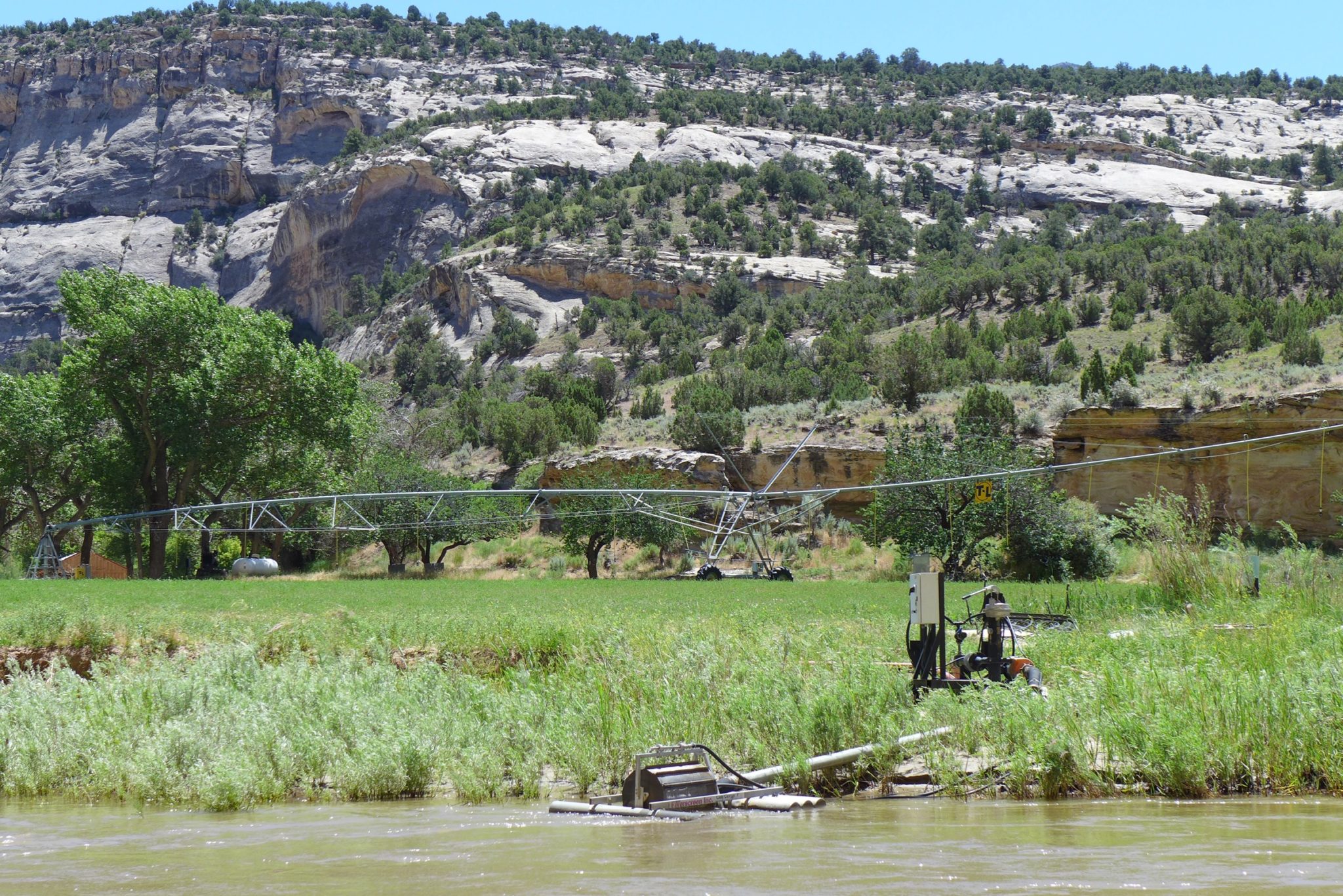
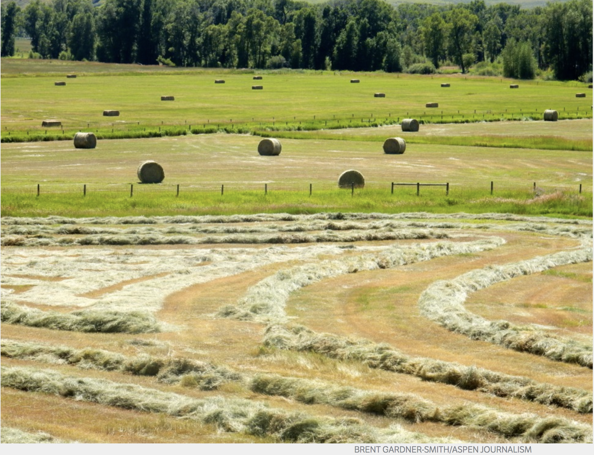
Irrigated pasture at Mantle Ranch along the Yampa River. Ranchers in the Yampa River basin are grappling with the enforcement of state regulations that require them to monitor their water use. Photo credit: Brent Gardner-Smith/Aspen Journalism
Irrigators in Northwest Colorado are facing a sea change in how they use their water, and many ranchers are greeting such a shift with reluctance and suspicion.
The final frontier of the free river, irrigators in the Yampa River region have long used what they need when the water is flowing with little regulatory oversight. Water commissioners have been encouraging better record keeping in recent years, but a first-ever call on the system during the 2018 drought led state officials to begin enforcing requirements to measure and record water use.
State law requires all irrigators to maintain measuring devices on their canals and ditches. Kevin Rein, state engineer and director of the Colorado Division of Water Resources, said such devices are widely used in other river basins throughout Colorado, where bigger populations and more demand for water have already led to stricter regulation of the resource. The Yampa River Basin is the last region to get into compliance, Rein said.
“The basin went under call for the first time in 2018,” he said. “I would not call that a driving force; I would call that affirmation of why it’s been important … to do this for so many years.”
Nearly 500 Yampa River Basin water users were ordered this fall to install a device by Nov. 30, although irrigators don’t need to comply until spring 2020, when irrigation water begins to run. Those without devices won’t be allowed to use their water and could be fined $500 daily if they do.
The new enforcement is being met begrudgingly by irrigators, many of whom are third- and fourth-generation ranchers and whose families have never measured and recorded water use in more than 100 years.
“Ever since the 1880s, there has never been a call on the Yampa River,” said Craig cattle rancher Dave Seely. “If there wasn’t any water, (ranchers) accepted the fact, so it’s unusual that suddenly we have all this coming down on us now.”
A call on the river occurs when someone with senior water rights isn’t receiving their full allotted amount, and the state places a “call” for users with junior rights to send more water downstream or stop diverting altogether. The move triggers administration of the river by state water commissioners, who make site visits to monitor how much water is flowing through each ditch.
A hayfield in the Elk River Basin, a tributary of the Yampa River. A first-ever call on the Yampa River in 2018 is leading state officials to enforce regulations about measuring water. Photo credit: Brent Gardner-Smith/Aspen Journalism
Government oversight
An air of the Wild West still lingers in this sparsely populated corner of the state, where many ranchers would rather accept a shortfall than invite the government into their affairs by making a call for their water.
“They just took it on the chin and dry farmed,” Seely said.
State officials have seen this resistance to change before and accept it as a matter of course.
“It’s a rough, rocky road at first, but after a while, I think a lot of people will be glad they have a device there,” said Erin Light, Division 6 engineer with the Division of Water Resources.
Light and her colleagues reminded irrigators at the Yampa-White-Green Basin Roundtable meeting in November that keeping accurate records helps protect their water right, since rights are considered abandoned if not used, although the state rarely enforces this.
“Your water right has a value, a value to water your livestock or your crops, but it also has a dollar value for your heirs,” Scott Hummer, a Division 6 water commissioner, said at the meeting. “The only way they have to sell the water or get a price for the water is if the engineers know how much water is consumed by your crop.”
But many irrigators feel mistrustful of state government having more oversight of their water and are worried that outside entities may have designs on the region’s largely unallocated resource. Climate change has led to hotter, drier conditions over the past 20 years, and growing populations have increased the demand for water — both in the Colorado River Basin and along the Front Range.
“It just raises the question of what’s the drive behind it,” said third-generation Yampa cattle rancher Philip Rossi. “It’s hard to have an opinion when you don’t fully understand the long game.
“They’re trying to put a monetary value on water,” Rossi said. “Are they trying to get a better understanding of exactly how much water there is … so they can put a value on it if they want to sell it? Are we helping ourselves, are we hurting ourselves, are we helping them? There’s so many of us that are not interested in selling our water.”
Other ranchers are concerned that increased oversight could mean new restrictions even when water is plentiful. Many are in the habit of using as much water on their fields as they need, regardless of their decreed right.
“When the water’s high, we want to get it across our fields quickly, so we take more water than (our allotted right),” said John Raftopoulos, a third-generation cattle rancher in western Moffat County. “The fear is that, even with high water, they’re going to cut you down to the maximum you can take … that they’ll regulate you to the strict letter of the law.”
An irrigated hayfield along the lower Yampa River. If irrigators don’t install measuring devices on their diversions by the spring irrigation season, they could be fined $500 a day. Photo credit: Brent Gardner-Smith/Aspen Journalism
No waste
Rein said users could continue using more than their allotted right when the river is a free river — in other words, not under a call — as long as they are not wasting it.
“There’s a statutory term called waste; you can’t divert more water than you can beneficially use,” Rein said.
He also said keeping accurate records would only protect the water user as demand increases statewide and across the West.
Measuring devices cost from $800 to $1,500, so installation can get expensive for the many ranchers who have more than one ditch. Rossi has three more devices to install. Raftopoulos has about five others, for a total of 15 on ditches irrigating roughly 2,500 acres of grass hay and alfalfa.
Light estimated 100 irrigation structures had requested extensions — which she is granting in many cases until either July 31 or Oct. 31 — but she won’t have an accurate count on how many ditches are in compliance with the orders until May or June.
“It’s something that was going to happen sooner or later because of water shortages. That’s the system, that’s the law,” Raftopoulos said. “It’s a burden right now, it’s expensive and it’s going to put more government in our ditches. There’s going to be more people watching what comes out.”
Aspen Journalism collaborates with the Steamboat Pilot and Today, the Craig Press and other Swift Communications newspapers on coverage of rivers and water. This story appeared in the Dec. 27 edition of the Steamboat Pilot and Today.
In a seven-page ruling, Boulder District Judge Andrew Macdonald stated that based on evidence placed on the record by both sides in the controversy, he found Boulder County “did not exceed its jurisdiction or abuse its discretion, or misinterpret or misapply the law,” when it asserted its permitting authority.
That authority, Boulder County has maintained, is established by State House Bill 1041, passed by the Legislature in 1974, which allows local governments to review and regulate matters of statewide interest through a local permitting process.
Denver Water challenged that authority by filing suit in Boulder District Court in April of this year, claiming what it termed a “zoned law exemption” which it asserted excused it from having to pass through the county process. Denver Water’s complaint claimed the zoning at the reservoir that existed at the time of the passage of the 1041 legislation — officially known as the Activities and Areas of State Interest Act — permitted its planned activities.
Additionally, the suit stated Boulder County commissioners had exceeded their jurisdiction and/or abused their discretion at a March 14 hearing at which they unanimously upheld Land Use Director Dale Case’s finding that the county review process must apply to Denver Water.
Macdonald’s ruling struck down Denver Water’s claim to an exemption based on prior zoning.
“There is nothing on the record that Denver Water had any well-established development rights to expand Gross Dam and Gross Reservoir prior to May 17, 1974,” he ruled. “Any prior contemplated expansion projects cannot be determined to be well-established development rights because the proposed Expansion Project is essentially an entirely new construction project.”
[…]
In an email Friday night, Denver Water spokesman Travis Thompson said, “As we continue to follow the process of determining the appropriate permitting methods, we will review the order and evaluate our next steps. No matter the path forward, we remain committed to considering input from Boulder County and from community members to minimize and mitigate the impacts of the Project.”
An additional hurdle remains for the project. Denver Water is still waiting for a final decision by the Federal Energy Regulatory Commission on a hydropower licensing amendment that Denver Water needs in order to go forward with its planned expansion of the reservoir.
Denver Water’s collection system via the USACE EIS
Plans to build a diversion dam on the Gila River in southwestern New Mexico have hit another snag. The Interior Department has denied a state entity an extension to receive $56 million in diversion construction funds.
The New Mexico Central Arizona Project Entity still has nearly $70 million in the New Mexico Unit Fund for a Gila diversion and regional water projects. But the loss of more federal money means less infrastructure, and less water that could be diverted from the river. In 15 years, the state has spent nearly $15 million planning for a diversion.
Under the Arizona Water Settlements Act of 2004, the CAP Entity had until the end of this month to receive a federal record of decision on environmental impact statements to obtain $56 million.
CAP Entity Executive Director Anthony Gutierrez and lawyer Pete Domenici Jr. visited Washington, D.C., in October to petition for an extension.
Timothy Petty, Interior’s assistant secretary for water and science, informed the state of the decision on Dec. 20.
Petty said in a letter that New Mexico’s “slow pace of progress” on the diversion plans showed a “lack of urgency” for delivering water to rural communities.
“Even today, a feasible project with necessary funding and contractual commitments has not been identified to enable project success,” he wrote. “It’s a disappointment this project, that would bring critical water supplies to rural communities in New Mexico, has faced such scrutiny and a lack of support from the State of New Mexico.”
Several alterations to the diversion plans were made as recently as July. The changes slashed project cost estimates by about $83million but also reduced the amount of water that could be diverted from the Gila.
Some Colorado River water users in 2020 will begin taking voluntary reductions to protect the water elevation level at Lake Mead. (Source: Bureau of Reclamation)
The Southern Nevada Water Authority has expressed interest in helping finance a wastewater reuse project being pursued by Southern California’s municipal wholesale water provider.
The goal: To free up Colorado River water.
The concept looks something like this. If the Metropolitan Water District of Southern California (MWD) could recycle a portion of its water, it could reduce its overall consumption of Colorado River water stored at Lake Mead. In turn, the water authority would help fund the project in exchange for additional water that MWD would be able to leave in the reservoir because of it.
Such a project is in the early stages, and it could take at least a decade to build out. Still, the water authority and MWD are actively discussing a potential partnership. John Entsminger, the water authority’s general manager, said he hoped there would be a preliminary deal next spring…
If the project moves forward, it would cost about $3.4 billion, recycling water for about $1,800 per acre-foot, Hasencamp said. It has not yet been determined what Nevada’s financial contribution would be. The project would still need to be approved by both the water district’s full board the MWD board.
The project is similar to other water-swapping proposals. Minute 323, a binational agreement between the United States and Mexico, tasked a working group with studying desalination plants. New supplies would allow Colorado River users to more easily exchange water at Lake Mead.
Water is essential to life. Yet in the eyes of the law, it remains largely unprotected — leaving many communities without access to safe drinking water, says legal scholar Kelsey Leonard. In this powerful talk, she shows why granting lakes and rivers legal “personhood” — giving them the same legal rights as humans — is the first step to protecting our bodies of water and fundamentally transforming how we value this vital resource.
Here’s a report from Michael Cox that’s running in The Montrose Press:
Prior to the Great World War (great only signifying size and intensity), one of the most productive pieces of land on the Western Slope of Colorado was regularly converted to a destructive river of Spring snow or Summer storm runoff from the Uncompahgre Plateau.
The Shavano (shav-a-no) Valley was named for a Ute Chief, and was either visited or inhabited by native peoples as early as 3,000 years ago. The Ute’s came about a thousand years ago. It was fine winter ground and in spring and summer the grass was lush, affording excellent feed for the tribe’s livestock.
American settlers came in the late 1800s and found the Valley to have the most fertile and easy-to-till soil in the area. There was also a bit of water from an artisian spring that feed a meandering creek. There is an excellent explanation for how the soil developed in the valley. In all probability, it was those regular floods that swept from the plateau and covered much of the Valley, at various times of the year, in water. Along with the water, the floods were depositing a new layer of silt to the already deep soil.
But enough is enough already. By the late 1930s and early 1940s the farmers in the Valley grew weary of rebuilding and reclaiming after the floods. The damage to their infrastructure was immense and included dead livestock, ruined roads, and lost homes. The locals tried some small diversions, dykes, and flood ways, which had only minimal effect. The task was tantamount to parting the sea, but Moses and his stick were nowhere nearby. Enter the Shavano Conservation District, a cooperative of farms and ranches joining together and forming the district with the idea of petitioning the Bureau of Reclamation to help put up some defenses against the floods.
“The farmers had figured out that they needed some serious diversion dams along the west side of the Valley,” says Mendy Stewart the Shavano District chief of education and communication. “But they had neither the tools nor the money to build them.”
In May of 1937, the Shavano Soil Conservation District (SSCD) was organized under the Colorado Soil Conservation District Act. By October of 1941, the intensifying world war not withstanding, the district plan got the nod from 111 landowners, representing 20,200 acres in Montrose County.
Eventually, two other smaller districts, the Uncompahgre and the Cimarron, joined the Shavano group – soil conservation became a way of life. Now the district covers 1.2 million acres in Montrose, Ouray, Gunnison and Delta counties. The Delta County segment is a tiny bit of acreage on the Montrose/Delta County line. In 2002 the District dropped the use of the word “soil” from the name as did other such entities across the country…
Eventually, with grants from the Bureau of Reclamation and using the equipment and manpower pool of the district, three diversion dams were built to stop the wild flow off the plateau and divert it into ditches. This kept the flood waters off the farm land and out of the homes and barns in the Valley.
The largest of the three dams is at the south head of the Valley and involves an earthen structure measuring more than a half mile from one end to the other. The spillway and some of the dam are concrete reinforced. The runoff from the Plateau collects behind the dam. The flow out of the pool is controlled and put into ditches, such as the M&D canal below the dam…
According to Stewart the list of things the SCD is involved in includes irrigation water management, flood control, technical assistance with conservation efforts, youth and adult environmental education, and special projects such as the Western Colorado Soil Health Conference. The 2020 conference is scheduled for February 20 and 21 at the Delta Center for the Performing Arts.
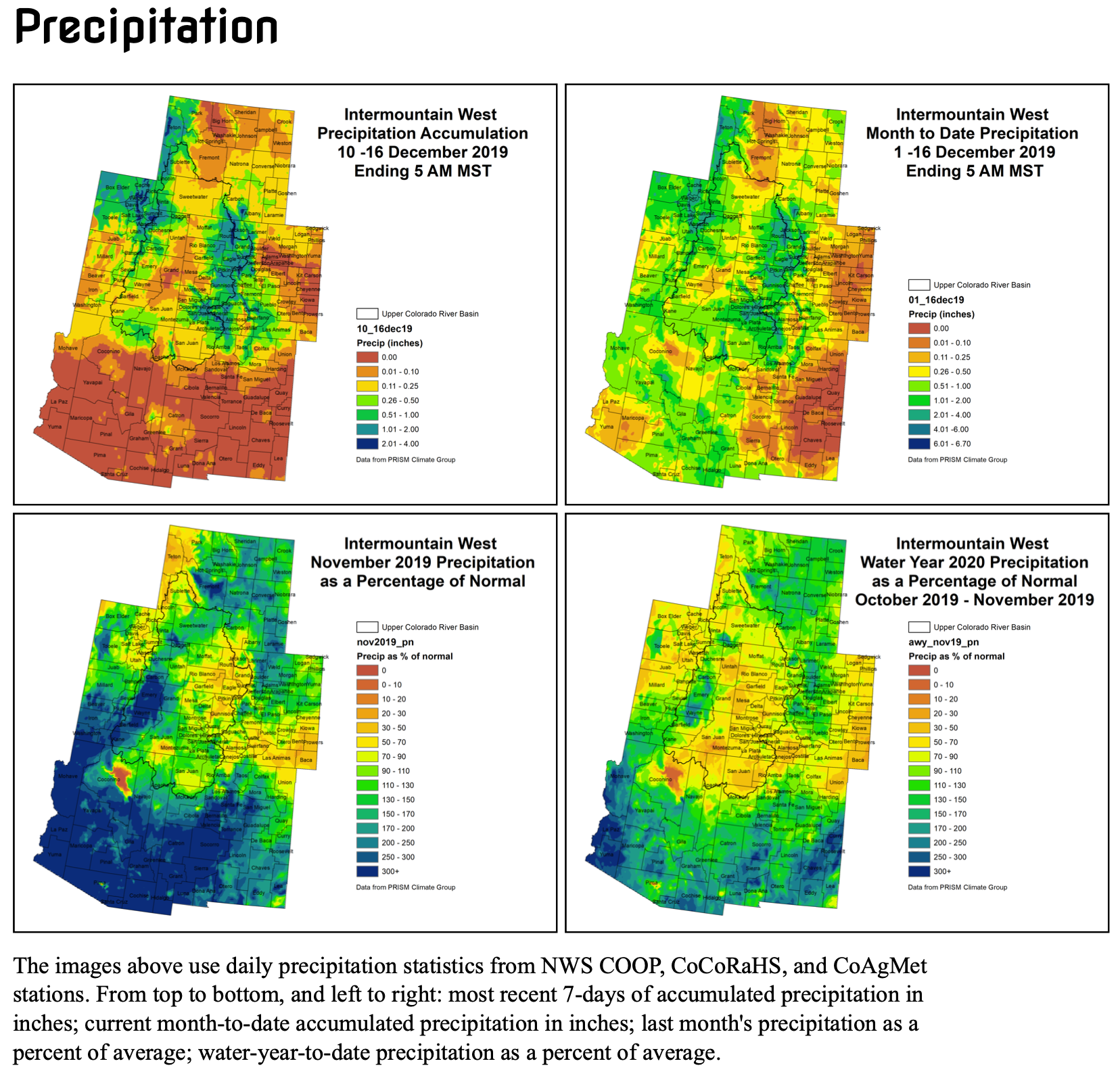
Click here to go to the NIDIS website hosted by the Colorado Climate Center. Here’s the summary:
Summary: December 23, 2019
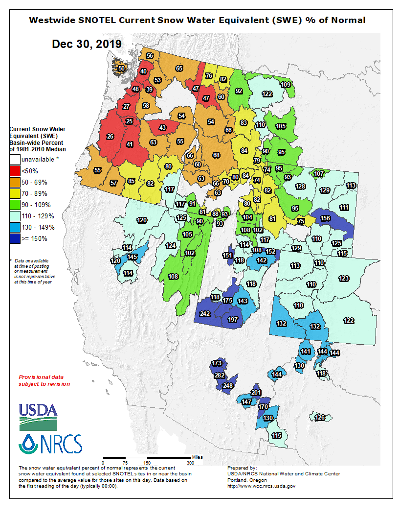
The last week over the Intermountain West has been a fairly quiet one, with almost no precipitation falling throughout the region. Temperatures across the Upper Colorado River Basin were near to slightly cooler than average. Month-to-date, the higher elevations of the IMW have received between 1 and 3 inches of precipitation, with the lower elevations mostly getting less than half an inch. This is a pretty normal pattern for this time of year, although most areas are a bit drier than average for the month. Despite that, 30 and 60 day SPIs look pretty good for the entire region, with some drier 60-day SPIs creeping into northwest Wyoming.
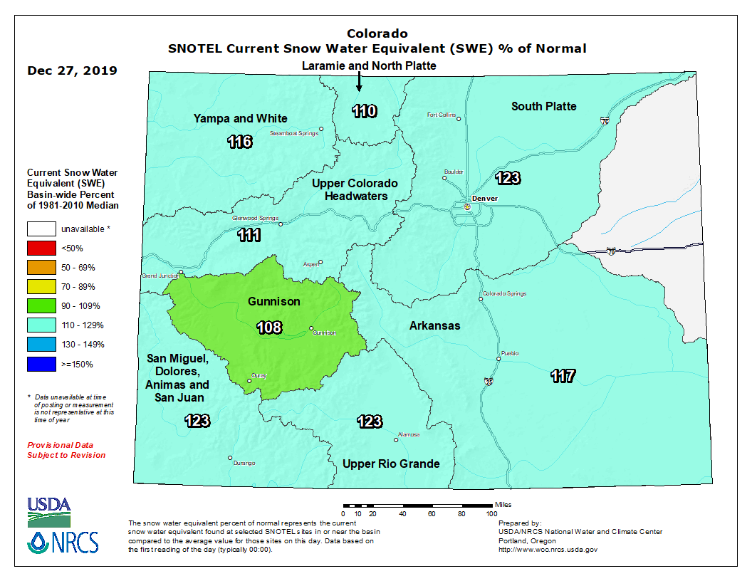
SNOTEL snowpack for the Intermountain West is off to a good start, with basin-wide averages ranging from near average in western WY to almost 200% of average in southern Utah. Individual SNOTEL sites in western WY are struggling a bit, but Utah and Colorado snowpack are in good condition.
Following this quiet week, there is good news on the horizon, with decent precipitation amounts forecasted over the next 7 days, especially focused in some drier spots. The southern half of Arizona is forecasted to get between 1 and 3 inches over the next week. Eastern New Mexico and into southeast CO are also expected to get over 1 inch of moisture. Most of the higher elevations should be able to get in on some of the activity as well. Unfortunately, Wyoming looks to miss out on the bigger accumulations.
Warm temperatures will dominate the region through Christmas, with cooler than average temperatures coming after the holiday. Climate Prediction Center shows a higher possibility of cooler than average temperatures continuing into the new year.
Statewide basin-filled snowpack map December 26, 2019 via the NRCS.
Colorado River Water Conservation District (CRWCD) board member Bill Trampe spoke to the county commissioners this past fall on behalf of the neighboring river district. Kathleen Curry, the chairman of the Gunnison Basin Roundtable, also spoke with commissioners during that meeting.
Trampe reported that the transfer of ownership of Wolford Mountain reservoir near Kremmling in Grand County occurs on January 1, 2020. “So at that point in time Denver Water gets 40 percent of the ownership,” he said.
Trampe said demand management and drought contingency planning is always front and center for the board, and said the board is frustrated with the state process moving forward and its slowness putting the nine working groups involved in the state water planning process (Colorado’s Water Plan) to work…
Trampe described issues relating to water resource demand management, with “interests” on the Western Slope trying to make deals with Front Range entities.
Trampe said the district felt that individual groups making those deals could lead to a lot more “working the market and eventual condemnation rather than purchase—meaning condemnation by force rather than a deal between parties. If condemnation starts, I think that’s going to ruin everything.”
The solution, he said, is to work together with Western Slope entities and keep a strong base in the river district to negotiate more collectively. “If there’s one pot of money under state control to pay for demand management, then that’s the way it ought to be. There shouldn’t be individual groups out there doing their own thing.”
County commissioner John Messner asked if there’s been discussion among river districts about a de-Gallagherizing measure to open up current tax funding constraints. De-Gallagherizing refers to ballot measures that freeze the residential property tax rate as a way to stabilize budgets of rural governments.
Messner asked if the CRWCD has an opinion on whether a measure will address special districts such as this one.
“We considered a ballot issue for this fall, but didn’t think we were ready,” replied Trampe. He said the reason to wait was to start more outreach to the public in terms of what the districts are and what they do beforehand. He said the districts are hoping to do this in 2020.
“Whether it’s de-Gallagherization, or TABOR issues, we’re still trying to decide. But yes, we’re going to do something. We’ve got to do something,” he said.
Looking to support a water survey on the Crystal River basin
Commissioner Jonathan Houck reported that during a fall Gunnison Basin Roundtable meeting, members discussed the Upper Crystal River watershed at length.
That watershed has an application in with the state to conduct a water study, because the 2018 drought demonstrated that several subdivisions in that basin, some of which are in Gunnison County, had no water plan or storage without the Crystal River’s regular flow.
The Water Supply Reserve Fund (WSRF) is managing that application, and the Gunnison Roundtable considered and ultimately decided on drafting a letter of support…
Curry noted that a project in a different river basin asking an adjacent roundtable to write a letter is “a little out of the ordinary. So that threw our roundtable a little bit, wondering if that was even the right role. But I put it on our agenda since, if it involved looking at storage feasibility near Marble, in Gunnison County, I thought [commissioners] might be interested in that,” said Curry.
Houck responded that the county should send a message as well. “We want to see good, thoughtful water planning per all residents within the county. Due to the size and geography of our county we actually span two watersheds. And it’s important for us to advocate for that but understand that the funding needs to come from the appropriate basin,” he said…
Last, Curry said that the roundtable is preparing to submit a Basin Implementation Plan (BIP) in contribution to Colorado’s Water Plan, and that will include an updated project list. “This is our opportunity to change our project list,” she suggested, with additions or deletions as appropriate. The roundtable formed a subcommittee to begin the process, and its first meeting was this fall.
Did you know that Leadville’s water system is the OLDEST in the state? Back in Leadville’s early “boom” days the pipes were soldered with silver, not metal! There was more silver than metal available back then. Photo: Parkville Water District.
Here’s the release from the USDA (Jay Fletcher/Weldon Freeman):
U.S. Department of Agriculture (USDA) Deputy Under Secretary for Rural Development Donald “DJ” LaVoy [on November 19, 2019] announced that the department is investing $635 million in 122 projects (PDF, 315 KB) to improve water systems and wastewater handling services in rural communities in 42 states. USDA is funding the projects through the Water and Waste Disposal Loan and Grant program.
“These investments will bring reliable infrastructure to rural communities. They will replace old, fragile, leaking water pipes with new ones and allow upgrades to water handling systems that are decades old, boosting water pressure and cutting water losses. Working with our partners, these investments create jobs and improve public health and safety,” LaVoy said. “Under the leadership of President Trump and Agriculture Secretary Perdue, USDA is committed to partnering with rural communities to help them improve their infrastructure, because when rural America thrives, all of America thrives.”
The projects announced today are in Alabama, Arizona, Colorado, Delaware, Florida, Georgia, Iowa, Idaho, Illinois, Indiana, Kansas, Kentucky, Louisiana, Maine, Maryland, Massachusetts, Michigan, Minnesota, Missouri, Mississippi, Montana, Nebraska, Nevada, New Hampshire, New Jersey, New Mexico, New York, North Carolina, North Dakota, Ohio, Oklahoma, Oregon, Pennsylvania, South Carolina, South Dakota, Tennessee, Texas, Utah, Vermont, Washington, West Virginia and Wisconsin.
Eligible applicants include rural cities, towns and water districts. The funds can be used for drinking water, stormwater drainage and waste disposal systems in rural communities that meet population limits.
Below are examples of water and wastewater projects in rural communities that will receive funding:
The city of Amity in northwest Oregon will use a $1.6 million loan and a $1.7 million grant to upgrade the municipal water system, which can no longer reliably provide the volume of clean drinking water the community needs. The investment will be used to improve the water treatment intake system. Additionally, larger pumps will be installed in reservoirs and at the water treatment plant.
The Forest Park Tenants’ Association Cooperative in Jaffrey, N.H., will use a $2 million loan and a $1.4 million grant to make water, wastewater and stormwater improvements at a 116-unit housing park. The current system no longer works properly, causing water loss and frequent sewage line blockages. All water mains and a section of the sewer main will be replaced, and a stormwater management system will be installed. The project also includes roadway improvements that will be funded through a Community Development Block Grant.
Starke, Fla., will use an $8.8 million loan and a $7.8 million grant to improve the city’s wastewater treatment facility, which is more than 40 years old. System improvements will correct health and sanitary issues and improve service to 2,331 customers.
View the interactive RD Apply tool or contact one of USDA Rural Development’s state or field offices for application or eligibility information.
In April 2017, President Donald J. Trump established the Interagency Task Force on Agriculture and Rural Prosperity to identify legislative, regulatory and policy changes that could promote agriculture and prosperity in rural communities. In January 2018, Secretary Perdue presented the Task Force’s findings to President Trump. These findings included 31 recommendations to align the federal government with state, local and tribal governments to take advantage of opportunities that exist in rural America. Increasing investments in rural infrastructure is a key recommendation of the task force.
USDA Rural Development provides loans and grants to help expand economic opportunities and create jobs in rural areas. This assistance supports infrastructure improvements; business development; housing; community facilities such as schools, public safety and health care; and high-speed internet access in rural areas. For more information, visit http://www.rd.usda.gov.
The Clifton Water District will not be raising water rates in 2020 District Manager Dale Tooker announced Thursday, but it will raise its tap fee for its most popular-size pipe by $500…
While the district has seen expenses rise, it has been able to keep its water rate level since 2016, Tooker said, at $22 for the first 3,000 gallons. The tap fees don’t go toward operations, Tooker said, but are used for capital projects…
One major way the district has been able to reduce its costs is by identifying and replacing its oldest water lines, Tooker said. Replacing lines before they break and leak is much more cost effective, Tooker said. Replacing an old line before it is leaking is around 30% less expensive than doing so after a leak, Tooker said…
Tooker said the district was increasing its tap fee, the amount it charges to add a new customer to the district, to reflect the increased cost to the district.
The new fee will be $7,500 for a 3/4-inch by 5/8-inch water tap, which is the most common size tap in the district, Tooker said. All other tap fees will remain the same.
Tooker said, while the district could ask voters to authorize a property tax to go toward sewer operations, the Clifton District has managed to operate for nearly four decades without relying on tax money.
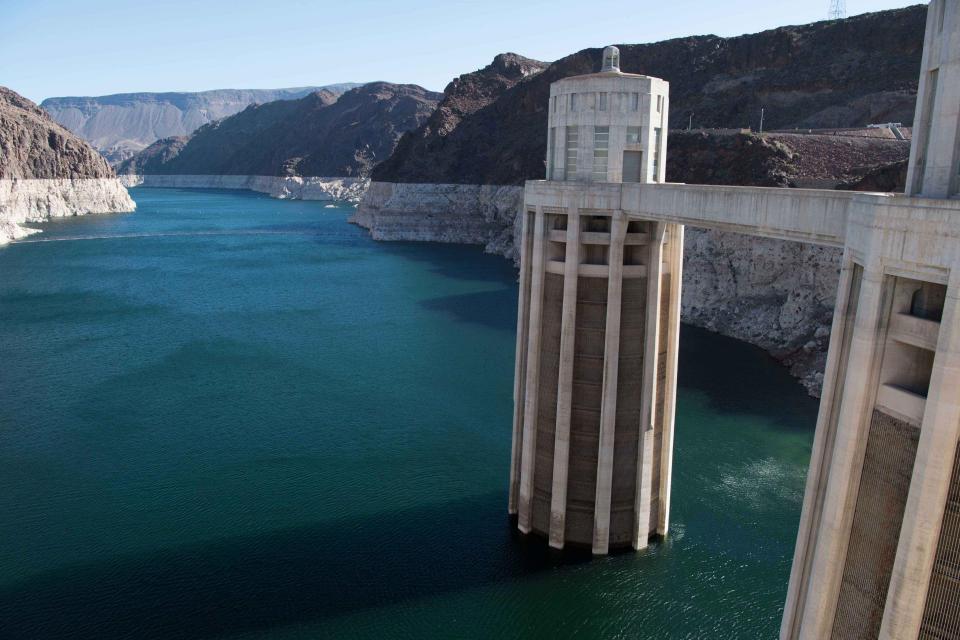
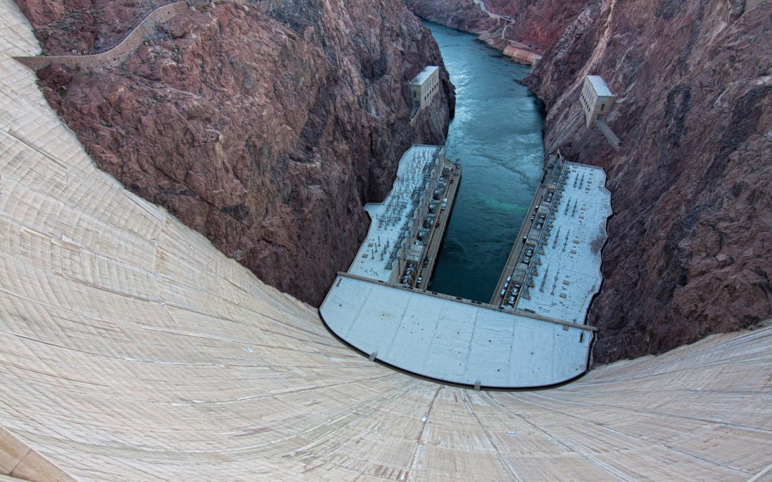
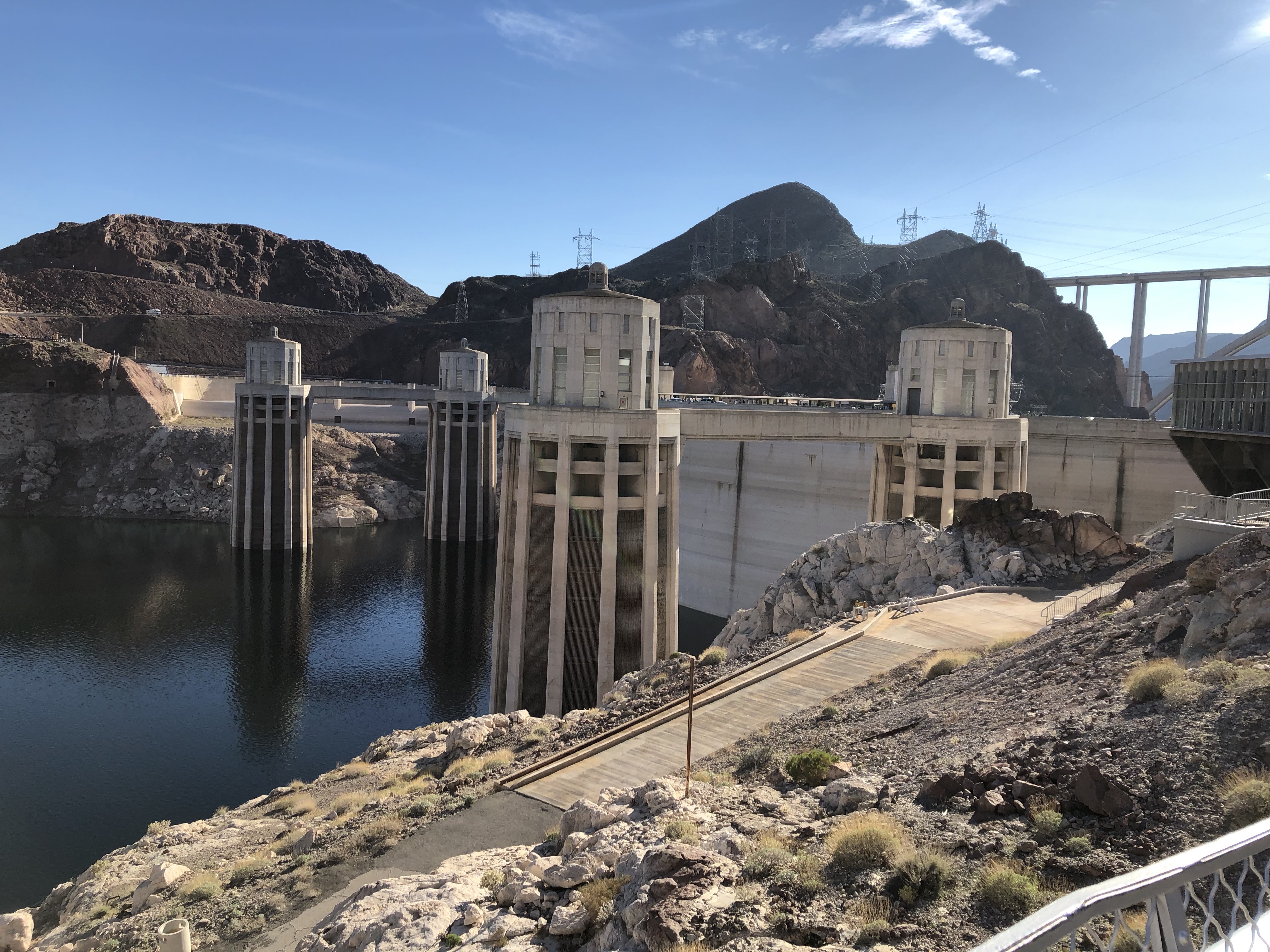
The construction of Hoover Dam created Lake Mead in 1935, which serves as the primary storage reservoir in the lower Colorado River Basin. Water levels in Mead have declined significantly since 2000 when the reservoir peaked at more than 1,200 feet above sea level. As of October 2019, the reservoir is less than 40 percent full at just over 1,080 feet above sea level. Credit: Jirka Matousek / Flickr via Water Education Colorado
Standing atop Hoover Dam, peering over the chain-link fence down its 726-foot concave face of concrete, you simply feel impressed. The dam tamed the Colorado River’s floods and created a reservoir, Lake Mead, able to hold 26.1 million acre-feet of water, not quite two years of annual flows, when full at an elevation of almost 1,220 feet.
But Lake Mead has been nowhere close to full for most of the 21st century. The widening “bathtub ring” of white in the once-black, volcanic rocks of Boulder Canyon documents the reservoir’s 190-foot fall. Despite a rambunctious runoff from the previous winter’s snowpack in the Rocky Mountains, the reservoir was 61 percent empty by mid-August 2019. The U.S. Bureau of Reclamation that same month projected the reservoir would be below 1,090 feet on January 1, 2020. That finding triggered the first-ever delivery cuts to Arizona, Nevada and Mexico under the Lower Basin Drought Contingency Plan, or DCP, signed by the basin states in 2019.
It’s a new era in the lower Colorado River Basin. The 20th century was one of engineering triumphs, ever more straws inserted into the river in defiance of geography and the innate aridity of the lower basin, the region below Lee Ferry, Arizona. This includes portions of Arizona, Nevada and California along with the Mexican states of Sonora and Baja California but also tribal lands, sovereign yet part of the United States. Water stored in Mead and other vessels gives Las Vegas Boulevard its fountains and faux falls, grocery stores across the country a reliable delivery of broccoli, lettuce and spinach in mid-winter, and Phoenix, San Diego and other metropolitan areas their prosperity.
Now comes a period of cutting back, pinching water deliveries for a time or perhaps forever. The first rude shock of this new challenge arrived during the first four years of the 21st century, the river delivering only 63 percent of what was then defined as normal at Lee Ferry. During the same period, in 2003, then-Interior Secretary Gale Norton ordered annual Colorado River deliveries to California cut to 4.4 million acre-feet, the state’s legal apportionment under the Boulder Canyon Project Act of 1928. The state had been taking 5.3 million acre-feet. It did so because it could. Nobody was being shorted, save for the river’s delta at the Gulf of California, which has not reliably seen water since the 1960s.
The Bureau of Reclamation then began working with the seven U.S. basin states to develop a plan if water-short years continued. The result in 2007 was the Colorado River Interim Guidelines for Lower Basin Shortages and Coordinated Operations for Lakes Powell and Mead. By identifying cuts in water deliveries to the lower basin keyed to reservoir elevations, the guidelines aimed to keep Mead from falling to worrisome levels. At 1,075 feet, the crisis would become real and deliveries to Arizona and Nevada would be cut. Those cuts deepen at 1,050 feet, when Mead is at 29 percent of capacity and hydroelectric production at Hoover Dam ends. More cuts come at 1,025. At elevation 895, Mead can no longer release water downstream. It’s called dead pool.
Water levels in Mead have flirted with but never crossed 1,075, the trigger for a shortage declaration under the interim guidelines. In 2013, after two years of exceptionally low flows, the Bureau of Reclamation and the seven states agreed an additional cushion was needed. That’s what the Lower Basin DCP provides, with cuts to lower basin states beginning sooner, at 1,090 feet, and greater cuts at lower elevations.
The Lower Basin DCP can be seen as part of the broader Colorado River DCP and a 2017 agreement called Minute 323 that was tacked onto the 1944 U.S.-Mexico water treaty, committing Mexico to deeper shortage sharing.
Two giant issues still loom, unresolved by the DCP. First, it does not address what experts call the “structural deficit.” Lower basin states have been using 1.2 million acre-feet annually more than the river delivers on average. Evaporation and system losses are not assessed against the lower basin.
Second, the river will likely deliver even less water in the future. Rising temperatures have been robbing the river of water, part of a climatic shift with no end in sight.
Belt-tightening identified in the DCP, though temporary, should suffice until a broader reassessment of Colorado River operations is completed. The DCP and interim guidelines expire in 2026, by which time a new river management plan will likely be in effect.
ARIZONA
Of the lower basin states, Arizona has the most at stake in keeping Mead above crisis level. The Colorado River Compact apportions the state 2.8 million acre-feet annually, dwarfing Nevada’s allocation of 300,000 acre-feet. The Colorado River provides nearly 40 percent of Arizona’s water.
The Central Arizona Project, or CAP, delivers 1.6 million acre-feet, more than half of the state’s Colorado River supply. In 1968, when authorizing CAP funding, Congress conceded California’s demand that CAP water be junior in priority to California. That means CAP users take shortages first if Mead levels decline.
Before signing the DCP, Arizona had to develop an intra-state plan. It was a pained but ultimately self-affirming experience. Arizona began its discussion in 2015 but got little done amid internal squabbling. Then a good snow year in the Rockies caused Mead to rise. One CAP director even wondered publicly whether planning for future shortages was necessary. That myopia was dispelled by the winter of 2017-2018. It was the fifth-driest year on record, with flows from the upper basin, source of 92 percent of the river’s water, just 41 percent of average. As Arizona dithered, Reclamation Commissioner Brenda Burman warned that if Arizona and other states didn’t take action by January 31, 2019, her agency would.
With a hard deadline and a sharp decline in river flows, Arizona’s major water agencies, the Arizona Department of Water Resources and CAP, coalesced by June 2018 to lead a transparent and inclusive 42-member task force. The result was 14 distinct agreements that together constitute compromises, payments, and water transfers to reduce use, some temporarily and others permanently. Then Arizona legislators had to approve their state’s drought contingency plan.
“It was emotionally charged, because not everybody was going to be pleased,” says Rosanna Gabaldón, a state representative whose district straddles Tucson and rural areas. For a time, Gabaldón doubted Arizona could agree on a drought package. But the legislation was signed with six hours to spare. Upon her review, Burman said both Arizona and California hadn’t completed their work, but they met her extended deadline of March 4.
Arizona’s cuts come almost entirely from the 1.6 million acre-feet pumped from the Colorado River through the CAP. CAP’s 336-mile canal crosses Phoenix and Tucson and reaches farmers in Pinal County, between the metropolitan areas. In 2020, because the Bureau of Reclamation’s August 2019 24-month study projected Lake Mead to fall below 1,090 feet by January 1, 2020, Arizona this year will take 6.9 percent less, or a 192,000 acre-foot cut. If Mead drops to 1,075 feet, as remains distinctly possible, Arizona could lose up to an additional 512,000 acre-feet, though some of that water could be recovered at a later date if storage recovers. At 1,025 feet, it cuts back up to 720,000 acre-feet, or nearly 26 percent of its Colorado River water.
Cities fare well enough in this squeezing exercise. Phoenix and six of its suburbs will see successive cuts beginning at Mead elevations of 1,075 feet. For Tucson, the spigot tightening begins at 1,045 feet and tightens even more at 1,025. However, only if Lake Mead falls to 1,000 feet would Tucson possibly have to cut water sent to homes or businesses.
Agriculture takes Arizona’s biggest hit. That was expected. If agriculture was the primary argument for the CAP in the 1960s, it had the lowest priority among the contracts. This use is almost entirely in Pinal County. Flat and mostly rural, most drivers on Interstate 10 between Phoenix and Tucson hurry through it. The county’s 200 farms produce 45 percent of Arizona’s cattle, 42 percent of its cotton and cottonseed, and 39 percent of its milk, according to a study commissioned by Pinal County irrigation districts. Cities were unimpressed. The total economic output of these Pinal County farms, they pointed out, was half that of the state’s golf courses.
Groundwater was the sole source of water in Pinal County from 1940 to about 1990, when CAP water arrived. Farmers, though, couldn’t repay even the subsidized costs of CAP’s capital-intensive infrastructure. In 2004, they agreed to a shorter-term contract for Colorado River water while being relieved of infrastructure costs. This lower-priced water is also subject to availability, however. Irrigators were already scheduled to stop receiving CAP water entirely by 2030. The plan was for farmers to then return to exclusive groundwater use. Arizona’s DCP will cause the farmers to lose a third of their water in years 2020-2022 and lose deliveries altogether in 2023, seven years earlier than previously scheduled.
Arizona’s compromise yielded the Groundwater Infrastructure Fund, which identifies $50 million—$20 million of it state money—for Pinal County farmers to finance new groundwater-pumping infrastructure. Not all legislators supported the aid.
“But many of us drew the line at funding groundwater-pumping infrastructure, which to us was going backwards. The last thing we should be doing is returning to depleting our groundwater aquifers”, says Airzon State Rep. Kirsten Engel, a Democrat from the Tucson area.
Will this cause farmers to pump groundwater below Pinal County to extinction? Probably—assuming that Lake Mead continues to sag. Application of Colorado River water across the cotton and alfalfa fields allowed the aquifer to rise to nearly 1940 levels. With no river water percolating into the aquifer, it will inexorably decline. Other, less thirsty crops have been getting attention: industrial hemp and a shrub called guayle, which produces an alternative to rubber. But these conversations occur in the margins.
New conservation efforts, including those in agriculture, will benefit from $2 million appropriated by state legislators. Arizona Gov. Douglas Ducey also replaced a council focused on water augmentation with one responsible for studying innovation and conservation.
New political strength of tribes, particularly those in Arizona, was evident in the drought contingency planning. Arizona tribes get 12.5 percent of the state’s water directly from the Colorado River and another 17.5 percent of CAP water. The Gila River Indian Community alone has 311,000 acre-feet, the largest single contract for CAP water. Their reservation just south of Phoenix was created in 1859, giving it the highest priority. The intra-Arizona DCP gives the Gila River Indian Community $92 million for 200,000 acre-feet lost in the DCP’s seven-year life. They also lose additional water that tribal officials value at $30 to $50 million. For the Gila River Indian Community, the DCP negotiations were something of a coming-out party. With European settlement, the tribe was dispossessed of their water until the Arizona Water Settlement Act of 2004 allowed the tribe to use water rights that had previously existed only on paper. Even so, the Gila were not invited to be at the table at the outset of DCP planning. “Tribes have to be at the policy table,” said Governor Stephen Roe Lewis. Now, they definitely are.
The Colorado River Indian Tribes—consisting of four distinct tribes, the Mohave, Chemehuevi, Hopi and Navajo, with a reservation that stretches along the Colorado River in Arizona and California—also played a significant role. They divert nearly 600,000 acre-feet directly from the Colorado River at the border between Arizona and California, with priority dates from 1865-1874. “This is not CAP water. It is not subject to being cut. It is the highest priority water in the lower basin,” explained Margaret Vick, special counsel to the Colorado River Indian Tribes, at the June 2019 Getches-Wilkinson Center Summer Water Conference at the University of Colorado-Boulder. After a history of being taken advantage of, the tribes are now “partners with the state legislative leaders,” she said.
The Central Arizona Aqueduct delivers water from the Colorado River. Photo credit: U.S. Bureau of Reclamation
The four tribes agreed to take 10,000 acres of farmland out of production for three years, allowing the water to instead remain in Lake Mead. In return, the tribes receive $38 million, including $30 million from the state and $8 million from the Environmental Defense Fund and the Walton Family Foundation.
“I don’t think Arizona could have met their requirements without the water that the tribes put on the table,” says Larry MacDonnell, an adjunct law professor at the University of Colorado-Boulder and a member of the Colorado River Research Group.
CALIFORNIA
California has different tensions. The state has more Colorado River water, 4.4 million acre-feet, the majority of it claimed for agriculture prior to the Colorado River Compact.
About a quarter of southern California’s water comes from the Colorado River. Metropolitan Water District of Southern California delivers this Colorado River water, along with water imported from northern California, to smaller agencies that collectively serve 19 million people. Metropolitan’s basic annual apportionment of Colorado River water is 550,000 acre-feet, and it gets about 400,000 of additional Colorado River water through transfers and exchanges, largely from irrigation districts. Under the DCP, if Lake Mead drops below 1,045 feet, California will contribute between 200,000 and 350,000 acre-feet of water a year, depending on the lake’s elevation. Because of the wet year in 2018-2019, Reclamation estimates a less than 10 percent chance that the reservoir will fall to that level by 2026.
California’s contribution under the DCP is shared by two of the state’s three big irrigation districts and Metropolitan. Initially, the Imperial Irrigation District (IID) was also planning to participate. It conditionally approved the plan in December 2018 but in March 2019, just before a federal deadline, IID decided it would not support the DCP as negotiated because one of its conditions—federal funding for the Salton Sea—had not been satisfied. Metropolitan’s board of directors voted to contribute an additional 250,000 acre-feet to Lake Mead if necessary to cover the Imperial Irrigation District’s portion. But these contributions are not permanent. Metropolitan, along with others in California, Arizona and Nevada, can in the future withdraw water left in Lake Mead under a provision in the 2007 guidelines called “intentionally created surplus,” or ICS.
ICS water is made through projects that create water system efficiency, conservation, or even importation of water into the Colorado River Basin. ICS water temporarily augments reservoir levels but is then available for later drafting by whomever contributed it. The Bureau of Reclamation reported provisionally that in 2018 Nevada had 700,448 acre-feet, California 698,432 acre-feet, and Arizona 343,052 acre-feet of ICS water stored in Mead.
This water might better be understood as a savings deposit. Metropolitan has stored and withdrawn water three times. But what if an entity wants to withdraw when those savings are most desperately needed? Imagine the scene from the movie “It’s a Wonderful Life,” when the panicked townspeople of Bedford Falls show up at the savings and loan, demanding their C-notes.
Spray irrigation on a field in the Imperial Valley in southern California. This type of irrigation is a lot better than the extremely water inefficient type of flood irrigation that is popular in this region. Still, in the high temperatures of this desert region a lot of the water evaporates, leaving the salts, that are dissolved in the colorado River water that is used, on the soil.
Brad Udall, senior scientist and scholar at Colorado State University, told a U.S. House subcommittee in February 2019 that this illustrated an implicit flaw in the concept. “These water storage efforts allowed us to push the problem forward in time, hoping Mother Nature will rescue us,” Udall said.
Bill Hasencamp, manager of Colorado River resources for Metropolitan, says his agency’s savings balance is responsible for about a 12-foot increase in Mead—contributing significantly to keeping the reservoir out of shortage. But he agrees that the savings device is not the long-term answer to the oversubscribed Colorado River Basin. “Eventually we have to make some permanent cuts in the lower basin, and that’s what we’re gearing up for in 2026 negotiations,” Hasencamp says.
More tension revolves around the shrinking Salton Sea, located 125 miles northeast of San Diego. It’s an ancient sea bed, below sea level, and filled sporadically through the ages by the Colorado River as it wandered on various paths toward the ocean. Its current iteration dates to 1905, when the river wrestled free of an attempt to channel it into orderly submission. It’s a shallow, salty marvel with twice the surface area of Lake Tahoe that also serves as a major stop for migrating birds, some listed on state and federal endangered and threatened lists, along the Pacific Flyway.
Water levels were sustained by 1.3 million acre-feet of annual runoff from Imperial Valley farms until 2003, when the Imperial Irrigation District began transferring water saved through conservation measures to San Diego County, Metropolitan, and the Coachella Valley Water District. The sea has fallen 9 feet since those transfers began, the saline water lapping onto shore at 237 feet below sea level in July 2019. As it does, the Salton becomes saltier, some 4 million tons of salt arriving through farm runoff each year, increasing the salinity 1 percent annually.
The Pacific Institute’s Michael Cohen, whose work for the past 20 years has focused on revitalizing the Salton Sea, identifies two problems. First is the decline of the sea in size and in its capacity for sustaining fish. It has dramatically fewer fish than 20 years ago, which in turn sustain resident and migratory birds. Birds have also lost roosting and breeding habitat.
A second issue is the human health impact of the wind blowing chemical-laden dust from the receding shores. The 650,000 residents of the Coachella and Imperial valleys already had a high incidence of asthma. The American Lung Association gives Imperial County an “F” score in high ozone and particulate pollution. The county seat, El Centro, is ranked eighth worst among 203 metro areas across the country for annual particle pollution. As transfers from irrigation districts to cities ramp up in the next decade, Salton Sea levels are expected to drop another 15 feet or so, exposing more toxic dust and more chronic respiratory issues. The shoreline by then will have receded 5 miles since 2003.
A 10-year Salton Sea mitigation plan, approved in 2017, has had stubby financial legs. To implement the phase-one plan requires $400 million, of which $300 million has somewhat belatedly been secured. That’s just the start of a longer-term plan for wetlands restoration and other mitigation.
For the Imperial Irrigation District, mitigating Salton Sea problems became the defining issue in the DCP. The district has legal rights to 18 to 20 percent of all Colorado River Basin water, 3.1 million acre-feet altogether, including use of 2.68 million acre-feet pre-compact, as of 2019. District directors in December voted to support the overall DCP framework. However, that support was contingent upon the federal government delivering $200 million for Salton Sea remediation.
Led by Metropolitan, California supported the DCP without the provision of contingency upon the federal funding. In March, Imperial sued Metropolitan and three other water districts, citing absence of a thorough environmental review of the drought plan. “Just as it is hydrologically connected to the Colorado River, the Salton Sea is inseparable from the DCP, and any attempt to sweep it aside or pretend it doesn’t exist is as unsustainable as it is cynical,” said Erik Ortega, president of the district, in a March 1 statement. “We all need to cross the finish line together, in California and across the two basins, but that won’t happen by taking shortcuts, environmental, economic or otherwise.”
In April 2019, on the day President Trump signed the DCP into law, Imperial asked a California court to suspend approvals of the lower basin DCP until after an environmental analysis was completed. With that, California, the lower basin, and all seven basin states moved forward on the DCP without the Imperial Irrigation District and without solving the problem of the Salton Sea.
MEXICO
Mexico is also part of the Colorado River Basin, apportioned 1.5 million acre-feet annually by the 1944 Mexican Water Treaty. It, too, is a partner in the effort to keep Mead from declining. A 2012 binational agreement specified that a shortage declaration under the 2007 interim guidelines would reduce deliveries to Mexico of up to 125,000 acre-feet. That agreement, Minute 319, also produced the historic 2014 pulse flow that used Mexico’s water stored in Lake Mead to wet the delta for the first time in 16 years. Minute 319 has since been supplanted by Minute 323. Signed in 2017, Minute 323 authorizes Mexico to continue storing water in Lake Mead and also commits the United States to financially support water efficiency projects in Mexico with the goal of leaving 200,000 acre-feet of water in Mead to benefit both countries. It also requires both countries to provide water and funding for delta habitat restoration.
Looking forward, Jennifer Pitt, director of Audubon’s Colorado River Program, sees need to build on existing binational relationships. “I think Mexico has already demonstrated that they are willing to be a partner in the equitable distribution of shortages, and I don’t think we should expect any different,” she says. Equitable, she believes, means proportionate to the shortages absorbed by the lower basin states.
Both the DCP and Minute 323 will expire in 2026. Negotiations between the U.S. and Mexico to determine what comes next after Minute 323, the DCP, and the interim guidelines, “will be tied to their implementation and operating experience [of Minute 323] between now and then,” Pitt says.
Minute 323 identifies specific projects but has no provision for another pulse flow. Pitt sees the river delta being like the Salton Sea: undeniably a part of the Colorado River Basin. The drying of the delta was the first visible signal of water imbalance.
Point 24 in the Colorado River Delta, September 12, 2016. Photo credit The Nature Conservancy.
Doing something about it means finding water to create a more resilient ecosystem that can address the habitat needs of birds that used that area as part of their migration path, she says. That this ecosystem is in Mexico also matters. “If the restoration effort were to be abandoned, we don’t know if Mexico would be as willing to share in the shortages with other water users,” Pitt says.
WHAT’S NEXT?
Even before the DCP was signed in May 2019, eyes were already on replacement of the interim guidelines and the DCP. It poses a greater challenge yet. The word “drought” probably should be discarded in the 2026 document’s title because the big overlapping issues of climate change and structural deficit that it must address are broader. “Hard issues left unresolved by the DCP will make the coming negotiations even more challenging,” said Udall in his February testimony to the U.S. House subcommittee.
But the DCP also marks several major achievements. The work was more inclusive, more deliberate in bringing tribes and environmental groups to the table, both of them often overlooked or strictly adversarial in the past. Even where it failed, there was success, as the Colorado River Research Group, in a May 2019 paper, pointed out: “Two of the most problematic features of the current management framework—the inability of Pinal County, Arizona, farmers to easily absorb CAP curtailments, and the environmental and public health challenges associated with limiting Salton Sea inflows—have influenced, and are influenced by, matters that were heretofore considered outside of basin water management planning.”
The Salton Sea is California’s largest lake, covering 330 square miles, and a major drop along the Pacific Flyway for migratory birds. But it is receding, threatening to create a public health and ecological crisis. By NWSPhoenix – Own work, CC BY-SA 4.0, https://commons.wikimedia.org/w/index.php?curid=56724223
Too, the DCP carved a path, concrete in its details and immediate in its consequences, to reconcile reality with diversions. Based on the plan’s provisions, the Bureau of Reclamation in August 2019 ordered reduced deliveries to Arizona of 192,000 acre-feet and to Nevada of 8,000 acre-feet in 2020. In addition, under its supplemental treaty agreement, Mexico gets 41,000 acre-feet less. Those cuts were based on projections that Mead’s water would be below 1,090 feet, the new cushion level, on January 1, 2020. That water must remain in the reservoir until Mead rises above an elevation of 1,100 feet. These are the first, marked acknowledgements of the 21st century hydrologic realities.
In Arizona, David White, deputy director of the Julie Ann Wrigley Global Institute of Sustainability at Arizona State University, sees the template that emerged dwarfing the details in importance. “That was a very big win for the state,” says White. Creating an open, transparent process for figuring out how to apportion cuts was vital.
The Arizona Republic was of a like mind. “Let’s be clear. This deal isn’t perfect. It’s costly and painful, and it solves exactly zero of our water problems,” it wrote in a January 31, 2019, editorial. “All DCP does is buy us time. But it showed us how to solve our problems and move forward in a drier future.”
Colorado River users – and the 40 million people served by the river – received clarity moving into 2020 at the 2019 Colorado River Water Users Association (CRWUA) conference in Las Vegas.
There, Secretary of the Interior David Bernhardt announced that “the Department will immediately begin work on a new report that will analyze the effectiveness of current Colorado River operational rules to ensure continued reliable water and power resources across the Southwest – a year ahead of when the current rules require the report.” The report will be a review of the effectiveness of Colorado River operations since enactment of the 2007 Guidelines, including the implementation of the Drought Contingency Plans (DCP) in 2019.
The evaluation of the effectiveness of the 2007 Guidelines is a mandatory first step in what has come to be called the “Reconsultation” – the process that will lead to next set of rules for managing the Colorado River and the River’s major reservoirs when the current Guidelines expire at the end of 2026.
The Secretary’s comments echoed the remarks made earlier at CRWUA by U.S. Bureau of Reclamation Commissioner Brenda Burman, that it was too early to begin work on developing the next set of operating rules – that would get in the way of implementing DCP and the evaluation of the 2007 Guidelines.
Arizona’s next steps in this process are already underway. Central Arizona Project (CAP) General Manager Ted Cooke and Arizona Department of Water Resources Director Tom Buschatzke began meeting with Arizona’s DCP Steering Committee delegates two months ago to initiate post-DCP discussions. The announcements from the Department of the Interior are consistent with the expectations and approach underway by CAP and ADWR.
At the federal level, the immediate work is to prepare a report that will analyze the effectiveness of the Guidelines. This will take some time to accomplish, but the early start sets the stage for the second step of the Reconsultation, which will be the development of the next program, which will need to be in place in 2026. The Secretary estimated it would take about a year to complete the new report. The Basin States and other experts would be consulted as part of the report preparation process.
Said Barnhardt, “This conference brings together the best ideas for managing the Colorado River. This year’s historic agreements once again demonstrated that the best way to protect the Colorado River is collaboration and cooperation, not litigation. Looking ahead, we are eager to complete a review of our current operations by leveraging that collaborative approach to identify lessons learned from rules that have guided our operations since 2007. Thank you to CRWUA for providing the forum for launching this initiative.”
CRWUA is the only association focused solely on Colorado River issues. It provides an opportunity for those with interest in the river to convene and discuss issues. The CRWUA conference also provides the opportunity for the U.S. Department of the Interior to speak to Colorado River users in one venue.
This year’s conference featured a resolution recognizing the 130th anniversary of the International Boundary and Water Commission (IBWC) and the 75th anniversary of the 1944 Treaty Concerning the Utilization of Waters of the Colorado and Tijuana Rivers and of the Rio Grande. The 1944 Treaty established a framework that provides significant and enduring benefits to Colorado River water users in the United States and Mexico and stands as an example of international cooperation and collaboration.
At this year’s conference, Central Arizona Water Conservation District (CAWCD) Board President Lisa Atkins moderated the Augmentation Colloquium, which featured a panel including CAP Colorado Programs Manager Chuck Cullom. Central Arizona Project General Manager Ted Cooke also served on a panel regarding the Interim Guidelines.
To learn more about CRWUA, visit its website, which was newly designed by CAP.
The annual Colorado River Water Users Association conference started up Thursday at Bally’s Hotel and Casino…
When it comes to the fight to conserve water, officials at this year’s conference say Nevadans have a lot to be proud of.
“Southern Nevada is on the cutting edge, you are at the forefront of conservation. What this town, what the water users of this town, have been able to do in the last ten years is really remarkable,” said Bureau of Reclamation Commissioner Brenda Burman.
The Silver State is regarded as a national leader in the fight to save the resource, citing investments in conservation infrastructure over the last two decades.
Drought markers along the Colorado River remain; dating back nearly twenty years.
Officials in Nevada are pushing back though. Working alongside reps from other states, water usage on the Colorado River has declined. Emergency drought plans have also been drawn and agreed on.
Click on a thumbnail graphic to view a gallery of drought data from the US Drought Monitor.
US Drought Monitor December 24, 2019.
West Drought Monitor December 24, 2019.
Colorado Drought Monitor December 24, 2019.
Click here to go to the US Drought Monitor website. Here’s an excerpt:
This Week’s Drought Summary
A major pattern change occurred during mid-December as a strong area of upper-level low pressure developed over the northeast Pacific. Following a rather dry November, enhanced onshore flow resulted in heavy rain and high-elevation snow across the Pacific Northwest where 7-day total amounts (liquid equivalent) ranged from 2 to 6 inches, liquid equivalent, or more. Surface low pressure formed over the Gulf of Mexico on December 21 with an eastward track. Widespread heavy rainfall (2 to 6 inches) accompanied this low pressure system from the western Florida Panhandle north to nearly all of Alabama, Georgia, and South Carolina. An expansive area of surface high pressure led to mostly dry weather (December 17 to 23) across the Great Plains, Corn Belt, and Northeast. Mostly dry weather also prevailed across mainland Alaska with periods of precipitation occurring along the Alaska Panhandle. A low pressure system recently developed to the west of the Hawaiian Islands but the heaviest rainfall associated with this low pressure system remained west of Hawaii…
Dry weather prevailed during mid-December from the central Rockies east to the northern and central Great Plains. This is a relatively dry time of year for much of these areas and 90- to 180- day precipitation averages much above normal across the eastern two-thirds of Montana and the Dakotas. However, long-term drought continues to plague western and southern Colorado. Short-term drought of varying intensity persists across southwest and south-central Kansas…
Widespread rain and high-elevation snow continued across the Pacific Northwest through December 21 before the storm track shifted south to California. 7-day precipitation amounts (as of 12Z December 23) ranged from 2 to 8 inches, liquid equivalent, or more along and west of the Cascades in western Washington and northwest Oregon. Based on this recent heavy precipitation, an increase in 28-day stream flows above the 25th percentile, and recovery in the 90-day SPIs, abnormal dryness (D0) was reduced slightly in coverage across northwest Washington and coastal Oregon. However, despite the recent heavy precipitation, no changes were made to the remainder of the ongoing abnormal dryness (D0) area given such a dry start to the wet season. Water year to date (since October 1) precipitation deficits of more than 12 inches, 28-day stream flows in the lowest 10th percentile, and basin average snow water content less than 50 percent support the short-term moderate drought (D1) across parts of Oregon and Washington. Heavy precipitation (more than 2 inches, liquid equivalent) during the past week resulted in a slight reduction in moderate drought (D1) in northern Idaho.
Lighter precipitation (generally less than 2 inches) extended south into northern California this past week, while mostly dry weather prevailed across the remainder of the West. Although basin average snow water content values are above normal across Arizona, New Mexico, and Utah, drought persists in these areas where 180-day precipitation deficits are relatively large and 6-month SPI values support ongoing long-term moderate (D1) to severe (D2) drought…
Mostly dry weather prevailed across much of the southern Great Plains during the past week. Therefore, a slight increase in abnormal dryness (D0) and moderate drought (D1) was warranted for southwest Oklahoma and northwest Texas. Also, a small increase in severe drought (D2) was necessary in parts of central Texas, based on 90day SPI values. Soil moisture currently ranks below the lowest 10th or 5th percentile from the Hill Country of Texas southwest to the Rio Grande River which supports areas of severe (D2) to extreme (D3) drought. In contrast to these worsening conditions, a brief period of heavy rainfall (2 to 4 inches) resulted in 1-category improvements in the Brownsville and Corpus Christi areas of Texas…
Looking Ahead
During the next 5 days (December 26-30), an upper-level low is likely to bring rain and high-elevation snow to southern California and the Southwest. This upper-level low is then likely to spawn a surface low across the southern Great Plains with a subsequent track northeast to the Great Lakes. Beneficial rainfall (0.5 to 1.5 inches) is expected with this low pressure system in southeast Colorado, Kansas, and Oklahoma. Light to moderate precipitation (an inch or less) will overspread the eastern U.S. on December 29 and 30. Following the brief period of heavy precipitation across the Pacific Northwest during mid-December, a drier pattern is likely to end December. Above-normal temperatures are forecast during late December across the central and eastern U.S., while below-normal temperatures prevail across the Great Basin and Southwest. A low pressure system is forecast to move away from the Hawaiian Islands on December 26. Strong onshore flow is likely to result in heavy precipitation (5 to 10 inches, or more) along the Alaska Panhandle. Arctic air with much below-normal temperatures are forecast to affect much of mainland Alaska.
The CPC 6-10 day extended range outlook (December 30, 2019 to January 3, 2020) indicates large probabilities (greater than 80 percent) for below normal temperatures throughout mainland Alaska as anomalous northeast surface flow persists. Wetter-than-normal conditions are forecast to continue into the beginning of January 2020 along the Alaska Panhandle. The strong Pacific flow is likely to prevent the arctic air over Alaska to shift south anytime soon. Therefore, above-normal temperatures are favored for a majority of the continental U.S. Increased chances of below normal precipitation are forecast for California and the Great Basin. Forecast confidence in the precipitation outlook decreases across the central and eastern U.S. with either near or above normal precipitation most likely.
Here’s the one week change map ending December 24, 2019.
US Drought Monitor one week change map ending December 24, 2019.
A view of a diversion dam on Costilla Creek in Taos County, New Mexico. The dam is adjacent to New Mexico State Road 196, near Costilla, New Mexico. By Jeffrey Beall – Own work, CC BY 4.0, https://commons.wikimedia.org/w/index.php?curid=68493556
Rio Grande cutthroat trout via Colorado Parks and Wildlife
Every year in late spring, 200 volunteers hike into Rio Grande Gorge north of Taos. Their backpacks are each filled with a few gallons of water – and 100 young Rio Grande cutthroat trout.
The state fish of New Mexico thrives in clear, cold, high-altitude streams, which means its habitat is threatened by wildfires, warming waters and invasive trout species. Now, the National Fish and Wildlife Foundation has awarded more than half a million dollars as part of a new recovery program.
Toner Mitchell, Trout Unlimited’s New Mexico Water and Habitat and Public Lands Coordinator, said the money will fund stream improvements and fish restoration. Trout Unlimited will receive $96,059 for New Mexico projects and $152,416 for Colorado projects…
Agencies and tribes in New Mexico and Colorado renewed a conservation agreement in 2013 with a strategy to protect the fish. The groups have restored trout habitat on Comanche Creek, a main tributary of the Rio Costilla and just a few miles from the Colorado state line.
“We want to bring these new fish populations into the best available habitat,” said Kevin Terry, Trout Unlimited Rio Grande Basin Project Manager. “We have spent decades reconnecting stream miles, removing non-native trout and stocking streams with Rio Grande cutthroat trout. Then the agencies check in on those fish to make sure they’re healthy and reproducing.”
On Comanche Creek, the groups have reduced bank erosion and raised the riparian water table by at least a foot, which improves stream flow and habitat for the sensitive fish…
The new funding will help assess habitat restoration work for tributary streams of the Rio San Antonio.
The Center for Biological Diversity wants Rio Grande cutthroat trout to be listed under the Endangered Species Act. But many conservationists believe they can save the fish without federal protection.
The restoration projects are already working, said Mitchell, who added that restrictions on grazing, fishing and land use that usually accompany an endangered status could turn the Rio Grande cutthroat trout into “public enemy No. 1.”
[…]
The Rio Puerco Alliance will also receive $151,684 as part of this program to minimize bank erosion on Encinado Creek in Rio Arriba County and create a barrier to keep out invasive trout species.
The U.S. Rafting Team has enlisted three veteran Grand Canyon guides in a mission to set a new speed record for descending the Colorado River’s 277 miles through the canyon. The team tested a new raft design last month on the Ruby Horsethief and Westwater canyons, rowing from Loma to Utah’s Dewey Bridge in about nine hours. (Robbie Prechtl, special to The Colorado Sun)
Lava Falls: “This, I was told, is the biggest drop on the river in the GC. It’s 35 feet from top to bottom of the falls,” John Fowler. The photo was taken from the Toroweap overlook, 7 June 2010, via Wikimedia.
They had been rowing for more than 20 hours and were on pace to set a record for the fastest descent of the Colorado River through the Grand Canyon when their customized cataraft failed in the roiling rapid. After four hours of repairs in the dark, they limped to the take-out more than five hours past the 34-hour, two-minute record set in 2016 by kayaker Ben Orkin.
Three years later, the Colorado-based team is back with a slightly different boat design and a trio of veteran Grand Canyon guides onboard. They plan to launch from Lees Ferry on Jan. 9 and row their custom-made raft through 130 rapids over 277 miles, rowing six at a time to reach Grand Wash Cliffs in less than 34 hours.
“Everything is going to have to be perfect,” said Edwards-based team captain John Mark Seelig. “The weather has got to be right and water has got to be right where we need it and we are going to have to hit our lines perfectly. We’re feeling good.”
The team, which competes in four-man and six-man whitewater races around the world, kept their heads down as they planned the last attempt, trying not to attract too much attention. They didn’t want to seem presumptuous, dropping in from Colorado for their first speed attempt and possibly irk the tight-knit Grand Canyon rafting community. And while they weren’t breaking rules, they did have sandal-maker Chaco helping with support. The National Park Service doesn’t smile on promotional campaigns in their parks…
[The USA Rafting Team has never won a world championship. With full-time jobs, families, and responsibilities, these scrappy 30-40-year olds use their free time and vacation days to train, travel the world, and race against competitors sometimes half their age. They’ve been close, but never the best. On January 13, 2017, they set their sights on making history, attempting to break a legendary speed record down 277 miles of the Colorado River through the Grand Canyon. Their goal was 34 hours. In a custom-built 48 foot raft and with ultramarathon effort, “The Time Travelers” is the story of ordinary people attempting something extraordinary on one of the world’s most breathtaking stages. 34 hours – just a blip in the scope of geological history – could be both their defining moment and the ride of their lives.
A Gnarly Bay Production and a Forest Woodward + Brendan Leonard Collaboration.
Music: Marmoset
Special Thanks: NRS, Yeti Coolers, Jack’s Plastic Molding, and Cataract Oars]
This time the team is self-funding its mission and using the record-setting attempt to raise money for Grand Canyon Youth, a nonprofit in the Southwest that gets kids on rivers. They want to raise $10,000 for the group.
The U.S. Rafting Team’s Seelig, Robbie Prechtl, Jeremiah Williams, Matt Norfleet and Kurt Kincel have enlisted experienced Grand Canyon raft guides and endurance athletes Lyndsay Hupp, Omar Eli Martinez and Justin Salamon for the 2020 attempt.
“The first attempt, we didn’t really talk about it. The narrative of the story has changed this time. It’s something more meaningful to us,” Seelig said. “We feel more supported by the Grand Canyon community this time and we are leaning on them for their knowledge.”
Map of Grand Canyon National Park via the NPS
Seelig said the expert guides, while maybe not as familiar with the raft, have decades of experience rowing the canyon and can provide critical navigational help as they line up daunting rapids in the dark. Each of them has logged dozens of descents of the canyon, mostly shepherding guests, and they are pining for a speed descent, Seelig said.
The U.S. Whitewater Rafting Team trains on its custom-built raft in December on the Colorado River. The team was on pace for a record descent of the 277-mile canyon [January 14-15, 2017] when a wave broke the frame and punctured a tube. Photo Special to The Denver Post by Forest Woodward.
As the digital transformation of the water sector continues to increase in pace and scale, we predict 2020 will be the year of lessons learned and enlightenment. The last few years were marked by peaks of inflated expectations over several emerging technologies, notably blockchain and AI/ML, both enabled by the ability to outsource storage and computing to the cloud. While these technologies and others remain exciting tools to improve efficiency and reduce costs, the integration into business operations has been lacking…
The key is to ensure that digital transformation is done with vision, purpose, and strategy. This brings us to the slope of enlightenment, which will be the key trend in 2020. The enlightenment trend of 2020 will be supported by change managers who will guide the water sector’s adoption and strategic integration of digital technologies.
Whereas the last few years highlighted technologists, we predict that 2020 will place a spotlight on the guides, those able to work between business and technology to seamlessly integrate the two.
This next year is when the rubber hits the road on large scale digital transformation. The water sector will need change agents to help establish vision, value, business imperatives, identify wins and friction points, and set out strategic roadmaps for water utilities.
The slope of enlightenment will continue to be lit by these guides, leading the water sector onto the plateau of productivity, where technologies are integrated to reduce business costs and increase efficiency, allowing us to achieve our goal of universal access to safe water and sanitation…
2020: Digital, decentralized and democratized
Will Sarni, CEO, Water Foundry
In the world of water, 2019 was an inflection point and in some respects a departure from the past. The digital transformation of the water sector took hold, centralized water systems continue to fail calling attention to the opportunities with decentralized systems and we moved closer to democratizing access to real time data, actionable information and alternative hydration.
Looking ahead to 2020, I see three major trends.
Digital: Analog water solutions are well on their way to extinction as the digital transformation of the water sector accelerates. Digital water technologies continue to scale with public and private enterprises and the innovation pipeline for new digital technologies is thriving. Digital technologies and start-ups such as satellite data acquisition for real time water quality monitoring and flood prediction, AI applications for asset and resource management and real time water quality monitoring at the tap are scaling.
Decentralized: Centralized water systems are aging, underinvested and increasingly fail. Decentralized (and distributed) water systems are emerging as viable alternatives to capital intensive centralized water systems. These decentralized systems are more resilient to extreme weather events and provide more affordable alternatives to capital intensive centralized systems.
Democratized: The tragedy of lead contamination of drinking water in Flint, Michigan was not an isolated occurrence and served as a wake-up call that democratized access to real time data and actionable information is now essential. Imagine if the residents of Flint had affordable and reliable real time water quality data at their taps? Imagine if safe drinking water was available via small scale air moisture capture technologies?
Don’t view these as separate trends. For example, digital technologies are enabling the adoption of decentralized systems and democratized data and information and access to water. 2020 will be the year of digital water fuelling decentralized and democratized access to water.
There has always been a bit of a mismatch between Colorado’s environmentally friendly self-image, its knack for salesmanship, and the messier reality on the ground. We wax rhapsodic about escaping to the mountains for the weekend, then sit for hours in traffic in our gas-guzzling SUVs to get there. We wear $300 Patagonia jackets made from recycled polyester and boast one of the worst waste diversion rates in the country.
In 2019, some of these contradictions were more apparent than ever — and many of the biggest stories in the realm of environmental policy and activism involved attempts to reconcile them…
Colorado Prepares for a Clean-Energy Revolution…
Most of them didn’t receive a fraction of the attention that SB 181 did, but a slate of clean-energy bills passed by lawmakers in 2019 could end up having a much more transformative effect on Colorado’s economy. Legislation to set statewide goals for greenhouse gas emissions cuts, speed up the decarbonization of the electric sector, incentivize electric vehicle purchases and more passed out of the legislature and boosted the state’s efforts to tackle climate change.
…but a Denver Climate Tax Goes Up in Smoke
While climate activists celebrated some big wins at the state level in 2019, they were left frustrated by events on the other side of Civic Center Park, where Mayor Michael Hancock quashed an effort to put an energy tax on the ballot in order to better fund the city’s climate programs. In a compromise with city council members who supported the measure, Hancock agreed to boost climate funding in his 2020 budget and launch a climate action task force that will make recommendations — including for a possible tax measure — next year.
Youth Climate Strikes and the Greta Effect
The largest day of climate demonstrations in history saw more than 5,000 activists, many of them young people, march through the streets of downtown Denver and rally at the State Capitol, joining millions around the world to demand that governments take more aggressive action to combat the climate crisis. “We’re the generation that’s going to have to deal with years of irresponsible climate policy by outdated politicians,” high school student Amelia Gorman told Westword. “It’s going to really affect our future, so it’s our job to speak out about it now.”
The activist who helped inspire this global Youth Climate Strike movement, Swedish teenager Greta Thunberg, drew another big crowd when she visited Denver a few weeks later, while young Denverites like Thomas Lopez emerged as leaders in their own right, challenging Hancock on stage at the Sustainable Denver Summit in December. There’s a new generation of climate activists making their voices heard, and they’re only going to get louder.
Photos from the Climate Strike September 20, 2019 in Denver, Colorado.
Denver School Strike for Climate, September 20, 2019.
Saving water on the Colorado River system, funding the state water plan, and preserving more water for streams are expected to top lawmakers’ water agenda when the Colorado General Assembly begins its work Jan. 8
Saving Water on the Colorado River
Last May the seven Colorado River Basin states signed a drought contingency plan that requires the three lower basin states, Arizona, Nevada and California, to cut water use. It also gives the four upper basin states — Colorado, New Mexico, Utah and Wyoming — the option to create a large-scale water conservation program that would add more water to storage in Lake Powell. That water would be credited to the Upper Basin states and protect them from cutbacks if levels in Powell start to fall below those needed to generate power and to meet water delivery obligations to the Lower Basin. Colorado and other Upper Basin states are exploring whether such a conservation program, known as demand management, is feasible. Any water users who contributed to the new Powell storage account would do so voluntarily and would be paid for their participation.
Where would that water come from? Since irrigated agriculture is the largest user, most of it is likely to come from farmers and ranchers. That troubles Colorado Rep. Marc Catlin, R-Montrose, former manager of the Uncompahgre Valley Water Users Association in southwest Colorado. “We’re still looking at agriculture as a living reservoir that we don’t have to build,” he says.
But Catlin sees “some shifting in the conversation” about sharing water cuts with East Slope communities, where there’s a growing recognition that “if it hurts western Colorado, it hurts the whole state.” That’s because East Slope urban water providers rely on transmountain diversions for much of their water supply. Denver Water, for example, counts on Colorado River imports for half its water. And since most of those rights are junior — acquired after the 1922 Colorado River Compact was signed — the metro area, along with irrigators in the South Platte and Arkansas River valleys that receive water via transmountain diversions, would also be affected by any cutbacks in Colorado River water deliveries. It is anticipated that those entities and regions would participate in conservation alongside West Slope irrigators.
While the Colorado Water Conservation Board (CWCB) is now examining whether to create such a program, lawmakers this year will consider a bill that would require CWCB to involve the public and the state’s nine river basin roundtables in developing a demand management program. Although CWCB would have final say, it would have to submit any draft program to the Water Resources Review Committee and consider its feedback.
Funding Colorado’s Water Plan
Implementing Colorado’s Water Plan is projected to cost $3 billion over the next 30 years, or $100 million annually. The CWCB and the General Assembly have provided some funding for the water plan, but those amounts cover only a fraction of the water plan’s estimated costs.
Enter Proposition DD, approved by voters in November. It legalizes sports betting and assesses a 10 percent tax on casinos’ net proceeds. The state can collect up to $29 million per year, with more than 90 percent of that going into a newly created Water Plan Implementation Cash Fund run by CWCB. Experience with sports betting in other states suggests that no more than $16 million in tax revenue will be generated annually, and during the first year just $7 million is expected.
Lawmakers are expected to discuss options giving them some say in how CWCB allocates that revenue, but those talks may not result in legislation this year.
Sen. Bob Rankin, R-Carbondale, a member of the Joint Budget Committee (JBC) and prime sponsor of the general fund water appropriations last year, does not expect Proposition DD to affect JBC’s water plan funding recommendations this year. Last year, for the first time, lawmakers approved $10 million in general fund money for the water plan. But Rankin cautions that appropriating another $10 million in general funds to support water plan implementation and demand management development will depend on how revenue forecasts shake out.
Instream Flows
Rep. Dylan Roberts, D-Avon, said he plans to introduce a bill that would expand the existing instream flow loan program. Under current law, a water right holder can loan water to the CWCB to further preserve water for rivers on stream segments where the board already holds an instream flow water right. The loan may be exercised for no more than three years in a single 10-year period. Roberts’ bill would increase the number of years the loan could be exercised from three to five, and allow for two additional 10-year periods.
The proposed bill is similar to one that passed the House of Representatives but was defeated in Senate committee last year. Opposition to that bill centered on the potential impact on historical irrigation return flows from leaving water in the stream rather than applying it on the land, the effects on soils fallowed for long periods, and the tight comment period allotted after a loan application is filed in which opponents can make their case. Those issues were discussed during the interim session, but the Water Resources Review Committee took no action.
Roberts says that recommendations developed by a Colorado Water Congress working group to provide water right holders with more opportunities to comment and protect downstream users will be incorporated into the new bill. With those changes, he’s optimistic that “we have arrived at a place where more of the water community feels comfortable with the program’s expansion.”
Other Issues
The Water Resources Review Committee recommended three other bills for consideration this session. One would address water speculation, with concerns raised that agricultural water rights are being sold to entities with no real interest in farming that are holding those rights for future, profitable transactions. The bill would create a working group to explore ways to strengthen anti-speculation laws and report its findings and recommendations to the committee next year.
Another bill would task the University of Colorado and Colorado State University’s Colorado Water Center with studying new technologies to improve monitoring, management, conservation, and trading of water rights and report back to the committee in 2021.
The final bill would increase the number of state water well inspectors and require rulemaking to help the state engineer identify high-risk wells for inspection.
And although no legislation has yet been drafted, Sen. Kerry Donovan, D-Wolcott, said she anticipates discussion of how to better dovetail water planning with land use development to ensure large new communities have sustainable water supplies.
Larry Morandi was formerly director of State Policy Research with the National Conference of State Legislatures in Denver, and is a frequent contributor to Fresh Water News. He can be reached at larrymorandi@comcast.net.
Fresh Water News is an independent, non-partisan news initiative of Water Education Colorado. WEco is funded by multiple donors. Our editorial policy and donor list can be viewed at http://www.wateredco.org.
George Washington addresses the Continental Congress via Son of the South
A tiny rainbow trout fry is giving CPW biologists hope that wild fish are reproducing naturally in the Gunnison River Gorge and that will eventually help to restore wild rainbows to rivers throughout the state. Photo credit: CPW
Here’s the release from Colorado Parks and Wildlife:
Work to restore wild rainbow trout in the Gunnison Gorge is starting to pay off as the population of the species is slowly increasing, according to surveys conducted recently by Colorado Parks and Wildlife. CPW biologists are hopeful that the success on the Gunnison will eventually help bring wild rainbows back to all Colorado’s rivers and streams.
Rainbow trout once dominated the renowned Gunnison River; but in 1994 CPW biologists found fish there infected with whirling disease and their population drifted toward zero. Brown trout, which are much more resistant to whirling disease, quickly took over and now are the dominant fish in the gorge and many other Colorado streams. Whirling disease infected streams and rivers throughout the state and imperiled rainbow trout populations.
The most significant observation from the Gunnison survey completed in October showed an abundance of “young of the year” fish that hatched in mid-summer and that showed no symptoms of whirling disease.
“We found the highest number of rainbow fry we’ve ever seen since the 1990s and they were spread over multiple sites in the canyon,” said Eric Gardunio, aquatic biologist for CPW in Montrose. “We’re seeing natural reproduction throughout the canyon and survival of wild fish in the life stage where they can be affected by whirling disease. It’s very encouraging.”
Rainbow Trout
For adult fish, the survey found 630 rainbow trout per mile in the survey sections. That’s significantly fewer than the 1,500-2,000 rainbows found per mile in the days before whirling disease; but improvement from the last few years is evident. In 2014, surveys found just 173 fish per mile; 489 fish per mile in 2016; and 522 fish per mile in 2017.
By comparison, brown trout now number about 5,000 fish per mile.
“It’s a very healthy river, but for rainbows we have a long way to go before we’ll be comfortable saying they are fully recovered,” Gardunio said.
CPW continues to stock whirling-disease resistant rainbows in that section of the Gunnison and at other rivers throughout the state.
The recovery plan for the fish started tentatively in 2003 when CPW obtained a whirling-disease resistant strain of rainbows from a hatchery in Germany. The fish, however, had been hatchery-raised for decades and were “domesticated”, meaning they had no experience in the wild. CPW researchers crossed the spawn of these fish, known as Hofers, with several other strains of rainbow trout. The crosses showed significant resistance to whirling disease and exhibited a “flight response” when placed in reservoirs.
In the spring of 2007, biologists started stocking the Hofer-cross fry in rivers and reservoirs statewide. Results were mixed throughout the state, but biologists found that the new strains did best in the East Portal section of the Gunnison River where CPW had, for many years, spawned wild trout to supply state hatcheries. That spot continues to be a productive area and rainbows are spawned there every year. They’ve even been given their own name – Gunnison River Rainbows.
Finding the young wild fish downstream in the Gunnison Gorge provides another encouraging sign that the 20-year journey to recover rainbow trout has been worth the effort. The abundance of brown trout, predators that feast on small fish, are perhaps the biggest challenge in the Gunnison and other rivers.
“The wild fry are the best thing for us to see down there,” Gardunio said. “As those fish grow into adults we’ll have more and more fish and hopefully, a self-sustaining population. We hope to see a continuing gradual increase.”
And if they thrive in the Gunnison, biologists are confident they’ll eventually take hold in big rivers throughout the state.
Looking downstream from Chasm View, Painted Wall on right. Photo credit: NPS\Lisa Lynch
Colorado Springs is following the lead of Denver and other Front Range cities that have instituted permanent water restrictions amid mounting concerns about future water shortages.
Under the new rules, residents and businesses that use sprinklers and other irrigation systems to water lawns and gardens may only do so three times a week. From May 1 to Oct. 15, landscape watering must take place before 10 a.m. or after 6 p.m.
The restrictions, which won final approval from the City Council on Thursday and will take effect Jan. 1, make exceptions for recently planted vegetation and turf grass on sports fields.
Residents may still water gardens or potted plants more than three times a week if they are using a handheld hose with a nozzle, a watering can or other handheld container or a low pressure, low volume “drip irrigation” system, such as a bubbler, drip emitter, in-line tubing or soaker hose…
Colorado Springs Utilities has for years recommended that its customers follow these parameters. In some dry periods since the early 2000s, the city has required them.
Meanwhile, municipalities including Denver and Fort Collins have mandated that residents and businesses abide by similar restrictions at all times.
“Right now, we’re playing catch up,” Gaebler said. “Considering we get up to 70% of our water from the Western Slope and the Colorado River, we do need to be leaders in this area.”
Utilities is competing with tens of millions of people in Colorado and six other Western states who also depend on the Colorado River Basin’s water supply. And as the Pikes Peak region’s population increases, so does the demand for the dwindling resource in the arid high desert of Colorado’s Front Range and plains…
Other water providers in El Paso County are mainly dependent on dwindling groundwater and are facing more pressure to find reliable water sources — ones replenished regularly by precipitation — rather than deep aquifers that are slow to recharge.
Countywide, the water supply needs to increase by more than a third over the next 40 years to avert a shortage, according to the county’s water master plan. The current supply is about 146,000 acre-feet per year, but demand is expected to increase to about 206,000 acre-feet per year by 2060, according to the document…
Utilities expects the permanent restrictions will save up to 1,000 acre-feet of water annually over the next 50 years. That would account for about a tenth of the agency’s long-term water conservation goals, said Pat Wells, Utilities’ general manager of water resources and demand management…
Water customers can apply for a permit if they must break the rules to establish new grass or plants. They can seek a water allocation plan, as well, if they need more flexibility.
The rules will also prohibit residents from using water to clean sidewalks, driveways and patios, “except when cleaning with water is necessary for public health or safety reasons or when other cleaning methods are impractical or inappropriate.” Utilities customers will be barred from allowing water that’s meant for irrigation to pool on paved surfaces or accumulate in gutters and drains.
The regulations also advises against watering landscapes during high wind or precipitation events and recommend that hoses with nozzles be used to wash vehicles and that restaurants refrain from serving drinking water unless a patron requests it.
In addition to instituting permanent restrictions, the City Council also updated its three-tiered water restriction system. Stage I emergency restrictions, which mirror the rules that are to become permanent, will be replaced with irrigation restrictions for nonpotable water users, which account for a small fraction of Utilities customers.
Colorado River Basin. Graphic credit: Water Education Colorado
City Council voted unanimously Tuesday for $87,000 to Farnsworth Group for out-of-scope design services associated with the Sunset Mesa Tank Replacement project.
The below-ground water storage tank on Sunset Mesa has been around the 1960s. The storage was nearing the end of its usage as structural damage has caused the need for a new tank, located next to the Sunset Mesa Sports Complex baseball fields…
Throughout this design effort, numerous out-of-scope items were required for the completion of the project.
In the city council packet, the Farnsworth Group provided detailed information into what changes needed to occur for the water tank project.
The company listed more evaluations and extras services for increased interconnectivity, operational flexibility, operator access and safety needed to be included.
The structure also needed easier access in locating interconnecting piping in the lower level of pump station as that will provide more convenient expansion in the future and safer access for operations staff.
The design will also help staff as it’ll provide a mounted valve actuator system and housing which will be safer and more convenient access. This will require increases in building size and electrical and instrumentation system designs.
It will also complete several design iterations to efficiently connect inlets, outlets and drains of the proposed and future standpipes; as well as additional pumps and drains.
The Farnsworth Group also suggested the project should have designs for potential future additions of disinfection residual control system and forced air ventilation system for THM removal.
The company said the water tank should have added flow metering for both inflow and outflow pipes. Control descriptions should be prepared for the operation of the pumps and the standpipe inflow valve and valving operations, Farnsworth Group wrote.
Finally, the Farnsworth Group determined a splitting project into two separate bid packages while adding contractor coordinator requirements. The intent is to stay away from the general contractor price markup on the tank portion of the project.
oday, The GOCO Board awarded $15.2 million in funding to 24 projects across the state, which includes open space grants, youth corps grants, and an additional $9.75 million investment in Fishers Peak Ranch in Las Animas County.
The Fishers Peak funding will support Colorado Parks and Wildlife in the agency’s acquisition of the property, which will become Colorado’s 42nd state park. This brings GOCO’s investment to date in the acquisition to $17.25 million. Given the size and scale of the property, visitors can expect multiple phases of development, with the first stage of public access slated for 2021 if not sooner.
GOCO awarded $5 million as part of its open space grant program, which funds private and public land conservation projects that give outdoor recreationists a place to play (or simply enjoy the view), protect wildlife habitat, safeguard the state’s water supply and watersheds, and sustain local agriculture.
GOCO also awarded $500,000 in Youth Corps funding through the Colorado Youth Corps Association (CYCA), which represents a statewide coalition of eight accredited corps that train youth, young adults, and veterans to work on land and water conservation projects. Corpsmembers earn a stipend for their service and an AmeriCorps education award to use toward college or reducing existing student loans.
In total, the open space and youth corps projects awarded grants this round will:
Invest in 23 projects in 18 counties
Conserve 16,852 acres of land, including wildlife habitat for 39 rare and imperiled species
Protect nearly 40 miles of riverway, creeks, and streams
Leverage $11.2 million in local matching funds
Reduce wildfire risk on 50 acres of open space
Restore and rebuild 6 miles of trail
Clear more than 350 acres of invasive plant and weed species
Funded projects are as follows:
OPEN SPACE – $5,000,000 AWARDED
Conejos Ranchland Initiative– Preserving Working Wet Meadows, $925,986 to Colorado Open Lands
COL will work with the Rio Grande Headwaters Land Trust and Colorado Cattlemen’s Agricultural Land Trust to conserve the 500-acre Rancho la Luz, the 433-acre Jackson Ranch, the 160-acre Crowther Meadows Ranch, and the 587-acre Caldon Cattle Company property, all located in the Conejos River floodplain near Manassa and some of the oldest ranches in Colorado.
In addition to helping maintain the region’s agricultural heritage, as the ranches will stay in operation, conserving the properties will protect 3.48 miles of active channels of the Conejos and San Antonio rivers. The riparian areas create a rich nesting and foraging environment for a wide array of waterfowl and migratory birds, such as bald eagle and greater sandhill crane. Large and small mammals call the ranches home, including a resident elk herd and river otter.
E Bar Ranch Conservation Legacy, $245,000 grant to Colorado Cattlemen’s Agricultural Land Trust
CCALT will conserve four parcels of E Bar Ranch, comprising 5,250 acres of native grasslands and riparian corridors in Elbert County. This project builds on a growing effort toward landscape-level conservation in the area, protecting its unique agricultural heritage, wildlife habitat, and ecological features forever. Several miles of Middle Bijou Creek, Wilson Creek, and Cattle Gulch run through the property, which serve as tributaries to the South Platte River and are essential to the overall watershed. The riparian areas provide important habitat for migratory birds and other wildlife, while also sustaining the livestock raised on the property.
Native short-grass prairie covers most of the property. Colorado has lost approximately 50 percent of its native prairie grasslands due to development, and it is a priority for many conservation groups to protect what remains of this landscape.
Heartland Ranch Preserve Expansion– Jagers Phase 1, $1,000,000 grant to Southern Plains Land Trust
SPLT will use its GOCO funding to expand Heartland Ranch Nature Preserve by purchasing a 6,614-acre parcel of the adjacent Jagers Ranch. The Jagers parcel will protect 7.4 miles of Arkansas River tributaries. The property is highly biodiverse, with critical habitat for leopard frog, swift fox, golden eagle, ferruginous hawk, burrowing owl, horned lizard, and the potential reintroduction of black-footed ferret.
The property contains short grass prairie, dramatic rock-covered mesas, lush canyons and bottomlands, perennial springs, and juniper woodlands that serve as feeding and breeding grounds for bison, pronghorn, and elk herds. Conservation of this property advances Colorado Parks & Wildlife’s conservation plan for grassland species in the area that the Colorado Natural Heritage Program considers of high biodiversity significance.
Homestead Ranch Preserve, $854,014 grant to Pitkin County
With the help of the GOCO grant, Pitkin County will acquire an inholding located in Thompson Divide from a private landowner. The property, which lies within a Colorado Natural Heritage Area of high biodiversity significance, is comprised primarily of aspen meadows and ponds and offers unique ecological features such as cottonwood, blue spruce, and alder trees. The project will protect one mile of pristine riparian habitat, which contributes to the outstanding wildlife habitat in the area. Elk and mule deer use the property as calving and fawning grounds, and it also provides habitat for bear, moose, mountain lion, lynx, and rare plants.
Morimitsu Farm/Historic Splendid Valley, $750,000 grant to The Conservation Fund
Morimitsu Farm is a 79-acre property located south of Downtown Brighton in the recently branded Historic Splendid Valley. The City of Brighton and Adams County have identified the area as prime for growing, processing, and distributing local food crops. The Conservation Fund will acquire the property with the help of GOCO funds and convey a conservation easement to Adams County, allowing for continued agricultural production on the land and protecting it from development forever. The farm’s soil is some of the most fertile in the state, and the property’s access to water from Fulton Ditch, a diversion of the South Platte River, makes it valuable for agriculture. Several migratory bird species rely on the land for habitat, and deer, fox, coyote, raccoon, and other wildlife are also found on the property.
Ridgway Inholding, $700,000 grant to Eagle Valley Land Trust
In 2017, with the help of GOCO funding, Eagle County purchased a 1,540-acre property formerly known as Hardscrabble Ranch and developed Brush Creek Valley Ranch and Open Space (BCVROS). With its new grant, in partnership with Eagle County Open Space, EVLT will purchase and conserve a 129-acre private inholding to BCVROS that will connect hundreds of thousands of acres of public lands and conserved riparian habitats. Conserving this property will forever protect the land’s scenic views along the well-traveled road to Sylvan Lake State Park, as well as one mile of Brush Creek, resulting in seven contiguous conserved miles of the creek. The riparian corridor serves as high-quality habitat for fish, waterfowl, migratory birds, raptors, reptiles, amphibians, small mammals, and big game. It also contains vital winter habitat and migration corridors for elk and mule deer.
The stretch of creek will complete the missing piece in the three miles of creek running through BCVROS, creating new opportunities for public fishing, education, and recreation. A trailhead is planned for the northern border of the inholding; future trails will provide connectivity to thousands of acres of Bureau of Land Management land.
Taylor-Oswald Ranch Conservation, $525,000 grant to San Isabel Land Protection Trust
San Isabel, in partnership with The Trust for Public Land, Colorado Cattlemen’s Agricultural Land Trust and the Natural Resources Conservation Service, will conserve the 2,687-acre Taylor-Oswald Ranch, a working ranch adjacent to the Sangre de Cristo Wilderness in Fremont County. Conserving the property will permanently protect its significant wildlife corridors, water resources, and scenic vistas from U.S. Highway 50. The conserved property also provides connection between other protected lands.
The ranch encompasses 122 acres of productive irrigated meadows and native wetlands, 26 miles of Arkansas River tributaries, and habitat for bird species of concern such as bald eagle, ferruginous hawk, willow flycatcher, prairie falcon, and others. Elk, mule deer, pronghorn, wild turkey, mountain lion, black bear, and bobcat also call the property home. Providing a crucial wildlife corridor that links the Sangre de Cristo Mountains to the Arkansas River, the ranch is directly adjacent to other conserved ranches and thousands of acres of public lands.
Russian Olive
YOUTH CORPS – $500,000 AWARDED
Alamosa Riparian Park, Alamosa City Ranch, Malm Trail, $16,600 grant to the City of Alamosa
The City of Alamosa will use its GOCO funding to hire Southwest Conservation Corps crews to construct new trails and improve existing trails at Alamosa Riparian Park, at Alamosa City Ranch, and on the city’s south side. Alamosa has expanded its trail network in recent years, creating additional, ongoing need for care and maintenance.
Box Cañon Falls Park Trail Repair and Beautification Project, $14,600 grant to the City of Ouray
With its GOCO grant, the City of Ouray will hire Southwest Conservation Corps (SCC) crews to restore trails, remove old fences, thin limbs and brush, add check dams to assist with drainage, and repair a retaining wall at Box Cañon Falls. Crew members will also identify areas in need of updated interpretive signage to enhance visitors’ learning experience. Efforts by the City and SCC will help ensure visitors continue to enjoy a safe, enjoyable recreation experience at the park.
Brush Creek Valley Ranch Fence Removal and Trail Reroute, $15,200 grant to Eagle County
Eagle County will hire crews from Rocky Mountain Youth Corps (RMYC) to make updates to Brush Creek Valley Ranch and Open Space. Based on recommendations from Colorado Parks and Wildlife, RMYC corps members will remove outdated, barbed wire fences and replace them with wildlife-friendly, high-tensile fencing. In addition, crews will construct a trail to connect users to nearby BLM lands.
City of Thornton Big Dry Creek Russian Olive Removal, $25,000 grant to the City of Thornton
With the help of GOCO funding, the City of Thornton will employ chainsaw crews from Mile High Youth Corps (MHYC) to continue Russian olive removal at Big Dry Creek open space. Thornton and Adams County previously received funding for four weeks of work to remove invasive species from 293 acres of open space. Phase two will allow crews to remove the invasives from an additional 250 acres. MHYC will eradicate all remaining Russian olive from the open space corridor to improve the overall health and stability of Big Dry Creek. It will also promote the biodiversity of native vegetation, which is critical for wildlife habitat.
Crested Butte Open Space Fencing and Noxious Weed Stewardship Project, $25,600 grant to Crested Butte Land Trust (CBLT)
With this GOCO grant, CBLT will hire Western Colorado Conservation Corps (WCCC) crews to treat areas overrun with noxious weeds across 20 miles of trail and more than 100 acres of remote terrain on conserved lands. The work will support the land trust’s larger effort to create a long-term, noxious weed management plan and help restore the natural landscape of Crested Butte’s trails and open spaces. In addition, WCCC crews will help rebuild CBLT-maintained cattle exclusion fences, repairing wire breaks and broken posts, which have been damaged by heavy snowfall in recent years.
East Plum Creek Restoration, $37,000 grant to Douglas County Conservation District
Douglas County Conservation District will use its GOCO funding to hire Mile High Youth Corps (MHYC) crews to restore eroded sections of once-healthy areas of East Plum Creek. Overgrazing of cattle accelerated erosion and diminished the quality of the wildlife habitat on the property. In addition, road construction near the creek inhibited the soil’s ability to retain moisture needed to support native plants and hold the banks together. To restore soil quality and help restore the ecosystem, crews will remove invasive species, such as Russian olive trees, and revegetate the 42-acre area with native plant species.
Elkhorn Creek Forest Health Initiative, $51,200 grant to Colorado State Forest Service (CSFS)
CSFS will partner with the Elkhorn Creek Forest Health Initiative and Larimer County Conservation Corps to reduce fire hazards through thinning, pile burning, and prescribed fire treatments at Ben Delatour Scout Ranch. CSFS aims to outline a plan to help build capacity within neighboring communities to assist with future forest health maintenance and wildfire mitigation efforts.
East Big Thompson River Invasive Species Removal and Mitigation Project, $18,000 grant to the City of Loveland
The City of Loveland will use its grant to treat and remove invasive species such as Russian olive, Siberian elm, and tamarisk in the 140-acre East Big Thompson River corridor. Larimer County Conservation Corps chainsaw crews will cut invasive trees to ground level and treat the area with herbicide to prevent re-growth. The work will improve wetland habitat along the river corridor and provide optimal conditions for native trees, shrubs, and underlying vegetation to recover.
Garden of the Gods & Rock Ledge Ranch Historic Site, $27,000 grant to the City of Colorado Springs
With the help of GOCO funding, the City of Colorado Springs will hire crews from Mile High Youth Corps (MHYC) to treat a 17.5-acre area of Garden of the Gods Park for noxious weed species and distribute seed mix to encourage the growth of native grasses. MHYC’s work will help restore the natural resources in and around the park, support the city’s long-term noxious weed prevention plan, and promote the importance of conservation efforts in the region’s most visited park.
GGP Seasonal Garden for Community Education, $15,200 grant to the Town of Pagosa Springs
The Town of Pagosa Springs will use its GOCO funding to hire a camping crew from Southwest Conservation Corps to work on the Geothermal Greenhouse Partnership (GGP) public education facilities in Centennial Park for two weeks. Work will include building 140 feet of wildlife fencing, planting native species to promote pollinator and bird habitat, and planting seedlings of the federally-endangered Pagosa skyrocket.
Restoration Plan for the Monument Corridor, $36,000 grant to Colorado West Land Trust (CWLT)
With the help of the GOCO grant, CWLT will hire Western Colorado Conservation Corps for restoration work in Monument Corridor open space. Corps members will treat and remove invasive vegetation along the trail corridor, plant and seed native species, clear debris, and help plant a demonstration garden at Lunch Loop Trailhead. Construction of the nearby Lunch Loop Connector Trail recently disturbed the invasive species, presenting an opportunity to restore the area with native species. Treating and removing the invasive vegetation will ensure a better experience for trail users, protect nearby wetlands, and reduce wildfire risk.
Riverside Park Open Space Restoration, $47,400 grant to the City of Evans
With the help of GOCO funding, the City of Evans will hire crews from Weld County Youth Conservation Corps to restore areas of Riverside Park Open Space that were damaged during the 2013 floods. The entire park was closed for five years but reopened to the public in 2018 after significant restoration work. An eight-acre area at the west end of the park was not restored and is now significantly overgrown. Crews will work for eight weeks to cut and chip excess vegetation and prepare the area for public access.
Russian Olive Removal Project, $34,000 grant to the City of Lakewood
The City of Lakewood will employ Mile High Youth Corps to plant native trees and shrubs, remove invasive weeds, and seed native grass along the Bear Creek Greenbelt. The work marks a new phase of restoration efforts by the partners, which have worked to remove 100 percent of the invasive Russian olive tree species in the area since 2013. Additionally, crews will install fencing in restored areas and plant wetland vegetation to support species diversity and improve water quality.
Russian Olive Tree Removal, $27,000 grant to Foothills Park and Recreation District (FHPRD)
Over the last four years, FHPRD has hired Mile High Youth Corps (MHYC) to assist with the large-scale removal of Russian olive trees on various properties within the district. With its GOCO grant, FHPRD will partner again with MYHC to build on these eradication efforts and remove more than 1,000 Russian olive trees from 81 acres of wetland habitat on the Meadows Greenbelt and Dutch Creek Drainage property.
Spring Creek Park Restoration Work, $15,200 grant to the Town of Brookside
With the help of GOCO funding, Mile High Youth Corps will assist with clearing debris, including tree trunks, branches, and other vegetation that prevent mowing of the area and pose a potential fire threat. Corps members will also help rebuild and seal the perimeter fence, rebuild the pedestrian bridge and park benches, repaint the property’s shed and vault restroom, and perform trail restoration work.
Steamboat Springs Trail Project, $35,000 grant to the City of Steamboat Springs
With the help of GOCO funding, the City of Steamboat Springs will employ crews from Rocky Mountain Youth Corps (RMYC) for trail building and restoration work. At Spring Creek Pond Loop Trail, RMYC corps members will build and restore trail at the area’s upper pond. At Emerald Mountain, crews will reroute 1,500 feet of the Prayer Flag Trail, which was built 25 years ago and has become badly eroded. Just outside of downtown, RMYC crews will build the first official trail at Rita Valentine Park to discourage the creation and use of social trails.
Great Outdoors Colorado (GOCO) invests a portion of Colorado Lottery proceeds to help preserve and enhance the state’s parks, trails, wildlife, rivers, and open spaces. GOCO’s independent board awards competitive grants to local governments and land trusts, and makes investments through Colorado Parks and Wildlife. Created when voters approved a Constitutional Amendment in 1992, GOCO has since funded more than 5,000 projects in all 64 counties of Colorado without any tax dollar support. Visit GOCO.org for more information.
Click here to view a gallery of satellite photos from NOAA:
As we look ahead to another year on this beautiful and fascinating planet, NOAA’s Satellite and Information Service would like to take a moment to review 2019 from a satellite’s perspective.
It was a year of record-breaking tropical cyclones—in both the Atlantic and Pacific. Many parts of the globe were ravaged by wildfires in 2019 while the wonders of our solar system were on full display. For NOAA personally, it was a year when we added another cutting-edge satellite to our fleet, as GOES-17 became operational.
With their lofty view from space, NOAA satellites can see both the awe-inspiring beauty and the sobering destruction that Mother Nature creates across our dynamic blue planet. Below is our Top 10 list (in no particular order) of the most captivating images that Earth-observing satellites captured in 2019.
Here comes the Moon
NOAA’s GOES-16 satellite used its Solar Ultraviolet Imager to capture the Moon passing in front of the Sun on February 5, 2019. (Wait for the image to download.)
The Dolores Town Board approved a $1.5 million budget for 2020 that funds a variety of services, and includes infrastructure upgrades and recreation projects…
The budgeted expenditures are $618,572 for the General Fund, $378,066 for the Street Fund, $285,584 for the Water Fund, $199,526 for the Sewer Fund, and $41,500 for the Conservation Trust Fund. Capital improvements total $278,000 for 2020 for all departments…
A major expense for 2020 is a $645,000 project to replace 50-year-old water lines beneath Colorado Highway 145. Nine deteriorating lines need to be replaced before the highway is repaved in 2021 by the Colorado Department of Transportation.
To help pay for the project, the town is seeking a $322,000 grant from the Department of Local Affairs, and may consider taking out a low-interest loan.
“Both water and wastewater treatment plants are in good condition, but repairs are necessary,” states the budget report…
The Water Fund budget includes $58,000 for a new chlorinator treatment system required by the Colorado Department of Public Health and Environment…
Dolores officials will be researching options for solar power in 2020 to offset electric costs, which represent nearly 6.5% of operations in all funds.
A snowcat sits on grass just days before Snowmass Ski Area opened this winter. As temperatures warm, ski resorts could face shorter seasons, less snowpack and more challenges making artificial snow. This year, it snowed heavily just before SkiCo opened Aspen Mountain and Snowmass the weekend before Thanksgiving, 2019. Photo Credit: Elizabeth Stewart-Severy/Aspen Journalism
Approaching Labor Day weekend of 1961, many Aspenites who had plans to go camping or enjoy outdoor concerts watched in trepidation as monsoon rains didn’t let up for two days. Then, that Friday night, the damp chill turned rain to snow — large, wet snowflakes fell overnight and for the next two days, thoroughly coating the green, late-summer landscape. Tree limbs bent and snapped, the music tent started to rip under the weight of the snow, motorists were stranded when Independence Pass closed and the power went out in the city for two days.
“It was a hell of a mess,” said lifelong Aspenite Jim Markalunas.
The mayor called Markalunas and asked him to reboot the defunct hydroelectric plant he had previously run while the regional electric utility struggled to restore the downed lines.
He managed to restore power to Aspen, and by the time residents woke up to a cold, sunny Labor Day morning, 27 inches of snow had fallen in town, a record that still stands, according to Markalunas, author of “An Aspen Weather Guide” and “Aspen Memories.”
Now 89, Markalunas also has tales of being surrounded by massive snowbanks as a 6-year-old in the 1930s and worrying about roofs collapsing from the heavy-snow years of the 1980s.
“Big snow years are oh-be-joyful for the (Aspen Skiing Company) and skiers but made for a lot of hard work for people maintaining the streets and intakes and such,” he recalled.
One b/w photograph D.R.C. Brown standing at Aspen Mountain, which does not have much snow, 1976. Photo credit: Aspen Historical Society via Aspen Journalism
Markalunas remembers lean years, too, most notably the winter of 1976-77. That ski season didn’t start until January and recorded just 86 inches of snow all winter. It also spurred massive investments in technologies to battle drought impacts, such as snowmaking and cloud-seeding.
Markalunas likes to say that Aspen’s weather is “consistently inconsistent.” But he started noticing a difference in patterns in the 1980s — in particular, less-frequent below-zero temperatures.
“The trend is we just don’t have the super-cold weather we used to have,” he said, pointing to weather data he has compiled from water department records showing that Aspen has hit a low of less than minus 20 just once since 1997.
“It seems as though the weather pendulum swings more extremely than in years of old,” Markalunas writes in “An Aspen Weather Guide.” “Storms are more violent but less frequent. The weather appears to be more volatile than in past years. … Unless we act to decrease carbon dioxide emissions, ski racks on SUVs might become useless accessories here.”
Markalunas’ observations are supported by other data, analyses and studies that paint a picture of a changing local climate. Pitkin County is warming, the number of frost-free days is increasing and snowpack is declining — all of which have myriad impacts on recreation, the ecosystem, wildlife, streamflow, water availability, droughts and wildfires. One of the most notable impacts is on the underpinning of modern Aspen’s economy: snow and skiing.
Officials at Aspen Skiing Company, or SkiCo, have been aware of changing temperatures and snowfall for some time. Like others, the biggest change that Rich Burkley, SkiCo’s senior vice president of strategy and business development, has seen in his 30-year career is more variability.
“It’s a feast of riches or famine, and you have to deal with that,” he said.
The start of this ski season has been a feast, with above average snowpack across the state.
It’s getting warmer
Pitkin County’s average temperature has been rising at a rate of 0.4 degrees per decade since 1950, according to the National Oceanic and Atmospheric Administration. In 2018, the average temperature throughout the year in Pitkin County was 39.5 degrees — 2.9 degrees warmer than the mean temperature during the baseline period of 1950-75.
Pitkin County’s average temperature each year since 1950 has risen, at a rate of .4 degrees Fahrenheit per decade, compared to the mean (gray line) temperature during the 1950-1975 baseline period. The Climate at a Glance tool, from NOAA’s National Centers for Environmental Information, can be used to plot historical temperature or precipitation data in a time series from a global to a city level. Credit: NOAA via Aspen Journalism
More-dramatic changes are happening in the cold-season months. Temperatures are rising almost half a degree per decade between November and April, compared with about one-quarter of a degree the other half of the year.
March is by far the fastest-warming month, heating up at a rate of 1 degree per decade since the 1950s. The average temperature of 34.4 degrees in March 2017, when Aspen hosted the World Cup ski racing finals, was a record 9.4 degrees higher than the 1950-75 baseline temperature.
The race venue on the lower half of the mountain lost several inches of snow surface per day, Burkley said. The only reason there was enough snow to race on was extra early-season snowmaking that at the time was considered excessive.
Markalunas’ theory of fewer really cold days shows in this data as well. Average annual low temperatures have risen in Pitkin County and appear to be accelerating — average minimum temperatures were more than 5 degrees higher than the baseline during three of the past five winters.
Low temperatures in the winter months in Pitkin County are rising faster than average yearly temperature — at a rate of .5 degrees per decade. The average low from November through April was 12.4 degrees from 1950-1975; it reached a record high of 18.1 degrees in the winter of 2016-17. Credit: NOAA via Aspen Journalism
“Even since 1980, there has been a pretty sharp annual average temperature increase over time,” said Elise Osenga, research and education coordinator for the nonprofit Aspen Global Change Institute, or AGCI. “Even just a couple degrees difference is a notable difference in annual average temperatures — especially if you are a seasonal-sensitive plant or animal.”
A 2014 report by AGCI notes that rising low temperatures, particularly in early winter, can affect the ability to make snow on the ski mountains, an activity typically limited to November and December. This hasn’t impacted SkiCo much yet, according to Burkley. Snowmaking now is about twice as efficient as it was two decades ago, thanks to automation and improved technology.
SkiCo also has plans to expand snowmaking to the top of Aspen Mountain next season, which Burkley said will be key to Thanksgiving openings as the upper part of the mountain often doesn’t have enough natural snow in November.
Zooming out, a recent Washington Post feature found that Pitkin County and much of the Colorado Rockies are warming faster than other places. Pitkin County’s average temperatures have risen 2.34 degrees since 1895, at the height of the Industrial Revolution; the average across the United States is 1.8 degrees. In fact, western Colorado and eastern Utah comprise a large “hot spot” that warns of greater climate shifts to come.
Freezing? Not so much
One critical trend related to rising temperatures — in particular, rising low temperatures — is an increase in the number of frost-free days, which AGCI counts as consecutive days of above-freezing temperatures from the last freeze of spring to the first time it dips below 32 degrees after that. Like temperature, the number of frost-free days has risen sharply in recent decades.
Since the 1980s, there’s now an additional month each year without freezing temperatures in Aspen, according to AGCI’s analysis. The actual number of days above freezing varies widely from year to year, but there is a clear upward trajectory, as seen in the Forest Health Index, which is produced by the Aspen Center for Environmental Studies with help from AGCI.
Higher temperatures mean less snow
Changes are, of course, also being felt beyond ski-area boundaries. In the summer of 1994, big-mountain skier Chris Davenport first skied 14,092-foot Snowmass Mountain, named for the massive snowfield that historically stretched across a wide bowl below its summit.
“In the next decade or so, it seemed like that permanent summer snow was getting smaller and smaller, until one summer in the mid-2000s, it was totally gone,” said Davenport. “It’s a direct effect of warming — even if it’s a few degrees, that snowfield couldn’t hang on.”
Winter snow might still linger into the summer months on Snowmass, Davenport said, but most years, the formerly year-round snowfield is gone by mid-July.
A skier hikes toward the 12,392-foot summit of Aspen Highlands in December 2017, during a low-snow winter. The ridge leading to Highland Bowl is usually covered with snow, even early in the winter. Photo credit: Catharine Lutz via Aspen Journalism
The waning snowfield on Snowmass Mountain is representative of a larger trend. Summer snow covering the Northern Hemisphere receded from 10.28 million square miles at its peak in 1979 to a low of 3.69 million miles in 2013, according to Climate Central’s website WXshift.com. Not only does that impact water supplies, but less snow cover means more sunlight absorbed by Earth, driving a feedback loop of further temperature increases.
Snowfall has also decreased in many parts of the United States, according to the Environmental Protection Agency, although no significant trends in precipitation have been found in the Aspen area or Colorado in general. Some climate models predict more precipitation in the future, but rising temperatures could mean that precipitation comes more often as rain rather than snow.
In Pitkin County, as in the American West and other mountain drainages around the world, snowpack is arguably the most consequential climate-change indicator. Mountain snowpack not only determines availability of snow for recreation but also how much water will be available for all manner of natural and human uses. In Colorado, including the Roaring Fork River valley, snowpack — usually measured by the amount of water in the snow, known as snow water equivalent, or SWE — is generally variable and can range widely from year to year. But this, too, has become more extreme in recent years.
“We’ve observed these huge year-to-year shifts,” said Karl Wetlaufer, a hydrologist with the U.S. Department of Agriculture Colorado Snow Survey, which collects and manages snowpack data. “So that does feel like a trend: Over the last 15 years, things seem to be much more erratic, with more extreme years on both high and low ends.”
The scientific community considers the April 1 snowpack the peak of the water year. Only once since 2010 has the Roaring Fork basin’s snowpack on April 1 been measured between 85% and 115% of normal, said Wetlaufer. That range was more common in earlier periods.
Hydrologist Karl Wetlaufer noted recent large swings in Roaring Fork basin snowpack data from the USDA’s National Water & Climate Center. The past 10 years show higher peaks and valleys than the longer-term record. Credi: Karl Wetlaufer/NRCS via Aspen Journalism
The last two winters feature some of the wildest snowpack swings — and the most extreme weather events. From October 2017 to September 2018, snowpack peaked at 72% of normal; the following snow season, it peaked at 144%.
The low-snow season resulted in such tinder-dry conditions that the Lake Christine fire, the most threatening fire in recent valley history, burned for months in the summer of 2018. That was followed by a winter capped off with an unprecedented avalanche cycle, the result of a steady buildup of the snowpack on a weak base layer, ultimately unleashed by a massive storm cycle that was fueled by warm atmospheric rivers from the Pacific Ocean.
Besides more variability, some recent scientific analyses, including this map produced by the EPA and AGCI’s 2014 report, have found that Colorado’s snowpack is decreasing. A study published by Peter Goble and Nolan Doesken of Colorado State University’s Colorado Climate Center found that central Colorado’s snowpack is diminishing by an average of .49 inches of SWE per decade, which was the most of the four regions studied. This calculation includes measurements taken at a station near Independence Pass.
Credit: Colorado Water
A half-inch of SWE can equate to 7.5 to 10 inches of snowfall, Goble said, which over 100 years could mean 75 to 100 fewer inches of snow — about one-third of the roughly 300 inches that fall on average on the Aspen Snowmass slopes.
“Considering that loss may accelerate, those numbers look a little threatening to the local lifestyle,” said Goble.
Recent research also accounts for factors such as dust on snow, likely to be more frequent in the future given the increasing aridity of areas west of Colorado and more human disruption of those areas. Dust on snow, similar to rain on snow, melts the snowpack more quickly.
Scientists agree that the main factor contributing to a declining snowpack is not less snowfall but warmer temperatures due to increased greenhouse-gas emissions. And because temperatures are expected to continue to rise — the amount depends on how much emissions are curbed — snowpack around Aspen and elsewhere will continue to decline.
Still, Goble is hopeful.
“When you look at the projections and how winters might change, it’s not a totally hopeless situation,” he said. “We still have control over our future. If this is a problem humans take seriously and we see a lot of action on a large scale over the next couple decades, it will make the outlook for the back half of the century a lot brighter than if it was business as usual.”
AGCI’s 2006 report for the city of Aspen, on the other hand, painted a dire scenario for future skiers (as well as downstream water users) with continued warming, including the potential for shorter ski seasons and substantially reduced snow cover.
Aspen Mountain will still be skiable in 2030 under all emissions scenarios, the report concluded, but “by 2100 the base area of Aspen Mountain has essentially lost a skiable snowpack, with the exception of the lowest greenhouse-gas concentrations.”
Graph from ACGI 2006 report: ‘Climate Change and Aspen’ via Aspen Journalism.
In all future emissions scenarios, the AGCI report found that Aspen Mountain’s base snowpack will start to accumulate later in the fall and melt earlier in the spring due to warming temperatures. Snow depths at all elevations are projected to be reduced throughout the season. In the worst-case scenario, the ski season will be 10 weeks shorter by 2100 and “snow depth goes to near zero for the entire lower two-thirds of the mountain.” That’s everything below the base of the Ajax Express chair.
“Under these scenarios, some of our seasons are shortened and our terrain could be reduced,” Burkley said. “We would be in download situations more frequently. We would build and concentrate snowmaking at higher elevations. We might have more hike-to or hike-out terrain. We would build lifts to access areas that have more consistent snowpack.”
Burkley said with existing infrastructure, SkiCo can offer lift-served, high-elevation skiing on three mountains. The proposed 180-acre Pandora expansion on top of Aspen Mountain also would expand into terrain that “will probably have the best snow in the future.”
A snowmaking gun in action, shooting water into the air to make snow. Photo credit: Brent Gardner-Smith/Aspen Journalism
Even as SkiCo relies more on snowmaking, Burkley acknowledges minimum streamflow requirements could be an additional challenge. There could be a time when natural snowpack declines to the point that there won’t be enough water in local streams to make all the snow it needs, in which case the company might have to decide to shut down one or more of its four mountains and focus efforts on what remains open.
SkiCo is also increasing its focus on summer operations, including Snowmass Bike Park. For now, this helps ensure a return on expensive infrastructure; later, it could help make up for shorter winters.
Ironically, the Aspen Snowmass ski areas could actually benefit in the short term from climate change. They’re situated at higher elevations with colder temperatures than many other resorts, especially those outside of Colorado, and could see increased visitation as lower-elevation ski areas become less viable.
Clearly, Aspen isn’t the only ski resort facing an existential crisis. Ski areas across the country are recognizing the challenges that climate change poses to their viability, and that’s provoking a shift in industry thinking.
“In recent memory, climate was an uncomfortable conversation. Resorts said it was politicized science,” said big-mountain skier Davenport, who is now a climate activist and board member of the advocacy group Protect Our Winters, or POW. “Now everyone’s on board.”
The scale of action is bigger than resorts switching to renewable energy or lobbying for climate-friendly policies in Washington, D.C., as SkiCo has been doing for years. Three of the largest industry groups — Outdoor Industry Association, Snowsports Industries America and National Ski Areas Association — recently formed the Outdoor Business Climate Partnership to provide leadership and inspire action on climate change. Using POW’s playbook, SIA launched United by Winter, a climate-advocacy platform for its members. And POW is now on the radar of elected officials in every state where the outdoor industry has a presence.
“It used to be inconvenient for outdoor companies to talk about climate change, but now the opposite is true: If you’re not having that conversation, consumers aren’t buying from you,” Davenport said. “Look how we’ve changed the conversation.”
Steamboat Springs: Hundreds of ranchers in the scenic Yampa Valley have ignored a state request to begin measuring the water they use, putting them on a collision course with regulators that will land many of them in court this summer if they don’t relent.
Division Engineer Erin Light, the top water chief in the region, said roughly 70 percent of irrigators in this remote part of northwestern Colorado have not installed measuring devices, meaning that millions of gallons of water are being consumed without oversight, something that is routine on other river systems.
“I sent out a notice in March saying, ‘I’m going to issue an order if you don’t install them now,’” she said. “It was a friendly gesture.”
No one responded.
“We have not been impressed with the response,” Light said.
On Sept. 30, she issued a formal order to 550 ranchers, which, if ignored, could result in fines of up to $500 a day and court action.
Yampa River Basin via Wikimedia. Ranchers and farmers in the valley have largely ignored Division Engineer Erin Light’s order to install measuring devices as of December, 2019.
The deadline to respond this time was Nov. 30. Few did so, Light said.
Under the terms of the order, ranchers who don’t install measuring flumes or other devices to track diversion rates from the river into their irrigation systems will be cut off if they try to irrigate in the spring. They will also likely face prosecution, Light said.
“We’ll be working with the attorney general’s office to begin court proceedings,” she said.
The issue reflects an end to a gentleman’s agreement that dates back to the late 1800s, a consensus that said these tough, resourceful ranchers could manage their own water, that the state did not need to issue a direct order, and that the hay meadows, and cattle and sheep operations, could continue diverting their irrigation water as they always had.
And that’s largely because of the Yampa River’s amazing flows. Unlike almost any other place in Colorado and the West, water here was once so abundant that there was almost always plenty to go around. Measurements weren’t needed, and the state rarely had to step in to resolve disputes among water users, allowing Mother Nature free rein.
But chronic drought, climate change, and population demands have begun eroding the Yampa’s once bountiful supplies. For the first time ever, in the desperately dry summer of 2018, Light was forced to step in, cutting off some irrigators because more senior water rights holders weren’t getting their legal share of water. That sent a shock across the valley but triggered little action.
These days the Yampa River has the distinction of being the only one of Colorado’s eight major river basins that remains largely unmeasured and unregulated.
But Light said the issue has become too critical, and water too scarce, to allow that to continue.
Mike Camblin, whose family has been ranching here for more than 100 years, said he will comply with the order. But he and many of his colleagues feel the state has been too heavy handed in its approach.
“What I don’t like about the order is that it’s forcing people to install those or they are going to get fined $500 a day to run water even if it’s a free river,” he said. The term free river means that there is enough water in the stream to satisfy all water rights, and under normal circumstances people can divert as much of the excess as they want.
Not anymore.
“I’m very disappointed,” said Dave Seely, a long-time rancher who has 11 different irrigation ditches that span Moffat and Routt counties.
Many of his ditches already have measuring devices, but the order means he will have to install at least five new ones at a total cost of more than $10,000, he estimates.
Light is aware of the anger in the ranching community and said she understands the financial burden the order will place on many irrigators.
“I’ve been trying to encourage my water users to understand that there is a value to them in measuring how much water they divert. Water is often a rancher’s most valuable asset. But many don’t want to hear that,” she said.
Seely plans to comply with the order so that he can divert in the spring. But there is a lingering resentment and sense of loss for an era that is ending.
“Historically there was never a call on the river, but now there is,” Seely said. “Now we’re under the jurisdiction of the state engineer forever.”
Hay fields in the upper Yampa River valley, northwest Colorado. Photo credit: Brent Gardner-Smith/Aspen Journalism
Driving down Highway 133 from the craggy wilds of the West Elk Mountains in central Colorado, one of the first signs of civilization is a mile-long coal train on a siding, along with the rusting steel framework of a canyon-spanning loading station that still dumps the black rock into trains at the rate of 50 cars per hour.
This nearly relict fossil fuel infrastructure is an improbable gateway to the orchards and vineyards of North Fork Valley. The few miles between the mine and Paonia mark a transition from the fossil fuel era into an uncertain post-carbon age, defined by climate change.
In Paonia, the air around Big B’s fruit stand is scented sweet-sour from the harvest of ripe apples. There are four types of cider on tap and nearly all the food on the menu is grown within a few miles of the local gathering spot.
The Mountain Harvest Festival is underway, and the place is buzzing, as community catalyzer Pete Kolbenschlag starts explaining how Paonia is building a sustainable future.
This community once relied heavily on coal mining jobs. Now it is developing a path toward a sustainable local economy based partly on organic agriculture and local renewable energy. It also must find ways to navigate challenges like global warming—and the growing threat of new fossil fuel development.
About eight years ago, the federal government proposed major oil and gas drilling in the North Fork Valley, and the plan roared to life this past summer, just as the organic food industry was really starting to take off. New drilling would take up land and threaten to bring more air pollution and potentially groundwater contamination that could put organic crops in jeopardy, while also contributing to climate change.
That’s not a mix that can work, said Kolbenschlag, who’s been working on community sustainability in the North Fork Valley for 20 years.
Many proposed drilling areas are right next to organic farms or ranches, and even directly on top of community drinking water springs, according to the Western Environmental Law Center, which is supporting the community’s legal challenges to fracking. Leaks from drilling could threaten local and regional water supplies. Industrial emissions and dust from increased traffic could taint fruits and vegetables, and energy infrastructure could harm wildlife habitat and diminish the area’s tourism appeal, along with the direct climate-harming impacts of more fossil fuel development.
“Leases were proposed in a ring around my house for 2 miles in every direction,” Kolbenschlag said. “We were able to stop that lease sale twice because the underlying land plan was outdated. There’s millions of dollars of agriculture on the line, even in a small area like this.”
Oil and gas drilling has been delayed above Paonia, Colorado because agencies didn’t adequately analyze climate and wildlife impacts. Courtesy of EcoFlight via The High Country News.
Untreated, polluted water flowing into the Roaring Fork River in the heart of Aspen and failing underground storm water infrastructure has the municipal government looking for new revenue streams to put toward an underfunded clean river program.
The city has made progress with capturing and filtering runoff before it hits the Roaring Fork from the Aspen Mountain basin on the south side of the river, with catch basins and wetlands near the Rio Grande park and trail.
But on the north side of the river, where east end neighborhoods and homes on Red Mountain are located, untreated storm water runoff goes directly into the Roaring Fork.
That is one likely cause of why the state has put the Roaring Fork on its watch list of impaired waterways, said April Long, the city’s clean river program manager.
Long has been charged with finding new revenue sources to fund the storm water department and clean river program in which almost $19 million in capital projects have been identified.
Ramping up the program is a priority that Aspen City Council zeroed in on earlier this year as it learned it is woefully underfunded…
The main funding source for the clean river program now is a property tax passed by voters in 2007 and put in place in 2008. It generates about $1.2 million annually.
But with underground corrugated metal pipes that are more than 40 years old and are rusting out, replacing just a third of the infrastructure is anticipated to cost $4 million, according to Long…
City Engineer Trish Aragon noted it costs more to replace pipes in emergency situations, and getting out in front of it is a better use of taxpayer money…
The department has identified just under two dozen projects that would create a more robust clean river program and address some of the state’s concerns.
One of them that will get some preliminary attention next year is designing a catch basin on the north side of the river at Mill Street and Gibson Avenue, near the old powerhouse.
It would collect runoff from the east end residential complexes including Hunter Creek and Centennial and some of Red Mountain…
Long and Aragon are beginning to look at funding options based on what other municipalities do, as well as other research and brainstorming exercises.
The establishment of some type of fee, along with grants and creating special districts in neighborhoods where the infrastructure needs to be done are options on the table.
Long said she plans to bring funding options, along with prioritized projects with timeframe scenarios to council sometime next year.
“Collaborative efforts with the United States, the Basin States and their water users and Mexico have been key to the success of managing water supplies, creating resiliency against drought and a more sustainable Colorado River…” – Tom Buschatzke, Director of the Arizona Department of Water Resources. Read More
On her quest to run a multi-day ultramarathon on each continent, Aussie Jacqui Bell slogged through endless deserts, landscapes of ice and breathtaking coasts. She also found a way to fight her personal demons. Originally published on Nov. 11 in Adventure Journal. A couple years ago, Jacqui Bell’s world turned dark. After being plagued by […]
Sean Cronin and John McClow at the 2014 CFWE President’s Award Reception
Click here to read the newsletter. Here’s an excerpt:
Here are a few of the reasons 2019 was a year to
CELEBRATE in the Gunnison River Basin
Year of plenty with full reservoirs & ditches!
The Gunnison Basin Roundtable had another successful year in their continued support of water users, water education and through management of grants for important projects from headwaters to mouth.
Completion of significant water use efficiency improvements within the Lower Gunnison Basin Project.
Blue Mesa played a huge role in meeting flow targets in the critical reaches while providing full supply to irrigators; Taylor Park, Paonia, Crawford & Ridgway Reservoirs met both human & environmental needs. as well.
Major agreements were signed benefiting not only our basin but all of the much larger Colorado River Basin as evidenced by the Drought Contingency Plan, approved by all seven basin states & Congress helping to ensure that we keep our eye on the prize – healthy Lake Powell & Lake Mead levels to maintain vital hydropower generation & compact compliance for all.
And one more of the many reasons to celebrate, one of our own,- John McClow was named Aspinall Water Leader of the Year.
Action Now seminars are geared toward providing water industry personnel with current information and training addressing relevant issues in the water industry. They also provide an excellent opportunity to meet, exchange ideas, and problem-solve with fellow associates. CO Certification Training Units (TU’s) for attending this program will be issued on the CCWP Portal after the completion of this seminar.
Water wonks, state and tribal officials, attorneys and irrigation district representatives hit the floor at Bally’s Las Vegas Hotel last week. Not to shake loose the slots. But to gamble on the future of the Colorado River.
During the annual meeting of the Colorado River Water Users Association (CRWUA), stakeholders from the seven US states that share the river’s water met to talk about everything from interagency cooperation to cloud seeding, forecasting to tribal water rights.
But even as the impacts of the Earth’s warming are increasingly clear, there’s still a political and practical disconnect between the cause of climate change—the burning of fossil fuels—and the challenges warming poses to water supplies in the western United States.
That decoupling was hammered home by US Department of the Interior Secretary David Bernhardt, who spoke at the CRWUA meeting. During his keynote speech, Bernhardt avoided mentioning climate change.
When pressed by reporters afterwards, he said he “certainly believe[s] the climate is changing.” But he cautioned that forecasting is speculative.
David Bernhardt answers a question about climate change from Luke Runyon, December 13, 2019, Colorado River Water Users Association Annual Conference.
And he praised the role energy development plays in states like New Mexico.
“The president was very clear when he ran for office on his position on energy; he’s for an all-of-the-above approach,” Bernhardt said. “In New Mexico last year, we sent $1.7 billion from federal lands to the state of New Mexico that went to schools and other things. So, when people tell me they want to stop oil and gas development on federal lands, I say ‘Call the governor of New Mexico.'”
Gov Michelle Lujan Grisham’s office could not answer SFR’s questions by deadline about Bernhardt’s claims related to revenues from drilling on federal land in New Mexico and balancing the disconnect between the state’s energy policies—which have spiked revenues—and emissions from that industry, which exacerbate the state’s water challenges.
The governor’s spokeswoman also could not provide a response to Bernhardt’s statements before deadline…
Brad Udall: “…latest version of my 4-Panel plot thru Water Year (Oct-Sep) of 2019 of the #coriver big reservoirs, natural flows, precipitation, and temperature. Data goes back or 1906 (or 1935 for reservoirs.) This updates previous work with @GreatLakesPeck
In 2017, a peer-reviewed study showed that warming was already causing flows on the Colorado River to decline. Between 2000 and 2014, flows averaged 19% below the 1906-1999 average, and scientists found that one-third of those losses were due to higher temperatures, rather than changes in precipitation. They also wrote that if warming continues, the Colorado River’s flows will drop even more—20 to 35% by 2050, and 30 to 55% by 2100.
A follow-up study in 2018 showed that even though annual precipitation in the Colorado River Basin increased slightly between 1916 and 2014, flows declined by 16.5 % during that same time period—due in large part to “unprecedented basin-wide warming.”
“Climate change is water change,” says Bradley Udall, one of the co-authors of both those studies. Udall is a senior water and climate research scientist at the Colorado Water Institute at Colorado State University.
In arid landscapes like the US Southwest, warming affects river flows, snowpack, soil moisture and even the amount of water crops and forests need to survive.
“In our case, [climate change] means these longer, hotter droughts that threaten the Rio Grande and the Colorado River system in ways that are unprecedented,” Udall tells SFR.
“If you’re going to reduce the risk of water shortages for humans and nature, you’ve got to solve the climate change problem.”
And, he says, solving the climate change problem means stopping fossil fuel production: “You can’t solve climate change if you’re going to continue to pursue fossil fuel production willy-nilly.”
And yet, drilling is booming across the world, including in New Mexico. And that development has consequences.
Per capita annual carbon dioxide emissions and cumulative country emissions. Data from the Global Carbon Project. Nature. Data from the Global Carbon Project
Earlier this year, the World Meteorological Organization showed that carbon emissions have continued to increase. According to a story in the BBC, “Using data from monitoring stations in the Arctic and all over the world, researchers say that in 2018 concentrations of CO2 reached 407.8 parts per million (ppm), up from 405.5ppm a year previously. This increase was above the average for the last 10 years and is 147% of the “pre-industrial” level in 1750.” Not only that, but methane emissions continue to rise, as well—and is now at 259 % what it was before the Industrial Revolution.
Meanwhile, global temperatures continue to ruse. The latest numbers from the National Oceanic and Atmospheric Administration show that the three-month season of September through November 2019 ranked second-warmest on record for the globe—with a global temperature of 1.69°F above average. Already, New Mexico’s average annual temperature has increased by 2°F—just since the 1970s.
Continued warming will have continued impacts across the US Southwest. And even after last winter’s robust snowpack, the basin’s reservoirs, system-wide, sit at just over half-full. The two largest reservoirs, Lake Powell and Lake Mead, are 52 % and 40 % full, respectively. A second year of good snowpack, Udall estimates, would put the system at perhaps 60 % full…
Asked to rectify that with the president’s statements about climate change as a “hoax” and his attacks on climate science, Bernhardt reiterated that Trump has been an “exceptional leader on western water issues.”
“I think it’s very hard to go back and find presidents who have given clear direction in memos to the secretaries, [that] say ‘Get on with it. Solve these situations,'” he said, referring to Trump’s 2018 presidential memorandum on reliable water supplies in the western US. In that memo, the White House directed federal agencies, including Interior, to “work together to minimize unnecessary regulatory burdens and foster more efficient decision-making so that water projects are better able to meet the demands of their authorized purposes.”
Bernhardt also directed the US Bureau of Reclamation to launch its review of the 2007 interim guidelines at the beginning of 2020.
Reclamation Commissioner Brenda Burman supports collaboration and cooperation between Basins within the confines of the Compact. (Source: Water Education Foundation)
FromThe Las Vegas Review Journal (Shea Johnson) via The Boulder City Review:
U.S. Bureau of Reclamation Commissioner Brenda Burman said Dec. 11 that Nevada has been a national leader in water conservation by reducing demand on the Colorado River and investing in infrastructure over the past two decades.
In Las Vegas for the Colorado River Water Users Association’s annual conference, Burman declined to say, however, whether she sees Nevada’s share of the river’s water increasing, even though it draws the least amount of water than any other state.
Instead she said Mexico and seven Southwestern states served by the river were focused on working within the existing rules and regulations, known as the “Law of the River.”
In an interview with the Review-Journal, Burman said that “desalination is going to be part of the answer” to reducing draws on the river, noting that California has already made major investments on that front, and talks between Mexico and lower basin states have questioned whether desalination is possible in that country.
“We all really need to be looking at an all-of-the-above approach,” she said about viable long-term solutions to river sustainability…
The three-day annual conference culminated with a tour of Hoover Dam with federal officials. It followed a keynote speech by Secretary of the Interior David Bernhardt.
The Supreme Court in the Netherlands on Friday ordered the government there to cut national greenhouse gas emissions by 25% by the end of 2020.
Why it matters: This is the first time the courts have ever forced a country to address climate change and could set a precedent for courts in other nations, including the United States, in the absence of other action.
What they’re saying: Michael Gerrard, director of the Sabin Center for Climate Change Law at Columbia University, per The New York Times said: “There have been 1,442 climate lawsuits around the world. This is the strongest decision ever. The Dutch Supreme Court upheld the first court order anywhere directing a country to slash its greenhouse gas emissions.”
One level deeper: The ruling was a success for environmental group Urgenda, “which filed the lawsuit in 2013 against the Dutch government with nearly 900 co-plaintiffs,” NYT reports.
The people of Colorado, Wyoming and Nebraska got an early Christmas present from the U.S. Senate on Thursday, and it has Don Ament breathing a sigh of relief.
Ament has said he was delighted to hear that the U.S. Senate passed a bipartisan bill Thursday to extend the Platte River Recovery Implementation Program as part of the year-end spending package. The bill was introduced by Colorado Senators Michael Bennet (D) and Cory Gardner (R). The bill was passed by the House of Representatives earlier this week and will now go to the president’s desk to be signed into law…
The first increment of the program is set to expire on at the end of this year; Senate Bill 990 extends the program by an additional 13 years. PRRIP is a cooperative agreement among the governors of Colorado, Wyoming, Nebraska, and the Secretary of the Interior to achieve Endangered Species Act compliance on the Platte River.
Ament, who represents Colorado’s governor on the four-entity board that oversees the program, has been concerned since April about whether PRRIP would be extended. That’s when Bennet and Gardner, along with U.S. Senators John Barrasso (R-Wyo.), Mike Enzi (R-Wyo.), Deb Fischer (R-Neb.), and Ben Sasse (R-Neb.), introduced the Platte River Recovery Implementation Program Extension Act.
Since then, however, Washington, D.C., has been somewhat distracted by political conflict between Republicans and Democrats, making any kind of bipartisanship seem to be impossible. That has had Ament concerned that funding for the program would lapse after Dec. 31, leaving the program’s future in doubt…
In addition to addressing protections under the federal Endangered Species Act, PRRIP has allowed the three states and the Department of Interior to avoid lengthy and expensive litigation involving the Endangered Species Act. According to a statement released by the U.S. Interior Department, “The program has provided a level of certainty to water users in the Platte River drainage that litigation would not have afforded.”
Whooping crane adult and chick. Credit: USGS (public domain)
At a meeting of the Colorado River Water Users Association in Las Vegas last week, federal officials accepted a drought contingency plan crafted this summer that will jump start voluntary conservation efforts by states and Mexico in the lower Colorado River basin beginning Jan. 1.
Nevada, Arizona and Mexico, which all drain water below Lee’s Ferry, in Marble Canyon, Ariz., have agreed to pull back water use. For the first time, California, which has a prior water right by law, has agreed to curtail water use if Lake Mead’s elevation drops significantly further…
U.S. Secretary of the Interior David [Bernhardt] told state water managers that the federal water reclamation bureau will immediately begin its review of the official river water apportionment plan, instead of waiting until the end of 2020…
Water professionals in the Colorado River watershed got scared in 2002, the driest year in recorded history, when the river trickled to 25 percent of its usual flow, said John Entsminger, general manager of the Southern Nevada Water Authority.
By 2005, river water users faced a new drought reality and states squabbled and threatened to sue each other.
“That’s when [Interior Secretary] Gail Norton laid down the gauntlet,” Entsminger said. Federal regulators stepped in and offered to come up with water-shortage guidelines.
Since then, states have tried to work together.
Lower-basin cities have ramped up water conservation efforts. For example, Las Vegas pays residents $3 per square foot to replace grass lawns with water-friendly landscaping.
“Our population has increased by 46 percent — more than 700,000 people have moved here — but our water consumption has decreased by about 25 percent during the same time period,” said Bronson Mack, a Southern Nevada Water Authority spokesperson.
Southern California cities also have drastically cut water use, drawing less from Lake Mead than ever before.
But the river flow problem won’t disappear from conservation because 80 percent of Colorado River water is used in agriculture and industry, Entsminger said. Agriculture, even with water conservation practices, uses about 2.5 times as much water as the same land developed for residential use.
Colorado River Basin. Map credit: The Water Education Foundation
When Colorado voters OK’d Proposition DD last month, they were told sports betting would deliver millions in tax revenue toward solving the state’s water problems.
But a new analysis from the Polis administration shows that likely won’t happen in the first full year of wagering.
The Division of Gaming expects sports betting, which starts in Colorado in May, to generate between $1.5 million and $1.7 million in tax revenue in the 2020-21 fiscal year, which begins on July 1. That amount isn’t enough to reach the threshold under which funds would be transferred to water projects.
The projection is wildly different from what state lawmakers anticipated when they put the measure on the November ballot. In fact, it’s about the same amount the Colorado General Assembly’s fiscal analysts projected would be generated in the first two months of sports betting.
The annual revenue expectation also is far less than the $16 million in tax revenue that legislative analysts forecast would be collected each year for the first five years of sports betting in Colorado. The state is authorized to collect up to $29 million in sports betting tax revenue annually under the Taxpayer’s Bill of Rights…
The Division of Gaming’s estimates were presented Thursday to the Joint Budget Committee as it prepared to draft the $30 billion-plus spending plan for the coming fiscal year. And members of the panel expressed concern…
It’s likely that enough tax revenue will be generated in future years to go toward the water plan, but how much water managers can expect appears lower overall given the latest projections by the gaming division. Proponents of sports betting are bullish that tax revenue figures will rise once the industry matures in Colorado, though they admit initial estimates were likely too high.
A spokeswoman for the Department of Revenue, which oversees the Division of Gaming, noted “that all of these numbers are still projections.” She added that the department has been consistently conservative in its assumptions about sports betting revenue when speaking with lawmakers and legislative analysts…
One reason revenue projections are lower: The gaming division doesn’t believe the state’s casinos, which will operate sports betting, will be willing to pay the $125,000 per license — which would have to be renewed every two years — to offer wagering as originally projected. Instead, gaming officials think that the most they could reasonably charge for a license fee would be $40,000 and possibly much less, according to a memo presented to the JBC on Thursday.
Because the cost to implement sports betting is expected to exceed the tax revenue generated in the first months, it could actually end up costing taxpayers money.
If that deficit were to happen, the Joint Budget Committee would likely ask the Department of Revenue to dig into its pockets to cover the difference. The funds could, however, ultimately have to come out of the legislature’s discretionary fund, which goes toward paying for things like transportation and education…
The division’s revenue estimates came after the agency gathered 75 people representing gambling companies and operators from around the world to help create its rules around sports betting. The agency also visited other states where sports betting has been legalized, like New Jersey, to better understand how to implement the wagering in Colorado and what to expect.
Click here to read the current assessment. Click here to go to the NIDIS website hosted by the Colorado Climate Center. Here’s the summary:
Summary: December 17, 2019
Last week the Intermountain West saw a nice weekend snowstorm in the mountains of Colorado with snowfall totals of 1 foot up to 3 feet in areas. Precipitation totals ranged from 1 to 4 inches. The other area in the IMW region that saw precipitation was north-central Utah and western Wyoming, with totals in the 1-4″ range as well. The rest of the region mainly saw less than 0.25″, with much of Arizona, New Mexico and eastern Colorado seeing less than 0.1″.
The precipitation through the mountains has been great on the short-term timescale, 30 to 60 days, with above average precipitation. On the longer timescales, 90-day and beyond is still very dry through western Colorado into much of Utah. It will take much more above average precipitation to recover.
The storm was very beneficial in the snowpack. We are now seeing above average snowpack in most of the IMW region, including in New Mexico and Arizona.
Despite the snow last week and the snow this month, temperatures over most of the region are above average for the month. Central Wyoming is the only area showing some widespread below average temperatures this month, with much of Colorado only seeing 0-3 degrees above average.
The precipitation outlook for the next week is looking pretty dry for much of the region. It looks like there is going to be a system to come through Arizona and southern Utah, but dry for the rest of the IMW. The 8-14 day outlook is showing good chances for above average precipitation the 24th – 30th, so some areas may have a white Christmas. Temperatures are leaning to be above normal during that same week.