#Snowpack news: #ColoradoSprings supply in good shape heading towards #runoff

Westwide SNOTEL basin-filled map February 20, 2020 via the NRCS.

From KRDO.com (Julia Donovan):

With more than a foot of snow across the Pikes Peak region in the past month, Colorado Springs Utilities says the water worries are over for now.

Planning supervisor Kalsoum Abbasi gave the details at a meeting on Wednesday.

She says, right now, they have more than three years worth of water stored in reservoirs. That supply would only dry up if the region saw multiple drought years in a row.

Abbasi said 2019 saw plenty of snow and rainfall, and 2020 is off to a great start.

“We are pretty far ahead of where we typically would be at this time of year,” she said. “So we’re really waiting for spring runoff, and I think this year we’ll probably have more runoff than we can store in reservoirs.”

Colorado Springs Utilities is stressing that the new rules restricting how often residents use their sprinklers are permanent and will not be changing, no matter how much water is in storage.

@POTUS Admin’s Clean Water Rollback Will Hit Some States Hard — The Revelator #WOTUS

New Mexico Lakes, Rivers and Water Resources via Geology.com.

From The Revelator (Tara Lohan):

The Santa Fe River starts high in the forests of New Mexico’s Sangre de Cristo mountains and flows 46 miles to the Rio Grande. Along the way it plays important roles for wildlife, irrigation, recreation and other cultural uses, and provides 40% of the water supply for the city of Santa Fe’s 85,000 residents.

But some stretches of the river don’t flow year-round, and that means parts of this vitally important water system could lose federal protections under changes to clean-water rules just passed by the Trump administration.

The administration’s new Navigable Waters Protection Rule replaces the Obama-era Waters of the U.S. (or WOTUS) rule that defined which waterways were protected under the Clean Water Act. The Obama administration broadened and clarified which waters were safe, but the new rule takes a much narrower view. Under the changes many waterways lose federal protection. That includes ephemeral streams and rivers that depend on seasonal precipitation — like parts of the Santa Fe — as well as waters that cross state boundaries and wetlands that aren’t adjacent to major water bodies.

This loss of protections means pesticides, mining waste, and other pollutants can be dumped into these streams and unconnected wetlands can be filled for development without running afoul of federal authorities…

The rule flies in the face of basic science about river ecology and groundwater, according to the Environmental Protection Agency’s own scientists. Even if streams don’t flow all the time or wetlands don’t touch major bodies of water, dumping pollutants into them can still harm the watershed — and by extension drinking water and wildlife.

The Trump administration promised these changes would offer more control to states, but many state officials say they find the new rules problematic, confusing and potentially dangerous.

“One of our biggest concerns with the final rule is that it’s not rooted in sound science,” says Rebecca Roose, water protection division director of the New Mexico Environment Department. “And there was really no attempt by the agency to reconcile the final rule with the scientific basis for the 2015 WOTUS rule and advice from the scientific community.”

While these changes will be felt in every state, they won’t be felt equally.

@BYU study: Wildfires increase winter #snowpack — but that isn’t necessarily a good thing

Jordan Maxwell and Sam St. Clair researched the impact of wildfires on snowpack. Photo by Jaren Wilkey/BYU

Here’s the release from Brigham Young University (Todd Hollingshead):

Deep in the Tushar mountains, some three hours south of BYU’s campus, Ph.D. student Jordan Maxwell and two other students found themselves in deep snow, both literally and figuratively.

It was December 2014 and the students had just started field work under the tutelage of BYU professor Sam St. Clair for research on the impact of wildfires on snowpack levels. Unfortunately, the snowmobiles they’d been using could go no further and there were still dozens of measurements they needed to take.

“So, we put on our skis and got to work,” Maxwell said.

The students would go on to log between 15 and 20 miles of backcountry skiing each day in the field, measuring snow depth levels and snow water equivalency at 30 sampling spots within the footprint of the Twitchell Canyon Fire, a 2010 mega-fire that consumed 45,000 acres and was the largest active wildfire in the United States at the time.

The team also measured the presence, height and diameter of trees at each location and whether or not those trees were killed by the fire. After crunching the data, collected over that winter and the next, they found pretty impressive numbers: there was an 85% greater snow depth in areas that burned completely compared to areas that didn’t burn at all.

“Fires mean more snow into the system initially because of reduced trees that usually block and hold the snow temporarily on branches,” said St. Clair, a professor of plant and wildlife sciences. “It’s a really good outcome for north-facing slopes where the snowpack will hold in the shade, but If you’ve got a south-facing (sun-exposed) aspect with a deep snowpack and a rapid spring melt, now there is a higher chance of erosion, loss of nutrients and potential of flooding for downstream communities. The larger and more severe the wildfire, the increased flood potential for valleys.”

The research also revealed a 15% increase in snow-water equivalent — the amount of water contained within the snowpack — for every 20% increase in tree mortality in the burned areas.

The findings, recently published in Environmental Research Letters, represent the first study to examine the effects of burn severity on snow accumulation and water equivalence using direct measures. The researchers believe the study has considerable implications for water forecasting, especially given that snow-water resources from mountain watersheds provide fresh water for over 20% of the global human population and more than 65% of Utah’s water resources.

According to St. Clair, the new data helps paint a more complete picture on water security. To estimate future water resources, he said hydrologists should not only consider topography, aspect (north vs. south facing slopes) and how wet or dry a winter is, they also need to account for the increasing number and severity of wildfires and burn potential to properly assess the risks for flooding and drought.

“Wildfire regimes are changing forest ecosystems, and now we know they’re impacting water hydrology too,” St. Clair said. “This is our future — increased fired due to climate change. As a fire ecologist, this research is now in the center of what everyone cares about.”

Added Maxwell: “This project was impactful in the scientific community because it shows that not only an increase in the number of fires or in the area they burn, but also the severity of the fire, may have a large effect on the amount and quality of water that’s available for us to use. As climate anomalies become more frequent, we have seen and will likely continue to see more severe fires.”

Read the full study here: https://iopscience.iop.org/article/10.1088/1748-9326/ab5de8

@ColoradoStateU engineering hosts interactive #climatechange exhibit, March 3, 2020, panel

Take a journey through climate change with a visit to the exhibit, Real People, Real Climate, Real Changes. Bring your family and friends, and learn together how climate is changing and how it is affecting people’s lives around the country and around the world.

Here’s the release from Colorado State University (Anne Manning):

Real People, Real Climate, Real Changes” – a traveling exhibit launched by the National Center for Atmospheric Research (NCAR) – is on display at the Colorado State University Walter Scott, Jr. College of Engineering this spring.

To celebrate the exhibit and partnership, NCAR and the college will host an NCAR Explorer Series panel discussion and reception from 5-7 p.m. March 3 in the atrium of the Scott Bioengineering Building, 700 Meridian Ave. (northeast corner of Laurel and Meridian avenues), in Fort Collins. The event is free and open to the public. The panel will begin at 6 p.m.

Registration, parking

Due to limited space, registration is required at https://advancing.colostate.edu/NCAREXHIBIT. Parking is free after 4 p.m. in Lot 310 on the north side of the Lory Student Center.

Some of the college’s leading experts in climate change will serve on the panel, including Jim Hurrell, former director of NCAR who is now Scott Presidential Chair in Environmental Science and Engineering at CSU. His research in atmospheric science centers on analyses and model simulations of climate, climate variability and climate change.

Other panelists

Bob Henson, a meteorologist and writer at Weather Underground, who helped develop the traveling NCAR climate exhibit as a consultant.

Tami Bond, CSU’s Scott Presidential Chair in Energy, Environment and Health and professor in mechanical engineering, who studies complex links between energy, climate and human choices.

Ellison Carter, CSU assistant professor, civil engineering, who studies health impacts of household energy use.

Emily Fischer, CSU associate professor, atmospheric science, who studies impacts of oil and gas development on air quality and connection between fires and air quality.

David Randall, CSU University Distinguished Professor, atmospheric science, who studies the effects of clouds on climate and how to represent cloud effects in climate models.

Russ Schumacher, CSU associate professor, atmospheric science, and Colorado State Climatologist, who studies weather forecasting and precipitation extremes such as flash floods.

Exhibit through March 12

The interactive exhibit will be open to the public in the Scott Bioengineering Building atrium through March 12.

“Our faculty are conducting innovative research on energy, air quality, protecting our environment, and water – all areas impacted by climate change – so we are excited to showcase this exhibit,” said CSU engineering dean Dave McLean. “NCAR and Jim [Hurrell] have given us a wonderful opportunity to better connect with our community, and also help tell the story of the science behind climate change.”

“Real People, Real Climate, Real Changes” was developed by NCAR and the UCAR Center for Science Education to help share the science of climate change and how it impacts people’s lives. The exhibit was made possible with funds provided by the National Science Foundation.

Using pictures, infographics, and personal stories, the traveling exhibit explains how scientists know the climate is changing, what that future may look like, and how the impacts are affecting people, from flooding and drought to sea level rise and severe weather. The exhibit also allows visitors to explore how their own choices make a difference.

Cañon City councillors approve #stormwater project

Cañon City photo credit DowntownCañonCity.com

From The Cañon City Daily Record (Carie Canterbury):

The Cañon City Council on Monday approved by majority vote a bid for the stormwater capital improvement project in the Dawson Ranch and Wolf Park subdivisions to Avalanche Excavating in an amount not to exceed $1,081,074.

The council in 2018 authorized financing through certificates of participation to fund an $8 million stormwater capital improvement plan and specific stormwater projects.

City Engineer Adam Lancaster said the newly approved project entails the replacement and installation of culverts of various sizes and lengths at 10 separate locations within the subdivisions…

“This project will make significant improvements in Dawson Ranch,” said Mike Gromowski, the chairperson of the Dawson Ranch Homeowners Association. “Stormwater currently does damage to about 150 properties with each major storm. … If we don’t do the work now, it will only cost more in the future – it will never get cheaper.”

#Snowpack news: SWE is in the average range or above across #Colorado

Click on a thumbnail graphic to view a gallery of snowpack data from the NRCS.

And, here’s the Westwide SNOTEL basin-filled map for Feburary 18, 2020 from the NRCS.

Westwide SNOTEL basin-filled map February 18, 2020 via the NRCS.

@SenatorBennet Calls on @EPA to Deliver on Promises Made in #PFAS Action Plan

Widefield aquifer via the Colorado Water Institute.

Here’s the release from Senator Bennet’s office:

One Year After EPA Pledged to Act on PFAS Exposure, Key Parts of the Strategy Have Yet to Be Implemented

Today, Colorado U.S. Senator Michael Bennet joined a group of senators in a letter to Environmental Protection Agency (EPA) Administrator Andrew Wheeler requesting he provide an updated timeline for when the EPA will implement commitments made in the agency’s plan to combat exposure to per- and polyfluoroalkyl substances (PFAS). The EPA released its PFAS Action Plan one year ago today and has yet to implement many of the commitments outlined in the strategy. Bennet, who raised concerns about flaws in the EPA’s initial plan, is an author of the PFAS Action Plan of 2019 and has long worked to address contamination issues across Colorado.

“As you are aware, communities across the country are struggling to respond to the widespread issue of PFAS contamination. The human health risks from this class of chemicals, which include birth defects, various forms of cancer, and immune system dysfunction, are still being examined, and the uncertainty has caused great concern among our constituents,” wrote Bennet and the senators in the letter.

The lawmakers went on to underscore that the PFAS Action Plan alone is insufficient to address the full scope and urgency of the problems associated with PFAS exposure, which is why failure to take an initial step to implement this plan is particularly concerning. They also highlighted that the EPA committed to establish federal drinking water standards last year for perfluorooctanoic acid (PFOA) and perfluorooctanesulfonic acid (PFOS), two of the most prevalent PFAS chemicals, but have also failed to follow through on that pledge.

In their letter, the senators also addressed other parts of the plan that have not been prioritized, including important remediation efforts to help expedite cleanup of PFAS contamination under the EPA Superfund law.

“Yet, despite then-Administrator Scott Pruitt committing the EPA to designating these materials [PFOA and PFOS] as hazardous substances in May 2018, the EPA has not even sent a proposal to the Office of Management & Budget for interagency review, let alone published it for public comment,” wrote Bennet and his colleagues.

The senators closed their letter with a request that the EPA provide an update on the status of every commitment made in the PFAS Action Plan, as well as an update on the timeline for executing the priorities included in the strategy.

The text of the letter is available HERE.

Bennet has long worked to address the health effects, cleanup, and reimbursement issues associated with PFAS, chemicals used in firefighting foams that have contaminated drinking water sources near military bases across the country, including at Peterson Air Force Base (AFB) in Colorado Springs.

In 2017:

  • Bennet pushed for a nationwide study on the health effects of PFAS and for additional funding for remediation and clean up.
  • Bennet secured $10 million for the nationwide Centers for Disease Control and Prevention (CDC) study in the 2018 omnibus package.
  • Bennet secured an additional $44 million in funding for Air Force environmental restoration and remediation in the 2018 omnibus package. A significant amount of that funding was used for remediation around Peterson AFB in Colorado.
  • Bennet supported a provision in the Fiscal Year 2018 National Defense Authorization Act (NDAA) that required a plan on how the Department of Defense might reimburse state or municipal agencies that expended funds to provide alternative water supplies.
  • In 2018:

  • Bennet wrote to the CDC to ask that the nationwide study include communities in Colorado near Peterson AFB.
  • Bennet visited communities around Peterson AFB to receive an update on remediation efforts. There, Bennet also received an update on the challenges water districts are having receiving reimbursement for steps they took to clean up drinking water.
  • Bennet demanded the Trump Administration (CDC and the Agency for Toxic Substances and Disease Registry (ATSDR)) release the results of a study regarding what levels of certain chemicals are safe in drinking water. According to news reports at the time, the EPA had been working to block the release of results from a Department of Health and Human Services (HHS) study on the toxicity of certain PFAS.
  • Bennet passed an amendment to provide funding for the Department of Defense to reimburse state and municipal water authorities for actions they took to clean up and mitigate PFAS in drinking water. The amendment was included in the Department of Defense-Labor-Health and Human Services-Education Appropriations bill, which passed the Senate in 2018. The provision was not included in the final version of the bill that was signed into law.
  • Bennet wrote to the CDC/ATSDR to voice disappointment that the CDC will not include military and civilian firefighters in its investigations of the human health effects of PFAS contamination pursuant to Section 316 of the FY19 NDAA.
  • In 2019:

  • Bennet and his colleagues introduced the PFAS Action Plan of 2019, legislation that would mandate the EPA, within one year of enactment, declare PFAS as hazardous substances eligible for cleanup funds under the EPA Superfund law, and enable a requirement that polluters undertake or pay for remediation.
  • Bennet introduced an amendment to the NDAA to authorize the U.S. Air Force to reimburse local water districts, like those around Peterson AFB, for actions they took to treat and mitigate PFAS contamination.
  • Following Bennet’s 2018 letter calling on the CDC to include Colorado communities near Peterson AFB in the nationwide study on the health effects of PFAS, Bennet praised the agency’s decision to include these communities.
  • From The Colorado Springs Gazette (Michael Karlik):

    More than 12,000 El Paso County water users have been impacted by the chemical, which tainted the Widefield aquifer.

    In 2016 the EPA lowered its health advisory levels for the compounds, vastly expanding the number of southern El Paso County residents considered at risk for exposure. A subsequent study tied the contamination to the decades-long use of a firefighting foam at Peterson Air Force Base.

    Water districts in the towns of Security, Widefield and Fountain have either tied into uncontaminated water from Colorado Springs Utilities, or installed filtering systems to eliminate the chemicals.

    In the letter, the senators say they believe the agency has not acted quickly enough to make water safe…

    The lawmakers are asking for the EPA to prioritize the establishment of a maximum contamination level for drinking water and to allow cost-recovery for cleanup by labeling PFAS as hazardous substances.

    February 2020 #ENSO update: mind reading — @NOAA

    From NOAA (Emily Becker):

    The tropical Pacific is warmer than average, but it doesn’t meet El Niño criteria. Forecasters estimate about a 60% chance that ENSO-neutral conditions will continue through the spring, with a 50% chance of neutral through the summer. (ENSO = El Niño/Southern Oscillation, the whole ocean/atmosphere El Niño/La Niña system.)

    If you’ve been paying close attention to the sea surface temperatures, you may have noticed that the Oceanic Niño Index, the three-month-average temperature anomaly in the Niño3.4 region, has now been above the El Niño threshold for two consecutive three-month periods, October–December and November–January. (Anomaly = departure from the long-term average.)

    January 2020 sea surface temperature departure from the 1981-2010 average. Image from Data Snapshots on Climate.gov.

    The forecast team considered the situation carefully and concluded that the current warmer Pacific Ocean doesn’t reflect El Niño conditions. Also, right now the most likely outcome (60% probability) through the spring is that ENSO will remain in neutral. Perhaps you’re wondering what we were thinking about when we developed our forecasts this month…

    You read my mind

    Have you ever wondered about the thought process of the ENSO forecaster? I hope so, because today I’ll take you into the mind of one! Well, into the mind of yours truly, since I’m not actually psychic. But, during our team discussions, one can get a pretty good picture of what the ten or so of us are all focusing on. Most of us have been studying the tropical Pacific, looking for clues about ENSO, for years—decades, in some cases—and we still find it interesting and full of surprises.

    The first question on my mind each month is about the current conditions in the tropical Pacific Ocean. Do we meet the first criterion for El Niño conditions, as illustrated in our diagnostic flow chart?

    Summary of decision process in determining El Niño conditions. NOAA Climate.gov drawing by Glen Becker and Fiona Martin.

    The Climate Prediction Center publishes a helpful weekly update on ENSO-related conditions in the ocean and atmosphere. First, I’ll check the Niño3.4 Index, the sea surface temperature in our primary ENSO-monitoring region—it’s been at or above the El Niño threshold (0.5°C above the long-term mean) for the past few months, so we pass the first box.

    Then, to answer the question in the second box, “Think it’ll stay above the threshold for the next several months?” I’ll start with the climate model forecasts. Currently, most of these models are around the threshold for the next few months, but then the anomalies gradually shrink as we go into the spring. To add to the picture of the future of sea surface temperatures in the tropical Pacific, I’ll check on the temperature of the water under the surface of the tropical Pacific.

    Area-averaged upper-ocean heat content anomaly (°C) in the equatorial Pacific (5°N-5°S, 180º-100ºW). The heat content anomaly is computed as the departure from the 1981-2010 base period pentad (5-day) means. Heat content increased has been elevated for the last few months. Climate.gov figure from CPC data.

    It’s been above average lately, meaning there’s a source of warmth to supply the surface. It’s not hugely elevated, though—for example, during the weak El Niño last February, the subsurface temperature anomaly was twice as large. Overall, we’re leaning “no” on the second box of the flowchart.

    Head in the clouds

    Then I’m on to examining the atmospheric conditions, asking if there are any patterns in the winds or rain that suggest the atmosphere is responding to changes in the ocean surface temperature. Typically, air rises over the very warm water of the far western Pacific, around Indonesia, travels to the east high up in the atmosphere, descends in the eastern Pacific, and travels back west near the surface. This is the Walker circulation, as elegantly discussed by Tom lo these many moons ago.

    Generalized Walker Circulation (December-February) during ENSO-neutral conditions. Convection associated with rising branches of the Walker Circulation is found over the Maritime continent, northern South America, and eastern Africa. NOAA Climate.gov drawing by Fiona Martin.

    To look for changes in the Walker circulation over the past month, I’ll examine the near-surface winds, which were blowing more west-to-east than normal in the western tropical Pacific over the past four weeks. Also, there was a bit more rain than average in the central Pacific. Both of these things can be consistent with El Niño conditions. However, the upper level winds were also more west-to-east than average in the eastern Pacific, which does not match up with El Niño conditions.

    Other important measurements of the Walker circulation are the Southern Oscillation Index and the Equatorial Southern Oscillation Index, both of which were close to zero over the past month. Overall, it’s more likely that the near-surface winds and rain patterns were influenced by short-term weather variability recently, not the seasonal pattern that defines ENSO.

    Brain waves

    What else might contribute to warmer-than-average surface water in the tropical Pacific? Global warming and climate change due to human emissions of greenhouse gases is always on our minds, of course. The average temperature of the Niño3.4 region has increased by more than 0.5°C since 1950.

    Temperature in the Niño3.4 region (5°S – 5°N latitude, 170°W – 120°W longitude) since 1950, using ERSSTv5 data. A 12-point running average has been applied to the monthly temperatures. Orange line shows the 1950 – 2020 trend. Climate.gov graphic from CPC data.

    When computing Niño3.4 anomalies, we use an averaging period of the most recent 30-year period, updated every five years, to adjust to some of this warming trend. Right now, that averaging period is 1986–2015. Next year, we’ll update to 1991–2020. I’m running out of space to get into the hows and whys of this, but Climate.gov has a nice description here. Overall, though, the climate is warming rapidly, and that can have some effect on ENSO, particularly when we are getting close to updating the averaging period.

    I’ll think about it and get back to you

    If you’re in an ENSO state of mind, you know we’re on your wavelength! We’re always closely monitoring the tropical Pacific and keeping you updated and informed.

    The latest “E-Newsletter” is hot off the presses from the Hutchins Water Center

    Click here to read the newsletter. Here’s an excerpt:

    USU TOOLS FOR UNCERTAINTY

    Utah State University’s Center for Colorado River Studies has released a new white paper on new approaches and tools to manage the Colorado River for an uncertain future. The paper includes
    recommendations for revisions to the guidelines for managing Lakes Powell and Mead, and the authors invite feedback.

    Heron wading in the Colorado River. Photo credit: Brent Gardner-Smith

    2020 #UTleg: More money sought for ailing Utah Lake, drying Great Salt Lake — The Deseret News

    Sunset from the western shore of Antelope Island State Park, Great Salt Lake, Utah, United States.. Sunset viewed from White Rock Bay, on the western shore of Antelope Island. Carrington Island is visible in the distance. By Ccmdav – Own work, Public Domain, https://commons.wikimedia.org/w/index.php?curid=2032320

    From The Deseret News (Amy Joi O’Donoghue):

    A pair of funding requests before a Utah legislative subcommittee aim to boost coordination and research efforts when it comes to the health of Utah Lake and the Great Salt Lake.

    Efforts to help the Great Salt Lake are multifaceted, with multiple state entities involved, as well as an advisory council, research groups, advocates and universities…

    Barlow said $110,000 for a full-time state coordinator for the Great Salt Lake will further bolster Utah’s efforts to help the lake and its ecosystem.

    The Great Salt Lake, the largest saltwater lake in the Western hemisphere and the eighth-largest terminal lake in the world, reached record low levels in recent years and faces more diversions from its tributaries in the future. One study put the economic value of lake at $1.3 billion, but its role in atmospheric chemistry — such as lake effect snow and air pollution — is just now beginning to be understood…

    One thing that is certain, however, as the Great Salt Lake continues to dry, it stands out as a major contributor of dust-born pollution.

    Utah Lake. CC BY-SA 1.0, https://commons.wikimedia.org/w/index.php?curid=192542

    For the Utah Lake, which is hit seasonally each year with harmful algal blooms, Rep. Keven Stratton, R-Orem, is seeking $100,000 to amplify efforts to mitigate those blooms.

    The onset of cyanobacteria, or the blue-green algae, can sicken animals and humans due their toxins.

    The lake, the third-largest freshwater lake in the United States west of the Mississippi, is a recreation hot spot for many along the Wasatch Front. It is home to the endangered June sucker fish, which exist nowhere else and can live to be 40 years old, according to the Utah Lake Commission.

    It is also home to five public boat harbors and/or marinas.

    Stratton said the appropriation would amplify studies already underway probing the algae issue on the lake and specifically help a three-year project that will begin this year by the Timpanogos Special Service District. That district treats wastewater of 10 cities in northern Utah County, which is discharged into the lake afterward.

    #Colorado Ag #Water Alliance: Water Quality and Your Farm’s Bottom Line – Brush, Colorado, February 24, 2020

    Click here for all the inside skinny and register.

    Cash-strapped farms are growing a new crop: #Solar panels — Grist #ActOnClimate #KeepItInTheGround

    NREL researcher Jordan Macknick and Michael Lehan discuss solar panel orientation and spacing. The project is seeking to improve the environmental compatibility and mutual benefits of solar development with agriculture and native landscapes. Photo by Dennis Schroeder, NREL

    From Grist (Maria Gallucci):

    The Kominek family farm is a green expanse of hay and alfalfa in northern Colorado. The family has planted and raked crops for half a century, but as yields declined over recent years, the farm began losing money. In late 2017, Byron Kominek went looking for more profitable alternatives, including installing solar panels and selling electricity to the utility. But Boulder County’s land-use codes made it difficult to use their 24 acres for anything but farming.

    So the Komineks found a compromise: a solar array with plants growing beneath, between, and around rows of photovoltaic panels.

    Construction is slated to begin this spring on a 1.2-megawatt solar array on the Kominek farm. Some 3,300 solar panels will rest on 6-foot and 8-foot-high stilts, providing shade for crops like tomatoes, peppers, kale, and beans on a five-acre plot. Pasture grasses and beehive boxes are planned for the perimeter…

    If successful, the project could serve as a model for other cash-strapped farmers, by transforming underperforming fields into potentially money-making hubs of clean energy and fresh food.

    Xcel Energy, the state’s biggest utility, has agreed to pay for each kilowatt-hour delivered from the Kominek’s solar array to the grid. Their neighbors can buy into the project, too. Participants invest in a percentage of the array, then receive credits on their monthly utility bills. Their investment also helps defray some of the farmers’ upfront construction costs.

    The vegetables will be sold through a community farm-share program, which allows neighbors to invest in the project in exchange for boxes of produce.

    This marriage of agriculture and solar photovoltaics — known by the awkward name “agrivoltaics” — is an emerging niche within the broader solar power industry.

    In the United States, less than 5 megawatts’ worth of solar arrays have crops planted beneath them, according to the National Renewable Energy Laboratory, or NREL. That’s barely a speck of the country’s 71,300 megawatts of installed solar capacity. The farm-plus-solar sector is relatively bigger in Japan, where the concept first emerged over a decade ago. Hundreds of projects now exist, including a 35-megawatt solar array that hovers over fields of ginseng, herbs, and coriander.

    Proponents say that this approach could allow for widespread renewable energy development without displacing much-needed land for food. Recent studies suggest that it could lead to more efficient energy and crop production by creating a cooler, moister microclimate.

    In a recent test in Arizona, scientists compared crops planted under solar panels with those grown in direct sunlight. They found that total fruit production for red chiltepin peppers was three times higher on the plots under the panels, and cherry tomatoes doubled production. Some of these plants used significantly less irrigation water, in part because the shaded soil retained more moisture. Solar panels placed with plants were also substantially cooler during the day — and therefore operated more efficiently — than the usual ground-mounted arrays, according to the study last year by NREL and the Universities of Arizona and Maryland.

    A project in South Deerfield, Massachusetts, delivered similarly promising results. Early field tests showed that Swiss chard, broccoli, and similar vegetables produced about 60 percent more volume compared to plants beneath a full sun.

    Screenshot from Jack’s Solar Garden website February 18, 2020. Click on the image to visit the website and sign up to purchase solar energy.

    Kominek’s project, called Jack’s Solar Garden, will provide more opportunities to study agrivoltaics. NREL, in nearby Golden, Colorado, plans to track how plants and panels perform together in Boulder County’s hot, dry climate. “If the structures help keep in moisture, and we have less evaporation, we’ll need less water to grow the same amount or even more [crops],” said Jordan Macknick, the lead energy-water-land analyst for NREL.

    Macknick leads NREL’s low-impact solar initiative along with biologist Brenda Beatty. Since 2015, researchers have developed more than 25 sites around the country that combine solar panels with food crops, native vegetation, or pollinator-friendly plants.

    Jack’s Solar Garden will be the biggest of the group and the first to include all three types. NREL is also adding solar projects in Puerto Rico, including one on a coffee plantation and another one on pasture lands for cattle.

    “We’re really just at the very beginning of understanding the benefits of agrivoltaics and what they could mean not only for the energy sector but also for the agricultural sector,” Macknick said.

    China connected the world’s largest floating solar power plant in central Anhui province to its power grid in early June 2017. The solar farm will generate electricity for 15,000 homes. Photo via Science.HowStuffWorks.com

    Agrivoltaics, also called “solar sharing,” first took off in Japan in 2004, after an engineer, Akira Nagashima, developed a stilted steel structure that raises panels 10-feet high. Available land is scarce in Japan, a country with ambitious targets for developing renewable energy. (Not coincidentally, floating solar arrays — which sit atop irrigation ponds and reservoirs — also got their start in Japan, in 2007.) Recently, Nagashima has begun studying how shade-intolerant crops might fare beneath solar arrays. His research team recently found that corn yields slightly improved in a solar-sharing system.

    Beyond research sites, however, pairing corn and other cash crops with solar may present significant challenges. On existing plots, smaller tractors can navigate the narrow spaces between rows of panels. But combine harvesters and other industrial equipment are too wide and bulky to fit through the gaps. Most crops grown beneath panels must be picked by hand. The work is manageable at the scale of a community garden, but it can be grueling, back-breaking work at an industrial scale. Farmers are developing machines to pick strawberries, melons, and tomatoes, which also might bump against the panels.

    For farms big and small, a lack of rural infrastructure remains a “key impediment” to boosting adoption of agrivoltaics, said Chad Higgins, an associate professor of biological and ecological engineering at Oregon State University. Power lines and electrical equipment might not be equipped to handle the addition of solar power. Roads and communications networks likewise might need to be expanded to support far-flung operations, he said.

    Still, if farmers and engineers can address such hurdles, the potential for agrivoltaics is immense, given how much of the planet’s land is devoted to agriculture.

    2020 #OgallalaAquifer Summit in Amarillo, #TX, March 31 – April 1, 2020 — The #Kansas #Water Office

    Here’s the release from the Kansas Water Office (Katie Patterson-Ingels, Amy Kremen):

    8-State Conversation to Highlight Actions & Programs Benefitting the Aquifer, Ag, and Ogallala communities

    The 2020 Ogallala Aquifer Summit will take place in Amarillo, Texas, from March 31 to April 1, bringing together water management leaders from all eight Ogallala region states: Colorado, Kansas, New Mexico, Nebraska, Oklahoma, Texas, South Dakota and Wyoming. The dynamic, interactive event will focus on encouraging exchange among participants about innovative programs and effective approaches being implemented to address the region’s significant water-related challenges.

    “Tackling Tough Questions,” is the theme of the event. Workshops and speakers share and compare responses to questions such as: “What is the value of groundwater to current and future generations” and “how do locally-led actions aimed at addressing water challenges have larger-scale impact?”

    “The summit provides a unique opportunity to strengthen collaborations among a diverse range of water-focused stakeholders,” said summit co-chair Meagan Schipanski, an associate professor in the Department of Soil and Crop Sciences at CSU. “Exploring where we have common vision and identifying innovative concepts or practices already being implemented can catalyze additional actions with potential to benefit the aquifer and Ogallala region communities over the short- and long-term.”

    Schipanski co-directs the Ogallala Water Coordinated Agriculture Project (CAP) with Colorado Water Center director and summit co-chair Reagan Waskom, who is also a faculty member in Soil and Crop Sciences. The Ogallala Water CAP, supported by the U.S. Department of Agriculture’s National Institute of Food and Agriculture, has a multi-disciplinary team of 70 people based at 10 institutions in 6 Ogallala-region states, engaged in collaborative research and outreach aimed at sustaining agriculture and ecosystems in the region.

    Some Ogallala Water CAP research and outreach results will be shared at the 2020 Ogallala Summit. The Ogallala Water CAP has led the coordination of this event, in partnership with colleagues at Texas A&M AgriLife, the Kansas Water Office, and the USDA-Agricultural Research Service-funded Ogallala Aquifer Program, with additional support provided by many other individuals and organizations from the eight Ogallala states.

    The 2020 Summit will highlight several activities and outcomes inspired by or expanded as a result of the 2018 Ogallala Summit. Participants will include producers, irrigation company and commodity group representatives, students and academics, local and state policy makers, groundwater management district leaders, crop consultants, agricultural lenders, state and federal agency staff, and others, including new and returning summit participants.

    “Water conservation technologies are helpful, and we need more of them, but human decision-making is the real key to conserving the Ogallala,” said Brent Auvermann, Center Director at Texas A&M AgriLife Research – Amarillo. “The emergence of voluntary associations among agricultural water users to reduce ground water use is an encouraging step, and we need to learn from those associations’ experiences with regard to what works, and what doesn’t, and what possibilities exist that don’t require expanding the regulatory state.”

    The summit will take place over two half-days, starting at 11:00 a.m. Central Time on Tuesday, March 31 and concluding the next day on Wednesday, April 1 at 2:30 p.m. The event includes a casual evening social on the evening of March 31 that will feature screening of a portion of the film “Rising Water,” by Nebraska filmmaker Becky McMillen, followed by a panel discussion on effective agricultural water-related communications.

    Visit the 2020 Ogallala summit webpage to see a detailed agenda, lodging info, and to access online registration. Pre-registration is required, and space is limited. The registration deadline is Saturday, March 21 at midnight Central Time.

    This event is open to credentialed members of the media. Please RSVP to Katie.ingels@kwo.ks.gov or amy.kremen@colostate.edu.

    Ogallala Aquifer. This map shows changes in Ogallala water levels from the period before the aquifer was tapped to 2015. Declining levels appear in red and orange, and rising levels appear in shades of blue. The darker the color, the greater the change. Gray indicates no significant change. Although water levels have actually risen in some areas, especially Nebraska, water levels are mostly in decline, namely from Kansas southward. Image credit: National Climate Assessment 2018

    #Drought news: Moderate (D1) to Severe (D2) Drought Conditions Return to Portions of South Central and Southeast #Colorado

    Colorado Drought Monitor February 11, 2020.

    From The Prowers Journal (Russ Baldwin):

    …the latest US Drought Monitor, issued Thursday February 13th 2020, indicated severe drought (D2) conditions across southwestern through northeastern portions of Baca County.

    Moderate drought (D1) conditions were indicated across most of Saguache and Costilla Counties, as well as all of Mineral, Rio Grande, Alamosa and Conejos Counties. Moderate drought (D1) conditions were also indicated across extreme southwestern Huerfano County, Las Animas County, southeastern portions of Pueblo County, Otero County, most of Crowley and Kiowa Counties, Bent County, Prowers County and the rest of Baca County.

    Abnormally dry (D0) conditions were indicated across Lake and Chaffee Counties, eastern portions of Saguache and southwestern portions of Fremont Counties, Custer County, the rest of Huerfano County, southwestern through northeastern Pueblo County, extreme southeastern El Paso County, as well as extreme northwestern Crowley and extreme northeastern Kiowa Counties.

    Drought free conditions were indicated across Teller County, and the rest of Fremont, Pueblo and El Paso Counties…

    AGRICULTURAL…

    The January 27th, 2020 USDA Colorado Crop Progress Report indicated minimal moisture during the month of January resulted in diminished topsoil moisture supplies across the state, with 61 percent of topsoil moisture being reported at short or very short. Subsoil moisture faired a little better with 34 percent being reported as short or very short statewide.

    HYDROLOGIC…

    The February 1st Colorado Water Supply Outlook Report indicated statewide precipitation for the month of January came in at 76 percent of average, bringing statewide 2020 Water Year precipitation to 88 percent of average overall.

    In the Arkansas Basin, NRCS data indicated January precipitation was 62 percent of average, which brings water year to date precipitation to 87 percent of average overall.

    Colorado NRCS data indicated statewide snowpack at the end of January was at 109 percent of average overall, which is 104 percent of the available snowpack at this same time last year.

    In the Arkansas Basin, NRCS data indicated February 1st snowpack was at 119 percent of average overall, which is 97 percent of the available snowpack at this same time last year.

    NRCS data indicated statewide water storage was at 105 percent of average overall at the end of January, as compared to 83 percent of average storage available statewide at this same time last year.

    In the Arkansas Basin, water storage at the end of January came in at 96 percent of average, as compared to 89 percent of average storage available at this same time last year.

    >365 statements of opposition so far in Elbert County Denver Basin Aquifer change case

    Denver Basin Aquifer System graphic credit USGS.

    From The Elbert County News (Tabatha Stewart):

    More than 365 parties in Elbert County have filed statements of opposition with the Colorado Water Court, in District 1, against a request by Independence developers to amend the uses for 75 acre-feet of water per year to include domestic, municipal, industrial, commercial, stock watering, fire protection and exchange and augmentation purposes, both on and off the subject property. Original decreed uses are for in-house and irrigation on the subject property.

    A public notice published in the Elbert County News Dec. 19 raised concerns from citizens that developers would be allowed to take water off the property and sell it, and the increased uses would affect the water in their wells, which draw from the Upper Dawson aquifer.

    Elbert County citizens rallied and held public meetings to share information about how to address the concerns, with some expressing mistrust of county commissioners and Craft Companies, the developers of Independence. Concerned residents had until Jan. 31 to file a statement of opposition with the water court, if they felt the change would affect their wells. More than 365 did so, with some residents combining their statements and hiring an attorney, and others filing individually.

    “I’ve entered about 365 parties so far, and I’m not done,” said water court clerk Connie Coppes on Feb. 3.

    Jill Duvall, who helped organize the public meetings, said residents have filed out of a need for self-preservation, since the majority of residents in Elbert County rely on well water.

    “More than 90 percent of us out here are on wells. If they run dry we’re done,” said Duvall. “I think the main concern for all of us is them taking the water off the property. And we would like to see them take the water from the lower aquifers for construction.”

    The water in question comes from five bedrock aquifers in the Denver Basin aquifer system, with Upper and Lower Dawson being in Elbert County. Other aquifers include Denver, Arapahoe and Laramie-Fox Hills, all of which have their eastern extent in Elbert County.

    Susan Schick, a member of Independence Water Warriors, agreed that the potential to take water off site is a big concern, but also said many don’t trust county commissioners to stop it from happening if the time comes.

    “Primarily we don’t want the water to go off site,” said Schick. “The county commissioners have confirmed that a public hearing would be needed before that could happen, but we don’t trust that they would respect the wishes of the public if that time came. I don’t think our commissioners are planning for those of us who are already out here.”

    Commissioner Chris Richardson has maintained that no water will ever leave the county.

    “Bottom line is that there is to be no transfer of water out of the county, and any use/sale off the development but within the county can only be approved in a public hearing with the BOCC,” Richardson stated in a previous interview.

    With so many statements of opposition filed with the water court, it could be quite a while before Craft’s request for a water amendment could be approved, or denied…

    Craft representatives have expressed a willingness to speak with concerned citizens, both during public meetings and in previous Elbert County News stories. They issued this statement regarding the filing of statements of opposition.

    “We have repeatedly offered to answer any questions regarding the Upper Dawson amendment by listing our outreach representative’s contact information (Peter Wall) on social media and in two local community articles (Elbert County News and Ranchland News). To date, our representative has not received a single inquiry from those opposing this amendment. As we’ve stated, we used standard language in the Upper Dawson amendment — language that is well within our rights. In fact, the language we used is the same language that has also been used in many of our opposers’ decrees.

    A new chapter in an epic ‘Fish story’ — News on TAP

    Decades after sprawling reporting project on four rare Colorado River species, some hopeful news for a prehistoric swimmer. The post A new chapter in an epic ‘Fish story’ appeared first on News on TAP.

    via A new chapter in an epic ‘Fish story’ — News on TAP

    2020 #COleg: New bills on water speculation, land use and instream flows advance at #Colorado Capitol — @WaterEdCO

    State Capitol May 12, 2018 via Aspen Journalism

    From Water Education Colorado (Larry Morandi):

    Four weeks into the work year, Colorado lawmakers have pushed forward water bills that would study ways to strengthen anti-speculation laws, offer a new avenue to set aside more water for streams, and authorize cities to consider state conservation goals and future water supplies before approving new development.

    Water speculation

    Senate Bill 48 passed the Senate unanimously on Jan. 29. It requires the Colorado Department of Natural Resources to form a working group to explore ways to strengthen anti-speculation laws. The agency must report its recommendations to the interim Water Resources Review Committee by Aug. 15, 2021. Although Colorado’s constitution and case law prohibit water speculation—hoarding water without putting it to beneficial use—the bill’s sponsor, Sen. Kerry Donovan, D-Vail, said she’s aware of out-of-state entities purchasing agricultural water rights without having “the best interests of our communities and agricultural future in mind.” She’s also concerned that if Colorado is faced with cutbacks in Colorado River use, due to ongoing drought and climate change, it will make Colorado’s water that much more appealing to speculators looking to profit.

    “I want to make sure we are fully prepared for what I think will be a new water future, and this bill will allow us to stay ahead of that and be proactive instead of reactive.” The bill is scheduled to be heard by the House Rural Affairs and Agriculture Committee on Feb. 27.

    New water source for instream flows?

    House Bill 1037, which passed the House unanimously Jan. 29, authorizes the Colorado Water Conservation Board (CWCB) to use an acquired water right, whose historic consumptive use has been previously quantified and changed to include augmentation use, to boost river flows for environmental benefits. Farmers have long used so-called augmentation water to help offset their water use, particularly of groundwater, when that use is not in priority within Colorado’s water rights system. Now, augmentation water could also be used to boost instream flows.

    Rep. Jeni Arndt, D-Fort Collins, the bill’s sponsor, noted that an augmentation plan can “make water rights available to boost instream flows without injury” to existing water rights. HB 1037 goes next to the Senate Agriculture and Natural Resources Committee on Feb. 20.

    Still another measure addressing instream flows, House Bill 20-1157, would significantly expand the state’s existing instream flow lease program. Sponsored by Rep. Dylan Roberts, D-Avon, it is scheduled to be heard Feb. 13 in the House Rural Affairs and Agriculture Committee.

    Coordination of land use and water planning

    House Bill 1095 was approved by the House Rural Affairs and Agriculture Committee on Feb. 3 and was scheduled to be heard on the House floor Feb. 12. It authorizes counties and municipalities that have adopted master plans that contain a water supply element to include state water plan goals and conservation policies that may affect land development approvals. Rep. Arndt, also this bill’s sponsor, noted that the 2015 Colorado Water Plan projects a municipal and industrial water supply gap of 560,000 acre-feet by 2050, and has an objective for municipal and industrial water conservation of 400,000 acre-feet by the same year.

    Testimony in support of the bill argued that it would help ensure enough water to meet future demand by ensuring new development doesn’t outpace water supplies. Opponents expressed concern that master plans were not the most effective means to achieve the bill’s objectives, and that local governments already have the requisite authority. The bill passed on a 7-4 vote and goes next to the full House for debate.

    Enough public input for now on demand management

    Senate Bill 24 was defeated in the Senate Agriculture and Natural Resources Committee on Jan. 30 at the sponsor’s request. The bill would have required that the CWCB gather additional public input on efforts to create a multi-state water conservation program, known as “demand management,” in which up to 500,000 acre-feet of water could be set aside in Lake Powell to protect minimum power pools and to provide additional protection for Colorado and other upper basin states should the river system hit crisis levels. It also would have required CWCB to submit any draft program to the interim Water Resources Review Committee, which would then hold public hearings in basins across the state, and to consider the committee’s feedback following the conclusion of those hearings.

    The bill’s sponsor, Sen. Don Coram, R-Montrose, requested that the committee defeat it because he believes, for now, it isn’t necessary. “The bill has created the reaction we wanted…..we’ll be watching to see how the outreach plays out,” he said.

    Larry Morandi was formerly director of State Policy Research with the National Conference of State Legislatures in Denver, and is a frequent contributor to Fresh Water News. He can be reached at larrymorandi@comcast.net.

    Western Water Webinars: Saline Lakes Series Part 1 – #SaltonSea, February 20, 2020 — @Audubon

    Just above the horizon here, a haboob (dust storm) can be seen heading north.
    This was shot at what remains of the Salton Sea Naval Test Station. Photo credit: slworking2/Flickr

    Click here to register:

    Audubon’s Western Water Initiative advocates for healthy rivers and lakes in the arid West, as well as the people and birds who depend on them.

    Audubon’s priority saline lake ecosystems—Great Salt Lake, Lahontan Valley, Salton Sea, Owens Lake, Mono Lake, and Lake Abert—are at risk due to changes in water quality, quantity, and timing of water delivery. These changes are brought on by drought, diversions, and climate change.

    This series of webinars will focus on efforts by Audubon and others to protect some of these unique systems. In this first webinar we will focus on a unique ecosystem that lies at the intersection of Western Water priority landscapes: The Salton Sea.

    Two members of Audubon California’s Salton Sea team, Andrea Jones (Director of Bird Conservation) and Frank Ruiz (Salton Sea Program Director) will discuss the history and current status of the Salton Sea, its relationship to the Colorado River and Delta, the status of birds, policy initiatives, and community engagement and education programs. Learn how you can contribute to our efforts at the Salton Sea, both locally and remotely.

    Time
    Feb 20, 2020 04:00 PM in Mountain Time (US and Canada)

    When It’s Okay (or Not) to Feed Birds — @Audubon

    Baltimore Oriole and Rose-breasted Grosbeak. Photo: Melissa Groo via The Audubon Society

    From The Audubon Society (Melissa Groo):

    Providing food—for photography or simple enjoyment—can be a thorny issue. For guidance, ask yourself these three questions.

    Whether we identify as birders or photographers or both, we are always looking for ways to get closer to birds, or to bring them closer to us. Offering food—sating the hunger that is such a primal drive for all of us—is an easy way to do that. But knowing what kind of food is okay to supply, and when, and where, can be confusing. Over and over, in nature-photography forums and on social media, I see the following questions: “Isn’t all bird feeding harmful?” and “What’s the difference between feeding birds at a feeder and feeding owls?” and “How can you be okay with handfeeding Gray Jays and opposed to feeding owls?

    These are false equivalences that, in the end, only hurt birds. To paint every species with one broad brush is to ignore or deny the varying needs and circumstances of every kind of bird and the realities of its particular life—realities that depend on population status, habitat, physiology, and the unique challenges it faces. There is no one-size-fits-all approach.

    So how do we make sense of it all?

    The Three Questions

    When I was younger, a mentor of mine gave me this advice: Before speaking, ask yourself the following three questions: Is it true? Is it kind? Is it necessary? I sometimes fall down on the job, but I aspire to follow these as best I can. When thinking through this issue, it occurred to me that, similarly, three questions could be applied to any bird-feeding situation. And that the answers could help guide decisions in a way that is best for both birds and people.

    1. Is this species at risk?

    Information on the status of a species is just a click away. Good sources include state and federal listings, the IUCN Red List, and Audubon’s Guide to North American Birds. Using these, we can easily discover how a species is doing in our states, provinces, countries, or worldwide. We may even find that the status of a species varies greatly from one place to another.

    If a bird is classified as “threatened,” “endangered,” or “of special concern,” that means it is struggling to survive. We must exercise extreme caution when making decisions that might affect that bird. Even if we have the best intentions, what we think might benefit a bird might actually cause unintended negative consequences.

    A case in point: Florida Scrub-Jays. If you were to do a simple google search like “scrub-jay status Florida,” you would quickly find that this species is listed as vulnerable to extinction by the IUCN and as federally threatened. Fewer than 5,000 Florida Scrub-Jays remain. Their numbers have dropped by 90 percent over the past century, as the scrub and scrubby flatwoods they require have been fragmented and destroyed by development and agriculture.

    Florida Scrub-Jay. Photo: Melissa Groo via Audubon Society

    Bird lovers quickly realized that Florida Scrub-Jays will come readily to the hand for peanuts. Unfortunately, studies have shown that jays fed by humans reproduce earlier in the year than those that are not. As a result, their fledglings hatch before the caterpillars they rely on for nutrition are available, leading to malnourishment and starvation. People also feed jays near roads, and collision with vehicles is a major cause of their death. Thus, it’s now illegal to feed Florida Scrub-Jays unless you have a permit from the U.S. Fish and Wildlife Service.

    Snowy Owls are also in precipitous decline. Although there are a number of reasons why offering food, such as pet-store mice, to owls can be harmful, certainly the fact that this species is vulnerable to extinction, per the IUCN, makes feeding them particularly irresponsible and ill-advised.

    In short, birds that have special population status due to their declining numbers should not be fed (unless, say, you’re a researcher working with appropriate permits). This advice is in line with the American Birding Association’s Code of Ethics.

    2. Is the food appropriate and safely provided?

    The most common place we offer food to birds is, of course, in our own backyards. Fortunately, there is a wealth of information on how to safely set up and maintain bird feeders. Providing feeders means taking on a responsibility, as in addition to food they can present a whole host of risks, including the spread of viruses and parasites, a greater chance of window strikes, and increased vulnerability to cats and raptors. But if best practices have been followed, research shows that feeders may actually help birds to survive and reproduce.

    Of course, the healthiest, most natural food you can offer to attract birds to your yard are native trees and shrubs, such as serviceberry or crabapples, which are a longstanding food source for them. Plant species native to each part of the country can easily be looked up in Audubon’s native plants database.

    One of the least healthy foods is also one of the most popular, especially in parks with resident waterfowl. Bread has little nutritional value and may cause an unhealthy condition referred to as “angel wing.” Opt instead for cracked corn or oats—in moderation, of course. Leftovers from overfeeding can contaminate water, spread diseases, and attract rodents.

    3) Is feeding this bird likely to change its behavior in harmful ways?

    Ask yourself: Might feeding this bird cause it to associate food with a particular place? Does it draw the bird closer to roads, for example, where it could be struck by a car? Feeding owls by the side of the road presents an obvious danger: Collisions with vehicles are a leading cause of death for owls, since they fly low over the ground and relatively slowly at times.

    Snowy Owl. Photo: Melissa Groo via Audubon Society

    Feeding a bird might also lead it to trust people. Could that habituation eventually put it in danger? Does the bird migrate to a region where it’s not well understood, or where it’s hunted? The answer will be different for a bird of prey (possibly yes) than for a songbird at a feeder or for a chickadee hand-fed sunflower seeds in a preserve (probably no).

    On the flip side, you should also ask whether feeding a bird might cause it to aggressively seek handouts from people. We’ve all seen gulls at the beach or swans in a park grab food out of someone’s hand. Once these birds begin to associate people with easy food, they can become bold and pesky. This both creates a hassle for people and poses a danger to the birds, as they gain a bad reputation and eventually may be harmed. Local ordinances and regulations may not permit feeding expressly because of these issues. There are also laws regarding feeding that govern our national park system, where it’s illegal to feed any wildlife.

    You don’t have to be a bird expert or conservationist to realize that birds today face a multitude of challenges. When thinking of offering food to birds, as nature photographers, birders, or nature lovers, each one of us can take a little time to do some research and to sensibly weigh the pros and cons of our choices. We can make informed decisions, and hopefully balance our desire to get the shot with what’s best for the birds.

    Ski country faces facts on airplane #carbon emissions — The Aspen Times Weekly #ActOnClimate #KeepItInTheGround

    San Juan Mountains March 2016. Photo credit: Greg Hobbs

    From The Aspen Times Weekly (Allen Best):

    In early December a friend from Denver and I both traveled to Las Vegas for a conference. I flew, he drove. We both worry about greenhouse gases accumulating in the atmosphere and the strong evidence now emerging of climate disruption. Which of us should have more carbon guilt?

    “Flying shame,” the phrase translated from its native Swedish, has come into vogue in some circles. We zoom around the continent, sometimes across great oceans, because we can, and because it’s wonderful compressing great distances with so little effort, so quickly immersing ourselves in new geographies and cultures, and because, as was the case of my friend and I, we thought our work required it.

    Quick and easy movement has a cost, though.

    If emissions from airplanes were a country, they would rank somewhere between Japan and Germany. That means about 1.5% of global emissions (carbon dioxide equivalent) as of 2012, according to the World GHG Emissions Flow Chart 2014. Other sources, slicing the greenhouse gas pie differently, put it at 2.4%. Residential buildings (11.2%), cars and trucks (10.6%) or even livestock and manure (6.5%) produce more.

    Scientists, however, suspect impacts may actually be double or more than those at ground level because of the chemical interactions of emissions at high altitudes…

    A slow boat or train?

    Perhaps the Swedes were unnerved by their fires above the Arctic Circle. In 2015, Olympic biathlon gold medalist Bjørn Ferry committed to stop flying. Some Swedish celebrities have followed suit. To avoid flying, the adolescent climate activist Greta Thunberg last summer sailed to the U.S. to call for urgent action. She has a following, as was acknowledged by Time magazine with its Person of the Year designation. It’s fair to assume that some snow riders, with their devotion to environmental action, follow Thunberg.

    What’s the least carbon-tainted mode of travel to a mountain resort? Bicycle, obviously, although catching a bus will do you well, too. It’s a bit cumbersome, definitely more time-consuming, but you can take a bus from Chicago, for example, to Glenwood Springs, then catch a RFTA bus to Aspen or Snowmass. The state-sponsored Bustang from Denver to Glenwood Springs has won raves. But again, don’t be in a hurry.

    You can take the train to Glenwood Springs, too, but few people ride the rails to go skiing. At Colorado’s Winter Park, for example, rails emerge from a tunnel under the Continental Divide within a few dozen yards of ski slopes. But Amtrak delivers just 10,152 travelers to the nearby depot in Fraser annually. A ski train from Denver adds 20,000 passengers annually for day trips.

    We fly because we’re in a hurry. Air travel has become more efficient in jet fuel. By the metric of passenger travel achieved on a gallon of jet fuel, air travel has improved from 34 passenger miles per gallon in 1991 to 56 passenger miles today.

    Not all air travel is equal, though. Air Force One, with its executive desk and sleeping quarters, of course, has a higher carbon footprint than somebody flying scrunched between other economy passengers. And first-class commercial travel has three times the carbon footprint of economy.

    How far you fly also matters. Shorter flights have a greater carbon intensity per mile than long-haul flights. A quarter of the fuel on a single trip can be burned in getting from the ground to 30,000 feet. That makes short-hop flights, say between Denver and Aspen, the most energy intensive.

    This rule only applies so far, though. The fuel for every long-haul flight itself requires energy for transport, because of its weight. WorldWatch Institute estimates that the most fuel-efficient distance for airlines is 2,600 miles, a little longer than the trip from New York to Los Angeles. But those added miles still produce more fuel consumption and hence emissions. Shorter, if less efficient, is still less.

    What does this mean in practice?

    The carbon-tracker website maintained by the International Civil Aviation Organization allows you to calculate your carbon dioxide emissions. For example, an economy round-trip flight between New York City’s JFK Airport and Denver produces 946 pounds of per passenger. That’s the equivalent of 59 bowling balls. Talk about carry-on baggage. A longer distance, say a roundtrip from London’s Heathrow to Denver, produces a fatter footprint as does flying premium instead of economy: 3,934 pounds. OK, you wanted to know: 246 bowling balls.

    What makes environmental sense — and economic sense for ski areas — is that when customers fly, they linger. A study of Rocky Mountain resorts by Colorado-based RRC that was commissioned by the National Ski Areas Association found 40% of out-of-state customers who flew stayed six days or longer. Of international travelers, 80% stayed six days or longer. The difference was particularly evident among those who stayed between 10 and 22 nights at the resorts.

    “As would be expected, international visitors tend to have the longest stays, followed by out-of-state visitors (and then) in-state visitors,” RRC’s David Becher says.

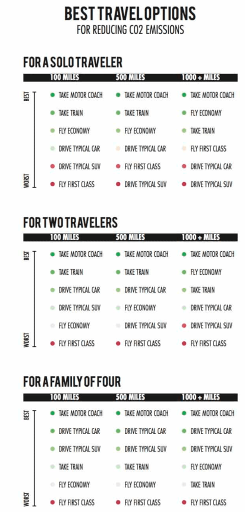
    Driving, in some situations, could be worse than flying. It depends upon the vehicle and the number of occupants. Driving solo from Chicago to Denver in an SUV, for example, will be more carbon intensive than flying economy. But number of occupants, distance and plushness of the jet make this less than straightforward. The best guide to travel comparisons I found was assembled by the Union of Concerned Scientists. (See chart, below).

    For the Las Vegas conference, my friend from Denver rented a medium-sized electric hybrid that gets 40 mpg and drove alone. I flew first to Reno and then Las Vegas. My return to Denver was direct.

    Who should have less carbon guilt? My research on the carbon-tracker website suggests I was responsible for 240 pounds of carbon emissions compared with 334 pounds for my friend in his rented hybrid car. Had my friend and I gone together by car, we would have had much lower carbon footprints. But we didn’t know of each other’s plans. It gets complicated.

    My friend does buy carbon offsets when traveling, whether by car or by plane. Such offsets have become more common. Air travelers flying into and out of a few mountain resort communities are now participating in an offset program called Good Traveler. Good Traveler was initiated in 2016 by the San Diego International Airport, which chose the Basalt-based Rocky Mountain Institute to manage it. It now has 17 U.S. airports, including major hubs in San Francisco and New York City. The Aspen-Pitkin County Airport joined the Good Traveler program in 2020…

    CAN SHINY GADGETS SAVE US?

    Burning biofuels, instead of fossil fuels, would theoretically reduce emissions. But they have been unable to achieve scale.

    In 2018, just 2 million liters of alternative jet fuel were produced, compared with the 360 billion liters of jet fuel consumed that year. Note the “m” and the “b.” Some suspect that lifecycle carbon costs of biofuels make them little better than conventional fossil fuels, too.

    Electrification of planes has produced excitement of late. All-electric planes began use in 2019 at a Denver-area airport for training of pilots. In December, a Vancouver company attracted international attention when it conducted a 10-minute demonstration flight of a 17-passenger seaplane retrofitted to operate on batteries. Harbour Air hopes to begin commercial operations within two years, planning an eventual fleet of 40 e-planes for short hops along the Pacific Coast in the Seattle-Vancouver area.

    Ampaire has made slower-moving, short-range and smaller aircraft such as are used to shuttle passengers among the Hawaiian Islands its goal. Peter Savagian, the company’s senior vice president of engineering, told an Aspen audience in November that such short-haul flights were responsible for one-third of global air emissions. NASA awarded Ampaire and another company, IKHANA, contracts to pioneer hybrid diesel/electric configurations for the 19-passenger Twin Otter.

    Advances in battery storage will be needed for longer distances. The newest batteries hold just 2% the energy of liquid fuel, Wired magazine explained in a 2017 story. In other words, 1,000 pounds of jet fuel yields about 14 times more energy than a 1,000-pound battery.

    In his talk at an Aspen Institute symposium titled “The Future of Aviation in a Carbon Constrained World,” Savagian counseled patience.

    “It will be decades before the largest aircraft are likely to be fully electrified,” he said. But when that happens, both airlines and consumers will benefit, he added. His company projects savings of 90% from electrified airplanes and maintenance costs cut 50%. Those savings, in turn, will allow airlines to cut fares by 15%, producing 40% more volume.

    Speaking at the same event, Aspen-area resident Amory Lovins — a co-founder of the Rocky Mountain Institute — maintained that airplane manufacturers could use carbon-fiber composite materials to make airplanes three to five times more energy efficient.

    “Many components made of metal today should not be,” Lovins said. He cited a simple $20 coffee pot. Replaced by a higher-tech model with energy consumption, it saves weight and hence fuel. “You take a pound out of a typical airplane and it’s worth around $2,000 in net-present value in fuel costs.”

    Lovins has credentials. In 1976, amid the Arab oil embargos, he wrote a landmark essay published in Foreign Affairs magazine that talked about climate change, renewable energy and energy efficiency. Both businesses and governments responded to his vision sluggishly. Time has mostly proven him correct.

    Price signals are needed to spur airlines to more rapid adoption of fuel-saving technology…

    Some think we’re in such a climatic pickle that we need to explore high-risk geo-engineering strategies.

    For example, can temperature rise of accumulated greenhouse gases be counteracted by reflecting more sunlight away from the Earth’s surface with giant mirrors in space? Another idea calls for spraying aerosols into the stratosphere, which is about 10 kilometers above the Earth’s surface, simulating the effect of volcanic eruptions. A volcano eruption in the Philippines in 1991 cooled global temperature by 0.6 degrees Celsius for about two years.

    Direct air capture is another idea, part of a broader set of solutions called negative emissions technology. This idea seeks to withdraw carbon dioxide or other greenhouse pollutants from the atmosphere. This is already being done in British Columbia by a company called Carbon Engineering. The company was founded in 2009 by David Keith, then a professor at the University of Calgary. Keith, with backing from Bill Gates and Murray Edwards, succeeded in removing CO2 from the atmosphere in 2015 and converting it into fuel in 2017 at the prototype between Vancouver and Whistler. Now, with backing from oil producers Chevron, Occidental and BHP, he’s trying to accomplish this at scale.

    But Keith, in a 2013 book called “A Case for Climate Engineering,” warned against seeing geo-engineering as the solution to climate change. “Our gadget-obsessed culture is all too easily drawn to a shiny new tech fix,” he said. Best, he said, would be to avoid creating emissions.

    Locally, emissions reduction has come up in plans to upgrade the Aspen-Pitkin County Airport. A citizens’ group appointed by the Board of County Commissioners early identified “carbon emission reduction” as a core community value that needs to be applied to the new facility. Varied ideas about what that means have come up as community outreach and the planning process played out over the past year.

    Some have suggested the airport itself should be carbon neutral or negative. It has little carbon footprint, however, compared with the planes that use it. A report to the commissioners early last year estimates 81,000 metric tons annually of emissions, a 30% increase between 2014 and 2017. Commercial and private jet traffic makes up more than 94% of those emissions.

    In aviation, as in so much else, it’s easier to create problems than solutions. A case in point is Denver International Airport, the fifth-busiest airport in the U.S. and a hub for many connecting flights to Aspen and other ski towns. The airport plans to add 39 new gates to accommodate growing traffic. Nowhere in the stories announcing the expanding airlines was mention of the carbon footprint.

    Allen Best writes about energy, water and other topics from a base in metropolitan Denver. More of his work can be found at http://mountaintownnews.net.

    Whirling Disease resistant rainbow trout now a reality in Colorado — #COParksWildlife

    In the Gunnison River gorge, CPW Aquatic Biologist Eric Gardunio, holds a whirling-disease resistant rainbow trout. CPW is stocking fish resistant to the disease throughout the state. Photo credit: Colorado Parks and Wildlife

    Here’s the release from Colorado Parks & Wildlife (Joe Lewandowski):

    Whirling Disease first impacted Colorado’s rainbow trout in the mid-1990s and eliminated many wild populations of this popular sport fish. The aquatic tragedy sparked a decades-long effort by Colorado Parks and Wildlife research scientists to find a remedy and re-establish populations.

    Since 2003, the researchers have been crossing a strain of rainbow trout resistant to the disease with other strains of rainbows in the hope of developing a trout that would fend off whirling disease. Now, after more than 20 years of study, frustration, experimentation and dogged persistence by CPW’s aquatic researchers, the tide has turned in the fight against the dreaded disease. Whirling-disease resistant rainbows are now thriving in the wild and the agency is collecting their spawn, enabling hatcheries to propagate millions of fish that will be distributed to rivers and streams throughout the state.

    “Thanks to advance genetic testing, we know these fish are maintaining their resistance to whirling disease,” said George Schisler, CPW’s aquatic research chief. “Now they are surviving, reproducing and contributing to future generations of Gunnison River rainbows.”

    This long success story started on an August day in 1994 when former CPW researcher Barry Nehring, while walking the river bank in the Gunnison Gorge, noticed small fish swimming helplessly in circles. He knew immediately that the fish were infected with a microscopic spore that damages the cartilage of young fish and prevents them from swimming and developing normally. Whirling disease had arrived in the wild.

    The disease was accidentally introduced to Colorado in the late 1980s when infected fish were imported to state and private hatcheries. After those fish were stocked in 40 locations, the spore spread and within a decade infected many rivers throughout state. The disease kills young fish, so eventually natural reproduction by wild rainbows ended across much of Colorado.

    In search of a remedy, CPW scientists and biologists from wildlife agencies throughout the West started researching the disease in the late 1990s. At a national conference in Denver in 2002, a researcher from Europe who studied whirling disease gave a presentation about a strain of disease- resistant rainbow trout he’d found at a hatchery in Germany. Schisler, working with the University of California-Davis, imported eggs and then tested the hatched fingerlings, known as Hofers – named after the German hatchery. He found they were 100 times more resistant to the disease than the various CPW rainbow strains.

    He also learned that because these fish had been raised in a hatchery for decades, they showed no inkling of the flight response needed to elude predators in the wild. So researchers started crossing them with wild strains, such as the Harrison Lake and Colorado River rainbow to produce fish that exhibit wild behavior and maintain resistance to whirling disease. Those fish were stocked in rivers around the state and some natural reproduction started.

    Biologists working in the East Portal Section of the Gunnison River gorge began documenting wild reproduction of rainbow trout in that location in the mid-2000s. These fish demonstrated strong resistance to whirling disease, but also had instincts to survive in the wild. Through advanced genetic analysis, Schisler and his research partner, Eric Fetherman, determined that a DNA marker unique to the stocked Hofer-crosses appeared to have been incorporated into this population, resulting in observed resistance to the disease.

    The researchers and agency aquatic biologists determined that developing a brood stock using the Gunnison River trout would be the best way to repopulate Colorado’s rivers with wild rainbows. Since 2014, more than 500,000 eggs have been collected from these fish to stock into whirlingdisease positive rivers and to create hatchery brood stocks.

    The trout now has its own moniker: The Gunnison River Rainbow.

    CPW’s Glenwood Springs hatchery is propogating both the pure Gunnison River Rainbows and crosses of those fish and other strains of whirling disease-resistant rainbows. This summer more than 1.3 million of fingerling disease-resistant rainbows will be stocked in rivers and streams throughout the state.

    The ultimate goal of the stocking effort is to restore natural reproduction in the wild, eliminating the need to stock rainbows in the future.

    However, re-establishing the rainbows continues to be a long-term project. After rainbows vanished, brown trout took over Colorado’s big rivers. They prey on the small rainbows that are stocked or hatch and compete for food and habitat with adult rainbows. Biologists say it will take many years for rainbows to become firmly established.

    Research scientists don’t declare victory easily, but Fetherman noted that the research project in the East Portal is officially closed. Populations across the state will continue to be monitored because the tiny worms that produce the spores causing whirling disease will likely always exist in Colorado’s rivers.

    “I feel like we’ve done some good work and these fish are ready to be stocked statewide,” Fetherman said.

    For more information on CPW’s aquatic programs, go to: https://cpw.state.co.us/thingstodo/Pages/Fishing.aspx

    Platte River Power Authority sets public sessions on energy options — The Loveland Reporter-Herald #ActOnClimate #KeepItInTheGround

    Transmission towers near the Rawhide power plant near Fort Collins, Colo. Photo/Allen Best

    From the Platte River Power Authority via The Loveland Reporter-Herald:

    Platte River Power Authority will hold public focus group meetings as the power provider works to update the plan that details how it will continue to deliver electricity to customers in Loveland, Estes Park, Fort Collins and Longmont as it moves toward more renewable resources.

    Platte River will hold sessions in each of those four communities, facilitated by Colorado State University’s Center for Public Deliberation, to receive input from residents and business owners as it updates its Integrated Resource Plan. A new such plan is produced every five years, using input, technology and best practices to lay out a mix of power sources.

    This plan is being completed in 2020, one year early, because the power provider’s board of directors decided to pursue a 100% carbon-free energy mix by 2030. Currently, about 30% of the energy delivered by Platte River is carbon-free, a number that will increase to 50% by 2021 with new wind and solar power sources and could reach 60% by 2023, according to a press release.

    Jason Frisbie, general manager and CEO, said in a press release that Platte River made significant progress on this updated plan last year and is now looking for input from businesses and residents regarding the “energy future of Northern Colorado.”

    The meetings are scheduled for 6-8 p.m. on each of the following dates:

  • March 4, 17th Avenue Place Event Center, 478 17th Ave. in Longmont.
  • March 5, Ridgeline Hotel, 101 S. St. Vrain Ave. in Estes Park.
  • March 11, Embassy Suites, Devereaux Room, 4705 Clydesdale Parkway, Loveland.
  • March 12, Drake Centre, 802 W. Drake Road, Suite 101, Fort Collins.
  • To attend a focus group, RSVP to 970-229-5657 or online at cpd.colostate.edu/events/platte-river-power-community-focus-groups/

    #NewMexico funds could help revamp management of #RioGrande — The Associated Press

    Elephant Butte Dam is filled by the Rio Grande and sustains agriculture in the Mesilla Valley of New Mexico.
    Sarah Tory

    From The Associated Press (Susan Montoya Bryan):

    New Mexico lawmakers are considering setting aside $20 million that could be used as seed money as water managers, municipalities and farmers scramble to find ways to reduce groundwater pumping that is at the center of a high-stakes legal battle.

    The fight over the Rio Grande has pitted Texas against New Mexico as demands increase and drought persists. It will be up to a special master appointed by the U.S. Supreme Court to eventually decide how New Mexico goes about ensuring enough of the Rio Grande flows south to users in Texas and Mexico.

    Right now, the system is out of balance, and Texas is arguing that New Mexico should be forced to reduce its pumping by as much as 60%. That would be equivalent to more than half of the water supplied annually to residents in Albuquerque, the state’s largest city.

    Such a reduction would be disastrous for users in southern New Mexico, says John D’Antonio, New Mexico’s top water engineer…

    The seed money would be used over three years for a combination of projects, from paying farmers to voluntarily fallow their land at certain times to efforts aimed at recharging the aquifer connected to the river. Other initiatives could involve importing more water…

    About 85% of the water being pumped along the lower Rio Grande goes to irrigate the nation’s most productive pecan orchards, chile and onion fields and other crops. The city of Las Cruces, New Mexico State University and electric utility Public Service Co. of New Mexico are among other major users. They have proposed paying into a fund that could be used for rotational fallowing and other efforts to address problems along the river…

    The Elephant Butte Irrigation District already has been looking at everything from stormwater capture to desalination of brackish groundwater and temporarily fallowing. But officials there agree with D’Antonio, saying the agriculture community alone cannot bear the full burden…

    … some advocates say New Mexico lawmakers need to boost funding for the state’s water management agencies to improve planning, collect more data and ensure the state doesn’t violate its compact delivery obligations. They point to a high vacancy rate within the state engineer’s office, saying more workers are needed to deal with a backlog of water rights cases, for example.

    D’Antonio said he’s trying to rebuild his agency following nearly a decade of austere state budgets and is hopeful the Legislature understands the importance of securing New Mexico’s water resources moving forward.

    “My feeling is there’s not a more important issue for an arid state like New Mexico than its water issues,” he said. “You start and stop with water. If you don’t have water, it really puts a kibosh on everything else that we do from an economic standpoint.”

    Weaning off #coal: Northern #Arizona starts a painful transition — The Navajo Times #JustTransition

    navajogeneratingstationnearpageazsunrisevicathyccviaflickr

    From The Navajo Times (Krista Allen):

    The city of Page, the Navajo Nation, and the Hopi Tribe are now dealing with economic repercussions of the Navajo Generating Station shutdown.

    When Salt River Project, operator of NGS, and the participants announced on Feb. 13, 2017, they had voted to close the power plant at the end of 2019, the community of Page and both tribes knew the closure would be disastrous for their economies.

    SRP permanently shut down the three units of the plant on Nov. 18, 2019. Since then, there has been a gnawing sense of despondency and anxiety in the Page-Lake Powell area where the closure has not only affected NGS and Kayenta Mine employees but also has impacted schools, Page Hospital, businesses and the libraries in Coconino County, among others.

    Page schools

    When Rob Varner, superintendent for Page Unified School District, started his job five years ago, student enrollment was around 2,650. Today, the enrollment f is 2,530, a 4.53 percent decrease. But the data constantly fluctuates…

    There are six schools within PUSD, which covers 1,800 square miles, including five northwestern Navajo Nation chapters. The student population within PUSD is 81 percent Native American, with at least 16 tribes represented. And of that population, 179 students have parents working at NGS.

    “We have seen a slow trickle of folks leaving,” Varner said…

    PUSD has lost $772,334 in revenue since the plant closed. This is due to student loss and cash inflow, said Varner…

    Page Hospital

    Page Hospital CEO Susan Eubanks said she has seen a decrease in revenue at the hospital, which decreases the facility’s access…

    Community college

    When talks of the NGS closure first started, Colleen Smith, president of Coconino Community College, talked to SRP about the possibility of developing some re-careering programs and a center for several of the regional colleges and universities to work together to provide higher education for people who were laid off from the plant.

    “I was encouraged to write a grant to SRP, but we didn’t receive anything, and we never received notice that we weren’t receiving anything,” Smith said. “We just wanted to provide good training. And I was working with (Coconino County District 5 Supervisor Lena Fowler) who was trying to help everyone.”

    Though CCC did receive some plant equipment to use for education.

    “But you need to know, along the way the things we’ve tried,” Smith said. “I’m adamant that we do not close (CCC’s Page Instructional Site) but that we continue to work to solve problems, be innovative and figure out how to provide more education up here in the northern part of our county. And we’ve been working with a lot of people to try to do that.”

    CCC has three campuses – two in Flagstaff and one in Page – and has been covering 18,000 square miles since 1991. CCC serves about 9,500 students annually. Smith said 75 percent of CCC students are full-time students who have jobs. And 20 percent of the CCC student population is Native American.

    But that percentage isn’t the same for the Page Instructional Site, said Kay Leum, executive director of extended learning at the Page campus, where 85 percent of the student population is Native.

    From fiscal year 2008 to 2017 state aid for the community college districts decreased by 71 percent, from $164.6 million to $47.7 million.

    Smith said that’s huge because nationally it’s considered appropriate funding for a community college to get one-third of its funding from the state.

    “One-third of the fund comes from local property taxes and one-third of the fund comes from tuition and fees,” Smith explained. “So, with these massive cuts – the cuts have affected CCC more than some colleges because we depend … on those funds: state appropriations because of our tax rate being so low (46 percent), far below the next (highest) one.”

    Smith said because the tax rate is so low, those cuts in state appropriations really impacted CCC.

    “It makes a difference in the things you accomplish … and I’m very proud of our college,” Smith said. “I think we’re good stewards for public funds because I think we’ve accomplished a lot with very little.”

    When the plant closed, CCC projected a loss of about $597,813 out of a $20 million general fund budget.

    “The effect of recession and cuts that all started in 2008 were massive,” Smith said. “Since then, we’ve seen significant increases in tuition and fees at our college. There were major cuts to classified and professional tech staff. Therefore, loss of programs, reduction in the number of students in the nursing program. (CCC) almost lost the program but instead cut it in half – many cuts.”

    And the Page Instructional Site nearly closed. Fowler convinced CCC officials to keep it open. The Williams campus, however, closed its doors.

    “Instead of closing the (Page campus), CCC just cut everything to the bone,” Smith said. “But I understand why that was done. It doesn’t mean I agree. I understand.”

    CCC has only 41 full-time faculty positions appropriated for its budget. Smith says that’s not enough. There are also some part-time faculty.

    Smith added that if CCC loses the $597,813, the board will have to make some decisions a little like what happened in 2008.

    “But I’m not saying these are the decisions they (CCC board) would make,” Smith said. “If we were to increase tuition to the amount that it would take to cover this loss, it would at least be (an extra) $10 per credit hour, which would be $300 more in tuition for students who are already paying the highest tuition in the state for community colleges.”

    Smith added that she’s strongly against closing the Page Instructional Site and that the board is trying to find ways to keep the Page campus open.

    “We did get some one-time money this year and one of the things we have been wanting to do is really support this campus (for new programs).”

    Three of those programs are a marine technology maintenance program, a hospitality program, and a tourism program to serve the area.

    “And everything we’re doing, we’re trying to bring our people home and keep them here, keep families together and strengthen our communities,” Fowler said. “When we talk about our communities. We don’t think about just Page or just LeChee, it’s all of us together.”

    La Junta Utilities Commission meeting recap

    Reverse Osmosis Water Plant

    From The La Junta Tribune-Democrat (Bette McFarren):

    Director of Water and Waste Water Tom Seaba reported this week that Colorado Department of Health and Environment has conducted its permit inspection of the new waste water treatment plant, and the results are good.

    Speaking at the Tuesday meeting of the Utilities Commissioners, Seaba said the total cost of the project was about $18.86 million. Three loans were obtained for the construction of the plant from the Colorado Water Resource and Power Development Authority. The first was for nearly $13.6 million, the second for $3 million, and the third for $3 million…

    Seaba also said he was pleased with the performance of his reverse csmosis plant crew. Through observation and careful maintenance, they were able to extend the life of the A and C Train membrane replacements — to 131 months from 58 months on the A Train, and to 137 months from 52 months on the C Train. They have saved one complete replacement of all three trains, at a savings of $386,442.

    In other news, the back-flow prevention survey is continuing. For businesses that do not have any back-flow prevention or cross connection control, the survey will consist of a visual inspection of the plumbing and building information. Reminder letters have been mailed to those consumers that have a known back-flow prevention device registered with the city.

    Wildscaping 101: Erie (Plant a better world for birds and people, Monday, March 09, 2020) — @AudubonRockies

    Photo credit: Evan-Barrientos via Audubon Rockies

    Click here for all the inside skinny from Audubon Rockies:

    Jamie Weiss, Audubon Rockies’ Habitat Hero coordinator, will demonstrate the importance of restoring our communities, one garden patch at a time. From a bird’s-eye view, learn how to create wildlife-friendly gardens that help combat the loss of open spaces and create green corridors that link your garden to larger natural areas by providing habitat for wildlife.

    Study Details Effectiveness of Kansas Program That Pays Farmers to Conserve Water — @UnivOfKansas

    Plots of land in Finney County, Kansas, utilize irrigation water from the High Plains Aquifer. Credit: NASA via the University of Kansas

    From the University of Kansas (Jon Niccum):

    Crops need water. And in the central United States, the increasing scarcity of water resources is becoming a threat to the nation’s food production.

    Tsvetan Tsvetanov, assistant professor of economics at the University of Kansas, has analyzed a pilot program intended to conserve water in the agriculture-dependent region. His article “The Effectiveness of a Water Right Retirement Program at Conserving Water,” co-written with fellow KU economics professor Dietrich Earnhart, is published in the current issue of Land Economics.

    “Residential water use is mostly problematic in California, and not so much here in Kansas. However, people don’t realize that residential use is tiny compared to agricultural use,” Tsvetanov said.

    “I don’t want to discourage efforts to conserve water use among residential households. But if we want to really make a difference, it’s the agricultural sector that needs to change its practices.”

    That’s the impetus behind the Kansas Water Right Transition Assistance Program (WTAP).

    “If you’re a farmer, you need water to irrigate. If you don’t irrigate, you don’t get to sell your crops, and you lose money. So the state says if you reduce the amount of water you use, it’s actually going to pay you. So it’s essentially compensating you to irrigate less,” he said.

    But this is not a day-to-day solution. The state recompenses farmers to permanently retire their water rights. The five-year pilot program that began in 2008 offers up to $2,000 for every acre-foot retired.

    This benefits the High Plains Aquifer, the world’s largest freshwater aquifer system, which is located beneath much of the Great Plains. Around 21 million acre-feet of water is withdrawn from this system, primarily for agricultural purposes.

    Tsvetanov and Earnhart’s work distinguishes the effectiveness between two target areas: creek sub-basins and high-priority areas. Their study (which is the first to directly estimate the effects of water right retirement) found WTAP resulted in no reduction of usage in the creek areas but substantial reduction in the high-priority areas.

    “Our first thought was, ‘That’s not what we expected,’” Tsvetanov said.

    “The creeks are the geographic majority of what’s being covered by the policy. The high-priority areas are called that for a reason — they’ve been struggling for many years. Our best guess is that farmers there were more primed to respond to the policy because there is awareness things are not looking good, and something needs to be done. So as soon as a policy became available which compensated them for the reduction of water use, they were quicker to take advantage of it.”

    Of the eight states sitting atop the High Plains Aquifer, Texas is the worst in terms of water depletion volume. However, Kansas suffers from the fastest rate of depletion during the past half-century.

    “Things are quite dire,” Tsvetanov said. “The western part of Kansas is more arid, so they don’t get as much precipitation as we do here in the east. Something needs to change in the long run, and this is just the first step.”

    Tsvetanov initially was studying solar adoption while doing his postdoctoral work at Yale University in Connecticut. When visiting KU for a job interview, he assumed the sunny quality of the Wheat State would be a great fit for his research. He soon realized that few policies incentivized the adoption of solar.

    “At that point, I thought, ‘I can’t really adapt solar research to the state of Kansas because there’s not much going on here.’ And then I started getting more interested in water scarcity because this truly is a big local issue,” he said.

    A native of Bulgaria who was raised in India (as a member of a diplomat’s family), Tsvetanov is now in his fifth year at KU. He studies energy and environmental economics, specifically how individual household choices factor into energy efficiency and renewable resources.

    The state of Kansas spent $2.9 million in the half decade that the WTAP pilot program ran. Roughly 6,000 acre-feet of water rights were permanently retired.

    “Maybe it’s a start, but it’s not something you would expect to stabilize the depletion,” Tsvetanov said. “This is just a drop in the bucket. Essentially what we need is some alternative source of income for those people living out there, aside from irrigation-intensive agriculture.”

    The Sacramento-San Joaquin deltas of 1772 and today — @HighCountryNews

    Here’s some of the history of the Sacramento-San Joaquin deltas from Matt Weiser writing in The High Country News, [February 27, 20214]:

    When Padre Juan Crespi first sighted the Sacramento-San Joaquin Delta in 1772, he thought he would be able to walk around it.

    The Spanish missionary and his party of 15 soldiers had been dispatched to find a land route from Monterey to Point Reyes, where Spain hoped to build a port. But 10 days into their journey, in the heart of Alta California, Crespi and his men encountered a maze of water, mud and swamp, instead of solid ground. It was the confluence of the Sacramento and San Joaquin rivers, the largest estuary on the West Coast of the Americas.

    Crespi expected the estuary to function like others he had seen, fragmenting into dozens of small braided channels fanning out toward the sea. Upstream, he figured, they would find a single channel to cross.

    But this estuary did the opposite. As Crespi traveled upstream, the water spread out, and his hopes thinned. On foot and horseback for three days in March, he and his companions searched fruitlessly for a way through the tangle of channels.

    “Crossing these rivers by boat or canoe would be apt,” a chastened Crespi wrote in his diary. “Because if you do not, it’s (necessary) to climb the mountains to the southeast and seek the path of the large river. To climb such a high pass certainly requires a greater number of soldiers and more provisions, which is why I withdrew.”

    Crespi was the first European to glimpse this odd California landscape, and the first of many to be confounded by it.

    Sixteen rivers and hundreds of creeks converge from all over California on the Delta’s vast central plain – all mud, tules and marsh – finally forming one mighty river that drains the state’s whole churning belly. It’s called an “inverted” estuary because its waterways unite before reaching the sea. The only place comparable is the Okavango Delta in Botswana.

    When Crespi encountered the estuary, its floodplain extended 100 miles north and south, filling the Central Valley with a wealth of snowmelt, all of it destined to squeeze through the land gap later called Golden Gate. Within a century of Crespi’s expedition, European settlers were trying to engineer their own logic into the place, trenching new channels and building levees to create some of the world’s richest farmland. Today, the Delta is crossed by three state highways and hundreds of miles of railroad tracks and county roads. There are 1,100 miles of navigable channels, and 72 islands ringed by levees. Modern charts detail where to anchor, where to catch the best striped bass, where to find the most convenient bridges and ferries.

    But the levees may be vulnerable to earthquakes. If they fail, the water supply would be compromised by a flood of salty water from San Francisco Bay. And rising sea levels could taint the water supply permanently.

    The Delta, which still covers an area the size of Rhode Island, provides half of all the freshwater consumed by a thirsty state, serving 3 million acres of farmland and 25 million Californians from Silicon Valley to San Diego. Gov. Jerry Brown hopes to better serve them by spending $15 billion on a new water-diversion system. If approved this year, it would shunt a portion of the Sacramento River out of the estuary into two giant tunnels, 30 miles long and 150 feet underground. The intent is to divert freshwater in a way less harmful to imperiled native fish species, while protecting those diversions from floods, earthquakes and a rising sea. The tunnels would serve existing state and federal canal systems that begin in the south Delta, near Tracy, and divert water to cities and farms, mostly in Southern California and the San Joaquin Valley. Another $10 billion would go to wildlife habitat improvements, in part to breach levees and restore tidal action to some islands. The state believes the proposed tunnel intakes would be far enough upstream to protect the water supply from disaster, at least under present climate-change scenarios. The intakes would also include modern fish screens, potentially preventing the extinction of the native Delta smelt, spring-run chinook salmon and other species that are being killed by the current water export system.

    But after seven years of study, state officials acknowledge that removing so much freshwater upstream may cause “unquantifiable” water-quality changes. Meanwhile, critics say taking so much freshwater from the estuary could harm Delta farms and perhaps concentrate pollutants in a way that hurts the same fish that state officials hope to restore. The Delta continues to confound.

    Forty-five years after Crespi turned back, Padre Narciso Durán came through with two small boats on an expedition led by Lt. Don Luis Arguello. They left the Spanish presidio, or fort, at San Franciso, which was established three years after Crespi’s visit. Their trip through the watery maze began on May 13, 1817, and lasted two weeks. Durán, who kept a journal, came along to baptize Indians.

    His party had a hard time from the start: They set out in a storm, and the boats became separated at the confluence. The storm blew Arguello onto the shore of the San Joaquin River, near its mouth. Durán and a second padre, in the other boat, took refuge for the night on a soggy mound of tules in the middle of the Sacramento.

    When the storm finally quit and the boats were reunited, another challenge arose. It was snowmelt season, and the downstream current in the Sacramento River was so strong that it nearly halted their progress. Without wind, days of brutal rowing followed, with little upstream progress to show for it.

    On top of that, the men experienced a condition that plagues Delta visitors to this day: They became disoriented.

    Seeking to remain on the Sacramento River, the party soon encountered a variety of branching side-channels. They could not be sure which one was the river itself. Because the Delta was in flood, the true riverbanks and many of the natural islands were submerged. A gap in the trees that looked like a river channel might turn out to be a flooded island where a boat would quickly run aground. “The thick leafiness makes the whole river like a tree-lined promenade,” Durán remarked.

    The next day, May 16, they traveled only four leagues upriver. They also took a wrong turn and left the Sacramento on a side channel – a serious mistake, as any detour meant more labor for the rowers. Eventually, though, they got lucky and recovered their course.

    Familiarity with this labyrinth benefitted the locals, who fled on rafts as soon as they spotted the expedition boats. The Europeans found two villages vacated, either because of the spring flood or because word had spread that the Indians might be conscripted as laborers in the Spanish missions.

    Occupants of a third village “fled at the noise of the launches, leaving only two old women, more than 60 years old.”

    Durán felt obliged to baptize both women, “because it seemed to us that they could die before Divine Providence could arrange another convenient time when we could baptize them in one or another of the missions.”

    Durán, who was no naturalist, made no effort to identify important land features or tree species, and does not mention sighting any animals. But the Delta was teeming with wildlife in a way that is difficult to imagine today: Vast herds of elk and pronghorn antelope roamed here, hunted by wolf and grizzly bear. Giant tidal marshes, packed with tules and cattails, hosted millions of waterfowl. The maze of curving sloughs was a nursery for one of the world’s most productive fisheries.

    The Delta remains the most important salmon fishery on the West Coast, producing most of the wild-caught king salmon in the Lower 48 states. Yet it may not survive. There are 57 endangered species here, including steelhead trout and two runs of salmon.

    Modern-day Californians are as oblivious to the region’s natural wealth as Durán seemed to be. A January 2012 survey found that 78 percent of California residents don’t know where the Delta is, or even what it is.

    The day after baptizing the two women, Durán and his party reached their turnaround point. They hoped to find a place to erect a cross, “and there to end our quest and retreat downriver.” After rowing upriver three more leagues, they pulled ashore to rest, where, by chance, they spotted some rafts in the tules and a village of Natives, “who came out at them armed with their customary fierce clamor.”

    Arguello mustered his soldiers to confront the Indians, who “calmed down, to everyone’s relief, and said they had armed themselves believing we were hostile people.” The travelers were invited to visit a larger village one league upriver, where they were promised fish.

    But Durán and his cohorts, possibly disoriented, never found the second Indian village, and never got the promised fish. Exhausted and frustrated, they were ready to turn back. Amid the flood, they could find no solid ground to erect a cross. So they carved one on an oak tree.

    The exact location of that cross is unknown today. But according to Durán’s diary, they carved it about 80 miles upstream from the confluence of the Sacramento and San Joaquin rivers, or approximately near today’s state capital, Sacramento, where Gov. Brown weighs the fate of the Delta today.

    Matt Weiser covers environmental issues for The Sacramento Bee and has written about the Delta and California water for 15 years.

    The contemporary translation of Crespi and Durán’s journals is by Alexa Mergen.

    #NEPA turns 50 amid new challenges to public process — @AspenJournalism

    A proposed trail connecting Redstone to McClure Pass is going through a federal environmental review. The existing trail switchbacks up McClure Pass. Photo credit: Pitkin County Open Space and Trails

    From Aspen Journalism (Marci Krivonen):

    The National Environmental Policy Act, or NEPA, turned 50 years old on Jan. 1. A fundamental component of the law is public involvement. Projects such as a new ski lift, trail or natural-gas lease each receives a NEPA review, and most of the time the public weighs in. NEPA has evolved over the years, but the biggest change may come in a new proposal from President Donald Trump.

    Katherine Hudson looks over a map that features the proposed trail between Redstone and McClure Pass. Hudson plans to voice her concerns about the project during the public comment period required by NEPA. Photo credit: Marci Krivonen/Aspen Journalism

    A NEPA case study: The trail between Redstone and McClure Pass

    Katherine Hudson lives near the Crystal River between Carbondale and Redstone. She said she loves living close to nature but thinks a proposed multi-use recreation trail will disturb the river.

    Proposed Redstoen to McClure Pass trail. Map credit: USFS

    “For me, it’s not just about the view,” she said. “I value this incredible waterway and how lucky we are to have it.”

    Hudson, a member of the Pitkin County Healthy Rivers Board, believes bridges planned along the trail will constrict the river.

    A five-mile section of the proposed trail sits on Forest Service land and will get, thanks to NEPA, a close review. Hudson was one of about 50 people looking over maps and visiting with Forest Service staff at an open house in Carbondale in late January.

    Under NEPA, federal agencies must consider impacts to the environment when projects such as the Redstone to McClure Pass Trail are proposed on public land. The law applies to all major federal actions, including infrastructure permitting and road construction. One goal is to “create and maintain conditions under which man and nature can exist in productive harmony,” according to the Environmental Protection Agency.

    Proposed changes from Washington

    In January, the White House released a plan to streamline NEPA, marking the first major update in decades. The changes would impose strict deadlines on completing analyses; would more closely involve contractors in studies; and would eliminate requirements to consider climate change.

    “It would make it really difficult to analyze the impacts on climate in any project,” said Will Rousch, executive director at Wilderness Workshop, a public-lands watchdog group based in Carbondale. “It would redefine what a major federal action is. That might eliminate some projects from going through the NEPA process.”

    Also, he said, fewer projects undergoing a review means fewer opportunities for the public to weigh in.

    But supporters say NEPA has become time consuming for federal agencies, project applicants and people seeking permits.

    U.S. Rep. Scott Tipton, a Republican from Colorado, points to a NEPA review of an Interstate 70 project near Denver that took 13 years to complete. He said lawsuits and reviews from multiple agencies kept it from moving forward more quickly.

    “This was a good example of how we do need to make sure that we’re doing the right thing environmentally but also that we’re not creating roadblocks that stifle any kind of development at all,” Tipton said.

    Katherine Hudson speaks with Roger Poirier of the White River National Forest at an open house in Carbondale in late January. The meeting was part of initial steps in the Forest Service analysis of the trail’s environmental impacts. Photo credit: Marci Krivonen/Aspen Journalism

    Local efforts to make NEPA more efficient

    President Richard Nixon signed NEPA into law in 1970. Two catastrophic events prompted its creation: Millions of gallons of crude oil leaked into the Pacific, and a heavily polluted river in Ohio caught fire. Now, agencies such as the White River National Forest use the law all the time.

    “It’s part of our work daily, for sure,” said WRNF supervisor Scott Fitzwilliams. “We use NEPA on almost every single project. But there’s varying levels of it.”

    For large, complex projects, a team of scientists may analyze a project’s impacts and create alternatives informed by public input. Small-scale projects, such as replacing a trailhead sign, don’t get in-depth reviews and public comments. The Forest Service determines how a project is analyzed based on its significance.

    The White River National Forest, like the Trump administration, sees ways to make NEPA more efficient. The agency has developed tools that reduce the time it takes to do an environmental analysis. Their work began with a Forest Service-wide effort in 2017. The White River National Forest’s efficiencies have reduced NEPA document size and planning by more than 80% compared with the national average.

    “We’re trying to be more efficient with the taxpayer’s money and really streamline where it’s appropriate,” Fitzwilliams said. “That doesn’t mean we cut corners; we still have a responsibility to disclose impacts, consider alternatives and involve the public, but we want to do it in a way that’s a little less bureaucratic.”

    Since the streamlining began, Fitzwilliams estimates his agency has saved time and money by not conducting three environmental-impact statements — the most-in-depth analyses — that would have been done before. An EIS is still utilized, he said, if a project is significant enough.

    “We’ve been doing less EIS’s and more EAs (environmental analyses),” said Fitzwilliams.

    The approach began with ski areas. Hundreds of NEPA analyses have been done on ski hills in the White River National Forest, so a new project, such as a lift, may receive a lighter review because previous studies help inform it.

    “We know the ground really well, and so we really focus on what the key issues are,” said Fitzwilliams. “Instead of doing a full specialist report on all the wildlife potential impacts, we may just focus on elk-calving areas.”

    The agency isn’t cutting corners, he said, and still focuses on considering impacts, alternatives and public involvement, the latter of which remains a high priority.

    “People expect that of their government,” Fitzwilliams said. “They don’t expect government to waste time and money just because.”

    The White River National Forest’s efforts to innovate NEPA earned the agency national distinction in December at the Under Secretary’s Awards and Chief’s Awards ceremony in Washington, D.C.

    What’s next locally and nationally?

    The NEPA process for the Redstone to McClure Pass Trail is just getting started. It will take one year to complete, partly because it’s contentious. It’s getting an environmental assessment — a middle-ground approach under NEPA. It’s neither the law’s deepest analysis nor its lightest-touch approach, and the public will have two chances to give feedback.

    The concerns raised at the open house — river health, maintaining biodiversity and preventing habitat fragmentation — will inform the final assessment.

    “It’s an issue that a lot of people care about, and I think without the NEPA process, you’d end up with a much worse project regardless of how it turned out because people wouldn’t get a say,” said Rousch.

    Hudson said she’s glad for the opportunity to comment on the trail project.

    “I’m in it for the long haul because there are a lot of things that are at stake,” she said. “The Crystal River is a jewel of this watershed, and decisions could be made with this project that could permanently alter that treasure.”

    She said she will submit concerns during both comment periods.

    Meanwhile, the Council on Environmental Quality, which oversees NEPA, is also taking public input on Trump’s proposed changes to NEPA until March 10.

    Aspen Journalism collaborates with Aspen Public Radio and The Aspen Times on coverage of environmental issues. A version of this story ran in The Aspen Times and aired on Aspen Public Radio on Feb. 13.

    Map of the Roaring Fork River drainage basin in western Colorado, USA. Made using USGS data. By Shannon1 – Own work, CC BY-SA 4.0, https://commons.wikimedia.org/w/index.php?curid=69290878

    The Pagosa Area Water and Sanitation District (PAWSD) and BootJack Ranch water court case update

    Bootjack Ranch. Photo credit: Mountain Workshop

    From The Pagosa Sun (Chris Mannara):

    Pagosa Area Water and Sanitation District (PAWSD) and BootJack Ranch are in water court regarding various opposition of diligence claims.

    At the Jan. 16 regular meeting of the PAWSD Board of Directors, PAWSD District Manager Justin Ramsey explained that BootJack Ranch, in 2018, started opposing PAWSD’s diligence on its water rights…

    Ramsey later explained that, in one instance, BootJack had requested that PAWSD no longer take water from Four Mile if the river levels dropped below a certain percentage during certain months.

    “I said that’s an absolutely ridiculous request. We turn our water off three weeks out of every month. It’s idiotic,” he said.

    On Aug. 2, 2018, the Colorado Water Conservation Board (CWCB) placed a call on the San Juan River, which Ramsey explained correlated to BootJack’s earlier requests on PAWSD not taking water from Four Mile.

    “Those numbers, they did corresponded with that. I think BootJack figures we quit turning the water on, and the water would get to the San Juan, CWCB wouldn’t do their call and they wouldn’t lose their water,” Ramsey explained. “So they wanted us to augment their water rights is what that was for.”

    According to Ramsey, BootJack Ranch is going after PAWSD’s diligence claims…

    What PAWSD has decided to do is oppose all of BootJack’s water rights issues, Ramsey noted…

    Ramsey noted that there will be a meeting with BootJack to see if the two entities can just “leave each other alone.”

    […]

    Ramsey explained that PAWSD went to the water court previously and explained that it needs 20 cubic feet per second (cfs) from Four Mile, which the court agreed to.

    “Now it’s called a non-perfected right. We don’t use that 20 cfs at this point. Our plan is to use it in the future,” he explained.

    According to Ramsey, the rea- son BootJack has filed this claim opposition relates to water from Four Mile that goes into the San Juan River.

    “The CWCB has an instream water right. The CWCB is the only entity in the state that’s allowed to have an in-stream water right. That goes from I think the 1st Street bridge in Pagosa down to McCabe Creek,” Ramsey explained. “If the water level drops, then they can do a call. That’s what they did last year.”

    That call affected BootJack, Ramsey noted…

    There has never been a time since PAWSD has had the Four Mile water right that it has been able to pull water in the summer, he explained, adding that PAWSD loses that ability in the first part or middle of May.

    #SanJuanRiver Water Conservancy District board meeting recap

    Dry Gulch Reservoir site. Credit The Pagosa Daily Post

    From The Pagosa Sun (Chris Mannara):

    At a regular meeting of the San Juan Water Conservancy District (SJWCD) Board of Directors on Feb. 3, the board nominated a few direc- tors to sit in on a subcommittee related to the Running Iron Ranch and San Juan River Headwaters Proj- ect (formerly known as Dry Gulch Reservoir).

    Chair Al Pfister and board mem- bers John Porco and Doug Secrist were nominated to be on the six- person subcommittee that will also consist of three members of the Pagosa Area Water and Sanitation District (PAWSD) board.

    SJWCD board member Bill Hudson will serve as an alternate for SJWCD’s portion of the subcommittee.

    This subcommittee was formed as a result of a joint work session between the SJWCD and PAWSD boards on Jan. 23.

    At that work session, it was suggested that a subcommittee should be created to craft an intergovernmental agreement between the two organizations regarding the property and determine what should be done when the Weber leases on the property end in 2023 and for a potential reservoir project…

    Also at the Feb. 3 meeting, the SJWCD board briefly discussed who to nominate to be appointed to the Pagosa Springs Urban Renewal Au- thority (URA) Commission.

    The 11-member URA commission is set up to consist of the seven town council members, an elected member of the school board, one person appointed by the county commissioners, one mayoral appointee and one person appointed by the taxing districts that levy taxes within the URA boundaries.

    A URA’s primary goal is to help redevelopment within the town, and tax-increment funding ( TIF) is a common source of funding for specific URA projects…

    Also at the Feb. 3 meeting, following an executive session, the board advised its legal counsel, Jeffrey Kane, to settle various cases the district, along with PAWSD, has with BootJack Ranch.

    In a follow-up interview on Feb. 4, Kane explained that there are five cases the SWJCD is a part of.

    Two of those cases involve both PAWSD and SJWCD as applicants, while the other three, BootJack Ranch is the applicant, Kane explained.

    “The motion that was carried gave me authority to prepare stipulations with certain terms and negoti- ate with the parties to try and settle the cases,” he said.

    Also at the Feb. 3 meeting, the SJWCD board elected its officers for the year.

    Al Pfister was voted to be chair of the board. He previously served as secretary. Susan Nossaman retained her seat as vice chair.
    Porco was elected as secretary after having previously served as chair.

    Candice Kelly retained her seat as treasurer.

    Senior Judge John L. Kane grants another delay in the #FountainCreek lawsuit (May 22, 2020)

    The Fountain Creek Watershed is located along the central front range of Colorado. It is a 927-square mile watershed that drains south into the Arkansas River at Pueblo. The watershed is bordered by the Palmer Divide to the north, Pikes Peak to the west, and a minor divide 20 miles east of Colorado Springs. Map via the Fountain Creek Watershed Flood Control and Greenway District.

    From The Pueblo Chieftain (Robert Boczkiewicz):

    A new court document states that progress continues toward resolving an environmental lawsuit against Colorado Springs for degrading Fountain Creek.

    The document was filed last week in Denver at the U.S. District Court for Colorado, where the lawsuit is pending.

    “The parties have continued to make significant progress toward a settlement that encompasses an agreement for relief for all violations alleged,” the court filing states…

    After a trial last year, a judge decided Colorado Springs had violated its permit that regulates discharges of the city’s storm water sewer system into the creek. Remaining to be decided is what the city would do to remedy the violations.

    The new document states that since October, the five parties have been exchanging drafts of a proposed agreement on how to settle the dispute.

    “The parties have met monthly (since November and) continued to have monthly scheduled settlement meetings so that they can continue their progress toward (a settlement),” the document states.

    Last week, Senior Judge John L. Kane granted the parties’ request to keep the case on hold until May 22, so they can continue their work. Kane is presiding over the case.

    He emphasized, however, he would not keep the case on hold beyond May 22 based on the same grounds that the parties have been stating.

    Status of Spring — USA National Phenology Network #ActOnClimate #KeepItInTheGround

    From the USA Phenology Network:

    HOW DOES THIS SPRING COMPARE TO “NORMAL”?

    Six Leaf Index Daily Anomaly 2020.
    Map credit: National Phenology Network
    Six Bloom Index Daily Anomaly 2020. Map credit: National Phenology Netwok

    How do you know when spring has begun? Is it the appearance of the first tiny leaves on the trees, or the first crocus plants peeping through the snow? The First Leaf and First Bloom Indices are synthetic measures of these early season events in plants, based on recent temperature conditions. These models allow us to track the progression of spring onset across the country.

    February 10, 2020

    Spring leaf out has arrived in the Southeast, over three weeks earlier than a long-term average (1981-2010) in some locations. Charlottesville, VA is 24 days early, Knoxville, TN is 20 days early, and Nashville, TN is 18 days early.

    Comparison of 2020 spring bloom to average from 1981-2010
    Spring leaf out has also arrived in parts of the West. Spring leaf out is on time to 2 days late in San Diego, LA, and San Francisco, CA and 10 days early in Portland, OR and Seattle, WA.

    Spring bloom has also arrived in several Southeast states as well as parts of southern CA, NV, and TX. Spring bloom is between 1 day and 2 weeks early.

    Check back on this page throughout the spring for updates on when spring arrived and whether spring was early or late for your location.

    Download static maps of Spring Leaf Out and Spring Bloom.

    HOW OFTEN DO WE SEE A SPRING THIS EARLY OR LATE?

    In places where spring has sprung, how typical is this year’s spring? Darker colors represent springs that are unusually early or late in the long-term record. Gray indicates an average spring.

    In parts of the Southeast, this year’s spring is the earliest in the 39-year record (dark green).

    WHEN DID SPRING ARRIVE AT LOCATIONS ACROSS THE COUNTRY?

    WHAT IS BEHIND THESE MAPS?

    The Extended Spring Indices are mathematical models that predict the “start of spring” (timing of leaf out or bloom for species active in early spring) at a particular location (Schwartz 1997, Schwartz et al. 2006, Schwartz et al. 2013). These models were constructed using historical ground-baesd observations of the timing of first leaf and first bloom in a cloned lilac cultivar (S. x chinensis ‘Red Rothomagensis’) and two cloned honeysuckle cultivars (Lonicera tatarica ‘Arnold Red’ and L. korolkowii ‘Zabelii’). These species were selected because they are among the first woody plants to leaf out and bloom in the springtime and are common across much of the country.

    Primary inputs to the model are temperature and weather events, beginning January 1 of each year (Ault et al. 2015). Maps for the current year are generated using temperature products from NOAA National Centers for Environmental Prediction Real-Time Mesoscale Analysis. More information is provided in our Gridded Product Documentation.

    To determine how the current spring compares to “normal”, we difference the day of year the leaf out or bloom was reached this year from the long-term average (1981-2010) day of year it was met. Long-term averages were calculated using PRISM Climate Data daily minimum/maximum temperature data (Oregon State University).

    To calculate how often we see a spring as early or late as the current spring, we compare the current year’s Spring Index Anomaly value to the anomaly values from 1981-2019. We determine how often a spring was at least this early (or late) by taking the 39 years in the record divided by the count of years that were earlier (or later) than the current year.

    From The Washington Post (Jason Samenow):

    Thanks to an abnormally warm winter, green leaves are sprouting and flower buds are bursting weeks early across the Southeast this year. Spring has sprung prematurely, and depending on the weather during the next two months, this could have detrimental effects on this vegetation.

    In several other recent abnormally mild winters, vegetation has emerged early only to be heavily damaged by brutal invasions of cold in early spring, which has come at a large cost to agriculture.

    A similar scenario is setting up for another devastating frost, on the heels of what is known as a “false spring.” The warmth across much of the Lower 48 states has been exceptional, with most locations in the southern and eastern third of the United States seeing one of their top 10 warmest winters on record to date, as if skipping ahead a season.

    90-Day Departure from Normal Temperature ending February 14, 2020 from the High Plains Regional Climate Center.

    Theresa Crimmins, director of the network and a research scientist at the University of Arizona, said spring has arrived up to four weeks early in some locations based on several indexes.

    “One of the biggest [concerns] is that we’re absolutely not past the risk of frost in a lot of these locations,” she said in an interview. “I’m seeing a lot of reports [of] leaf buds breaking and flowers blooming in a lot of those early-blooming plants. That’s definitely a problem.”

    Crimmins explained that trees can bounce back from a frost. “But if flower buds get hit by frost, typically they do not regenerate those buds and then you won’t see fruit,” she said.

    In 2017, abnormally warm conditions in February resulted in many species flowering prematurely in the Southeast and Mid-Atlantic. Then a severe frost hit in mid-March. South Carolina lost 85 to 90 percent of its peach crop. In parts of Georgia and North Carolina the blueberry crop was “devastated.” In Washington, about half of the cherry blossoms were damaged.

    In 2012 and 2007, there were also so-called false springs. A study published by the American Geophysical Union in 2013 determined the false spring of 2012 was the earliest on record in North America…

    Rising winter temperatures from human-caused climate change would seem to increase the likelihood of false springs in the future. However, the rising temperatures would also potentially decrease the intensity or even eliminate the occurrence of killer frosts that might follow.

    #Snowpack news:

    Click on a thumbnail graphic to view a gallery of snowpack data from the NRCS.

    From Weather Nation TV (Chris Bianchi) via The Cañon City Daily Record:

    Colorado statewide snowpack levels are running well above average following a recent run of snowstorms, based on official data this week from the Natural Resources Conservation Service.

    Statewide snowpack is running at 116% of season-to-date average, a slight boost from snow levels earlier this year. This is partially as a result of a recent run of February snowstorms that has ski resorts like Steamboat Springs (275 inches of seasonal snowfall, as of Friday), Breckenridge (273 inches) and Wolf Creek (261 inches) already closing in on 300 inches of annual snowfall.

    Highest snowpack levels are in Colorado’s northern mountains, although each of the state’s eight major river basins were reporting above-average snowpack levels, as of Wednesday. In the South Platte river basin (east of the Continental Divide, including the Front Range), snowpack levels were running at 131% of average, the highest of the state’s eight basins.

    A major storm system slammed much of northern Colorado with as much as 51 inches of snow last week, contributing to the increased snowpack figures.

    Utah snowpack basin-filled map February 15, 2020 via the NRCS.

    From The Deseret News (Amy Joi O’Donoghue):

    Utah’s snowpack across the state is sitting at 121% of normal and the reservoirs on average are in pretty great shape — 80% full — but forecasters are still yearning for a cold and wet March.

    Soils are pretty dry, and in particularly in the southwest region of Utah, precipitation activity has all but dried up since Thanksgiving.

    At a water supply forecast meeting earlier this week at the National Weather Service in Salt Lake City, senior hydrologist Brian McInerney emphasized there is much to be happy about, however…

    In northern Utah, the weather pattern has been gracious when it comes to snowpack totals, with the Bear River drainage at 121% of normal, the Weber-Ogden river basin at 114% and Provo-Jordan at 122%.

    Gary Henrie, with the Provo Area Office of the U.S. Bureau of Reclamation, said across Utah reservoirs are in much better position than they were a year ago — at 80% capacity compared to 60%.

    The water year, in fact, has been a mirror image of the 2019 precipitation rate, with snow in northern Utah piling on with frequent storm activity.

    There are have been some instances of extremes, however.

    Northern Utah struggled through an extremely cold spell in October and November, and even though St. George endured 155 days during the 2019 calendar year without any measurable precipitation, it was the wettest calendar year on record and the second wettest water year logged there…

    …officials with Salt Lake County Flood Control and Salt Lake City Department of PublicUtilities, in coordination with the State Engineer’s Office, announced plans to open gates on Utah Lake to allow more water to flow to the Jordan River and Surplus Canal.

    Officials are taking the move this weekend to accommodate above-average snowpack and higher-than-average water levels in Utah Lake, Deer Creek Reservoir and Jordanelle Reservoir, a news release from the county stated.

    West Drought Monitor February 11, 2020.

    From The Grand Junction Daily Sentinel (Dennis Webb):

    Colorado’s snowpack remains above-average this winter, with a wet start to February helping to make up for what, in much of the state, was a drier-than-normal January.

    But streamflow forecasts for the state are below-average. That reflects in part precipitation that as of Feb. 1 was 88% of average statewide for the latest water year, which started Oct. 1 and includes rain as well as snowfall.

    Snowpack was at 110% of normal Friday, according to the Natural Resources Conservation Service. That’s down from 118% at the start of the year, but snowpack had dropped to 106% at the end of January before recent storms hit much of the state. Those storms made travel perilous but also blessed ski areas and bolstered the outlook for spring runoff and water supplies for irrigators, municipalities and other purposes…

    It currently is above 100% of median for every major river basin in the state. The Gunnison River Basin is on the low end among basins, at 105%. The Upper Colorado River Basin in Colorado is at 114%, and the South Platte basin leads the state at 117%.

    Levels on Grand Mesa are currently running a bit below-normal…

    Even with the decent snowpack this winter, spring and summer streamflow forecasts look less promising, particularly in western and southern basins. According to the NRCS, streamflows for the Yampa/White, Arkansas and South Platte basins are expected to be at 98, 97 and 96% of average, respectively. But the forecast for the Upper Colorado River is for streamflows at 91% of average. For the Gunnison, the prediction is 81%. Streamflows for the Rio Grande and combined San Miguel/Dolores/Animas/San Juan basins currently are expected to be at 77 and 76% of average, respectively.

    The federal Colorado Basin River Forecast Center says that as of Feb. 1, overall Upper Colorado River Basin flows into Lake Powell were expected to be about 80% of normal. Water storage in Powell is only at about half of the reservoir’s capacity, reflecting long-term drought during the 21st century.

    The center says water-year precipitation so far is at 90% of average for the Upper Colorado River Basin above Powell. Precipitation is 85% of average for the Gunnison River Basin.

    Much of western and southern Colorado, including all of Mesa County, is in moderate drought. In terms of snowfall, southern Colorado was the driest part of the state in January. Cody Moser, a hydrologist with the Colorado Basin River Forecast Center, noted that soil moisture conditions there are below average as well. That figures into streamflow predictions, as more snowmelt may percolate into dry soil rather than reaching streams…

    Moser said precipitation in January and into this month has favored northern Colorado over southern Colorado. He said moist weather systems have been coming from the Pacific Northwest into northern Utah and southwest Wyoming, and into northern Colorado…

    Statewide reservoir storage in Colorado was at 105% of average for Feb. 1. It was above 100% everywhere but in the Arkansas and Rio Grande basins. Storage in the Upper Colorado River Basin in Colorado was at 110% of average Feb. 1; in the Gunnison it was at 104%.

    From The Sacramento Bee (Dale Kasler):

    California’s alarmingly dry winter continues, with no meaningful snow or rain in sight. Although it’s far too soon to predict a drought, experts said wildfire risks could worsen this summer as a result of the shortage of precipitation.

    And while the rainy season still has more than two months left, a persistent high-pressure ridge over the Pacific is keeping wet weather at bay, just as it did during the five-year drought, said Daniel Swain, a climate scientist at UCLA. Swain said it’s possible parts of Northern California “could go completely dry in the month of February.”

    Private weather forecaster Jan Null said there’s only a 15 percent chance of precipitation levels hitting normal levels. “That’s not where I’m going to put my money on the table,” said Null, founder of Golden Gate Weather Services in Half Moon Bay…

    Sacramento could be heading into record territory: So far the city hasn’t received any rain in February, a month that normally sees 3.69 inches. The driest February in recorded history in Sacramento saw 0.04 inches of rain, according to Michelle Mead of the National Weather Service.

    Fresno hasn’t seen any rain this month, either. The same with Merced.

    The Sierra Nevada snowpack is 40 percent below normal. The Department of Water Resource’s eight-station index for the northern Sierra, a closely-watched gauge of precipitation in the mountains and foothills, is 42 percent below normal.

    From Northern Water:

    Northern Water’s Snowpack and Streamflow Comparisons reports show snow-water content comparisons and streamflow forecasts for the watersheds in the Colorado-Big Thompson Project. Northern Water publishes the reports on this page from the beginning of February through the beginning of May. Go to the SnoWatch Snowpack Data page for snowpack data from remote Snowpack Telemetry (SNOTEL) platforms in eight watersheds, covering an area from west of Loveland, CO to east of Kremmling, CO.

    February 2020 Streamflow Forecast

    February 1 snowpack is at or above average in most basins except for Willow Creek. Streamflow forecasts are generally a bit lower than we would normally expect with these snowpack conditions due to the impacts of the hot and dry conditions in late summer 2019 on soil moisture. The forecast for most basins is around 90-100% of average, though Willow Creek is lower due to the lower snowpack.

    From The Pagosa Sun (Chris Mannara):

    Snow water equivalency (SWE) [in the San Juan River wateshed] is currently 19.1 inches. Last week it was 18.7 inches.

    The SWE median has gone from 19.5 inches to 20.5 inches this week.

    This week, the SWE is currently 93.2 percent of median, when last week, it was 95.9 percent of median.

    Precipitation data is currently 19.7 inches, when last week, it was 19.1 inches.

    The precipitation average is 23.7 inches. Last week it was 22.2 inches.

    This week, precipitation is 83.1 percent of median. Last week, it was 86 percent of median.

    And, here’s the Westwide SNOTEL basin-filled map for February 15, 2020 via the NRCS.

    Westwide SNOTEL basin-filled map February 15, 2020 via the NRCS.

    South Fork #RepublicanRiver Restoration Coalition (SFRRC) meeting recap

    The Republican River’s South Fork near Hale, Colorado, with the region’s seemingly endless fields. Credit: Wikimedia Commons/Jeffrey Beall

    From the Republican River Water Conservation District (Deb Daniel) via The Burlington Record:

    Over 60 people attended the meeting of the South Fork Republican Restoration Coalition (SFRRC) on Monday evening, Feb. 10 at the Old Town Museum meeting room, in Burlington.

    Dave Hornung, Kit Carson County Commissioner, opened the meeting, welcoming everyone and thanking them for attending the meeting.

    Hornung listed the members of the SFRRC: Three Rivers Alliance, Kit Carson County, Yuma County, The Nature Conservancy, the Republican River Water Conservation District (RRWCD) and the Colorado Division of Parks and Wildlife.

    He introduced members of each organization including MaryLou Smith, facilitator, formerly from CSU.

    Hornung made it very clear that the meeting was not to discuss refilling Bonny.

    He read the list of objectives the SFRRC compiled in the stream management grant for this phase of the project.

    He emphasized that the focus of the meeting is to describe the best option to restore streamflow to the South Fork Republican River.

    Rod Lenz, president of the RRWCD, gave a brief history of the SFRRC and talked about how much cooperation there has been with all the entities involved in this project.

    Robin Wiley, Yuma County Commissioner commented on how much cooperation the SFRRC has received from the Bureau of Reclamation (BOR), Senator Cory Gardner’s office and The Nature Conservancy (TNC).

    He especially thanked the TNC for all their work on the project and for supplying the $120,000 cash match for our grant CWCB application.

    “We simply would not be as far along with this project if it were not for The Nature Conservancy being a big part of our project and we appreciate them partnering with us,” Wiley added.

    Frank McGee, Colorado Parks and Wildlife (CPW), Area Wildlife Manager explained the CPW’s support of this project and how well the BOR has worked with the SFRRC.

    He also mentioned the new area management agreement between BOR and CPW and how important it is to this project.

    William Burnidge, from The Nature Conservancy, gave a presentation explaining the research and analysis that went into the options the SFRRC considered.

    Burnidge stated that the option that the SFRRC has chosen is the most cost effective and leaves the ability for additional actions to be taken in the future, while restoring streamflow to the river and bringing back recreation to the area now.

    Those in attendance had several questions including how to manage the silt and cat tails, concerns about EPA and restoring the facilities at Bonny, questions about funding, etc. were answered by SFRRC members.

    Smith pointed out how cohesive this project has been. She explained that projects that have this much cooperation from all parties including state and federal legislators, federal agencies, CSU and all of our local entities that are in SFRRC — are usually very successful.

    She commended everyone for their efforts and encouraged the public to continue to be involved and informed in this project. With everyone pulling in the same direction, she was certain we will be able to reach our goal.

    The public was very receptive to the project and expressed how much they appreciated the efforts of the SFRRC. Anyone wishing to review the presentation can find it on the RRWCD website: http://republicanriver.com.

    If you have questions or concerns about the project contact any SFRRC member or the RRWCD office at 970-332-3552.

    @USFWS to start releases from Lake McConaughy on February 17, 2020 for the Platte River Recovery Implementation Program

    Platte River Recomery Implemtation Program area map.

    From The Kearney Hub:

    The U.S. Fish and Wildlife Service, in coordination with the Platte River Recovery Implementation Program, plans to release water from Lake McConaughy to benefit downstream habitat used by threatened and endangered species.

    Releases will start Monday and may continue through March 15…

    USFWS, PRRIP and Central Nebraska Public Power and Irrigation District staff will coordinate the releases, monitor weather and runoff conditions, and be prepared to scale back or end releases if required to minimize the risk of exceeding flood stage.

    Current expectations include:

    Environmental account water traveling down the North Platte channel below Lake McConaughy will be increased by approximately 300 cubic feet per second to 700 cfs.

    – The river will remain well below the designated flood stage of 6 feet at the city of North Platte.

    – Flows downstream of North Platte are expected to be significantly below flood stage.

    – Flows at Grand Island should be approximately 700 cfs, or less than 6 inches higher than current flows.

    – In the Overton to Grand Island stretch, the river stage is expected to be less than 1 foot above normal levels for this time of year.

    The #ColoradoRiver Water Conservation District may move to put a mill levy increase on the November 2020 ballot #COriver #aridification #KeepItInTheGround #ActOnClimate

    Oil and gas well sites near the Roan Plateau

    From The Glenwood Springs Post-Independent (Thomas Phippen):

    River district Director Andy Mueller presented the commission with the possibility of asking taxpayers to double the existing mill levy for Garfield and 14 other counties. Currently, the River district levies about a quarter mill on properties, which has been enough since about 1992.

    Under the 2019 assessment rate, the river district’s current quarter-mill levy comes out to $1.79 on a $100,000 home. If increased, the half-mill would cost the same home $3.58 in property taxes.

    But with cost increases, decreasing revenues from oil and gas development, and several crises looming over the Western Slope’s water, the current tax is simply not enough, Mueller said…

    Mueller said the river district has cut costs in recent years, but sustaining current operations requires an increase.

    And the district wants to support important projects that are currently unfunded, like identifying and developing small high-mountain reservoirs.

    Those reservoirs could play a role in keeping streams flowing, and supplementing water for agriculture and municipalities “during times of severe hot, dry summers that we’re having more and more of,” Mueller said.

    “We can’t do it with the current revenue stream,” he added, which is why he again asked the district’s board to look into placing the tax increase on the November 2020 ballot.

    The Garfield County commissioners expressed support for the mill levy ballot language…

    If the river district’s board approves the ballot language, and voters approve the property tax in November, it would bring in an additional $4.9 million to the district.

    Mueller suggests using most of that for the special water projects. One example is the Windy Gap bypass, which would reconstruct a channel around the reservoir to preserve fish habitats and river flows.

    The river district’s mission is “to make sure we have water for all of our industries and economic activity, everything from recreation to agriculture,” Mueller said, but that’s impossible without sufficient funding.

    Opinion: Forever means forever. #Colorado’s iconic landscapes require “perpetual conservation easements” protection — The Colorado Sun

    From The Colorado Sun (Melissa Daruna):

    There has been a lot of talk in the local news lately about perpetual conservation easements. What is this tool, and why should people care?

    A perpetual conservation easement is a voluntary legal agreement between a landowner and a land trust or government entity to protect land — and its associated natural resources — forever.

    The core goal is permanent protection. We need this tool to permanently protect Colorado’s iconic landscapes. It’s therefore critical that we protect the tool.

    Melissa Daruna. Photo credit: Keep it Colorado

    Since 1965, nonprofit land trusts and their partners have helped Colorado landowners conserve more than three million acres of working lands, wildlife habitat and open spaces that define our state and contribute to our quality of life.

    This work is voluntary, collaborative, nonpartisan and local. More than 30 nonprofit land trusts are responsible for the stewardship of nearly 80% of the 2.2 million acres of private land conserved in this state — and they rely on perpetual conservation easements to ensure this activity continues.

    To use an example of one well-known area that is permanently protected, let’s look at Greenland Ranch.

    Greenland Ranch is an undeniably gorgeous eight-mile span of rolling hills, rugged overlooks and sweeping vistas that drivers see as they travel along I-25 between Denver and Colorado Springs.

    Sitting on 21,000 acres, it is the oldest-operating cattle ranch on the Front Range. It’s hard to imagine that drive without the open space that, for so many, is iconic of Colorado and everything our state represents — and that draws people here in the first place.

    Greenland Ranch. Photo credit: John Fielder via the Conservation Fund

    And yet, given all of the growth in Colorado in recent years, it’s also easy to imagine how that view would change if dotted with subdivisions, strip malls and big-box stores. Such development would create a radically different look and feel for our Colorado.

    Fortunately, that second scenario will never take place on Greenland Ranch. Urban sprawl will never define that land, thanks to a conservation easement that permanently protects it — and the commitment of land conservation partners and the landowner who shared a vision to keep the area in its natural state.

    The list of properties around the state that Coloradans enjoy and that are protected by perpetual conservation easements is long — from peach orchards in Palisade, to Fisher’s Peak in Trinidad, to a mining claim now protected as open space in San Juan National Forest’s Weminuche Wilderness, to publicly accessible recreation trails in Eagle Valley; and the list goes on.

    In Summit County, the Fiester Preserve adjacent to the County Commons is an example of an open space in a more urban setting that’s protected by perpetual conservation easements; its original easement was put into place to protect the property’s value as an open space, invulnerable to development.

    It’s important to realize that while conservation easements are a tool designed to primarily protect private lands, they offer real public benefits — including access to clean water, unblemished views, preservation of wildlife and in many cases, access to outdoor recreation opportunities.

    The rewards are also economic. According to recent studies by Colorado State University, every dollar invested in conservation through Great Outdoors Colorado and the conservation easement tax credit (which landowners can receive in exchange for their land donation) returns between $4 and $12 in public benefits.

    Additionally, every dollar that has been invested in perpetual conservation easements through the Federal Farm Bill over the past decade has generated $2 of new economic activity and created more than 1,000 new jobs in Colorado — most of which were in rural areas.

    Whether we’re talking about the iconic landscapes that define Colorado, or parks and open spaces in urban areas or mountain towns, it’s critical to uphold the perpetual conservation easement tool.

    Without it, Colorado will look very different in the future as our population grows, and sprawl will be Colorado’s defining characteristic.

    Melissa Daruna is executive director of Keep It Colorado, a nonprofit statewide coalition of land trusts, public agencies and champions for conservation in Colorado.

    #WinterBikeToWorkDay 2020

    Webster Lake in Northglenn February 14, 2020, Winter Bike to Work Day 2020.

    Great ride in this morning.

    #YampaRiver Fund opens 1st grant cycle; applications due March 24 — Steamboat Pilot & Today #ColoradoRiver #COriver #aridification #GreenRiver

    Niche ag, along the Yampa River. Photo: Brent Gardner-Smith/Aspen Journalism

    From The Steamboat Pilot & Today (Derek Maiolo):

    An endowment fund to protect the Yampa River opened applications for its first grant cycle Tuesday, Feb. 11.

    The Yampa River Fund, launched in September 2019, plans to award approximately $100,000 to $200,000 in grants during this cycle, according to its manager Andy Bauer. Applications will be accepted through March 24.

    A partnership of 21 public, private and nonprofit entities representing the entire Yampa River Basin collaborated to create the board that governs the Yampa River Fund. Its mission, according to Bauer, is to fund projects to improve river health, protect the water supply and boost river flow in dry years.

    This comes amid concerns over the health of the Yampa River, the supply of which is vital to local agriculture and a key component to recreation from rafting in the summer to snowmaking in the winter.

    Kelly Romero-Heaney, Steamboat Springs water resource manager and chair of the Yampa River Fund board, cited three primary issues the fund aims to address: warming waters, the proliferation of northern pike and the deterioration of riparian forests.

    Recent measurements have shown river temperatures are reaching dangerous levels. Romero-Heaney cited the 2018 Yampa River Health Assessment and Streamflow Management Plan, which found that summer water temperatures were surpassing healthy levels by about 5 degrees. Such temperatures kill off cold-water fish species, namely trout.

    Non-native northern pike, which are aggressive predators, have decimated native species. Wildlife agencies like Colorado Parks and Wildlife encourage the fishing of pike through contests and the implementation of pike removal projects to limit their numbers.

    Asked about the deterioration of riparian forests along the Yampa River, Romero-Heaney pointed to the last century of land management as a major factor. The number of cottonwoods has seen a particular decline, which decreases the amount of shade over the water and contributes to further warming.

    Despite these issues, the Yampa River is healthier than many waterways in the country. The river remains largely free-flowing, unlike many rivers controlled with extensive dams. It is the largest, unregulated tributary remaining in the Colorado River system, according to the National Park Service. It also has been protected from extensive development along its banks, Romero-Heaney said…

    As manager of the fund, Bauer listed three types of projects that will be prioritized during the grant cycle. Those include projects to sustain healthy flows, restore riparian habitats and improve infrastructure along the river, such as diversion structure and irrigation systems.

    Eligible applicants include state and local government entities, public districts and irrigation entities, mutual ditch companies, homeowners associations and nonprofits, according to a news release from the Yampa River Fund. Bauer encourages private landowners to partner with these entities to secure funding.

    Grant applications are available at http://yampariverfund.org/grants.

    Colorado lakes, reservoirs remain free of invasive mussels; but more boats found with mussel infestations in 2019 — @COParksWildlife

    Thanks to CPW’s inspection program, Colorado remains free of invasive aquatic mussels. But the number of boats that require decontamination is increasing. Photo credit: Colorado Parks & Wildlife

    Here’s the release from Colorado Parks & Wildlife (Joe Lewandowski):

    More boats requiring decontamination because of infestations of destructive mussels entered Colorado last year than in 2018, but the statewide inspection program coordinated by Colorado Parks and Wildlife again succeeded in keeping invasive mussels out of the state’s lakes and reservoirs.

    While Colorado remains mussel free, CPW officials are concerned that the number of boats entering Colorado that need decontamination continues to increase. CPW will not let down its guard to keep invasive aquatic species out of the state.

    “The Colorado Parks and Wildlife’s Aquatic Nuisance Species Program continues to meet the challenge of protecting the state’s water resources and infrastructure from the establishment of Aquatic Nuisance Species,” said Elizabeth Brown, the agency’s invasive species program manager. “Colorado remains free of adult zebra and quagga mussel reproducing populations, while some nearby western states without mandatory inspection programs continue to detect infestations. Colorado has prevented the introduction of this invasive species due to the diligent efforts of watercraft inspection and decontamination, early detection monitoring, education and enforcement efforts.”

    Other western states that have mussel infestations include: Arizona, Utah, Kansas, South Dakota, North Dakota, Oklahoma, Texas and California. Where there are infestations, mussels can clog up pipes and important infrastructure, cover docks, shorelines, rocks, any hard surface and can ruin powerboat engines.

    Throughout the state last year, 481,543 boat inspections were conducted, 7,000 more than in 2018. A total of 22,947 boats, 281 with attached mussels, were decontaminated, compared with 19,111 in 2018. Unfortunately, the number of intercepted boats fully infested with mussels increased by 40 percent, from 51 in 2018 to 86 in 2019. In 2017, only 16 mussel-infested boats were intercepted.

    Brown said she’s very concerned about the substantial increase in infested boats entering the state.

    “This growth trend is directly related to the growing threat invasive mussels pose to Colorado’s water infrastructure, natural resources and outdoor recreation. Along with work by our partners, CPW’s Invasive Species Program is critical to maintaining opportunities for recreation, preserving natural heritage and protecting water supply and delivery infrastructure for municipal, industrial and agricultural use,” Brown said.

    A fully formed adult zebra or quagga mussel has never been detected in Colorado waters. However, the larval stage of the mussels, known as veligers, were detected as recently as 2017 in Green Mountain Reservoir in Summit County and the reservoir is still considered suspect for quagga mussels. For detection, biologists perform three types of sampling to target the three life stages of mussels. CPW confirms all visual detections with DNA analysis to confirm the genus and species of the mussel. If no additional detections are verified in 2020, Green Mountain Reservoir will be delisted.

    In 2019, crews sampled 179 standing, and four flowing waters statewide for veligers. In addition to the sampling efforts performed by CPW, the National Park Service contributed 38 plankton samples. There were no detections of zebra or quagga mussels in Colorado.

    CPW works in partnership with dozens of other agencies, counties and municipalities throughout the state. Help from the partners is critical in maintaining a mussel-free Colorado, Brown said.

    In 2019, CPW authorized 72 locations to perform watercraft inspections and decontaminations.

    Following is a list of the Colorado waters where the most inspections are conducted:

    For more information about CPW’s ANS prevention program, see: https://cpw.state.co.us/thingstodo/Pages/BoatInspection.aspx.

    #MancosRiver watershed plan update

    Mancos and the Mesa Verde area from the La Plata Mountains.

    From the Colorado Ag Water Alliance via the Fencepost:

    Agricultural producers in southwest Colorado, mostly cow-calf ranchers, expended less labor to access the same amount of water to irrigate their pastures since implementing improvements to their irrigation ditches as part of a community-wide project. They also have seen improvement in riparian habitats. A new video, which can be viewed at https://www.coagwater.org/stream-management, portrays the impact to the community of these project improvements.

    The improvements were implemented following development of the Mancos Watershed Plan in 2011. The community project was able to acquire $6 million along with Natural Resources Conservation Service cost share dollars to improve irrigation ditch diversion structures, install pipe irrigation systems and reduce ditch bank erosion in some of the 49 ditches that divert water off the Mancos River and its tributaries. The funding also allowed the watershed to improve the river’s fisheries.

    “Ranchers involved in the project were skeptical at first of the help proposed by the watershed plan and the different values and perspectives of those involved in the project,” said Gretchen Rank, director of the Mancos Conservation District. “But as they saw the opportunities to improve their irrigation system, while also improving the environmental health of the river, they agreed to work together on the project.”

    “We learned not to make assumptions based on personal views and knowledge,” Rank said. “Involvement in the stakeholder process enabled participants to recognize the diversity of opinions, needs and knowledge that are brought to the table. Throughout the process, participants gained respect for other perspectives, often changing the way they think about the watershed. Decisions made at the watershed level affect everyone within that watershed, so it is important that decisions are data driven and community informed for the best possible outcomes.”

    Through the watershed planning process, several ditches were identified as being in dire need of better diversion structures that would require a lot less maintenance and upkeep, according to Ben Wolcott, Wolcott Ranch, Mancos, Colo., who also served on the Mancos Conservation District board of directors.

    “Before any of this got upgraded, irrigation diversions were just push-up structures and anything cobbled together, sometimes tree trunks and whatever was in the river,” said Wolcott. “Most years we didn’t even get any water, but now with the new diversion structures and screens we have in place in front of piped ditches, we’ve seen leaps and bounds in (improved) efficiency. I go to each headgate once a week instead of daily, and that is mostly a five-minute maintenance check. The diversions can handle high water really well and then still divert water under low flows.”

    Another rancher who has benefited from the project is Ryan Brown, Reddert Ranch, Mancos, Colo. “Over my 60 years, I’ve seen the river channel deepen, which makes it harder to dam up diversions. It was helpful when the Mancos Conservation District came to us and asked if it could help make those diversions more efficient.”

    Tom Weaver, Ratliff Homestead, Mancos, Colo., said that before water piping was installed there was a lot of seepage and evaporation in his and his neighbor’s irrigation ditch. “There’s more (water) going down the river now due to increased efficiency.”

    Rank added that the piping and diversion improvements have allowed fish to pass through upstream to reach their spawning grounds, while reducing soil erosion and the spread of noxious weeds.

    “I think it is important for local landowners to stay involved with their communities and with the organizations that are helping facilitate the changes and improvements like this,” said Wolcott. “Their voice can be heard, and their values can be shared.”

    The Mancos Watershed Plan is the second of three projects showcased in a video series. The series is produced by the Colorado Ag Water Alliance and River Network with the goal of demonstrating how farmers, ranchers, ditch companies, conservation districts, environmental groups and other entities have come together to improve river health, irrigation efficiency and environmental and recreational use of Colorado’s limited water supplies.

    “As Colorado’s population grows, farmland is pressured by development, and agricultural water is being sold or rented to municipalities,” said Greg Peterson, CAWA executive director. “It is imperative that we work with others to preserve agricultural irrigation water and that farmers and ranchers get involved in watershed planning.”

    To see a six-minute video of the Mancos Watershed Project, a fact sheet on this project and other resources, visit https://www.coagwater.org/stream-management. For more resources on funding for agricultural infrastructure improvements, contact Greg Peterson with the Colorado Agricultural Water Alliance at coagwater@gmail.com.

    Grants to help fund stream management planning, such as those used by the Mancos Watershed Project, are available through the Colorado Water Conservation Board. For more information on stream management planning in your area, visit http://coloradosmp.org or contact Alyssa Clarida with the Colorado Department of Agriculture State Conservation Board at alyssa.clarida@state.co.us

    #Snowpack news: #Colorado Has Seen A Lot Of Snow This Month. That’s A Good Thing For #Drought Conditions — Colorado Public Radio

    From Colorado Public Radio (Claire Cleveland):

    After a very dry January, much of Colorado has seen more snow this month. In fact, statewide snowpack is above average at 116 percent.

    That’s important for reducing drought in the state. The latest report says 44 percent of the state is still experiencing moderate or severe drought. But that’s down a bit from the week before. And last year at this time, two-thirds of the sate had at least moderate drought conditions and nearly 22 percent saw extreme drought.

    Statewide Basin High/Low graph February 12, 2020 via the NRCS.

    On the bright side, much of central and northern Colorado currently has no drought or abnormally dry conditions, according to the latest monitor map. And the next chance for snow on the Front Range comes early next week, while the mountains could see more flurries Sunday.

    Colorado Drought Monitor February 11, 2020.

    “We had gotten into some moderate to severe drought across the state with the dryness that happened a few months ago, and we’re still recovering from that,” [Rich] Tinker said. “But this snowpack certainly helps and everything you can put on top of the mountain is water you theoretically will be able to get into a reservoir at some point.”

    The latest #ENSO Discussion is hot off the presses from the Climate Prediction Center

    Click here to read the discussion. Here’s an excerpt:

    ENSO Alert System Status: Not Active

    Synopsis: ENSO-neutral is favored through Northern Hemisphere spring 2020 (~60% chance), continuing through summer 2020 (~50% chance).

    During January 2020, near- to above-average sea surface temperatures (SSTs) were evident across most of the equatorial Pacific Ocean. The latest weekly Niño-3.4 and Niño-3 indices were near average (+0.2°C to 0.0°C), while the Niño-4 and Niño-1+2 indices were warmer at +1.2°C and +0.8°C, respectively. After decreasing in early to mid January, positive equatorial subsurface temperature anomalies (averaged across 180°-100°W) slightly increased during the latter part of the month. Temperatures remained above average across most of the subsurface ocean, reaching ~150m depth in the central Pacific. During the month, westerly wind anomalies persisted over the western equatorial Pacific Ocean, while upper-level winds were mostly westerly over the east-central and eastern equatorial Pacific. Tropical convection remained suppressed over Indonesia and was enhanced around the Date Line. The traditional and equatorial Southern Oscillation indices were near zero. Overall, the combined oceanic and atmospheric system remained consistent with ENSO-neutral.

    The majority of models in the IRI/CPC plume continue to mostly favor ENSO-neutral (Niño-3.4 index between -0.5°C and +0.5°C) through the Northern Hemisphere summer. The forecaster consensus predicts the Niño-3.4 index will be at or slightly above +0.5°C for the January – March 2020 season, but then slightly favors ENSO-neutral for the February – April 2020 season. While it is expected that oceanic temperatures will remain elevated in the near term, particularly in the western and central equatorial Pacific Ocean, most models predict a gradual decrease in Niño-3.4 SST anomalies into the spring and summer. In summary, ENSO-neutral is favored through Northern Hemisphere spring 2020 (~60% chance), continuing through summer 2020 (~50% chance; click CPC/IRI consensus forecast for the chance of each outcome for each 3-month period).

    What the #BearsEars management plan does — and doesn’t do — Lost Souls Press

    Butler Bridge. Photo credit: Jonathan Thompson

    From Lost Souls Press (Jonathan Thompson):

    Public lands lovers have been up in arms since the Trump administration issued the final management plans for what’s left of Bears Ears National Monument. And the outrage is sowing confusion, along with headlines that imply that the plans “invite polluters into” the national monument, or that the “US plans to open millions of acres of public lands to cattle, drilling.”

    That’s not quite right.

    Every day, Trump and his plutocrats and sycophants give us plenty to be disgusted about. The new Bears Ears management plan, however, isn’t all that worthy of outrage. What is outrageous is this: The removal of lands from national monument status in the first place, along with the evisceration of dozens of regulations that were put in place to protect those public lands.

    President Barack Obama established the Bears Ears National Monument on 1.35 million acres of federal land in 2016 using the Antiquities Act. The designation immediately halted all new oil and gas leasing and the staking of new mining claims (existing mineral rights remained in place, however, as did the ability to file for new grazing rights). Obama left office before the management planning process began.

    From Bears Ears National Monument. Photo credit: Jonathan Thompson

    A year later, in December 2017, Trump signed the proclamation that shrunk the original monument by about 85%. That re-opened 1.1 million acres to oil and gas leasing and mining claims. The 201,876 acres that remained of the monument remain off-limits to drilling and mining.

    The shrinkage immediately faced legal challenges from the tribal nations that proposed the monument in the first place, as well as from environmental groups. Unlike an executive order, the Antiquities Act, passed by Congress in 1906, is a one-way law: A president can use it to protect antiquities, but not to take those protections away. In 1976, Congress passed the Federal Land Management Policy Act, which further strengthened the one-way nature of the Act. Prior to FLPMA, presidents did modify the boundaries of monuments established by their predecessors. However, the actions were never tested in the courts.

    Despite the fact that the status of the monument and its boundaries were in legal limbo, the Bureau of Land Management in 2018 started the process of creating a management plan for what remained of the diminished monument. The move was not only premature, but it was also like tossing salt in the gaping wound left by the original shrinkage. And, assuming the courts reverse the shrinkage, it will likely turn out to be a big waste of effort and resources.

    In early February, the process was completed when the BLM handed down its approved management plans for the Indian Creek and Shash Jáa units, which make up the post-shrinkage Bears Ears National Monument. The plans do not apply to or affect the 1.1 million acres that were removed from the original monument.

    As is typically the case in the crafting of such plans, the BLM put forward several alternatives, from “no action,” which mostly would have kept the status quo on monument lands, to the “environmentally preferred alternative,” which was more restrictive and prescriptive.

    In the end, the BLM chose a mash-up of all the alternatives, leaning heavily in the “no action” direction, which the agency says has “fewer land and resource use restrictions” and allows for “review of management actions on a case-by-case basis at the site-specific implementation level.” In other words, while there are slightly more protections than there were prior to monument designation, the plans generally retain the status quo.

    Highlights/lowlights include:

  • Off-highway vehicles will continue to be allowed on designated routes — which are plentiful — but there will be no OHV free-for-all areas. Mountain biking will be limited to designated OHV routes, which are plentiful. OHVs will continue to be allowed in Arch Canyon.
  • Heavily visited, fragile cultural sites will remain open to the public, but visitor numbers will continue to be limited at Moon House.
  • Target shooting will be prohibited near rock art sites, but not in other parts of the monument.
  • The plan puts stricter restrictions on collection of petrified wood and fossils, and puts a few places off-limits to camping and OHV use.
  • Arch, Mule, Fish, and Owl Canyons, as well as nine tributaries to Butler Wash, will be closed to grazing, but the plan also “facilitates economic opportunities in the local communities supported by tourism, which includes guided tours and dispersed recreation, as well as economic opportunities provided by grazing.” In other words, grazing will continue on most of what remains of the monument.
  • The plans “maintain or increase existing level of vegetation treatments” for fire management, which could be a justification to do more chaining (which is where a swath of land is cleared of vegetation by dragging a huge chain behind bulldozers, often to convert forests into grazing land).
  • More specifics will be ironed out in the cultural resource, recreation area/business, and travel management plans, to be formulated over the next several years.
  • But those particulars are less relevant than the fact that they only apply to a mere fraction of the lands that were protected under the Obama monument designation. The 1.1 million acres taken out of the original monument contain some of the most sensitive, spectacular, and culturally rich areas.

    Those who opposed monument designation in the first place argue that the protections afforded by a monument are unnecessary since several layers of regulations already limit or mitigate development on public lands. Yet the Trump administration has gone on a regulatory rollback frenzy, stripping away the rules that were put in place to protect the nation’s land, water, air, workers, and human health. Those 1.1 million acres are all the more vulnerable as a result.

    These new management plans don’t change that in any way. They do, however, provide a look at what we can expect if the courts overturn Trump’s monument shrinkage and Trump is re-elected: Most likely, a similar, minimally protective plan will be extended to the restored monument, rendering it little more than a monument in name, only, while attracting more visitors and more damage.

    If a Democrat is elected in November, however, they could use the Antiquities Act as it was intended, and re-designate the monument within its original boundaries. Even better, they could designate a bigger monument, one that follows the boundaries originally proposed by the inter-tribal coalition. Then they could toss out the inadequate management plans and start from scratch.

    Jonathan P. Thompson is the author of River of Lost Souls: The Science, Politics, and Greed Behind the Gold King Mine Disaster (Torrey House, 2018), and the forthcoming novel, Behind the Slickrock Curtain (Lost Souls Press, 2020).

    This article is available for reprint, and Thompson is available to do freelance work. Contact him at Jonathan@RiverOfLostSouls.com for details.

    The road to Bears Ears via the Salt Lake Tribune.

    Genetics tests confirm presence of #wolves in #Colorado — @COParksWildlife

    Here’s the release from Colorado Parks & Wildlife:

    Colorado Parks and Wildlife (CPW) biologists have received notification back from a genetics lab confirming that four scat samples collected near a scavenged elk carcass in Moffat County in early January came from wolves. This is the first official documentation of a pack of wolves in the state since the 1940s.

    Of the four samples, DNA results indicate three are female and one is male. The testing was also able to determine that all the wolves were related, likely as full siblings.

    “The DNA doesn’t tell us the age,” said CPW Species Conservation Program Manager Eric Odell. “We don’t know where or when they were born. We can’t say. But that there are closely related wolves is a pretty significant finding.”

    Odell also noted that “although previous reports had mentioned sightings of up to six wolves, this doesn’t do anything to alter that estimate. Just because we only collected four scat samples doesn’t mean there were only four animals.”

    CPW is still waiting to receive results back from scat samples collected at a potential wolf sighting in Moffat County on January 19.

    CPW would like to remind the public that wolves are a federally endangered species and fall under the jurisdiction of the U.S. Fish and Wildlife Service. According to the US Fish and Wildlife Service, killing a wolf can result in federal charges, including a $100,000 fine and a year in prison, per offense.

    The public is urged to contact CPW immediately if they see or hear wolves or find evidence of any wolf activity. The Wolf Sighting Form can be found on the CPW website.

    #Drought news: Limited improvement in the D0 and D1 areas in central and western #Colorado, limited expansion of D0 to D2 conditions W. #KS, E. CO

    Click on a thumbnail graphic to view a gallery of drought data from the US Drought Monitor.

    Click here to go to the US Drought Monitor website. Here’s an excerpt:

    This Week’s Drought Summary

    Heavy precipitation affected large parts of the Nation last week, with heavy snow in the central Rockies bringing some relief to the dry areas there. The broadest area of heavy precipitation stretched from the Middle Atlantic States southwestward into the Lower Mississippi Valley and the Southeast. At least 2 inches fell from the Ohio River to near the Gulf and southern Atlantic Coasts, with 7 to 10 inches measured across the much of the interior Southeast. On the other side of the 48 states, heavy precipitation covered parts of the Northwest. Near the coast in Washington and northern Oregon, most locations recorded at least 4 inches of precipitation, with isolated amounts to 10 inches in higher elevations. Just to the east, along the Cascade Range from central Oregon northward, a broad swath received at least 5 inches of precipitation, and most of a strip through central Washington reported 10 to locally 15 inches. Well inland, in the central and northern Rockies, precipitation was largely elevation-dependent,. The more elevated regions observed 2 to 5 inches, with lesser amounts in adjacent areas of lower elevation. Heavier amounts more broadly covered central Idaho and adjacent areas in Washington and Oregon, with totals of 4 to locally 8 inches common. It was another week of above-normal temperatures in the East and part of the interior Northwest, while subnormal readings were recorded in the central Rockies where the heavy snowfall dominated the week. Temperatures were 10 to 15 degrees F warmer than normal in the east-central States and part of the interior Southeast, and most sites east of the Mississippi River were at least 4 degrees F above normal. Many locations across the Country averaged 2 to as much as 5 degrees F above normal since mid-November 2019, especially east of the Mississippi River and the interior Rockies and Far West…

    High Plains

    Most of the region saw little to no precipitation this past week, leaving the Drought Monitor unchanged in south-central Kansas, and prompting some limited expansion of the D0 to D2 conditions in western Kansas and eastern Colorado. Farther west, most lowland areas received only light precipitation, but heavy snows blanketed the higher elevations from central Colorado into western Wyoming. Snowpack is now near to above normal for this time of year in western Wyoming, and considerably above normal from central Wyoming southward through most of the higher elevations in central Colorado. This prompted removal of the D0 area that had covered southwestern Wyoming. More limited improvement was noted in the D0 and D1 areas in central and western Colorado, where dryness is more entrenched…

    West

    Moderate to heavy precipitation in the Northwest and parts of the northern Intermountain West boosted snowpack enough improve drought designations in parts of the region. In Idaho, D0 was retracted to cover only the central part of the state, with some D1 remaining across the interior where snowpack remained unfavorably low (10th to 20th percentile historically for this time of year). A bit of abnormal dryness was also pulled out south-central New Mexico and northwestern Utah, but an unremarkable week kept dry conditions essentially unchanged across the rest of the Four Corners States outside Colorado. Across Nevada and California, however, dryness and drought intensification prevailed. On the 60-day time scale, markedly low precipitation totals (among the driest 5 percent of historical occurrences) covered most of a swath across central sections of California and Nevada, and 30-day amounts were less remarkable but still significantly below normal across most of the 2 states, outside the far northern and southern tiers. Since mid-December, less than half or normal precipitation has fallen from central and southern Nevada westward across most of California, with less than 25 percent of normal observed in the southern Sierra Nevada and adjacent central valleys. Central and southern sections of coastal California accumulated 3 to 8 inches less precipitation than normal during this period while deficits of 5 to 12 inches piled up in the Sierra Nevada. Precipitation summed over the past 6 months is notably below normal over most of both states. In particular, central and southern parts of the Sierra Nevada accumulated a deficit of 9 to locally near 20 inches of precipitation (about half of normal), and snowpack is less than 60 percent of normal for the date in the central and southern Sierra Nevada. The confluence of all these factors led to the introduction of moderate drought in the central and southern Sierra Nevada, and the adjacent central valleys. The state had been drought free since the first few days of December. Farther east, D0 was broadly expanded to cover part of northeastern California and a broad swath across much of interior Nevada. The last 6 months brought less than half of normal precipitation to this region, but with lower normals than farther west, accumulated deficits were less dramatic (generally 3 to locally 6 inches)…

    South

    Abundant rainfall eliminated D0 in relatively small parts of southeastern Louisiana and southernmost Mississippi, but most areas of dryness along the central Gulf Coast missed the bulk of the precipitation, keeping most of the D0 area unchanged. Farther west, moderate to heavy precipitation (1 to locally 4 inches) eliminated almost all dryness across western Louisiana and southwestern Arkansas, and induced improvement across the D0 to D2 conditions in eastern Texas as well. In addition, moderate rains in north-central Texas as well as the Red River Valley removed D0 from those regions, but left moderate drought largely intact across southwestern Oklahoma. But farther south, most areas of dryness and drought across central and southern Texas received little if any precipitation, prompting areas of drought intensification and expansion. Severe drought now covers large portions of central and southwestern Texas, and the D3 along parts of the Rio Grande Valley expanded into neighboring counties. Over the last 90 days, precipitation deficits reached 5 to 7 inches across interior eastern Texas, and less than 25 percent of normal has fallen around the areas of extreme drought in southwestern Texas…

    Looking Ahead

    During the next 5 days (February 13 to 17), the pattern is expected to be similar to last week, but with less extreme precipitation amounts. Still, over an inch is expected in a swath from southeast Louisiana to the upper Ohio River Valley, with a stripe of 1.5 to 2.5 inches expected from east-central Mississippi through northwest Alabama, central Tennessee, and southeast Kentucky. This, however, will be enough to exacerbate and already-soggy situation there. To the west, precipitation should again be orographically dependent. The higher elevations from central Colorado northwestward through the northern Intermountain West are expecting 1 to locally near 3 inches of precipitation, with the higher amounts most prevalent in the lower Idaho Panhandle. Farther west, moderate to heavy precipitation is expected along both the Pacific Coast and Cascade Mountains from central Oregon northward. Between 1.5 and 4.0 inches will douse many areas along the coast, and a strip through the middle of the Cascades can expect 2 to 5 inches. Meanwhile, nearly all areas of dryness and drought from the southern half of the Plains to the Pacific Coast will see less than 0.2 inch, with most sites recording little or none. Areas from the northern Plains and western Great Lakes southward into the middle Mississippi Valley should average colder than normal during this period, and subnormal daytime highs are expected along most of the northern tier of states. Across most of the western, southern, and eastern parts of the country, daytime highs should average near normal but nighttime lows are expected to remain above normal.

    In the extended range forecast for the ensuing 5 days (February 17 to 21), odds favor surplus precipitation across the southern half of the Plains and from the Mississippi Valley eastward to the Atlantic Coast. Florida is an exception, with slightly enhanced chances for subnormal precipitation noted on northern and central parts of the Panhandle. Wetter than normal weather is also favored in much of the Pacific Northwest and Idaho, but enhanced chances for subnormal precipitation exist in the dry areas from Wyoming and the western Four Corners region to the Pacific Coast. The largest tilt of the odds toward dryness will be centered across California. Meanwhile, the mild winter is expected to continue from the lower Mississippi River, lower Ohio Valley, and eastern Great Lakes to the Atlantic Seaboard, except northern New England. Meanwhile, colder than normal conditions seem more likely through the southern half of the Plains, and most of the Rockies and Intermountain West. Wetter than normal weather is favored across the south-central and southeastern parts of Alaska, with odds tilting toward colder than normal weather in south-central parts of the state.

    US Drought Monitor one week change map ending February 11, 2020.

    2020 #COleg: SB20-008 [Enhance Penalties Water Quality Criminal Violations], “Federal action has been going down in recent years to protect our waterways” — Faith Winter

    From Colorado Springs Independent (Faith Miller):

    SB20-008, sponsored by Sen. Faith Winter, D-Westminster, would increase penalties for polluting state waters from $12,500 currently to $25,000 per day for “criminal negligence” violations, as well as a year in jail, and from $25,000 currently to $50,000 per day for “knowing and intentional” violations, as well as up to three years behind bars.

    Knowing or intentional pollution would be prosecuted as a class 5 felony.

    While testifying to the Senate Agricultural & Natural Resources Committee on Feb. 6, Winter said the bill aligns Colorado’s own pollution laws under the Water Quality Control Act with the federal Clean Water Act governing the same crimes.

    “Federal action has been going down in recent years to protect our waterways,” Winter testified, saying that recent reports showed the number of new cases prosecuted by the federal Environmental Protection Agency are at a 20-year low, and that the agency was too short-staffed to adequately police pollution.

    No water pollution crimes have been prosecuted under Colorado law, while only two have been prosecuted under federal law in the past 10 years, Jason King testified on behalf of the Colorado Department of Law, which supports the bill.

    Center for #ColoradoRiver Studies: Strategies for Managing the Colorado River in an Uncertain Future #COriver #aridification

    Click here to read the White Paper (Jian Wang, David E. Rosenberg, Kevin G. Wheeler, and John C. Schmidt). Here’s the executive summary:

    Colorado River managers and stakeholders face many uncertainties—issues like climate change, future water demand, and evolving ecological priorities. Managers and stakeholders are looking for new ways to communicate about uncertain future conditions, help cope with an uncertain future, and develop public policy when future conditions are highly uncertain. Historically, Colorado River managers have operated Lake Powell and Lake Mead under the assumption that the future natural flow regime of the Colorado River at Lee Ferry will resemble the previously observed regime, but most climate scientists believe that the flow regime is changing, and that future flows will be lower, more variable, and more uncertain.

    • It is also difficult to predict future demand for Colorado River water, future river ecosystem conditions, or the values that future generations will attach to those ecosystem conditions. These uncertainties present immense challenges when developing river management policies to enhance water supplies and ecosystem condition.
    • To help Colorado River stakeholders think about, talk about, and better manage the river in the face of these unknowns, this white paper distinguishes four levels of uncertainty. Future conditions can be described by point estimates with small ranges (Level 1), probabilities (Level 2), scenarios of possible future conditions (Level 3), or a level of complete unknown (Level 4).
    • We represent each level with day-to-day and Colorado River examples. These examples illustrate how the further a stakeholder attempts to peer into the future, the greater the level of uncertainty.
    • Managers and stakeholders can classify the uncertainty level of each key system factor to guide decisions about which modeling tools and public policies to use. Tools include defining alternative scenarios, Many Objective Robust Decision Making (MORDM), Decision Scaling (DS), and Dynamic Adaptive Policy Pathways (DAPP) for uncertain future conditions that can only be described by scenarios (Level 3).
    • There is need to expand the discussion about how to renegotiate the Interim Guidelines and the Lower Basin Drought Contingency Plan (DCP). This discussion should consider uncertainties in future hydrology, demands, and river ecosystem conditions that can only be described by scenarios (Level 3). Revisions to the Interim Guidelines should (1) include more information about future conditions as new information becomes available, (2) define interim decision points (called signposts) when existing policies should be reconsidered, and (3) allow more flexibility in day-to-day management decisions that respond to unforeseen conditions.
    • This white paper suggests that new guidelines designed to adapt to uncertain future hydrology, water demand, and river ecosystem conditions are likely to look quite different than the current guidelines, which seek to provide certainty about the amount of water managers can divert.
    • New guidelines that acknowledge different levels of uncertainty levels will be more adaptable, more flexible, and will be better able to anticipate and respond to a wider range of future Colorado River conditions. This adaptability and flexibility can help avert future crises.

    @USBR awards $150,000 to the @CWCB_DNR to develop tool to inform water management decisions in the #ArkansasRiver Basin

    Here’s the release from the Bureau of Reclamation (Peter Soeth):

    The Bureau of Reclamation selected 19 projects to receive $3.5 million in WaterSMART Applied Science Grants to develop tools and information that will inform and support water management decisions. These projects will be matched by more than $4.5 million, non-federal cost-match, supporting a total project cost of $8 million.

    “Water managers need the most updated information to ensure they are making the best water management decisions,” said Reclamation Commissioner Brenda Burman. “Applied Science Grants fund tool development and studies that help make western water more reliable.”

    The projects selected are as follows:

  • City of Sierra Vista (Arizona), Web-based Hydrologic Information Portal for the Upper San Pedro Basin, $99,000
  • Mojave Water Agency (California), Integrated Model Development and Alternatives Evaluation, $150,000
  • Pala Band of Mission Indians (California), Pala Tribe Innovative Practices in Hydrologic Data Acquisition and Use for Water Management, $55,120
  • Point Blue Conservation Science (California), California Central Valley Wetlands Water Budget Tool Development, $150,000
  • Rancho California Water District (California), Groundwater Modeling Enhancement for the Murrietta-Temecula Groundwater Basin, $195,000
  • University of California Agriculture and Natural Resources (California), A California Crop Coefficient Database to Enhance Agricultural Water Demand Estimations and Irrigation Scheduling, $299,627
  • University of California, Merced (California), Defining the Rain-Snow Transition Zone in the Northern Sierra Nevada, $299,976
  • Colorado Water Conservation Board (Colorado), Arkansas River Colors of Water and Forecasting Tool, $150,000
  • The Henry’s Fork Foundation (Idaho), Predictive Hydrologic Modeling and Real-Time Data Access to Support Water Resources Management, $273,211
  • Idaho Power Company (Idaho), Precipitation Modeling Tools to Improve Water Supply Reliability, $300,000
  • Desert Research Institute (Nevada), Quantifying Environmental Water Requirements for Groundwater Dependent Ecosystems, $296,740
  • New Mexico Institute of Mining and Technology, New Mexico Water Data Initiative and Regional Pilot Project for Improved Data Management and Decision Support Tool in the Lower Pecos Valley, $300,000
  • Office of the State Engineer/Interstate Stream Commission (New Mexico), Developing a Projection Tool for Rio Grande Compact Compliance, $141,272
  • Oklahoma State University (Oklahoma), Improving Seasonal Streamflow Forecasts for Irrigation Districts by Incorporating Soil Moisture Information Derived from Remote Sensing, $88,476
  • Oklahoma State University (Oklahoma), Applying Unmanned Systems for Water Quality Monitoring, $150,000
  • Texas Water Trade (Texas), Modeling Aquifer Properties in the Contributing Zone of Comanche Springs, $150,000
  • Gulf Coast Water Authority (Texas), Enhancement of Water Availability Models of the Lower Brazos Basin $30,000
  • Utah State University (Utah), A Platform Toward an Early Warning System for Shortages in Colorado River Water Supply, $91,078
  • Washington State University (Washington), Quantifying the State of Groundwater in the Columbia Basin with Stakeholder-Driven Monitoring, $299,940
  • Learn more about all of the selected projects at https://www.usbr.gov/watersmart/appliedscience/.

    The Arkansas River, at the Crowley County line. Photo: Brent Gardner-Smith/Aspen Journalism