Report: #Groundwater Availability of the Northern #HighPlainsAquifer in #Colorado, #Kansas, #Nebraska, #SouthDakota, and #Wyoming — @USGS #OgallalaAquifer

Click here to download the paper. Here’s the executive summary:

The Northern High Plains aquifer underlies about 93,000 square miles of Colorado, Kansas, Nebraska, South Dakota, and Wyoming and is the largest subregion of the nationally important High Plains aquifer. Irrigation, primarily using groundwater, has supported agricultural production since before 1940, resulting in nearly $50 billion in sales in 2012. In 2010, the High Plains aquifer had the largest groundwater withdrawals of any major aquifer system in the United States. Nearly one-half of those withdrawals were from the Northern High Plains aquifer, which has little hydrologic interaction with parts of the aquifer farther south. Land-surface elevation ranges from more than 7,400 feet (ft) near the western edge to less than 1,100 ft near the eastern edge. Major stream primarily flow west to east and include the Big Blue River, Elkhorn River, Loup River, Niobrara River, Republican River and Platte River with its two forks—the North Platte River and South Platte River. Population in the Northern High Plain aquifer area is sparse with only 2 cities having a population greater than 30,000.

Droughts across much of the area from 2001 to 2007, combined with recent (2004–18) legislation, have heightened concerns regarding future groundwater availability and highlighted the need for science-based water-resource management. Groundwater models with the capability to provide forecasts of groundwater availability and related stream base flows from the Northern High Plains aquifer were published recently (2016) and were used to analyze groundwater availability. Stream base flows are generally the dominant component of total streamflow in the Northern High Plains aquifer, and total streamflows or shortages thereof define conjunctive management triggers, at least in Nebraska. Groundwater availability was evaluated through comparison of aquifer-scale water budgets compared for periods before and after major groundwater development and across selected future forecasts. Groundwater-level declines and the forecast amount of groundwater in storage in the aquifer also were examined.

Major Findings

  • Aquifer losses to irrigation withdrawals increased greatly from 1940 to 2009 and were the largest average 2000–9 outflow (49 percent of total).
  • Basin to basin groundwater flows were not a large part of basin water budgets.
  • Development of irrigated land and associated withdrawals were not uniform across the Northern High Plains aquifer, and different parts of the Northern High Plains aquifer responded differently to agricultural development.
  • For the Northern High Plains aquifer, areas with high recharge and low evapotranspiration had the most streamflow, and most streams only remove water from the aquifer.
  • Results of a baseline future forecast indicated that groundwater levels declined overall, indicating an overdraft of the aquifer when climate was about average and agricultural development was held at the same state as 2009.
  • Results of two human stresses future forecasts indicated that increases of 13 percent or 23 percent in agricultural development, mostly near areas of previous development, caused increases in groundwater pumping of 8 percent or 11 percent, and resulted in continued groundwater-level declines, at rates 0.3 or 0.5 million acre-feet per year larger than the baseline forecast.
  • Results of environmental stresses forecasts (generated from two downscalings of global climate model outputs) compared with the baseline forecast indicated that even though annual precipitation was nearly the same, differences in temperature and a redistribution of precipitation from the spring to the growing season (from about May 1 through September 30), created a large (12–15 percent) decrease in recharge to the aquifer.
  • For the two environmental stresses forecasts, temperature and precipitation were distributed about the same among basins of the Northern High Plains aquifer, but the amounts were different.
  • Citation

    Peterson, S.M., Traylor, J.P., and Guira, M., 2020, Groundwater availability of the Northern High Plains aquifer in Colorado, Kansas, Nebraska, South Dakota, and Wyoming: U.S. Geological Survey Professional Paper 1864, 57 p., https://doi.org/10.3133/pp1864.

    @ColoradoStateU Water Resources Archives Project: Delph Carpenter Diaries Project

    From the Colorado State University Water Resources Archives (Patricia Rettig):

    Why Transcription Matters

    Handwritten text is impossible to electronically search. It can also be difficult to read. With transcription, both are easier: “6/20 Saturday – Cheyenne – Wyo-Colo. Took 9 AM train for Cheyenne for final arrangements in re abstracting of the record in Wyo-Colo. Consulted with Judge Lacey and John D. Clark until 4 PM …”

    We are seeking volunteers to help transcribe such pages, in this case diaries of western water lawyer Delph Carpenter, to aid in research access.

    How to Help

    To contribute to this project: go to the Delph Carpenter Diaries page on the From the Page platform. Sign up for a free account, or sign in if you already have one. You can also transcribe up to three pages without an account. Pick a place to start and be sure to read the transcription conventions at the bottom of the page.

    To get updates on the Water Resources Archive and this project, sign up for our e-newsletter. And, follow the CSU Libraries on social media: Twitter, Facebook and Instagram!

    About Transcribing Delph’s Diaries

    Some standard transcription practices:

  • Transcribe handwritten text only, not preprinted text such as headers on diary pages; but please transcribe all dates including preprinted dates.
  • Do not transcribe words that are crossed out.
  • Spelling: Use original spelling if possible. Spell out ampersands, whether they are printed (&) or handwritten (similar to a plus sign).
  • Capitalization: Modernize for readability.
  • Punctuation: Add modern periods, but don’t add punctuation like commas and apostrophes.
  • Line breaks: Hit return once after each line ends. Two returns indicate a new paragraph, which may be notated in the original as indentation. Each diary entry should get its own paragraph.
  • Illegible text: If characters in a word are difficult to read, make a guess and enclose the entire word in single square brackets with a question mark at the end: [Tomlinson?]. If you can’t make out any letters at all, please enter [illegible]. You only need to enter [illegible] once for a series of illegible words.
  • A single newline indicates a line break in the original document, and will not appear as a break in the text in some views or exports. Two newlines indicate a paragraph, and will appear as a paragraph break in all views.
  • Also, review our “Decoding Delph” handwriting cheat sheet:

    Decoding Delph

    About Delph Carpenter
    The “Father of Interstate River Compacts,” Delph E. Carpenter (1877-1951) served the state of Colorado as a lawyer, state senator, and river commissioner. He wrote, negotiated, and promoted the Colorado River Compact, among others, following his service as lead counsel in the Wyoming vs. Colorado suit.

    Carpenter kept daily diaries, with varying levels of detail about his activities during the height of his career, almost continuously for 15 years. Read more about Carpenter in the Guide to the Papers of Delph E. Carpenter and Family.

    Or, check out the biography of him:

    Silver Fox of the Rockies by Daniel Tyler
    Call Number: KF373.C37164 T95 2003
    ISBN: 0806135158
    Publication Date: 2003

    @POTUS targets a bedrock environmental law — @HighCountryNews #ActOnClimate #KeepItInTheGround #NEPA

    From The High Country News, February 12, 2020 (Jonathan Thompson):

    Three years of rollbacks have taken a toll, without delivering real benefits.

    “I’m approving new dishwashers that give you more water so you can actually wash and rinse your dishes without having to do it 10 times,” President Donald J. Trump told a crowd in Milwaukee in January. “How about the shower? I have this beautiful head of hair, I need a lot of water. You turn on the water: drip, drip, drip.”

    While this may sound like just another Trumpism intended to distract his base from his impeachment troubles, the words nicely encapsulate the administration’s disastrous approach to environmental policy. First, he gins up a false problem. Then he blames the false problem on “regulatory burdens.” Then he wipes out said regulations with complete disregard for any actual benefits or the possible catastrophic consequences.

    Trump followed this pattern in January, when he announced one of his most significant rollbacks yet, a drastic weakening of the National Environmental Policy Act, or NEPA — the bedrock law passed during the Nixon era that requires environmental reviews for projects handled by federal agencies.

    Trump said the overhaul is necessary because the law imposes interminable delays on infrastructure projects, hampering economic growth. “It takes many, many years to get something built,” he said in an early January speech at the White House. “The builders are not happy. Nobody is happy. It takes 20 years. It takes 30 years. It takes numbers that nobody would even believe.”

    Maybe nobody would believe them because — like Trump’s assertion that modern toilets must be flushed “15 times” — they simply aren’t true. Every year, the nonpartisan National Association of Environmental Professionals analyzes the implementation of NEPA. The group has found that over the last decade, full environmental impact statements have taken, on average, less than five years to complete. Only about 5% of all reviews take longer than a decade, and less than 1% drag on for 20 years or more. These rare cases can be caused by a project’s complexity, or by delays or changes made by its backers that have nothing to do with NEPA or any other environmental regulations.

    Trump isn’t letting facts get in his way, however. The proposed changes would “streamline” reviews, according to the administration, and, most notably, “clarify that effects should not be considered significant if they are remote in time, geographically remote, or the result of a lengthy causal chain.”

    A project’s potential contribution to climate change, in other words, would be discounted. Indeed, environmental effects will no longer be considered significant — except for the most direct, immediate ones. A proposed highway plowing through a low-income neighborhood, for example, would result in more traffic, leading to more pollution, leading to health problems for residents and exacerbating global warming. But since all of that is “remote in time” and the result of a “lengthy causal chain,” it would not necessarily be grounds to stop or modify the project. By discounting long-term and cumulative impacts, this seemingly simple change would effectively gut a law that has guided federal agencies for a half-century.

    That, Trump claims, will speed up approvals and create more jobs. But a look back at the effects of his previous regulatory rollbacks suggests otherwise.

    Since the moment he took office, Trump has been rescinding environmental protections. He drastically diminished Bears Ears National Monument, he tossed out rules protecting water from uranium operations, he threw out limits on methane and mercury emissions, weakened the Clean Water Act, and, more recently, cleared the way for the Keystone XL pipeline, yet again. According to Harvard Law School’s regulatory rollback tracker, the Trump administration has axed or weakened more than 60 measures that protect human and environmental health since he took office.

    Energy Fuels’ White Mesa Mill from inside Bears Ears National Monument. Photo credit: Jonathan Thompson

    Trump often boasts that his policies have created 7 million jobs during his term. Correlation, however, does not equal causation. Even as the overall economy has boomed — a trend that was already in place when Trump took office — the sectors that should have benefited the most from Trump’s rollbacks continue to flail.

    Trump killed or weakened at least 15 regulations aimed at the coal industry in hopes of bringing back jobs. By nearly every measure, the industry is weaker now than it was when Trump was elected. Trump shrank Bears Ears National Monument to make way for extraction industries and rescinded regulations on uranium in part to help Energy Fuels, a uranium company. But in January, the company laid off one-third of its workforce, including most of the employees at the White Mesa Mill, adjacent to Bears Ears. Nearly every one of the protections that Trump killed were purportedly “burdening” the nation’s mining, logging and drilling industries. Regardless, the number of people working in that sector is down 20% from five years ago.

    Rolling back environmental regulations will no more create jobs than removing “restrictors” from showerheads will give Donald Trump a thick head of hair — it won’t. It will merely result in more waste, dirtier air and water, and a more rapid plunge into climate catastrophe.

    Now, Trump is going after energy-efficient lightbulbs, and his reasoning is as specious as ever. “The new lightbulb costs you five times as much,” he told his followers at the Milwaukee rally, “and it makes you look orange.”

    Jonathan Thompson is a contributing editor at High Country News. He is the author of River of Lost Souls: The Science, Politics and Greed Behind the Gold King Mine Disaster. Email him at jonathan@hcn.org.

    @ColoradoClimate: Weekly #Climate, #Water and #Drought Assessment of the Intermountain West

    Click here to read the current assessment. Click here to go to the NIDIS website hosted by the Colorado Climate Center. Here’s the summary:

    Summary: February 11, 2020

    Decent precipitation fell through much of the northern and central Rockies of Colorado and along the Front Range, with this area seeing at least 0.50″ of precipitation over the last week. This is a very welcome sight for the Front Range of Colorado after a very dry January. Other areas seeing a nice amount of precipitation in the Intermountain West was a line of 0.50″ plus precipitation amounts from northwest Wyoming into northern and central Utah along the Wasatch range.

    Not showing up on our precipitation maps that end Monday morning is the additional precipitation that fell Monday along Colorado’s Front Range, additional amounts up to a quarter inch, higher amounts farther south. More impressive are the precipitation numbers coming out of the Phoenix area, with amounts up to 1.25″. New Mexico also saw beneficial precipitation from precipitation on Monday, with Albuquerque receiving a few inches of snow, translating to around a half inch of precipitation. Other half inch amounts popped up in southern New Mexico as well.

    Standardized precipitation index values (SPIs) are a mixed bag across the region and across time scales. For the Four Corners area, very dry SPIs still show up on the 6-month timescale. In the short-term 30-day timescale, dry SPIs dominated much of Utah. Colorado is wet in the northern and central mountains and the Front Range, near normal to dry for the rest of the state.

    Snowpack across the region is looking good, with the entire IMW region seeing above normal snowpack. With the systems moving through, the region saw a nice cool down with below normal temperatures over much of the region. This has helped with the month-to-date temperatures cool to near normal. This will help with the evaporative demand, even while some areas remain dry.

    The next 7-days starting Tuesday is showing a shot of precipitation in the mountains of Colorado, Utah and Wyoming and a nice shot of precipitation for much of New Mexico. The 2-week outlook is hinting at chances for below normal precipitation for the western half of the IMW region and chances of above normal for the eastern half, with temperatures leaning to the cool side of normal for the region.

    Rockies #snowpack good, but dryness could threaten #ColoradoRiver flow — The Las Vegas Review-Journal #COriver #aridification #runoff

    Westwide SNOTEL basin-filled map February 10, 2020 via the NRCS.

    From The Las Vegas Review-Journal (Blake Apgar):

    The snowpack in the Rocky Mountains is currently 14 percent above average for this time of year, but last year’s dry summer could reduce runoff to the Colorado River.

    Warren Turkett, a natural resource analyst for the Colorado River Commission of Nevada, told commissioners Tuesday that a warm summer and lack of precipitation in the upper Colorado River Basin last year left soil drier than normal, which is expected to cut the amount of water flowing into Lake Powell to 20 percent below average based on current projections…

    He told the Review-Journal that rapidly warming temperatures early in the season could cause rapid early runoff, resulting in declines beyond the current forecast.

    From the Vail Daily (Randy Wyrick):

    Last weekend’s massive storms bounced the region’s snowpack to 125% of normal, according to the experts who keep track of snow totals.

    “The last five days have been great for snowpack accumulation,” said Brian Domonkos, the supervisor of the Colorado Snow Survey Program, which is part of the United States Department of Agriculture.

    Domonkos scanned 50 sites around Colorado, quickly crunched some numbers and found that the weekend storms boosted the statewide snowpack to 117%, and 125% in the Upper Colorado River Basin.

    Over the last five days, snow water equivalent in the Upper Colorado River Basin that includes Eagle County is up 15%. The South Platte basin is up 14%. The snow water equivalent is the amount of water the snow contains…

    On Saturday the Vail SNOTEL site recorded 1.7 inches of snow water equivalent since the day before, only the third time in the 42-year site record that has happened, Diane Johnson with the Eagle River Water and Sanitation District said.

    The 3.2 inches of SWE received in four days from Thursday to Monday represents 22% of this year’s snow water equivalent, 134 days in the water year, Oct. 1 to Tuesday.

    “Hooray for now. Vail is now at 125% of normal, but as we always say – there’s a lot of winter ahead of us and we’ll see what happens,” Johnson said.

    #Colorado Pushes Back as @POTUS Targets Key Environmental Law #NEPA #ActOnClimate #KeepItInTheGround

    From Westword (Chase Woodruff):

    Activists with a wide range of conservation and indigenous-rights groups had been bracing themselves for a fight over a critical environmental-protection law known as the National Environmental Policy Act, or NEPA, since soon after President Donald Trump took office three years ago. But they were caught off-guard by the specifics of what the White House’s Council on Environmental Quality proposed when it unveiled its plan to “modernize” NEPA regulations last month — including an abbreviated outreach process that featured just two hearings where the public would have an opportunity to comment on proposed changes.

    “It’s unprecedented,” says Jeremy Nichols, an activist with environmental group WildEarth Guardians. “This is sweeping. This isn’t some little tweak of an air regulation or a rule that affects only a specific sector. This affects all aspects of American life. You can draw a line between any person here and a relevant, recent NEPA process — I-70, Rocky Flats, there’s so much.”

    For Nichols and other Colorado-based activists, there was one small consolation: They didn’t have to travel very far to speak at the first of the two public hearings, which was held at the Environmental Protection Agency’s regional headquarters in Denver on Tuesday, February 11. There, CEQ officials outlined their plan to dramatically weaken NEPA regulations, which require federal agencies to perform extensive reviews of the environmental impacts of major industrial and infrastructure projects.

    “The proposed rule is proposed to modernize and clarify the CEQ regulations to facilitate more effective, efficient and timely NEPA reviews by federal agencies,” said Ted Boling, associate director of NEPA policy at CEQ. “The revisions are intended to make the regulations easier to read, understand and follow.”

    But activists say that’s just code for undermining environmental protections at the behest of powerful industry groups. As laid out by Boling, the new rules would make sweeping changes to the NEPA process, imposing time and page limits on key environmental reports, limiting the scope of many reviews and increasing the number of projects that could be excluded from the process altogether.

    Because NEPA reviews include extensive public comment processes, the changes could prevent impacted communities from weighing in on proposals with potentially serious environmental implications. That’s particularly troubling to Native Americans who have long been victimized by the federal government, said indigenous activists who spoke during a public comment period on February 11.

    “I think that the proposed changes are a slap in the face to our democracy, and a slap in the face to the integrity of our mother earth,” said Lyla June Johnston, an activist and member of the Diné (Navajo) Nation. “The policies of Trump tend to favor business, and they are willing to expedite business at the expense of the health of our water, our ecology and future generations.”

    Supporters of the proposed change included representatives of the U.S. Chamber of Commerce, oil and gas groups and other industrial interests, who argued that NEPA reviews have become too lengthy and burdensome…

    For full NEPA reviews, federal agencies prepare lengthy documents known as Environmental Impact Statements that examine the potential effects on public health, safety, air and water quality, natural landscapes, wildlife, noise and more. The Trump administration’s proposed rule changes would limit the scope of the impacts that such reviews could evaluate — especially with respect to climate change, said Colorado Energy Office director Will Toor, who testified in opposition at the February 11 hearing and was especially critical of a section in the revised rule that instructs federal regulators not to consider environmental effects “if they are remote in time, geographically remote, or the product of a lengthy causal chain.”

    “This language appears to be surgically designed to eliminate consideration of climate impacts, since these are precisely caused by the cumulative impacts of emissions greenhouse gases,” Toor said. “Our agency is particularly concerned about decisions the federal government may make about energy and transportation infrastructure, or about fossil-fuel development on federal public lands in Colorado, that could undermine our state policy goals and harm residents.”

    Toor was one of four members of Governor Jared Polis’s cabinet to testify against the proposed changes. But despite hours of testimony from state agency heads, elected officials, dozens of grassroots activists and other speakers from across Colorado and the West, activists fear that their voices will matter less to the Trump administration than the handful of highly paid lobbyists who expressed their support…

    As hearings continued throughout the day inside the EPA’s Denver office, activists from a broad coalition of environmental groups gathered just across the street for a series of rallies outside the Alliance Center, hoping to send a message to Trump and his allies even as they worried that the outcome of its abbreviated public outreach process is preordained.

    “We have no illusions that we’re going to show up and change CEQ’s mind, but at least we can demonstrate the political power here,” Nichols says. “We want the Trump administration to regret they ever decided to hold a hearing in Denver.”

    Denver’s Brown Cloud via the Denver Regional Council of Governments.

    From The Denver Post (Bruce Finley):

    The political fight over the Trump administration’s efforts to trim environmental reviews for new development flared across a deep divide Tuesday at a federal hearing in Denver, with climate change looming heavily and frustrations high.

    It pitted a large coalition of state and local government leaders, tribal activists and community groups against powerful commercial interests led by construction, real estate, trucking and fossil fuel developers.

    On one side, as a White House Council on Environmental Quality panel held its only field hearing outside Washington, D.C., those in favor of “modernizing” reviews under the National Environmental Policy Act, or NEPA, lamented the “weaponizing” of this 50-year-old law to delay pipeline, road, mining and other projects where federal agencies play a decision-making role.

    “Too often, it is used by groups opposed to projects going through at all,” Western Energy Alliance vice president Tripp Parks said, referring to efforts to drill on public land to extract oil and gas.

    Colorado Motor Carriers Association president Greg Fulton pointed to delays on road expansion projects, saying “congestion on our nation’s highways now costs the trucking industry $70 billion annually.”

    An environmental review for the $1.2 billion realignment of Interstate 70 as it cuts across north Denver spanned 13 years, led to five lawsuits and 148 required mitigation efforts that raised the cost by $50 million — evidence of “a broken system,” said Matt Girard, a Denver-based director of the American Road and Transportation Builders Association.

    On the other side, WildEarth Guardians attorney Jeremy Nichols countered that “delay is a sign that NEPA is working.” Nichols submitted a petition that he said contained signatures of 15,000 Americans opposed to the proposed NEPA changes.

    The 170 or so full reviews launched nationwide each year that require environmental impact statements take, on average, four and a half years to complete, White House officials said. Some 10,000 lesser “environmental assessments” are conducted more quickly…

    A preponderance of the 100 people who testified were against the proposed overhaul, including Colorado government leaders and environmental protection advocates. They argued that careful, science-driven reviews, tedious as they can be, are essential for democracy and lead to better decisions. NEPA reviews in Colorado ensured that building I-70 through Glenwood Canyon did not lead to blasting away pristine cliffs and re-channeling the Colorado River as originally planned.

    Dozens of other opponents who could not secure tickets to testify, including Denver City Council President Jolon Clark, held rallies outside in a snow-drenched parking lot near the Environmental Protection Agency building where the all-day hearing was held…

    Inside the EPA hearing room, Nebraska landowner Jeanne Crumly, facing installation of an oil and gas pipeline from Canada across her land, urged the White House officials to reverse proposed changes that would limit review of indirect impacts that are “remote in time” or place because that could mean reviewers fail to anticipate likely toxic spills and decreasing land values that reduce local government tax revenues.

    And a proposed change that would let project developers conduct their own environmental impact studies, while consulting with feds, could give a foreign corporation, such as the pipeline company TransCanada, influence over U.S. federal decisions.

    Native Americans led the struggle against streamlining NEPA reviews, which also include restrictions on public comment and a rule that agencies could only consider scientific studies that are deemed “reliable.”

    “We sit on the precipice of environmental and ecological collapse… We cannot have an economy on a dead planet,” said Navajo musician and poet Lyla June Johnston.

    Navajo high school student Najhozhoni Rain Ben, 17, studying math and aiming for physics and business, drove from her home in Shiprock, N.M., to Denver — joining other out-of-state residents from as far as North Carolina who seized the opportunity to weigh in for comprehensive NEPA reviews.

    Crying as she testified, Ben said: “I am no coward. … And we do not care only for ourselves. … This should not be happening. We shouldn’t be talking about this. We should be implementing plans for the future. This is not for the future. This is for profit.”

    […]

    Colorado Energy Office director Will Toor said the White House-backed changes “appear surgically designed to eliminate consideration of climate impacts.” Toor testified that residents of Colorado and the West disproportionately feel climate warming impacts, including worse droughts, catastrophic wildfires, reduced snowpack, increased 100 degree-plus days and extreme storms.

    “The persistent burning of fossil fuels both in and outside our state has altered the climate,” Colorado Department of Natural Resources director Dan Gibbs told the White House officials, urging continued reviews that address wide impacts. Proposed trims of the process would undermine NEPA, Gibbs said.

    John Putnam, the Colorado health department’s environmental programs chief, pointed to the ozone air pollution for which Colorado now ranks among the most serious violators of federal air quality health standards as “the ultimate cumulative or indirect impact” because it comes from multiple sources and forms through chemicals mixing in the atmosphere…

    White House officials told The Denver Post they will give equal weight to oral testimony and 43,000 or so comments received online as of Tuesday at regulations.gov (docket number CEQ-2019-0003).

    Council on Environmental Quality panel member Stuart Levenbach said testimony citing specific proposed changes, such as removal of the words “cumulative effects,” likely would make the most difference as the White House and other federal agencies conduct reviews and consider possible adjustments in their proposed overhaul. A second hearing is set for Feb. 25 in Washington, D.C., and online comments must be sent by March 10.

    From the Western Council of Resource Councils via Indian Country Today:

    Community leaders from across the Western U.S. traveled to Denver, Colorado today to testify at a hearing held by the Council on Environmental Quality (CEQ), the division of the White House charged with implementing the National Environmental Policy Act (NEPA). In the public hearing, farmers, ranchers, tribal members, environmental experts and others from across the West turned out in force to tell the Council on Environmental Quality that the National Environmental Policy Act’s public comment process promotes public participation in government decision-making, and should be strengthened, not weakened. Those testifying told the Council on Environmental Quality that the National Environmental Policy Act fosters better government decisions and prevents harm to the environment and public health.

    Pictured: Juan Mancias, Chairman of the Carrizo / Comecrudo Tribe of Texas.(Photo: Angel Amaya of Western Organization of Resource Councils)

    Mark Fix, rancher and Northern Plains Resource Council leader from Miles City, Montana, spoke about how he and other ranchers mobilized during a National Environmental Policy Act review to oppose a coal railroad that jeopardized their private property rights and ranching operations. “Thanks to the National Environmental Policy Act, landowners and irrigators who live along the Tongue River are safe from having the railroad condemn their property. However, if the National Environmental Policy Act is changed, the railroads and coal companies could literally force their way across our property and our public lands and develop a railroad and a coal mine that are not needed. We must protect the land and water for future generations. Without the National Environmental Policy Act there will be little hope that citizens can protect the land and water that we need to survive.”

    “The National Environmental Policy Act’s public participation requirements are especially important for landowners and others who are directly impacted by decisions related to oil and gas development, power line construction, pipeline right of ways, and other federal actions that are proposed by private corporations,” said Liza Millett of Laramie, Wyoming, a member of the Powder River Basin Resource Council. “The National Environmental Policy Act is the process by which those of us impacted by these kinds of decisions get to submit comments to the agency. In many cases, public comments result in a better decision. Comments help reduce impacts and often force the agency to look at alternatives and other options that it would not have considered but for the public involvement in the process.”

    “For tribal communities like Fort Berthold, which bear the brunt of health problems such as heart disease and asthma from the poorly planned federal projects, the National Environmental Policy Act isn’t just an environmental protection law, it’s a critical tool for ensuring our voice. We cannot afford to lose it.” said Lisa DeVille, a leader with Fort Berthold Protectors of Water and Earth Rights, from Mandaree, North Dakota. “Any law that provides broad opportunities for public participation in government decisions that affect the environment and local communities shouldn’t be rolled back; rather, laws like the National Environmental Policy Act should be embraced and strengthened. The National Environmental Policy Act is one of the only avenues for tribal members to have any input on federal actions.”

    “From personal experience, industry dishonesty and agency fear cause document review delays and excessive paperwork,” said Shannon Ansley, Environmental Hydrogeologist and Idaho Organization of Resource Councils member from Pocatello, Idaho. “If the Council on Environmental Quality approves the proposed changes to the National Environmental Policy Act, there will be increased litigation on federal actions, effectively slowing, instead of speeding up, the process of reviews and approval.”

    Under the proposed rules, government agencies could ignore the landscape-scale or global impacts of a project, such as climate change; public participation would be reduced to the lowest legal amount; and complex environmental reviews would be subject to arbitrary time and page limits. The proposal also explicitly allows a project applicant, such as a company proposing to mine or drill public minerals or on tribal lands, to prepare its own environmental impact statement and removes the prohibition on hiring contractors that have conflicts of interest, such as financial ties to the applicant.

    The Western Organization of Resource Councils (WORC) is a network of grassroots organizations that span seven of the Western states with 15,000 members. Many Western Organization of Resource Councils members live on lands overlying and neighboring federal, tribal, state and privately owned mineral deposits, and experience numerous impacts due to federal mineral production and other federal projects. Headquartered in Billings, Montana, Western Organization of Resource Councils also has offices in Colorado and Washington, D.C.

    Northern Plains is a grassroots conservation and family agriculture group that organizes Montanans to protect our water quality, family farms and ranches, and unique quality of life.

    The Powder River Basin Resource Council, founded in 1973, is a family agriculture and conservation organization in Wyoming. Resource Council members are family farmers and ranchers and concerned citizens who are committed to conservation of our unique land, mineral, water, and clean air resources.

    Focusing on trees as the big solution to #ClimateChange is a dangerous diversion — The New York Times

    Like many Westerners, giant sequoias came recently from farther east. Of course, “recent” is a relative term. “You’re talking millions of years (ago),” William Libby said. The retired University of California, Berkeley, plant geneticist has been studying the West Coast’s towering trees for more than half a century. Needing cooler, wetter climates, the tree species arrived at their current locations some 4,500 years ago — about two generations. “They left behind all kinds of Eastern species that did not make it with them, and encountered all kinds of new things in their environment,” Libby said. Today, sequoias grow on the western slopes of California’s Sierra Nevada.

    Here’s a guest column from Erle C. Ellis, Mark Maslin and Simon Lewis that’s running in The New York Times:

    One trillion trees.

    At the World Economic Forum last month, President Trump drew applause when he announced the United States would join the forum’s initiative to plant one trillion trees to fight climate change. More applause for the decision followed at his State of the Union speech.

    The trillion-tree idea won wide attention last summer after a study published in the journal Science concluded that planting so many trees was “the most effective climate change solution to date.”

    If only it were true. But it isn’t. Planting trees would slow down the planet’s warming, but the only thing that will save us and future generations from paying a huge price in dollars, lives and damage to nature is rapid and substantial reductions in carbon emissions from fossil fuels, to net zero by 2050.

    Even a 16-year-old can tell you that.

    Focusing on trees as the big solution to climate change is a dangerous diversion. Worse still, it takes attention away from those responsible for the carbon emissions that are pushing us toward disaster. For example, in the Netherlands, you can pay Shell an additional 1 euro cent for each liter of regular gasoline you put in your tank, to plant trees to offset the carbon emissions from your driving. That’s clearly no more than disaster fractionally delayed. The only way to stop this planet from overheating is through political, economic, technological and social solutions that end the use of fossil fuels.

    There is no way that planting trees, even across a global area the size of the United States, can absorb the enormous amounts of fossil carbon emitted from industrial societies. Trees do take up carbon from the atmosphere as they grow. But this uptake merely replaces carbon lost when forests were cleared in the first place, usually long ago. Regrowing forests where they once flourished can undo some damage done in the past, but even a trillion trees can’t store enough carbon to head off dramatic climate changes this century.

    In a sharp rebuttal to last summer’s paper in Science, five scientists wrote in the same journal in October that the study’s findings were inconsistent with the dynamics of the global carbon cycle. They warned that “the claim that global tree restoration is our most effective climate solution is simply incorrect scientifically and dangerously misleading.”

    The focus must shift from treating climate change as a “global carbon” problem to a “carbon pollution” problem. No matter that deforestation, tilling soils for agriculture and even methane emissions from livestock and rice paddies also contribute to global climate change. All together these account for only about 20 percent of total greenhouse gas emissions. Carbon pollution from fossil fuels is the overwhelming reason global climate change is such an urgent problem. Solve this, and the need for other climate change solutions is not nearly so urgent.

    Before it was blocked by the Trump administration, the Environmental Protection Agency was already moving in this direction, by requiring states to meet targets for cutting emissions of carbon dioxide and other greenhouse gases from power plants. Combating pollution has a long track record of success in the United States and around the world — effective solutions have been pursued through an array of approaches, from direct penalties and taxes to cap-and-trade programs and government investments in new technologies that avert pollution.

    Still, carbon pollution from fossil fuels remains the greatest regulatory challenge ever. Globally, fossil fuels provide about 80 percent of the energy powering the global economy today. Yet ending fossil fuel use could also provide huge economic and employment opportunities. Through new spending on infrastructure and research for energy and transportation, the American economy could be transformed for the better and for the long run. For example, all internal flights between American cities less than 600 miles apart could be replaced by high-speed electric ‘bullet’ trains traveling over 200 miles per hour, providing a quicker, safer and cleaner way to get around and built with American technology, steel and workers. The battle against carbon pollution is also a battle for a better America and a better world.

    Everyone loves a simple solution, but it is just too tempting to say “let’s plant trees” while we continue to burn fossil fuels. We must not play foolish games with the Earth’s climate: We will all end up paying for it in the end. Regulating carbon pollution down to net zero emissions by 2050 will end the global climate crisis for good.

    And making this possible will require making clean energy cheap — through investments, incentives, regulation and research. Experience from around the world shows that decarbonizing modern societies is hard, and even harder in the face of the vested interests of industries and people still holding trillions of dollars in carbon stocks. But there is no other real solution.

    Cheap energy is a universal social good. But the reality is that fossil fuels are not cheap at all. More than $5 trillion per year is spent globally to subsidize fossil energy and the long-term costs of carbon pollution are orders of magnitude above those. Do not imagine that free markets are what sustain the fossil fuel industry either: at least 12 of the world’s 20 largest fossil fuel companies are state owned.

    The ultimate challenge in solving global climate change is to make clean energy cheap, safe and available. That and regulating fossil carbon pollution will boost innovation, employment and our health and well-being. When it comes to reducing emissions fast, let’s put the focus where it needs to be: regulating carbon pollution and making clean energy available to everyone. Planting trees can’t do that.

    Erle C. Ellis is a professor of geography and environmental systems at the University of Maryland, Baltimore County, and the author of “Anthropocene: A Very Short Introduction.” Mark Maslin and Simon Lewis are professors of earth system science at University College London, and the authors of “The Human Planet: How We Created the Anthropocene.”

    Biggest storm of the season boosts snowpack — News on TAP

    Survey says: Snowpack soaring on heels of epic powder days at Colorado ski resorts. The post Biggest storm of the season boosts snowpack appeared first on News on TAP.

    via Biggest storm of the season boosts snowpack — News on TAP

    Estes Park: Public Invited To Land Trust Event Focusing On The Future Of Land #Conservation

    From the Estes Valley Land Trust via The Estes Park News:

    On February 13 at 5 p.m., the Estes Valley Land Trust will host the Love Our Land Social at the Estes Valley Community Center. Drop-ins are welcome, refreshments will be provided and this event is free and open to the public.

    Since 1987, the Estes Valley Land Trust, along with its partners, has preserved nearly 10,000 acres of land in and around Estes Park. “Our first 30 years were defined by major conservation successes, such as working with landowners to help them preserve Hermit Park Open Space, Meadowdale Ranch, and the Eagle Rock School,” said Jeffrey Boring, Executive Director of the Estes Valley Land Trust. “We want to continue to engage our partners and the broader community to plan the future of land conservation across the region.”

    While many acres of land in the valley have already been preserved, there are more than 28,000 acres still available for development. The land trust is hosting a social event to receive public feedback on the types of land that are most important to preserve in the future.

    “There is a tremendous amount of support for land conservation around Estes, but we want to know what types of land the community considers the most important to conserve,” Boring said. Lands that protect the most iconic views, lands that are critical for wildlife habitat, new outdoor recreation opportunities, or lands of historic significance are all potential conservation opportunities.

    The public will be invited to complete a survey to help prioritize these conservation opportunities.

    Results from the survey will be used to develop a regional Open Space and Outdoor Recreation Plan. The plan will highlight land conservation goals and include partnerships that could be formed to preserve key areas. “The Estes Valley Land Trust Board of Directors will consider the Open Space and Outdoor Plan our strategic plan and will guide our future conservation efforts,” said Boring.

    The plan may also help guide the Town’s Comprehensive Land Use Plan and identify where growth and development is appropriate and where it is not. “Consideration of open space and outdoor recreation opportunities is a critical part of developing a good Comprehensive Plan,” said Travis Machalek, Town Administrator, Town of Estes Park. “The Open Space and Outdoor Recreation Plan will be a valuable source document as the community works to create an updated Comprehensive Plan for Estes Park.”

    The communities of Estes Park, Allenspark, Glen Haven, Drake, and residents of unincorporated Larimer County have a long legacy of preserving land and protecting habitat. The Love Our Land Social is an opportunity to continue this legacy and chart the future of land conservation.

    The Open Space and Outdoor Recreation Plan is funded by a grant from Great Outdoors Colorado and matching funds from the Town of Estes Park, Larimer County, Estes Park Economic Development Corporation and the Estes Valley Board of Realtors.

    Aerial view of Lake Estes and Olympus Dam looking west. Photo credit Northern Water.

    #Snowpack news: Statewide up, #ArkansasRiver Basin sits at 119% of median

    Westwide SNOTEL basin-filled map February 20, 2020 via the NRCS.

    From The Mountain Mail (Brian McCabe):

    After a dry October and early November, the 2020 water year has been mixed for Colorado.

    As of Feb. 1, statewide snowpack was up, at 109 percent of median, while year-to-date precipitation is at 88 percent.

    However, much of the state has been hit by several storms in the past few days, which have not yet been taken into account.

    “After a particularly dry late summer and fall, December provided substantial snow accumulation in Colorado,” Karl Wetlaufer, Natural Resources Conservation Service hydrologist, said. “January then followed with mostly below average precipitation, with southern Colorado being the driest, an area that received the most accumulation in December.”

    That means while snowpack is above normal across the state, the precipitation deficit has led to streamflow forecasts below average statewide.

    Currently Colorado is at about two-thirds of its normal peak snowpack in mid-April.

    Reservoir storage across the state has dropped throughout the water year on average, but not across the board, with some reservoirs up while others are down.

    Statewide, reservoir storage is at 105 percent of average, with only the Arkansas and Rio Grande basins below 100 percent, at 96 and 85, respectively.

    However, the state average is 83 percent compared to last year’s percentage of average reservoir storage, with South Platte and Yampa/White basins at 104 and 103 percent.

    The combined San Miguel, Dolores, Animas and San Juan Basins are lowest at 57 percent.

    The Arkansas Basin, South Platte River and combined Yampa and White river basins, where the average of forecast values is 96, 97 and 98 percent of normal, have the most plentiful water supply forecasts, with outlooks for spring and summer streamflows to be close to average.

    Snowpack in the Arkansas Basin is above normal at 119 percent, tied with the South Platte Basin as highest in the state.

    Precipitation for January, however, was 62 percent of average, bringing water year-to-date precipitation to 87 percent of average.

    The Upper Arkansas Basin is currently at 130 percent of median and 123 percent of last year’s median. Last year saw a lot of precipitation in late winter and early spring months.

    The Cucharas and Huerfano sub-basin is at 97 percent of median, the Apishapa sub-basin is at 89 percent, and the Purgatoire sub-basin is at 105 percent.

    Reservoir storage at the end of December was 96 percent of average, compared to 89 percent last year for the Arkansas Basin.

    @NOAA: The polar vortex is going to make you put on a sweater. Be afraid. Be very afraid.

    From NOAA (Michelle L’Heureux):

    Just kidding! But, oh well, you clicked and now we’re all going to go for a walk together down polar vortex lane. Six years ago, “polar vortex” became the latest weather term to enter the public conversation; since then, it’s been blamed—sometimes rightly, sometimes wrongly—for every outbreak of wintry weather. Because I’m generally considered an ENSO expert, I’m inviting along some of my polar vortex friends to chaperone* our walk.

    So, let’s start with a quiz. When you read/hear “The Polar Vortex is here!” you should:

  • (a) Put on your long johns and immediately consume as many hot beverages as possible.
  • (b) Lock the doors to protect yourself from a wintery tornado.
  • (c) Check with your local forecast and prepare as you normally would for a forecast of cold (or warm) temperatures. Or, as we like to say, be weather ready and climate smart.
  • The answer is (c), but, hey, if you really want to pick the other two options, we’re not going to stop you.

    If you’re a meteorologist hearing the term, you would also grumble a bit at that headline because the polar vortex doesn’t come and go. It’s not “here” because it’s always there in our atmosphere, spinning around the winter hemispheres (Footnote #1).

    Look up as you walk. Way up.

    In scientific papers reaching back to the 1940s, polar vortex generally refers to the atmospheric circulation in the stratosphere, not the troposphere. In polar regions, the bottom edge of the stratosphere starts about 5 miles above the ground and extends upwards to around 30 miles. The troposphere is the layer between the ground and the stratosphere, and is where we work and play.

    Illustration of the tropospheric and stratospheric polar vortexes across the Northern Hemisphere. The arrows show the direction of the atmospheric winds, which typically blow from west to east in the mid-latitudes. Schematic is by NOAA Climate.gov and is adapted from Waugh et al., 2017, Bulletin of the American Meteorological Society.

    Darryn Waugh and colleagues did a great job covering the history of the polar vortex in this article from a couple years ago. In it, they point out that although knowledge of a stratospheric vortex extends back to the late 1940s, it was later on (1970s to 2000s) that the term “polar vortex” was more frequently used to describe weather closer to the surface. This is why they recommend that folks refer to the tropospheric polar vortex or the stratospheric polar vortex. These vortexes are different!

    They’re different, but there are times when the two polar vortexes are in similar positions and are more strongly linked. Let me explain how the troposphere and stratosphere are different, and then we’ll talk about those special times.

    In the troposphere: the low road

    Weather in the troposphere can be a bit messy, but colder air tends to be relegated closer to the pole while warmer air resides in the Tropics. Between them are the middle (mid-) latitudes, where warmer and colder air often clash and do battle. It’s quite uncomfortable going from 70°F one day to 30°F the next, so we forgive you for wanting to yell “polar vortex!” because yikes! [but please don’t] However, the rapid changes in temperature can simply be described by the passage of a weather front, a sharp boundary between different air masses.

    Thus, the tropospheric polar vortex is a slightly wordier way to describe the separation between the generally colder air to the north and the warmer air to the south. The edge of the vortex is characterized by a jet stream or river of fast flowing air that separates the air masses. The jet appears very sinuous on the map below (red/purple shading indicates the fastest winds) and sort of looks like a snake slithering around the hemisphere. (That analogy gave me the creeps too. Sorry!).

    Winds blowing along the 500-hPa geopotential level on January 12, 2020 (on average this is 5.5 km or 3.5 miles above sea level and is within the troposphere). Image modified by NOAA Climate.gov using images from Earth Nullschool (data source: GDAS from NOAA).

    When the tropospheric polar vortex expands, and the jet stream slides to the south, it will increase cold air outbreaks (Footnote #2). But the vortex can also contract, with the jet stream moving north, which means warmer weather where you live (we saw this happening over the U.S. and Eurasia during parts of December 2019 and January 2020).

    In the stratosphere: the high road

    Then there is the stratosphere, which most of the time could not care less about what is happening near the surface. The stratosphere is a quieter, generally much less exciting place than the troposphere. The stratospheric polar vortex edge is located where the strongest winds occur, another jet stream (a jet that is at much higher altitude) that sort of just hums along without the messy frontal clashes that happen in the troposphere. It’s kind of just chill with air flowing along in a more or less concentric circle around the pole.

    Winds blowing along the 10-hPa geopotential level on January 12, 2020 (on average this is 30 km or 19 miles above sea level and is within the stratosphere). Image modified by NOAA Climate.gov using images from Earth Nullschool (data source: GDAS from NOAA).

    Sometimes the stratospheric vortex is doing its own thing, whirling around, and then—all of a sudden—the troposphere might start whacking the stratosphere from below! Hey! Mind your own business, troposphere! That really hurts! (important caveat in Footnote #3)

    This jostling usually happens during the winter. The atmospheric circulation in the troposphere can get wild enough that it will shove momentum and heat upward into the stratosphere, which, understandably, can upset the stratospheric polar vortex. And, woo boy, you do NOT want to mess with the stratospheric polar vortex. Sometimes the stratospheric winds will simply weaken or strengthen, but when the stratosphere gets really upset, it will literally break down in an epic tantrum: A Sudden Stratospheric Warming.

    These are also the times when scientists and forecasters start excitedly talking about the polar vortex to their friends. Mainly it’s because these events are highly disruptive to the planetary circulation and are times when the breakdown in the stratospheric vortex can weaken the tropospheric vortex. Amy Butler (@DrAHButler) has talked about this sort of phenomenon before on our blog, so check these posts (here and here) for a refresh.

    Alternate routes

    Below is an image showing pressure departures averaged over the Arctic during a sudden warming event in early 2013. The red shading in early to mid-January 2013 is vertical, which indicates that a weaker vortex (and above-average pressures) extends all the way from the surface (bottom edge) through the stratosphere (top edge). Then, from mid-January onwards, the weaker vortex (red shading) descends from the stratosphere into the troposphere (the blue shading indicates lower pressures or where the vortex is stronger than normal).

    Sudden Stratospheric Warming during January-March 2013. Image shows geopotential height anomalies, which is indicative of pressure differences over the Northern Hemisphere polar cap (averaged from 65°N to 90°N). Red shading is an indicator of higher-than-average pressure over the Arctic and blue shading indicates lower-than-average pressure. The x-axis shows the time evolution and the y-axis shows the pressure levels in hectopascal, hPa (Earth’s surface is located at the bottom of the image and the division between the stratosphere and troposphere is located around 250-300hPa). Image courtesy of CPC Stratospheric monitoring with the data source from GDAS (NOAA).

    Sudden Stratospheric Warmings and other instances when the stratospheric polar vortex weakens can influence the tropospheric circulation and increase the chances of cold air outbreaks over the middle latitudes (and warmer conditions near the Arctic). These surface impacts are not a given – climate forecasts are probabilistic for a reason. The variability from event to event can make it challenging to incorporate these impacts into forecasts (Footnote #4).

    The stratospheric polar vortex can also strengthen, which counterintuitively (polar strengthening!) may actually mean above-average temperatures for parts of North America and Eurasia. In fact, it’s possible that the strengthening of the stratospheric polar vortex has loaded the dice in favor of a more mild winter (December 2019- January 2020). In cases such as these, we gently suggest that you take off your sweater.

    * Thanks to Amy Butler (NOAA ESRL), Darryn Waugh (John Hopkins), Craig Long (NOAA CPC), and Laura Ciasto (NOAA CPC) for their reviews and suggestions.

    Footnotes

    (1) Within this article I’m going to mostly focus on the polar vortexes that swirl around the Northern Hemisphere, but keep in mind there are polar vortexes in the Southern Hemisphere too, which speed around the southern oceans and Antarctica. The stratosphere and troposphere can only be coupled during the fall through spring (approximately October-April in the Northern Hemisphere). This is because the lower stratospheric flow is usually westerly (blowing from west to east) and therefore can be disturbed by waves propagating upwards from the troposphere. During the summer, the stratospheric polar vortex breaks down and winds are mostly easterly and therefore it isn’t sensitive to the troposphere.

    (2) Keep in mind that cold air outbreaks do not have to be associated with a hemispheric-wide change in the tropospheric polar vortex. Often, there is a displacement in the tropospheric polar vortex over just a certain region (jet shifts south), so that particular region experiences a cold air outbreak. Likewise, at the same time the tropospheric polar vortex is sliding to the south in one region (e.g. eastern North America), it could be shifting north in another region (e.g. western North America). This northward displacement could have the effect of reducing the number of cold air outbreaks and leading to more mild conditions.

    (3) Emphasis on the sometimes. There is active research that is looking at whether an increase in (or “whack” from) anomalous tropospheric wave activity is required to instigate significant changes in the stratosphere. Other stratospheric conditions may be needed such as having a certain vortex geometry or internal resonance (de la Cámara et al., 2019). So it is also the case that an increase in tropospheric wave activity could sometimes be reflecting these stratospheric changes and not causing them.

    (4) Sometimes a sudden stratospheric warming does not lead to a clear change in the tropospheric vortex (and exerts less of an influence on surface temperature). In fact, January-March 2019 is such a case (image here). The weakening of the polar vortex appeared to have trouble getting below ~200mb and into the troposphere. If you are curious and want to examine more sudden stratospheric warmings, check out Amy’s webpage where she and her colleagues document them through history.

    Governor Polis’s Administration Push Back on Trump Attempt to Roll Back Bedrock Environmental Law #NEPA

    Roan Cliffs Aerial via Rocky Mountain Wild

    Here’s the release from Governor Polis’ office:

    Gov. Jared Polis and members of the Polis administration released the following statement ahead of a federal field hearing in Denver about the Trump administration’s attempt to roll back the National Environmental Policy Act (NEPA), a bedrock federal environmental law.

    “While I would strongly support reasonable NEPA reforms that speed up construction permits and reduce red tape, it is troubling to see the White House instead propose changes that would undermine the fundamental purposes of the law and increase the danger of disasters including pipeline leaks and explosions,” said Governor Polis. “Maintaining the federal role as custodians of our environment – to prevent things like costly pipeline spills and contamination – is critical to ensure we protect our state’s most precious environmental resources that support our economy and our way of life.”

    Shoshana Lew, executive director of the Colorado Department of Transportation is set to testify at the hearing today.

    “When we look to the history of transportation in America, there are countless places where infrastructure fundamentally changed the shape of communities — be it through roads that connected or disconnected neighborhoods; arterials that bifurcated or circulated urban cores; or beautiful mountain highways that put vacation destinations on the map,” said Director Lew. “Transportation infrastructure can grow our economy, connect, and improve peoples’ lives in so many ways, but it can also carry costs — to the natural landscape, to neighborhoods, or to the air that we breathe. For half a century, NEPA has provided a vital framework for assessing those trade-offs.”

    “We support reasonable modernization of the National Environmental Policy Act, but these proposed changes fundamentally undermine the law by willfully blinding agencies to the effects of their actions. They will prevent federal agencies from considering the full consequences of their actions and threaten the quality of Colorado’s air, water and soil. Federal agencies will not adequately consider how federal decisions affect ground-level ozone, greenhouse gases and water pollution,” said John Putnam, director of Environmental Operations at the Department of Public Health and Environment.

    Putnam and Colorado Energy Office Executive Director Will Toor will also testify at today’s hearing.

    “Colorado has adopted science-based emissions targets designed to align our state with the scale and pace of reductions needed to mitigate the worst of climate impacts,” said Colorado Energy Office Executive Director Will Toor. “We are working with businesses and communities across the state to reduce emissions while seizing the economic benefits and consumer cost savings of clean, zero-emissions electricity. The proposed changes to NEPA essentially eliminate all consideration of climate impacts in federal decision-making and will put us at risk for greater harm to our health, economy, iconic landscapes and quality of life.”

    Colorado Department of Natural Resources executive director Dan Gibbs also weighed in.

    “Since its passage in 1970, NEPA has allowed the State and citizens of Colorado to play informed, meaningful roles in federal decision-making and resulted in better federal projects though consideration of their broader impacts on Colorado’s natural resources and environment,” said Dan Gibbs, Executive Director, Colorado Department of Natural Resources. “I am concerned that a number of the modifications proposed by the Council on Environmental Quality will undermine the fundamental aspects of NEPA that have made it so successful and result in significant negative impacts to our state’s land, water, wildlife and natural resources.”

    Photo credit Croft Production Systems.

    Webinar: “Know Your Snow,” February 19, 2020 @ColoradoWater #snowpack #runoff

    From the Colorado River Water Conservation District via The Aspen Daily News:

    The Colorado River District will present an online seminar next week delving into the details of snowpack’s effect on water supply in an age of climate change.

    The webinar, titled “Know Your Snow” and taking place at noon on Feb. 19, will feature presentations from Colorado River District Deputy Chief Engineer Dave Kanzer and Dr. Jeffrey Deems, a research scientist at the National Snow and Ice Data Center. The presentation will highlight the latest research in snow science and the connections between snowpack and water supplies on Colorado’s Western Slope. Webinar participants will have a better understanding of our snow hydrology and its impact upon our water supplies in the face of our warming climate. They’ll also hear updates on current snowpack and snow monitoring on the Western Slope.

    Over the last 20 years, snow scientists like Kanzer and Deems have noted that things are changing, causing water managers to grow concerned. Already, the Colorado River District is studying the risks to our snowpack and water supply to plan for an uncertain future.

    “Snowfall and snowmelt patterns are less predictable,” Kanzer said. “Our water supply systems were designed and built in response to historical patterns, and they may also need to adapt and change. We’re seeing shorter snow accumulation seasons, more precipitation falling as rain and snow accumulating in smaller ranges on the mountainside. With these changes, we need to change our approaches to managing our water supply.”

    “Know Your Snow” will explore these changes and how we might adapt. The event is free to attend, though you must register online.

    A flight from NASA’s Airborne Snow Observatory gathers data about the snowpack above the reservoir on a June 24 flight. Information gathered from the flight helped Denver Water manage reservoir operations. Photo courtesy of Quantum Spatial

    2020 #COleg: HB20-1095 [Local Governments Water Elements In Master Plans]. “Everybody has to do something in order to create sustainability” — Greta Follingstad

    From The Colorado Sun (Moe Clark):

    To ensure that they don’t develop beyond the limits of their water supply, Riley says [Woodland Park] has closely integrated its land-use decisions with local water conservation and efficiency goals that align with the Colorado Water Plan.

    A new bill at the Colorado Capitol hopes to encourage more local governments to do the same. House Bill 1095 says that if a community identifies it will need more water to grow, it should also include conservation measures for its existing supply.

    “In a state that hates mandates, this is a gentle nudge for communities to make sure they are planning for the future when it comes to water,” said state Rep. Jeni Arndt, a Fort Collins Democrat who is bringing the bill.

    Woodland Park via Ute Pass Cams.

    The Colorado Water Plan five years ago set the goal that by 2025, 75% of Coloradans will live in communities that have incorporated water-saving actions into land-use planning.

    Currently, 24 communities have completed the Sonoran Institute’s Growing Water Smart Training, a leading program that helps communities integrate land use planning and water conservation efforts, said Sara Leonard, a spokeswoman for the Colorado Water Conservation Board.

    Leonard estimates that 15 to 20 more communities have participated in similar workshops, but many more would need to take part in order to meet the state’s goal…

    HB20-1095 would also make permanent a temporary, partially grant-funded position in the Department of Local Affairs that assists local governments in integrating water conservation in their land use planning — though there is currently no money allocated in the bill to support the position.

    “Historically, water resource planning and land-use planning have been implemented on parallel tracks. By separating these planning areas into different silos, the impacts from each on the other are not fully addressed,” Leonard said.

    “With a growing population in Colorado, it is imperative to synchronize land and water planning to help planners to better understand the impact of new growth and redevelopment on future water demand in our urban areas.”

    Today, Woodland Park has added dozens of regulations and ordinances into its zoning and building codes that focus on water conservation. It also limits the number of houses that can be built each year by setting a cap for how many new taps can be installed.

    What the bill would do –– and what it wouldn’t

    One of a dozen water bills introduced this session, ranging from water well inspections to fee exemptions, House Bill 1095 requires that if a local government’s comprehensive plan includes a water supply element, it must also include conservation policies.

    A comprehensive plan is an advisory document that outlines long-term goals for community development, and often includes guidelines for things like transportation, utilities, land use, environmental protection, recreation and housing.

    But comprehensive plans are not regulatory documents.

    These conservation policies may include “goals specified in the state water plan, and may also include policies to implement water conservation and other state water plan goals as a condition of development approval, including subdivisions, planned unit developments, special use permits, and zoning changes,” the bill says.

    Jeni Arndt. Photo credit: ColoradoCapitolWatch.com

    Though state statute requires every municipality or county in Colorado to have a comprehensive plan, it doesn’t require them to include water element. But if it does, water conservation measures must be added the first time the plan is amended after the bill takes effect, but no later than July 1, 2025.

    Gretel Follingstad, a Colorado-based land use planner and consultant who specializes in water resource management, said the language in the bill makes the recommendations “optional” and minimizes the bill’s potential impact.

    “If you really want a strong policy around water, and you really want the state water plan goals to come to fruition, you need a will, not a may,” she said. “Because otherwise communities won’t do it if they don’t have the funding for it or they don’t have the political will, or if they don’t feel like they have a problem.”

    But just by adding water into the local comprehensive plans, it’s changing the conversation, she said.

    “We can’t change the fact that Colorado uses water districts as water suppliers and that those water districts are separate entities from their community,” Follingstad said. “All we can do is to teach the community planners that water is not infinite.”

    […]

    In July, the Colorado Water Conservation Board released a technical analysis and update to the state’s supply and demand projections. The update examined water supply under five scenarios, with the two biggest drivers for water supply gaps being population growth and a warming climate.

    The scenarios project that municipal and industrial water users may see water supply gaps ranging from 250,000 to 750,000 acre-feet by 2050. Approximately one acre-foot can support the needs of two families of four to five people a year, according to the Colorado Water Center at Colorado State University.

    “It’s unlikely that conservation efforts can completely close the gap,” Arndt said. “But it can certainly help.”

    Colorado Counties Inc., which lobbies on behalf of the state’ county governments, testified at the bill’s Feb. 3 hearing before the the House Rural Affairs and Agriculture Committee that its members worry the measure could open the door to formal regulations…

    Gervais also added that counties and local governments already have the authority to include water planning in their land-use planning process. A 1991 law requires water utilities with a demand of greater than 2,000 acre-feet annually to have a water conservation plan.

    “I’m glad we have that, but that’s not a substitute for a five- or 10-year visionary master plan,” Arndt said.

    For Follingstad, comprehensive plans are crucial tools for communities envisioning the future. And that they can provide a policy framework for zoning and development regulations…

    Avoiding the worst case scenario

    Even though the bill doesn’t give local governments more authority, advocates hope it helps bring water conservation into the land-use conversation at the beginning of the community planning process, not the end.

    “So, basically, utilities have been expected to come up with a supply to meet the demands,” Follingstad said.

    “But when you insert population growth that’s beyond the capacities of many watersheds and water systems, and you insert climate change, which is making water, especially in the West, especially in Colorado because of the Colorado River compact, much more scarce — that’s not a sustainable system.”

    Follingstad helped create the Growing Water Smart handbook — a guidebook that helps local governments integrate water conservation measures into their land use planning.

    Since 2017, Colorado’s Water Conservation Board has worked with the Sonoran Institute and Babbitt Center for Land and Water Policy to host Growing Water Smart workshops in communities across Colorado. The next workshop is May 6-8 in Breckenridge.

    The training focuses on reducing the demand for water by utilizing three key strategies: decreasing water use by modifying consumption behaviors; using technology and optimizing building or site designs to use less water; and increasing water recycling.

    She says Colorado lags behind other states in terms of integrating water conservation into land use plans. And that lack of governmental guidance has created a false sense of security for some communities.

    “Everybody has to do something in order to create sustainability,” she said. “And this is a way of making sure that towns and communities across Colorado, No. 1, understand that there is a state water plan and that the goals in that plan are real and serious and have consequences. And two, that there is a way at the local level that they can make a difference.”

    If signed into law, the bill would take effect on Aug. 5.

    2020 #COleg: HB20-1143 [Environmental Justice And Projects Increase Environmental Fines]

    Denver’s Brown Cloud via the Denver Regional Council of Governments.

    From Westword (Chase Woodruff):

    As Colorado steps up its efforts to reduce air pollution around Denver and across the state, a broad coalition of advocates and Democratic lawmakers are pushing for greater emphasis on “environmental justice” — and it starts with making sure that communities, regulators and industry know exactly what that is.

    “There is not a definition, in Colorado state statutes, of what an environmental justice community is,” says Representative Dominique Jackson, a Democrat from Aurora. “So we’re putting that on the books — that certain communities that haven’t had a seat at the table are guaranteed to have a seat at the table.”

    On Monday, February 10, Jackson and other lawmakers unveiled HB20-1143, which would increase the maximum penalties that regulators can impose on violators of state air- and water-quality rules, and give affected communities more of a say in how that money is spent.

    tion projects” in affected communities.

    “This bill is about air and water quality, it’s about health and safety, but most of all, it’s about environmental justice,” said Representative Serena Gonzalez-Gutierrez, a Democrat from Denver and one of the bill’s lead sponsors, at the press conference announcing the bill. “It’s no secret that when corporations put profit over people by polluting the air we breath and the water our children drink, it’s often low-income communities that are the hardest hit. It’s often black and brown communities that are disproportionately impacted.”

    Officials at CDPHE are ramping up the state’s efforts to clean up its air following the passage of new state-level emissions rules and an Environmental Protection Agency ruling that classified the Front Range as a “serious” violator of federal air-quality standards. It’s an issue that hits especially close to home in north Denver communities like Globeville and Elyria-Swansea, as well as the town of Commerce City, all located in the shadow of some of the state’s largest sources of air pollution, including the Suncor Energy oil refinery.

    Farmington: #ClimateChange: What it means for us, March 27, 2020

    Global CO2 emissions by world region 1751 through 2015.

    Click here for all the inside skinny:

    Description
    San Juan County Climate Awareness Coalition
    Presents

    CLIMATE CHANGE: WHAT IT MEANS FOR US

    SAVE THE DATE! Friday March 27th
    8:30 am – 5:00 pm

    Cost: $5 donation encouraged at the door, no charge to register

    Location: San Juan College, Farmington, NM

    Workshops include:
    * Agricultural sustainability: climate change in our backyard
    * Insect migration
    * Disease re-emergence
    * Environmental racism and the impact on Native communities
    * Transitioning our energy economy
    * Plastics
    * What we can do: the personal and the political
    * Film festival

    And much more!

    Fri, March 27, 2020
    8:30 AM – 5:00 PM MDT

    San Juan College
    4601 College Boulevard
    Farmington, NM 87402

    #Snowpack news: And a beautiful snowfall it was

    Click on a thumbnail graphic to view a gallery of snowpack data from the NRCS. (Click here to go to the Colorado Snow Survey interactive website, it is very cool and has many features that cannot be shown with a static image.)

    And, here’s the Westwide SNOTEL basin-filled map for February 10, 2020 via the NRCS.

    Westwide SNOTEL basin-filled map February 10, 2020 via the NRCS.

    Wyoming homecoming: Embracing the familiar and the fraught — Katie Klingsporn

    Originally published in WyoFile on Dec. 3. It was already dark when we crossed the Wyoming state line, but I didn’t need daylight to know what was out there. Oceans of sagebrush, the occasional pronghorn and mile upon mile of unpeopled land. I didn’t have to see the white cliffs armoring the face of the […]

    via Wyoming homecoming: Embracing the familiar and the fraught — Katie Klingsporn

    Air Force, State Health Department To Test Water Around Buckley AFB — CBS Denver @CDPHE #PFAS

    Radomes protecting satellite dishes and other space operations equipment at Buckley Air Force Base. By RekonDog at English Wikipedia, CC BY-SA 3.0, https://commons.wikimedia.org/w/index.php?curid=6303317

    From CBS Denver:

    Water wells within a one-mile drain path from Buckley Air Force Base will soon be tested for chemicals similar to those that have contaminated water sources adjacent to other military bases across the United States, the state health department and the Air Force announced Friday.

    The Air Force Civil Engineer Center and the Colorado Department of Public Health and Environment plan to begin taking sample from wells to the north and west of the base by February 18.

    Well owners will be notified by February 10.

    The operation seeks to determine whether firefighting foam used in prior years’ aircraft fire training exercises has accumulated to levels deemed unhealthy by the Environmental Protection Agency…

    The South Adams County Water & Sanitation District shut down three wells in 2018 after the water supply near Interstate 270 and Quebec Street was found to measure high levels of PFAS. That location is approximately six miles northeast of Buckley.

    Owners of wells near Buckley will be notified if testing reveals unacceptable levels of PFAS. In that case, the Air Force said it would immediately provide alternate sources of water, including bottled, and seek permanent resolution through the well owner and regulators.

    Christine Arbogast honored by Colorado Water Congress — Southeastern #Colorado Water Conservancy District @COWaterCongress #CWCAC2020

    Christine Arbogast. Photo credit: Southeastern Colorado Water Conservancy District

    Here’s the release from the Southeastern Colorado Water Conservancy District (Chris Woodka):

    Christine Arbogast, a driving force in the political world of water for four decades, received the highest water award from the Colorado Water Congress at its annual convention last month.

    Ms. Arbogast was surprised to learn she is the 2020 Wayne N. Aspinall “Water Leader of the Year” Award during the closing luncheon at the convention.

    “I had no idea, but it truly is an honor,” she said.

    “What is consistent about Chris is that she cares about people,” one CWC member said. “I would say she is passionate about ensuring people who wouldn’t normally have access get heard on Capitol Hill and gets their voice heard.”

    The award has been presented annually since 1981 in recognition of lifetime achievements, service and commitment to Colorado water projects or programs. Ms. Arbogast is the third woman to receive the award. Nominations are screened by the CWC board and voted on by past recipients.

    A native of Pueblo, Ms. Arbogast is a graduate of Southern Colorado State College (now Colorado State University-Pueblo), with a degree in journalism and political science. After working for the Fremont County Sun and Durango Herald, she began work a press secretary for U.S. Rep. Ray Kogovsek, D-Colo., in 1979.

    After Kogovsek left office in 1984, Ms. Arbogast was special projects administrator for the Colorado Department of Agriculture as the Always Buy Colorado (now Colorado Proud) began. But she soon returned to politics and her old boss when she joined Kogovsek & Associates in 1985. She took over the firm in 2017 after Kogovsek’s death.

    Kogovsek & Associates works primarily in Western states on resource and tribal issues as well as for local government, capital construction projects, and public land use.

    Among the firm’s clients are the Southeastern Colorado Water Conservancy District, the city of Pueblo, Southwestern Water Conservancy District, Rio Grande Water Conservation District, the Republican River Conservation District, the Ute Mountain Ute and Southern Ute tribes, and the Dolores Water Conservancy District.

    Ms. Arbogast was instrumental in completing the Ute Mountain Ute Indian Rights Settlement, defeating American Water Development Inc.’s attempt to appropriate Rio Grande groundwater, and creating the Great Sand Dunes National Park and Rio Grande Natural Area.

    Most recently, she helped the Southeastern District and Bureau of Reclamation secure state and federal funding for the Arkansas Valley Conduit.
    She is the current president of the National Water Resources Association, a group that connects state water agencies such as CWC to advocate for water issues on the national level. For years, she has headed the Federal Affairs Committee of NWRA, and strengthened its role.

    She has been a mentor to countless people in her field, and serves as president of the non-profit Women in Water Scholarship Fund.

    Christine Arbogast and past Aspinall Award winners January 31, 2020. Photo credit: Southeastern Colorado Water Conservancy District

    @DenverWater files appeal to #Boulder District Court ruling that the Gross Reservoir Expansion Project must go through 1041 process

    Gross Reservoir. Photo: Brent Gardner-Smith/Aspen Journalism

    From The Boulder Daily Camera (Charlie Brennan):

    The action filed to the Colorado Court of Appeals raised several issues to be addressed by the higher court, including whether Boulder District Court Judge Andrew Macdonald erred in his Dec. 27 decision by concluding Boulder County had not exceed it jurisdiction, abused its discretion or misapplied the law in determining it had regulatory control over the project.

    “While we appreciate the district court’s consideration, we respectfully disagree with the conclusion and have decided to exercise our right to further review by the court of appeals,” Denver Water spokesman Travis Thompson said in a statement.

    “The Gross Reservoir Expansion Project is a vital component of developing a more secure, reliable drinking water supply for a quarter of the state’s population,” he added. “In the face of the uncertainties of climate change that bring more frequent and extreme droughts and precipitation events, we’ve come together with partners on both sides of the divide to ensure the project benefits the environmental health of our entire state.”

    […]

    Gross Dam enlargement concept graphic via Denver Water

    Denver Water, which serves 1.4 million customers in the Denver metro area, but none in Boulder County, had planned to start construction in 2019 on what would be the largest construction project in Boulder County history, raising Gross Dam by 131 feet to a height of 471 feet, and increasing the capacity of the reservoir by 77,000 acre-feet.

    The Art of Managing Storm and Wastewater Using Data — SmartCoverSystems.com

    From SmartCoverSystems.com (Greg Quist):

    Read the full issue of Water & Finance Management here.

    Stormwater and sanitary sewer systems may be some of the least technologically sophisticated systems in the utility’s arsenal. Most often, these systems are gravity-based and out of sight. As a result, operational assess- ments are limited to the occasional vi- sual inspection when an operator lifts a manhole to check conditions, or worse when called out due to backups, over- flows or odors. With this lack of visibility, operators are left to use their experi- ence, intuition and instincts to operate these vital systems.
    In addition, storm and sanitary sew- er systems are often “build and forget” projects. With no data to support real- time assessments, these systems are as- sumed to be operating to specification unless there is a major problem. Or they are subjected to routine but perhaps unnecessary cleaning programs or other capacity management activities. Both these conditions create the perception of efficiency, and absent an external impetus, such as EPA-enforced consent decrees or significant property or public health impacts, the budgets for fire, police, and roads often command more financial attention than do storm and sanitary systems.

    The relative invisibility of these sys- tems and a lack of continual investment means that the managers of storm and sanitary sewer systems must be able to operate at increasingly proficient levels within the financial constraints of their budgets. In the past this was based on experience. Today, these managers have a powerful tool at their disposal to achieve this: information. Through the use of data-driven analytics and remote sensing and communication tools, the operators of storm and sanitary sewer systems can elevate the performance of their systems even in the face of scarce financial resources.

    In some ways, we could call this the Sewerball equivalent of the Moneyball. For those not familiar with the book, “Moneyball: The Art of Winning an Un- fair Game,” by author Michael Lewis takes the reader on a journey to discov- er how the Oakland Athletics maximized the potential of their undercapitalized team by focusing on data. Sabermetrics, a term coined by Bill James, can be defined as the use of statistical analysis to analyze baseball records and make determinations about player performance.

    Hawthorne, California is the home of SpaceX, which launched in to orbit the Iridium Satellite network, linking sewer monitors with their customers even in the midst of extreme weather events.

    Sabermetrics allowed Oakland to build a team within an existing (and minimal) budget, that in aggregate could compete with teams with comparatively unlimited resources.
    In our Sewerball story, however, we apply statistical analysis to understand the performance of our storm and sani- tary sewer infrastructure and use that information to maximize its operational availability and capacity within a constrained budget.

    The Transition to Data-Driven Decisions

    In the 1980s, Bill James pioneered the concept that the traditional baseball data was in fact not representative of the performance of players and the sport. While statistics in baseball have been around for generations and the availability of data staggering, according to James the statistics being employed were not meaningful assessments of team or individual performance. They also failed to provide any guidance or insight into the operations of the teams. For example, the number of hits achieved by a player is not truly reflective of the effectiveness of a hitter. James’ notable insight was existing data could be combined in new ways to generate something more useful than traditional metrics. In this case, James proposed a mathematical formula to determine how many runs a hitter creates:

    From the perspective of the game, this is a more effective “stat.” If the object of baseball is to score runs to defeat your opponent, then the batter who creates more runs is a more valuable player.

    Interestingly, this concept has a direct parallel in the water and wastewater sector: it is data rich, but information poor and oftentimes we are not calculating the correct performance indicators to truly understand the game, or in our case, the performance of our underground system.

    However, the water and wastewater sector is now amassing vast troves of data that, when combined in unique ways, can be used to derive important relationships. Large internal and ex- ternal data sets can be combined and compared against a physical model of operations that can inform the process and maximize efficiency.

    As an example, using a set of sophisticated sensors within a sewer system, patterns of normal conditions and indicators of abnormal situations become apparent. By combining this level of understanding with external data sets such as NOAA’s rainfall and tidal information, the utility can make predictive assessments of how externalities are impacting the physical operations of the system — and adapt operationally. This creates a system that takes the guesswork out of understanding the real-time condition of the storm and sanitary sewer systems and allows operational decisions to be made in a timely and cost-effective manner.

    The result is that for the first time, these often-ignored systems can be elevated and operated in a manner that not only guarantees compliance but can have significant fiscal benefits.

    By using a data-driven decision sup- port platform combining the data from 50 sensors and providing insight into the real-time conditions in the collec- tion system, the City of Hawthorne, California, has reduced sanitary sewer overflows by more than 99 percent and saved more than $2.5 million in fines and mitigation costs over the past 13 years. Similarly, the City of South Bend, Indiana, installed a real-time monitoring system consisting of more than 120 sensors and automation to stormwater retention basins to control the release of stormwater. This resulted in the elimination of dry weather overflows and reduced combined sewer overflows by 70 percent (1 billion gallons per year) over the period of 2008 to 2014, according to EPA data.

    Data-driven services can also be used to better deploy resources. For example, the San Antonio Water System (SAWS) uses trend analysis from 200 remote sensors to manage a real-time sewer cleaning optimization program. This program has allowed SAWS to strategically identify areas needing cleaning and resulted in an overall reduction of cleaning operations by 95 percent and projected saving more than $3.4 million in three years, according to SAWS data.

    Finally, data can also be deployed to drive significant savings in capital expenditures. This was the case in Mt. Crested Butte, Colorado, where state regulators threatened to cancel the town’s operating permits if the sewer overflow problems could not be solved. While one traditional solution considered the investment in a $10 million project to replace the sewer main, the town was able to optimize the utility of their existing infrastructure by better understanding the way in which the system operates. With real-time visibility into their collection system — at a cost of $96,000 in sensors — the town was able to comply with the regulatory requirements and avoid the requirement to construct new facilities.

    The Move to Artificial Intelligence

    At the time, James was pioneering Sabermetrics and demonstrating that the methods and analysis were often correct, he was mostly ignored. This may be attributed to baseball’s tradi- tionalist roots — one where the primary senses and gut intuition determined the flow of play of the players, the teams and the sport. The same situation exists in storm and sanitary sewer systems: their relative invisibility results in their being operated by intuition based on past experience rather than on actual operating conditions assessments.

    However, with real-time visibility into the conditions of these systems, that veil of intuition is being lifted and replaced by actual understanding. As the availability of highly granular, accurate and validated data increases, storm and sanitary sewer system op- erations can leverage the analytic tools of artificial intelligence to improve assessments. For example, SmartCover Systems (Escondido, California) has collected more than 200 million hours of sewer and stormwater monitoring data, which are now used in machine learning pattern recognition routines to identify common issues with our collection system infrastructure – issues that are rarely evident to operators who are “popping a manhole.” Companies such as SmartCover, EmNet, Innovyze, Echologics and OptiRTC are leveraging sensor and data technologies to create an advantage for operators who can rely on a data-driven understanding of their underground infrastructure systems for the first time in decades.

    Most importantly, these technologies are more than the sensors. Data is integrated into real-time decision support tools that offer full service operational insights to provide operators and utility management staff with advanced warning of potential issues and allows them to oper- ate the system with confidence and effectiveness.

    Meet the veteran insider who’s shepherding Governor Newsom’s plan to bring climate resilience to #California water — Water Education Foundation @WaterEdFdn

    From the Water Education Foundation (Gary Pitzer):

    WESTERN WATER Q&A: FORMER JOURNALIST NANCY VOGEL EXPLAINS HOW THE DRAFT CALIFORNIA WATER RESILIENCE PORTFOLIO CAME TOGETHER AND WHY IT’S EXPECTED TO GUIDE FUTURE STATE DECISIONS

    Nancy Vogel, director of the Governor’s Water Portfolio Program, highlights key points in the draft Water Resilience Portfolio last month for the Water Education Foundation’s 2020 Water Leaders class. Source: Water Education Foundation

    Shortly after taking office in 2019, Gov. Gavin Newsom called on state agencies to deliver a Water Resilience Portfolio to meet California’s urgent challenges — unsafe drinking water, flood and drought risks from a changing climate, severely depleted groundwater aquifers and native fish populations threatened with extinction.

    Within days, he appointed Nancy Vogel, a former journalist and veteran water communicator, as director of the Governor’s Water Portfolio Program to help shepherd the monumental task of compiling all the information necessary for the portfolio. The three state agencies tasked with preparing the document delivered the draft Water Resilience Portfolio Jan. 3. The document, which Vogel said will help guide policy and investment decisions related to water resilience, is nearing the end of its comment period, which goes through Friday, Feb. 7.

    In an interview with Western Water, Vogel acknowledged that every governor seeks to put their stamp on solving the state’s water resource issues. The hope with the Water Resilience Portfolio, she said, is that it can be a catalyst for progress because California’s next drought or flood is never far away and the time to act is now.

    Western Water: How would you describe the purpose of the portfolio?

    NANCY VOGEL: It’s a high-level policy planning document, much like the Water Action Plan was for the Brown administration. It sets forth our priorities and it’s the blueprint for state agencies working on water. I’ve been impressed with just how much time and energy people have put into providing us input and making sure that it’s on the scale we need.

    WW: You have been presenting the portfolio around the state. What’s the response been?

    VOGEL: Its generally positive. People say they feel as if they’ve been heard. A lot of people say ‘I can see my comments reflected in the Portfolio, but I’m going to send you another set of comments because I have a quibble with this or that or you forgot X, Y or Z,’ and that’s a good opportunity for us to take another look.

    WW: The Sierra Club wrote that the document ‘suffers from an unprioritized list of actions and is ultimately a restatement of water policy depending heavily on a few large-scale and outdated water fixes.’ How do you respond to that?

    VOGEL: We’ll have to agree to disagree on that. I do not think the draft portfolio depends on a few big projects. Our approach is diversified, as a portfolio should be. As for the criticism that this is a restatement, we have momentum coming out of the 2012-2016 drought and we want to continue to make progress without massive new mandates on local water districts or attempts at drastic reforms that would unleash uncertainty and stall progress.

    WW: What’s the relevance of the portfolio to the average Californian?

    Nancy Vogel, a former journalist, is director of the Governor’s Water Portfolio Program. Source: Water Education Foundation

    VOGEL: We all need water and food and want our grandkids to experience spring-run chinook salmon and snow geese. Nobody wants a California where fellow residents lose their homes to flood or tap water to drought. It takes a lot of planning and investment to maintain water supplies and natural systems in a state with such big geographic and timing imbalances in its water resources. This is a document that tries to steer state resources and efforts toward helping the very diverse regions of California be ready for more extreme conditions — drought and flood — and to be able to supply water to communities, the economy and the environment into the future despite climate change and increasing population.

    WW: How does the portfolio address the land use changes that are anticipated to occur as a result of the Sustainable Groundwater Management Act?

    VOGEL: The draft portfolio acknowledges that local planners face changes in their tax rolls, workforce and land uses, and the state can help local governments anticipate and adjust to those changes with funding and resources for planning. Land uses will change in some places, and that’s going to have a ripple effect on communities and county budgets.

    WW: The portfolio says a new emphasis on cooperation across state agencies and with regional groups and leaders is needed. How does that occur?

    VOGEL: Our approach to the draft Portfolio embodies cooperation — we asked for extensive input. We wanted to hear about local concerns and what water managers think the state can best do to support them as they address those concerns. I think it’s a mindset. Sometimes people forget how much [Integrated Regional Water Management] has accomplished in terms of the way we look at collaboration on a watershed scale. And it’s easy to focus on the things that IRWM isn’t doing or isn’t doing as well as we’d like. But we’re in a much different place now in 2020 than we were in 2000 because of IRWM and we want to build on that. There are lots of other ways for regions to collaborate on a watershed scale and we’re open to that and we want to support that too. But we don’t want to take everything that’s been accomplished and all those human relationships forged in the planning efforts under IRWM — we don’t want to just toss that aside and start over. We want to build on that. And we need to improve the way we coordinate at the state level, too.

    WW: How do you make sure this just doesn’t end up another book on a shelf and that there is follow through?

    VOGEL: That will take sustained, high-level focus from Secretaries [Wade] Crowfoot, [Jared] Blumenfeld and [Karen] Ross [from Natural Resources, Cal EPA and Food and Agriculture, respectively] and I know they’re committed to that. We also task ourselves with doing an annual update on progress, in which the public will hold us accountable for what we’ve accomplished and have yet to accomplish. We get the resources, the right people in the right places, and we make progress.

    WW: How did your experience in journalism prepare you for this task and to be an advocate for this portfolio?

    Vogel answers questions from members of the Water Leaders class. Source: Water Education Foundation

    VOGEL: A journalist learns to listen and to absorb information quickly and to organize it. We had a lot of information coming in quickly as we began to prepare the portfolio and I think my experience with organizing information in a way that I could then disseminate to people who needed to make decisions helped. Journalists get to interview everybody who cares about an issue and so they end up with a unique perspective on a problem that’s valuable. And I felt like I got to do that in some ways as the person who was herding cats on the portfolio. I got to hear everybody’s concerns and that was a privilege. It’s hard to do justice to all the experience and knowledge and often conflicting but heartfelt values reflected in the input we got. We did our best. It was a team effort across the departments and the agencies. It’s been a lot of hours but so worthwhile. I just want to improve the document now and make it the best it can be.

    Reach Gary Pitzer: gpitzer@watereducation.org, Twitter: @gary_wef. Know someone else who wants to stay connected with water in the West? Encourage them to sign up for Western Water, and follow us on Facebook and Twitter.

    2020 #COleg: SB20-135, Conservation Easement Working Group Proposals

    Saguache Creek

    From The Denver Post (David Migoya):

    Colorado lawmakers are set to consider [SB20-135, Conservation Easement Working Group Proposals] next week that could refund hundreds of millions of dollars to people who innocently bought into the state’s conservation easement tax credit program, only to see officials dismiss the tax credits as worthless and tag them with hefty bills.

    The individuals bought the credits from landowners who had received them after protecting millions of acres of property from future development, or their representatives.

    But revenue officials eventually said the land wasn’t worth what the landowners claimed and negated more than $220 million in credits, leaving the buyers on the hook for the tab.

    That was a decade ago.

    After years of public hearings, focus groups and stakeholder conferences, Sens. Jerry Sonnenberg, R-Sterling, and Kerry Donovan, D-Vail, seek to undo the mess and ensure those individuals who unknowingly bought into the program are repaid. House co-sponsors include Dylan Roberts, D-Steamboat Springs, and James Wilson, R-Salida.

    The bill is largely the result of a task force empaneled from a bill Sonnenberg successfully pushed last year. The leaders of the task force — a landowner caught in the tax-credit debacle and the director of a land trust that managed many easements — were frequently at odds on the issue but worked together to find solutions.

    Breathing a little easier thanks to new air quality regulations — #GlenwoodSprings Post-Independent #ActOnClimate #KeepItInTheGround

    Here’s a guest column from Mark Pearson, Steve Allerton, and Leslie Robinson that’s running in The Glenwood Springs Post-Independent:

    Good news for public health and the environment recently, with lots of work ahead. That’s the short version about what’s happening with oil and gas regulations in Colorado.

    On Dec. 17, the Air Quality Control Commission (AQCC) adopted a host of new rules that will reduce ozone, methane and other noxious emissions from oil and gas operations throughout Colorado. In addition, the commissioners agreed to a rule supported by Western Colorado Alliance, Grand Valley Citizens Alliance and the League of Oil and Gas Impacted Coloradans (LOGIC) that will require monthly inspections of wells and other infrastructure located within 1,000 feet of homes, schools and businesses, with prompt repairs when leaks are found.

    The commissioners deserve a big thanks for taking decisive action to reduce emissions not only on the Front Range where ozone is a persistent problem but throughout the entire state where emissions are also problematic. In Southwestern Colorado, for instance, there is a massive methane cloud that hangs over a 2,400-square-mile area that includes Durango and Cortez. In Garfield County, the American Lung Association has documented worsening ozone levels despite claims from the county commissioners that the air is clean.

    By adopting statewide rules, the AQCC recognized that air pollution knows no boundaries and that all Coloradans deserve to breathe clean air, no matter where they live. By adopting tighter regulations near homes and schools, the Commissioners responded to the legitimate concerns that people living in energy-impacted communities across the state have been raising for years.

    It is also important to acknowledge that hundreds of residents living in places such as Grand Junction, Rifle, Glenwood Springs, Carbondale, Telluride, Durango and Bayfield took the time to craft arguments in favor of strong statewide regulations and attend hearings to have their voices heard. Their testimony had real effects on the commissioners’ opinions and deliberations. It was our democracy working at its best.

    The AQCC will be picking up the mantle again in May 2020 when it considers new rules for pneumatic devices that control pressure in wells, pipelines and storage tanks. These devices are notoriously leak prone, and both industry and conservation groups have been working together for nearly three years to come up with solutions. Throughout the year, the AQCC will take up other regulatory changes that address the mandates of Senate Bill 181, the law passed last year which changes the way oil and gas is regulated in Colorado.

    For too many years, state regulators have acknowledged but largely ignored the concerns of citizens living in the shadow of oil and gas wells. Communities like Battlement Mesa in Garfield County live today with wells just a little more than 500 feet from some neighborhoods. Residents regularly report noxious smells and are literally shut into their homes when the wind is blowing the wrong direction.

    The new rules adopted last month are an important step in the right direction for communities like Battlement Mesa, but they are just the beginning of a process of regulatory reform that will make our air cleaner and reduce our impact on the climate. There is much work ahead, and we urge residents to remain involved in the coming year.

    Leslie Robinson is chair of the Grand Valley Citizens Alliance, based in Garfield County; Steve Allerton is board president of the Western Colorado Alliance for Community Action, based in Grand Junction; and Mark Pearson is executive director of San Juan Citizens Alliance, based in Durango.

    Oil and gas well sites near the Roan Plateau

    Clovis City Water Tests Find Toxic [#PFAS] Linked To Cannon Air Force Base — #NewMexico in Focus

    From New Mexico in Focus (Laura Paskus):

    New tests by Clovis’ water utility show toxic chemicals associated with groundwater contamination from Cannon Air Force Base have been found in the city’s water supply.

    According to a letter sent to customers of the utility EPCOR late this week, trace amounts of PFAS, or per- and polyfluoroalkyl substances were found in about 10 percent of the company’s 82 intake wells. In the letter, Clovis operations supervisor Mark Huerta wrote that EPCOR detected the chemicals at levels between four and seven parts per trillion.

    Saturday, EPCOR posted an undated copy of the letter on its website, which continued to feature posts from 2018 with headlines such as “Cannon Air Force Base Plume and Why it Doesn’t Affect your Water.”

    […]

    In his letter, EPCOR’s Huerta wrote, “None of the sample results came close to EPA’s health-based recommended advisory level. And none of the water EPCOR supplies to you comes from the area surrounding the Cannon plume…”

    […]

    The presence of the toxic chemicals in the municipal water supply for Clovis, however, raises questions about how the plume might be moving underground, or if other above-ground uses could be spreading contaminated water.

    In the letter to customers, Huerta wrote that “there is no health concern,” and added that the wells that sampled positive for PFAS have been taken out of service…

    The Air Force and the New Mexico Environment Department have filed suits and countersuits over the PFAS contamination and its cleanup.

    In early 2019, the Air Force sued the state, challenging New Mexico’s attempt to force the military to address the PFAS contamination under the hazardous waste permit issued by NMED. In March 2019, New Mexico filed its own complaint against the Air Force, asking a federal District Court judge to order the military to act on and fund cleanup at Cannon and Holloman.

    On Feb. 14, New Mexico In Focus will feature an interview with New Mexico Environment Department Secretary James Kenney about PFAS contamination, including the latest revelations by EPCOR. In August 2019, environmental correspondent Laura Paskus interviewed Kenney about the state’s battle with the Air Force over PFAS.

    If you’ve been affected by PFAS contamination in your community, call our tip line at (505) 433-7242.

    Clovis, New Mexico. Photo credit: Clovis and Curry County Chamber of Commerce

    How big are the discrepancies with snowpack-measuring tech? — The Montrose Press #snowpack #runoff

    San Juan Mountains March, 2016 photo credit Greg Hobbs.

    From The Montrose Press (Michael Cox):

    The primary tool currently in use to measure snowpack in the Western United States is SNOTEL. We all rely on the SNOTEL website to see what’s happening during winter in the Rockies. But, you may be surprised to learn that the SNOTEL (SNOw TELemetry) has been missing the mark in its automated reading of snow depth in the Western US. How do we know that? Because, there is a new tool – actually an old one, repurposed – that could enhance greatly the accuracy of the 732 SNOTEL stations currently being used for the critical purpose of measuring snowpack in the mountains to help water managers forecast the potential runoff.

    The solo SNOTEL system was as good as it got for 50 years when it came to measuring snow in the mountains. The system of sensors that measure snow depth and the amount of water contained in the snow was put into use back in the 1970s. It has not been updated since then, although some stations were added in the 1980s. SNOTEL measures two primary parameters, snow depth and density. Density tells us how much water is in the snow. It does this by sensing the weight of the snow on something called a snow pillow. The pillow is about eight feet square and as the snow builds up, it gets weighed. That number and the depth at the station are reported to the system as what we call the snowpack.

    SNOTEL actually functions pretty well up to a point. The biggest drawback with it is the minuscule sampling of a vast area of snow production. The 732 stations are spread out through the mountain snow regions of all the Western states, including Alaska. That area is 1.76 million square miles, of which about a third is mountainous and has snow pack. That means there is a SNOTEL station for every 800 square miles of mountain terrain. Some of the stations are not as accurate as they need to be because of location. Some terrain, where extraordinary snow accumulation occurs, such as the bottom of an avalanche chute, never get measured because they are below the altitude level where SNOTEL stations are located. The avalanche-prone San Juans may have much more snow than we ever knew.

    Given the increasingly critical nature of determining even short term snow inventories, people like John Lhotak, an operations hydrologist with the Colorado River Basin Forecast Center, told a press meeting, “SNOTEL is the best network we have, but there are definitely shortcomings.”

    Enter LIDAR. LIDAR is one of those pseudo-acronym things that the lab guys and bureaucrats love. This one stands for Light Detection and Ranging.

    This map shows the snowpack depth of the Maroon Bells in spring 2019. The map was created with information from NASA’s Airborne Snow Observatory, which will help water managers make more accurate streamflow predictions. Jeffrey Deems/ASO, National Snow and Ice Data Center

    Quite simply, if you flew over the mountains without snow on them and determined the height (compared to sea level), and then flew over and scanned them when the snow is in place, you would simply deduct the original snow-less height from the snow packed image and “voila!!!” you get the snow depth of the whole mountain almost to within centimeters.

    Sounds simple enough, but the data crunching is mind numbing. All the data points from the ground-only image must be overlaid with the image taken with snow on the ground. The measurement points are chosen and then comes all the subtraction and interpolation. The people like Jeffrey Deems at the National Snow and Ice Center and Sam Tyler at Utah State University (and their teams) have developed the computer tools to breakdown the gigabytes of data collected to simple usable terms.

    The whole concept was first tested in California’s Sierra Nevada Mountains eight years ago. The dry model of the mountains was made by flying at 20,000 feet in a straight back-and-forth pattern. After some storms passed the location, the team went back and flew the same pattern at the same altitude. The resulting 3D images were a precise measurement of the snow on the ground. Tyler’s team also did a test of the system near Logan, Utah, at about 8,000 feet…

    The Airborne Snow Observatory (ASO) folks tell us, “We see it as moving from a sparse-point base network (with SNOTEL) to a system that can map the entire snow pack in a river basin,” Jeffrey Deems said, “It is really an enabling technology.”

    In 2013 the ASO tested the system on selected sections of the Front Range, Gunnison Basin, Rio Grande Basin, and Uncompahgre watershed. Deems said, regarding the SNOTEL numbers, “We were missing a lot of the picture. We need to fix that.”

    What the tests revealed was that in the Rio Grande Basin, for example, the forecasts were way off, reporting as much as 50% less snow and water than what was actually on the ground. That makes accurate forecasts and water use management for that basin impossible…

    But the bean counters aren’t so sure. First of all, flying several thousand miles back and forth over the Colorado peaks costs a lot of money. The tab for flying for the new imagery on a regular basis could cost $400,000 a year or more, according to Frank Kugel, director of the Southwest Water Conservation District. Is the return on investment really there?

    SNOTEL Site via the Natural Resources Conservation Service

    Also, everyone in the water biz seems to agree that we will still need SNOTEL. It is currently the only tool for proofing the accuracy of the LIDAR images and vice versa. It is also the best tool for the density issue. For the time being, people like Deems think using SNOTEL in tandem with LIDAR is the right way to get the best measurements. Rather than replacing SNOTEL, Deems would opt for even more SNOTEL stations…

    Deems said [February 6, 2020] that the cost of LIDAR seems justified when you consider the cost of a bad forecast. It is no secret that the low estimate on the Rio Grande in 2013 translated into millions of dollars of water misused after the forecast. Making the investment available for better measurements seems like a no brainer…

    Meanwhile, the Colorado Water Conservation Board has already decided to invest $250K in 2021 for flights to measure the Gunnison Basin, of which the Uncompahgre River is a part.

    Map of the Gunnison River drainage basin in Colorado, USA. Made using public domain USGS data. By Shannon1 – Own work, CC BY-SA 4.0, https://commons.wikimedia.org/w/index.php?curid=69257550

    #Denver: 29th Annual Governor’s Forum on #Colorado #Agriculture February 26, 2020

    Click here for all the inside skinny:

    Beyond just production and profit, what really drives agriculturists is possibility. The 2020 Governor’s Forum on Colorado Agriculture zeroes in on this innate quality, with a program full of dynamic speakers and presentations, featuring the latest in innovation, collaboration, and glimpses into what the possibilities of Colorado agriculture holds not just in the present, but the future. The Colorado Agriculture Leadership program is pleased to once again host the Governor’s Ag Forum, with this year’s theme, Brand It Agriculture, promising a day full of networking and discovering what lies ahead for our state’s second-largest economic driver.

    Registered attendees of the Forum are also invited to a pre-Forum reception, taking place from 5:30-8:30 p.m. on Tuesday, Feb. 25, at the History Colorado Center, 1200N. Broadway, Denver, CO 80203.​ PLEASE NOTE! THIS IS A NEW LOCATION AND TIMES!

    From The Sterling Journal-Advocate (Jeff Rice):

    A passionate advocate for global agriculture will keynote the 2020 Governor’s Forum on Colorado Agriculture later this month.

    Michele Payn, known for being a community catalyst and antagonizing people into action, will speak at the morning general session on Feb. 26 at the Renaissance Denver Stapleton Hotel.

    Payn has worked with farmers in more than 25 countries, raised over $5 million in sponsorships for the National FFA Foundation and founded AgChat and FoodChat on Twitter. She is the author of three books: Food Bullying, a #1 best seller; Food Truths from Farm to Table, an IPPY bronze medal winner; No More Food Fights!; and hosts the Food Bullying Podcast. She holds degrees in Agricultural Communications and Animal Science from Michigan State University.

    Hosted by the Colorado Agriculture Leadership Program, this year’s Governor’s Ag Forum features a full program of dynamic speakers, breakout sessions, and networking opportunities.

    Hemp and mental health will again be on the agenda for the day-long conference. There is a morning session on rural mental health preparedness training, and three sessions having to do with hemp; production and economics, regulation and finance, and the Colorado Hemp Advancement and Management Plan being featured in breakout sessions.

    Other sessions will be devoted to bridging the rural and urban gap through media, agritourism, water and the Ag Leadership programs.

    The Governor’s Forum will be followed by a reception and banquet for induction of three individuals in to the Farm Credit Colorado Agriculture Hall of Fame. Chris Dinsdale of Sterling, Charles Hanavan, Jr of, Cheyenne Wells and Don Shawcroft of Alamosa will be formally inducted that evening.

    Winter storm (beautiful snowfall) pummels #Colorado, stranding travelers and heightening avalanche danger — The #ColoradoSprings Gazette #snowpack

    From The Colorado Springs Gazette (Liz Henderson):

    A large storm pummeled Colorado on Friday, stranding travelers in the mountains, reducing travel along the Front Range to a crawl and heightening the danger from avalanches in the backcountry.

    Treacherous travel did have a silver lining for the state’s water supply.

    The snowpack in the upper Colorado headwaters area, comprised of Grand Junction, Glenwood Springs and Aspen, was at 114% Friday. Snowpack in southeastern Colorado, including Colorado Springs and Pueblo, was at 115%, according to data from the National Water and Climate Center…

    Loveland pass saw more than 32 inches of snow by Friday evening, data from the National Weather Service showed. Rabbit Ears pass received more than 50 inches, Copper Mountain more than 33 inches and parts of Littleton 12 inches.

    Palmer Lake saw about 10 inches of snow, Black Forest 9 inches and southern Colorado Springs about 9 inches, weather service data showed.

    Early Friday, avalanches were triggered to reduce the danger of one starting on its own, closing westbound lanes of I-70 at exit 218. Hours later, westbound lanes of the interstate were closed from Golden to the Eisenhower Tunnel, CDOT said.

    An avalanche closed I-70 at Frisco, but the interstate was reopened within an hour, state officials said.

    From The Summit Daily:

    Breckenridge Ski Resort

    48-hour total: 39 inches
    24-hour total: 20 inches
    Overnight: 6 inches
    Loveland Ski Area

    48-hour total: 39 inches
    24-hour total: 24 inches
    Overnight: 5 inches
    Copper Mountain Resort

    48-hour total: 32 inches
    24-hour total: 15 inches
    Overnight: 4 inches
    Arapahoe Basin Ski Area

    48-hour total: 29 inches
    24-hour total: 15 inches
    Keystone Resort

    48-hour total: 15 inches
    24-hour total: 4 inches
    Overnight: 2 inches

    Westwide SNOTEL basin-filled map February 8, 2020 via the NRCS.

    And, here’s a reminder of why the storm set up so well across Colorado and the central and northern Rockies.

    #Snowpack Above Normal but #Water Supply Forecasts Lower After Dry Fall — NRCS #Colorado Snow Survey

    Click here to read the release from the NRCS (Brian Domonkos):

    Water year 2020 has continued to be a mixed bag of conditions across Colorado and month-to-month. This has left the state with above normal snowpack and below normal water year precipitation. This came about after a dry October and early November before the start of the primary snowpack accumulation. “After a particularly dry late summer and fall, December provided substantial snow accumulation in Colorado. January then followed with mostly below average precipitation with southern Colorado being the driest, an area that received the most accumulation in December” notes NRCS Hydrologist Karl Wetlaufer. Statewide snowpack was 109 percent of normal on February 1st and water year to date precipitation was 88 percent. While above normal snowpack exists across the state the precipitation deficit leading to and entering winter have led streamflow forecasts to be mostly below average across the state. Forecasts have overall been following precipitation trends across the major basins of the state.

    Statewide snowpack February 8, 2020 via the Colorado Snow Survey (NRCS) interactive application.

    The most plentiful water supply forecasts currently exist in the combined Yampa and White, Arkansas, and South Platte River basins where the average of forecast values is 98, 97, and 96 percent of normal, respectively. Outlooks for spring and summer streamflows are notably less in basins further to the west and southwest. In the Colorado basin the average of forecasts is for 91 percent of average with the lowest values existing in the western half of the basin. In the Gunnison forecasts average out to be 81 percent of average. At the low end the Rio Grande and combined San Miguel, Dolores, Animas, and San Juan basins are forecasted for 77 and 76 percent of average, respectively.

    Reservoir storage has steadily dropped statewide throughout the water year, with respect to normal, but storage in some basins has gone up and some have gone down. Currently the only basins holding below average storage are the Rio Grande and Arkansas. The total range of storage values is from a low of 85 percent in the Rio Grande to a high of 127 in the Yampa basin with a statewide average of 105 percent. Details of snowpack and reservoir conditions by basin can be seen in the table below.

    At this point in the season Colorado has built about two-thirds of what the normal peak snowpack is in mid-April. “While the dry early season conditions have led to forecasts lower than the snowpack may suggest it is still encouraging to have the snowpack that we do with a few more months of accumulation left. That said, as the last two winters have shown things can continue to be variable and a lot can still change. In the meager 2018 season the snow we have now was all that accumulated by the peak and we have the same amount as we did at this time last year which turned out to be huge by the end of the season” Wetlaufer comments. With respect to Wetlaufer’s comments it is worth noting that much of Colorado is actively being hit by a large winter storm at the time of this writing.

    5 Things You Should Know About the Earth’s Warming Ocean — The Revelator #ActOnClimate #KeepItInTheGround

    A map of the Southern Ocean and Antarctica. This file is licensed under the Creative Commons Attribution-Share Alike 3.0 Unported license.

    From The Revelator (Tara Lohan):

    Part of Joellen Russell’s job is to help illuminate the deep darkness — to shine a light on what’s happening beneath the surface of the ocean. And it’s one of the most important jobs in the world right now.

    Russell is a professor of biogeochemical dynamics at the University of Arizona. From that dry, landlocked state, she’s become a leading expert on how the climate is changing in the Southern Ocean — those vast, dark waters swirling around Antarctica.

    “This is an age of scientific discovery,” she says. But also, “it’s very scary what we’re finding out.”

    Researchers like Russell have been ringing alarm bells in report after report warning that the world’s ocean waters are dangerously warming. Most of the heat trapped by the greenhouse gas emissions we’ve spewed into the air for decades has actually been absorbed by the ocean. Over the past 25 years, that heat amounts to the equivalent of exploding 3.6 billion Hiroshima-sized atom bombs, according to Lijing Cheng of the Chinese Academy of Sciences and lead author of a new study on ocean warming.

    Now we’re beginning to witness the cascading repercussions of that oceanic warming — from supercharged storms to dying coral reefs to crashing fisheries.

    There’s still a lot left to learn about these problems, but here’s a look at some of the top findings from researchers, along with what they hope to uncover next.

    1. Yes, It’s Definitely Getting Warmer

    There’s no doubt among scientists that the ocean is heating and we’re driving it.

    The latest confirmation is the study by Cheng and colleagues, published this month in Advances in Atmospheric Sciences, which bluntly stated, “Ocean heating is irrefutable and a key measure of the Earth’s energy imbalance.”

    The study found ocean waters in 2019 were the warmest in recorded history. And that follows a pattern: The past decade has also seen the warmest 10 years of ocean temperatures, and the last five years have been the five warmest on record.

    Graphic via The Revelator.

    “Every year the ocean waters get warmer, and the reason is because of the heat-trapping gases that humans have emitted into the atmosphere,” says John Abraham, one of the study’s coauthors and a professor in mechanical engineering at the University of St. Thomas. “It’s concerning for sure.”

    2. The Southern Ocean Has Been Hit Worst

    Much of this warming occurs between the surface and a depth of 6,500 feet. It’s happening pretty consistently across the globe, but some areas have experienced higher rates of warming. One of those is the Southern Ocean, which has acted as a giant sink, absorbing 43% of our oceanic CO2 emissions and 75% of the heat, scientists have concluded.

    That’s because the ocean basin functions like an air conditioner for the planet, says Russell. Strong winds pull up cold water from deep below, and then the cold surface water takes up some heat from the air. When the winds slow, the water sinks, more cold water rises, and the process repeats.

    “The sinking water isn’t warm, per se, just a bit warmer than it was when the wind pulled it up,” she says. “In this way the Southern Ocean can sequester a lot of heat well below the surface.”

    For that reason what happens in the Southern Ocean is globally important. And it makes new findings all the more concerning.

    Melt water from the Nansen ice shelf fracture in Antarctica. Photo by Stuart Rankin (CC BY-NC 2.0)

    Normal upwelling of waters from deep in the Southern Ocean has traditionally brought nutrients to the surface, where they then get moved by the Antarctic Circumpolar Current, the world’s strongest ocean current, to feed marine life in other areas. But new research from Russell and colleagues found that this process will be disrupted as warm waters cause the Southern Ocean’s ice sheets to melt even faster. This will change the historical upwelling and could trap nutrients instead of pushing them out.

    That, she says, will “begin to starve the global ocean of nutrients.”

    3. A Lot of Changes Are Happening

    As bad as that sounds…there’s a lot more.

    One of the most obvious results of ocean warming is higher sea levels. That’s caused in part because water expands as it warms.

    But there’s also the effect on sea ice. The warmer the water gets, the more ice melts — as is happening in Antarctica. Not surprisingly rates of global sea-level rise are accelerating. This means more property damage, storm surges, and waves lapping at the heels of our coastal communities.

    Warmer waters also mean more supercharged storms. An increase in heat drives up evaporation and adds extra moisture to the atmosphere, causing heavy rains, more flooding and more extreme weather events.

    The aftermath of Cyclone Idai, one of the deadliest storms in history, in Mozambique, March 2019. Photo by Denis Onyodi: IFRC/DRK/Climate Centre (CC BY-NC 2.0)

    In some places it can make drier conditions worse, too. When air rises and cools below the dew point, it turns into clouds or precipitation. “But in places like Arizona or Australia, where rain is generally formed when air is pushed upward over mountains, “the warmer atmosphere might not be cold enough to cause rain,” explains Russell. “This is how a warmer atmosphere carrying more moisture might actually rain less in some places — contributing to drought and therefore fire.”

    The recent study in Advances in Atmospheric Sciences identified warming waters as “one of the key reasons why the Earth has experienced increasing catastrophic fires in the Amazon, California, and Australia in 2019 (extending into 2020 for Australia).”

    And that’s not all.

    Warming ocean waters also contribute to the rise of colonies of algae that can produce toxins deadly to wildlife and sometimes people.

    These harmful algal blooms pose a problem even way up in the Gulf of Alaska, where the annual algae season has gotten longer, says Rick Thoman, a climate specialist with the Alaska Center for Climate Assessment and Policy at the University of Alaska Fairbanks.

    “That’s all, of course, due to warmer water,” he says.

    The biggest change in the region may be along the coast of the Bering Sea, where water temperatures have historically been too cold for the blooms to occur — but that’s starting to change.

    “Now the water temperatures are getting up to the point where they’re warm enough to support these harmful algal blooms,” Thoman says. Toxins from the blooms can work their way up the food chain and have even shown up in some marine mammals in the areas. “People are concerned about whether it’s safe to eat their staple foods,” he says.

    4. Marine Heat Waves Are Getting Worse

    While temperatures are rising across the world’s oceans, some areas are also seeing dangerous short-term spikes known as marine heatwaves.

    Scientists anticipate that these heatwaves, which can be fatal to a long list of sea creatures, will continue to get more severe and more frequent as the ocean warms. By the end of the century, conditions in some areas may be akin to a permanent heatwave.

    That’s likely to be bad news for everything from seaweed to birds to mammals, and it could result in fundamental changes for food webs and the animals and coastal economies that depend on those resources.

    “Collectively, and over time, an increase in the exposure of marine ecosystems to extreme temperatures may lead to irreversible loss of species or foundation habitats, such as seagrass, coral reefs and kelp forests,” a December 2019 study in Frontiers in Marine Science found.

    And these changes likely aren’t far off. These marine heatwaves “will emerge as forceful agents of disturbance to marine ecosystems in the near-future,” the researchers wrote.

    We’re already seeing what that would look like.

    Marine heatwaves off Australia have spurred oyster die-offs and losses to the abalone fishery, and one event in 2016 caught the world’s attention when it caused severe bleaching of the biodiverse Great Barrier Reef, triggering mass coral deaths.

    An aerial view of widespread coral bleaching in the northern Great Barrier Reef, 2016. Photo: Terry Hughes, ARC Centre of Excellence for Coral Reef Studies (CC BY-ND 2.0)

    And scientists now believe that “the blob,” a mass of warm water that persisted off the Pacific Coast from California to Alaska from 2014 to 2016, led to the starvation of an estimated 1 million common murres (Uria aalge) — a normally resilient seabird. The warm waters likely reduced and changed phytoplankton communities — an essential part of the marine food web. But that’s not all. The warm waters increased the metabolism — and the appetite — of big fish like pollock and salmon. That demand spike crashed populations of forage fish that murres usually find plentiful.

    Tufted puffins, Cassin’s auklets, sea lions and baleen whales also suffered losses, although the murres were hit worst.

    Most recently a prolonged marine heatwave off the coast of Alaska led to the closure of region’s commercial Pacific cod fishery for 2020 — the first time that’s ever happened.

    “When you cancel whole fisheries, that really impacts people’s lives and livelihoods,” says Thoman.

    5. What We Don’t Know

    Scientists have enough information now to tell us that we need to quickly change course. But there’s still a lot to learn about how warming temperatures will affect myriad species in the sea, not to mention weather patterns and coastal economies.

    One current line of research is to better understand how ocean warming affects weather.

    “We know that a warmer ocean means more water evaporates into the atmosphere,” says Abraham. “Consequently, it makes the weather more severe because humidity drives storms. We would like to quantify this. So how much worse is weather now and how bad will it be?”

    Some of that information will come from existing systems.

    Deploying an Argo float. Photo by NOAA

    “We live in a time of great change, and the ocean is telling us these stories mostly through our incredible Argo floats,” says Russell. This global network of nearly 3,900 floating sensors can measure temperature, salinity and pressure at varying depths across the world’s oceans.

    But in the Southern Ocean, Russell works with an even more advanced group of biogeochemical sensors. They measure nitrates, which can tell researchers about the building blocks of nutrients for the food web. They also measure oxygen, “how the ocean is breathing,” she says, and pH, which helps tell the carbon content of the water.

    Russell says she’d like to see this technology put to use in more waters around the world.

    “We’re trying to get a global biogeochemical Argo array, but so far haven’t gotten funding for it,” she says. “I’m desperate to see the rest of the ocean because it’s all connected and it’s mixing quickly.”

    The Arctic, she says, is one place where this technology would play a particularly valuable role.

    “It’s so shallow in many places, and under ice for so much of the year, that we haven’t really been able to get a big float array up there,” she says. “But the Arctic is critical to our national interest and it’s relatively unstudied. Can you imagine that, in this day and age?”

    There’s plenty to keep researchers busy, but the rest of us also need to act quickly to reduce greenhouse gas emissions because, the researchers of the Advances in Atmospheric Sciences study concluded, the oceans are so vast that they’ll require years to dissipate all of this excess heat and register the changes we’re starting to make today. Cutting emissions, they wrote, is the only way to reduce “the risks to humans and other life on Earth.”

    Tara Lohan is deputy editor of The Revelator and has worked for more than a decade as a digital editor and environmental journalist focused on the intersections of energy, water and climate. Her work has been published by The Nation, American Prospect, High Country News, Grist, Pacific Standard and others. She is the editor of two books on the global water crisis. http://twitter.com/TaraLohan

    Rollbacks on federal regs imperil Colorado waters — The Boulder Weekly

    Middle Dutch Creek near the Grand River Ditch. Photo credit Greg Hobbs.

    From The Boulder Weekly (Matt Corina):

    On Jan. 23, the Trump administration finalized a rule that would remove protections for waterways throughout the country, and as much as 70% of Colorado’s water, according to the Colorado Department of Public Health and the Environment…

    The new Navigable Waters rule specifies four protected types of waterways: territorial seas and large rivers and lakes; tributaries that flow year-round; lakes and ponds that are connected to larger bodies; and adjacent wetlands. In the West, where many tributaries don’t flow in warm months, and are being drained and diverted due to infrastructure projects, the amount of impacted waterways is likely to be large…

    In the face of the Navigable Waters rule and the NEPA rollbacks, it will be up to Western states to ensure appropriate environmental protections are enacted to mitigate the new rules’ impact.

    Denver site of one of two hearings on #NEPA changes

    Grand Mesa Colorado sunset.

    From The Grand Junction Daily Sentinel (Dennis Webb):

    Denver next week will be the site of one of two public hearings scheduled nationally on controversial proposed changes by the Trump administration regarding how a 50-year-old environmental law is carried out.

    The White House Council on Environmental Quality is proposing what it calls an update to the regulations governing how the National Environmental Policy Act is implemented.

    The act requires federal agencies to assess the environmental impacts of actions, including public lands management decisions applying to oil and gas leasing and well permitting, grazing and mining, and other uses. The requirement also pertains to construction of roads, bridges, power lines, water projects and other infrastructure, and the act process provides for public input.

    The proposal would streamline the act process, consistent with direction from President Trump. This includes creating presumptive two-year time limits for completing environmental impact statements, which on average now take four and a half years to complete, and creating presumptive one-year limits in the case of less-involved environmental assessments.

    It also specifies presumptive page limits on these documents. Agencies on average prepare about 170 environmental impact statements a year and about 10,000 environmental assessments.

    The proposal also seeks to reduce unnecessary burdens and delays through facilitating the use of environmental assessments versus environmental impact statements, or categorical exclusions from either of these forms of review. Such exclusions are already applied to about 100,000 agency actions a year.

    It also would state that analysis of cumulative effects isn’t required under the environmental policy act. Such analysis is sometimes pushed by entities such as conservation and activist groups. A current lawsuit challenging the Bureau of Land Management’s resource management plan for the Grand Junction Field Office alleges a failure to consider cumulative climate impacts of local oil and gas development in combination with other development under the BLM’s national oil and gas program.

    Public hearings on the proposed changes are scheduled Tuesday in Denver and Feb. 25 in Washington, D.C.. People were asked to sign up online for free tickets to attend the Denver event, and all tickets for the morning and afternoon sessions were quickly snatched up. That prompted the addition of an evening session, for which tickets also are gone…

    In a Natural Resources Defense Council blog, Gilchrist contends the National Environmental Policy Act process has proven important in Colorado, such as in causing the BLM to defer oil and gas leasing in the North Fork Valley in response to public comments, and resulting in the U.S. Forest Service scaling back plans to clearcut aspen on the Grand Mesa, Uncompahgre and Gunnison National Forests.

    Small streams and wetlands are key parts of river networks – here’s why they need protection — The Conversation


    Biscuit Brook, a popular fly fishing spot in New York’s Catskill Mountains.
    Ellen Wohl, CC BY-ND

    Ellen Wohl, Colorado State University

    The Trump administration is proposing to redefine a key term in the Clean Water Act: “Waters of the United States.” This deceptively simple phrase describes which streams, lakes, wetlands and other water bodies qualify for federal protection under the law.

    Government regulators, landowners, conservationists and other groups have struggled to agree on what it means for more than 30 years. Those who support a broad definition believe the federal government has a broad role in protecting waters – even if they are small, isolated, or present only during wet seasons. Others say that approach infringes on private property rights, and want to limit which waters count.

    I study rivers, and served on a committee that reviewed the science supporting the Obama administration’s 2015 Clean Water Rule. This measure, which defined waters of the United States broadly, is what the Trump administration wants to rewrite.

    The Trump proposal goes completely against scientists’ understanding of how rivers work. In my view, the proposed changes will strip rivers of their ability to provide water clean enough to support life, and will enhance the spiral of increasingly damaging floods that is already occurring nationwide. To understand why, it’s worth looking closely at how connected smaller bodies of waters act as both buffers and filters for larger rivers and streams.

    Ephemeral channels like upper Antelope Creek in Arizona flow only after rain or snowfall, but are important parts of larger river systems.
    Ellen Wohl, CC BY-ND

    Parts of a whole

    The fact that something is unseen does not make it unimportant. Think of your own circulatory system. You can see some veins in your hands and arms, and feel the pulse in your carotid artery with your finger. But you can’t see the capillaries – tiny channels that support vital processes. Nutrients, oxygen and carbon dioxide move between your blood and the fluids surrounding the cells of your body, passing through the capillaries.

    And just because something is abundant does not reduce each single unit’s value. For example, when we look at a tree we tend to see a mass of leaves. The tree won’t suffer much if some leaves are damaged, especially if they can regrow. But if it loses all of its leaves, the tree will likely die.

    These systems resemble maps of river networks, like the small tributary rivers that feed into great rivers such as the Mississippi or the Columbia. Capillaries feed small veins that flow into larger veins in the human body, and leaves feed twigs that sprout from larger branches and the trunk.

    A conservation biologist explains how the wetlands and backwaters of Oregon’s Willamette River system were critical to rescuing the Oregon chub, one of this valley’s most endangered fishes, from near extinction.

    Microbes at work

    Comparing these analogs to rivers also is apt in another way. A river is an ecosystem, and some of its most important components can’t be seen.

    Small channels in a river network are points of entry for most of the materials that move through it, and also sites where potentially harmful materials can be biologically processed. The unseen portions of a river below the streambed function like a human’s liver by filtering out these harmful materials. In fact, this metaphor applies to headwater streams in general. Without the liver, toxins would accumulate until the organism dies.

    As an illustration, consider how rivers process nutrients such as nitrogen and phosphorus, which are essential for plant and animal life but also have become widespread pollutants. Fossil fuel combustion and agricultural fertilizers have increased the amount of nitrogen and phosphorus circulating in air, water and soil. When they accumulate in rivers, lakes and bays, excess nutrients can cause algal blooms that deplete oxygen from the water, killing fish and other aquatic animals and creating “dead zones.” Excess nitrogen in drinking water is also a serious human health threat.

    River ecosystems are full of microbes in unseen places, such as under the roots of trees growing along the channel; in sediments immediately beneath the streambed; and in the mucky ooze of silt, clay, and decomposing leaves trapped upstream from logs in the channel. Microbes can efficiently remove nutrients from water, taking them up in their tissues and in turn serving as food for insects, and then fish, birds, otters and so on. They are found mainly in and around smaller channels that make up an estimated 70 to 80 percent of the total length of any river network.

    Map of the Missouri River basin showing its network of tributaries.
    Missouri River Water Trail, CC BY-ND

    Water does not necessarily move very efficiently through these small channels. It may pond temporarily above a small logjam, or linger in an eddy. Where a large boulder obstructs the stream flow, some of the water is forced down into the streambed, where it moves slowly through sediments before welling back up into the channel. But that’s good. Microbes thrive in these slower zones, and where the movement of dissolved nutrients slows for even a matter of minutes, they can remove nutrients from the water.

    Flood control and habitat

    Other critical processes, such as flood control, take place in small upstream river channels. When rain concentrates in a river fed by numerous small streams, and surrounded by bottomland forests and floodplain wetlands, it moves more slowly across the landscape than if it were running off over land. This process reduces flood peaks and allows more water to percolate down into the ground. Disconnect the small streams from their floodplains, or pave and plow the small channels, and rain will move quickly from uplands into the larger channels, causing damaging floods.

    These networks also provide critical habitat for many species. Streams that are dry much of the year, and wetlands with no surface flow into or out of them, are just as important to the health of a river network as streams that flow year-round.

    Marvelously adapted organisms in dry streams wait for periods when life-giving water flows in. When the water comes, these creatures burst into action, with microbes removing nitrate just as in perennially flowing streams. Amphibians move down from forests to temporarily flooded vernal wetlands to breed. Tiny fish, such as brassy minnows, have waited out the dry season in pools that hold water year-round. When flowing water connects the pools, the minnows speed through breeding and laying eggs that then grow into mature fish in a short period of time.

    The Arikaree River in eastern Colorado is an intermittent stream that supports brassy minnow, a species of concern in the state.
    Ellen Wohl, CC BY-NC

    Scientific sleuthing with chemical tracers has shown that wetlands with no visible surface connection to other water bodies are in fact connected via unseen subterranean pathways used by water and microbes. A river network is not simply a gutter. It is an ecosystem, and all the parts, unseen or seen, matter. I believe the current proposal to alter the Clean Water Act will fundamentally damage rivers’ ability to support all life – including us.The Conversation

    Ellen Wohl, Professor of Geosciences, Colorado State University

    This article is republished from The Conversation under a Creative Commons license. Read the original article.

    Garfield County to lease its Ruedi Reservoir water to help endangered fish in #ColoradoRiver — @AspenJournalism #COriver #aridification

    The “braiding” of shallow water and exposed riverbed concerns biologists. The 15-mile reach of the Colorado River near 19 Road in Grand Junction is home to four species of endangered fish. Garfield County is leasing some of the water it owns in Ruedi Reservoir to help bolster flows during late summer and early fall. Photo © Brent Gardner-Smith/Aspen Journalism

    From Aspen Journalism (Heather Sackett):

    Through the release of water it owns in Ruedi Reservoir, Garfield County will help endangered fish species in an often-depleted section of the Colorado River.

    Garfield County will lease 350 acre-feet of water annually over the next five years to the Colorado Water Conservation Board under the CWCB’s instream-flow program. The water will bolster flows July through October in the 15-mile reach of the Colorado River near Grand Junction, home to the endangered humpback chub, bonytail, razorback sucker and Colorado pikeminnow. The CWCB board approved Garfield County’s offer at its meeting last week in Westminster.

    Garfield County owns 400 acre-feet a year of Ruedi water as a backup source for the county, municipalities and other water users within its service area. Since the county does not immediately need the water, it will lease the water to the CWCB for five years at $40 an acre-foot for the first year and $45 an acre-foot for the second year. The price would go up in years three through five by 2% annually. The maximum price the CWCB would pay for the water is $14,000 in 2020 and $78,915 over the five years of the lease.

    Water from Ruedi Reservoir flows down the Fryingpan River and into the Roaring Fork, which flows into the Colorado River at Glenwood Springs.

    “We are really appreciative that Garfield County stepped up and offered to lease the water,” said Linda Bassi, CWCB’s stream- and lake-protection chief. “You never know what kind of water year we are going to have, so it’s great to have an extra supply to send down to the reach for those fish.”

    The blue expanse of Ruedi Reservoir as seen from the air. Students with the Carbondale-based Youth Water Leadership Program took to the air with EcoFlight to see how people have modified water in the Roaring Fork watershed. Garfield County is leasing 350 acre-feet of water it owns in Ruedi Reservoir to help bolster flows in the Colorado River for endangered fish. A section of fish habitat known as the 15-mile reach often has low flows in late summer because of two large upstream irrigation diversions. Photo credit: Heather Sackett/Aspen Journalism

    Preserving Fryingpan fishing

    Late summer, flows in the 15-mile reach are often lower than what is recommended by the U.S. Fish and Wildlife Service for healthy fish habitat mainly because of two large upstream irrigation diversions: DeBeque Canyon’s Grand Valley Project, known as the Roller Dam, and Palisade’s Grand Valley Irrigation Canal.

    Gail Schwartz, who represents the Colorado River mainstem, Fryingpan and Roaring Fork region on the CWCB board, reminded staffers of the need to coordinate flows out of Ruedi to preserve conditions for anglers. When flows exceed about 300 cubic feet per second, it becomes difficult to wade and fish the Fryingpan’s popular Gold Medal Fishery waters. At critical wading flows of 250 to 300 cfs, Colorado Parks and Wildlife recommends releases be capped at 25 cfs to avoid dramatic changes for anglers.

    “We want to support the economy and the recreation on the Fryingpan and we want to support the success of the 15-mile reach for the species,” Schwartz said.

    This map shows the 15-mile reach of the Colorado River near Grand Junction, home to four species of endangered fish. Water from Ruedi Reservoir flows down the Fryingpan River and into the Roaring Fork, which flows into the Colorado River in Glenwood Springs. Map credit: CWCB

    More fish water

    At its March meeting, the CWCB board will consider another lease of Ruedi water for endangered fish. The Ute Water Conservancy District, which provides water to about 80,000 people in the Grand Junction area, is offering to renew its lease of 12,000 acre-feet of water it stores in Ruedi Reservoir. The CWCB could lease the water at $20 an acre-foot for 2020, at a total cost of $240,000.

    Aspen Journalism collaborates with The Aspen Times and other Swift Communications newspapers on coverage of water and rivers. This story was published in the Feb. 6 edition of The Aspen Times.

    Fryingpan River downstream of Ruedi Reservoir. Photo credit Greg Hobbs

    The February 2020 “Confluence” newsletter is hot off the presses from @CWCB_DNR

    Click here to read the newsletter. Here’s an excerpt:

    Colorado Water Leaders Gather for Annual Water Congress Convention

    On January 29 – 31, the Colorado Water Congress hosted its annual convention in Westminster, where hundreds of attendees discussed the biggest water issues facing Colorado this year. The Colorado Water Conservation Board moderated a variety of workshops and panels – covering the ongoing Demand Management Feasibility Investigation, Instream Flow Recommendations, Stream Management Plans, Water Conservation and Efficiency, Agriculture, Climate Change, and updates on the Colorado Water Plan.

    Other highlights included a forum for Colorado state legislators to share their perspectives on upcoming water policy, as well as addresses from Attorney General Phil Weiser and Governor Jared Polis.

    PHOTO: Chane Polo (Colorado Water Congress), Dianna Orf (Orf & Orf), Sen. Kerry Donovan, Rep. Dylan Roberts, Rep. Donald Valdez, Rep. Jerry Sonnenberg, Rep. Marc Catlin

    #Snowpack news: #Colorado looking pretty good ahead of the expected beautiful snowfall

    Westwide SNOTEL basin-filled map February 6, 2020 via the NRCS.

    #Drought news: A beautiful snow on the way, thanks Pacific atmospheric river

    Click on a thumbnail graphic to view a gallery of drought data from the US Drought Monitor.

    Click here to go to the US Drought Monitor website. Here’s an excerpt:

    This Week’s Drought Summary

    Most areas of dryness and drought received little precipitation this past week. Where there was significant precipitation, some improvement was noted, particularly in the Northwest where surplus precipitation fell during the previous 3 to 4 weeks. Moderate to heavy rains also brought improvement to southern Florida and patches of eastern North Carolina. Meanwhile, precipitation was patchy from the central Gulf Coast across eastern Texas to the Red River Valley (south), bringing a mixed bag of improvements and deterioration there. But across the dry regions in California, the Four Corners States, central and southern Texas, and northern Florida, only a few tenths of an inch of precipitation was recorded at best. Some areas of deterioration were noted in these areas, but most areas remained unchanged from last week…

    High Plains

    It was a dry week across most of the High Plains, with light to moderate precipitation limited to south-central Kansas and central through northern sections of Wyoming. As a result, there was some reduction in the extent of D0 and D1 in south-central Kansas, and D0 coverage was reduced a bit in northern and western Wyoming, Snowpack has improved in the state, with most sites in western areas reporting near to slightly below normal amounts for this time of year. Snow water equivalent in the reconfigured D0 areas, however, were measured in the 10th to 30th percentile at several sites, though most were a little closer to normal. In the large area of D0 to D2 from southern Wyoming through Colorado and a small part of adjacent Kansas, the dry week kept conditions unchanged…

    West

    Moderate to heavy precipitation fell on western parts of Washington and Oregon, and across the northern Intermountain West, particularly in Idaho and adjacent areas. But most of the West Region was dry, with only a few sites recording up to 0.25 inch across the interior valleys of Washington and Oregon, the entireties of New Mexico, Arizona, Utah, and Nevada, and all but extreme northwestern California. Despite the dry week, no dryness or drought intensification seemed warranted, and the D0 to D2 areas remained as they were the prior week. The wetter conditions farther north prompted some D0 and D1 reductions, especially where 30-day precipitation totals were substantial (12 inches plus in northwestern Oregon and western Washington; 4 to 8 inches in south-central Idaho and northwestern Montana; 5 to 10 inches with isolated higher totals across the Idaho Panhandle). Lesser amounts fell on most of western Montana, but snowpack increased enough to remove D0 from almost all of that area despite numerous locations reporting 90-day precipitation totals in the 5th to 20th percentile. This area will be monitored closely for re-development, but no substantial impacts are reported at this time..

    South

    Areas of abnormal dryness cover much of coastal Mississippi and Louisiana, far western Louisiana, and southwestern Arkansas. Similar conditions have been observed in part of the Red River Valley and adjacent southwestern Oklahoma, with an embedded area of moderate drought observed there. Most significantly, a large area of generally moderate to severe drought extends across much of eastern, central, and southern Texas, with a few patches of extreme (D3) drought in southwestern Texas. Patchy light to moderate precipitation brought improvement to isolated areas in Mississippi, Louisiana, eastern Texas, and the Red River Valley, but most of these regions remained unchanged. In contrast, precipitation totaled less than 0.2 inch in central and southern Texas, bringing drought intensification to several areas there, though most locales remained unchanged from last week. In eastern Texas, precipitation totaled 5 to 8 inches below normal for the past 90 days, and in much of southwestern Texas, only 10 to less than 50 percent of normal has been measured since early December 2019…

    Looking Ahead

    During the next 5 days (February 6 to 10), heavy precipitation and above-normal temperatures are expected from the central Gulf Coast northeastward through the middle Atlantic states. Amounts may reach 3 to 6 inches from the Alabama and Florida Panhandle coasts northeastward through the southern half of the Appalachians, the interior Carolinas, and the Delmarva Peninsula. Totals exceeding an inch could reach as far east as the southern Atlantic Coast, and as far west as the Ohio River and the Northeast. Farther west, moderate to heavy precipitation is expected from the higher elevations of the northern Intermountain West southeastward through the central Rockies. Generally 2 to 4 inches are expected in far northeastern Oregon through much of the Idaho Panhandle, and 1.5 to 2.5 inches are forecast for the higher peaks from western Montana through central Colorado. In addition, heavy precipitation is expected in the climatologically-wet windward areas of the Pacific Northwest. Some areas along the coast and on the west side of the Cascades should get 3 to 7 inches of precipitation. Elsehwere, only light to moderate precipitation (up to 0.75 inch) is expected in eastern Texas and adjacent locales, with only a few tenths of an inch at best in other areas of dryness and drought (particularly California, the lower elevations of the central Rockies, and the southern Rockies). Daily minimum temperatures should be above normal across much of the country, even as daily highs average near to below normal across the Rockies and Plains. Temperatures on the whole should average 6 to 9 degrees above normal in the middle Atlantic states and Southeast, but closer to normal from New England and the Appalachians westward

    The CPC extended range forecast for the ensuing 5 days (February 10 to 14) shows odds favoring above-normal precipitation for most of the country save for most of Florida, the Far West from central California northward, and the Alaska Panhandle, where most areas have enhanced chances for subnormal precipitation. Meanwhile, the West and the East should experience opposite extremes of temperature, divided by a swath from western Texas, the middle Mississippi Valley, and the Great Lakes. There is high forecast confidence in this pattern. Odds for unusually warm weather reach 80 to 90 percent in the Southeast while chances for subnormal temperatures are 70 to 80 percent from roughly the Rockies westward. Colder than normal conditions are anticipated in the Alaskan Panhandle, through with less confidence than in western areas of the contiguous states.

    Satellite view from NWS Sacramento.

    And, here’s the one week change map ending February 4, 2020.

    US Drought Monitor one week change map ending February 4, 2020.

    Report: The Case of the Shifting Snow — Climate Central

    Click here to read the report. Here’s an excerpt:

    Whether you live among palm trees or pine trees, snow plays a critical role in our climate. Snow keeps our planet cooler, significantly affects water resources, and is a revealing indicator of climate change.

    Forecasting snowfall and determining long-term trends of snow climatology are inherently challenging, but the research team at Climate Central has produced an analysis of snowfall trends across the United States. While no single overall national trend in snowfall can be discerned from the results, clear regional and seasonal patterns do emerge. In almost all areas of the country, snow is decreasing in the “shoulder” seasons—fall and spring. Results from 145 locations show that 116 stations (80%) had decreased snowfall before December, and 96 stations (66%) had decreased snowfall after March 1. Winter showed a mixed record, with more snow in northern climates, and decreasing snow in the southern regions. We also compared total snowfall from the 1970s to the 2010s and ranked the 20 cities with the biggest percentage gains and losses, using endpoint analysis.

    The changing patterns of how much, when, and where snow falls have significant impacts on our climate, our economy, and our lives. This report provides a primer on the climatology of snow and includes resources on how to report on snow—or the lack of it—in your area.

    GLOBAL WARMING AND ITS IMPACT ON SNOW

    Temperature is obviously the major factor in whether precipitation falls to the ground as snow, ice, or rain. As the surface temperature of the earth continues to rise, it’s already impacting snowfall patterns and amounts. Common sense tells us that a warmer climate will have less snowfall, as warmer temperatures are likely to make the snow melt to rain before it hits the earth, or melt it quickly when it hits the ground. In the United States, winters are the fastest warming season, the longest cold snaps are becoming shorter, and the number of days with temperatures below 32°F is expected to continue to decline across the country.

    Counterintuitively, global warming could actually cause colder regions to experience greater snowfall in the near to medium term. That’s because warmer air “holds” more moisture—about four percent more per degree (F)—and that additional moisture can fall as snow when temperatures are below freezing.

    According to ongoing academic research, warmer surface temperatures and reduced Arctic sea ice may also be leading to changing atmospheric circulation patterns that bring cold events to the eastern United States.

    Graphic credit: Climate Central

    Ten additional homes to be tested for #PFAS contamination in Boulder Heights — The Boulder Daily Camera

    From The Boulder Daily Camera (Kelsey Hammon):

    After results late last year showed water wells in three out of 18 homes in a mountain community west of Boulder had elevated levels of polyfluoroalkyl substances, or PFAS, the county and Colorado Department of Public Health and Environment plan to test the water at 10 additional properties this year.

    Ron Falco, safe drinking water program manager for the state of Colorado, said the department and county are in the process of finalizing an a $8,000-contract to continue testing in the Boulder Heights subdivision. The cost will be covered by the CDPHE. Falco said officials hope more water samples will provide answers on the extent of the contamination and bring awareness to residents…

    Testing is anticipated to begin mid-February. Results could be ready sometime in March. The testing follows an announcement last year that contaminated water was found in a well at the Boulder Mountain Fire Protection District’s Station 2.

    Joe Malinowski, the environmental health, division manager for Boulder County Public Health, said it still is unknown what the source for contamination is…

    The three homes that tested above the health advisory of 70 parts per trillion last year, showed combined levels of perfluorooctanic acid, PFOA, and perfluorooctane sulfate, PFOS, at 2,057 parts per trillion, 416 parts per trillion and 200 parts per trillion…

    Homeowners who live in the mountain community depend on wells as a source of water…

    Many PFAS chemicals found in water have been traced to a type of fire suppressant, called Class B firefighting foam, according to the CDPHE. The foam is used to fight industrial and chemical fires. Benson emphasized in a September meeting that the station does not use this type of foam. Last year, state legislature passed House Bill 19-1279, calling on state health departments to conduct surveys every three years of fire departments to determine use and disposal of the foam.

    The CDPHE, county and fire department have worked together to determine which homes should be tested, Falco said. The properties are near the fire station or slightly outside the 1,500-foot radius, according to Malinowski.

    PFAS contamination in the U.S. via ewg.org

    Start-ups Help to Pay Farmers to Sequester Carbon — H2O Radio @H2OTracker #ActOnClimate

    Biological carbon sequestration is the long-term storage of carbon in soils and vegetation resulting from applications of compost and mulch to land. Soils hold more carbon than the atmosphere or plant and animal life combined. Climate experts say no strategy to reduce climate change is complete without using the vast carbon sinks available in the world’s soils. Over the centuries, human activities have degraded soil, resulting in the loss of a significant portion of their carbon content to the air. Graphic credit: Cal Recycle

    From H2O Radio:

    Farmland could capture around 20 percent of the annual emissions of carbon dioxide, but one issue has been how to incentivize farmers to engage in practices like no-till and planting cover crops that sequester the greenhouse gas. Yale Climate Connections reports that some start-up companies are getting into the game, using the sale of carbon offsets to help pay farmers to use sustainable practices.

    One company called Indigo Agriculture promised last year that farmers who signed up for its program would receive at least $15 per metric ton of carbon sequestered. The payments are to be financed partly through the sale of offsets, which go for $20 per ton. According to Indigo’s website, as of February 2, growers had committed close to 18 million acres to the program.

    Another start-up, Seattle-based Nori, recently launched an online marketplace, connecting anyone who wants to fund sequestration with farmers in a pilot program. According to the company, a recent transaction moved enough carbon credits to pay a Maryland farmer more than $80,000—enough to capture more than 5,000 metric tons.

    According to Rattan Lal, a soil expert at Ohio State University, the benefits of carbon-rich soil go beyond climate—it’s also vital for food security, water quality, and biodiversity. Losses of carbon from the soil can be reduced through minimizing soil disturbance, keeping the soil covered, and rotating crops. But, according to Lal, less than 10 percent of cropland is currently farmed this way.

    @USBR allocates $120 million to tribal #water projects

    Installing pipe along the Navajo-Gallup Water Supply Project. Photo credit: USBR

    Here’s the release from Reclamation (Marlon Duke):

    Bureau of Reclamation Commissioner Brenda Burman initiated the first annual allocation of $120 million from the Reclamation Water Settlements Fund for Indian water rights settlements. The allocation will provide important funding for the Navajo-Gallup Water Supply Project in northern New Mexico and water projects on the Blackfeet Reservation in northwestern Montana.

    “This funding represents an investment in vital water infrastructure for tribal communities,” said Commissioner Burman. “Reclamation remains focused on meeting our Indian water rights settlement commitments and helping to fulfill the Department of the Interior’s Indian trust responsibilities.”

    Specific amounts under this allocation include:

    Navajo-Gallup Water Supply Project – $100 million. The Navajo Gallup Water Supply project is a key element of the Navajo Nation Water Rights Settlement on the San Juan River in New Mexico. Construction of the project is well underway, with the first project water deliveries anticipated before the end of 2020. When fully complete, the project will provide reliable municipal, industrial, and domestic water supplies from the San Juan River to 43 Chapters of the Navajo Nation; the city of Gallup, New Mexico; the Navajo Agricultural Products Industry; and the southwest portion of the Jicarilla Apache Nation Reservation.

    Blackfeet Settlement – $20 million. The “Blackfeet Water Rights Settlement Act” authorizes Reclamation to plan, design and construct facilities to supply domestic water and support irrigation—including developing new water infrastructure on the Blackfeet Reservation, located in northwestern Montana. Under the Settlement Act, Reclamation will plan, design and construct the Blackfeet Regional Water System, which at full buildout will serve an estimated 25,000 reservation residents in the communities of Browning, Heart Butte, Babb, East Glacier, and Blackfoot, as well as rural farms and ranches.

    Today’s allocation is in accordance with the Omnibus Public Land Management Act of 2009 (P.L. 111-11), which established the Reclamation Water Settlements Fund, detailed how funding is to be deposited into the fund, and described the way the fund is to be expended.

    Blackfeet country. Photo credit: Beinecke Library [CC BY (https://creativecommons.org/licenses/by/2.0)]

    @ColoradoClimate: Weekly #Climate, #Water and #Drought Assessment of the Intermountain West

    Click here to read the current assessment. Click here to go to the NIDIS website hosted by the Colorado Climate Center. Here’s the summary:

    Summary: February 4, 2020

    January was dry for a lot of the Intermountain West, with the driest spots showing up over the Front Range Urban Corridor (Colorado Springs up to Cheyenne), southwest Utah, and isolated locations in northern Wyoming. The higher elevations in northern Colorado, northern UT, and western WY were slightly wetter than average. Most of the IMW was warmer than average for January.

    February started with very warm temperatures and mild conditions and has quickly transitioned to a more active (i.e. cold and wet) pattern for much of the IMW. This colder and active pattern is expected to continue bringing more storms across the region throughout this week and on the 8-14 day timescale. In the short-term, storms look to favor the northern portions of the IMW, with more southern moisture possible out to 2 weeks.

    Standardized precipitation index values (SPIs) are a mixed bag across the region and across time scales. For the Four Corners area, very dry SPIs still show up on the 6-month timescale. In the short-term 30-day timescale, dry SPIs dominated much of Colorado and Utah. However, snowpack throughout the IMW remains in good condition. Evaporative demand shows low values for the Upper Colorado River Basin (representing wind, humidity, and temperature conditions), but does show some high anomalies that could be stressing vegetation on the eastern plains of Colorado and New Mexico.

    @CPW_NE: “From the boat ramp we counted 116 (53 adults, 63 immatures) in a 5-minute scan,” [for #BaldEagles at Barr Lake]

    Arkansas Valley Conduit gains federal funding — Southeastern #Colorado Water Conservancy District

    Arkansas Valley Conduit Comanche North route via Reclamation

    Here’s the release from Southeastern (Chris Woodka):

    The Arkansas Valley Conduit received $28 million in federal funding to finish design and begin construction of the long-awaited pipeline.

    “We are very grateful and thankful for the work of Senator Gardner and our delegation in securing this funding,” said Bill Long, president of the Southeastern Colorado Water Conservancy District, sponsor of the AVC. “This amount of money is a real milestone in the history of the project.”

    […]

    “I think this is a wonderful example of bi-partisan support and partnership of federal, state and local officials that is needed to secure a safe drinking water supply, not only for the people of Southeastern Colorado, but for every rural American,” Long said…

    The AVC is seen by the Colorado Department of Public Health and Environment as the best remedy for high levels of naturally occurring radioactive materials in drinking water for about 15 of the water providers. Other communities are also facing issues of expensive treatment for other sorts of contamination.

    The $28 million is the first step in a $600 million project to provide clean drinking water from Pueblo Dam through a 130-pipeline to Lamar and Eads. The Colorado Water Conservation Board approved a $100 million finance package for AVC in November. State legislative approval is needed to finalize the availability of those funds.

    The Bureau of Reclamation and Department of Interior worked with other cabinet-level agencies in the past two months as part of an initiative to find efficiencies in construction of water projects.

    The AVC will provide clean drinking water to about 50,000 people in 40 communities east of Pueblo.

    The AVC was first authorized as part of the Fryingpan-Arkansas Project in 1962 as a way to provide supplemental water to communities east of Pueblo. It was never built because of the cost to local water systems.

    In 2009, federal legislation made revenues from the Fry-Ark Project available for construction and repayment of the AVC. A 2014 Record of Decision by the Bureau of Reclamation determined the AVC was the best solution for water quality and supply problems in the Lower Arkansas Valley.

    Reclamation has worked with the Southeastern District for the past three years in planning efforts to reduce costs and the time needed to reach water systems east of Pueblo.

    Pueblo Dam. Photo credit: Dsdugan [CC0] via Wikimedia Commons

    From Senator Bennet’s office:

    Colorado U.S. Senator Michael Bennet today released the following statement applauding news that the Arkansas Valley Conduit will receive $28 million of Bureau of Reclamation funding to begin construction on the water diversion and storage project in the lower Arkansas Valley, which would bring clean drinking water to an estimated 50,000 Coloradans:

    “For more than five decades, Coloradans in the southeastern corner of our state have been waiting for the federal government to fulfill its promise to deliver clean drinking water to their communities. Since I came to the Senate, we’ve worked together to pursue any and every avenue possible to ensure we fulfill that promise and build the Arkansas Valley Conduit,” said Bennet. “I’m thrilled this project is one step closer to breaking ground and ensuring that families in southeastern Colorado have access to a safe water supply.”

    The Arkansas Valley Conduit is the final component of the Fryingpan-Arkansas Project, a water diversion and storage project in the lower Arkansas Valley. Once constructed, the Conduit will deliver clean drinking water to families and municipalities throughout Southeastern Colorado.

    In 2009:

  • Congress passed legislation by Bennet and former U.S. Senator Mark Udall (D-Colo.) to authorize the construction of the Arkansas Valley Conduit.
  • Bennet worked to secure $5 million in funding to begin construction on the Conduit as part of the Energy and Water Appropriations Conference Report.

    In 2013:

  • Bennet and his colleagues sent a letter to the Bureau of Reclamation to quickly approve the Conduit’s Environmental Impact Study (EIS) in order to expedite the project’s completion.
  • In 2014:

  • Following Bennet and Udall’s efforts to urge the Bureau of Reclamation to quickly approve the Conduit’s EIS, the Record of Decision was signed in February.
  • After the President’s budget included an insufficient level of funding for the project, Bennet led a bipartisan letter urging the administration and the House and Senate Appropriations Committees to allow the Conduit’s construction to move ahead as planned.
  • Bennet successfully urged the Department of Interior to designate $2 million in reprogrammed funding from Fiscal Year (FY) 2014 for the Conduit.
  • Bennet secured language in the FY 2015 Senate Energy and Water Development Appropriations Act that sent a clear signal to the Bureau of Reclamation that the Conduit should be a priority project.
  • In 2016:

  • Bennet secured $2 million from the Bureau of Reclamation’s reprogrammed funding for FY 2016.
  • Bennet secured $3 million for the Conduit as part of the FY 2017 Energy & Water Appropriations bill.
  • In 2017:

    Bennet secured $3 million for the Conduit for FY 2017.
    In 2019:

  • In April, Bennet and Senator Cory Gardner (R-Colo.) wrote to Senate Appropriations Committee Chairman Lamar Alexander and Ranking Member Dianne Feinstein, urging them to prioritize funding for the Conduit.
  • Bennet, Gardner, Congressman Scott Tipton (R-CO-3), and Congressman Ken Buck (R-CO-4) wrote to the Department of the Interior urging the Department to support the project.
  • Bennet secured approximately $10 million for the Conduit in the December 2019 spending bills for Fiscal Year 2020.
  • From The Pueblo Chieftain (Anthony A. Mestas):

    The Arkansas Valley Conduit, a 130-mile water pipeline that would serve as many as 40 communities and 50,000 people east of Pueblo, is receiving a major financial boost to begin construction, decades after the project was authorized by the U.S. Congress…

    The funding will come from the Department of the Interior Bureau of Reclamation’s Fiscal Year 2020 work plan.

    John F. Kennedy at Commemoration of Fryingpan Arkansas Project in Pueblo, circa 1962.

    Getches-Wilkonson Center: 7th Annual Clyde O. Martz Winter Symposium — A #GreenNewDeal for #PublicLands?, February 28, 2020

    Click here for all the inside skinny:

    Symposium Introduction

    For the 7th Annual Martz Winter Symposium we are joined by legal scholars, political appointees, and practitioners across a range of specialties to address the new legal challenges facing public lands law. Managing public lands for a diverse population, impacts on local communities, recreational disputes, and potential litigation all have broad practical import for policymakers, litigators, the outdoor recreation industry, and those who enjoy our public lands.

    The Getches-Wilkinson Center is hosting the 2020 Martz Winter Symposium in collaboration with the Colorado Law Review and the Colorado Natural Resources, Energy & Environmental Law Review. It is our hope that these dialogues and the forthcoming law review articles will generate solutions that can be implemented by practitioners on the ground and will inform future lawyers entering the field.

    Greeley Central sophomore raising money to replace school faucets as part of environmental contest — The Greeley Tribune

    Jorge Rubio via GoFundMe.com

    From The Greeley Tribune (Trevor Reid):

    After representatives of an annual environmental contest spoke at Greeley Central High School in 2019, sophomore Jorge Rubio started looking around for opportunities to reduce water waste.

    When he went to wash his hands in a restroom at the school, the answer hit him.

    “So much water was coming out,” Jorge said. “We do not need this much water to wash our hands.”

    Jorge, 16, set out to replace his school’s water faucets, which use 3.5 gallons per minute. That’s more than twice the maximum volume of water per minute allowed by the Environmental Protection Agency’s WaterSense program. Faucets that qualify for the WaterSense marker use a maximum of 1.5 gallons per minute.

    Jorge took his idea to his chemistry teacher, Amy Bekins, who supported it and gave Jorge some advice on how to proceed. They met with the building manager and district officials who would install the new faucets. Jorge went to home improvement stores and began researching faucets.

    Caring for Our Watersheds is an annual environmental contest challenging students to find ways to care for their local water resources. The contest is sponsored by Nutrien, an agricultural producer and distributor with a location in Loveland. The individual or team whose project wins first place is awarded $1,000 for their school.

    Limited by that $1,000, Jorge began by looking at replacing the faucets on the first floor of the school. He estimated they would save 30,000 gallons of water per year by changing out the faucets on the first floor. After submitting his proposal, Jorge’s project was selected as a top 10 finalist out of 491 projects from 650 students in northern Colorado.

    Before he knew he was selected as a finalist, Jorge started dreaming a little bigger. He decided he wanted to replace faucets for all three floors.

    Aimee Nance, Jorge’s seminar teacher and a marketing teacher at Greeley Central, offered help to find creative funding opportunities for the project’s expansion. Whether that means working with local businesses or crowdfunding, Nance told Jorge it never hurts to ask for help…

    Jorge has started a GoFundMe with a $1,000 goal to fund replacing the faucets on the second and third floors of the school. He hopes to have the project implemented by the end of March before going in front of judges in May.

    Are Republicans coming out of ‘the closet’ on #ClimateChange? — The Washington Post

    Science Senator. It’s called science.

    From The Washington Post (Steven Mufson):

    Bruce Westerman, a Republican congressman from Arkansas, has a plan to help save the planet — one he thinks may also help save his party.

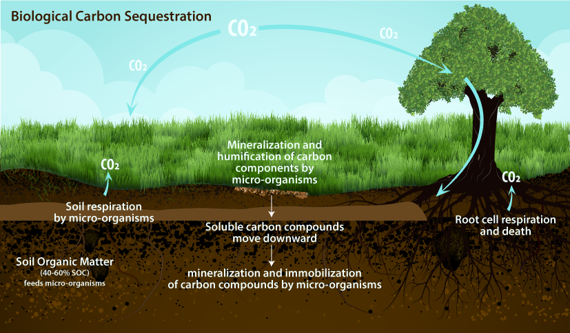
    His proposal, which calls for planting a trillion trees to suck carbon dioxide from the atmosphere, was warmly received last month when House Republicans gathered to discuss their policy agenda heading into the 2020 elections.

    After years of denying that the planet was growing hotter because of human activity, an increasing number of Republicans say they need to acknowledge the problem and offer solutions if they have any hope of retaking the House.

    In poll after poll, large numbers of young and suburban Republican voters are registering their desire for climate action and say the issue is a priority. And their concern about climate change is spreading to older GOP supporters, too.

    Almost 7 in 10 Republican adults under 45 said that human activity is causing the climate to change, according to a poll last summer by The Washington Post and the Kaiser Family Foundation.

    Republicans “can’t win the majority back [in the House] without winning suburban districts, and you can’t win suburban districts with a retro position on climate change,” said former South Carolina congressman Bob Inglis, a Republican who is pushing his party to craft a climate plan…

    The GOP is still hammering out details, but some critics say the new Republican approach to climate change looks a lot like the old one. In addition to trees, senior Republicans are said to be considering tax breaks for research, curbs on plastic waste and big federally funded infrastructure projects in the name of adaptation or resilience…

    The already well-worn buzzword “innovation” will be their rallying cry, and natural gas, despite its carbon emissions, will be embraced…

    House Minority Leader Kevin McCarthy (R-Calif.) and Rep. Garret Graves (R-La.) told the news outlet Axios that a new set of policies would expand an existing tax credit to encourage carbon capture and storage, sharply increase research-and-development funding for “clean energy” technology, curb plastic pollution, and plant a whole lot of trees. Graves in an interview also said that U.S. exports of liquefied natural gas would be better for the climate than natural gas from Russia…

    What’s missing? There are no taxes or tax revenue. There are no regulatory standards to boost automotive fuel efficiency or contain methane emissions. And there are no limits on fossil fuels. [ed. emphasis mine]

    Moreover, Republicans have no taste for a proposal that leading economists say is the fastest, most powerful way to cut carbon emissions — a $40-per-ton carbon tax on polluters, promoted by George Shultz, secretary of state under President Ronald Reagan, and James A. Baker, Reagan’s treasury secretary and secretary of state under President George H.W. Bush. Money raised by the tax would be returned to taxpayers in the form of dividends…

    Younger voters’ concerns

    As difficult as it may be to change the positions of GOP lawmakers, Trump makes matters even more complicated. Moments after rhapsodizing about trees at Davos, the president took aim at climate activists, calling them “perennial prophets of doom” and “the heirs of yesterday’s foolish fortunetellers.”

    Earlier, in response to efforts to ban plastic straws that end up in the ocean, the Trump Make America Great Again Committee, a super PAC, sold packs of 10 red plastic straws emblazoned with Trump’s name and said that “liberal paper straws don’t work.”

    It is unclear whether Trump will refer to the changing climate in his State of the Union speech Tuesday, with the possible exception of the trillion-trees commitment, which echoes Bush’s unrealized 1990 proposal to plant 1 billion trees a year for a decade.

    Among voters who approve of Trump’s overall job performance, his approval ratings on climate change — 73 percent — were the lowest out of six questions the Post-Kaiser poll asked his supporters. And 23 percent of all Republicans disapprove of his handling of the climate issue, substantially higher than the 9 percent of Republicans who disapprove of his job performance overall.

    “You see among younger voters a higher concern,” said David Winston, a veteran Republican pollster who has been researching attitudes toward climate change. “Does it meet the levels of the economy and health care? No. But you are seeing it move up as a level of concern.”
    Much of the impetus for a new Republican posture on climate change has come from McCarthy and Graves.

    When House Speaker Nancy Pelosi (D-Calif.) created the House Select Committee on the Climate Crisis last year, Graves told McCarthy the party needed to change its position on climate change or risk being left behind by its voters and awash in a worsening series of floods and fires.

    “My conversation with McCarthy was about hey, number one, I think the science is pretty good here and I don’t think the path forward has to be a hard right or a hard left turn,” said Graves, the ranking Republican on the climate committee.

    McCarthy was receptive. In October, he told the Washington Examiner that the GOP would introduce several free-market-based bills in response to the Green New Deal, a sweeping set of policy proposals backed by some Democrats that would aim to cut greenhouse-gas emissions to net zero over 10 years.

    Before he ran for Congress, Graves worked as a congressional aide, then returned to Louisiana to help clean up after Hurricane Katrina. In 2008, then-Gov. Bobby Jindal (R) put him in charge of the Coastal Protection and Restoration Authority, where he learned about permanent changes to the coastline. In 2014, he won his first race for Congress.

    Graves is no liberal. He has received a 3 percent lifetime score from the League of Conservation Voters, based partly on his opposition to requirements that natural-gas producers control methane releases and his support for logging Alaskan national forests.

    “I think that some climate advocates have made a fundamental error in identifying fossil fuels as the enemy as opposed to emissions,” Graves said.

    Louisiana ranks as the nation’s third-largest producer of natural gas, and the biggest campaign contributions to Graves in the current electoral cycle come from the oil, gas and utility industries. His four biggest contributors are the ClearPath Foundation, which promotes nuclear energy, hydropower and increased energy research; Entergy, a New Orleans-based utility; Marathon Petroleum, a refiner; and NextEra Energy, a big Florida-based utility that relies heavily on wind, natural gas, nuclear and solar. Over Graves’s career, Koch Industries has also been a major contributor.

    Graves and other Republicans paint a bright line between their approach to climate change and Democrats’. They have sharply attacked the Green New Deal…

    Graves also opposes taking some measures when other countries are not acting in similar ways. “If you were to implement the Green New Deal, you would be playing into the hands of China,” he said.

    Instead, Graves said, Congress ought to promote U.S. technology, which is “all about U.S. competitiveness.” And spending on resilience to prevent costlier climate damage is “an awesome conservative fiscal argument,” he said.

    In the Senate, some lawmakers are seeking common ground, led by Sens. Christopher A. Coons (D-Del.) and Mike Braun (R-Ind.). “There have been a lot of Republicans in the closet on climate,” Braun, a freshman senator, told The Post in December. Coons and Braun each recruited three colleagues to their Senate Climate Solutions Caucus.

    Sen. Sheldon Whitehouse (D-R.I.) has also managed to work with Republicans on specific parts of a climate policy. He joined with Sen. James M. Inhofe (R-Okla.), a longtime climate denier, and Sen. John Barrasso (R-Wyo.), who also represents a fossil-fuel-intensive state, to pass legislation that gives tax credits to companies that capture carbon dioxide from the air and store it.

    Risky territory for GOP
    Still, some Republicans have paid a political price for urging action on climate change. Consider the swift downfall of California state legislator Chad Mayes. In July 2017, Mayes, then the State Assembly’s Republican leader, joined Democrats in supporting a climate-change program called cap-and-trade.

    “We lower taxes, we reduce costs, we reduce regulations, and at the same time we’re going to protect our environment,” Mayes said at a news conference. “I know for some they’re going to look at this and say: What in the world is going on? Why are Republicans talking about something like cap-and-trade? Well I’ll tell you. We believe that markets are better than Soviet-style command and control. We believe that markets are better than government coercing people into doing things that they don’t want to do. We believe that businesses in California want to do the right thing.”

    A month later, Republican activists in the assembly’s 25-member caucus stripped Mayes of his leadership position.

    He went on to form a group called “New Way California,” but that, too, was attacked. Two months ago, Mayes quit the Republican Party and filed to run as an independent.

    Inglis, the former congressman from South Carolina, has followed a similar path. “For my first six years in Congress, I just said that climate change was nonsense,” he said. “I didn’t know anything about it except that Al Gore was in favor of it.”

    After going back to private life, Inglis decided to run again for Congress. His son insisted that he wise up on climate change.

    Then Inglis went on a congressional trip to Antarctica and looked at bore samples of polar ice. “It is an amazing record of the Earth’s atmosphere,” he said. That convinced him that human activity since the Industrial Revolution was warming the planet.

    Back in Washington, in 2009 he proposed a bill that would have imposed a carbon tax, adjusted the prices of imports from countries such as China and India that did not have such a tax, and return the revenue to taxpayers by cutting payroll taxes.

    It was poorly timed during the Great Recession, he recalled. And unpopular.

    He lost the Republican primary to Trey Gowdy by a margin of 71 percent to 29 percent…

    After Barack Obama moved into the White House in 2009, Republicans solidified their opposition to his entire agenda, including any climate plan.

    “My party was against everything Obama was for,” Inglis said.

    It took nearly a decade for any shift. On Feb. 12, 2018, Joseph Majkut, climate policy director at the libertarian Niskanen Center, became the first Republican witness before the House Science Committee in nearly 10 years to talk about tackling climate change, according to Inglis.

    The former congressman is now traveling the country trying to change Republican minds about climate policy…

    Democrats and middle-of-the-road politicians are wary about the GOP’s recent climate buzz.

    “I think they’re caught on the politics,” said Ben Finzel, president of a public relations firm, RenewPR, and a former Hill staffer. “The challenge is they want to get stuff done but also want to beat up the Dems.”

    Jason Grumet, president of the Bipartisan Policy Center, said he thinks there is meaningful change underway.

    “The fact that Leader McCarthy is publicizing his intention to put out a Republican climate solution matters a lot,” Grumet said. “The details will be embraced and ridiculed like every other climate plan. But that gives tremendous license for the Republican Party to get in the game.”

    New Federal Rule Reduces Protections for Water in the West, Harming People and Birds — @Audubon

    Click here to read the January 2020 Western Water News from Audubon. Here’s an excerpt:

    Western Water News
    UPDATE: New Federal Rule Reduces Protections for Water in the West, Harming People and Birds

    The Trump Administration’s revised Waters of the United States rule shrinks the number of waterways protected under the Clean Water Act.

    Phainopepla. Photo: Elaine Padovani/Great Backyard Bird Count via Audubon Rockies

    UPDATE (1/23/2020): Today, the Trump Administration announced finalization of rollbacks to the Clean Water Rule. The newly published Navigable Waters Protection Rule removes Clean Water Act protections for many rivers, streams, and wetlands, which could allow them to be altered, degraded or filled without first seeking a federal permit. For example, a large number of streams and wetlands that only flow or are wet for part of the year are now exempt from Clean Water Act protections. Some 138 species and subspecies of birds in the U.S. are designated as “wetland dependent” and many more are threatened by the new rule.

    At Audubon, we know the value that wetlands, rivers, lakes, and streams provide to birds. These waterways are critical habitat for the lifecycle of millions of birds, not to mention the millions of people who rely on clean water to drink, bathe, wash, and grow our food.

    Riverside forests and wetlands—fed by both continuous and intermittent water sources—are essential for birds, particularly in the arid Southwest.

    However, under the 2019 Proposed Revised Definition for Waters of the United States (WOTUS) many waterways that flow for only portions of the year would be excluded from Clean Water Act protections. This means ephemeral waterways like the Rio Puerco in New Mexico, Centennial Wash in Arizona, Milpitas Wash in Southern California’s Imperial County and Chemehuevi Wash in San Bernardino County would no longer be protected. Without WOTUS protections, developers can build in these areas without federal permits, and the waterways and their surrounding environments would be unprotected from potentially harmful discharges. In the past, industrial operators used these dry washes as disposal sites for pollutants, only to end up contaminating the groundwater below.

    Along many of the dry washes in the desert Southwest, trees like mesquite, palo verde, and ironwood thrive. When water occasionally flows through these normally dry washes, these thrifty trees take advantage. Along these washes, trees grow tall and into dense desert forests. They support abundant avian life, especially Lucy’s Warblers, Bell’s Vireos, Black-tailed Gnatcatchers, Phainopeplas, and Ladder-backed Woodpeckers. These woodlands comprise only five percent of the acreage in the desert regions of the Southwest but support 90 percent of the bird life, according to A Natural History of the Sonoran Desert. For these habitats to be stripped of their protections under the Clean Water Act means a serious risk of habitat loss in areas of outsized importance for birds.

    On the human side of the equation, excluding dry washes and ephemeral streams and rivers risks damage to property through flooding. In Arizona, for example, drainages coming off local mountain ranges flow infrequently. However, when they do flow due to rain or snow events, floodwaters can overwhelm the normally dry channels. Clean Water Act protections can require that developers mitigate impacts to these washes, or mandate that development keep the washes intact in order to act as drainages for storm events. As part of the urban fabric, these washes serve as flood protection for communities during storm events and as corridors for wildlife when dry.

    Losing protections on thousands of stream and river miles because they only flow seasonally or after rain events or snowmelt will negatively impact the birds and people who rely on these important water resources throughout the Southwest. Audubon will submit formal comments on the proposed WOTUS definition to the Environmental Protection Agency and the Army Corps of Engineers by the April 15, 2019 deadline, and we invite you to do the same.