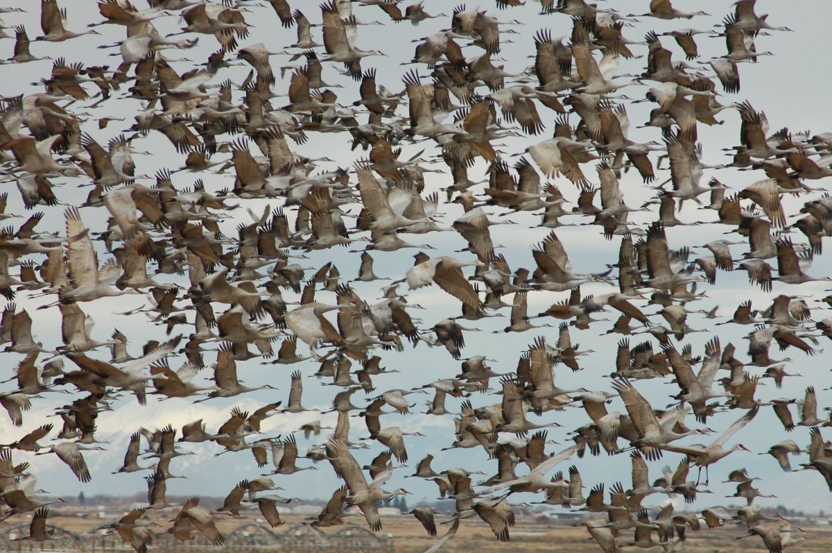
The sandhill cranes are back in the San Luis Valley on their spring migration. Photo credit: Colorado Parks & Wildlife
Here’s the release from Colorado Parks & Wildlife (Joe Lewandowski):
Cranes make annual return to the San Luis Valley
In the San Luis Valley nature is again putting on one of its most memorable displays: the spring migration of greater sandhill cranes. In appreciation of this wildlife spectacle, area organizations, businesses and wildlife agencies are holding the 37th Annual Monte Vista Crane Festival, March 6-8.
“Everyone who lives in Colorado should take the time to see this ancient and magnificent migration,” said Joe Lewandowski, public information officer for the Southwest Region of Colorado Parks and Wildlife. “This is one of only a few great wildlife migrations in the United States that people can easily see. The sights and sounds are amazing.”
The cranes started arriving in mid-February, flying from their winter nesting grounds to the south, primarily in New Mexico. The large wetland areas, wildlife refuges and grain fields in the San Luis Valley draw in about 25,000 birds. The cranes stop in the valley to rest-up and re-fuel for their trip north to their summer nesting and breeding grounds in Idaho, Montana and Wyoming.
Even if you can’t travel to the San Luis Valley during the weekend of the festival, there is still plenty of time to see the birds. The cranes usually stay in the valley for most of March.
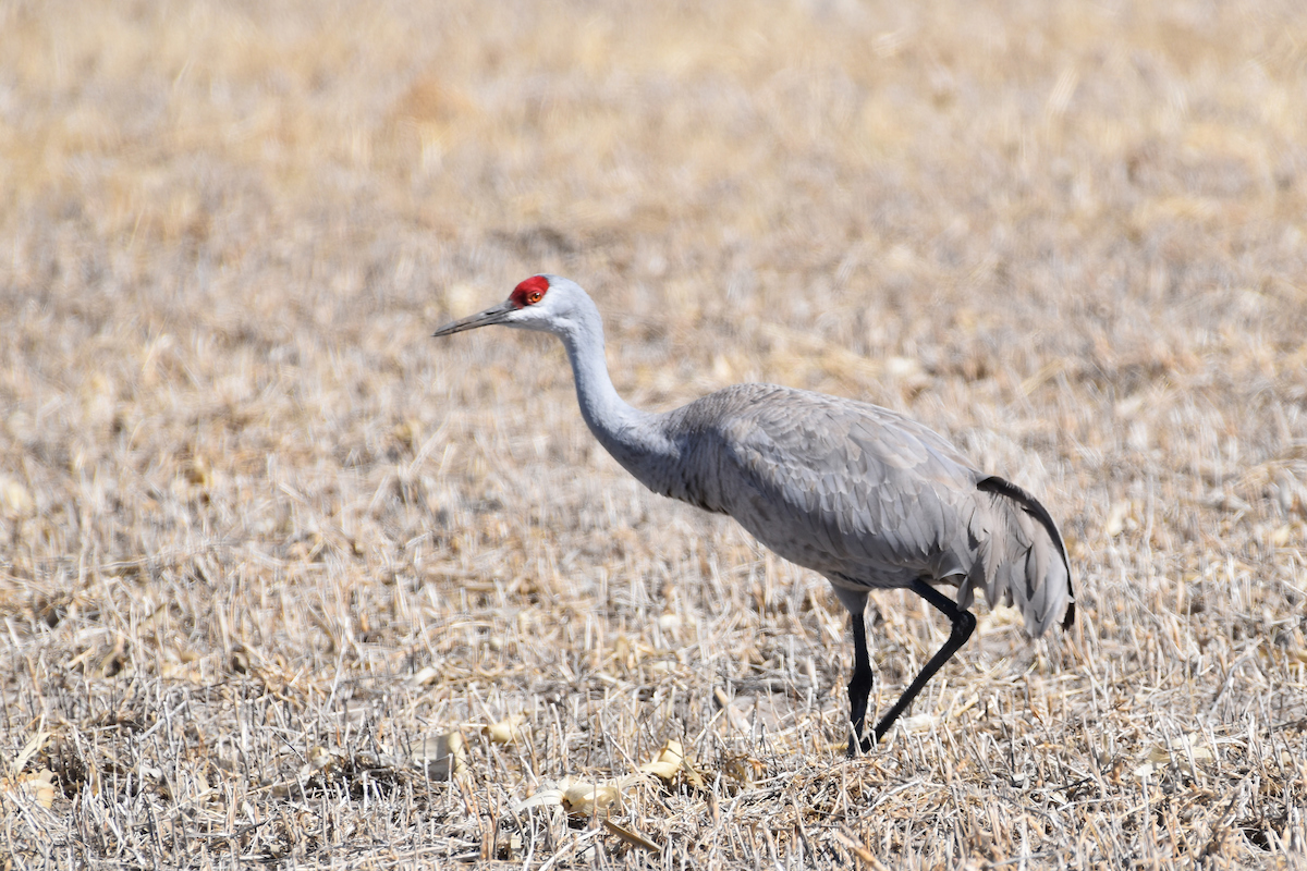
Cranes are among the oldest living species on the planet: Fossil records for cranes date back 9 million years. The birds that migrate through Colorado are the largest of the North American sandhill subspecies standing 4-feet tall with a wing-span of up to 7 feet and weighing in at 11 pounds. Besides their imposing size, the birds issue a continuous and distinctive call. At this time of year cranes are engaged in their mating ritual and the birds perform an elegant hopping dance to gain the attention of other birds.
The birds are abundant in areas near the town of Monte Vista. They can be seen most readily in the Monte Vista National Wildlife Refuge, about five miles south of town of Colorado Highway 15. Birds also gather at the Alamosa National Wildlife Refuge, southeast of the town of Alamosa, and at that Rio Grande, Higel and Russell Lakes state wildlife areas.
The cranes are most active at dawn and at dusk when they’re moving from their nighttime roosting areas to fields where they feed. In the middle of the day, they “loaf” and eat in the grain fields of the Monte Vista refuge.
Be sure to dress warm, as winter still reigns in the valley.
During the three days of the festival, free tours are offered at 7 a.m. and 4 p.m. when the birds are most active. Visitors ride buses to various spots on the wildlife refuge and U.S. Fish and Wildlife Service staffers talk about the migration and the refuge. If you want to take a tour, be on time because the buses leave promptly.
Birdwatchers who travel on their own should be cautious when parking, getting out of vehicles and walking along roads. View birds from a distance with binoculars and spotting scopes, and observe trail signs and closure notices.
Many other bird species – including eagles, turkeys, and a variety of raptors and waterfowl – can also be seen throughout the San Luis Valley. Look in the many cottonwood trees for owl nests.
The festival headquarters and starting point for the tours is the Ski Hi Park building located near U.S. Highway 160 on Sherman Avenue on the east side of Monte Vista. Visitors can pick up maps, schedules and information at the headquarters.
Besides the tours, a variety of workshops are put on by bird, wildlife and photography experts. An arts and crafts fair continues through the weekend at the headquarters building.
Approximate distances to Monte Vista: Denver, 220 miles; Colorado Springs, 182 miles; Salida, 85 miles; Vail, 175 miles; Durango, 135 miles; Grand Junction, 230 miles.
Here’s the release from Stanford University (Danielle Torrent Tucker):
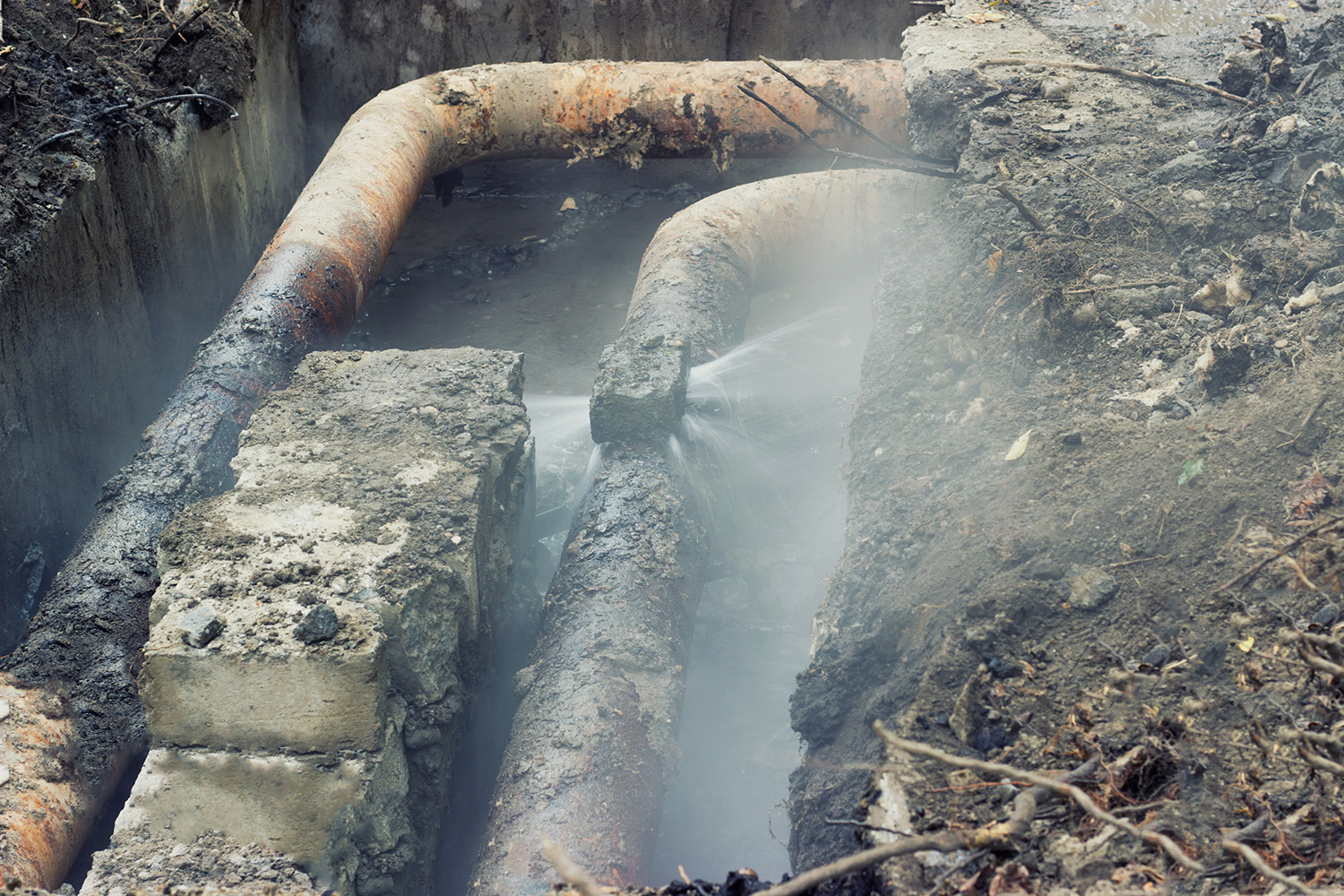
Stanford researchers propose a new way to locate water leaks within the tangle of aging pipes found beneath many cities. The improvement could save time, money and billions of gallons of water.
You can delay irrigating the lawn or washing the car all you want, but to really make a big dent in water savings we need to stop water waste long before the precious resource ever reaches our taps.
A new way to detect leaks in aging pipes underground could save save money and billions of gallons of water. (Image credit: HiddenCatch / iStock)
An estimated 20 to 50 percent of water is lost to leaks in North America’s supply system – a major issue as utilities contend with how to sustain a growing population in an era of water scarcity.
“People talk about reducing the time you take showers, but if you think about 50 percent of water flowing through the system being lost, it’s another magnitude,” said study author Daniel Tartakovsky, a professor of energy resources engineering in Stanford’s School of Earth, Energy & Environmental Sciences (Stanford Earth).
In a move that could potentially save money and billions of gallons of water, Tartakovsky, along with Abdulrahman Alawadhi from the University of California, San Diego, have proposed a new way to swiftly and accurately interpret data from pressure sensors commonly used to detect leaks.
In addition to water utilities, Tartakovsky said the method could also be applied to other industries that use pressure sensors for leak detection, such as in oil and natural gas transmission networks that run under the sea and pose additional environmental hazards.
The research was published online Feb. 12 in the journal Water Resources Research.
Water hammer
The new method targets water leaks in transmission mains, which are typically routed out of sight underground. Water transmission networks in North America and much of Europe are fitted with sensors that measure pressure to gauge flow.
The researchers built upon a technique known as the water hammer test – the industry standard for predicting the location of leaks. The test involves suddenly shutting off flow through a pipe and using sensors to gather data about how the resulting shock wave, or “water hammer,” propagates. Tartakovsky and Alawadhi propose a new way to assimilate this data into a mathematical model to narrow down the location of a leak.
The current method for detecting leaks is computationally expensive; to reduce the cost, analysts need to make a lot of simplifying assumptions, according to Tartakovsky.
“We proposed a method that is fast enough that you don’t need to make these assumptions, and so it’s more accurate – you could do it in real time on a laptop,” Tartakovsky said. “It’s something utilities can use with existing computational resources and the models they already have.”
By improving speed and accuracy, the researchers’ method saves money, both in terms of time and labor and the cost of wasted water. For example, if you wanted to find a leak in a football field–length pipe, you could dig up the whole field until you hit wet soil, or you could use the new method to constrain the location of the leak to a 10-meter section of the pipe.
“In cities, it’s harder because pipes are under buildings and you have to break asphalt and things like that, so the more accurate your prediction of the location, the better,” Tartakovsky said.
Cities have the most potential for major water leaks – and the older the urban areas, the bigger the problems, with their complex networks of aging pipes.
“For operators who routinely use water hammer tests, the cost of this is zero – this is just a better way of interpreting these tests,” Tartakovsky said. “We are not selling it or patenting it, so people could just use it and see whether they get better predictions.”
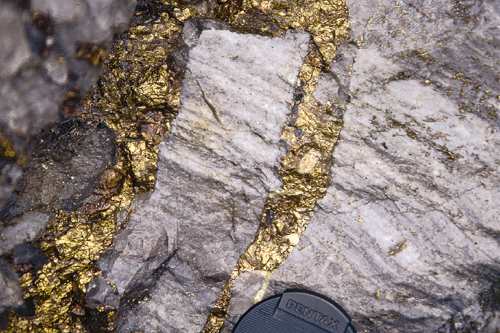
The Fremont County Commission on Tuesday unanimously approved a conditional use permit request from Zephyr Minerals Ltd. to expand its gold exploration area southwest of here…
Among the 24 conditions of the approval require Zephyr to get sufficient water to the drill site and avoid disturbance of ground within 500 feet of Grape Creek, Bell said.
The company would expand the current 593 exploration area by 1,169 acres for a total of 1,762 acres. The Colorado State Land Trust board last April OK’d exploration on a parcel in the Grape Creek/Horseshoe Mountain area, just southwest of Canon City’s Temple Canyon Park.
“I feel like they (Colorado State Land Board) made it pretty tough on them. They have to helicopter water in,” Tim Payne, commissioner, said.
Commissioner Dwayne McFall said land use issues are the hardest for the commission to address because there are residents who are both for and against them.
Zephyr currently is conducting exploration just west of the Dawson Ranch neighborhood in the Dawson Peak area. The new exploration area would be to the west of that —on U.S. Bureau of Land Management Land — and Zephyr has another application pending with that agency.
Exploration would impact less than 2% of the permitted area, according to the application. The disturbance area would be about 3 acres.
Exploration would be done in two phases, including an airborne magnetic and electromagnetic geophysical survey. The second phase would be “traditional core drilling to test targets generated by the airborne survey,” according to the application.
FromThe Cañon City Daily Record (Carrie Canterbury):
The expansion will add acreage to the west of the current boundary of the CUP. The application was approved by a majority vote by the Fremont County Planning Commission in January and was tabled by the county commissioners Feb. 11 to allow the board more time to compile findings…
During the February meeting, Will Felderhof, the executive chairman and director for Zephyr Minerals, said his company has demonstrated during the last eight years that they’ve been doing everything correctly, that they are committed to doing things properly and they are committed to following all of the rules and regulations.
The board heard from 13 people during a public hearing Feb. 11. Of those, 10 were against the expansion, two were neutral and one was in favor.
Gary Peterson, the chairman of the Royal Gorge Preservation Project, said the CUP expansion request “is an operational part of the process that leads to the development of a full-blown mining operation that has the potential to propel our community into just another dirty little mining community … ”
Others speaking in opposition shared concerns about water, noise, access and imposition the expansion could have on wildlife.
Findings presented Tuesday state that the Colorado Parks and Wildlife and the Bureau of Land Management have expertise regarding the potential disruption of wildlife in the area and the lighting proposed for the drill site is minimal and does not exceed the amount that is necessary for the operations.
The board prohibits the applicant from conducting drill operations without a source of water to use in the process, which may require the use of a helicopter or other means without the use of roadways or other vehicular traffic.
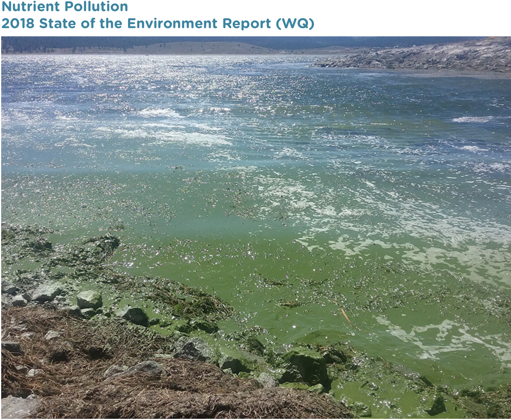
Pond on the Garcia Ranch via Rio Grande Headwaters Land Trust
From the Rio Grande Water Conservation District, San Luis Valley Water Conservancy District, and Conejos Water Conservancy District via The Valley Courier:
Many San Luis Valley residents recently received a phone survey inquiring about support for a proposal to export 20,000 acre-feet annually from the Valley to the Front Range.
The project proponents, Renewable Water Resources (RWR), have stated their intent to pump deep groundwater from the confined aquifer over Poncha Pass and Trout Creek Pass to the South Platte River.
RWR’s website is fraught with misinformation regarding the water supplies, hydrology, and legal obligations of the Valley.
The phone survey was no different. The call included approximately 20 questions, many with significant factual inaccuracies. It is important that community members have an understanding of the truth about their water resources.
The proponents would not provide a list of the survey questions. Therefore, the following account of key questions may not be exact.
Survey Question: “Did you know there are 2 billion acre-feet of water within the Valley aquifer system?”
Fact: This figure is false and has long been quoted by tycoons looking to get rich by exploiting the Valley’s water resources. The origin of the claim that there are 2 billion acre-feet stored in the deposits underlying the Valley is a USGS report from 1971 where geologist Phil Emery took a stab at estimating the contents of the aquifers. During the trial for the American Water Development Incorporated (AWDI) water export proposal, another ill-advised effort to take water from the Valley, Emery noted he had miscalculated his estimate. Further court decisions, studies, and the State of Colorado’s groundwater model, the Rio Grande Decision Support System, have shown there is no unappropriated water in the basin. Meaning, all of the surface and groundwater has been spoken for by existing water users. In fact, there are more claims to water than can be satisfied and the Valley’s water supplies are over appropriated.
Survey Question: “Do you realize this proposal will withdraw water from 3,000 feet below the surface and will have no environmental impacts?”
Fact: Pumping from 3,000 feet impacts the confined aquifer, which is the deeper of the Valley’s two aquifers. The confined aquifer is connected to the unconfined (shallow) aquifer and surface flows to some degree. RWR has expressed intent to pump from a series of deep wells in the north end of the Valley. Extensive pumping in this area could have great impacts to surface and groundwater, which supply the Great Sand Dunes National Park and Preserve, Baca National Wildlife Refuge, and numerous important ecosystems on public and privately owned lands.
Survey Question: “Are you aware of the pending action by the State Engineer to shut off irrigation wells in Subdistrict 1 with no compensation?”
Fact: There is no pending action by the State Engineer to shut off irrigation wells in Subdistrict 1. In response to the recognition by local water users and State officials that groundwater use in certain parts of the basin is unsustainable, local leaders worked to pass legislation that allows communities within the Valley to create plans to balance water use and supply. The Rio Grande Water Conservation District (RGWCD) then formed Groundwater Management Subdistricts (Subdistricts) to create and implement plans of water management. These actions allow the Valley water users to work together to recover aquifers themselves, rather than facing sweeping orders from the State Engineer to shut down or curtail wells. Subdistrict 1 has been in operation for ten years and has until 2030 to recover the groundwater to levels identified as the sustainability targets in the legislation that enabled Subdistricts. The State Engineer and staff of the Colorado Division of Water Resources have provided critical support and are working closely with local water managers to ensure implementation of the plans of water management is successful.
Survey Question: Did you know there have been pipelines exporting water out of the San Luis Valley for the last 100 years?
Fact: There are no existing pipelines out of the Valley. There are two ditches that take water across the Sangre de Cristo mountains from Medano Creek to a ranch in the Wet Mountain Valley. These diversions occur pursuant to a 1914 court ruling and divert a combined total of 15 cfs from May 15-July 15 of each year. The cumulative diversions total an average of 1,063 acre-feet per year, a far cry from the 20,000 acre-feet proposed by RWR.
The RGWCD, San Luis Valley Water Conservancy District, and Conejos Water Conservancy District urge residents to take action by seeking out the facts of the Valley’s water resources and advocating for the truth. Please see http://www.rgwcd.org for information about current aquifer levels and the Subdistricts’ efforts to manage our groundwater.
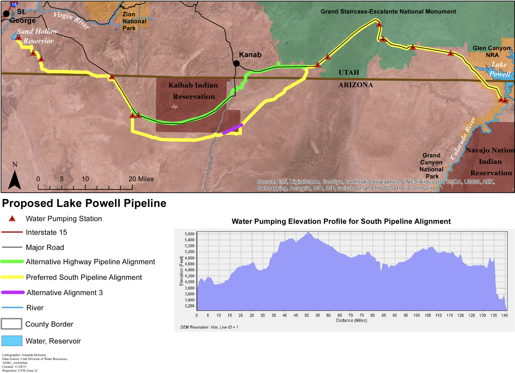
This $2+ billion project would pump 28 billion gallons of water 2,000 feet uphill across 140 miles of desert to provide just 160,000 residents in Southwest Utah with more water. Graphic credit: Utah Rivers Council
Climate change is increasing the variability of the Colorado River so much so that the river could lose one-fourth of its flow by 2050, according to a new government study.
As plans for the 140-mile Lake Powell Pipeline — which would divert over 86,000 acre-feet annually from the reservoir to southwestern Utah — are under review by the Bureau of Reclamation, what does the Colorado River’s diminishing flows mean for the project?
The new report, produced by the U.S. Geological Survey and published in Science, attributes a 16% decline in the river’s flow from 2000-2017 to rising temperatures. The Colorado River hydrates seven downstream states, storing water in shrinking Lake Powell and Lake Mead reservoirs.
Washington County Water Conservancy District Manager Zach Renstrom said he thinks the variability of climate change provides even more reason for the county to pursue the pipeline.
“Climate change is a big deal to us, we are very concerned about it, and specifically how it’s going to affect our watershed,” Renstrom said. “When we look at these dynamics, they’re one of the strong arguments for the Lake Powell Pipeline because we need to make sure to have a robust infrastructure in place so we can adjust for (climate change).”
Rising temperatures, less snow
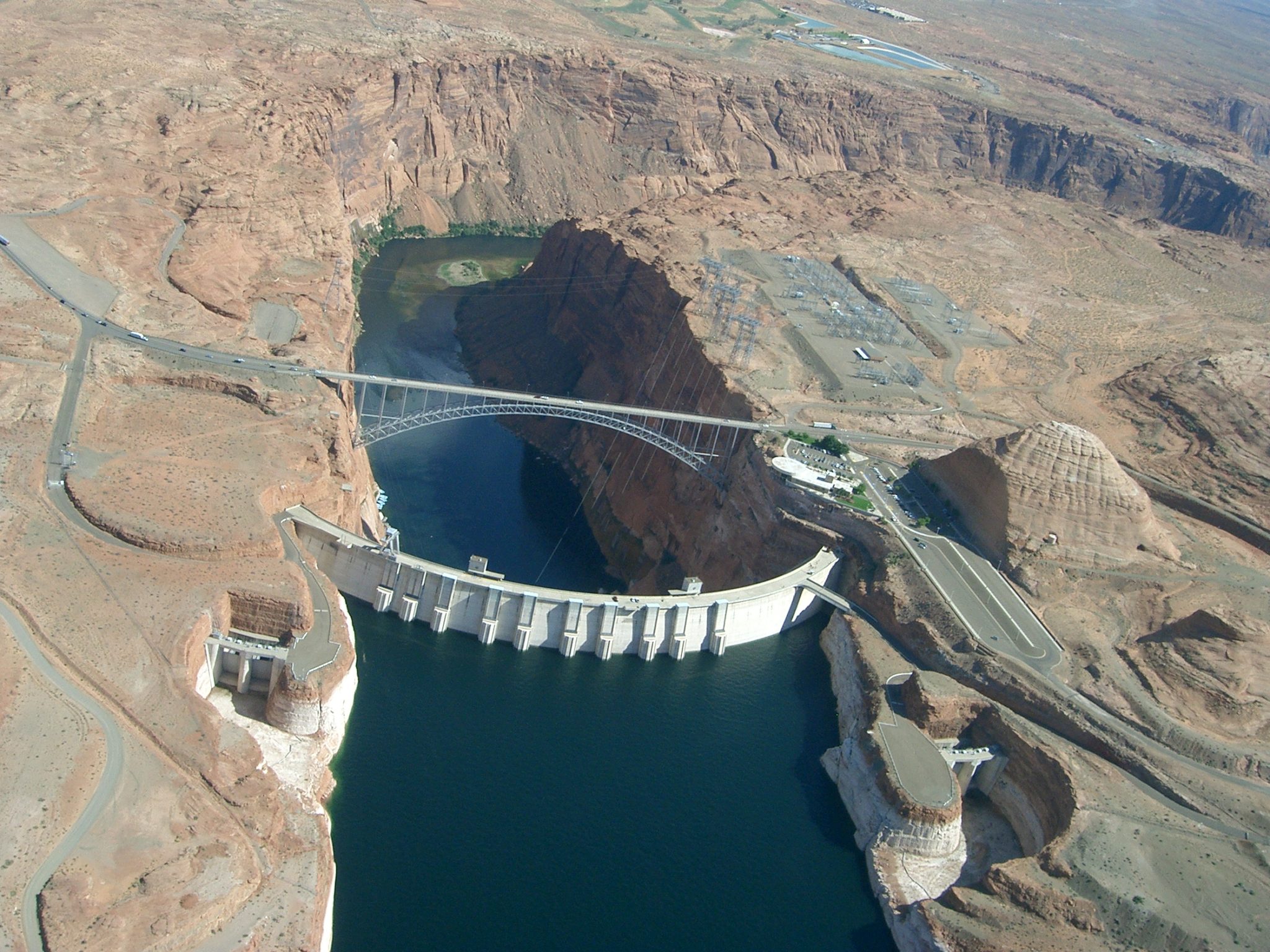
Seen from the air, Glen Canyon Dam holds back the Colorado River to form Lake Powell. The state of Colorado is looking into how to fund a program that would pay irrigators to reduce their consumptive use in order to send water downstream to a savings account in Lake Powell. Photo credit: Brent Gardner-Smith/Aspen Journalism
USGS scientists considered two scenarios of climate change in the Colorado River study. In one, warmer temperatures by 2050 would reduce the amount of water flowing in the river by 14-26%. In the other scenario, warming would take away 19-31% of the river’s flow…
Milly and fellow USGS scientist Krista Dunne focused on the reflectivity of snow, known as albedo, as a key element in the river’s sensitivity to warming. They zeroed in on the role of snow cover as a “protective shield” for water in the river basin.
Milly likened the flowing river to the leftovers of the “meal” of snow and rain that falls across the basin after evaporation has “eaten” its share…
And the amount consumed by evaporation is driven by how much energy the basin absorbs in the form of sunlight. The snow cover in the Rocky Mountains reflects back to the sky and space a significant fraction of the sunlight.
As the world gets hotter with the burning of fossil fuels, more of the precipitation falls as rain instead of snow. And the snow melts away earlier in the year. As the snow cover in the mountains is progressively lost, the river basin absorbs more energy…
“When we talk about structural deficits and overuse of the Colorado River system, it’s exclusive to the lower basin,” WCWCD spokesperson Karry Rathje said.
Washington County’s population is projected to grow 229% by 2050, but Renstrom says he’s worried that growth may come sooner than expected. He’s pushing to get the pipeline going in the next 10 years in order to diversify the county’s water supply.
“Even when we look at reduced flows … the water in the Lake Powell Pipeline should be available for us to withdraw,” Renstrom said. “As the guy who has to worry about where water is coming from in 30 years if some of the higher-end climate models come to pass, and the Virgin River is dried up, it makes me feel very secure that we’ll have another tool in that toolbox.”
Scenes from the Seeded and Natural Orographic Wintertime Clouds: The Idaho Experiment (SNOWIE) project, which was undertaken in Idaho’s Payette Basin in winter 2017. Credit: Joshua Aikins via Aspen Journalism
n innovative new study conducted in Idaho and published on Monday seems to confirm what Vail and other Colorado ski resorts have believed for decades — that “cloud seeding can boost snowfall across a wide area if the atmospheric conditions are favorable.”
“This is a revelation. We can definitely say that cloud seeding enhances snowfall under the right conditions,” said Sarah Tessendorf, a scientist at the National Center for Atmospheric Research in Boulder and co-author of a new paper on the research conducted by scientists from the University of Colorado Boulder and University of Wyoming, among others.
Cloud seeding uses ground-based generators to disperse dust-sized silver iodide particles into clouds so that ice crystals can form on those particles and fall to the ground in the form of snow. Scientists, water managers and ski industry executives say it’s precipitation that would otherwise stay in the clouds, so cloud seeding is an environmentally safe way to enhance snowfall.
But the efficiency of cloud seeding has so far been hard to prove. Tessendorf said previous cloud seeding studies were unable to achieve statistically significant results because the natural variability of the weather was too great and demanded a larger sample size than could be reasonably obtained, for financial reasons.
In winter 2017, the National Science Foundation, which sponsors NCAR, teamed up with the Idaho Power Company to conduct a field study called SNOWIE (Seeded and Natural Orographic Wintertime Clouds — the Idaho Experiment).
SNOWIE used supercomputing technology to develop a new computer model to simulate cloud seeding, as well as new measurement capabilities, such as a high-resolution cloud radar on a Wyoming research aircraft that can see previously invisible cloud features. Researchers also located mobile radars on mountain ridges north of Boise to see clouds not visible to stationary National Weather Service radars that are blocked by the mountains themselves.
The scientists then used airborne seeding instead of ground-based generators because the silver iodide dispersed downwind from the aircraft in a zig-zag pattern, which is a very unnatural pattern for precipitation to form.
That allowed the scientists “to unambiguously detect the impact of cloud seeding in these clouds using the mobile and airborne radars,” Tessendorf said. “This had never been done before. In the three cases we report on, there was negligible natural snow falling, so the zig-zag pattern was able to be detected very clearly and tracked to the ground to quantify the snow reaching the ground due to seeding.”
One of the examples cited in a press release accompanying the study was a cloud-seeding flight on Jan. 19, 2017, that generated snow for 67 minutes, dusting about 900 square miles with a tenth of a millimeter of snow beyond what was falling naturally.
“This was barely enough snow to cling to the researchers’ eyelashes,” the release reads, ‘but it would have stayed in the air if not for cloud seeding.”
“We tracked the seeding plume from the time we put it into the cloud until it generated snow that actually fell onto the ground,” said Katja Friedrich, a University of Colorado Boulder professor and lead author of the new study.
Scenes from the Seeded and Natural Orographic Wintertime Clouds: The Idaho Experiment (SNOWIE) project, which was undertaken in Idaho’s Payette Basin in winter 2017. Credit: Joshua Aikins via Aspen Journalism
Finding the ideal storms
Dave Kanzer, deputy chief engineer for the Colorado River District, helps oversee a system of 25 ground-based cloud-seeding generators in the central Colorado region that includes Grand, Summit, Eagle and parts of Pitkin County. Nearby generators include one atop Arrowhead and another above Camp Hale.
Kanzer said storms from the north and northwest, which tend to be colder, are ideal for cloud seeding, with temperatures in the clouds no higher than 21 degrees Fahrenheit and no lower than 5 degrees Fahrenheit. If the clouds have the right temperature range and the right moisture levels but lack sufficient particles for ice crystals to form, that’s where cloud seeding comes in.
“We take advantage of the first two and we add the proper amount of particulate matter to enhance the snowfall and precipitation … and that accumulates in the snowpack somewhere in the range of between 5 and 15% on a per storm basis when those conditions are met,” Kanzer said. “And that helps to increase the water yield of the snow sheds in the range of 1 to, 4% of water on a seasonal basis.”
Scenes from the Seeded and Natural Orographic Wintertime Clouds: The Idaho Experiment (SNOWIE) project, which was undertaken in Idaho’s Payette Basin in winter 2017. Credit: Joshua Aikins via Aspen Journalism
A tool to maintain snowpack
The Colorado Department of Natural Resources regulates cloud seeding, permitting operations in nine different parts of the state. The operations in the central zone, at the headwaters of the Colorado River, are funded by a wide range of groups, including Front Range utilities and water districts that divert Western Slope water, including Denver Water and Northern Water.
The Colorado River District spends around a $150,000 a year contracting with Western Weather Group to run the program, which Kanzer said is about the same amount Vail Resorts spends on the program for its four Colorado ski areas – Vail, Beaver Creek, Breckenridge and Keystone.
Vail Resorts declined to comment for this story.
Kanzer presented on cloud seeding at a November Eagle River Watershed Council meeting in Avon, where a few of the 50 or so participants got heated in their questioning of the environmental safety of the process.
Kanzer said cloud seeding is safe, using inert silver iodide that cannot be detected in the environment after it’s released into clouds. He added the process could become increasingly critical to maintaining mountain snowpack as the climate changes.
“It’s one tool that we can use to mitigate or adapt to the changes that we have not only predicted but are starting to experience with shorter snow-covered seasons,” Kanzer said. “And so (cloud seeding) helps us extend that time or at least forestall the reduction.”
Aspen Journalism collaborates with The Vail Daily and other Swift Communications newspapers on coverage of water and rivers. This story ran in the Feb. 25 edition of The Vail Daily.
In March, Denver Water is launching a major initiative to protect customers from lead in their homes. The post New Lead Reduction Program underway appeared first on News on TAP.
Westminster’s city leaders want to replace aging water tanks and a water main and keep up with environmental regulations, and they are asking residents to fork out an extra $7 a month in their water and sewer bills to pay for it.
City Council is hosting public meetings to explain the needs and why it wants to increase rates in 2021 and 2022 for the projects. Under the proposal, the average customer will be billed an extra $4 for drinking water and $3 for sewer each month in 2021, and then again in 2022. That equates to about $168 per customer over the next two years.
The exact rate increase depends on each customer’s usage and varying usage year-round, said Westminster Public Works Director Max Kirschbaum…
The projects on the table include $16 million to replace deteriorating storage tanks for drinking water, $11.5 million to replace a water main on Lowell Boulevard and $4.6 million to meet new environmental regulations for the Big Dry Creek Wastewater Treatment Facility, according to the city’s website.
The city’s water is filtered in a plant that was built in 1970, Tom Scribner, water treatment plant superintendent, said. Age and everyday wear and tear has chipped away at the concrete and pipes. The plant still works and is expected to last another 20 years before it needs to be shut down…
The city is working on repairing infrastructure at several sites throughout Westminster, including a $16 million underground pipe project on 112th Avenue and Huron Street and a waste-water pump on Zuni Street between 84th and 88th Avenues…
For the past decade, the department has been spending about $30 million a year on maintaining infrastructure, Kirschbaum said…
The Public Works department is hosting a series of open houses to inform Westminster residents about the bill increases and changing infrastructure. The first was on Feb. 26 at City Park Recreation Center, and a second is scheduled for March 18 at the same location at 6 p.m. Refreshments will be provided.
As the climate warms, Colorado may see fewer days of this light powder and more of the heavy, moist stuff, according to Noah Molotch, a professor of snow hydrology who directs the Center for Water, Earth Science, and Technology at the University of Colorado, Boulder. “One of the first signals that I think we’ll see related to climate change in Colorado is an increase in snowfall density,” Molotch says. “As it gets warmer, that snow will be less fluffy and heavier.”
The reason lies in how snowflakes form, thousands of feet above the ground. Each snowflake begins when water vapor in clouds condenses around particulates—like pollen or dust—creating ice crystals, which begin to grow outward. Because of the unique features of water vapor movement at icy temperatures, vapor will condense only onto the very tips of the crystals, forming six arms, each splitting into many branches—ultimately, a snowflake. True to the cliché, each one is indeed unique.
For the quintessential, picture-book snowflake to form, the temperature must be between minus 8 and 15 degrees Fahrenheit, with a relatively high level of moisture in the air. Different shapes arise at temperatures slightly warmer than 15 degrees but still below freezing: columns, prisms, and needles that don’t look anything like traditional snowflakes. “If one were to cast judgment on the beauty of snowflakes, these would not win the beauty contest,” Molotch says.
When the air is warmer, the movement of water vapor inside clouds will slow down. Instead of condensing onto the outermost tips of ice crystals, water vapor will build all around it, rendering its nascent six-sided structure indistinguishable. Ultimately, this creates thick blobs that often collide with water droplets and other flakes in the air and reach the ground as dense, heavy snow. David Robinson, a snow scientist at New Jersey’s Rutgers University, calls it “packing snow,” which is great for crushing into snowballs and snowmen but makes for a more arduous skiing experience.
No studies have attempted to document an increase in snow density over time, Molotch says. Gathering that data isn’t something scientists can easily determine from satellites or airplanes and would therefore require a lot of work on a large scale. But based on well-understood physical principles about how snow forms under different temperatures in the atmosphere, it’s likely that Colorado skiers may gradually see less light powder as the climate warms—although, Molotch adds, the state’s snow still has a way to go until it becomes as heavy as snow in the Sierra.
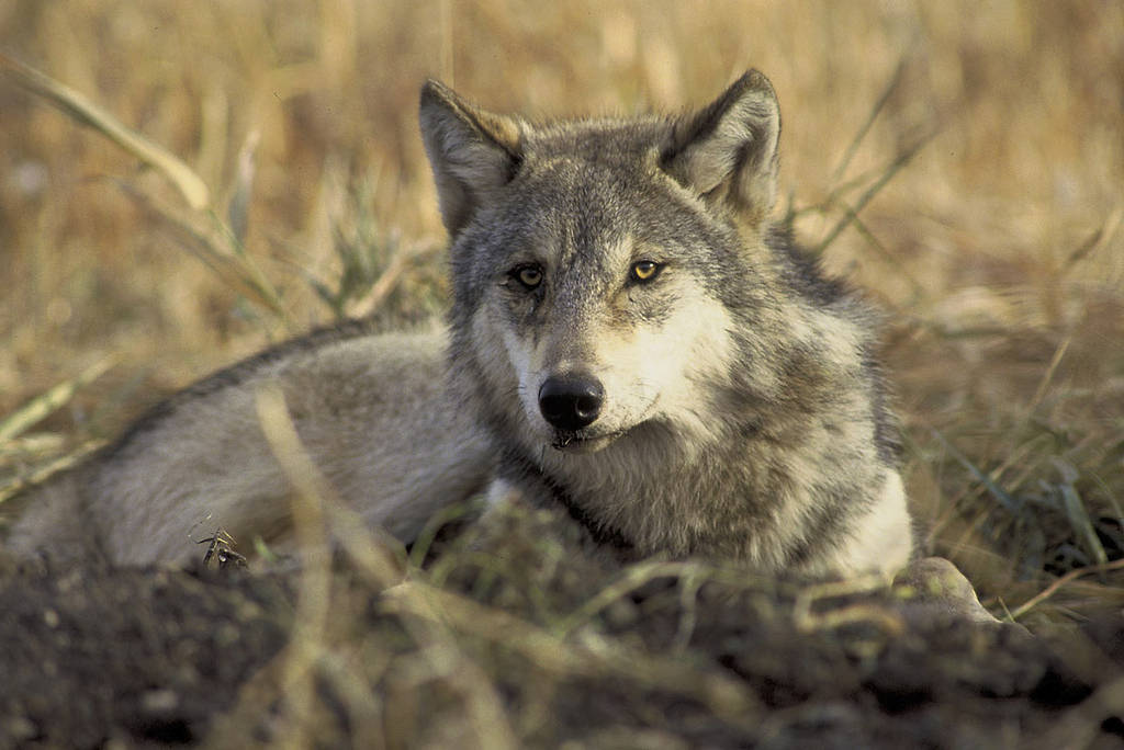
Gray wolves were extirpated from Colorado in the 1930s, but a pack was recently spotted in the northwest corner of the state. In November, voters in the state will decide on a measure to reintroduce gray wolves. JOHN AND KAREN HOLLINGSWORTH, USFWS
Since Colorado’s last wild wolves were killed in the 1930s, a few lone animals have been spotted in the state. So, when a pack was spotted in northwest Colorado — several months before Colorado voters decide whether they’ll support a bill to reintroduce gray wolves to the state — it wasn’t a total surprise to Carbondale ecologist Delia Malone.
“It does give life to the idea that Colorado has ample suitable habitat for wolves,” said Malone, a member of the science advisory team for the Rocky Mountain Wolf Project, which hopes to reestablish a sustainable population of wolves in Colorado.
Malone and Colorado wildlife officials agree that the rural northwest corner of the state is well-suited for wolves. CPW isn’t releasing the pack’s exact location, but agency spokesperson Lauren Truitt says there is plenty of prey and room to roam.
“With Colorado not having any wolf presence, there’s not a whole lot of competition for them, so it’s very likely that they’ll hang around,” Truitt said.
CPW biologists used DNA testing on four scat samples, which revealed there are at least three females and one male in the pack, and those wolves are all closely related, probably as full siblings.
“That does not mean there’s a sustainable population of wolves in Colorado,” Malone said. “A sustainable, recovered population is a population that is ecologically effective in their role to restore natural balance; they’re well-distributed throughout Colorado; they’re well-connected. And six little wolves is not that.”
Malone says her work as an ecologist gives her a clear view that Colorado needs wolves.
“Our ecosystems are not in great shape,” Malone said.
The combination of a warming climate and lack of predators has reduced the resilience of Colorado’s aspen forests and other habitats. Malone said the presence of wolves has tremendous benefits, including improving water availability in the driest months of the year.
“They (wolves) move the elk so that they don’t overgraze, so that there’s willow left for the beavers to build their dams, to store their water, to supply streamflows in the late-summer season,” Malone said.
Malone and others point to the ecological benefits seen after wolf recovery in Yellowstone National Park as a model. The National Park Service says that without pressure from predators such as wolves, the elk population grew far beyond what was sustainable. The number of elk has since reached healthier levels.
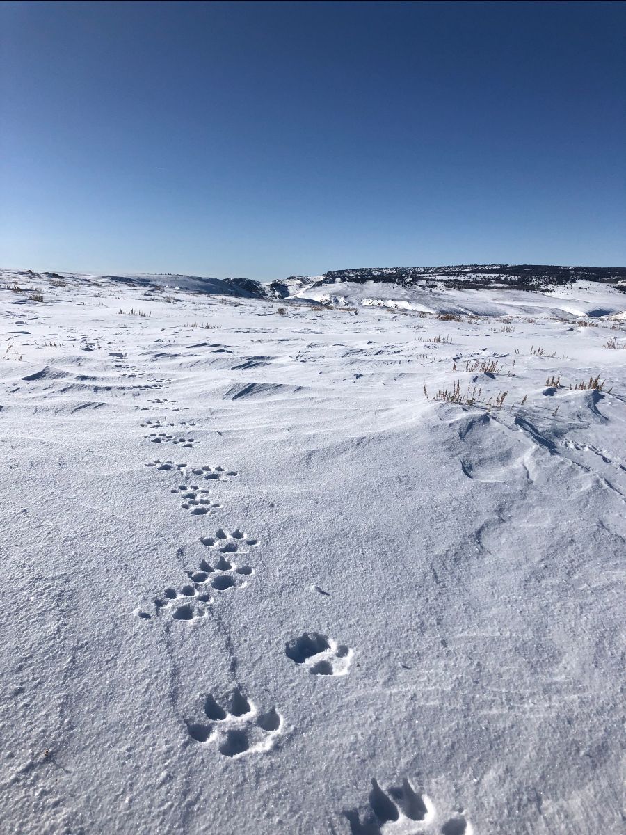
A trail of wolf tracks observed by Colorado Parks and Wildlife officers in Northwest Colorado on January 19, 2020. Photo credit: Colorado Parks & Wildlife
While a pack sighting indicates the possibility of wolves returning to western Colorado on their own, there are also two potential paths to reintroduction.
Sen. Kerry Donovan in January introduced to the state legislature a bill that would take cautious steps toward wolf reintroduction, potentially beginning in 2025.
In November, voters will decide on Initiative 107, which would require CPW to create a plan to reintroduce and manage gray wolves by the end of 2023. The Rocky Mountain Wolf Project has been working for years on a plan that would fully restore wolves to Colorado.
“Vast areas that are rugged and remote without humans are the ideal reintroduction sites,” Malone said.
The Rocky Mountain Wolf Project identified several potential reintroduction sites, including the Flat Tops Wilderness north of Glenwood Springs; Grand Mesa, Uncompahgre and Gunnison National Forests; Weminuche Wilderness in San Juan National Forest; and Carson National Forest.
Gray wolves are currently listed as a protected species under the Endangered Species Act, which gives management authority to the federal government. Last year, the federal government petitioned to remove those protections and declare wolves recovered. That would mean that CPW would be in charge of management.
If Initiative 107 passes and gray wolves remain listed under the ESA and, therefore, under federal management, Truitt says the next steps are unclear.
“The ballot initiative instructs the Commission to develop and implement a plan for reintroduction, but is silent as to what CPW is supposed to do if it has no authority to reintroduce or manage wolves,” she wrote in an email.
There is strong support across the state for wolf reintroduction. In an online survey conducted by Colorado State University professor Rebecca Niemiec, 84% of respondents intended to vote for wolf reintroduction.
Bill Fales and Marj Perry raise cattle near Carbondale. They fear that the presence of wolves in Colorado would come with a significant economic hit to their ranching operations. Photo credit: Elizabeth Stewart-Severy/Aspen Journalism
Herd instinct and ranching changes
Jose Miranda raises water buffaloes, mostly for dairy, in Old Snowmass. He says it would be silly to think that wolves won’t change his operations, but he still plans to vote for reintroduction.
“My position is that morally, it’s the right thing to do,” Miranda said. “On the verge of so many species that are facing extinction, if we can do something to help some of them, we just have to.”
Miranda acknowledges that wolves would mean major changes for many ranchers, particularly those whose use permits to graze cattle on U.S. Forest Service land. Those permit areas tend to be large, with animals spread out across the landscape rather than gathered in herds.
Longtime Carbondale ranchers Bill Fales and Marj Perry use a Forest Service permit to graze up to 900 head of cattle each year in the summer and fall.
Perry has been researching ranchers’ experiences across the West, and she worries that wolf predation would be particularly severe during two times of the year: calving season, when wolves tend to hang out lower in the valleys and there are an abundance of calves available; and early fall, when wolf pups are learning to hunt.
“It’s a lot easier to learn to hunt a calf than a deer or elk,” Perry said, adding that their cattle are spread out on Forest Service lands during that time of year.
Researchers and ranchers have identified ways to minimize the loss of cattle to wolves and other predators. Matt Barnes, a rangeland and wildlife conservationist and a former rancher, says ranchers who use strategic grazing — a process in which cattle are moved from one pasture to another and work is done to encourage herd behavior — lose very few animals to predators.
“If they bunch up and stand their ground, the vast majority of the time, they all survive,” Barnes said. “A lone prey animal out there is kinda easy pickings.”
Wolves hunt by forcing their prey to run and attacking from the sides. That’s how they are able to kill animals that are four times their weight. But researchers think wolves are only successful about 15% of the time, and much of their success depends on how the prey behave — namely, if they gather in a herd.
“There is something magic about that herd effect,” Barnes said. “It’s prey animals’ primary anti-predator behavior.”
Cattle — indeed, all kinds of prey — can move the weakest members of the herd to the middle, and defend themselves using their hooves.
Miranda, who raises water buffaloes, thinks his animals stand a pretty good chance against wolves because of their herding behavior.
“I know that the water buffaloes that I have are probably going to have a better instinct protecting themselves and the younger animals as far as protecting themselves against a pack of wolves,” Miranda said.
But Perry and Fales say the landscape where their cattle graze make herding up very difficult. There aren’t many open fields on the Forest Service land where their permit is, and there’s also limited access to water.
“We try to not have the cattle in a big bunch in order not to hammer the riparian areas,” Perry said. “Our whole strategy has been to keep cattle strung out. And so far, it seems like it’ll be really hard to remedy that.”
Wolf advocates also say range riders can help minimize losses; a rider who is out with the cattle daily can watch for injured or weakened cows or calves that might become targets and keep an eye out for wolves. But Fales doesn’t think that would work, either, especially with the challenges of finding reliable labor.
“We do a lot of range riding. There’s never a day when there’s not someone out there,” he said. “But it would be totally insufficient to manage for wolves.”
The management strategy that Perry and Fales think would work in their situation is one that currently isn’t an option in Colorado: killing the problem wolves that prey on cattle.
“The only thing I would really advocate for would be lethal control,” Perry said. “You can’t have wolves without forevermore killing them.”
Killing wolves is illegal in Colorado because the species has federal protection under the ESA, but the future of that status is uncertain. Some ranchers, including Miranda, are hopeful that reintroduction would mean a larger voice in how wolves are managed than if the animals return to the state on their own.
“Some of these programs are very progressive,” Miranda said. “As long as there’s that kind of help and communication, that’s very fortunate.”
In fact, the CSU survey found that nearly 80% of people who identify as ranchers intend to vote for reintroduction. The online survey asked respondents a series of questions about how officials could manage wolves — including lethal control and compensation for ranchers for lost livestock — before asking whether people support the ballot initiative.
The initiative does not include any promise of lethal control, and management depends on a series of questions — namely, if wolves are removed from protections under the ESA. Even then, Barnes said control measures need to be carefully executed.
“For lethal control to make sense, it’s got to be targeted to the specific individuals that are involved in the conflict,” Barnes said. “Preemptive lethal control does not work.”
Also, he said, the number of cattle and sheep actually killed by wolves in states such as Montana and Wyoming is surprisingly low.
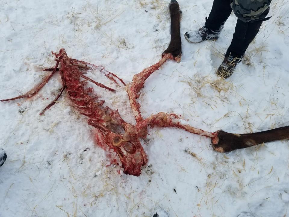
A scavenged elk carcass was found in Moffat County on Jan. 2. CPW officials confirmed that scat found nearby and from which they collected DNA samples belonged to wolves. Photo credit: Colorado Parks & Wildlife
Wolves kill few cattle, sheep
In Montana in 2018, the U.S. Department of Agriculture confirmed the loss of 71 livestock — 64 cattle and seven sheep — and two dogs to wolves. The USDA received 93 complaints of wolves killing livestock that year, while the state was home to an estimated 2.55 million cattle, 225,000 sheep and 819 wolves.
The numbers are similar in Wyoming, where wolves are considered “predatory animals” in most of the state, meaning they can be killed at will. In 2018, wolves were confirmed to have killed 71 head of livestock: 55 cattle, 15 sheep and 1 horse.
Wolves do kill livestock but not in big numbers.
“The rhetoric, the exaggeration, the myth is our biggest challenge,” Malone said. She said wolf advocates have work to do to assure ranchers that wolves won’t devastate their livelihood.
“We need to do work with the ranching community to be sure that they are whole and that they’re fairly treated,” Malone said. “But we can do that. We have good examples of it.”
Initiative 107 includes direction for the Colorado Parks and Wildlife Commission to create a plan to compensate
for livestock lost to wolves. Similar plans exist in other Western states, including Montana, where the state paid $82,959 to 40 livestock owners.
Funding for such a program in Colorado would come from an existing wildlife cash fund, and Malone says the goal is for public input to help shape policy on how to fairly compensate ranchers for their losses.
Still, Fales and Perry worry that wolves in Colorado would mean a significant economic hit — and an emotional one, too.
“There’s an emotional attachment (to the cattle), even though you’re selling them for a beef animal. You’re taking care of them, we’re with them just night and day when they’re calving,” Perry said. “And to go out and find them just shredded and eaten up is not something I would ever vote for.”
If Initiative 107 passes, Perry says she might quit. And her husband, Fales, thinks others might follow suit.
“I think a lot of people will quit, and certainly in this part of Colorado, there are a zillion developers ready to help you quit,” he said.
Gray wolves are currently protected under the Endangered Species Act, but the Trump administration has petitioned to delist them. That decision, expected this spring, will impact the management and possible reintroduction of wolves in Colorado. Photo credit: Tracy Brooks, U.S. Fish and Wildlife Service via Aspen Journalism
Coexistence amid conflict
Historically, conflicts between ranchers and wolves have not ended well for the predators.
“Because of their depredations of domestic animals, wolves in Colorado were systematically eradicated by shooting, trapping and poisoning,” reads the CPW informational website on wolves.
In recent years, CPW officials say there have been no reports or evidence of people killing wolves in the state, except for a widely publicized incident in 2015 where a hunter shot a wolf that he said he thought was a coyote.
While wolf advocates point to the ecological benefits of restoring wolves to their historic range, the social implications might be harder to pin down. Perry says she understands why people might be attracted to the idea of wolves, but she believes the implications on the ranching industry will be far-reaching.
“There could be unintended consequences (of wolf reintroduction),” Perry said. “Loss of ranchland, which means more fragmentation, more housing development, more decline for all animals, prey and predator.”
Barnes, who has experience in both wildlife conservation and raising livestock, says part of having domestic animals is the risk of predators.
“Very little in nature gets to live out its life without the risk of getting eaten,” Barnes said. “Coexistence is possible, but it’s probably not peaceful.”
[Thornton] plans to start building uncontested portions of the water pipeline in Windsor and Johnstown to keep the project on schedule, spokesman Todd Barnes said.
Meanwhile, Thornton plans to file an opening brief [February 27, 2020] in its lawsuit contesting Larimer County commissioners’ rejection of the pipeline. Commissioners’ jurisdiction applies only to unincorporated areas of the county.
Once Thornton files the opening brief, Larimer County commissioners will have about five weeks to file reply briefs, unless they get an extension.
It’s been more than a year since commissioners unanimously denied a 1041 permit for the pipeline’s proposed path through unincorporated Larimer County. The pipeline is intended to transport Poudre River water from reservoirs northeast of Fort Collins to Thornton’s water treatment plant.
The water, eventually amounting to an average of 14,000 acre-feet annually, would support Thornton’s growing population. About 140,000 people call the Denver suburb home today, but city officials expect the population to grow to 250,000 during the coming decades…
Many Larimer County residents objected to the pipeline’s proposed path, arguing Thornton should run the water through a stretch of the Poudre River instead. Thornton’s water is already taken out of the river upstream of Fort Collins for agricultural use, but river advocates say Thornton should use its project as an opportunity to bolster stream flows and provide a benefit to Larimer County.
Larimer County commissioners rejected Thornton’s 1041 permit because they said it didn’t meet seven of the 12 criteria for the permit, including mitigation of environmental impacts, mitigation of adverse effects on land, and project benefits that outweigh the loss of any natural resources or agricultural productivity…
Thornton’s lawsuit argues commissioners were legally bound to base their decision solely on the pipeline’s siting and direct impacts. Commissioners’ decision illegally undermined Thornton’s rights by taking irrelevant factors into consideration, Thornton argues…
“… this Court should declare, or rule as a matter of law, that (the board) cannot consider, condition or deny the application based on any river or canal concepts that undermine Thornton’s property rights, constitutional rights and water rights in the diversion point, the delivery point, the quantity and quality of the water right or the right to remove water from Thornton-owned farms adjudicated in the Water Decree because doing so is prohibited by (state statute),” stated documents Thornton filed in Larimer County District Court this week.
Larimer County’s rejection of Thornton’s permit application applies only to its proposed path through unincorporated parts of the county. Thornton has intergovernmental agreements with Windsor and Timnath allowing pipeline construction and is crafting an agreement with Johnstown, Barnes said.
The Johnstown portions of the pipeline that could begin construction in March are on easements with private landowners.
Barnes said the project remains on schedule to begin water deliveries in 2025.
From RethinkWolves.com via The Rio Blanco Herald-Times:
Rio Blanco county ag groups raised $34,000 to help oppose the statewide ballot initiative to introduce wolves on the Western Slope of Colorado. The Rio Blanco Stockgrowers, in partnership with Rio Blanco Farm Bureau and Rio Blanco Woolgrowers, hosted “Dance Without Wolves,” a fundraiser dinner, dance and auction to raise money to oppose the proposal.
More than 300 people gathered at the Fairfield Center in Meeker for the sold-out event. Rio Blanco Stockgrowers President Brian Collins noted, “This sends a strong message statewide that families on the Western Slope are very concerned about introducing wolves in their backyard and the subsequent negative impact on their families and communities.”
More than 70 live and silent auction items were donated, numerous sponsorships provided, and many businesses and individuals provided services free of charge. Contributions came from surrounding communities and all areas within the county. All three organizations worked together closely to ensure success.
Rio Blanco County Farm Bureau President Janice Weinholdt said, “The outpouring of donations and support from our community was overwhelming and underlines the deep concern in our county and the surrounding communities. We thank all who made this event possible.” A listing of helpers and donations, etc. will be compiled for next week’s paper.
Proceeds from the event are dedicated to Coloradans Protecting Wildlife, the issue committee running the campaign against the initiative. Coloradans Protecting Wildlife is run by the Colorado Farm Bureau, Colorado Cattlemen’s Association, Colorado Woolgrowers Association, Rocky Mountain Elk Foundation and the Safari Club International. People are encouraged to donate to the campaign at http://www.rethinkwolves.com.
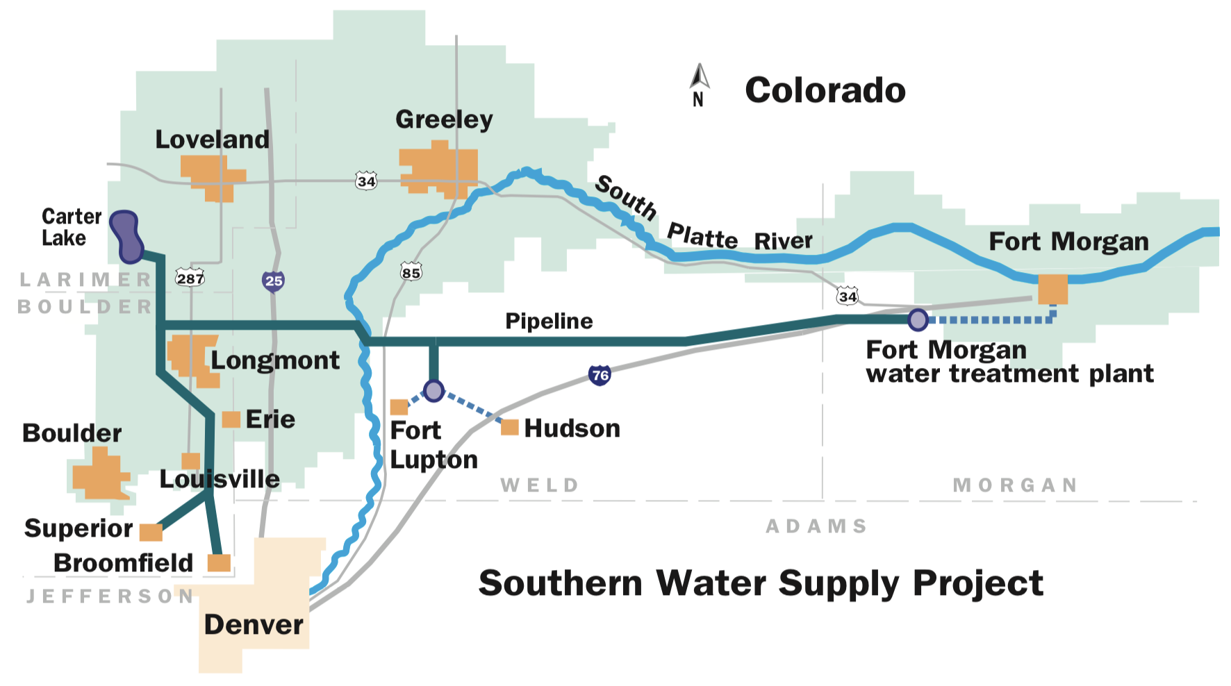
Southern Water Supply Project Map via Northern Water.
Click here to read the newsletter. Here’s an excerpt:
Final pipeline pieces get put into place for Southern Water Supply Project II
The contractors for the Southern Water Supply Project II reached a significant milestone last month with the installation of the final portion of pipeline.
The final piece was placed along the 20-mile route near Carter Lake in southern Larimer County. The pipeline, funded by the City of Boulder, Left Hand Water District, Longs Peak Water District and the Town of Berthoud, will bring water supplies to those communities year-round.
While the installation of pipeline is complete, additional work remains. Northern Water technicians are installing and programming equipment for integration into its SCADA system, and testing of the pipeline segments for quality assurance is ongoing. Northern Water anticipates the pipeline will start carrying water to its destination at Boulder Reservoir in April.
Beyond the pipeline, however, work will continue on another important aspect of construction: reclamation of disturbed ground. The pipeline runs through easements on a variety of public and private properties, and reclamation crews will be working with those entities to ensure lands are reclaimed to their owners’ satisfaction.
Garney Construction was the lead contractor for the $44 million project.
Click on a thumbnail graphic to view a gallery of drought data from the US Drought Monitor.
US Drought Monitor February 25, 2020.
West Drought Monitor February 25, 2020.
Colorado Drought Monitor February 25, 2020.
Click here to go to the US Drought Monitor website. Here’s an excerpt:
This Week’s Drought Summary
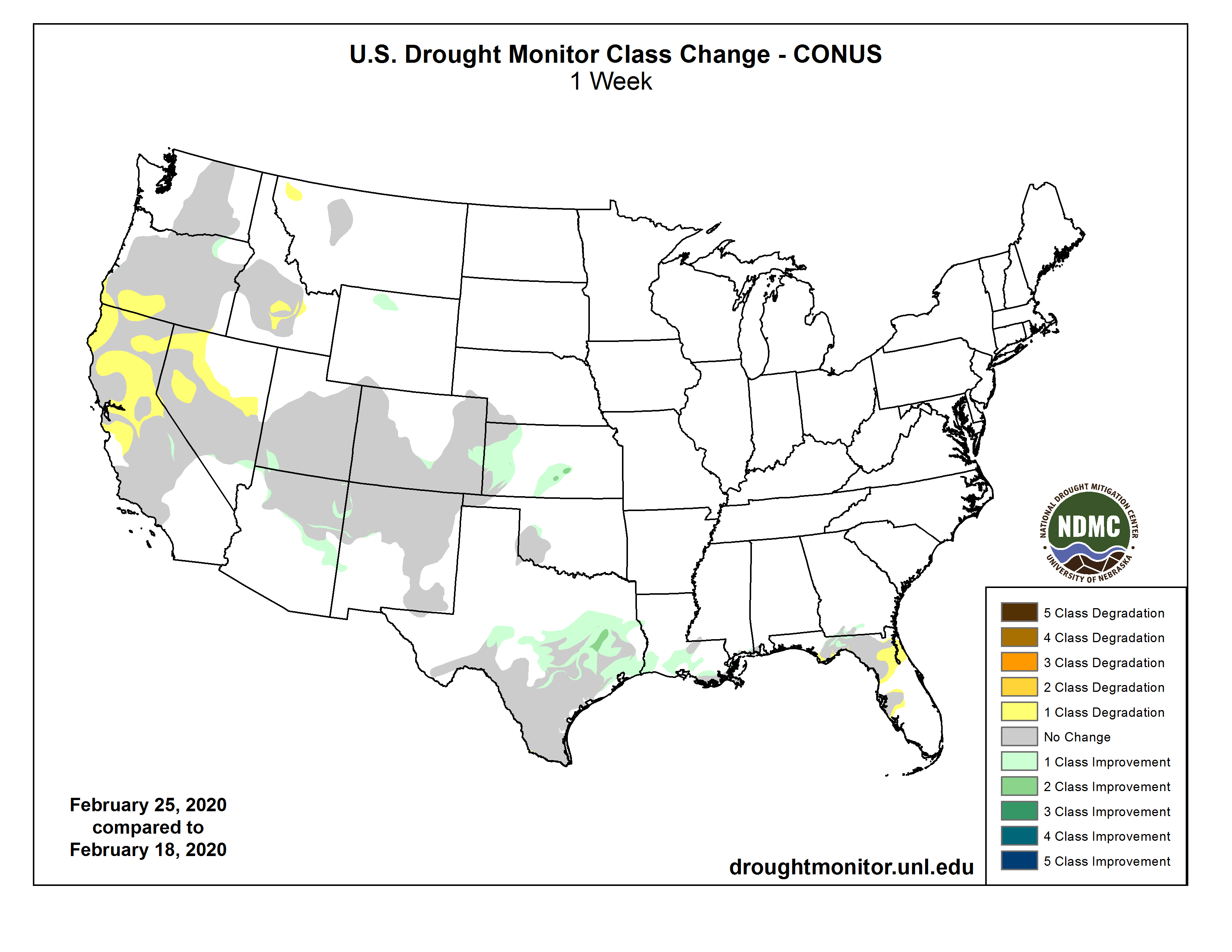
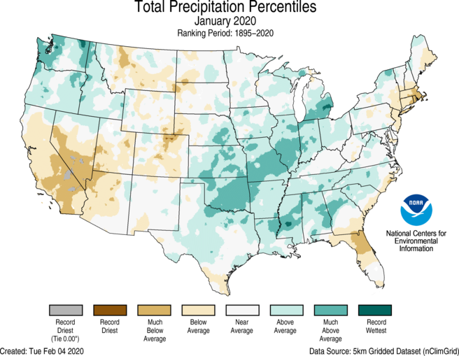
High pressure continued to persist over the eastern Pacific Ocean, forcing a split in the normal west to east upper-air flow for Pacific storm systems. As a result, storms bypassed the central West (e.g. California and the Great Basin), instead tracking northward into the Pacific Northwest and British Columbia, and southward across Baja California and the Southwest. This pattern has produced a very dry January and February in California, normally the two wettest months of the year, resulting in an expansion of short-term D0 and D1 that are impacting non-irrigated land and non-managed rivers. Fortunately, the statewide reservoir storage stood at 104% of average for this time of year. Farther to the east, once these systems reached the Plains, Gulf moisture was entrained into them, generating widespread precipitation across the South and Southeast and mixed or frozen precipitation in more northern locations. The week’s greatest precipitation (1-4 inches) fell on the northern Cascades, parts of the Southwest (mostly Arizona), the central Plains (mainly Kansas), and from central Texas eastward across the lower Mississippi, Tennessee, and Ohio Valleys, the Southeast, and southern Appalachians. Little or no precipitation, however, fell on most of California, the Great Basin, and Intermountain West, northern Plains and upper Midwest, parts of the southern Plains, most of Florida, and the mid-Atlantic. Weekly temperatures averaged below normal in southwestern Alaska, the Northwest, Rockies, Plains, upper Midwest, Southeast, and New England. In contrast, above-normal readings were observed in eastern and southern Alaska, the Southwest, eastern Great Lakes region, mid-Atlantic, and along the eastern Gulf and southern Atlantic Coasts…
Much of the region was saw little or no precipitation with the exception of Kansas and eastern Colorado. Unseasonably heavy precipitation (1-3 inches) fell across much of Kansas and into Missouri, effectively erasing the two small D1 areas and D0 in south-central Kansas as surpluses now replaced deficits out to 90-days. Likewise, moderate precipitation (0.5-1.5 inches) in western Kansas and eastern Colorado (where February normally contributes to only 2-3% of the annual total) removed shortages out to 90-days, improving the D0-D2 by 1-category. In central Colorado, 0.5-1 inch of precipitation was enough to improve most indices to the normal range, thus D0 was removed in parts of Pueblo and Custer Counties. For D0 changes in Wyoming and Montana, please refer to the West write-up…
As a large ridge of high pressure off the California Coast remained entrenched, Pacific storm systems were deflected farther north or south of the ridge, affecting the Pacific Northwest and southwestern Canada, or Baja California and the Southwest, but keeping most of California, Nevada, northern Utah, and southern sections of Oregon and Idaho mostly dry. Unfortunately, this pattern has remained entrenched during much of January and February, normally the two wettest months of the year for California, and has greatly diminished the good (wet) start to the Water Year (Oct. 1). After above-normal precipitation during November and December in the Southwest and most of California (and below-normal precipitation in the Northwest), 2020 brought a flip to the weather pattern as California and parts of the Southwest dried out while the Northwest observed surplus precipitation. During the past 60-days, less than 25% of normal precipitation had fallen on much of California and western Nevada, creating deficits exceeding a foot in parts of the Sierra Nevada, and 4-8 inches along the coast. SNOTEL basin average WYTD precipitation has dropped to between 45-54% of normal in the Sierra Nevada while Feb. 25 SWC stood between 46-61%. In southern Oregon, although the past 60-days were somewhat better than California, a dry November and December started their Water Year off to a slow start. Their SNOTEL basin average WYTD precipitation and Feb. 25 SWC was between 67-69% and 71-77%, respectively. In southern Idaho, the Big Lost, Big Wood, and Little Wood basins were mostly dry this week, and the Feb. 25 SWC dropped to between 57-71% while WYTD precipitation held steady, ranging from 55 to 64%.
Although the California statewide average reservoirs were 104% of normal for this time of year, the timing of the precipitation deficiencies are just as important as the magnitude in California. According to California State Climatologist Michael Anderson, February is an important month as temperatures begin to warm and rangeland comes out of winter stasis. With late rains, germination was delayed, and now with little or no rain in February, it will be difficult for rangeland to develop the nutrients necessary for good forage. Expectations are that rangeland conditions will be poor or very poor, and supplemental feeding required. Reports from the field have already mentioned that some rangeland and pastures have already headed out, meaning that they completed their annual life cycle and won’t produce any more biomass, something that normally happens in late April or May. A report from northern California mentioned blowing dust when checking their herd – while blowing snow would be the norm. The latest USDA/NASS February report for California had topsoil moisture 25% very short, 40% short, and 35% adequate. Subsoil moisture was 10% very short, 50% short, and 40% adequate. Some areas are considering irrigation due to the dry weather, and cattle continued to be provided supplemental feed. With numerous non-managed 7-day averaged USGS stream flows in the lower tenth percentile (much below normal) in southwestern Oregon and the northern half of California, and non-irrigated lands already being impacted, D0(S) was expanded into northwestern and west-central California and northwestern and central Nevada. Where short-term conditions (60-days; SPIs at D2-D4) and WYTD conditions (120-days; SPIs at D1-D2) were the worst, D1(S) was added in central California and the Sierra Nevada, southern Oregon, and west-central Nevada. Fortunately, the long-term hydrologic conditions were much better, with California statewide reservoirs at 104% of normal as of Feb. 25. In southern Idaho, D2(SL) was added to the Big Wood, Little Wood, and Lost River basins. In northwestern Montana, a small D0 was introduced from Kalispell to Eureka based upon 90-day indices as SWC and WYTD precipitation is below normal, possibly due to a precipitation shadow effect from this winter’s dominant flow patterns.
In contrast, a southern storm system dropped light to moderate totals (0.5-2.5 inches) on the Southwest, mainly Arizona, but enough precipitation fell elsewhere on southern Nevada, southwestern Utah, northeastern Arizona, and central and eastern Colorado to slightly improve D0-D2 in these areas. In addition, 0.5-1 inch fell on the eastern side of the southern Sierra Nevada (western Inyo and eastern Fresno counties) that the eastern edge of the D1(S) was adjusted (improved) slightly westward. In northeastern Oregon (central Umatilla county), D0 was trimmed back as stream flows, SWC, WYTD precipitation, and soil moisture indicators were much improved. In northern Wyoming, although it was a quiet week, a re-evaluation of the tools showed that all indicators at all time periods were normal or wet, thus the D0 was erased there. Washington was left unchanged…
Similar to last week, another storm system dropped moderate to heavy rain (1-4 inches, locally to 7) from central Texas eastward across northern Louisiana, central Mississippi, and into central Alabama and Georgia. Decent totals (0.5-2 inches) also fell on southwestern and northern Oklahoma, central and eastern Texas, and much of Arkansas, Louisiana, Tennessee, and Mississippi. Little or no precipitation was reported in far western and southern Texas, the eastern half of Oklahoma, and extreme northwestern Arkansas. And like last week, 1- and a few 2-category improvements were made in central and southeastern Texas, while most of the D0 in southern Louisiana was alleviated. USGS stream flows have responded, with 7-day averaged values in the 75th to 90th percentiles in eastern Texas eastward. In contrast, where weekly totals were lower (less than 1.5 inches) and decent 60- to 90-day deficits remained, D0 was left. This included southeastern Louisiana and extreme southern Mississippi. A small portion of the D0 was removed in southwestern Oklahoma where 1-1.5 inches fell. Status-quo was decided for southern Texas even though it was mostly dry since major degradations were made last week there. The only change was the removal (downgrade) of a small D1area (to D2) in southwestern Starr County. USGS stream flows have also responded here, but the opposite way as 7-day averages were in the 10th to 25th percentiles. If it remains dry this week with low humidity and gusty winds (red flag warnings), potential deterioration is possible next week as reported impacts were on the rise…
Looking Ahead
During the next 5 days (February 27-March 2) in the West, light to moderate precipitation is expected in the Cascades, Sierra Nevada, Great Basin, and northern and central Rockies later in the 5-day period. Dry weather should prevail across the Plains, while a departing storm system early in the period brings light to moderate totals to the Northeast, Ohio Valley, and central Florida.
In the extended range forecast for the ensuing 5 days (March 3-7), odds are tilted toward above-normal precipitation east of the Rockies, especially from the lower Missouri and Tennessee Valleys northeastward into western New England, and across most of Alaska. Subnormal precipitation is favored in the Far West, especially California, Nevada, and Utah, and in extreme southern Texas. Above-normal temperatures are likely east of the Mississippi River, the Far West (mainly California), and northern High Plains. Enhanced probabilities for subnormal temperatures were found across Alaska, and in the central and southern Rockies.
US Drought Monitor one week change map ending February 25, 2020.
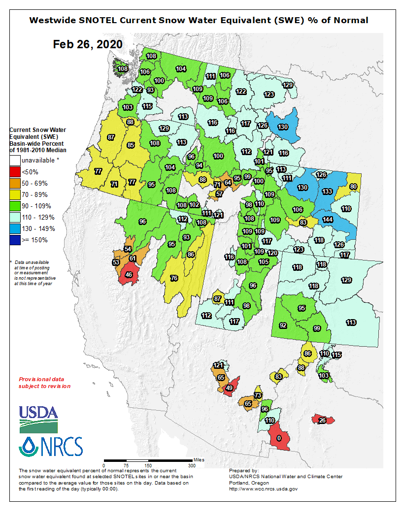
The number of snowstorms in Colorado this February is making the record books in some parts of the state. “We’re looking at having just a great water year—again,” said Colorado Springs Utilities. Water Resource Manager, Abby Ortega. Snowpack becomes the water supply when it melts.
“February [is] kind of our low point for reservoir storage and currently in storage we’re at 79% of capacity, which is about 2.8 years of demand in storage today,” said Ortega. The numbers are high compared to other years.
Then consider snowpack. The Colorado River Basin is at 119% of average. The Arkansas River basin is also over 100% of average. If snow trends continue, this year there could be more run-off than can be stored.
Yet, a new water saving ordinance in Colorado Springs now restricts outdoor watering to three days. Ortega says it is not based on this single water year. “We also know that we live in Colorado and its ups and downs. We’ll have another drought year. We’ll have another wet cycle, and we want our customer use to be consistent through that.”
Men viewing vortex tube sand trap in Jackson Ditch at Bellvue Hydraulic Laboratory, 1948. Photograph from Irrigation Research Papers, Water Resources Archive.
Fromm email from the CSU Water Resources Archives (Patty Rettig):
You are invited to Water Tables 2020
To celebrate Colorado State University’s 150th anniversary, this year’s event highlights the University’s impressive water heritage. Our table hosts are a dynamic group of CSU faculty, staff, alumni, and partners who have had an impact on water locally and around the world. Join the conversation and support the Water Resources Archive!
Saturday, April 4
5 p.m. | Reception | Morgan Library, Archives and Special Collections
1201 Center Ave. Mall
Fort Collins
6:30 p.m. | Dinner and Discussion | Lory Student Center Ballroom
1101 Center Ave. Mall
Fort Collins
Register by March 28, using the link below.
If you have questions or wish to register directly, contact
CSU Events at (970) 491-4601 or by EMAIL.
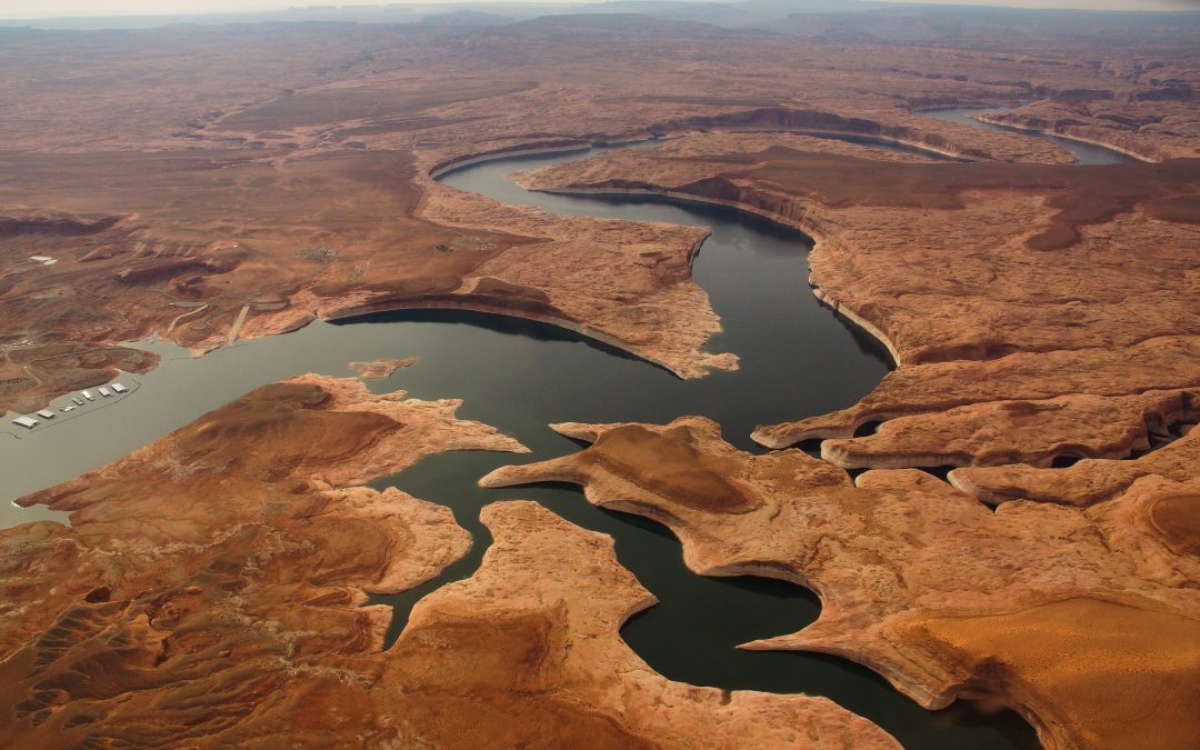
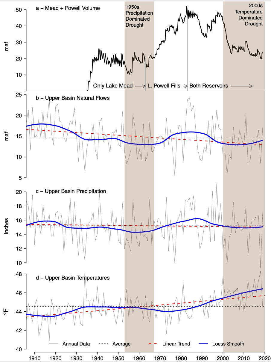
Lake Powell, created with the 1963 completion of Glen Canyon Dam, is the upper basin’s largest reservoir on the Colorado River. But 2000-2019 has provided the least amount of inflow into the reservoir, making it the lowest 20-year period since the dam was built, as evidenced by the “bathtub ring” and dry land edging the reservoir, which was underwater in the past. As of October 1, 2019, Powell was 55 percent full. Photo credit: Eco Flight via Water Education Colorado
This year, the first-ever Colorado River Drought Contingency Plan is set to launch, and water officials expect 2020 to bring unprecedented changes to the way the river is run, including cutbacks in water use by some states.
Drought and climate change are expected to play a leading role in determining how to reduce water use and bring the stressed river system into a sustainable, balanced state of being.
After historically low levels were reached last year in Lakes Powell and Mead, Arizona and Nevada are now poised to implement their first-ever cuts in water diversions, while Colorado and the other upper basin states are working to explore ways to conserve water and bank it in Lake Powell’s new drought pool to avoid future shortages.
Brad Udall, a senior climate scientist at Colorado State University’s water center, said the river’s operations are set for a major rework.
2019, he said, was “a really big [water] year, so I think everybody’s happy, but to think somehow the drought is over and climate change isn’t happening—or to hope for the best and ignore the lessons of the last 19 years—I think these high temperatures will remind people, ‘This is not the same old game we used to play in the 20th century.’”
A look back
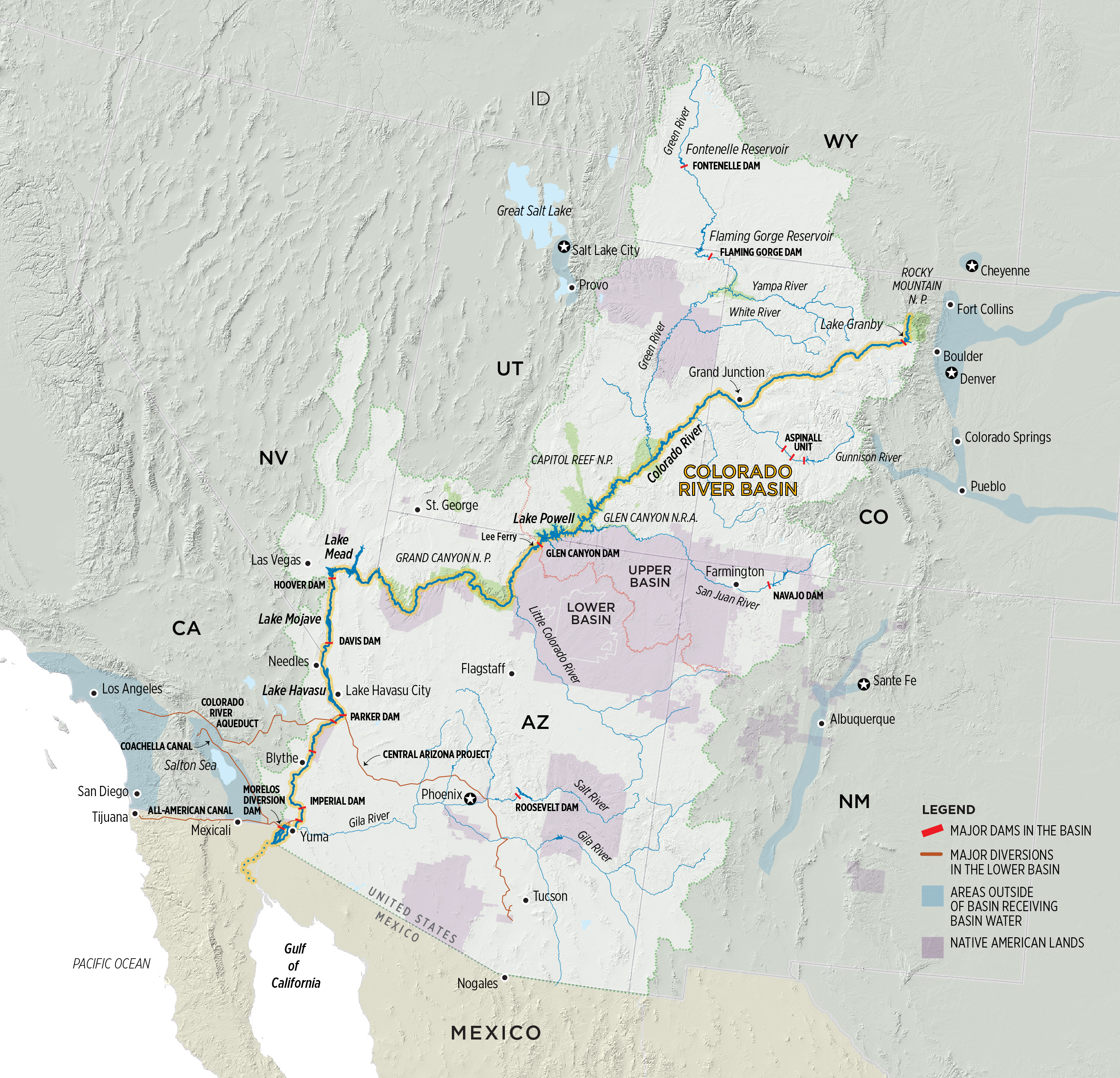
A lot has changed since the Colorado River Compact first divvied up the river’s waters in 1922. Today, more than 40 million people in two countries rely upon the river, which originates on the Western Slope of the Rocky Mountains in northern Colorado, and is fed by major tributaries like the Green, Gunnison and San Juan rivers. Cities from Denver to San Diego, though geographically outside of the natural river basin, divert water from the river for drinking and industry, and farmers irrigate 5.5 million acres of everything from alfalfa to melons.
The Colorado River Basin is also now more than 2 degrees Fahrenheit warmer than the twentieth century average—with “hotter” droughts depleting river flows. By necessity, as the climate continues to change, bringing continued warming and drying, shortage-sharing agreements on the river must continuously be updated to keep changing, too. The Drought Contingency Plan (DCP) was needed as a stop-gap until a new set of operating guidelines, due by 2026, are written.
The DCP’s predecessor
The DCP’s origins lie with the Colorado River Interim Guidelines. Written in 2007, the operating guidelines were designed to address the Colorado River’s deteriorating storage levels. They identify how to operate the river’s two major reservoirs, Lake Powell and Lake Mead, under hotter, drier conditions, and to share the risk of shrinking water supplies between the upper and lower basins.
But the 2007 interim guidelines, while temporarily keeping the basin out of crisis, did not anticipate the extent of drought that the basin would experience. In 2013, then-Secretary of the Interior Sally Jewell directed states to consider additional measures or face unilateral federal action to avoid a potential crisis. With its own interests to protect, including water deliveries to contractors and tribal water rights, the federal government needed states to put a more robust plan in place.
That led to the latest temporary plan, the DCP, which negotiators say provides some security in avoiding a potential crash of the Colorado River system.
Six years in the making, the DCP includes two plans, hammered out separately by the lower and upper basin states. The upper basin plan focuses on flexibility in reservoir operations during drought conditions, investigating how to reduce water demands—including with voluntary water conservation programs—and weather modification to augment precipitation. In the lower basin, the process needed to move more quickly because water use already exceeds allocations. Cities and farms in Arizona, California and Nevada agreed to scale back and take deeper cuts as Lake Mead reaches threshold elevations that trigger those cutbacks. This summer, the first threshold was triggered, so Arizona and Nevada will implement their cutbacks this year.
Developing plans for each basin was tricky considering that within each state there are also individual tribes, competing interests, and conflicts between urban and rural water users. But, pushed by a deadline from U.S. Bureau of Reclamation Commissioner Brenda Burman, in March 2019, the seven states asked Congress to provide necessary authorizations to execute their final plans. In an era when Congress spends much of its time at an impasse, legislators on both sides of the aisle recognized the need for drought planning. In April, federal legislators passed the Colorado River Drought Contingency Plan Authorization Act and the following month, on May 20, representatives from the seven basin states and Department of the Interior signed completed upper and lower basin drought contingency plans.
Colorado River Basin. Graphic credit: Water Education Colorado
Not a new problem
As Eric Kuhn and John Fleck write in their new book, “Science Be Dammed: How Ignoring Inconvenient Science Drained the Colorado River,” even during compact negotiations in the 1920s, records showed the river’s annual flows were lower than the total 17.5 million acre-feet allocated to the seven states and Mexico. In fact, three different studies during the 1920s estimated natural river flows at Lee Ferry at between 14.3 million acre-feet and 16.1 million acre-feet.
Planners chose to ignore that information, Fleck says, and with it, they ignored convincing evidence showing the basin regularly experienced long periods of drought. “We have rules written down on paper, allocating water across the basin, that essentially allocate more water than the river actually has—and this manifests itself quite differently in the lower basin than the upper basin,” says Fleck, director of the Water Resources Program at the University of New Mexico. Fleck’s co-author Kuhn is the now-retired general manager of the Colorado River Water Conservation District.
In the lower basin, California, Nevada and Arizona have long overused their share of the river (approximately 7.5 million acre-feet annually, averaged over 10-year rolling cycles), Fleck says, whereas the upper basin states have yet to use more than around 4 million acre-feet (of the “remaining” 7.5 million acre-feet originally intended, but not necessarily guaranteed, for them). But everyone needs to come to terms with the fact that there is less water in the basin, Fleck says. “And that’s what the DCP is,” he says. “The first steps toward a long-term plan for everyone to use less water.”
Today, Kuhn and Fleck note, the river’s average flow between 2000 and 2018 has been only 12.4 million acre-feet—16 percent lower than the 1906-2017 average of 14.8 million acre-feet per year.
To use less water, the two basins need their own strategies. In the lower basin, the DCP sets rules to scale back use of lower basin allocations as Lake Mead drops, or until storage conditions improve. Arizona, Nevada and Mexico will see cuts this year, while California could follow in future years if reservoir storage declines continue. Over the past few years, water users already started scaling back voluntarily, and, says Fleck, “The DCP gives the structure that gives us the confidence [the cutbacks] will continue,” he says.
The upper basin occupies a precarious position of its own, even though it uses less water than it technically could under the compacts that govern its use—use in the upper basin has remained flat, at around 4 million acre-feet per year, since 1990. Because upper basin states must not interfere with a specific quantity of water flowing downstream, they’ll take on much of the burden of dealing with declining flows in a warmer future, Fleck adds. “That means the upper basin has to be sure it has the tools in place to make sure it can continue to meet its compact obligations, to send water out of Lake Powell,” he says. “And it may have to figure out how to conserve water below 4 million acre-feet.”
Brad Udall: “…latest version of my 4-Panel plot thru Water Year (Oct-Sep) of 2019 of the #coriver big reservoirs, natural flows, precipitation, and temperature. Data goes back or 1906 (or 1935 for reservoirs.) This updates previous work with @GreatLakesPeck
Challenges of a warming world
Any planning on the Colorado River—from the crops farmers plant, to the ways in which cities incentivize conservation among customers, to the DCP’s successor—must address the fact that the basin is facing a hotter, drier future.
Rainfall records, reconstructed from tree ring chronologies that stretch back more than a thousand years, reveal past patterns of southwestern droughts, marked by dry conditions associated with natural climate variability. Today’s droughts in the basin are different. They are notable not just for a lack of precipitation, but also for warmer temperatures, which spur changes in snowpack, increase transpiration in forests and fields, and boost evaporation from reservoirs.
The U.S. Global Change Program’s Fourth National Climate Assessment in 2018 painted a troublesome picture of reduced water supplies and future food insecurity in the region. It also identified risks to southwestern tribes from drought and wildfire, and challenges to the region’s infrastructure and energy supplies.
More localized studies of the Colorado River Basin also show that as climate change continues to heat and dry the region, the river’s flows will keep dropping. A 2017 study by Brad Udall, a senior water and climate research scientist at the Colorado Water Institute at Colorado State University and Jonathan Overpeck, dean of the School for Environment and Sustainability at the University of Michigan, showed that flows between 2000 and 2014 averaged 19 percent below the 1906-1999 average, with one-third of those losses due to higher temperatures, versus changes in precipitation. If warming continues, according to that 2017 study, Colorado River flows could decline by 20 to 35 percent by 2050 and 30 to 55 percent by the end of the century.
A study published the following year by Udall and others reiterated that “unprecedented basin-wide warming” was responsible for the declines, this time looking at 1916 through 2014, when the river’s flows dropped by 16.5 percent during that period, even though annual precipitation had increased slightly. The study also revealed the entire basin’s sensitivity to shifts in precipitation patterns—that it matters whether precipitation comes as rain or snow, and also where it falls. Snowfall in the upper basin is more beneficial to the system, for example, than rainfall in southern Arizona. And the future doesn’t look promising: The 2018 study forecasts a future decline in snowfall within four sub-basins in Colorado.
Healthier snowpack this past winter offered everyone a bit of a reprieve, but the Colorado River Basin’s problems aren’t over. At the end of the water year, total system storage was at only 53 percent, according to Reclamation, though that’s up from just under 47 percent in October 2018.
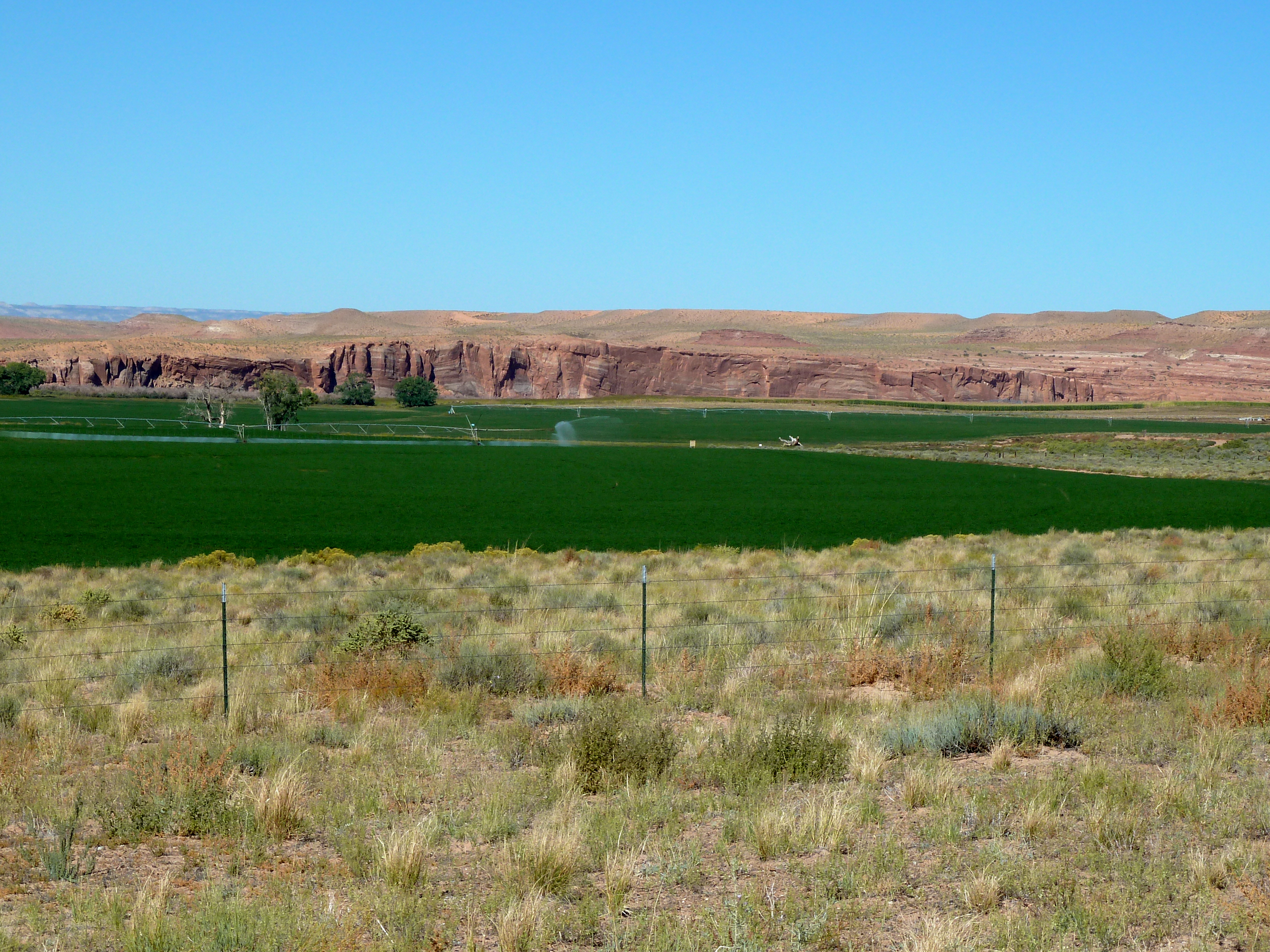
An irrigated field along the Green River in Utah. Photo: Brent Gardner-Smith/Aspen Journalism
From from Audubon’s Western Water News:
Utah’s Water Banking Act (S.B. 26 Water Banking Amendments), which Audubon supports, unanimously passed both the House and Senate and will become law following the Governor’s signature. This bill authorizes the 10-year water banking pilot program allowing water rights holders the opportunity to temporarily and voluntarily lease their water rights included in a water bank. We greatly appreciate Utah’s proactive legislative sponsors and the many collaborators who spent years developing the water banking program, seeking input from water users throughout the state.
Click here to read the current assessment. Click here to go to the NIDIS website hosted by the Colorado Climate Center. Here’s the summary:
Summary: February 25, 2020
Some parts of the Intermountain West received good amount of precipitation last week. Most of Arizona received over half an inch. This half inch plus of moisture also extended into western New Mexico and southern and central Utah. Parts of Colorado mountains saw between a quarter to half an inch as well. A decent storm on the eastern plains dropped half an inch over Kiowa and surrounding counties in eastern CO – which is about what their monthly average is for February. Northwest Utah, most of Wyoming, northeast Colorado, and eastern New Mexico were dry or received less than a tenth of an inch.
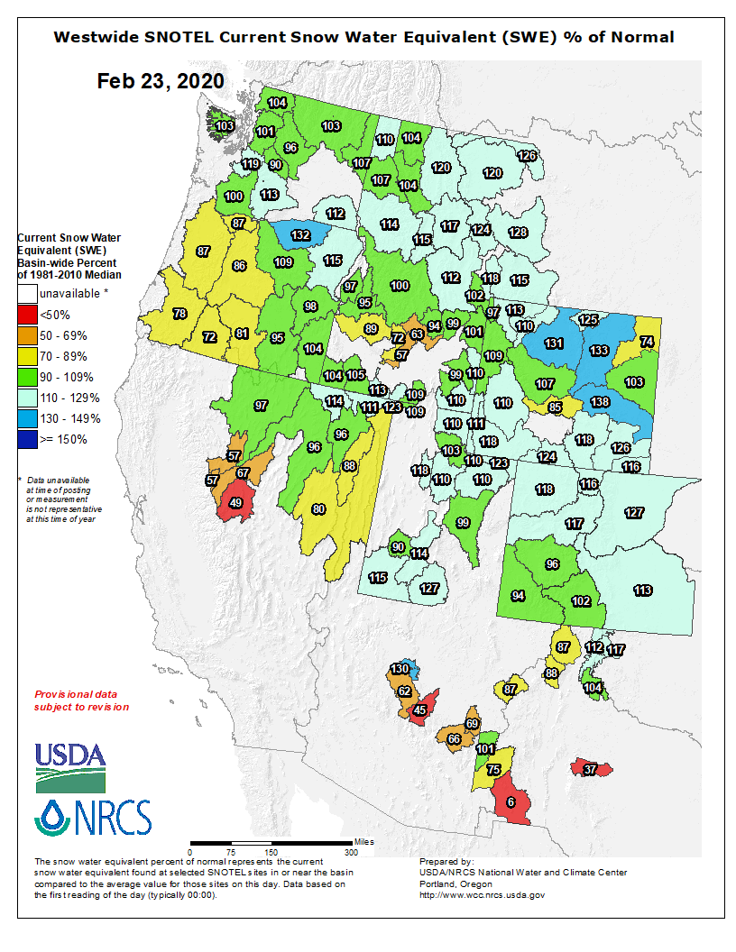
Temperature in the northern half of the IMW were colder than average and a little bit warmer to the south. Overall, a lot of February has been a bit cool for the IMW. Snowpack is still in good condition, with the northern basins well over the median for snowpack at this time of year. The central UT mountains, the San Juans, and the southern mountains in Arizona are a bit lower on snowpack, hovering near normal to slightly below normal.
The outlook for the next week shows a continued active pattern with moisture expected for most of the IMW. Higher mountain areas should see more than inch of precipitation with more spotty accumulations expected in the lower elevations. The cold air currently over the region should move out as warm temperatures move in for the weekend, ahead of the next cold air mass early next week.
Colorado College’s State of the Rockies Project Conservation in the West poll, released Feb. 20, shows Colorado voters support protecting more public lands in the face of climate change and energy development threats. The 10th annual poll also surveyed voters in Arizona, Idaho, Montana, Nevada, New Mexico, Utah and Wyoming and found:
• 69 percent of those polled label themselves as “conservationists” and vote accordingly.
• 81 percent consider an elected official’s stance on issues involving water, air, wildlife and public lands “important” when deciding how to vote.
• 47 percent say those are “primary” issues in their voting decision, a sharp increase from 31 percent in 2016.
“… voters in Colorado and across the West increasingly believe their lands and lifestyles are coming under attack from the impacts of climate change and energy development,” CC associate professor and director of the State of the Rockies Project Corina McKendry said in a release. Read more at https://www.coloradocollege.edu/stateoftherockies/conservationinthewest/.
More than three-fourths of Colorado voters say it’s important for public officials to prioritize environmental issues like climate change, clean air and water. The results come from the annual bipartisan Conservation in the West poll…
The results show climate change as a rising issue for Colorado and Western voters ahead of the March 3 presidential primary known as Super Tuesday. They echo exit poll results in Iowa and New Hampshire, which show the topic near the top of the list along with health care as important for voters.
Driving the recent change are increased wildfires across the West, particularly in Montana. Metz said the majority of respondents support the move away from fossil fuels toward wind and solar.
“These findings on climate change really document a pretty significant shift in Western voters’ thinking over the course of the last decade and a strong desire for action,” he said.
Releases from the Aspinall Unit will be decreased to 600 cfs on Wednesday, February 26th. Snowpack in the Upper Gunnison Basin is currently at 103% of normal. The February 15th runoff forecast for Blue Mesa Reservoir predicts 83% of average for April-July inflows. Flows in the lower Gunnison River are currently above the baseflow target of 1050 cfs. River flows are expected to stay above the baseflow target for the foreseeable future.
Pursuant to the Aspinall Unit Operations Record of Decision (ROD), the baseflow target in the lower Gunnison River, as measured at the Whitewater gage, is 1050 cfs for January through March.
Currently, there are no diversions into the Gunnison Tunnel and flows in the Gunnison River through the Black Canyon are around 800 cfs. After this release change Gunnison Tunnel diversions will still be at zero and flows in the Gunnison River through the Black Canyon will be around 600 cfs. Current flow information is obtained from provisional data that may undergo revision subsequent to review.
The river is due to lose up to 31 percent of its flow by midcentury—an alarming trend that could affect 40 million people
Not only are humans drawing unsustainable amounts of water from this source, but abnormally low precipitation and hot, dry conditions have been shrinking it for years—an alarming trend that is likely to worsen as climate change takes its toll. “To the extent that water is life, the idea that we lose the Colorado River—or even that it is diminished—has an outsize impact on this region,” says Jennifer Pitt, Colorado River Program director at the National Audubon Society. Yet despite the river’s importance, scientists have had a hard time pinning down how much its flow may decline as the world warms. To Chris Milly, a senior research scientist at the U.S. Geological Survey, the question is both disconcerting and fascinating. “I was pulled into the mystery of what was really going on in the river basin,” he says. “My interest bordered on obsession.”
That obsession turned into a year-long immersion in data. The results, published [February 20, 2020] in Science, suggest that by midcentury, the river could lose 14 to 31 percent of its historical flow from the period of 1913–2017.
Milly and his colleague Krista Dunne, also at USGS, created an extremely detailed computer model that analyzed how water moves in and out of the Colorado River basin via precipitation, melting snowpack, evaporation and other key processes. But because there are several physical parameters with values that are difficult to measure (such as the maximum amount of water the soil can hold at any given location in the basin), the researchers ran the model a whopping 500,000 times—tweaking those unknown parameters in every instance—until they found 171 versions that reproduced historical records remarkably well. They then projected their new and improved model into the decades ahead in order to estimate how the river might shift if the basin’s temperature increases by one degree Celsius (1.8 degrees Fahrenheit). The answer was grim: its flow would drop by 9.3 percent. Based on a range of climate scenarios, Milly and Dunne went on to predict that by midcentury, the Colorado River’s flow will likely decrease by as much as 31 percent, compared with historical values.
The study indicates the Colorado’s future hinges on snowpack, which is a major source of its water, because as the snow gradually melts in the spring and summer, the resulting water trickles into the ground, the river and its tributaries as it. “We discovered that snow cover behaves as a protective shield,” Milly says. Its high surface reflectivity, or albedo, throws back incoming solar radiation and keeps the ground beneath it relatively cool. But climate change is reducing the extent of that shield, allowing more solar radiation to penetrate the surface and thus creating a number of cascading effects. A large amount of moisture within the soil and trees will likely evaporate. Much of the remaining snowpack and groundwater will do so as well, leaving little water to run into the river.
Brad Udall, a senior scientist at Colorado State University, who was not involved in the new paper, calls its findings—particularly the 9.3 percent drop in flow—“eye-popping.” Udall co-authored a 2017 study that suggested the flow would decrease by 3 to 10 percent per 1.8 degrees Fahrenheit of warming, so the fact that Milly and Dunne’s number sits at the high end of that range grabbed his attention. But he does not doubt the researchers’ results, which, he says, went into much greater detail than previous efforts. “I would argue that they did it more elegantly and more rigorously,” he says. “And you have to take this result pretty seriously.”
Udall thinks the findings will have major ramifications for water managers and users alike. “Every drop in that river is being used. And any reduction like that is going to cause serious pain,” he says. But he is hopeful that conservation managers will find the best route forward. “I like to say, ‘Hey, if we’ve got 20 percent less, that still means the glass is 80 percent full,’” he says. “Let’s get smart and savvy and figure out how to use what we’ve got.” Meanwhile Pitt, who was also not involved in the new study, is similarly inspired by a resolution reached last year when the seven U.S. states that host the river agreed to voluntarily cut their water use.
Still, Pitt worries that the Colorado River will continue to change—and in unpredictable ways. Although scientists have made significant strides in forecasting the impacts of rising global temperatures, those projections cannot include the inherent variability of water flow in the river. The historical record, for example, shows it might drop to roughly four million acre-feet in one year and climb to about 24 million acre-feet in another—all because of a varying snowpack. (An acre-foot is the volume of an area of one foot of water over a depth of one acre, or roughly 326,000 gallons.) In addition, these studies cannot take into account the many broader changes that the decreasing snowpack will manifest in the Southwest. Not only does the early snowmelt create a darker, more absorptive earth, it also bumps summer—and fire season—earlier. That process will further dry the region and reduce the flow of water into the Colorado River.
FromThe High Country News, February 24, 2020 (Jonathan Thompson):
The U.S. is a net exporter of petroleum, but it is not energy-independent.
After ordering a drone strike on Qassem Soleimani, Iran’s elite forces commander, President Donald Trump told the media that the assassination was made possible by the United States’ newfound energy-independence. Previous presidents had refrained from such acts, fearing higher prices at the pump, he said, but now, “we are independent, and we do not need Middle East oil.” As is often the case with Trump’s statements, this one is problematic and inaccurate. The U.S. may not need oil from the Persian Gulf, but we are not energy-independent, and never will be. But that hasn’t stopped presidents from trying to spin oil independence into policy justifications.
“Americans will not have to rely on any source of energy beyond our own,” Richard Nixon declared, seeking to quell public angst over the 1973 oil embargo. Yet Americans continued to guzzle petroleum, and oil imports rose, reaching a 10 billion-barrel peak in 2006. In 2009, a number of factors collided, reversing the trend. Americans drove less during the financial crisis; domestic consumption decreased, and imports fell. Meanwhile, the Federal Reserve implemented policies that encouraged investment in high-risk endeavors, including drilling. Global oil prices rose again, as demand from Asia increased. And producers went on a debt-fueled drilling frenzy, deploying horizontal drilling and multi-stage fracking to pull oil from shale formations.
Domestic oil production climbed faster than demand, and imports continued to decline. Near the end of 2019, the U.S. exported more petroleum products than it imported for the first time in five decades. Trump had little to do with it, though, as the causal factors were in motion well before his election. Nor are we anywhere near “energy independence.” The U.S. depends on foreign countries not only to supply oil — importing more than 8 million barrels of crude per day — but also to purchase its petroleum products.
Price fluctuations are acutely felt in the Western United States. People in rural areas drive more and have fewer options for public transit, so high gas prices can break budgets. Meanwhile, the economies of many Western communities still depend on energy extraction, and drilling is driven by the price of oil. So when oil prices drop because the coronavirus has lessened demand for oil in Asia, it reverberates through Western economies.
Here’s a breakdown of U.S. entanglements in the global oil market. The data are for October 2019.
Sources; U.S. Energy Information Administration, International Energy Agency, Oil Change International
Here’s the release from NCAR/UCAR (David Hokansky):
Scientists announced today that they have successfully used a combination of radars and snow gauges to measure the impact of cloud seeding on snowfall. The new research addresses decades of speculation about the effectiveness of artificial methods to increase precipitation, demonstrating unambiguously that cloud seeding can boost snowfall across a wide area if the atmospheric conditions are favorable.
“This is a revelation,” said Sarah Tessendorf, a scientist at the National Center for Atmospheric Research (NCAR) and co-author of a new paper about the research. “We can definitely say that cloud seeding enhances snowfall under the right conditions.”
The researchers, including scientists from the University of Colorado Boulder, University of Wyoming, and University of Illinois at Urbana-Champaign, arrived at their results by analyzing detailed observations taken in a cloud seeding experiment in Idaho during the winter of 2017. They found that injecting clouds with silver iodide generated precipitation at multiple sites at the ground, sometimes creating snowfall where none had existed.
The study provides the most comprehensive evidence to date that cloud seeding can generate rain or snow.
Tessendorf cautioned, however, that successfully producing precipitation requires the presence of clouds. The results are also dependent on such atmospheric factors as local winds. Even when cloud seeding enhances precipitation, there are additional factors that will determine if it is a cost-effective approach to increasing snowpack or replenishing reservoirs.
“The seeding produces ice and that ice can form snow, but is it enough additional snow to make it cost effective?” she asked. “For water managers, the bottom line is the amount of snowpack that you’re building over the whole winter and how much runoff it will generate. We are looking into some promising approaches to address those bigger questions, but we still have plenty of work to do to get there.”
The study was published this week in Proceedings of the National Academy of Sciences. Funding came from the National Science Foundation (NSF), which is NCAR’s sponsor, and from the Idaho Power Company.
A scientific challenge
As far back as the 1940s, scientists demonstrated that injecting certain types of particles into clouds could induce ice to form and grow around them until they fell out of the clouds.
But measuring what effect, if any, cloud seeding had on measurable rain or snow proved very difficult. Researchers compared the amount of precipitation from randomly seeded clouds with similar clouds that were not seeded, but such statistical analysis produced mixed results, partly because natural precipitation is so variable that it is difficult to pick out the signal from the noise. Other work has indicated that cloud seeding can boost precipitation at specific locations, but left open the question of whether the increase in precipitation extended across significant areas.
To tackle the question, NSF and the Idaho Power Company launched a major field project in the winter of 2017 called SNOWIE (Seeded and Natural Orographic Wintertime clouds — the Idaho Experiment). Researchers used airborne and ground-based radars, high-resolution snow gauges, and computer modeling to quantify the impact of injecting silver iodide into clouds over the Payette Basin region north of Boise. The seeding aircraft released silver iodide along a flight path that resulted in a zigzag pattern of seeding effects in the clouds.
Scientists used the Doppler on Wheels radar to measure snowfall in the Idaho mountains that was generated by cloud seeding during the SNOWIE field project. Photo by Joshua Aikins via NCAR
This approach enabled the research team to observe the entire process and compare the side-by-side seeded and unseeded areas.
“We tracked the seeding plume from the time we put it into the cloud until it generated snow that actually fell onto the ground,” said Katja Friedrich, a professor at the University of Colorado Boulder and lead author of the new study.
The results show that, on at least three occasions, the seeding measurably boosted the snowfall across the targeted watershed. A cloud seeding flight on January 19, 2017, for example, generated snow for about 67 minutes, dusting roughly 900 square miles of land with about a tenth of a millimeter of snow above the minimal amount that was falling naturally.
The three cases highlighted in the study produced a combined total of 571 acre feet of water, or the equivalent content of about 285 Olympic-sized swimming pools.
Other cloud seeding attempts, however, were not so easily detected and may not have been successful. Tessendorf said the research team is continuing to analyze 18 additional attempts during SNOWIE in order to learn under what conditions the seeding effect can be detected and result in an increase in precipitation.
he results from SNOWIE can be used to improve computer models of cloud seeding processes and better inform officials as they make decisions about their particular priorities, Tessendorf said. Ski resorts might want to increase snow on selected days, whereas water managers would want to build up snowpack over the course of the winter in order to generate additional spring runoff.
“We’re going to need to dig deeper into the data and further quantify the seeding impact,” Tessendorf said. “It’s important to find out whether this enhances snowpack in a way that meets specific needs. ”
About the article
Title: Quantifying snowfall from orographic cloud seeding
Authors: Katja Friedrich, Kyoko Ikeda, Sarah A. Tessendorf, Jeffrey R. French, Robert M. Rauber, Bart Geerts, Lulin Xue, Roy M. Rasmussen, Derek R. Blestrud, Melvin L. Kunkel, Nicholas Dawson, and Shaun Parkinson.
Publication: Proceedings of the National Academy of Sciences
Thunderclouds building over the Rocky Mountains, shot as a short pano with an iPhone.
The end result was a critical research finding: On three occasions, injecting clouds with silver iodide generated significant precipitation, more than doubling the rate of snowfall that had been falling naturally…
Cloud seeding is the deliberate injection of substances like silver iodide by airplane to create precipitation. The practice dates back to the 1940s when American chemist Vincent Schaefer used airplanes — and even cannons — to inject clouds with silver iodide or dry ice. While the industry around cloud seeding has existed for decades in the United States, the ability of science to verify results has been more ambiguous.
Scientists flew an airplane that had high-resolution cloud radar that could see features in clouds that are undetectable to the naked eye. Scientists also positioned mobile Doppler radars on wheels that storm chasers use high in the mountains above basins to observe changes in weather.
“Having these mobile radars positioned up on top of mountain ridges to be able to see over the basins where we were targeting cloud seeding, we were able to get measurements that we wouldn’t have seen otherwise,” [Sarah] Tessendorf said.
Eric Hjermstad, field operations director, Western Weather Consultants, lights a cloud seeding generator north of Silverthorne, Colorado. Photo credit: Denver Water
A lot of the current water scarcity problems in the Southwest could be eased if it just snowed more and with a regular frequency in the high country of Colorado, Utah and Wyoming. More snow means more time to deal with the Colorado River’s fundamental supply and demand imbalance.
The onus to correcting that imbalance often falls more on the demand side of the equation, with myriad policy pushes that either incentivize or force people to use less water. On the supply side, options are limited.
There’s one tempting proposition for western water managers currently feeling the pressure to dole out cutbacks to users due to the region’s ongoing aridification — inducing clouds to drop more snow.
For decades, states have invested in weather modification programs, also known as cloud seeding, in the hopes of boosting precious snowpack. The practice showed up in a recent agreement among Colorado River Basin states, and investment is expanding, with water agencies in Wyoming and Colorado for the first time putting funds toward aerial cloud seeding, rather than solely relying on ground-based generators.
“I can say that we’re up significantly in the last 24 months on the number of smaller large-scale programs that we’re modeling and completing feasibility studies for,” says Neil Brackin, CEO of Weather Modification, Inc., a North Dakota-based cloud seeding company that operates across the Western U.S.
Brackin’s company is in charge of the Colorado and Wyoming aerial programs, flying cloud seeding operations when moisture-laden snow storms arrive in northern Colorado’s Never Summer range or southern Wyoming’s Medicine Bow and Sierra Madre ranges…
It’s not snowing when we visit the generator, but Hjermstad agrees to fire it up to demonstrate how it works. First, he gets propane flowing and then turns on a valve to the silver solution. With a fire starter, he lights the chimney on top. A bright orange flame flares from the generator, sending microscopic bits of silver iodide into the air.
If there was a storm right now and the wind was blowing the right direction, Hjermstad says, this generator could be influencing how much snow it eventually drops…
There is a certain class of clouds that are ripe for seeding, he says. Some clouds arrive in Colorado full of supercooled liquid water, but they’re not dropping that moisture. By injecting small particles into the cloud, a snowflake is able to form. The silver iodide acts as the “seed,” which enables the growth of a new ice crystal. That new snowflake can ricochet through the cloud, amplifying its impact…
From late November to April, Hjermstad keeps an eye on each weather system forecast to drop snow or pass over his generators. If it looks promising, he’ll contact the landowners where the generator sits, tell them when to turn it on and turn it off, and watch its track on radar with ground truthing courtesy of Colorado’s highway webcams.
For decades, the practice has had a problem with its reputation. Anecdotal accounts from farmers and ski resort owners confirmed cloud seeding effectiveness. Recent scientific studies have given it more credence, but top experts in the field argue there’s still a lot we don’t know about how well cloud seeding works…
Parked in a hangar outside Laramie, Wyo., we’re sitting inside the small research plane French uses to study clouds. To get to know a cloud, he says, you can’t just look at it from the outside, you need to get inside it. An expensive suite of on board instruments lets him look at how snow forms in real time.
“Ice crystals come in many many different shapes,” French says. “They can look like six-sided plates. They can look like long needles or columns. They can look like dendrites, which is kind of the typical snowflake shape.”
For years, French has devoted much of his research to understanding the science behind cloud seeding. In 2017 he partnered with the Idaho Power Company and other researchers to fly the research plane behind another plane that was seeding clouds. The result was a series of scientific articles. A 2018 report French co-authored showed for the first time how aerial cloud seeding worked…
The study, called “Seeded and Natural Orographic Wintertime Clouds: The Idaho Experiment” (SNOWIE) and conducted in the Payette River basin near Boise, Idaho, was a big deal. Before then, no one had solid evidence that showed the physics of cloud seeding working in the real world.
With new data in hand, French was able to say, “Yes, the amount of snow that was falling at this location increased.”
That might sound like a definitive endorsement of cloud seeding effectiveness. But the scientists producing the research are circumspect about their findings, and ready to caution people from taking away too much from SNOWIE’s early results…
Sarah Tessendorf is a researcher at the National Center for Atmospheric Research in Boulder, Colo. and worked with French on SNOWIE. People ask her frequently if cloud seeding works. And she says it depends on how you define “work.” If the question is whether or not cloud seeding is capable of producing more ice inside a cloud, then the answer is yes. But more often than not, the question is more complicated and people are hoping for more than that.
“So, sometimes the question … is, ‘Does it produce additional snowpack on the ground?’ And we’re still working to try to answer that question,” Tessendorf says.
Tessendorf is cautious about what she’s currently able to prove when it comes to cloud seeding. In the past, studies have shown the practice could boost snowpack by up to 15 percent. Tessendorf says the increase in snowpack cited in those studies has been a moving target over the years, with varying levels of rigorous data gathering. When she and other researchers want solid proof, they’re looking for a 95 percent level of confidence that cloud seeding caused the increase, and it wasn’t just a serendipitous series of storms…
In a gilded Las Vegas conference room in December 2017, water managers detailed their solutions to the Colorado River basin’s chronic water scarcity, and how to wean the Southwest from total reliance on the overtaxed river.
A representative from the Upper Colorado River Commission laid out what Colorado, Wyoming, New Mexico and Utah would bring to the table. A three-pronged Drought Contingency Plan included a focus on demand management, which would create a dedicated pool of saved water within Lake Powell. Another prong dealt with reservoir operations to streamline decision making between state and federal agencies. The third was a re-commitment to weather modification programs which had been in place in some form since 2007.
In mid-2018, before wrangling over Colorado River Drought Contingency Plans reached a fever pitch in the river’s Lower Basin, water agencies in California, Arizona and Nevada agreed to spend upwards of $1.5 million each year on cloud seeding programs in the watershed’s upper reaches.
“The reason that cloud seeding is being implemented on a relatively large scale in the Colorado River basin is it’s a very low-risk, high-reward scenario,” says Dave Kanzer, an engineer with the Colorado River District and manager of the Central Colorado Mountain River Basin Weather Modification Program, which receives funds from Lower Basin water agencies.
If you’re a water manager in the Southwest, it’s easy to think of cloud seeding like an extra battery for a smartphone. The guy selling the battery tells you it will probably only charge your phone another four or five percent, maybe more if you plug it in at exactly the right time. So it’s not reliable, but it’s the cheapest on the market. Every other battery is expensive and takes years to make. And if a lot of people are counting on you to make a call, you might just be willing to buy the battery, even if it ends up doing nothing in the end.
Kanzer says investors understand the risks involved with cloud seeding. They’re not under a delusion that it will be the basin’s saving grace…
Colby Pellegrino is with the Southern Nevada Water Authority, the water utility for Las Vegas, and says her agency’s investment in Upper Basin cloud seeding is worthwhile.
The University of Wyoming King Air (UWKA) research aircraft supports a large variety of instrumentation, and is configurable for measurements of cloud properties, air motion, turbulence and fluxes, atmospheric chemistry and aerosols. A research crew of three to four can typically be accomodated with an approximate four hour flight endurance and a maximum flight level of 28,000 ft. The UWKA has a payload capacity of up to 1,650 lbs, supporting the suite of instrumentation maintained by the UW Research Flight Center as well as user-supplied equipment. The UWKA is commonly configured to accomodate the University of Wyoming Cloud Radar (WCR) and University of Wyoming Lidar (WCL) systems.
Two University of Wyoming researchers contributed to a paper that demonstrated, for the first time, direct observation of cloud seeding using radar and gauges to quantify the snowfall. Traditionally, cloud seeding — used to increase winter snowpack — has been evaluated using precipitation gauges and target/control statistics that led mostly to inconclusive results.
The research, dubbed SNOWIE (Seeded and Natural Orographic Wintertime Clouds — the Idaho Experiment), took place Jan. 7-March 17, 2017, within and near the Payette Basin, located approximately 50 miles north of Boise, Idaho. The research was in concert with Boise-based Idaho Power Co., which provides a good share of its electrical power through hydroelectric dams.
“This looks at how much snow falls out of seeded clouds at certain locations. That’s what’s in this paper,” says Jeff French, an assistant professor in UW’s Department of Atmospheric Science and fourth author of the paper. “We want to see if we can apply what we learned over a number of cases over an entire winter.”
The paper, titled “Quantifying Snowfall from Orographic Cloud Seeding,” appears in the Feb. 24 (today’s) issue of the Proceedings of the National Academy of Sciences (PNAS), one of the world’s most prestigious multidisciplinary scientific journals, with coverage spanning the biological, physical and social sciences.
The paper is a follow-up to a previous PNAS paper, by the same research team, titled “Precipitation Formation from Orographic Cloud Seeding,” which was published in January 2018. That paper focused on what happens in the clouds when silver iodide is released into the clouds. In the case of the SNOWIE Project, the silver iodide was released by a second aircraft funded through Idaho Power Co., while the UW King Air took measurements to understand the impact of the silver iodide, French says.
Katja Friedrich, an associate professor and associate chair of atmospheric and oceanic sciences at the University of Colorado-Boulder, was the newest paper’s lead author. Bart Geerts, a UW professor and department head of atmospheric science, was sixth author on the paper. Other contributors were from the University of Illinois at Urbana-Champaign, the National Center for Atmospheric Research (NCAR) and Idaho Power Co.
Throughout the western U.S. and other semiarid mountainous regions across the globe, water supplies are fed primarily through snowpack melt. Growing populations place higher demand on water, while warmer winters and earlier spring reduce water supplies. Water managers see cloud seeding as a potential way to increase winter snowfall.
“We tracked the seeding plumes from the time we put the silver iodide into the cloud until it generated snow that actually fell onto the ground,” Friedrich says.
French credits modern technology, citing the use of ground-based radar, radar on UW’s King Air research aircraft and multiple passes over a target mountain range near Boise, with making the detailed cloud-seeding observations happen. Despite numerous experiments spanning several decades, no direct, unambiguous observation of this process existed prior to SNOWIE, he says.
Over the years, research of cloud seeding “has been clouded,” so to speak, Geerts adds. He says it was difficult to separate natural snowfall and what amount was actually produced through cloud seeding. However, this study was able to provide quantifiable snowfall.
“Natural snowfall was negligible. That really allowed us to isolate snow added through cloud seeding,” Geerts says. “However, we are still in the dark where there is lots of natural snowfall.”
Following a brief airborne seeding period Jan. 19, 2017, snow fell from the seeded clouds for about 67 minutes, dusting roughly 900 square miles of land in about one-tenth of a millimeter of snow, based on the team’s calculations. In all, that cloud-seeding event and two more later that month produced a total of about 235 Olympic-sized swimming pools’ worth of water.
Other observations where snow from cloud seeding was measured took place Jan. 20 and Jan. 31 of that year.
In all, the UW King Air made 24 research flights or intense observation periods (IOPs) lasting 4-6 hours each during SNOWIE. Of those IOPs, cloud seeding occurred during 21 of the flights. During the last three flights, Idaho Power had to suspend cloud seeding because there was so much snow in the mountains already.
While a good deal of research took place aboard the King Air, much of it also occurred on the ground. Numerical modeling of precipitation measurements was conducted using the supercomputer, nicknamed Cheyenne, at the NCAR-Wyoming Supercomputing Center. The numerical models simulated clouds and snow precipitation — created in natural storms and with cloud seeding — over the Payette Basin near Boise. The numerical models also allow researchers to study future storm events where measurements have not been obtained in the field.
While the 24 cloud-seeding flights by King Air was a good start, Geerts says, in an ideal world, even more flights are necessary to learn more about cloud seeding in other regions of the country.
Friedrich adds that the research is an important first step toward better understanding just how efficient cloud seeding can be at creating those winter wonderlands.
“Everyone you talk to will say, even if you can generate a little bit more snow, that helps us in the long run,” she says.
French says the team has applied for a new National Science Foundation grant to continue analyzing cloud-seeding data collected from the remaining research flights during 2017.
“We will look at areas where natural snowfall occurs,” French says. “We’ll take what we learned and see if we can quantify how much snow was produced through silver iodide in areas already receiving snow.
“When we get done with the next three years, we’d like to go out and make similar-type measurements in Wyoming, Colorado or Utah, where clouds may have different characteristics,” French adds. “We can broaden the types of clouds we can sample.”
This video shows Drone footage from the top of Granite Peak in Idaho as we were digging out the Doppler On Wheels (DOW) mobile radar, RV trailer, and porta potties that were deployed for the Seeded and Natural Orographic Wintertime Clouds: The Idaho Experiment (SNOWIE) scientific field campaign. This site was called the “Snowbank” site during the project due to the roadway that leads to Snowbank Mountain just to the north of Granite Peak. I was the CU Boulder graduate student lead working with the Center for Severe Weather Research (CSWR) to operate the DOWs during SNOWIE.
Click here to read the newsletter. Here’s an excerpt:
Attention K-12 teachers in the Gunnison River Basin – NEW financial assistance for water education now available (for example: bring your students to the Eureka Science Museum in Grand Junction). Please visit our website for more information.
Contiguous U.S. fifth warmest for January, Great Lakes ice cover well-below average
In Yellowstone National Park. Photo credit: Pixabay via NOAA
During January, the average contiguous U.S. temperature was 35.5°F, 5.4°F above the 20th century average, ranking fifth warmest in the 126-year record. This was the ninth consecutive January with temperatures at least nominally above the 20th century average for the month.
The January precipitation total for the contiguous U.S. was 2.70 inches, 0.39 inch above average, and ranked in the wettest third of the 126-year period of record. The February 2019–January 2020 precipitation total was 34.95 inches, 4.99 inches above average and ranked third wettest for this 12-month period.
This monthly summary from NOAA National Centers for Environmental Information is part of the suite of climate services NOAA provides to government, business, academia and the public to support informed decision-making.
January Temperature
Much-above-average temperatures were observed across much of the Great Lakes and Northeast as well as parts of the Mid-Atlantic, Southeast, the southern Plains and West. Michigan ranked fifth warmest, while Wisconsin and Rhode Island ranked sixth warmest. No state in the Lower 48 ranked average or below average for the month.
Temperatures during the first part of winter were warm enough across the Great Lakes to keep surface water temperatures above freezing across a large portion of the basin. As a result, lake-effect snow events become possible much later in the season than on average, which can lead to higher seasonal snowfall totals. Basin-wide ice cover spiked briefly at the end of January — approximately 35 percent of average for this time of year. Lake Erie, which averages just over 50 percent ice coverage at the end of January, was only 0.4 percent frozen on January 31.
In stark contrast to the record warmth experienced during 2019, the Alaska average January temperature was −6.2°F, 8.4°F below the long-term mean. This tied with 1970 as the 13th coldest January on record for the state and the coldest January since 2012.
McGrath ranked fourth coldest while Kodiak and King Salmon ranked fifth coldest for the month. The coldest average temperature reported across the state during January was −30.4°F in Chicken, AK — 9.5°F below average. The coldest daily minimum temperature of −62°F was also reported in Chicken on January 10.
Cold January temperatures aided in the recovery of the Bering Sea Ice extent during January, which increased to 81 percent of average for this time of year.
January Precipitation
During January, much-above-average wetness was observed across the Pacific Northwest as well as portions of the central and southern U.S. The state of Washington ranked fourth wettest while Oklahoma ranked sixth wettest on record.
Below-average precipitation occurred across much of the Southwest, Florida and portions of the High Plains and Northeast. Rhode Island ranked sixth driest and Massachusetts ranked tenth driest for January.
Alaska had its 14th driest January since records began in 1925 and the driest January since 2006. The Central Interior division was record dry for the month. Despite the below-average statewide precipitation, snowfall was plentiful across the Panhandle and other near-coastal locations.
According to the January 28 U.S. Drought Monitor report, approximately 11 percent of the contiguous U.S. was in drought, similar to the coverage at the end of December. Drought conditions expanded and shifted slightly across parts of Oregon, the state of Washington and Idaho. Improvements occurred across portions of the Southwest and Hawaii, while drought was eliminated in both Alaska and Puerto Rico during January.
Excess nitrogen and phosphorus in waterbodies, known as nutrient pollution, is a growing problem in Utah and across the country. Nutrients are linked to cyanobacterial growth, including harmful algal blooms, and can lower dissolved-oxygen levels in waterbodies, adversely affecting aquatic life. This pollution comes from a variety of sources, including wastewater treatment plants, nonpoint source pollution from agricultural operations, and residential and municipal stormwater runoff. Nutrient pollution poses a significant threat to Utah’s economic growth and quality of life, leading to substantial costs to the state and taxpayers if left unaddressed.
Here’s the release from the US Department of Agriculture:
U.S. Secretary of Agriculture Sonny Perdue today announced the Agriculture Innovation Agenda, a department-wide initiative to align resources, programs, and research to position American agriculture to better meet future global demands. Specifically, the U.S. Department of Agriculture (USDA) will stimulate innovation so that American agriculture can achieve the goal of increasing production by 40 percent while cutting the environmental footprint of U.S. agriculture in half by 2050.
“We know we have a challenge facing us: to meet future food, fiber, fuel, and feed demands with finite resources. USDA’s Agriculture Innovation Agenda is our opportunity define American agriculture’s role to feed everyone and do right as a key player in the solution to this challenge,” said Secretary Perdue. “This agenda is a strategic, department-wide effort to better align USDA’s resources, programs, and research to provide farmers with the tools they need to be successful. We are also continually mindful of the need for America’s agriculture industry to be environmentally, socially, and economically sustainable to maintain our position as a leader in the global effort to meet demand. We are committed as ever to the environmental sustainability and continued success, of America’s farmers, ranchers, foresters, and producers.”
BACKGROUND:
The first component of the Ag Innovation Agenda is to develop a U.S. ag-innovation strategy that aligns and synchronizes public and private sector research. The second component is to align the work of our customer-facing agencies and integrate innovative technologies and practices into USDA programs. The third component is to conduct a review of USDA productivity and conservation data. USDA already closely tracks data on yield, but on the environmental side, there’s some catching up to do. Finally, USDA has set benchmarks to hold us accountable. These targets will help measure progress toward meeting the food, fiber, fuel, feed, and climate demands of the future. Some of the benchmarks include:
Food loss and waste: Advance our work toward the United States’ goal to reduce food loss and waste by 50 percent in the United States by the year 2030.
Carbon Sequestration and Greenhouse Gas: Enhance carbon sequestration through soil health and forestry, leverage the agricultural sector’s renewable energy benefits for the economy, and capitalize on innovative technologies and practices to achieve net reduction of the agricultural sector’s current carbon footprint by 2050 without regulatory overreach.
Water Quality: Reduce nutrient loss by 30 percent nationally by 2050.
Renewable Energy: We can increase the production of renewable energy feedstocks and set a goal to increase biofuel production efficiency and competitiveness to achieve market-driven blend rates of 15% of transportation fuels in 2030 and 30% of transportation fuels by 2050.
Click here for all the inside skinny and to register:
The 2020 Annual Water Seminar is titled “Wading into Watershed Health,” and there’s plenty to talk about. Water supply and water quality are inextricably linked to the health of our watersheds–from forest to valley floor. Irrigators, municipalities, tribes, and fish populations are among those impacted by recent wildfires. Efforts to bring significant financial support to southwest Colorado for forest management and wildfire mitigation have been successful. Also, the regional forest products industry is gaining momentum as economic incentives shift.
As Rocky Mountain PBS kicks off ‘Water Week,’ we present to you a behind-the-scenes feature of Denver’s water system. The post From snowflake to tap — a video journey appeared first on News on TAP.
House Bill 1143 — which will be discussed in the House Finance Committee on Feb. 27 — would create a seven-member environmental justice advisory board to identify mitigation projects in affected areas. The bill also aims to add a new position in CDPHE focused on environmental justice to lead the advisory board.
“A lot of these communities have never experienced justice,” said Rep. Dominique Jackson, an Aurora Democrat who is helping push the bill. “The health implications are substantial when it comes to air and water quality violations. These communities know what they need better than any person in the legislature.”
The current maximum fine for air quality violations is $15,000 per day, per violation; for water quality violations, it’s $10,000. The bill would increase both fines to $42,357, which is in line with the federal maximum.
Current law allocates all water quality fines to the Water Quality Improvement Fund. The new bill would authorize the use of money in that fund to pay for projects addressing impacts to environmental justice communities. Currently, all air quality fines go into the general fund. The bill would create the community impact cash fund to go toward environmental mitigation projects.
“I worked really hard, with a coalition of community members, to come up with the definition of an environmental justice community,” Jackson said. “… I just really wanted to make sure that people who didn’t feel as though they have had a voice in the conversation, who’ve been experiencing impacts in their community, generally speaking for quite some time, were able to come to the table.”
The bill defines an environmental justice community as one where residents “are predominantly minorities or have low incomes; have been excluded from environmental policy-setting or decision-making processes; are subject to a disproportionate impact from one or more environmental hazards; or experience disparate implementation of environmental regulations, requirements, practices and activities.”
“Fines are powerful enforcement tools, but they aren’t the only options available to us,” said Jessica Bralish, a state health department spokeswoman.
“Our priority is to bring facilities into compliance, resolve violations and take steps to ensure long-term compliance,” she said. “We assess the maximum daily fine in response to particularly egregious, dangerous or repeated violations. Our goal is always to enforce state laws in pursuit of our broader mandate — protecting and preserving the public health and environment in Colorado.”
One hurdle for the bill: the Taxpayer’s Bill of Rights, which limits the amount of revenue the state can collect and spend. The bill sponsors are exploring if it’s possible to classify the fines as “damages” so that the funds won’t fall under TABOR. Other prime sponsors of the bill include Rep. Serena Gonzales-Gutierrez, a Denver Democrat, and Sen. Faith Winter, a Westminster Democrat.
John Putnam, the director of environmental programs at CDPHE, said the increase in fines will bring Colorado up to federal standards.
Here’s the release from Rocky Mountain PBS (Hillary Daniels):
Rocky Mountain PBS Announces “Water Week” – A Collaboration of Communities Throughout Colorado to Elevate Conversations on Water
Rocky Mountain PBS (RMPBS) will bring Colorado-based organizations and communities together during “Water Week” in an effort to provide resources and information to a broad statewide audience by convening conversations to share the diverse perspectives of Coloradans with respect to water.
“Water Week” features unique, historical and informational programming on RMPBS, along with digital resources, and events in communities across Colorado designed to connect experts, environmentalists and businesses to all who see water as an essential part of Colorado’s past and its future.
“One year ago, RMPBS organized a statewide listening tour and engaged local advisory committees to better understand which topics are most important to their communities,” states Amanda Mountain, President & CEO for Rocky Mountain Public Media. “Water repeatedly surfaced as both an historic and contemporary issue, which led us to invest in programming and partnerships to continue these conversations around this critical topic.”
Colorado’s statewide water plan prescribes that conversations about water play a role in shaping our shared future in the state and in the broader West. We asked over 40 water experts to provide feedback to RMPBS about how public media can engage those who are not otherwise actively involved in the topic, as well as how best to expand the number of perspectives represented on public media.
“I think we’re going to see a much longer period of aridity and therefore, incredibly creative thinking that’s going to have to come about,” said Andy Mueller, General Manager for the Colorado River Water Conservation District. “It doesn’t spell the end of civilization in the southwestern United States. What it means though is our civilization’s going to have to transform.”
“Water Week” festivities begin with a variety of RMPBS hosted events across Colorado that are free to local communities including:
• February 25 at 6:00pm in Colorado Springs at ALMAGRE Venue + Bar
• February 25 at 6:00pm in Gunnison at Western Colorado University
• February 26 at 5:30pm in Grand Junction at Eureka! McConnell Science Museum
• February 26 at 6:00pm in Durango at Fort Lewis College
• February 26 at 5:30pm in Montrose at History Colorado Ute Indian Museum
• February 26 at 6:30pm in Pueblo where at Walter’s Brewery & Taproom
• February 27 at 6:00pm in Denver/Littleton at Sterling Ranch Community Center
• February 28 at 5:00pm in Durango at the Powerhouse Science Center
“Water Week” programming on RMPBS begins on February 27th at 7pm with a new episode of Colorado Experience entitled “Western Water & Power”. This program visits the history of Western arid lands could provide. “Whiskey is for drinking and water is for fighting,” de scribes the urgent struggle every generation of Coloradans faces to control this fleeting but precious resource — creating hydrodynamic history through structures that can propel water to run uphill toward money and power. This episode is produced in partnership with Colorado Mesa University.
Immediately following at 8pm, Colorado Experience: “Living West – Water” will explore what happened to the Ancestral Pueblo people of Mesa Verde and Goodman Point. After settling in
southwest Colorado for over 700 years, the ancestral Pueblo people suddenly left their cliff dwellings and spring-side kivas, leaving behind a variety of archaeological treasures. In this episode, historians and archaeologists discuss the possibility that this drastic move was caused by a devasting drought in the southwest region. Discover the similarities in historic conditions – and what the disappearance of water might mean for the state of Colorado today.
Continuing at 8:30 pm, Confluence tells the story of The Colorado River, which runs through the Western Slope, shaping both the landscape of the American Southwest and the people living near its waters. Confluence follows an up-and-coming indie folk band as they traverse this endangered river system, documenting its places and people through original music.
“Water Week” concludes its programming with “Arkansas River: From Leadville to Lamar” airing at 9:30pm. This program explores the economic and social importance of the river basin including its recreational, municipal, and agricultural value. By the year 2050, the population of Colorado is expected to double, but future growth and economic development hinges on a dependable water supply. In response, the state has developed a plan that will meet the needs of all water users. On RMPBS, come discover why the Arkansas River basin is an important part of that new water plan.
Across the state, RMPBS will be celebrating water week with events. These events will take place in Colorado Springs, Gunnison, Pueblo, Grand Junction, Durango, Montrose, and Denver. Colorado Office of Film, Television & Media will have their water event on February 25 at Western State Colorado University at the University Center Theatre at 6 pm in Gunnison as part of the Colorado Experience Roadshow.
In Colorado Springs, RMPBS will be hosting their event at Almagre Venue + Bar on February 26 at 6pm and will have whiskey tastings.
At Walter’s Brewery & Taproom, there will be a sneak peak of Colorado Experience: “Western Water & Power” while sampling different types of beers. This event will take place on February 26 at 6:30 pm.
In Grand Junction, RMPBS will be hosting their event at Eureka! McConnell Science Museum on February 26 at 5:30 pm. Attendees will get to mingle with local water partners, catch a short preview of Colorado Experience: “Western Water & Power”, and enjoy whiskey and beer tasting.
RMPBS will also be in Durango at Fort Lewis College on February 26 at 6 pm. Attendees will get to watch the full screening of Colorado Experience: “Western Water & Power” with an academic panel afterwards.
Colorado Film Commission will be hosting a screening of Colorado Experience: “Western Water and Power” with a Q&A afterwards on February 26 at 5:30 pm at Ute Indian Museum in Montrose.
In Denver, RMPBS will be hosting an event at Sterling Ranch in Littleton on February 27 at 6 pm. While there, attendees will get to enjoy the full episode of Colorado Experience: “Western Water and Power” with beer tasting and information from local water businesses and organizations.
RMPBS will be hosting another event in Durango on February 28 at 5 pm at the Powerhouse Science Center. At the event, attendees will get to watch the full episode of Colorado Experience: “Western Water and Power” while they enjoy beer tasting and engage with local water businesses and organizations.
RMPBS wishes to thank all the local community and statewide partners in supporting our mission of strengthening our civic fabric and convening important conversations that impact our state including Colorado River District, Ute Water District, Peach Street Distillers, Ska Brewing, Business for Water Stewardship, Audubon Rockies, and Sterling Ranch.
For more information regarding “Water Week,” to RSVP to events, access resources, and learn how to get involved, visit the Rocky Mountain Public Media website at: http://rmpbs.org/events/WaterWeek .
Climate change has long been one of the most polarizing issues dividing conservative and progressive voters, but a recent Colorado College poll of residents in eight Western states found potential for common ground on environmental protections..
National Wildlife Federation President Collin O’Mara said he expected the hyper-local effects of climate change, such as wildfire and drought, to succeed in uniting voters on the need for action, where national climate campaigns focused on puffins and polar bears had failed.
“When we’re talking about fires in your backyard … talking about the droughts, things that affect backyards, it all of a sudden becomes real and it all of a sudden becomes a shared value,” O’Mara said, during a panel about the poll results.
The 10th annual State of the Rockies survey conducted in January supports O’Mara’s expectation showing 80% of voters in Colorado, Wyoming, Nevada, Utah, Montana, Arizona, New Mexico and Idaho consider a public official’s stance on air, water, wildlife and public lands protections a primary election issue on par with the economy, health care and education.
Decades of political inaction on climate change and carbon-cutting measures was driven, in part, by a “false choice” between protecting the environment and hurting the economy, said former Democratic Colorado Gov. Bill Ritter, director of the Center for the New Energy Economy at Colorado State University.
Now that renewable energy sources, such as wind and solar, have fallen below the cost of coal-fired power plants, he said he expects more conservatives to back a transition to clean energy because there is a strong business case for it.
Market forces have already pushed major electrical utilities in Western states to embrace ambitious targets for cutting coal power in the coming years because renewables are a more economical choice, he said. Since 2008, all of the coal-powered generation that has been retired in the West has been replaced by renewable generation, he said…
Many Republicans in Western states believe in conservation, in part, because they are hunters and anglers, said Greg Brophy, Colorado director for The Western Way, a right-leaning conservation group. His assertion is backed up by the recent poll, which found 69% of voters across all eight states identify as conservationists.
However, Republicans want to make sure environmental protection is done in a way that is affordable and makes economic sense, he said…
Nationally, concern about climate change is rising faster among Democrats than Republicans with some ranking it as the No. 1 issue over health care, housing and the economy nationally, said Dave Metz, with FM3 research, a left-leaning company that worked on the poll.
Among conservative voters, climate change has not risen to the top as dramatically, but awareness about it is growing as they observe severe weather patterns over time, said Lori Weigel, with New Bridge Strategy, a right-leaning company that worked on the poll.
The poll reflected that changing sentiment with 32% of voters across five Western states, including Colorado, naming climate change the most important environmental problem, up from 5% in 2011.
The poll examined the views of 3,200 voters on a range of environmental issues, including renewable energy, water, public land and wildlife protections. Of those polled, 39% identified as conservative, 35% as moderate, and 23% as an independent or another affiliation and 3% refused to identify their political party.
Here’s a guest column from Marne Hayes that’s running in Bozeman Daily Chronicle:
A decade of polling by Colorado College’s State of the Rockies project shows that people across the West care deeply and are increasingly concerned about issues related to our outdoor way of life and the quality of our air, water, wildlife and public lands. The Colorado College Conservation in the West poll surveys the views of eight Mountain West states including Montana and looks at how these priorities and concerns influence voters.
The poll results released this week show that nationally, 80% consider a decision maker’s stance on issues involving air, water, public lands and wildlife when gauging their support; up significantly from just 31% in 2016. In Montana, that number jumps to 84%, with 75% of us considering ourselves conservationists, concerned with issues that affect our outdoor way of life, and our natural assets. Half of those polled across the West – 44% – said that these issues are not just important, but a “primary factor” in their decision to support elected officials.
The poll touches on everything from the basic qualities of our air, water and wildlife issues woven through our public lands, as well as the opinions about policies that focus on protections, issues related to oil and gas development, mining on public lands, climate change concerns and support for programs like the Land and Water Conservation Fund that invest in our outdoor infrastructure.
In Montana, 67% of us support full, dedicated funding for the Land and Water Conservation Fund, and 73% think that portions of existing public lands where wildlife migrate each year should not be open to oil and gas drilling. Fifty-seven percent of those polled think that action should be taken to address climate change – a +12 percentage-point jump from 2011. Past research by the University of Montana offers related findings, with 82% of Montanans overwhelmingly saying that public lands help the economy.
Clearly, our public lands and the outdoor way of life that supports our communities, jobs and the economy of the state are of deep importance to us in Montana. The Colorado College poll shows that support for conservation on public lands remains consistent and strong over the last decade, with “urgency and demand for action” intensifying as voters in Montana and the West “increasingly believe their lands and lifestyles are coming under attack” from impacts of threats to our public lands. The urgency behind these concerns is not just about our way of life, but our livelihoods as well.
Montana’s outdoor industry supports 71,000 jobs and consumer spending at over $7 billion. With nearly 34 million acres of public lands serving over 20 million visitors annually, our outdoors are a critical pillar in a thriving and robust economy across the state.
Gov. Bullock, who this week presented on the findings of the Conservation in the West Poll summed it up, saying, “Folks out West have a special appreciation for our public lands, and we know our public lands are our heritage, our birthright, and our great equalizer.” In addition to providing the backdrop for our Montana way of life, study after study shows our public lands are crucial to our economic future and the small businesses leading the way.
Our public lands, our air, clean water and wildlife are all critical to our Montana way of life. In the roster of Business for Montana’s Outdoors, 225 business and roughly 4,600 jobs are directly impacted by our outdoors, and the competitive advantages that our public lands provide. It is clear that as Montanans, and citizens of the West, we are increasingly concerned, and want our elected leaders to fight for responsible conservation policies because jobs and our economic future depend on it. We hope those officials and those campaigning to hold public office are listening.
The National Weather Service is reporting that the Arkansas River Basin’s snowpack, which feeds into the Arkansas River, is at about 116 percent of its average.
At this rate, chile and cantaloupe farmers downstream can expect a good amount of water coming their way by the time the run off starts.
“People that are use to getting water, farmers, municipalities, they should be getting their normal load. If we continue to build up a bigger snowpack, then more people are going to get water as the year moves on,” said service hydrologist, Tony Anderson.
The Pagosa Area Water and Sanitation District (PAWSD) Board of Directors briefly discussed fluoride in drinking water at its meeting on Feb. 13.
PAWSD stopped putting fluoride in the local water supply in 2005.
“The state has contacted us, and they would like to give us a presentation on the pros and cons of [fluoridation of] the water,” PAWSD Manager Justin Ramsey said. “We do not put fluoride in the water. I have no wish to put fluoride in the water. I told the state I’ll be happy to sit through their little spiel.”
[…]
Asked for comment on the fluoride issue, San Juan Basin Public Health’s (SJBPH) Brian Devine, Water and Air Quality Program manager, sent the following statement via email: “SJBPH supports the evidence-based practice of public water providers distributing water with the optimal levels of fluoride for public health. For some water providers, that means adding fluoride to drinking water, for others in naturally highly-fluoridated areas, it means removing it. Optimal levels of fluoride strengthen growing teeth in children and protect tooth enamel from plaque in adults, leading to less tooth decay. This means lower lifetime health costs and improves the opportunity for everyone to live a healthier life. These benefits led community water fluoridation to be named one of the top ten public health achievements of the twentieth century by the Centers for Disease Control and Prevention.”
Presenting to City Council Feb. 11, SGM Water Engineer Rick Huggins told councilors that the project has gone as expected locally, after the city’s recent water quality plans were set into motion when the Colorado Department of Public Health increased disinfectant residual requirements for water systems, which Craig couldn’t meet in 2016.
Previously, Craig was using free chlorine to keep its water clean, but due to the failure to meet state requirements, the City of Craig had to act.
According to Huggins, after months of studies and workshops, council members decided a few key upgrades along with treating the city’s water system with monochloramine was the most cost-effective solution to keep the water safe. The project was expected to cost $5.2 million, requiring the city to increase rates to help finance the entire project.
According to Huggins, SGM expects the project to cost $3.128 million in the end, which is below the $3.375 million the company estimated costs would be at the start of the project.
The city announced to residents in their latest water bill that the monochloramine changeover will be implemented sometime in March…
Huggins did add that the project has run into scheduling issues that has pushed the project back 4-6 weeks, but he said that SGM anticipates that they’ll have Craig’s water treatment system compliant with state regulations by April 1.
An irrigation ditch flows on the Marshall Mesa in Boulder County. A new USDA report shows little progress has been made in reducing overall ag water use in the state, despite millions of dollars spent on water-saving projects. Credit: Jerd Smith via The Fresh Water News (Water Education Colorado)
Colorado’s farm water use remains stubbornly high, according to a new report from the U.S. Department of Agriculture, despite millions of dollars spent on experimental water-saving programs and a statewide push to conserve water.
Farm water is critical to Colorado’s effort to balance a growing population with a water system stressed by drought and climate change. Farmers are the largest users of water in Colorado and other Western states. On the Front Range, for instance, growers use about 89 percent of available supplies, according to the Colorado Water Plan, while cites and industry consume less than 10 percent.
State water officials and environmentalists have long called for finding ways to use less water on farms as one way to make Colorado’s drought- and growth-pressured supplies go further.
Although some individual operations are finding success in improving water efficiency, the new report shows little progress has been made on a statewide level. While the national average has gone steadily down since 2003, Colorado’s ag water use has not changed, remaining almost exactly where it was 17 years ago, according to the USDA’s Irrigation and Water Management Survey, which is conducted every five years.
Colorado growers applied an average of 1.6 acre-feet of water per acre in 2018, according to the USDA, slightly above the 1.5 acre-foot-per-acre average nationwide.
Graphic via Water Education Colorado
Bill Meyer, Colorado director of the USDA program that produces the survey, said it wasn’t clear why the numbers aren’t showing a reduction. “You would assume that with better technologies and farming practices that it would have gone down.”
A complex beast
But Colorado Agriculture Commissioner Kate Greenberg said the USDA report doesn’t capture the layered realities of Western water.
“These surveys and charts don’t tell the whole story,” Greenberg said. “It’s an incredibly complex beast, both from the legal and hydrologic perspective.”
The new report comes at the same time Colorado cities, such as Denver, have become remarkably savvy in cutting water use, saving more than 20 percent in the last decade. They’ve done this largely by shrinking lawns, offering incentives to use water-saving plants, and enacting price increases, strategies that are largely unavailable to farmers.
And Colorado isn’t the only state struggling.
Seven arid states comprise the Colorado River Basin—Colorado, Wyoming, Utah, New Mexico, Arizona, Nevada and California—and all exceed the national average for farm water use, with the exception of Wyoming, which uses 1.5 acre-feet of water per acre, in line with the national average.
While it comes as no surprise that arid states would use more water than rain-rich states like Nebraska and Missouri, it doesn’t make the problem any less urgent, water officials said.
The pressure is on
Water managers are well aware of the public call for conservation.
“There is no doubt that with climate change and urbanization, the pressure is on [to reduce the use of] ag water,” said Aaron Derwingson, a farm water expert with The Nature Conservancy’s Colorado River Project. “A lot of people are saying, ‘If ag got more efficient we wouldn’t have [these looming shortages] this problem.”
Numerous programs are aimed at further improving farm water efficiency and conserving water that could eventually be freed up to share with cities or to benefit the environment while preserving farm economies.
Derek White Heckman farms 1,200 acres near Lamar in southeastern Colorado. In an effort to become more efficient with his water use, he is experimenting with cover crops, which when grown after a major crop such as corn is harvested help boost soil nutrients and, equally important, help keep moisture in the soil. Because rain is so scarce in this region, he’s willing to try almost anything to make sure he uses every drop of water that comes through his irrigation ditch.
And none of the work is easy, Greenberg said.
“Producers have been making progress in using new efficient technologies, but just because they are getting more efficient, doesn’t mean that they are going to divert less,” Greenberg said. “The legal liability for water right holders is that if they don’t use the full amount, they risk losing it.”
She is referring to Colorado’s prior appropriation system, in which the right to use water can be maintained only if it continues to be put to beneficial use. Water rights are subject to complex quantification analyses in the event of a transfer or sale. Although the only part of the water right that is transferable is the part that is technically “consumed” to grow the crop, much misconception remains around the notion of “use it or lose it.” Farmers who divert less, as they’re being encouraged to do, often don’t, because they fear losing their full water right, Greenberg said.
Ancient v. modern irrigation
Decades ago, the majority of Colorado farm fields were watered using flood irrigation, a simple, but labor-intensive method that fills field furrows with water to saturate adjacent rows. It is considered only 50 percent efficient. Today, less than half of those fields are watered using flood irrigation, with the majority now using a much more efficient technology that sprinkles fields, allowing water to be applied more precisely and reducing evaporation, according to the USDA report.
An irrigation system known as a center pivot sprinkler sits in a field near Longmont, Colo. The systems have helped Colorado use its farm water more efficiently, but state use still exceeds the national average. Credit: Jerd Smith via The Fresh Water News (Water Education Colorado)
Still, the most modern, efficient systems for irrigating crops, subsurface or drip irrigation, are used on fewer than 1 percent of Colorado fields, according to the USDA, in part because they are much more expensive than traditional methods and because they don’t fit well with Colorado’s crop mix.
Nationwide roughly 10 percent of farm fields use these modern systems, according to the USDA survey.
Drip systems work best with high-dollar crops, such as vegetables, which comprise a small portion of Colorado’s farm economy.
Pricey upgrades
The vast majority of Colorado farmers grow corn, wheat and hay, whose low commodity prices don’t justify pricey high-tech watering technologies, Greenberg said.
Installation of one sprinkler system, for instance, can cost $700 per acre, while a subsurface drip irrigation system can cost nearly twice that amount, at $1,331, according to research done at Kansas State University.
The lack of progress frustrates farm conservation experts. They say that changes to Colorado’s laws to remove conservation disincentives may be needed as well as more funding to modernize farm ditches and diversion structures.
“It’s a tough situation,” said Joel Schneekloth, regional water resource specialist with the Colorado State University Extension Service.
Finding just enough
Colorado’s scenic, historic irrigation ditches lose significant amounts of water to seepage and evaporation, some of which actually enhances wildlife habitat and streams and helps ensure farmers downstream have enough water (via return flows) to fulfill their own water rights.
“It takes a certain amount of water just to run a canal system,” Schneekloth said. “Often you can’t reduce that amount unless you line the canals, but then you run into reduced return flows farther downstream.”
“We would like to get to a point where we are putting on just enough water, but not excess water,” Schneekloth said.
Clint Evans is Colorado State Conservationist with the USDA. His agency spent $45 million in 2019 on some 600 farm water conservation projects, all with the hope of helping Colorado farmers use their water more efficiently. And the projects have shown some success.
One project in the Grand Valley has lined and piped miles of irrigation ditches, allowing some 30,000 acre-feet of previously diverted water to remain in the Colorado River.
Still, given the vast amounts of water used, these small programs have yet to move the needle significantly, according to the report.
Food or development?
Even as Colorado considers new ways to conserve farm water, some fear that across-the-board cuts in farm water use could cripple local farm economies, hurt streams and wetlands that have come to rely on the excess water that flows off of irrigated fields, and eventually limit Colorado’s ability to grow food.
“The most common way I’ve seen the narrative framed is, ‘If ag uses 80 percent of the water, and we could get that down to 70 percent, the Front Range could grow [urbanize] as much as it wants,” Greenberg said, “meaning that growth has a greater value than water used in farming.
“What we could choose to say, instead, is that we value our farmers and ranchers, and we value being able to produce our own food just as much as the rampant development that is gobbling up ag land and ag water,” Greenberg said.
Jerd Smith is editor of Fresh Water News. She can be reached at 720-398-6474, via email at jerd@wateredco.org or @jerd_smith.
The coal-fired Tri-State Generation and Transmission plant in Craig provides much of the power used in Western Colorado, including in Aspen and Pitkin County. Will Toor, executive director of the Colorado Energy Office has a plan to move the state’s electric grid to 100 percent renewable energy by 2040. Photo credit: Brent Gardner-Smith/Aspen Journalism
Coal-fired power plants are closing, or being given firm deadlines for closure, across the country. In the Western states that make up the overallocated and drought-plagued Colorado River, these facilities use a significant amount of the region’s scarce water supplies.
With closure dates looming, communities are starting the contentious debate about how this newly freed up water should be put to use.
That conversation is just beginning in the northwest Colorado city of Craig, home to nearly 9,000 residents and hundreds of coal industry workers. In January, TriState Generation and Transmission announced it will fully close Craig Station by 2030. The same goes for the nearby Colowyo coal mine.
The news comes on the heels of several high profile closures or closure announcements in Wyoming , New Mexico and Arizona . Each has a coal plant that taps into the Colorado River or its tributaries…
Craig’s economy is intimately tied to the coal plant. But as the conversation about the announcement continued, other nagging questions came up, [Jennifer Holloway] said. Like what’s going to happen to the plant’s sizable water portfolio? It uses more than 10 times more water than all of Craig’s residents. Like what’s going to happen to the plant’s sizable water portfolio? It uses more than 10 times more water than all of Craig’s residents.
In the arid West, water, and access to it, is intertwined with local economies. Where water goes — to a coal plant, a residential tap, or down a river channel — says something about a community’s present and future economy, and its values…
Holloway wants to see Craig make a transition plenty of other Western communities have attempted over the last century, from an extractive economic base to a recreation-based one. She’s quick to name drop the region’s new slogan — “Colorado’s Great Northwest” — and list the various draws, like Dinosaur National Monument, the nearby Steamboat ski resort and the relatively free-flowing Yampa River.
“One idea that I fully support is switching Dinosaur National Monument into a national park,” she said. “And hopefully TriState would partner with that effort and maybe use some of that water as we legislated that park to guarantee that we had the water moving west.”
The Yampa River, in Dinosaur National Monument. Photo: Brent Gardner-Smith/Aspen Journalism
Without local input into what happens to Craig Station’s water rights, Holloway worries it could hurt the Yampa, which is the coal plant’s current water source. Colorado has a long history of transmountain diversion, where water from the wetter Western Slope is diverted eastward to the populous Front Range.
“That’s the biggest fear, is they’re going to go into the headwaters of the Yampa, make a pipeline going over to the eastern slope,” Holloway said.
So far TriState hasn’t tipped its hand on what it plans to do with the water. Duane Highley, TriState’s CEO, said at a news conference shortly after Craig Station’s closure announcement that his company is already fielding calls from interested buyers, but didn’t elaborate as to who has inquired.
“When you look at a typical coal facility it uses an enormous amount of water,” Highley said, “and the fact that that will be liberated and available for other reuse will be significant.”
[…]
Craig Station uses on average 16,000 acre-feet of water each year… A 2019 Bureau of Reclamation report showed thermal electric power generation in the Upper Colorado River basin accounted for 144,000 acre-feet, or about 3% of all water consumed in the watershed in Colorado, Wyoming, New Mexico, Utah and parts of northern Arizona…
“As a legal matter, the owners of the water rights, at least in Colorado, could do something else with them. As a practical matter, there’s not much else they can do with them,” said Eric Kuhn, former head of the Colorado River District and author of Science Be Dammed: How Ignoring Inconvenient Science Drained the Colorado River.
TriState has limited options with the water rights, Kuhn said. The energy provider could sell them to a local municipality, though communities along the Yampa River, like Steamboat Springs, Hayden and Craig, likely wouldn’t be able to use that much water all at once. TriState could offer them to local farmers, though most of the easily irrigable land has already been irrigated for a long time. They could turn them into in-stream flows. Or they could sell them to a user outside the Yampa basin, like a Front Range city. Any project proposed to pump the plant’s freed up water more 200 miles eastward would face significant political pushback and a multi-billion dollar price tag, Kuhn said.
According to Kuhn, these coal closures also have implications for broader Colorado River management. The recently signed Drought Contingency Plans task water leaders in Colorado, Utah, Wyoming and New Mexico to begin exploring a conceptual program called demand management, where in a shortage, water users would be paid to use less. Coal plants using less water would alleviate the situation.
“What it’s going to do is take the pressure off of these states to come up with demand management scenarios, because where does that water go? It’ll flow to Lake Powell,” Kuhn said.
Global CO2 emissions by world region 1751 through 2015.
FromThe Grand Junction Daily Sentinel (Dennis Webb):
In this election year, the 10th annual poll also found that four-fifths of those polled consider an elected official’s stance on issues involving water, air, wildlife and public lands to be important in deciding whether to support them, according to poll results issued Thursday. Forty-four percent call those factors a primary factor in their decision, up from 31 percent for states covered in the poll in 2016.
The poll found that two-thirds of respondents want their member of Congress to place more emphasis on protecting federal lands than on maximizing responsible oil and gas drilling and mining to produce more domestic energy…
The survey is a product of the college’s State of the Rockies Project. Four hundred registered voters were surveyed by phone in January in each of eight western states, including Colorado, for a total 3,200-person sample. The poll was conducted by Republican pollster Lori Weigel and Democratic pollster Dave Metz and has a margin of error of 2.65 percent overall and 4.9 percent in each state.
Thirty-seven percent of respondents were Republicans and 31 percent Democrats. Sixty-nine percent said they are conservationists. Sixty-two percent identified themselves as residents of cities or suburbs, and the rest as living in small towns or rural areas.
Respondents identified climate change as the first- or second-most-important environmental problem in each state surveyed (when adding up both climate change and global warming as concerns identified by those polled)…
Climate change/global warming as a top concern among respondents has increased dramatically over the poll’s 10 years, from 5 percent in 2011 to 32 percent today when comparing the five states polled in both years, and 35 percent today when accounting for all eight states surveyed. Thirty-six percent of respondents to this year’s poll identified pollution as a top concern. Water (29 percent) and energy/oil/gas (15 percent) ranked third and fourth among top environmental problems identified by those surveyed.
About two-thirds of surveyed voters in the eight states view climate change as a serious problem, up from 55 percent of those surveyed in 2011. Nearly three-quarters of respondents say they want their congressional representatives and state governors to have a plan to cut carbon pollution contributing to climate change, with majorities of Democrat, Republican and independent voters all voicing that view.
Sixty percent say action on climate change is needed. A majority of voters in every state polled except Wyoming backs gradually increasing the use of renewable energy sources to 100 percent, the poll found.
Metz said the degree to which climate change is becoming a more bipartisan concern is striking. He said some partisan polarization over the issue remains, with Democrats more likely to volunteer climate change as a major concern than independents or Republicans. But voters who were polled all ranked climate change among their top-three environmental concerns regardless of party, which Metz said suggests a growing consensus around the urgency of the issue.
A view of a diversion dam on Costilla Creek in Taos County, New Mexico. The dam is adjacent to New Mexico State Road 196, near Costilla, New Mexico. By Jeffrey Beall – Own work, CC BY 4.0, https://commons.wikimedia.org/w/index.php?curid=68493556
Sen. Tom Udall, D-N.M., believes the U.S. is nearing “the tipping from where there is no return” when it comes to dealing with climate change and protecting the environment.
And a recent poll conducted in eight Western states indicates many share that opinion. Udall believes the results of the Conservation in the West Poll released Thursday should be a call to action among members of Congress. Almost 75% of the 3,200 people who participated in the poll in Arizona, Colorado, Idaho, Montana, Nevada, New Mexico, Utah and Wyoming believe Congress should develop comprehensive plans to reduce carbon emissions and combat climate change.
“Policymakers in Washington have our marching orders,” Udall said during a press call about the poll, sponsored by the Colorado College State of the Rockies Project. “Public support for conservation and climate action is stronger than ever.”
Among the findings in the poll: 70% of New Mexico residents believe significant effects of climate change will occur within the next decade. A majority of participants in the poll considered pollution, climate change and water issues among their biggest concerns, although a person’s political views reflected the order. Among Democrats, 54% considered climate change the most important issue, followed by pollution at 37% and water at 30%. Pollution was the top issue among Republicans, at 33%, water at 27% and climate change at 16%. Independents equally listed pollution and climate change as their top issue, at 39%, followed by water.
The poll said 73% of voters favor a national goal to protect 30% of America’s land and ocean areas by 2030, with majority support across party lines for the conservation goal. Udall and U.S. Rep. Deb Haaland, D-N.M., support legislation that would work towards that goal.
“A movement is growing from the ground up, with Westerners of all political stripes clamoring for action to save our way of life, starting with a national conservation goal of protecting 30% of our natural land by 2030 to stave off a looming extinction crisis,” Udall said.
In response to a question from the Journal, the senator said plans to achieve that goal should be “state-, tribal- and community-specific.”
He indicated public land should be set aside from oil and gas drilling and mineral development, rather than allowing drilling up into the 30% point.
The poll said 67% of voters consider habitat conservation a priority for their elected officials over oil and gas drilling and mining. Over half of all voters – 52% – said that microplastics in rivers, streams and drinking water supplies are serious problems affecting public lands and public health.
Udall was critical of the Trump administration, saying “it has taken a hatchet to our nation’s proud conservation legacy.”
And the poll indicated voters were concerned about recent decisions to roll back Endangered Species Act and Clean Water Act protections.
Verde River near Clarkdale along Sycamore Canyon Road. Photo credit: Wikimedia
The poll, which surveyed 400 Arizona voters in January, found that 77 percent of respondents oppose “allowing new uranium mining claims on existing public lands next to the Grand Canyon National Park,” while 19 percent support allowing new uranium mining.
Climate change, pollution, and water issues were the top concerns for Arizonans, the poll found.
According to the poll, 72 percent of Arizona respondents consider themselves conservationists, and 80 percent said “issues involving clean water, clean air, wildlife and public lands are important in deciding whether or not to support an elected official.”
Sixty-six percent of Arizona respondents said “Inadequate water supplies” is a “very serious” or “extremely serious” problem while 25 percent said it was a “somewhat serious” problem.
On the issue of “low level of water in rivers,” 62 percent said it was a “very serious” or “extremely serious” problem and 21 percent said it was “somewhat serious.” Pollution of waterways was also of concern to Arizona respondents, with 50 percent saying “very serious” or “extremely serious” problem.
Despite their opinions of water issues, 38 percent view oil and gas drilling as “not a problem” for the environment while 34 percent believed it’s a “very serious” or “extremely serious” problem. On climate change, 51 percent said it’s a “very serious” or “extremely serious” problem.
A daylong tour through Denver’s urban watershed will pay off for thousands of kids this summer. The post Teaching the teachers about water appeared first on News on TAP.
As Rocky Mountain PBS kicks off ‘Water Week,’ we present to you a behind-the-scenes feature of Denver’s water system. The post From snowflake to tap — a video journey appeared first on News on TAP.
A winter wonderland in Winter Park, Colorado, near the west portal of the Moffat Tunnel, which delivers water from the Fraser and Williams Fork River basins, under the Continental Divide and on to the Moffat Treatment Plant in Lakewood, Colorado. Photo credit: Denver Water. (Photo taken in winter of 2016-2017.)
Scientists with the U.S. Geological Survey found that the loss of snowpack due to higher temperatures plays a major role in driving the trend of the river’s dwindling flow. They estimated that warmer temperatures were behind about half of the 16% decline in the river’s flow during the stretch of drought years from 2000-2017, a drop that has forced Western states to adopt plans to boost the Colorado’s water-starved reservoirs.
Without changes in precipitation, the researchers said, for each additional 1 degree C (1.8 degrees F) of warming, the Colorado River’s average flow is likely to drop by about 9%.
The USGS scientists considered two scenarios of climate change. In one, warmer temperatures by 2050 would reduce the amount of water flowing in the river by 14-26%. In the other scenario, warming would take away 19-31% of the river’s flow.
“Either of the scenarios leads to a substantial decrease in flow,” said Chris Milly, a senior research scientist with USGS. “And the scenario with higher greenhouse-gas concentrations decreases the flow more than the scenario with lower greenhouse gas concentrations.”
The findings, which were published Thursday in the journal Science, refine previous estimates and indicate the impacts of warming will likely be on the high end of what other scientists calculated in previous research…
Looking at trends over the past century, the researchers examined recorded measurements from 1913-2017 and found the average temperature across the Upper Colorado River Basin increased by 1.4 C (2.5 F) and the river’s flow decreased by about 20%.
They estimated that more than half of this lost flow was attributable to higher temperatures. That equates to a loss of roughly 1.5 million acre-feet of water per year…
Milly and fellow USGS scientist Krista Dunne zeroed in on their estimate by pinpointing the reflectivity of snow, known as albedo, as a key element in the river’s sensitivity to warming.
They used measurements of albedo across the Upper Colorado River Basin recorded over decades by instruments called MODIS (short for Moderate Resolution Imaging Spectroradiometer), which orbit the Earth aboard two NASA satellites.
Milly and Dunne focused on the role of snow cover as a “protective shield” for water in the river basin.
Milly likened the flowing river to the leftovers of the “meal” of snow and rain that falls across the basin, after evaporation has “eaten” its share.
“The more that’s consumed by evaporation, the less that’s left for the river and the people downstream,” Milly said.
And the amount consumed by evaporation is driven by how much energy the basin absorbs in the form of sunlight. The snow cover in the Rocky Mountains reflects back to the sky and space a significant fraction of the sunlight.
As the world gets hotter with the burning of fossil fuels, more of the precipitation falls as rain instead of snow. And the snow melts away earlier in the year. As the snow cover in the mountains is progressively lost, the river basin absorbs more energy.
Anti-climate change lobbying spend by the five largest publicly-owned fossil fuel companies. Statista, CC BY-SA
FromThe Guardian (Patrick Greenfield and Jonathan Watts):
The world’s largest financier of fossil fuels has warned clients that the climate crisis threatens the survival of humanity and that the planet is on an unsustainable trajectory, according to a leaked document.
The JP Morgan report on the economic risks of human-caused global heating said climate policy had to change or else the world faced irreversible consequences.
The study implicitly condemns the US bank’s own investment strategy and highlights growing concerns among major Wall Street institutions about the financial and reputational risks of continued funding of carbon-intensive industries, such as oil and gas.
JP Morgan has provided $75bn (£61bn) in financial services to the companies most aggressively expanding in sectors such as fracking and Arctic oil and gas exploration since the Paris agreement, according to analysis compiled for the Guardian last year.
Its report was obtained by Rupert Read, an Extinction Rebellion spokesperson and philosophy academic at the University of East Anglia, and has been seen by the Guardian.
The research by JP Morgan economists David Mackie and Jessica Murray says the climate crisis will impact the world economy, human health, water stress, migration and the survival of other species on Earth.
“We cannot rule out catastrophic outcomes where human life as we know it is threatened,” notes the paper, which is dated 14 January.
Drawing on extensive academic literature and forecasts by the International Monetary Fund and the UN Intergovernmental Panel on Climate Change (IPCC), the paper notes that global heating is on course to hit 3.5C above pre-industrial levels by the end of the century. It says most estimates of the likely economic and health costs are far too small because they fail to account for the loss of wealth, the discount rate and the possibility of increased natural disasters.
The authors say policymakers need to change direction because a business-as-usual climate policy “would likely push the earth to a place that we haven’t seen for many millions of years”, with outcomes that might be impossible to reverse.
“Although precise predictions are not possible, it is clear that the Earth is on an unsustainable trajectory. Something will have to change at some point if the human race is going to survive.”
The investment bank says climate change “reflects a global market failure in the sense that producers and consumers of CO2 emissions do not pay for the climate damage that results.” To reverse this, it highlights the need for a global carbon tax but cautions that it is “not going to happen anytime soon” because of concerns about jobs and competitiveness.
The authors say it is “likely the [climate] situation will continue to deteriorate, possibly more so than in any of the IPCC’s scenarios”.
Without naming any organisation, the authors say changes are occurring at the micro level, involving shifts in behaviour by individuals, companies and investors, but this is unlikely to be enough without the involvement of the fiscal and financial authorities.
The loss of the reflective snowpack drives evaporation and reduces the flow of water, the study found.
In 2018, snowpack in the Rocky Mountains was much lower than usual. Credit: Joshua Stevens/NASA Earth Observatory
The 40 million people who rely on Colorado River water need to prepare for a drier future.
Global warming is shrinking the Rocky Mountain snowpack that feeds the river and flows are declining at a rate of about 9.3 percent for every 1.8 degrees Fahrenheit increase in temperature, according to a new study that “identifies a growing potential for severe water shortages in this major basin.”
The decline is “mainly driven by snow loss and consequent decrease of reflection of solar radiation,” a pair of scientists with the U.S. Geological Survey wrote in a new paper published Thursday in the journal Science. The study helps resolve a “longstanding disagreement in previous estimates of the river’s sensitivity to rising temperatures.”
The study links dwindling flow of water with the loss of albedo, a measure of the snowpack’s reflective quality. Like ice in the Arctic, white snow reflects solar radiation back to space. But as the snowpack in the Colorado River declines, the ground and, crucially, the air directly above the ground, warm up. Water from the melting snow or from rain evaporates from the soil, rather than trickling into the streams that feed the Colorado River.
The scientists found the link by measuring the relationship between the amount of water in the snow, the amount of the sun’s incoming radiation and how much of that was reflected back by the snowpack’s albedo, showing that, as the snowpack dwindled, the river’s flow declined.
Brad Udall: “…latest version of my 4-Panel plot thru Water Year (Oct-Sep) of 2019 of the #coriver big reservoirs, natural flows, precipitation, and temperature. Data goes back or 1906 (or 1935 for reservoirs.) This updates previous work with @GreatLakesPeck
Brad Udall, a climate scientist with the Colorado River Research Group, said the study “adds another brick in the wall of evidence that it’s very likely we’re going to see significant declines in Colorado River flows.
“Scientists have been trying to figure out how sensitive the river is to global warming,” he said, “and these numbers put the sensitivity at the upper end of what’s possible.”
The research divided the Colorado River Basin into 960 sub-areas and broke down the data, including satellite measurements of albedo, month by month. That enabled the scientists to see that the effect was dominant in the late spring and early summer, when the snowpack was being depleted, said Chris Milly, the senior U.S. Geological Survey researcher who led the new research. Previous studies on the Colorado River’s climate sensitivity focused primarily on precipitation and temperatures, without considering the radiation balance, he added.
“Before our study there was a huge range of estimates of how sensitive Colorado River flows are to warming, from 2 percent to 15 percent for every 1 degree Celsius of warming. We really wanted to try and understand and narrow that uncertainty,” Milly said.
It’s not just a Colorado problem. “Many water-stressed regions around the world depend on runoff from seasonally snow-covered mountains,” the authors wrote in the journal report, “and more than one sixth of the global population relies on seasonal snow and glaciers for water supply.”
The findings suggest that the snow cover offers a “protective shield” that limits evaporation from this natural reservoir, the scientists wrote in the study. As the shield shrinks, it will crimp water availability in snow-fed regions that are already stressed, including the Colorado River Basin…
Unending Stream Flow Decline
University of Michigan climate researcher Jonathan Overpeck said the new study is valuable because it details the mechanism “by which regional human-caused warming is reducing flows in the Colorado River.”
Continued warming, he said, “will lead to significant and unending reductions in river flows. Until global warming is stopped, the Colorado and other key rivers of the Southwest will continue to provide less and less water to the region.”
[…]
Colorado River Basin. Graphic credit: Water Education Colorado
Research since then has confirmed that global warming is affecting water supplies in the West in several different ways. As early as 2013, U.S. Geological Survey research showed that warmer spring temperatures since 1980 have cut the Rocky Mountain snowpack by 20 percent.
A 2016 study in California’s Sierra Nevada Mountains showed how the snowfall line is speeding uphill. At lower elevations where the mountains aren’t so steep, tens of thousands of square miles that used to be white all winter now stay brown and heat up, and the moisture in the soil evaporates.
In 2017, Overpeck, along with Udall, showed a clear relationship between warming temperatures and less water in the Colorado River Basin, as they studied the Colorado River’s 21st century “hot drought.”
Extremes
The new study doesn’t take into account extreme events like the crippling 2012 drought that sent Colorado River flows to record lows while reservoir storage plummeted.
By the end of May that year, 100 percent of Colorado was in some stage of drought, including the mountains that supply more than three-quarters of the Colorado’s total flow. It would end up being Colorado’s hottest year on record, as well as one of the state’s worst wildfire seasons, burning a quarter million acres and causing temporary evacuations of 35,000 people.
But so-called Black Swan climate events like megadroughts lasting several decades have happened regularly in the last few thousand years, and are increasingly likely in a world that’s cooking in a thickening stew of greenhouse gases.
In May 2019, the Colorado River Research Group published a warning about “unexpected shocks from Black Swan events.” That includes megadroughts or extreme floods, as well as “socioeconomic events that might stress the existing legal/management framework beyond any known circumstance,” the report said.
Because of global warming, the chances of such events are increasing at the same time that reservoir storage and groundwater reserves are being depleted, a disconcerting situation “given the role of multiple megadroughts in undermining past civilizations in the region,” the river researchers wrote.
They said planning scenarios should be based on water records that stretch back longer than the last century, and should take into account that “the abnormally wet period of the early 20th century … might be better viewed as a highly unlikely hydrologic event that cannot be assumed to be part of the future.”
The paleoclimate record clearly shows that the first 100 years of the European settlement era in the Colorado River Basin was an unusually stable period of abundant water, and that there were sudden extreme swings between drought and floods during past geologic eras of rapid climate change.
One of most severe drought periods on record in the Colorado River Basin was between the years 900 to 1300, when regional temperatures close to today’s triggered “a period of extensive and persistent aridity over western North America,” according to a 2010 study in the Proceedings of the National Academy of Sciences…
Overpeck said, “The good news is that we understand what is happening to the Colorado River and why. This means we can have confidence on the solution, which is putting a rapid stop to climate change, mainly by ending the burning of fossil fuels.”
He added, “Simply put, the more oil and gas we burn, the less water will be available to the American Southwest.”
Confluence of the Little Colorado River and the Colorado River. Climate change is affecting western streams by diminishing snowpack and accelerating evaporation, a new study finds. Photo credit: DMY at Hebrew Wikipedia [Public domain]
Using hydrologic models, researchers with the U.S. Geological Survey, found that the Colorado River basin is extremely sensitive to slight changes in temperature. In their new paper in the journal Science, they show for each degree Celsius temperatures rise, flows in the river are likely to decline more than 9%.
That decline is likely to cause severe water shortages in the Colorado River basin, where more water exists on paper in the form of water rights than in the river itself. Warmer temperatures diminish snowpack, lessening the amount of water available…
The reductions might sound small, Milly said, but they will be felt throughout the basin.
“There’s not a lot of slack in the system,” Milly said. “In the long-term communities, states will be making adjustments to how they allocate water.”
[…]
The finding comes as water managers throughout the watershed are gearing up for negotiations over a long-term plan for the river’s management. The Colorado River’s current operating guidelines expire at the end of 2026, and the states that make up the watershed are required to start negotiating new ones by the end of this year.
“The new rules must consider how to manage the river with unprecedented low flows in the 21st century,” Udall said. “The science is crystal clear — we must reduce greenhouse gas emissions immediately. We now have the technologies, the policies and favorable economics to accomplish greenhouse gas reductions. What we lack is the will.”
Roaring Springs Waterfall along North Kaibab Trail. Photo by Whit Richardson via MyGrandCanyonPark.com
FromThe Washington Post (Juliet Eilperin, Chris Mooney):
Up to half of the drop in the Colorado’s average annual flow since 2000 has been driven by warmer temperatures, four recent studies found. Now, two U.S. Geological Survey researchers have concluded that much of this climate-induced decline — amounting to 1.5 billion tons of missing water, equal to the annual water consumption of 10 million Americans — comes from the fact that the region’s snowpack is shrinking and melting earlier. Less snow means less heat is reflected from the sun, creating a feedback loop known as the albedo effect, they say.
“The Colorado River Basin loses progressively more water to evaporation, as its sunlight-reflecting snow mantle disappears,” write the authors, USGS senior resource scientist Chris Milly and physical scientist Krista A. Dunne…
Milly and Dunne, who analyzed 960 different areas in the Upper Colorado River Basin to determine how disappearing snowpack influenced the river’s average annual flow, determined that the flow has dipped 9.3 percent for each temperature rise of 1 degree Celsius (1.8 degrees Fahrenheit). The average annual temperature for the area they surveyed has risen 1.4 degrees C (2.5 degrees F) in the past century, Milly said in a phone interview.
The region is poised to warm even more in the years ahead, Milly said, and it isn’t “likely” that precipitation can compensate for these hotter and drier conditions. Comparing the Colorado River’s historic flow between 1913 and 2017 to future conditions, he added: “That flow, we estimate, due to the warming alone would be reduced anywhere from 14 to 31 percent by 2050.”
Colorado State University senior scientist Brad Udall, who has written two papers attributing half of the Colorado River’s lower flows to warming temperatures, said in a phone interview that researchers now “have multiple lines of evidence pointing to a very similar number.”
“And this number is worrying,” Udall said of the new study. “I would say eye-popping.”
[…]
Andrew Mueller, general manager for the Colorado River District, said in an email that the new findings provide “confirmation of significantly grim indicators about future flow in the Colorado River.”
The amount of water that would disappear with another 1 degree C temperature rise, he added, is nearly five times what Las Vegas uses each year. “A decline in flows of this magnitude will present a significant challenge to all inhabitants in the Colorado River Basin.”
The current operating rules for the river expire at the end of 2026, and negotiations over how to share the water going forward start this year.
Udall said that in light of current projections, policymakers need to consider crafting an agreement where all the major players in the West will use less water than they do now.
“These projections are dire, but we’re looking at a glass that’s 70 percent full, not half full,” he said. “It could be grimmer.”
Officials at the U.S. Bureau of Reclamation, who brokered a drought contingency plan among seven states and Mexico last year, said that they are continuing to monitor the way climate change is affecting the river.
“Reclamation works closely with leading scientists at the state and federal level, as well as universities to understand the potential impacts of climate change on the Colorado River,” said bureau spokesman Marlon Duke. “We will continue to use the best available science to manage the river to sustain reliable water far into the future.”
Here’s the release from the State of the Rockies (Corina McKendry):
10th annual Conversation in the West Poll shows significant spike in concern about impacts of climate change and energy development on public lands and outdoor lifestyles
The tenth annual Colorado College State of the Rockies Project Conservation in the West Poll released today shows voters in the Mountain West are calling for an aggressive agenda to protect more public lands in the face of threats from climate change impacts and energy development.
The poll, which surveyed the views of voters in eight Mountain West states (Arizona, Colorado, Idaho, Montana, Nevada, New Mexico, Utah, and Wyoming), found that public lands and the outdoor way of life continue to be of deep importance to Western voters. 69 percent label themselves as “conservationists,” and that perspective informs their votes. 80 percent of voters consider an elected official’s stance on issues involving water, air, wildlife, and public lands “important” when deciding whether to support them. Nearly half of all voters—44 percent —say those issues are a “primary factor” in their decision, a marked increase from 31 percent in 2016. Conservation issues were also deemed important by many of the most critical “swing” voter sub-groups in the West, including Latinos, millennials, sportsmen, moderates, and suburban women.
“Support for conservation on public lands has remained consistent and strong over the decade-long history of our poll,” said Corina McKendry, Director of the State of the Rockies Project and an Associate Professor of Political Science at Colorado College. “The urgency and demand for action behind those feelings is now intensifying as voters in the West increasingly believe their lands and lifestyles are coming under attack from the impacts of climate change and energy development.”
Western voters expect their elected officials to advance policies reflecting the predominant conservationist perspective across the region.
73 percent of voters favor a national goal to protect 30% of America’s land and ocean areas by 2030, with majority support across party lines for the ambitious conservation goal. The proposal is especially popular with Latino voters, receiving 82 percent support.
67 percent want their member of Congress to protect national public lands over allowing more drilling and mining.
70 percent agree that private companies should not profit from using public lands when it limits the public’s enjoyment of the area.
79 percent say the lack of resources to properly maintain public lands is a serious problem.
70 percent support fully funding the Land and Water Conservation Fund, with strong majority approval for the program across party lines.
“Folks out West have a special appreciation for our public lands, and we know our public lands are our heritage, our birthright, and our great equalizer,” said Montana Governor Steve Bullock. “In this age of polarization, our return to shared values and our work to conserve our region’s natural heritage and public lands is precisely what we need to chart a path forward.”
Growing fears about the impacts of climate change
Voters view climate change as the first or second most important environmental problem in each state surveyed. Climate change as a top concern has increased dramatically over ten years of the poll from 5 percent in 2011 to 32 percent today.
Overall, 67 percent of voters across the region see climate change as a “serious problem” and 60 percent say the evidence of climate change requires action. When the survey began in 2011, those findings were 55 percent and 48 percent, respectively. The increase in concern about climate change is reflected across the political spectrum.
Western voters are alarmed about the impacts of climate change, with 62 percent believing the effects over the past ten years have been significant and 64 percent agreeing they will continue to be significant over the next decade—a finding mirrored in every state surveyed except for Wyoming. Women and people of color are especially likely to say there will be significant impacts from climate change felt in their state.
The feared impact of climate change includes more severe wildfires, which are viewed as a serious problem by 82 percent of voters, reflecting a 5 percent increase over the past four years. To deal with the impacts, 74 percent of voters expect their congressional representatives and state governors to have a plan to reduce carbon pollution that contributes to climate change. Reducing carbon pollution is seen as an important objective for public officials by a majority of Democrats, Republicans, and independent voters.
Concerns about energy development and a push for clean, renewable sources
When it comes to energy development, Western voters want to make sure public lands are protected and safe.
69 percent of voters view the impacts of mining on land and water as serious problems.
63 percent say the impacts of oil and gas drilling pose a serious problem.
69 percent of voters support increasing royalty fees for drilling on public lands.
84 percent want to see mining companies pay a fee for their operations on public lands.
88 percent support requiring oil and gas companies to use updated equipment to prevent methane gas pollution.
Western voters want to see the expansion of clean, renewable sources of energy. In every state except Wyoming, a majority of voters are behind gradually increasing the use of renewable energy sources to 100 percent. Asked about the desired percent of electricity coming from renewable sources, Western voters give an average score of 63 percent. As in previous years, solar power and wind power rank the highest by a long shot among energy sources voters said they would like to see encouraged in their state.
“Policy-makers in Washington have our marching orders: public support for conservation and climate action is stronger than ever. A movement is growing from the ground up, with Westerners of all political stripes clamoring for action to save our way of life, starting with a national conservation goal of protecting 30 percent of our natural land by 2030 to stave off a looming extinction crisis,” said New Mexico Senator Tom Udall. “Elected officials ignore the will of Western voters not just at the peril of the planet—but also at the peril of their own political futures.”
Continued support for protecting water and wildlife
Water is among the top environmental concerns of voters in the West. Additionally, voters are disappointed with the current administration’s actions in regards to water.
69 percent say water supplies are becoming more unpredictable every year.
80 percent of Western voters view water supplies and low levels in rivers as a serious problem in their state.
84 percent of voters say pollution of rivers, lakes, and streams is a top concern.
79 percent say microplastics in their drinking water supplies are a top concern.
71 percent of voters view removing Clean Water Act protections as a “bad change.”
Wildlife also remains a top concern for Westerners and the administration’s policies towards wildlife are largely rejected by voters in the West.
77 percent believe loss of habitat is a serious problem.
64 percent say allowing more drilling instead of protecting sage-grouse habitat was a “bad change.”
67 percent of Western voters view the administration’s decision to reduce protections for threatened species under the Endangered Species Act as a “bad change”
76 percent of voters support policies like designating portions of public lands where wildlife migrate each year as areas closed to oil and gas drilling.
This is the tenth consecutive year Colorado College has gauged the public’s sentiment on public lands and conservation issues. The 2020 Colorado College Conservation in the West Poll is a bipartisan survey conducted by Republican pollster Lori Weigel of New Bridge Strategy and Democratic pollster Dave Metz of Fairbank, Maslin, Maullin, Metz & Associates.
The poll surveyed 400 registered voters in each of eight Western states (AZ, CO, ID, MT, NV, NM, UT, & WY) for a total 3,200-person sample. The survey was conducted between January 11-19, 2020 and has a margin of error of ±2.65 percent nationwide and ±4.9 percent statewide. The full survey and individual state surveys are available on the State of the Rockies website.
Click on a thumbnail graphic to view selected information from each state in the survey along with Latino voters.
Click on a thumbnail graphic to view a gallery of drought data from the US Drought Monitor.
US Drought Monitor February 18, 2020.
West Drought Monitor February 18, 2020.
Colorado Drought Monitor February 18, 2020.
Click here to go to the US Drought Monitor website. Here’s an excerpt:
This Week’s Drought Summary
With high pressure anchored over the eastern Pacific Ocean, storm systems bypassed California, Nevada, Arizona, and Utah, instead tracking either northward into the Pacific Northwest or southward across Baja California and into the southern Rockies. Once they reached the Nation’s mid-section, ample Gulf moisture was incorporated into the storm systems, generating widespread showers and thunderstorms in the South and Southeast, along with mixed or frozen precipitation in more northern locales. The week’s heaviest precipitation (1-4 inches) fell on western sections of Washington and Oregon, parts of the Rockies, and in the southern Great Plains, lower Mississippi, Tennessee, and Ohio Valleys, Southeast, and Appalachians. Weekly temperatures averaged below normal in Alaska and across much of the North-Central States as Arctic air brought sub-zero readings to most of the Midwest Thursday and Friday. In contrast, above-normal readings encompassed the Southeast, mid-Atlantic, and portions of the Far West…
Little or no precipitation was recorded across the northern and central Plains, although scattered light totals occurred in parts of the northern and central Rockies. The past 30-days have been drier than normal, but January and February precipitation climatologies are normally dry, and temperatures have been below normal the past 2 weeks. From 3-months and longer, however, wet conditions prevailed throughout much of the northern and central Plains, and with low temperatures, the non-growing season, and frozen and snow-covered ground in the north, drought and D0 was limited to southern areas (Kansas and Colorado), along with smaller D0 areas in northern Wyoming and western Montana. In south-central Kansas, light precipitation (0.25-1 inch) was enough to ease drought and dryness, while decent snowfall in central Colorado brought most indices close to normal, thus eliminating D0 in Lake County. In western Wyoming’s Teton County, 0.5-2 inches of precipitation boosted SNOTEL WYTD basin average precipitation and SWC to near-normal (97%) and above-normal (112%) levels, respectively, eliminating the D0 there. Light precipitation in northern Wyoming’s Big Horn County also decreased D0 along its eastern edges. In contrast, D0 expanded somewhat in western Montana as 30- and 60-day indices were very low (dry), but WYTD values were close to normal. Fortunately, SNOTEL WYTD basin average SWC has remained above normal…
High pressure off the California coast kept much of California, Nevada, Arizona, and Utah precipitation-free this week, with above-normal temperatures in California. Instead, Pacific storm systems were deflected northward or southward, allowing the Pacific Northwest to receive welcome moisture after such a dry start to the Water Year (mainly October and November 2019). The precipitation, along with enough cold air, has steadily increased the SNOTEL basin average WYTD precipitation and SWC in the Washington Cascades to near- or above-normal values, thus easing drought in western and eastern sections of the state. These values decrease as one heads southward, with SWC between 77-91% of normal in the Oregon Cascades, and dropping to between 52-71% of normal in the Sierra Nevada. In southern Idaho, light to moderate precipitation in the southwest helped to improve the D1 to D0 as SWC rose to 92% of normal. However, the SWC of the Big Lost, Big Wood, and Little Wood basins have dropped to between 58-74% of normal, with WYTD precipitation ranging from 52-60% of normal. Thus, D1 was expanded southward to encompass these basins, and additional deterioration may be required soon if it stays dry. Since many changes were made last week, only minor modifications were made to the Far West this week. This included bridging the D0 gap in northern California as conditions were similar to the two D0 areas to the north and south; slightly expanding D1 into central Oregon while improving D1 to D0 and D0 to nothing in eastern Oregon; slightly retreating the D0 and D1 in the northern Oregon and Washington Cascades eastward as another round of decent precipitation fell there, increasing both the SNOTEL WYTD basin average precipitation and SWC; and slightly readjusting the D1 area in central Washington eastward to better reflect where the driest indices were. In the Southwest, a southern tracking storm system brought welcome precipitation to southern Arizona and most of New Mexico over the 2-week period, allowing for 1-category improvements (D0 to nothing) in southwestern and southeastern New Mexico, along with some slight D1 improvements in central and east-central sections. The balancing between the poor 2019 summer monsoon versus favorable 2019-2020 winter precipitation was taken into account. The northern areas (D2) were left unchanged this week since they was hit harder by the weak summer and fall monsoon, and because the WYTD basin average precipitation has been below-normal (73-94%), while southern areas were at or above-normal (95-144%). Elsewhere, no changes were made, although the boundary between the short-term (S) versus short and long-term (SL) impacts were differentiated in the Far West with impact lines…
Heavy rains (2-5 inches) fell from central Texas northeastward into southwestern Arkansas, across northern Louisiana, and from west-central Mississippi northeastward into central Tennessee. Light to moderate amounts (0.5-2 inches) were reported in northern and eastern Texas, eastern Oklahoma, and the remainder of Arkansas, Louisiana, Mississippi, and Tennessee. Little or no precipitation occurred in western portions of Texas and Oklahoma, and across southern and southeastern Texas. Weekly temperatures were seasonable in western and northern sections of the South, and above-normal along the central Gulf Coast. With the heavy rain that fell across central and northeastern Texas, a broad 1-category improvement was made, including some 2-category reductions (D2 to D0; D1 to nothing) in northeastern Texas where the amounts were the greatest. Elsewhere, some of the D0 and D1 was erased in northern Texas and southwest Oklahoma that incorporated precipitation over the past 2-week period; the D0 in southwest Arkansas was removed; and some D0 was alleviated in Louisiana and southern Mississippi where the totals exceeded an inch. In contrast, very dry weather the past 30- to 60-days in southern Texas, combined with above-normal temperatures, warranted a broad 1-category degradation in many southern and southeastern sections of the state. Deficits at 30-days reached 0.5-1.5 inches and 1.5-3 inches in southern and southeastern portions, and at 60-days, shortages were 1-2 inches and 2-4 inches, respectively. D3 was added or expanded where the short- and medium-range tools (3-, 6-, and 9-months) were the driest, along with corresponding to low values (less than tenth percentile) on the USGS average stream flows. D0 was also expanded into extreme southwestern Louisiana where little or no rain fell and short-term deficiencies grew…
Looking Ahead
During the next 5 days (February 20-24), another round of moderate to heavy precipitation (1-3 inches) is expected for the Pacific Northwest (western Washington and Oregon, northern Idaho), the central Great Plains, and from central Texas eastward across the Southeast to the Carolina Coasts. Light to moderate amounts (0.5-1 inch) are possible in the Four Corners Region, the Rockies, western Corn Belt, and eastern sections of the Northeast. Little or no precipitation is forecast for most of California, northern Nevada and Utah, eastern Oregon, southern Idaho, across the northern Plains, upper Midwest, and Great Lakes region, and southern Florida. Temperatures should average below-normal across the Northwest, Rockies, and southern half of the contiguous U.S., and above-normal in the Southwest, northern Plains, upper Midwest, and southern Florida.
In the extended range forecast for the ensuing 5 days (February 25-29), odds favor above-normal precipitation throughout Alaska, and from the central Plains northeastward into the Great Lakes region, the western and central Gulf Coasts, and the eastern quarter of the Nation. Subnormal precipitation is favored west of the Rockies, the northern and southern Plains, and the lower Mississippi Valley. Temperatures are likely to be below-normal across much of the lower 48 States and western Alaska, with low odds for above-normal temperatures in California, the Northeast Coast, southern Florida, and south-central and southeastern Alaska.
US Drought Monitor one week change map ending February 18, 2020.