#BlueRiver Watershed Group moves forward with long-term plan to assess water issues — The Summit Daily #ColoradoRiver #COriver #aridification

Map of the Blue River drainage basin in Colorado, USA. Made using USGS data. By Shannon1 – Own work, CC BY-SA 4.0, https://commons.wikimedia.org/w/index.php?curid=69327693

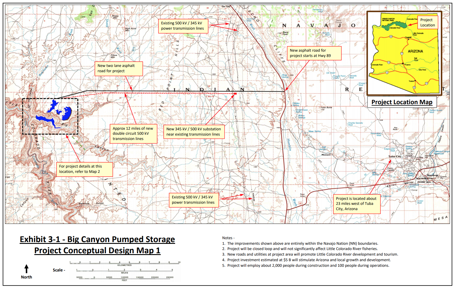
From The Summit Daily (Taylor Sienkiewicz):

In 2019, the Blue River Watershed Group started working on an integrated water management plan in partnership with Trout Unlimited to understand why there is a decline of fish between the Dillon and Green Mountain reservoirs and how to reverse or mitigate the problem.

The plan and its associated research is also intended to guide future goals and projects in the Blue River basin watershed.

The local water management plan is part of the larger Colorado Water Plan
, which aims by 2030 “to cover 80% of the locally prioritized lists of rivers with stream management plans and 80% of critical watersheds with watershed protection plans.”

Blue River Watershed Group Executive Director Erika Donaghy said the local water plan is a way to protect the Blue River watershed for its multiple uses, including being part of Summit County’s summer and winter recreation economy.

“In terms of planning for our future — and as the climate is changing and we know water is getting more and more scarce — … it’s a proactive plan to make sure that we are really using this scarce resource really wisely going forward and how do we protect its quality,” Donaghy said.

The conservation efforts in the plan also line up with Summit County Open Space and Trails efforts. Summit open space Senior Resource Specialist Jason Lederer explained that the county’s main goal is to have thoughtful management of natural water resources.

“The county has, in partnership with groups like the Blue River Watershed Group, worked hard to restore streams to a natural condition so that they provide better ecological function in terms of habitat and water quality components,” Lederer said.

The Blue River Watershed Group is in phase one of the plan, which includes assessing the conditions of the entire watershed by breaking up the watershed into three reaches. Donaghy explained that in this first phase of the plan, the group is putting together detailed descriptions of each of the reaches, including compiling information such as the average temperature of the water, the state of aquatic life, whether there are mining impacts and types of habitats.

These descriptions will come from data and studies that already have been done as well as new studies. The plan is meant to evaluate all uses of the watershed, including municipal as well as agricultural uses. Once the initial stage of the plan is complete, Donaghy said there will be some areas where there simply isn’t enough information to move forward, requiring more research and studies be conducted. In other areas, the group will have the information they need and can come up with solutions to improve issues that have been identified.

Update: #LittleColoradoRiver pumped hydropower proposals — @AmericanRivers

From American Rivers (Sinjin Eberle):

We will intervene, again, in the FERC preliminary permit process, but you can help too.

Little Colorado River Upstream towards Big Canyons. Photo credit: Sinjin Eberle

As we wrote in October, a Phoenix-based developer has proposed to build a pumped hydropower facility on and above the Little Colorado River in Arizona, one of the major tributaries to the Colorado River in the Grand Canyon. Because this is an energy-related project, the Federal Energy Regulatory Commission (FERC) is the federal agency that would permit the project. The developer, Pumped Hydro Storage, LLC, actually applied for preliminary permits for two complete projects within the canyon, holding their place in line for two possible locations in the same area.

In November, we filed our comments with FERC, opposing the projects on a number of grounds. First and foremost, the idea of building new dams, reservoirs, and other related infrastructure (imagine the pipes, wires, roads, and other structures needed for such a facility) on such a major tributary of the Colorado River would be a destructive, resource intensive, and in all likelihood, impossible, endeavor. Secondly, the facilities would be situated firmly within the Navajo Nation, on Navajo land – yet the Navajo were barely even consulted on the project prior to the permit applications being submitted to FERC, and have since come out strongly against the projects being built on their lands, and very close to one of the most significant cultural sites to the Hopi as well. Lastly, the Little Colorado River is home to a major humpback chub recovery project, a fish on the brink of being down-listed from Endangered to Threatened due to the success of the program.

Including from American Rivers, the proposal generated a wide body of opposition from sources who don’t often speak out against projects like this, such as the Bureau of Reclamation and Department of Interior, multiple Tribal Nations and the two local Navajo Chapters in the area, multiple conservation groups, and even Arizona’s Department of Game and Fish. Basically, nobody outside of the developer feels that these projects are warranted, or even a very good idea, let alone feasible.

Big Canyon Pumped Hydro Project #15024-000 | Credit: FERC permit application via American Rivers

Now, Pumped Hydro Storage has applied for a new project with FERC (Permit 15024-000), which would be located not within the Little Colorado River, but in Big Canyon, a tributary to the Little Colorado about 23 miles west of Tuba City, Arizona. Unlike the original proposal, in this new one Pumped Hydro Storage is proposing to extract groundwater, bring it to the surface where it would rest in three different surface reservoirs, and build a fourth, lower reservoir and a variety of pipes and penstocks and other infrastructure to generate electricity. Here is how it is described in the permit application:

The proposed project would be located entirely on Navajo Nation land and consist of the following new facilities:

  • A 450-foot-long, 200-foot-high concrete arch dam (Upper West Dam)
  • A 1,000-foot-long, 150-foot-high earth filled dam (Middle Dam)
  • A 10,000-foot-long, 200-foot-high concrete arch dam (Upper East Dam)
    • each of which would impound three separate upper reservoirs with a combined surface area of 400 acres and a total storage capacity of 29,000 acre-feet of water
  • A 600-foot-long, 400-foot-high concrete arch dam (Lower Dam) that would impound a lower reservoir with a surface area of 260 acres and a total storage capacity of 44,000 acre-feet of water
  • Three 10,000-foot-long, 30-foot-diameter reinforced concrete penstocks;
  • An 1,100-foot-long, 160-foot-wide, 140-foot-high reinforced concrete powerhouse housing nine 400-kilowatt pump-turbine generators
  • And a whole lot more associated infrastructure, including a new 15-mile paved road, powerlines, a 30-ft diameter tunnel, and more.
Map Credit: Stephanie Smith, Grand Canyon Trust

Finally, an additional twist, as reported in a recent Associated Press article, the developer concedes that there was overwhelming opposition to his original proposal, and that he would consider pulling the proposals in the Little Colorado River if this Big Canyon proposal were allowed to move forward. From the article:

The article then goes on to say:

Many of the reasons that Pumped Hydro Storage, LLC’s initial proposal shouldn’t move forward apply to this new proposal as well; namely that the project would be built on Navajo Nation lands, and neither the local Chapter, nor the Navajo Nation government, have given their permission to construct the project on their lands. Second, the idea of pumping significant volumes of groundwater from one of the most arid regions of the country to profit from cheap electricity is misguided, at best. And just like the first round of proposals, destruction of significant Hopi holy sites, as well as threatening critical humpback chub and other fish habitat, through the massive extraction of local groundwater, is simply not acceptable.

In addition to how environmentally destructive and wasteful these projects are, this proposal is especially tone-deaf and exploitive at this moment in our history. The Navajo Nation is grappling with some of the highest number of cases, and deaths per capita, from the novel Coronavirus pandemic. One of the reasons why the outbreak has impacted the Navajo so heavily is the lack of readily available clean water. In fact, in the western Navajo Nation, the lack of basic infrastructure to deliver water to people’s homes is sorely lacking, and most of the people in that area have to haul water themselves many miles to have any at all. The idea of building expansive infrastructure to extract scarce groundwater for a hydropower project that extracts the resource and the capital from it, when people around the project who lack that access to that very resource are working hard to defend their communities against a deadly virus, could not be more misguided.

It is important to understand that a preliminary permit only allows the developer to hold a location for a potential future proposal. It is not a license application. In fact, a preliminary permit is not even required to submit a license application or receive a Federal Energy Regulatory Commission (FERC) hydropower license. To learn more about hydropower licensing, visit the Hydropower Reform Coalition’s website.

We will intervene, again, in the FERC preliminary permit process, but you too can help by taking action here.

While it is unlikely that this project will ever advance past this phase, proposals like this underscore the importance of permanently protecting our last, best rivers like the Little Colorado.

Little Colorado River. Photo credit: Sinjin Eberle via American Rivers

#Runoff news: Generally below average streamflow W. of the Continental Divide of the Americas @AspenJournalism #ColoradoRiver #COriver #aridification

The Roaring Fork River near Mill Street in Aspen was flowing around 255 cfs on Thursday afternoon. The Colorado River Basin Forecast Center predicts spring runoff will peak here for the year on Saturday. Photo credit: Heather Sackett/Aspen Journalism

From Aspen Journalism (Heather Sackett):

Flows in local rivers are peaking this week, with a spring runoff that is slightly earlier and lower than normal.

“It kind of depends on where you are, but on the Colorado (River’s) main stem, for sure, the peak is below average,” said Cody Moser, senior hydrologist with the Colorado River Basin Forecast Center in Salt Lake City.

But despite the lower-than-average flows, this weekend is probably one of the best of the year to go boating on local waterways.

Vince Nichols, owner of the Aspen-based rafting company Blazing Adventures, said this weekend’s relatively big water is akin to a powder day.

The company is running trips on the upper Roaring Fork River, especially the Slaughterhouse section between Cemetery Lane and Woody Creek, and doing so in accordance with Pitkin County-mandated social-distancing and cleaning guidelines due to the COVID-19 pandemic.

“This will likely be one of the high-water weekends of the year,” Nichols said. “For the next seven to 10 days, there will be really good rafting conditions on the Roaring Fork.”

Flows in the Roaring Fork, at its confluence with the Colorado in Glenwood Springs, are predicted to be 74% of average for April through June. According to stream gauges, the Roaring Fork appears to have hit its peak seasonal flow on June 2 at just over 4,000 cubic feet per second. The normal period for peak runoff at this location is between May 29 and June 23, at about 5,900 cfs.

Predicting the exact day of peak flows near Aspen is trickier. The forecast center is predicting a peak for the Roaring Fork in Aspen on Saturday, at 490 cfs, because of rain expected that day. The Roaring Fork at Mill Street was running at a daily high of about 330 cfs on Thursday.

There would be more water flowing through Aspen if not for the Twin Lakes Tunnel, which takes water from the Roaring Fork headwaters near Independence Pass to Front Range water providers. About 600 cfs of water from the upper Roaring Fork basin was being diverted through the tunnel Thursday.

“The challenge is we’ve got that big warmup and precipitation in the forecast in this weekend,” Moser said. “It’s kind of a tough call.”

The low runoff, despite a snowpack that was slightly above normal, is due to 2019’s dry late summer and fall, plus this year’s drier-than-average March, April and May. Dry soils and plants sucked up a lot of the moisture before it made its way into the streams.

This photo taken on Thursday, June 4, shows little snow left on top of Independence Pass, the headwaters of the Roaring Fork River. This year’s peak spring runoff is slightly earlier and lower than normal. Photo credit: Brent Gardner-Smith/Aspen Journalism

Below-average flows

According to the U.S. Geological Survey gauges, the Crystal River near Redstone appears to have peaked on June 2, at about 1,750 cfs. The Crystal at this location usually peaks between May 25 and June 18, at about 1,930 cfs.

Downstream on the Colorado, flows peaked in DeBeque Canyon, above Grand Junction, on June 2, at about 13,300 cfs. A typical peak is about 17,000 cfs between May 24 and June 12.

This year’s peak flows on the Colorado near Grand Junction were augmented by releases from several upstream reservoirs to the benefit of endangered fish in the 15-mile reach between Palisade and the Gunnison River, which flows into the Colorado in central Grand Junction.

Beginning May 29, Green Mountain Reservoir, Wolford Mountain Reservoir, the Moffat Tunnel and other water-storage facilities released water to enhance the Colorado’s natural peak in the 15-mile reach. The augmented high flows enhance fish habitat.

Ruedi Reservoir, above Basalt on the Fryingpan River, did not participate in the coordinated reservoir operations this year because there was not surplus water to contribute, said Tim Miller, a hydrologist with the Bureau of Reclamation who manages water levels in Ruedi.

“I was getting kind of worried about fill a month ago,” Miller said. “I was pretty sure we didn’t have extra. We haven’t received anything near average precipitation for part of April or all of May.”

Ruedi Reservoir, which can hold 102,373 acre-feet of water, is currently 79% full. Releases from Ruedi will decrease Friday to allow it to fill, bringing flows on the Fryingpan to 115 cfs. Miller said it could end up about 5,000 acre-feet short of filling this year, which usually happens in early July.

Aspen Journalism is a local, nonprofit and investigative news organization that covers water and river issues in collaboration with The Aspen Times and other Swift Communications newspapers. This story ran in the June 5 edition of The Aspen Times.

From The Pagosa Sun (Chris Mannara):

As of June 3, the San Juan River had a reported flow of 745 cfs, lower than the average for June 3 of 1,560 cfs.

The highest reported flow total for the San Juan River came in 1948 when the river had a reported flow of 4,090 cfs.

The lowest flow total for the San Juan River came in 2002 when the river had a flow of just 116 cfs.

Green Mountain Reservoir operations update #runoff #ColoradoRiver #COriver #aridification

From email from Reclamation [May 6, 2020] (Elizabeth Jones):

Green Mountain Reservoir is decreasing release to the Blue River. Green Mountain Dam will adjust release from 1,450 cfs to approximately 150 cfs in multiple adjustments over the next three days. Green Mountain Reservoir is discontinuing release for support of the Coordinated Reservoir Operations Program. No main stem Colorado River water rights administration is in effect. Green Mountain Powerplant will use all release for power generation while exercising the 1935 Direct Flow Hydropower Water Right. Green Mountain Reservoir is storing water under the 1935 First Fill Storage Right.

If you have any further questions, please don’t hesitate to reach out. Thank you.

Elizabeth E. Jones | Public Affairs | Bureau of Reclamation | Missouri Basin Region | 406.247.7607

Map of the Blue River drainage basin in Colorado, USA. Made using USGS data. By Shannon1 – Own work, CC BY-SA 4.0, https://commons.wikimedia.org/w/index.php?curid=69327693

#Drought expansion resumes in #Colorado — The Kiowa County Press #ColoradoRiver #COriver #ArkansasRiver #aridification

From The Kiowa County Press (Chris Sorensen):

Extreme drought increased to the south and now encompasses most of Baca County. Temperatures across the eastern plains have been 3-12 degrees warmer than normal for this time of year in the area.

Colorado Drought Monitor June 2, 2020.

In western Colorado, severe drought expanded to cover the remainder of Dolores, San Miguel and Montrose counties, along with the southern three-quarters of Mesa County.

Some improvement was noted in the central mountains as moderate drought shifted to abnormally dry conditions for all of Teller and Jefferson counties, and portions of Fremont, Park, Douglas and El Paso counties…

Nearly 1.4 million people in Colorado are in drought-impacted areas.

Colorado Drought Monitor June 4, 2019.

One year ago, Colorado was free from abnormally dry conditions and all levels of drought for the first time since tracking began in 2000.