FromColorado Public Radio (Paolo Zialcita and Michael Elizabeth Sakas):
Last month was the hottest August on record since Colorado started tracking temperatures in 1895. Now a map released weekly by the U.S. Drought Monitor shows over half the state is experiencing extreme drought, exacerbated by intense heat…
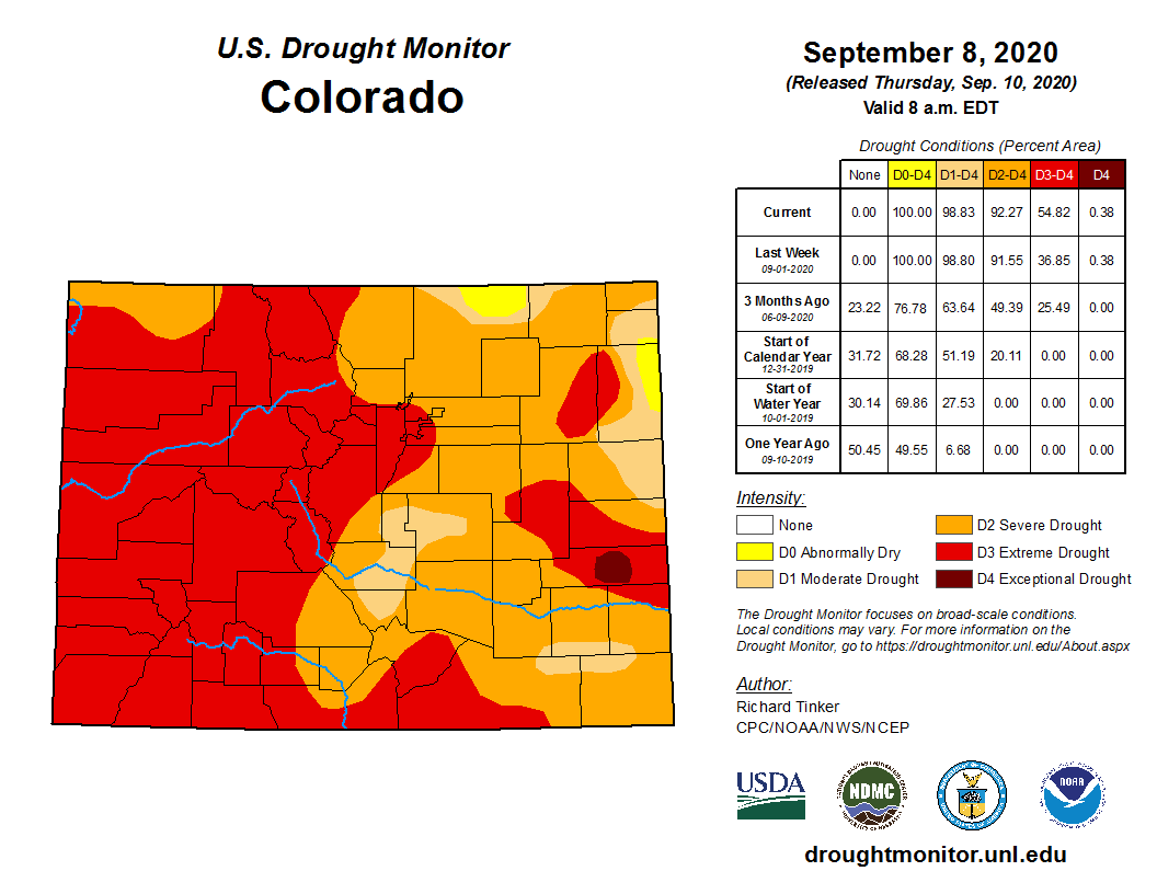
Colorado Drought Monitor September 8, 2020.
Fifty-five percent of Colorado is undergoing a D3 drought, the second-highest level. Widespread D3 drought can mean that wildfires continue to burn, outdoor recreational activities have to be reduced, or in some cases, low reservoir levels and mandatory water use restrictions.
This drought has been a long time coming, according to assistant state climatologist Becky Bolinger.
“This has been a situation that has been unfolding basically since the beginning of the water year, which is back to last October, when we started to see lack of monsoon moisture last late summer,” Bolinger said. “What happens to that map from here on out, really depends on how many more storms can we get like we got this week.”
Bolinger said it might be a surprise to some people that drought conditions have worsened since Colorado experienced weather whiplash this week, as snow and freezing temperatures swept across the state after weeks of dangerous fire conditions.
She explained that the latest drought report is based off of data collected Tuesday morning, before the snow started to roll in. She does expect that the storm brought some welcome relief, but said it won’t solve Colorado’s drought.
“We’re still going to have areas that are in that bad drought and if we don’t have more storms that continue to put improvements on — so if we go back to our warm, dry pattern — the benefit of this storm is going to be pretty limited,” Bolinger said.
In her estimation, Colorado’s dry year and everything that’s occurred, including massive wildfires covering large parts of the state in smoke, are a direct result of climate change.
Interview [with State Climatologist Russ Schumacher] Highlights
These interview highlights have been lightly edited for length and clarity.
Henry Zimmerman: Let’s start with this snow. How rare is it to see snow this early in September?
Russ Schumacher: It’s really rare. In Fort Collins, it’s the earliest we’ve ever had measurable snowfall in September, with records at our weather station on the CSU campus going back to the late 1800s.
Some places have had earlier snow like Denver a couple of times. But this is remarkable because we’ve seen it, not just a local snow here along the Front Range, but the snow has swept all the way down through southern Colorado. It’s really kind of all the numbers we look at — it’s pretty unbelievable, we have a history of snow in September, but never this early and never this much.
Over the past few weeks, did we break any records in terms of heat?
We broke a lot of records.
Most of the stations here on the northern Front Range, here in Fort Collins we had our latest 99, we didn’t quite make it to 100, but it was our latest 99 we have ever seen, the previous record was set last year on September 2.
Denver saw its latest 100. We had the highest temperature ever recorded in September in Colorado in La Junta, in southeast Colorado on Sunday. And so all sorts of heat records statewide, and then this really abrupt shift to the cold and the snow.
When we talk about extreme weather, I think we also have to talk about climate change. Record breaking fires, extreme heat one day, snow the next, is this an example of climate change?
So I think the extreme heat we’ve seen, not just here in Colorado but across the Southwest over the last month and a half, there’s no doubt in my mind that that’s been made worse as a result of the climate being warmer. And just warmer and drier summers across the Southwest has been something that climate scientists have suggested was likely, and I think we’re seeing that this summer.
Now the shift from the extreme heat to extreme cold within the matter of a couple of days, connecting the dots there is more complicated. There are potential reasons why these extreme shifts might become more common in a warmer climate. One being that essentially, we’ve built this huge dome of high pressure and heat over the West this summer, and if we go back to a roller-coaster analogy, what we may be doing is essentially making that roller coaster a little bit steeper, and thus when the low pressure systems that bring the cold air around it, might be diving down a steeper down-slope here into Colorado, and really increasing those rapid changes.
But this is an active research topic that a lot of people are looking at to try and understand what to expect from these kinds of shifts in a warmer climate. But the bigger story of the extreme heat across the West very much has a fingerprint of climate change on it.
What do you expect to come in the next several years in terms of extreme weather?
These kind of seasonal predictions or multi-year predictions are always hard to make.
I don’t think the summer monsoon rains have been permanently shut off or anything like that. So we’ll have wet years and wet summers again, not every year will be like this year. But that being said, what we expect in a warmer climate is that what we thought was a hot year in the past may become more of an average year going forward.
And there are probably more extremes on the horizon, maybe ones that we haven’t even come to fully understand yet.
In response to a cooler forecast and increasing tributary flows, the Bureau of Reclamation has scheduled a decrease in the release from Navajo Dam from 850 cubic feet per second (cfs) to 800 cfs on Saturday, September 12th, starting at 4:00 AM. Releases are made for the authorized purposes of the Navajo Unit, and to attempt to maintain a target base flow through the endangered fish critical habitat reach of the San Juan River (Farmington to Lake Powell).
The San Juan River Basin Recovery Implementation Program has recommended flows in the critical habitat reach as close to 500 cfs as possible for the summer of 2020. This is within their normal recommended range of 500 to 1,000 cfs. This target base flow is calculated as the weekly average of gaged flows throughout the critical habitat area from Farmington to Lake Powell.
This scheduled release change is subject to changes in river flows and weather conditions. If you have any questions, please contact Susan Behery (sbehery@usbr.gov or 970-385-6560), or visit Reclamation’s Navajo Dam website at https://www.usbr.gov/uc/water/crsp/cs/nvd.html
The San Juan River’s Navajo Dam and reservoir. Photo credit: U.S. Bureau of Reclamation