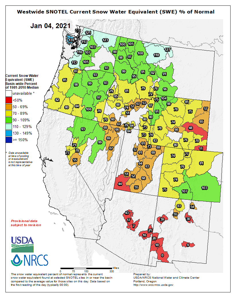
Westwide SNOTEL basin-filled map January 6, 2021 via the NRCS.
FromThe Grand Junction Daily Sentinel (Dennis Webb):
Drought continues to grip the entire state of Colorado, and drought more regionally continues to drive increasing concerns about the adequacy of water supplies throughout the Colorado River Basin given the drier and warmer weather that generally has prevailed through much of the 21st century. That has added urgency to efforts by Upper Basin states such as Colorado to continue exploring measures to reduce water demand by agriculture, cities and other users in times of drought to help head off the possibility of a mandatory curtailment of uses under an interstate compact.
With snowpack below average so far, this winter has offered little promise of reversing the continuing dry trend. But the winter is young and a few big storms can improve the outlook quickly, which is why everyone from ranchers to municipal water providers to firefighters will be listening closely in coming months to what forecasters have to say about what weather is in store…
The road to Bears Ears via the Salt Lake Tribune.
The Antiquities Act of 1906 was signed into law by Theodore Roosevelt, for “… the protection of objects of historic and scientific interest” through the designation of national monuments by the President and Congress. National monuments are one of the types of specially-designated areas that make up the BLM’s National Conservation Lands. Some of the earliest national monuments included Devils Tower, the Grand Canyon, and Death Valley. They were initially protected by the War Department, then later by the National Park Service. More recently, the BLM and other Federal agencies have retained stewardship responsibilities for national monuments on public lands. In fact, the BLM manages more acres of national monuments in the continental U. S. than any other agency. This includes the largest land-based national monument, the Grand Staircase-Escalante National Monument in Utah featured here. National monuments under the BLM’s stewardship have yielded numerous scientific discoveries, ranging from fossils of previously unknown dinosaurs to new theories about prehistoric cultures. They provide places to view some of America’s darkest night skies, most unique wildlife, and treasured archaeological resources. In total, twenty BLM-managed national monuments, covering over five million acres, are found throughout the western U. S. and offer endless opportunities for discovery. Photos and description by Bob Wick, BLM.
Meanwhile, the Biden administration’s actions on other matters related to public lands and the environment should prove interesting in coming months. For example, Biden could decide to reverse the Trump administration’s decision to shrink the size of the Bears Ears and Grand Staircase-Escalante national monuments in Utah.
Among other actions that would draw strong reactions pro and con, he could follow through on a campaign promise to ban oil and gas leasing and drilling on federal lands. Such a move likely would be cheered heartily by some conservationist and activist groups concerned about the greenhouse-gas, public health and other impacts of oil and gas development.
But the Western Energy Alliance industry group already has promised a legal challenge of such an action, which a University of Wyoming professor has estimated would result in Colorado in an annual average loss of $73 million in tax revenues from 2021-25 and average annual job losses in the state nearing 5,200 over that same timeframe…
LOVED, HOPEFULLY NOT TO DEATH
Public-land use is yet one more issue where what has happened in 2020 raises questions about what might come in 2021. With all the limitations that COVID-19 forced on people, one way they responded was to head in huge numbers into the great outdoors where the socially distanced solace of scenery and fresh air has provided a balm for the malaise of pandemic-related restrictions.
Colorado Parks and Wildlife, the BLM, the Forest Service and the National Park Service all reported strong visitation numbers, from hikers to boaters to back-country skiers.
While those agencies love the fact that people are enjoying the lands and facilities they manage, they cringe at the many problems that can result, such as trail heads overflowing with cars, illegal camping and improper disposal of human waste.
This year, we can only hope, the threat from COVID-19 will subside as vaccination rates increase. It will be interesting to watch if public land visitation eases as well. Here’s guessing that it won’t, at least not by much.
Who, having discovered the joys of getting outdoors and enjoying the lands that belong to all of us, wants to then go backward, retreating to a life involving more indoor pursuits?
We love our public lands, perhaps now more than ever. The trick for us, and for those challenged with managing those lands, is how to prevent our loving them to death.
FromThe Fort Collins Coloradoan (Miles Blumhardt):
Two assessments conducted by Arapaho and Roosevelt National Forests officials offered a sobering look into the devastation the Cameron Peak Fire left on Larimer County’s landscape and recreational sites.
While the Cameron Peak Fire had a fire perimeter that enclosed nearly 209,000 acres, the impacts on the landscape by the largest wildfire in Colorado history varied widely, ranging from swaths that went unscathed to areas that were severely burned.
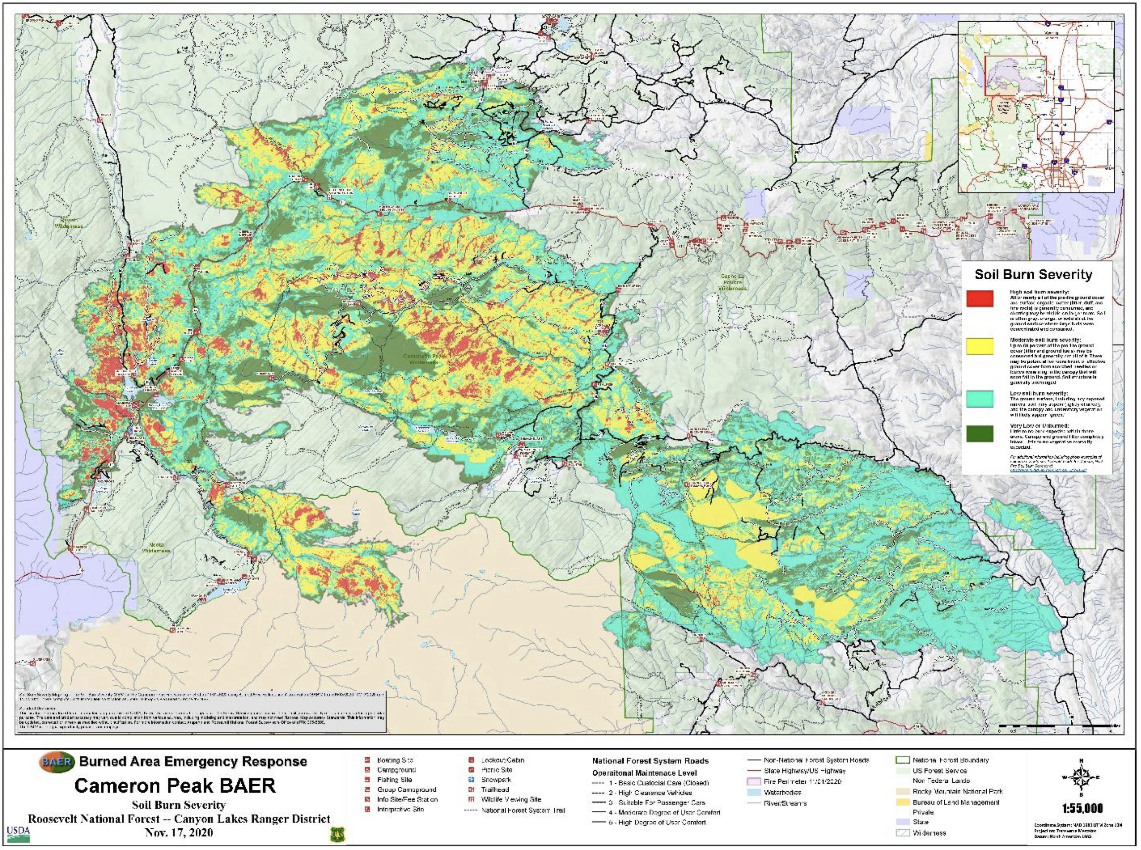
The survey showed an estimated 36% of the area within the Cameron Peak Fire perimeter suffered high (6%) or moderate (30%) soil burn severity. That indicates an increased risk of erosion and flooding caused by the soil being less able to absorb moisture, along with a lack of vegetation to absorb water and roots to stabilize the soil…
Another 44% of the area suffered low burn severity and 20% was unburned.
The assessment said determining soil hydrophobicity, or the ability to repel water, was hampered by snowfall during the assessments. However, it estimated 55% of the burn area could contain water-repellant soil.
The assessment said there is a 90% to 100% chance that water quality would be impacted by post-fire ash and sediment-laden runoff, nutrient loading and potential debris flows within the first few years following the fire.
Options to reduce the impacts to stream flows, soil erosion and debris flows are limited due to the nature of the burn and slope characteristics, the assessment noted. It stated treatment recommendations should focus on minimizing life/safety threats and damage to property through road and trail closures, trail stabilization, campground treatments and warning signs.
A burnt sign on Larimer County Road 103 near Chambers Lake. The fire started in the area near Cameron Peak, which it is named after. The fire burned over 200,000 acres during its three-month run. Photo courtesy of Kate Stahla via the University of Northern Colorado
Given all the recreational sites in or near the burn area, the assessment said the consequences for potential impacts on life and safety are “major.”
Where it burned hottest
Soil burn severity is the result of fire progression and intensity. The longer the fire remains in an area, the higher the likelihood of high and moderate soil burn impacts. Areas burned during large runs from the wind-driven fire generally suffered lower soil burn severities due to the fire moving more through the tree canopy than on the ground.
The assessment’s soil burn severity map shows the area around the starting point on the west side of the fire near Chambers Lake suffered high soil burn severities. Other high soil severity burn areas occurred north of the Colorado State University Mountain Campus east into the Buckhorn Road area and in the northern section of Rocky Mountain National Park.
The Thompson Zone of the East Troublesome Fire that burned over the Continental Divide to near Estes Park burned mostly in the low to moderate category.
Most of the fire’s rapid growth was driven by high winds usually preceding precipitation events, mostly snow. The map shows the area to the east of the fire’s initial starting point suffered low soil burn severities during such an event.
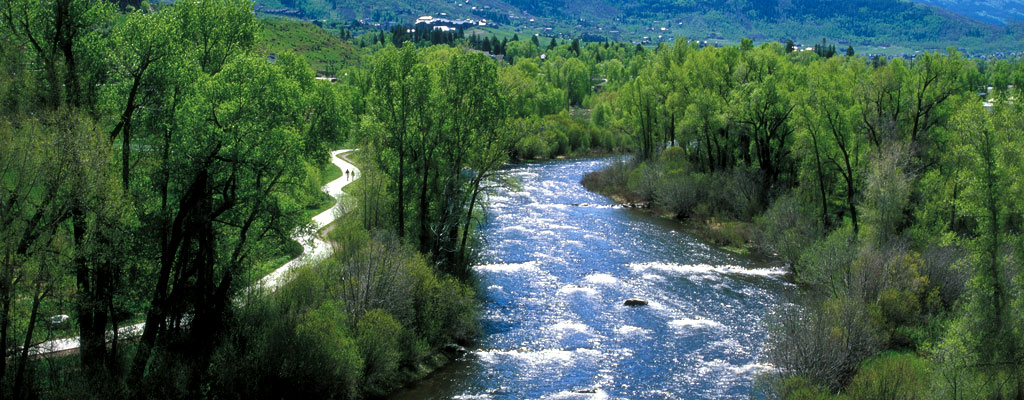
The Yampa River Core Trail runs right through downtown Steamboat. Photo credit City of Steamboat Springs.
Here’s a guest column from Patrick Stanko that’s running in the Steamboat Pilot & Today:
Do you know the critical water concepts? The Colorado State Water Education plan has identified six critical concepts that all Coloradans should understand about water.
The first concept is “The physical and chemical properties of water are unique and constant.” The physical properties of H2O are unique because its molecular structure gives rise to surface tension. The solid form of water, the white stuff so important to our community, is less dense than the liquid form allowing it to float.
The second concept states, “Water is essential for life, our economy and a key component of healthy ecosystems.” As we all know, there would be no life without water, and the ecosystems need clean water to survive. But the Routt County economy, both recreational and agricultural, depends upon water.
The Yampa Valley receives most of its water in the form of snow, the basin’s biggest reservoir, which is used by the recreational industry to ski and play on. When the spring melt happens, that water is used by agriculture to irrigate and produce the lush green hay fields we all have grown accustomed to, and of course, the river is used for fishing, boating and tubing.
The third and fourth concepts are “Water is a scarce resource, limited and variable” and “The quality and quantity of water, and the timing of its availability, are all directly impacted by human actions and natural events.” One only has to compare the last two years to see how variable and scarce water is in Colorado.
s the weather becomes drier and more variable and the population of Colorado continues to grow, water will become scarer. An update by the Colorado Water Plan predicts that the municipal and industrial gap in water supply will be in the range of 250,000 to 750,000 acre-feet of water annually. As a reference, the Dillon Reservoir holds approximately 250,000-acre feet.
The fifth concept is “Water cycles naturally through Colorado’s watersheds, often intercepted and manipulated through an extensive infrastructure system built by people.” Again, the biggest reservoir and storage of water in the Yampa Valley is snow.
In the spring the snow melts, some of the water returns to the atmosphere via sublimation, evaporation or transpiration. If the soil is dry, then most of the water will seep back into the ground filling the aquifers. The water that makes it to the river is used by the agriculture community to irrigate meadows for grazing and crops. Water is also captured in reservoirs, like Fish Creek Reservoir, that supplies Steamboat Springs with drinking water.
The sixth concept states “Water is a public resource governed by water law.” Colorado has a long doctrine of water laws dating back to the 1860s. A water right allows one to put a public resource to beneficial use as well as a place in line, where the junior water right may be curtailed to meet the needs of the senior water right, “first in time, first in right.”
For more information about critical water facts please see the Water Education Colorado SWEAP website at https://www.cowateredplan.org/ or the Colorado Water Plan formed by the Colorado Water Conservation Board at https://cowaterplan.colorado.gov/. And for information on the local water issues, visit Yampa White Green Basin Roundtable at https://yampawhitegreen.com.
Patrick Stanko wrote this column on behalf of the Yampa White Green Basin Roundtable public education participation and outreach coordinator.
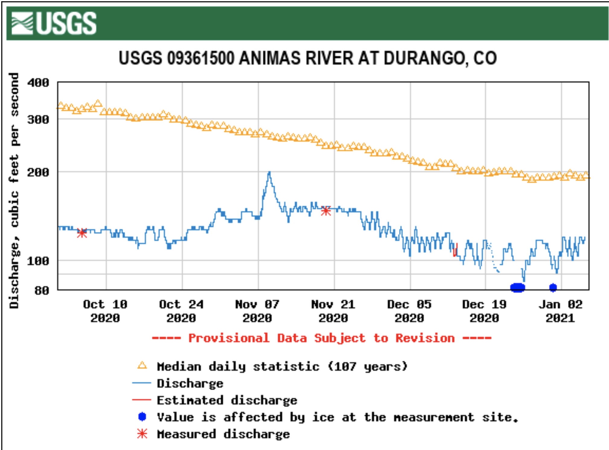
Records show the Animas River recently broke the all-time low flow set on the water gauge behind the Powerhouse Science Center, which has collected data for 109 years.
The previous record low flow at the U.S. Geological Survey’s water gauge was set March 2, 1913, when the Animas River was running at 94 cubic feet per second…
On Dec. 21, flows on the Animas dipped below 94 cfs and continued to fall. At its lowest point, the river was running at 79.6 cfs on Christmas Day, as well as the day after.
As of Tuesday, the Animas was running around 120 cfs, nearly half the historic average on the more than century-old water gauge.
“It’s one of the oldest gauges in Southwest Colorado,” said Steve Harris, with Harris Water Engineering…
A few years ago, the USGS, looking to cut costs, floated the idea of decommissioning the gauge by the Powerhouse Science Center. In response, local stakeholders banded together to form a partnership to help with funding…
The fact the Animas recorded an all-time record low in 109 years of records is a testament to the prolonged drought hitting the region.
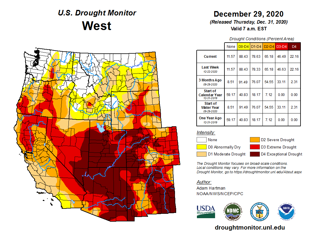
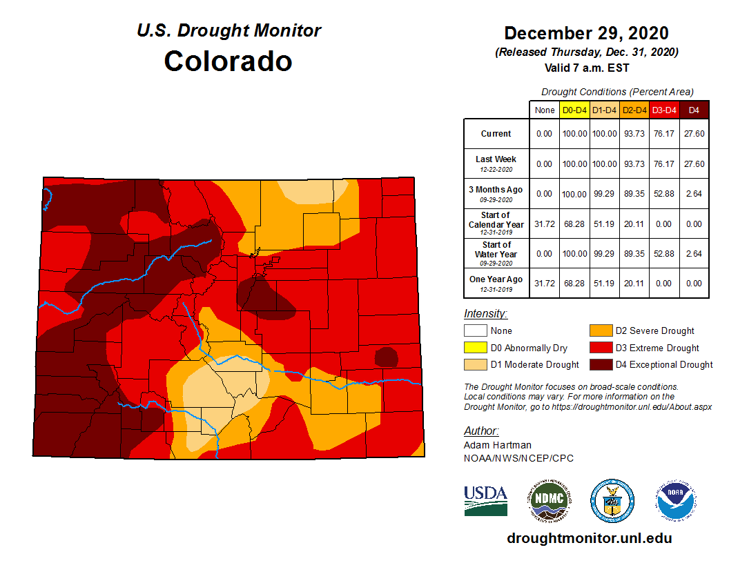
As of Tuesday, the U.S. Drought Monitor had Southwest Colorado listed in an “exceptional” drought – the highest category of drought…
West Drought Monitor December 29, 2020.
And snowpack, so far, in Southwest Colorado is behind – federal records show snowpack is just 74% of historic averages as of Tuesday.
Westwide SNOTEL basin-filled map January 4, 2021 via the NRCS.
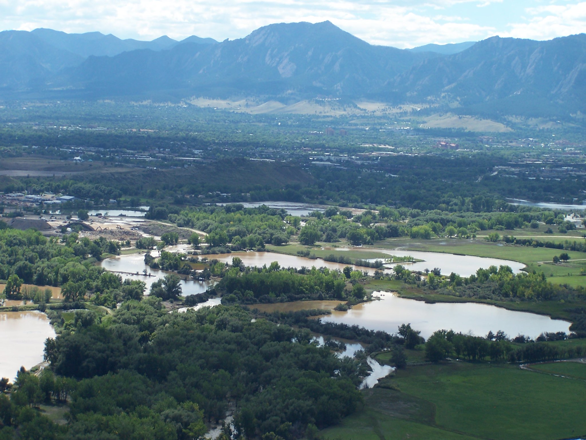
City council this week will again consider an alternative design for flood control on South Boulder Creek, one that’s been rejected twice before. This time, staff, the open space board and an advisory group of elected and appointed officials are recommending against the plan, pushed by residents opposed to University of Colorado plans for an eventual southern campus.
If city council agrees with that assessment, it will cap an effort to protect south Boulder from flooding — a process that, by the city’s own reckoning, started, nearly half a century ago. Winnowing potential options took two decades…
Council settled on a “final” detention, dam and flood wall design in June, but their vote came with a caveat: One more look at resident-proposed design to detain water further upstream on South Boulder Creek. The Open Space Board of Trustees requested further analysis once it was revealed that flood structures would be built on open space land rather than state right-of-way along U.S. 36.
Upstream detention, as the design is referred two, was ruled inadequate by project staff in 2015 and again in 2018. This time, a staff analysis showed that upstream detention would be more costly than the current plan for the same level of protection and would impact more sensitive habitat.
OSBT agreed on Dec. 16, as did an advisory group assembled by the city that included representatives from OSBT, Water Resources Advisory Board, Planning Board and city council.
“The advisory group concluded that although an upstream alternative could be feasible, it does not perform better than the Variant 1, 100-yr design when considering the June 2020 council comparison criteria, and substantial engineered structures would still be required on OSMP lands.”
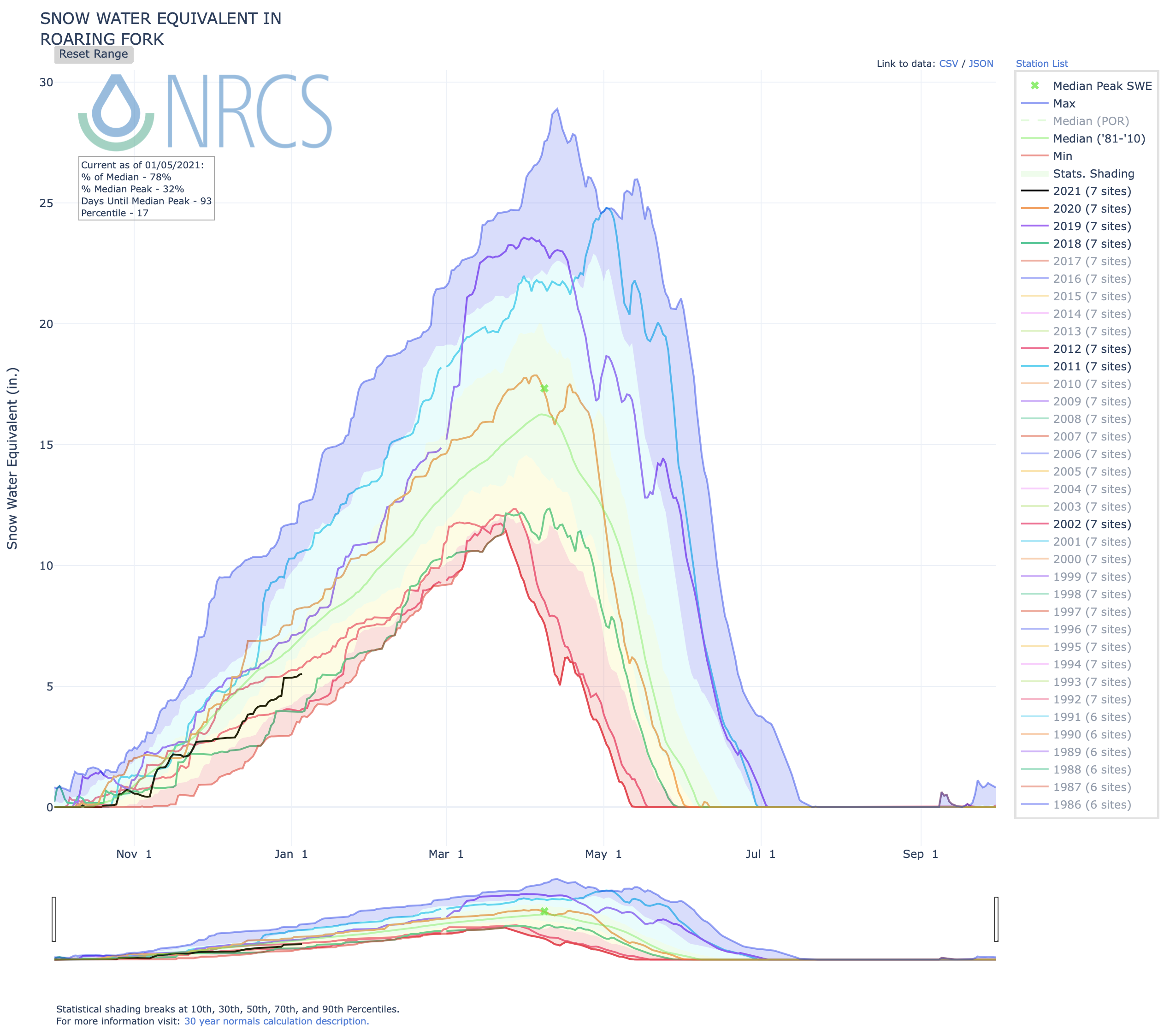
Months of dry weather have left much of the Roaring Fork Valley in critical levels of drought, even after snow in December. The region has not been so dry this time of year since 2002. The Roaring Fork River and many others across the state are below normal levels of flow, which is unlikely to change without an extraordinarily wet winter.
Colorado Drought Monitor December 29, 2020.
“An average or slightly below average snowpack is not going to get us out of this drought,” said Steve Hunter, a hydrologist with the City of Aspen. “So we need a pretty epic year.”
[…]
What this year’s winter will bring for the Roaring Fork Valley is unclear. Forecasters are focused on the effects of La Niña, a weather phenomenon that helps shape long-term snow predictions.
Northern Colorado tends to see more snow because of that phenomenon, while the southern part of the state gets less. The Roaring Fork Valley sits between those two regions and tends to see roughly average precipitation during La Niña years…
He said this area’s municipal water supply – which is fed by local creeks – is not at risk right now, but his team could issue usage restrictions if that changes.
“If we have back-to-back droughts – we had a significant drought in 2020, and if we don’t have a significant snow year – we’re going to be doing water restrictions, mainly on the irrigation and landscaping end, to protect water for drinking and residential use.”
Long-term climate data shows a shift toward shorter snow seasons, higher temperatures and less precipitation.
Protections for endangered species, disaster assistance and conservation were all targets of the most recent round of attacks on the environment.
This holiday season just about everything was different. Vacations were postponed. Parties and family get-togethers were canceled or moved online as folks hunkered down at the request of public-health officials. But one thing `continued as usual: President Trump’s attacks on the environment.
In the weeks following the Nov. 3 election, Trump’s team continued its unprecedented onslaught on environmental regulations, with nearly a dozen new rollbacks or threats to public health, wildlife, clean air, public lands and the climate.
As the New Year approached, the assaults didn’t let up. Here are some of the most recent:
1. Cutting Disaster Funding
Despite a record-tying 16 weather and climate disasters topping $1 billion each this year in the United States, the Federal Emergency Management Agency proposed a plan to curtail federal disaster aid.
It would affect wealthier states the most, requiring that they have higher levels of damage than less wealthy states to get federal assistance.
The proposal, announced on Dec. 14, “would be one of the most significant revisions of federal disaster policy in nearly a half-century and comes as states grapple with massive fiscal shortfalls due to the pandemic,” E&E News reported.
The new rule is now open for public comments until Feb. 12 and would fall under the incoming Biden administration to move it forward — if it wishes.
2. Efficiency Rollbacks
The Department of Energy took two steps back on Dec. 15., finalizing new rules that ease efficiency requirements for some fixtures and appliances.
The move comes a year after Trump complained that showerheads don’t have enough flow for him to wash his hair and toilets need to be flushed 10 or 15 times, which earned him a hearty amount of ridicule on social media.
But his new rules are no laughing matter when it comes to conservation and efficiency.
One of the rules would roll back a water-efficiency requirement for showerheads put in place by Congress in 1992 during the George H.W. Bush administration. The other would allow for some new washers and dryers to use more water and energy.
Both would amount to more needlessly wasted energy, water and money.
3. No Help for Monarchs
Photograph of a Male Monarch Butterfly. Photo by and (c)2007 Derek Ramsey (Ram-Man)
Monarch butterflies on both the east and west coasts are in perilous decline, with populations falling 80% or more. So it made sense that on Dec. 15 the U.S. Fish and Wildlife Service ruled that the butterflies were in need of protection under the Endangered Species Act. But the agency unfortunately decided those protections wouldn’t be immediately forthcoming.
Monarchs were essentially told to get in line behind other species awaiting protection — and there are a lot of those these days. “The Trump administration has listed only 25 species — fewer than any since the [Endangered Species] act took effect in 1973,” the AP reported. “The Obama administration added 360.”
The current plan proposes delaying action to list monarchs until 2024, which would then be followed by another year of public comment and development of the final rule: time the species may not have.
4. Pardons
In late December Trump issued dozens of pardons and commutations in what The Guardian called “another audacious application of presidential power to reward loyalists.” The list included predictable names of political allies like Paul Manafort and Roger Stone, but among them was a pardon for Utah state Rep. Phil Lyman.
Lyman has railed against the federal management of public lands and in 2015, when he was serving as a San Juan County commissioner, he led 50 all-terrain vehicles on a ride through Utah’s Recapture Canyon. The area had been closed to motorized vehicle traffic to protect archeological sites. The illegal stunt earned him 5 days in jail and a $96,000 fine.
5. Airplane Emissions
On Dec. 28 the EPA finalized the first rule regulating greenhouse gas emissions from commercial airplanes. But hold your applause: The historic step isn’t likely to amount to much.
The agency said that all the planes likely to be affected by the rule would be compliant by the date required, and therefore, EPA doesn’t think there’ll be any emission reductions associated with the greenhouse gas regulations or that they’ll help spur technical improvements that wouldn’t already have happened.
This “do-nothing rule,” as environmental groups have dubbed it, may be hard for the Biden administration to quickly undo as the EPA has decided to forgo the usual 30-day waiting period between the publication of the final rule and its implementation.
“The agency has used the procedural tactic — which is legally allowed with ‘good cause’ — in recent weeks in an apparent effort to obstruct the incoming Biden administration,” E&E News reported.
6. Endangered Species Act
The outgoing Trump administration took two more swings at the Endangered Species Act, which it has worked to undo in the last four years.
On Dec. 15 the administration finalized a rule that narrowed the definition of habitat to only areas that currently support a species. This would eliminate the government’s ability to protect areas that could help support species in the future and areas previously occupied by the species. The move limits the tools available to protect endangered species, many of which have seen their historic range greatly diminished by development, agriculture and now climate change.
Two days later the Fish and Wildlife Service undermined the law again with a rule that lets money trump science. The change would allow the agency to omit areas from critical habitat designation if a review of the economic costs to industry outweigh the ecological benefits.
Tara Lohan is deputy editor of The Revelator and has worked for more than a decade as a digital editor and environmental journalist focused on the intersections of energy, water and climate. Her work has been published by The Nation, American Prospect, High Country News, Grist, Pacific Standard and others. She is the editor of two books on the global water crisis.
The Confederated Salish and Kootenai Tribal Council unanimously ratified its water compact with the state [December 29, 2020], clearing the path for rehabilitation of the Flathead Indian Irrigation Project and return of the National Bison Range to tribal control.
The Confederated Salish and Kootenai Tribes ratified their water compact with the state on Tuesday, ending a decades-long process to settle water right claims affecting a huge swath of Montana’s irrigated land.
The U.S. Congress ratified the compact — passed by the Montana Legislature in 2015 — last week as part of a massive appropriations bill. President Donald Trump signed the bill on Sunday, leaving ratification by the tribes as the final hurdle to finalizing the agreement.
The CSKT Tribal Council unanimously voted to ratify the agreement on Tuesday during a meeting held via Zoom.
With the tribes’ ratification, the federal government will create a $1.9 billion trust fund for repairing the deteriorating Flathead Indian Irrigation Project. Additionally, the tribes will regain control of the National Bison Range.
In exchange, the tribes agreed to relinquish claims to the vast majority of their off-reservation water rights claims, which could have limited irrigation in 51 of the state’s 85 adjudication basins. The CSKT had filed thousands of claims based on the tribes’ 1855 Hellgate Treaty with the federal government, by which the tribe retained the right to hunt and fish in traditional locations both on and off the present-day Flathead Reservation in exchange for ceding more than 20 million acres of land.
A tribal spokesman didn’t immediately respond to an email seeking comment Tuesday afternoon. But after Congress approved the compact last week, CSKT Tribal Council Chairwoman Shelly Fyant said during a press conference that the agreement would have a “profound and positive impact on the future of the Flathead Reservation for the next century.”
[…]
The compact had languished since Montana U.S. Sen. Jon Tester, a Democrat, introduced legislation to ratify it in 2016. Montana’s other U.S. senator, Republican Steve Daines, introduced a bill late last year, co-sponsored by Tester, to finalize the compact.
Groups including the Montana Stockgrowers Association, Montana Agricultural Business Association and Association of Gallatin Agricultural Irrigators have said finalizing the compact would offer certainty for irrigators, protect the state’s water and help avoid years of costly litigation…
On Tuesday, another tribal attorney, Rhonda Swaney, encouraged the Tribal Council itself to ratify the compact in order to prevent any attempts by “outside entities” to further challenge the agreement, pointing to the Republican legislators’ letter to Daines as an example.
Many Indian reservations are located in or near contentious river basins where demand for water outstrips supply. Map courtesy of the Bureau of Reclamation.
A burnt sign on Larimer County Road 103 near Chambers Lake. The fire started in the area near Cameron Peak, which it is named after. The fire burned over 200,000 acres during its three-month run. Photo courtesy of Kate Stahla via the University of Northern Colorado
To understand, and possibly predict what happens after a river’s headwaters goes up in flames, researchers are descending on newly created burn scars across the West to gather data in the hopes of lessening some of the impacts on drinking water systems.
On a sunny winter morning, a team of researchers led by Colorado State University hydrologist Stephanie Kampf roamed through the steep drainage of Tunnel Creek, a tributary to the Poudre River. Much of the creek burned this summer and fall during the Cameron Peak Fire west of Fort Collins, Colorado…
For more than an hour and a half, Kampf’s team searched for a flat spot to construct a temporary weather station. The university received a National Science Foundation grant to put instruments into the field quickly, before snows began to accumulate in the burned area. At more than 208,000 acres, the burn scar is the state’s largest on record.
The East Troublesome Fire in Grand County burned down to the shore of Willow Creek Reservoir, one of the lakes in Northern Water’s collection system in Grand County. Dec. 13, 2020. Credit: Jerd Smith
Smoke from the Mullen Fire along the Wyoming-Colorado border as seen from the Snowy Range in Wyoming on Oct. 6, 2020. Photo/Allen Best
The Grizzly Creek Fire jumped Grizzly Creek north of Glenwood Canyon. (Provided by the City of Glenwood Springs)
Firefighters on the march: The Pine Gulch Fire, smoke of which shown here, was started by a lighting strike on July 31, 2020, approximately 18 miles north of Grand Junction, Colorado. According to InciWeb, as of August 27 2020, the Pine Gulch Fire became the largest wildfire in Colorado State history, surpassing Hayman Fire that burned near Colorado Springs in the summer of 2002. Photo credit: Bureau of Land Mangement-Colorado, via InciWeb and National Interagency Fire Center.
Two other nearby fires broke size records in 2020 as well. In late October the East Troublesome Fire exploded near the headwaters of the Colorado River, burning 193,812 acres, killing two people and causing thousands to flee their homes. To the north, the Mullen Fire on the Colorado-Wyoming border topped out at 176,878 acres. Downstream on the Colorado River, the Grizzly Creek Fire torched 32,631 acres in and around Glenwood Canyon. And in the Book Cliffs north of Grand Junction, Colorado, the Pine Gulch Fire burned nearly 140,000 acres.
In the case of Cameron Peak, which acts as the headwaters for the Poudre River, Kampf and her colleagues want to know: what happens to the snow that falls on a burned area this high in elevation and this big?
“Some of these streams have burned so much, like the whole riparian zone is burned. And so there’s nothing alive at all,” Kampf said…
Existing research shows fires can affect snowpack in different ways. With fewer trees, and without their full, bushy branches, more snow tends to accumulate on the ground. Snow that’s caught in trees often blows off or turns immediately to vapor. So when a wildfire moves through a forest, scientists say to expect more snow to pile up on the ground.
But the lack of tree cover also causes that accumulated snow to behave differently. Without a shaded canopy above it, the snow is more exposed to the sun, and in the spring, melting can become erratic. Mid-winter melting can occur, which means a lessened runoff come spring.
These general findings can change, depending on the type of forest that burned, the direction the burned slope is facing, and the severity of the burn in that area…
Studies of dust on snow have shown its dramatic effect on the timing of snowmelt. The same is true of snow that’s been mixed with charred debris and smoke particles, [Anne] Nolin said. “All that black guck on the snow makes it melt a lot faster,” she said.
A mis-matched timing of snowmelt makes the job of reservoir management much harder, Nolin said. Many water providers use long-term models to gauge when to release and store water. A burned drainage area makes those historical data less reliable…
With water supply margins already tight in many portions of the West, Boisrame said, water providers, agriculturalists and environmental groups are realizing, “that we actually need to know” the detailed effects of how each individual burn scar will affect the water cycle.
That’s because no two fires are alike. Depending on weather and fuel loads, each fire burns a landscape with varying severity. And that severity matters, not just for forest recovery, but also for water quality immediately following it, said Ben Livneh, a University of Colorado-Boulder engineering professor.
“The most severe impacts actually come from moderate severity fires,” Livneh said.
In fires with lots of high severity burn, much of the vegetation is completely combusted. Dissolved organic carbon can be one of the biggest headaches for water treatment facilities following a fire. Treating it can also result in byproducts found to be carcinogenic, Livneh said. But if there’s not much organic material left in a burned area — because it all burned — it doesn’t cause as many problems.
“And so maybe somewhat counterintuitively, the most severe fires aren’t necessarily the most damaging, at least from a water treatment and water quality perspective,” Livneh said.
Research has shown too that forest management can play a big role in lessening the impacts of fire on water systems. The Desert Research Institute’s Boisrame looked closely at one creek in Yosemite National Park. In that watershed, land managers have been more hands-off with fire suppression, and allowed smaller fires to burn more frequently…
One hurdle in understanding the relationship of burn scars and snowpack is that it’s a challenge to get good data from such dynamic environments. Landslides and floods after a fire can destroy scientific instruments.
That was top of mind for Colorado State University’s Kampf as she traversed the Cameron Peak burn scar. Finding a site for a weather station is like looking for a proper campsite. Researchers want something flat, on stable ground and free from large hazards like falling rocks and trees. That’s often hard to find in a recently burned forest…
The weather station along Tunnel Creek will be compared to another site untouched by fire. Other stations will look at impacts at higher and lower elevations. They’re likely to collect data on soil moisture, solar radiation and precipitation for the next three to four years, Kampf said, though long-term funding hasn’t yet been secured.
Water Asset Management bought this 57-acre parcel as part of a $6 million deal in January 2020. The land is irrigated with water from the Grand Valley Irrigation Company Canal. Photo credit: Bethany Blitz/Aspen Journalism
Investor interest in the river could redefine century-old rules for who controls one of the most valuable economic resources in the United States.
There is a myth about water in the Western United States, which is that there is not enough of it. But those who deal closely with water will tell you this is false. There is plenty. It is just in the wrong places.
Cibola, Ariz., is one of the wrong places. Home to about 300 people, depending on what time of year you’re counting, the town sits on the California border, in a stretch of the Sonoran Desert encircled by fanglike mountains and seemingly dead rocky terrain. Driving across the expanse, where the temperature often hovers near 115 degrees, I found myself comforted by the sight of an oncoming eighteen-wheeler carrying bales of hay, which at least implied the existence of something living where I was headed.
Thanks to the Colorado River, which meanders through town, Cibola is a verdant oasis that chatters at dusk with swooping birds. Along both banks, a few hundred acres produce lush alfalfa and cotton, amid one of the more arid and menacing environments in North America.
This scene is unlikely to last, though. A few years ago a firm called Greenstone, a subsidiary of a subsidiary of the financial-services conglomerate MassMutual, quietly bought the rights to most of Cibola’s water. Greenstone then moved to sell the water to one of the right places: Queen Creek, a fast-growing suburb of Phoenix 175 miles away, full of tract houses and backyard pools.
Transferring water from agricultural communities to cities, though often contentious, is not a new practice. Much of the West, including Los Angeles and Las Vegas, was made by moving water. What is new is for private investors — in this case an investment fund in Phoenix, with owners on the East Coast — to exert that power.
When I reached Holly Irwin, a county supervisor who lives in Cibola, by phone a couple of weeks after my visit, she was angry.
“They’re going to make big bucks off the water, and who’s going to suffer?” she said. “It’s the rural counties going up against big money.”
Grady Gammage Jr., a spokesman for Greenstone, said, “In my view there is enough water both to sustain a significant agricultural economy on the river and to support urban growth in central Arizona.”
[…]
Water from the Colorado River flows through the Grand Valley Irrigation Company’s canal near Palisade, shown in a file photo. Photo credit: Brent Gardner-Smith/Aspen Journalism
In the West, few issues carry the political charge of water. Access to it can make or break both cities and rural communities. It can decide the fate of every part of the economy, from almond orchards to ski resorts to semiconductor factories. And with the worst drought in 1,500 years parching the region, water anxiety is at an all-time high.
In the last few years, a new force has emerged: From the Western Slope of the Rockies to Southern California, a proliferation of private investors like Greenstone have descended upon isolated communities, scouring the driest terrain in the United States to buy coveted water rights.
The most valuable of these rights were grandfathered in decades before the population explosion in desert cities like Phoenix and Las Vegas, and privilege water access to small, often family-owned farms in stressed communities. Rechanneling water from rural areas to thirsty growth spots like Queen Creek has long been handled by municipal water managers and utilities, but investors adept at sniffing out undervalued assets sense an opportunity.
As investor interest mounts, leaders of Southwestern states are gathering this month to decide the future of the Colorado River. The negotiations have the potential to redefine rules that for the last century have governed one of the most valuable economic resources in the United States…
Increasingly, the river is threatened by drought, with flows down 20 percent over the last 20 years. As a result, the talks starting in January will be a vehicle for urgent attempts to manage the water, including replenishing downstream reservoirs. By design, the five-year process is ponderous and built to be consensus-driven, with an eye toward shared sacrifice.
Most of the water in the 1,450-mile-long river comes from Colorado, and as that state’s top water official from 2013 to 2017, James Eklund directed the creation of a comprehensive long-term plan to address climate change, the first by a state in the West. He believes that the last best hope against the drought is a market-based solution, one that allows private investors seeking a profit a significant hand in redrawing the map of water distribution in the West.
“I have seen time and again the wisdom of using incentives that attract private sector investment and innovation,” Mr. Eklund said. “Dealing with the threat of climate change to our water requires all sectors, public and private, working together.”
James Eklund, hails from a Western Slope ranching family. He often works to add a touch of levity to otherwise serious-minded state-level water meetings. Photo credit: Aspen Journalism
To proponents of open markets, water is underpriced and consequently overused. In theory, a market-based approach discourages wasteful low-value water uses, especially in agriculture, which consumes more than 70 percent of the water in the Southwest, and creates incentives for private enterprise to become involved. Investors and the environment may benefit, but water will almost certainly be more expensive…
The interested players range from financial firms to university endowments to investor groups, including at least two in Colorado led by former governors. T. Boone Pickens, the Texas oilman who died in 2019, was an early evangelist of water buys. Another supporter is Michael Burry, the hedge fund manager portrayed by Christian Bale in “The Big Short,” who made more than $800 million shorting the subprime mortgage market in the mid-2000s.
Matthew Diserio, the president and co-founder of the hedge fund Water Asset Management, has called the U.S. water business “the biggest emerging market on earth” and “a trillion-dollar market opportunity.”
WAM, based in New York and San Francisco, invests broadly in water-related ventures, and one of its core businesses is collecting water rights in arid states like Arizona and Colorado. Since leaving government, Mr. Eklund has become WAM’s legal counsel and public face.
“They’re making water a commodity,” said Regina Cobb, the Arizona assemblywoman who represents Cibola. “That’s not what water is meant to be.”
Private investors would like to bring in or amplify existing elements of Wall Street for the water industry, such as futures markets and trading that occurs in milliseconds. Most would like to see the price of water, long set in quiet by utilities and governments, rise precipitously.
Traders could exploit volatility, whether due to drought, failing infrastructure or government restrictions. Water markets have been called a “paradise for arbitrage,” an approach in which professionals use trading speed and access to information for profit. The situation has been compared to the energy markets of the late 1990s, in which firms like Enron made money from shortages (some of which, it turned out, traders engineered themselves).
Many see the compact as a safeguard isolating the river from the market.
The negotiating states will be focused on restoring the flow of the Colorado River, which has been so diminished by use that from 1998 to 2014 it did not even reach its natural terminus in the Gulf of California. But they will also be looking at rebalancing water levels in Lake Powell and Lake Mead, two federally owned reservoirs that hold water to use in case of extreme drought…
“The reality is we have an overallocated river,” said Jeffrey Kightlinger, general manager of the Metropolitan Water District of Southern California, the largest water supplier in the country. “You’ve got two drivers exacerbating the problem. One, moving very rapidly, is climate change. And you’re still seeing continued growth. So you’re going to see a very important negotiation.”
The emergence of open markets could outpace the negotiations. If states, cities, big farms and utilities were able to buy water freely, especially across state lines, the allocations of the compact could be obviated and the governmental power to manage the fate of the river eroded.
“The Western model is a sort of comprehensive, consensus-based public discussion, and it’s worked very well,” said Bruce Babbitt, a former governor of Arizona and secretary of the interior during the Clinton administration. “My fear is that the speculators are going to break it. They’re going to try to break up the system.”
‘A Pool Within the Pool’
In the last few years, Colorado has been debating a water policy approach that has further piqued the interest of private investors: paying farmers not to use the river at all.
Demand management, as the policy is known, is an attempt to solve the so-called wrong places problem and free up water from agriculture and reroute it to urban uses and conservation.
“The idea is, if you pay the farmers enough, they’ll go away,” said Brad Udall, a water and climate researcher at Colorado State University whose family have been lawmakers in the region for 60 years…
It’s not necessarily a new concept — in parts of Southern California, farmers have been paid for more than a decade to fallow land. Nor is it official policy yet. But Mr. Eklund would like it to be.
As Colorado’s water commissioner, he piloted a demand-management program and was known for crisscrossing Colorado’s back roads to convince skeptical farmers of the benefits of the approach. Later, as the state’s negotiator on the Colorado River, he helped make it an official goal of the compact states.
Mr. Eklund secured an “account” in Lake Powell. In theory, water saved by demand management could flow to the account, often called “a pool within the pool,” and be drawn upon if the current drought continues to realize worst-case scenarios.
However, the same water could also flow where water often flows: toward the highest bidder. WAM and other investors could theoretically create their own reservoir “accounts” and let the water sit until its value was maximized.
Andy Mueller, general manager of the Colorado River District, is skeptical. “They’d have to have a storage account of their own in a federal reservoir, and from my perspective that’s a nonstarter,” Mr. Mueller said. “Right now, we have legal and political mechanisms in place to prevent that from happening.”
He added, though, that the pressure of the drought could shift the terrain. “Is that something that can change? Yeah. And crisis drives change.”
[…]
Flipping Water
The proponents of water markets say they are not in it just for the money. They believe that the West has an outdated and overregulated system governing access to water, which has encouraged the cultivation of crops in the desert.
“Agriculture all over the West required the development of irrigation infrastructure, such as dams and ditches,” Mr. Libecap said. “Often, the best land in the West is not along rivers, so you needed to move water.”
The system worked as long as there was enough to go around, said Mr. Libecap, who recently advised the State of Colorado on its growing water problems…
Mr. Mueller believes that the demand management pilot program triggered a land rush in rural western Colorado, with investors snapping up farms and flipping their water rights.
WAM has become one of the largest landholders in the Grand Valley, a high-mountain desert on the Western Slope of the Rockies, 250 miles west of Denver. But Mr. Eklund denies that the firm is flipping water rights…
Of course, not everyone has been displeased by the arrival of hedge funds reportedly paying millions in cash for old farms. Marc Catlin, a third-generation farmer who represents western Colorado in the General Assembly, said, “A farmer’s property is their 401(k).”
The Enron Fear
Where water investors have historically gotten involved in markets is through agriculture, with mixed results.
In 2015, California got just 5 percent of its average annual snowpack, the lowest in 500 years. Utilities, which in previous dry years bought water from farmers, found they could no longer afford it. The price had risen tenfold in a matter of months.
It wasn’t just the drought: California’s crops had shifted from low-value seasonal vegetables like lettuce and bell peppers to permanent non-staples, like almonds, that were so valuable that it was no longer economical for farmers to sell water to cities, even as prices spiked.
Mr. Kightlinger, of the Metropolitan Water District of Southern California, traces the recent private-investor interest in water to the 2015 crisis. “When you have pistachio and almond farmers willing to pay 10 times the average price, people sit up and say, ‘How can I own some of this?’” he said…
California’s agricultural water markets — a mosaic of online exchanges connecting farmers and water brokers — are considered a potential model for the West: fast, flexible and responsive to extreme weather. In September, Nasdaq and CME Group, the world’s largest derivatives marketplace, announced plans to open a futures market for California water, joining it with commodities like Brent crude oil and soybeans.
The market in the Colorado-Big Thompson Project is also nimble and responsive. An engineering marvel from the heyday of federal water construction, the project is a vast network or reservoirs filled by a tunnel that pipes water from the Colorado River 13 miles under the Continental Divide. The high-tech market there services Denver and other cities, fueling development in some of the fastest-growing housing markets in the country. In the last 10 years, the price of water there has gone up more than eightfold.
In Australia, however, water markets have had unintended consequences. Valued at $2 billion after 14 years in existence, Australia’s markets primarily facilitate trades in agricultural areas. When started, they were hailed as a fast, flexible way of redistributing water on the driest inhabited continent, with little regulation attached.
“We went harder and faster than anyone and let the market rip,” said Stuart Kells, a professor at La Trobe Business School in Melbourne. “We let anyone come play.”
This led to domination by professional investors with no ownership of farmland, Mr. Kells said. As a result, “water has turned into a financialized product like what happened to energy in the late 1990s,” he said.
Last year, Australia’s devastating wildfires and drought spiked water prices. Subsequently, the government’s antitrust department started an inquiry. Though it stopped short of calling for a shutdown, an interim report last summer recommended comprehensive changes in water markets, citing inadequate regulation and market exploitation by professional traders.
“Here water is very scarce, and in periods of shortage traders essentially cheer on the drought,” Mr. Kells said. “The markets have become a paradise for arbitrage.” He compared the dynamic to “California in the 1990s, where fires and outages were beneficial for traders because of price spikes and you saw Enron traders cheering on fires.”
Australia has also seen the advent of a market in complex financial products, such as derivatives, based on water.
“What has happened in Australia should be a cautionary tale for America,” Mr. Kells said. “The way the markets were set up left them open to being gamed.”
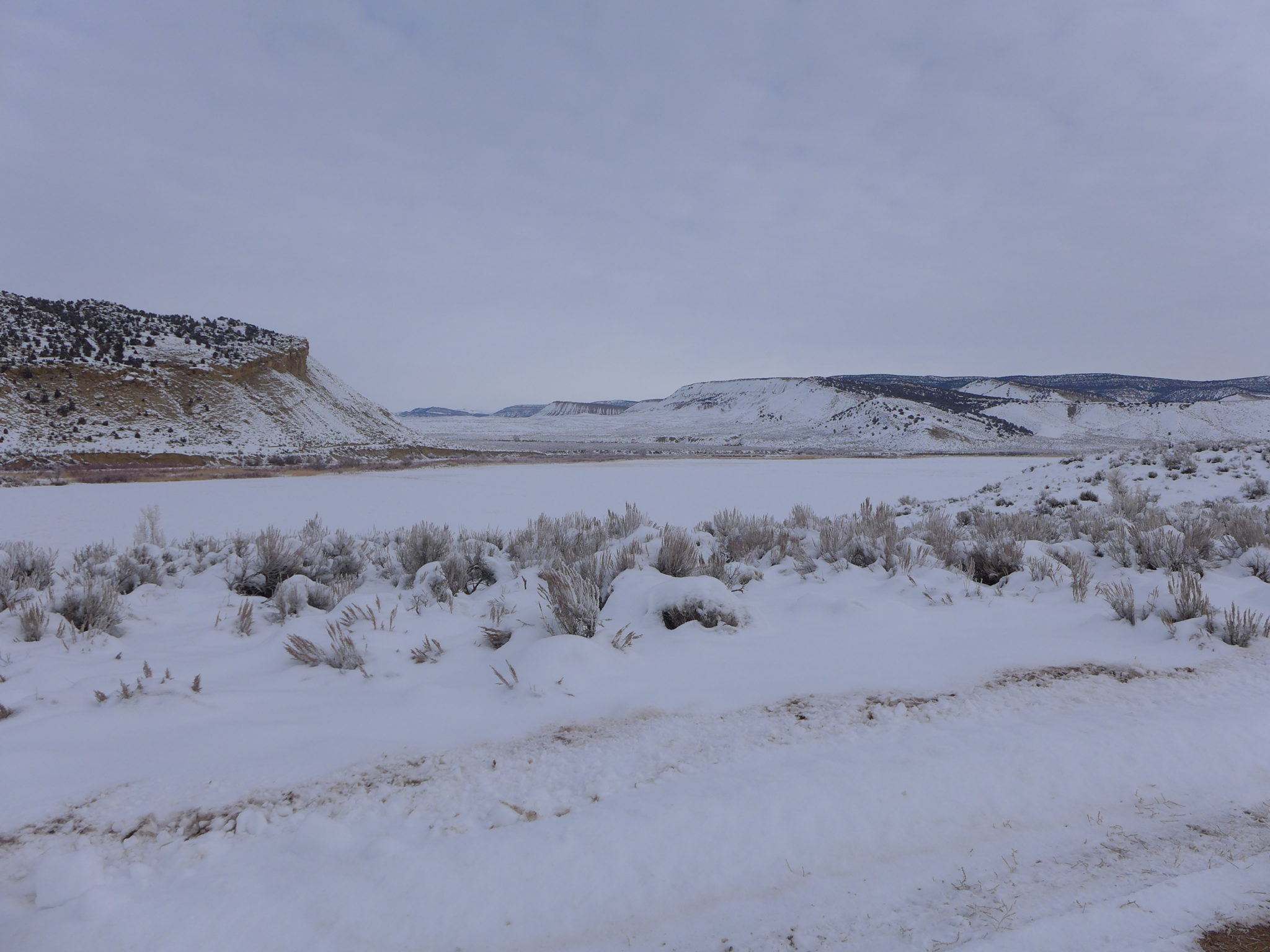
One option for the White River storage project would be an off-channel dam and reservoir at this location. Water would have to be pumped from the White River into the reservoir site. Photo credit: Heather Sackett/Aspen Journalism
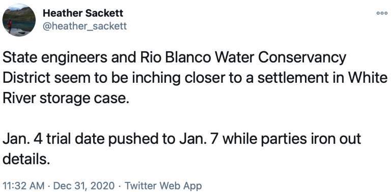
A water court judge has agreed with state engineers and dismissed several of a water conservancy district’s claims for water for a dam and reservoir project in northwest Colorado.
Division 6 Water Judge Michael A. O’Hara III, in a Dec. 23 order, determined that Rio Blanco Water Conservancy District has not provided enough evidence that its current existing water rights won’t meet demands in the categories of municipal, irrigation, domestic, in-reservoir piscatorial, commercial and augmentation for Yellow Jacket Water Conservancy District.
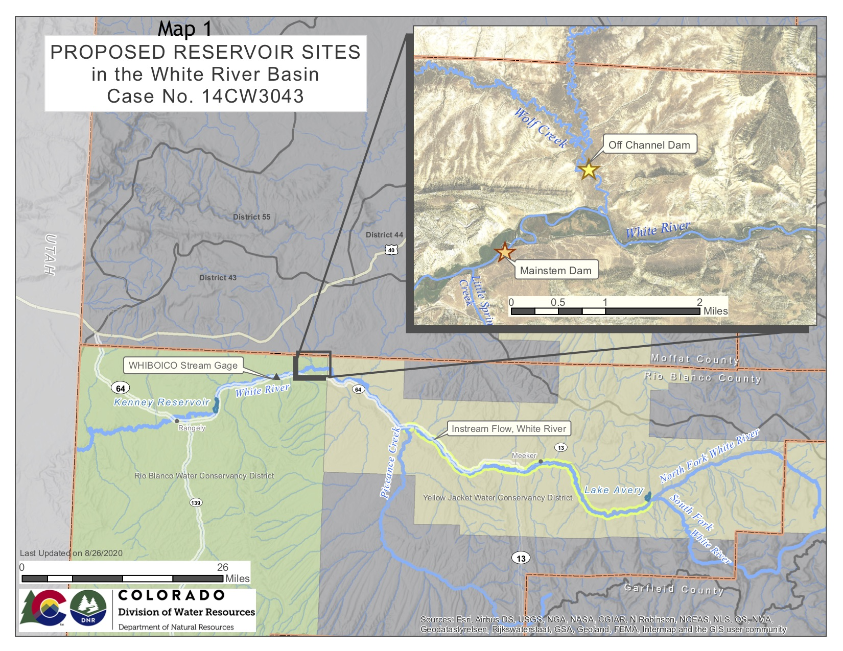
The Rangely-based conservancy district is seeking a conditional water-storage right to build an off-channel reservoir using water from the White River to be stored in the Wolf Creek drainage, behind a dam 110 feet tall and 3,800 feet long. It would involve pumping water uphill from the river into the reservoir.
Rio Blanco initially applied for a 90,000 acre-foot water-storage right but later reduced that claim to 66,720 acre-feet for the off-channel reservoir, which would be located between Rangely and Meeker.
According to Colorado water law, new conditional water rights cannot be granted without a specific plan and intent to put the water to beneficial use. For more than five years, top state water engineers have repeatedly said the project is speculative because Rio Blanco has not proven a need for water above its current supply.
State engineers asked the court to dismiss Rio Blanco’s entire application in what’s known as a motion for summary judgment. The court agreed to dismiss only some of Rio Blanco’s requested water uses.
“The applicant has failed to demonstrate that its existing water rights for municipal, irrigation, domestic, in-reservoir piscatorial, and commercial uses are insufficient to meet its needs and are therefore dismissed,” O’Hara wrote in his order.
The town of Rangely’s water needs and whether water was needed for irrigation were two main topics of questions from state engineers in hundreds of pages of depositions in the case.
O’Hara’s order said there are three water-use claims left to resolve at trial: whether Rio Blanco can get a water right for augmentation in the event of Colorado River Compact curtailment, water for endangered species and water for hydroelectric power.
The trial is scheduled to begin Monday, but the parties could still reach a settlement agreement before then.
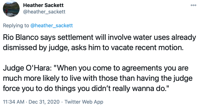
“We are involved in productive settlement discussions with the engineers and both sides hope that produces a settlement rather than a trial,” said Alan E. Curtis, an attorney for Rio Blanco.
Even if the parties reach a settlement, the judge will still have to approve the final water-right decree. Curtis said parties often reach settlements at the last minute, sometimes even after a trial has begun.
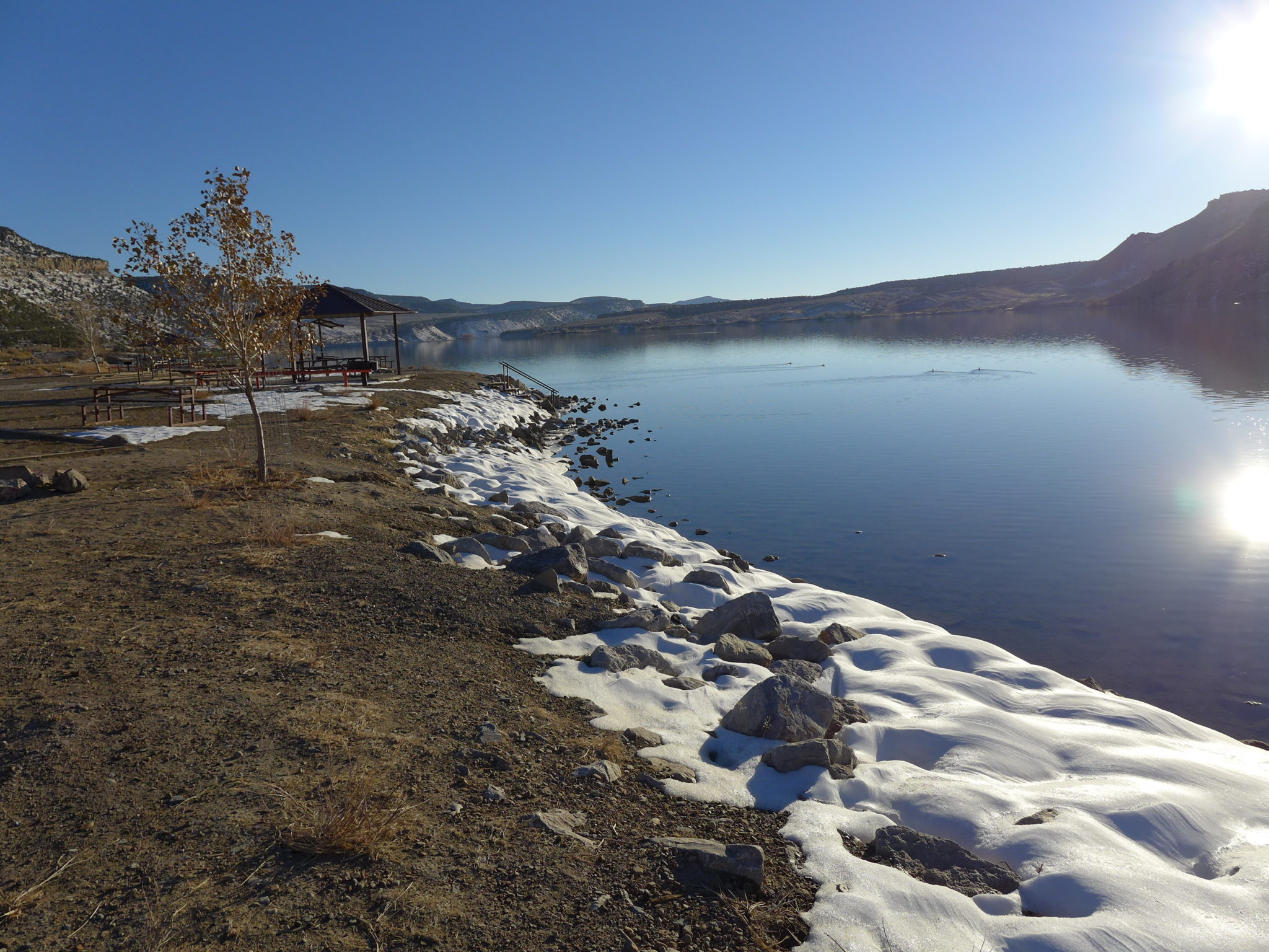
Ducks swim on Kenney Reservoir, which sits near Rangely, in late October. The reservoir is silting in and approaching the end of its useful life, according to the Rio Blanco Water Conservancy District, which wants to build a new reservoir with water from the White River. Photo credit: Heather Sackett/Aspen Journalism
Compact curtailment
If the case goes to trial next week, a main point of contention will be whether Colorado River Compact compliance is a valid beneficial use of water stored in the White River project. Rio Blanco is proposing that 11,887 acre-feet per year be stored as “augmentation,” or insurance, in case of a compact call. Releasing this replacement water stored in the proposed reservoir to meet these compact obligations would allow other water uses in the district to continue and avoid the mandatory cutbacks in the event of a compact call.
According to the 1922 Colorado River Compact, the upper-basin states (Colorado, Utah, New Mexico and Wyoming) must deliver 7.5 million acre-feet a year to Lake Powell for use by the lower-basin states (Arizona, California and Nevada). If the upper basin doesn’t make this delivery, the lower basin can “call” for its water, triggering involuntary cutbacks in water use for the upper basin.
Water managers are especially worried that those with junior water rights, meaning those later than 1922, will be the first to be curtailed. Many water users in the White River basin, including the towns of Rangely and Meeker, have water rights that are junior to the compact, meaning these users could bear the brunt of involuntary cutbacks in the event of a compact call. Augmentation water would protect them from that.
State engineers argue that augmentation use in the event of a compact call is not a beneficial use under Colorado water law and is inherently speculative. But O’Hara disagreed, saying there is sufficient legal authority for Rio Blanco to develop an augmentation plan for a compact call.
“While it is tempting for the court (to) rule, as a matter of law, that the requested augmentation use is speculative because it is based on an event that may or may not occur, it chooses not to do so here,” O’Hara’s motion reads.
This map shows the potential locations of the proposed White River storage project, also known as the Wolf Creek project, on the White River between Rangely and Meeker. A water court judge has dismissed several of the Rio Blanco Water Conservancy District’s claims for water. Credit: Colorado Division of Water Resources via Heather Sackett/Aspen Journalism
Endangered fish water
Rio Blanco says it needs 60,555 acre-feet of water per year for maintenance and recovery of federally listed and endangered fish. Releases from the proposed reservoir could benefit endangered fish downstream, including the Colorado pikeminnow and razorback sucker.
But the gauge used to measure these flows — the Watson gauge — is located downstream in Utah. State engineers say this violates Colorado’s law regarding exporting water across state lines. Rio Blanco says the water will benefit fish in the White River within Colorado and that they use the Watson gauge because there isn’t one between Taylor Draw dam in Rangely and the state line. Where exactly the fish will benefit from reservoir releases is a matter to be hashed out at trial.
“The court finds that the location of beneficial use is a material fact in dispute,” O’Hara’s order reads. “The expert reports conflict and the characterization of how and where water is to be used vary.”
Another point the parties can’t agree on is how much water from the proposed reservoir would be used by the Upper Colorado River Endangered Fish Recovery Program. The program has not committed to a specific amount of water.
A May 2019 letter from program director Tom Chart says the recovery program “does not know whether, or how much, allocated storage in the project or other White River basin projects may be needed in order to offset depletion effects to the endangered species to assist in the recovery of the endangered fish.”
But, as O’Hara points out, the letter does not say the program will not need water from a future Wolf Creek reservoir.
“The letter creates a material fact in dispute, one more suitable for resolution at trial,” O’Hara’s order reads.
Also to be decided at trial is water use for hydroelectric power. State engineers say hydropower is not an independent use and depends on the court granting the other water uses. They say that if the other uses are dismissed, then hydropower should be dismissed too. But Rio Blanco says water should be stored in the reservoir specifically for hydropower generation and should not be contingent on other uses.
The trial is scheduled to begin [Thursday, January 7, 2021] in Routt County District Court in Steamboat Springs.
Aspen Journalism is a local, nonprofit, investigative news organization covering water and rivers in collaboration with The Aspen Times and other Swift Communications newspapers. This story ran in the Dec. 31 edition of The Aspen Times.
Firefighters on the march: The Pine Gulch Fire, smoke of which shown here, was started by alighting strike on July 31, 2020, approximately 18 miles north of Grand Junction, Colorado. According to InciWeb, as of August 27 2020, the Pine Gulch Fire became the largest wildfire in Colorado State history, surpassing Hayman Fire that burned near Colorado Springs in the summer of 2002. Photo credit: Bureau of Land Mangement-Colorado, via InciWeb and National Interagency Fire Center.
FromThe Grand Junction Daily Sentinel (Alex Zorn):
The Pine Gulch Fire, which started from a lightning strike 18 miles north of Grand Junction on July 31, became the largest wildfire in Colorado history less than a month later. Though it did not keep that title for long, finishing wildfire season third in the state at just over 139,000 acres, its impact on western Colorado will be felt for years to come.
By September, the fire had reportedly cost $28 million to put out and though structure damage was minimal, it may be several years until the habitat is back to normal.
The fire remained in rural Mesa and Garfield counties for its entirety but dry and hot conditions fueled its growth throughout the month of August. Within a week, the fire grew to more than 10,000 acres as triple-digit temperature days became the norm for firefighters on scene.
The extreme dry heat, combined with the drought-stressed vegetation and steep terrain led to weeks of active burning with little extremely dangerous conditions for hand crews. Crews used aircraft to fight the fire early on but it did not stem the growth of the blaze.
“Between August 4 and August 9, 475,228 gallons of water (was dropped) on the Pine Gulch Fire from helicopters,” Incident Command reported…
At its peak, the fire’s closure was about 640,000 acres with around 900 firefighting personnel surrounding its perimeter, helping out at the forward operating base, running equipment up to the firefighters, or out on the front lines putting out hot spots and protecting homes.
About 80% of the fire burned on BLM land. Wayne Werkmeister, the office’s associate manager, told The Daily Sentinel it affected about one-tenth of the acreage in the office’s jurisdiction, and he expected the office to be kept busy for the next decade dealing with the fire’s impacts. Weed threats, range management and recreation impacts will be some of the other longer-term impacts officials will be dealing with for years to come, particularly when it comes to the BLM’s Grand Junction Field Office.
The Grizzly Creek Fire jumped Grizzly Creek north of Glenwood Canyon. (Provided by the City of Glenwood Springs)
GRIZZLY CREEK FIRE SHUTS DOWN Interstate 70 FOR WEEKS
Fire investigators have officially ruled the Grizzly Creek Fire was human-caused. The fire one mile east of Glenwood Springs shut down Interstate 70 in both directions between Glenwood Springs and Gypsum for two weeks, the longest-ever closure for that stretch of the corridor…
The August fire swept through much of Glenwood Canyon, charred many hillsides, scorched the undersides of some elevated portions of I-70 and sent rocks and burned logs down onto the highway and the railroad going through the canyon.
Colorado River “Beginnings”. Photo: Brent Gardner-Smith/Aspen Journalism
Click here to read Ian James’ fantastic article about the current state of the Colorado River from stem to stern that’s running up at AZCentral.com. Click through and read the whole article. Here’s an excerpt:
The warming climate is intensifying drought, contributing to fires and drying out the river’s headwaters, sending consequences cascading downstream.
ROCKY MOUNTAIN NATIONAL PARK, Colorado — Beside a river that winds through a mountain valley, the charred trunks of pine trees lie toppled on the blackened ground, covered in a thin layer of fresh snow.
Weeks after flames ripped through this alpine forest, a smoky odor still lingers in the air.
The fire, called the East Troublesome, burned later into the fall than what once was normal. It cut across Rocky Mountain National Park, racing up and over the Continental Divide. It raged in the headwaters of the Colorado River, reducing thick forests to ashes and scorching the ground along the river’s banks.
The fires in Colorado spread ferociously through the summer and fall of 2020 after months of extreme heat that worsened the severe drought.
As smoke billowed over the headwaters, the wildfires raised warning signs of how profoundly climate change is altering the watershed, and how the symptoms of heat-driven drying are cascading down the heavily used river — with stark implications for the entire region, from Colorado’s ranchland pastures to the suburbs of Phoenix…
Over the past year, the relentless hot, dry months from the spring to the first snows left the soil parched. The amount of runoff into streams and the river dropped far below average. With reservoirs sinking toward new lows, the risks of shortages are growing.
Much of the river’s flow begins as snow and rainfall in the territory of the Colorado River Water Conservation District, which includes 15 counties on Colorado’s West Slope. Andy Mueller, the district’s general manager, said the extreme conditions over the past year offer a preview of what the region should prepare for in the future.
“Climate change is drying out the headwaters,” Mueller said. “And everybody in the Colorado River Basin needs to be concerned.”
Mueller saw the effects while backpacking in Colorado’s Holy Cross Wilderness in the summer with his 19-year-old daughter. Above the tree line, at an elevation of 12,000 feet, they expected to see mushy green tundra. Instead, they found the ground was bone dry…
People who focus on the river have widely acknowledged the need to adjust to a shrinking system with less water to go around.
Many suggest solutions can be achieved through collaborative efforts — often with money changing hands in exchange for water — while working within the existing rules. Others say solutions shouldn’t fall on the backs of farming communities by taking away water that fuels their economies. Some people argue the river seems headed for a crash and its rules need to be fundamentally reimagined…
The deals between the seven states are designed to temporarily lower the odds of Lake Mead and Lake Powell dropping to critical lows over the next five years. The states’ representatives have yet to wade into the details of negotiations on what shortage-sharing rules will look like after 2026, when the current agreements expire.
Still unresolved are difficult questions about how to deal with the shortfall over the long term.
What’s increasingly clear is that the status-quo methods of managing the river are on a collision course with worsening scarcity, and that eventually something will have to give…
Watershed ‘thirstier’ with heat
Last winter, after a dry year, the Rocky Mountains were blanketed with a snowpack that was slightly above average. Then came extremely hot and dry conditions, which shrank the amount of runoff and flows into tributaries and again baked the soils dry.
[Andy] Mueller said the change occurred abruptly at the end of the snow season in the spring…
With the heat, some of the snow didn’t melt but instead evaporated directly into the air, which scientists call sublimation — something that has been happening more over the past two decades. The flows in streams dropped over the next few months, and then August brought record heat, which dried out the headwaters and fueled the fires through the fall…
In a 2018 study, scientists found that about half the trend of decreasing runoff in the Upper Colorado River Basin since 2000 was the result of unprecedented warming. In other research, scientists estimated the river is so sensitive to warming that it could lose roughly one-fourth of its flow by 2050 as temperatures continue to rise…
“A warmer atmosphere is a thirstier atmosphere, and we’re seeing less runoff bang for our precipitation buck,” said Jeff Lukas, an independent climate researcher in Colorado. “We’ll still have wetter and drier years, but the baseline is very likely to be shifting downward, as it has in the last 20 years.”
And when extreme heat comes, it leaves less water running in tributaries and also translates into drier forests, leading to increased fire risk.
The soils were so dry over the past year that they soaked up moisture, contributing to below-average stream flows, said Megan Holcomb, a senior climate change specialist with the Colorado Water Conservation Board.
“You can think of it as like the dry sponge that you haven’t wetted in forever,” Holcomb said. “That kind of soil moisture deficit is not something that you rebound from immediately.”
Lake Powell, behind Glen Canyon Dam, shows the effects of persistent drought in the Colorado River Basin. (Source: U.S. Bureau of Reclamation)
After the hot spring came a dry summer. The lack of monsoon rains compounded the drought. And then came August, Holcomb said, when a map of record-hot temperatures hugged the Colorado River Basin like a “massive red handprint.”
In areas of western Colorado that drain into the river, it was the hottest and driest August on record, breaking the previous temperature record by 2 degrees F, said Russ Schumacher, Colorado’s state climatologist and director of the Colorado Climate Center.
The state usually gets its largest wildfires in June and July. But with the severe drought, the fires burned through August, and then exploded in October with unprecedented speed and intensity. The ultradry conditions, together with high winds, contributed to the three largest wildfires in Colorado history, which together devoured more than half a million acres.
In the future, rising temperatures will lead to more of these scorching summers.
Firefighters on the march: The Pine Gulch Fire, smoke of which shown here, was started by a lighting strike on July 31, 2020, approximately 18 miles north of Grand Junction, Colorado. According to InciWeb, as of August 27 2020, the Pine Gulch Fire became the largest wildfire in Colorado State history, surpassing Hayman Fire that burned near Colorado Springs in the summer of 2002. Photo credit: Bureau of Land Mangement-Colorado, via InciWeb and National Interagency Fire Center.
The Cameron Peak fire soon after it started on Aug. 13, 2020. By Sept. 11, the fire had grown to more than 102,000 acres (now >200,000 acres) and was not expected to be considered out until Oct. 31. Photo credit: InciWeb via The Colorado Sun
East Troublesome Fire October 21, 2020 via Wildfire Today.
Scenes of the CalWood Oct. 17, 2020 (Jivan West/CU Independent)
Abby Burk of the conservation group Audubon Rockies noticed how low the river was in the summer when she went paddling in her kayak. In parts where the river was full and muddy a year earlier, she found bars of gravel. Where there once were channels to paddle through, she encountered dead-end lagoons.
In November, when Burk drove through the headwaters near the smoldering fires, she snapped photos of the hills and mountains, still golden-brown beneath a dusting of snow.
When the soil is so parched, it will always “take the first drink” before water reaches the streams, Burk said. “We need a lot more snow for many years to come to really replenish the soil moisture deficits that we’re seeing now.”
The fire scars will also bring challenges come spring, she said, when melting snow will send runoff carrying ash, debris and sediment into streams, potentially creating complications for water systems.
Burk said she’s hoping there will be a slow melt so the runoff comes gradually, without “bringing down the mountain into the river.”
Rancher and fly-fishing guide Paul Bruchez raises cattle on 6,000 acres near Kremmling. Bruchez has taken an active role in Colorado River issues ever since his family suffered from a critical water shortage during the 2002 drought. Photo credit: Russ Schnitzer via Aspen Journalism
A rancher looks to adapt
Paul Bruchez raises cattle on his family’s ranch in the headwaters near the town of Kremmling, where the Colorado River winds through pastures…
Bruchez has been involved in discussions about the river as a member of the Colorado Basin Roundtable. And while he’s heard many people voice alarm about the watershed lately, Bruchez said he and other neighboring ranchers have been talking about the need to adapt to a river with less water since 2002, when severe drought came.
The flows dropped so low then that even ranchers with the longest-standing water rights, known as senior rights, couldn’t get it to their fields.
“Within this river basin, we have seen a change over time of the quantity and volume of water that is available. And in that same time, we’ve seen a growth of population that relies on it,” Bruchez said. “We knew this in 2002 when we hit that drought, that if we didn’t change how we operated, we weren’t going to survive.”
Since then, Bruchez and other ranchers have been talking about ideas for adapting…
The closer the region gets to a scenario of curtailing water allotments, Bruchez said, the more investors and representatives of cities and towns are going to be contemplating ways of securing water from elsewhere.
For people in agriculture, he said, “we need to be at the table or we’re going to be on the menu.”
[…]
Blue Mesa Reservoir, Curecanti National Recreation Area. Photo credit: Victoria Stauffenberg via Wikimedian Commons
‘It affects everybody’
One of the main tributaries that feeds the Colorado is the Gunnison River, which like the mainstem has shrunk during the heat-amplified drought. Along the Gunnison, cattle ranchers got less water last year and their pastures produced less hay.
The river’s low flows also forced an early end to the river rafting season on Labor Day weekend. After that, releases from a dam had to be cut back and the Gunnison was left much shallower than usual, with rocks protruding in stretches where boats would normally be drifting until the end of September.
Sonja Chavez via Gunnison Basin Roundtable.
The river has dropped to some of its lowest levels in years, said Sonja Chavez, general manager of the Upper Gunnison River Water Conservancy District.
The effects are visible at Blue Mesa Reservoir, one of the state’s largest, which has declined to less than half its full capacity.
Visiting the lake, Chavez walked on sandy ground that used to sit underwater.
Looking across the inlet where the river pours into the lake, she pointed to a gray line on the rock showing the high-water mark. During spring runoff, she said, the river in this channel can reach about 20 feet higher. But with the soil so parched, its level dropped.
“When we are dry in the Upper Gunnison Basin, it affects everybody downstream of us,” Chavez said. And the swings between high and low flows, she said, have made it difficult to plan how to operate the reservoirs…
Iron Fen. Photo credit from report “A Preliminary Evaluation of Seasonal Water Levels Necessary to Sustain Mount Emmons Fen: Grand Mesa, Uncompahgre and Gunnison National Forests,” David J. Cooper, Ph.D, December 2003.
Gunnison River in Colorado. Source: Bureau of Reclamation via the Water Education Foundation
Upper Gunnison watershed May 2019. Photo credit: Greg Hobbs
In the Gunnison Valley, a local climate action group meets to talk about potential solutions. Some conversations have focused on how to manage forests that have grown thick with vegetation over the past century as federal agencies have focused mostly on putting out fires.
While the forests have grown thicker, warmer temperatures have enabled beetles to flourish, littering the mountains with dead trees.
Chavez and others want to prioritize efforts to make the forests healthier and more fire-resilient by thinning the trees through logging, mechanical treatments or controlled burns, which they say would make the whole watershed healthier. She said the federal government needs to be more involved and the region needs funding for these projects.
“Our big push this year is to do some watershed management planning and work with the Forest Service to identify zones of concern, or areas that we can treat,” Chavez said. “We’re worried if we had a big fire what would happen.”
Alongside those efforts, water managers are discussing ways of dialing down water usage…
Ranchers, farmers consider using less
One lifelong rancher who had a smaller-than-usual hay crop was Bill Trampe, who has worked on water issues for years as a board member of the Colorado River District.
His cattle graze on meadows near Gunnison where the grasses survive year after year. He was short of water to irrigate after mid-June, which left the pastures parched.
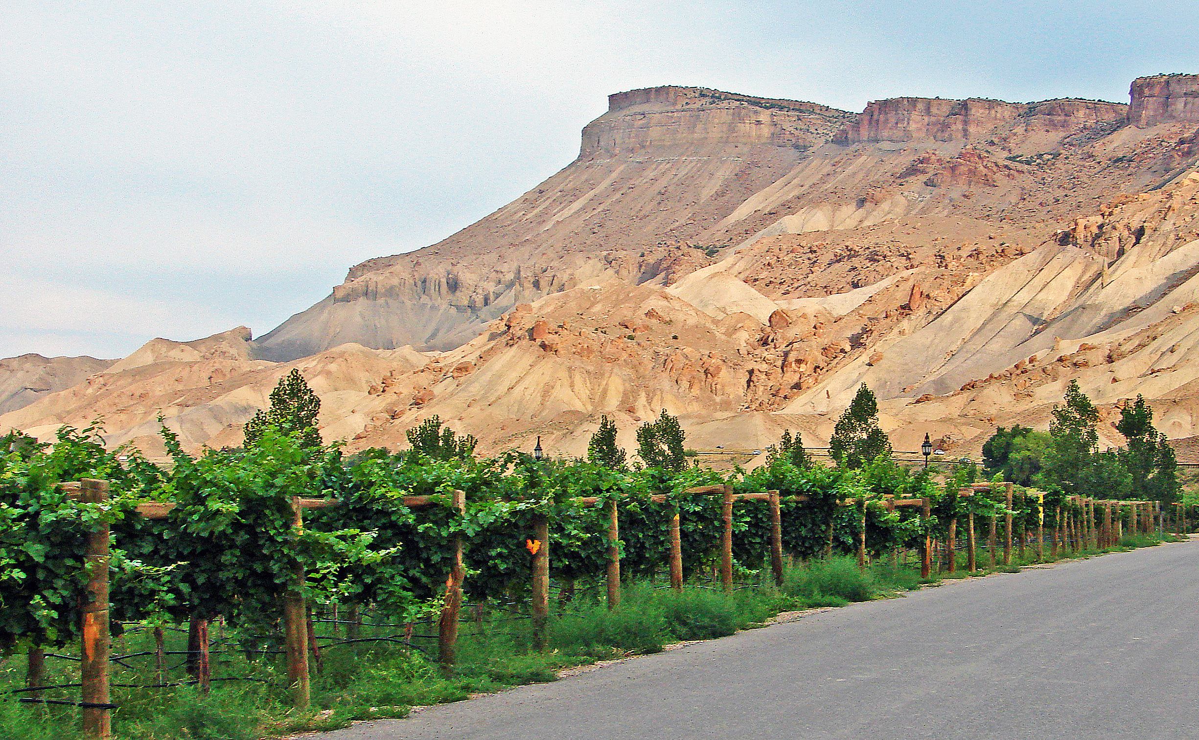
Palisade is just east of Grand Junction and lies in a fertile valley between the Colorado River and Mt. Garfield which is the formation in the picture. They’ve grown wonderful peaches here for many years and have recently added grape vineyards such as the one in the picture. By inkknife_2000 (7.5 million views +) – https://www.flickr.com/photos/23155134@N06/15301560980/, CC BY-SA 2.0,
Over the past two decades, only a few years brought good snowpack, he said, and ranchers have repeatedly had to weather the financial hits of years when they must buy hay for their cattle…
‘We need to set the terms’
In other parts of the river basin, some representatives of agricultural water agencies are worried about the potential consequences of paying farmers to leave land dry.
One such voice is J.B. Hamby, a newly elected board member of California’s Imperial Irrigation District, who said he’s concerned that while cities and sprawling suburbs continue to grow rapidly, agricultural communities are increasingly at risk. He said people in cities need to realize there is a priority system that shouldn’t be changed…
Arizona gets nearly 40% of its water from the Colorado River. Much of it flows in the Central Arizona Project Canal, which cuts across the desert from Lake Havasu to Phoenix and Tucson.
In 2020, Arizona and Nevada took less water from the river under the drought agreement among Lower Basin states, and in 2021 they will again leave some of their water in Lake Mead. The latest projections show Mead could fall below a key threshold by summer, which would trigger a shortage declaration and larger cutbacks in 2022…
Now, with less water flowing to farms, the amount of runoff into the Salton Sea has shrunk, leaving growing stretches of exposed lakebed that spew dust into the air. The dust is contributing to some of the worst air pollution in the country, and many children suffer from asthma.
Hamby said the Imperial Valley would have been better off without the water transfer deal. Looking at the proposed approach in Colorado, Hamby said, it seems to replicate what occurred in Imperial.
“When you tie money to water, you get users who become addicted to the money and don’t actually in the end start to want to farm anymore,” Hamby said. “That is really corrosive to the long-term survival, much less thriving, of rural communities when people get more hooked on money rather than the way of life and putting the water on the land.”
He argued that such an approach would be “subverting the whole priority system” and enabling cities to avoid taking cuts themselves…
‘Are we doing enough?’
At his ranch by the river, Bruchez said he wants to be on “the preventative side,” getting ahead of the looming problems instead of reacting. And that includes studying and promoting conservation, he said, because the bottom line is “we just all have to figure out how to use less water.”
In early 2019, Bruchez began talking with Perry Cabot, a researcher from Colorado State University, about a project that would help provide data on crop water use, impacts of reduced irrigation and strategies for conserving water.
Cabot gave a presentation to the Colorado Basin Roundtable, and members supported the idea of a study. The project began in 2020 with about $900,000 in funding, including support from the Colorado Water Conservation Board and groups including Trout Unlimited and American Rivers.
A group of nine ranchers participated and were paid for leaving some fields dry or partially dry, Bruchez said. More than 900 acres weren’t irrigated for the entire year, and about 200 acres were “deficit irrigated,” meaning they received less water.
Bruchez’s ranch totals about 6,000 acres. He participated on about 41 acres, where he stopped irrigating on June 15 and didn’t water the rest of the year.
“My end goal is to understand the impacts of water conservation for agriculture so that if and when there are programs to participate, agriculture is doing it based on science,” Bruchez said…
Paul Bruchez said he’s seen that when people talk about solutions, they often seem to draw boxes around different approaches like demand management, water conservation, climate change and forest management, but he thinks they’re all quite connected.
“It’s all the same conversation,” Bruchez said. “To me, the question just comes down to, are we doing enough, quick enough?”
[…]
“It’s that water that is provided by the Colorado River that ties us all together,” Mueller said. “And truly, when we recognize the importance of the Colorado River and how it ties us together, that’s when we succeed as a society.”
Ian James is a reporter with The Arizona Republic who focuses on water, climate change and the environment in the Southwest. Send him story tips, comments and questions at ian.james@arizonarepublic.com and follow him on Twitter at @ByIanJames.
Ruedi Reservoir release will increase tomorrow morning by approximately 14 cfs. The flow at the Fryingpan River gage below Ruedi Reservoir will increase from 46 cfs to 60 cfs for the next two months. The release increase is due to a contract release, and the goal is to mitigate formation of anchor ice within the Fryingpan River channel.
Fryingpan River downstream of Ruedi Reservoir. Photo credit Greg Hobbs
Steamboat Lake, shown here in late August, was closed for two weeks last summer after toxins were detected above harmful levels. Toxic, blue-green algae blooms have been found in Routt County reservoirs each of the past two summers. Photo credit: Juli Arington/Aspen Journalism
Since state officials began a more focused monitoring effort six years ago to detect toxic algae blooms in Colorado’s lakes and reservoirs, testing has documented harmful levels of such toxins three times on the Western Slope.
Two of those toxic blooms occurred in Routt County reservoirs — first at Stagecoach Reservoir in 2019 and then at Steamboat Lake last summer, which was the first year that state park managers were required to regularly test for toxic algae. Results showing bacteria above state thresholds caused a two-week swimming closure at the popular state park.
Since 2014, toxic algae has been discovered in nine Front Range lakes or reservoirs, while the only other Western Slope bloom was found in 2018 at Fruitgrowers Reservoir in Delta County.
More research is needed to determine the causes of these recent blooms. But an increase in testing due to more stringent Colorado Parks and Wildlife (CPW) toxic algae monitoring protocol, a history of ranching around and on reservoir land, and climate change are probably contributing to the increase in recorded toxic blooms on the Western Slope.
Steamboat Lake State Park manager Julie Arington said the updated CPW monitoring and testing guidelines influenced the discovery of the toxic bloom last summer. The new guidelines, which were updated going into the season, require park managers to regularly test for toxins May through September, according to CPW officials.
“It may have been there before (this year), but we just didn’t notice it. We hadn’t been testing for it,” Arington said. But in mid-August, when water temperatures were at their warmest, toxin levels were found to be above the recently-established thresholds and park managers shut down the lake to swimming for two weeks, until winds and cooler temperatures slowed the blooms down.
Blue-green algae that populate lakes in and of themselves are not harmful and form the basis of the riparian food web. Under certain conditions, however, the algae multiply rapidly, form blooms and produce toxins.
Nutrients and warming cause these blooms, said Jill Baron, a research ecologist and senior scientist with the U.S. Geological Survey. “Period.”
Toxic algae feed off phosphorus and nitrogen, nutrients sourced from fertilizers, vehicle emissions, sewage, soil, animal excrement and plant material. If ingested in levels above state health standards, the toxins cause sickness, liver and brain damage when ingested during recreational lake activity or when drinking contaminated water.
Construction of Stagecoach Reservoir takes place in 1988. The U.S. Geological Survey has been collecting data on algae compositions in Stagecoach Reservoir and in the greater Yampa River watershed. Some suspect that the land’s ranching history, which loaded nutrients onto what would become the bottom of the reservoir, may be a factor. Photo credit: Bill Fetcher via Aspen Journalism
Tracing Steamboat and Stagecoach nutrients
Steamboat and Stagecoach reservoirs sit in the greater Yampa basin to the north and south, respectively, of Steamboat Springs. Steamboat Lake, which holds 23,064 acre-feet of water, is portioned off a creek that feeds into the Elk River, a tributary of the Yampa. Stagecoach, which holds 36,439 acre-feet of water, is a dammed section of the Yampa River.
Nutrients deposited at the bottom of both reservoirs from decades of ranching probably contribute to the blue-green algae blooms. By the early 1880s, settlers were ranching in the Yampa Valley, including the lands that would become Stagecoach and Steamboat reservoirs, said Katie Adams, curator for the Tread of Pioneers museum.
The future site of Steamboat Lake is shown here in 1949. The barn pictured was owned by the Wheeler family, one of several families who ranched the land before it was bought by brothers John and Stanton Fetcher. John Fetcher proposed the construction of Steamboat Lake, which was built in 1967 and funded by the operators of Hayden power station and the Colorado Division of Parks and Outdoor Recreation. Photo via Bill Fetcher and Aspen Journalism
Steamboat Lake was constructed in 1967 with funds from the operators of Hayden Station power plant and the Colorado Division of Parks and Outdoor Recreation. It became a state park in 1972.
The former ranch lands where Stagecoach is today were bought in 1971 by the Woodmoor Corporation, which planned to build a residential and recreational community with ski areas and golf courses, but the company went bankrupt in 1974. The site was later bought and developed by the Upper Yampa Water Conservancy District and power companies, which funded the reservoir’s construction in 1988. So, for decades leading up to the post-war era, cattle excrement was enriching the reservoir lands with nitrogen and phosphorus — nutrients that fuel the growth of blue-green algae.
Those involved in planning and constructing Stagecoach Reservoir were told algae blooms were a likelihood, said Stagecoach State Park manager Craig Preston.
“Even when they were going through the (construction) processes, they were told there would likely be algae situations, because of the nutrients in the soil,” Preston said.
Baron agrees that nutrients at the bottom of both lakes probably contribute to the blooms.
“They basically took a meadow and turned it into a lake. So, all that vegetation and organic matter on the bottom of that meadow is slowly decomposing and putting its nutrients into the lake itself,” Baron said.
Researchers are focusing on the region to determine which specific sources of nitrogen and phosphorus prompt harmful algal growth. The USGS has been collecting data on algae compositions in Stagecoach Reservoir and in the greater Yampa River watershed and will analyze possible sources of blue-green algae as part of the report, USGS hydrologist Cory Williams said. The results of the study will be published in February or March, according to Williams.
Toxic-algae blooms appeared in Steamboat Lake last summer. The lake shut down for two weeks after harmful levels of a toxin produced by the blue-green algae were found in the water. As climate change continues, toxic blooms and summer shutdowns of lakes are predicted to become more common. Photo credit: Julie Arington/Aspen Journalism
Origins and evolution of state protocol and monitoring
CPW began drafting toxic-algae protocol the summer of 2014, after a local agency found microcystin — a toxin commonly produced by blue-green algae — in Denver’s Cherry Creek Reservoir, said CPW Water Quality Coordinator Mindi May.
“At the time, we didn’t know what the numbers meant. So, we started looking around for state or federal thresholds, and there just weren’t any,” May said.
That same summer, a toxic bloom in Lake Erie contaminated the drinking water of 400,000 residents, forcing officials in Toledo, Ohio, to cut off water for three days. After these two events, May asked Colorado Department of Public Health and Environment staff to develop toxic-algae thresholds for drinking water and recreation, and traveled to state parks in 2015 to encourage staff to test for — and monitor — toxic algae during summer months.
CDPHE developed protocol and thresholds for toxic algae in 2016, based on Environmental Protection Agency standards created in 2014. The thresholds dictate the maximum amount of toxins that lakes can contain, including 8 micrograms per liter for microcystin and saxitoxin, and 15 micrograms per liter for anatoxin and cylindrospermopsin. If lakes cross this threshold, state park managers must post danger signs and close the lake to activities involving bodily contact with the water until tests show that toxins fall below harmful levels, May said.
In 2018, the CDPHE developed a database to compile monitoring and testing efforts in Colorado reservoirs and track the occurrence of toxic-algae blooms since 2014. Data from park managers’ toxin tests are included, along with data collected by CDPHE officials and other local and federal agencies, said MaryAnn Nason, CDPHE’s communications and special projects unit manager.
“We really learned a lot in those early years, and we have a lot more resources now to monitor and test for toxins,” May said of CPW’s and CDPHE’s efforts.
The Yampa River winds through hay meadows in the Yampa Valley in 1987, prior to construction of the dam that formed Stagecoach Reservoir. Photo credit: Bill Fetcher via Aspen Journalism
Western lakes lack data but will feel burn of climate change
CDPHE data shows an increase in toxic blooms from 2014 to 2020 and hints that these blooms are spreading west. Last summer recorded seven toxic blooms, compared with four in 2019 and one in 2018. Yet, increases could also be due to increased monitoring and testing over the years and due to the new 2020 protocol. For instance, 52 lakes were monitored for toxic algae in 2014, compared with 73 last summer.
More data is needed to determine how climate change and nutrients will interact to produce toxic blooms, and determine the impacts this will have on drinking water and summer recreation for high country and Western Slope lakes.
It is likely that climate change will spur more toxic blooms in the West. In a 2017 study of 27 Rocky Mountain lakes, researchers project that climate change will cause average annual lake-surface temperatures to increase 41% by 2080, with dramatically warmer water in the summer and 5.9 fewer ice-free days with each passing decade.
Warmer lakes create a widened window for toxic algae to bloom. A separate national study, also from 2017, predicts that rising air temperatures and the resultant warmer waters will increase toxic-bloom occurrence from an average of seven days per year in U.S reservoirs now to 16-23 days in 2050 and 18-39 days in 2090.
Long-term solutions for current and future blooms include placing limits on greenhouse gas, as well as nitrogen and phosphorus emissions, Baron said. Short-term solutions include waiting for blue-green algae to stop producing toxins and keeping visitors out of the water while they do, said May.
As frosty temperatures inhibit algal growth, Steamboat and Stagecoach park managers get a break from thinking about the turquoise-tinted toxins. In May, they’ll start the second season of following the parks’ new protocol, May said.
Regarding last summer’s toxic bloom, Steamboat Lake State Park’s Arington said, “I think this won’t be the last year that we see it.”
This story ran in the Steamboat Pilot & Today on Dec. 31.
Here’s the release from Aurora Water (Greg Baker):
Aurora Water has won the 2020 Outstanding Water Laboratory Award from the Rocky Mountain Section of the American Water Works Association (RMSAWWA). RMSAWWA is a nonprofit, scientific and educational association serving members in Colorado, New Mexico and Wyoming that is dedicated to effectively managing and treating water. The annual award recognizes a drinking water analysis lab for its exceptional performance, dedication and teamwork. Aurora Water’s Quality Control Lab is a repeat winner of this prestigious award, having won the honor a total of seven times since 2008.
Aurora Water’s quality control staff of 10 laboratory specialists conduct dozens of tests daily at the Quality Control Laboratory. Hundreds of water samples are collected each month from source to tap, ensuring that the water provided to Aurora residents is consistently and reliably safe.
“This award recognizes the hardworking professionals at Aurora Water’s Quality Control Laboratory, who are dedicated to providing excellent service to our citizens,” said Aurora Water’s Environmental Compliance Principal Sherry Scaggiari. “Through their rigorous sampling, testing and reporting on every aspect of our water and waste water system, they maintained the highest level of service, even during a pandemic.

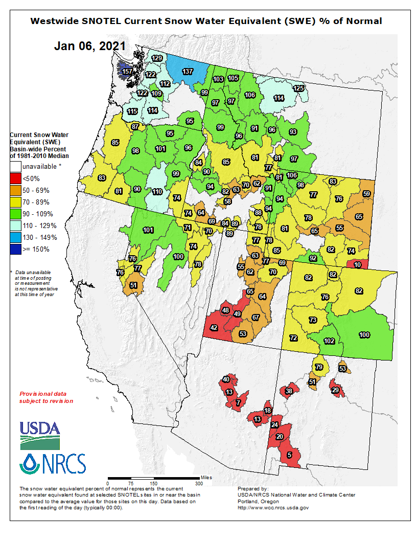
 The road to Bears Ears via the Salt Lake Tribune.
 The Antiquities Act of 1906 was signed into law by Theodore Roosevelt, for “… the protection of objects of historic and scientific interest” through the designation of national monuments by the President and Congress. National monuments are one of the types of specially-designated areas that make up the BLM’s National Conservation Lands. Some of the earliest national monuments included Devils Tower, the Grand Canyon, and Death Valley. They were initially protected by the War Department, then later by the National Park Service. More recently, the BLM and other Federal agencies have retained stewardship responsibilities for national monuments on public lands. In fact, the BLM manages more acres of national monuments in the continental U. S. than any other agency. This includes the largest land-based national monument, the Grand Staircase-Escalante National Monument in Utah featured here. National monuments under the BLM’s stewardship have yielded numerous scientific discoveries, ranging from fossils of previously unknown dinosaurs to new theories about prehistoric cultures. They provide places to view some of America’s darkest night skies, most unique wildlife, and treasured archaeological resources. In total, twenty BLM-managed national monuments, covering over five million acres, are found throughout the western U. S. and offer endless opportunities for discovery. Photos and description by Bob Wick, BLM.