#Drought news March 2, 2023: Abnormal dryness contracted in parts of #Colorado and #Wyoming, and abnormal dryness and moderate to exceptional drought contracted in eastern #Kansas

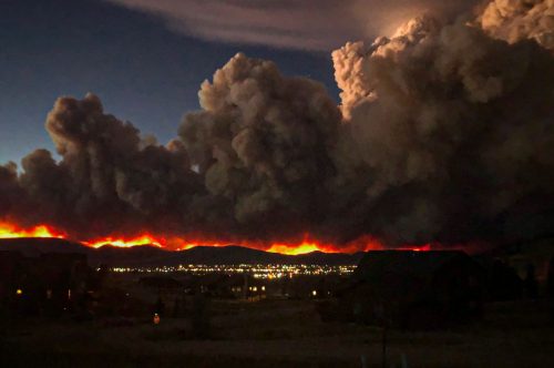
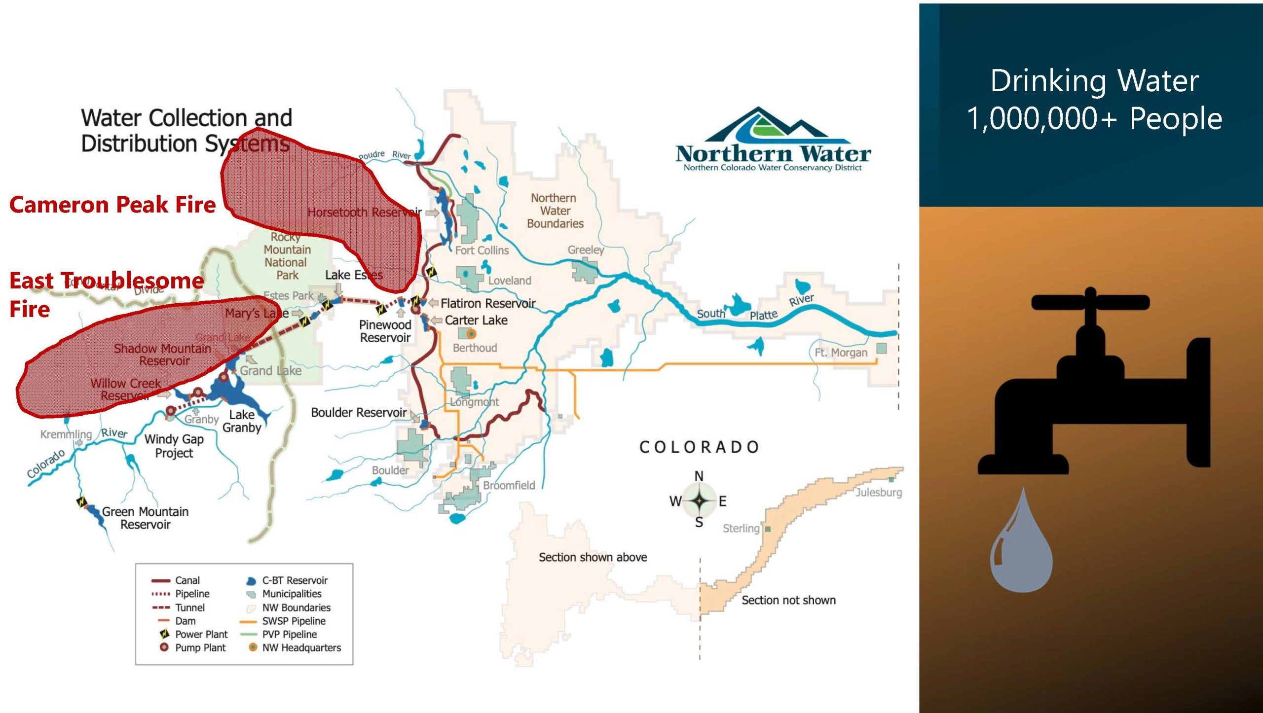
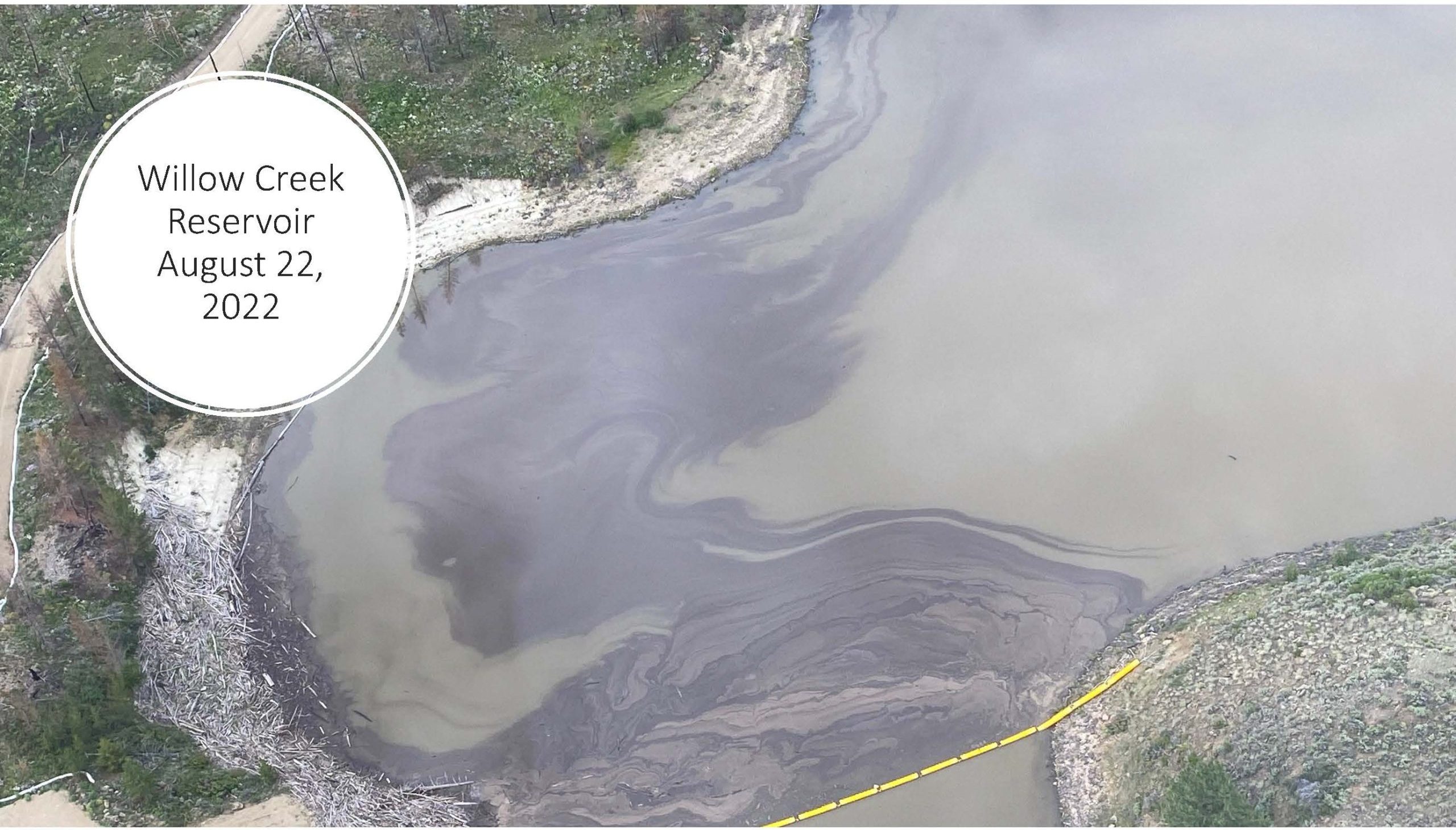
Click on a thumbnail graphic to view a gallery of drought data from the US Drought monitor website.

Click the link to go to the US Drought Monitor website. Here’s an excerpt:

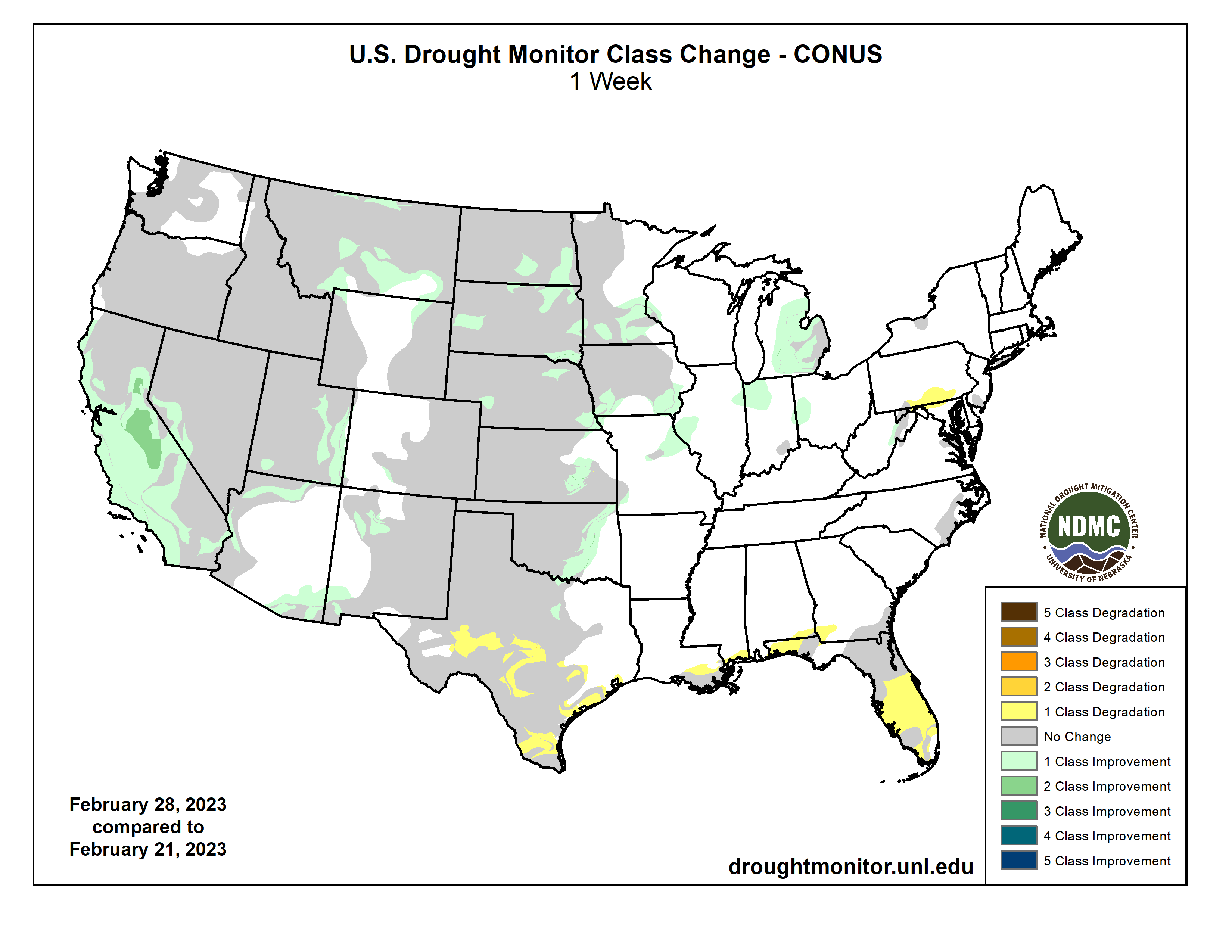
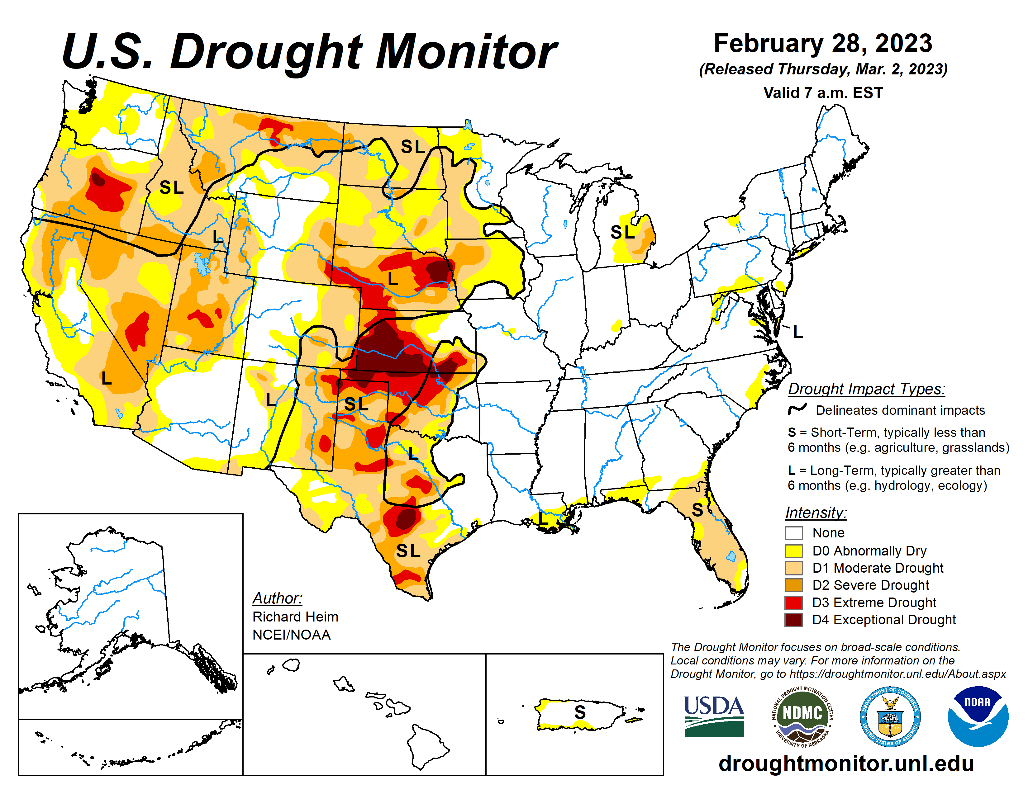
This Week’s Drought Summary

A series of Pacific low pressure and frontal systems moved across the western contiguous U.S. (CONUS) during this U.S. Drought Monitor (USDM) week (February 22-28). The weather systems dropped copious amounts of rain and snow across the West, especially over the Sierra and coastal ranges and Rocky Mountains. The weather systems re-intensified as they crossed the Plains and into the Midwest, tapping Gulf of Mexico moisture to spread several inches of rain over northeast Texas to the Appalachians and Ohio Valley, with several inches of snow falling in the below-freezing air across the northern tier states from the Dakotas to New England. A high-pressure ridge over the Gulf of Mexico generated a southerly flow that spread warmer-than-normal air from the Gulf Coast to southern Great Lakes. It also pushed the low-pressure systems along a storm track that went northeastward from the southern and central Plains to the Great Lakes. Temperatures averaged cooler than normal across the snowy northern states, across the central to northern Plains, and over the West. Little to no precipitation fell across the Gulf Coast, western portions of the southern and central Plains, and over the northern Plains near the Canadian border. It was also drier than normal over parts of the Pacific Northwest, northern New England, and the Mid-Atlantic states. Wetter-than-normal conditions were widespread across the rest of the West, parts of the northern and central Plains and Northeast, and much of the Midwest. Drought or abnormal dryness expanded where it continued dry in parts of Texas, Florida, and other Gulf Coast states. Drought or abnormal dryness contracted or reduced in intensity where it was wet across much of California and other parts of the West and Plains, as well as part of the Great Lakes region…
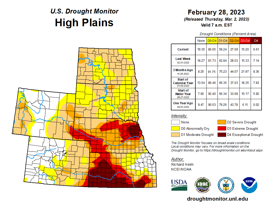
High Plains

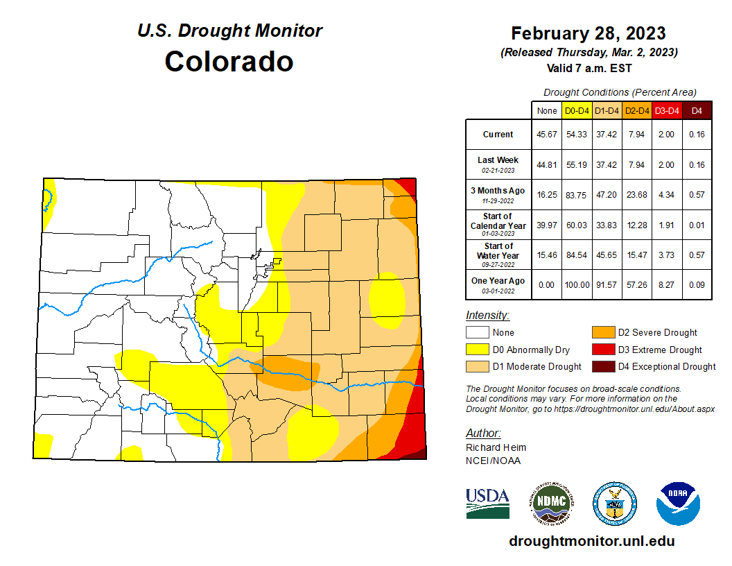
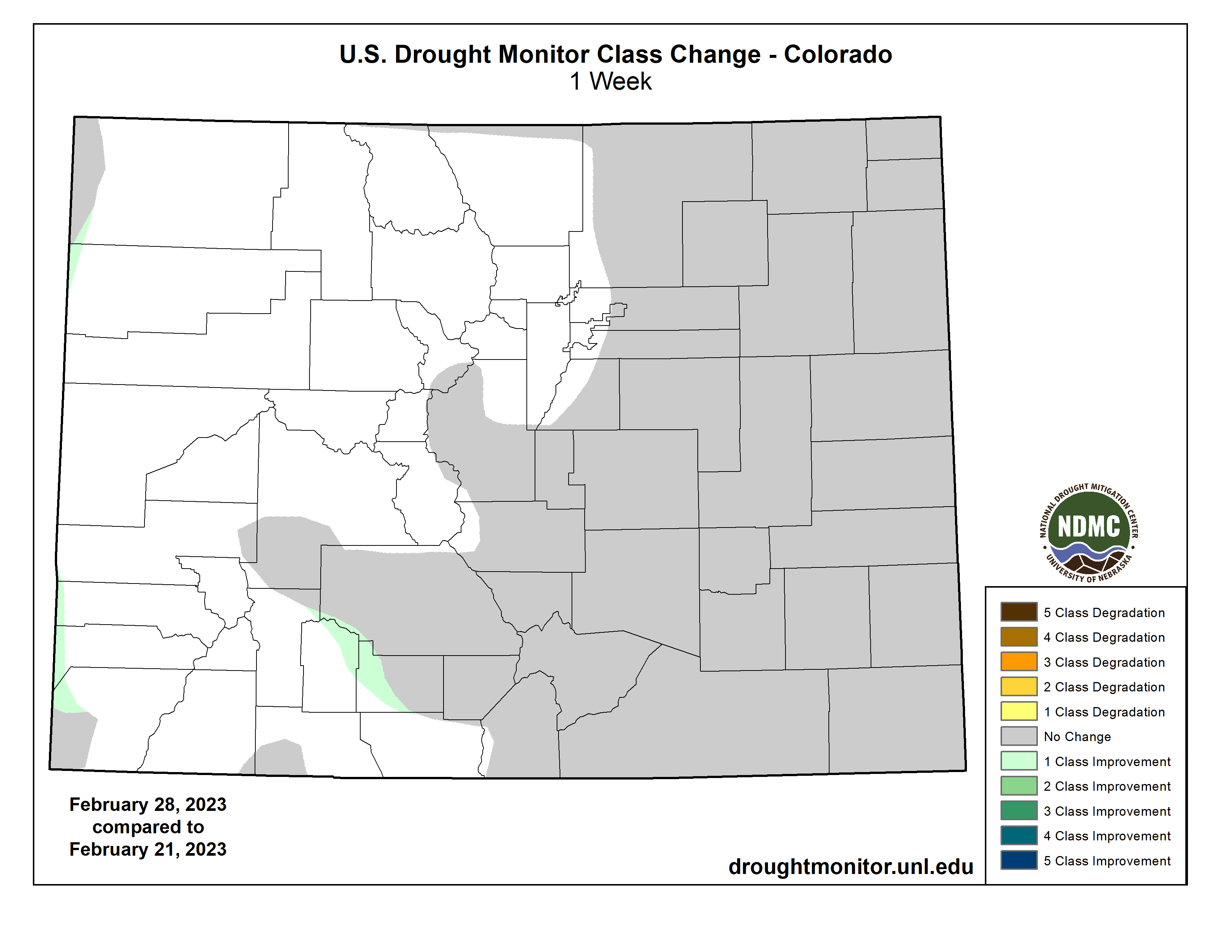
The High Plains region experienced a patchwork pattern of precipitation this week. The Rocky Mountain areas of Wyoming and Colorado, as well as the eastern half of Kansas, received half an inch to locally 2 inches or more of precipitation, and half an inch fell across South Dakota and northern and eastern parts of Nebraska. But North Dakota, eastern Colorado, and adjacent parts of Kansas and Nebraska were drier, receiving less than half an inch. This winter has been particularly wet for central to northern portions of the High Plains region, while Kansas and parts of southeast Colorado have missed out on the above-normal winter precipitation. The heat and dryness of last summer and fall dried out soils, and as winter set in the soils froze in the northern states, locking the dryness into place. The precipitation this week and earlier weeks resulted in contraction of moderate to severe drought in the Dakotas to Nebraska, and exceptional drought in Nebraska, but abnormal dryness was kept to reflect the leftover dry state of the frozen soils. Abnormal dryness contracted in parts of Colorado and Wyoming, and abnormal dryness and moderate to exceptional drought contracted in eastern Kansas…
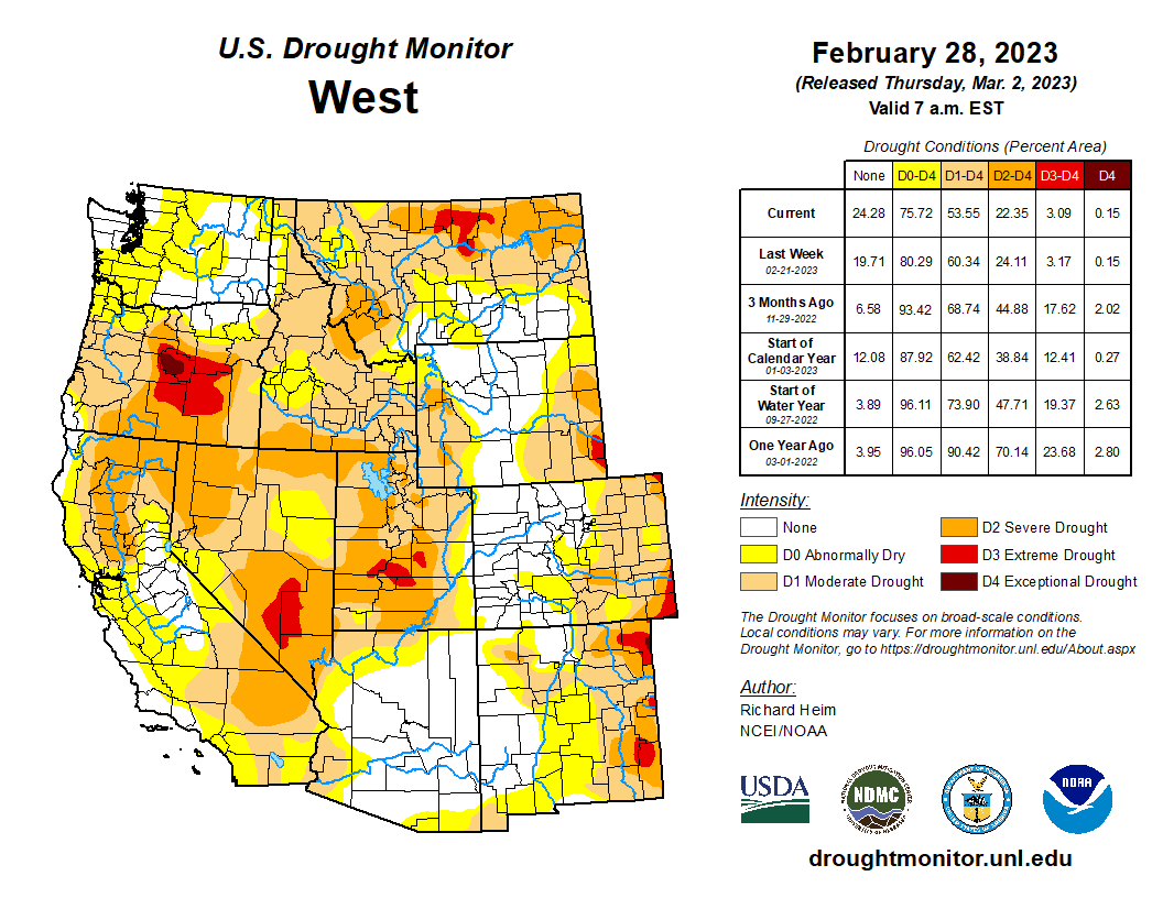
Colorado Drought Monitor one week change map ending February 28, 2023.

West

Much of the western CONUS has suffered from episodes of drought since 1999. The most recent drought episode has lasted up to 3 years. The lack of precipitation was accompanied by excessive heat, which increased evapotranspiration and further dried soils. The prolonged drought lowered groundwater and reservoir levels. The Pacific weather systems of this week and last week added to copious precipitation that has been received from atmospheric rivers since December 2022, especially over California and states to the east. The coastal mountain ranges, Sierra Nevada, and central to southern Rockies received 2 inches or more of precipitation this week, with totals exceeding 5 inches in parts of California. The heavy rains this week resulted in widespread flash flooding in parts of California. Some interior parts of the West had half an inch or more of precipitation, but favored rainshadow areas received less than a fourth of an inch. According to SNOTEL observations, 4 feet or more of new snow fell across the Sierra Nevada range this week. The SNOTEL station at Css Lab reported 78 inches of new snow, bringing the total snow depth to 178 inches as of February 28. Mt. Rose Ski Area reported 178 inches of snow on the ground, Ebbetts Pass reported 176 inches, and Echo Peak had 172 inches. The Hanford, California, area received 9.59 inches of precipitation during December 1, 2022-February 26, 2023. This is the third highest amount for the December 1-February 26 period in the 1900-2023 history for the Hanford area. The rain has improved California soil moisture and streamflow levels, while the snow has increased mountain snowpack to much above-normal levels. Most California reservoirs have refilled with water levels near or above average, but groundwater levels remain low and may take months to recover. Abnormal dryness and moderate to severe drought were contracted across much of California to reflect the above-normal precipitation of recent months, above-normal snowpack, and improved reservoir levels. According to USDM statistics, central California’s Sierra Nevada mountains and foothills are now free of drought and abnormal dryness for the first time since January 2020. Abnormal dryness and moderate to extreme drought were trimmed in Montana, abnormal dryness and moderate to severe drought contracted in New Mexico, and abnormal dryness and moderate drought were pulled back in Arizona. Soil moisture and mountain snowpack have improved in Utah, but groundwater and many reservoirs continue at very low levels. Abnormal dryness and moderate to severe drought were trimmed in Utah in areas where reservoir levels have improved sufficiently. The precipitation in the Pacific Northwest, especially Oregon, was not sufficient to warrant improvement in the drought depiction. In Oregon, reservoirs remain depleted at record to near-record low levels. The southwest Oregon reservoirs have improved only a couple percent over the last two weeks: Emigrant reservoir’s level rose from 21% full on February 16 to only 22% full by February 27; Hyatt increased from 14% to only 15%; Howard Prairie from 17% to 18%; and Agate from 35% to 37%…

South

Two inches or more of precipitation fell in strips across Arkansas and eastern Oklahoma, with half an inch or more stretching from northeast Texas to Tennessee. But little to no precipitation fell across western and southern areas of the region. Abnormal dryness and moderate to extreme drought were trimmed in parts of eastern Oklahoma and north-central Texas, but abnormal dryness expanded along the Gulf Coast in Louisiana and Mississippi. Abnormal dryness and moderate to extreme drought expanded in parts of the southern half of Texas as streamflow, soil moisture, and groundwater continued at very low levels. High winds, low humidity, and hot temperatures continued to dry out the soils. Two years of drought in the southern Plains were capped this week by raging dust storms. The continued dry weather, and now 100+ mph winds with low humidity, have desiccated crops, with the media reporting that the dryland wheat crop in parts of Texas, Oklahoma, and Kansas could see abandonment rates up to 80%…

Looking Ahead

As this USDM week ended, one weather system was moving across the Northeast and another was slamming into the West. More Pacific weather systems will follow during March 2-7, bringing half an inch or more of precipitation to the West Coast and higher elevations of the West, parts of the Great Plains, and much of the CONUS to the east of the Plains. Another 4 inches or more of precipitation can be expected for the Sierra Nevada and coastal ranges, and from northeastern Texas and eastern Oklahoma to the Ohio Valley and southern Appalachians. An inch or more of precipitation should be widespread from eastern Kansas to the southern Great Lakes, and from the eastern Great Lakes to the Northeast and Mid-Atlantic states. Western and some central parts of the Great Plains, especially Nebraska, western Texas, and southeast New Mexico, as well as southern California to the Great Basin, are forecast to receive less than half an inch of precipitation. Temperatures are predicted to be warmer than normal in the south and southeast to cooler than normal in the West. A cooler- and wetter-than-normal pattern is likely for March 8-15 across the CONUS. The Gulf of Mexico coast and much of Alaska likely begin this period warmer than normal, but odds favor cooler-than-normal temperatures as the period progresses. At the beginning of this period, below-normal precipitation is favored in the Northeast and Great Lakes, but below-normal precipitation is expected to dominate the southern half of Alaska through the period.

US Drought Monitor one week change map ending February 28, 2023.

#Aurora residents restricted to watering lawns twice a week this summer — or face surcharge: Low reservoir levels trigger Stage 1 water restrictions — The #Denver Post

Homestake Reservoir circa 2010. Photo credit Aurora Water.

Click the link to read the article on The Denver Post website (Saja Hindi). Here’s an excerpt:

Aurora residents will have to decrease their lawn watering use by one day starting May 1 because of low water storage levels — the city is likely the first in Colorado to make such a decision so far this year. The reservoir levels are projected to get to about 48% capacity by mid-April, triggering the city’s Stage 1 drought restrictions. The City Council passed a declaration to move to “Stage 1 Water Availability” at a meeting earlier this month. Members also voted on first reading, 9-1, to implement a surcharge on lawn watering. A final vote is expected Monday, and the plan has received little opposition from members.

Residents will receive letters from the city’s water department alerting them to which days they can water their lawns, down from three to two — even-numbered home addresses will have different days than odd numbers and the department will advise residents to water within certain hours. Any properties that have watering variance allowances for irrigation will also have to reduce their consumption. Multifamily and commercial properties without irrigation variances will need to restrict watering to twice a week as well. City officials say that residents’ water bills should remain the same as their bills from last summer (when they could water three times a week) even with the surcharge in effect as long as they stick to watering their lawns twice a week. If they go beyond that, they could see higher costs that will make their bills go up…

The goal is to reduce outdoor water use by 20% citywide — officials hope the surcharge will incentivize lower use — and these restrictions would remain in effect until the City Council approves a change. If water conditions improve, city staff says the restrictions will be lifted.

Northern Water Begins New Source #Water Protection Program

Graphic credit: Northern Water

Click the link to read the release on the Northern Water website:

Northern Water is embarking on a new source water protection program to safeguard the high-quality water that comes from the watersheds that supply water to the Colorado-Big Thompson (C-BT) and Windy Gap projects, as well as the Northern Integrated Supply Project, and to reduce the risk of contamination of our water sources. Our source water program includes an initial planning phase, and we have begun the process of developing a strategic source water protection plan (SWPP) to help guide our efforts. 

By developing a SWPP, we will be part of a state and nationwide effort to protect water sources from the ground up. At the state level, Colorado’s Source Water Assessment and Protection (SWAP) Program is a voluntary program designed to help public water systems take preventative measures to keep their sources of drinking water free from potential contaminants. The SWAP program came about due to the 1996 Safe Drinking Water Act amendments.

By developing a SWPP, we will be part of a state and nationwide effort to protect water sources from the ground up. The typical development of a SWPP involves identifying a source water protection area(s), creating an inventory of potential contaminants to the water sources, and subsequently developing best management practices to help mitigate those potential contaminants. We anticipate that the SWPP development and process will span a few years and are currently kicking off the first phase with outreach to key constituents. Following the completion of our SWPP, we will move into the implementation phase which will involve execution of the BMPs identified in our SWPP. 

We will be communicating with various stakeholders throughout the process and providing periodic updates of the plan throughout various channels. Once the SWPP is finalized, it will be made available to the public via our website.  

If you have any questions or comments about this process, please contact Kimberly Mihelich, Source Water Protection Specialist by emailing kmihelich@northernwater.org or calling 970-622-2211.

New #Colorado #wildfire report calls for continuous disaster funding, liability protection — @WaterEdCO

The East Troublesome Fire burns in Grand County in October 2020. Credit: Northern Water

Click the link to read the article on the Water Education Colorado website (Jerd Smith):

To help watersheds recover quickly from catastrophic wildfires, federal and state funds need to be available continuously, rather than on an as-needed basis, and water districts and local governments need to be shielded from the liability that normally comes when working with federal wildfire recovery programs, according to a new report.

The draft report, 2020 Post-Fire Watershed Restoration: Lessons Learned, was presented two weeks ago at the annual convention of the Colorado Water Congress in Aurora. It focused on the post-fire recovery response to the East Troublesome and Cameron Peak fires in 2020. The fires are the largest in Colorado history and engulfed Northern Water’s system in Rocky Mountain National Park as well as water systems that serve Fort Collins, Larimer County and the city of Greeley. Those systems deliver water to more than 1 million people on the northern Front Range and help irrigate hundreds of thousands of acres of farmland.

Source: Northern Water

“Having predictable annual funding for wildfire recovery is urgent because these events are going to happen,” said Esther Vincent, who led the report team and who serves as director of environmental services at Northern Water.

After the two fires were contained, local communities and water districts began working quickly using funding from the U.S. Department of Agriculture’s Emergency Watershed Protection (EWP) Program. But that federal fund is replenished on an as-needed basis and is used by all 50 states when disasters occur. When it runs out, as it sometimes does, it can take years for Congress to approve more cash.

“Waiting until there is enough political will is an inefficient way to fund the EWP Program,” said Sean Chambers, who also served on the report team and who is the director of water and sewer utilities for the City of Greely. Greeley coordinated much of the recovery work on the Cameron Peak Fire.

“When we started recovering from Cameron Peak there was money available and we were able to start immediately addressing some high-risk slope stability issues on tributaries, around reservoirs, on private property. But then we ran out of money,” Chambers said.

More money was found in the EWP Program by asking other states to turn over unused funds, but it took months during a critical time window when the watershed restoration teams only had a few weeks to work before the burn scars were covered with snow and became inaccessible, Chambers said.

Nearly $70 million has been spent on the Emergency Watershed Protection (EWP) programs used to recover from these 2020 fires. The Natural Resources Conservation Service (NRCS) provided the majority of the funding, with local sponsors contributing matching funds. Source: Northern Water

Another issue that hampered the immediate post-fire recovery effort is the liability that must be assumed by those who partner with key federal programs that provide funding, including the EWP Program.

Northern’s Vincent said the Northern Water Board was deeply concerned about assuming the liability, which requires local partners to assume full financial responsibility for the work, which can cost millions of dollars. But ultimately the board agreed to do so.

As a result, the report recommends that Congress remove the liability requirement from its disaster contracts and also suggests that a new insurance pool be created to limit the liability of restoration partners, according to Peggy Montaño,  an attorney who serves as Northern’s legal counsel and who also served on the report team.

Todd Bolt is the state coordinator of the EWP Program and a member of the work group that wrote the report. He declined to comment on the federal funding and liability recommendations, but he said the report was “eye-opening.”

“It brought a lot of people together who have first-hand experience, state, federal, local. And it has opened everybody’s eyes that there are things we can do better with the post-fire effort in Colorado,” Bolt said.

Two additional recommendations that the report makes are to streamline data collection and modeling analyses and to refine them so that they can be used to make decisions faster. The second is to have “local navigators,” who are trained and ready to help immediately after a fire.

More than a half dozen agencies can be on the ground post-fire, gathering data and trying to understand what might happen with rain storms, sediment loads and debris flows. But agencies often use different parameters for collecting the data they use in their modeling. Some, for instance, might use only the burn area itself for modeling, when a broader watershed boundary is needed to understand what’s happening on streams above and below the burn scar.

Fire-stained debris from the East Troublesome fire gathers in Willow Creek Reservoir. It is part of Northern Water’s collection system. Source: Northern Water

Northern’s Vincent said there were so many different modeling and data collection efforts underway that it made it difficult to know which would be the best to use.

“Bringing all of this information together and digesting it when you are the practitioner on the ground and you have to make decisions about what these models mean and what mitigation strategies are going to work is difficult. We were swimming in this downpour of modeling outputs, with little guidance and understanding of ‘OK this is where we have a problem. This is where we need to take action and do mitigation.’”

Bolt said that a “local navigator” program would specialize in connecting local residents and local governments with the resources they need to begin restoration work post-fire.

“Someone who could lead them through the process would be helpful,” he said.

Looking ahead, report authors plan to share their findings with lawmakers and others who are working on protecting Colorado from the wildfires they say are sure to come.

“No matter how successful we are with forest management and helping our watersheds be more resilient, it is going to take a long time to do the projects that need to occur at a landscape scale,” Vincent said. “We are still going to have devastating, large-scale megafires. We need to focus on paths to being prepared and getting better at the post-fire recovery process.”

Jerd Smith is editor of Fresh Water News. She can be reached at 720-398-6474, via email at jerd@wateredco.org or @jerd_smith.

The East Troublesome fire as it tore through the Trail Creek Estates subdivision on Oct. 21, 2020. (Brian White, Grand Fire Protection District)

Study Reveals Suncor PFAS Pollution in Surface Water and Municipal Drinking Water Systems — Earth Justice

Suncor Refinery with Sand Creek in the foreground July 9, 2022. Photo credit: Allen Best/Big Pivots

Click the link to read the release on the Earth Justice Website (Perry Wheeler):

Groups call for CDPHE to issue strongest possible water discharge permit for refinery

DENVER, CO — 

new study conducted by Westwater Hydrology LLC connects PFAS pollution in Sand Creek and the South Platte River, as well as river water used by Commerce City, Brighton, Thornton, Aurora, and other municipal drinking water systems, to the Suncor refinery in Denver. The study found that Suncor’s 2021 discharges from just one outfall, 020, account for 16-47% of the total PFAS loading in Sand Creek and 3-18% of the total PFAS loading in the South Platte.

Municipalities, including Commerce City, Brighton, Thornton, and Aurora, utilize water intake wells along the South Platte downstream of Suncor. Due to the hydrology of the river and the underlying aquifer, any PFAS in the river gets drawn into the drinking water system when it enters these intake wells. The South Platte is also a major source of agricultural irrigation water; Suncor’s PFAS pollution is likely taken up by crops, creating another exposure point for the humans and animals that consume them.

“The communities surrounding the refinery have faced disproportionate health impacts and threats from Suncor for far too long,” said Caitlin Miller, senior associate attorney with Earthjustice’s Rocky Mountain office. “This facility continues to pollute the air that people breathe and the water that they drink with relative impunity. It is time for the Colorado Department of Public Health & Environment (CDPHE) to issue the strongest possible water discharge permit that prohibits Suncor from discharging any more PFAS.”

The PFAS levels studied at Outfall 020 do not account for additional pollution from Suncor’s other outfalls, including process water and stormwater outfalls, which only add to the overall impacts to Colorado’s waterways and drinking water.

CDPHE’s Water Quality Control Division has put forth a draft water permit that reduces the amount of PFAS that Suncor can discharge but fails to limit it to levels that are safe. Suncor installed a temporary treatment system in October 2021 to reduce its PFAS discharges at Outfall 020, but even with these measures in place, the pollution remains at toxic levels according to updated toxicity assessments from the Agency for Toxic Substances and Disease Registry (ATSDR) and the U.S. Environmental Protection Agency (EPA).

In its initial comments on the draft permit, Suncor requested that CDPHE dramatically weaken the pollution limits and monitoring requirements in its final permit for multiple pollutants, including PFAS.

“We have endured pollution to our sources of life through environmentally-racist policies in Commerce City for so long without restoration that even state and federal agencies have normalized trauma to our communities without protection or regulation from extractive industries,” said Renée Millard-Chacon, co-founder and executive director of Womxn from the Mountain, an Indigenous Womxn-led nonprofit based out of Commerce City. “However, we are all connected, and it is never okay to harm disproportionately impacted communities this way, including our future generations, without respecting our right to live and thrive without severe environmental degradation for an economic gain that has never benefited residents’ health.”

PFAS are toxic pollutants that persist in our bodies and the environment for decades. Drinking water is one of the most common routes of exposure to PFAS. Studies of the best-known PFAS have shown links between the chemicals and kidney and testicular cancer, as well as endocrine disruption in people.

The EPA recently objected to Suncor’s draft Title V air permit, finding that CDPHE failed to scrutinize changes to the company’s operations, including those that allow the company to emit even more harmful pollution into surrounding communities. EPA’s objection directs CDPHE to no longer rubberstamp proposed changes to the refinery’s operations.

Read the study: Surface Water PFAS Evaluation – Suncor Energy USA Inc., Commerce City Refinery, Colorado

Update: August 2, 2022

When it was released, the Westwater Hydrology report indicated that South Adams County Water and Sanitation District (SACWSD) had at least one intake well – Well 119 – impacted by Suncor’s PFAS discharges. It found that these PFAS discharges could therefore impact Commerce City drinking water. Since releasing the report, we have learned and verified that this well is not hooked up to SACWSD’s general municipal supply, but rather provides underground irrigation water for portions of Commerce City.

SACWSD has created a dual water system for its northern service area where one set of water infrastructure supplies potable drinking water and another separate system supplies non-potable underground irrigation water. Irrigation water, including irrigation water for domestic use, in the area north of 96th Avenue and east of Highway 2 is impacted by Well 119. This remains a concern if residents use the water for home vegetable or fruit gardens.

The new information about Well 119 does not change any of the other conclusions in the report.

New #ColoradoRiver U.S. Senate caucus takes shape — KUNC #COriver #aridification

Colorado- Governor John Hickenlooper on Feb. 26, 2012. USDA Photo by Lance Cheung.

Click the link to read the article on the KUNC website (Alex Hager):

Senators from the seven Western states that use water from the Colorado River have been convening to discuss its future. John Hickenlooper, a Democrat from Colorado, spearheaded the caucus and said the group has been meeting for “about a year,” though news of its existence only recently became public. The caucus meets as a growing supply-demand imbalance threatens the water supply for 40 million people in the Southwest and a multibillion-dollar agricultural industry…

“Our role is not to take the place of the state water councils or the state governors,” Hickenlooper said. “It is really to facilitate and try to create an environment where we can find the right compromise and be able to use collaboration and cooperation in such a way that we create as little hardship, as little sacrifice for the farmers and ranchers of the Colorado River basin as possible.”

[…]

Hickenlooper said the caucus is designed to help bridge gaps between states that have been at odds over how to share the Colorado River’s water. Efforts to agree on cutbacks to water use are often hamstrung by the river’s varied users and esoteric legal structure…Hickenlooper said the caucus is unlikely to draw up a federal law that would change water allocations, but could still produce some actionable steps, such as legislation to help states incentivize more efficient water use.