
Click the link to read the article on the Sibley’s Rivers website (George Sibley):

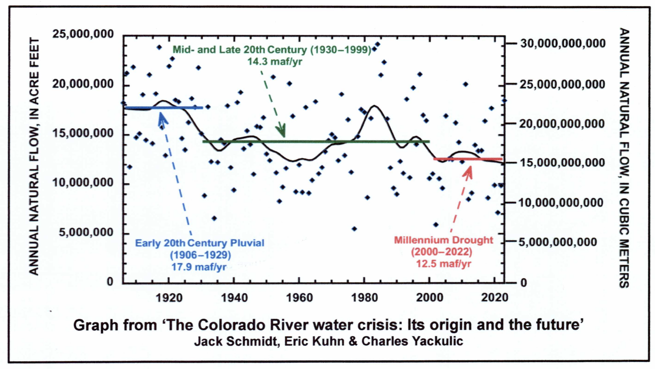
The graph above may look familiar; I used it in a post last summer (June 27, ‘Beyond 2026’). It illuminates a study by three ‘Colorado River elders’: hydrologist Jack Schmidt, retired river manager Eric Kuhn, and USGS scientist Charles Yackulic.
I personally think that every meeting convened on Colorado River issues should have this graph projected on the wall until we all grow to accept it as the reality of our past, present and future situations. Certainly it should be illuminating the meetings currently in process, as representatives of the seven Colorado River Basin states, and its 30 First People tribes, sit down to figure out how to ‘reoperate’ the river after the current ‘Interim Guidelines’ expire (guidelines now modified twice, with increasing urgency) in 2026.
The graph is a record of the flow volumes of the river over the past century-plus, from 1906 to 2022. The flyspecks all over the graph are the annual flows – illustrating a fundamental problem for river planning: the flows are literally all over the map, enabling those motivated more by politics than science to find evidence for any desired perception of bounty or paucity. The wavy black line is their ‘smoothing curve based on the locally weighted least squared error method for the nearest 15% of the data set’ – essentially an effort to sort a pattern out of the seemingly random behavior of the river. What the black line shows is a fairly clear downward trend in the averaged flows – but with upward loops that might inspire hope in anyone grasping for hope.
The brilliance of their study, though, lies in the three straight lines stepping down on the graph. They have broken the recent 117 years of flows – basically the period of our heavy involvement with the River – into three periods, divided around two extended dry spells:
- The blue line shows the average of the river volumes from 1906 to 1929, since discovered through tree-ring studies to have been the wettest period in the river’s natural history going back many centuries. This ‘pluvial’ (very wet period) coincided with what I would call the early dawn of the Anthropocene Epoch, when we humans were beginning to really develop our technical abilities to fundamentally change the geological and ecological ‘nature’ of the planet, to better meet the needs of our swarming species. The Colorado River Compact was created in the middle of this first period; the seven states who divided the river in order to conquer it believed they were working with a river whose roughly measured annual flows averaged just under 18 million acre-feet (maf). Call it the Pluvial Period of our Colorado River. (I say ‘our Colorado River,’ the river which Euro-American civilization claimed as it own to do with as we will – as opposed to the Colorado River on which our river is an ephemeral, maybe one millennium, maybe less, overlay.)
- The green line represents the average of flows for the period from a 1930s ‘wake-up’ dry spell to the end of the century – and the dry spell that began in 2001. The ‘smoothing curve’ shows that, for that 70-year period, the river only came close to the pluvial-period average briefly in the 1980s. The average flow for whole 70-year period was 14.3 maf, 20 percent below the pluvial average. The early 1930s saw the construction of Hoover Dam, and by the end of that period our river was fully developed, all the major structures in place for our various human uses, ranging from irrigation water for four or five million acres of desert land, to domestic water for 35-40 million people, to whitewater in the canyons affording the industrialized recreational opportunity to go risk your life. These changes have also been accompanied by unanticipated and unwanted collateral changes, worst of which are the climatic consequences of the substances that fueled all of our impressive development. Call this the Early Anthropocene Period of our Colorado River.
- The red line represents the average of the river’s volume of flow since the dry spell at the turn of the century – 12.5 maf, 14 percent below the average flow of the Early period, and 30 percent below the average flow of the ‘Pluvial River.’ This period – like the pluvial period – is a short period in the scale of even human time, let alone geological time, but most scientists says it is probably the shape of the future we’ve shaped for ourselves; the red line is much more likely to gradually slope down than go back up, as we continue to pump carbon gases into the atmosphere. Call this the Woke Anthropocene Period – with a flip of the bird for those who wish to remain ‘unwoke’ about the situations we must try to address.

So – today we are working with a river that is roughly only about two-thirds the size of the river a century ago, when we began making plans for controlling and using the river. This being the case – is it unrealistic to suggest that maybe we should start from scratch with this new river we’ve created? Work out a new reality-based post-2026 management plan for our Woke Anthropocene River (the red line on the chart)?
I realize that probably sounds like I’m suggesting we throw out the revered Colorado River Compact, or at least do radical surgery on it. Well, yes, I am suggesting that. I am aware that numerous Colorado River water mavens have said that this is simply impossible, out of the question, but I’m going to argue that it is impossible not to at least seriously dig into it and make some major changes, for a number of very prescient reasons.
The first and most obvious reason is the fact that we have known since the drought of the 1930s and the anemic flows of the 1940s that the 17.9 maf Pluvial River for which the Compact was written was gone, which negated the ‘equitable division and apportionment’ specified in the Compact. When representatives from the four states of the Compact’s Upper Basin gathered in 1948 to create an Upper Colorado River Compact, they knew already that there might only occasionally be 7.5 million acre-feet (maf) of water per year for them, especially since the State Department had given Mexico 1.5 maf/year in 1944, on top of the 7.5 maf the existing Compact said the Upper Basin had to deliver on average to the Lower Basin.
So instead of apportioning 7.5 maf among themselves, they created percentages of whatever was left in the river after fulfilling the Compact and Mexican obligations: 51.75 percent for Colorado, 11.25 percent for New Mexico, 23 percent for Utah, and 14 percent for Wyoming. But X percent of what? That was a problem; estimates dropped from around 6 maf immediately after WWII to around 4 maf today, even as Upper Basin use was increasing. Nonetheless, that division into percentages of what’s actually there in the river, over a five or ten year rolling average, makes more sense than firm numbers devoid of real context.
Another serious flaw in the Compact is its failure to take into account system losses – evaporation, bank seepage, et cetera. For the free-flowing Pluvial River, when the Compact was created, these were relatively minor – maybe 5-8 percent or so of the flow. But as the reservoirs and long canals were added, the system losses increased to around 12-13 percent for the Early Anthropocene River (green line on the graph). And now in the warmer and drier Woke Anthropocene Period, system losses are closer to 16 percent of the total flow, maybe more. It’s hard to get good numbers for this because the science of measuring it, especially sublimation and transpiration, is still fairly primitive.
Being committed to deliver defined quantities to the Lower Basin and Mexico, the Upper Basin states absorb their system losses as part of their ‘whatever is left’ portion of the river’s water, but the Lower Basin states have never deducted from their 7.5 maf share the system losses from their several reservoirs (including the huge Mead Reservoir) and hundreds of miles of open canals. They have written it off as covered by ‘surplus flows’: Upper Basin water that made it past Lee Ferry or, since the 1960s, into Powell Reservoir, which the ever-accommodating Bureau continues to pass along as ‘surplus.’ This included roughly 10 million acre-feet of water since 2000 that the Upper Basin has no storage for above Powell (effectively Lower Basin storage), but that ‘surplus’ only made up about half of the Lower Basin’s system losses for the Woke period; the rest was drained from reservoir storage, creating most of the shortages in the 2020s. Real hydrology has to dominate distribution. [ed. emphasis mine]
Another Compact problem: The division of the Colorado River into two basins – hailed as a stroke of genius in the 1920s – was not a smart thing to do with a desert river. A desert river only exists because of a ‘water producing’ upland high enough to cool and condense precipitation from air forced up its slopes. At least 85 percent of the water in the Colorado River comes from snow and rain in the 10 percent of the natural basin above 8,000 feet elevation – a boundary that bears no relation to the geographically and ecologically irrelevant state boundaries that are the basis for the Compact division.
A desert river divides naturally into a ‘water producing’ region and a ‘water using’ region. Would it not make a great deal of sense for all of those in the water-using portion of the desert river to be directly involved in – and invested in – the care and keeping of the water-producing portion of the river?
But that is unthinkable under the Compact, which is based on those geographically irrelevant state boundaries, creating two geographically clumsy state-based ‘basins’ that are pitted against each other, the upper one mandated to pass a set amount of water to the other regardless of the climatic vagaries imposed on their mutual headwaters, conceivably having to eventually sacrifice some of its own uses of the waters to deliver the set quantities.
The state-based two-basin division was just a field-expedient solution to the problem that really drove the Compact Commissioners: how to persuade Congress that there was enough agreement among the seven states on the use of the river’s water to allow Congress to go ahead and fund the creation of a big control and storage dam on the mainstem. But the expedient solution has resulted mostly in a worsening antipathy between the state-based basin that includes both the river’s water-producing region and quite a bit of its water-using region, and the state-based basin that consumes most of the produced water and produces comparatively little.

An example of what this means can be seen in the recent ‘forest planning’ process for the Grand Mesa, Uncompaghre and Gunnison National Forests. These three National Forests are mostly above 8,000 feet in the Gunnison River Basin where 15 to 20 percent of the Colorado River’s water is produced. The forests shade and shelter the winter snowpack from sun and wind, but also cause the sublimation of an undetermined part of it through branch interception, and [then] drinking heavily from the water as the snowpack melts; there are probably a host of other more subtle and complex interactions affecting water production.
But the draft forest plan issued last summer did not even mention the Colorado River by name, let alone its water needs. Concerns expressed by probably more people than just me resulted in a couple paragraphs in the revised final draft plan about the river and its climate-related troubles, but there is still no sense that the plan requires forest managers to be as actively concerned about their organic charge to ‘secure favorable flows of water’ as they traditionally are about the companion charge to provide a dependable supply of timber. And which is more important for the Colorado River Basin: timber production (small and scraggly compared to the northern Rockies) or water production?
Yet an admittedly quick search of the hundreds of comments on the first draft and the objections to the final draft show no comments about this omission from any of the big water users downriver from the forests. And the Compact does not encourage what would be construed as interbasin meddling. We need to be one river.

A final reason why the Colorado River Compact should probably be scrapped and a new one created is the fact that the 30 First People nations overlaid on the seven states will no longer be covered (literally) and dismissed with a single sentence; they will be part of the new management regimen, and this alone mitigates for starting over. They have popular support that the representatives of the Great Father in Washington no longer enjoy, and will either be, in the immortal words of Lyndon Johnson, in the tent, or out of the tent pissing in.
In fact, a place to start the whole process of planning for the new Woke Anthropocene River might be for everyone involved to look at a document called ‘A Common Vision for the Colorado River System: Toward a Framework for Sustainability.’ This comes from a ‘Ten Tribes Partnership’ of desert First Peoples, most of whom have gone through, or are still going through, the ‘settlement’ process of negotiating for some portion of the water that should have been theirs since the creation of their reservations (see my last post). Its authors understand the patience, and the willingness to give a little (or a lot) to get a little, that will have to be present as we all figure out what to do beyond 2026 with a shrinking river. Many will find their vision statement naive, but at least they have an articulated and somewhat unified vision, which can hardly be said for the Compact states, where each state just wants, as one water leader said for Colorado, ‘for our state to come out stronger.’ Stronger than what, or whom, and how?
