
Click on a thumbnail graphic to view a gallery of drought data from the US Drought Monitor website.


Click the link to go to the US Drought Monitor website. Here’s an excerpt:
This Week’s Drought Summary
This U.S. Drought Monitor (USDM) week saw improvement in drought-related conditions across areas of the West, Lower Midwest, Northeast, and the South. On the map, widespread improvements were made in drought-affected areas across Arizona as well as in other areas of the Desert Southwest including western New Mexico and southern Utah. In California, storms during the past few weeks, in addition to an overall wetter pattern in recent months, have continued to help improve conditions leading to removal of areas of drought in Southern California. Since October 1st, numerous locations in California, southern Nevada, and Arizona have received record to near-record precipitation accumulations including Santa Barbara, California (+8.2-inch departure from normal), Ontario, California (+4.11 inches), Las Vegas, Nevada (+2.08 inches), and Flagstaff, Arizona (+5.71 inches). In the Pacific Northwest, drier-than-normal conditions have prevailed (past 30-days) across areas of the region including central and eastern Oregon, southern Idaho, and southwestern Montana. Moreover, snowpack conditions across the Pacific Northwest continued to lag behind normal levels. In the Lower Midwest (Missouri) and areas of the South (Texas), widespread improvements were made in response to rainfall events during the past week. In areas of the Upper Midwest (Michigan, Wisconsin), exceptionally dry conditions have prevailed during the past 60-day period with numerous locations observing record to near-record dryness. In the Southeast, warm and dry conditions continued leading to expansion and intensification of drought conditions in the Florida Panhandle, southern Alabama, and southern Georgia. In the Northeast, recent rains led to reduction of areas of drought in West Virginia, while isolated areas of New England saw minor improvements.
In terms of reservoir storage in areas of the West, California’s reservoirs continue to be at or above historical averages for the date (November 24), with the state’s two largest reservoirs (Lake Shasta and Lake Oroville) at 110% and 100% of their averages, respectively. In the Southwest, Lake Powell is currently 29% full and Lake Mead is 32% full, with the total Colorado River system contents at 37% of capacity on November 23 (compared to 42% of capacity at the same time last year), according to the U.S. Bureau of Reclamation. In Arizona, the Salt River Project is reporting that the Salt River system reservoirs are 54% full, the Verde River system is 68% full, and the total reservoir system is 56% full (compared to 73% full a year ago). In New Mexico, the state’s largest reservoir, Elephant Butte, along the Rio Grande River is currently 5% full (12% of average). In the Pacific Northwest, Washington’s Franklin D. Roosevelt Lake is 94% full (105% of average for the date), Idaho’s American Falls Reservoir on the Snake River is 25% full (64% of average), and Hungry Horse Reservoir in northwestern Montana is 88% full (107% of average)…
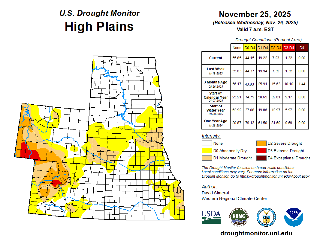
High Plains
On this week’s map, only minor changes were made in the region, including changes in eastern Kansas, Nebraska, and southwestern South Dakota. For the week, precipitation across the region was generally light and primarily restricted to eastern and central portions of Kansas as well as in eastern and central South Dakota. In terms of average temperatures, warmer-than-normal temperatures (5 to 15+ degrees F above normal) were observed across the region with the greatest anomalies observed in the Dakotas. According to NWS NOHRSC, the current regional snowpack spatial extent is limited to areas of central and northern North Dakota…

West
Out West, recent storms have delivered much-needed precipitation to drought-affected areas of California, central and southern Nevada, southern Utah, Arizona, southern Colorado, and western New Mexico. On this week’s map, widespread improvements were made in Arizona, across the southern-third of California, and in isolated areas of Nevada, Utah, Colorado, and New Mexico. Moreover, the recent storm activity in the southern extent of the region has boosted snowpack conditions in the southern and central Sierra Nevada, Spring Mountains (southern Nevada), San Francisco Peaks (northern Arizona), Mogollon Rim (central Arizona), ranges of southwestern Utah, and Nacimiento Mountains (northern New Mexico). Elsewhere, snowpack conditions were poor across most of the Intermountain West and Pacific Northwest. In other parts of the region, some minor degradations were made on the map in northern Colorado and north-central Montana…
South
Across much of the region, generally dry conditions prevailed this week, especially in the far southern and western portions of the region, with little or no precipitation observed. In contrast, light to moderate rainfall (2 to 4+ inches) was observed along a swath extending from central Texas to southwestern Arkansas. The beneficial rainfall led to one-category improvements in areas of Moderate (D1) to Extreme Drought (D3) with most of the improvements focused on areas of central and northeastern Texas. Elsewhere, minor improvements were made on the map in southeastern Oklahoma, southwestern Arkansas, and northern Mississippi. In Louisiana, short-term precipitation deficits (past 90-day period) and declining soil moisture levels led to expansion of areas of Moderate Drought (D1) and Severe Drought (D2). For the week, average temperatures were well above normal across the region with anomalies ranging from 4 to 16 degrees F above normal. Looking at reservoir conditions in Texas, Water for Texas (November 25) was reporting statewide reservoirs at 74% full, with many reservoirs in the eastern part of the state in very good condition, while numerous reservoirs in the western portion of the state were experiencing continued below-normal levels…
Looking Ahead
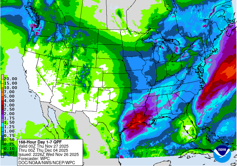
The NWS Weather Prediction Center 7-Day Quantitative Precipitation Forecast (QPF) calls for moderate precipitation accumulations ranging from 2 to 4+ inches (liquid) across areas of the South and areas of the Southeast. Likewise, a significant winter storm is expected to impact the Upper Midwest and Great Lakes regions. In the West, dry conditions are expected to prevail across California and the Great Basin, while some lighter accumulations are expected across the Intermountain West. In the Pacific Northwest, moderate accumulations are expected across western Washington and some lesser accumulations across areas of the Northern Rockies of Idaho and northwestern Montana. The Climate Prediction Center 6-to-10-day Outlook calls for a moderate-to-high probability of below-normal temperatures across the eastern half of the West, Plains, South, Midwest, and Northeast. Above-normal temperatures are expected across the Southeast and along the Pacific Coast from Northern California to Washington. In terms of precipitation, there is a low-to-moderate probability of above-normal precipitation across most of the conterminous U.S. except for northern California and western Oregon where below-normal precipitation is favored.
