
Click the link to access the update on the NOAA website:
May 14, 2026
West Braces for Critical Water Shortages After Unprecedented Snow Drought
Key Points
- Snowpack, the western U.S.’s largest non-man made reservoir, is already gone in many places. Significant hydrological drought impacts (low water supply) are already occurring and will continue through summer across much of the West. Compounding these impacts, the West continues to experience long-term drought. Drought conditions can be expected to deteriorate, and impacts to become more pronounced.
- April and May snowfall in some areas did not offset seasonal snow deficits, but increased soil moisture and slowed high-elevation snowmelt, which may slow drought deterioration and temporarily mitigate early season wildfire risk. Snow did not fall in all states.
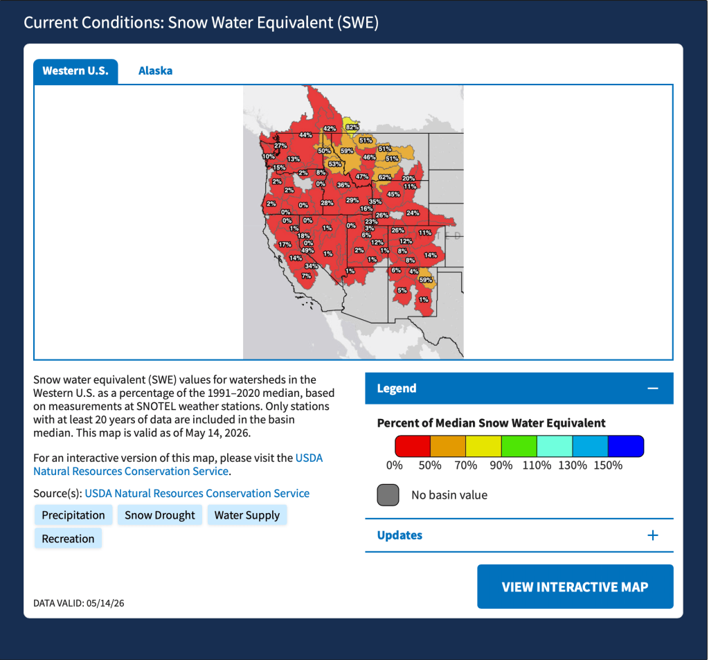
- This year’s peak snowpack will be the new benchmark low for Wyoming, Utah, Colorado, and New Mexico; there are no comparable years. [ed. emphasis mine] In these states, snow water equivalent (SWE) around April 1, the usual peak date, was 32- 53% lower than the previous record low during the SNOTEL era. In Idaho, record warm temperatures pushed snow to only the high elevations, leaving the state with no historical comparison.
- Earlier-than-normal meltout (snow no longer present) occurred across the Western U.S., with many SNOTEL locations setting a new earliest or second earliest meltout date on record. Water supply forecasts in many watersheds are still forecasted to approach historic lows or at historic lows.
- In Oregon, 62 of 73 forecast points are approaching or at historic lows.
- In Utah, peak flows occurred and concluded in many streams before the spring runoff season even started.
- As the West enters summer, evaporative demand (thirst of the atmosphere) and water demands will increase. This will further strain and reduce water supplies. Current outlooks favor-warmer-than-normal normal temperatures. Any relief will depend on late spring storms, along with the level of activity and geographic extent of the monsoon season.
Snow Drought Conditions Summary
This update is based on data available as of Monday, May 11, 2026 at 12:00 a.m. PT. We acknowledge conditions are evolving.
Quantifying snow drought values is an ongoing research effort. Here, we define snow drought as snow water equivalent (SWE) at or below the 20th percentile, which is a baseline guided by partner expertise and research. Note that reporting of SWE by Snow Telemetry (SNOTEL) stations may be unavailable or delayed due to technical, weather or other issues, which may affect snow drought depiction in this update.
Current Conditions
The unprecedented heat wave and rapid snowmelt in March made recovery from the snow drought nearly impossible, despite the April and May snow for some. The April and May storms slowed snowmelt in the high elevations where little snowpack remains and brought rain to the lower elevations, increasing soil moisture. These conditions will likely slow further drought deterioration and mitigate immediate wildfire risk. However, not all states saw this precipitation. Outlooks continue to favor an early start to the wildfire season in some areas of the West.
This water year continues to be the warmest on record (since 1895) in California, Nevada, Utah, Arizona, Colorado, Utah, New Mexico, Wyoming, and Montana; the second warmest in Oregon and Idaho; and the fourth warmest in Washington. The average temperature over the last 5 years was the warmest on record in Wyoming, Arizona, Colorado, Idaho, Montana, Nevada, Utah, and Washington. In California and Oregon, the last 5 years were the third warmest 5-year period on record. Many states are experiencing long-term drought, compounding the impacts from this year’s snow drought. Record low water supply are forecasted in many locations, reflecting the impacts of this year’s snow drought, long term drought, and record warmth.
This year’s western snow drought is considerably worse than significant snow droughts of the past for many states. Even for states where there is precedence, anticipating impacts or drawing comparisons to previous significant snow droughts is challenging given increasing demands on western water supply and multiyear droughts. In Washington, snowpack in 2026 was greater than its record low, 2015, and similar to that in 2001. However, Washington is in its fourth consecutive year of drought, and a drought emergency was declared in all previous years with similarly low snowpack. This year’s peak snowpack will be the lowest on record for Wyoming, Utah, Colorado, and New Mexico. This year will represent the new benchmark low. In these states, snowpack around April 1, the usual peak date, was 32- 53% lower than the previous record low in the SNOTEL record. Idaho also experienced a new record low snow season. In Idaho, warm temperatures melted snow at middle and lower elevations, and no previous years compare to this condition for the state.
Given that snow droughts often precede hydrological drought (when low water supply becomes evident in the water system), significant hydrological drought impacts are already and will continue to impact much of the West.
Jump to conditions for your region:
- Colorado, Idaho, Montana, Utah, Wyoming (Rocky Mountains) Snow Conditions
- Arizona and New Mexico Snow Conditions
- Oregon and Washington Snow Conditions
- California and Nevada Snow Conditions
- Alaska Snow Conditions
Widespread Early Snowmelt Across West

Central Rocky Mountains
Much of the snow is gone at SNOTEL stations in Utah and Colorado, with snow remaining at only 12% and 37% of stations in the two states, respectively. At stations where snow has disappeared, the melt out occurred an average of 40 days early. Snow water equivalent (SWE) at most of the remaining stations is at 20% of median or less. Storms in April slowed high elevation snowmelt, but were far from sufficient for the region to recover from considerable seasonal SWE deficits. An early May snowstorm in Colorado brought beneficial moisture to parts of the state, but again, did not alleviate the SWE deficits and water supply concerns. Record low streamflow volumes are forecast for the Yampa River (28% of average) and the Colorado River at Lake Powell (13% of average). Temperatures in October-April in Utah and Colorado were the highest on record, but, in contrast to the northern Rocky Mountains, seasonal precipitation across the region was generally much below normal. Water year precipitation totals were below the 15th percentile for many SNOTEL stations in central Utah and central and northern Colorado.
Utah
On May 7, 2026, the Utah Drought Response Committee formally recommended Utah Governor Spencer Cox issue a drought emergency declaration for all 29 counties in the state. The recommendation cited record low snowpack, water supply concerns, and statewide drought. Formal drought declarations also were issued for parts or all of the state in 2021, 2022, and 2025. Drought has impacted southern Utah for 8 of the last 10 years. A formal drought emergency declaration allows the state to activate resources, support agriculture, and coordinate water restrictions.
Colorado
On March 16, 2026, acting on recommendations from the state’s Water Conditions Monitoring Committee, Governor Jared Polis activated Phase 2 of the state’s Drought Response Plan and the state’s Drought Task Force. The actions followed the warmest start to the water year in the Colorado Climate Center’s 131-year record, and statewide snow water equivalent among the lowest in more than four decades of records. The last time the Drought Task Force was activated was in 2020. During every year since 2020, portions of the South Platte River and Rio Grande River have required priority calls to curtail water use to ensure that senior water rights holders receive their legal share. The Drought Task Force identifies critical impact areas to coordinate state-level support and resources for affected Colorado communities.
Arizona
In 2025, Arizona operated under Tier 1 reductions in Colorado River Water Supply and is still operating under this structure. These reductions are a result of less available water in the Colorado River, impacting central Arizona agricultural users. These reductions represent a 512,000 acre-foot reduction in water, with most reductions being taken by the Central Arizona Project water users.
New Mexico
Several years of extreme drought and the earliest snowmelt on record are challenging water users of the Rio Grande River. The Middle Rio Grande Conservancy District began staggered irrigation operations in late March with natural flow of the Rio Grande. The Carlsbad Irrigation District began releases for irrigation on March 22 and has allocated only 2.5 acre-feet per acre to farmers.
For More Information, Contact:
Dan McEvoy
Desert Research Institute, Western Regional Climate Center
daniel.mcevoy@dri.eduJason Gerlich
University of Colorado Boulder Cooperative Institute for Research in Environmental Sciences / NOAA’s National Integrated Drought Information System
jason.gerlich@noaa.govTony Bergantino
Wyoming State Climate Office, University of Wyoming
antonius@uwyo.eduAmanda Sheffield
University of Colorado Boulder Cooperative Institute for Research in Environmental Sciences / NOAA’s National Integrated Drought Information System
amanda.sheffield@noaa.gov