After results late last year showed water wells in three out of 18 homes in a mountain community west of Boulder had elevated levels of polyfluoroalkyl substances, or PFAS, the county and Colorado Department of Public Health and Environment plan to test the water at 10 additional properties this year.
Ron Falco, safe drinking water program manager for the state of Colorado, said the department and county are in the process of finalizing an a $8,000-contract to continue testing in the Boulder Heights subdivision. The cost will be covered by the CDPHE. Falco said officials hope more water samples will provide answers on the extent of the contamination and bring awareness to residents…
Testing is anticipated to begin mid-February. Results could be ready sometime in March. The testing follows an announcement last year that contaminated water was found in a well at the Boulder Mountain Fire Protection District’s Station 2.
Joe Malinowski, the environmental health, division manager for Boulder County Public Health, said it still is unknown what the source for contamination is…
The three homes that tested above the health advisory of 70 parts per trillion last year, showed combined levels of perfluorooctanic acid, PFOA, and perfluorooctane sulfate, PFOS, at 2,057 parts per trillion, 416 parts per trillion and 200 parts per trillion…
Homeowners who live in the mountain community depend on wells as a source of water…
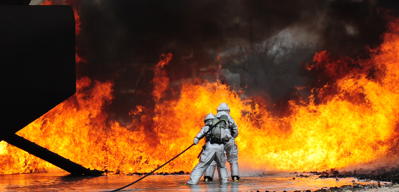
Many PFAS chemicals found in water have been traced to a type of fire suppressant, called Class B firefighting foam, according to the CDPHE. The foam is used to fight industrial and chemical fires. Benson emphasized in a September meeting that the station does not use this type of foam. Last year, state legislature passed House Bill 19-1279, calling on state health departments to conduct surveys every three years of fire departments to determine use and disposal of the foam.
The CDPHE, county and fire department have worked together to determine which homes should be tested, Falco said. The properties are near the fire station or slightly outside the 1,500-foot radius, according to Malinowski.
Click here to read the January 2020 Western Water News from Audubon. Here’s an excerpt:
Western Water News
UPDATE: New Federal Rule Reduces Protections for Water in the West, Harming People and Birds
The Trump Administration’s revised Waters of the United States rule shrinks the number of waterways protected under the Clean Water Act.
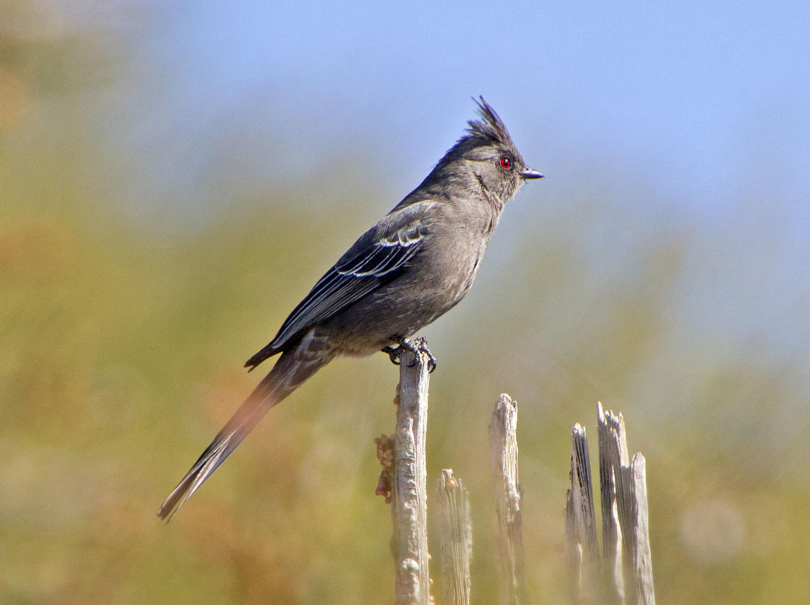
Phainopepla. Photo: Elaine Padovani/Great Backyard Bird Count via Audubon Rockies
UPDATE (1/23/2020): Today, the Trump Administration announced finalization of rollbacks to the Clean Water Rule. The newly published Navigable Waters Protection Rule removes Clean Water Act protections for many rivers, streams, and wetlands, which could allow them to be altered, degraded or filled without first seeking a federal permit. For example, a large number of streams and wetlands that only flow or are wet for part of the year are now exempt from Clean Water Act protections. Some 138 species and subspecies of birds in the U.S. are designated as “wetland dependent” and many more are threatened by the new rule.
At Audubon, we know the value that wetlands, rivers, lakes, and streams provide to birds. These waterways are critical habitat for the lifecycle of millions of birds, not to mention the millions of people who rely on clean water to drink, bathe, wash, and grow our food.
Riverside forests and wetlands—fed by both continuous and intermittent water sources—are essential for birds, particularly in the arid Southwest.
However, under the 2019 Proposed Revised Definition for Waters of the United States (WOTUS) many waterways that flow for only portions of the year would be excluded from Clean Water Act protections. This means ephemeral waterways like the Rio Puerco in New Mexico, Centennial Wash in Arizona, Milpitas Wash in Southern California’s Imperial County and Chemehuevi Wash in San Bernardino County would no longer be protected. Without WOTUS protections, developers can build in these areas without federal permits, and the waterways and their surrounding environments would be unprotected from potentially harmful discharges. In the past, industrial operators used these dry washes as disposal sites for pollutants, only to end up contaminating the groundwater below.
Along many of the dry washes in the desert Southwest, trees like mesquite, palo verde, and ironwood thrive. When water occasionally flows through these normally dry washes, these thrifty trees take advantage. Along these washes, trees grow tall and into dense desert forests. They support abundant avian life, especially Lucy’s Warblers, Bell’s Vireos, Black-tailed Gnatcatchers, Phainopeplas, and Ladder-backed Woodpeckers. These woodlands comprise only five percent of the acreage in the desert regions of the Southwest but support 90 percent of the bird life, according to A Natural History of the Sonoran Desert. For these habitats to be stripped of their protections under the Clean Water Act means a serious risk of habitat loss in areas of outsized importance for birds.
On the human side of the equation, excluding dry washes and ephemeral streams and rivers risks damage to property through flooding. In Arizona, for example, drainages coming off local mountain ranges flow infrequently. However, when they do flow due to rain or snow events, floodwaters can overwhelm the normally dry channels. Clean Water Act protections can require that developers mitigate impacts to these washes, or mandate that development keep the washes intact in order to act as drainages for storm events. As part of the urban fabric, these washes serve as flood protection for communities during storm events and as corridors for wildlife when dry.
Losing protections on thousands of stream and river miles because they only flow seasonally or after rain events or snowmelt will negatively impact the birds and people who rely on these important water resources throughout the Southwest. Audubon will submit formal comments on the proposed WOTUS definition to the Environmental Protection Agency and the Army Corps of Engineers by the April 15, 2019 deadline, and we invite you to do the same.
Jan. 23, 2020, the Environmental Protection Agency (EPA) Administrator Andrew Wheeler announced the improved definition for “waters of the United States” (WOTUS) with the Navigable Waters Protection Rule. “ The Navigable Waters Protection Rule ends decades of uncertainty over where federal jurisdiction begins and ends. For the first time, EPA and the Army Corps of Engineers are recognizing the difference between federally protected wetlands and state protected wetlands. It adheres to the statutory limits of the agencies’ authority. It also ensures that America’s water protections – among the best in the world – remain strong, while giving our states and tribes the certainty to manage their waters in ways that best protect their natural resources and local economies.”
In March 2014, the Obama administration released a regulation that would assert Clean Water Act jurisdiction over nearly all areas including those with undiscernible connections to water resources and man-made conveyances. Specifically, the Obama WOTUS rule expanded agency control over 60 percent of the country’s streams and millions of acres of wetlands that were previously non-jurisdictional. In September 2019, the Trump administration, EPA and Army Corps of Engineers repealed the controversial 2015 WOTUS rule and proposed a new Clean Water rule clarifying which level of government, federal or state, would oversee water features and dry land that is sometimes wet.
The revised WOTUS definition identifies four clear categories of waters that are federally regulated under the Clean Water Act: the territorial seas and traditional navigable waters; perennial and intermittent tributaries; certain lakes, ponds and impoundments; and wetlands that are adjacent to jurisdictional waters. The final action also details what waters are not subject to federal control, including features that only contain water in direct response to rainfall; groundwater; many ditches, including most farm and roadside ditches; prior converted cropland; farm and stock watering ponds; and waste treatment systems.
Leaders of the National Potato Council (NPC) welcomed the announcement that the U.S. Environmental Protection Agency (EPA) finalized its proposed rule defining the Waters of the United States (WOTUS) rule with the Navigable Waters Protection Rule. EPA’s action also defines what waters are not subject to federal control, including most farm and roadside ditches, prior converted cropland, and farm and stock watering ponds.
“Potato farmers are committed to protecting the nation’s waters,” said Britt Raybould, President of the National Potato Council. “However, the imposition of unnecessary federal burdens, such as regulating ditches on private farms that are generally dry throughout the year, undermines that overall mission by creating uncertainty and increasing costs. EPA’s newly issued rule avoids those negative outcomes and provides increased clarity regarding the responsibilities of farmers under the Clean Water Act in protecting our nation’s surface water resources.”
[…]
Contrastingly, Jill Hunsaker Ryan, executive director, Colorado Department of Public Health and Environment stated, “The EPA’s announcement today is alarming as it puts our precious waters at risk. Every Coloradan, and so many others from neighboring states, are dependent on Colorado’s healthy waterways. At the department, regardless of what happens at the federal-level, we’ll always be committed to the health of our waters. Healthy waters mean healthy Coloradans,” said Jill Hunsaker Ryan, executive director, Colorado Department of Public Health and Environment.
“In the absence of federal leadership, we are going to do everything possible to protect streams and wetlands in Colorado. It’s sad that we have to step up in contrast with our federal government on something so basic as protecting our water, but we must. The rollback removes huge swaths of Colorado’s waters from federal jurisdiction, waters used by 19 states and Mexico. It’s estimated that almost 70 percent of our Colorado Waters could be impacted by this rule. Additionally, the change will impose significant burdens upon the State of Colorado,” said Patrick Pfaltzgraff, director, Water Quality Control Division.
Earlier in the year, the Colorado Department of Public Health and Environment, Colorado Department of Natural Resources, and Colorado Department of Agriculture collectively rebuked the EPA’s proposed rule change.
When Wendy Rash was diagnosed in 2005 with a thyroid disorder, chronic fatigue and other ailments, her doctor couldn’t explain her suddenly failing health.
Soon, other family members became ill. Her brother-in-law contracted fatal kidney cancer. Her father-in-law developed esophageal cancer. Then her 32-year-old son began having severe kidney problems.
It wasn’t until 2016 that scientists tested the tap water they had been drinking and found it was contaminated with man-made chemicals known as per-fluorinated compounds, part of a family of chemicals called PFAS. The chemicals were traced to firefighting foam from a nearby military airfield, one of hundreds of Pentagon bases nationwide that for decades may have contaminated drinking water used by tens of thousands of people.
“We had no clue,” said Rash, 58.
The role played by PFAS in the family’s illnesses is not known. Studies have shown a link between the chemicals and a range of health problems, including an elevated risk for some cancers, but they have not established a clear cause-and-effect relationship.
Widefield aquifer via the Colorado Water Institute.
Rash’s family history of illnesses is common in Fountain, a Colorado Springs suburb flanked by mountains and military bases. And the scientific uncertainty about how much risk residents face has only worsened the anxiety many feel, as Fountain and surrounding towns have become a center of the growing national furor over the possible health effects of ingesting PFAS.
Congress is trying to expand regulation of the chemicals. Earlier this month, the House voted 247 to 159 in favor of a bill requiring the Environmental Protection Agency to designate PFAS as hazardous substances, which would free up funds for the cleanup at contaminated sites.
But the Trump administration has threatened to veto the bill, saying in a Jan. 7 statement that such a move would force high compliance costs on businesses and states, and that the EPA, not Congress, should make the decision.
Dominion, a wholesale district, has the vision to develop a renewable water and centralized wastewater system for northwest Douglas County. Dominion’s system provides options where none have existed before.
To create a water system that is built to last, we leveraged location, infrastructure and partnerships to create a regionally integrated network. As we grow, our values remain the same: dependability, water quality, environmental stewardship and innovation.
Dominion began this journey by partnering with other water providers to leverage regional assets to most economically and efficiently serve our customers. We continually engage our regional partners and prioritize cooperation within the water and wastewater community.
Currently, we have agreements with South Metro WISE (Water Infrastructure and Supply Efficient Partnership), Aurora and Castle Rock for renewable water. These agreements, along with Dominion’s other water supplies, give us the flexibility to provide water to Sterling Ranch and potentially new customers within our 33,000-acre service area.
Dominion will continue to grow and strengthen its portfolio. In addition to our water supply agreements with regional partners, in 2019, Dominion’s board approved the purchase of 500 acre-feet of storage in the Chatfield Reallocation Project from the state of Colorado. With this storage, shared with nine other water providers, Dominion will expand its ability to efficiently utilize its renewable water.
In 2020 Dominion’s long-term investments will connect northwest Douglas County to the largest water providers in Colorado. At the heart of Dominion’s system is the new Eastern Regional Pipeline that will bring 1,325 acre-feet of renewable WISE water to our region and add to Dominion’s already robust and reliable water supply portfolio.
This pipeline is the key to bringing renewable water to northwest Douglas County, giving those on unsustainable groundwater an exciting opportunity. The pipeline will not only carry the WISE supply but also future supplies to serve prospective customers and firefighting capabilities for much of the region. The new pipeline is nearly complete and is expected to connect this summer, completing a loop the south metro water providers have been working toward for over a decade.
Sterling Ranch
Dominion also continues to stay in the forefront of innovative solutions to support and develop water technology, sustainability and management. We are developing rainwater harvesting through the only state-approved pilot project. In late 2019, thanks to a long-running relationship between Vanderbilt University and Sterling Ranch, Dominion, Aurora and South Metro partners are working with Vanderbilt on water-treatment technologies that would address water quality challenges faced broadly by Colorado and nationwide.
The Trump administration formally proposed a rule last week that strips away protections that have been in place 50 years for waters all across the U.S. In what is seen as a victory for fossil fuel producers, farmers, and real estate developers, the proposed rule retains protections for large bodies of water, rivers, and streams—but removes safeguards for many wetlands, intermittent streams, and groundwater.
E & E News reports that a group called Public Employees for Environmental Responsibility, made up of current and former EPA scientific advisers, has filed a complaint calling for an investigation into the process leading to the new rule, charging that it was based more on politics than science. They claim that the final rule contradicts the overwhelming scientific consensus on the connectivity of wetlands and rivers and streams. They add that officials instructed staff not to submit comments for the record.
The new rule, which will be implemented in 60 days, is sure to be challenged in court by environmental groups and some state attorneys general. The outcome, if it makes it to the Supreme Court, is not certain. One environmental law expert told Politico that conservative justices on the Court may not like the way the Trump administration ignored both science and the experts it picked to advise the EPA.
Fen soils are made of a rich, organic peat material that take thousands of years to form and require a constant groundwater source to survive. At the Rocky Mountain Fen Research Project, scientists transplanted fen soils from another site to the “receiver” site south of Leadville where they restored a groundwater spring to sustain the transplanted soils. Photo credit: Sarah Tory/Aspen Journalism
Elected officials and advocacy groups in Colorado responded to a change to a federal rule on water protections.
The previous rule, called “Waters of the United States,” or WOTUS, was established in 2015 by the Obama administration. That rule, however, was under intense scrutiny by Republicans, property rights groups, and several industries for what they perceived as federal regulatory overreach, citing it’s expansive interpretation.
That rule was repealed by the U.S. Environmental Protection Agency and the Department of the Army in September.
The new rule, called the Navigable Waters Protection Rule, was announced on Thursday at a builders’ industry trade show in Las Vegas.
The Trump administration says the new rule will still protect navigable waters from pollution but also will provide regulatory relief and more certainty for development.
“EPA and the Army are providing much needed regulatory certainty and predictability for American farmers, landowners and businesses to support the economy and accelerate critical infrastructure projects,” EPA Administrator Andrew Wheeler said in a statement. “After decades of landowners relying on expensive attorneys to determine what water on their land may or may not fall under federal regulations, our new Navigable Waters Protection Rule strikes the proper balance between Washington and the states in managing land and water resources while protecting our nation’s navigable waters, and it does so within the authority Congress provided.”
The new rule creates four different categories for bodies of water to be federally regulated under the Clean Water Act, and excludes certain types of bodies of water such as ditches.
The new rule drew broad criticism from Colorado Democrats and environmental groups that work in the state.
“In Colorado, we value our clean water. Our rivers, streams, and lakes serve as the lifeblood of our communities and help support our thriving outdoor and agriculture industries,” Gov. Jared Polis said. “Our administration will continue to reject attempts by the Trump administration to gut proven ways to protect our health and environment.”
U.S. Rep. Ed Perlmutter, D-Colo., tweeted that the new rule “removes protections for smaller bodies of water & rolls back federal protections for smaller headwaters that have been protected for almost 50 years – including the Colorado River.”
Western Resource Advocates, an environmental advocacy group headquartered in Boulder, in a tweet urged state lawmakers “to stand w/ their communities & lead where the federal government won’t. We’re calling on our leaders throughout the West to come together & safeguard healthy rivers & clean water.”
Republicans and some industry groups praised the rule change for reducing regulations.
“The uncertain interpretation of the term ‘navigable waters’ created by WOTUS has left farmers, ranchers and private land owners unprotected from federal land and water grabs,” U.S. Rep. Scott Tipton, R-Colo., said “Over the last three years, President Trump’s administration has worked to repeal unnecessary and burdensome regulations with updated versions that better suit the needs of our agricultural communities.”
Don Shawcroft, president of the Colorado Farm Bureau, which advocates for agricultural interests, said the new “rule provides clarity and stability for farmers and ranchers everywhere, ensuring that farmland remains healthy and productive, and our waters protected. It is a major win for Colorado agriculture.”
Both the Colorado Chamber of Commerce and the National Federation of Independent Business-Colorado supported the rule change.
In response to proposed PFAS regulations, cities and water managers are raising concerns over their financial liability
In the summer of 2018, Lucy Molina, a 45-year-old mother of two who lives in Commerce City near the Suncor oil refinery, said a city council member told her that her tap water was contaminated with toxic per- and polyfluoroalkyl chemicals, also known as PFAS. At the time, she said, she didn’t know what the chemicals were. It was just one more reason to not drink the water in the heavily industrial north Denver area…
The city’s water utility, South Adams County Water and Sanitation District, put out a news release in July 2018 saying the water was safe to drink because the PFAS concentrations fell below the Environmental Protection Agency’s health advisory limit of 70 parts per trillion. One part per trillion is about equal to one grain of sugar in an Olympic-sized swimming pool.
But in the wake of growing public concern over PFAS, a group of chemicals used in a range of products, including firefighting foam, non-stick cooking wear and Gore-Tex waterproof outdoor gear, Colorado’s health agency is questioning whether that concentration limit is in fact safe.
“If I ask the state toxicologist and I ask experts in the field, they will never use terms like ‘safe’ with respect to PFAS,” said John Putnam, the director for environmental programs at the Department of Public Health and Environment. “Because we don’t really know, since there are limits to all these studies.”
New research has linked exposure to PFAS to health issues including cancer and immune, reproductive, and hormonal dysfunction. But the EPA’s advisory level, which is not enforceable, hasn’t changed since 2016 and seems unlikely to be revised any time in the near future. The Trump administration’s EPA has been rolling back water protections. And Congress has failed to pass comprehensive PFAS regulations, in part because Republicans, including those in Colorado’s delegation, have concerns about how much it will cost cities and water managers to comply. Compliance could include more frequent testing of water supplies costing thousands of dollars per week and upgrades to water treatment facilities that could cost millions of dollars.
That’s left Colorado in the unprecedented position of scrambling to set a drinking water standard — and then trying to enforce it. Putnam said this is a task the state doesn’t have the money or staff to handle yet. And any effort it takes to cut corners to hold polluters accountable or mandate cleanup could be challenged in court by cities, water managers and other groups concerned about their own financial liabilities…
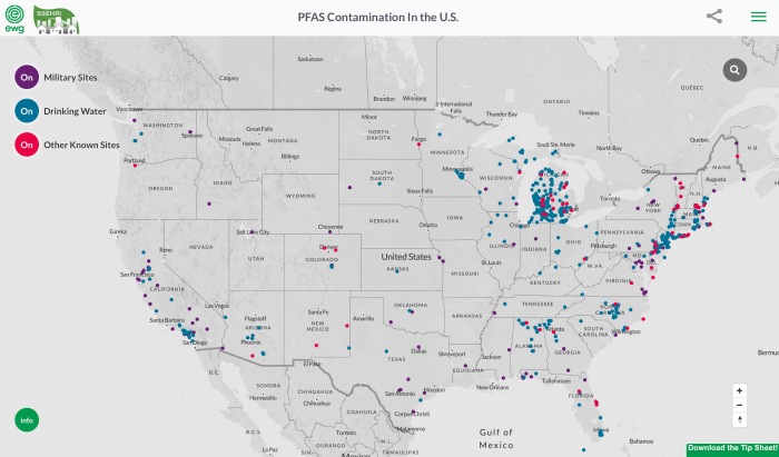
But some residents in Colorado are tired of waiting. Since 2016, the state has known the toxic, mostly non-biodegradable “forever chemicals” have been found in Colorado’s drinking water supplies above the federal advisory limit. The chemicals have been found in groundwater within fire districts in Boulder County and near Front Range military bases, airports and other industrial sites that use PFAS-laced foam to extinguish fires. The cities of Security, Widefield and Fountain, which share a watershed with military bases and the Colorado Springs Airport, are ground zero for PFAS contamination in Colorado. A well at the Peterson Air Force Base tested at 88,000 parts per trillion for a PFAS compound. El Paso County, home to the three cities and four military sites — Air Force Academy, Fort Carson Army Base, Peterson Air Force Base and the Schriever Air Force Base — was selected by the Agency for Toxic Substances and Disease Registry as the site to take blood samples from residents and study the health effects of PFAS. The chemicals are less likely to be found in high levels in water supplies in other areas of the state, but given the chemicals’ omnipresence in modern life, they’re likely found in nearly everyone’s blood…
In response to public demand and inaction at the federal level, Colorado’s health department is asking the state legislature for legal permission to write drinking water standards for PFAS and is working on separate rules that could hold water polluters accountable by setting a groundwater standard and new permit permit requirements for how much PFAS is allowed to be released into the water.
The bill also could require fire departments and facilities that use PFAS to inform the state how much they have stockpiled, and if used, require that the PFAS be captured and disposed of properly.
Separate from the bill authorizing the Colorado Department of Public Health and Environment to write drinking water standards, the health department’s Water Quality Control Commission has been working on a new PFAS policy that would allow the state to regulate the chemicals through updated groundwater rules. The regulations could also set new conditions on water pollution permits.
Denver is among the cities raising concerns about the proposed regulations. The city has fire departments that use PFAS chemicals and owns the Denver International Airport, which is required by Federal Aviation Administration to use PFAS in its firefighting foam for safety certifications, and it faces financial liability for any regulations adopted. In a written comment to the state’s PFAS Action Plan, a representative for Denver said the state could be legally liable if it moves too fast with PFAS regulations, citing Colorado’s Administrative Procedures Act.
To set such standards under the state’s Administrative Procedures Act and other laws, the state will have to study health research, exposure potentials, and the cost-effectiveness of requiring utilities to meet such guidelines. That will take time and money, Putnam said. In many ways, Putnam said, Colorado’s law was written to slow the pace of regulation…
In September, lawmakers approved $500,000 so that the Colorado Department of Public Health and Environment could subsidize drinking water testing and pay a third party to analyze the samples. As of Jan. 16, of the 891 water providers and private well owners the state notified, 132 have applied for funding to test their supplies. In the 2020-2021 state budget, the department is requesting $250,000 to hire two new toxicologists to help study PFAS exposure and another $500,000 to continue the drinking water testing program.
It’s unclear whether lawmakers will approve the additional money…
Some environmentalists and water utility managers say polluters should be paying the price for cleanup and monitoring. States like New York have sued companies like DuPont and 3M, which manufacture PFAS chemicals. Scott, of the South Adams County Water and Sanitation District, said the state should focus on identifying the source of the pollution “so the cost of having to do the treatment is not passed on to our customers.”
Scott said PFAS contamination in his district could be coming from any number of industrial sources in the area. Suncor, an oil refinery located along Sand Creek, has acknowledged it has released PFAS into the water. The facility uses firefighting foam to put out petroleum-based fires…
Commerce City resident [Lucy] Molina said people should at least be given more information about their water quality. She said many of the area’s residents, nearly half of whom are Latino, speak only Spanish. The latest water report is in English. And it doesn’t mention the cancer risks of PFAS exposure.
“The Trump Administration’s new water rule makes it a lot easier to pave America’s critical wetlands and put up parking lots,” said David Yarnold, president and CEO, National Audubon Society (@david_yarnold) after the Administration announced the finalization of its rollbacks to the Clean Water Act. “Wetlands are not only important places for birds, they also are natural buffers that absorb flood waters and purify water for us all.”
The newly published, Navigable Waters Protection Rule, removes Clean Water Act protections for many rivers, streams, and wetlands that could allow them to be altered, degraded or filled. For example, a large number of streams and wetlands that are only wet for part of the year are now exempt from Clean Water Act protections. Some 138 species and subspecies of birds in the U.S. are designated as “wetland dependent” and many more are threatened by the new rule.
“This disintegration of Clean Water Act protections further threatens birds by putting critical habitat at risk of pollution and destruction of habitat,” said Julie Hill-Gabriel, vice president for water policy at the National Audubon Society. “We’ve already lost 3 billion birds in the past 50 years and we know that two-thirds of North American bird species are at risk of extinction from climate change.”
Birds use lakes, tributaries, streams, ponds, wetlands, prairie potholes, and other water bodies for breeding, nesting, and raising young. These water bodies provide crucial sources of drinking water and food, stop-over locations during migration and needed shelter for birds as they seek protection from predators and harsh weather.
The rule will adversely impact birds in the arid southwest, in the Great Lakes to the north, in the Everglades to the south, and in the Delaware River basin to the east. The Clean Water Act is one of our most powerful environmental laws. The final rule undermines the science-based definition of “Waters of the United States” and is another example of this Administration passing laws and policies that are bad for birds and people.
Natalie Jones in the field July 17, 2019. Photo credit Northern Arizona Univeristy
Here’s the release from Northern Arizona University (Heidi Toth):
Where does the water in the Grand Canyon come from?
We all know the Colorado River, but it’s not the most mysterious water resource in the Grand Canyon; we know it moves through at a rate of about 12,000 cubic feet per second as it travels from the Rocky Mountains to the Gulf of California. But Roaring Springs, Grand Canyon National Park’s only water source, is a bigger mystery—one NAU researcher Natalie Jones hopes to have a hand in solving.
Jones, an NAU research technician and graduate student contracted by the Grand Canyon Physical Sciences program, asked where the water in Roaring Springs comes from in research she did with School of Earth and Sustainability professor Abe Springer. It’s building on previous research for both of them. They published their findings in November in Hydrogeology Journal, with Jones as the lead author and in collaboration with researchers at the Grand Canyon National Park, Nez Perce-Clearwater National Forests and the Kentucky Geological Survey at the University of Kentucky.
So, where does the water come from? It’s complicated. But this research helps to pinpoint the region feeding the springs and, importantly, the risk of contamination in that region. It takes researchers one step closer to understanding how to protect this vital resource.
Jones and her co-authors set out to investigate how to create a better way to model karst-aquifer vulnerability in the Grand Canyon. Having a model that more accurately predicts different variables in the geology and water behavior in the park will benefit future researchers and water managers as they consider individual recharge areas and how best to protect them.
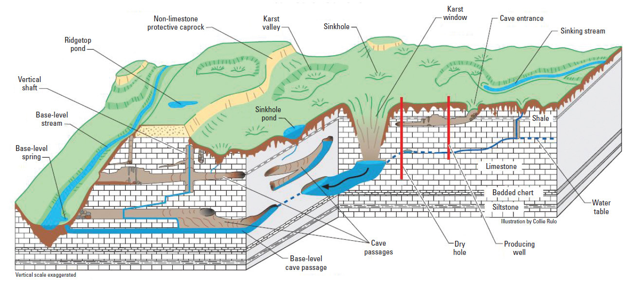
Did you know water can sometimes dissolve rock? Karst is a type of rocky feature such as a cave or sinkhole that forms in dissolvable rocks. Karst creates pathways that can carry water quickly from the land surface directly to underground aquifers. Karst landscapes cover about 16 percent of the Earth’s land surface, including most of the Colorado Plateau around Flagstaff and the Grand Canyon. It’s an important geologic feature that most of us have never heard of.
Karst aquifers, which have a pipe-like flow network of caves and conduits, directly supply up to 25 percent of the world population with water for drinking, agriculture and other needs and they are uniquely vulnerable to contamination. Two such aquifers, the Redwall and Coconino aquifers, supply water to Roaring Springs and many other Grand Canyon springs. The two aquifers are stacked on top of each other. While there are many types of vulnerability models, most ignore the complication of layered karst aquifer systems; this results in oversimplified, less accurate modeling.
“Vulnerability models identify regions of high, moderate and low vulnerability on the land surface, which directly relates to how quickly and efficiently water or contaminants would sink and enter the aquifer,” Jones said. “However, existing well-regarded vulnerability modeling methods for karst aquifers did not produce realistic results for our region.”
How does the modeling work?
Jones modified the well-known concentration-overburden-precipitation method (COP). This method is effective, the researchers say, but it oversimplifies some details, which limits the model. She presented two new models that better address the factors that help scientists predict vulnerability.
The modifications more accurately account for recharge patterns in the Grand Canyon region, which has many karst features and a deep, complex aquifer system. Jones and the research team automated a process to identify sinkholes from high-resolution topography data, converted those data into sinkhole densities, and combined those data with a map of fault locations in the region. Jones then incorporated these features into the existing model using a geographic information system to produce the final vulnerability model.
It meant significant data processing, but the result was a model that produced greater resolution of vulnerability regions and fit well with previous groundwater flow path analyses. In addition to creating a better model on which future research can build, Jones found similar patterns in vulnerability between the two karst aquifers in the Grand Canyon region, despite them being separated by more than 600 meters of impermeable rock.
Jones also learned that about a fifth of the Kaibab Plateau has high vulnerability to contamination of the Redwall-Muav aquifer, which is about 1,000 meters deep, and almost half of the plateau surface (45.6 percent) has high to very high vulnerability for the Coconino aquifer, which is much closer to the surface.
What does this mean for me?
If you’ve stopped to fill your water bottle while you’re hiking the Grand Canyon or admiring the views on the canyon rim, this matters to you. Since the Roaring Springs is the only source of water in the park, its quality has significant value. This research provides better information to water managers to protect the Grand Canyon’s water resources, including creeks on the north side, which researchers think are recharged by the Kaibab Plateau.
“These springs and streams support diverse ecosystems, and many hikers and wildlife rely on them for survival,” Jones said. “This research helps narrow down where these water sources are coming from and could help us better protect them in the future.”
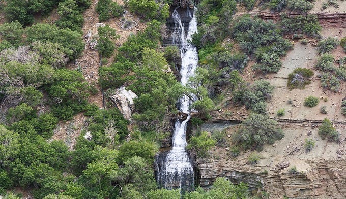
Roaring Springs Waterfall along North Kaibab Trail. Photo by Whit Richardson via MyGrandCanyonPark.com
Photo credit from report “A Preliminary Evaluation of Seasonal Water Levels Necessary to Sustain Mount Emmons Fen: Grand Mesa, Uncompahgre and Gunnison National Forests,” David J. Cooper, Ph.D, December 2003.
The Trump administration on Thursday will finalize a rule to strip away environmental protections for streams, wetlands and other water bodies, handing a victory to farmers, fossil fuel producers and real estate developers who said Obama-era rules had shackled them with onerous and unnecessary burdens.
From Day 1 of his administration, President Trump vowed to repeal President Barack Obama’s “Waters of the United States” regulation, which had frustrated rural landowners. His new rule, which will be implemented in the coming weeks, is the latest step in the Trump administration’s push to repeal or weaken nearly 100 environmental rules and laws, loosening or eliminating rules on climate change, clean air, chemical pollution, coal mining, oil drilling and endangered species protections…
His administration had completed the first step of its demise in September with the rule’s repeal.
His replacement on Thursday will complete the process, not only rolling back 2015 rules that guaranteed protections under the 1972 Clean Water Act to certain wetlands and streams that run intermittently or run temporarily underground, but also relieves landowners of the need to seek permits that the Environmental Protection Agency had considered on a case-by-case basis before the Obama rule.
It also gives President Trump a major policy achievement to bring to his political base while his impeachment trial continues.
“Farmers coalesced against the E.P.A. being able to come onto their land, and he’s delivering,” said Jessica Flanagain, a Republican strategist in Lincoln, Neb. “This is bigger news for agricultural producers than whatever is happening with the sideshow in D.C.,” she added…
The new water rule will remove federal protections from more than half the nation’s wetlands, and hundreds of thousands of small waterways. That would for the first time in decades allow landowners and property developers to dump pollutants such as pesticides and fertilizers directly into many of those waterways, and to destroy or fill in wetlands for construction projects.
“This will be the biggest loss of clean water protection the country has ever seen,” said Blan Holman, a lawyer specializing in federal water policy at the Southern Environmental Law Center. “This puts drinking water for millions of Americans at risk of contamination from unregulated pollution. This is not just undoing the Obama rule. This is stripping away protections that were put in place in the ’70s and ’80s that Americans have relied on for their health.”
The Obama rule protected about 60 percent of the nation’s waterways, including large bodies of water such as the Chesapeake Bay, Mississippi River and Puget Sound, and smaller headwaters, wetlands, seasonal streams and streams that run temporarily underground. It limited the discharge of pollutants such as fertilizers, pesticides and industrial chemicals into those waters…
The new rule, written by the Environmental Protection Agency and the Army Corps of Engineers, will retain federal protections of large bodies of water, as well as larger rivers and streams that flow into them and wetlands that lie adjacent to them. But it removes protections for many other waters, including wetlands that are not adjacent to large bodies of water, some seasonal streams that flow for only a portion of the year, “ephemeral” streams that only flow after rainstorms, and water that temporarily flows through underground passages.
Legal experts say that Mr. Trump’s replacement rule would go further than simply repealing and replacing the 2015 Obama rule — it would also eliminate protections to smaller headwaters that have been implemented for decades under the 1972 Clean Water Act.
“This is rolling back federal jurisdiction of the Clean Water Act further than it’s ever been before,” said Patrick Parenteau, a professor of environmental law at Vermont Law School. “Waters that have been protected for almost 50 years will no longer be protected under the Clean Water Act.”
That could open millions of acres of pristine wetlands to pollution or destruction, and allow chemicals and other pollutants to be discharged into smaller headland waters that eventually drain into larger water bodies, experts in water management said. Wetlands play key roles in filtering surface water and protecting against floods, while also providing wildlife habitat.
Ean Thomas Tafoya, a Colorado-based clean water activist with the group GreenLatinos, said the new rule could harm the quality of the water in the Colorado River, which supplies water to 17 western states.
“We are a headwater state,” he said. “This rollback will affect almost every single stream that flows into the Colorado River.”
Mr. Tafoya said about 90 percent of the streams that supply the Colorado River run only after rainfall or snowmelt. Under the new Trump water rule, many of those streams will not qualify for federal pollution protection. But Mr. Tafoya said pollutants such as chemical pesticides that end up in those dry stream beds could nonetheless be swept into larger bodies of water when the streams begin running after the spring thaw of mountain snow.
“The toxics or poisons that lie dormant will still be there when the streams are reactivated,” he said. “They will still get into the larger bodies of water.”
Government scientists, even those appointed by the Trump administration, say those concerns are justified. The E.P.A.’s Scientific Advisory Board, a panel of 41 scientists responsible for evaluating the scientific integrity of the agency’s regulations, concluded that the new Trump water rule ignores science by “failing to acknowledge watershed systems.” They found “no scientific justification” for excluding certain bodies of water from protection under the new regulations, concluding that pollutants from those smaller and seasonal bodies of water can still have a significant impact on the health of larger water systems.
Those scientific findings, although they are not reflected in the administration’s policy, could still play a role in the fate of the new rule. Several state attorneys general are expected to join with environmental groups to sue to overturn the Trump water rule, and those groups are likely to cite those findings as evidence that the rule is not legally sound.
“The legal standing all has to do with whether you have a rational basis for what you’re doing,” said Mr. Parenteau. “And when you have experts saying you’re not adhering to the science, that’s not rational, it’s arbitrary.”
Each year, the board votes on a new chairperson that is from either location; a town member is appointed to lead on odd years, and a rural member is appointed on even years. The opposite happens for the vice chairperson.
For 2020, the board voted Jim Jensen, who represents the surrounding rural area, as chair. He replaces Finn Kjome, who lives in town limits. Kjome was appointed as the new vice chair at last week’s meeting.
Other water commission board members are Mike Grafmyer, Jim Wells, Ron Gabbett and John Owens.
Tim Lippert, the town’s public works director and operator, gave the board several updates. The first item was the repair work needed on a town vehicle and the possibility of purchasing a new vehicle as a replacement. Lippert said the repairs would cost approximately $1,000.
He also presented new raw water data to the board, as they’d requested information on how the new system was impacting the town’s reserves. However, the water data is based on only the first year of operation and study for Norwood’s new system. The board agreed that additional data over several years is needed to ensure data collected on the raw water system is accurate.
Lippert informed the board of a state program, which is offering free testing of municipal water for the chemical Teflon, a substance dangerous to drinking water and frequently found in fire-fighting foam.
Lippert told the board that the testing is not mandatory, but could possibly be in the future.
Teflon testing has been occurring across the nation since 2013 and has recently started in Colorado. The test looks for Teflon in amounts as small as 70 parts per trillion.
Norwood’s board expressed willingness to do the Teflon testing if the tests are paid for by the state program. Board members said they don’t want to have to pay for the testing with the town’s money.
Currently, the state has roughly $500,000 in funding for the free testing. Lippert said on Monday the Town of Norwood did apply for funds and will know in the near future if the test will be conducted locally.
At the same time, board members also said they don’t believe that the chemical will be found in Norwood’s water, because of the lack of forest fires that have occurred on the Lone Cone. Still, they said they are open to running the test to be certain.
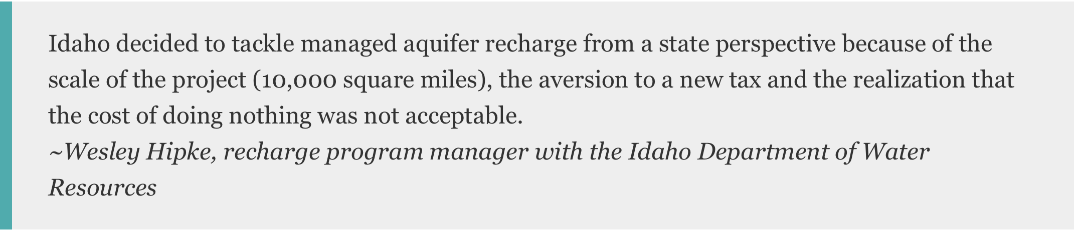
A new injection well built by the Albuquerque Bernalillo County Water Utility Authority will pump treated river water back into the aquifer for future use in the metro area. The $2 million well, built at the San Juan-Chama Drinking Water Treatment Plant in north Albuquerque, is key to the city’s aquifer storage and recovery plan.
Project manager Diane Agnew said the well, which is the first of its kind in the city, is a “success for Albuquerque’s water sustainability.”
“This is like a ‘water savings account’ that builds up over time,” she said. “The injection well gives us an alternate source to meet our long-term water demand. It lets us take (treated) San Juan-Chama water and store it in the aquifer, where it won’t evaporate.”
[…]
To access the stored aquifer water, the new well pumps can be “flipped” from injection to extraction.
The project expands on the city’s efforts to recharge the aquifer and address long-term water demand.
Each winter, San Juan-Chama water is released into the Bear Canyon Arroyo. That water infiltrates the ground and eventually ends up in the aquifer.
Agnew said the Bear Canyon setup takes advantage of the arroyo’s natural recharge mechanism, but the water may evaporate before it seeps into the ground, and it can take as long as six weeks to reach the aquifer.
The new injection well can send 3,000 gallons of water a minute directly into the aquifer 1,200 feet below the well site, where it can be stored without risk of evaporation. Injected well water reaches groundwater in just a few days…
As with the arroyo project, water will be injected at the well site from October to March, when water demand is lower.
The water authority has worked with the state Bureau of Geology and Mineral Resources to identify other areas in the city which would be optimal for future aquifer injection wells.
Albuquerque’s shift away from pumping groundwater has spurred recovery of the aquifer underneath the city.
A report released last year by the U.S. Geological Survey showed city groundwater withdrawals had dropped by 67% from 2008 to 2016. Aquifer levels in some parts of Albuquerque rose as much as 40 feet during that time.
About 60 percent of Colorado fire departments report that they have firefighting foam with synthetic chemicals known as PFAS, according to a recent survey by the Colorado Department of Public Health and Environment…
“We are highly cognizant of how dangerous PFAS can be in terms of the cancer-causing properties for our firefighters,” said Greg Pixley, a public information officer with Denver Fire Department “We are working every effort we can to reduce PFAS in our day-to-day operations.”
[…]
An older generation of the firefighting foam containing PFAS has been retired from use in Colorado, and across military bases. Now, a newer version with a different chemical formula is available. Originally it was believed to not accumulate in the body, but research is emerging that shows potentially toxic health effects are concerns for many of the firefighters who use this product on the front lines…
State health officials know PFAS chemicals are a problem. Conducting a survey is one part of the state’s plan to address the health risks. In addition to reporting PFAS foam supplies, health officials asked which fire departments had used PFAS firefighting foam in the past. About 19 departments reporting using the foam.
However, it’s unclear what, if any, testing will happen across those departments that reported using the foam.
The state government has made about $500,000 available with a priority for Colorado’s 890 drinking water districts for testing of PFAS chemicals. But fire departments will be at the back of the line behind drinking water districts to access to those funds, according to state health officials…
According to the state survey, the largest caches of the new PFAS foam is held by Suncor, the Denver Fire Department, South Metro Fire Rescue and the Pueblo Fire Department.
The departments that have large quantities of the new form on hand use it because they respond to fires at regional or municipal airports. The Federal Aviation Administration requires fire responders at some airports to have the PFAS foam on hand to ensure “the extinguishment of the fire for the successful evacuation of passengers and aircrew during an aircraft fire,” according to a statement from the FAA.
“It was a compromise,” said Eric Hurst, a public information officer with South Metro Fire Rescue. “We essentially worked with Centennial Airport to find the safest environmentally friendly [firefighting foam] available and used that.”
The FAA is under the gun to find a replacement by Oct. 4, 2021, at which time it can no longer require the use of PFAS foam.
The agency is currently researching and evaluating replacement firefighting foams. Some airports like London-based Heathrow have switched to a fluorine-free foam that doesn’t have PFAS chemicals linked to health issues…
“[DIA] along with other commercial airports and airport industry associations, continues to press the FAA for a firefighting alternative that would satisfy commercial travel safety responsibilities while reducing the potential for environmental impact,” said Emily Williams, a public information officer with Denver International Airport.
State law does set some limits on how the new PFAS foam can be used. Legislation in 2019 prevents fire districts from using it to conduct training exercises. It is only to be used to fight fires.
Once a symbol of American ingenuity, PFAS were originally conceived as wonder chemicals that could resist stains, repel water, extinguish horrific oil-based fires, and keep eggs from sticking to the pan. Today, we know them as a Frankenstein-like invention, zombie chemicals that will not die.
Chemists created thousands of such compounds by bonding carbon to fluorine in chemical chains, forging one of the strongest bonds ever discovered. Now they have been found across the planet—even in the blood of arctic foxes and polar bears. Public health studies found PFAS in the blood of about 95 percent of Americans. While the health impact of low levels of exposure is less clear, the chemicals are linked to liver, thyroid, and immune effects, cancer, and low birth weight. It will take billions of dollars—and yet more engineering prowess—to remove PFAS from drinking water and the environment. The task seems bleak, even as the US Department of Defense prepares to spend more than $2 billion on cleaning up PFAS on its bases. Firefighting training sites, airports, and industrial sites are also big contributors.
On Friday, the US House of Representatives passed the PFAS Action Act, which would require the EPA to set drinking water limits for two PFAS (PFOA and PFOS) and to designate PFAS chemicals as hazardous substances under the Superfund cleanup program. Its path forward is uncertain. Even if the Senate passes the measure, the Trump administration has called its provisions “problematic and unreasonable” and threatened a veto.
But here’s a shred of optimism: Some new technologies show promise in breaking those ultra-strong carbon-fluorine bonds, which means the compounds known as “forever” chemicals could be removed from at least some groundwater. “I have actually started to feel a little bit of hope,” says Chris Higgins, an environmental engineer at the Colorado School of Mines and a PFAS expert. “We’re getting some technologies that seem to be working.”
The most promising approach involves an electrical reaction that looks like lightning striking water. Contaminated water goes through a plasma reactor, where argon gas pushes the PFAS compounds to the surface. Electrodes above and below the surface generate plasma—a highly reactive gas made up of positive ions and free electrons—that interacts with the PFAS and breaks the carbon-fluorine bonds.
“Our goal is to completely destroy the compound and not just transfer it from one phase to another,” says Michelle Crimi, an environmental engineer at Clarkson University in Potsdam, New York, who works on emerging technology to remediate PFAS. The plasma reactor technique was developed by her colleagues Selma Mededovic, a chemical engineer, and Tom Holsen, an environmental engineer.
Crimi is also using ultrasound waves to create cavities—essentially holes—in the water. When they collapse, they instigate physical and chemical reactions that break apart the PFAS chains. Other researchers are working on electrochemical techniques and even soil bacteria that may metabolize PFAS.
The team responsible for the development of the enhanced contact electrical discharge plasma reactor, a novel method for degrading poly- and perfluoroalkyl substances (PFASs). Professors Selma Mededovic Thagard and Thomas Holsen with Nicholas Multari and Chase Nau-Hix (shaved head), pose in the CAMP lab, October 6, 2017.
Colorado officials will continue to reach out to drinking water districts to encourage testing for synthetic chemicals known as Per- and Polyfluoroalkyl Substances — otherwise known to the public under the PFAS acronym umbrella.
The sign-up rate, however, has been minimal.
About one week into the Colorado Department of Public Health and Environment’s campaign, officials said about 8 percent of Colorado’s roughly 790 drinking water districts have signed up for tests…
That’s not to say that officials aren’t pleased with the sign-up rate so far. They plan to send email notifications to drinking water districts to remind them of the available funds over the coming weeks…
While the [EPA’s] current advisory limits are voluntary, they are determining whether to formally regulate two of the chemicals, PFOA and PFOS. A decision is expected later in 2020.
The High Plains Aquifer provides 30 percent of the water used in the nation’s irrigated agriculture. The aquifer runs under South Dakota, Wyoming, Nebraska, Colorado, Kansas, Oklahoma, New Mexico and Texas.
Click here for all the inside skinny from Kansas State University.
The U.S. House voted Friday to pass a comprehensive legislative package that would crack down on per- and polyfluoroalkyl substances, a class of chemicals known as PFAS that are said to cause serious health problems.
Used in tape, nonstick pans and other everyday substances, PFAS have been linked to cancer, decreased fertility, developmental delays and other conditions and have been found in high concentrations in sources of public drinking water and other sites around the country.
The PFAS Action Act includes a series of provisions designed to mitigate their harm. It cleared the House with support from 223 Democrats and 24 Republicans. One hundred and fifty seven Republicans voted against it, as did one Democrat and Michigan independent Rep. Justin Amash. Twenty-four lawmakers did not vote.
Colorado’s delegation was split on the vote, with Democratic representatives voting for the bill and Republicans voting against it…
Friday’s vote came after supporters of the legislation suffered a stinging setback last month, when key PFAS provisions were struck from the National Defense Authorization Act (NDAA) before it was signed into law.
Opposition to those provisions from Senate Republicans prompted House Democrats to call the PFAS bill to the floor this month, House Speaker Nancy Pelosi (D-Calif.) said Friday.
“Last year, our members worked relentlessly to pass bold legislation to tackle the PFAS crisis,” Pelosi said on the House floor. “Unfortunately, at the end of the year, the Senate GOP refused to join the House to secure full, robust protections against PFAS chemicals and key provisions were cut from the NDAA.”
The “Senate GOP obstruction,” she said, “is why we are here today.”
The NDAA does take some steps to address PFAS. It includes provisions that require the U.S. military to transition off of PFAS-laden fire-fighting foam by 2024, ban the foam in exercises and training and test PFAS levels in military firefighters’ blood.
But supporters said the PFAS Action Act passed Friday goes much further.
It would require the U.S. Environmental Protection Agency to list certain PFAS chemicals as hazardous substances under the EPA’s Superfund program, which would accelerate cleanup of contaminated sites. That would be a “significant first step while we allow the EPA to study the remaining compounds — which needs to start now,” Dingell said in a press release.
The bill would also create a national drinking standard for certain PFAS chemicals, help people understand water testing results, prevent new PFAS chemicals from being approved and more…
Colorado public health officials acknowledge federal action on creating a legally binding drinking water standard is lagging, forcing the state to address a public health crisis it’s ill-equipped to handle. The state is in the process of adopting new regulations after finding PFAS levels above the federal health advisory limit in groundwater across the Denver metro region, Colorado Springs and Boulder County. In September, lawmakers approved $500,000 so that the Colorado Department of Public Health can begin testing public drinking water supplies for the toxic chemical…
Despite its bipartisan support in the House, the bill faces an uphill battle.
First, it must pass the GOP-controlled Senate, where hundreds of House-passed bills are languishing on the desk of Majority Leader Mitch McConnell (R-Ky.). Senate Environment and Public Works Committee Chairman John Barrasso (R-Wyo.) told Bloomberg News that the legislation had “no prospects in the Senate.”
If it passes the Senate, then it would move to the White House, which issued a veto threat on Tuesday…
The EPA is already “taking extensive efforts” to address PFAS across the nation, it added — an assertion underscored by the EPA in a statement released on the same day as the White House veto threat.
But critics say the EPA’s “action plan” doesn’t go far enough to contain and clean up PFAS and are skeptical the agency will put public health over corporate profits.
A statewide anti-fracking group looked to Aurora when crafting more efforts to keep fossil fuel drilling away from homes and schools — and now, Superfund sites.
Activist group Colorado Rising submitted six possible ballot initiatives to the Secretary of State’s office earlier this week. Voters could decide in November on one these six proposals. All are variations of Colorado Rising’s earlier ballot initiative to increase drilling setbacks in 2018, Proposition 112, which voters turned down by a wide margin.
The next year, however, Senate Bill 181 was passed into law, ceding regulation to local governments, now able to increase setback distances and more…
Currently, the statewide setback between drilling and homes is 500 feet, but local governments, such as Aurora and other counties or municipalities, have the power to increase that distance.
Now, Colorado Rising wants to protect Superfund sites from drilling — a move partially inspired by drilling around the Lowry Landfill Superfund site in Aurora, said spokeswoman Anne Lee Foster.
The 507-acre Superfund site contained about 138 million gallons of toxic waste dumped there for decades, although some has leaked out in what scientists call a “plume.” Activists fear more drilling could disrupt the area geology and release waste.
Aurora Councilwoman Nicole Johnston, who represents the region near the Lowry Landfill, said she supports the decision to include Superfund sites in the list of possible ballot initiatives. Of the six proposed initiatives, four would create a 2,500-foot buffer zone between well pads and Superfund sites.
A Sentinel review did not find active oil and gas wells within the proposed buffer zone from the Lowry Landfill border.
The closet oil and gas well is about 2 miles away from the site boundary, according to Colorado Oil and Gas Conservation Commission data. However, the buffer zone proposals would still allow for horizontal drilling underneath the Lowry Landfill surface and toxic waste if the well was drilled outside the buffer.
FromThe New Mexico Political Report (Kendra Chamberlain):
NMED announced late Thursday that the department issued an administrative compliance order to the Air Force for unlawfully discharging wastewater without a groundwater permit at Cannon Air Force Base since April 1, 2019…
“The Air Force continues to ignore New Mexico’s environmental laws,” said NMED Sec. James Kenney in a statement. “Rather than address PFAS contamination, the Department of Defense shows no interest in helping afflicted communities and impacted natural resources.”
Cannon Air Force Base is one of two military installations in the state where PFAS chemicals have contaminated groundwater. The base’s groundwater discharge permit expired at the end of March 2019 and has not been renewed.
In January 2019, the Air Force sued NMED after the department issued a notice of violation for PFAS contamination of groundwater at Cannon. In March 2019, NMED and the New Mexico Office of the Attorney General filed a complaint in federal district court, asking a judge to compel the Air Force to cleanup PFAS contamination at both Cannon and Holloman Air Force Base. The Air Force did not renew its groundwater discharge permit after entering into litigation with NMED.
NMED is now asking the Air Force to pay $1,699,872.60 in civil penalties and submit a discharge permit application within 30 days. The department said it may assess penalties of up to $25,000 per day for “continued noncompliance.”
Fred Stone hasn’t been able sell his milk since November 2016 because his longtime buyer said it was too contaminated with so-called forever chemicals.
But to the federal government, it isn’t contaminated enough to qualify him for a disaster aid program that’s supposed to pay farmers whose milk is polluted through no fault of their own.
And now, Stone says, he can’t afford to keep testing his milk, at $600 a pop, to show it’s either sufficiently contaminated for federal aid, or cleaned up enough to get back the Maine state dairy license he lost last year…
Art Schaap, owner of Highland Dairy in Clovis, N.M., also can’t sell any milk because his cow’s water is contaminated with PFAS from uses at the nearby Cannon Air Force Base. He’s gotten aid from the indemnity program and is grateful for it.
But he’s angry that both he and Stone have had their livelihoods taken from them. Industries and the military that released these chemicals into the environment need to be held accountable, Schaap said.
Federal agencies are “not doing their jobs. They’re kicking the can down the road like this problem is going to go away,” he said. “This stuff just doesn’t go away.”
“The milk industry does not want this in their milk, period,” Schaap said.
The Wyoming State Engineer’s Office recently heard a proposal to drill eight high-capacity water wells in Laramie County, and now 17 ranchers and farmers in the area are protesting.
The wells would use a total of 1.5 billion acre feet of water from the Ogallala Aquifer that many states in the Western U.S. rely on for water. Fifth generation Wyoming rancher and attorney Reba Epler said if the state engineer approves these wells, stock wells on her family ranch would likely dry up.
“One of the ways we’d be impacted immediately is that we’d have shallower stock wells that we’ve used for about 50 years,” Epler said. “We’d have to drill much deeper, and the cost of drilling deeper is getting significantly more expensive.”
Epler said all eight wells were applied for by three members of the Lerwick family. She said it’s possible the family wants to sell the water to use in the fracking process since a lot of oil and gas development is happening in the area.
“If you really want to know, I think it’s a classic resource grab,” Epler said. “And anyone who controls 4,642 acre feet of water has a tremendous amount of power and they will have it a long time and many generations of people will have that kind of power.”
Epler said it doesn’t make sense to give anyone that much water when the Ogalalla Aquifer is already drawing down so much nationwide.
“The aquifer in parts of Texas has gone dry, it’s gone dry in parts of New Mexico. Oklahoma, Kansas are having a really difficult time because their pivots are drying up. Colorado, eastern Colorado is having a heck of a time.”
Epler said she remembers when Lodgepole Creek near her ranch ran year round.
Ogallala Aquifer. This map shows changes in Ogallala water levels from the period before the aquifer was tapped to 2015. Declining levels appear in red and orange, and rising levels appear in shades of blue. The darker the color, the greater the change. Gray indicates no significant change. Although water levels have actually risen in some areas, especially Nebraska, water levels are mostly in decline, namely from Kansas southward. Image credit: National Climate Assessment 2018
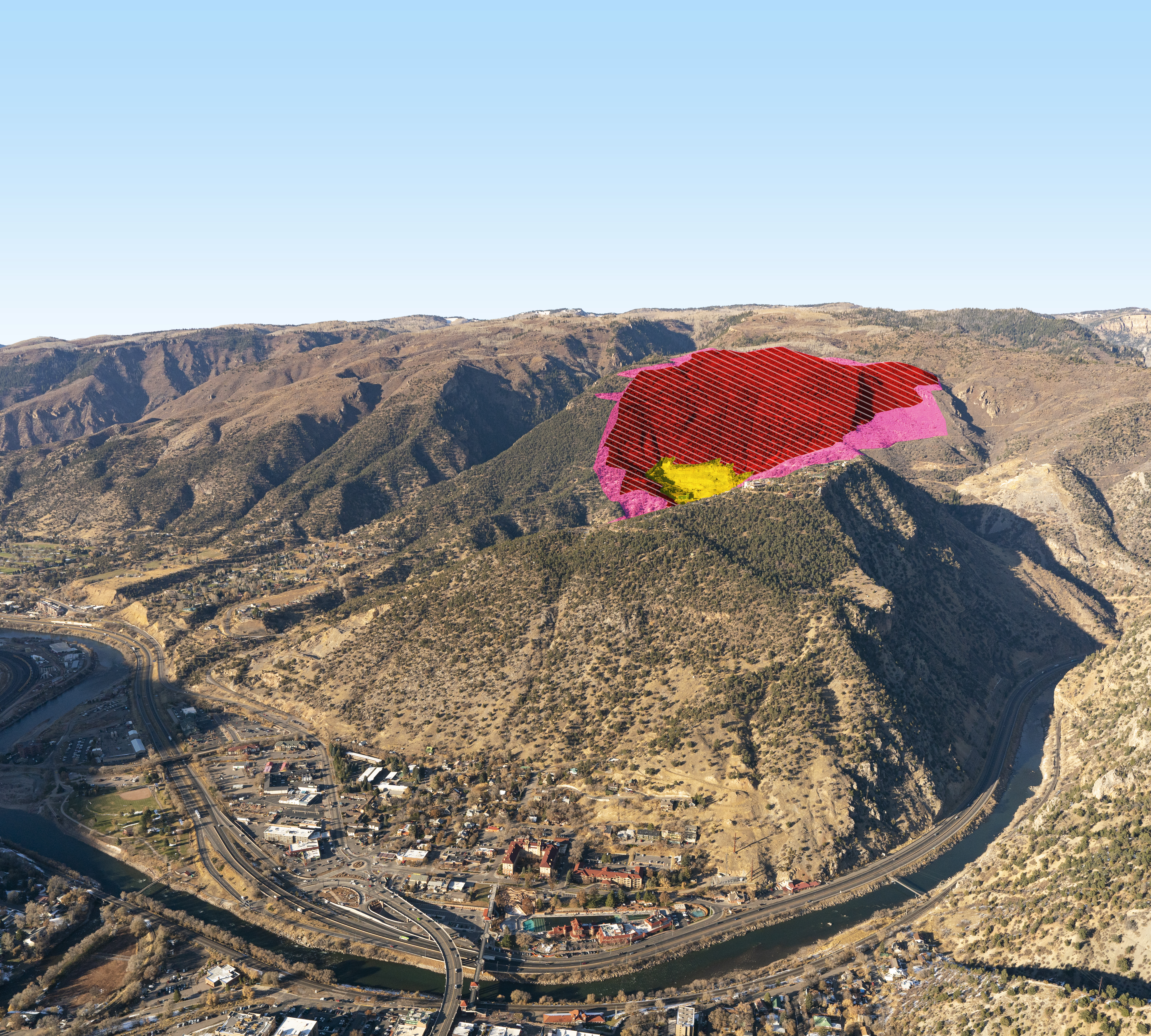
The proposed expansion of the Mid-Contintent Limestone Quarry above Glenwood Springs by the politically connected Rocky Mountain Resources has spurred the city to create a taxpayer funded campaign against the plan. The mine’s existing footprint of roughly 16 acres is in yellow and the proposed expansion is in red. Photo credit: City of Glenwood Springs via The Colorado Sun
…if history is a guide, the process to a decision about whether to approve or deny RMR’s expansion proposal could take years.
The time line of the environmental review of the project, which would expand the limestone quarry from about 23 acres to 321 acres and remove millions of tons of rock per year, is anything but certain.
“The (Bureau of Land Management)’s current estimate for starting the formal (environmental impact statement) is summer 2020, although that could change to be earlier or later depending on the status of the studies and as BLM gathers more information,” according to a BLM fact sheet on the quarry proposal.
The agency has a number of baseline studies to complete before the environmental review process can begin in earnest, so the schedule is up in the air, according to BLM spokesman David Boyd.
“We just don’t know. It’s not like we have a schedule and I’m not saying what it is, we just have to wait and see where all the parts are,” Boyd said.
One part of the baseline studies is a hydrological analysis.
The study required several test wells and monitoring of the groundwater for a year. RMR planned to begin drilling the monitoring wells in the fall.
Due to the intense interest in all things related to the quarry, however, the BLM asked for public comments on issuing a categorical exclusion to approve the test wells.
After receiving 250 comments, and a last-minute letter from Rep. Scott Tipton, R-Colo., urging more environmental review, the BLM decided to conduct an environmental assessment with “a detailed analysis of potential impacts of drilling the wells.”
That analysis has begun, Boyd said, and should be complete in the next few months.
Because of the scoping period in late 2019, the assessment will not need additional public comment, Boyd said.
The hydrological study needs a year’s worth of data from all four seasons, but there’s a chance that the BLM could begin public comment, scoping and other parts of the environmental impact statement before all the hydrological data is in, Boyd said.
Still, the process “certainly (won’t start) before summer, and likely at this point later than that,” Boyd said.
In addition to the hydrologic study, the BLM is conducting a cave and karst study to research underground features on the proposed quarry site, an ethnographic study and an anthropologic and cultural study.
Many of those studies have begun, Boyd said…
The average amount of time it takes for the BLM to complete an environmental impact statement is nearly four and a half years, according to a 2017 analysis of the process by the White House.
The process will officially begin when the BLM posts notice of intent to complete an environmental impact statement.
Then there will be periods of scoping and public comment, which will likely include public meetings.
When the BLM completes a draft of the statement, it will be made available for additional public comment. The average time from formal notice to draft EIS is nearly two and a half years at the BLM. From the draft to a final statement is another year and a half, on average, and then it usually takes another six months before the final decision is announced.
Many environmental reviews take less time; a few take a decade or more.
In a sign that perhaps Nestlé Water might not find its Chaffee County 1041 permit renewal quite as easy as it had hoped, the Chaffee Board of County Commissioners has again changed the date of the public hearing, returning it to the April 26 date that they had initially expected would be honored…
During a Dec. BoCC session, commissioners were not altogether pleased to learn that Nestlé had asked for the required public hearing to be moved forward to Jan. 2020. They appeared “surprised” that county staff appeared to have acquiesced to the company’s request for an earlier date.
Public comments made in response to an earlier Ark Valley Voice article about the topic indicate that there are some who are not pleased with what they consider to be a rubber stamp approval of the state permit that allows Nestlé to continue to draw water from Chaffee County. During the Oct. BoCC session, county staff had indicated that Nestlé had met all the terms of the expiring ten-year contract.
“They have met all the requirements and they been a good neighbor,” said Chaffee Planning Manager Jon Roorda.
It would appear that commissioners are aware that renewal of the permit issued in 2009 for Nestlé Water to take water from Chaffee County for its branded, bottled water product might be more contentious than it was ten years ago. In 2009, the country was in the grips of the Great Recession, identified as the most serious economic downturn since the 1930s, and Chaffee County had experienced that economic impact. In addition, current public sensibilities to water shortages, heightening wildfire danger and the need to protect our natural environments was not as high then as they are a decade later.
Take a walk back in time to read about Nestlé here and here.
The proposed expansion of the Mid-Contintent Limestone Quarry above Glenwood Springs by the politically connected Rocky Mountain Resources has spurred the city to create a taxpayer funded campaign against the plan. The mine’s existing footprint of roughly 16 acres is in yellow and the proposed expansion is in red. Photo credit: City of Glenwood Springs via The Colorado Sun
FromThe Associated Press via TheDenverChannel.com:
The federal Bureau of Land Management plans to conduct an environmental assessment of test drilling proposed by the owner of a Colorado limestone quarry seeking to expand the operation, officials said.
Rocky Mountain Resources Industrials Inc. sought an environmental review exemption for five test wells, The Colorado Sun reported .
The company needs to perform the test drilling to assess the viability of expanding its Mid-Continent Limestone Quarry near Glenwood Springs, officials said.
The company will be required to pay for the environmental study that the agency will use to examine the potential impacts to the region’s water resources, bureau officials said.
Prior to mining, snowmelt and rain seep into natural cracks and fractures, eventually emerging as a freshwater spring (usually). Graphic credit: Jonathan Thompson
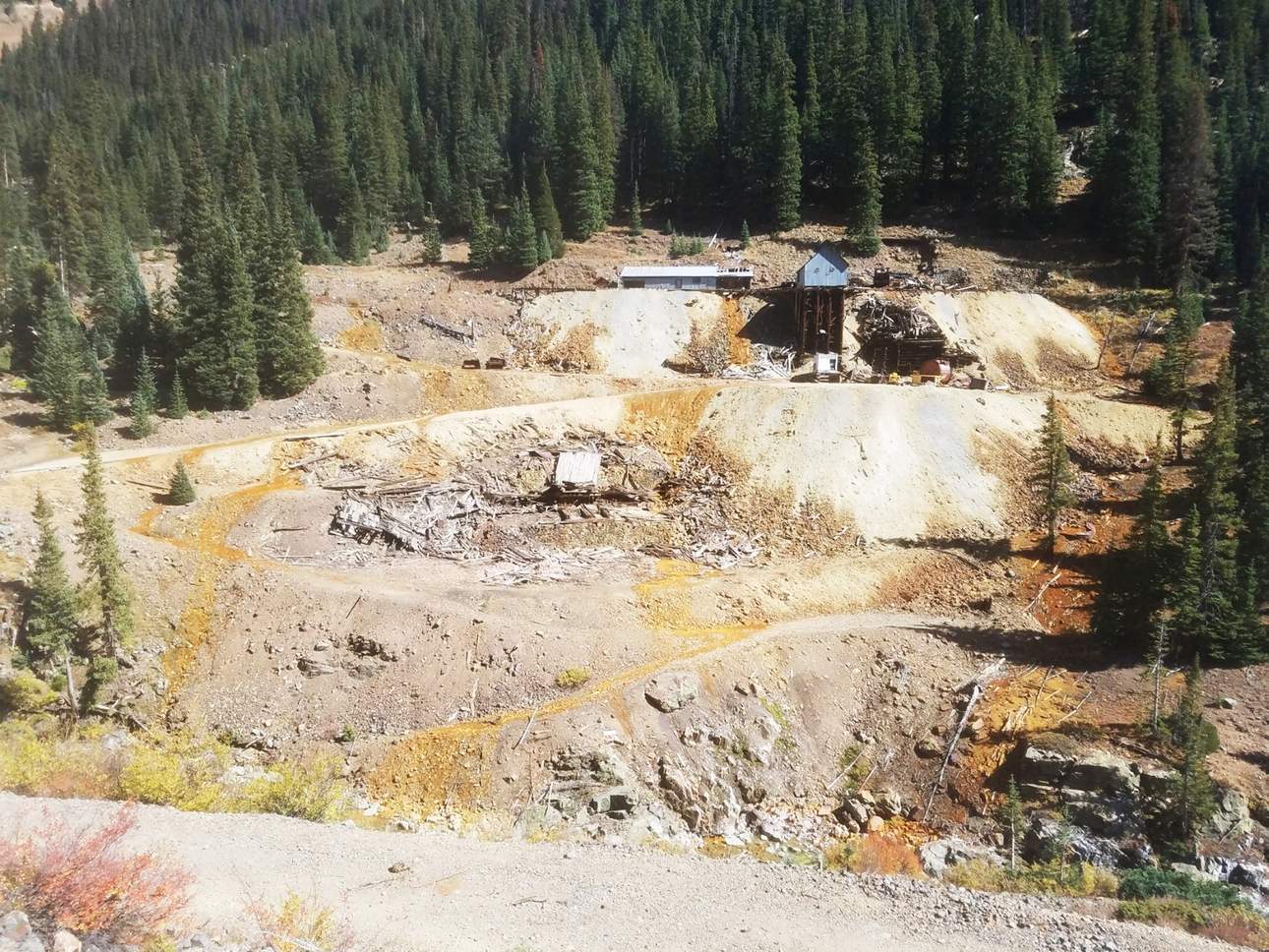
Sunnyside Gold Corporation, the last mining company to actively operate in the Silverton caldera, was recognized for “five years of responsible mining and 30 years of successful remediation and reclamation,” according to the award announcement provided to The Daily Times by Sunnyside Gold Corporation.
This award comes as Sunnyside faces continued litigation alleging the bulkheads it installed in the Sunnyside Mine’s American Tunnel led to changes in water levels. The suit claims this eventually created a buildup of water in the Gold King Mine that U.S. Environmental Protection Agency contractors later accidentally released when they breached a collapsed portal into the mine.
“The primary purpose of the engineered concrete bulkheads was to isolate the interior workings of the Sunnyside Mine, and to prevent water flow from the interior workings to the Animas Basin,” said Kevin Roach, Sunnyside’s director of reclamation, in an email to The Daily Times.
Roach said that while Sunnyside owns mines near the Gold King, it never owned or operated the Gold King Mine. He said the company was not involved in the Gold King Mine spill and has no responsibility for it.
“There is no physical man-made connection between the Sunnyside and Gold King mine workings,” Roach said.
And Roach stood by the decision to install bulkheads in Sunnyside’s mine workings.
“One of the most important lessons that can be derived from SGC’s successful reclamation is that, in appropriate circumstances, bulkheading of closed mines can be an effective method to improve water quality,” he said.
Sunnyside has maintained the U.S. Environmental Protection Agency, which triggered the spill, bears the responsibility. Roach further highlighted studies showing the water quality in the Animas River returned to pre-spill conditions shortly after the incident…
The award also comes after Sunnyside refused to comply with an order the EPA sent the company to install groundwater wells and meteorological stations as part of the Bonita Peak Mining District Superfund Site remediation work. The Superfund site includes 48 mine sites believed to have impacted water quality in the Animas River. Some of these mine sites were related to Sunnyside’s operations…
Working to reclaim land
Over the past 30 years, Sunnyside has spent $30 million on reclamation work. Roach said much of Sunnyside’s work occurred at sites it does not own. In addition to installing bulkheads, this work included relocating or removing mine tailings from several sites, including near the Animas River and its tributaries.
Sunnyside Gold Corporation was a latecomer to the mining activity in the Silverton caldera, entering the region in 1985 when it acquired the Sunnyside Mine, which it operated until 1991. The mine itself dates back to 1873 and includes two tunnels for hauling ore and drainage, one of which is the American Tunnel.
Following the installation of bulkheads in the American Tunnel, the Sunnyside Gold Corporation was released from liabilities in 2003 when the Colorado Department of Public Health and Environment concluded it had completed its obligations laid out in a consent decree.
In terms of the future, Sunnyside does not have plans to resume mining in the Silverton caldera. However, that does not necessarily mean mining is gone from the caldera forever.
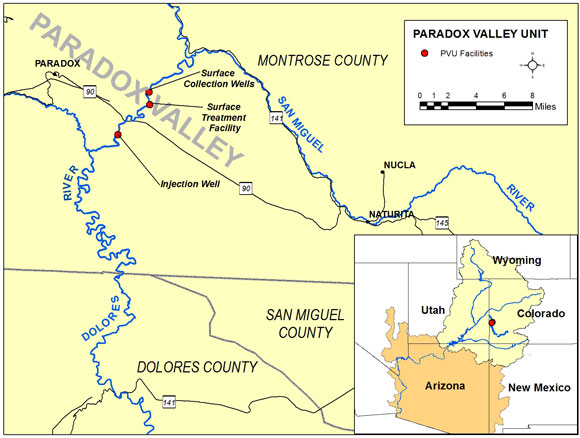
Paradox Valley Location Map. Credit: Bureau of Reclamation
Here’s the release from the Bureau of Reclamation (Justin Liff, Lesley McWhirter):
The Bureau of Reclamation is seeking public input on alternatives to reduce salinity in the Colorado River from sources in the Paradox Valley in western Colorado. Currently, the Paradox Valley Unit (PVU) in Montrose County, Colorado, is intercepting naturally occurring brine and injecting it 16,000 feet underground via a deep injection well. The PVU began operating in 1996 and is nearing the end of its useful life. The United States has a water quality obligation to control salt in the Colorado River, in compliance with the Colorado River Basin Salinity Control Act, the Clean Water Act, and a 1944 treaty with Mexico.
“The Paradox Valley Unit is a cost-effective salinity control project in the Colorado River Basin as it prevents 95,000 tons of salt annually from reaching the Dolores River and eventually the Colorado River—that’s approximately 7% of total salinity control occurring in the basin,” said Area Manager for Reclamation’s Western Colorado Area Office Ed Warner. “Reducing salt in the rivers improves water quality, crop production and wildlife habitat in the basin.”
Reclamation is preparing an Environmental Impact Statement and has released a draft for public review and comment. Alternatives analyzed in the draft EIS include a new injection well; evaporation ponds; zero liquid discharge technology; and no action, which would result in no salinity control in the Paradox Valley.
The public is invited to attend public meetings to learn more, ask questions and provide comments. Two public meetings will be held on:
– Tuesday, Jan. 14, 2020 in Paradox, Colorado at the Paradox Valley Charter School, 21501 6 Mile Rd., at 5 p.m. – Wednesday, Jan. 15, 2020 in Montrose, Colorado at the Holiday Inn Express & Suites, 1391 S. Townsend Ave., at 6 p.m.
Reclamation will consider all comments received by 11:59 p.m. Mountain Standard Time on Feb. 4, 2020. Those interested may submit comments by email to paradoxeis@usbr.gov or to Ed Warner, Area Manager, Bureau of Reclamation, 445 West Gunnison Ave, Suite 221, Grand Junction, CO 81501.
While going down a wormhole the other day, I stumbled across a variety of documents on the Gold King Mine on the wonderful Mountain Scholar site. It was an exciting find for me because:
I had never seen these documents before, and I’ve seen a heck of a lot of Gold King documents; and,
These date back to between 1917 and 1925 — long after the mine’s heyday. Because the mine was struggling during this time, there wasn’t a lot of press in the local newspapers about it; and,
They contain the best mine cross-section diagram that I’ve seen from the days that the mine was still active.
In other words, it’s just an additional handful of esoteric ore to add to the pile. But more than that, these documents are important because they could help answer the enduring question: From where does the water now draining from the Gold King Mine originate? To understand why the answer to that question is critical — and why it’s so hard to come by — you’ll have to read my book.
What we do know is that prior to the plugging of the American Tunnel by the Sunnyside Gold Co. with three bulkheads placed in 1996, 2001, and 2003, the Gold King Mine Level #7 was dry. Sometime after the bulkheads were placed, the Gold King adit (opening to the mine) began draining increasing amounts of acidic, metal-loaded water. It was this same water that came gushing out on that fateful day in August 2015.
It may seem like an open-and-shut case in which Sunnyside’s bulkheads are causing water that had drained from the American Tunnel to back up inside the mountain and enter into the Gold King Mine. And it is. But what is not known is which bulkhead(s) is/are causing the problem. And only when we know that will we know whose water is ending up in the Gold King Mine. Is it leaking in from the Sunnyside Mine pool? Or is it water that would have ended up in the Gold King Mine prior to the construction of the American Tunnel in the early 1900s?
It’s complicated, in other words, and explaining all of the intricacies would take, well, a book.
Unfortunately, I didn’t find the answer in these new (to me) documents, although there were a few small clues. I did managed to glean a few nuggets from the reports, however, such as:
I had read in other documents that the Gold King folks had drilled the American Tunnel into Bonita Peak some 6,225 feet before work was halted. But the pictured map from 1918 says the tunnel was 7,000 feet deep at the time (which would have put it directly under the Gold King).
Colorado mining reports indicated that the mine last produced ore in 1924 before shutting down altogether. But among these papers was a receipt apparently showing a shipment in December 1925.
And, finally, the clue to the aforementioned mystery. Though it’s a bit tangled, the text pictured below (from 1923) indicates that there was a lot of water encountered in Level #7 at one time, and that the water, instead of draining out of the Level #7 adit, was apparently “deep drained” by the American Tunnel. This lends more support to the notion that the water now draining out of the Gold King is “Gold King water,” rather than “Sunnyside water.”
“(Thompson) combines science, law, metallurgy, water pollution, bar fights and the occasional murder into one of the best books written about the Southwest in years.”
— Andrew Gulliford, historian and writer, in The Gulch magazine.
The number of places where the U.S. military spilled or suspects it discharged perfluorinated compounds has grown, Pentagon officials said Wednesday, but they did not say where or how many sites are under investigation for possible contamination.
The Department of Defense previously identified 401 sites on active and former military bases where the compounds — perfluorooctane sulfonate or perfluorooctanoic acid, also known as PFOS and PFOA — were released or a suspected discharge occurred.
Assistant Secretary of Defense for Sustainment Robert McMahon said Wednesday that continued Department of Defense efforts to identify locations with potentially harmful levels of chemicals uncovered more sites, namely National Guard facilities.
He said the department will name the sites when it has verified the number and locations.
“As part of this process, we think there are probably more installations, and I’m not ready to tell you what that number is, but we found that we under-counted,” McMahon told reporters in a briefing at the Pentagon.
The chemicals, which are used in firefighting foams to battle aircraft and ship fires and also found in household items such as non-stick cookware, stain repellents and food wrappers, have been linked to some types of cancer and birth defects.
In July, Defense Secretary Mark Esper created a task force to determine the extent of the contamination and potential health risks to military personnel and families posed by the chemicals, which fall under a family of compounds known as per- and polyfluoroalkyl substances, or PFAS. The task force also is charged with finding alternatives to PFAS-free firefighting foams.
The group is expected to release an interim report on its findings this month. Originally, the final report was due by January, but Esper shortened the timeline for completion from 180 days to 120, and now, McMahon said, the goal is to release an interim report that will be an “accurate picture of the multitude of things we are doing.” With McMahon retiring from the Department of Defense on Friday, it’s unknown whether there will be a final report.
“I don’t know what will happen after 120 days, whether the task force continues to go or if it stands down. It’s irrelevant to me because the focus is on doing what’s right for our soldiers, sailors, airmen and Marines and their families and the communities. We are going to be just as aggressive,” McMahon said.
The Department of Defense established a new website Tuesday that focuses on its work on PFAS and includes congressional reports and other DoD initiatives addressing the investigation and cleanup.
Naval Research Lab Chemical Engineer Katherine Hinnant tests an experimental aqueous film-forming foam at the NRL in Washington, Sept. 23, 2019. NRL scientists are conducting research to support the Defense Department’s effort to replace firefighting foams containing fluorine. Photo credit: Department of Defense
The move comes the week that a movie about PFAS, “Dark Waters,” premiers. The film tells the story of attorney Robert Bilott’s 20-year fight against DuPont, one of the manufacturers of PFAS chemicals. On Tuesday, the movie’s star, Mark Ruffalo, testified before Congress about the dangers of these chemicals.
They are known as “forever chemicals” because they do not break down, and build up in blood and tissues if absorbed.
“It’s time to regulate PFAS chemicals,” Ruffalo told members of the House Oversight and Reform Environment Subcommittee. “It’s time to end industrial releases of PFAS into the air and water, it’s time to end needless uses of PFAS in everyday products like food packaging, it’s time to finally filter PFAS out of drinking water and it’s time to clean up legacy PFAS contamination, especially at our military bases.”
Peterson is one of the locations where on-base and community water sources tested significantly above the EPA’s recommended PFAS or PFOA exposure limit of 70 parts per trillion.
“Colorado Health Department investigators found that lung, bladder and kidney cancer rates are significantly higher than expected in the same areas of the PFAS water contamination, yet the state has never offered contaminated residents medical monitoring or PFAS blood level tests,” said Favors, who respresented the Fountain Valley (Colorado) Clean Water Coalition.
Dozens of PFAS compounds are used in medical devices, pharmaceuticals and laboratory supplies. As such, Rep. James Comer, R-Ky., the subcommittee’s ranking member, said, caution should be taken when considering “sweeping action” against an entire class of substances.
“We should be careful of taking actions that have the potential to affect vast swaths of the economy, including hospitals and other [industries] that use lifesaving products made from PFAS compounds,” Comer said during the hearing.
Of the 401 sites named by the Defense Department as having a known or suspected discharge of PFAS, 36 on-base locations had contaminated drinking water and more than 90 had either off-base drinking water or groundwater contamination at levels above the Environmental Protection Agency’s accepted threshold.
In cases where the Defense Department found drinking water supplies exceeding the 70 parts per trillion recommendation, the services supplied bottled water and in-home water filtration systems to ensure water quality.
“In some places, we had very marginal levels, so part of this is ‘You don’t have to worry about it.’ But in some places, we have levels that are higher … and we’ve reacted to that,” McMahon said.
Advocacy groups say that no amount of PFAS is safe; the Environmental Working Group, a Washington, D.C.-based non-profit that has been sounding the alarm on the problem, says that 1 part per trillion is the maximum safe level, based on independent studies.
The EPA has released a draft proposing that the screening level of a contaminated site that would trigger further investigation of PFOS and PFOA should be 40 parts per trillion individually, and for remediation, 70 parts per trillion, combined, in groundwater.
The DoD follows the EPA’s current recommendation of 70 parts per trillion.
McMahon said this week that installation commanders can expect to receive letters instructing them to begin a dialogue, if they have not already done so, with their local communities on the DoD’s PFAS investigation, its findings and any clean up efforts within their communities, according to McMahon.
“One of the things we haven’t done real well is our transparency and activity in getting the message out,” McMahon said. I want our installation commanders to go talk to the community.”
The Environmental Working Group maintains a map as well as lists of the military installations and sites with known PFAS contamination. According to EWG, of the 100 most contaminated sites, 64 had groundwater contamination exceeding 100,000 parts per trillion. The highest known contamination was seen at the former England Air Force Base, near Alexandria, Louisiana, that measured 201.7 million parts per trillion of a PFAS chemical known as PFHxS.
A wetland area along Homestake Creek in an area that would be flooded by a potential Whitney Reservoir. The cities of Aurora and Colorado Springs are looking to develop additional water in Eagle County and divert it to the Front Range. Photo credit: Brent Gardner-Smith/Aspen Journalism
One morning last month, Brad Johnson arrived at a patch of rippling yellow grasses alongside U.S. 24, a few miles south of Leadville in the upper Arkansas River valley. Sandwiched among a cluster of abandoned ranch buildings, a string of power lines and a small pond, it is an unassuming place — except, of course, for its views of 14,000-foot peaks rising across the valley.
But appearances can be deceiving. The rather ordinary-looking property was a fen, which is a groundwater-fed wetland filled with organic “peat” soils that began forming during the last ice age and that give fens their springy feel.
“It’s like walking on a sponge,” Johnson said, marching across the marshy ground, stopping every now and then to point out a rare sedge or grass species.
Johnson was visiting the fen to record groundwater measurements before winter sets in. As the lead scientist for the Rocky Mountain Fen Research Project, Johnson is part of an effort spearheaded and paid for by Aurora Water and the Board of Water Works of Pueblo to study new ways to restore fens.
The research could help facilitate future water development in Colorado, such as the potential Whitney Reservoir project, part of a 20-year water-development plan from Aurora Water and Colorado Springs Utilities for the upper Eagle River watershed. The utilities, working together as Homestake Partners, are looking at building the reservoir in the Homestake Creek valley, south of Minturn, in an area that probably contains fens, which could hinder the project.
Aurora and Colorado Springs are working together on the reservoir project, and Aurora and Pueblo are funding the fens research. Although the Whitney project is not directly tied to the fen project, if the research efforts are successful, they could help Aurora and Colorado Springs secure a permit approval for the reservoir — and maybe alter the fate of an ecosystem.
Brad Johnson, a wetland ecologist for the Rocky Mountain Fen Research Project, takes groundwater measurements at the research site near Leadville, while his dogs, Katie and Hayden watch. The cities of Aurora and Colorado Springs are looking to develop additional water in Eagle County and divert it to the Front Range. Photo credit: Sarah Tory/Aspen Journalism
Irreplaceable resources
If you’ve walked through Colorado’s high country, chances are you’ve walked by a fen, which are among the state’s most biodiverse and fragile environments. To protect fens, the U.S. Fish and Wildlife Service and the Environmental Protection Agency drafted a “fen policy” in 1996. The policy, amended in 1999, determined that fens are irreplaceable resources because their soils take so long to regenerate. “On-site or in-kind replacement of peatlands is not possible,” the policy reads.
Inside the Fish and Wildlife Service, however, a different interpretation emerged. “Irreplaceable” became “unmitigable,” making it difficult or impossible to secure approval for any project that would severely impact fens.
Although Johnson is in favor of fen conservation, the Fish and Wildlife Service’s “unmitigable” interpretation bothered him. Not only was that status not supported by the fen policy itself, he believes saying “no” all the time is not in the best interest of fens.
“My fear is that if we don’t have the means of mitigating our impacts, we’ll just impact them,” he said.
Eventually, Johnson believes, conservationists will have to make some concessions to development. But by researching better mitigation techniques, he hopes he can help preserve fens in the long run.
Fen soils are made of a rich, organic peat material that take thousands of years to form and require a constant groundwater source to survive. At the Rocky Mountain Fen Research Project, scientists transplanted fen soils from another site to the “receiver” site south of Leadville where they restored a groundwater spring to sustain the transplanted soils. Photo credit: Sarah Tory/Aspen Journalism
An organ transplant
For water utilities, fens have been particularly troublesome. Fens like to form in high-alpine valleys, the places best suited for dams and water reservoirs that take water from rivers mostly on the Western Slope and pump it over the mountains to supply the Front Range’s growing population.
But the fen policy has stymied many of the utilities’ plans to develop new water projects. Those defeats helped spur Front Range utilities to start researching new mitigation strategies that would help them comply with environmental regulations — and get around the fen policy.
“They wanted to figure out how to do this right so they could actually permit their projects,” Johnson said.
Through the fen-research project, Aurora and Pueblo saw an opportunity to address the fen policy’s requirement that a project offset unavoidable impacts to a fen by restoring an equivalent amount of fen elsewhere.
Since the fen project began 16 years ago, Aurora and Pueblo have invested $300,000 and $81,500 in the research, respectively. More recently, other funders have joined the effort, including Denver Water, Colorado Springs Utilities at about $10,000 each and the Colorado Water Conservation Board ($100,000).
After a number of fits and starts, Johnson three years ago settled on a design for the research that would test whether it’s ecologically possible to transplant fen soils from one location to another. First, Johnson restored the original groundwater spring at the old Hayden Ranch property. Then, he and a team of helpers removed blocks of soil from another degraded fen site and reassembled them, like an organ transplant, at the “receiver” site, where the restored spring now flows through veinlike cobble bars and sandbars, feeding the transplanted fen.
Brad Johnson, the lead scientist for the Rocky Mountain Fen Research Project, at the project site in the Upper Arkansas River Valley. Launched by two Front Range water utilities in 2003, the project is studying a new way to mitigate potential impacts to fens, an ecologically rich and fragile wetland found throughout Colorados’ high country. Photo credit: Sarah Tory/Aspen Journalism
Positive signs
It’s still too early to know whether the project could eventually serve as a fen-mitigation strategy for a new reservoir, but Johnson is optimistic about the results thus far. In 2017, after just one growing season, he was shocked to discover 67 different plant species growing at the transplanted fen site — compared with just 10 at the donor site. He was thrilled by the news. The data showed that the transplanted fen ecosystem is thriving.
That’s good news for utilities such as Aurora, too.
A week after Johnson visited the Rocky Mountain Fen Project site, Kathy Kitzmann gave a tour of the wetland-filled valley formed by Homestake Creek where Aurora and Colorado Springs are planning to build Whitney Reservoir.
Kitzmann, a water resources principal for Aurora Water, drove down the bumpy, snow-covered road that winds along the valley bottom, pointing to the two creeks that would — along with Homestake Creek and the Eagle River, near Camp Hale — help fill the reservoir. A pump station would send the water upvalley to the existing Homestake Reservoir and then through another series of tunnels to the Front Range.
In the lower part of the valley, Kitzmann stopped at the first of four potential reservoir sites — ranging in size from 6,000 acre-feet to 20,000 acre-feet — that the utilities have identified for the project and the wetlands it would inundate.
“You can sort of see why it wouldn’t be the best, just given the vastness of the wetlands,” Kitzmann said.
Farther along, the valley becomes more canyonlike, with higher rocky walls and fewer wetlands — probably offering a better reservoir site, said Kitzmann, although the permitting agencies won’t know for sure until they complete their initial feasibility studies.
In June, Aurora and Colorado Springs submitted a permit application to the U.S. Forest Service to perform exploratory drilling and other mapping and surveying work, but the agency has not yet approved the permit.
Potential fen impacts are just one of several environmental hurdles facing the project. One of the Whitney alternatives would encroach on the Holy Cross Wilderness. Aurora and Colorado Springs have proposed moving the wilderness boundary, if necessary, to accommodate the reservoir.
It’s also likely that the wetlands in the Homestake Valley contain fens, but until the utilities conduct wetland studies around the proposed reservoir sites next summer, the scope of the impacts remains uncertain.
Environmental groups including Colorado Headwaters, a nonprofit, oppose the Whitney Reservoir project, arguing that it would destroy one of the state’s most valuable wetlands, as well as an important habitat for wildlife and rare native plants.
In the meantime, Aurora is hopeful that Johnson’s research might one day help solve some of the environmental problems around new water development. “We are excited about proving that you can restore and rehabilitate fens,” Kitzmann said.
The dam in the Eagle River headwaters that forms Homestake Reservoir, which diverts water to the Front Range. If the wetlands in the Homestake Creek valley contain ancient peat bogs called fens, it could hinder the progress of the Whitney Reservoir project. Photo: Brent Gardner-Smith/Aspen Journailsm
Inevitable impacts
But is a transplanted fen as good as not touching one in the first place?
A Fish and Wildlife Service spokesperson said fens are still designated a “Resource Category 1,” which means that the appropriate type of mitigation is avoidance, or “no loss.”
White River National Forest supervisor Scott Fitzwilliams echoed the spokesperson’s statement, noting that land managers place a high emphasis on protection for fens: “It’s really hard to replace a wetland in these high elevations.”
Johnson, asked whether he was worried that his research into fen mitigation might end up facilitating the kinds of projects that are most damaging to fens. He sighed. “I’m sensitive to that,” he said.
But like it or not, Johnson believes that more impacts to fens are inevitable. As Colorado’s population grows, water utilities will have to build new reservoirs, the state will need new roads and ski resorts will want to expand.
“I can’t argue with whether they should get built,” he said. “I’m just a wetlands guy.”
Editor’s note: Aspen Journalism collaborates with the Vail Daily and other Swift Communications newspapers on coverage of water and rivers. This story appeared in the Nov. 18 print edition of the Vail Daily.
The city is assembling a war chest to ward off an “existential crisis” stemming from a politically connected company, Rocky Mountain Resources, that wants to expand a limestone mine just above Glenwood Springs’ famous hot springs
“I don’t think citizens have a problem with us spending their money on health and safety issues for things that are a threat to our town. And this proposal, this is 100% a threat to our town. It’s a threat to everything we are,” Glenwood Springs Mayor Jonathan Godes said about the city’s new publicly funded advertising and media campaign to block a politically connected mine owner from exponentially expanding an open-pit limestone quarry just above the city’s hot springs.
The historic resort city has directed $250,000 toward the fight to stop the expansion of the Mid-Continent Limestone Quarry and put another $1 million in a reserve war chest. And Glenwood Springs leaders have gathered unprecedented support for its first public affairs campaign targeting a business, with council members, trustees and commissioners from every municipality in Pitkin and Garfield counties unanimously backing the fight to block the mine expansion.
The resolutions the city has gathered in recent months come from the Pitkin County commissioners as well as trustees and council members from Rifle, Silt, New Castle, Glenwood Springs, Carbondale, Basalt, Aspen and Snowmass Village. Every community vote was unanimous…
Garfield County’s commissioners have not formally issued a resolution opposing the mine, but the board is defending lawsuits filed in both state and federal court by the mine’s owner, Rocky Mountain Resources, which argues the county’s enforcement of the mine’s county permit conflicts with state and federal permitting. The resolutions passed by Glenwood Springs’ neighbors demand that RMR comply with those local regulations.
“It’s really cool and it’s really wonderful that these other municipalities are coming to help us,” said Steve Beckley, the owner of the Iron Mountain Hot Springs and Glenwood Caverns Adventure Park, which is adjacent to the proposed expansion of the Mid-Continent Limestone Quarry. “When a mine owner sues a county and says you don’t have jurisdiction over us even though we are in your backyard, I hope that everybody in this state stands up and takes notice. This could be a precedent that impacts everywhere in Colorado.”
RMR, which has owned the Mid-Continent Limestone Quarry since 2016, wants to expand its federal permit with the Bureau of Land Management from 15.7 acres to 447 acres, with mining of chemical-grade limestone and dolomite on 320 acres within that boundary.
The proposal calls for RMR to increase its now-seasonal operations, which are prohibited from Dec. 15 to Apr. 15 and produce up to 60,000 tons of limestone products a year, to a 20-year, year-round operation that would produce 5 million tons of limestone products a year. The proposal seeks BLM permission to use as many as 30 semi-trucks, each making 15 to 20 daily round-trips from the mill down the unpaved Transfer Trail road to a riverside railyard.
The BLM is pursuing an intensive Environmental Impact Statement review of the Mid-Continent expansion plan, but the likely years-long process is just beginning and public comment is months away.
But the communities around the mine are preparing residents for that comment period, hoping the public campaign can sway the BLM to reject the proposal.
In addition to concerns over visibility, truck traffic and potential disruption of the flow of geothermal water that feeds the town’s hot springs, opponents of the mine fret that RMR’s owner, Chad Brownstein, has deep political connections that could greenlight the expansion despite opposition.
Interior Secretary David Bernhardt once lobbied on behalf of oil and gas clients for Brownstein’s father’s influential Denver law firm Brownstein Hyatt Farber Schreck.
The ultimate decision for the mine expansion will fall to Bernhardt, who is under investigation for influencing policy that benefited California’s Westlands Water District, which was his largest client as a lobbyist.
“Are we worried about the failure of the BLM to listen to the concerns of the community and follow the law? Yes we are and we should be. Some of the lawyers and lobbyists at the Brownstein firm working on this plan are former BLM officials. The revolving door is spinning wildly on this one,” said Matt Ward, an environmental lawyer whose Washington, D.C.-based Sustainable Strategies DC is helping Glenwood Springs plan its campaign…
The proposed expansion of the Mid-Contintent Limestone Quarry above Glenwood Springs by the politically connected Rocky Mountain Resources has spurred the city to create a taxpayer funded campaign against the plan. The mine’s existing footprint of roughly 16 acres is in yellow and the proposed expansion is in red. Photo credit: City of Glenwood Springs via The Colorado Sun
In April, Garfield County’s commissioners held a public hearing and found RMR was not in compliance with the county’s special-use permit last amended in 2010, citing five issues:
* The mine’s federal, state and county permits authorized chemical-grade limestone dust, but RMR was supplying road base and construction materials.
* The quarry operated between Dec. 15 and April 15, when operations are not permitted.
* The mine’s operators expanded to almost 21 acres but the county permit allows operations on only about 16 acres.
* The mine’s exploratory drilling, allowed under a BLM permit, was not authorized by the county permit.
* Mine traffic on Transfer Trail was violating conditions of the county permit.
The commissioners gave RMR until June 1 to correct the permit violations. (The Colorado Division of Reclamation, Mining and Safety has approved the operation’s boundary of 38 acres and in 2017 reported the mine was in compliance with its rules.)
The lawsuits urged both courts to stop the county’s permit enforcement, saying the county’s Notice of Violation conflicted with not just federal and state permits, but the General Mining Act of 1872. The fight hinges on that 147-year-old legislation. RMR says it is mining “locatable minerals,” which federal law dating to 1872 encourages with lesser regulation, smaller taxes and easier access to public lands. But RMR’s Mid-Continent mine has historically produced minerals the legislation describes as “common,” like basic limestone and aggregate, which requires stricter regulation and bigger severance tax payments to the federal government and local communities.
Last week the company’s attorneys replied to the division, noting the lawsuits and saying the county “has not acknowledged preemption of state and federal law.” RMR’s attorney David McConaughy, with Garfield & Hecht, said Garfield County won’t act on its list of violations until the federal case is resolved and since the federal case has been stayed, the county’s Notice of Violation “will not be enforced and will have no impact on RMR’s operations for at least several months.”
McConaughy also said RMR is applying for a new special-use permit from Garfield County…
The required Air Pollutant Emissions Notice applications detail air quality mitigation plans for blasting, crushing, screening and moving as much as 3.9 million tons of limestone products for 10 hours a day, 250 days a year. The air quality permit request documents mitigation efforts for 64 daily round-trips by 34-ton trucks on unpaved roads for 10 hours a day, 365 days a year. The request included a check for $573.39 for processing the notice applications.
50 truck trips an hour
The potential for as many as 600 truck trips up and down the unpaved Transfer Trail between 6 a.m. and 6 p.m. every day of the year — that’s 50 trips an hour, according to the BLM application — ranks among the most troubling issues for residents of Glenwood Springs.
Equally troublesome is RMR’s more recent request for the BLM to allow drilling of five wells — between 125- and 250-feet deep — to study water quality and hydrology around the mine as part of a baseline to anchor the BLM’s environmental review of the proposed expansion. RMR is asking the BLM to exclude the monitoring wells from more intensive environmental review.
That proposal drew 250 comments that the BLM is reviewing, agency spokesman David Boyd said.
Glenwood Springs residents fear the wells could disrupt the delicate geothermal network that feeds the historic Glenwood Hot Springs Pool and the newer Iron Mountain Hot Springs, two of the city’s top tourist attractions…
Garfield County’s three commissioners want the BLM to include the drilling of the water-monitoring wells in a comprehensive environmental review to safeguard the hot springs, which they described in a letter to the BLM sent last month as “the lifeblood and economic engine” of the community…
More than 200 Roaring Fork Valley businesses have signed a petition protesting the planned expansion, Peterson said…
Mining for highly valuable, or “locatable” minerals is regulated less tightly and allows for smaller severance taxes paid to local communities. That part of the 1872 mining law was designed to encourage mining for valuable minerals on public land. RMR is arguing its mining of chemical-grade limestone for high-end concrete and dolomite falls under the 1872 legislation’s “locatable minerals” protections.
But opponents of the plan say the mine is producing common minerals, which require stricter regulation and heftier payments. Residents and city leaders have collected sales receipts showing the company is selling aggregate, or road base, for local projects, like Glenwood Springs’ new bridge spanning the Colorado River.
Ken Nordstrom, the environmental health director for the Delta County Health Department, looks at a physical version of the map. Photo credit: University of Colorado at Boulder
Prior to this study, there was no data on private drinking water quality in this six-county area, and the findings have proven to be relevant to many residents. Of the 457 wells analyzed in the survey, 11% have arsenic concentrations exceeding the Colorado primary drinking water standard maximum contaminant level. Additionally, 15% of the well water that was tested exceeded at least one primary drinking water contaminant standard from the state.
Residents can explore results through an interactive online map created by Holly Miller as part of her recently completed master’s degree in the Environmental Engineering Program at CU Boulder. The site shows locations for all the tested wells, provides links to request free testing kits and houses detailed water-quality information.
Samples for the survey came from volunteers in those communities. Miller’s work was done under Professor Joe Ryan, who said the database was an important step toward public awareness. That is because water quality is an important factor in overall health, but privately owned wells are unregulated and mostly untested for things like arsenic. Putting the survey results online gives residents, many of whom rely on well water, information about their home’s water quality and that of their neighbors so they can make informed health decisions.
Arsenic in groundwater can occur naturally, or it can come from human sources like agriculture, where it was used as a pesticide, or mining operations. Ingestion can have short-term effects, including nausea and fatigue, as well as long-term effects like skin thickening and discoloration. Ryan said that more testing was needed, but the source of the higher levels in this case was likely geologic. He added that better understanding of that aspect would be valuable when making decisions about new wells and development needs in those communities.
Ken Nordstrom, the environmental health director for the Delta County Health Department, said that without a healthy drinking water source, you cannot have a healthy community.
“CU Boulder has helped us develop this resource for individual homeowners to ensure that they have a healthy drinking water supply,” he said.
Holly Miller. Photo credit University of Colorado at Boulder
“Collaborating with Delta County has been a great asset for my professional career. I gained valuable research and outreach skills, which ultimately created the foundation for my current position where I work as the project manager for my program’s geographical information systems database used to map information about abandoned mine-land sites across the state,” she said.
The project is nearing completion, and sample kits have now been sent to approximately 1,000 volunteers. From that group, results have been returned to over 750 of them. Miller said the plan is to update the interactive map by the end of the year, and the Delta County Environmental Health Department staff is planning to survey residents in the counties to identify the impacts this project has had on helping private well owners keep their water safe.
Ryan said this type of work was just as important for students in his lab starting their careers as it is to the communities they are serving.
“This type of work is important because I can bring students into it – but it isn’t just having them take samples and analyzing them. It’s a good case where we are getting them into a mode where they are trying to find out the client’s problem and the best way to address it,” he said. “This kind of work provides extra opportunities for students and real benefits to communities we work with.”
This map shows estimates of how many private domestic well users in each county may be drinking water with high levels of arsenic. An estimated 2.1 million people throughout the U.S. may be drinking domestic well water high in arsenic
The Delta County Health Department (DCHD) paired up with the University of Colorado to study water quality in private wells. They said they got definitive data that shows not everyone can trust the water they are drinking.
DCHD oversees six counties: Delta, Gunnison, Hinsdale, Montrose, Ouray and San Miguel.
Approximately 36,000 people, or 60% of the population, in this area drink water from private wells that aren’t regulated because they’re privately owned, according to the department’s director, Ken Nordstrom.
Nordstrom said there are around 10,000 private drinking water wells in the six-county region his department oversees and that until this point there was no information readily available to the public about the quality of water in those wells…
So with the help of a Centers for Disease Control and Prevention (CDC) grant, the DCHD started taking a closer look at gathering data and CU Boulder joined in 2016.
Subsurface Temperature Map at 20,000 ft. Map via the University of Utah FORGE project.
FromThe Grand Junction Daily Sentinel (Joe Vaccarelli):
New research in Milford, Utah led by the University of Utah will study geothermal reservoirs. The university received $140 million from the U.S. Department of Energy for the Frontier Observatory for Research in Geothermal Energy (FORGE) site.
John McLennan, a research scientist and associate professor with the Energy and Geoscience Institute at the University of Utah, shared his insights into the new facility and the potential for geothermal energy in the U.S. during an energy briefing Wednesday hosted by the Grand Junction Area Chamber of Commerce at the DoubleTree Hotel.
FORGE will be an underground lab that will drill wells in an effort to extract geothermal energy. Geothermal power can help with agriculture, aquaculture, space heating and more. The site is near the intersection of Interstate 70 and Interstate 15 in central Utah…
Utah has three geothermal plants producing energy at the moment. Colorado does not have any, McLennan said. However, he pointed out that Colorado Mesa University heats and cools its buildings on campus using a geothermal system that includes seven well fields and 171,000 feet of pipes. He noted it could save the university upward of $1 million.
During his presentation Wednesday, McLennan pointed to the benefits and challenges of geothermal energy, noting that many of the areas that have used it are along the so-called “Ring of Fire” of the Pacific Rim or in areas with natural hot springs. He did say that it takes a great deal more water to create energy than oil, but it is a cleaner energy source.
However, the drilling can create a problem and he pointed to several failures over the past 40 years. He said new technology with drilling and connecting wells could have a positive impact on the industry, especially at the FORGE site.
The University of Utah has studied the site since 1980, particularly on seismic level as drilling can spur some activity. He said FORGE is in an area of low seismic activity and small populations of both animals and people.
As for its potential, McLennan said geothermal isn’t in line to replace other forms of energy, but could be a nice supplement of power for communities around the country.
The areal and vertical location of the major aquifers is fundamental to the determination of groundwater availability for the Nation. An aquifer is a geologic formation, a group of formations, or a part of a formation that contains sufficient saturated permeable material to yield significant quantities of water to wells and springs.
A two-dimensional map representation of the principal aquifers of the Nation is shown below. The map, which is derived from the Ground Water Atlas of the United States, indicates the areal extent of the uppermost principal aquifers on a national scale. In this map, a principal aquifer is defined as a regionally extensive aquifer or aquifer system that has the potential to be used as a source of potable water. (For study or mapping purposes, aquifers are often combined into aquifer systems.)
Principal aquifers of the United States (modified from Principal Aquifers, U.S. Geological Survey, 2003)
From the Minneapolis Star-Tribune (Matt McKinney):
A rail company’s proposal to ship Minnesota groundwater in bulk to the Southwest appeared to die a swift death Friday when Department of Natural Resources Commissioner Sarah Strommen said she saw “virtually no scenario” in which she would approve it [ed. emphasis mine].
Her response came amid widespread shock and concern over the water shipment plan proposed by Empire Building Investments Inc., the real estate arm of Lakeville-based Progressive Rail…
“We’re long past the days of thinking of our water supplies as infinite, and we shouldn’t be considering any activities that could leave public and private drinking water wells high and dry,” said Trevor Russell, water program director for Friends of the Mississippi River…
Hansen said Empire Building’s request may end up galvanizing legislative efforts to strengthen protections for Minnesota’s groundwater.
Strommen directed the DNR on Friday to send a letter to Empire Building’s chief executive, David Fellon, advising him that he wasn’t likely to get approval.
The Lamar City Council took steps to help improve a problem with groundwater infiltration in the area of Rancher’s Lift Station behind Rancher’s Supply on East Olive Street in Lamar. Groundwater (inflow and infiltration) is entering the sewer system negatively impacting the city’s Wastewater Treatment Plant. The excess groundwater affects electricity costs, unnecessary equipment wear and tear on lift station pumps and the Wastewater Treatment Plant and influences the amount of wastewater permitted by the State of Colorado. The current permit allows for 1.16 million gallons per day, but in the summer when ground infiltration increases, the Plant consistently exceeds that number by at least 50to 60%. The lift station at Rancher’s Supply is a major contributor to the problem and if not corrected, state compliance and future growth will become major issues.
The council approved the hiring of Granite Inliner to line the sewer with an inner pipe in the impacted area at a cost of $65,160. The firm has been employed by the city to line parts of the stormwater drainage system in the Northwest Stormwater Drainage Project with more than satisfactory results. It was noted that there was only $47,000 remaining in the fund, but the balance should be made up from the 2020 budget, perhaps using a grant from the Colorado Department of Health and Environment expected later this year.
A public hearing was held to begin the process of updating the city’s Water Conservation Plan through a Colorado Water Conservation Board grant. The council voted to adopt the plan which dictates that communities in the state develop and implement a water conservation plan and revise it as conditions alter for a community. The CWCB has the authority to without grants for any community which have not adopted the required plan. A new, draft plan was completed by the city using a grant for the engineering study in 2015. However, the city’s Water Enterprise management team was not satisfied with the quality of the plan and the engineer is no longer available. City staff eventually hired the water engineering firm, Helton & Williamsen to produce a supplement to the Plan which corrected the areas of concern to city staff. The Plan was approved by the council during its regular meeting on Monday, October 28th.
The proclamation No. 19-07, “November 8, 2019 as Zonta International Centennial Day in the City of Lamar, Colorado” was approved by the council. The Prowers County chapter joined other chapters around the world to celebrate the 100th anniversary of the founding of Zonta. Local activities included displays by members in numerous parades, gathering books about strong females to donate to local school libraries and a pubic proclamation with week of November 8th will culminate in the lighting of the Prowers County Courthouse in anniversary teal colors. Zonta was founded on November 9, 1919 in Buffalo, NY and has since expanded into an international service and advocacy organization with 29,000 members in 63 countries on six continents. Since 1923 Zonta has contributed more than $41 million U.S. dollars to empower women through improved education, health care, economic opportunities and safe living conditions…
…[increases in] water usage rates which are recommended to go up by $1.00 each for in-city water connections and $2.00 per service for those residents who are outside the city boundaries.
FromThe Grand Junction Daily Sentinel (Charles Ashby):
The Legislature’s Water Resources Review Committee approved introducing four bills on [October 24, 2019], two of which are aimed at protecting and improving the state’s water supply.
“We have an incredible opportunity to pilot and deploy new technologies that could revolutionize and improve how we manage and consume Colorado’s most essential natural resource,” said Rep. Dylan Roberts, D-Avon, vice chairman of the 10-member committee, which also includes Rep. Marc Catlin, R-Montrose, and Sens. Kerry Donovan, D-Vail, and Don Coram, R-Montrose.
The water speculation measure, which Donovan and Coram are to introduce in the Senate, calls on the Colorado Department of Natural Resources to convene a special work group to study the extent of water speculation in the state, and report back to the committee by 2021…
The new technology measure, which Donovan also is to help introduce, calls on the University of Colorado and the Colorado Water Institute at Colorado State University to conduct feasibility studies on such things as using sensors to monitor surface and groundwater use and quality, and using aerial and satellite technologies to help monitor water supplies.
The other two measures call on the Colorado Water Conservation Board to broaden its public comment rules for its water resources demand management program, and requiring the Colorado Division of Water Resources to hire more well inspectors.
The Water Resources Review Committee advanced Bill 5, which would set a minimum number of six well inspectors during the next fiscal year. The price tag is estimated at $279,000 in the first year, with the original bill tentatively tying funding to whether voters pass Proposition DD in November. The initiative would legalize sports betting, with tax money going to the state’s water plan.
If DD were to fail, the legislature would have to raise well permit fees by 45%. However, the committee approved an amendment to remove the funding alternatives from the legislation until further consideration. The bill would also prioritize high-risk wells for inspection.
Currently, there are two full-time inspectors and a chief inspector who has duties other than inspections…
Earlier this year, the Colorado Office of the State Auditor found that 4,000 wells were constructed in fiscal year 2018. However, only 310 were inspected—and fewer than 10% of the high-risk wells…
Bill 6 would require the executive director of the Department of Natural Resources to recommend changes to the state’s water anti-speculation law. A spokesperson for the House Democrats said that committee members have heard about people purchasing Western Slope water rights, holding them while the price appreciates, and then selling the rights for a profit.
“I don’t think a hedge fund invests in anything without an expectation of making money off of it. Do we know if that’s speculation? We don’t,” said Sen. Kerry Donovan, D-Vail. “Do we have the needed laws in place to prosecute what could be water speculation under the expectation of demand management? That’s some of what we need to look at.”
The committee also advanced Bill 2, which clarifies public comment procedures for any changes to a program for demand management, as well as Bill 3, which directs the University of Colorado and other state agencies to study the feasibility of new water management and monitoring technologies. These include sensors, aerial observation platforms and satellite-based remote sensors.
Photo credit from report “A Preliminary Evaluation of Seasonal Water Levels Necessary to Sustain Mount Emmons Fen: Grand Mesa, Uncompahgre and Gunnison National Forests,” David J. Cooper, Ph.D, December 2003. From Western State University via The Crested Butte News:
Monitoring and protecting an important part of the local ecosystem
by Tobias Nickel, Nick Catmur, Christopher Kittle, Heather Reineking and Justin Sanchez—graduate students in the Master in Environmental Management program at Western Colorado University
In front of us, Bureau of Land Management (BLM) hydrologist Andrew Breibart slogs across what from afar might be mistaken for an alpine meadow full of sedges, willow and spruce saplings. A closer look reveals that our group of Western Colorado University (WCU) students stands on neither solid ground nor water, but something in-between. The ground moves under our feet, and with every step we sink deeper into a thick, mucky substance. Protected by rubber boots, we follow Breibart across the Butterfly Fen, located 30 miles southwest of Gunnison in the San Juan Mountains near the mountain community of Arrowhead.
“I have been visiting this special place since 2015,” says Breibart, “when I first learned about the threats and impacts to this unique ecosystem.”
After a short trudge across the fen, we unload our field equipment and get to work. With direction from our professor, Dr. Jennie DeMarco, we lay out transects, fixed paths along which we take vegetation measurements and collect soil samples.
“The goal of our research is to better understand the ability of fen ecosystems to store carbon and retain soil moisture,” explains Master in Environmental Management (MEM) student Heather Reineking.
Breibart adds, “Carbon sequestration and maintenance of soil moisture are key issues in building resilience to a changing climate.”
But what are fens and why do they matter?
Fens are ancient wetlands found in different parts of the world. In the Rocky Mountains, fens started to form after the last ice age around 12,000 years ago. What distinguishes fens from other wetlands is their strong connection to groundwater as well as a thick layer (16-plus inches) of peat. Peat is an accumulation of dead and decomposing plant matter that forms over hundreds, even thousands, of years, in permanently saturated, nearly oxygen-free soils. Peat is also what lends fens their spongy characteristic, so if you have ever experienced that wet and springy sensation under your feet while hiking across the alpine, you yourself have likely stood atop a fen.
Because peat is primarily composed of plant matter, it typically has a carbon content of over 50 percent. The slow but constant accumulation of peat makes fens globally important as carbon sinks. In fact, despite covering only 3 percent of the Earth’s surface, fens and other peatlands are second only to oceans in carbon storage. However, when a fen is dried out, the peat is exposed to air and the carbon is released in the form of CO2, making them powerful greenhouse gas emitters.
While it can take thousands of years for peat to build up in fens, degradation of these ancient ecosystems can reverse this sequestration in only a few years.
Beyond their role in the global carbon cycle, fens support biodiversity and provide an ecological refuge for rare plant species. Additionally, fens are important habitat for elk, moose, amphibians and migratory birds.
Fens provide other critical ecological functions as well, including filtering large volumes of water and maintaining base flows to streams year-round.
Breibart explains, “With climate change and prolonged droughts, fens play an increasingly vital role for maintaining flows in our headwater streams and the Colorado River Basin. Fens in the San Juan Mountains and closer to home at the Iron Fen outside of Crested Butte maintain a high water table during drought years such as the ones in 2002, 2012 and 2018.”
Considering the numerous societal and ecological benefits of fens, the BLM strives to protect and restore these little-known ecosystems on the lands that the agency has been entrusted with. Threats to fens include trailing by domestic and wild ungulates (cows and elk), logging operations, water diversions, road building and climate change.
In the face of these threats, the need to study these often-overlooked ecosystems to inform their restoration is critical. This is the reason why our group of students is measuring vegetation and collecting soil cores at the Butterfly Fen. “We are collecting baseline data so that we can compare current conditions to future conditions and learn if restoration measures are effective in maintaining or even improving the ecological function of the fen,” explains MEM student Justin Sanchez.
Meanwhile, the sounds of drills and chainsaws can be heard nearby as a youth crew from the Western Colorado Conservation Corps (WCCC) is hard at work constructing a buck and pole fence to prevent cattle from trailing through the fen.
“These lands are managed for multiple uses,” says Breibart. “We have a timber sale for spruce bark beetle, livestock grazing, hunting and snowmobiling, but we also need to take into consideration the impacts on these sensitive ecosystems.”
The BLM is seeking a win-win solution by fencing off the delicate fen area and creating an alternative water source, so that livestock can still graze the surrounding meadows.
Furthermore, in partnering with students at WCU, the BLM is using the best available science to inform fen restoration measures. MEM student Chris Kittle says, “We hope that our research will support the BLM in protecting these rare ecosystems, so that the benefits fens bring to natural and human communities do not dry up.”
Breibart is elated, saying, “After four years, the BLM Gunnison Field Office finally has the resources to protect and preserve the Butterfly Fen, and I look forward to more collaborative fen restoration projects in the future.”
In a decision reflecting the complicated process of renewing a Colorado 1041 Permit, the Board of Chaffee County Commissioners moved to direct staff to extend the Nestlé Water (NWNA) permit and set a hearing six months down the road, due to the need for proper public notification. The six month time frame was requested by Nestlé to prepare for the required public hearing.
The hearing to consider renewal of the permit under which Nestlé has operated since 2009 had been initially scheduled based on the county’s standard 15 day public hearing notice requirements. But the process of renewing a Colorado 1041 permit requires at least a 30 day notice of public hearing, which did not occur in this case. Nestlé is requesting a 10-year extension.
“The extension is the simplest for us and the county,”said Nestlé Western U.S. Director Larry Lawrence, who attended the Oct. 15 meeting. “ We have been in good standing for the past ten years. When we reviewed our 1041 permit we had a couple different methods we could do: modify it [the agreement], or extend for 10 years. The process as I understood it was simply, all we had to do was file a formal written request, which we did on Sept. 16. We’re happy to work on other modifications as allowed.”
[…]
In 2009, after a comprehensive two-year permitting process that included significant stakeholder input, Nestlé was given unanimous approval by the Board of Chaffee County Commissioners to operate and source water from the Ruby Mountain Springs site in Chaffee County. At that time, the county required two permits in order for NWNA to operate in Chaffee County:
a Special Land Use Permit (SLUP) to develop a water supply in an area currently zoned as rural or commercial and,
a 1041 Permit to identify and mitigate any potential impacts from the proposed project.
The last-minute discovery that the scheduling of the Nestlé 1041 permit process was made in error, required formal action. While the BoCC initially discussed continuing the matter to its Nov. 19 regular meeting, “This does require notice to the public and public comment,” said Tom…
A motion was made by Commissioner Keith Baker to extend the current Nestlé permit for six months, to the time of the public hearing regarding the 1041 permit, which should occur in April, 2020. Commissioner Rusty Granzella seconded and it passed unanimously.
The EPA Annual Meeting reporting on activities at the Superfund site will be from 6 to 8 p.m. Thursday at the Abbots Room, Abbey Conference Center. Colorado Department of Public Health and Environment and Environmental Protection Agency officials will be present as well as representatives of Colorado Legacy Land to answer questions and take comments from Fremont County residents. The Lincoln Park neighborhood and the site of the former Cotter uranium mill south of Cañon City were declared a Superfund site in 1984 due to the widespread groundwater and soils contamination from the operation of the mill.
The September meeting of the Community Advisory Group for the Lincoln Park Cotter Superfund site was held Sept. 19 at the Garden Park Room.
Updates on early cleanup actions included the TCE (trichloroethylene) plume near the Shadow Hills Golf Club. The Work Plan was approved in July 2019 by the agencies. Testing of all the soil borings is complete and installation of monitoring wells began Sept. 26.
The Soil Excavation Evaporation Pond Construction Plan is out for comment. This plan is proposed to speed the dewatering of the radioactive tailings located at the former Cotter mill site. The CDPHE and EPA, as well as the community, have an opportunity to review the plan. The deadline for comments is 5 p.m. Oct. 15 to Dustin McNeil at dustin.mcneil@state.co.us. A link to the work plan and other documents is available at: https://sites.google.com/state.co.us/cotter-uranium-mill/documents-available-for-public-review-and-comment.
Emily Tracy, chairperson of the Community Advisory Group, states “Now that early actions toward the cleanup of the Lincoln Park Site are moving forward under the ownership of Colorado Legacy Land, the community will be able to have critical input in the process. At the meeting, you will be able to ask why these actions are being taken and how the physical action of removal, moving soils, pumping water from the primary impoundment will move the cleanup toward the Remedial Investigation of the site. That is the next step in the EPA CERCLA process which may be proposed as early as next year.”
Tracy continued: “It should be remembered that 5-6 million tons of toxic materials sit in the 157-acre impoundment ponds. According to past estimates, 1.5 million gallons of contaminated water and 1.5 million tons of contaminated soils sit waiting for cleanup, and still threaten our community if anything goes wrong.”
“If a Lincoln Park resident has a well, they are advised not to use it because of contamination from the uranium mill. Wouldn’t it be great to have the use of that water?” asks CAG member Sharyn Cunningham, who had to stop using her wells many years ago. “If there is any hope for cleaning up our Lincoln Park wells, we all need to make sure it is done and done right!”
From the Water Education Foundation (Gary Pitzer):
WESTERN WATER NOTEBOOK: A UC BERKELEY SYMPOSIUM EXPLORES APPROACHES AND CHALLENGES TO MANAGED AQUIFER RECHARGE AROUND THE WEST
A water recharge basin in Southern California’s Coachella Valley. Source: California Department of Water Resources
To survive the next drought and meet the looming demands of the state’s groundwater sustainability law, California is going to have to put more water back in the ground. But as other Western states have found, recharging overpumped aquifers is no easy task.
Successfully recharging aquifers could bring multiple benefits for farms and wildlife and help restore the vital interconnection between groundwater and rivers or streams. As local areas around California draft their groundwater sustainability plans, though, landowners in the hardest hit regions of the state know they will have to reduce pumping to address the chronic overdraft in which millions of acre-feet more are withdrawn than are naturally recharged.
It’s not a new problem, but one that is emblematic of California’s long-standing separation of surface water and groundwater in its management oversight. Some say it’s a problem the state should have been working on long ago as other states around the West have done.
“We are so far behind everybody else,” said Felicia Marcus, former chair of the State Water Resources Control Board. “As we get to the point where managed aquifer recharge is the obvious answer to a regular person, a regular person would assume we’re already doing this.”
UC Berkeley groundwater symposium panelists (from left) Dave Owen with UC Hastings School of the Law, former State Water Resources Control Board Chair Felicia Marcus and Bill Blomquist, with Indiana University Purdue University Indianapolis. Source: University of California, Berkeley
Marcus was among the panelists from across the West at a Sept. 10 groundwater recharge symposium presented by the University of California, Berkeley’s Center for Law, Energy & the Environment. Panelists discussed a variety of approaches and challenges to getting water back in the ground to aid depleted aquifers.
Until the passage of the Sustainable Groundwater Management Act (SGMA) in 2014, there was no statewide governance regulating groundwater pumping. California was the last state in the West to address its groundwater crisis with regulation.
Landowners could take as much as they wanted, if it was put to a beneficial use. In good times, with stable imported water deliveries and relatively healthy aquifers, pumping is not a problem. But decades of overdraft have put a significant dent in parts of the San Joaquin Valley. The land surface has literally sunk in certain areas because of the large-scale pumping of water. Finally, in 2014, lawmakers sought to put the brakes on the problem with SGMA. Sustainability plans required under SGMA for the most overdrafted areas are due in January 2020.
Heavily opposed during its introduction and still facing resistance today, SGMA emphasizes a ground-up approach that requires local leaders to devise the means to bring the most severely depleted aquifers into balance in the next 20 years.
This schematic illustrates different ways managed aquifer recharge can be accomplished. Source: California Department of Water Resources
One way to do that is by managed aquifer recharge, or MAR. Surface water or flows from storm-swollen rivers are steered onto land where the water percolates into the ground. It is a straightforward process that works within the right parameters, experts say.
On average, aquifers provide about 40 percent of the water used by California’s farms and cities in a normal rain year, and significantly more in dry years. There’s a growing recognition that surface water and groundwater are connected: Surface waters gain volume from the inflow of groundwater through the streambed. That volume is lost when groundwater pumping rates exceed natural recharge.
Managed aquifer recharge projects strive to replicate the natural process in which winter rains soak into the ground and replenish water above and below ground. However, projects require extensive monitoring and management to be successful. Farmers for years inadvertently recharged their aquifers through flood irrigation of certain crops and orchards. If they’re asked to act intentionally to recharge, they want assurances they can reap the benefit.
“If we put water in, we want to retain the right to take it out,” Don Cameron, vice president and general manager of Terranova Ranch, 25 miles southwest of Fresno, said at the Berkeley symposium. Terranova has been a leader in using winter runoff to flood its fields for groundwater recharge. “To me that’s the incentive for a grower to do groundwater recharge. I want water security just as much as anyone else does.”
In the West, managed aquifer recharge projects in Colorado, Idaho and Washington state are looking to boost depleted aquifers while at the same time strengthening streamflow and benefiting the environment. “Any time you have more water in the river, it’s good for everyone,” said Jennifer Johnson, hydrologic engineer with the U.S. Bureau of Reclamation’s Pacific Northwest Region’s Water Management Group, which is working to replenish aquifers in the Yakima River Valley in south central Washington.
Leaving Water in the Ground
In California, every drop of surface water is accounted for, even the bonus flows that come during very wet years.
In the strict, defined world of the state’s water rights, quantity, beneficial use and avoiding wasteful use is paramount. Beneficial use means exactly that. It’s the water people use at home each day, the irrigation that raises crops and the hydroelectric power so crucial as a renewable energy source.
It’s also the water that pulses through major waterways, keeping fish like salmon alive and healthy as they migrate to and from the ocean.
Don Cameron, vice president and general manager of Terranova Ranch, near Fresno. Terranova has been a leader in using winter runoff to flood its fields for groundwater recharge. Source: University of California, Berkeley
While helpful, the act of storing water to recharge aquifers is not a designated beneficial use, according to the State Water Board. Obtaining a water right to divert water to underground storage means identifying the eventual beneficial use of that water, the board says. That could include uses that allow for water to remain in the aquifer, such as to prevent land subsidence.
That process is not as difficult as it sounds because a wide interpretation exists for beneficial uses, especially as it relates to avoiding some of the undesirable results identified in SGMA.
Managed aquifer recharge and groundwater banking are essentially the same practice with different outcomes. Managed aquifer recharge boosts overall health of aquifers and nearby rivers and streams. In some instances, some of the water can be pumped back up. In groundwater banking, water is intentionally injected or percolated strictly for later withdrawal. Groundwater banks such as those in the southern San Joaquin Valley store vast quantities of imported water that faraway partners use through a complicated exchange process.
The key is having the available water to get into the ground — not always an easy task. “We’ve had two very wet years recently, but in most years, we don’t really have excess surface flows that can be recharged to groundwater, at least not in significant amounts,” said Dave Owen, professor at UC Hastings College of the Law. “And even when we do have flood flows, they aren’t always in the places that most need” the water.
Incremental Implementation – Colorado and Idaho
The South Platte River Basin is shaded in yellow. Source: Tom Cech, One World One Water Center, Metropolitan State University of Denver.
Managed aquifer recharge is instrumental in preserving the health of the South Platte River in northeastern Colorado, where groundwater pumping has been depleting flows in the river. There, well owners have been paying taxes and annual assessments since 1973, in part to construct groundwater recharge sites.
In 2006, due to a drought and changing legal parameters, the annual assessments were increased 400 percent and about $100 million of bonds have been approved since then by voters. Some of those funds were used to construct recharge projects, said Cech with Metropolitan State University in Denver.
In Idaho, about a third of the state’s economy relies on the agricultural products from the region known as the Eastern Snake River Plain Aquifer in southern Idaho. A decade ago, with the water table dropping, lawmakers saw the coming crisis and adopted a comprehensive water management plan for the area.
“The declining spring river flows as a result of the declining aquifer would have resulted in curtailing most of the groundwater users in the area,” said Wesley Hipke, recharge program manager with the Idaho Department of Water Resources. “This would not only have affected agriculture, but also the cities and towns and related industries that are currently in place.”
Idaho decided to tackle managed aquifer recharge from a state perspective because of the scale of the project (10,000 square miles), the aversion to a new tax and the realization that the cost of doing nothing was not acceptable, Hipke said.
“Obviously without a stable water supply, the prospect of future growth is slim,” he said.
The state’s plan outlined the means to manage overall water demand while increasing aquifer recharge and reducing withdrawals. Grabbing as much natural flow as possible, the plan’s aim is to reach 250,000 acre-feet of annual recharge by 2024.
Challenges and Potential for MAR in California
Tom Cech, co-director of the One World One Water Center at Metropolitan State University of Denver. Source: University of California, Berkeley
As vital as groundwater is to California’s water supply, the extent of expanded managed aquifer recharge remains to be seen. Aquifers are recharged naturally every time it rains and snows, but carefully managed recharge is happening on a limited basis.
“There’s no question it can expand. The question is by how much,” said Owen with UC Hastings.
In its review of groundwater recharge, the Public Policy Institute of California noted in September that a key challenge is inadequate conveyance for moving storm flows to suitable recharge locations. There is “significant potential” to increase MAR on farmland if local agencies adopt better incentive systems and water accounting, PPIC wrote.
Getting water in and out of aquifers using MAR is a big challenge, from an infrastructure standpoint of getting the water when it’s available and moving it to where it can sink into the ground, Owen said in an interview. In addition, there’s not a perfect accounting process for tracking those water molecules. Even in cases where groundwater is being banked, getting the water back out that someone has put in can be complicated in aquifers with “unrestrained, poorly regulated” pumping.
“If you put water into a bank, you may have a legal right to withdraw it,” Owen said, “but that legal right does you no good if someone else has pumped out the physical water.”
Reach Gary Pitzer: gpitzer@watereducation.org, Twitter: @gary_wef
Know someone else who wants to stay connected with water in the West? Encourage them to sign up for Western Water, and follow us on Facebook and Twitter.
From the San Juan County Sheriff’s office via The Durango Herald:
The Environmental Protection Agency said Friday it would continue to monitor a mine that spilled wastewater into the Animas River and added sampling results should be available next week.
Crews with the Bureau of Land Management notified the EPA on Wednesday night the Silver Wing Mine, north of Eureka, was releasing mine wastewater into the Animas River, discoloring the waterway.
The mine is in the Bonita Peak Mining District Superfund, but the EPA has not begun cleanup work there, agency officials said. The Silver Wing Mine historically has discharged wastewater, but the spill is thought to have released more wastewater than normal.
Andrew Mutter, a spokesman for the EPA, said field crews that visited the site Thursday reported the discharge flow rate from the Silver Wing Mine was similar to past flow rates and the water in the Animas River downstream of the Silver Wing was running clear.
Sliver Wing Mine: Photo credit: San Juan County Sheriff Bruce Conrad
Local environmental activists and state lawmakers gathered near Colorado Springs on Tuesday to call for more federal support in cleaning up toxic PFAS chemical contamination near some of the state’s military bases, most recently including the U.S. Air Force Academy.
Firefighting foams used regularly on military bases for decades leached chemicals into local groundwater supplies. In 2016, the Environmental Protection Agency issued a health advisory warning of a connection between PFAS and certain types of cancer.
The military has spent hundreds of millions of dollars on cleanup nationwide, including $50 million at Peterson Air Force Base alone.
But speakers at the event organized by the nonprofit Environment Colorado said much more funding is still needed.
Fountain Valley Clean Water Coalition founder Liz Rosenbaum urged Colorado’s congressional delegation to fight for more PFAS cleanup funds in next year’s National Defense Authorization Act (NDAA).
“We have done everything that we can possibly do from the local level, from our city, the county and the state,” Rosenbaum said. “This is a national contamination because it has been done by the department of defense. So we have to look to Congress and our elected officials in D.C.”
Republican Rep. Doug Lamborn sits on the conference committee which is working out differences between Senate and House versions of the NDAA. Lamborn’s office did not send a representative to the press conference.
Republican state Sen. Dennis Hisey said he doesn’t think it matters where the money comes from, as long as Congressional leaders work to raise awareness of how much is left to do in cleaning up these so-called “forever chemicals.”
One day in mid-July [2019], Colorado state engineer Kevin Rein stood before a packed room of farmers and ranchers and admitted that he might be forced to ruin their lives. Rein, a middle-aged man with wavy gray hair, spoke in the measured tones of a technocrat, but his message was dire: If the valley’s residents cannot figure out how to sustainably manage their water use, the state would do it for them. And though he stressed, time and again, his office’s dedication to working with them, and though he praised their efforts, his goodwill fell flat in the hot, poorly ventilated room, where more than 120 people were crammed, worried about their future.
For most of the 20th century, water use in this southern Colorado basin outstripped water supply. The people of the valley came up with an uncommon solution to this not-uncommon problem: an experiment in communal water management. And what they’ve found is that self-governance is hard. Rein not only has the authority, but a legal mandate, to end this experiment if its failure becomes assured. If or when it becomes clear that the San Luis Valley’s water system cannot reach a sustainable level by the year 2031, then, yes, he said, his office would shut off irrigation for a substantial part of the area. That would mean no water for many fields, which could mean foreclosures, bankruptcies and family farms sold.
The stifling room went silent for a full 10 seconds. When the questions resumed, they came without outrage. Rein was not the villain. Most people present must have known that, in the end, they themselves represented both the cause of the problem and its only possible solution.
Cleave Simpson, bottom right, converses with other water users following a Subdistrict 1 budget meeting. Photo credit: Luna Anna Archey/High Country News
THE SAN LUIS VALLEY is a high-mountain desert ringed by the Southern Rockies and blessed with unusual water resources. From its headwaters in the San Juan Mountains, the Rio Grande traces southeast down to the valley floor, beneath which lie two enormous stores of water, one just belowground, the other deeper and enclosed by clay. The river and these aquifers sustain more than 1,500 farms and ranches — and the towns that rely on them — in harsh conditions generally inhospitable to agriculture. Center, a small town with a predictable location relative to the rest of the valley, registers some of Colorado’s coldest temperatures and lowest rainfall. Farming at almost 8,000 feet means long winters and a three-month growing season, accompanied by regular dry spells and occasional July killing frosts. But the sandy soil and near-constant sun are great for potatoes, making the valley the nation’s second-largest producer of “fresh” spuds — as in produce found in a store, not French fries. Other crops include barley, which often goes to the Coors Brewing Company, and alfalfa.
When morning comes to the valley, the Sangre de Cristo (“Blood of Christ”) Mountains earn their name, burning blood-red as the sun summits the sawtooth peaks. On high, snowpack endures for most of the year, watched daily by the farmers below, whose yearly water supply depends on the runoff. A drought that began in 2002 and continues today — recent rainfall notwithstanding — made the valley’s water deficit even more acute. In response to this new aridity, the people of the valley sought authority to regulate their own water use, which the state granted in 2004. In 2012, local governing bodies made up of water users across the valley began to tax commercial irrigation, replace water removed from rivers and streams, and pay farmers to fallow their land.
Western water wonks mostly view this attempt at self-management with hope, as a possible model for other communities facing water crises. But on the ground in the valley, the situation is grim. Last year, the snowpack was low and little rain fell; the Rio Grande’s flow in 2018 was one of the lowest ever recorded. The U.S. Department of Agriculture designated the valley a drought disaster area. With little surface water, farmers had to rely on water pumped from belowground, wiping out years of steady accretion to the shallower, or unconfined, aquifer. Last year’s dry spell put the valley back where it started: about 800,000 acre-feet below the aquifer’s legally mandated recovery level. Seven years gone and no net gains. In December, Rein sent the valley a warning letter. If, he wrote, it is “undeniable that the sustainability goals” will not be met by the 2031 deadline, irrigation shutdowns would follow. Rein would repeat this message in July. This threat now haunts thousands of water users, an ever-present doom on the horizon.
Kyler Brown rides along the Rio Grande River, where headgates divert water into irrigation canals. Coming up with a plan to reduce water use is the easy part, he says. Changing peoples’ behavior is trickier. Photo credit: Luna Anna Archey/High Country News
DROUGHTS BELONG TO THE CHAOTIC FORCES OF CLIMATE, and markets to invisible hands. But the San Luis Valley’s experiment in self-governance means that its agricultural producers control their own fate. Among them is Kyler Brown, who farms barley and potatoes a few miles north of Monte Vista. On a windy, warm day, Brown drove me through his family fields. The farm belongs to his father-in-law; Brown married into the valley. He is 36, tall and sturdy, and sports a black beard and a wide-brimmed hat. Brown laughs often in loud bursts and treats the valley’s struggles to moderate water use with a black humor. To him, the valley is suffering from old habits that die hard.
“It hasn’t led to violence yet,” he said with a grin, as the truck bounced down a two-wheel dirt track. The San Luis Valley is occasionally called “the Kumbaya basin” for its collaborative spirit, but Brown dislikes this description. For decades, the locals lived beyond nature’s limits. Now, water is scarce.
It was late March, and the snow still sat heavy on the surrounding peaks. The irrigation ditch adjoining the fields was overgrown with weeds. Soon, the scrub would be burned clean, the gates connecting Brown’s fields to the Rio Grande Canal open, and his water allotment flowing. Brown steered with one square tanned hand and gestured with the other. If the valley’s farms and ranches, its towns and economies, are to survive, he said, their relationship to water must change, and yet Brown does not think the local governance system, as it stands now, is up to the challenge. “People thought the (water management system) was the miracle, that was the amazing thing,” he said. But implementing the system, forming committees and boards, that’s the easy part, Brown went on. Changing how people act, that’s the real work.
This is especially true when water suddenly appears plentiful, as it did this spring. As if in response to Rein’s letter, southwestern Colorado had one of its snowiest winters in decades. In the mountains above the valley, the season-to-date snowpack average stayed above 300% for most of the spring. The Rio Grande, snow-fed, ran fast and full across the heart of the valley. Grazing meadows flooded in places. Ditches and canals, the vascular system that carries the lifeblood of the valley, filled.
This, then, was the challenge the valley faced, after the disastrous drought and Rein’s letter: 2019’s abundant water, set against 2018’s drought, offered yet another test of the farmers’ habits. Could they use the welcome, unexpected snowpack to refill the aquifers? This is a hard ask: Last year’s drought strained farmers financially. This year, the resource is plentiful.
Brown wants to take on this clash between individual and communal interest. Over the winter, he proposed a “consensus-building” plan to the local water management authority — something that would bring farmers, ranchers and community members together to build agreement on a few key conservation points. As Brown sees it, the people of the valley need to accept that the problem is not principally, or only, water scarcity. People’s water habits, the crops they grow, the decisions they make on the farm: All of these need to be held up and examined under the new arid realities.
“Everyone needs to think every time they turn on a pump,” he said.
Kyler Brown rides along a section of pooled water on the land where he runs his cattle. There hasn’t been so much standing water at summer’s end in years. Photo credit: Luna Anna Archey/High Country News
Brown took me to a small meadow near the Rio Grande, where he runs a few dozen cattle on the cottonwood flats. The river was full to its banks, running dark and cold. Seeing so much water makes scarcity hard to imagine. It’s easy to think that way when the river is full.
Perhaps that’s been the problem all along. The valley’s system of water rights dates back to the 1850s, following the Mexican-American War. The Rio Grande supported the area’s early farms and ranches. Acequias, community water channels, shared the resource at the valley’s southern end. Founded in 1852, the San Luis People’s Ditch in Culebra Creek is the oldest continuously used water right in the state. These waterways created thousands of acres of marshy terrain in the low country, grown over with stands of cottonwood and willow that shaded native wildflowers. By 1900, the entire flow of the Rio Grande was allocated via surface water rights.
The well that Kyler Brown uses for irrigation was drilled in 1978. Photo credit: Luna Anna Archey/High Country News
After World War II, electrification enabled farmers to pump water from wells tapped deep into the aquifers. By the second half of the 20th century, surface-water users had to curb irrigation, thanks to river compacts formed with downstream states. Well users faced no such restrictions. They pumped away, which impacted stream flows, since ground- and surface water interact. For a time, this was not a problem; there was enough water to go around for both surface and groundwater users. (In fact, the water table was so high that valley houses built in the early 20th century don’t have basements.)
The development of center-pivot sprinklers in the 1970s brought big changes, expanding agricultural capacity by allowing more efficient irrigation, no matter what the river was doing. Water use and farm size increased. Before this pumping technology, fields were flooded from the irrigation ditches, and the runoff helped replenish groundwater. But now, the combination of pumps and sprinklers drained the groundwater without replenishing it. Few questioned what this technology allowed. The water table dropped, and the rivers and creeks thinned. The pheasants that once thrived in the thickets and woodlands disappeared.
Center, Colorado, is surrounded by center-pivot-irrigated farms that draw water from shrinking aquifers below the San Luis Valley. Photo credit: Google Earth
TODAY, MORE THAN 14,000 PERMITTED WELLS puncture the valley floor. On a map, they appear as a tightly packed confederation of crop circles, laid out like thousands of green sundials set against the dusty waste of the desert. Many of these wells pump within the valley’s first water management “subdistrict,” which began the experiment in self-governance eight years ago. Two more subdistricts became active this year, on May 1. If all goes according to plan, there will be seven of these, distinguished by differences in geography and hydrology.
The actual work of shared governance takes place through the taxpayer-funded Rio Grande Water Conservation District, which includes the subdistricts. In practice, this involves committee meetings, lots of them. Each subdistrict’s board is made up of water users — farmers and ranchers. (Board members are mostly, but not uniformly, older, white and male. The valley is not — about half the population is Hispanic or Latino.) The meetings take place in a drab, reddish stucco building outside Alamosa. Committee members show up in stiff jeans, flannel shirts and seed caps that are removed for the Pledge of Allegiance, which begins each meeting, revealing pale foreheads above weather-beaten faces. The audience resembles the boards. Most people seem to know each other. Before an April session, I heard a farmer in a hat that proclaimed “compost done right” confide to the man next to him that “we’re going to be doing more quinoa this year, for sure.”
The meetings themselves tend to be dry affairs. In April, Subdistrict 2 board members went page-by-page through the annual water plan, discussed a few water leases, and solemnly approved a $78.22 refund to a ranch for a water fee overcharge. Someone cracked a joke about “counting every penny.” But these sessions, however mundane, are where the water management work gets done, amid a patchwork of interests, values and preoccupations.
Board and community members gather at a Rio Grande Water Conservation District’s Subdistrict 1 budget meeting in August. The subdistrict voted to raise pumping fees from $90 per acre-foot to $150 per acre-foot. They also discussed the fallow field program and ways to make it more accessible for farmers, such as allowing half fields to be fallowed. Photo credit: Luna Anna Archey/High Country News
Cattle ranchers sit next to barley and alfalfa producers. Big operators who own thousands of acres farmed with the newest in GPS-driven tractor technology rub shoulders with smallholders who supplement their agricultural income with a second job in one of the scattered towns. Some have water wells and some have river rights, and many have both. There are disagreements and digressions, punishingly long budget sessions, personal gripes, and episodic displays of resourcefulness and democratic good sense. In the middle of all this is Cleave Simpson, the water district manager, a fourth-generation farmer who tends about 800 acres of hay. Tall, thick-shouldered with sun-narrowed eyes, Simpson has a remarkable ability to explain water policy minutiae in clear, everyday language. People remark on his steady presence and decent conduct in an uncertain time. Even people who disagree with him tell me this.
Simpson believes that the valley can fix its water imbalance, but he admits the difficulty. Cutting water use is unpleasant, he told me, “but we can either wait on Mother Nature — or we can give it a shot ourselves.”
For eight years, the first subdistrict has given it a shot, and the results are uneven. Farmers within its borders must comply with the subdistrict’s water plan or get their own through state water court. Some early resistance aside, most chose the first option. Subdistrict 1 has several tools at hand to curb pumping. The primary one is a fee on pumped water; the current rate is $90 per acre-foot. Those with excess water can sell it to those who want more, via a credit system. There is also a program that pays farmers to take land out of production. About 10,000 acres of farmland have been retired this way, only about a quarter of the expected figure by this point.
Though the system is complicated, the aquifer is not. The aquifer responds to two things: recharge from the surface and reduced pumping. The effects are so obvious that locals sometimes refer to the aquifer as “the bathtub.” The amount of surface recharge each year is limited, so replenishing the aquifer effectively means less groundwater pumping for irrigation. That’s the hard part.
Subdistrict 1 sits atop the unconfined aquifer, so in many ways it is the most important. Many of the largest and most lucrative farms are here, in the heart of the valley. The subdistrict stops just before the Rio Grande to the south and stretches into the valley’s northern reaches, where smaller farms and ranches sit amid the sage and chico brush. Most of the farmers here grow barley, alfalfa or potatoes. Almost all of them rely on wells that pump from the aquifer. When Rein threatened a pumping shut-off, he was referring to Subdistrict 1’s more than 3,000 wells.
Rein’s letter woke people up, said Erin Nissen, who plants potatoes and barley with her father, Lyle, outside the small town of Mosca. At a special meeting after the letter ran in the local paper, several dozen people were expected to show. Hundreds came, filling the room and spilling out the door. “The letter was good,” she told me over the phone. “Scary, but good. There was talk from the beginning: ‘Oh, it’s fine, they won’t come and shut off the wells.’ ”
People are realizing now that the state might, indeed, shut off the wells. Part of the problem, according to Nissen, is an inability to require water-use cutbacks. When the subdistrict system was formed after the 2002 drought — the mention of which still makes valley farmers shiver — the architects thought market mechanisms would be enough, given commodity prices, and the hydraulic and climactic data available.
While sound at the time, this model could not account for the realities of a changing climate, and the subdistrict has proven unable to discourage enough farmers from pumping. “There’s a really sad mindset of, ‘I can pay for it, so it’s my neighbor’s problem,’ ” Nissen said.
Dale Bartee checks the soil in his field of organic flax seed. The plant requires less water than crops like alfalfa and barley. Photo credit: Luna Anna Archey/High Country News
IN PRACTICE, THE SUBDISTRICT’S POLICIES cannot account for the valley’s unequal water distribution. Farmers with good surface water rights take what they need from the river and sell the extra as credits, while wealthier farmers and operations owned by corporations and other outside entities pay the pumping fee and buy up credits. In both cases, there is no behavior change. Hiking the pumping fee will eventually hurt large water users, but it would also devastate small, poorer farms and ranches. It doesn’t take much to break them. For some, the cost is already too high.
That was the case for Dale Bartee’s neighbors, in the northern part of Subdistrict 1 near Center. In the past few years, he said, three locally owned farms nearby sold, in part due to the ever-rising pumping fee, with most of the land going to out-of-state investment firms.
“We used to see all our neighbors on the road, and we’d stop and visit with them,” he said. “Not anymore; now, it’s just haul by and never see them.
“It’s really hurt this area,” he added, sitting at his kitchen table in mid-August. He and his 8-year-old son, Kolby, had been out in the fields, and Bartee made sure Kolby washed his hands and arms before sitting down to talk. A laconic man with a horseshoe mustache, Bartee is the fourth generation of his family to work the farm and hopes to make it five. He runs a cow-calf herd, puts up hay and grows small grains. Kolby and his brother run a herd of 57 sheep. Bartee’s operation has middling surface rights, so he does all he can to limit pumping costs.
Kolby Bartee, age 8, drives as his brother, Tyler, 12, feeds hay to sheep on their farm. The boys run their own sheep herd as part of their family’s fourth-generation farm. Photo credit: Luna Anna Archey/High Country News
All summer, farmers discussed a pumping fee increase as if it were a certainty. They were right. At a budget meeting in late August, Subdistrict 1’s board confirmed a $150-acre-foot rate for next year’s irrigation season. In the public comment period, many argued that the fee would drive farmers from the land. Others said an increase was the only choice, given the aquifer’s level. Several board members spoke about the rate hike as a grim necessity. To Bartee, the new fee means that “the big guys and the ones with the surface credits are just going to get bigger.”
The other subdistricts seem to have learned a few things. LeRoy Salazar, the president of Subdistrict 3 near the Conejos River, which flows wide and shallow down from the San Juan Mountains and east across the valley’s southern end, said that his board can mandate water use restrictions during a dry spell. Simpson agrees, but obtaining this capacity for Subdistrict 1 would require an arduous return to water court. A small farmer himself, Simpson said that a $150-acre-foot fee could make his operation untenable.
Without enforcement authority, Subdistrict 1 has minimal tools besides higher taxes to restrain pumping or manage competition between members. As Brown sees it, this sustains incentive structures that are geared toward use, not conservation and replenishment. “I have a decreed right to that water on paper, and I’m going to pump as much as I can, for as long as I can.”
The instinct is understandable. Most farmers operate on tight financial margins and will pump all they can to bring their crops to market. But when it comes to creating a sustainable system for the valley as a whole, these private instincts run afoul of public considerations.
By April, as snowmelt accelerated on the peaks and farmers prepared to plant potatoes, Brown was already souring on the prospects for his consensus-building plan, proposed to address the public-private push-and-pull. The response, he said at the time, had been pretty quiet. At an April presentation of the proposal by one of Brown’s friends, the skepticism was tangible. Brown said he understands public hesitation. The community has already tightened its belt, but it has not been enough. He likened the water challenge to a family budget.
“Every family has a hard time living within its means,” he said. “Not because there aren’t externalities, like going to the emergency room or no Christmas bonus. But it’s about behavior.”
Farmer Erin Nissen with some of her cattle. Under Subdistrict 1’s fallowed field program, she is still able to utilize the land for grazing. Photo credit: Luna Anna Archey/High Country News
IF THE VALLEY IS TO MEET WATER DEMANDS, inherited habits from wetter times will need to change. Right now, for example, many farmers pump to their legal limit, whether or not the crops need water. In a year like 2018, when the rivers and ditches ran low, heavy well pumping is the only option for many. And in a wet year, the economics of farming and the demands of thirsty crops like alfalfa and wheat prevail. If the water is there, alfalfa will keep drinking. Of the crops that grow in the valley, alfalfa uses the most water per acre. It is also extremely lucrative: The valley exports bales by the truckload to dairies and stockyards all over the West, and in a good year like this one, a farmer can get three cuttings.
In Subdistrict 1, it falls to the ranchers and farmers themselves to break these inherited habits. On the ground, this looks something like what Erin Nissen is up to. Nissen, who is in her late 20s, grew up on her family’s farm. She has a calm demeanor, a direct gaze and innovative ideas on how to manage water use.
Her family operation consists of 11 fields, with each 120-acre section divided into 40-acre plots. Each plot is farmed independently, with crops that rotate each year. They currently grow 240 acres of potatoes and 60 acres of barley. Other fields are planted with cover crops, which are chopped up and turned back into the soil. Also in the rotation are fields of sorghum-sudangrass that are grazed by cattle, fertilizing the fields and thereby reducing the need for chemical inputs. All of this is done with an eye towards building up organic material and promoting healthier, more resilient soil, which acts as a sponge and better retains water. Once rare in the valley, crop rotation has become more common, its benefits for the soil now widely recognized.
Erin Nissen shows the quinoa crop she planted to help decrease water use on her family’s farm. Photo credit: Luna Anna Archey/High Country News
For irrigation, Nissen uses evaporation models to predict the precise amount of water her crops will need. If the afternoon turns cloudy, for instance, she’ll reduce irrigation by a few percent. Even the sprinklers have been modified — anything to shave water use down to the minimum. Newly installed nozzles spray water in droplets, like rain. Older models distribute a mist that is more likely to blow away. Nissen has also reduced the total number of acres she cultivates and voluntarily limits her pumping.
Many farmers use some of these techniques, but few use them all. It can be hard to introduce crop rotations, let alone a full switch to less thirsty crops like quinoa and hemp. Habits are durable things, especially successful ones. Barley and potatoes, planted on the same fields every year — and irrigated in the same ways — have made and sustained many livelihoods in the valley.
I asked Nissen why she has introduced so many changes, and her first answer was: necessity. The family has lower-priority surface water rights, so they depend on taxed water that is pumped from belowground. Cutbacks save money, and healthier soil means higher crop yields. But Nissen also called it an ethical move. Like so many young people who grow up on farms, she went away for college, graduating from Texas Tech University with a degree in agricultural and applied economics. After graduating, she returned, the fourth generation of her family on the farm. It’s not just any future she wants for the valley, but this one, where family farms of moderate size endure, where children work the same land their parents and grandparents tilled. Attaining that future, though, Nissen said, demands that she change her farm’s water habits. “It’s important that farmers cut back for the good of the valley,” she said.
Kyler Brown’s five-year-old son, Elijah, plays at the family breakfast table with a swather that he made. Photo credit: Luna Anna Archey/High Country News
THIS COMMUNAL VIEW was what Brown wanted to encourage with the consensus-building plan, breaking away from the system that brought on the current water crisis. In early June, the Subdistrict 1 board gave the proposal a muted response. For now, the idea has little life.
Like Nissen, Brown’s ultimate hope is for people to face up to the conditions at hand and then consider what sort of future they want for the valley, before it’s too late. For both of them, the point of the subdistrict system, this experiment in self-governance, is not simply to guarantee the valley’s economic future, but, crucially, to sustain a certain sort of life on the land and the communities this life supports. “If we want as many people, as many families, working the land as possible, that’s a value we need to be working towards,” Brown said.
Even while family farms and smaller operations endure in the San Luis Valley, many people describe a trend towards consolidation — larger farms growing at the expense of smaller operations, while outside dollars buy up land as investments or tax write-offs. Department of Agriculture census records show an increase in the number of large, rich farms in recent decades.
The side of a farm building north of Center, Colorado. The farms in the San Luis Valley are known for their fresh potatoes. Photo credit: Luna Anna Archey/High Country News
Some of the valley’s larger operations, such as North Star Farm, which is owned by a California-based trust, and Natural Prairie from Texas, are backed by outside money, as are many of the new hemp operations. Without the strong community ties and commitment to family farms that have inspired Nissen to overhaul her farming practices and conserve water, these deep-pocketed operations have little reason to limit their water use beyond the legal mandate.
The San Luis Valley depends on agriculture. Along any of the valley’s highways, most of the storefronts and signs advertise this dependence, from engine shops and welders, to potato warehouses and irrigation engineers, to the shiny new combines that crouch in waiting along the bar ditch. People, too, rely on agriculture. Farm dollars fund a public school system and several hospitals. Monte Vista has more than a dozen churches. Alamosa boasts a small university, Adams State, which offers an agriculture degree tailored to local students.
There is a divide between the valley’s majority-Hispanic towns and the farms that surround them, according Flora Archuleta, director of the San Luis Valley Immigrant Resource Center. “The people in control are white, the farmers,” she said. “They own the land.” Even so, she went on, Alamosa, Monte Vista and Center would likely not exist without agriculture. The resource center sits on a storefront strip down a gravel side street in Alamosa. Across the street, passenger train cars sit humped and rusting in an old railyard. The office is constantly busy — something different every day. In May, Immigration and Customs Enforcement (ICE) invaded a nearby Mexican restaurant, taking five people. Decades ago, more than 10,000 migrant workers staffed the farms each year. Some farmworkers, mainly Mexican and Guatemalan, still come up through New Mexico and Arizona for planting season, but fewer now, Archuleta said, due to the ever-increasing mechanization of industrial agriculture and tightening immigration policies over the past decade. “The valley is a farming community,” she said, “and that’s what people rely on.”
As Heather Dutton, a fifth-generation valley resident and manager of the San Luis Valley Water Conservancy District, put it, even Alamosa’s mountain-bike stores — in a town of fewer than 10,000 people — exist because there are enough people with enough money to ride on weekends. “There’s this huge chain of people who are all able to live here because of farming in one way or another,” she said, sitting in a craft beer and coffee shop in Alamosa. When we got up to leave, Dutton stopped to say hello to several diners she knew. Like her, all of them rely in some way on the success of those farms for a livelihood.
Alamosa, Colorado, in the San Luis Valley, is heavily dependent on the farm economy. Photo credit: Luna Anna Archey/High Country News
A major downturn in agriculture — whether it happens over time, due to climate change and consolidating market forces, or immediately, should the state order well closures — would hurt Alamosa and the other towns. And the valley is already struggling, despite the presence of so many large, wealthy farms. Commodity prices have not been healthy in more than a decade, and the six counties that constitute the valley are among Colorado’s poorest. Shuttered storefronts dot Alamosa’s main street. A recent casualty is a J.C. Penney, which anchored the block for more than a century. Locals took this closure particularly hard, even petitioning the company to keep the store open. Explaining the closure in a statement, the company said it is shutting locations that do not meet financial targets.
Archuleta’s family has lived in the area since before it was part of the U.S. If farming collapses, she predicts, “the valley would become a ghost town.”
Water from an aquifer that lies below Colorado’s San Luis Valley flows through a center-pivot irrigation system, one of some 14,000 that draw water from below. Photo credit:Luna Anna Archey/High Country News
IN FEBRUARY, MANY PEOPLE SPECULATED that, with a large river and some luck with snowmelt, the valley could regain what was lost last year and maybe substantially more. The first part came to pass: The Rio Grande is projected to have its highest annual flow in more than two decades. The second part did not. As of September, the aquifer had gained about 140,000 acre-feet, less than what had been lost in 2018 and not even the largest yearly recharge since 2002. The water level by summer’s end tends to be the replenishment for the year. It is enough to stay the threat of well shutdowns for now, but next year is as likely to return to drought as it is to resemble 2019. Rein’s warning endures. Did the valley take advantage of this year’s snowpack? As with most things, the result is mixed — not exactly a failure, but not all it could have been.
During a Subdistrict 1 meeting, Cleave Simpson consults with a farmer in the audience. Photo credit: Luna Anna Archey/High Country News
The valley’s people know that the subdistrict system may well fail, yet many continue to act on behalf of a project that asks them to place their trust in each other. Simpson was born here, left for the Colorado School of Mines, and spent more than a decade working as an engineer before coming back and buying a farm with his wife, Cathy, who is also a local. This tracks a pattern in Simpson’s family history; his great-grandfather was the first in the family to arrive in the valley. His grandfather left for a time, then came back, as did his father. His son, Jared, left for college. Now 27, he works the farm with his father. Simpson told me he does the often-thankless task of running the valley’s water governance system for his son. “I love agriculture,” he said. “My son loves agriculture. He has a college degree, he doesn’t have to do this. I do wonder why we keep beating our heads against the wall. But this is home.”
And if it fails, this experiment in self-governance, why should people outside the valley, beyond these homes, care? I put this question to Brown in March. We were driving out along the dirt track through the low country that cradles the river. Snow was visible high above, and spring was coming on. He thought about this for a moment. The valley’s inhabitants produce food, and their livelihood depends upon a thriving agricultural economy, he said. Most of the country does not live this way. And failure to address the water crisis would threaten this way of life, another instance of the decades-long economic abandonment of rural America. But then, after a pause, he added something more. Here in the Colorado mountains, there exists a community, one with a past full of mistakes and a future dark with uncertainty — yet a community all the same. “People who live here aren’t any more special than people anywhere else,” he said, “but they also aren’t any less special than anyone else.”
Kyler Brown carries his three-year-old daughter, Olivia, to the truck to drive her to daycare. Photo credit: Luna Anna Archey/High Country News
Nick Bowlin is an editorial fellow at High Country News. Email him at nickbowlin@hcn.org.
A wetland along Castle Creek. Photo credit: Brent Gardner-Smith/Aspen Journalism
Here’s a guest column by Robert Redford that’s running in The Washington Post:
Robert Redford is an actor, director and trustee of the Natural Resources Defense Council.
The real star of my 1992 movie, “A River Runs Through It,” was not supposed to be Brad Pitt. It was supposed to be Montana’s iconic Big Blackfoot River, which starts as a watery thread up near the Continental Divide and runs down to its confluence with the Clark Fork near Missoula, about 75 miles west. The Blackfoot was so badly degraded by decades of gold mining and logging waste, though, we shot the film instead mostly on the Gallatin River 200 miles away.
Today, the Blackfoot is on the mend, thanks to state and local action grounded in common-sense federal protections for clean water in our rivers, lakes, estuaries and bays.
If there’s one thing, in fact, we should all be able to agree on as Americans, it’s that clean water is life itself. Any threat to that imperils us all.
That’s why we need to stand up to President Trump’s attempt to replace the clean water rule with a flimsy substitute that would leave half the nation’s wetlands and millions of miles of streams without the protection they need. That’s what Trump plans to do by December, unless enough of us speak out before then.
That’s worth protecting. Trump, though, is putting it all at risk by repealing the rule. The substitute rule he expects to finalize in December would lack the protections we need to prevent oil and gas companies, shopping-center developers, factories, coal companies and others from contaminating our waters, sending the pollution downstream and leaving our families and communities to pay the price.
In fact, when Andrew Wheeler, the Environmental Protection Agency administrator, announced the formal repeal of the clean water rule this month, he did so, not at EPA headquarters or near a treasured body of water as we might expect, but at the National Association of Manufacturers, which fought the clean water rule tooth, nail and hair. Wheeler, a former coal lobbyist, decried the clean water rule as “an egregious power grab” by Washington, claiming it creates uncertainty for farmers and other property owners.
And yet, in the roughly half of the country where its implementation hadn’t been halted by court challenges, the clean water rule set fair and consistent rules of the road for everyone. And the rule wouldn’t affect normal farming and ranching operations.
Americans of both parties began working on clean water nearly 50 years ago. We have come a long way. You don’t see worrisome debris and disgusting suds in our rivers the way we did when I was younger. It’s been slow and steady work to clean these watersheds, and we still have a long way to go. Even today 8 in 10 Americans worry about pollution to our rivers, lakes and reservoirs.
Trump wants to leave it largely up to states to protect fresh water. Nothing in the clean water rule, though, stops states from doing so; it simply provides a minimum standard of protection nationwide. That’s important for many reasons, including keeping one state’s pollution from flowing downstream to another.
When he announced the new proposed rule, Wheeler said the rule was an example of regulatory “overreach. ”
Consider that statement for a minute. Wheeler is supposed to be the nation’s chief environmental steward, our last line of defense against toxic pollution and industrial ruin. Now he says it’s a stretch to expect him to protect clean water?
It shows you how far down the rabbit hole we’ve gone with an administration that’s waging the single worst administrative assault in history against our environment and health. Trump has tried to weaken, delay or repeal more than 80 different safeguards that protect the air we breathe, the water we drink, and our lands, wildlife and habitat.
These are needed rules, each one grounded in sound science, the public interest and the rule of law.
Here’s an in-depth look PFAS in El Paso County from Faith Miller that’s running in the Colorado Springs Independent. Click through and read the whole article. Here’s an excerpt:
Researchers at the Colorado School of Public Health will study the health effects of toxic PFAS chemicals — found in firefighting foam used by the military — in residents of El Paso County, thanks to a $1 million federal grant.
Colorado is just one of seven states named in a multisite study into the health effects of the chemicals. Nationally, the study will recruit “at least 2,000 children aged 4–17 years and 6,000 adults aged 18 years and older who were exposed to PFAS-contaminated drinking water,” according to a statement from the Agency for Toxic Substances and Disease Registry, which is funding the project along with the Centers for Disease Control and Prevention.
The Colorado School of Public Health, at the University of Colorado Anschutz Medical Campus in Denver, plans to recruit 1,000 adults and 300 children for the study. Previous research has found that people who lived in the Fountain and Security-Widefield areas, near Peterson Air Force Base, prior to 2015 have higher-than-normal levels of PFAS chemicals in their blood.
The research team will include experts from the Colorado School of Mines, Children’s Hospital Colorado, the Colorado Department of Public Health and Environment, and the University of Southern California, according to a statement from CU Anschutz.
John Adgate, chair of the school’s Department of Environmental and Occupational Health and the co-principal investigator on the study, says it’s not yet clear which members of the PFAS chemical group will be looked at, but the list will likely include “PFHxS, PFOS and PFOA, as well as a bunch of others.”
Most extensive research into PFAS chemicals has so far been focused on PFOS and PFOA, while health effects of other PFAS aren’t as well established.
“The El Paso County site is interesting because [the contamination is] mostly from firefighting foams, which results in people having elevated blood levels of what’s known as PFHxS and PFOS,” Adgate explains.
Adgate and his research team found last year that study participants who’d been exposed to the contamination had blood levels of PFHxS about 10 times as high as U.S. population reference levels. Levels of this chemical were also higher than those for residents in other communities exposed to PFAS.
Click here to read the report. Here’s the abstract:
The National Park Service (NPS) and the Bureau of Land Management (BLM) are concerned about cumulative effects of groundwater development on groundwater-dependent resources managed by, and other groundwater resources of interest to, these agencies in Snake Valley and adjacent areas, Utah and Nevada. Of particular concern to the NPS and BLM are withdrawals from all existing approved, perfected, certified, permitted, and vested groundwater rights in Snake Valley totaling about 55,272 acre-feet per year (acre-ft/yr), and from several senior water-right applications filed by the Southern Nevada Water Authority (SNWA) totaling 50,680 acre-ft/yr.
An existing groundwater-flow model of the eastern Great Basin was used to investigate where potential drawdown and capture of natural discharge is likely to result from potential groundwater withdrawals from existing groundwater rights in Snake Valley, and from groundwater withdrawals proposed in several applications filed by the SNWA. To evaluate the potential effects of the existing and proposed SNWA groundwater withdrawals, 11 withdrawal scenarios were simulated. All scenarios were run as steady state to estimate the ultimate long-term effects of the simulated withdrawals. This assessment provides a general understanding of the relative susceptibility of the groundwater resources of interest to the NPS and BLM, and the groundwater system in general, to existing and future groundwater development in the study area.
At the NPS and BLM groundwater resource sites of interest, simulated drawdown resulting from withdrawals based on existing approved, perfected, certified, permitted, and vested groundwater rights within Snake Valley ranged between 0 and 159 feet (ft) without accounting for irrigation return flow, and between 0 and 123 ft with accounting for irrigation return flow. With the addition of proposed SNWA withdrawals of 35,000 acre-ft/yr (equal to the Unallocated Groundwater portion allotted to Nevada in a draft interstate agreement), simulated drawdowns at the NPS and BLM sites of interest increased to range between 0 and 2,074 ft without irrigation return flow, and between 0 and 2,002 ft with irrigation return flow. With the addition of the proposed SNWA withdrawals of an amount equal to the full application amounts (50,680 acre-ft/yr), simulated drawdowns at the NPS and BLM sites of interest increased to range between 1 and 3,119 ft without irrigation return flow, and between 1 and 3,044 ft with irrigation return flow.
At the NPS and BLM groundwater resource sites of interest, simulated capture of natural discharge resulting from withdrawals based on existing groundwater rights in Snake Valley, both with and without irrigation return flow, ranged between 0 and 100 percent; simulated capture of 100 percent occurred at four sites. With the addition of proposed SNWA withdrawals of an amount equal to the Unallocated Groundwater portion allotted to Nevada in the draft interstate agreement, simulated capture of 100 percent occurred at nine additional sites without irrigation return flow, and at eight additional sites with irrigation return flow. With the addition of the proposed SNWA withdrawals of an amount equal to the full application amounts, simulated capture of 100 percent occurred at 11 additional sites without irrigation return flow, and at 9 additional sites with irrigation return flow.
The large simulated drawdowns produced in the scenarios that include large portions or all of the proposed SNWA withdrawals indicate that the groundwater system may not be able to support the amount of withdrawals from the proposed points of diversion (PODs) in the current SNWA water right applications. Therefore, four additional scenarios were simulated where the withdrawal rates at the SNWA PODs were constrained by not allowing drawdowns to be deeper than the assumed depth of the PODs (about 2,000 ft).
In the constrained scenarios, total withdrawals at the SNWA PODs were reduced to about 48 percent of the Unallocated Groundwater portion allotted to Nevada (35,000 acre-ft/yr reduced to 16,817 acre-ft/yr or 16,914 acre-ft/yr, without or with irrigation return flow, respectively), and about 44 percent of the full application amounts (50,680 acre-ft/yr reduced to 22,048 acre-ft/yr or 22,165 acre-ft/yr, without or with irrigation return flow, respectively). This indicates that the SNWA may need to add more PODs, or PODs in different locations, in order to withdraw large portions or all of the groundwater that has been applied for.
At the NPS and BLM groundwater resource sites of interest, simulated drawdown resulting from the addition of the constrained SNWA withdrawals applied to the Unallocated Groundwater amount ranged between 0 and 290 ft without irrigation return flow, and between 0 and 252 ft with irrigation return flow. With the addition of the constrained SNWA withdrawals applied to the full application amounts, simulated drawdowns at the NPS and BLM sites of interest ranged between 0 and 358 ft without irrigation return flow, and between 0 and 313 ft with irrigation return flow.
At the NPS and BLM groundwater resource sites of interest, with the addition of the constrained SNWA withdrawals applied to the Unallocated Groundwater amount, simulated capture of 100 percent of the natural discharge occurred at five additional sites without irrigation return
flow, and at two additional sites with irrigation return flow (in addition to the four captured from existing water rights both with and without irrigation return flow). With the addition of the constrained SNWA withdrawals applied to the full application amounts, simulated capture of 100 percent occurred at six additional sites both with and without irrigation return flow.
On September 20th, the U.S. Environmental Protection Agency (EPA) finalized a partial deletion of the Vasquez Boulevard/Interstate 70 (VB/I-70) Superfund site in Denver, Colorado from the National Priorities List (NPL) of the nation’s most contaminated sites. EPA and the Colorado Department of Public Health and Environment have determined that all required cleanup activities are complete in the area proposed for deletion.
“The deletion of this area from the Superfund list represents the culmination of two decades of efforts to sample, clean up and restore residential yards affected by lead and arsenic contamination in north Denver,” said EPA Regional Administrator Gregory Sopkin. “We share this residential cleanup achievement with our partners at the State of Colorado, the City of Denver and the local community.”
Under the Trump administration, EPA’s Superfund program has reemerged as a priority to fulfill and strengthen the agency’s core mission of protecting human health and the environment. In fiscal year 2018, EPA deleted all or part of 22 sites from the Superfund’s NPL, the largest number of deletions in one year since FY 2005 and a significant increase over the past few years.
EPA is finalizing the deletion of the residential area of the VB/I-70 Superfund site, also called Operable Unit 1, based on a determination that no further action is needed to protect human health and the environment. EPA received public comments on the proposed deletion from February 6th to April 8th 2019 and prepared a responsiveness summary to those comments, which is available online at http://www.regulations.gov (Docket # EPA-HQ-SFUND-1999-0010) or at the Valdez-Perry Branch Library, 4690 Vine Street, Denver, Colo.
The area will continue to be subject to regular EPA review for protectiveness. EPA will continue to address contamination concerns at remaining portions of the VB/I-70 site, which includes the locations of two former smelters. EPA proposed the deletion of Operable Unit 1 earlier this year and concluded a public comment period in March.
The VB/I-70 Superfund site includes four square miles in north Denver, including the Cole, Clayton, Swansea/Elyria, southwest Globeville and northern Curtis Park neighborhoods. EPA placed the site on the NPL in 1999 due to metals contamination, mainly lead and arsenic, associated with historic smelter operations in the area. In 2003, EPA selected a remedy for residential properties that included extensive soil sampling, soil removal, and a community health program. In completing that work, EPA has sampled more than 4,500 residential yards and cleaned up more than 800.
Historically, the affected north-Denver neighborhoods were a major smelting center for the Rocky Mountain West. Two smelting plants—Omaha & Grant and Argo—operated at the site for varying lengths of time, beginning as early as the 1870s, refining gold, silver, copper, lead and zinc. As a result, heavy metals were deposited in area soils at levels that, in some cases, posed a health risk to residents. Groundwater impacted at the former smelter locations is currently being addressed as Operable Units 2 and 3 of the VB/I-70 Superfund site.
Colorado Attorney General Phil Weiser is taking a hard look at the Trump administration’s decision last week to roll back Obama-era clean water regulations as he determines how to respond.
The Democrat says that he might challenge the unwinding of the Waters of the United States Rule if he determines that the Environmental Protection Agency has gutted the policy to the extent that Colorado’s water quality could suffer without sufficient oversight…
Weiser said his office worked with lawyers in a host of Colorado departments, including the heads of agriculture, natural resources and public health and environment, earlier this year to urge the EPA not to cut clean water regulations beyond what they were in 2008 as they slashed the Waters of the United States rule.
In 2008, the EPA issued guidance on which waterways, including wetlands and streams, are covered by the Clean Water Act. The Waters of the United States rule implemented by the Obama administration shored up and expanded that guidance.
Weiser told The Colorado Sun last week that he was still examining the rollback and didn’t yet know exactly how the state would respond.
“The sort of guideposts are how close to the rules that were adopted to what we recommended,” Weiser said…
The Trump administration has vowed to implement revised clean water policies before the end of the year, and they are expected to be less inclusive than the Obama-era policy. President Donald Trump ordered the Waters of the United States rule repealed and replaced in February 2017.
San Luis Valley farmer Dale Bartee, left, with his parents and his oldest son, Tyler, the fourth generation on the farm. Luna Anna Archey/High Country News
If water flows to money, in Colorado, it flows to the Front Range. There, a booming population has strained municipal governments, which are actively looking elsewhere for new water sources. This is nothing new: In recent decades, locals have fended off several schemes to export the San Luis Valley’s water east over the mountains. The latest of these is Renewable Water Resources, a venture backed by Denver metro money and former Republican Gov. Bill Owens. Worsening drought, poor commodity prices, economic trends towards consolidation and the ever-present threat of state intervention in local water management have some people worried — and others sensing an opportunity.
Sean Tonner, a businessman and longtime state Republican operative who worked for Owens, is behind the current water export scheme. Tonner exudes salesmanship, the sort of person who calls you by your first name the second he meets you. His plan reworks one that was pushed by the late Gary Boyce, a notorious water export advocate. Tonner, who now owns Boyce’s 11,500-acre property at the foot of the Sangre de Cristo Mountains, proposes a 22,000-acre-foot pipeline to carry water from the northern end of the valley over Poncha Pass to Douglas County in the southern Denver metro area. His company would buy and remove from irrigation about 30,000 acre-feet of San Luis Valley water, paying local farmers for the water rights that would offset the export.
Tonner uses the phrase “win-win” to describe the project. The front page of the project’s website reads: “Best for the San Luis Valley. Best for the environment. Best for Colorado.” Few in the valley see it that way. The Rio Grande Water Conservation District rejected the proposal in January 2019, and the board has told Tonner it would fight any attempt to export water from the valley. Several town governments oppose the plan, as well. If it goes to court, the exporters would have to prove that the plan would not injure Rio Grande water rights, the aquifer or the protected areas that rely on the aquifer, including Great Sand Dunes National Park.
At a February water conference at Adams State University, former U.S. Sen. and Interior Secretary Ken Salazar — the most public member of the well-known Salazar family, which has farmed in the southern part of the valley since the 1850s — declared that “water will flow out of this valley to the North only over my dead body,” drawing a raucous cheer from the audience of farmers and ranchers.
Even so, it is easy to imagine the valley’s economic plight making it possible for Tonner’s proposal to catch on. His plan offers incentives that previous plans lacked, including a $50 million fund for local governments to use in the community. If the valley’s financial woes worsen — or if the state were to shut off thousands of wells in Subdistrict 1 — that cash could sway some desperate local officials.
Tonner claims he has local support. At a community meeting in Saguache on May 23, he told the large crowd that he had enough water users interested in selling to obtain 22,000 acre-feet of water. Few farmers and ranchers want to admit this, but the valley’s grim circumstances are pushing some to sell.
Ron Bartee and his son, Dale Bartee, work on modifying a grain combine from the 1970s to harvest their new crop of flax seed, a less water-dependent grain. Luna Anna Archey/High Country News
Tyler, age 12, and Kolby Bartee, 8, move their herd of sheep out to pasture. Luna Anna Archey/High Country News
Deanna Bartee, a professor at Adam’s State University, goes through Kolby’s morning lesson before he works on the farm in the afternoon. Deanna and Dale homeschool their sons because the boys wanted to be more involved on the farm. Luna Anna Archey/High Country News
I put the question to rancher Dale Bartee in August: What would happen if the drought returns next year, the valley’s pumping fee is higher, and the export company shows up with ready money?
“If the price is right, it would be very hard to say no,” he said with a sigh, sitting at his kitchen table. It’s an admission he does not like making out loud. Like many here, Bartee sees the export advocates as turncoats, exploiting the imbalance of economic and political power concentrated on the other side of the mountains to extract rural resources. Repeated attempts to export the valley’s water make the people feel dispensable.
“For me, I will probably be one of the last ones to say yes to it, because of my boys,” Bartee said, whose two sons work the farm with him.
“They both say they want to come back, they want to farm,” their father said. “And if I sell out, what do they have left?”
If the valley’s water use were corrected, Rio Grande Water Conservation District Manager Cleave Simpson believes, the export schemes would evaporate. “Buy and dry” proposals, as they are known, seem less appealing when water supply and demand are in better balance, he said. The subdistrict model is an attempt to allow current farms to carry on at slightly diminished capacity, rather than face the “draconian” decision of either selling to exporters to get what money they can or risk having pumping rights suspended by the state engineer.
“I don’t think producers should have to make that choice,” Simpson said.
Nick Bowlin is an editorial fellow at High Country News. Email him at nickbowlin@hcn.org.