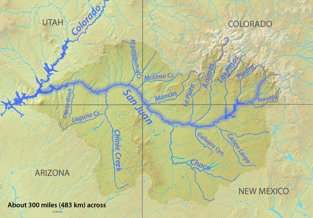
Rio Grande and Pecos River basins. Map credit: By Kmusser – Own work, Elevation data from SRTM, drainage basin from GTOPO [1], U.S. stream from the National Atlas [2], all other features from Vector Map., CC BY-SA 3.0, https://commons.wikimedia.org/w/index.php?curid=11218868
Attorneys laid out their arguments Monday during the first day of a virtual trial in a lawsuit over Rio Grande water with Texas and the federal government alleging that New Mexico’s use of groundwater cut into Texas’ share of river water.
The appointed special master, Michael Melloy, a senior judge for the U.S. 8th District Court of Appeals, is hearing arguments in the 8-year-old case and will compile a report for the U.S. Supreme Court.
Melloy determined in late August that the long-awaited three-month trial would be split into two portions, one virtual and one in-person later in Cedar Rapids, Iowa. He cited a health emergency for one of the Texas attorneys and concerns about the increase of COVID-19 cases for splitting the trial.
Virtual testimony from a mix of members of federal agencies, farmers, irrigation managers, hydrologists and city officials from El Paso and Las Cruces will continue over several weeks.
In the 2014 complaint in the case, officially called No. 141 Original: Texas v. New Mexico and Colorado, Texas attorneys allege New Mexico’s groundwater pumping reduced Texas’ Rio Grande portion by tens of thousands of acre feet each year, and owes Texas damages. An acre-foot of water is equal to about 325,851 gallons.
Colorado is named as a defendant only because it is a signatory to the 82-year-old Rio Grande Compact…
The longstanding tug-of-war over the river’s water between the states and the federal government started a decade ago. In a 2011 federal lawsuit, New Mexico alleged the federal government shorted New Mexico its Rio Grande water, and gave too much to Texas. It escalated when Texas filed a new lawsuit against New Mexico in the U.S. Supreme Court three years later.
On Monday, attorney Stuart Somach, who represents Texas, opened with an apology for repeating arguments, saying he’s presented Texas’ case since 2012…
The basis for Texas’ case, Somach said, was that New Mexico’s groundwater pumping south of the Elephant Butte Reservoir depleted the Rio Grande and violated the Rio Grande Compact.
Historically, the Rio Grande was split 57% to New Mexico and 43% to Texas. Somach said that the increased groundwater use from the city of Las Cruces, New Mexico State University and agriculture in New Mexico reduces the total amount of river water available to Texas.
“We don’t quibble with the fact that we get 43% of something,” Somach said. “But what we’re entitled to is 43% of the conditions that existed in 1938, not the conditions that have been created by New Mexico groundwater pumping.”
Somach said over the next few weeks, Texas farmers, the irrigation district and officials from the city of El Paso will testify to the “injury caused directly by New Mexico’s actions.”
James DuBois, an attorney in the Department of Justice, told the court that New Mexico has known that groundwater pumping would impact the amount of water in the Rio Grande…
DuBois said New Mexico’s actions threatened the compact, and the 1906 treaty that guarantees Mexico’s portion of the Rio Grande, up to 60,000 acre-feet…
DuBois said the court would hear from federal officials at the U.S. Bureau of Reclamation, which oversees irrigation projects in the West, about a 2008 operating agreement between the federal government and irrigation districts that updated allocations.
He said to expect testimony from the International Boundary and Water Commission, a binational agency which enforces the water treaty with Mexico, in coming weeks.
The opening arguments for New Mexico were split between the outside counsel and New Mexico Attorney General Hector Balderas.
Balderas said the uncertain climate future and a shrinking river make this case pressing…
Balderas said the state maintains that New Mexico is not receiving its fair share of water. He referenced the federal civil case from 2011, when the then-Attorney General Gary King sued the federal government over the 2008 operating agreement with the irrigation districts. King alleged the agreement gave too much water to Texas and shorted New Mexico. That 2011 case remains unresolved, because when Texas filed the lawsuit in the Supreme Court in 2014, action halted in the lower courts.
“It’s not Texas that is being harmed in this case, it is New Mexico,” Balderas said…
Attorney Jeff Wechsler, representing New Mexico, said the 2008 operating agreement meant that New Mexico is shorted on surface water, making area farmers more reliant on groundwater pumping…
Wechsler said that additional water in Texas is sold by the El Paso irrigation district to Hudspeth County, which is allowed to use Rio Grande project waste water…
Wechsler went on to say that groundwater pumping in the Hueco Bolson by El Paso, a major source of water for the city, has impacted Rio Grande project waters.
Wechsler said that New Mexico farmers, relying on groundwater because of the federal government’s allocation changes since 2008, are paying more in maintenance and in soil changes, which he said amount to millions in damages.
Weschler asked the court to rule that “New Mexico receives 57% of project water” and allow the state to collect damages.
In 1979 the Upper Arkansas Water Conservancy District was formed. Since that time innumerable benefits have been provided to the citizens of the district.
The primary goal of the district is protection of water rights within the Upper Arkansas. Continuous monitoring and involvement in legislative measures that impact water rights, involvement in water court cases that have the potential to negatively impact Upper Basin water rights and operating umbrella augmentation plans that prevent injury to water rights by making weekly water replacements to affected rivers and streams by out-of-priority uses are the major areas of work.
Other areas include conducting water studies such as ground water monitoring, water balance studies with the U.S. Geologic Survey, identification of and development of alluvial water storage, watershed health activities such as spearheading the Monarch Pass Steep Slope Timber Harvesting Project and water education programs. The benefits of these programs are not always recognized by citizens of the district.
Water resource development is essential to an effective water right protection program. The most obvious and direct benefit of this is the district’s umbrella augmentation plan program. Augmentation is a little understood water resource concept that was developed in 1969 when Colorado fully recognized in legislation the connection between tributary ground water and surface water. With this recognition all ground water production was brought under and regulated by the prior appropriation system.
Basically, this meant that the right to extract ground water for use would be governed by the date of first use. In an arid country such as Colorado, and in particular eastern Colorado, there is never enough water to satisfy all legal claims. Thus, priority of use is controlled by the established date of first use or “First in Time Is First in Right.” This legislation prevented most well use except when a “fully consumable” water source was used to replace the amount of water used up by the well. In other words, the well use would have to be augmented with a court-decreed “Plan of Augmentation.”
The full impact of this was not completely felt until the decision of the Kansas-Colorado Compact lawsuit and the adoption by Colorado in 1995 of the “Amended Rules and Regulation on Tributary Ground Water Use in the Arkansas Basin.”
Fortuitously, the district had filed in 1992 and obtained an umbrella augmentation plan in 1994. The benefits have been enormous for citizens within district boundaries of its decreed augmentation areas needing augmentation to use their wells, surface diversion or ponds.
The value of being able to enroll into the district’s augmentation plan and continue to use one’s well is best quantified by cost savings. Typical residential well augmentation requires a source of fully consumable water, storage, an engineering plan and a water court decree. The typical current cost for such a plan ranges from a low of $80,000 to $150,000 per residence. The cost per residence with the district’s plan is less than $4,500, a savings per residence of $75,000 to more than $145,000.
Presently the district provides augmentation to over 2,000 wells. The vast majority of these are for residential use. This savings expressed in dollars would represent a cost savings to district citizens of as much as $290 million.
The additional and as important benefit is to rivers and streams in the district. Annually more than 700-acre feet of water is released to our streams and available to support water rights and protect them from injury.
Further benefits are the water infrastructure that is maintained and constructed that supports recreation and the environment. Many of the area lakes and reservoirs are filled with district owned and controlled water rights, such as O’Haver Lake.
The studies and watershed health projects the district has undertaken in its 35 years of existence provide a wealth of knowledge and data for present and future understanding of our water resource and a roadmap to future water development.
Ralph “Terry” Scanga is general manager of the Upper Arkansas Water Conservancy District.
Developer 4 Site Investments plans to build more than 3,200 homes north of Judge Orr Road adjacent to Eastonville Road and U.S. 24. County commissioners on Tuesday, Sept. 28, 2021, voted to approve a service plan for four new metropolitan districts that will fund the subdivision. Courtesy of Grandview Reserve Sketch Plan
El Paso County commissioners on Tuesday approved four new metropolitan districts that will fund a proposed subdivision of more than 3,200 homes in Peyton, a move some locals say could alter the area’s “small-town feel” as thousands of expected residents move in.
Commissioners voted unanimously to form the metropolitan districts that propose issuing $290 million in debt over 30 years to build the planned Grandview Reserve subdivision on about 768 acres between U.S. 24 and Eastonville Road, near Falcon Regional Park.
Grandview Reserve developers expect to build up to 3,260 single-family homes in the new subdivision over 14 years, said Russell Dykstra of law firm Spencer Fane LLC, representing developer 4 Site Investments LLC. About 244 homes would be built each year from 2022 through 2032 before construction gradually tapers down between 2033 and 2036, according to meeting documents. Previously, anticipated build-out was planned to occur over eight years.
County planner Kari Parsons said homes were expected to sell on average for about $340,000. Developers will charge each future property owner special district taxes to finance the $295 million debt. Owners of a newly built $400,000 home in the subdivision could owe about $1,859 in taxes annually, Dykstra said.
The proposal presented Tuesday was revised from a previous request to form five new metropolitan districts that proposed issuing $250 million in debt to build the new development. Parsons said developers now proposed issuing $290 million in debt because of increased construction costs…
Developers contended several other nearby districts — including the 4-Way Ranch, Meridian Ranch and Woodmen Hills metro districts — cannot support nor pay for traffic, water and storm drainage improvements planned for the area, meeting documents show.
In a March 31 letter addressed to commissioners and included in meeting documents Tuesday, the 4-Way Ranch Metropolitan District said it cannot provide services to the proposed Grandview Reserve subdivision because it does not have enough water. The district also said forming four new Grandview Reserve Metropolitan Districts “would provide an economic alternative for services and would eliminate undo [sic] financial burden” on the 4-Way Ranch Metro District No. 2.
The Grandview Reserve Metro District would provide water to the Grandview Reserve subdivision, which needs about 1,200 acre-feet a year, developers said. An acre-foot of water is enough to cover an acre of land to a depth of about one foot and is considered the amount needed by a family of four for about a year.
Denver Basin Aquifer System graphic credit USGS.
The metro district would source mostly from the Arapahoe and Laramie-Fox Hills aquifers, but offsite wells from neighboring lands owned by 4 Way Ranch will “likely be needed” for full development, meeting documents show.
Upper Black Squirrel Creek Designated Groundwater Basin
Mirko Cruz of Trout Raley law firm, representing the Upper Black Squirrel Creek Ground Water Management District, said the developer hasn’t “provided sufficient evidence” that the new metro district owns or controls adequate water rights to service the development. Developers have a purchase and sale agreement “for a portion of the water needed” to meet the subdivision’s demands but it doesn’t prove their guaranteed right to use the water, he said…
Cherokee Metropolitan District will provide wastewater services to the subdivision, developers said.
The dry bed of the Arkansas River near the Santa Fe Trail crossing at Cimarron, Kansas. The Ogallala aquifer groundwater levels in much of western Kansas started dropping in the 1950s as pumping increased, according to the Kansas Geological Survey. File Photo / Max McCoy
Due to a number of reasons including this year drought conditions, water supply is becoming a major concern in western Kansas.
Agriculture-heavy western Kansas is substantially supported by the Ogallala Aquifer, one of the world’s largest aquifers. But water-intensive crops and farming are putting incredible pressure on it. Groundwater levels in the Ogallala have been on the decline ever since irrigation began. The state water plan warns that if irrigation and pumping continue at this rate, some regions may see themselves out of water in as little as 20 years.
“For agriculture, the impact on farming is increasing costs to pump water from a continuously lowering groundwater level,” Elmer Ronnenbaum, general manager at Kansas Rural Water Association, told The Center Square. “At some point, the aquifer will either not yield sufficient water for irrigation or the costs associated with pumping water from so deep will make irrigation no longer feasible.”
While funding for groundwater management remains an issue, there are a few solutions being implemented.
“Practical solutions include Intensive Groundwater Use Control Areas (IGUCA) and Local Enhanced Management Areas (LEMA),” Ronnenbaum said. “Another solution that has been floated in recent years is an aqueduct to transport water to southwest Kansas from the Missouri River in northeast Kansas, but generally has been deemed too costly and is opposed by neighboring states and local (northeast Kansas) residents.”
Two LEMAs have already been established in Northwest Kansas Groundwater Management District (GMD) No. 4, which appears to have slowed water level declines over just a few years. A third LEMA was just implemented in Western Kansas GMD No. 1.
Kansas farmers will continue to farm, but with limited water supply, some may have to shift their focus to continue to be profitable.
“Advances in technology have allowed some irrigators to keep irrigating with less yield of water but comes at a cost to change,” Ronnenbaum said. “Some farmers will have to switch to dryland crops or crops with lower irrigation water use requirements as the aquifer declines in their areas. For example, cotton requires half the amount of irrigation water but currently is nearly as profitable as corn.”
The Ogallala aquifer, also referred to as the High Plains aquifer. Source: National Oceanic and Atmospheric Adminstration
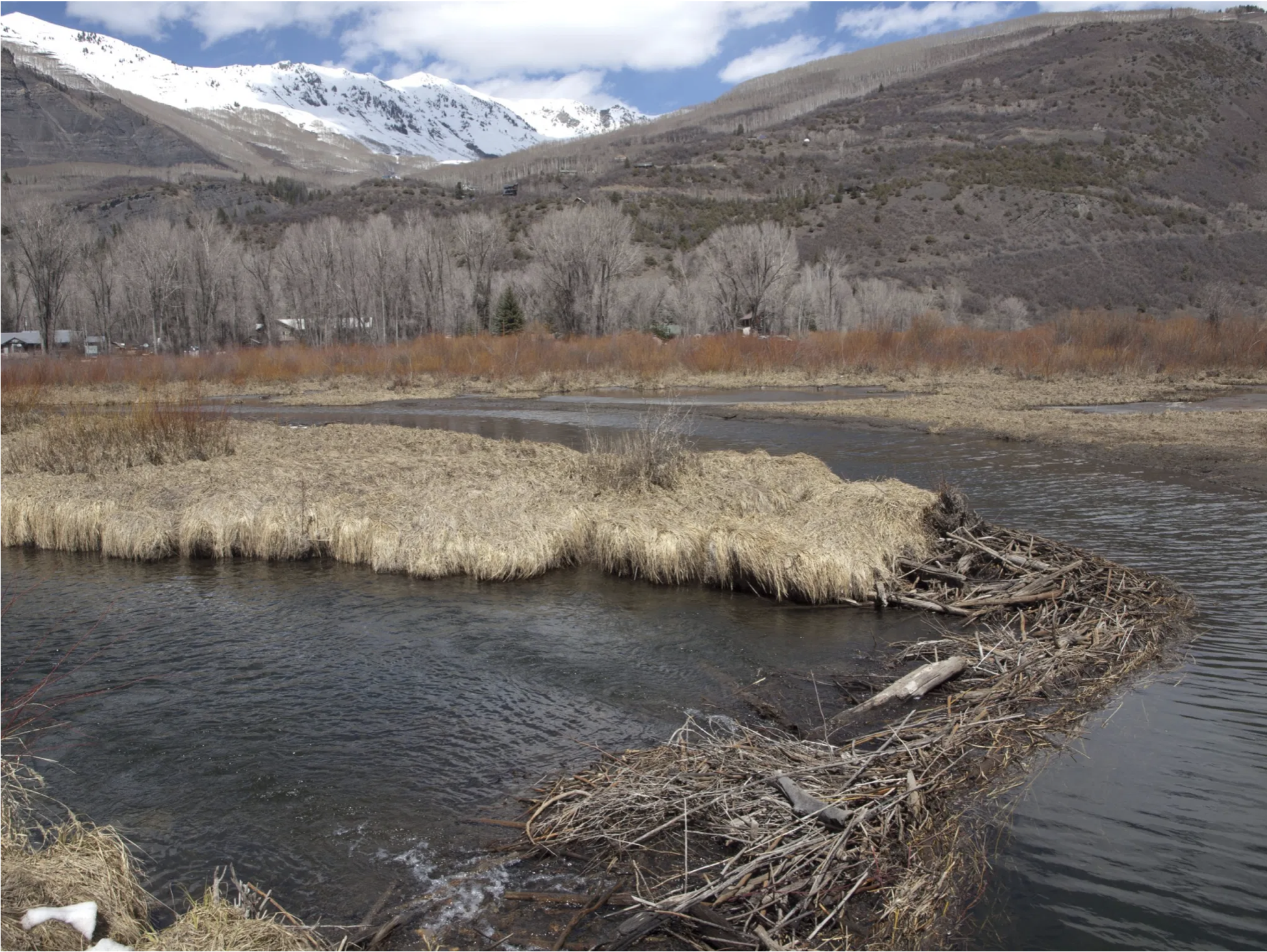
These wetlands, located on a 150-acre parcel in the Homestake Creek valley that Homestake Partners bought in 2018, would be inundated if Whitney Reservoir is constructed. The Forest Service received more than 500 comments, the majority in opposition to, test drilling associated with the project and the reservoir project itself. Photo credit: Heather Sackett/Aspen Journalism
David O. Williams is a contributor to Writers on the Range. Photo credit: Writers on the Range
It was 1952 when the cities of Aurora and Colorado Springs first started gobbling up water rights in a remote, high mountain valley on the state’s Western Slope. The valley is called Homestake, and now, those same cities want even more of its pure water.
In western Colorado, where only about 20% of Colorado’s population lives, all water tries to flow toward the Pacific Ocean. On the east side, where most people live, water flows to the Atlantic. To bring the water from the west side to the east side of the Rockies requires lots of money and lots of pipelines.
But money isn’t much of a barrier when your population is exploding: Colorado Springs, with 478,961 residents, and Aurora, with 386,261, need more water. And they aim to get it even if it must cross under the Continental Divide and damage a fragile and ancient wetland called a “fen” in the process.
The new reservoir the two cities plan to build would be five miles downstream from their existing Homestake Reservoir, and called Whitney Reservoir after a creek that flows into Homestake Creek. There’s also a Whitney Park within the nearby Holy Cross Wilderness Area, which could lose some 500 acres if the new reservoir goes through.
The Holy Cross Wilderness Area near Vail, which could lose 500 acres under the new reservoir plan. (Photo Credit: John Fielder via Writers on the Range)
But protesters are already active, and conservation groups are threatening lawsuits. Meanwhile, the cities have already quietly begun test drilling at four possible dam sites on U.S. Forest Service land along Homestake Creek.
Obstacles, however, are popping up. The Forest Service says it won’t even consider a reservoir proposal that shrinks a wilderness area, and the cities would have to get that approval from both Congress and the White House.
The U.S. congressman for the district, rising Democratic star Joe Neguse, has also made it clear he doesn’t support shrinking a designated wilderness or damaging wetlands. Local leaders are also chiming in: “A Whitney Reservoir would irreparably change and harm our community,” said Minturn Mayor John Widerman and Red Cliff Mayor Duke Gerber, who co-wrote a letter to the Forest Service. Both represent small towns dependent on tourism and outdoor recreation.
State Sen. Kerry Donovan, a Democrat who grew up in the nearby ski town of Vail, also wrote the Forest Service to oppose the dam: “I cannot express how sternly the citizens of my district … oppose water diversion projects to Front Range communities.”
Another issue, and for some it’s the most critical, is the fate of valuable “fen” wetlands that would be destroyed by a dam and reservoir. “This is one of the finest wetlands we can find on our forest — it’s unbelievable,” White River National Forest Supervisor Scott Fitzwilliams told Aspen Journalism in 2019. “You can mitigate, but you can’t replace 10,000 years of work.”
etlands, which are havens of biodiversity, offer priceless ecological benefits. As wetlands are lost to development nationwide, critics of the dam project worry about its local impact. (Photo Credit: John Fielder via Writers on the Range)
Nor can you turn the clock back to 1952, when Colorado’s population was 1.36 million, compared to 5.7 million today, and the global land and ocean temperature was 1.52 degrees Fahrenheit cooler. Climate change, scientists say, will cause the Colorado River to lose up to 31% of its historical flow by 2052. That prediction was a factor in a recent, first-ever federal water shortage declaration.
“When Colorado Springs and Aurora got their water right, the [Holy Cross] wilderness wasn’t there and wetlands at that time were something we were just filling in,” said Jerry Mallett, president of the local conservation group Colorado Headwaters. “Since then (wetlands) have become an extremely valuable resource because of what they can do for groundwater recharge, addressing climate change — all kinds of things.”
Then there’s the issue of Kentucky bluegrass, Colorado’s landscaping groundcover of choice. Kentucky gets more than 50 inches of rain a year compared to the Front Range average of 17, so why pump western Colorado’s high-elevation water through the Rockies for lawns?
Colorado photographer and conservationist John Fielder, who says he’s been just about everywhere within the nearly 123,000-acre Holy Cross Wilderness Area, wants people to just look at his images of the fen wetlands along Homestake Creek, and then ask themselves these questions:
“Is anything more sublime and fertile and life-giving than a 10,000-or-more-year-old fen wetland? You can’t “mitigate” the loss of ancient wetlands by creating a manmade wet place somewhere else. No more water to the Front Range.”
David O. Williams is a contributor to Writers on the Range, writersontherange.org, a nonprofit dedicated to spurring lively conversation about the West. He is a freelance writer who lives near Vail, Colorado.
A growing oats and radish mix. Photo by Paul Gross, MSU Extension.
Click here to read the report. Here’s the abstract (Vesh R. Thapa, Rajan Ghimire, and Mark A. Marsalis):
Cover crops can improve soil health by maintaining soil organic carbon (SOC) and nitrogen (N) contents, yet their dynamics in relation to crop yield in a semi-arid cropping system are poorly understood. The main objective of this study was to evaluate the response of diverse winter cover crop species and their mixture on SOC and N fractions and their relationship with sorghum (Sorghum bicolor L. Moench) yield in a winter wheat (Triticum aestivum L.)–sorghum–fallow rotation with limited irrigation management. Cover cropping treatments included pea (Pisum sativum L.), oat (Avena sativa L.), canola (Brassica napus L.), and mixtures of pea+oat (POM), pea+canola (PCM), peat+oat+canola (POCM), and a six-species mixture (SSM) of pea+oat+canola+hairy vetch (Vicia villosa Roth)+forage radish (Raphanus sativus L.)+barley (Hordeum vulgare L.) as cover crops and a fallow. Soil samples were analyzed for residual inorganic N, potentially mineralizable carbon (PMC) and nitrogen (PMN), SOC, and total N. Response of labile inorganic N, PMC, and PMN varied with cover crop treatments. The SOC and total N contents did not differ among treatments but were 20% and 35% higher in 2020 than in 2019, respectively. Sorghum grain yield was 25% and 40% greater with oats than with PCM and canola cover crops in 2019, while it was 33–97% greater with fallow and oats than other treatments in 2020. Oat as a cover crop could improve the resilience of limited-irrigation cropping systems by increasing SOC, soil N, and crop yield in semi-arid regions.
“We know who pooped in the river, now we’re trying to figure out where it’s coming from,” Alyssa Richmond said as she took a sample of water recently from the muddy San Juan River, in the blazing high desert outside Farmington.
Richmond is coordinator for the San Juan Watershed Group, a collection of local agencies and volunteers working to improve water quality on the San Juan River as it runs through northern New Mexico. The group’s ultimate goal, Richmond said, is to have the stretch of river meet national water quality standards. But as it stands, it’s not going well.
Among a plethora of water-quality issues that include mine pollution, urban runoff and rising water temperatures amid an increasing drought, is the issue of E. coli contamination. A naturally occurring bacteria that lives in all humans and animal stools, E. coli can contaminate ground and surface water, and lead to health implications.
For at least the past 10 years, researchers have launched a full-scale investigation to better understand E. coli issues up and down the San Juan River watershed, from high up in the San Juan Mountains to its major tributary, the Animas River, to stretches that run into the Navajo Nation.
Early results are not encouraging: the EPA’s standard for acceptable E. coli levels is 126 colony-forming units (CFU) per 100 milliliters. In stretches of the San Juan River through Farmington, water samples taken this summer exceeded nearly 1,500 CFUs. “We didn’t expect it to be as high as it was,” Richmond said on a sampling day in late August. “It was shocking.”
But it’s not all doom and poop. The San Juan Watershed Group’s efforts will ultimately help inform where cleanup projects should be focused to achieve the highest improvement in water health. And, all up and down the watershed, even to the highest reaches of the Animas River around Silverton, there is a concerted push to face E. coli issues head on.
“The good news is everyone agrees there should be no human poop in the water,” said San Juan Citizens Alliance’s Animas Riverkeeper Marcel Gaztambide, who probably never thought he’d have to make so obvious a statement to the local paper. “And it’s an issue of concern, so it’s good we’re talking about it now.”
Defecation detectives
E. coli is a difficult contaminant to fully contextualize because not only is it naturally occurring, it is also one of the most common bacteria. It can come from livestock as well as wildlife like elk, deer, birds, beaver – pretty much any animal that poops. And to complicate matters further, only some strains of the bacteria are harmful to human health.
In the early 2010s, however, researchers knew high E. coli levels were an issue in the San Juan River in northern New Mexico, but the question was, who was the main culprit? After conducting two years of microbial source testing, which not only shows the level of E. coli but also pinpoints the exact source, the results were not what researches were expecting. It came back that the largest contributors were … drumroll, please … humans.
In fact, test results showed human feces in 70 to 100 percent of samples taken from the Animas River at the Colorado-New Mexico state line down to the border of the Navajo Nation.
With the guilty party exposed, funding was again secured to take the investigation a step further this summer by understanding where exactly the human waste was coming from, Richmond said. It’s a process that’s rather simple, by testing upstream and downstream of suspected source points, and then seeing where the spikes in E. coli levels occur. And already, there are some potential smoking guns: failing septic tanks from homes and development, outdated wastewater treatment plants and illegal RV dumping.
What the sampling has also shown, Richmond said, is the high E. coli levels aren’t necessarily coming from upstream communities in Durango and elsewhere. Instead, early results indicate the highest spikes happen in and around Farmington…
It’s a watershed moment
But that doesn’t necessarily mean upstream communities are swimming in sparkling clean waters.
The Animas River, for instance, has issues all its own. Remember that EPA standard of 126 cfu/100 mL? Well, one study conducted by Fort Lewis College in October 2018 found E. coli levels in the Animas at Santa Rita Park, near the Whitewater Park (close your eyes kayakers and surfers) at 226 CFUs. Bare in mind, this was before the completion of the City’s new water reclamation facility in December 2019…
Over in the Florida River, which runs into the Animas about 18 miles south of Durango, progress is also being made, said Warren Rider, coordinator for the Animas Watershed Partnership, which focuses on water quality issues on the Colorado side of the border.
The Florida River for years has exceeded safety standards for E. coli and accounts for nearly a quarter of the bacteria and nutrients dumped into the Animas River before the state line. In a bit of a shock, the Florida was delisted last year, but that was mostly due to a lack of data, researchers say.
While natural sources do account for a portion of contamination in the Florida, agriculture and livestock operations also contribute a good amount of harmful bacteria. As a result, Rider said the Animas Watershed Partnership has tried to work with landowners to fence off waterways to livestock and reestablish vegetation along stream banks…
Up in the high country
And no one has forgotten about the highest reaches of the watershed atop the San Juan Mountains, where an unprecedented increase in recreation, and therefore human waste, has been well noted and nosed in the past year or so.
This summer, the U.S. Forest Service and Mountain Studies Institute partnered to test heavily trafficked recreation areas for E. coli. Colleen Magee-Uhlik, a forest ambassador with MSI, said areas with high use of recreation showed much higher concentrations than locations with little human impact.
In the obvious case study, South Mineral Creek – that of Ice Lakes fame – water samples taken above the highest areas of recreation tested at about 22 CFUs. Farther downstream, in a location that would catch all the cumulative impacts of recreation and camping, samples were more than four times as high, at nearly 90 CFUs. (And, it should be noted, South Mineral was closed this year because of fire damage, which likely means levels would be even higher if people were in the area)…
Christie Chatterley, Fort Lewis College assistant professor of physics and engineering, said in the popular backpacking spot Chicago Basin in the Weminuche Wilderness, a student-led research program also found high levels of E. coli in streams. FLC has plans to conduct microbial source testing to see exactly where the bacteria is coming from, but Chatterley said it’s probably safe to assume hikers and campers…
So what can be done?
For starters, using best practices in the high country, such as burying waste 6 to 8 inches deep and 200 feet away from water, and packing out toilet paper can go a long way. This message is even more important as record numbers of people visit the backcountry, many without a working knowledge of how to protect the very landscape they come to enjoy.
Farther downstream, upgrading septic tanks is seen as another obvious target. Brian Devine, with San Juan Basin Public Health, said new septic regulations require people selling their homes to have septic systems inspected. In 2020 alone, more than 500 systems were inspected, which led to many leeching septic tanks being fixed. “It’s resulting in systems getting repaired,” he said. Richmond, with the San Juan Watershed Group, said agencies are working with New Mexico health officials to tackle failing and outdated septic systems as well.
And, the city of Durango’s Biggs said the Clean Water Act continues to push water quality standards. “The Clean Water Act has really improved water quality, and the Animas would be a testament to that,” he said. “And everyone benefits, including our downstream users.”
So yes, there’s no quick and easy fix to E. coli issues in the Animas and San Juan rivers, but all these efforts are folded into the long history of communities along the watershed, and the responsibilities they have to one another, Biggs said. It’s an issue that dates back to the 1800s when Silverton would send down water contaminated by mining operations to Durango, and a few decades later, when Durango’s uranium pile sat along the banks of the Animas River, only to be swept downstream.
The dry bed of the Arkansas River near the Santa Fe Trail crossing at Cimarron, Kansas. The Ogallala aquifer groundwater levels in much of western Kansas started dropping in the 1950s as pumping increased, according to the Kansas Geological Survey. File Photo / Max McCoy
For decades, the Texas Panhandle was green with cotton, corn and wheat. Wells drew a thousand gallons (3,785 liters) a minute from the seemingly bottomless Ogallala aquifer, allowing farmers to thrive despite frequent dry spells and summer heat.
But groundwater that sustained generations is drying up, creating another problem across the Southern plains: Without enough rain or groundwater for crops, soil can blow away — as it did during the Dust Bowl of the 1930s.
“We wasted the hell out of the water,” says Muleshoe, Texas, farmer Tim Black, recalling how farmers irrigated when he was a kid. Water flooded furrows or sprayed in high arcs before farmers adopted more efficient center-pivot systems.
His grandfather could reach water with a post-hole digger. Black is lucky to draw 50 gallons (189 liters) a minute from wells up to 400 feet (122 meters) deep.
Now farmers are facing tough choices, especially in parts of Texas, New Mexico and Oklahoma.
Some are growing less-thirsty crops or improving irrigation. Others, like Black, are replacing some cash crops with cattle and pastureland.
And more are planting native grasses that go dormant during drought, while deep roots hold soil and green with the slightest rain…
Black, a former corn farmer, plants native grasses on corners of his fields, as pasture for cattle and between rows of wheat and annual grass.
The transition to cattle, he hopes, will allow his oldest son to stay on the land Black’s grandparents began plowing 100 years ago. His younger son is a data analyst near Dallas…
More than half the currently irrigated land in portions of western Texas, eastern New Mexico and the Oklahoma Panhandle could be lost by the end of the century, according to a study last year. And the central part of the aquifer could lose up to 40% of irrigated area by 2100.
Those losses might be slowed as farmers adapt to lower water levels, researchers say. But the projections underscore the need for planning and incentives in vulnerable areas.
The U.S. Department of Agriculture is prioritizing grasslands conservation in a “Dust Bowl Zone” in parts of Colorado, Kansas, New Mexico, Oklahoma and Texas.
But reestablishing native vegetation in the sandy soil over the Ogallala has proven difficult where irrigation ceased on former Kansas farmland. The same is true on land outside the Ogallala previously irrigated with river water, including in Colorado’s Arkansas River Valley.
Extended periods of drought that plagued the Southwest over the past 20 years likely will continue, says meteorologist Brad Rippey with the USDA.
So farmers may need to use some remaining groundwater to reestablish native grasses, says study co-author Meagan Schipanski, an associate professor of soil and crop sciences at Colorado State University.
Historic photo of the High Plains in Haskell County, Kansas, showing a treeless semi-arid grassland and a buffalo wallow or circular depression in the level surface. (Photo by W.D. Johnson, 1897)
A center-pivot sprinkler near Wray, Colo. Photo/Allen Best
Click here to read the report (Neal T. Graham, Gokul Iyer, Mohamad I. Hejazi, Son H. Kim, Pralit Patel & Matthew Binsted). Here’s the abstract:
Governance measures such as restrictions on groundwater pumping and adjustments to sectoral water pricing have been suggested as response strategies to curtail recent increases in groundwater pumping and enhance sustainable water use. However, little is known about the impacts of such sustainability strategies. We investigate the implications of such measures, with the United States (U.S.) as an example. Using the Global Change Analysis Model (GCAM) with state-level details in the U.S., we find that the combination of these two governance measures can drastically alter agricultural production in the U.S. The Southwest stands to lose upwards of 25% of their total agricultural production, much of which is compensated for by production increases in river basins on the east coast of the U.S. The implementation of future sustainable water governance measures will require additional investments that allow farmers to maximize production while minimizing water withdrawals to avoid potentially detrimental revenue losses.
Colorado state health officials said they’re hopeful a recent federal court ruling that effectively overturned Trump-era rules reducing oversight of Western rivers and streams will allow states to revert back to a more protective standard.
“We are aware of Arizona’s court decision and are following what it means for other states, especially arid states such as Colorado. We are hopeful the Arizona ruling will apply nationwide because it has the potential to allow states to revert back to standards that protected our state waters more,” said Trisha Oeth via email.
Oeth, who is the environmental health and protection policy director at the Colorado Department of Public Health and Environment (CDPHE), also said the state understood the need to ensure that more certainty regarding the regulations was critical to protect all the interest groups affected by them.
The Trump rule sought to overturn Obama Administration rules that expanded the scope of the Clean Water Act. But Aug. 30, the Arizona court rejected it, saying it harmed streams in Western states and ignored important science. It has directed regulators across the country to use a set of rules developed prior to the Obama Administration’s actions until the Biden Administration can develop new regulations.
Since 2019, when the Trump-era rule was finalized, the CDPHE has been working, without success, on a proposed permitting program that lawmakers would have to approve. The permitting program would have covered streams and rivers left unprotected by the Trump rule. The so-called dredge-and-fill permits proposed by the state would be required when activities such as road and home building affect streams no longer covered by the Trump rule.
But farm interests, developers and contractors remain concerned that the Clean Water Act (CWA) rule, known as the Waters of the U.S. (WOTUS) rule, will remain mired in legal battles and regulatory uncertainty, delaying projects and raising their costs.
“It’s a big fear of ours,” said Zach Riley, the Colorado Farm Bureau’s director of public policy. The organization, which has 23,000 members, had supported the narrower WOTUS rule.
The political seesaw has been going on for decades with the CWA legally hamstrung over murky definitions about which waterways fall under its jurisdiction, which wetlands must be regulated, what kinds of dredge-and-fill work in waterways should be permitted, what authority the CWA has over activities on farms and Western irrigation ditches.
Administered by the U.S. Army Corps of Engineers and the Environmental Protection Agency, the CWA is credited with making U.S. waters some of the cleanest in the world. But it has also been difficult to administer, in part because the country is home to widely different geographies and because of numerous court cases that have altered how it is interpreted by different presidential administrations.
Western states have been particularly concerned because in the Midwest and East, for instance, major rivers that carry barge and shipping traffic are clearly “navigable,” the term early courts used to determine how water would be regulated. If a stream was navigable, it was subject to federal law.
But Colorado and other Western states rely on shallow streams that often don’t flow year round and don’t carry traditional commercial traffic. Over the years many of those streams too became protected by the Clean Water Act.
The Trump administration’s WOTUS rule, however, excluded them, saying that only navigable streams would be regulated, meaning that thousands of miles of streams in Colorado and other Western states that don’t flow year round or carry commercial shipping traffic would no longer have been protected.
Whether Colorado can or should craft a new permitting regulation that will remove it from the political back-and-forth that has dogged WOTUS and provide industry and environmental groups with more certainty isn’t clear yet.
The CDPHE has not yet said what it plans to do, saying it is still analyzing the Arizona decision.
“At the state level, it will be interesting,” said Alex Funk, senior counsel and director of water with the Theodore Roosevelt Conservation Partnership, which has advocated for a new state permitting program. “We’re still supportive of a state program to get out of this habit of having new WOTUS rules every four years…we need something that will survive at the federal level.”
Still others want the CDPHE to take a breather, to wait and see how the EPA and other agencies interpret this latest ruling before trying to create a new state regulation.
“Given the pace of change and the multiple rounds of litigation, the state could take more time to discuss what’s needed,” said Gabe Racz, an attorney who represents water utilities and industry at the Colorado Water Congress.
And Racz said he believes there is a chance that the Biden Administration will be able to craft new rules that can endure at the federal level, regardless of who is in the White House.
“The Biden Administration announced they planned to develop a durable rule. I’m hopeful. That’s a step in the right direction,” Racz said.
Jerd Smith is editor of Fresh Water News. She can be reached at 720-398-6474, via email at jerd@wateredco.org or @jerd_smith.
From the Environmental Defense Fund (Christopher Kuzdas):
In June, a portion of my neighborhood in Flagstaff, Arizona, was put on pre-evacuation notice due to a nearby wildfire. A few weeks later, storms dumped heavy rains over a burn scar from a 2019 fire that caused destructive floods through parts of town. So far, this summer has been our third-wettest monsoon season on record, a complete contrast from our two driest monsoon seasons on record in 2019 and 2020.
These extremes are just a few local examples of the havoc that climate change is causing around the world. Here in the West, we are now in uncharted territory with the first-ever shortage declaration on the Colorado River.
What the shortage declaration means
The U.S. Bureau of Reclamation recently confirmed the Colorado River will be operated under never-before-used shortage rules, called a “tier 1” shortage, starting in 2022.
Under the rules defined by the 2019 Drought Contingency Plan (DCP), other agreements and the river’s operating guidelines, Arizona will absorb the brunt of this shortage. About one-third less water will flow through the Central Arizona Project canal to the Phoenix and Tucson areas, primarily impacting farmers. Nevada and Mexico will also see mandatory but smaller water cuts.
Though overused and overallocated, the Colorado River still provides water for 40 million people in the United States, Mexico and 30 Native American tribes. Water use across the Colorado River Basin has been unsustainable for years, and it was set up to be that way, going back to the 1922 Colorado River Compact that divided up the river. But climate change is now magnifying and accelerating problems in the basin. Photo credit: The Environmental Defense Fund
Even more concerning are water supply projections for 2023 and beyond.
Bureau of Reclamation projections forecast Lake Mead could fall close to a threshold where there are no rules outlining additional water cuts to avoid a crash to dead pool — when no water can flow out of Hoover Dam. This risk of an acceleration in plummeting water levels — which also jeopardizes water levels in Lake Powell — has prompted basin state representatives to initiate meetings to discuss additional actions that might be needed if water levels in Lake Mead fall below 1,020 feet.
It will get hotter and drier
This unprecedented situation offers a glimpse into our future. Warming scenarios from the latest IPCC report suggest that we could exceed 2 degrees Celsius of warming around midcentury, with more than 5 degrees by the end of the century, in the absence of action to curb carbon emissions.
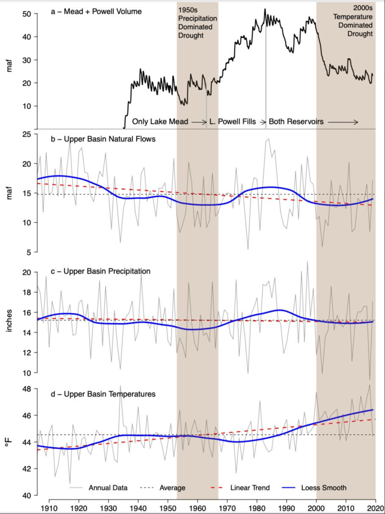
Brad Udall: Here’s the latest version of my 4-Panel plot thru Water Year (Oct-Sep) of 2019 of the #coriver big reservoirs, natural flows, precipitation, and temperature. Data goes back or 1906 (or 1935 for reservoirs.) This updates previous work with @GreatLakesPeck
Why does this matter for the Colorado River? Colorado River flows are highly sensitive to warming, and aridification caused by climate change is already reducing the water flowing in the river. With each additional 1 degree Celsius (1.8 degrees Fahrenheit) of warming, the Colorado River’s average flow drops by 9.3%, according to the U.S. Geological Survey. Colorado River flows could be up to one-third less than the current average within a generation, unless meaningful and immediate reductions in carbon emissions are achieved.
The outlook for the Colorado River is overwhelming. But what our future looks like is still our choice. We can, and should, choose to pursue a just transition to a basin with significantly less water. While in no way comprehensive, below are four ways to get started on that path.
1. Reconcile water demand with our climate reality.
Reconciling demands with our climate reality, at the very least, will involve updating river operating rules, scaling up conservation programs and shifting away from outdated expansionism.
The rules that determine how we balance supply and demand, and the underlying rights and agreements that collectively determine who gets how much water and when, will play a major role in how we transition to a basin with less water.
River operating rules have become more flexible to some extent as they evolved through new agreements like the DCP. However, current river operating rules still don’t account for the full suite of climate change impacts, especially those impacts under more dire climate scenarios. While river operating rules are already a focus of discussion, updating them will require thoughtful leadership, as well as attention to climate and other social and environmental considerations.
Scaling up conservation programs such as system conservation in the Lower Basin and demand management in the Upper Basin will also play an important role. If not for water conserved in Lake Mead, a “tier 1” shortage would have occurred years ago. Our challenge moving forward will be expanding the scale and impact of these programs, and in the Upper Basin, moving much faster to do so.
To fully reconcile demands with our climate reality, we must also finally shift away from legacy expansionism and boosterism that still show up through unnecessary project proposals like the Lake Powell Pipeline. We can do more with less.
Lake Mead water levels have dropped to a record low. Overall water use must also go down, and it must go down significantly to meet our climate reality. Photo: Chris Richards/Flickr (CC BY-NC-ND 2.0) via Audubon
2. Address long-standing inequities.
Long-standing inequities should be addressed to ensure water security for all. Two of the many considerations are inclusive decision-making and fully recognizing tribal water rights.
Inclusive and transparent processes to make decisions are essential to developing solutions that account for multiple values and goals. In the past, decision-making was often exclusive and responded primarily to a narrow set of private interests. That is changing.
From the 2018 Tribal Water Study, this graphic shows the location of the 29 federally-recognized tribes in the Colorado River Basin. Map credit: USBR
For example, Arizona’s DCP process included some tribes and conservation groups, and the process would not have been successful without the leadership of the Gila River Indian Community and the Colorado River Indian Tribes. More diversity at the table enables more creativity and better solutions.
Although the Colorado River Basin’s 30 sovereign Native American tribes have unique rights and claims to a significant portion of the Colorado River’s flow, not all are using their water for several reasons. Those reasons include aging or inadequate infrastructure; limited funding; and significant legal, policy and administrative barriers.
Overcoming such barriers to accessing Colorado River water and confirming and fulfilling tribal water rights will be critical for many tribes to achieve goals such as meeting basic water needs and securing livelihoods. Addressing those barriers is a step toward dealing with long-standing inequity and should be a priority for policymakers.
3. Take a whole-portfolio approach.
A whole-portfolio approach includes new watershed-focused actions to support communities in adapting to and mitigating the steadily compounding risks and extremes of climate change. The recently published Ten Strategies for Climate Resilience report describes a suite of local and watershed-scale projects to do just that, including forest health and restoration, naturally distributed storage, regenerative agriculture and new crop markets.
A whole-portfolio approach also necessitates adequate management and planning for our other water supplies. However, that’s not fully possible across a large part of the basin without changes in state-level water law and policy. For example, Arizona, which makes up almost half the landmass of the Colorado River Basin, already depends on groundwater for 40% of its annual water supply and will only become increasingly dependent on groundwater as Colorado River flows shrink. Arizona does not manage groundwater across most of the state, and local rural communities have little to no power to do so.
Changing this free-for-all approach to groundwater in rural Arizona is critical if we hope to have a water-secure future for all people in the basin.
4. Lead on climate.
More warming means less water in the Colorado River Basin. How much water dries up depends on how fast we can get off fossil fuels. Across the basin, and globally, freshwater agendas must start including actions to stop heating the planet. Climate leadership is water leadership.
The road ahead is difficult. But what our shared future looks like in the Colorado River Basin is our own choice. Let’s choose to collectively pursue a just transition to a basin with less water.
Could a $134 million pipeline recycling suburban water help wean communities off depleted aquifer sources? The latest complex solution for the arid, fast-growing West…
For the H20 molecules lying thousands of feet underground in the Denver Basin aquifer, trapped by millions of years of geologic shifts, there would be a long journey ahead.
Should they get sucked up a well owned by a northern El Paso County water agency, the water drops may first be sprinkled on a lawn in, say, the Woodmoor district east of Monument. From there, the water would sink back underground and flow downhill toward Monument Creek. On into Fountain Creek, and south toward the Arkansas River.
Then the drops would ripple past Colorado Springs, which is desperate to entrap more water of its own for future growth, and is pushing for unloved dams 100 miles away to bring more Western Slope water over the Continental Divide.
On the water would glide past Security, Widefield and other communities, which are struggling to secure clean water supplies of their own in the wake of contamination from polyfluoroalkyl substances (PFAS) running off firefighting foam used for decades at a local military base.
Still going, the hardworking aquifer water then would pass farmland that will eventually be dried up by Woodmoor and other northern suburbs buying agriculture water for their own growth. At the town of Fountain, the water would pass a town that has slowed new homebuilding because it doesn’t have enough future supply for new water taps.
Chilcott Ditch looking towards headgate. Photo credit: Chilcott Ditch Company
And then those precious H20 molecules would hit a curve of Fountain Creek where the Chilcott Ditch headgate looms like an ominous fork in the road of life: If Woodmoor and its allies get their way, the molecules they pulled from the timeless aquifer will get diverted here and sent into a $130 million-plus pipeline, to be shipped back north to the top of El Paso County. The journey for those molecules would begin all over again, in a project appropriately dubbed The Loop, until — in the official water rights phrase — the original aquifer water has been “used to extinction.”
But that only happens if El Paso County and local water agencies convince the keepers of the federal American Rescue Plan that the stimulus funds can be used for water projects like the Loop, and not just highways.
Can this tortured trip for the ancient, sandstone-filtered water really be the best solution to Colorado’s relentlessly expanding water demands?
“There’s something in it for everybody,” said Jessie Shaffer, Woodmoor Water and Sanitation District manager and a key proponent of the Loop…
Backers of the Loop idea say it would solve many problems at once.
It would reduce unsustainable withdrawals from the Denver Basin aquifers, with local water providers already on notice they need to find alternative sources. The pipeline would allow the homes in subdivisions north and east of Colorado Springs to use southern water rights they’ve already purchased but can’t access. And it would promote water recycling, considered a key to Colorado’s water use future, by allowing those northern areas to reuse aquifer water after it’s run off into Fountain Creek and shipped north again by the Loop.
From a purely practical standpoint, drilling new wells into the aquifer is getting so expensive that the suburban districts think twice even when they own the rights. As the aquifer sinks from overuse, drilling prices soar.
Williams mentioned a northern exurban community that spent more than a million dollars on a well to water its new golf course…
A map being shown around El Paso County by suburban water agencies traces the path of the Loop, a complex $134 million pipeline and pumping project that would allow northern and eastern communities in the county to reuse aquifer water returning to Fountain Creek, and pipe along water rights they have bought up on the southern side of the county. (Provided by Woodmoor Water and Sanitation District)
El Paso County grew by more than 17%, and more than 100,000 people, between 2010 and 2020. As developers work to build out planned communities in areas like Flying Horse or Banning Lewis Ranch, the county’s population is projected to expand by hundreds of thousands more in the coming decades.
State water engineers who control withdrawals from aquifers have allowed cities and other water buyers to take out water at a rate protecting a 100-year life for the underground pools. Alarmed at the drops in the Denver Basin pools, El Paso County changed the local standard to preserve 300 years of life for the aquifers. That was another push to local water providers to find other sources.
The Loop pipeline, Shaffer said, is a key to shifting “off of a finite and exhaustible water supply onto a long term, renewable and sustainable water supply.”
[…]
That’s where the American Rescue Plan, signed by President Biden in March, comes into the picture. State and local agencies will battle over the $1.9 trillion stimulus funding for years to come, but Colorado water officials are hopeful some grants can be used for drinking water supply projects. There also may be far more stimulus and infrastructure funding to come, in a building package awaiting final U.S. House approval and a greatly expanded recovery budget that may pass under reconciliation.
Toss a Frisbee too far at the disc golf course in west Denver and you’ll hit water burbling at the bottom of Lakewood Gulch.
Your errant Frisbee shouldn’t be underwater. Not this time of year. The other stream that runs into the confluence that makes up the disc golf park has a more historically accurate name: Dry Gulch.
A new study from Colorado State University researchers shows that about 80% of the water running through Denver’s inviting stream parks late in the summer flows there from lawns drenched in Denver tap water and leaks from the agency’s intricate system, not from snow runoff or foothills rain.
By history, geology and hydrology, these greenbelts should be bone dry. It’s only the return flow from all your lawn watering that makes a Denver stream anything other than a dry gulch for much of the year, according to the study. Watering to excess — meaning the grass doesn’t need all of it or the sprinklers are hitting concrete instead of green space — makes up most of that 80%. Leaking pipes and system flushes flowing down into stream beds make up the rest.
“It was surprisingly high,” said lead researcher Aditi Bhaskar, assistant professor at CSU’s Department of Civil and Environmental Engineering. Water engineers know tap water flows have an influence on urban streams, but Bhaskar had not expected them to make up effectively the entire creek.
Photo credit from report “A Preliminary Evaluation of Seasonal Water Levels Necessary to Sustain Mount Emmons Fen: Grand Mesa, Uncompahgre and Gunnison National Forests,” David J. Cooper, Ph.D, December 2003.
FromThe Washington Post (Dino Grandoni and Brady Dennis):
A federal judge Monday threw out a major Trump administration rule that scaled back federal protections for streams, marshes and wetlands across the United States, reversing one of the previous administration’s most significant environmental rollbacks.
U.S. District Judge Rosemary Márquez wrote that Trump officials committed serious errors while writing the regulation, finalized last year, and that leaving it in place could lead to “serious environmental harm.”
A number of business and farm groups had supported the push to replace Obama-era standards with the Navigable Waters Protection Rule, on the grounds that states were better positioned to regulate many waterways and that the previous protections were too restrictive.
The ruling in the U.S. District Court for the District of Arizona, which applies nationwide, will afford new protections for drinking-water supplies for millions of Americans, as well as for thousands of wildlife species that depend on America’s wetland acreage.
Márquez, a Barack Obama appointee, noted that the U.S. Army Corps of Engineers, which oversees permits to dredge and fill waterways under federal jurisdiction, determined that three-quarters of the water bodies it reviewed over a nearly 10-month period did not qualify for federal protection under the new rule. Federal agencies identified 333 projects that would have required a review under the Obama rule, she added, but did not merit one under the Trump standards…
Home builders, oil drillers and farmers — who have long argued that earlier restrictions on developing land made it too difficult to do their work — are likely to appeal…
North American Indian regional losses 1850 thru 1890.
In June, the Biden administration announced that it would write regulations to strengthen wetland protections but would keep the Trump-era rule on the books while it did so. But tribal and environmental groups pressed the court in Arizona to vacate the previous administration’s rule sooner, since some wetlands may be irreparably harmed during the time it would take to replace it…
“We came in and said, ‘No, no, no, no, you can’t leave this in place,’” said Janette Brimmer, a senior attorney for Earthjustice, which represented the Native American and green groups in court. She added, “This is hugely good.”
The ruling marks the latest salvo in a decades-long legal and regulatory battle over the full extent of the Clean Water Act’s reach.
That landmark 1972 law prohibits polluting “waters of the United States” without a permit. But the question of which waterways fall under that category has been debated in courtrooms and agencies ever since.
In 2015, Obama’s administration moved to protect a broad swath of water bodies, including “ephemeral” streams that appear only after rainfall and help purify water. Hydrologists have found that even these intermittent rivulets can affect the water quality of large rivers and lakes downstream.
But the Trump administration replaced that regulation with a far narrower one, on the grounds that the Obama rule exceeded the government’s legal authority.
“They basically ignored it all,” Mark Ryan, a former EPA lawyer who helped craft the Obama-era regulation, said of the Trump team. “It was a voluminous bit of science.”
With Monday’s court ruling, agencies will go back to applying water protection standards from the 1980s, which are more expansive than the Trump-era rule but not as sweeping as Obama’s.
The push to overhaul federal clean-water regulations has caused ongoing fights in places such as in Georgia, near the sprawling Okefenokee Swamp. A proposal to strip-mine for titanium would have received strict scrutiny under the Obama-era standards, and some federal officials and environmental groups raised concerns about its potential impacts.
But last year the Army Corps of Engineers determined that under the revised Trump rule, the area was no longer federally protected…
“This is a welcome day for the Okefenokee, the wetlands surrounding the refuge, and will force Twin Pines to reevaluate this disastrous project,” Christian Hunt, Southeast program representative for Defenders of Wildlife, said in an email.
Created by Imgur user Fejetlenfej , a geographer and GIS analyst with a ‘lifelong passion for beautiful maps,’ it highlights the massive expanse of river basins across the country – in particular, those which feed the Mississippi River, in pink.
Today, the U.S. District Court for the District of Arizona said Trump’s Navigable Waters Protection Rule must be vacated because the rule contains serious errors and has the potential to cause significant harm to the Nation’s Waters if left in place while the Biden administration works on revisions to the rule. It represents the culmination of a lawsuit brought by six federally recognized Indian tribes, who are represented by Earthjustice and sued the Environmental Protection Agency (EPA) and Army Corps of Engineers for passing a rule that eliminated Clean Water Act protections for thousands of waterbodies by redefining them as not “waters of the U.S.”
Thanks to this lawsuit and the Court’s ruling, the country will now return to water protections that were in place for years starting in 1986, wiping the Trump Dirty Water Rule off the books. This outcome ensures Clean Water Act protections are in effect while the Biden administration works to develop a new rule. The Dirty Water Rule was particularly damaging for waters throughout the West, Southwest and Great Lakes. The six tribes and their members have been disproportionately harmed by the rule as their livelihoods and culture were put at risk when the Dirty Water Rule eliminated protection for thousands of wetlands, headwater streams, and desert washes.
“The court recognized that the serious legal and scientific errors of the Dirty Water Rule were causing irreparable damage to our nation’s waters and would continue to do so unless that Rule was vacated,” said Janette Brimmer, Earthjustice attorney. “This sensible ruling allows the Clean Water Act to continue to protect all of our waters while the Biden administration develops a replacement rule.”
For Tribes, just like for every living being on the planet, water is life and has been so since time immemorial. The Trump administration, however, wholly disregarded that when it put industry profit over people by rolling back Clean Water Act protections. Even though the Biden administration has initiated the process to repeal the Trump Dirty Water Rule, it continues to apply the rule in the meantime, exacerbating the harms to Tribes.
In court filings, the federal government acknowledged that the Dirty Water Rule completely disregarded decades of the best science and neglected to assess the impacts the rule had on downstream communities. EPA’s own science advisors said Trump’s rule threatened to weaken protection of the nation’s waters by disregarding the established connectivity of ephemeral wetlands and small streams to downstream rivers and lakes.
Earthjustice is representing the Pascua Yaqui Tribe, Tohono O’odham Nation, Quinault Indian Nation, Menominee Indian Tribe of Wisconsin, Fond du Lac Band of Lake Superior Chippewa, and the Bad River Band of Lake Superior Chippewa.
Quinalt Indian Nation dancers on beach. Photo credit: Quinalt Indian Nation
“Small headwater streams are fundamental to the protection and restoration of salmon and our way of life,” said Guy Capoeman, president of the Quinault Indian Nation. “Today’s ruling will protect all waters on which the Quinault people rely.”
On Aug. 18, 2021, the U.S. Environmental Protection Agency announced that it will end use of chlorpyrifos – a pesticide associated with neurodevelopmental problems and impaired brain function in children – on all food products nationwide. Gina Solomon, a principal investigator at the Public Health Institute, clinical professor at the University of California, San Francisco and former deputy secretary at the California Environmental Protection Agency, explains the scientific evidence that led California to ban chlorpyrifos in 2020 and why the EPA is now following suit.
1. What is chlorpyrifos, and how is it used?
Chlorpyrifos is an inexpensive and effective pesticide that has been on the market since 1965. According to the EPA, approximately 5.1 million pounds of chlorpyrifos have been used annually in recent years (2014-2018) on a wide range of crops, including many different vegetables, corn, soybeans, cotton and fruit and nut trees.
Until 2000, chlorpyrifos was also used in homes for pest control. It was banned for indoor use after passage of the 1996 Food Quality Protection Act, which required additional protection of children’s health. Residues left after indoor use were quite high, and toddlers who crawled on the floor and put their hands in their mouth were found to be at risk of poisoning.
The Environmental Protection Agency has concluded that less-toxic alternatives to chlorpyrifos are available.
2. What’s the evidence that chlorpyrifos is harmful?
Researchers published the first study linking chlorpyrifos to potential developmental harm in children in 2003. They found that higher levels of a chlorpyrifos metabolite – a substance produced when the body breaks down the pesticide – in umbilical cord blood were significantly associated with smaller infant birth weight and length.
Subsequent studies published from 2006 to 2014 showed that those same infants had developmental delays that persisted into childhood, with lower scores on standard tests of development and changes that researchers could see on MRI scans of the children’s brains. Scientists also discovered that a genetic subtype of a common metabolic enzyme in pregnant women increased the likelihood that their children would experience neurodevelopmental delays.
These findings touched off a battle to protect children from chlorpyrifos. Some scientists were skeptical of results from epidemiological studies that followed the children of pregnant women with greater or lesser levels of chlorpyrifos in their urine or cord blood and looked for adverse effects.
Epidemiological studies can provide powerful evidence that something is harmful to humans, but results can also be muddled by gaps in information about the timing and level of exposures. They also can be complicated by exposures to other harmful substances through diet, personal habits, homes, communities and workplaces.
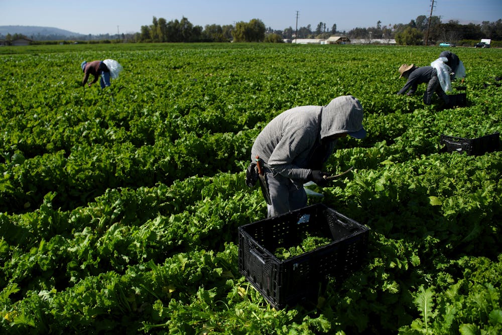
Farm laborers, like these workers harvesting curly mustard in Ventura County, Calif., are especially vulnerable to pesticide exposure. Patrick T. Fallon/AFP via Getty Images
3. Why did it take so long to reach a conclusion?
As evidence accumulated that low levels of chlorpyrifos were probably toxic to
humans, regulatory scientists at the EPA and in California reviewed it – but they took very different paths.
At first, both groups focused on the established toxicity mechanism: acetylcholinesterase inhibition. They reasoned that preventing significant disruption of this key enzyme would protect people from any other neurological effects.
Scientists working under contract for Dow Chemical, which manufactured chlorpyrifos, published a complex model in 2014 to estimate how much of the pesticide a person would have to consume or inhale to trigger acetylcholinesterase inhibition. But some of their equations were based on data from as few as six healthy adults who had swallowed capsules of chlorpyrifos during experiments in the 1970s and early 1980s – a research method that now would be considered unethical.
California scientists questioned whether risk assessments based on the Dow-funded model adequately accounted for uncertainty and human variability. They also wondered whether acetylcholinesterase inhibition was really the most sensitive biological effect.
In 2016 the EPA released a reassessment of chlorpyrifos’s potential health effects that took a very different approach. It focused on epidemiological studies published from 2003 through 2014 at Columbia University that found developmental impacts in children exposed to chlorpyrifos. The Columbia researchers analyzed chlorpyrifos levels in the umbilical cord blood at birth, and the EPA attempted to back-calculate how much chlorpyrifos the babies might have been exposed to throughout pregnancy.
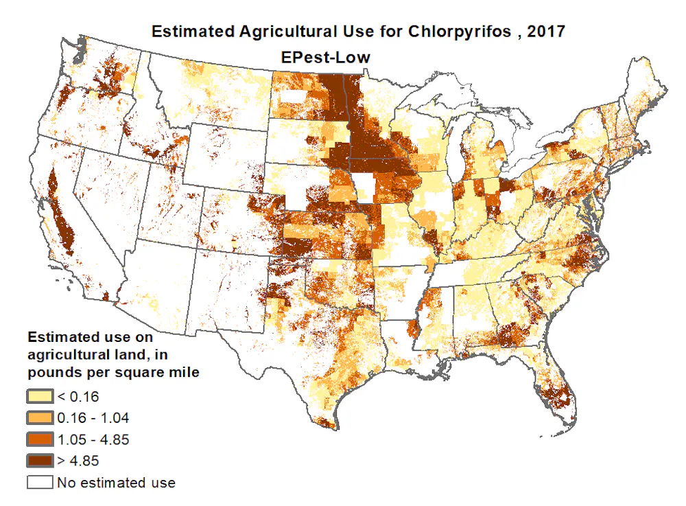
Scientists estimate that U.S. farmers used more than 5 million pounds of chlorpyrifos in 2017. USGS
On the basis of this analysis, the Obama administration concluded that chlorpyrifos could not be safely used and should be banned. However, the Trump administration halted this decision one year later, arguing that the science was not resolved and more study was needed. The Trump administration subsequently abandoned the human epidemiological studies and reverted to using the Dow-sponsored model and acetylcholinesterase inhibition endpoint that was used back in 2014.
History indicates that both political and scientific considerations likely accounted for the long delays. Although the conclusions clearly shifted with different federal administrations, the epidemiological studies and the acetylcholinesterase model also pointed in different directions – one suggested high health risks in humans, and the other suggested relatively lower risks. Policy conclusions thus depended partly on which data scientists chose as the basis for evaluating health risks.
4. What convinced California to impose a ban?
Three new papers on prenatal exposures to chlorpyrifos, published in 2017 and 2018, broke the logjam. These were independent studies, conducted on rats, that evaluated subtle effects on learning and development.
The results were consistent and clear: Chlorpyrifos caused decreased learning, hyperactivity and anxiety in rat pups at doses lower than those that affected acetylcholinesterase. And these studies clearly quantified doses to the rats, so there was no uncertainty about their exposure levels during pregnancy. The results were eerily similar to effects seen in human epidemiological studies, vindicating serious health concerns about chlorpyrifos.
California reassessed chlorpyrifos, using these new studies. Regulators concluded that the pesticide posed significant risks that could not be mitigated, especially among people who lived near agricultural fields where it was used. In October 2019, the state announced that under an enforceable agreement with manufacturers, all sales of chlorpyrifos to California growers would end by Feb. 6, 2020, and growers would not be allowed to possess or use it after Dec. 31, 2020.
Two months after the California decision, the European Union voted to ban chlorpyrifos due to concerns about neurodevelopmental harm. New York, Hawaii, Oregon and Maryland also moved to end use of the pesticide within their borders. On the same day that California sales of the pesticide ceased, the main manufacturer of chlorpyrifos, Corteva Agrosciences, announced that it would stop producing the chemical.
Over a decade passed while the agency reevaluated the science, studying multiple ways of analyzing the data. In 2016 the EPA proposed to grant the petition and ban chlorpyrifos, but did not complete this action by the end of the Obama administration.
In July 2019, under the Trump administration, the EPA denied the petition, saying that claims about neurodevelopmental toxicity were “not supported by valid, complete and reliable evidence.” Nonetheless, a new EPA risk assessment released in 2020 identified significant risks associated with combined exposures to chlorpyrifos from multiple sources, including food and drinking water.
In late April 2021, a federal court in California ordered the agency to either ban use of chlorpyrifos on food within 60 days or show that it was safe. “The EPA has had nearly 14 years to publish a legally sufficient response to the 2007 Petition,” the ruling stated. “During that time, the EPA’s egregious delay exposed a generation of American children to unsafe levels of chlorpyrifos.”
With the agency’s Aug. 18 announcement, that delay is finally over.
This is an updated version of an article originally published on Jan. 23, 2020.
The one item on the agenda was Ordinance 11-21 (passed unanimously) which amends chapter 13.24 of the Estes Park Municipal Code (MC) regarding agreements to provide raw water.
According to a memo to the board from Utilities Director Rueben Bergsten and Water Superintendent Chris Eshelman, the amendment is to assure the responsible management of water resources by requiring Town Board approval for raw water agreements lasting more than a year.
“The responsible management of our raw water resources, I think we would all agree, is becoming more and more important,” [Rueben] Bergsten said at the meeting….
The question for the state as a whole, and Estes Park itself, is how many entities to allow access to our water resources and for how much?
“We do anticipate, as time goes by, more and more and more property owners are going to be coming to the Town of Estes Park asking for what’s called replacement water,” Bergsten told the board. “We do this for a lot of people. It’s a matter of keeping the local economy healthy.”
A typical client seeking replacement water is someone using well water, or river water for irrigation and have water needs that still outweigh their supply.
“The Town owns 300 acre-feet of Windy Gap water rights. Windy Gap water can fulfill augmentation plan requirements for replacement water,” the memo said. “The Town has occasionally entered into long-term agreements with entities to supply replacement water.”
The most recent agreements made were: Preuss in July 2020, Idlewild in April 2019, and Cheley Camp in May 2012.”
Bergsten and Eshelman believe these raw water lease agreements are beneficial to the local economy and the surrounding communities; however, they tie up the town’s water rights.
“Town Staff foresee an increase in the number of replacement water requests as the State Water Commissioner increases their effort to audit augmentation plans,” the memo said. “Their audits included private wells.”
While requiring Town Board approval for raw water agreements lasting more than a year does have advantages such as reducing the administrative workload required to account for water use and augmentation, and supporting the responsible management of the town’s water, Bergsten and Eshelman are mildly concerned they may appear to be over reaching.
“Requiring properties to connect to our system might appear heavy-handed; however, their alternative requires them to pay an engineering firm to develop an augmentation plan, hire a lawyer to process the augmentation through water court, and secure replacement water from the Town,” the memo explains.
Colorado water commissioners declined to upgrade water quality rules for the urban stretch of river, though conservation groups say they are finally being heard.
Public officials, conservation groups and citizen speakers pleaded with the Colorado Water Quality Control Commission [August 9, 2021] to reverse a 2020 decision and strengthen protections for the South Platte River in north Denver and Adams County, but the commissioners declined.
Opponents of the commission’s decision last year thought they had one last chance in a “town hall” feedback format to urge the commissioners to revisit the controversial vote, which rejected a staff recommendation to upgrade the South Platte to higher water quality protections. They pointed to the recent weeks of high heat and air pollution in metro Denver, as well as a new climate change report showing irrefutable and irreversible damage to the environment, as more reasons to protect the river with tougher regulations…
“We cannot wait five more years to upgrade or revisit what’s happening to the communities in north Denver,” said Ean Tafoya, Colorado director of the nonprofit GreenLatinos.
The commissioners, who are appointed by Gov. Jared Polis to oversee the Water Quality Control Division of the Colorado Department of Public Health and Environment, said they would not reverse their 2020 decision now. The coalition favoring more protections said after the town hall they would consider trying to force the commission to reconsider through a petition process, by taking legal action…
The Platte River plods through downtown Denver, a small workhorse with a big load. Photo/Allen Best
But some commissioners appeared to leave the door open to further discussions and to seek more community input on future river decisions…
Those who want to elevate the South Platte’s urban stretches used the commission’s town hall comment period to attack the 2020 decision. The staff of the water quality division last year had recommended that the South Platte River through north Denver and Adams County, long plagued by industrial releases and wastewater effluent, be upgraded to the next higher level of stream protections.
Metropolitan Wastewater Reclamation District Hite plant outfall via South Platte Coalition for Urban River Evaluation
The higher level would have forced existing polluters in that section, like Metro Wastewater, Suncor or Molson Coors, to avoid further degrading water quality with any new activity unless they could prove it was essential to their continuing business. As it stands now, those existing polluters have “protected use” status that permits them to degrade the water, even though water quality in those central urban streams has improved in recent decades.
The Colorado division of Parks and Wildlife, the Environmental Protection Agency, the Adams County Commissioners and others had supported the staff request for a river protection upgrade. The water commissioners rejected the idea last year, and then again in June.
Adams County Commissioner Steve O’Dorisio said he wanted to be frank with the water commissioners that not enough opponents were prepared for the discussion ahead of the 2020 decision.
“Back in 2020 we did not know how this specific decision would affect our river and our communities,” O’Dorisio said.
Jeff Neuman-Lee, describing himself as a citizen speaker for the town hall forum, pointed to Colorado’s air fouled by wildfire smoke and heat-generated ozone in recent weeks.
“We’ve been just degrading our Earth over and over and over again, and we can’t tolerate any more,” he said. “It’s depressing to see that we’re allowing water quality to go unheeded; to create stretches of our rivers and say we don’t care about them, we’re just going to let them go.”
[…]
Sunrise along the Clear Creek Trail August 12, 2021.
Some of Monday’s speakers said they were concerned that leaving the South Platte’s water quality protection where it is now will weaken the current permit renewal process underway for the Suncor refinery, which borders Sand Creek as it empties into the South Platte. The state health department is reviewing and answering public comments on Suncor’s permit application, and conservationists and neighborhood groups want Suncor’s water and air pollution caps cut way back.
“This idea of grandfathered legacy pollution,” Tafoya said, “just because they always have, doesn’t mean they should continue to.”
Release of firefighting foam. PFAS are substances found in firefighting foams and protective gear, as well as many household products, like pizza boxes and rain jackets. Graphic credit: ITRC
Here’s an in-depth report from Laura Paskus that’s running in The Santa Fe Reporter. Click through and read the whole article. Here’s an excerpt:
Today, we know the [firefighting] foam contained toxic chemicals responsible for polluting the water around hundreds of military bases nationwide, including Cannon and Holloman Air Force bases in New Mexico. And the toxic chemicals are present in the drinking water of millions of Americans…
Over the years, [Kevin] Ferrara has learned that the military knew Aqueous Film Forming Foam (AFFF) was dangerous—and so did the companies that manufactured it. But without federal regulations that set drinking water standards or hazardous waste limits, states like New Mexico still can’t hold the Pentagon accountable for the pollution that has crept from the bases into the wells of local residents and businesses. Meanwhile, military firefighters like Ferrara wonder what’s happening within their own bodies—and the bodies of those whose water they polluted.
In the waning days of Gov. Susana Martinez’s administration, the New Mexico Environment Department (NMED) was grappling with a problem. A “forever” problem, as it turns out.
Contractors hired by the military were investigating whether AFFF used at the state’s three Air Force bases had contaminated groundwater with PFAS.
In an August 2018 conference call, Air Force officials told state officials that PFAS had been found in wells at Cannon Air Force Base at concentrations above the US Environmental Protection Agency’s lifetime health advisory of 70 parts per trillion. Further studies showed the levels exceed 26,000 parts per trillion—more than 370 times that EPA health advisory—and that PFAS was also in off-base wells that supply homes and dairies in Clovis.
In October, NMED, the New Mexico Department of Health and the New Mexico Department of Agriculture publicly announced the presence of the contamination on and off the base. They advised private well-owners within a 4-mile radius of the base to use bottled water. NMED issued a notice of violation against the Air Force for breaking state regulations. The agency issued “corrective action permits” with cleanup mandates for the military’s state permits.
But in January 2019, just after Gov. Michelle Lujan Grisham took office, the US Department of Defense sued New Mexico, challenging the state’s authority to mandate cleanup.
And although the state made no announcements nor issued any corrective actions, a report the Air Force submitted to NMED during the Martinez administration showed that groundwater samples of PFAS at Holloman Air Force Base were as high as 1.294 million parts per trillion. In February 2019, NMED issued a notice of violation against the Air Force over Holloman, too.
The following month, in March 2019, New Mexico filed its own lawsuit, asking a federal judge to compel the Air Force to act on, and pay for, cleanup at Cannon and Holloman.
But that hasn’t worked out as planned.
“We wanted action quickly. When that wasn’t available, or that wasn’t on the table, that’s when we litigated,” NMED Secretary James Kenney says in an interview.
The lawsuit has been lumped in with hundreds of other PFAS-related lawsuits. One court in South Carolina now oversees all cases regarding PFAS and the military’s use of the AFFF—more than 750 separate actions.
Even though New Mexico has tried to extricate itself from the multidistrict litigation, hoping to pursue its case against the Air Force without being tied to those hundreds of other cases, a judge has denied that request. And in June, the Biden administration’s Defense Department called New Mexico’s attempts to compel cleanup under state permits “arbitrary and capricious.”
In summary, three years after the Air Force notified New Mexico of the PFAS pollution, there are no clean-up plans in place at Cannon or Holloman, though earlier this year, Cannon announced an on-base pilot project to test the best ways to remove PFAS from water. And even though the military knows when, why and how the contamination happened, it has sued New Mexico to say the state can’t make it clean up the problem.
Meanwhile, state Environment Sec. Kenney says the EPA needs to set federal pollution standards for the toxic substances.
In 2016, the EPA established a lifetime health advisory for two types of PFAS found in firefighting foams, perfluorooctanoic acid (PFOA) and perfluorooctane sulfonic acid (PFOS). But that advisory of 70 parts per trillion isn’t a regulatory limit. That means states like New Mexico don’t have any legal tools to require that polluters like the military clean up PFAS.
These wetlands, located on a 150-acre parcel in the Homestake Creek valley that Homestake Partners bought in 2018, would be inundated if Whitney Reservoir is constructed. The Forest Service received more than 500 comments, the majority in opposition to, test drilling associated with the project and the reservoir project itself. Photo credit: Heather Sackett/Aspen Journalism
A group of Colorado residents demonstrated Saturday against the construction of a reservoir in the Homestake Valley, marching through the streets of Red Cliff and treating passing vehicles to a variety of colorful signs.
If you were headed south on Highway 24 on Saturday afternoon, you might have been able to read a clever statement like “Stop the whole dam thing,” and “They can’t ‘fen’ for themselves.”
Or you might have noticed a message or two that was more direct. Using an elongated trash picking tool to hoist her sign, Silverthorne resident Jan Goodwin wrote “CO Springs doesn’t need Red Cliff’s water.”
The group is opposed to building a new reservoir in the Homestake Valley 6 miles southeast of Red Cliff, which would be used by the people of Colorado Springs and Aurora, who hold water rights in the area, including the rights to the water in the existing Homestake Reservoir.
These wetlands in the Homestake Creek valley are near the site of the proposed Whitney Reservoir. The Forest Service is considering whether to issue a permit for drilling and a geotechnical study to test whether the site would support a dam. Photo credit: Heather Sackett/Aspen Journalism
But the nuances of the issue, including the sensitive wetlands known as “fens” and the study required for “the whole dam thing,” as referenced in the signs, was also discussed among the demonstrators. In order to construct a new dam and reservoir, the area will require some study, and the Forest Service has already approved that study, which will allow the cities to drill “10 bore samples up to 150-feet deep using a small, rubber-tracked drill rig as well as collect geophysical data using crews on foot,” according to the Forest Service, along with the construction of more than a half-mile of temporary roads to facilitate the work.
The effort could also impact up to 180 acres of wetlands on lower Homestake Creek, wetlands that include fens — groundwater-fed wetlands which began forming during the last ice age. A scientifically unproven idea to relocate the fens is being spearheaded and paid for by Aurora Water and the Board of Water Works of Pueblo…
A map prepared by Aurora Water that shows a potential 500-acre adjustment to the Holy Cross Wilderness boundary near the potential Whitney Reservoir on lower Homestake Creek. The map as current as of July 16, 2019.
[Charles] Fleming said he would like to see the people of Colorado Springs and Aurora make more of a good faith effort toward water conservation before seeking another reservoir in the Homestake Valley.
“I’d like to see them get rid of the green grass and focus more on xeriscaping first,” he said.
Parks said as a hotelier in Red Cliff, she sees the recreational appeal of the Homestake Valley as a wild space, not a space that would benefit from the creation of a National Recreation Area or reservoir.
One version of the reservoir envisions an encroachment into 500 acres of the Holy Cross Wilderness area of the White River National Forest, which would require an act of Congress.
This image was taken during the peak outflow from the Gold King Mine spill at 10:57 a.m. Aug. 5, 2015. The waste-rock dump can be seen eroding on the right. Federal investigators placed blame for the blowout squarely on engineering errors made by the Environmental Protection Agency’s-contracted company in a 132-page report released Thursday [October 22, 2015]
Todd Hennis claims the U.S. Environmental Protection Agency has occupied part of his property near the Gold King Mine but hasn’t compensated him for doing so
The owner of an inactive southwestern Colorado mine that was the source of a disastrous 2015 spill…has filed a lawsuit seeking nearly $3.8 million in compensation for the federal government’s use of his land in its ongoing cleanup response…
Gold King mine spill Animas River August 2015 photo — Nancy Fisher via The Colorado Independent
Todd Hennis claims the U.S. Environmental Protection Agency has occupied part of his property near the Gold King Mine but hasn’t compensated him for doing so since the August 2015 spill, The Durango Herald reports. He also claims the EPA contaminated his land by causing the spill, which fouled rivers in Colorado, New Mexico and Utah with a bright-yellow plume of arsenic, lead and other heavy metals.
Hennis is seeking nearly $3.8 million in compensation in the suit filed [August 3, 2021] in the U.S. Court of Federal Claims. He contends EPA actions have violated his Fifth Amendment rights to just compensation for public use of private property.
The Chaffee County Board of Commissioners voted Tuesday to approve the conditions under which a water bottling company could continue to pull water from a spring connected to the Arkansas River.
They are allowed to do so through the water right they bought back in 2010, but the county gives the green light if it finds the company follows all of the rules.
The 1041 permit process outlines specific conditions that BlueTriton has to meet in order to pull water out of Chaffee County. BlueTriton, previously known as Nestle, owns two wells. State water records obtained by 9Wants to Know show the company can pull up to 196 acre-feet of water each year…
[Della] Malone said regardless of the amount of water BlueTriton will take, Colorado is at the point where as much water as possible needs to stay in the river to keep fish, and the birds that feed on them, alive…
For the most part, BlueTriton has been a good steward of the water. The county hired W.W. Wheeler and Associates to conduct an updated analysis in 2020 and said the company is not using as much water as it could be.
Gary B. Thompson, an engineer for the water engineering firm W.W. Wheeler and Associates, found the utilization of the wells was not causing problems…
Jennifer Davis, Chaffee County attorney, said in an email that Monroe’s report led to increased wetlands monitoring in the 2009 contract. Any 2021 contract would have similar measures that would allow the county to cancel the contract if there was evidence that the wetlands were being stressed.
“It is important to note that during the recent hearings, evidence was presented that the applicant has substantially complied with those plans over the past 10 years,” Davis wrote. “…If [BlueTriton Brands] fails to comply with the plans, the permit can be suspended or terminated.”
In 2020, Wheeler found the nearby wetlands are healthy and the permit has “adequate” monitoring protocols.
Turrquoise Reservoir, which stores water brought under the Continental Divide from the Eagle, Fryingpan and Roaring Fork river headwaters. Photo credit: Aspen Journalism
Clear Creek Reservoir
The well permits allow for a maximum of 196 acre-feet per year. On average, the Wheeler report found the wells pulled in 111.7 acre-feet on average. The well had not been tapped for more than 100 acre-feet per year since 2014, according to the report. Any water taken for the water bottling operation is replaced with water from the nearby Turquoise Reservoir and Clear Creek Reservoir…
How much water goes to water bottles?
Kevin Rein, a state engineer and the director of the Colorado Division of Water Resources, said water bottling facilities use a small portion of the state’s water. He wrote in an email that one fairly standard-sized Colorado bottled water company found it was responsible for 0.0006% of the state’s annual water use.
For context – 85.2% of the state’s water goes to agriculture each year and 6.6% are used by cities and commercially according to data from the Colorado Division of Water Resources…
Other requirements of the permit
Other requirements of the contract have mostly been met. Davis said in an email BlueTriton did not finalize a conservation easement, but that commissioners did not penalize the company because deadlines were not clearly explained in the permit.
According to a letter from the Colorado Department of Natural Resources, Nestle did not begin discussions about donating land for an easement until 2019, 10 years after the original 1041 permit was issued by the Chaffee County Commissioners…
BlueTriton will pay $1.2 million across 10 years to various causes like water sustainability, forest health and affordable housing. It will pay $430k in just the first year, then $92,500 each year afterward.
Nestle sold its North American water brands to BlueTriton for $4.3 billion dollars.
Arkansas River Basin — Graphic via the Colorado Geological Survey
This image was taken during the peak outflow from the Gold King Mine spill at 10:57 a.m. Aug. 5, 2015. The waste-rock dump can be seen eroding on the right. Federal investigators placed blame for the blowout squarely on engineering errors made by the Environmental Protection Agency’s-contracted company in a 132-page report released Thursday [October 22, 2015]
Here’s the release from the New Mexico Office of the Natural Resources Trustee (Elysia Bunten):
The New Mexico Office of the Natural Resources Trustee (ONRT) is in the preliminary stages of soliciting ideas for projects that will restore natural resources in New Mexico injured by the 2015 Gold King Mine release.
We welcome stakeholder engagement in our process and invite you, as a stakeholder who was affected by the contamination, to participate in this process. Please see the attached letter containing details about ONRT’s funding, process, upcoming information session, and timetable.
Prior to mining, snowmelt and rain seep into natural cracks and fractures, eventually emerging as a freshwater spring (usually). Graphic credit: Jonathan Thompson
While Douglas County remains under a drought watch, water officials in Parker and Castle Rock are optimistic about water supplies as the state heads into the hottest part of summer.
Castle Rock Water Director Mark Marlowe said this is the first summer the town is using the reusable water supply. In 2006, the town invested $208 million to build the reusable water facility. Water started pumping into residents’ homes early this year.
Because of the renewable water source, Marlowe said as the high-use water months continue, Plum Creek resources are “holding up well.”
“We have been able to utilize renewable water because the creek is running well,” he said. “Reusable water tends to be more drought resistant, and it does not depend on rainfall. It is water we have already used that will be put back into the system. It is a reliable source, especially during a drought.”
[…]
Ron Redd, district manager for Parker Water & Sanitation District, said water supplies are holding up well, and residents have not even met peak demand as expected this year.
Thanks to a wet spring, Redd said, customers in Parker and Castle Pines have used a lot less water in June and early July this year compared to the same time last year.
With 2020 being so dry, Redd said residents were using about 28 million gallons of water per day. This year, the average use is half that at 14 million gallons.
Late on Friday afternoon, July 16, the consumer protest organization calling itself Unbottle & Protect Chaffee County Water (“UPCCW”), a Colorado non-profit corporation, delivered a notice from the law offices of John Barth, of Hygiene, Colorado to the Chaffe Board of County Commissioners, and Chaffee Planning Director Dan Swallow. Interestingly enough, the notice did not include the county attorney’s office.
In it, the group issued a set of complaints; in their view, Chaffee County has failed to follow the required permitting procedure for issuance of a 1041 permit. The group’s basis for that claim; that the county plans to review a draft of the proposed 1041 permit and conditions at the upcoming July 20 BoCC meeting, but that it hasn’t yet made the document available. It also issued its own set of permit conditions.
The UPCCW group takes the position that since the BoCC hasn’t yet made that draft available, the failure to do this constitutes a violation of the law. Further, it claims that the county violated the law by voting to approve the issuance of a 1041 permit for the project, before considering a draft proposal of the 1041 permit and conditions.
The UPCCW was formed specifically to protest the Nestlé Waters North America/BlueTriton 1041 permit. Its nonprofit membership includes residents of Chaffee County opposed to the renewal of a 1041 permit for Nestlé Waters North America — now BlueTriton Brands.
That permit allows the company to pump spring water from Ruby Mountain Spring, on property Nestlé owns in Chaffee County, transfer it to its pumping station in Johnson Village, then trucking it to its Denver bottling plant.
The notice goes on to state that the county didn’t reopen public comments during the last session (this, after multiple public sessions with the most extensive public comment ever held in the county on a proposal, and formal notification of the process laid out to be followed). The group’s complaint; that by not specifically seeking their input on the language of the 1041 permit conditions as it has been drafted, that this also constitutes a violation of the law.
The document also cites numerous state statutes for what it claims; then makes an assertion that it is their perception that Chair Greg Felt has a conflict of interest that should have prevented him from ruling on this. In fact, in what many will consider an audacious request, it asks that the BoCC’s July 6 decision to approve the permit be rescinded and that Mr. Felt recuse himself from the proceedings.
Felt has addressed the issue of conflict of interest not once, but twice during the proceedings. While the protest groups make reference to his role as the Vice–Chairman of the Upper Arkansas Water Conservation District (UAWCD) it’s stated as a perceived conflict; the mission of the UAWCD is to secure and manage water resources to meet the needs of the Upper Arkansas River Valley.
During their July 6 session, following the 2 to 1 vote on the permit, which ended months of lengthy questions and debate, the BoCC openly discussed the necessary timing to proceed with a new 1041 permit, and the development of what will be complex conditions. They pushed county legal, which was concerned about the tight timeframe, to get a first draft ready for them to review in the public meeting on July 20, which they explained would be the beginning of the permit development public process.
Once, or if, the BoCC finalizes a written resolution containing the conditions of the permit renewal, the issuance of that resolution and written 1041 permit will trigger the statute of limitations for any challenges to the BoCC’s actions under Colorado Rule of Civil Procedure 106.
FromThe Douglas County News-Press (Thelma Grimes):
As afternoon rainstorms have continued through spring and early summer, officials of the Centennial Water and Sanitation District, the water provider in Highlands Ranch, warn residents that the community is still under a drought watch designation.
“A drought is not just about precipitation,” said Swithin Dick, water rights administrator for Centennial Water. “Precipitation is one part of the equation, but you also have to look at snowpack, water runoff, demand and water supply.”
Centennial Water monitors the water supply for the community daily. On July 7, Centennial Water’s reservoir storage was 8,048-acre feet, or 47% of 17,200 acre-feet total capacity. Centennial Water’s median storage level for July over the past 10 years has been 8,904 acre-feet, or 52% of the capacity…
“Despite the precipitation we have received over the past month, the storage level in our reservoirs has declined,” Dick said. “This is because community water demand has increased, which is offsetting the water we have been able to capture.”
Dick said water supplies are based on water rights priority in the region. Water rights determine who is able to capture the water for use…
Centennial Water has three stages for measuring drought condition. In April, the Centennial Water Board of Directors approved the lowest stage level, drought watch. The drought watch designation is for residents in Highlands Ranch, Solstice, and portions of northern Douglas County.
If drought conditions get worse, the board can approve two new stages, Drought Stage 1 and Drought Stage 2, which would mean higher fees to further encourage residents to practice water conservation.
For instance, a resident who uses between 101% and 120% of the allotted amount, rates would go from $5.52 per 1,000 gallons to $6.95 under a Stage 1 designation. Under a Stage 2 designation, rates would increase to $8.38.
For more information about water conservation and drought conditions in Highlands Ranch, visit http://centennialwater.org.
Recruitment for a large-scale study on the health effects of “forever chemicals” will start in the Fountain Valley this month and its results could help set federal limits on the chemicals in drinking water.
The work is part of the second large-scale study in the country to examine exposure to perfluorinated compounds — a family of manmade chemicals that linger in the body and have earned the nickname “forever chemicals” — and the health risks they pose.
The first large-scale study was done 15 years ago in Ohio and West Virginia and found probable links between the chemicals and conditions including high cholesterol, thyroid disease, kidney and testicular cancers, said epidemiology professor Anne Starling, with the University of Colorado.
This study through the Agency for Toxic Substances and Disease Registry is set to investigate health effects of the chemicals including impacts to the immune system, kidneys, liver and thyroid. It will also help determine if the chemicals change neurobehavioral outcomes in children trough tests of their attention, memory and learning abilities. The study was expected to begin last fall but it was delayed by the pandemic, Starling said.
Researchers plan to study 7,000 adults and 2,100 children exposed to perfluorinated compounds across seven states, including 1,000 adults and 300 children 4 and older in the Fountain Valley…
The study will also be the first to include people with high levels of a chemical found in firefighting foam in their blood, Starling said.
Firefighting foam from used by the military at Peterson Air Force Base contaminated the aquifer that residents in Widefield, Security and Fountain used for drinking water, studies have determined. After the contamination was found in 2016, drinking water providers for all three communities worked to ensure the water was safe. Since then, the Air Force has paid $41 million for three new water treatment plants to bring the level of chemicals down to nondetectable levels.
Researchers will take one-time blood and urine samples to help determine how the chemicals may have affected residents’ kidneys, liver and sex hormones, among other bodily functions. It will not examine whether the chemicals cause cancer.
The urine samples will likely be more indicative of forever-chemicals residents have recently been exposed to, Starling said…
The tests and residential histories should allow researchers to estimate the cumulative lifetime exposure residents have had to the chemicals, according to a news release.
The work will also examine the neurobehavioral effect of the chemicals in children because some smaller studies have suggested that exposure to the forever chemicals early in life may affect children’s development and response to vaccines, but the connection is not yet well established, she said.
The researchers plan to have children complete puzzles and problem-solving tasks, similar to activities they might do in school, as part of the study, she said…
The neurobehavioral tests will not diagnose problems in individual children, she said.
The upcoming study expects to build on a recent study of 220 residents in the Fountain Valley that found the median level of a chemical specific to firefighting foam in residents was 10 times higher than the national median. Some residents had levels of the chemical that were much higher, said Colorado School of Mines Professor Christopher Higgins, a lead researcher on the study…
Scientists don’t know whether the chemical specific to the foam is more or less dangerous than other forever chemicals, Starling said.
The levels of chemicals in residents seem to be dropping and that may be good if some of the health effects are reversible. But some people may still be experiencing long-term health effects…
Study participants will receive individual test results that could be shared with their doctor. The test results may not indicate a problem, but more and more doctors are becoming aware of the potential health effects of forever-chemical exposure, Starling said.
In the long-term, the Environmental Protection Agency and the National Academies of Science could use results from this study to help set enforceable limits on water contamination. No federal maximum limits on forever chemical contamination of drinking water exist, she said.
Recruitment for the study is expected to start later this month and researchers have set up an office in Fountain to meet with residents. Data collection could take 12 to 18 months. The entire study could be completed in 2024, although researchers should have results to share before that, Starling said.
Those interested in participating in the study can find more information at http://co-scope.org. Those interested in participating can email coscope@cuanschutz.edu or call (719) 425-8828.
Once again this summer, rain has been hard to come by in this historic farming valley of southern Colorado. The average annual precipitation in the middle of the San Luis Valley hovers around seven inches — about as low as it gets in all of Colorado, according to the state’s climate center.
And yet farming prevails. It is the lifeblood of Alamosa, the town that rose from a once-bustling railroad and today is often passed by travelers en route to more flashy destinations on the Western Slope. Unlike other rural communities that have swapped mining or energy for tourism, the ruling industry here is and always has been agriculture.
“The hospital, the county and city offices and school district, all of those are important,” said Alamosa Mayor Ty Coleman. “But farming and ranching, that’s it. That’s huge.”
Once again this summer, rain has been hard to come by in this historic farming valley of southern Colorado. The average annual precipitation in the middle of the San Luis Valley hovers around seven inches — about as low as it gets in all of Colorado, according to the state’s climate center.
And yet farming prevails. It is the lifeblood of Alamosa, the town that rose from a once-bustling railroad and today is often passed by travelers en route to more flashy destinations on the Western Slope. Unlike other rural communities that have swapped mining or energy for tourism, the ruling industry here is and always has been agriculture.
“The hospital, the county and city offices and school district, all of those are important,” said Alamosa Mayor Ty Coleman. “But farming and ranching, that’s it. That’s huge.”
[…]
But by the turn of the 20th century, the Rio Grande was considered over-appropriated. Demand outpaced supply.
“So we’ve always lived in this area where there was this level of stress,” said Heather Dutton, manager of San Luis Valley Water Conservancy District and fifth-generation native.
The difference, she said, is this century’s more dire circumstances.
Fundamental changes
A multi-agency report last year found average annual streamflows to be steadily declining since the 1930s, with drops worsening in the 2000s. Citing climate change, the report warned of that long trusted snowpack in the mountains becoming less dependable.
A farmer uses a center pivot to battle drought on a field in Center, Colo., in the San Luis Valley on Aug. 24, 2020. Credit: Allen Best
Where Simpson’s and Dutton’s grandfathers and fathers didn’t have the Rio Grande to count on, they had groundwater. They joined drilling and pumping that ramped up in the ’30s. The shallow and “unconfined” aquifer and deeper “confined” aquifer, both remnants of an ancient lake, represented turning points for farming.
“But it was also a turning point for what my generation is now grappling with,” Dutton said, “where now we have too many wells, we have too much pumping, and we’re taking more out of the aquifer than we’re putting back in.”
The decades saw agreements for taking and giving back — for digging a hole, filling it with water and thus recharging the unconfined aquifer in hopes of making up for Mother Nature.
“By far, that’s where most of the groundwater withdrawals occur in the valley,” Simpson said. “The potatoes are grown and raised above that unconfined aquifer. Most of the intense irrigation is above that unconfined aquifer.”
Simpson manages the Rio Grande Water Conservation District, which has tracked the aquifer’s storage since 1976. From the mid-’80s to today, charts show a staggering drop: A change amounting to about 1.3 million acre-feet of water.
The severe drought of 2002 started the steep trend of decline. Since then, there have been year-to-year gains of storage — eight years totaling 746,791 acre-feet. But there have been more years of drops, 10 totaling more than 1.7 million acre-feet. Lows this year are on par with record lows following the 2012 drought, data show.
The hope of Simpson and Dutton is to locally regulate before higher powers enforce harsher demands. The state has called on the valley to bring water back up to pre-2000 levels, or else face possible consequences of widespread shutdowns in 2030…
Farmers are taxing themselves to pump, with that money going to other farmers to pump less. Simpson and Dutton have been encouraging creativity, such as less water-needy crops like hemp and quinoa.
But they fear more drastic measures.
“There is a need to physically take land out of production,” Dutton said. “And it’s not like it’s just one person owns everything and we can just say, ‘Hey, can you cut back your farm by 30%?’ There are hundreds of families that farm and ranch here.
“And this is how they make their living, it’s in their blood, they want to do it, they’re proud of it. So trying to get people to cut back or stop farming altogether, it’s a study in psychology and human behavior. It’s really hard.”
And there are broader ramifications to consider when farms close, Simpson said. The well-being of his hometown is at stake when that happens, he said — Alamosa’s school, hospital and small businesses.
The dry bed of the Arkansas River beneath the Second Street Bridge at Dodge City, Kansas. The barricades and barbed wire are to prevent access from city property, but the river bed is public land. File Photo / Max McCoy via The Kansas Reflector
Out past the 100th meridian things get dry damned quick.
The meridian traditionally marks the line where the west begins and agriculture is difficult without irrigation. You can find it easily on a map of Kansas. Just look for Dodge City, in the lower western third of the state. The meridian runs right through town. There’s a marker at the old railway depot, but the line is really a few blocks to the east. An Eagle Scout named Michael Snapp determined the location, with the help of GPS, and in 2007 planted a 600-pound limestone post to mark the spot. It’s on the south side of Highway 50, between avenues L and M.
The Arkansas River also runs through Dodge City. Or at least it used to. It’s been a dry bed now for decades. If you (carefully!) make your way past the wire and barricades at Wright Park you can see what has become of it. The river is nothing but hard-pack sand and tire tracks, from the four-wheelers that tear up and down the old channel. The Arkansas is one of three legally navigable rivers in the state (the other are the Kaw and the Missouri), but you’d have a hard time getting a boat down it now. It’s a legal absurdity that sums up our state’s complicated relationship to water.
I wrote about this in my book, “Elevations: A Personal Exploration of the Arkansas River,” published by the University Press of Kansas. By following the Arkansas River from its headwaters at the Continental Divide above Leadville, Colorado, all the way to the Oklahoma line below Arkansas City, I learned a few things.
The most important lessons came from experts like Rex Buchanan, the former director of the Kansas Geological Survey, who for years has braved January weather to drop steel tapes down sometimes remote wells to physically measure water levels. Because of volunteers like Rex, Kansas has some of the best statistics available, and they go back decades.
I won’t pretend to speak for Rex — he’s articulate and passionate about water, and is among the state’s foremost advocates for water conservation — but I can say that water levels in the High Plains Aquifer have been going steadily down since the 1950s. The explosion of pumping technology after World War II allowed more, and deeper, water to be pumped than ever before, which was a boon to agriculture. The feeling at mid-century was that the Ogallala Aquifer — a shallow aquifer that runs for hundreds of miles below the 100th meridian, from South Dakota down to the Texas panhandle — would provide an inexhaustible supply of water. Not only does the Ogallala irrigate crops, it also provides water for industry and tap water for municipalities like Colby, along Interstate 70 in northwestern Kansas.
The Visitor Center at Colby, Kansas. Water is supplied to this western Kansas town from deep wells drawing from the Ogallala Aquifer. Kansas Reflector / Max McCoy via The Kansas Reflector
The problem is, the aquifer isn’t a uniform depth. Imagine an egg carton, with some deep pockets and other shallow ones, and you have some idea of the Ogallala. Because the aquifer has to be recharged by rainwater — and because things west of Dodge City are, well, arid — some places are in danger of exhausting the water supply quicker than others. Dodge City and Colby are in two of the most critically depleted parts of the aquifer of all, marked by swaths of angry red on most groundwater maps. Colby is in Thomas County, where the Kansas Geological Survey predicts the water will be depleted in less than 25 years.
I had a friend who flew into Denver recently from back east who asked me if all the circles he saw from the window seat of his airliner were some kind of crop circles or navigation aids. No, I said, that’s pivot irrigation — and it’s killing western Kansas.
Drought has hit areas like Dodge City particularly hard in recent years, because the less rain fills, the more water has to be pumped out of the ground to keep the crops growing. Some local water management districts in the state are taking conservation seriously. There are five such districts across the state, governed by local boards. And some of them — particularly toward the Nebraska line — have a chance of achieving sustainability by reducing usage by 20 or 30%. But for places like Dodge City, where demand is high and rain is slow in coming, it would take hundreds of years for the aquifer to recharge, even if all irrigation stopped today. If we drain it, some scientists say, it might take 6,000 years for it to refill naturally.
Right now, the west is experiencing a severe water crisis, with the Colorado River basin experiencing a historic, extended drought. There’s talk of the New Water Wars, with municipalities vying with farms and industries for tap water. At the same time, the heat wave of late June and early July — driven by climate change — broke records in the Pacific Northwest, with Portland hitting a jaw-dropping 116 degrees Fahrenheit.
In Kansas, we’ve so far escaped the worst of the heat wave, and an unusually wet summer has prevented drought. But we are headed into what is traditionally our hottest period, from late July to early August. The record high temperature for the state was recorded July 24, 1936, at Alton, in north central Kansas, at 121 degrees, according to the National Weather Service.
The dry bed of the Arkansas River near the Santa Fe Trail crossing at Cimarron, Kansas. The Ogallala aquifer groundwater levels in much of western Kansas started dropping in the 1950s as pumping increased, according to the Kansas Geological Survey. File Photo / Max McCoy
While researching my book about the Arkansas River, I was interested in not only the natural landscape, but also the history of how human beings have interacted with the river. What I found was disturbing. Because of irrigation and climate change, much of the river has simply dried up between Garden City and Great Bend. This has resulted in the disappearance of cottonwood trees along the riverbed, the desertification of some areas, the loss of ecosystem, and the destruction of one of the state’s most important natural features. The Arkansas is really two unconnected rivers now, the upper and the lower.
I grew up in southeast Kansas, on the edge of the Ozark Plateau. Like much of the eastern third of the state, it is a wet region, with plenty of rainfall and plenty of creeks and rivers. But out past the 100th meridian — the rainfall curtain — it’s a different and in many ways more fragile world.
Rivers of Kansas map via Geology.com
One of the things I remember most about my meeting with Buchanan, that committed soul who actually goes out and measures water levels, was a map he showed me of the historic rivers and creeks in western Kansas. The waterways looked like veins in a leaf, spreading across the high plains. Then he showed me a recent map, and many of those waterways were simply gone, erased from the landscape.
That was a few years ago. The situation has just gotten worse since.
Sign marking the 100th Meridian West at the train depot at Dodge City, Kansas. The actual meridian is a few blocks to the east. File Photo / Max McCoy
To save what is left of the water in western Kansas, we must change our relationship with water. The history of water rights in Kansas has been a troubled one. Since 1945, Kansas has been a “prior appropriation” state, like most western states, which means the right to use is based on “first in time, first in right.” It’s a property right, clear down to the aquifer. This doctrine places an emphasis on legacy water rights and prioritizes recognized “beneficial” uses, which are economic in nature.
Recognizing the hazard posed by water scarcity, Kansas since 1978 has enacted three novel legal strategies to cope with drought and dwindling resources. The first was the ability of the chief engineer — the state’s chief water administrator, at the Kansas Department of Agriculture — to designate some areas as Intensive Groundwater Use Control Areas. The second, in 1991, was to require conservation plans from some water rights applicants. The third, in 2012, gave communities within IGUCAs the authority to voluntarily create, through a public hearing process, a Local Enhanced Management Area with more restrictions. There are currently five LEMAs in the state, with Wichita County (in far western Kansas) being the newest.
But as Caleb Hall pointed out in a 2017 journal article, such efforts are insufficient to combat increased water depletion caused by climate change. Hall is an environmental attorney, a Kansas City native and a University of Kansas School of Law alum.
“IGUCAs allow established, yet still unsustainable, agricultural practices to continue,” Hall writes, “never questioning if water usage is truly beneficial if it is being applied to thirsty corn.”
If the western water rights model does not voluntarily change now, Hall argues, climate change will force it to do so in the future.
The question at the heart of the problem is what is truly beneficial.
Instead of viewing water as a property right to be exploited for personal profit, we must become guardians of that which remains. Twentieth century technology allowed us to use water at a rate far beyond what was sustainable. Climate change has brought the crisis to a head. Nothing is going to bring back the Arkansas River in western Kansas in our lifetimes, but if we start changing our laws now, we just might be able to save what’s left of the Ogallala Aquifer.
The Ogallala aquifer, also referred to as the High Plains aquifer. Source: National Oceanic and Atmospheric Adminstration
Monument Creek, taken looking south from the northern section of Monument Valley Park via Loraxis
FromThe Tri-Lakes Tribune (Benn Farrel) via The Colorado Springs Gazette:
With limited water resources, the Town of Monument looks to encourage water conservation among residents while the area is experiencing high temperatures in its semi-arid climate and increased water demand.
As the town invests $22 million in improvements to the infrastructure of its water system, an increase in water production and additional storage is in the near future. However, to maintain healthy landscapes around the community, the town is encouraging responsible water practices, implementing water restrictions and has offered tips to efficient water use…
Properties within the service of Triview Metropolitan District are also under restrictions from May 1 through Sept. 30 every year…
Properties which use the Woodmoor Water and Sanitation District are restricted from June 1 to Sept. 30…
Photo from the Colorado Independent.
On May 31, the Town of Monument released an informational video, “Conserving water using rain barrels,” on its YouTube channel, informing residents of their rights to conserve rainwater with rain barrels and how to do it. A few years ago, the State of Colorado legislature passed House Bill 16-1005 which allows single-family residences to collect rainwater in two barrels maximum, each up to 110 gallons, to be used solely for outdoor use and not consumption or indoor use. It also mandates the top of the barrels must be sealed to prevent pests from getting in.
The bill was geared toward helping homeowners offset the use of their irrigation systems for their landscaping.
Residents of the Town of Monument, who use of the town’s water system, are offered a $50 rebate if receipts for the rain barrel purchases are provided and their account with the Monument Water Department is current. The rebate is given in the form of a credit toward the account.
Tips for installing the rain barrels are available on the Town of Monument’s YouTube channel, or by visiting the town’s website, tomgov.org, clicking on the “Community” tab and visiting the Garden & Landscaping page.
Denver Basin Aquifer System graphic credit USGS.
The Triview Metropolitan District is presently making a transition from making use of the non-renewable groundwater from the Denver Basin to renewable surface water. Last year, the district acquired 568-acre feet of water rights and purchased another 1,000-acre feet of water storage in April. Triview acquired nearly 850 acres of land to be used for the development of two large reservoirs which are near completion.
Monument is planning to install a new water treatment system in the coming months that will remove radium from one of its wells allowing it to start serving the town again.
The town expects to spend about $1.5 million on the new water treatment system, an associated building and lab space. The work will expand an existing facility at Second Street and Beacon Lite Road, said Tom Tharnish, Monument’s public works director.
Extended exposure to radium, a naturally occurring element and common along the Front Range, can cause cancer and other health problems over time, according to the Environmental Protection Agency…
The problem was discovered in the city’s 9th well about four years ago and no unsafe levels of radium ever reached residents’ taps. Monument’s engineers designed a system that diluted the radium to safe levels, but that proved to be only a temporary fix. The well was shut down late last year while the town worked on a more permanent solution, Tharnish said.
The new filtration system will employ a resin that will filter out the radium at the end of the water treatment process, he said…
The new technology will also come with ongoing maintenance costs. The resin will need to be replaced every year to 18 months and will require between $18,000 to $20,000, Tharnish said…
Monument’s board of trustees approved drilling a 10th well in November to help offset the loss of water from the well that had to be shut off because of radium pollution. The work was expected to cost $624,975. The new well is expected to be in production next week, Tharnish said.
The community is also seeking additional water rights, so that it doesn’t need to rely as heavily on its groundwater, Wilson said.
A Laramie County family said last week statutes and regulations obligate the state engineer to approve its plan to drill eight high-capacity water wells into the troubled High Plains Aquifer, a plan some neighbors strongly oppose.
Members of the Lerwick family made their case for the new wells in a three-day public hearing in Cheyenne that pit neighbor against neighbor. Farmers and ranchers living near the proposed development said it would draw water from the aquifer under their lands, imperiling springs, creeks and wells on which their operations depend.
If the project moves forward, opponents said, they will be left with unsatisfactory legal recourse. But expert witnesses called by the Lerwicks contested those claims, saying that there’s enough water for the development and that they’re not looking to harm their neighbors
The hearing stemmed from a 2019 application by Ty Lerwick, Keith Lerwick and Rod and Jill Lerwick to the State Engineer’s Office for eight permits to drill irrigation wells in the High Plains Aquifer system.
The proceeding’s purpose was to provide information to the Laramie County Control Area Advisory Board and the State Engineer’s Office. The advisory board will make a recommendation to the state engineer, who will then issue a decision on the Lerwick applications…
The various parties presented their cases, and participation was limited to the parties, their representatives and their identified witnesses. Those opposed to the Lerwick wells were identified as contestants, and the Lerwicks as contestees.
The applications would allow the Lerwicks to drill high-capacity wells that protesters say would draw more than 1.5 billion gallons from the ground each year. Several farmers and ranchers testified that they would have to drill new wells at significant cost to replace water sources that could be lost if the proposed wells are approved…
Epler even argued that approval could set a dangerous precedent for Wyoming.
The Lerwicks used their words sparsely throughout the proceeding. Rod Lerwick said his intention is to develop the water for irrigation, not harm his neighbors.
The area in question, which covers two-thirds of eastern Laramie County, is designated as the Laramie County Control Area. Since it was established in 1981, groundwater levels have continued to decline, according to the state engineer’s records. Despite that, in 2015, then-state engineer Pat Tyrell issued an order that created potential for new high-capacity wells to be drilled in the area.
Both the Lerwicks and their opponents contend that the law is on their side.
Evidence shows there is water available for appropriation in the aquifer and that law requires the state engineer to approve development that is of benefit to the public interest, according to the Lerwicks’ lawyer, Laramie attorney Bill Hiser. The state engineer could impose regulations on the Lerwicks’ development designed to protect the public interest, and that his clients would comply, Hiser said.
He also noted that guideposts are in place to ensure development proceeds properly. Not only would people who believe they’ve been injured by the development have an interference claim as a recourse, Hiser said, but the state engineer has the ability to monitor the development as it proceeds. (Hiser said there is “no chance” the Lerwicks would start eight new high capacity wells at one time.)…
Epler, attorney for the contestants, painted a different picture.
The Lerwicks’ permit applications are not legally sufficient, Epler said, pointing to what she saw as errors and omissions. The burden is on the applicants to demonstrate there is water available for appropriation in the source, and the Lerwicks failed to do so, she said.
The contestants’ position, Epler said, is that there is not, in fact, water available for the Lerwicks’ development. Granting the permits would only lead to more high capacity wells, she said, exacerbating the problem…
The rights of established water users needed to be considered, Mark Stewart, a Cheyenne attorney representing Lerwick-opponents at the Gross-Wilkinson Ranch, said. The ability to bring an interference claim, Stewart said, is an insufficient legal remedy.
“That’s too little too late,” Stewart said. “You’ve heard uncontroverted evidence that an injury to groundwater cannot be remedied immediately. It takes time to investigate, to determine the amount of injury, and it takes time to remedy and redress that.”
The development’s relative harm to the community would “far outweigh” the benefit to the Lerwicks, Conner Nicklas, a Cheyenne attorney representing Harding Ranch, Inc., said. Nicklas said his client had already seen water drying up in wells and on the surface, and estimated it would cost $500,000 to resupply water lost because of the Lerwick development…
Probing the ultimate purpose, contestants’ attorneys asked Lerwick about any plans to transfer water rights temporarily — potentially for significant profit — for oilfield use. Lerwick testified that he had not entered into third-party agreements to transfer water rights for fracking and that there was no third-party financing of the application…
Epler asked if there could be a profit incentive to eventually transfer water for fracking, to which Lerwick replied it was “possible, but not likely.”
Rod Lerwick said he has “nothing to hide” when it comes to the family’s plans for groundwater development. The plan for now, he said, is to use the development for irrigation.
When asked how he would feel if he were in the contestants’ situation, Rod Lerwick said he has thought about that, but doesn’t know if he would be among protesters to a permit application…
Expert testimony
Two expert witnesses testified for the Lerwicks that there is groundwater available for high-capacity irrigation wells in the Laramie County Conservation Area.
In 2012, the state engineer’s office contracted with AMEC Environment & Infrastructure to conduct a hydrogeologic study largely focused on the conservation area. The modeling depicted current aquifer drawdown compared to pre-development conditions, and also evaluated future groundwater level changes with several modeling scenarios…
Ben Jordan, senior hydrologist at Weston Groundwater Engineering in Laramie, said that the modeling in what’s known as the AMEC Report, as well as hydrographs and monitoring wells, tell him there is water available for appropriation in the district where the proposed wells would be located…
Jordan also said there “are tools in place to make sure harm is minimized,” whether that’s the state engineer putting certain requirements on the permit or the recourse of filing an interference claim…
The contestants responded with their own expert witnesses, who questioned the picture Jordan and Rhodes painted…
Russ Dahlgren, a hydrologist and engineer with Dahlgren Consulting, Inc., testified that he does not believe there is water available for a development like the one proposed by the Lerwicks. The AMEC model, he said, needs to be vetted, reviewed and modified. In an April 2020 letter to the State Engineer’s Office, Dahlgren wrote that the 2015 order that opened up the conservation area to high-capacity drilling should be discontinued and urged a moratorium on new high-capacity wells.
Dahlgren also testified that filing an interference claim takes a significant amount of time and effort. “I think we can do better than that particular standard,” he said.
The application now moves to the Laramie County Control Area Advisory Board, which has yet to set a date to consider the information gathered at the hearing.
Much of the groundwater pumped up from the Denver basin in northern and central El Paso County flows down Monument or Fountain creeks, never to be seen again after it’s been used and treated once.
Colorado Springs Utilities, Monument and six groundwater districts want to see that water returned back to homes and businesses to be reused and to help ease the pressure on groundwater.
The groundwater that’s already flowed through showers, sinks and toilets once could potentially be treated and reused twice, and that could help the diminishing aquifer last longer, said Jenny Bishop, a senior project engineer with the water resources group within Colorado Springs Utilities.
Reusing the water could reduce the amount of fresh groundwater that must be pumped annually, limit the need for new wells, give districts more time to pursue additional water rights and make the most of a finite resource, she said. The deeper groundwater in El Paso County is not replenished by rain or other natural sources.
Denver Basin Aquifer System graphic credit USGS.
While Colorado Springs Utilities does not rely on Denver basin groundwater, future water reuse projects identified by an ongoing study involving Monument and the groundwater districts could rely on Utilities infrastructure. In recent years, Utilities has also started to focus more on effective water use across the county.
Utilities “recognizes that long-term water security for the Pikes Peak region depends on the efficient use and reuse of reusable water supplies,” Bishop said.
The Pikes Peak Regional Water Authority Regional Water Reuse Study is going to determine how and where groundwater could be diverted from Monument or Fountain creeks and returned to the water providers. It’s possible the water could be diverted below Colorado Springs and may require new water storage, such as a reservoir or a tank, she said.
Larger projects that could serve multiple water providers, such as Tri-View and Forest Lakes metro districts, are expected to be efficient, Bishop said. The study could also recommend more than one project to recapture water, she said.
Not all of the groundwater that is pumped up from the ground will be available for reuse, because some of it goes into outdoor irrigation, some is used up by thirsty residents, some is lost in the treatment process and some is lost to evaporation in the creeks, among other points of loss. But the water returned to districts could be substantial…
Study participants
The following water providers are participating the water reuse study although not all of them would benefit from groundwater flowing back to be used again. Some are interested in portions of the project like additional water storage
Woodmoor Water and Sanitation District
Town of Monument
Triview Metropolitan District
Forest Lakes Metropolitan District
Cherokee Metropolitan District
Donala Water and Sanitation District
Security Water District
Colorado Springs Utilities…
The $100,000 study to identify the projects that would allow the most water reuse may be finished by the end of the year. The document is expected to project cost estimates for construction and operation of the projects. The work could include new water storage, such as reservoirs.
Funding, permitting and designing the projects is expected to take a few years as well, Bishop said.
The Ella Ditch, in the Crystal River Valley, placed a call for the first time ever during the drought-stricken summer of 2018. That meant the Town of Carbondale had to borrow water from the East Mesa Ditch under an emergency water supply plan. Photo credit: Brent Gardner-Smith/Aspen Journalism
Officials say back-up water supply plan will not affect Wild & Scenic designation
Representatives from the Colorado River Water Conservation District say their efforts to develop a solution to a water shortage on the Crystal River will probably include natural fixes before a dam and reservoir and that the plan should not impact a future Wild & Scenic designation.
Staff from the Glenwood Springs-based Colorado River Water Conservation District presented some preliminary findings of a study of a back-up water supply plan, known as an augmentation plan, to Pitkin County commissioners [June 22, 2021]. They said their preference is to find and develop natural infrastructure like aquifer recharge or wetlands restoration before proposing a dam and reservoir.
Water could be diverted and stored in an underground aquifer during peak flows and then be allowed to slowly seep back into the river when it’s needed. Restoring wetlands can raise the water table throughout the valley floor, creating a sponge that holds water.
River District staff said they would absolutely not consider storage on the main stem of the Crystal — any potential small reservoir would be on a tributary — and that whatever solutions they come up with shouldn’t affect the long-held goal of some residents to get a federal Wild & Scenic designation to protect the free-flowing nature of the river.
River District Director of Government Relations Zane Kessler said the River District is working with environmental groups like American Rivers to find a solution to the shortage.
“We see a real opportunity to do something cool here and think outside the box,” he said. “I don’t know that natural infrastructure could take care of all of it, but we want to prioritize that first and look at opportunities.”
The Crystal River in August 2018 was running at 8 cfs near the state fish hatchery. Colorado River Water Conservation District staff said a study of a back-up water supply will look at natural infrastructure before dams and reservoirs to address a water shortage. CREDIT: HEATHER SACKETT/ASPEN JOURNALISM
Water shortage
The River District, along with Rifle-based West Divide Water Conservancy District, undertook the study, paid for by a state grant, to examine a problem that became evident during the summer of 2018: that in dry years there may not be enough water for both irrigators and residential subdivisions.
“2018 was a wake-up call for water users on the Crystal,” Kessler said.
That August, the Ella Ditch, which irrigates land south of Carbondale, placed a call on the river for the first time ever. That meant that junior water rights holders upstream were supposed to stop taking water so that the Ella Ditch, which has water rights dating to 1902, could receive its full amount. Under Colorado’s prior appropriation system, those with the oldest water rights have first use of the river.
The Colorado Division of Water Resources did not enforce the call by turning off water to homes, but instead told water users they must work together to create a basin-wide augmentation plan.
Most junior water rights holders have augmentation plans, which allows them to continue using water during a call by replacing it with water from another source, like releasing it from a reservoir. The problem on the Crystal is that several residential subdivisions don’t have augmentation plans.
Until water users come up with a permanent solution, DWR has said it may not allow outdoor water use when a senior call is on as a temporary fix. Water managers expect once-rare calls by irrigators to become more frequent as rising temperatures result in less water in streams.
Sprinklers irrigate land on the east side of the Crystal River (in foreground) in August 2018, one of its driest years in recent history. A call by a downstream senior water rights holder during the drought of 2018 illustrated a long-simmering problem: several subdivisions in the Crystal River Valley don’t have back-up water plans. CREDIT: HEATHER SACKETT/ASPEN JOURNALISM
Demand quantification
River District staff presented the first step in the study: a demand quantification or putting numbers on the amount of water needed for different uses throughout the year.
Engineers found 90 structures — many of them wells for in-house water use — that take water from the river system and which would need to be included in the augmentation plan. These 90 structures deliver water to 197 homes, 80 service connections in Marble, nearly 23 irrigated acres, Beaver Lake and Orlosky Reservoir in Marble, 16,925 square-feet of commercial space, plus some water for livestock.
In order for these water users to keep taking water during a downstream call by an irrigator, they would have to replace about 113 acre-feet of water in the Crystal River per year. The amount of extra flow that would need to be added to the river is small — just .58 cubic feet per second during July, the peak replacement month.
Some commissioners asked if simply using less water — instead of creating a new supply of water — especially by irrigators on the lower Crystal, could solve the problem.
“I’d love to see an analysis of the conservation opportunities,” said Commissioner Kelly McNicholas Kury. “What can we do that’s not taking the water out, but preserving it in the stream?”
River District General Manager Andy Mueller acknowledged there may be more “aggressive” irrigators on the Crystal, but that in addition, climate change is decreasing the amount of water available. He said he wants the River District to work more closely with Pitkin County to find conservation opportunities.
“I think those types of opportunities require identifying the potential for them but then developing relationships with the water users,” Mueller said.
Tuesday’s meeting was a chance for board members from both organizations, which have not historically seen eye to eye on water issues, to work together and ask questions. Next steps include public outreach and education, coordinating with water managers and eventually developing a basin-wide augmentation strategy.
“We are going to continue to evaluate alternatives and try to get some additional expertise in the realm of natural infrastructure or aquifer recharge,” Kessler said. “We are going to do our best to make sure that this effort aligns with the Wild & Scenic values that the community supports.”
Aspen Journalism covers water and rivers in collaboration with The Aspen Times. For more go to http://www.aspenjournalism.org.
This view is from the top of John Martin Dam facing west over the body of the reservoir. The content of the reservoir in this picture was approximately 45,000 acre-feet (March 2014). By Jaywm – Own work, CC BY-SA 4.0, https://commons.wikimedia.org/w/index.php?curid=37682336
The Arkansas Valley Conduit promises to bring clean drinking water to more residents of southeast Colorado
n the 1940s, the Arkansas River was dammed south of town to build [John Martin Reservoir], a place locals call the Sapphire on the Plains. The reservoir was tied up in a 40-year battle until Colorado and Kansas came to an agreement, in 2019, to provide an additional water source to help keep the levels high enough for recreation and to support fish.
Forty years may seem like a long time to develop a plan to save fish and improve water levels for a reservoir, but southeastern Colorado is used to long fights when it comes to water…
Arkansas Valley Conduit map via the Southeastern Colorado Water Conservancy District (Chris Woodka) June 2021.
For nearly a century, leaders in southeastern Colorado have worked on plans to bring clean drinking water to the area through the proposed Arkansas Valley Conduit, but progress on the pipeline project stalled after a major push in the 1960s. Pollution, water transfers and years of worsening drought amid a warming climate continue to build stress for water systems in the area. Adding to that, the area continues to see population decline combined with a struggling economy.
The water needed for the conduit will be sourced from melting snowpack in the Mosquito and Sawatch mountain ranges [ed. and Colorado River Basin]. Under the Fryingpan-Arkansas Project Act, passed in the early 1960s, the water has been allocated for usage in the Lower Arkansas Valley. The water will be stored at Pueblo Reservoir and travel through existing infrastructure to east Pueblo near the airport. From there, the conduit will tie into nearly 230 miles of pipeline to feed water to 40 communities in need.
Renewed plans to build a pipeline to deliver clean drinking water to the Lower Arkansas Valley are bringing hope for many people in southeastern Colorado. But in an area that is inextricably linked to its water, the future can seem unclear…
“Deliver on that promise”
“It was nearly 100 years ago, in the 1930s, that the residents of southeast Colorado recognized that the water quality in the lower valley of the Arkansas River was quite poor,” said Bill Long, president of the Southeastern Colorado Water Conservancy District and a former Bent County commissioner.
Water systems in the district, which includes Pueblo, Crowley, Bent, Prowers, Kiowa and Otero counties, have two main issues affecting drinking water.
The first is that a majority of those systems rely on alluvial groundwater, which can have a high level of dissolved solids. This can include selenium, sulfate, manganese and uranium, which are linked to human health concerns.
Second, the remaining systems in the water district rely on the Dakota-Cheyenne bedrock aquifer that can be affected by naturally occurring radionuclides. Radium and other radionuclides in the underlying geologic rock formation can dissolve into the water table and then be present in drinking water wells, also carrying health risks.
John F. Kennedy at Commemoration of Fryingpan Arkansas Project in Pueblo, circa 1962.
In 1962, residents in southeastern Colorado thought President John F. Kennedy was delivering a solution to their drinking water problem during a ceremony in Pueblo. Congress had passed the Fryingpan-Arkansas Project Act, and Kennedy came to Pueblo to authorize the construction of a pipeline to deliver clean drinking water…
Residents of the 1930s began working on ideas to deliver clean drinking water to southeastern Colorado. By the 1950s, they were selling gold frying pans to raise money to send backers to Washington, D.C., to encourage Congress to pass the Fryingpan-Arkansas Project Act. But it wasn’t until 1962 that the pipeline authorization became a reality.
Fast forward 58 years, and two more politicians came to Pueblo to address a crowd about the same pipeline project. This time, on Oct. 3, 2020, it was at the base of Pueblo Dam. Because of funding shortfalls, the Arkansas Valley Conduit was never built after it was authorized in 1962.
The Colorado communities could not afford to cover 100% of the costs, as initially required, so in 2009, the act was amended to include a 65% federal share and a 35% local cost share. Additionally, in 2020, Congress appropriated $28 million more toward the project, according to the water conservancy district.
That October day, Sens. Michael Bennet and Cory Gardner took turns talking about the importance of the project. They told a small crowd that when the pipeline is built, it will provide clean drinking water to 50,000 residents in southeastern Colorado…
The water conservancy district estimates the pipeline project’s cost will range from $546 million to $610 million…
Physical construction of the pipeline won’t start until 2022, according to the water district…
“The solution to pollution Is dilution”
A hand-painted sign with stenciled letters welcomes travelers on Highway 96 into Olney Springs. The highway cuts across four blocks that make up the width of the small town with around 340 residents.
Olney Springs is one of six water systems in Crowley County that plans to have a delivery point, known as a spur, on the Arkansas Valley Conduit. The plans for the pipeline call for two spurs in Pueblo County, three in both Bent and Prowers counties, and one in Kiowa County. Out of the 40 total participants, the remaining 25 are in Otero County…
Located along the Arkansas River about 70 miles east of Pueblo, La Junta is the largest municipality in Otero County. With its population around 7,000 and a Walmart Supercenter, a Holiday Inn Express and Sonic Drive-In, La Junta can feel like a metropolis when compared to Olney Springs.
La Junta is one of two Arkansas Valley Conduit participants, along with Las Animas, that uses reverse osmosis to remove potentially harmful and naturally occurring toxins from the water. Reverse osmosis is a process that uses pressure to push water through a membrane to remove contaminants. According to the Department of the Interior and the Bureau of Reclamation’s Arkansas Valley Conduit Environmental Impact Statement, reverse osmosis can treat source water to meet standards, but the brine from the process “is an environmental concern, and operation costs are high.”
The other participants use conventional methods to treat water. The environmental impact statement said those methods can be as simple as adding chlorine for disinfection and filtration or adding chemicals to remove suspended solids, but that those treatments “…cannot remove salt or radionuclides from water.”
Tom Seaba, director of water and wastewater for La Junta, said out of a total of 24 water districts in Otero County, 19 were in violation with the state due to elevated levels of radionuclide.
Four of the 19 came into compliance with the state’s drinking water standards after La Junta brought them onto its water system. The remaining 15 are still in violation with the state, according to Seaba.
La Junta spent $18.5 million to build a wastewater treatment plant that came online in 2019 to help meet water standards for its community. But the city’s water treatment came with its own issue: selenium.
After La Junta treats its water using reverse osmosis, the water system is left with a concentrate, which is safe drinking water. However, it’s also left with a waste stream high in selenium. “That wastewater has to go somewhere,” Seaba said. It goes to the city’s new wastewater treatment plant…
According to the environmental impact statement, “La Junta’s wastewater discharge makes up about 1.5% of average annual flow in the Arkansas River.” The study goes on to say that during drought or low-flow events, the wastewater discharge can contribute up to half of the streamflow downstream from the gage.
Seaba is looking to the Arkansas Valley Conduit as a possible answer. “The solution to pollution is dilution,” he said. The water from the pipeline will not have a selenium problem, Seaba explained. By blending water from the conduit with the selenium waste from reverse osmosis, La Junta hopes to reduce costs and stay compliant with Environmental Protection Agency standards to discharge into the river.
The environmental review studied a section of the Arkansas River from where Fountain Creek runs into the river east to the Kansas border. The study found that a section of the river was impaired by selenium…
“I sure don’t drink it”
The EPA sets a maximum contaminant level in drinking water at 5 picocuries per liter of air for combined radium and 30 micrograms per liter for combined uranium. If contaminant levels are above those numbers, the water system is in violation of drinking water regulations, which the state enforces.
According to data provided by the Colorado Department of Public Health and Environment, the Patterson Valley Water Company in Otero County, one of the 40 pipeline participants, had the highest result of 31 picocuries per liter for combined radium in 2020. In that same county, Rocky Ford, another pipeline participant, had a high result of 0.2 picocuries per liter for combined radium. According to the state health department, Rocky Ford’s combined radium sample numbers were last recorded in 2013.
Manzanola, also in Otero County and a pipeline participant, topped the list with the highest result of 42 micrograms per liter for combined uranium in 2020. In contrast, 19 other pipeline participants, from across the valley, had results of 0 micrograms per liter for combined uranium, according to the most recent numbers from the state health department.
Levels of the two carcinogens are sporadic throughout the valley. The average of the highest results of all 40 participants in the pipeline for combined radium is roughly 8 picocuries per liter and combined uranium is roughly 5 micrograms per liter. According to Seaba, averaging the members’ highest results might seem unfair to some individual water systems because it brings their numbers up, but what those averages do show is that water in Pueblo Reservoir, which will feed the future conduit, is approximately three times less affected by combined radium and combined uranium than the average of current water used by pipeline participants. In 2020, the highest result of combined radium in the Pueblo Reservoir was 2.52 picocuries per liter, and the highest result of combined uranium was 1.7 micrograms per liter…
“I sure don’t drink it,” said Manny Rodriquez. “I don’t think anybody in town drinks the water.”
Rodriquez, who grew up in and still lives in Rocky Ford, was not sure if the water at his apartment was in violation of the state’s clean drinking water act or not. State data showed at that time his water was not in violation. Colorado is required to notify residents if their water system is in violation of the clean drinking water act…
MaryAnn Nason, a spokesperson for the Colorado Department of Public Health and Environment, used an example to show how violations can add up: “If a public water system has two entry points that fail for both combined radium and gross alpha (measures of radionuclides), and they have those same violations for 10 years each quarter, that is going to appear as 160 violations on the website. But really, it is one naturally occurring situation that exists for a relatively long time,” Nason said.
For some residents like Ruby Lucero, 83, it makes little difference to her if her water is in violation with the state or not. She plans to buy her drinking water no matter what the results say about her tap water…
Straight line diagram of the Lower Arkansas Valley ditches via Headwaters
“The struggling farmer”
In the past decade, Otero County has seen a 2.9% drop in population. Residents have a ballpark difference of $38,000 in the median household income compared to the rest of the state, and the county is not alone. All six counties that are part of current plans for the Arkansas Valley Conduit are seeing economic hard times.
Adding to those factors is drought. Years of drought keep hitting the area’s No. 1 industry: agriculture.
The Rocky Ford Ditch’s water rights date back to 1874, making them some of the most senior water rights in the Arkansas River system. In the early 1980s, Aurora was able to buy a majority of those water rights. Over time, Aurora acquired more shares and has converted them to municipal use…
“We still have a heavy lift before us”
Planned off the main trunk of the Arkansas Valley Conduit, a pump station near Wiley will push water along a spur to support Eads in Kiowa County. Water that ends up in Eads will have traveled the longest distance of the pipeline project. The majority of the pipeline will be gravity-fed, but this section will need to be pumped uphill.
The journey is a good representation of Eads’ battle with water. Not only is clean drinking water needed, but the area is also desperate for relief from years of drought exacerbated by climate change…
Long said that Eads is different from a majority of the other participants in the project because it is not located along the Arkansas River…
The domestic water that will be delivered via the conduit is even more important for a town like Eads, said Long. “It’s very difficult to attract new industry when you have a limited supply of very poor water.”
Long believes the conduit will make a huge difference to support communities in the Lower Arkansas River Valley…
Long has been working on the Arkansas Valley Conduit project for nearly 18 years.
“After such a long fight, to finally be where we are feels good, but honestly I can say it doesn’t feel as good as I thought it would. Only because I know we have so much work still to do, and I know how difficult the past 18 years have been,” Long said. “We still have a heavy lift before us.”
Arkansas River Basin via The Encyclopedia of Earth
A controversial water dispute in Laramie County that got held up last year because of the pandemic will see its day in court June 9-11 in Cheyenne.
17 ranch families are pushing back on a permit application by three members of the Lerwick family to drill eight high-pressure wells north of Cheyenne. These wells would appropriate 1.6 billion gallons of ground water from the Ogallala Aquifer, a water source that’s already gone dry in several other Western states.
Attorney Reba Epler owns a ranch in the area and said this case is crucial for establishing a more modern approach to water management in Wyoming…
The wells would use 4700-acre feet of water or the equivalent used by a town of about 10,000 people. Epler said her dad remembers fishing on some creeks that no longer flow in the area. Most local creeks have gone dry.
Wyoming rivers map via Geology.com
“Horse Creek is probably the last flowing creek in Laramie County,” Epler said. “And that creek sustains so much agriculture and so much wildlife, so many birds and fish and it is quite a magnificent creek and it is sustained by the base flow of the groundwater from the Ogallala Aquifer.”
Epler said granting permits on these wells would endanger Horse Creek.
The Ogallala aquifer, also referred to as the High Plains aquifer. Source: National Oceanic and Atmospheric Adminstration
Promoting community-driven wetland conservation with Pagosa Wetland Partners.
The story of Pagosa Wetland Partners (PWP) begins with a verdant, 15-acre stretch of wetlands teeming with birds adjoining the San Juan River in the southwestern Colorado town of Pagosa Springs. Uniquely fed by geothermal hot springs, this wetland is an ecological and cultural treasure. It harbors rare species, provides a key winter refuge and nesting site for birds, and serves as a premier site for nature observation. It is considered a birding hotspot by residents and tourists alike, with more than 180 species identified to date.
However, this downtown wetland area faces diverse threats, some of which include limited protections in local county and town building codes, possible light and noise pollution, and harmful water runoff. The possibility of inadvertent disruption to the unique warm geothermal water inflows is a primary concern that we are collaborating with the town and local developers to ensure doesn’t occur.
PWP began at a November 2019 meeting of the local Weminuche Audubon Society, where local conservationist Bob Lecour alerted the chapter to the possibility of proposed development that would threaten the Riverwalk Conservation Area. In the months to follow, a group of concerned citizens, including future PWP leaders Randy McCormick and Barry Knott, assembled and delivered a presentation to the Pagosa Springs town council on the environmental and tourist value of these unique wetlands. This presentation began the critical step of building awareness within the town government and community about the importance of wetland conservation. The proposed development did not materialize, however. The organization recognized that more extensive and far-reaching work would be required to ensure lasting protection of the wetlands.
PWP has grown in the year since its formation. We have recruited new members and articulated our mission and objectives to conserve, protect, and enhance the wetlands.
Our work has been shaped by three strategies:
Building partnerships wherever possible with local businesses and town government
Educating stakeholders about the value of wetlands
Striving for clear policy successes
From its inception, PWP has positioned itself as a willing collaborator with all stakeholders, including town government, environmental groups, and local developers. We have framed our environmental protection work in terms of promoting responsible development and science-driven conservation. We are very careful to avoid simplistic antagonism towards development. This approach has been key in building fruitful partnerships with developers and town government. Although there have been times when PWP has taken a firm stand against a potentially damaging project, more broadly, our relationships have been congenial and have allowed us to gain support and financial backing for our initiatives.
At the same time, our focus on rigorous science has allowed us to collaborate effectively with diverse conservation organizations, including a wetland water-monitoring partnership with River Watch of Colorado, utilizing Weminuche Audubon as a non-profit recipient for donations, and receiving ongoing guidance from Audubon Rockies staff. These partnerships have built our base of support, expanded our options for financial backing, and allowed us to connect with a diverse cross-section of the community, including many key decision-makers.
Our education initiatives aim to expand community knowledge and engagement with the wetlands, thus creating political pressure to preserve the area. This education initiative, inspired by advice from Abby Burk of Audubon Rockies, started with a series of educational articles in the local newspaper, the Pagosa Sun, in December 2020. These articles aim to educate the community about the unique ecology and beauty of the area as well as its importance as a tourist destination. They include pieces on wetland ecology, profiles of specific wetland species, and coverage of human threats to wetlands. As COVID-19 restrictions have loosened, our education and outreach have expanded, including a successful booth at the recent local Earth Day event and the upcoming launch of our Riverwalk Naturalist Program, which will provide guided nature tours of the wetlands to visitors and residents. Our education efforts have been successful in building community interest in the wetlands and in framing them as a key natural resource in the minds of residents and policymakers.
Great Blue Heron at the Pagosa Springs wetlands. Photo: Barry Knott
Our efforts also include the appointment of PWP co-chair, Barry Knott, to the Land Use and Development Code (LUDC) revision steering committee. He is working, along with other committee members, to update and add more significant wetland protection provisions into the revised code, which will be finalized in 2021.
PWP has also collaborated with the town to develop environmentally responsible approaches to proposed initiatives in the wetlands. These collaborations have included providing scientific and citizen input on the proposed placement of night lights along the wetlands pathway and the installation of a wind harp in the wetlands. In both cases, the information provided by PWP resulted in a reassessment of the environmental viability of the projects by the town and their collaborators. These collaborations are the most tangible markers of our growth as an organization. However, they would not be possible without the strong foundation of partnerships and public education that underlie them.
In addition to its value as a community conservation success story, I hope this article will offer a blueprint for other organizations looking to promote conservation in their communities. The three main themes of PWP’s development (building partnerships, educating the public, and pursuing policy protections) are easily transferable to many environmental causes. In addition, many of the organizational strategies we have used, including delegating tasks to match members’ skills, being willing to connect with key decision-makers, and being highly flexible about securing resources and building partnerships, are also useful to a range of start-up conservation organizations. Our work to protect the wetlands continues with the LUDC revision process and the launch of our naturalist program coming in the near future. As our work continues, I hope it provides an inspiration for others to advance their conservation goals. If you want to learn more, you can contact Pagosa Wetland Partners at pagosawetlands@gmail.com.
The slag pile left over from a 1900s smelting operation on a wetlands property subject to a unique conservation play that is working its way through various agencies. An analysis by the Colorado Department of Public Health and Environment found that the material does not post a significant health risk if it is fenced off. CREDIT: CURTIS WACKERLE/ASPEN JOURNALISM
You wouldn’t want to put it in your granola, in the words of Crystal Valley Environmental Protection Association President John Armstrong, but a heap of waste material left over from a 1900s smelting operation near the banks of the Crystal River in Marble does not appear to pose enough of an environmental hazard to prevent the donation of 55 acres of otherwise stunning, mostly wetlands terrain to a land conservation organization.
But the road to reach this point has been long for the private owner of the now three contiguous parcels across the river that the owner has been trying since 2016 to see donated and permanently preserved in its natural state. In that time, concerns about potential liabilities associated with the slag pile have held up the initiative.
But support from CVEPA, which agreed to put $1,000 toward an analysis of the material, plus a discussion with the Pitkin County Health Rivers and Streams board about a grant, gave momentum to the effort last year. This spring, the Colorado Department of Public Health and Environment (CDPHE) completed its analysis of the site and determined that contaminant levels in the material are within the range considered to be non-threatening to human health for a day-use recreation site.
In the end, the analysis work was completed pro bono, and proponents hope that funds pledged can be used for materials to fence off the slag heap and put up some interpretive signage explaining the history of the smelter and the slag left behind. This would complement an eventual management framework in which a land-conservation agency holds title to the property and allows passive, non-motorized public access along an existing route following the river.
Blocks of marble, likely connected to a historic railroad line running to a quarry, were artistically stacked by a previous owner along what one Marble resident referred to as “The Trail With No Name.” CREDIT: CURTIS WACKERLE/ASPEN JOURNALISM
That would adhere to long-held use patterns on the land, where private owners have allowed the public to hike, bike or Nordic ski. The biodiverse area straddling the river and the wooded hillside, referred to by Marble history museum curator Alex Menard as the Trail With No Name, has been the site of nature walks hosted by the Roaring Fork Conservancy to observe the beaver dams dotting the wetlands. A portion of it near the slag heap is also marked by giant slabs of marble — probably left over from a railroad that used to run through the site to a marble quarry on Treasure Mountain — that a previous owner artistically stacked just off the trail. The trail itself leads to scenic waterfalls on Yule Creek, although the falls are just over the property line on an adjacent parcel controlled by a separate owner.
“This is really a wildlife refuge,” said Menard, who was instrumental in bringing the project to the attention of the CVEPA. “It’s a place where you can see an eagle taking a trout out of water with its talons, then half a mile farther up, there is a moose; walk a little more, there’s a bear, a blue heron. It’s a wild place.”
As noted by Armstrong, it could also be a desirable spot for a “McMansion,” if not for the benevolence of the private donor — an out-of-state woman who also donated the land in town that is becoming Marble Children’s Park. That land is now owned by Aspen Valley Land Trust, which is working with the town and obtaining additional grant funding to spruce up the site.
AVLT is critical to the conservation effort on the wetlands parcel, as well. AVLT staff is completing survey and title work on the property and will soon be proposing action to the land trust’s board. However, the exact shape of that action is still to be determined, according to AVLT director Suzanne Stephens.
“(We) have talked with our lands committee about potentially accepting fee ownership, but we are also investigating potential partnerships and other options for the property, so it’s not a foregone conclusion that we’ll end up with it,” Stephens wrote in an email. “However, we are committed to seeing it protected one way or another.”
Potential partners include Colorado Parks and Wildlife, CVEPA, Pitkin County and other entities, Stephens said.
A beaver dam along the Crystal River as it runs through a property that a private owner is seeking to donate for conservation purposes. Also visible in this photo is a Canada goose island nesting site with a large beaver lodge. CREDIT: COURTESY PHOTO BY ALEX MENARD
The site is “unquestionably one of the most important wetlands and riparian parcels in the valley,” Stephens said.
“The fact that it adjoins Beaver Lake and almost the entirety of its acreage is wetland and river make it extremely important from a land and water conservation perspective,” she wrote, referring to the body of water located on a CPW-owned parcel to the north. “The habitat is crucial and threatened across the west, and combined with the proximity to the town of Marble and the fact that the smelter site has historic significance and the parcel offers flat, easy access and a lovely walk make it a rare gem that deserves to be conserved for a multitude of reasons.”
The parcels outlined in yellow across the Crystal River from Marble are subject to a unique conservation effort. Beaver Lake is located on state-owned land abutting one of the parcels to the north. CREDIT: SCREENSHOT VIA GUNNISON COUNTY GIS MAPPING WEBSITE
‘Like a glass blob’
In the early days of industrialization and European settlement in the Crystal River Valley, a smelting and ore-crushing operation known as the Hoffman Smelter was erected on the site, according to Menard’s historical accounting. The site processed silver, lead, zinc and copper ore hauled by mule train from mines around Marble from roughly 1898 until 1911.
The smelter is long gone, but its shadow still hangs over the site. According to Armstrong, initial donation efforts in 2016 and 2017 ran aground on concerns about the slag heap, although proponents have long held that such concerns would ultimately be inconsequential.
A close-up view of the rock-like material that crumbles off the slag heap, left over from a 1900s smelting operation near Marble. CREDIT: CURTIS WACKERLE/ASPEN JOURNALISM
The heap in question — perhaps 50 feet long and 10 feet high and located near the edge of the trail — “looks like something volcanic,” Armstrong said.
The mostly solid mound is, however, shedding pieces the size of small rocks. But there is not a strong presence of dust or other material that could wash away in a rainstorm or become airborne in dry conditions. CVEPA’s hope has been that any toxic material is inert, locked up in the rock.
“I have a strong feeling that it shouldn’t be something that should preclude something from acquisition,” Armstrong said in December, when CVEPA was awaiting the results of a materials analysis involving a private lab and CDPHE.
CDPHE — which was reviewing the site following a grant process where projects are submitted that present a public benefit — has substantially completed its analysis, and its findings line up with Armstrong’s characterization.
“Nothing is alarming,” said Mark Rudolph, an environmental protection analyst and brownfield site coordinator with CDPHE. He referred to the slag material as “like a glass blob.”
Rudolph noted that vegetation around the slag pile is healthy and that water quality in the Crystal River, about 50 yards from the material, meets the highest standards. Lead concentrations in the material fall in the range deemed acceptable for recreation sites, he said, and most of it appears locked up in the rocklike formation.
A final report from CDPHE is pending and will include recommendations on how to manage the site for public use. Those recommendations are likely to include clearing from the road any particles that have come off the slag heap. The road was recently built using a historic easement that allows access to a neighboring property owner, who is developing a home. Other strategies could include reseeding areas around the heap and using crushed marble or some other material to cover the slag particles that are visible on the shoulder of the road.
“It’s going to be a great addition to the town if we can get it all the way through,” Menard said of the conservation effort.
Protecting continued public access to these waterfalls along Yule Creek, just over the property line from a parcel set to be donated to a land conservation agency, is an ongoing priority for the CVEPA. CREDIT: COURTESY PHOTO BY JOHN ARMSTRONG
For Armstong and CVEPA, there is further work to be done to ensure public access to the falls, which are about 1.5 miles in from the beginning of the walk through the wetlands. The falls are on the property owned by the man who recently built the road. He could not be reached for comment.
“The owner of the private property seems amenable to allowing access, as he has placed ‘no trespassing’ signs farther up the road beyond the access to the falls,” the CVEPA wrote in a winter 2020 newsletter article about the Marble wetlands donation initiative.
This story ran in the May 29 edition of The Aspen Times.
The Centers for Disease Control and Prevention (CDC) and the Agency for Toxic Substances and Disease Registry (ATSDR) have released the initial results of exposure assessments conducted in communities near current or former military bases known to have had per- and polyfluoroalkyl substances (PFAS) in their drinking water.
Individuals who participated in the assessments provided blood and urine samples to CDC and ATSDR for analysis. The assessment focused on El Paso County near Peterson Air Force Base, in the Fountain Valley and Security-Widefield areas.
The assessments measured the levels of three specific PFAS chemicals in 346 residents’ bodies: PFOS, PFHxS, and PFOA, and found levels higher than in the general U.S. population, as measured by National Health and Nutrition Examination Survey (NHANES). Most people in the United States have been exposed to PFAS and have PFAS in their blood…
Results of the 2020 PFAS exposure assessment in El Paso County. Courtesy Centers for Disease Control and Prevention and the Agency for Toxic Substances and Disease Registry
While levels of PFOA and PFOS chemicals were only slightly higher than the general population, levels of PFHxS in El Paso County residents were higher than any other population surveyed, except the people who manufactured the chemicals in Alabama. “What we’ve been fighting for, for five years, is identifying how contaminated we are from the toxic firefighting foam, the PFHxS,” said Rosenbaum. “We are highly contaminated in El Paso County.”
The most recent results from the CDC and ATSDR were presented alongside results from the 2018 and 2019 PFAS Aware study conducted by the Colorado School of Public Health, and showed a slight decrease in PFAS levels overall. “[PFAS Aware] did a 200 person blood study and then a final 50,” said Rosenbaum. “I was in the 200 and the final 50, and my levels dropped from 19 [micrograms per liter, μg/L] to 12 [μg/L]. You can see just how high we are from 2019, and it’s dropping a little by 2020, because as we’re not drinking this water, it’s not bio-accumulating in our system. What’s been in our system is slowly filtering out as we go to the bathroom.”
Jessica Woelfel’s family is weighing whether or not they can continue living in their home of six years in Midway, south of Fountain, as affordable water options dry up.
“It’s forcing us out of our home,” said Woelfel. “We’re going to have to move and we own this place. We’re kind of down to the last resort here.”
Because her family doesn’t live in Fountain City limits, they can’t receive Fountain City water. Because they don’t live in Pueblo, they can’t get a key for access to Pueblo water. The family says Wigwam utilities quoted them $50,000 for a new water tap and pipes to their home. Unable to afford that hefty bill, her household pays Koury Transport to truck in water from the Pueblo area at a rate of $85 per 1,000 gallons…
Owner of Koury Transport, Grant Koury, says he does everything he can to keep costs low. But the business model factors in upfront water costs, rising fuel prices, heavy equipment, insurance, delivery, and labor fees.
Koury told 13 Investigates the company services 20 to 40 Midway-area homes twice a week. Each roundtrip takes about five hours. Koury says his business also faces limited water supply coupled with increasing demand…
Meanwhile, the Fountain Utilities Department is evaluating how it can accommodate thousands of new taps amid rapid development plans…
The city of Fountain currently provides water to 8,700 taps. A recent study revealed a way to improve the water delivery system. City leaders are implementing a plan that would increase the number of available water taps in Fountain by 1,000 to 1,200…
The Fountain Utilities Department calculated the demand for new water taps across all proposed development projects. It’s more than three times the current supply.
One farmer claimed to have learned more in one day of master irrigator training than he had in five years of farming on his own.
For another, the light bulb came on when he realized by making one simple change he could save $10,000 a year.
Colorado Master Irrigator program manager Brandi Baquera was thrilled to share those glowing endorsements during a panel presentation at the virtual Ogallala Aquifer Summit in late March. She always believed the program’s “one-stop shop” format was exactly what the region’s irrigated farmers needed.
The first class of the master irrigator program, which was held a little over a year ago, offered 32 hours of instruction to 25 producers who collectively farm 20,000 acres across multiple counties in the Republican River Basin…
Center pivot sprinklers in the Arikaree River basin to irrigate corn. Each sprinkler is supplied by deep wells drilled into the High Plains (Ogallala) aquifer.
While program participation is currently limited to the Republican Basin, Baquera is eager to see the concept spread and get adopted by other advisory teams and coordinators across the state…
How to conserve water, without putting farmers out of business or harming the local economy, has always made it difficult to translate talk into action.
“Conservation has been a conversation out here for so long,” Baquera said. “It’s not for lack of trying, it’s just finding the right formula. It’s about connecting all the dots.”
Farmers taking the training don’t just sit through a class on theory; they learn about water use efficiency practices and technologies immediately applicable to their farms.
The curriculum is developed by an advisory committee consisting of local experts, with emphasis on the unique features of the basin. Participants are awarded a $2,000 stipend, along with a package of additional incentives that include free energy audits, discounts from local businesses and service providers, and prioritization for cost-share grants through the Natural Resource Conservation Service.
Most importantly, it emphasizes peer-to-peer interaction, discussion and learning…
The point of the program is that using less groundwater doesn’t necessarily mean lower yields or lower profits, it’s more a matter of understanding the tools available and knowing how to use them, she said.
Here’s the release from the University of California, Santa Cruz (Tim Stephens):
Despite differences in aquatic life and toxic metals in streams across a broad region of the western United States, scientists found common responses to cleanup of acid mine drainage
Leviathan Creek below an abandoned open pit mine, an EPA Superfund site in the Sierra Nevada, where iron oxide deposits coat the stream bottom. (Photos by David Herbst)
Many miles of streams and rivers in the United States and elsewhere are polluted by toxic metals in acidic runoff draining from abandoned mining sites, and major investments have been made to clean up acid mine drainage at some sites. A new study based on long-term monitoring data from four sites in the western United States shows that cleanup efforts can allow affected streams to recover to near natural conditions within 10 to 15 years after the start of abatement work.
The four mining-impacted watersheds—located in mountain mining regions of California, Colorado, Idaho, and Montana—were all designated as Superfund sites under the Comprehensive Environmental Response, Compensation, and Liability Act (CERCLA), which helps fund the cleanup of toxic-waste sites in the United States. They are among the few acid mine drainage sites where scientists have conducted extended studies to monitor the effectiveness of the remediation efforts.
“The good news from them all is that Superfund investments can restore the water quality and ecological health of the streams,” said David Herbst, a research scientist at UC Santa Cruz and coauthor of a paper on the new findings to be published in the June issue of Freshwater Science, now available online.
A few kilometers downstream from the mine, significant recovery of water quality and aquatic life has occurred since remediation of acid mine drainage. Photo credit: David Herbst
Leviathan
For the past two decades, Herbst has been monitoring streams affected by acid mine drainage from the Leviathan mine in the central Sierra Nevada. The new study developed out of discussions he had with other scientists involved in long-term studies of similar sites.
“There are not many of these long-term studies of impacted watersheds, and by combining our data we could identify the common threads of recovery between these different sites,” Herbst said.
To assess the recovery of aquatic life in streams and rivers severely polluted by the abandoned mines, the researchers combined data from long-term monitoring over periods of 20 years or more. They used aquatic insects and other diverse invertebrate life (such as flatworms and snails) as indicators of the restoration of ecological health, with nearby unpolluted streams serving as standards for comparison.
Even with differing mixes of toxic metals and different treatment practices used to control the pollution at each site, the studies documented successful recovery to near natural conditions within 10 to 15 years. Much of the recovery was rapid, occurring within the first few years of treatment.
“These promising results and shared paths suggest that even daunting environmental problems can be remedied given the effort and investment,” Herbst said.
Common responses
The research also revealed that the sites shared common responses despite differences in the species of aquatic life occurring across this broad geographic region. Shared feeding habits, patterns of development, and behavioral characteristics unified how stream invertebrates responded to the alleviation of metal pollutants.
Species with traits such as feeding on algae, long life cycles, and clinging to the surfaces of stones became increasingly common as toxicity declined over time. Species that were more prevalent when metal concentrations were higher had traits such as rapid development, short life cycles, feeding on deposits of organic matter, and an ability to escape quickly off the bottom by drifting into the flow of water.
The species most sensitive to toxic metals are the mayflies, stoneflies, and caddisflies. Across all streams, the loss of these sensitive insects occurred at a toxicity level predicted by lab bioassays based on the combined levels of the toxic metals present.
“The convergence of these responses across streams and at a level consistent with how water quality criteria are established lends support to guidelines established for what chemical conditions are protective of stream and river ecosystems,” Herbst said.
The additive toxicity of the metals present determined the response to pollutants, he noted, showing that water quality standards should be based on combined metals present rather than singly for each metal. In other words, even if a metal is below its toxic level, when it is present with other metals the combined effect may exceed the tolerance of aquatic life.
“It is vital to account for this factor in how water quality standards for metals are applied,” Herbst said.
The other coauthors of the study are William Clements at Colorado State University in Fort Collins, Michelle Hornberger and Terry Short at the U.S. Geological Survey in California, and Christopher Mebane at the USGS in Idaho.
On Friday, April 23 — the day after Earth Day — a quarter or more of Colorado’s streams, rivers, and wetlands lost critical protections as the Navigable Waters Protection (NWP) Rule went into effect in the state following a year of legal efforts to prevent it.
Until this week, Colorado remained the only state to successfully avoid application of the Trump administration rule, which last year rolled back key protections in the Clean Water Act — the bedrock environmental law protecting our drinking water from pollution. A judicial stay issued as a result of a legal challenge by Colorado Attorney General Phil Weiser has kept the state’s waterways protected until now. The appeals court recently lifted the stay, so the NWP Rule will take effect in Colorado Friday, April 23.
The NWP Rule will impact the protections of critical sources of drinking water and leaves at least 25% of Colorado’s streams and 22% of wetlands vulnerable to pollution. The rule hits “ephemeral” streams, those that flow seasonally, particularly hard, curtailing critical safeguards for waterways that respond primarily to precipitation events — which make up 68% of waters in Colorado. It also threatens the safety and reliability of clean drinking water, which 94% of Westerners say is essential. Below maps developed by Water for Colorado Coalition partner’s Trout Unlimited and The Nature Conservancy illustrate the extent to which this policy will threaten Colorado’s water.
“In a state known for its work to conserve the natural resources that are vital to so many Coloradans’ well-being and livelihoods, it is shocking that this rollback is drifting by so quietly,” said Josh Kuhn, Water Advocate for Conservation Colorado, a Water for Colorado Coalition partner. “Colorado serves a vital national role as a headwaters state, and we need our lawmakers to take action now protecting our rivers, streams, and wetlands from irreversible harm.”
It is now up to the legislature to prevent this dangerous rule from taking effect and removing safeguards for water sources. Colorado needs state policies protecting clean drinking water and our waterways more broadly regardless of who is in the White House. While policy changes in the new federal administration could reestablish protections, that will take years — by then, the damage done to our waters will be irreparable. If Colorado leadership doesn’t step in, streams and wetlands could be filled with construction debris, subject to polluted runoff from nearby development sites or obliterated by bulldozers.
“We need immediate legislative action to ensure our water is treated as the precious natural resource it is,” said Melinda Kassen, Sr. Counsel, Theodore Roosevelt Conservation Partnership. “The Colorado Legislature has prioritized critical funding for the Colorado Water Plan — but if they don’t protect our streams and wetlands from pollution, what are we funding? Our streams, rivers, and wetlands need safeguards from activities that would release pollutants into them. Without this, unregulated construction may impair sources of drinking water and the streams and wetlands that support hunting and angling in Colorado.”
The Water for Colorado Coalition has environment, legal, and policy experts available to discuss the implications of this rule’s implementation, and the need for immediate state action.
About the Water for Colorado Coalition
The Water for Colorado coalition is a group of nine organizations dedicated to ensuring our rivers support everyone who depends on them, working toward resilience to climate change, planning for sustained and more severe droughts, and enabling every individual in Colorado to have a voice and the opportunity to take action to advocate for sustainable conservation-based solutions for our state’s water future. The community of organizations that make up the Water for Colorado Coalition represent diverse perspectives and share a commitment to protecting Colorado’s water future to secure a reliable water supply for the state and for future generations.
Three new water treatment plants in Fountain, Security and Widefield needed to remove toxic “forever chemicals” from the groundwater, carrying a heavy price tag of $41 million, are nearing completion.
The plant in Widefield was finished in February, the Security plant is expected to be operational this week and the Fountain plant is expected to be complete in June, following a pause in construction that lasted more than a month, officials with each district said.
Construction of the Fountain plant was halted because the supplier of critical piping for the plant could not provide it, said Dan Blankenship, utilities director for Fountain, adding that the supplier’s work was delayed by the coronavirus. In a written statement the Air Force Civil Engineer Center said work on the $7 million plant in Fountain is expected to resume May 3. The other two plants are expected to cost a combined $34 million, the statement said.
The Air Force is paying for the water treatment plants that will remove per- and polyfluoroalkyl substances (PFAS) from groundwater because investigations showed the contamination came from Peterson Air Force Base, where firefighters used a foam rich in one of those compounds for decades to put out aircraft fires…
Widefield aquifer via the Colorado Water Institute.
Water providers stopped using the groundwater after the contamination was discovered in 2015 and 2016, and studies are still ongoing to learn about the long-term health consequences of the contamination. The compounds’ ability to stay in the body led to their nickname “forever chemicals.”
Encouraging results from one of the studies conducted by the Colorado School of Public Health and Colorado School of Mines showed that the amount of chemicals in blood samples taken from 53 exposed residents dropped from 2018 to 2019, according to a presentation of results. The median level of the chemical most closely associated with firefighting foam dropped 50% in the participants, results showed…
The new treatment plants are meant to protect the public from additional exposure to the chemicals and allow the districts in some cases to return to using a key water source.
In Security, the new plant was tested in December, and water samples showed it was removing problematic chemicals down to undetectable levels, said Roy Heald, general manager of the Security Water and Sanitation Districts.
In the past year, Greeley officials purchased about 1,000 acre-feet of water, equivalent to about 1,000 football fields covered in a foot of water. Adam Jokerst, deputy director of water resources for the city, said it’s more water than city had acquired in the past 10 years. Jokerst, who manages the water acquisition program, said the program has about a $9 million budget this year…
What is a water right?
Colorado’s waters are owned by the state and all its citizens, but water rights dictate the right to use the water. Water decrees, issued by water courts, confirm water users’ rights to that water.
Older water decrees were simple, Jokerst said, giving the example of a decree for the city’s senior direct rights, meaning the city has priority to divert water for direct application to beneficial use. Throughout the year, the city can use 12.5 cubic feet per second. That’s about it, he said.
Newer decrees can range from dozens to hundreds of pages, detailing how the water is to be diverted, measured and accounted for.
“Greeley owns a portfolio made up of many different water rights,” Jokerst said. “Some of those water rights are direct diversions from the Poudre River. Some are ownership in irrigation companies.”
Irrigation companies that historically provided irrigation water to farmers can issue shares of stock, basically selling a piece of the water rights held by those companies. The city converts that water from agricultural to municipal use to change the water right, though the city does rent some water rights to agricultural users, maintaining the historic use.
The city also owns water through the Colorado-Big Thompson and Windy Gap projects, as well as water diverted from the Laramie River. With a lot of variability across these different sources, the city’s water experts always plan for the worst case scenario: How much water could we provide to our customers in a drought situation?
Through the current plan, the city can provide about 40,000 acre-feet per year to its customers, well above the roughly 25,000 acre-feet of demand the city sees in a typical year. In a wet year, the city could potentially deliver up to 70,000 acre-feet, to give an idea of the impact of the planned drought.
When the city can, it rents a lot of that water to agricultural partners, renting about 20,000 acre-feet in the past year. In addition to maintaining historic use, this provides a source of revenue and supports Greeley’s agricultural economy, Jokerst said.
Jokerst said he’d consider the city’s “Big Three” sources to be:
Senior direct rights from the Poudre River
Ownership in the Greeley-Loveland Irrigation Company, which feeds the city’s Boyd Lake System
Colorado-Big Thompson (C-BT) and Windy Gap projects
Jen Petrzelka, water resources operations manager, added the direct and C-BT water is available year round, whereas a lot of the ditch directs only come in during irrigation season, which typically starts about now to early May and runs through the end of September or into October.
Accounting for the city’s diverse portfolio
The city must account for its water on a daily basis, submitting a monthly report to the state. Petrzelka said they manage about 10 different spreadsheets for all the city’s water right decrees…
Petrzelka keeps an eye on the city’s water supply to help prevent the need for watering restrictions. In all, the city has four engineers and scientists who manage the various decrees and operations, plus three workers out in the field, according to Jokerst.
The state ensures water users aren’t causing injury to other users’ water rights, with local river commissioners dedicated throughout the state. Jokerst compared the commissioners to a referee in a sports game.
“Any time we change the way we’re operating, whether that be our releases or operating an exchange, we have to get their approval,” Petrzelka said.
When agricultural water rights are changed, Jokerst said, some water is owed back to the river, just as the water historically returned to the river and groundwater after agricultural use.
“A lot of what we do is add water back to the river to compensate for those irrigation rights that we changed,” he said.
In addition to enforcement by river commissioners, everybody watches their neighbors, keeping track of what other users are doing on a day-to-day basis. Part of that monitoring happens in water court, where decisions about decrees are settled…
Greeley has a steady stream of water court cases the city must defend in court, according to Jokerst, as well as cases involving other entities in which the city enters opposition to protect its water rights. As of this past week, the city was involved in 32 water court cases.
“Water court cases are really just a structured negotiation where the applicant and the opposers reach agreement on whatever it is the applicant is trying to do,” Jokerst said. “All the parties involved negotiate an outcome that protects all their water and gets the applicant what they need.”
Petrzelka and Jokerst estimated the city’s water court costs at about $500,000 this year, mostly covering the costs of outside attorneys and engineers. Internal legal counsel also helps guide the department, Jokerst said.
Here’s the release from the Environmental Protection Agency:
[On April 8, 2021] the U.S. Environmental Protection Agency (EPA) [release] an updated toxicity assessment for perfluorobutane sulfonic acid (PFBS), a member of a larger group of per- and polyfluoroalkyl substances (PFAS). Today’s PFBS assessment is part of EPA’s commitment to restore scientific integrity to all of the agency’s actions and increase the amount of research and information available to the public on PFAS chemicals.
“This PFBS assessment reflects the best available science, involved extensive federal, state, and public engagement, and is critical to EPA efforts to help communities impacted by PFAS,” said senior career scientist Dr. Jennifer Orme-Zavaleta, Acting Assistant Administrator for the Office of Research and Development and the agency’s Science Advisor. “The assessment posted today fixes the errors in the version issued earlier this year, was developed by EPA career scientists, and upholds the values of scientific integrity. I’m proud to release such an important assessment that will help EPA and communities take action to address PFAS and protect public health.”
EPA, federal agencies, states, tribes, and local communities can use the PFBS toxicity assessment, along with specific exposure and other relevant information, to determine if and when it is necessary to take action to address potential health risks associated with human exposures to PFBS under appropriate regulations and statutes.
The assessment released today has gone through all appropriate reviews, includes input EPA received from external peer review, upholds the tenants of scientific integrity, was authored by expert career scientists in EPA’s Office of Research and Development, and has not been compromised by political staff – these were all issues with a version of the assessment that was posted during the previous administration. The release of today’s PFBS assessment upholds the integrity of EPA’s science, which EPA, states, tribes, and more rely on to make decisions that protect the health of their communities.
Ephemeral streams are streams that do not always flow. They are above the groundwater reservoir and appear after precipitation in the area. Via Socratic.org
For the second time in less than a year, state health officials plan to ask lawmakers to fast-track permitting authority over hundreds of miles of streams left unprotected after a 2020 Trump Administration rollback of federal Clean Water Act rules.
The Colorado Department of Public Health and Environment’s move comes just weeks after a federal court denied Colorado’s effort to prevent the new federal rules from taking effect.
The CDPHE is holding work group sessions and seeking public comment on a proposed bill that is likely to be introduced in the next two weeks, officials said. The CDPHE declined to comment for this article.
Last May Colorado Attorney General Phil Weiser sued the U.S. Environmental Protection Agency and won a temporary injunction against the new rules, which would have taken effect in June 2020. But a federal appeals court overturned that decision last month.
As a result, the rules are set to take effect in Colorado April 23. Though many expect the Biden Administration to alter the new rules, once again, state health officials say an interim rule is needed to ensure the state has the permitting authority and the funds needed to protect streams.
The CDPHE launched a similar effort last year, but a lack of support for that proposal caused the agency to withdraw it. Now agency officials say they will try again.
Major water interests, such as the nonpartisan Colorado Water Congress, are closely watching the latest legislative effort.
Colorado Water Congress Executive Director Doug Kemper said right now there is too much uncertainty around which streams and which activities will be overseen by federal and state agencies.
“It’s a big deal right now because you don’t really know what activity is covered and what is exempted,” said Kemper. His group has not taken a position on the CDPHE’s initiative, in part because a formal bill has yet to be introduced.
Environmentalists said it’s important that the state moves quickly to assume the permitting authority to protect streams and to allow millions of dollars in construction, dam and road projects to be properly reviewed and permitted.
Industry groups, however, believe new legislation isn’t required right now because the state has some discretion to act already and because the U.S. Army Corps of Engineers, which oversees much of the work on federally protected streams, also has some discretionary authority to review and issue permits.
“We’re concerned that the focus is solely on legislative options,” said John Kolanz, an attorney who represents the Colorado Stone, Sand and Gravel Association. He believes the state could make changes to its own rules, rather than enacting a new law.
“We don’t think it’s advisable to rush through legislation and a complicated rulemaking by the end of the year,” Kolanz said during a public work group meeting hosted by the CDPHE Monday.
Melinda Kassen, general counsel for the Theodore Roosevelt Conservation Partnership who tracks water quality regulation, disagreed, saying the CDPHE must be given new legal authority quickly in order to adequately monitor and fund stream protection work over the next one to two years.
“The biggest part of this legislation is getting some fees so that the [Colorado Water Quality Control] division can do its job and go out and see what’s happening on the ground,” Kassen said Monday.
At issue is what’s known as the Waters of the U.S. (WOTUS) rule. The rule was designed to classify which streams are subject to federal rules and which activities must obtain permits from the Army Corps to ensure those streams are protected even when they are disturbed by home and road building, construction of new storm water systems, and other activities.
But WOTUS has been contested in courts for years over murky definitions about which waterways fall under its jurisdiction, which wetlands must be regulated, what kinds of dredge-and-fill work in waterways should be permitted, what authority the CWA has over activities on farms and Western irrigation ditches, and what is allowable for industries and wastewater treatment plants to discharge into streams.
It has also been difficult to administer because the U.S. is home to such a wide variety of waterways.
In the East and Midwest massive rivers are filled with barge and shipping traffic and are clearly “navigable.” That was the term early courts used to determine how water would be regulated. If a stream was considered navigable, it was subject to federal law.
But Colorado and other Western states rely on shallow streams that don’t carry traditional commercial traffic. The U.S. Geological Survey estimates 44 percent of Colorado’s streams are intermittent, meaning they are sometimes dry, and 24 percent are ephemeral, meaning they can be dry for months or years and appear only after extraordinary rain or snow. Just 32 percent of Colorado streams are classified as being perennial, meaning they flow year round.
Under the new federal rule only perennial and intermittent streams, or those deemed navigable, are regulated, meaning that thousands of miles of streams in Colorado and other Western states are no longer protected under the law.
If the CDPHE’s new legislative effort succeeds, it would give state health officials the authority to issue so-called dredge-and-fill permits on stream segments no longer protected by the federal law.
Jerd Smith is editor of Fresh Water News. She can be reached at 720-398-6474, via email at jerd@wateredco.org or @jerd_smith.
City of Steamboat Springs officials know the municipality’s primary fresh water supply is increasingly at risk from potential wildfire danger in the Fish Creek watershed, so work will continue this summer to boost water supply redundancy.
The city along with Mount Werner Water District are proceeding with construction of enhanced and expanded “infiltration galleries,” or shallow wells that are filled by ground water near the Yampa River, to increase the volume of secondary water supply intake. Water collected through the Yampa well field, which is located near where Walton Creek meets the Yampa River, is piped to the nearby Yampa Water Treatment Plant
Frank Alfone, water district general manager, said the district’s work should be complete by Dec. 1 for a third shallow well and new raw water transmission line located about a quarter mile south of the district’s two existing wells. The additional well will push intake capacity for 2022 from 1.8 million gallons per day to 2.8 million.
The Yampa Water Treatment Plant, built in 1972, has about half the capacity of the primary Fish Creek Filtration Plant. The Yampa plant was updated in 2018 to be able to process more gallons per day and is used primarily to process water for the outdoor watering season from June through September, Alfone said.
Kelly Romero-Heaney, city water resources manager, said the city will open up bids in 2022 for construction of four additional Yampa River shallow wells to increase the overall intake capacity in the location to 3.5 million gallons per day, which would be available by 2023.
The secondary water intake improvements are part of the city’s updated Water Supply Master Plan, completed in 2019, and a key component of the overall supply plan is the updated Water Conservation Plan approved in May, Romero-Heaney said. The goal of the 10-year Water Conservation Plan is to reduce the amount of water used per household by 10%…
[Romero-Heaney] said the city accomplished six key water conservation measures in 2020. Steamboat Springs City Council and the district adopted regulations that permanently limit outdoor watering to between 6 p.m. and 10 a.m. three days per week based on the last digit of a street address. The city replaced 619 feet of aging and possibly leaking water lines, fixed five water main breaks and replaced irrigated sod in front of City Hall with a low water use demonstration garden.
The city updated the water distribution infrastructure master plan to prioritize water line replacements to mitigate leaks and water loss…
Screenshot from the linked Steamboat Pilot & Today article April 7, 2021.
The updated conservation plan, posted on the city’s Water Conservation webpage, notes the city is actively engaged in meeting a variety of challenges to ensure a reliable water supply. Those challenges include drought, wildfire, need for more water treatment capacity, uncertainty of Colorado River Compact call, aging infrastructure, low flows in Fish Creek, growth in the west Steamboat Springs area and the uncertainty of climate change that has increased the statewide annual average temperatures by 2.5 degrees through the past 50 years…
The plan looks to preserve the health of Fish Creek and the Yampa River and protect drinking water supplies while reducing the use of chemicals and the energy intensive carbon footprint of treating fresh water and waste water. The plan also factors in the water requirements of the estimated 400,000 to 500,000 visitors to the city each year.
Steamboat’s primary source of treated water comes from snowmelt from the 22-square-mile Fish Creek watershed. Those supplies are stored in Fish Creek and Long Lake reservoirs and treated at the Fish Creek Filtration Plant.
Questions about the water conservation plan can be emailed to kromeroheaney@steamboatsprings.net.
The city of Greeley is clear to move ahead with the acquisition of an aquifer containing 1.2 million acre-feet of water as a new source of raw water after opponents of the project fell short of the required number of signatures to force a special election.
Save Greeley’s Water, which formed in opposition to the Terry Ranch Aquifer Storage and Recovery project, needed to collect 2,192 signatures by Thursday to require city council to reconsider an ordinance change that was required to make the Terry Ranch deal viable, or turn it over to a citywide referendum. On Thursday afternoon, they turned in just 2,028 signatures, falling at least 164 signatures short, according to City Clerk Anissa Hollingshead.
With the referendum effort’s failure, the city will move ahead on the purchase, which will supplement Greeley’s existing water resources…
City leaders and water experts have promoted the deal as a way to secure Greeley’s water future, meeting the needs of more than 260,000 people by the year 2065, according to projections from the state demographer. In drought years, city leaders plan to draw from the aquifer, allowing them to build wells as necessary and preventing steep water rate hikes. In wet years, the city plans to inject water into the aquifer for future use, not only saving the water for when it’s needed, but preventing evaporation…
The city’s next steps are to complete the purchase and refine the infrastructure design and phased implementation plan of Terry Ranch.
New legislation could help states and tribes clean up decades-old mining liabilities and restore the environment while creating needed jobs.
Mined lands reclaimed for biking trails, office parks — even a winery. Efforts like these are already underway in Appalachia to reclaim the region’s toxic history, restore blighted lands, and create economic opportunities in areas where decades-old mines haven’t been properly cleaned up.
The projects are sorely needed. And so are many more. But the money to fund and enable them remains elusive.
Mining production is falling, which is good news for tackling climate change and air pollution, but Appalachia and other coal states are also feeling the economic pain that comes with it. And that loss is more acute on top of pandemic-related revenue shortfalls and the mounting bills from the industry’s environmental degradation.
Local leaders and organizations working in coal communities see a way to flip the script, though. The Revelator spoke with Rebecca Shelton, the director of policy and organizing for Appalachian Citizens’ Law Center in Kentucky, about efforts focusing on one particular area that’s plagued coal communities for more than 50 years: cleaning up abandoned mine lands.
Shelton explains the history behind these lands, the big legislative opportunities developing in Washington, and what coal communities need to prepare for a low-carbon future.
What are abandoned mine lands?
Technically an abandoned mine land is land where no reclamation was done after mining. Prior to the passage of Surface Mining Control and Reclamation Act in 1977, coal-mining companies weren’t required to reclaim — or clean up — the land they mined.
What SMCRA did, in addition to creating requirements for companies to do reclamation into the future, was create an abandoned mine land fund to distribute money to states and tribes with historic mining so that they could clean up those old sites. The revenue for that fund comes from a small tax on current coal production.
The program has accomplished a lot. It has closed 46,000 open mine portals, reclaimed more than 1,000 miles of high walls, stabilized slopes, and restored a lot of water supplies.
t’s been a successful program, but the work is far from done. A conservative estimate is that there’s still more than $11 billion needed to clean up existing identified liability across the U.S. [for sites mined before 1977].
What are the risks if we don’t do this?
There are safety, health and environmental issues.
Just this spring we’ve already gotten calls from folks living adjacent to abandoned mine lands that are experiencing slides [from wet weather causing slopes destabilized by mining to give way]. People’s homes can be completely destabilized, and if they don’t get out in time, it can be really dangerous.
There’s also a lot of existing acid mine drainage across coal-mining communities, which is water that’s leaking iron oxides and other heavy metals from these abandoned mine lands. This is bad for the ecology of the streams, but heavy metals are also not safe for humans to be exposed to.
Acid mine drainage in a stream. Photo: Rachel Brennan (CC BY-NC 2.0) via The Revelator
There’s legislation in Congress now that could help deal with this issue. What are those bills?
One bill is the reauthorization of the abandoned mine land fund. That bill is absolutely critical because the fee on coal production, which is the only source of revenue for the fund, will expire at the end of September if Congress doesn’t take action.
If Congress fails to extend that, we may not see any more funding for the $11 billion needed to clean up abandoned mine lands. If passed, the bill would reauthorize the fee at its current level for 15 more years.
The challenge is that even if the fee is reauthorized, it’ll likely generate only around $1.6 billion — based on current coal-production projections — and that’s vastly inadequate to cover all of the liabilities that exist.
Also, when the abandoned mine land fund was first started, there were some funds that were not redistributed to states and tribes and have just remained in the fund — [about] $2.5 billion that’s not being dispersed on an annual basis.
So another bill, the RECLAIM Act, would authorize [an initial] $1 billion to be dispersed out of that fund that would go to approximately 20 states and tribes over the next five years. This money would be distributed differently than the regular funds in that any kind of project would have to have a plan in place for community and economic development.
So though the funds can only be used for reclamation, they need to be reclamation with a plan. There are so many high-priority and dangerous abandoned mine land sites that exist, and the RECLAIM Act funds would prioritize supporting community and economic development for communities adjacent to these lands.
How much support are you seeing for these bills?
We see momentum in this Congress, and there’s a lot of conversation around investing in our nation’s infrastructure. We see abandoned mine lands and their remediation as natural infrastructure that we need to invest in to keep our communities safe and prepare them for the future.
But we also see these bills as important pieces of an economic recovery package. COVID-19 has really exacerbated so many of the existing health and economic crises already in coal communities.
When we talk about economic stimulus and job creation, we also see reauthorizing the abandoned mine land fund as contributing to that because it takes a lot of work and creates a lot of jobs to do land reclamation.
Abandoned mines can pose serious health and safety hazards, such as landslides, erosion and surface instability. Photo: USGS via The Revelator
We’ve talked about the legacy issues from lands mined before 1977, but what concerns are there from current or recent mining? Is that reclamation being done adequately?
That’s an area that also needs a closer look.
As the industry declines, we’ve seen coal companies file for Chapter 11 bankruptcy or reorganization. And when they do this, oftentimes they’re granted permission to get rid of liabilities that would affect their solvency. Sometimes those liabilities are reclamation obligations, pension funds or black lung disability funds.
And then what you see is smaller companies taking on these permits that the reorganizing company no longer wants. But many are under-capitalized and they sometimes don’t have the ability to even produce coal, or if they do they can’t keep up with the reclamation. And it’s dangerous for communities if there’s environmental violations that aren’t getting addressed.
I’ll give you a recent example. Blackjewel [the sixth-largest U.S. coal producer] went bankrupt in the summer of 2019. Since then there’s been very little done to address any kind of environmental violations existing on their permits.
Because of SMCRA, companies are required to have bonds in order to obtain their mining permits, but these bonds are not always adequate. The Kentucky Energy and Environment cabinet made a statement in the Blackjewel bankruptcy proceedings that it estimated that reclamation obligations on these permits were going to fall short $20 to $50 million.
What else is needed to help coal communities transition to a low-carbon economy?
That’s a big question. We have to address these legacy issues in order to help transition these communities into the future. And we have to address the problems right now of folks who are losing their jobs and need to be supported through training programs or through education credits.
But we also need to be thinking about the future more broadly. What will be in place 20 years from now for the younger generation?
There’s going to be a lot of gaps in local tax revenues because so much of the tax base has been reliant on the coal industry, which makes it really difficult for communities to continue to provide public services and keep up infrastructure as that industry declines. It’s going to be critical to think about that and invest in that.
I think the best approach is to find solutions that work for [specific] places. And to do that we need to listen to community leaders and folks in these communities that have already been working to build something new for many years. There are solutions that I think can apply to all places, but there also needs to be a targeted intention to create opportunities where communities can develop their own paths forward.
The South Taylor pit is one of Colowyo Mine’s current active coal mining site. Photo by David Tan via CoalZoom.com
Image credit: Dan Winters
Coal plant water consumption in the American West. Graphic credit: The Energy Policy Institute
Coal train loading at Spring Creek mine, Montana. Photo: WildEarth Guardians, (CC BY-NC-ND 2.0).
Spring Creek Coal Mine. Photo credit: Cloud Peak Energy
One coal mine remains open in the North Fork Valley. Photo/Allen Best
The U.S. is the second-largest producer of coal in the world, thanks in part to massive surface mines like this one in Wyoming. Photo courtesy BLM.
West Virginia coal mine circa. 1908
December 22, 2008 Kingston Fossil Plant coal ash retention pond failure via the Environmental Protection Agency and the Tennessee Valley Authority