#Utah Senator Mike Lee and Representative Celeste Maloy look to Congressional Review Act to crush Grand Staircase Escalante National Monument, plan: Plus: Another #ColoradoRiver wonkfest; more public lands and #aridification news — Jonathan P. Thompson (LandDesk.org) #COriver

Glen Canyon Dam, January 2022. Jonathan P. Thompson photo.

Click the link to read the article on The Land Desk website (Jonathan P. Thompson):

March 6, 2026

๐ŸŒต Public Lands ๐ŸŒฒ

Sen. Mike Lee and Rep. Celeste Maloy, both MAGA Republicans from Utah, have formally introduced legislation to use the Congressional Review Act to revoke the Biden-era management plan for Grand Staircase-Escalante National Monument. If successful, the move would also bar the feds from developing a new management plan that resembles the current one.

The current management plan is not draconian by any means. It was fashioned over years, with oodles of input and compromise, and is far less restrictive than the preservation-oriented alternatives It allowed for motorized vehicle use on designated routes and added almost no new restrictions for livestock grazing. Revoking it is not the same as rescinding the national monument or shrinking its boundaries, and will not open up any of the monument to new mining claims or oil and gas leases.

So itโ€™s not clear what Lee and Maloy hope to achieve, except to strike a blow to a national monument that they donโ€™t like and to throw oversight of 1.9 million acres of public land into disarray. Or maybe theyโ€™re just trying to build up their anti-public-land credentials to head off challenges from even more extreme candidates such as, say, Phil Lyman, who just challenged Maloy for her 3rd District congressional seat.

You still have time to let your representatives in Congress know how you feel.


Ugggg.

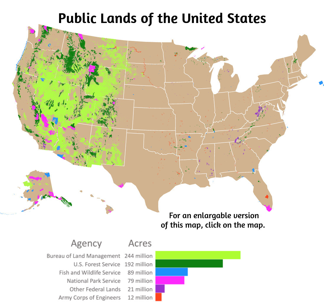
While well-intentioned greens are parsing BLM director nominee Steve Pearceโ€™s words for indications he might be inclined to sell off public land, the Trump administration is orchestrating a massive de facto transfer of public lands to oil and gas companies.

Iโ€™m talking about oil and gas leasing. And no, itโ€™s not an actual transfer of public land; the lessee does not take title to the land, nor can they block public access, but they do get the rights to drill that land and preclude other uses on it. And, once it is drilled, the land is scraped of all vegetation, covered with heavy equipment, poked with a massive drill, hydraulically fractured, and becomes an industrial-scale, methane-, hydrogen sulfide-, and VOC-oozing hydrocarbon factory for many decades to come.

On the auction block this June is a good chunk of slickrock-studded landscape northwest of Moab, between Hwy. 191 and the Green River, along with some parcels in the Lisbon Valley. All in all, the BLM proposes selling off 39 parcels covering some 71,600 acres. You have until March 30 to give your two cents. https://eplanning.blm.gov/Project-Home/?id=6fad61fa-a7f2-f011-8407-001dd80bcf93

***

Of course, sometimes the BLM holds an oil and gas auction and no one comes. That was the case with the Big Beautiful Cook Inlet Oil and Gas Lease Sale (yes, that is the official name) held March 4 in Alaska, in which more than 1 million acres of offshore leases were put on the block. There were zero bids. Zilch. Nada. Someday, maybe every oil and gas lease sale will be like that.

***

A federal judge has halted construction of the Northern Corridor Highway through the Red Cliffs National Conservation Area near St. George, Utah, while an advocatesโ€™ lawsuit proceeds.

The BLM approved the contested project earlier this year. The Utah Department of Transportation, apparently wanting to get started before a legal challenge could take hold, began erecting fencing along the project, even though their development plan hadnโ€™t been approved. This activity would have disturbed desert tortoise habitat.

The court did not approve, blocking further work until the lawsuit is resolved.

***

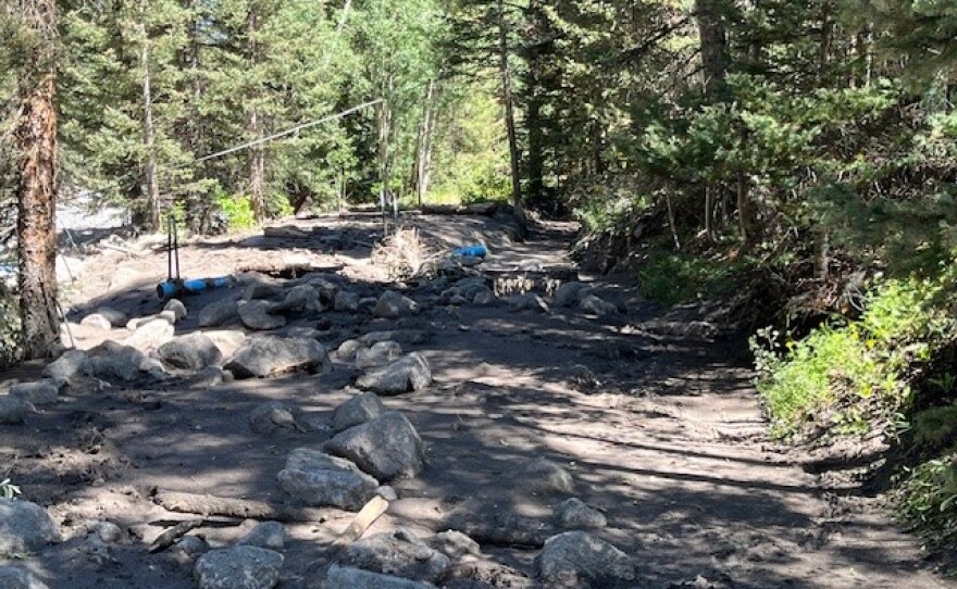
In other Utah road news, Garfield County began chip-sealing the first ten miles of the Hole-in-the-Rock Road in Grand Staircase-Escalante National Monument, drawing protest and a lawsuit from environmental groups.

The county has been aching to pave the gravel road, which often becomes riddled with potholes and washboards, for years, but failed to gain BLM approval. Environmental groups have resisted, saying that improving the road could lead to more paving or widening of primitive byways in the area, and would increase the number of people and their impacts on the fragile landscape.

The county has also wielded RS-2477 โ€” an 1866 statute โ€” in an attempt to wrest control over the byway, which leads to the famed Colorado River crossing of the 1879 Latter Day Saint expedition to Bluff. Last July, a federal court granted Garfield County quiet title to the section of the road within the county.

Garfield County interpreted that as a green light to chip seal the road.

That triggered a lawsuit from the Southern Utah Wilderness Alliance, pointing out that because the road crosses BLM land, the county must still get the agencyโ€™s go-ahead for major improvements. It didnโ€™t, but the BLM has done nothing to stop the action, which SUWA says violates federal environmental laws.
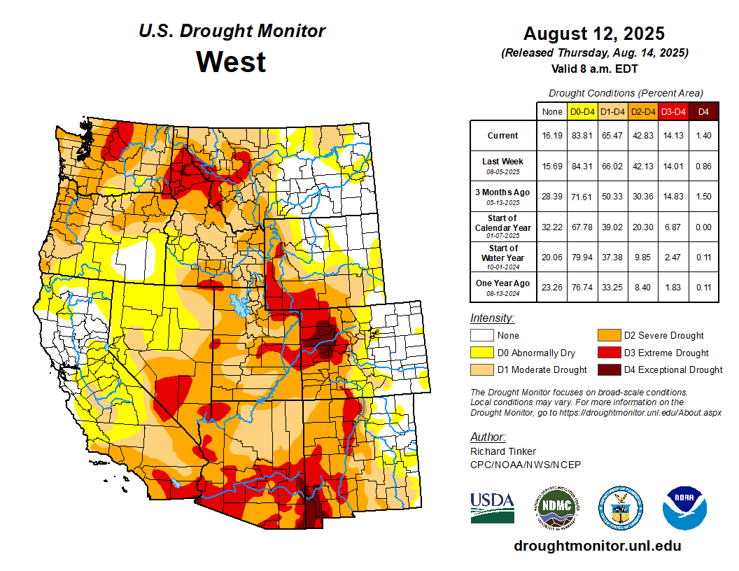

๐Ÿฅต Aridification Watch ๐Ÿซ

I was accused recently of being all โ€œdoom and gloomโ€ when it comes to this yearโ€™s snow levels, so I set out to find some good news to report. It didnโ€™t go so well, but I did uncover a few tiny nuggets, including:

  1. After the February storms, the Center for Snow and Avalanche Studies reported: โ€œThis is rare, but currently we do not have any dust on the snowpack.โ€ Thatโ€™s good news because dust on the snow decreases albedo (reflectivity), leading to faster snowmelt. We need what little we have to stick around as long as possible. Buzzkill: The really big dust events tend to come in the springtime.
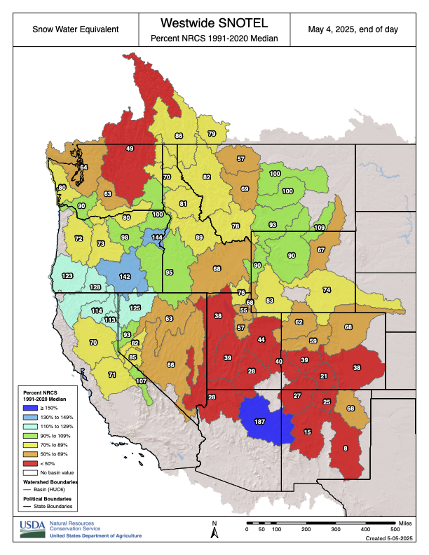
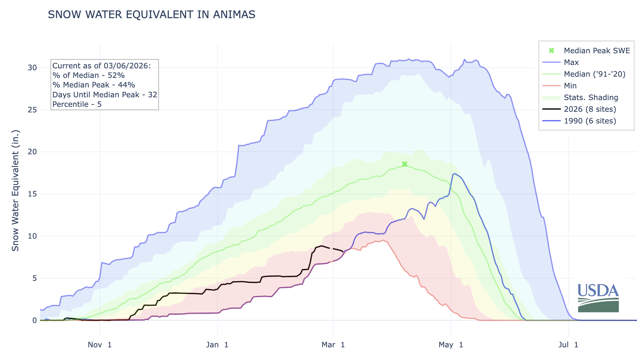
  2. I tend to rely on a handful of high-elevation SNOTEL sites as indicators of how the mountain snowpack is doing. One of them is in Columbus Basin in the La Plata Mountains. Like everywhere else, the snow water equivalent there is way below normal. However, itโ€™s still above 2002 levels for early March, so thatโ€™s kind of heartening. I guess?
  3. Hope lies in 1990: That year, snowpack levels in the Animas River watershed were lower on March 6 than they are today. But beginning in mid-March, storms pummeled the region, resulting in a May 3, 1990, snowpack peak that was 94% of normal and bringing runoff up to decent levels. We could see a repeat of that March-April-May miracle!
  4. And โ€ฆ oh. Iโ€™ve just been informed that there is no more good news.
As grim as this may be, it also offers a glimmer of hope: The snowpack could still recover like it did in 1990. Source: NRCS.

Now back to our regularly scheduled doom and gloom, bullet style.

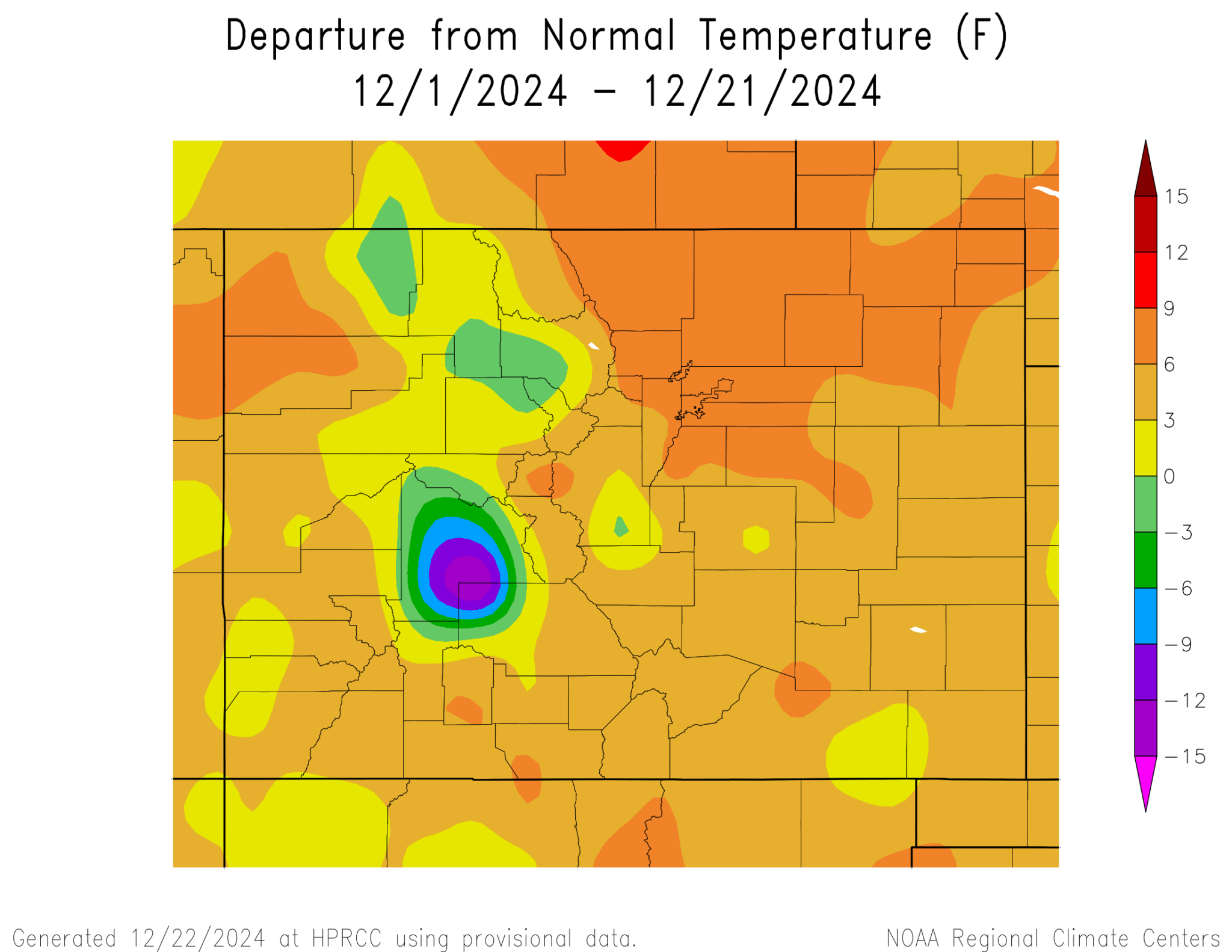
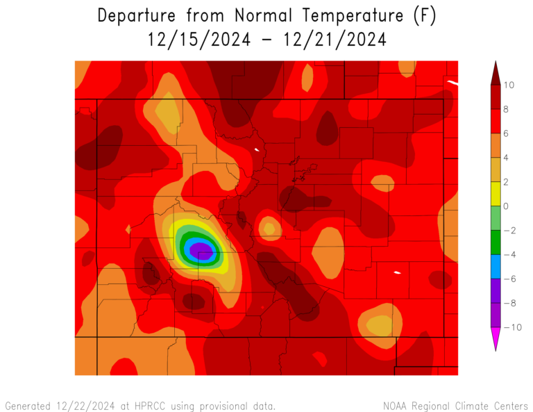
  • The late February-early March heat wave across most of the West shattered thousands of daily high temperature records and dozens of monthly ones, topping off the Westโ€™s warmest winter on record. Monthly records (121 tied or broken nationwide during the last week of Feb.) include:
    • Dinosaur National Monument in Utah hit 68ยฐ F on 2/26;
    • Imperial County, Californiaโ€™s airport reached 97ยฐ on 2/28;
    • Albuquerque airport, 77ยฐ on 2/25;
    • Hovenweep National Monument in Utah, 70ยฐ on 2/28;
    • Havasu, Arizona, and Malibu Hills, California, were both 93ยฐ on 2/27;
  • Sampling of daily records (845 broken or tied during the last week of Feb) include:
    • Mancos, Colorado, hit 50ยฐ F on 2/28; the aforementioned Columbus Basin (elev. 10,784 feet) reached 48ยฐ and Mineral Creek, Colorado, hit 51ยฐ that same day;
    • McClure Pass, Colorado, reached 49ยฐ on 2/28;
    • Needles, California, and Phoenix both hit 92ยฐ on 2/28;
    • South Lake Tahoe airport, 60ยฐ on 2/28.

Those kinds of temperatures melt the snow, even on north faces, causing this yearโ€™s snow water equivalent graph lines to uncharacteristically dip during a time of year when they normally would be shooting upward. They also heighten risk of wildfires in the low country. On the last day of February,ย a blaze broke outย in Chautauqua Park in Boulder, forcing some evacuations before it was contained. Another one was sparked west of Boulder on March 4.

The North Fork of the Gunnison, which feeds the ditches in and around Paonia and Hotchkiss and the orchards, vineyards, and farms there, is in trouble. This yearโ€™s snowpack so far is in the same boat as it was on this date in 2002 and 2018, two very dry years when irrigation ditches were shut off early in the growing season.

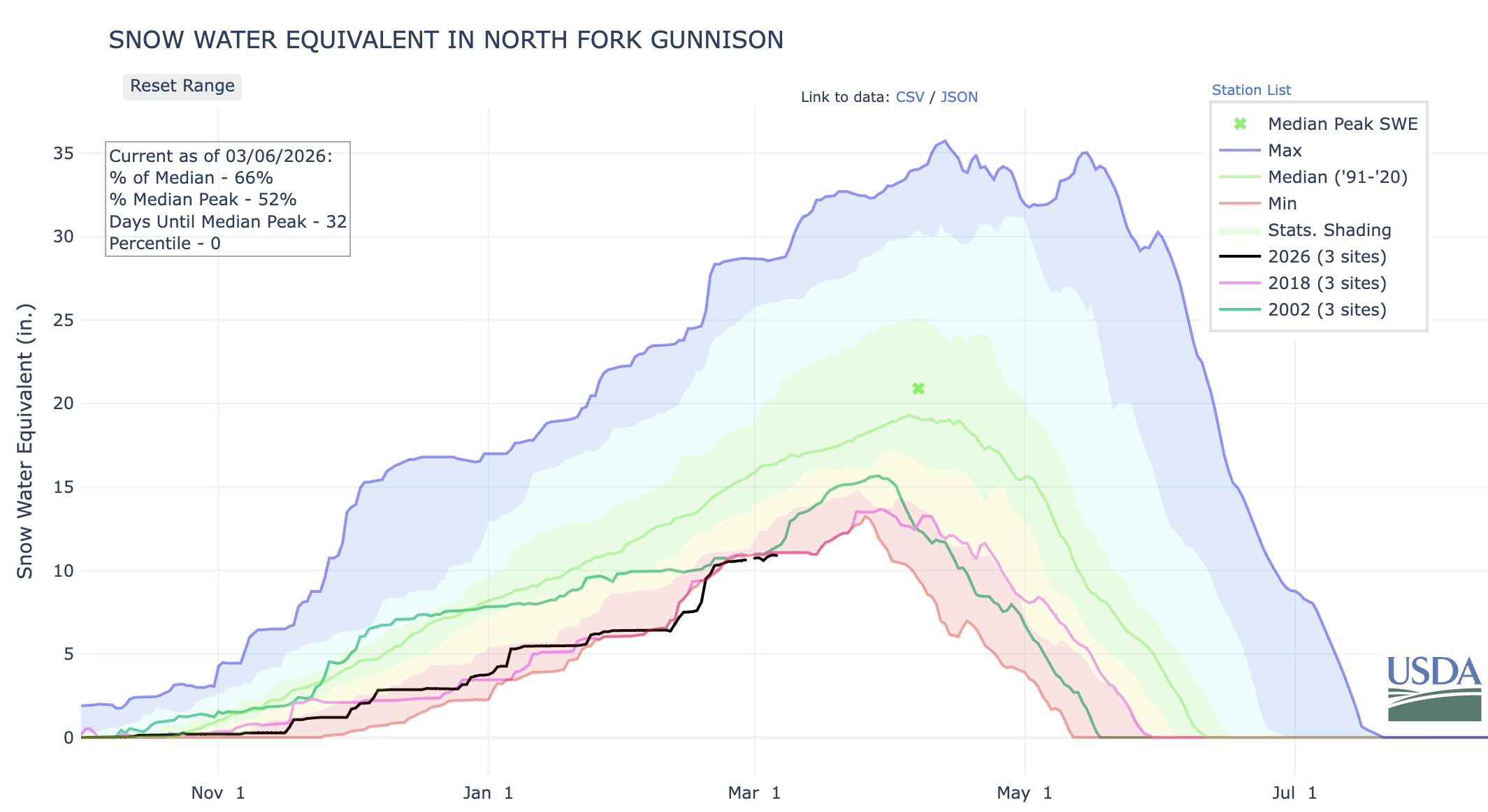
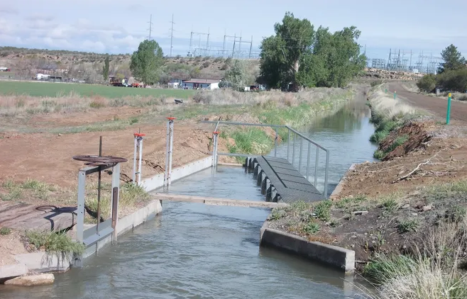
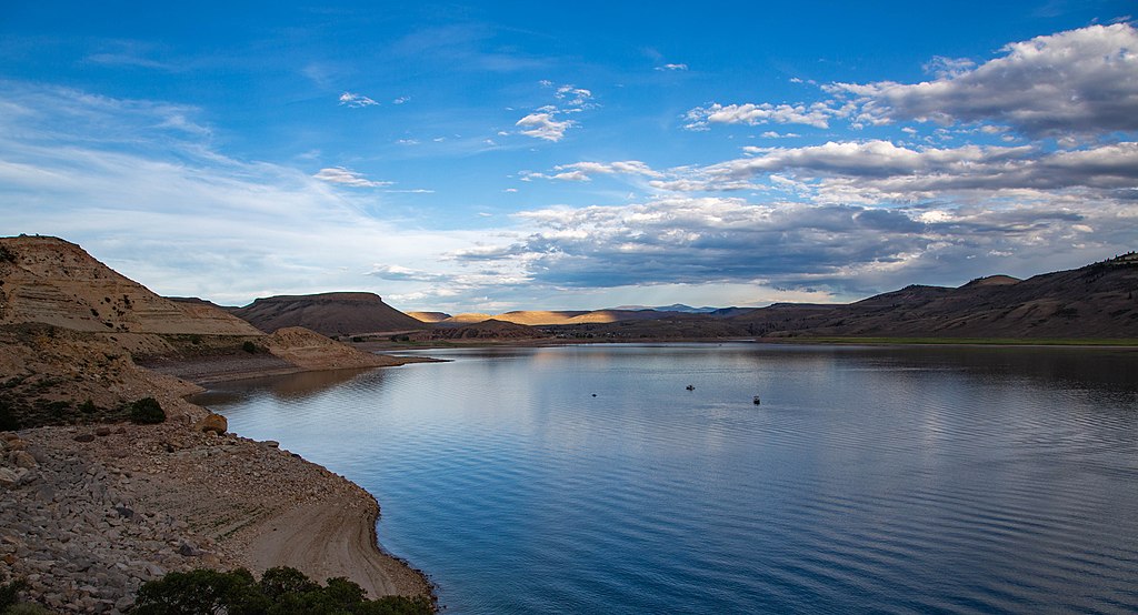
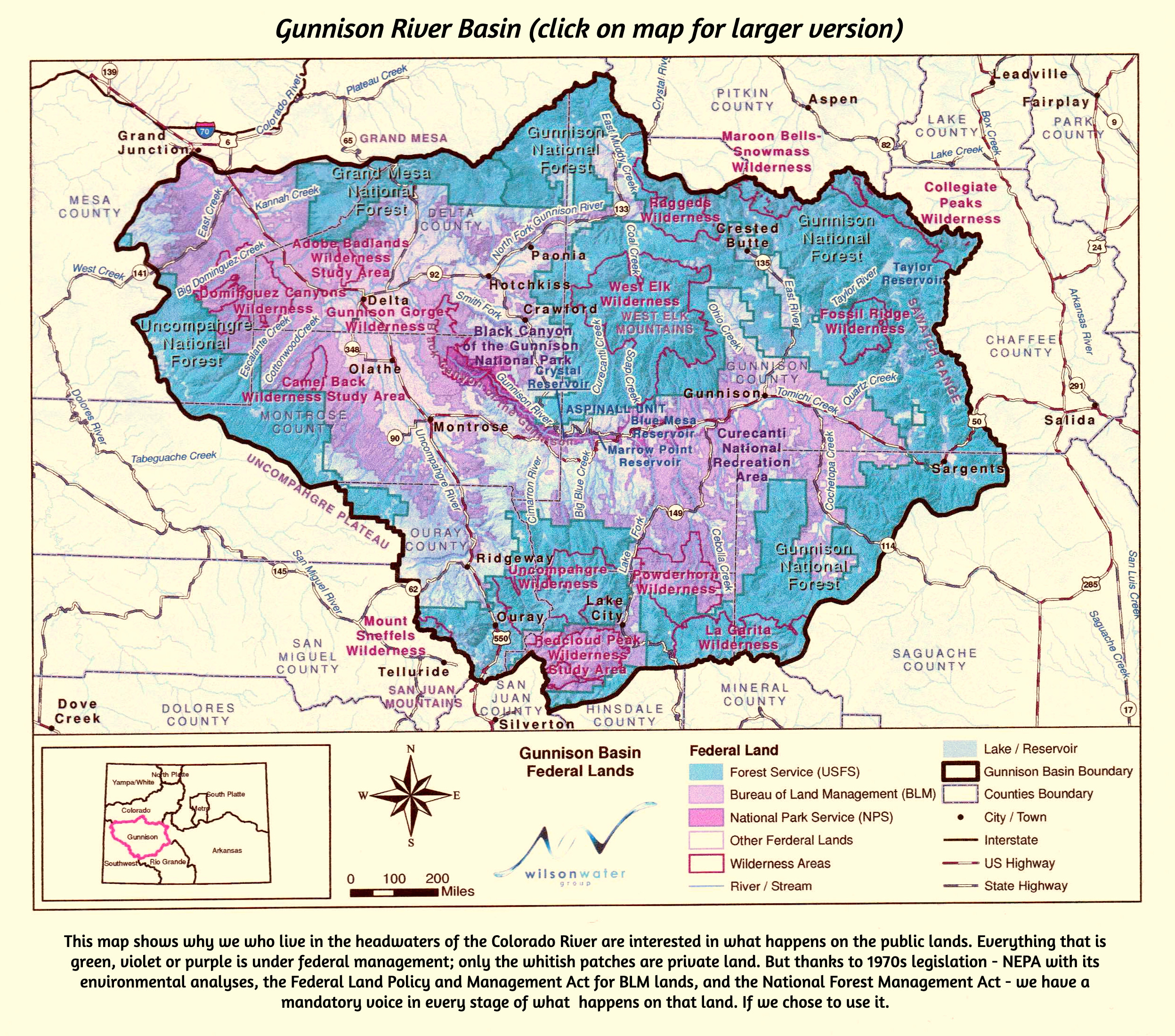
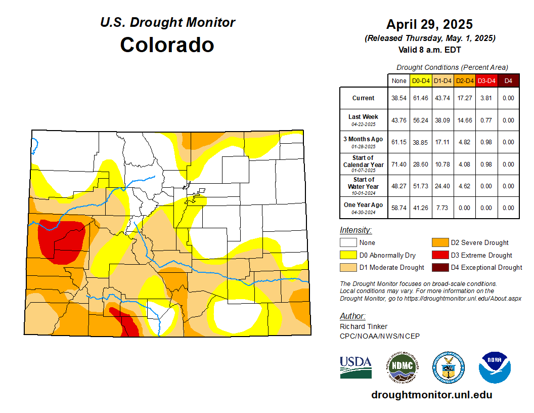
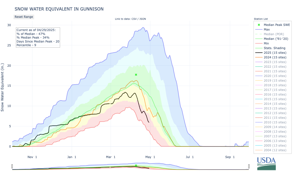
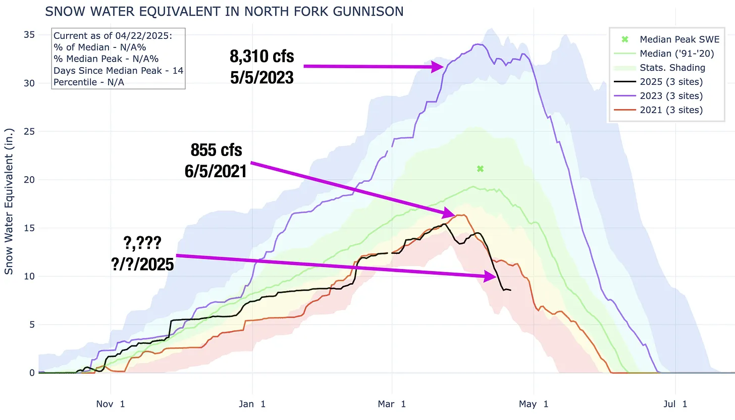
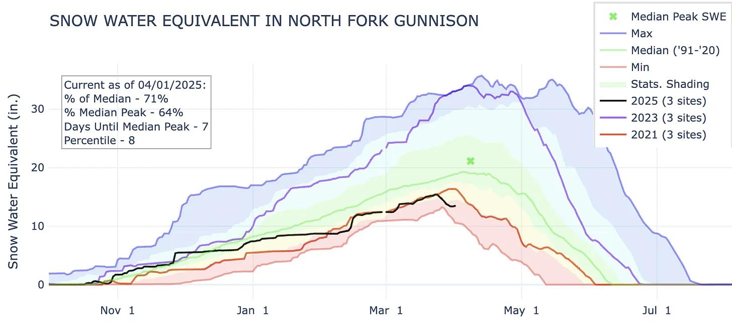
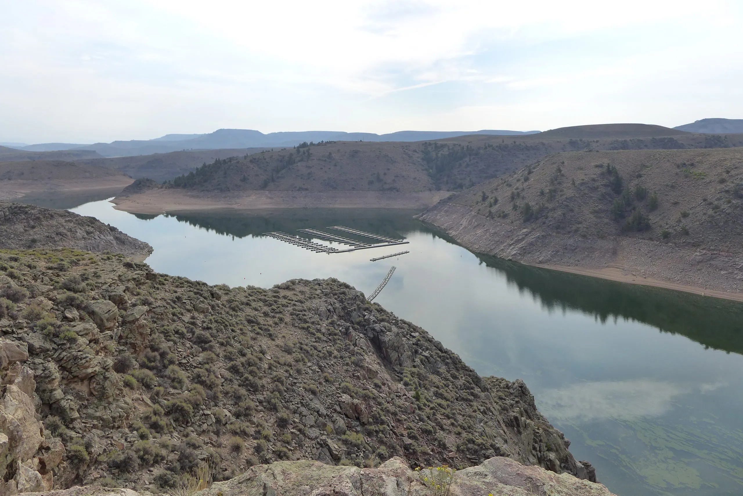
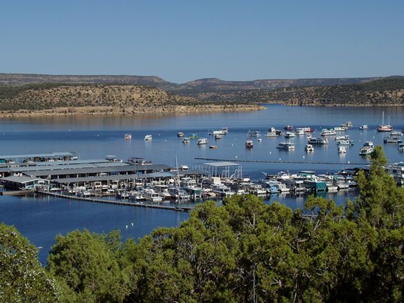
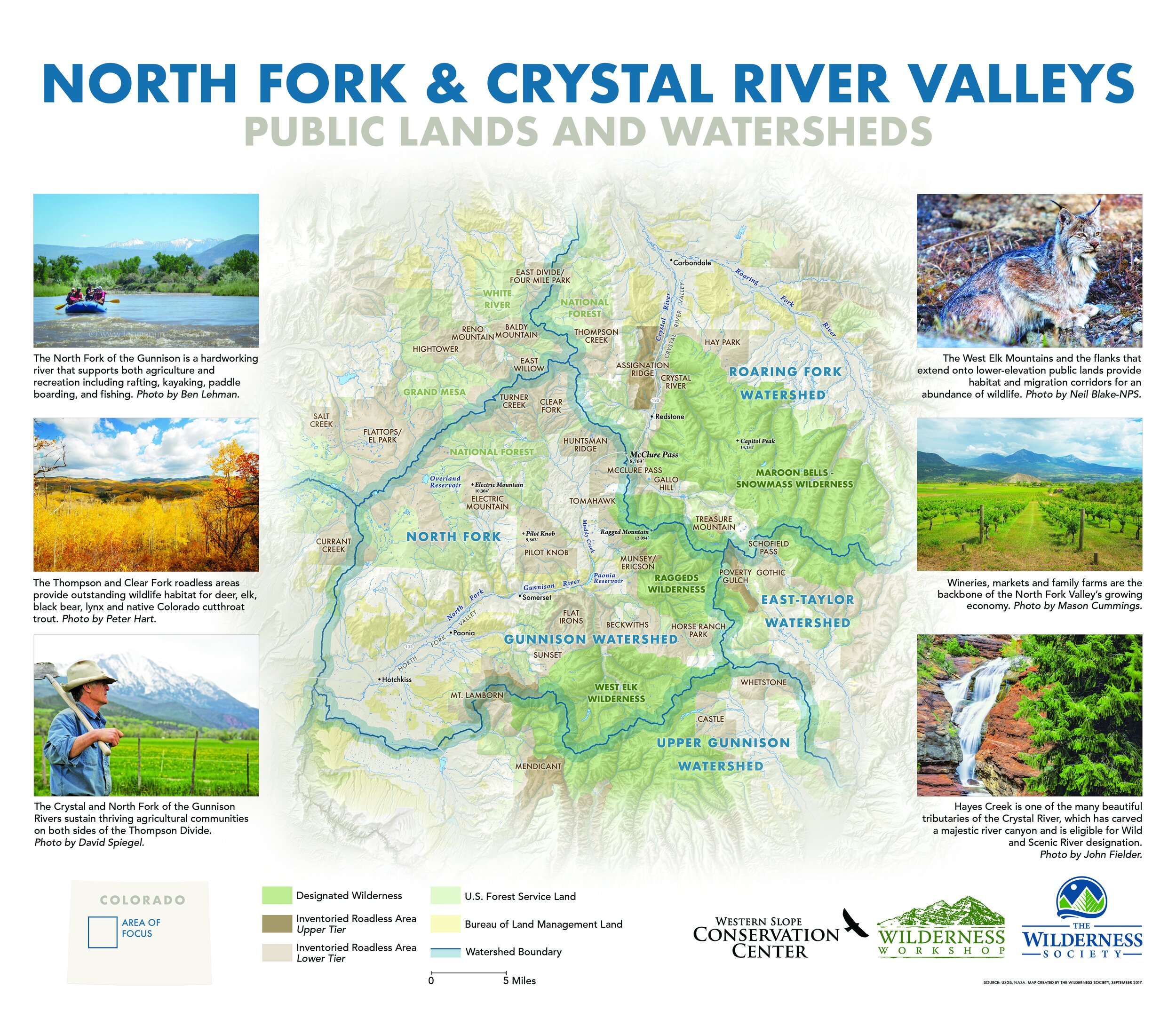
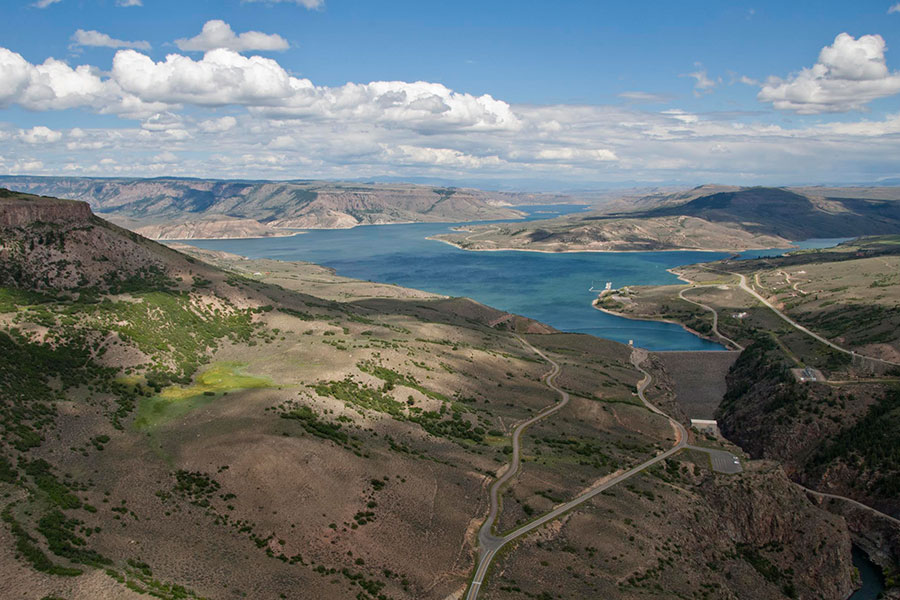
Aside from the entire Upper Colorado River watershed, Iโ€™m also especially concerned about the North Fork of the Gunnison. Snowpack levels are at a record low for this date, or about the same as they were in 2018, and Paonia Reservoir is currently utilizing just 22% of its storage capacity (note the record high temp on McClure Pass above, at the headwaters of Muddy Creek, which feeds the reservoir). This does not bode well for the many small farmers who rely on the river for irrigation. In 2018, downstream senior rights holders made a call on the river in June, forcing junior irrigators in the North Fork to lose water perilously early in the season.

This bad situation could be exacerbated if the feds were to decide to release water from Paonia Reservoir in an attempt to buoy Lake Powell water levels. While this is hypothetical, it is not beyond the realm of possibility by any means.

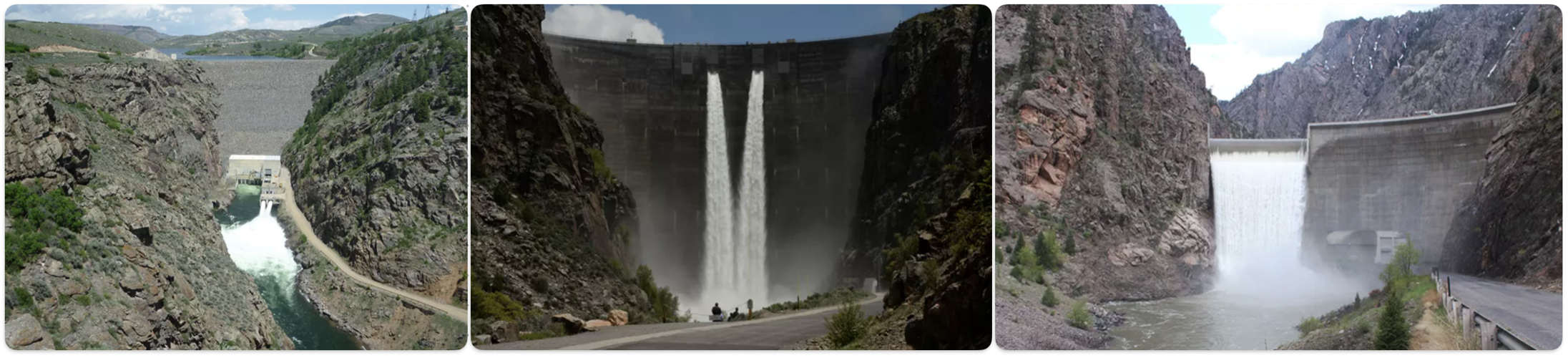
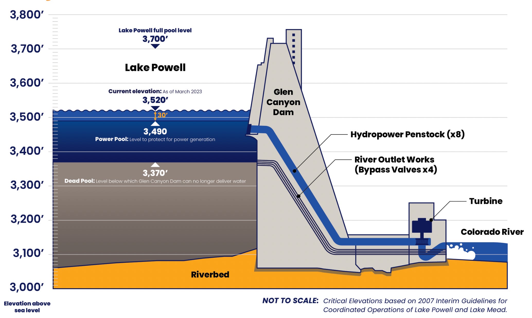
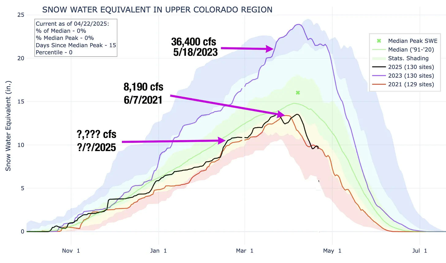
And, saving for some sort of April-May miracle, the Colorado River runoff will be extraordinarily scant this spring and summer, almost certainly pushing Lake Powell to critically low levels.

***

That demands a plan, and the Bureau of Reclamation came up with several alternatives last month. Most of the major players have commented on the alternatives, and itโ€™s safe to say that almost no one is satisfied with any of them โ€” albeit for different reasons.

One of the more universal critiques is that none of the alternatives adequately address dry and critically dry scenarios on the river, like the one that is likely to occur this summer. The draft environmental impact statement itself states, โ€œIn critically dry periods, all alternatives have unacceptable performance.โ€ That leaves many wondering what, exactly, the Bureau of Reclamation plans to do to keep the system from collapsing over the next nine months.

There is a lot here, and it gets pretty darned deep in the wonk weeds. Still, what Iโ€™ve included is a mere sampling of some of the comments from just a few of the commenters in the hope that it will give readers a better idea of where different stakeholders stand, and how complicated and difficult this situation really is.

For those who donโ€™t like weeds, hereโ€™s the short version: Itโ€™s a tangled mess with a bunch of moving pieces and stakeholders who are digging in their heels to ensure that their constituents get the water they need to drink, irrigate crops, run industries, or whatever. And theyโ€™re all butting up against the reality that there simply isnโ€™t enough water in the river to go around.

Ian James has a slightly less crunchy version for the Los Angeles Times.

Here are the comments and commenters:

Fourย Democratic members ofย Arizonaโ€™s congressional delegationย feel that the Lower Basin is getting the dry end of the stick (their comments are similar to those of theย Arizona Department of Water Resources):

  • Arizona is understandably displeased because they would take the greatest hit under any alternative. This is not because they are somehow inferior, but because the water rights to the Central Arizona Project, which delivers Colorado River water to Phoenix and Tucson, are junior to most other big users in the Lower Basin.ย โ€œโ€ฆ each alternative, though broad in scope, will translate in practice specifically as drastic reductions to Arizonaโ€™s water supply.โ€
  • โ€œWe are deeply troubled that Reclamation all but abandons its increasingly critical role in ensuring the Upper Basin States fulfill their delivery obligations under the Colorado River Compact of 1922 (Compact).โ€ย This refers to the non-depletion or minimum-delivery obligation that Iโ€™ve written about before.
  • โ€œThe DEIS itself acknowledges that โ€˜widespread impacts on social and economic conditions may also be possible,โ€™ including circumstances in which municipalities may need to pursue alternative or even hauled water sources to maintain basic services. Drastic cuts could have cascading consequences for human health and safety and destabilize the lives and livelihoods of Arizonans, tribal communities, and critical industries that rely on Colorado River supplies.โ€
  • They say the cuts will damage the stateโ€™s agriculture, manufacturing, and aerospace industries and that it will put at risk: โ€œโ€ฆ the largest concentration of advanced semiconductor manufacturing investment in the country, representing roughly $200 billion in announced projects since 2020.โ€ Semiconductor production is extremely water-intensive, with the average factory consuming up to 10 million gallons of ultra-pure water daily.
  • They call on any plans toย โ€œinclude verifiable Upper Basin conservation measures commensurate with Lower Basin conservation measures, including identifying tangible metrics that demonstrate Upper Basin water conservation.โ€

The Colorado River District, which represents water users on Coloradoโ€™s Western Slope, wasnโ€™t so psyched about the alternatives, either:

  • โ€œWe believe that Reclamation must institute bold and meaningful changes but that those changes must be implemented in a manner that is consistent with the 1922 Colorado River Compact, the 1944 binational treaty with Mexico, the 1948 Upper Basin Compact, and the other foundational elements of the Law of the River.โ€
  • โ€œReclamation must prioritize hydrologic reality over predictability for Lower Basin users. The Draft EIS places undue emphasis on predictability1 for water users, a goal that is unattainable under future climate conditions unless system storage is replenished and overall demands are permanently reduced to match the supply.โ€
  • โ€œโ€ฆ several alternatives include Upper Basin water conservation ranging from zero to 500,000 acre-feet annually โ€ฆ <but> โ€ฆ fails to analyze the environmental or socioeconomic impacts associated with these conservation volumes.โ€ย It adds that a 200,000 acre-feet reduction in the Upper Basin would require fallowing 52,000 acres on the Western Slope.
  • โ€œLower Basin water use must be reduced by 1.5 million acre-feet at all times, regardless of the alternative. This amount represents system losses (i.e., transit losses and reservoir evaporation) and should not be classified as shortage.โ€ย This is a longstanding issue. Reservoir evaporation and other such losses are counted against the Upper Basinโ€™s consumptive use, in part because of the non-depletion obligation. The same is not true for the Lower Basin; when they say they use 7.5 million acre-feet, that does not include evaporation or seepage or other system losses, only what they pull out of the river.
  • โ€œThe range of alternatives must include option(s) that perform under critically dry hydrology. Currently, none of the alternatives in the Draft EIS perform under critically dry hydrology. At least one alternative must protect critical infrastructure and respond effectively to significantly lower river flows than historically observed.โ€ย We are approaching a critically dry situation this summer, when the feds will have to decide whether and how to keep Lake Powell from dropping below minimum power pool. So far there is no plan for this.
  • โ€œHydrology must drive Post-2026 operations. Operating guidelines based upon comparative reservoir elevations which do not factor in real time hydrology have been disastrous for protecting storage in Lake Powell and thus, have failed to provide the water supply certainty for the Upper Basin intended by the Law of the River โ€ฆโ€
  • โ€œInterbasin transactions must not be allowed in the proposed action.โ€ย That is, Upper Basin users with senior rights should not be able to sell their water to Lower Basin users.

Theย team of Anne Castle, John Fleck, Eric Kuhn, Jack Schmidt, Katherine Tara, and Kathryn Soren,ย river experts and academics who arenโ€™t representing any specific water user, state, or basin, alsoย weighed in. Their comments, as Fleck put it in hisย Inkstain blog, could be summed up as: โ€œTell us what youโ€™re going to do.โ€ย And, also:

  • The group calls on Interior toย โ€œprimarily focus on the Dry and Critically Dry scenarios. โ€ฆ We think it important to be mindful of the underlying year-to-year hydrology of the 21st century as we look to the future. โ€ฆ we are struck by the fact that 50% of the individual years of the 21st century have been Dry or Critically Dry, and only 27% of the years (including 2017, 2019, 2023) have been Moderately Wet or Wet.โ€
  • โ€œWe suggest that the DEIS include a description of an alternative that performs sufficiently well during Dry scenarios and an alternative that performs sufficiently well during Critically Dry scenarios.โ€
  • โ€œ โ€ฆ it is imperative that Reclamation provide a clear picture of what actions will be implemented in the near term (i.e., next year, next 3 years, next 5 years) to protect critical infrastructure, and to protect public health and safety.โ€
  • Noting that lawsuits are inevitable regardless of which alternative the feds choose, they urge them to avoid โ€œsafeโ€ options and go with a plan with โ€œโ€ฆ the broadest possible interpretation of Reclamationโ€™s and Interiorโ€™s authority to provide a predictable and resilient Colorado River so that the system can continue to operate in a reasonable manner while the lawsuits proceed.โ€
  • Call on the feds to โ€œโ€ฆ explore these areas for possible inclusion in the preferred alternative:
    • Reduction of deliveries in the Lower Basin in excess of 1.48 MAF when insufficient water is available for release.
    • Provision for releases of water from the Colorado River Storage Project initial units as necessary to protect critical elevations in Lake Powell and ensure continued Upper Basin Compact compliance.
    • Operation of federal projects in the Upper Basin to store or use less water during critical periods.
    • Continuation, expansion, and modification of Assigned Water programs (such as Intentionally Created Surplus and Mexican Water Reserve) with improvements to ensure operational neutrality and minimize adverse impact to priority water.
    • Establishing a conservation pool in Lake Powell for storing Upper Basin conserved water to be utilized for Compact compliance purposes. For more on conservation pools, check out the Shannon Mulaneโ€™sย explainerย in theย Colorado Sun.
  • The group finds fault with the plan for not addressingย โ€œthe need for enforceable reductions in the Upper Basin.โ€ย They go with the Lower Basinโ€™s interpretation of theย non-depletion/minimum-deliveryย obligation, saying that the Colorado River Compact does not guarantee that the Upper Basin gets half of the water in the river. Plus, they point out that the planโ€™s demand forecasts for the Upper Basin are unrealistically high, putting more of the burden for cuts on the Lower Basin.

Theย Southern Nevada Water Authorityย andย Colorado River Commission of Nevadaare especially critical, writing:

  • โ€œSince the onset of drought in 2002, <Nevada water users> have reduced their overall Colorado River water consumption by more than 40 percent even as our population grew by more than 875,000 people. And they, unlike so many others, have not ignored the reality facing the basin by making the flimsy argument that our economy cannot prosper while water consumption decreases.โ€
  • Like Arizona, they bring up the minimum-delivery/non-depletion clause of the Colorado River Compact and call on the Upper Basin to comply with it.
  • Interiorโ€™s โ€œโ€ฆ approach to protecting the Glen Canyon Dam river outlet works by reducing releases from Lake Powellโ€”rather than making infrastructure repairs and improvementsโ€”is shortsighted and harms Nevada and the Lower Basin States.โ€

Theย Upper Colorado River Commissionย emphasizesย the Lower Basinโ€™s history of exceeding its Colorado River Compact allocation and failing to account for evaporation and other system losses. Coloradoโ€™sย Upper Colorado River CommissionerBecky Mitchell submitted similar, very detailedย commentsย that emphasized the Colorado River Compactโ€™s equitable division of the river between the Upper Basin and Lower Basin. She points out that the Lower Basinโ€™s interpretation of the minimum-delivery/non-depletion clause contradicts and even negates that division.

๐Ÿ“– Reading (and watching) Room ๐Ÿง

Must read: Teal Lehtoโ€™s and Len Neceferโ€™s speculative fiction take on what might happen on the Colorado River, and to the people who rely on it, in 2030 if current climatic trends continue. Itโ€™s dramatic and sensational and catastrophic, but itโ€™s also very well informed, smart, and not at all far-fetched, in my humble opinion.

Yikes! #LakePowell likely to receive half or less of its normal water supply this year — Shannon Mullane (Fresh Water News) #ColoradoRiver #COriver #aridification

The Bureau of Reclamationโ€™s latest forecast for the Colorado River predicts Lake Powell will โ€œmost probablyโ€ drop below the critical minimum power pool level before the end of this year, jeopardizing Glen Canyon Damโ€™s structural integrity. In the worst-case scenario, it would do so before summerโ€™s end. This could force the feds to operate the dam as a โ€œrun-of-the-riverโ€ operation to preserve the damโ€™s infrastructure and hydropower output, which would significantly diminish downstream flows and threaten Lower Basin water supplies.

Click the link to read the article on the Water Education Colorado website (Shannon Mullane):

February 19, 2026

Lake Powell could receive only half the normal amount of water from upstream rivers and streams this year, according to a recent federal study.

The U.S. Bureau of Reclamation releases a monthly study that forecasts good, bad and most likely storage conditions for the Colorado River Basinโ€™s key reservoirs over the next two years. The February forecast expects about 52%, or about 5 million acre-feet, of the normal amount of water to flow into Lake Powell by September. The more grim outlook says Powellโ€™s inflows could be 3.52 million acre-feet or 37% of the average from 1991 to 2020.

Itโ€™s enough to spike concerns about hydropower generation at Glen Canyon Dam โ€” which controls releases from Powell โ€” prompt discussions about emergency releases from upstream reservoirs and trigger federal actions to slow the pace of water out of the reservoir.

โ€œI think theyโ€™re going to be nervous about operating the turbines,โ€ said Eric Kuhn, former general manager for the Colorado River Water Conservation District.

In January, about 79% of the 30-year average flowed into Lake Powell โ€” which is on the Utah-Arizona border โ€” from upstream areas of Arizona, Colorado, New Mexico, Utah and Wyoming, according to the federal February 24-month study, released Friday.

The February projections also showed even less water flowing into Lake Powell, a decline of about 1.5 million acre-feet since January.

One acre-foot is enough water to support two or three households for a year. Colorado used an average of 1.96 million acre-feet of Colorado River water between 2021 and 2025.

The Colorado River Basin, which provides water to 40 million people, has been plagued by a 25-year drought that drained its main reservoirs โ€” the largest in the nation โ€” to historic lows amid unyielding human demands.

And that stress is going to continue. The most probable forecast shows nothing but below-average flows in February โ€” 71% of the 30-year average โ€” and for April through July, when flows are likely to be 38% of the norm.

Feds take action to boost Powell

Upstream states like Colorado do not get a drop of water from Lake Powell, Kuhn said. Coloradans rely mostly on local reservoirs to help pace the spring runoff and support year-round water use.

But the reservoirโ€™s status can impact whether upstream reservoirs, like Flaming Gorge in Wyoming and Blue Mesa in Colorado, will have to make emergency releases to elevate water levels in Lake Powell.

In response to the dry and warm winter, the federal government is trying to keep the water in the reservoir above certain critical water levels, according to the study.

At 3,490 feet in elevation, Glen Canyon Dam can no longer send Powellโ€™s water through its penstocks and turbines to generate hydroelectric power โ€” that would remove a cheap, renewable and reliable power source for communities across the West.

Lake Powell is projected to drop below the critical elevation by December, or as soon as August in one scenario, according to the 24-month study.

Federal officials are likely to call for emergency water releases from upstream reservoirs to keep Powellโ€™s water level from falling to that point. Theyโ€™re working to maintain a cushion by keeping Powellโ€™s water level above 3,525 feet, or at the very least 3,500 feet in elevation, according to the study.

Lake Powellโ€™s elevation was just over 3,532 feet as of Monday, but itโ€™s expected to drop to 3,497 feet by Sept. 30 under the most likely forecast. (The minimum forecast puts it closer to 3,469 feet.)

Putting himself in the Bureau of Reclamationโ€™s shoes, Kuhn would be looking upstream to fill that gap.

โ€œWhere do they plan for it?โ€ he said. โ€œI would be looking to get a lot of water if Iโ€™m going to keep Lake Powell above 3,500. โ€ฆ 3,525 may not be possible. There just may not be enough water in the system.โ€

Facing new lows

That is partly because the Bureau of Reclamation is required by a 2007 agreement, which expires this fall, to release certain amounts of water each year based on reservoir elevations. Replacing these rules is the focus of ongoing high-stakes โ€” and deadlocked โ€” negotiations among states.

Powellโ€™s releases are expected to be 7.48 million acre-feet between Oct. 1, 2025, and Sept. 30, according to the February 24-month study.

To try to keep reservoir levels up, the Bureau of Reclamation has adjusted its normal releases since December to keep about 600,000 acre-feet of water in the reservoir. That water will eventually be released downstream as required by the 2007 rules.

Federal officials could also release less than 7.48 million acre-feet this year to keep more water in Lake Powell, according to the study. A 2024 short-term agreement allows the officials to release as little as 6 million acre-feet of water this year to avoid Lake Powell falling below 3,500 feet.

Lake Powellโ€™s lowest release was about 2.43 million acre-feet in 1964, when the reservoir was first being filled. Since 2000, when the basin dipped into the ongoing 25-year drought, Powellโ€™s average annual release has been 8.69 million acre-feet, according to The Sunโ€™s analysis of water release data.

โ€œI donโ€™t think theyโ€™re going to release 7.48 this year. I think they have to cut the flow down to 7 (million acre-feet) or even below,โ€ Kuhn said.

More by Shannon Mullane

Map of the Colorado River drainage basin, created using USGS data. By Shannon1 Creative Commons Attribution-Share Alike 4.0

Historic valve replacement underway at Blue Mesa Dam: $32 Million Project Ensures Reliable Water Delivery and Hydropower for the future — USBR #GunnisonRiver

In the 1950s, the U.S. Bureau of Reclamation built the Blue Mesa, Morrow Point and Crystal dams west of Gunnison as part of the massive regional Colorado River Storage Project. The Bureau of Reclamation is currently in the process of replacing all four original valves at Blue Mesa Dam for the first time. (Photos/National Park Service)

Click the link to read the release on the Reclamation website:

February 12, 2026

 For the first time since its completion in 1966, the Bureau of Reclamation is replacing all four original valves at Blue Mesa Dam, the largest of the three dams that make up the Aspinall Unit on the Gunnison River. This multi-year, $32 million federally funded project is a major milestone in ensuring the reliability and safety of one of Coloradoโ€™s most important water and power facilities.

Standing 390 feet tall, Blue Mesa Dam creates Blue Mesa Reservoir, the largest body of water in Colorado, with a capacity of nearly 941,000 acre-feet. Together with Morrow Point and Crystal dams, the Aspinall Unit provides water storage, flood control and hydropower generation. Blue Mesaโ€™s power plant alone produces 86 megawatts of electricity, helping power homes and businesses across the region.

Crews help guide the removed ring follower gate to a flatbed truck so it can be transported to California for refurbishment. Reclamation photo

The project will replace two ring follower gate valves and two butterfly valves, critical components that control how water moves through Blue Mesa Dam.

  • Ring follower gates, located in the damโ€™s outlet works, allow water to bypass the turbines during maintenance or emergencies, ensuring uninterrupted flows to the Gunnison River.
  • Butterfly valves, located inside the penstocks, act as flow-control and isolation devices for water entering the turbines to generate hydropower.

Work began in January with the removal of the first ring follower gate, a massive assembly measuring 18 feet long by 7 feet wide and weighing about 14 tons. The hydraulic hoist system adds another 12 tons. Before safely removing the gate, crews first installed a blind flange, a heavy steel plate that temporarily seals the opening and holds back water.

The gate and its components are now in California for refurbishment and will return for installation in August. Later this fall, once irrigation demands ease, the blind flange will be removed and normal operations restored. After this first gate is complete, crews will move on to the second ring follower gate, followed by the two butterfly valves.

โ€œThis work is complex,โ€ said Blue Mesa Plant Supervisor Eric Langely. โ€œWe must maintain minimum river flows downstream, avoid disruptions at Morrow Point and Crystal dams, and manage drought-related constraintsโ€”all while working inside a dam built nearly 60 years ago.โ€

The project is being led by a skilled team of Reclamation engineers, plant operators, and technical specialists. Their expertise ensures this upgrade will keep Blue Mesa Dam operating safely and efficiently for decades to come.

Crews weld the temporary blind flange into place inside Blue Mesaโ€™s penstock. Courtesy photo/USBR)

Grants available through #GunnisonRiver Basin Foundation — The #Gunnison Country Times

Gunnison River Basin. By Shannon1 – Own work, CC BY-SA 4.0, https://commons.wikimedia.org/w/index.php?curid=69257550

Click the link to read the article on The Gunnison Country Times website:

The Gunnison River Basin Roundtable recently announced grants of up to $1,500 for water education through its public education, participation and outreach committee. The 2026 Water Education Grant is now accepting applications. Funds are available to anyone engaged in water education, including public and private schools, libraries, scout troops, homeschoolers, 4-H clubs and other organizations offering programming for children up to 18 years old in the Gunnison Basin. Applications are due at 5 p.m. on Feb. 23. For more information, visit gunnisonriverbasin.org/.

Bureau of Reclamationย Aspinall Unit Coordination Meeting February 11, 2026 #GunnisonRiver

Aspinall Unit dams

From email from Reclamation Reece K. Carpenter:

January 14, 2026

In order to avoid conflict with Colorado Water Congress the first Aspinall Coordination Meeting of 2026 is being rescheduled.

The next coordination meeting for the operation of the Aspinall Unit is rescheduled for Wednesday, February 11th 2026, at 1:30 pm

This meeting will be held at the Western Colorado Area Office in Grand Junction, CO. There will also be an option for virtual attendance via Microsoft Teams. A link to the Teams meeting is below. 

The meeting agenda will include updates on current snowpack, forecasts for spring runoff conditions and spring peak operations, and the weather outlook.

Shareholders sue Uncompahgre Valley Water Users Association — The #GrandJunction Daily Sentinel

This photo from the Uncompahgre Valley Water Users Association website shows some of its water infrastructure. The association is facing a lawsuit from some of its shareholders who say they arenโ€™t getting a fair share of their irrigation water.

Click the link to read the article on the Grand Junction Daily Sentinel website (Dennis Webb). Here’s an excerpt:

November 14, 2025

Some shareholders have sued the Uncompahgre Valley Water Users Association, contending they arenโ€™t receiving their fair share of irrigation water and their livelihoods are being harmed…The plaintiffs have been โ€œdeprived of consistent and proportional water deliveries during critical irrigation periods since 2022,โ€ which is when new association management took over, the suit says. Over that period plaintiffs also have been deprived of water owed to them based on priority water rights, the suit says.

โ€œThese failures have occurred even in years with above-average snowpack and available water. Despite Plaintiffsโ€™ repeated requests to the UVWUA to correct these deficiencies, Plaintiffs continued to receive disproportionate, inconsistent, and insufficient water deliveries during the 2025 irrigation season,โ€ the suit says…The suit says the plaintiffs have experienced problems including weeks without delivery during planting and growing seasons. One plaintiff, Tom Gore, reported going 60 days last year without expected water deliveries. Another, Frank Gilmore, has been able to run only two irrigation pipes simultaneously instead of the normal five and has lost entire cuttings of hay. Delayed irrigation last year left a third of plaintiff Dan Varnerโ€™s newly reseeded 34-acre hayfield unproductive, requiring costly reseeding, the suit says. It says the impacts to shareholders have included things such as failed crop rotations, increased cattle feed costs, reduced soil health, and loss of profit from hay and sweet corn yields…

The plaintiffs are shareholders receiving water from the Ironstone Canal system, one of the projectโ€™s primary delivery systems. The suit says the associationโ€™s delivery practices have deprioritized the Ironstone system and intentionally favored the East Canal system instead. The suit says that last March, Pope admitted in a meeting that the association was intentionally and disproportionately routing water to the East Canal system before delivering to Ironstone System shareholders, contrary to historical practice. It says that in July, Pope also acknowledged that the delivery of 10 cubic feet per second of priority water rights had been mismanaged that irrigation season. Pope said that corrective action would be taken, but as of August, the association had failed to restore full delivery of that water, the suit says. The suit says the association also has failed to regularly maintain association ditches by burning or clearing debris.

Map of the Gunnison River drainage basin in Colorado, USA. Made using public domain USGS data. By Shannon1 – Own work, CC BY-SA 4.0, https://commons.wikimedia.org/w/index.php?curid=69257550

#Coloradoโ€™s #UncompahgreRiver project turns problems into opportunities — Hannah Holm (AmericanRivers.org)

Uncompahgre River, Colorado | Hannah Holm

Click the link to read the article on the American Rivers website (Hannah Holm):

November 12, 2025

The Uncompahgre River flows from Coloradoโ€™s San Juan mountains through the towns of Ouray and Ridgway and then into Ridgway Reservoir, which stores water for farms and households downstream. The river is beautiful, but also troubled; runoff from old mines carries heavy metals into the river, and it is pinched into an unnaturally straight and simple channel as it passes from mountain canyon headwaters into an agricultural valley.

As the river moves through the modified channel, it carves deeper into the valley floor and less frequently spills over its bank. As a result, the local water table has dropped, and riverside trees such as cottonwoods have died, impoverishing this important habitat. Water users on the Ward Ditch at the top of the valley were also struggling with broken-down infrastructure, making it difficult to access and manage water for irrigation. This confluence of challenges created a landscape of opportunity for the Uncompahgre Multi-Benefit Project, which addresses environmental problems along the river and water usersโ€™ needs, while also improving water quality and reducing flood risks downstream. 

Uncompahgre River, Colorado | Hannah Holm

The Project, managed by American Rivers, took an integrated approach to restoring a one-mile stretch of the river, which included replacing and stabilizing the Ward Ditch diversion, notching a historic berm to reconnect the river to its floodplain, and placing rock structures in the river that both protect against bank erosion and improve fish habitat. Meanwhile, ditch and field improvements make it easier to spread water across the land for agriculture and re-establish native vegetation.

Photo credit: American Rivers

In addition to the direct benefits this project delivers for on-site habitat and landowners, the enhanced ability of the river to spread out on its floodplain, both through the ditch diversion and natural processes, also provides downstream benefits. As the water slows and spreads across the floodplain during high flows, its destructive power to erode banks and damage infrastructure downstream is diminished. The same dynamics enable pollutants and sediment from upstream abandoned mines or potential wildfires to settle out before the river flows into the downstream reservoir.

Uncompahgre River, Colorado | Hannah Holm

With construction wrapping up in November 2025, the transformation of this stretch of river and its adjacent floodplain is nearly complete.ย  Fields of flowers and fresh willow plantings are replacing invasive species and dead cottonwoods, and new pools, sandbars, and riffles are providing instream habitat, complementing other organizationsโ€™ work to remediate old mines upstream.ย As a bonus, when the water level is right, the reach has become an inviting run for skilled whitewater boaters.

Map of the Gunnison River drainage basin in Colorado, USA. Made using public domain USGS data. By Shannon1 – Own work, CC BY-SA 4.0, https://commons.wikimedia.org/w/index.php?curid=69257550

#Colorado Parks and Wildlife continues increased zebra mussel sampling on the #ColoradoRiver with multi-agency effort

A Colorado Parks and Wildlife Aquatic Nuisance Species staff member looks for adult zebra mussels on a rock from the Colorado River on Oct. 29. That day, over 70 individuals from Parks and Wildlife and its partner agencies and groups searched Western Slope rivers for signs of zebra mussels. Colorado Parks and Wildlife/Courtesy Photo

Click the link to read the article on the Colorado Parks & Wildlife website (Rachael Gonzales):

November 13, 2025

GRAND JUNCTION, Colo. โ€” On Oct. 29, over 70 people from multiple partner agencies and groups joined Colorado Parks and Wildlife (CPW) for a one-day sampling effort on the Colorado River. From the headwaters in Grand County to Westwater, Utah, volunteers from nine agencies spent the day floating the river in search of adult zebra mussels.ย 

Similar surveys were conducted on the Eagle and Roaring Fork rivers, as well as the tail end of the Gunnison River near the confluence of the Colorado River. 

The rivers were divided into smaller sections to simplify the identification of potential zebra mussel habitat and maximize the amount of surveying that could be done in each section. Stopping at points along the way, teams conducted shoreline surveys by inspecting rocks and other hard surfaces where zebra mussels may attach. 

Staff and volunteers sampled approximately 200 locations, covering over 200 miles between the four rivers. 

Through this sampling effort, CPW  confirmed a single adult zebra mussel in the Colorado River near Rifle. During surveys following the large-scale effort, CPW Aquatic Nuisance Species (ANS) staff discovered additional adult zebra mussels within Glenwood Canyon.

With these new findings, the Colorado River is now considered infested from the confluence of the Eagle River down to the Colorado-Utah border. 

โ€œAlthough it is disappointing to have found additional zebra mussels in the Colorado River,โ€  said Robert Walters, CPWโ€™s Invasive Species Program Manager, โ€œthis survey achieved its primary objective of gaining a more comprehensive understanding of the extent of the zebra mussel population in western Colorado.โ€

To date, no zebra mussels โ€” adult or veliger โ€” have been found in the Colorado River upstream of the confluence with the Eagle River.

Mudsnails next to a coin. Adult mudsnails are about the size of a grain of rice. Photo credit: City of Boulder

As a result of the one-day sampling effort, CPW also confirmed the presence of New Zealand mudsnails in the Roaring Fork River. While New Zealand mudsnails have previously been identified in the Colorado, Gunnison and Eagle rivers, this is the first time they have been detected in the Roaring Fork River.

โ€œWe could not have pulled off such a massive effort without our partners. These partnerships are instrumental in the continued protection of Coloradoโ€™s aquatic resources and infrastructure from invasive mussels,โ€ said Walters.

CPW would like to thank the following agencies and groups who also participated in the one-day sampling effort, in addition to our federal partners at the U.S. Fish and Wildlife Service and Bureau of Reclamation:

  • City of Grand Junction
  • Eagle County
  • Mesa County
  • Orchard Mesa Irrigation District
  • Roaring Fork Conservancy
  • Utah Department of Natural Resources

โ€œItโ€™s not just our federal, state and local partners that play a role in understanding the extent of zebra mussels in the Valley, but also the general public,โ€ Walters continued. โ€œThat is why we are continuing to ask for the public’s help.โ€

If you own a pond or lake that utilizes water from the Colorado River or Grand Junction area canal systems, CPW would like to sample your body of water. You can request sampling of your body of water by CPW staff at Invasive.Species@state.co.us.

In addition to privately owned ponds and lakes, CPW also encourages those who use water pulled from the Colorado River and find any evidence of mussels or clams to send photos to the above email for identification. It is extremely important to accurately report the location in these reports for follow-up surveying.

CPW will continue sampling through Thanksgiving, focusing on smaller ponds in the Grand Valley.

Prevent the spread: Be a Pain in the ANS
Simple actions like cleaning, draining and drying your motorized and hand-launched vessels โ€” including paddleboards and kayaks โ€” and angling gear after you leave the water can make a big difference to protect Colorado’s waters.

Learn more about how you can prevent the spread ofย aquatic nuisance speciesย and tips to properlyย clean, drain and dryย your boating and fishing gear by visiting our website. Tips for anglers and a map of CPWโ€™s new gear and watercraft cleaning stations areย available here.

Colorado Rivers. Credit: Geology.com

The Weminuche Wilderness at 50 — and a way forward for public lands: The creation of Colorado’s wilderness area was remarkably nonpartisan — Jonathan P. Thompson (LandDesk.org)

A photo illustration of the Grenadier Range in the Weminuche Wilderness. Jonathan P. Thompson photo.

Click the link to read the article on The Land Desk website (Jonathan P. Thompson):

October 28, 2025

Editorโ€™s note: Last week I had the pleasure of speaking at the San Juan Citizensโ€™ Alliance celebration of 50 years of the Weminuche Wilderness, Coloradoโ€™s largest wilderness area at nearly 500,000 acres. Congress passed the legislation establishing the Weminuche in 1975, and it now covers some of the most spectacular landscape in the nation. This is an adapted version of the talk I gave (with a lot fewer umms and uhhs in it).

As Iโ€™m sure you all are aware, our public lands have been under attack for a while now, but especially in the last nine months, from both the Trump administration and from the Republican-dominated Congress.

This all out assault has given me many reasons to worry about the fate of some of my favorite places. I have worried about Sen. Mike Lee, the MAGA adherent from Utah, selling off Animas Mountain or Jumbo Mountain to the housing developers; I have fretted about Trump shrinking or eliminating Bears Ears, Grand Staircase-Escalante, or Ancestral Footprints of the Grand Canyon national monuments and opening them to the latest uranium mining rush; and I worry that regulatory rollbacks and the administrationโ€™s โ€œenergy dominanceโ€ agenda will make the San Juan Basin and the Greater Chaco Region more vulnerable to a potential new natural gas boom driven by data center demand for more and more power.

But one place I havenโ€™t worried (as much) about being attacked by the GOP and Trump is the Weminuche Wilderness. Thatโ€™s not because I think Trump or Lee are above messing with wilderness areas. They arenโ€™t. In fact, just this week they opened the Arctic National Wildlife Refuge up to oil and gas leasing. Still, the Wilderness Act is one of the few major environmental laws these guys havenโ€™t gone after directly โ€” at least so far.

But more than that, the reason I feel the Weminuche is less vulnerable to MAGA attacks is because I am confident that even the most die-hard anti-environmentalist sorts understand that an attack on the Weminuche would be an attack on this region and its identity. The Weminuche has simply become ingrained in the collective psyche of southwest Colorado and beyond. If the feds were to try to open it to logging or drilling or mining or any other sort of development, there would be a widespread, deep revolt from this entire region, even from many a Trump voter.

In part, thatโ€™s because of how special the place is, with or without a wilderness designation. But it also has to do with the way the wilderness was established, and the widespread local support it ultimately garnered.

Not long after the Wilderness Act of 1964 was signed into law, federal and state agencies and residents of southwestern Colorado began talking about establishing a wilderness area in the remote San Juan Mountains. Areas such as the Silverton Caldera had been heavily mined, and no longer qualified for wilderness designation (even if the mining industry and local communities would have allowed it).

But the heart of the San Juans in and around the Needle and Grenadier ranges certainly fit the bill. In 1859, Macomb expedition geologist J.S. Newberry described the San Juans as a โ€œthousand interlocking spurs and narrow valleys, [which] form a labyrinth whose extent and intricacy will at present defy all attempts at detailed topographical analysis. Among these are precipices, ornamented with imitations of columns, arches, and pilasters, which form some of the grandest specimens of natureโ€™s Gothic architecture I have ever beheld. When viewed from some nearer point they must be even awful in their sublimity.โ€

โ€œAwfulโ€ might be a bit harsh, but sublime? Indeed. That this should become a wilderness must have seemed like a no-brainer.

Nevertheless, the process to designate the Weminuche was no slam dunk. It took a half decade of wrangling and debate and boundary adjustments and congressional committee sausage-making. What to me is most remarkable, however, looking back on the process from our current, politically polarized era, is that the debates were not partisan. And even though there were differing opinions on where the boundaries should be drawn or even whether there should be any wilderness at all, the conversation was just that: a conversation, and a civil one at that.

Proposals were forwarded by the Forest Service and the Colorado Game & Fish Department. Meanwhile, the Citizens for the Weminuche Wilderness โ€” made up of local advocates, ranchers, scientists, business people, and academics โ€” came up with its own proposed boundaries.

My father chronicled some of the back and forth in an insert he put together and edited for the Durango Herald in 1969 called โ€œThe Wilderness Question.โ€ It includes his editorials and news stories, but also opinion pieces from a variety of residents.

Looking back, it is a truly striking document. First off, thereโ€™s the fact that the Forest Serviceโ€™s original proposal would have excluded Chicago Basin โ€” now considered the heart of the wilderness area and a Mecca for backpackers and peak-baggers (and their attendant impacts) โ€” and the City Reservoir trail and surrounding areas. They were left out, in part, because there were hundreds of mining claims in those areas, and the mining industry remained interested in them, despite their remoteness and difficult access.

The citizens group, however, was having none of that, and demanded that both areas be included in the wilderness area. Carving these areas out would be like cutting the soul from the place. Ranchers weighed in, as well. James Cole, who was described as a โ€œprominent Basin rancher,โ€ wrote this for the Herald supplement: โ€œThe La Plata County Cattlemen are in favor of the proposed Weminuche Wilderness Area โ€ฆ We would like to see Weminuche Creek and Chicago Basin, which the forest service would like to exclude, included in the Wilderness Area.โ€

It may seem odd, today, to see a livestock operatorsโ€™ group advocating for morewilderness than even the feds wanted, but it makes a lot of sense. Not only are many ranchers conservation-minded, but their operations were unlikely to be affected by wilderness designation, since grazing is allowed in wilderness areas. Itโ€™s actually far stranger to see southeastern Utah ranchers become some of the most zealous opponents of Bears Ears National Monument, since its establishment didnโ€™t ban or restrict current grazing allotments.

Fred Kroeger, a lifelong Republican1 and local water buffalo, who for years pushed for the construction of the Animas-La Plata water project, supported wilderness designation because it would protect the regionโ€™s water. (My grandparents, who were Animas Valley farmers and Republicans also supported the designation).

John Zink was a rancher, businessman, fisherman, and hunter and member of the citizensโ€™ committee. In the Herald supplement he wrote that the proposed Weminuche Wilderness, โ€œoffers outdoor lovers an opportunity to support another sound conservation practice.โ€

He continued:

โ€œFor me it wonโ€™t be many years until slowed feet and dimmed eyes make the south 40 the logical place to hunt, and when the time comes, I expect to enjoy it. But a new and younger generation of outdoor lovers will then be climbing the peaks and wading the icy streams. I ask all outdoor enthusiasts to support the proposed Weminuche Wilderness Area, so each new generation may enjoy it much as it was when Chief Weminuche led his braves across this fabled land.โ€

Thatโ€™s not to say everyone was in favor of the citizensโ€™ proposal, but opposition was almost always on pragmatic, not political or ideological grounds. Probably the most strident opposing opinion piece in the Herald supplement came from an engineer at the Dixilyn Mine outside of Silverton, who didnโ€™t want his industry shut out of any potentially mineralized areas, including Chicago Basin. Less than two decades later, the mining industry would be all but gone from the San Juans โ€” and it had nothing to do with wilderness areas or other environmental protections.

John Zinkโ€™s son, Ed, who would go on to become a prominent businessman, pillar of the community, and the driving force establishing Durango as a cycling hub, asked that some areas, including the trail to City Reservoir, be excluded from the wilderness to accommodate the rights of โ€œriders of machines.โ€ He was talking about motorbikes back then, but would later focus more on mountain bikes. Zink, a staunch Republican, was undoubtedly bummed when the City Reservoir trail was included in the wilderness area, per the citizensโ€™ proposal.

Nevertheless, a few years later, when I was about eight years old, I went on one of my earliest backpacking trips up the trail with Zink (who was my dadโ€™s cousin), along with his sons Tim and Brian, nephew Johnny, and my dad and my brother. We hiked for hours without seeing anyone else โ€” and without hearing the buzz of any motorized vehicles. Ed didnโ€™t seem to miss his motorcycle one bit, nor did he or other motorized groups file lawsuits to try to block or shrink the wilderness, as is common practice today.

Ed would later be instrumental in establishing the Hermosa Creek wilderness area north of Durango, a compromise bill that left Hermosa Creek trail open to mountain bikes and motorbikes. Again, he worked from a pragmatic mindset: He wanted to protect the watershed from which his irrigation and drinking water came, and the forests that sustained game and wildlife, while also retaining recreational access.

When Congress finally passed the bill establishing the Weminuche, it went with the citizensโ€™ group proposal and then some, designating 405,000 acres of federal land as a wilderness area and including Chicago Basin and City Reservoir. The Weminuche Wilderness was expanded in 1980 and again in 1993.

In the years since, public lands protection and conservation have become more and more politicized, along with just about everything else. The pragmatism of the 1970s has been abandoned in favor of ideology; public lands, somehow, have become a pawn in the culture wars. Iโ€™m sure both parties share some of the blame, but judging from their actions of late, the MAGA Republicans have become the staunchly anti-public lands conservation party โ€” and bear absolutely no resemblance to the old school Republicans who fought for wilderness designation 50 years ago. Hell, for that matter, some Republican politicians donโ€™t even resemble their selves from just a couple of decades ago.


The death of the pragmatic Western Republican: Extremism is killing the old-school GOP — Jonathan P. Thompson


Trumpโ€™s going to go away some day, and the attacks on public lands will probably ease off. But they wonโ€™t stop altogether. Humansโ€™ hunger for more stuff and minerals and energy will undoubtedly put pressure on the places we hold dear, maybe even on the Weminuche. But polarization and political partisanship will only hamper our ability to save these places. Our only hope is to, somehow, recover some of the civility, the non-partisanship, and the pragmatism that fueled the designation of the Weminuche in 1975.

I have no idea how weโ€™ll get there, but I do hold out hope. I really have no choice. Iโ€™ll leave you with some words written by my father, Ian Thompson, in the โ€œWilderness Questionโ€ insert in 1969:

โ€œThe Wilderness effort we are engaged in at the time is, in one respect, a pitifully futile struggle. Earthโ€™s total atmosphere is human-changed beyond redemption, Earthโ€™s waters would not be recognizable to the Pilgrims. Earthโ€™s creatures will never again know what it is to be truly โ€œwild.โ€ The sonic thunder of manโ€™s aircraft will increasingly descend in destructive shock waves upon any โ€œwilderness areaโ€ no matter how remote or how large. No, there is no wilderness, and throughout the future of humanity, there will be no wilderness. We are attempting to save the battered remnants of the original work of a Creator. To engage in this effort is the last hope of religious people.

โ€œThe child seen here and there in โ€œThe Wilderness Questionโ€ would have loved Wilderness. There is tragedy in that knowledge. Hopefully we will leave him a reasonable facsimile of Wilderness. In the last, tattered works of Creation this child might find the source of strength necessary to love America and the works of man. If we care enough to act.โ€

*Nowhere in the several-page insert are political parties mentioned, most likely because people were less inclined to identify themselves according to political party, but also because environmental preservation was not at all partisan at the time. I mention their affiliations here to further demonstrate the way the discussion transcended party politics.


Speaking of the Weminuche: It looks like wolves may have made their way into the wilderness area. Colorado Parks and Wildlifeโ€™s most recent Collared Gray Wolf Activity map shows that the wolves have been detected in the San Juan, Rio Grande, Uncompahgre, and Gunnison River watersheds in the southwestern part of the state. Since the minimum mapping unit is the watershed, itโ€™s not clear that the wolves have for sure ventured into the Weminuche. But it is certain that they have been recorded in the San Juan Mountains. It seems only a matter of time before they cross into New Mexico and maybe even Utah.


When Trump was elected for the second time, I figured there was no way he could make public lands grazing any less restrictive. After all, presidential administrations of all political persuasions have famously โ€” or infamously โ€” done very little to restrict grazing or to get it to pay for itself (the BLMโ€™s grazing fee has remained at $1.35 per AUM, the mandated minimum) for decades. But, alas, the U.S. Agriculture Department recently announced its plan to โ€œFortify the American Beef Industry: Strengthening Ranches, Rebuilding Capacity, and Lowering Costs for Consumers.โ€ 

The plan, as you may imagine, looks to expand public lands grazing, among other things. And it was released at about the same time as Trump encouraged folks to eat Argentinian beef, since he seems to have developed a sort of crush on Argentina President Javier Milei. 

Iโ€™ll get into the details of the USDA plan and offer some thoughts on it in the next dispatch. In the meantime, you can dive into my deep dive on public lands grazing here, though you have to be a paid subscriber (or sign up for a free trial) to get past the paywall.


The West’s Sacred Cow Public land grazing makes it through another administration unreformed — Jonathan P. Thompson

West’s Sacred Cow part II: Indian Creek case study Plus: Monarchs in trouble, Wacky weather, Living in f#$%ed up times — Jonathan P. Thompson

Windom, Eolus, and Sunlight — Weminuche Wilderness via 14ers.org
Coyote Gulch enjoying a lunch break at the top of Windom Peak or Sunlight Peak in the Weminuche Wilderness with a hiking buddy, 1986ish.

What do fens do? Make peat, store water and help combat #ClimateChange: Meet the researchers restoring these unique wetlands high in #Coloradoโ€™s San Juan Mountains — Anna Marija Helt (High Country News)

Scientists secure jute netting over mulch on a newly planted section of the Ophir Pass fen in Coloradoโ€™s San Juan Mountains. Anna Marija Helt/High Country News

Click the link to read the article on the High Country News website (Anna Marija Helt):

September 28, 2025

The resinous scent of Engelmann spruce wafted over a shallow, mossy pool surrounded by lush sedges near the 11,800-foot summit of Ophir Pass, in southwestern Coloradoโ€™s rugged San Juan Mountains. This type of wetland, known as a fen, forms when perennial water saturates the ground, limiting plant decomposition and allowing organic matter to accumulate as peat. 

Just downhill, however, on that hot, sunny July day, another part of the fen was visible: a degraded area, bare soil exposed on a steep slope. 

Peatlands โ€” fens and bogs โ€” are key climate regulators. (Bogs are maintained by precipitation, but fens, which, in North America, occur in the Northeast, Midwest and Mountain West, depend on groundwater.) Their peat retains plant carbon that would otherwise decompose and be released as carbon dioxide. Despite covering only about 4% of Earthโ€™s land area, peatlands store a third of the worldโ€™s soil carbon โ€” twice the amount trapped in forest biomass. โ€œFens are old-growth wetlands,โ€ said Delia Malone, a recently retired field ecologist with the Colorado Natural Heritage Program. Some of Coloradoโ€™s fens are over 10,000 years old. 

In relatively dry southern Colorado, they also provide a secondary round of water storage. The first round is Coloradoโ€™s snowpack, which, as it melts, feeds groundwater that fensโ€™ spongy peat captures and later releases to dwindling waterways and drying landscapes after the snow is gone. 

But the steep and degraded bare patch at Ophir Pass no longer functions. Where sedges, mosses, bog birch and other wetland species should be thriving, white PVC groundwater testing wells dot the ground, and heavy straw tubes called wattles reduce water and sediment runoff into the creek below. 

โ€œThis is the steepest peatland weโ€™ve ever tried to restore, as far as I know,โ€ said wetland ecologist Rod Chimner, a professor at Michigan Tech. In the Rockies, fens lie at high elevations, which complicates restoration. Approximately 2,000 fens have been mapped so far in the San Juans, and about 200 need work. Chimnerโ€™s Ph.D. advisor, David Cooper, began restoring the areaโ€™s fens decades ago, and together theyโ€™ve literally written the book on mountain peatland restoration. Now, Chimner and staff from Mountain Studies Institute (MSI) โ€” a local nonprofit research and education center โ€” are restoring an ecosystem born from the last ice age but damaged by bulldozing in the 1970s. 

Dams, road-building and other human activities harm Coloradoโ€™s fens, which can take 1,000 years to build just 8 inches of peat soil. The Ophir Pass fen is a rare iron fen, fed by groundwater rendered acidic by iron pyrite. The resulting chemistry supports unique plant communities โ€” and leaves iron and other minerals incorporated in the peat or deposited in hardened layers. This fen was likely damaged by bog iron mining, which has degraded several iron fens in the San Juans. 

Wattles on a steep degraded section of the fen. Anna Maria Helt/High Country News
Lenka Doskocil examines roots in peat that could be centuries old. Anna Maria Helt/High Country News
A restored pool flanked by sedges. Anna Maria Helt/High Country News

CLOUDS STARTED TO BUILD as workers used hand saws to extract plugs of sedge and soil from a healthy, already restored part of the fen. Like Goldilocksโ€™ bed, the plugs have to be just right: Too large or too many, and digging them up disturbs the soil surface; too small, and they wonโ€™t survive transplantation. โ€œAs long as it has at least one rhizome, it will plant and spread,โ€ said Lenka Doskocil, a research associate with MSIโ€™s Water Program and Chimnerโ€™s graduate student. She split a plug, revealing rhizomes embedded in the rusty-brown peat, then nestled it into a bucket of plugs. Sometimes, workers plant nursery plugs or greenhouse starts from seeds collected in the area. 

Chimner and Doskocil hauled the first bucket of plugs up to the bare patch, began digging small, regularly spaced holes, then gently inserted one sedge plug per opening. A stiff breeze provided relief as several other people joined in. โ€œTake your time and do it right,โ€ Chimner said encouragingly as he stepped back to observe. Otherwise, the plugs wouldnโ€™t take.

Doskocil spotted an older plug protruding from the soil. But it wasnโ€™t from rushed planting: Frost heave, a freeze-thaw cycle that thrusts soil upwards, had kicked it out of the ground, she said, tucking it back in. Frost heave complicates planting and breaks rhizomes, preventing nearby plants from colonizing bare soil. But Chimnerโ€™s past research has yielded a solution: Team members insulated the surface around each newly transplanted sedge with Excelsior, a shredded aspen mulch tough enough to withstand several winters. โ€œWeโ€™re giving them little down jackets,โ€ Chimner said.

A rhythm of extract-portage-dig-plant-mulch ensued as the iron-painted ridge of Lookout Peak towered to the north. A passenger yelled โ€œthank youโ€ from a truck descending the pass. Doskocil broke open a handful of peat, revealing roots that were hundreds of years old, if not older.

Planting the steepest quarter acre here has been difficult, and a 2021 fire didnโ€™t help. โ€œWeโ€™re kind of starting all over againโ€ in that section, Chimner explained. Theyโ€™re experimenting with direct seeding, which is common in wetland restoration, but challenging at the high-elevation site. โ€œIโ€™ve seeded here three times,โ€ said Haley Perez, a community science program assistant with MSI. 

Conservation biologist Anthony Culpepper, associate director of MSIโ€™s Forest Program, gestured uphill toward what used to be a bare โ€œMars slope.โ€ He listed the challenges: timing, winds that blow seeds away, variable winter and monsoonal precipitation, a short growing season, a sunbaked slope and animals that eat the seeds. Still, over many seasons and with multiple collaborators โ€” several federal agencies, San Juan National Forest, Purgatory Village Land, the National Forest Foundation, San Juan Citizens Alliance and others โ€” theyโ€™ve made great progress. That former Mars slope is now covered with mat-forming, soil-stabilizing wetland plants, including rare species. 

The fen is wetter from strategic placement of wattles and check dams, wooden slats that slow surface water flow so that it soaks into the ground instead of running straight downhill. In turn, more groundwater has enabled transplantation and spread of thousands of plants. Much of the fen is now green, with mosses and other vegetation colonizing on their own. โ€œThis is the first time Iโ€™ve seen arnica at the site,โ€ said Culpepper, who also noted the lack of invasives, a promising sign. 

MSI takes an adaptive approach to restoration: Research guides planning and execution, and outcomes are carefully monitored to guide future work. Thatโ€™s important in a region and state where rising temperatures and declining snowpack are predicted to lower water tables, which could disrupt new peat formation and even promote peat decomposition, potentially shifting some fens from carbon storage to carbon release. โ€œHow do we get our systems to a spot where theyโ€™re resilient enough to withstand the challenges that are going to continue to come?โ€ asked Doskocil. MSI and its collaborators are working on it โ€” at Ophir Pass; at Burrows Fen, a new project north of Silverton; and elsewhere throughout the San Juans. 

Fat raindrops landed as the group debated whether to secure the mulch with a layer of jute netting. A wind gust decided it; they added the netting and then, just as the sun returned, trooped uphill to their vehicles to head home. Someone asked Chimner if he was satisfied with the day. โ€œWhen I can look down and see all green, Iโ€™ll be satisfied,โ€ he replied.   

We welcome reader letters. Email High Country News at editor@hcn.org or submit a letter to the editor. See our letters to the editor policy.

This article appeared in the October 2025 print edition of the magazine with the headline โ€œFen fixers.โ€

U.S. Representative Paul Gosar looks to eliminate two #Arizona national monuments: Plus — Mining Monitor, Hydrocarbon Hoedown, Messing with Maps — Jonathan P. Thompson (LandDesk.org)

Rock fins jutting up at the south foot of the Henry Mountains laccolith in southern Utah. Jonathan P. Thompson photo.

Click the link to read the article on The Land Desk website (Jonathan P. Thompson):

September 19, 2025

๐ŸŒต Public Lands ๐ŸŒฒ

For the most part, President Donald Trump has done everything we feared the candidate would do and then some: following Project 2025 to a T, gutting environmental and public health protections, shredding the First Amendment (to the point of even losing Tucker Carlson), threatening political opponents, and generally embracing authoritarianism.

But when it comes to public lands, there is actually one act we expected the administration to do shortly after the inauguration, but that it hasnโ€™t yet attempted: Shrinking or eliminating national monuments, especially those designated during the Clinton, Obama, and Biden administrations. Even after Trumpโ€™s Justice Department opined (wrongly, Iโ€™d say) that the Antiquities Act authorizes a president to shrink or revoke national monuments, the administration didnโ€™t actually do it.

I suspect this is because they realize how deeply unpopular that would be. Sure, Trumpโ€™s first-term shrinkage of Grand Staircase-Escalante and Bears Ears national monuments may have garnered some support from a handful of Utah right-wingers, but theyโ€™d be behind him regardless. Meanwhile, it pissed off a lot of Americans who value public lands but might otherwise support Trumpโ€™s policies.

Thatโ€™s not to say the national monuments are safe. Itโ€™s just that the administration seems to be intent, for now, to outsource their destruction to their friends in Congress. The House Republicansโ€™ proposed budget, for example, would zero out funding for GSENMโ€™s new management plan โ€” a de facto shrinkage.

And now, Rep. Paul Gosar, a MAGA Republican from Arizona, has introduced bills that would nullify Baaj Nwaavjo Iโ€™tah Kukveni โ€“ Ancestral Footprints of the Grand Canyon National Monument and the Ironwood Forest National Monument northwest of Tucson. The former blocks new mining claims in an area that has been targeted for uranium extraction. And the latter, established by Bill Clinton in 2000, covers a 189,713-acre swath of ecologically rich Sonoran Desert near the gaping wound known as the Asarco Silver Bell copper mine. The national monument designation blocked new mining claims.

Ironwood Forest is immensely popular with locals, and the Marana town council in August voted unanimously to oppose efforts to reduce or revoke the monument designation.

Interestingly enough, neither of the national monuments are in Gosarโ€™s district, which covers the heavily Republican western edge of the state, so he wonโ€™t suffer from voter blowback if the legislation succeeds.

โ›๏ธ Mining Monitor โ›๏ธ

Congressional Republicans, with some Democratic support, are again trying to pass legislation that would allow mining companies to dump their waste on public lands.

The Mining Regulatory Clarity Act of 2025, introduced by Rep. Mark Amodei, R-Nevada, made it through the House Natural Resources Committee this week on a 25-17 vote. It would tweak the 1872 Mining Law to ensure that mining companies can store tailings and other mining-related waste on public land mining claims that arenโ€™t valid, meaning the claimant has not proven that the parcels contain valuable minerals. This was actually the norm for decades until 2022, when a federal judge ruled that the proposed Rosemont copper mine in Arizona could not store its tailings and waste rock on public land. That ruling was followed by a similar one in 2023, leading mining state politicians from both parties to try to restore the pre-Rosemont Decision rules.

The bill would supplement Trumpโ€™s executive order from March invoking the Defense Production Act to expedite mining on public lands, and his โ€œemergencyโ€ order that fast-tracks mining and energy permitting on public lands.

***

Photo credit: Jonathan P. Thompson/The Land Desk

IsoEnergy, the company that owns the controversial Daneros Mine just outside Bears Ears National Monument and the Tony M Mine, plans to begin exploratory drilling at its Flatiron claims in Utahโ€™s Henry Mountain uranium district. Last year, the Canada-based company staked a whopping 370 lode claims on federal land. Along with two Utah state leases, this adds up to about 8,800 acres south-southwest of Mt. Hillers.

๐Ÿ›ข๏ธ Hydrocarbon Hoedown

A peer-reviewed study out of UCLA recently found that pregnant women living near the Aliso Canyon natural gas storage facility in Los Angeles during the sustained blowout of 2015 experienced more adverse birth outcomes than expected. Specifically, the prevalence of low birthweight was 45% to 100% higher than those living outside the affected area. This should concern not only folks living near Aliso Canyon (which is still operational), but also anyone who lives near an oil and gas well or other facility.

Aliso Canyon is a depleted oil field in the hills of the Santa Susana Mountains in northern LA. Southern California Gas pipes in natural gas, pumps it into the oil field, and stores up to 84 billion cubic feet of the fuel there. In October 2015, one of the wells blew out and for the next 112 days spewed a total of about 109,000 metric tons of methane, a potent greenhouse gas and the main ingredient of natural gas.

Thatโ€™s bad. But also mixed into the toxic soup that erupted from the field were other compounds such as mercaptans including tetrahydrothiophene and t-butyl mercaptan, sulfides, n-hexane, styrene, toluene, and benzene. All really nasty stuff that you donโ€™t want in your air, and that is often emitted by oil and gas wells. The authors write:

โ€œThe emissions of BTEX and other HAP compounds are of particular concern as even at levels below health benchmarks they have been linked to health effects, including neurological, respiratory, and developmental effects.โ€

That appears to have been the case with the Aliso Canyon blowout, where โ€œlow birth weight and term low birth weight was higher than expected among women living in the affected area whose late pregnancy overlapped with the disaster.โ€

Itโ€™s simply more confirmation that fossil fuel development and consumption can take a big toll on the environment, the climate, and the people who live in or near the oil and gas patch or associated infrastructure. And that limits on methane emissions are important, even if you donโ€™t care about climate change.

***

Long-time Land Desk readers might remember my story about the Horseshoe Gallup oil and gas field and sacrifice zone in northwestern New Mexico. I wrote about how the area had been ravaged by years of drilling and largely unfettered development, how the wells had been sold or handed off to increasingly irresponsible and slipshod companies as they were depleted, and how that had left dozens of abandoned facilities, oozing and seeping nasty stuff, but were not cleaned up because state and federal regulators still considered them to be โ€œactive.โ€


A trip through a sacrifice zone: The Horseshoe Gallup oilfield — Jonathan P. Thompson

Saga of an Oil Well (The Horseshoe Gallup Field Sacrifice Zone Part II) — Jonathan P. Thompson


The field is still there, along with most of the abandoned wells. But Capital & Mainโ€™s Jerry Redfern reports that some of the worst sites, including the NE Hogback 53, are being cleaned up. Well, sort of. The extensive reclamation of the well and the tank battery was started, only to be halted in May at the end of the stateโ€™s fiscal year. It resumed in July, and is expected to cost about $650,000.

This highlights the need for stronger enforcement and, most importantly, adequate reclamation bond requirements. At prices like that, cleaning up just the Horseshoe Gallup could cost tens of millions of dollars, and the taxpayer will be left to shoulder most of the bill.

๐Ÿฅต Aridification Watch ๐Ÿซ

Clarification: In Tuesdayโ€™s dispatch on the Colorado River and Lake Powell, I wrote that another dry winter would put โ€œโ€ฆ the elevation of Lake Powell at 3,500 feet by this time next year. And, due to the infrastructureโ€™s limitations, Glen Canyon Dam would have to be operated as a โ€˜run of the riverโ€™ facility.โ€ That probably needs a bit more explanation. 

One smart reader pointed out that even after the surface level of Lake Powell drops below minimum power pool, or 3,490 feet in elevation, the dam can still release up to 15,000 cfs from its river outlets. Technically, managers would not be forced to go to run of the river until the surface level dropped below 3,370 feet, which is known as โ€œdead pool.โ€

However, the Bureau of Reclamation is very wary of relying on the river outlets, because they werenโ€™t designed for long-term use and could fail under those circumstances. So, BoR is intent on keeping the water levels above minimum power pool so that all releases can go through the penstocks and the hydroelectric turbines. โ€œIn effect,โ€ the authors of the paper wrote, โ€œat least for the short term, the engineering and safety issues associated with the ability to release water through Glen Canyon Dam mean that the amount of water actually available for release from Lake Powell is only that which exists above elevation 3500 feet.โ€

So, as long as this is the case, the BoR will need to go to run of the river as soon as the elevation drops to 3,500 feet. I hope that helps clear things up!

๐Ÿ—บ๏ธ Messing with Maps ๐Ÿงญ

Todayโ€™s map is less about the map than it is about the publication it comes from, the USGSโ€™s Guidebook of the Western United States Part E. the Denver & Rio Grande Western Route, published in 1922. This thing is super cool, and super detailed (itโ€™s 384 pages long). Itโ€™s got some great photos and maps, like this one (click on the image to see it in larger size on the website).

Besides having a cool, hand drawn style, this map struck me because it was made prior to the reservoirs on the Gunnison River. And it shows how the railroad tracks used to go into the Black Canyon at Cimarron and continue along the river all the way to Gunnison (most of that section is now under water). I suppose I should have known that was where the tracks went, but it never really occurred to me before. Credit: USGS

Related to that map were these two photos illustrating the miracle of irrigation.

Map of the Gunnison River drainage basin in Colorado, USA. Made using public domain USGS data. By Shannon1 – Own work, CC BY-SA 4.0, https://commons.wikimedia.org/w/index.php?curid=69257550

#Ridgway Rebuilds Critical Water Infrastructure After 2024 Flood — KVNF

Damage to Ridgway raw water diversion. Photo credit: Town of Ridgway

Click the link to read the article on the KVNF website (Brody Wilson). Here’s an excerpt:

August 25, 2025

40 miles from Ridgway, high in the San Juans a water diversion structure diverts water into a pipe that then fills the storage reservoir for Ridgway’s water treatment plant.ย  When a massive storm tore through the drainage in August 2024, it destroyed the townโ€™s main water diversion system. More than a year later, construction is finally underway on a new, more resilient setup to keep clean water flowing. Town Manager Preston Neill says the storm caused an โ€œunbelievable amount of waterโ€ to surge down Beaver Creek. The force of the water filled the diversion point and part of the Ridgway ditch with mud, boulders, and debris. The creek widened, undercut the diversion, and rerouted itself below the level of the townโ€™s intake infrastructure, making it impossible for water to reach the townโ€™s storage reservoir. Town staff said it was the most severe change to the creek in over 40 years.

โ€œThe Creek and the Ridgway ditch are no longer aligned,โ€ Neill said in an interview with KVNF. โ€œThat just became buried in feet of boulders and mud and other debris.โ€

The town is now building an entirely new diversion system designed to withstand future high-flow events. Construction began in mid-August 2025, almost exactly one year after the flood. Neill says that timeline reflects the complex process of coordinating with state and federal agencies and securing funding. The bulk of the estimated $3 million project is being covered by outside sources. The Natural Resources Conservation Service is expected to reimburse up to 75% of construction costs, with the rest split betweenother agencies (both state and federal) and the Town of Ridgway. All engineering and pre-construction work has been reimbursed at 100% by federal funds.

Aspinall Unit operations update September 4, 2025: Bumping down releases from Crystal Dam to 1,450 cfs September 6, 2025 #GunnisonRiver

Crystal Dam, part of the Colorado River Storage Project, Aspinall Unit. Credit Reclamation.

From email from Reclamation (Conor Felletter):

September 4, 2025

On Saturday, September 6, 2025 at 6pm MT, Reclamation will decrease releases from Crystal Dam to 1,450 cfs from the current release of 1,500 cfs. Gunnison Tunnel diversions remain at 1025 cfs. Gunnison River flows in the Black Canyon/Gunnison Gorge, currently ~460 cfs, are anticipated to decrease to ~410 cfs. This schedule will remain in effect until a new notification is issued. Scheduled releases are subject to changes with changes in river flows and weather conditions.

Releases are made for the authorized purposes of the Aspinall Unit, and to maintain target base flows through the endangered fish habitat along the Gunnison River between Delta and Grand Junction. 

Contact Conor Felletter (cfelletter@usbr.gov or 970-637-1985) for more information regarding Aspinall operations.

#Drought puts Blue Mesa in crosshairs again — The Gunnison Country Times

Blue Mesa Reservoir. Photo credit: Curecanti National Recreation Area

Click the link to read the article on the Gunnison Country Times website (Alan Wartes). Here’s an excerpt:

August 13, 2025

After weeks of hot, dry and windy weather across western Colorado, Gunnison County Commissioners received a water-issues update on Tuesday that was filled with โ€œsoberingโ€ news. In addition to details about Gunnison Countyโ€™s worsening drought conditions, commissioners heard from representatives of the Colorado Water Conservation Board (CWCB) that the U.S. Bureau of Reclamation is once again considering emergency releases from Blue Mesa Reservoir to bolster falling water levels in Lake Powell [in 2026, h/t Sue Serling].

West Drought Monitor map August 12, 2025.

According to drought.gov, approximately 50% of Gunnison County is in โ€œextremeโ€ drought, compared to just 5% one month ago. Conditions in most of the remainder of the county are rated as โ€œsevere.โ€ Precipitation for most of the county has been between 25% and 50% of normal for the past 30 days, with little immediate relief in sight.

CWCB representative Amy Ostdiek told commissioners she believes emergency releases will come from elsewhere in the Upper Basin this year, but couldnโ€™t rule out the possibility that Blue Mesa would be included…If current conditions persist, Lake Powell is projected to fall below the critical elevation of 3,525 feet above sea level in the spring of 2026. This would be the second time that has occurred since the reservoir filled in 1980. The other time happened in 2021, precipitating emergency releases from Blue Mesa Reservoir and Flaming Gorge and Navajo reservoirs totaling 180,000 acre-feet. An acre-foot is the volume of water that would cover one acre a foot deep.

As of Aug. 10, Blue Mesa was 61% full and is projected to end the year at 51% of its storage capacity โ€” without any additional releases. Taylor Reservoir is forecasted to be at 65% of average capacity at the end of 2025. The threshold of 3,525 feet at Lake Powell was agreed to in the Upper Basin Drought Response Operations Agreement as the trigger point for possible releases. The purpose is to prevent Lake Powell from dropping below 3,490 feet, known as โ€œdead poolโ€ โ€” the point at which the Glen Canyon Dam can no longer generate electricity. Up to 5 million people across six western states depend on hydroelectric power from the dam. Emergency releases in 2021 were controversial. Critics argued that federal authorities did not properly consult with Upper Basin water users prior to the decision and failed to account for impacts to local economies and communities. Further, many objected on the grounds that water managers had no way of measuring whether the extra water in fact reached Lake Powell.

Credit: USGS and Reclamation 2023

Aspinall Unit operations update August 11, 2025

Aspinall Unit dams

From email from the Bureau of Reclamation (Conor Felletter):

On Monday, August 11 at 8pm MT, Reclamation will increase releases from Crystal Dam to 1,700 cfs from the current release of 1,650 cfs. Gunnison Tunnel diversions remain at 1025 cfs. Gunnison River flows in the Black Canyon/Gunnison Gorge, currently ~590 cfs, are anticipated to increase to ~640 cfs. 

Releases are made for the authorized purposes of the Aspinall Unit, and to maintain target base flows through the endangered fish habitat along the Gunnison River between Delta and Grand Junction. 

Reclamation conducts Public Operations Meetings three times per year to gather input for determining upcoming operations for the Aspinall Unit & Gunnison River. Input from individuals, organizations, and agencies along with other factors such as weather, water rights, endangered species requirements, flood control, hydro power, recreation, fish and wildlife management, and reservoir levels, will be considered in the development of these reservoir operation plans. In addition, the meetings are used to coordinate activities and exchange information among agencies, water users, and other interested parties concerning the Aspinall Unit & Gunnison River. The next Operations Group meeting will be held on August 21, 2025 at 1:00 p.m in Montrose, CO at the Holiday Inn Express (1391 S. Townsend Ave). This meeting is open to the public with a virtual option using Microsoft Teams. Register for the webinar at this link.

Contact Conor Felletter (cfelletter@usbr.gov or 970-637-1985) for more information regarding Aspinall operations or the Operation Group meeting.

Water treatment plant set for 2025 groundbreaking — Gunnison Country Times #GunnisonRiver

The water treatment process

Click the link to read the article on the Gunnison Country Times website (Alex McCrindle). Here’s an excerpt:

July 23, 2025

On July 22, after months of uncertainty about the impact of federal funding cuts and tariffs, Gunnison City Council received an update on the future of the water treatment plan project. Gunnison Public Works Director Pete Rice addressed the council with a report on funding, design and construction of the proposed plant on the Van Tuyl Ranch. The water treatment plant, estimated to cost $50 million and be one of the largest infrastructure developments in city history, is divided into three projects. The first project covers the construction of a raw water intake and three separate wells at the VanTuyl Ranch. The second and third projects focus on the water delivery system and water treatment facility. With the first project nearing approval from the Environmental Protection Agency (EPA), the city is expected to finalize its design this fall and begin construction before the end of 2025. The treatment plant initiative stems from the 2021 water master plan and a potable water evaluation. Gunnison currently relies on nine wells to source its drinking water. The system is outdated and no longer permitted by the state. Because all of the wells pull water from the same aquifer, drinking water is vulnerable to contamination and extended drought conditions. The proposed plant will allow Gunnison to pull water from the Gunnison River, in addition to the aquifer…

The first project includes the construction of a raw water intake and three separate wells. The proposed intake will be 18-feet deep alongside the Gunnison River, and cylindrical intakes will extend halfway into the river. The first project is expected to be approved by the EPA in the next four weeks, and begin construction this year with well drilling extending into 2026. The project is projected to cost $4 million, with $900,000 covering design, and $3 million going toward construction. The entire construction cost is funded by $1.75 million in congressionally directed spending, and $1.5 million from a Colorado Water Conservation Board grant. Four additional grants covered roughly $850,000 in design costs. The City of Gunnison will pay the remaining $25,000. Once complete, the water intake will have little impact on outdoor recreation, including boating and fishing, Rice said. However, construction will likely disrupt those activities for an estimated two to three months. It is currently unknown if construction can take place in the winter to minimize impact on summer recreation. Project two focuses on a complex network of pipes that will connect the raw water intake and wells, and deliver water directly to the water treatment plan. The third project is the construction of the water treatment plant itself. Rice said the second and third project design is estimated to be completed between winter 2025 and spring 2026, with construction lasting into 2029. The two projects will cost $2.7 million for design, and $40 million for construction. The majority of design costs are already funded by six grants, while the construction costs are set to be discussed at upcoming council meetings.

Map of the Gunnison River drainage basin in Colorado, USA. Made using public domain USGS data. By Shannon1 – Own work, CC BY-SA 4.0, https://commons.wikimedia.org/w/index.php?curid=69257550

Romancing the River: The Empire Strikes the Public Lands, Part 2 — George Sibley (SibleysRivers.com)

Click the link to read the article on the Sibley’s Rivers website (George Sibley):

June 10, 2025

Get used to it: Iโ€™m probably going to be using that quote at the head of every post here for the near future at least; nothing so perfectly summarizes the history not just of the past several months, but of the past century, beginning โ€“ so I would argue โ€“ in the 1920s with the first crash of over-financialized hog-trough capitalism,  resolved with the construction of Hoover Dam, and the birth of a growing government partnership with the private sector in financing and building what we came to accept as 20thcentury reality.

Since the 1990s and the creation of the internet and virtual reality, we have seen the process of imperial reality creation speed up โ€“ now to a literally unbelievable speed with leadership standing firmly athwart the line between the merely incredible and the absolutely ridiculous.

Science has been puffing and panting along behind the juggernaut of industrial civilization for that whole century, trying to point out theโ€™ real realitiesโ€™ we have to ultimately confront and learn to live with, real realities whose consequences for what we have been doing are measurable, documentable โ€“ and increasingly alarming. So alarming that the Trumpty-Mumpty masters of the universe are telling us we can ignore, deny them. No, not can, but will deny and ignore them, because in their new reality such things as โ€˜climate crisis,โ€™ โ€˜social inequity,โ€™ โ€˜resource depletionโ€™ (including potable water) either do not exist, or are deported, or are otherwise under control.

A Big Beautiful Joke: How many Republicans does it take to change a light bulb? Answer: None; Trump just says Iโ€™ve fixed it, and the Republicans sit in the dark and applaudโ€ฆ.

Okay โ€“ moving on. Iโ€™ll begin with a couple of corrections to the last post, about the Trumpish assault on the public lands, specifically the lands managed by the Bureau of Land Management (BLM). First, the correct name of the law mandating the BLM Resource Management Plans that the MAGAs donโ€™t like, is the Federal Land Policy and Management Act (FLPMA). And second, the Gunnison Sage Grouse is not a subspecies of Sage Grouse; it has been recognized as a distinct species. My apologies, and thanks to Arden Anderson, a retired BLM agent living in Gunnsion.

But now โ€“ well, Iโ€™m confused.

In my last post here, I got about halfway through some historical perspective on a bill proposed by my occasional congressional representative, Jeff Hurd, a lawyer from Grand Junction. (By โ€˜occasional representative,โ€™ I mean I occasionally feel represented by Congressman Hurd, a definite improvement over the Repugnican Lauren Boebert whom he replaced.) But โ€“ now heโ€™s got me almost as confused as Trump gets us all on tariffs.

Hurdโ€™s bill to the House is for a โ€˜Productive Public Lands Actโ€™ (โ€˜PPL Actโ€™). In Hurdโ€™s own words: โ€˜This bill would force the Bureau of Land Management to reissue nine Biden-era Resource Management Plans (RMPs) which locked up access to viable lands throughout Colorado and the West. A reissue of these RMPs will put us on a path to energy dominance allowing for a more secure and prosperous United States.โ€™ This is a direct legislative response supporting Trumpโ€™s trumped-up โ€˜national energy emergency,โ€™ announced his first day in office with an executive order titled โ€˜Unleashing American Energy.โ€™ One โ€˜First Dayโ€™ promise he did keep. We will look at more closely at the โ€˜national energy emergencyโ€™ in the next post (if it is still part of official reality).

Meanwhile,ย however, at about the time my post about Hurdโ€™s PPL Act was appearing in your inbox, Hurd announced that he was introducing in the House, as a bipartisan legislation proposal, the bill that Coloradoย Democratย Senator [Michael Bennet] had just introduced in the Senate, for a โ€˜Gunnison Outdoor Resources Protection Actโ€™ (โ€˜GORP Actโ€™).

The GORP Act, if passed, according to Senator [Bennet’s] website description, โ€˜will protect over 730,000 acres of public lands in Western Colorado, safeguarding the regionโ€™s local economy, world-class recreation, ranching heritage, wildlife habitat, and clean air and water.โ€™ Itโ€™s a true mulitple-use bill, in the spirit of the FLPMA, that includes:

  • Enlargement of existing wilderness areas into undeveloped land around their edges;
  • โ€˜Protection Areasโ€™ designated to protect the natural and undeveloped character of public lands;
  • โ€˜Recreation Management Areasโ€™ to provide for sustainable management of both motorized and unmotorized recreation;
  • โ€˜Special Management Areasโ€™ set aside for โ€˜broadly conserving, protecting, and enhancing the natural, scenic, scientific, cultural, watershed, recreation and wildlife resourcesโ€™;
  • A โ€˜Rocky Mountain Scientific Research and Education Areaโ€™ in the upper East River valley, above and below the Rocky Mountain Biological Lab in Gothic;
  • โ€˜Wildlife Conservation Areasโ€™ to conserve and restore wildlifeย andย wildlife habitat (including the Gunnison Sage Grouse);
  • Existing mineral claims or oil and gas leases can be developed, but there will be no further withdrawals for minerals or oil and gas on the public lands covered by GORP, and the oil and gas rights under some of the land can only be developed with no surface disturbance (by horizontal drilling or tunneling).

If the GORP bill were to pass, it would require new Resource Management Plans that would, in Repugnican terminology, be โ€˜locking upโ€™ a large quantity of public land for a diversity of uses valued in the local economy and culture โ€“ with no accommodation for the โ€˜national energy emergency.โ€™ The GORP bill includes practically everything the โ€˜Productive Public Landsโ€™ bill wants to undo in nine existing BLM Resource Management Plans.

It is not, in short, a bill anyone would expect from even a Republican, let alone a Repugnican โ€“ and certainly not from the congressman who put the โ€˜Productive Public Landsโ€™ bill before the House. Iโ€™ve submitted a question to Congressman Hurd asking for his rationale, in submitting one bill that essentially contradicts another bill he had submitted. Iโ€™ve received no answer yet, but will pass it along when I do.

The simplest explanation โ€“ maybe just simplistic, fitting the Trumpty-Mumpty era โ€“ is that Rep, Hurd knows that the โ€˜Productive Public Landsโ€™ bill will probably be passed by the Republican-majority House (the usual one or two vote โ€˜landslideโ€™), while the GORP Act has practically no chance of passing. But proposing it will make him some friends among the conservationists and environmentalists that continue to be a growing part of his district, grasping at any straw in these times. Or maybe, Iโ€™ve heard it suggested locally, his work session with the Gunnison County Commissioners, between his presentation of the two bill, was a low voltage version of the biblical bolt that struck Saul/Paul on the road to Damascus. The commissioners did make a well-informed and passionate defense of the grassroots input on and support for the amended Gunnison Sage Grouse RMP that Rep. Hurdโ€™s PPL Act would throw out.

And the amended Sage Grouse Resource Management Plan deserves a defense, in whatโ€™s left of our democratic system of governance. Rep. Hurd and other Repugnican supporters blame these RMPs on President Biden, but all President Biden did was what other presidents this century, excepting Trump, have done: they have stood back and let the 1970 National Environmental Policy Act, and the two 1976 Acts, the Federal Land Policy and Management Act and the National Forest Management Act, work as Congress intended, back in the way-too-short 1970s โ€˜enviro-populistโ€™ era.

That legislation happened before the Supreme Court turned our elections over to the plutocrats who only want to get richer. From the mid-1960s through the 1970s, the people elected a series of Congresses that actually performed the will of the people, who saw the forests dying from acid rain, rivers too polluted to even swim in let alone drink from, air sometimes unbreathable, and who wanted to protect and restore what was still salvagable on the planet after a century of pedal-to-the-metal, balls-to-the-wall industrial capitalism. That, in at least my mind, is one of the times when America was great. And needs to be great again in that way, even greater as the challenges escalate โ€“ but that wonโ€™t happen during the Trumpty-Mumpty hog-trough administration.

The GORP bill is a synthesis of portions of the plans evolving since the turn of the century to keep the Gunnison Sage Grouse viable as a species, and also of a โ€˜Gunnison Public Lands Initiativeโ€™ that has been evolving since 2014. The โ€˜GPLIโ€™ is a collaboration involving ranchers, motorized and non-motorized recreational users, whitewater and flatwater interests, and other stakeholders whose joint purpose is to strike a balance between conservation (in culture as well as nature), preservation, and tourism on the 2.5 million acres of public lands in Gunnison County โ€“ four-fifths of the County. Sage Grouse concerns spread the GORP bill into counties beyond Gunnison County where the bird is found in small populations.

The national public land agencies โ€“ mainly the BLM and Forest Service โ€“ accept the need for public participation in resource management planning, and respect the level of knowledge that most stakeholders bring to the table; but they also have top-down management priorities to work into the mix, and are a little reluctant about โ€˜citizen initiativesโ€™ with a more local economic and ecological focus. Senator Bennett used the Gunnison Public Lands Initiative as a foundation document for his GORP bill, but the U.S. Forest Service mostly ignored it in the recent Grand Mesa, Uncompahgre and Gunnison National Forest planning process for the next decade.

They prefer citizen response to alternatives established (with citizen participation) through the NEPA environmental analysis procedure; various alternative management action plans are outlined and analyzed according to the exhaustive (and often exhausting to read) environmental analysis that had been assembled. There is always a โ€˜no action, continue current managementโ€™ alternative; there is usually a โ€˜heavy industrialโ€™ alternative that the environmental and recreational users donโ€™t like, a โ€˜heavy recreation and preservationโ€™ alternative that the loggers and miners donโ€™t like, and gradations between leading to a โ€˜preferred alternativeโ€™ that tries to balance the various multiple uses in a way that everyone can live with.

So that is where we stand now: Senator [Bennet] and Representative Hurd are presenting the grassroots, multiple-use โ€˜Gunnison Outdoor Resource Planning Actโ€™ bill (GORP Act) in the two houses of Congress, with thirty West Slope participating organizations signed on, including eleven County Boards of Commissioners. And Representative Hurd is presenting in the House of Representatives the โ€˜Productive Public Lands Act bill (PPL Act). The GORP bill, if passed, would require Resource Management Plans of exactly the type that the PPL bill, if passed, would seek to rescind, in favor of a top-down, single-use bill to โ€˜Unleash American Energy.โ€™

Next time, we will take a deeper look at the unleashing of American energy on our public lands. (And after that, I promise, itโ€™s back to the river โ€“ the beautiful, the beautiful and also useful river.

Map of the Gunnison River drainage basin in Colorado, USA. Made using public domain USGS data. By Shannon1 – Own work, CC BY-SA 4.0, https://commons.wikimedia.org/w/index.php?curid=69257550

Aspinall Unit operations update June 23, 2025: 700 cfs in the Black Canyon

Crystal dam spilling May 2009

From email from Reclamation (Conor Felletter):

June 23, 2025

Today, Monday, June 23rd at noon MT, the releases from Crystal Dam will increase to 1,650 cfs. On Tuesday, June 24th at 9am MT, the scheduled releases from Crystal Dam will increase to 1,750 cfs. Releases are currently at 1,550 cfs. This release change is intended to meet the baseflow target in light of rapidly declining tributary flows. Reclamation will evaluate the need for further release increases in the coming days based on updated forecasts.

Gunnison River flows in the Black Canyon/Gunnison Gorge are currently ~500 cfs and are anticipated to increase to approximately 700 cfs. Gunnison Tunnel diversions remain at 1025 cfs.

Releases are made for the authorized purposes of the Aspinall Unit, and to attempt to maintain a target base flow through the endangered fish critical habitat reach of the Gunnison. Future release changes will be determined based on changes in tributary flows and weather

Aspinall Unit operations update June 14, 2025: 420 cfs in Black Canyon (June 16, 2025)

Black Canyon National Park July 2020. Photo credit: Claire Codling/The Department of Interior

From email from Reclamation (Conor Felletter):

On Monday, June 16th, the scheduled releases from Crystal Dam will decrease to 1,400 cfs. This release change is intended to conserve water amidst the increasingly hot & dry conditions in the Gunnison basin while downstream tributaries are still providing enough water to keep the lower Gunnison River above the baseflow target.

Gunnison River flows (Black Canyon/Gunnison Gorge) are currently 520 cfs and will decrease to ~420 cfs.

Releases are made for the authorized purposes of the Aspinall Unit, and to attempt to maintain a target base flow through the endangered fish critical habitat reach of the Gunnison (near Whitewater).  Future release changes are subject to changes in river flows and weather conditions. 

Thank you,

Aspinall Unit Spring operations update

Aspinall Unit dams

From email from Reclamation (Eric Knight):

May 21, 2025

The May 1st forecast for the April โ€“ July unregulated inflow volume to Blue Mesa Reservoir is 460,000 acre-feet. This is 72% of the 30 year average. Snowpack in the Upper Gunnison Basin peaked at 93% of normal. Blue Mesa Reservoir current content is 527,000 acre-feet which is 64% of full. Current elevation is 7483.4 ft. Maximum content at Blue Mesa Reservoir is 828,00 acre-feet at an elevation of 7519.4 ft.

Based on the May forecasts, the Black Canyon Water Right and Aspinall Unit ROD peak flow targets are listed below:

Black Canyon Water Right

The peak flow target is equal to 2,360 cfs for a duration of 24 hours.

The shoulder flow target is 300 cfs, for the period between May 1 and July 25.

Aspinall Unit Operations ROD

The year type is currently classified as Moderately Dry.

The peak flow target is 4,585 cfs for a duration of 1 day (based on a May 15 forecast of 430 Kaf)

There are no half bankfull duration or peak duration targets.

Pursuant to the Aspinall Unit Operations ROD, releases from the Aspinall Unit will be made in an attempt to match the peak flow of the North Fork of the Gunnison River to maximize the potential of meeting the desired peak at the Whitewater gage, while simultaneously meeting the Black Canyon Water Right peak flow amount. The latest forecast for flows on the North Fork of the Gunnison River shows a period of high and near peak flows beginning on May 29th.

Therefore ramp up for the spring peak operation will begin on Saturday, May 24th, with the intent of timing releases with this potential higher flow period on the North Fork of the Gunnison River. Releases from Crystal Dam will be ramped up according to the guidelines specified in the EIS, with 2 release changes per day, until Crystal begins to spill. The release schedule for Crystal Dam is:

Crystal Dam will be at full powerplant and bypass release on May 28th and Crystal Reservoir will likely begin spilling by the next day. The peak release from Crystal Dam should be reached on May 29th and the peak flow on the Gunnison River at Whitewater should be reached on May 30th.

The current projection for spring peak operations shows flows in the Gunnison River through the Black Canyon peaking around 3700 cfs in order to achieve the desired peak flow at Whitewater. Actual flows will be dependent on the downstream contribution of the North Fork of the Gunnison River and other tributaries. Lower tributary flows could lead to higher releases from the Aspinall Unit and vice versa. Once the peak target has been reached, details of the ramp down operation will be released.

Black Canyon July 2020. Photo credit: Cari Bischoff

Romancing the River: The Empire Strikes the Public Lands, Part 1 — George Sibley (SibleysRivers.com)

Click the link to read the article on the Sibley’s Rivers website (George Sibley):

May 20, 2025

We are an empire now, and when we act, we create our own realityโ€ฆ. And while youโ€™re studying that realityโ€”judiciously, as you willโ€”weโ€™ll act again, creating other new realities, which you can study too, and thatโ€™s how things will sort out.โ€™

That is indeed the way things seem to be sorting out today, in imperial America, under the imperious Trump, breakers of things. โ€˜The administrationโ€™ breaks a law in the process of creating Trumpโ€™s still vaguely formulated imperial reality. Citizen groups bring suit against his action, and the action is studied by judges in the context of the Constitutional rule-of-law, part of our existing (recently existing?) triumvirate reality of legislate-execute-evaluate, checks-and-balances, et cetera.

The judges tell Trump that he is exceeding his Constitutional authority, and he must undo most of what he has done. But by then he has distracted us from that by breaking something else in his chainsaw massacre of 250 years of American evolution, another action the judges must study and pass judgment on, thanks to suits brought by groups faithful to Constitutional reality.

But Trump ignores all of their judgments by appealing them, as he continues to commit actions reshaping reality and warranting further judicial study. And the Constituttional reality weโ€™ve taken for granted for 250 years suddenly begins to seem somewhat less real than it was back in good old 2024. When we should have known better โ€“ but those damn grocery prices, and Trump promised that on day oneโ€ฆ. Well, fool us once, shame on the fool; fool us twice (or fifty or a hundred times), shame on us.

So on to damage control. Today I want to look at the unfolding situation with the nationโ€™s public lands โ€“ always a sore spot with many true conservative Republicans from western states as well as Trumpโ€™s Repugnicans. The map below shows the situation โ€“ more than 630 million acres of public land, most of it by far in the West: small dots and patches of it east of the Great Plains, but vast swaths west of the plains. This land is our land, as the song says, but how the composite โ€˜we the peopleโ€™ can or should relate to and live with this land has been an ongoing debate at all levels of governance for more than 250 years.

Youโ€™ll quickly note from the map above that public land is almost half of what we call the โ€˜Intermountain Westโ€™ โ€“ the region between (and including) the Rocky Mountains on the east and the Sierra-Cascade ranges on the West. The importance of these particular public lands and their resources extends well beyond their actual geography. Most all of the water for the Colorado River, for example, starts on public lands in the green areas (National Forest lands) in the states of Colorado, New Mexico, Utah and Wyoming, and nurtures the entire River Basin and some out-of-basin extensions all the way to southern California. Coal trains continue to rumble eastward from Wyoming, Utah and Colorado carrying low-sulphur coal to the remaining back-east coal-fired power plants โ€“ and the Trumpsters want to make coal great again (โ€˜clean, coalโ€™ of course). Trucks roll down from the publicโ€™s mountain forests carrying 150-year-old spruce logs like we will not see again for four or five generations, if then, destined for suburban housing โ€“ and the Trumptsters want to increase logging from those lands by 25 percent.

But what I want to focus on today is the yellow land on the map, the Bureau of Land Management (BLM) land that makes up around half of the Intermountain West, and a large portion of the Colorado River Basin, mostly below 8,000 feet elevation. The BLM is a bureaucracy in the Interior Department, Iโ€™ll remind you, charged with managing all of the public lands that have not yet been designated for more specific uses, like National Forests or National Parks.

This gets the BLM nicknamed the โ€˜Bureau of Leftover Management,โ€™ but that misses the real picture. The BLM lands do include a lot of brown or just barren land that makes one think nature is still trying to figure out what to do with it. But the BLM lands also include a very diverse and often spectacularly beautiful array of ecological landscapes from which areas are regularly designated (and sometimes undesignated then redesignated) as National Monuments (28 of them now on former BLM land), Wilderness Areas (221), and more than 600 others areas designated as part of the National Conservation Lands, including National Scenic Rivers, National Scenic and Historic Trails, and,refuges for various threatened and endangered species. There are treasures yet to be discovered, and either used or protected from use, in the BLM lands.

Significant segments of this land made the news recently when my congressman, Jeff Hurd of Coloradoโ€™s Third District (the West Slope, headwaters of the Colorado River), introduced a bill for a โ€˜Productive Public Lands Act.โ€™ Rep. Hurd, I will note, occasionally behaves more like a true Republican than a Repugnican. He was one of the few Republican congressmen brave enough to voice disapproval of Trumpโ€™s pardon of all the January Sixth rebels. Most recently, he was the only Republican to vote against the suspicious sale of some BLM lands in the vicinity of โ€˜growth hot spotsโ€™ in Nevada and Utah. He has shown some spine in not drinking all of the Trump koolaid.

But the โ€˜Productive Public Lands Actโ€™ bill, and the language used to sell it, are pure Trumpish bullshit. I will let Congressman Hurd speak first for it: โ€˜This bill would force the Bureau of Land Management to reissue nine Biden-era Resource Management Plans (RMPs) which locked up access to viable lands throughout Colorado and the West. A reissuance of [the Trump-era] RMPs will put us on a path to energy dominance allowing for a more secure and prosperous United States.โ€™

A colleague in the Western Republican Caucus, California Congressman Doug LaMalfa, chimes in: โ€˜The Biden Administration was hell-bent on locking up public lands, threatening the prosperity of rural economies across the countryโ€ฆ. Fortunately, a new era has dawned, and we have the opportunity to reverse these lockups and reinstate the multiple-use mandate on Americaโ€™s public lands.โ€™

Thatโ€™s raw meat to the Trump base, but itโ€™s also disinformation of the sort that sounds good to the uncommitted but under-informed โ€“ and most of us are somewhat under-informed on the public lands. โ€˜Multiple useโ€™ โ€“ who can object to that? Especially if Joe Biden was trying to โ€˜lock upโ€™ the pubic lands and threatening our rural prosperity!

But as usual the barefoot lie has legs and runs off in all directions while the truth is still pulling on its support hose. The nine Resource Management Plans in question wereย notย created by President Biden and his โ€˜deep stateโ€™ cronies in Washington; they were created in accord with the rule of law, in this case, the Federal Land Policy and Management Act. (FLMPA), passed in 1976 in a couple of remarkable decades of what might be called โ€˜eco-populismโ€™: a nation of people deeply concerned about the growing impacts of a century of unbridled industrial capitalism supercharged by fossil-fuel technology โ€“ acid rain killing the forests, industrial pollution killing the rivers, out-of-sight-out-of-mind buried barrels of unidentified stuff killing people drinking from aquifers. The people elected Congresses in the 1960s and 70s that โ€“ imagine this! โ€“ actually addressed the peopleโ€™s concerns with legislation that began to change the game; tempering the enthusiastic power to change the planet with a growing sense of responsibility for the changes being wrought, and their consequences.

American Progress (1872) by John Gast is an allegorical representation of the modernization of the new west. Columbia, a personification of the United States, is shown leading civilization westward with the American settlers. She is shown bringing light from east to west, stringing telegraph wire, holding a book, and highlighting different stages of economic activity and evolving forms of transportation. By John Gast – This image is available from the United States Library of Congress’s Prints and Photographs division under the digital ID 09855.This tag does not indicate the copyright status of the attached work. A normal copyright tag is still required. See Commons:Licensing for more information., Public Domain, https://commons.wikimedia.org/w/index.php?curid=373152

Passage of the FLMPA in 1976 marked a major step in the evolution of public land management โ€“ which did not even exist overall until after World War II. From the 1780s until 1946, all of the new nationโ€™s undesignated lands were under the U.S. General Land Office, which essentially had one purpose: to get as much of that land as possible into private hands as soon as possible, through vehicles like the 1864 Homestead Act, the 1872 General Mining Act, and others going back the 1787 Northwest Ordinance. The American expansionist vision was a land full of rugged American individuals, farming, mining, logging, stockgrowing, all with their own piece of land, and all living in modest decentralized self-sufficient communities that would be the safely dispersed foundation of American democracy.

But by 1900 we were beginning to take ever-larger segments of the public lands out of Land Office control, realizing that cheap land was often getting treated cheaply. Congress began setting aside National Parks and Monuments, beginning with Yellowstone in 1872. In the 1890s presidents began establishing โ€˜Forest Reservesโ€™ to protect valuable forest land from โ€˜timber minersโ€™; early in the 20th century these became National Forests, and were moved administratively to the Department of Agriculture, with rangers to protect them and set up grazing fees and timber sales.

Charging for uses on the unclaimed public lands that had basically been used free was not popular (still isnโ€™t), but there was a grudging acknowledgment that management was probably necessary. This was affirmed in the 1930s when a group of Colorado ranchers worked with their congressman Edward Taylor to create the 1934 Taylor Grazing Act, and 80 million acres were withdrawn from General Land Office disposition to be managed by a new Grazing Service โ€“ with fees for users.

That paralleled another big cultural change happening in America through the first half of the 20th century: rural Americans were moving to the cities; around 1920 the growing urban population passed the declining rural population, and while the nation still paid lip service to the โ€˜family farm,โ€™ there were few people going out to homestead on the public lands. Instead, an increasingly well-off and mobile urban โ€˜middle class,โ€™ with two-week paid vacations, rediscovered the public lands as a resource for recreation, relaxation and renewal; they wanted the public lands to stay forever beautiful, spectacular, adventuresome โ€“ and accessible.

These two changes led to the Grazing Service and the General Land Office being quietly combined in 1946 into the Bureau of Land Management โ€“ with the Land Office gradually fading into irrelevance: the United States were no longer in the business of selling off national treasures cheap.

What we see in this evolution is a nation of people gradually waking up to the reality of needing to begin taking responsibility for the consequences of a century of enthusiastic exploitation. The final step came 30 years later with the Federal Land Management and Planning Act in 1976 noted earlier โ€“ following the foundational National Environmental Policy Act of 1970. NEPA mandated that any project involving federal funding would be preceded by a full environmental impact analysis: we will look before we leap. And if it involved public land, it would have to fit in with developed Resource Management Plans, and some larger projects would have to do their own RMP. This was tedious, difficult, often contentious work โ€“ but essential to serious democratic governance. Impatience with this hard work is the first seed of submission to tyranny.

The Resource Management Plans for public lands are all required to have two components. One is planning for multiple uses โ€“ all the uses practiced or potentially practiced on the land in question had to be fit into the overall purposes of each plan. The other requirement is public participation at every stage of the process, from all groups with a practical or potential use interest in that land.

โ€˜Multiple useโ€™ does not mean โ€˜everything going on everywhereโ€™; it means determining how much of every use represented at the table can go on with reasonable accommodation to every other use, and where in the planning area it should happen. There are land and resource uses that are compatible with other uses, and there are uses destined to be the only thing happening in specific places. Mining/drilling, logging, and intensive farming are obviously single uses on any given piece of land, while grazing and hiking and some conservation uses can all go on in the same area, with reasonable accommodations to each other. And the โ€˜mandatedโ€™ public participation means that all would-be users will be heard from in the planning process โ€“ participate or shut up.

A Gunnison sage-grouse hen leads her chicks in the Gunnison basin during the summer of 2019. Some private landowners have undertaken habitat restoration projects on placed conservation easements on their property in an effort to protect the bird. Photo credit: Greg Petersen via Aspen Journalism

I canโ€™t speak to all nine of the Resource Management Plans that Hurd and LaMalfa want to repeal, but I am quite familiar with one of them: โ€˜The Gunnison Sage-Grouse Record of Decision and Approved Resource Management Plan Amendment, dated October 2024.โ€™ This is a RMP to try to save a species of Sage Grouse that has been listed as โ€˜Threatenedโ€™ by the U.S. Fish and Wildlife Service, under the Endangered Species Act. Without going into the multiple decades of detail, this plan was worked out among ranchers, outdoor recreational users (both motorized and unmotorized), fishermen, environmental organizations, scientists, local government representatives, state and federal agencies, industrial reps when relevant, and citizens just interested.

There are places in the basin where some of the single-use land users are indeed โ€˜locked outโ€™ for restoration needs, but this is not โ€˜Joe Biden locking them outโ€™; this is the people establishing priorities based on difficult efforts to balance economic and ecological needs, in places at least as dependent on recreational uses as extractive uses. Bidenโ€™s only relationship with the whole process was to give the rule of law (FLMPA/NEPA) his blessing, and the time and space it warrants to get it hashed out down on the ground where the problem shapes lives.

To hammer the point home, in case you donโ€™t get it โ€“ This is not an absence of โ€˜multiple use planningโ€™; it is a stellar example of it. The RMP has been worked out over the past two decades by multiple users of landscapes shared with a threatened species who are all willing to try to live with the plan โ€“ the kind of local governance that was once celebrated by โ€˜Main Street Republicansโ€™ (as opposed to โ€˜Wall Street Republicansโ€™). I expect the other eight plans have somewhat the same rooted authenticity.

So long as we have the legal mandate to do this, and the local patience and will to work it out in our down-on-the-ground reality, we have not yet fully succumbed to the imperial โ€˜created realityโ€™ that Trump and our local Congressman want to impose on us.

The next logical step here is to ask whether the poor oppressed oil and gas industry, which the Repugnicans want to โ€˜liberateโ€™ through the Productive Public Lands Bill, really needs liberating โ€“ which requires looking at what they can and cannot do now, and whose fault that is or isnโ€™t. But Iโ€™ve taken so long here in providing some background for that discussion that itโ€™s time to give you a breather. Iโ€™ll be back with the rest of the story in a couple weeks. Stay tuned.

Meanwhile, Iโ€™ll leave you with this irrelevant reflection on Trumpโ€™s rejection of the low-flow showerhead:

An anti-BLM sticker (referring, presumably, to the federal land agency, not the Black Lives Matter movement) at another Phil Lyman rally against โ€œfederal overreachโ€ and motorized travel closures in southeastern Utah back in 2014. Photo credit: Jonathan P. Thompson/The Land Desk

Notice of Upper Gunnison River Water Conservancy District Board and Lake San Cristobal Water Activity Enterprise Meetings on Tuesday, May 20, 2025 in Lake City, Colorado #GunnisonRiver

Map of the Gunnison River drainage basin in Colorado, USA. Made using public domain USGS data. By Shannon1 – Own work, CC BY-SA 4.0, https://commons.wikimedia.org/w/index.php?curid=69257550

From email from the Upper Gunnison River Water Conservancy District (Sue Uerling):

Please see the attached notice for the May Upper Gunnison River Water Conservancy District and Lake San Cristobal Water Activity Enterprise Meetings in Lake City, Colorado on Tuesday, May 20th, 2025 with lunch beginning at noon.  If you would like to join the meeting via Zoom, please use the following link to pre-register for the meeting:

https://us02web.zoom.us/meeting/register/tZIpfuiprT8uHNakChm1C21AdG737XbK7MUu

Questions?  Please contact the District at (970)641-6065

#Drought forming across Western Slope: Water supply forecasts well below normal — The Gunnison Country Times

Colorado Drought Monitor map April 29, 2025.

Click the link to read the article on the Gunnison Country Times website (Bella Biondini). Here’s an excerpt:

April 30, 2025

Aerial images of the Gunnison Basin revealed that much of the rolling lowlands had already melted out by the end of March. With warmer-than-usual temperatures lingering most of April, the high country is also on track for a speedy melt, triggering the potential for a short water supply this summer. Snowfall was sporadic across much of the valley and Colorado this winter.

Westwide SNOTEL basin-filled map May 4, 2025 via the NRCS.

According to the Natural Resources Conservation Service, on April 30 snowpack statewide is 57% of normal, with the southwestern portion of the state faring far worse than its northern neighbors. These are the lowest snowpack levels for this time of year since the 2014-15 water year. Marked on the map in hues of red and orange โ€” signaling a drought is in place โ€” the snowpack this week in the Gunnison Basin sat at 47% of normal, the Upper Rio Grande at 23% and the San Miguel-Dolores-Animas-San Juan at 28%. There is little moisture in the current forecast, and the NOAA Climate Prediction Center outlook continues to show a warm and dry spring.. Winter 2024-25 started off with momentum with a huge early-season storm around Thanksgiving. Headed into the spring runoff season, near- to above-normal soil moisture conditions were also present in the Gunnison Basin, Cody Moser said during a water supply update on April 24. Moser is a senior hydrologist with the Colorado Basin River Forecast Center. Positive soil moisture conditions impact the water supply outlook as these areas can expect increased runoff. But over the last four months, the valley dried out, Moser said. Precipitation levels October through March across the Gunnison Basin were 88% of the 30-year average (this spans from 1991-2020, some of the driest years on record). December was by far the worst, at 48% of average. The arrival of spring brought no relief. The dry trend continued in April and brought record-high temperatures. The heat resulted in an early melt, draining some of the high-altitude areas that usually hang onto snow much later in the season.

According to the 10-day forecast the melt is expected to pick up this week. Water supply projections across the Gunnison River Basin are below normal, ranging from between 50-80% of average. At Blue Mesa Reservoir, projections show an inflow of just under 500,000 acre-feet of water as the snow melts. This runoff year falls into the โ€œmoderately dryโ€ category, similar to 2020 and 2022. Blue Mesa is currently 61% full, and is expected to fill to 80%.

Local Motion: Protecting and Conserving West Slope Water — KVNF #GunnisonRiver #UncompahgreRiver #ColoradoRiver #COriver #aridification

Map of the Gunnison River drainage basin in Colorado, USA. Made using public domain USGS data. By Shannon1 – Own work, CC BY-SA 4.0, https://commons.wikimedia.org/w/index.php?curid=69257550

Click the link to read the article on the KVNF website (Brody Wilson):

April 29, 2025

The Colorado River is the lifeblood of the American Southwest. Forty million people depend on it โ€” not just here in Colorado, but in cities like Phoenix, Las Vegas, and Los Angeles.

Here on the Western Slope, we donโ€™t always feel directly connected to the Colorado River. After all, we live in the Gunnison Basin โ€” a different watershed, right?

Not quite. The Gunnison River contributes about 17% of the Colorado Riverโ€™s total annual flow. So any decision made about the Colorado Riverโ€™s future directly affects us โ€” how much water we can use, when, and for what purpose. For decades, the river has been in a slow-moving crisis. Climate change, explosive population growth, and overallocation have pushed the system to the brink. In 2022, the riverโ€™s two main reservoirs โ€” Lake Powell and Lake Mead โ€” reached such low levels that hydropower turbines at Glen Canyon Dam were nearly shut down and dam operators were near “dead-pool” where water would no longer be able to pass through the dam. But today, nearly three years later, the system isnโ€™t bouncing back. Andy Mueller, General Manager of the Colorado River District, has a blunt message: the Colorado River is carrying less water than it used to, and if we donโ€™t change course, the future of agriculture, recreation, and the our way of life across the Western Slope could be at risk.

โ€œThe average temperature in March has gone up 4.2 degrees Fahrenheit,โ€ Mueller told the crowd in Ridgway. โ€œAnd for every 1 degree of warming, streamflow drops by 3 to 5 percent. Weโ€™re looking at a 20% decline right here in the Uncompahgre Valley over the last 125 years.โ€

These trends are part of a long-term warming and drying pattern. Less snow is falling, and what does fall melts earlier. That means less water reaches our rivers โ€” and more of it is lost to evaporation or absorbed by plants growing in longer, hotter seasons.

In 1922, Federal and State representatives met for the Colorado River Compact Commission in Santa Fe, New Mexico. Among the attendees were Arthur P. Davis, Director of Reclamation Service, and Herbert Hoover, who at the time, was the Secretary of Commerce. Photo taken November 24, 1922. USBR photo.

To understand whatโ€™s happening now, you have to go back to 1922. Thatโ€™s when the seven states in the Colorado River Basin signed a compact to divide the riverโ€™s water. Colorado, New Mexico, Utah, and Wyoming became the โ€œUpper Basin.โ€ California, Arizona, and Nevada formed the โ€œLower Basin.โ€ Each side was promised 7.5 million acre-feet of water per year. But there was a problem: the river wasnโ€™t carrying that much water โ€” and certainly doesnโ€™t now. For decades, this over-allocation was masked by big reservoirs like Lake Powell and Lake Mead. But as the drought continues, those buffers have disappeared. In 2007, the states and federal government adopted a temporary fix: interim guidelines to manage the system during dry years. Those guidelines are set to expire in 2026. New rules must be negotiated now โ€” and the clock is ticking.

โ€œThereโ€™s a lot of confusion out there,โ€ Mueller said. โ€œPeople talk about renegotiating the Compact โ€” but thatโ€™s not whatโ€™s happening. The Compact isnโ€™t being touched. Whatโ€™s being negotiated are the guidelines for how Powell and Mead are operated โ€” especially in times of shortage.โ€

โ€˜State of the River:โ€™ Could be better, but โ€ฆ — Gunnison Country Times #GunnisonRiver

Click the link to read the article on the Gunnison Country Times website (George Sibley). Here’s an excerpt:

April 23, 2025

The fickle โ€œchildren of the Pacific Ocean,โ€ El Niรฑo and La Niรฑa, have again dealt the Gunnison River Basin a bad hand. A weak La Niรฑa winter sent the storm-bearing jet streams over the northwestern United States and southern Canada, leaving the Southwest, and southern half of Colorado, relatively dry for 2025, according to Bob Hurford, Coloradoโ€™s Division 4 (Gunnison Basin) Engineer. Hurford visited Gunnison on April 17 for an annual โ€œState of the Riverโ€ program, along with Andy Mueller, general manager of the Colorado River Water Conservation District, known as the โ€œRiver District,โ€ the programโ€™s sponsor. Sonja Chavez, manager of the Upper Gunnison River Water Conservancy District, and Jesse Kruthaupt, Gunnison agent for Trout Unlimitedโ€™s Colorado Restoration Program spoke on the state of the Upper Gunnison River.

Hurford led with a discussion of what is unfolding locally in water year 2025 (Oct. 1, 2024 through Sept. 30, 2025). The Upper Gunnison Basinโ€™s April 1 snowpack (usually at or near the maximum depth for the winter) contains only 59% of the 30-year average water content. It is projected at this point to yield through July about 540,000 acre-feet of runoff or less for the river โ€” probably not enough to fill Blue Mesa Reservoir after downstream water rights are filled. An acre-foot of water is the amount it would take to cover the playing area of a football field to the depth of one foot. As the changing climate warms the planet, March is becoming the โ€œnew April.โ€ This yearโ€™s snowpack peaked in mid-March. With the big melt usually beginning sooner nowadays, spring-like weather is causing trees and other plants to also begin โ€œdrinkingโ€ sooner…Increasing evaporation and plant transpiration also come with the changing climate. According to Mueller, for every additional degree Fahrenheit in the ambient temperatures, another 3-5% of water on the surface and in plants disappears as water vapor. These are changes to be anticipated for as long as we continue to warm the planetโ€™s climate. Hurford concluded his presentation with a chart indicating that the decade beginning with 2020 is on track at this point to be the driest decade on record, including the droughts of the 1930s and 2000s.

Map of the Gunnison River drainage basin in Colorado, USA. Made using public domain USGS data. By Shannon1 – Own work, CC BY-SA 4.0, https://commons.wikimedia.org/w/index.php?curid=69257550

The Price of Conserving Water — Elizabeth Miller (Headwaters Magazine)

Lake Powell at Wahweap Marina as seen in December 2021. Dwindling streamflows and falling reservoir levels have made it more likely that what some experts call a Colorado River Compact โ€œtripwireโ€ will be hit in 2027. Credit: Heather Sackett/Aspen Journalism

Click the link to read the article on the Water Education Colorado website (Elizabeth Miller):

April 9, 2025

When Colorado convened a working group on water speculation, its members shared stories of times in which theyโ€™d seen or thought they might have seen investment water speculation occurring โ€” when water rights are purchased with a primary purpose of profiting from the future sale or lease of that water as demand drives up its price. On the list was the notion that buyers with no real interest in agriculture would buy agricultural land and water rights with the primary intention of enrolling in a program that pays water rights holders not to use that water.

The concern, essentially, was that programs that compensate farmers for fallowing fields like the Upper Colorado River Basinโ€™s System Conservation Pilot Program, and nonprofits that fundraise to keep water in streams werenโ€™t sufficiently guarded against abuse, particularly when it comes to an increasingly constrained Colorado River system.

โ€œThe impacts of drought and the risks that drought causes in the Colorado River Basin, just by way of example, attract money to the concept that money can be made from taking water out of production โ€” conservation,โ€ says Peter Fleming, general counsel for the Colorado River District.

โ€œWhere do you draw the line in that?โ€ Fleming asks. โ€œWhich one is a good, socially recognized benefit that the state as a whole should support versus which one is bad because it encourages speculation in water resources, and it makes things more difficult for others, and it has adverse secondary impacts in the local economies when you take water out of production?โ€

A few guardrails exist to make real conservation efforts โ€” those that serve the common good โ€” clear. But questions remain on whether those protections can really stop investment water speculation before speculation occurs.

Little Cimarron Ranch, where a first-of-its-kind agreement allows water rights to go to irrigation in the spring and summer, and to instream flows to support river health in the summer and fall. Photo courtesy of Mirr Ranch Group

Streamflows for the Public Good

In 1973, Colorado lawmakers legally recognized instream flows, in which water is allocated to the river to maintain flows and habitat as a โ€œbeneficial useโ€ in parallel with industries, cities and agriculture. That 1973 legislation tried to prevent speculators from prospectively appropriating instream flows and locking up the stateโ€™s water by taking measures like limiting who can operate instream flows to a single state agency, the Colorado Water Conservation Board.

โ€œThere is government oversight for specifically this reason โ€” to prevent speculation,โ€ says Josh Boissevain, staff attorney with the Colorado Water Trust, a nonprofit that works to secure water for streams. โ€œInstream flow is a decreed use, so using that water for instream flow is not speculation at all, even though itโ€™s left in the river.โ€

When water rights owners work with the water trust to use their water to restore flows, it takes a lot of paperwork and a close look at the web of other users affected. The process can be tedious and time-consuming, and the profits marginal.

โ€œNobody is doing that for the money,โ€ Boissevain says. โ€œThey do it because they care.โ€

Some loopholes have been closed. For example, a 1994 change to Coloradoโ€™s water law prevents conditional water rights holders, who hold onto water rights for unbuilt projects or potential future uses, from transferring those rights to instream flows. That law blocks speculators from selling conditional water rights to the CWCB for a profit.

Shoshone Hydroelectric Plant back in the days before I-70 via Aspen Journalism

Having a perfected water right โ€” one that is fully established and has been put to beneficial use โ€” converted to instream flows is fine, Fleming says. The Colorado River District participates in those programs and is working to buy a water right currently used to generate 15 megawatts at Xcel Energyโ€™s aging Shoshone hydroelectric power plant. The River District aims to convert that hydropower right to an instream flow right to ensure that this water continues to flow from the headwaters down through boating hotspots in Glenwood Canyon, regardless of the 115-year-old power plantโ€™s future.

But Fleming, who worked on a 2021 report that reviewed Coloradoโ€™s legal sideboards on speculation, remains concerned that the lines are not clearly enough drawn between those recognizable benefits to the state and local economies, and the place where speculators could start counting on those efforts and โ€œconservingโ€ to make a profit. At a certain scale, the effects of taking water off farm fields could ripple out beyond bare fields to farm supply stores and gas stations, as well as the local job market in rural communities.

Perhaps the most frightening possibility that could result from profiteering is that water rights bought and steered from use in Colorado will somehow be sold to thirsty fields or towns in Arizona or Nevada. But even if both buyer and seller are willing, specific language in interstate compacts and existing law complicates the likelihood of selling water from one state to a buyer in a different state.

Meanwhile, conservation groups are also concerned about speculators cornering them out of the increasingly expensive water rights market, Boissevain says. To adapt to the current water market, the Colorado Water Trust is exploring a new acquisition model with Qualified Ventures, a consulting company based in Washington, D.C. Through this new approach, the water trust would buy land with water rights through financing from lenders. A conservation easement would protect the land as agricultural, and the tax rebate from that status would partially repay the loan. The water trust would reassess how to profitably farm that land while sharing the water rights between agriculture and environmental flows. Then the land could be sold, potentially at a reduced price, perhaps to a first-generation farmer.

โ€œItโ€™s another way to keep ag in production and keep water on the land,โ€ Boissevain says. โ€œItโ€™s another step up in the competition against people that might try and buy [irrigated farms] for speculation or maybe even development.โ€

Confluence of the Cimmaron and Gunnison rivers. Photo: Brent Gardner-Smith/Aspen Journalism

The results might resemble a project on the Little Cimmaron River near Gunnison, where the Colorado Water Trust purchased 5.8 cubic feet per second of flow in the McKinley Ditch to return water to a river that was nearly dry in late summer months. The water trust partnered with a land trust to buy the water rights and land, put a conservation easement on the land, then sell the land and water rights to a private landowner. In a first-of-its-kind agreement, the water rights can go to irrigation in the spring and summer, and to the CWCB for instream flow in the late summer and fall when the river needs it most. In a very dry year, all of the water can be left in the stream protected, and in a wet year, all of it can be diverted for agriculture.

This map shows the 15-mile reach of the Colorado River near Grand Junction, home to four species of endangered fish. Map credit: CWCB

Environmental groups contend that for the environment to thrive, the entire river system needs this kind of adaptability, particularly as Colorado River Basin states renegotiate operations for Lake Powell and Lake Mead ahead of the current guidelinesโ€™ expiration in 2026.

โ€œWe want to see better, more realistic management of the Colorado River that accounts for climate change and โ€ฆ drastic shifts in hydrology,โ€ says Matt Rice, Southwest regional director with American Rivers. โ€œItโ€™s all about creating, from our perspective, more flexibility in the system to avoid emergency action after emergency action because weโ€™re collectively afraid to make hard decisions when we need to.โ€

With an eye on the prospect of a compact call or other crisis, WaterCard, a Colorado-based company, aims to leverage private market dynamics to promote water conservation in the Colorado River system. It also provides an avenue for companies and individuals to offset their water footprint.

It works like this: A person can buy a WaterCard, which gives them conservation credits linked to a quantifiable amount of water conserved on a Colorado farm or ranch. Itโ€™s like an offset. The WaterCard buyer also receives an NFT digital token as proof of purchase.

In the field, WaterCard funds are used to compensate farmers and ranchers who sign up for the program and voluntarily reduce water usage by fallowing fields for a season, decreasing irrigation, or transitioning to drought-resistant crops.

To demonstrate the concept, WaterCard founder James Eklund, who is also a working water attorney and rancher, is fallowing 66 acres of grass-alfalfa hay at his family ranch in western Coloradoโ€™s Plateau Valley. Introducing a market-based mechanism for water conservation in a headwaters state does not equate to speculation, Eklund says, because buyers are only purchasing credits tied to conserved water, not the underlying water rights themselves.

โ€œThis approach aligns fully with the anti-speculation doctrine, which I strongly support. That doctrine prohibits buying a water right, leaving it unused, and flipping it for profit โ€” thatโ€™s speculation,โ€ he says.

WaterCardโ€™s model is designed to work within the Upper Colorado River Commissionโ€™s System Conservation Pilot Program (SCPP) and, Eklund hopes, eventually within a demand management framework. SCPP was designed to explore solutions to low flows in the Upper Colorado River Basin by granting funding to irrigators who voluntarily apply to conserve water for the season. If a demand management program is developed, conserved water could serve as a โ€œsavings accountโ€ in Lake Powell, helping Colorado meet future obligations to send water to downstream states under the Colorado River Compact.

By piggybacking off of the SCPP, WaterCard benefits from the SCPPโ€™s efforts to verify conservation efforts. Therefore, producers enrolled in WaterCard must also have a project enrolled in the SCPP. WaterCard will simply boost the amount of funding those irrigators receive for conservation efforts, making SCPP participation more appealing. As of early 2025, however, itโ€™s unclear whether the SCPP will continue. Eklund argues that this model allows private entities and individuals to play a meaningful role in preventing water crises, one $3.50 WaterCard โ€” representing 500 gallons of water saved โ€” at a time.

Farmers and ranchers who participate can diversify revenue sources while continuing to farm and ranch. Eklund contends that current SCPP payments are insufficient and rejects the notion that fair compensation would cause agricultural producers to abandon their livelihoods.

โ€œThat idea is insulting,โ€ he says. However, if farmers and ranchers can derive a higher dollar value for conserved water through a market-based system, he says, thatโ€™s not speculation, thatโ€™s โ€œmarket-based capitalism.โ€

Independent journalist Elizabeth Miller has written about environmental issues around the American West for publications including The Washington Post, Scientific American, Outside, Backpacker and The Drake.

Map of the Colorado River drainage basin, created using USGS data. By Shannon1 Creative Commons Attribution-Share Alike 4.0

The Land Desk Predict the Peak Super-Contest: Plus: President Trump expedites big mining projects — Jonathan P. Thompson (LandDesk.org)

The Lisbon Valley copper mine in southeastern Utah is looking to expand, and now the Trump administration has moved to expedite its permits. Jonathan P. Thompson photo.

Click the link to read the article on The Land Desk website (Jonathan P. Thompson):

April 22, 2025

โ›๏ธ Mining Monitor โ›๏ธ

A little while back I wrote about Trumpโ€™s executive order aimed at making it easier to mine on federal landsNow itโ€™s becoming a little clearer how that might play out on the ground. The U.S. Permitting Council last week released a list of the first wave of mining projects the administration plans to fast track through the permitting process.

The projects include a few that the Land Desk has covered or mentioned in the past, such as:

The announcement promised there are โ€œmany more projects on the wayโ€ to the expedited list, though it does not elaborate on what fast-tracking might look like, exactly. The council says it will publish permitting timetables for the projects by May 2. Stay tuned to the Land Desk for updates.


๐Ÿ˜€ Good News Corner ๐Ÿ˜Ž

Prizes, folks. There are prizes for the winners of the Land Deskโ€™s Predict the (spring) Peak Super Contest! Why super? Because itโ€™s not just for one stream, but for five. And that means there could be five winners, and each gets to choose one of these prizes from our merch selection.

Is that enticing, or what? But there is a bit of a catch: Only paid Land Desk subscribers will be eligible to enter the contest, meaning only they can win the prizes. But donโ€™t fear: Sign up now and get 20% off the regular annual subscription price, and get the privilege of entering the Predict the Peak contest.

The idea is to accurately predict the spring runoff peak streamflow (in cubic feet per second) and the date of the peak for any or all of these five stream gages:

So an entry for the Animas might look like this: Animas River, May 17, 2,950 cubic-feet per-second. The winning entry would be the closest streamflow reading to the actual peak, with the date being a tie-breaker if needed. So if someone gets the cfs right, but the date wrong, they would beat out someone with the right date but wrong flow.

Entries will only be eligible if they are entered into the comment section below this post. Donโ€™t email me your entries! They wonโ€™t count! (If you are a paid subscriber but are having problems commenting, let me know at landdesk@substack.com). And they must be entered before Friday, May 16, to be eligible. Winners will be determined after spring runoff has peaked on all of the rivers, which will likely be in late June or early July (or perhaps earlier if spring remains warm).

Iโ€™ve prepared the following graphs to help you out. They show this yearโ€™s April 22 snowpack level, along with the snowpack curve and peak flows and dates for 2021 and 2023. Good luck!

Streamflow readings are for the Animas River gage in Durango. Source: NRCS, USGS.

Streamflow readings are for the North Fork gage in Lazear. Source: NRCS, USGS.

Streamflow readings are for the Rio Grande gage at Otowi Bridge. Source: NRCS, USGS.
Streamflow readings are for the San Miguel River gage at Uravan. Source: NRCS, USGS.

Streamflow readings are for the Colorado River gage at the Utah-Colorado state line. Source: NRCS, USGS.

Streamflow readings are for the Colorado River gage at the Utah-Colorado state line. Source: NRCS, USGS.

20% Off Spring Runoff Special

The Creation of Night Owl Food Forest — #Colorado Farm & Food Alliance #GunnisonRiver

In the past an inland sea covered the area of the North Fork of the Gunnison River. Screenshot from The Creation of the Night Owl Forest

A heartwarming story about a love of place and mimicking natural processes to create new life on a small uplands farm outside Paonia, Colorado. Using agroforestry, hugelkultur, and careful observation this short film shows how one woman’s inspiration becomes the Night Owl Food Forest. Thanks to LOR Foundation for making this film possible.

Map of the Gunnison River drainage basin in Colorado, USA. Made using public domain USGS data. By Shannon1 – Own work, CC BY-SA 4.0, https://commons.wikimedia.org/w/index.php?curid=69257550

Gunnison: State of the River April 17, 2025 #GunnisonRiver

Map of the Gunnison River drainage basin in Colorado, USA. Made using public domain USGS data. By Shannon1 – Own work, CC BY-SA 4.0, https://commons.wikimedia.org/w/index.php?curid=69257550

From email from the Upper Gunnison Water Conservancy District (Sue Uerling):

The Colorado River District and the Upper Gunnison River Water Conservancy District are sponsoring the State of the Upper Gunnison River dinner and presentation.ย  This event will be held on April 17, 2025, beginning at 6:00 p.m. at the Fred Field Center.ย  The Colorado River District requires that you pre-register for the event using this linkย  ย https://form.jotform.com/250417068418154.ย  Hope to see you there.

Aspinall Unit operations update April 13, 2025

Aspinall Unit dams

From email from Reclamation (Erik Knight):

Releases from the Aspinall Unit will be increased from 1200 cfs to 1500 cfs Monday, April 14th.  Releases are being increased to coincide with increasing diversions at the Gunnison Tunnel.

Flows in the lower Gunnison River are currently above the baseflow target of 1050 cfs. After this release change river flows are expected to remain above the baseflow target for the foreseeable future.

Pursuant to the Aspinall Unit Operations Record of Decision (ROD), the baseflow target in the lower Gunnison River, as measured at the Whitewater gage, is 1050 cfs for April through May.

Currently, Gunnison Tunnel diversions are 620 cfs and flows in the Gunnison River through the Black Canyon are around 590 cfs. After this release change Gunnison Tunnel diversions will be around 1050 cfs and flows in the Gunnison River through the Black Canyon will be around 450 cfs. Current flow information is obtained from provisional data that may undergo revision subsequent to review.

This scheduled release change is subject to changes in river flows and weather conditions. For questions or concerns regarding these operations contact:

Erik Knight at (970) 248-0629, e-mail eknight@usbr.gov

Map of the Gunnison River drainage basin in Colorado, USA. Made using public domain USGS data. By Shannon1 – Own work, CC BY-SA 4.0, https://commons.wikimedia.org/w/index.php?curid=69257550

Improving #GunnisonRiver basin water resources one project at a time — The Gunnison Country Times

Milkweed, sweet peas, and a plethora of other flora billow from Farmerโ€™s Ditch in the North Fork Valley of western Colorado. Jonathan P. Thompson photo.

Click the link to read the article on the Gunnison Country Times website (Beverly Richards). Here’s an excerpt:

April 2, 2025

โ€œI was standing there looking at a trickle running down a very large ditch thinking, โ€˜Man, itโ€™s going to be hard to irrigate with that,โ€™โ€ said Jesse Kruthaupt of Trout Unlimited. โ€œIt was the summer of 2012, and I was visiting with a ranch manager about options to improve his irrigation system and water delivery, while also improving flows in Ohio Creek. As many remember, the snowpack that winter was pretty lean, and by the middle of June, there wasnโ€™t much water left in many streams or ditches in western Colorado.โ€ 

It is situations like the one above that are at the core of the Upper Gunnison River Water Conservancy Districtโ€™s grant program. Since 2009, the program has provided funds to address many of the issues facing basin water users, including drought resiliency.  The districtโ€™s board of directors initiated the program in 2009 with a budget of $100,000. That year, only two grant applications were awarded for a total of $45,000.  Since it was brand new and many of our constituents didnโ€™t have a good grasp of what the program was all about, we were pretty excited to see the two applications then and happy to fund a pond lining project and ditch rehabilitation project.   Since then, thanks to the success of many projects we have funded, the great outreach efforts of Jesse Kruthaupt and other consultants and the districtโ€™s education efforts, triple the amount of funding is available. The grant program continues to be hugely supportive of a variety of water projects. I am pleased to see that a number of projects have been dipping into available technology to achieve the best possible results and better water management. The number of applications and the requested funding amounts have grown steadily over the past 15 years. In 2025, we received 14 applications with a whopping  $470,420 in requests, and $1.94 million in total project costs (applicants are required to contribute matching funds).  

Map of the Gunnison River drainage basin in Colorado, USA. Made using public domain USGS data. By Shannon1 – Own work, CC BY-SA 4.0, https://commons.wikimedia.org/w/index.php?curid=69257550

On President Trump & tirades; April 1 #snowpack update; Also, Oil executives blast White House econ policies — Jonathan P. Thompson (LandDesk.org)

Horse near Aneth. Photo illustration by Jonathan P. Thompson

Click the link to read the article on the Land Desk website (Jonathan P. Thompson):

April 1, 2025

๐Ÿคฏ Trump Ticker ๐Ÿ˜ฑ

Last week, one of the Land Deskโ€™s more conservative readers cancelled his paid subscription. He wrote that he appreciated my passion for public lands, but was no longer interested in reading what he called a โ€œtirade against Trump.โ€

This type of thing happens all the time in this business, and, unlike Elon Musk, Iโ€™m not looking for your pity. But I was a bit saddened, given that this person had been a paid subscriber since the Land Desk was launched, and because I really do appreciate having readers and commenters from across the political spectrum.

Besides, while Iโ€™m prone to a rant now and then, I do think โ€œtiradeโ€ is taking it a little too far. Anyway, my point in telling yโ€™all this is to let you know that writing about Trumpโ€™s shenanigans every dispatch is just about the last thing I want to be doing with my time. Iโ€™d much rather be delving into old maps, getting into the nuances of Western water, exploring the history of floods and droughts and wildfires, taking contrarian views on the housing crisis, or dissecting the contradictions of oil and gas markets. And I will continue to do all of that.

At the same time, itโ€™s impossible for me to ignore the barrage of destruction, corruption, chaos, authoritarianism, and incompetence emanating from the White House. My passion for public lands โ€” and for justice, truth, reason, morality, decency, intelligence, and kindness โ€” demands that I document these egregious acts, and do my part to resist them, even if it is just by informing my readership about whatโ€™s happening.

I am not impartial, not by any means. I am partial to the planet and its survival, toward my fellow human beings, toward peace and justice and compassion and truth. [ed. emphasis mine] I am not, however, partisan: I will scrutinize Democrats and Republicans equally, fact-check the left and the right, and give credit where credit is due โ€” even to Donald Trump.

***

Hopi tribal members cross Havasu Creek. Photo credit: From the Earth Studio

And on that note: The Trump administration appears to have unfrozen nearly $4.2 million in federal funding to help the Hopi Tribe build a solar-powered microgrid to run two remote wells and associated infrastructure that will provide water to Upper and Lower Moenkopi. The funding was approved by the Biden Energy Department, Trump froze it as part of a larger stop on Infrastructure and Inflation Reduction law money, but now it has been released. So good on you, Donny!

Now, how about you direct your Environmental Protection Agency to release funding for the Walker River Paiute Tribe to expand access to clean water and electric power infrastructure, and for Navajo Powerโ€™s program to bring solar to off-grid homes.

***

Though it may be inadvertent, Trumpโ€™s economic policies may ultimately benefit the environment in some ways. The haphazard, on-again, off-again tariffs, for example, along with the gutting of the federal governmentโ€™s workforce, have sent the stock market into a tailspin. Meanwhile, the tariffs โ€” along with reciprocal tariffs levied by the U.S.โ€™s trading partners โ€” will increase prices on most consumer goods. People will buy less, travel less, which will mean less pollution and environmental impacts.

***

And yet more kudos for Trump! Seriously. Despite all of his bluster, Trump has managed to really piss off oil and gas executives โ€” the same ones that were throwing money at his campaign just a few months ago โ€” and possibly dampen drilling on public lands.

See, the thing about tariffs is that they very well may raise the price you pay for gasoline (depending on where your local refinery gets its crude oil), but the economy-dampening part of tariffs actually brings down the price of oil, while also raising the cost of steel pipes and other supplies. Thatโ€™s no bueno for petroleum companies, whose profit margins are directly proportional to the price of crude.

Many of these folks wonโ€™t criticize Trump in public, given his vindictive and authoritarian leanings, but give them the cover of anonymity, as a Dallas Federal Reserve survey did, and they go off on the White Houseโ€™s herky-jerky non-policies. Hereโ€™s a sampling:

There was only one mention of regulations getting in the way of the oil business, and that wasnโ€™t federal rules, but state ones:

Well, there you have it, folks.

***

Oh, and these oil companies might also be angry that the MAGAs are all buying Teslas โ€” or at least pretending to โ€” in order to โ€œown the libs.โ€ Which is pretty funny, given the amount of gibberish Trump devoted to dissing electric vehicles during his campaign rallies. Tesla also stands to benefit the most from Trumpโ€™s tariffs, another dig at the internal combustion fans.

***

Maybe the national parks will be a bit less crowded this summer, as well, as international travel ebbs.

Anyone whoโ€™s traveled the Western national park service knows that they are popular with overseas visitors. On a single grocery run at the Page, Arizona, Safeway recently, I heard no fewer than three different languages spoken, in addition to Navajo and English, and that was in the off-season. In 2018 (the last year that data is available), more than 14 million international travelers visited U.S. national parks and monuments. About 14% of the Grand Canyon National Parksโ€™ visitors were from overseas, with about 6% of Zionโ€™s visitation from overseas.

Tourism Economics is predicting that international travel to the U.S. will be down significantly this year, thanks not only to the administrationโ€™s hostile economic moves, but also โ€œpolarizing Trump administration policies and rhetoric.โ€ Also, thereโ€™s that thing where travelers have been detained at the border, even thrown in jail, simply for trying to get a visa. This decline undoubtedly will impact Western U.S. tourism and national park and monument visitation numbers. Not good for the tourism economy, but it might give the parks a much needed rest.

๐Ÿฅต Aridification Watch ๐Ÿซ

Itโ€™s first-of-the-month snowpack update time again, and this will likely be the last of the season barring some freak climatic shift over the next several weeks. Snowpack levels typically peak in mid-elevation areas in mid- to late-March, and in the high country in mid- to late-April, meaning we are now headed into spring runoff season.

Generally speaking, itโ€™s looking like runoff will be average to paltry, depending on which side of the snow-divide your watershed falls. It is a very jagged line, by the way, with places in the west and north having average to above average snowpack, while the southern-Interior West generally had a super dry winter. But even within those areas there are sort of outliers: The Grand Traverse ski race between Aspen and Crested Butte was canceled due to lack of snow for the first time in its 26-year history.

And thereโ€™s big variations over short distances. Red Mountain Pass is still just below median, for example, while the southern San Juan Mountains, just a few dozen miles away, are experiencing a severely dry winter.

Before I get to the graphics, however, a quick note. The snowpack and precipitation plots I run here come from the USDAโ€™s Natural Resources Conservation Service. Itโ€™s just one of the valuable services they provide. I havenโ€™t found any stats on whether DOGE has gone after NRCSโ€™s staff, yet. But the DOGE website says it has or will cancel the leases for the following NRCS offices. Whether they and their staffs will simply go away, be absorbed into another facility, or what, isnโ€™t disclosed.

  • Natural Resource Conservation Service offices slated for lease cancellations: Missoula, Montana; Wasilla and Fairbanks, Alaska; Logan, Utah; Gallup and Raton, New Mexico; Yuma, Arizona; Dayton, Puyallup, and Renton, Washington; Portland, Oregon; and Woodland, Yreka, Salinas, Oxnard, and Blythe, California.

Hopefully the staff of these offices and services they provide will endure.

Now to the snowpack plots. I included the plots for 2021 and 2023 because those were the most recent big and crappy years for snowpack.

The watersheds that feed Lake Powell are not in terrible shape, sitting at 88% of the median just six days before the typical peak. However, levels are lower than they were in 2021 at this time, and 2021 was not a good year for the Colorado River. Source: NRCS.
The North Fork of the Gunnison has followed a snow accumulation pattern similar to the Upper Colorado Riverโ€™s.
Red Mountain Pass is one of the few bright spots in the Four Corners region. Snow levels have tracked right around normal for most of the winter. Though itโ€™s now down to 90% of median, there are potentially still over three weeks left in the snow accumulation season, meaning an above-average season is still possible; snow is forecast for much of this week there.
This SNOTEL site, in the San Francisco Peaks north of Flagstaff, is the comeback story of the year, rebounding from ultra-dry to average over the course of several weeks. Itโ€™s one of the only sites in Arizona that received measurable snow accumulation this season.
The drought has spread and intensified over the last year.
And it doesnโ€™t look like it will get better anytime soon โ€ฆ

If you want to know more about the drought and the Colorado River basin, Iโ€™d suggest checking out theย Wright-Ingraham Instituteโ€™s interactive Drought Interfaces app. Itโ€™s super cool and informative.

Aspinall Unit operations / #GunnisonRiver flow change — Erik Knight (USBR) #UncompahgreRiver

Grand opening of the Gunnison Tunnel in Colorado 1909. Photo credit USBR.

From email from Reclamation (Erik Knight):

March 17, 2025

Releases from the Aspinall Unit will be increased from 700 cfs to 1200 cfs Tuesday, March 18th. ย Releases are being increased to coincide with the start of diversions at the Gunnison Tunnel.

Flows in the lower Gunnison River are currently above the baseflow target of 1050 cfs. After this release change river flows are expected to remain above the baseflow target for the foreseeable future.

Pursuant to the Aspinall Unit Operations Record of Decision (ROD), the baseflow target in the lower Gunnison River, as measured at the Whitewater gage, is 1050 cfs for March through May.

Currently, Gunnison Tunnel diversions are 0 cfs and flows in the Gunnison River through the Black Canyon are around 650 cfs. After this release change Gunnison Tunnel diversions will be 450 cfs and flows in the Gunnison River through the Black Canyon will be around 700 cfs. Current flow information is obtained from provisional data that may undergo revision subsequent to review.

This scheduled release change is subject to changes in river flows and weather conditions. For questions or concerns regarding these operations contact:

Erik Knight at (970) 248-0629, e-mail eknight@usbr.gov

#ColoradoRiver District: 2025 State Of The River Meetings #COriver #aridification

Click the link to go to the Colorado River District website for all the inside skinny:

Join the conversation at your local meeting!

The Colorado River Districtโ€™s State of the River meetings are a spring tradition in Western Colorado, bringing communities together to discuss the most pressing water issues facing our region. These free public events provide valuable insights into river forecasts, local water projects, and key challenges impacting West Slope water users.

Eleven meetings are planned across the Western Slope; see the list below. These events offer an opportunity to hear directly from water experts and better understand the factors shaping the future of our rivers. A complimentary light dinner will be provided, and all events include a Q&A session to address your questions and concerns.

While each program is tailored to reflect local water priorities, key topics at all events will include:

  • River flow forecasts
  • Updates on the Colorado River system
  • Local water projects and priorities
  • Current challenges facing Western Colorado water users
  • Shoshone Water Rights Preservation Project updates

If there are specific local issues or projects you would like to see highlighted, please include that information in your registration.

Registration is required, but attendance and dinner are free. We encourage all community membersโ€”whether deeply involved in water issues or just beginning to engageโ€”to join us and participate in this important conversation.

Secure your spot today and be part of shaping the future of water in Western Colorado.

Click each event below to register!

Agendas will be posted for each meeting once they are finalized.

Lower Gunnison River: March 17th

Uncompahgre River: March 18th

Upper Yampa River: March 25th

Lower Yampa River: March 26th

White River: April 2nd

Roaring Fork and Crystal Rivers: April 3rd

Upper Gunnison River: April 17th

Grand Valley State of the River: April 22nd

Upper Colorado River: May 13th

Eagle River Valley: May 21st

Blue River: May 22nd

The Colorado River Water Conservation District spans 15 Western Slope counties.
Colorado River District/Courtesy image

February storms offer some relief from dry #ColoradoRiver conditions, but water outlook remains poor — Shannon Mullane (Fresh Water News) #COriver #aridification

Click the link to read the article on the Water Education Colorado website (Shannon Mullane):

February 20, 2025

February snowstorms brought some relief to parched landscapes in the Colorado River Basin, but the riverโ€™s reservoirs are less than half full heading into a spring runoff season that is expected to be lower than normal, according to a briefing this week at the Upper Colorado River Commission.

The dry conditions underline water concerns in the drought-strapped river basin and come as high-stakes negotiations over new, post-2026 operating rules continue. If similar conditions occurred under any of the options for the new operating rules, it would mean deep cuts for Lower Basin states, which include Arizona, California and Nevada, officials said during the commissionโ€™s meeting Feb. 18.

It was a โ€œstarkโ€ report, said Rebecca Mitchell, Coloradoโ€™s representative on the commission and the stateโ€™s lead negotiator on Colorado River issues.

โ€œWe have to acknowledge that cuts [in water use] are probable, possible and likely,โ€ she said. โ€œI want to reiterate: We are committed to working with the Lower Basin states toward that seven-state consensus.โ€

The Colorado Riverโ€™s system of reservoirs store water to ensure critical supplies reach 40 million people across seven states, 30 tribal nations, and parts of Mexico.

As of Monday, the water stored in all of the basinโ€™s reservoirs was 42% of the total capacity, according to a presentation during the commission meeting when the latest reservoir conditions were discussed. 

Lake Powell, an immense reservoir on the Utah-Arizona border, was 35% full. And Blue Mesa, a federal reservoir and the largest reservoir in Colorado, was 62% full.

Westwide SNOTEL basin-filled map February 20, 2025 via the NRCS.

The reservoir levels will rise once the mountain snowpack melts in the spring. But the spring runoff forecast is low for all of the federal reservoirs in the Upper Basin, which includes Colorado, New Mexico, Utah and Wyoming. The runoff into Lake Powell is forecast to be 67% of average for April through July.

These conditions can change as more snow falls on the region, but the two-week outlook shows a return to dry conditions, according to the commission presentation.

The snowpack so far this season has hovered just below average in the Upper Basin. It was 86% of the 30-year norm as of Feb. 1, but the recent storms boosted it to 94% as of Wednesday, according to the Colorado Basin River Forecast Center.

In Colorado, the February snowstorms also helped boost the snowpack to 94% of the 30-year norm. The stateโ€™s snowpack typically peaks in early April.

โ€œThe snow brought us some positivity. I still like to remind folks, when we see Lake Powell at 35% full, that means itโ€™s 65% empty,โ€ Mitchell said. โ€œThatโ€™s troubling.โ€

Negotiating Colorado River operations

The U.S. Bureau of Reclamation has outlined five ways the Colorado River could be managed after 2026.

If any of those alternatives governed water in the basin right now, then the three Lower Basin states would need to cut their use by 1.8 million to 2.8 million acre-feet based on the conditions in February, said Chuck Cullom, the commissionโ€™s executive director. In the worst possible scenarios, the cuts would deepen to between 2.1 million and 3.2 million acre-feet.

How such cuts would play out among the four Upper Basin states, like Colorado, is less clear. Some options include cutting use by 200,000 acre-feet.

Each of the basins has the legal right to use about 7.5 million acre-feet of water per year. One acre-foot roughly equals the annual water use of two to three homes.

The post-2026 operating plans are not final, and negotiators from the seven basin states are still at odds over how cuts should be made in the riverโ€™s worst years.

Graphic credit: The Colorado River water crisis its origin and future Jock Schmidt, Eric Kuhn, Charles Yackulic.

Lower Basin officials have said everyone needs to cut back in dry years, and voluntary conservation does not provide enough certainty.

Upper Basin officials say their states should not have to make mandatory water cuts but could do voluntary conservation. The Lower Basin is using more than its legal share and should cut its water use first, Upper Basin officials have said.

โ€œThe opportunities for conservation and other activities in the Upper Basin is limited by water supply,โ€ Cullom said. โ€œYou canโ€™t conserve water that isnโ€™t available.โ€

โ€œEveryone is sufferingโ€

Upper Basin water users already experience water shortages every year โ€” and this must be acknowledged in how the river is managed in the future, officials said during this weekโ€™s meeting.

According to the commissionโ€™s analysis, water users in the Upper Basin end up using about 1.3 million acre-feet less than their full supply each year, based on data from 1991 to 2023.

The full supply is the maximum amount of water used. Across all four states, this maximum use typically totals about 5.18 million acre-feet per year. The commission says shortages happen when water users must use less than their normal maximum supply. 

The Upper Basin hasnโ€™t developed its full 7.5 million-acreโ€“foot share because of the uncertain water supply, officials said. 

Scott Hummer, former water commissioner for District 58 in the Yampa River basin, checks out a recently installed Parshall flume on an irrigation ditch in this August 2020 photo. Compliance with measuring device requirements has been moving more slowly than state engineers would like.
CREDIT: HEATHER SACKETT/ASPEN JOURNALISM

To cut water use, ditch riders tell water users to shut their headgates, which control how much water runs from one river, stream or ditch to another. Farmers get two cuttings of hay instead of three, which reduces their profits. Ranchers, facing higher hay prices or hay production challenges, might end up raising smaller cattle herds, impacting beef and dairy production, officials said.

The impacts keep going from there: People hire fewer ranch hands. Cities tighten their summer watering restrictions. Local recreation economies take a hit โ€” as do ecosystems that are overstressed by higher temperatures and drought.

Tensions rise between community members who need water for different reasons and are trying to share an uncertain supply, said Commissioner Brandon Gebhart of Wyoming.

โ€œAnd trying to do that without completely destroying one or the other,โ€ he said. โ€œOftentimes, this means that everyone is suffering.โ€

More by Shannon Mullane

DALLE Image by Scott Harding American Whitewater

Romancing the River: Remembering Dick Bratton โ€“ and His Times — George Sibley (SibleysRivers.com)

Photo credit: Sibley’s Rivers

Click the link to read the article on the Sibley’s Rivers website (George Sibley):

February 17, 2025

Well, with the fate of constitution democracy in the courts where we know the mills grind slowly (as opposed to the grinders who break things quickly); and with the money frozen for farmers doing well by doing good in water conservation; and neither white smoke nor black smoke arising from the chimneys of the enclaves trying to envision the next decade or so for the Colorado River โ€“ Iโ€™ll take a break from my wonkish efforts to think outside the box, to remember a friend and mentor, and friend of the River, who thought outside the box often in the last half of the 20th century.

The cantankerous Colorado River water community recently lost a valued member, L. Richard Bratton, a water attorney in the Upper Gunnison River Basin from 1958 till his death January 28.

Dick Brattonโ€™s scope of influence went beyond the Upper Gunnison mountain valleys, however; he was a creative thinker who never met anyone he could not talk to โ€“ or listen to, or work with. A born โ€œconnector,โ€ he became an active player in events on the cusp of major changes in the development of water in the entire Upper Basin of the Colorado River.

Born in 1932 and raised in Salida, Dick Bratton came to Gunnison to attend Western State College, then went to the University of Colorado Law School. While at school in Gunnison, he had met Ed Dutcher, a somewhat legendary West Slope water attorney. Shortly after Bratton completed law school, Dutcher invited him to join his firm in 1958.

Aspinall Unit dams

Bratton joined Dutcherโ€™s firm that year โ€“ and in 1959, the Colorado River Storage Project (CRSP) came to the Upper Gunnison River Valley in a big way, with Congressional approval of funding for CRSPโ€™s Curencanti Project (Blue Mesa, Morrow Point and Crystal Dams, now renamed the Wayne Aspinall Unit), and he found himself plunged into all of the ongoing and emerging challenges faced by small communities with agrarian roots in an urbanizing and industrializing world.

The first challenge was Theodore Rooseveltโ€™s conservation vision. The โ€œFather of American Conservationโ€ had a different view of conservation than most of us have today; to him and his philosopher sidekick Gifford Pinchot, conservation meant first the orderly development of resources otherwise wasted โ€“ like the Colorado River pouring itself into the sea in a two-month uncontrolled and mostly unused flood of snowmelt. And when it came to what should be developed and by and for whom, their rule was โ€œthe greatest good for the greatest number,โ€ with โ€œfor the longest timeโ€ sometimes remembered, sometimes not.

In the Upper Gunnison, the Bureau of Reclamation had chosen the Curecanti Reservoir site not to benefit the small ranches and farms of the Upper Gunnison valleys, in accord with their original Rooseveltian mission. It was chosen because it was a great site for a major reservoir in a regional water development for four states that were paranoid over their obligation to make sure a set amount of water passed on to the three more populous states below the Colorado River canyons. The greatest good for the greatest number.

The Curecanti Reservoir as originally proposed, however, would have backed 2.5 million acre-feet (maf) of water almost up to the city limits of Gunnison, with the shallow end exposing major mudflats every summer as the reservoir was drawn down, and the prevailing westerlies would have turned Gunnison into a dust bowl. Brattonโ€™s partner and mentor Ed Dutcher had invested much of his career into opposing this local sacrifice for the greatest good for the greatest number โ€“ not just standard NIMBYism; the community was fighting for its life, and also for the life of two small towns that would be inundated along with 30 miles of legendary fishing stream, 23 small river resorts, and 6,000 acres of ranchland.

After much noisy negotiation with the Bureau of Reclamation for Dutcher and his โ€œCommittee of 39,โ€ the Bureau dropped the reservoir size to just under one million acre-feet, saving Gunnison from the dust inundation, but still losing the two smaller towns and their economic activities โ€“ and the great fishing.

Being sensitive to the cost the project was imposing on the ranchers and farmers that the Bureau was actually created to serve, however, an โ€œUpper Gunnison River Projectโ€ with seveeral small reservoirs was included as a future participating project in the CRSP Act, to be paid for partially by the revenues from the hydroelectric plant on the three largest CRSP dams: Glen Canyon, Flaming Gorge and the Curecanti Unit.

So one of Brattonโ€™s first jobs in Gunnison was helping talk the people of the valley into taxing themselves a little to create an Upper Gunnison River Water Conservancy District under state law, both to help the Bureau lobby for project funding in Washington, and to nudge and harass the Bureau into getting project planning and execution done. Creating the Conservancy was accomplished in an election in 1959, a busy year for Dutcher and Bratton.

In 1961 Dutcher was appointed to a judgeship, and Bratton took over the law firm. That same year, the Bureau opened an office in Gunnison, and began the preliminary work for the Curecanti Project โ€“ clearing the land of trees, relocating roads, and buying out all of the human occupants, an unpleasant and depressing process in the valley. The โ€œgreatest good for the greatest numberโ€ rule, applied in many areas other than conservation, has nothing in the formula for the โ€œlesser numbersโ€ โ€“ probably one source of our current urban-rural troubles.

As construction proceeded on the Curecanti dams, though, a โ€œbig pivotโ€ in the way the entire nation perceived the American West was becoming unignorable. The Bureau of Reclamation had depended on the willingness of the American people to continue investing in the โ€œreclaimingโ€ of arid lands to create more of the iconic โ€œfamily farmsโ€ and to otherwise further the development of raw resources to feed the people and industries of an increasingly urbanized and industrialized economy. But the increasingly urbanized, industrialized โ€“ and after the Second War, increasingly mobilized โ€“ American people were enjoying a rising standard of living that included more time for recreation โ€“ paid vacations! โ€“ and โ€œtheirโ€ western public lands were increasingly perceived not as a resource hinterland, but as a vacation paradise, to be kept as pure and pristine as possible with millions of people trampling through.

On Brattonโ€™s home front, the Crested Butte Ski Resort also opened in 1961 upvalley, forcing the beginning of a transition in the Upper Gunnisonโ€™s self-perception as part of the mining, farming and ranching โ€œworking west,โ€ as opposed to a service sector serving visitors to the great western playground. โ€œConservationโ€ was swinging from the Rooseveltian orderly development of otherwise โ€œwastedโ€ resources toward conservation as careful guarding of the Westโ€™s resources, including preservation of its residual wild magnificence, Wallace Stegnerโ€™s โ€œsociety to match its scenery.โ€

Bratton himself was the son of a โ€œworking westโ€ family, with a couple generations before him in Colorado engaged in mining and mining-related economic activities. But like the political creator of the Colorado River Storage Project, West Slope Congressman Wayne Aspinall, Bratton could see where things were going, and worked to make the transition at home as non-disruptive as possible for the โ€œOld Westโ€ yielding to the โ€œNew West.โ€ (Aspinallโ€™s CRSP Act included provisions for recreational facilities around the major dam sites โ€“ but also provisions for a number of โ€œOld Westโ€ valley-scale projects that could not meet cost-benefit analyses on their own without assistance from hydropower revenues.)

The Taylor River, jewel of the Gunnison River basin. Photo: Brent Gardner-Smith/Aspen Journalism

The creative quality of Brattonโ€™s work in that transition is probably best shown in the story of the resurrection of the Taylor River. The Taylor River collected runoff from some of the highest and snowiest peaks of the Continental Divide and came down to the Gunnison River through 25 miles of canyons โ€“ a beautiful mountain river with a reputation among โ€œanglersโ€ (donโ€™t even say โ€œbaitโ€) as a world-class fishery, even in the early 20th century.

But in the 1930s, the Bureau put a dam at the head of the canyons to store late-season water for farmers in the Uncompaghre River valley, more than a hundred miles downriver at the receiving end of the Gunnison Tunnel, the Bureauโ€™s first big transbasin water project. That project to make life better for distant farmers effectively killed the Taylor and its aquatic life as a river, reversing its natural wet and dry cycles and turning it into an irrigation canal that ran at the will of the Bureau. This was a great loss to the people of the Upper Gunnison, who knew that the best time for fishing was after work anyway. The loss of the Taylor was their first lesson in what the greater good for a greater number meant for the lesser number.

And the Curecanti Project was their second lesson, inundating another twenty-some miles of world-class fishery, along with two small towns and a fishing-resort community that made decent livings from the river. But the Upper Gunnison farmers and ranchers held out hope that, once the Curecanti Unit was in place to play its role in the larger world of Colorado River Basin policy and politics, the Bureau would at least fulfill its promise and begin work on the Upper Gunnison River Project to give them a little help with late-season water.

But just in the decade-and-a-half from the difficult passage of the CRSP Act in 1956 to the completion of the Curecanti Project, public support for expensive irrigation projects to develop western lands basically dried up, replaced by active opposition to anything disturbing the natural beauty and magnificence of The West. It became obvious to the Upper Gunnison Conservancy board and Bratton โ€“ attorney on retainer to the board for its first 40 years โ€“ that there would be no federal funds for an Upper Gunnison River Project.

But Bratton โ€“ a convener and collaborator who managed to maintain good working relationships even with opponents โ€“ started to play on the Bureauโ€™s guilt at not being able to fulfill their promise to the people of the Upper Gunnison. He found a willing collaborator in Bob Jennings, a Bureau manager in the West Slope office. Together, they devised a plan whereby the Bureau would let the Uncompaghre Valley Water Users Association store their Taylor Reservoir water in the Blue Mesa Reservoir โ€“ at least a day closer to where the water would be used. Then the water could be moved from the Taylor Reservoir down to Blue Mesa from in a schedule more in tune with the natural flow of a river. Maybe the Bureau could not create small upstream reservoirs for the โ€œOld Westโ€ agrarian economy, but it could facilitate the resurrection of a beautiful river for the โ€œNew Westโ€ economy taking shape (and Old West workers who liked to fish).

Taylor Dam. By WaterArchives.org – CO-A-0034, WaterArchives.org, CC BY-SA 4.0, https://commons.wikimedia.org/w/index.php?curid=36300145

This was accomplished with a 1975 agreement among the Uncompahgre Valley farmers, the Colorado River Water Conservation District, the Upper Gunnison River Water Conservancy, and the Bureau. The Bureau would manage the โ€œnewโ€ river, but with input from the other three parties โ€“ input that begins each spring with a meeting of an Upper Gunnison River โ€œLocal Users Groupโ€: representatives from Taylor River irrigators, whitewater recreation businesses, Taylor Reservoir flatwater businesses, anglers, and riparian residents. This group sits down with projections for the summer runoff, and compile suggestions for the Bureau on the operation of the Taylor River that will meet all their needs more or less (and being sure to get the Uncompahgre farmersโ€™ water down to Blue Mesa storage in a timely way). The Bureau and other parties can override their recommendations, but seldom need to. And the Taylor is a beautiful mountain river again โ€“ โ€œunnaturalโ€ only in being democratically operated by all of its Old West and New West users.

Bratton did not stop there. He led the Upper Gunnison River Water Conservancy District through the process of filing for rights on a secondfill of the Taylor Reservoir. Taylor Park above the reservoir gathers on average half again the 110,000 af needed for the Uncompahgre users first fill. Any water collected in a second fill would be left in the river, for wildlife and other environmental benefits downriver โ€“ a right consistent with Coloradoโ€™s 1973 instream flow law, to sustain the aquatic and riparian environment โ€œto a reasonable degree.โ€ This water right, inconceivable before the 1970s and NEPA awarenesss, was granted in 1990 โ€“ just in time to help thwart a proposal for a transmountain diversion to the Front Range from the adjacent Union Park.

Even then, Bratton was not yet done playing on Bureau guilt for imposing the Curecanti Unit on the Upper Gunnison with no compensatory project for the local water users โ€“ even though the Upper Gunnison community generates a lot of economic activity from the Curecanti National Recreation Area around Blue Mesa Reservoir. Early in the 21st century, Bratton wanted to develop some ranchland he owned adjacent to the City of Gunnison, with a tributary of the Gunnison River running through it. This development was not received by local residents with any great enthusiasm.

But Bratton remembered a โ€˜handshake agreementโ€™ with the Bureau from the Curecanti construction era, that the Bureau would replace the great sport fishery the reservoir would inundate with some good public access fishing streams elsewhere in the basin. So rather than developing a standard golf-course-rimmed-with-expensive-homes development, Bratton reminded the Bureau of its promise, and sold it the stream corridor through his land for public access, to be managed by Colorado Parks and Wildlife.

Bratton was also deeply committed to his alma mater, Western State College (now Western Colorado University). In 1975 โ€“ obviously a busy year in his life โ€“ he orchestrated the creation of the Western State College Foundation, with bequests from former Colorado Governor Dan Thornton and his wife Jessie, valley ranchers; the Foundation continues as an important support for program development at the University.

The following year, 1976, he collaborated with Western history professor Duane Vandenbusche on a water education course. The next year, 1977, that evolved into the โ€œWestern Water Workshop,โ€ to which Bratton invited an incredible lineup of speakers, including โ€“ in the same room โ€“ longtime West Slope Congressman Wayne Aspinall, Denver Waterโ€™s longtime chief counsel and bitter West Slope adversary Glenn Saunders, Assistant Bureau of Reclamation Director Cliff Barrett, former Governor John Vanderhoof, and a number of other luminaries of the โ€œwater buffalo era.โ€ Your author was privileged to sneak into those summer sessions โ€“ one of the most memorable of which was Bureau man Cliff Barrett trying to suss out the implications of President Carterโ€™s recently released โ€œhit list,โ€ a list of water projects, including a number of CRSP projects, that did not meet a new cost-benefit analysis โ€“ essentially the official end of the era of federally-funded western water development.

The Western Water Workshop continued for forty years; a place where East Slope and West Slope, Old West and New West participants could gather for a couple days of off-the-record escape from the physical and cultural heat of the cities in the summer. I sserved as director of the Workshop for six year after the turn of the century until I retired from Western, and I found Dick Bratton to still be a great resource and idea person. At that time he had been appointed by President G. W. Bush to be the federal representative on the Upper Colorado River Commission. He once took pains to save my Water Workshop job when I had inadvertently offended one of the old โ€œwater buffaloโ€ with a couple invitees to a session; Bratton reminded his old friend that the Workshop promised โ€œthe presentation of all reasonable points of view.โ€

The reader may feel this article is more a history lesson than the remembrance of a man.ย (A full obituary can be found in the Feburary 6ย Gunnison Country Times โ€“ย www.gunnisontimes.com)ย But it is my feeling that some people cannot be understood outside of the history they are part of, and Dick Bratton was such a person. Like his friend Wayne Aspinall, he tried to help Coloradoโ€™s West Slope (and the larger intermountain West) negotiate the difficult, inevitable, and ongoing transition from the โ€œOld West working economyโ€ to the โ€œNew West amenity economy.โ€ His heart may have been more with the former, but he became at home with the latter because, basically, he was at home in the world, whatever it was, and enjoying working with whomever he encountered there. And he was a fisherman as well as the son of a miner.

Greg Hobbs, Dick Bratton, Jim Pokrandt

Upper #ColoradoRiver Basin water managers want monthly #drought meetings with feds: Conditions could mirror 2021โ€™s historically bad runoff — Heather Sackett (AspenJournalism.org) #COriver #aridification

Elk Creek Marina at Blue Mesa Reservoir on the Gunnison River was temporarily closed so the docks could be moved out into deeper water in 2021 after federal officials made emergency releases from the reservoir to prop up a declining Lake Powell. Upper Colorado River Basin officials are requesting monthly drought-monitoring meetings with the U.S. Bureau of Reclamation in hopes of avoiding future last-minute emergency releases. Credit: Heather Sackett/Aspen Journalism

Click the link to read the article on the Aspen Journalism website (Heather Sackett):

February 19, 2025

Water managers are preparing for another potentially lackluster runoff this year in the Colorado River Basin.

At a meeting Tuesday, water managers from the Upper Colorado River Commission agreed to write a letter to the U.S. Bureau of Reclamation asking for a monthly meeting to monitor drought conditions. Officials from the four Upper Basin states (Colorado, New Mexico, Utah and Wyoming) are hoping to avoid a repeat of 2021 when emergency reservoir releases caught them off guard. 

โ€œWe want to be as prepared as possible since hydrology has flipped pretty quickly in previous years,โ€ said UCRC Executive Director Chuck Cullom. โ€œWe think itโ€™s prudent to collectively review the forecast and the water supply so that we arenโ€™t caught in the situation we were in in 2021.โ€

From July through October of that year, Reclamation made emergency releases from three Upper Basin reservoirs: 20,000 acre-feet from Navajo, on the San Juan River; 125,000 acre-feet from Flaming Gorge, on the Green River; and 36,000 acre-feet from Blue Mesa, on the Gunnison River. The goal was to boost water levels at Lake Powell, which had fallen to a critical elevation, and ensure that Glen Canyon Dam could still produce hydroelectric power. 

View below Flaming Gorge Dam from the Green River, eastern Utah. Photo credit: USGS

Guidelines for Upper Basin reservoir releases are laid out in the Drought Response Operations Agreement, which was signed in 2019 by the Upper Basin states and the federal government. The three reservoirs are part of the Colorado River Storage Project, and the federal government can authorize emergency releases from them without permission from the states or local entities.

But Colorado water managers were not happy about the timing or lack of notice from the bureau when the emergency releases happened in 2021. Drawing down Blue Mesa, Coloradoโ€™s largest reservoir, during the height of the summer boating season forced marinas to close early for the year and was a blow to the stateโ€™s outdoor recreation economy.

โ€œItโ€™s February, and we are seeing hydrology that could potentially impact reservoir operations,โ€ Cullom said. โ€œLetโ€™s plan for it rather than reacting over a weeklong period. Weโ€™re trying to preempt some of the concerns and criticisms of reservoir operations in 2021.โ€

Water year 2021 was historically bad, with an Upper Basin snowpack that was near normal at 93% of average but translated to only 36% of average runoff into Lake Powell, the second-worst runoff on record. One of the culprits was exceptionally thirsty soils, which soaked up snowmelt before runoff made it to streams, due to 2020โ€™s hot and dry summer and fall. 

Credit: Laurine Lassalle/Aspen Journalism

Officials said current conditions could be setting the basin up for another year like 2021. Alex Pivarnik, a supervisor with the bureauโ€™s Upper Colorado Operations Office, presented the latest data to commissioners Tuesday. 

โ€œComing into the winter, soil-moisture conditions were pretty much dry throughout most of the basin,โ€ Pivarnik said. โ€œAnd January was a really bad month for us in the basin. โ€ฆ Coming into February, it was kind of a make-or-break for us.โ€

Februaryโ€™s โ€œmost probableโ€ modeling projection for spring runoff into Lake Powell is 67% of average. The February forecast for total Powell inflow for water year 2025 is 71% of average. 

Those numbers, taking into account snowpack conditions up until Feb. 5, were down from Januaryโ€™s most probable runoff forecast, which put Lake Powellโ€™s spring inflow at 81% of average and total Powell inflow for water year 2025 at 82% of average.

After a storm cycle that brought snow to mountain ranges throughout the Upper Basin over Presidents Day weekend, snowpack for the Upper Basin stood at 94% of median as of Wednesday. In 2021, Upper Basin-wide snowpack on Feb. 19 was 89%. 

โ€œWhile the snow brought us some positivity, I still like to remind folks when we see Lake Powell at 35% full, that means itโ€™s 65% empty and thatโ€™s troubling,โ€ said Becky Mitchell, Coloradoโ€™s representative to the UCRC. โ€œI want to note that weโ€™ve been slightly optimistic because of the snow, but it still does not look as good as weโ€™d like.โ€

Mitchell acted as chair of Tuesdayโ€™s UCRC meeting after former chair and federal representative Anne Castle was asked to resign by Trump administration officials last month. A new federal representative to the UCRC has not yet been appointed.

Snowpack for the Upper Colorado River Basin, water years 2021 vs. 2025

This chart shows how much snowpack has been measured at various SNOTEL stations located in the Upper Colorado River Basin.

Snowpack for the Upper Colorado River Basin, water years 2021 vs. 2025 This chart shows how much snowpack has been measured at various SNOTEL stations located in the Upper Colorado River Basin. Chart: Laurine Lassalle – Aspen JournalismSource: SNOTEL Get the dataCreated with Datawrapper

This is a critical time for Colorado River management as the Upper Basin states are in talks with the Lower Basin states (California, Arizona, Nevada) about how the nationโ€™s two largest reservoirs, Lake Powell and Lake Mead, will be operated and cuts will be shared after 2026 when the current guidelines expire. Overuse, drought and climate change have driven reservoir levels to their lowest points ever in recent years.

Cullom gave an overview of the timeline needed to implement a new plan for post-2026 operations. The seven basin states need to reach agreement on a plan by early summer; the bureau would issue a final environmental impact statement by the spring of 2026 and a record of decision by August 2026. New guidelines would take effect in water year 2027, which begins Oct. 1, 2026. 

Negotiations with the Lower Basin states, which ground to a halt at the end of 2024, have resumed, and Upper Basin commissioners said they are hopeful that they will reach a consensus. Failure to do so would mean river management decisions would be imposed by the federal government, which is something that state representatives want to avoid.

โ€œA consensus is the best option out there for everyone, and Iโ€™m hopeful that weโ€™ll get there,โ€ Mitchell said, adding that โ€œthe highest level of certainty that we will have as seven basin states is if we can determine our own future. โ€ฆ I want to reiterate that we are committed to work with the Lower Basin states toward that seven-state consensus.โ€

Udall/Overpeck 4-panel Figure Colorado River temperature/precipitation/natural flows with trend. Lake Mead and Lake Powell storage. Updated through Water Year 2024. Credit: Brad Udall

Easement protects North Fork Valley mesa — The #Colorado Land Trust #GunnisonRiver

Map of the Gunnison River drainage basin in Colorado, USA. Made using public domain USGS data. By Shannon1 – Own work, CC BY-SA 4.0, https://commons.wikimedia.org/w/index.php?curid=69257550

Click the link to read the release on the Colorado Land Trust website:

Feb. 10, 2025- A newly announced conservation easement will protect more than 7,400 acres in the North Fork Valley from development.

Landowner Peter Slaugh worked with the Colorado West Land Trust to permanently protect Scenic Mesa Ranch, which is south of Hotchkiss and near the confluence of the North Fork of the Gunnison River and the mainstem of the Gunnison River.

โ€œThanks to the commitment of landowner Peter Slaugh, this remarkable landscape will remain protected forever โ€” ensuring its rich wildlife habitat, agricultural legacy, and scenic beauty continue to benefit the community for generations to come,โ€ the land trust said in a news release.

The ranch includes miles along the two rivers, borders the Gunnison Gorge National Conservation Area and helps connect lower-elevation public land with the West Elk wilderness.

โ€œThe propertyโ€™s scale, high-quality habitat, and strategic location make this an incredibly important conservation achievement,โ€ Rob Bleiberg, executive director of the land trust, said in the release. โ€œWe are grateful to partner with Peter Slaugh to protect this incredibly important piece of Western Coloradoโ€™s wildlife and agricultural heritage.โ€

The mesa and the ranchโ€™s riparian areas and canyons are home to wildlife such as eagles, river otters, elk, mule deer, bighorn sheep, mountain lions and black bears. Scenic Mesa also supports livestock grazing, irrigated hay production and dryland pastures, and the conservation easement permanently secures senior water rights, ensuring the landโ€™s continued agricultural productivity and preservation of open space, the land trust said.

Slaugh said in the release, โ€œWe live in a dry climate where water is key to promoting healthy habitats. We feel honored to act as stewards of this ranch with a rich history. While raising cattle, we are equally committed to managing the health and survival of wildlife and their habitats. Itโ€™s important to us that this land remains a wildlife preserve and avoids development.โ€

Slaugh and the land trust plan to partner on restoration projects to improve aquatic and upland habitats, including river restoration work with the Western Colorado Conservation Corps.

According to the land trust, the conservation easement preserves the beauty of a mesa visible from Colorado Highway 92 and surrounding public roads. The land also is adjacent to more than 13,000 acres of conserved land and near public lands, further enhancing its value as an ecological asset.

The nonprofit Colorado West Land Trust, based in Grand Junction, has conserved more than 144,000 acres in Delta, Gunnison, Mesa, Montrose, Ouray and San Miguel counties.

Cosmos in full-summertime bloom in the North Fork Valley in October 2024. Jonathan P. Thompson photo.

Colorado River District Board Approves $300,000 Grant to #Colorado Mesa University Water Center #ColoradoRiver #COriver #aridification

The Colorado River Water Conservation District spans 15 Western Slope counties. Colorado River District/Courtesy image

Click the link to read the release on the Colorado River District website (Lindsay DeFrates):

February 10, 2025

GLENWOOD SPRINGS, Colorado โ€” The Colorado River Districtโ€™s Board of Directors held its first quarterly meeting of the year on Jan. 21-22 and approved $480,000 in Community Funding Partnership grants to support water projects across the Western Slope. A highlight in this round of funding is a $300,000 grant to the Colorado Mesa Universityโ€™s Ruth Powell Hutchins Water Center to support the Centerโ€™s growth over the next three years, including hiring an executive director and establishing a long-term growth strategy for the organization. The River District funding award will be matched by $ 300,000 from Colorado Mesa University.

The grant and partnership with CMU will strengthen the Water Centerโ€™s ability to serve as a West Slope hub for water policy and academic education, fostering leadership and innovation in water resource management. The funding will also support strategic planning and program expansion, positioning the West Slope as a central source of research, collaboration, and leadership in Coloradoโ€™s River.

โ€œSupporting the CMU Water Center is an investment in the expertise and leadership needed to secure Western Coloradoโ€™s water future,โ€ said Colorado River District General Manager Andy Mueller. โ€œCMU has long been a trusted leader in West Slope education and data-informed research. This partnership empowers local knowledge and innovation and will create future generations of water leaders in the Colorado River.โ€

โ€œAt CMU, we take pride in being a voice for Western Colorado, and we see the Water Center as central to that mission,โ€ said Colorado Mesa University President John Marshall. โ€œWith this investment from the Colorado River Districtโ€”matched by CMUโ€”we are establishing a strong, foundational hub for water research and policy rooted in Western Slope expertise, helping students and professionals drive solutions for our regionโ€™s water future.โ€

In addition to the CMU Water Center grant, the Board approved $180,000 in Community Funding Partnership grants for critical water projects across the Western Slope. An $80,000 grant will support the Terror Ditch Pipeline Project in Delta County, piping just over a mile of ditches to reduce water loss and mitigate infrastructure collapse risks, benefiting over 500 acres of agricultural land in the Gunnison Basin. Another $100,000 grant will fund the Upper Yampa Watershed and Stagecoach Reservoir Water Quality Model Project in Routt County, which will develop decision-making tools to address harmful algal blooms and improve water quality in the Upper Yampa River Basin.

The Community Funding Partnership, launched in 2021, is designed to support the development of multi-benefit water projects across Western Colorado. To date, the program has funded over 130 projects and leveraged nearly $100 million in funding for projects that benefit agriculture, infrastructure, healthy rivers, watershed health and water quality, and conservation and efficiency.

For more information on the Colorado River Districtโ€™s Community Funding Partnership and how to apply for future funding opportunities, visit www.ColoradoRiverDistrict.org.

Change, #Climate, and Rural Action in 2025 – What federal changes mean for rural climate action — #Colorado Farm & Food Alliance

Click the link to read the article on the Colorado Farm & Food Alliance website:

January 28, 2025

Change is the only constant, all around us at all times. In our natural, human, and political systems, the pace of change feels particularly intense right now. How will we participate in this change, appropriate to its scope and scale, to shape or be shaped by it? 

For the past several years, the Colorado Farm & Food Alliance has focused on three broad โ€œavenuesโ€ (or approaches) for local solutions regarding rural climate action. In each of these, the new federal administration and shift in Congress could impede or derail progress already made and potentially into the future. 

Avenues for climate action that the CO Farm & Food Alliance has focused on are (1) meeting landscape-level conservation goals to secure water supplies and boost ecological and climate resilience; (2) producing more locally generated and community-centered clean energy; and (3) helping small-acreage agricultural producers benefit from and support the shift to more regenerative practices that increase climate mitigation and adaptation, and boost farm health. 

In 2025, we expect ongoing attempts to rollback current environmental and conservation policy โ€“ based on stated intent from the new administration and Congress, along with early action and leadership changes in agencies and on committees โ€“ with a hard shift away from natural resource protection, environmental justice, and climate action. 

The CO Farm & Food Alliance is troubled by this change in federal direction. We will work with partners to defend the progress made and seek opportunities to continue that progress. 

With our model of local action and community-rooted solutions, the CO Farm & Food Alliance will work to prevent harm and continue to advance on all of these fronts in partnership with national and local allies.

meeting landscape-level conservation goals to secure our water supplies, wildlife, and quality of place

The Colorado Farm & Food Alliance began with the premise that healthy lands and clean water protect Colorado farms, food, and drink. At the time of our founding, we sought to unify as a local voice for farm and food leaders who supported the protection of the public lands and water source areas surrounding the North Fork Valley. 

As our focus broadened to include food security and climate change, among other issues, we also recognized that land use, specifically the conservation and restoration of natural places and systems is a powerful way to help address climate anomalies. 

The Colorado Farm & Food Alliance remains committed to working with our partners to secure and maintain protection for critical public and watershed lands in western Colorado. Protecting cherished places such as the Thompson Divide and Clear Fork area, the North Fork Valley, and Dolores Canyons enjoys broad public appeal. 

Conservation also helps address the biodiversity crisis and makes watersheds and Colorado farms more resilient to drought. These iconic landscapes are foundational to the character of this place and its residents. They protect our water supplies, essential wildlife habitats, and popular hunting and recreation areas. This means we will join with others to defend public lands and conservation policies from rollbacks and other emerging threats in Washington. However, there will also be opportunities to champion the importance of public lands to Colorado and highlight their values.

producing more locally produced and community-centered clean energy

Rural communities’ powering of farms, businesses, and homesโ€”and the growth of renewable energy projects in rural areasโ€”can significantly improve peopleโ€™s lives and livelihoods. However, rollbacks to clean energy, environmental justice, and other climate programs could set western Colorado back and be a โ€œgut punchโ€ we do not need

The Colorado Farm & Food Alliance supports deploying more community-based renewable energy for farms and rural communities. We will closely monitor how Washington’s changes might impact local communities’ ability to develop their own home-grown power solutions. 

For transitioning coal and power-plant communities, like the North Fork and other places in Colorado, environmental justice means supporting local solutions for front-line communities. This is recognized in climate funding laws passed during the last Congress, which directly benefit places like Craig, Naturita, and Pueblo, as well as communities in Delta County. However, a recent January 2025 White House Executive Order seeks to defund many of these programs.

Despite this, we will continue working with partners to help advance innovative community-based clean energy projects – like the Thistle Whistle Community Solar project. We will advocate for the preservation of funding that allows coal-mining and power-plant communities โ€“ whether rural or urban, red or blue โ€“ to envision and implement their own home-grown energy solutions.

The North Fork River valley. Photo credit: Colorado Farm & Food Alliance

supporting small-acreage agricultural producers in benefiting from a shift to more regenerative practices

The Farm Bill, which is central to agriculture in the United States, was recently extended for a third time. This has made a normally five-year bill into an eight-and-counting ordeal. It is not certain that it will be settled this year, but it will have a far-reaching impact when it is. 

Thatโ€™s because the Farm Bill touches many things, from nutrition to farming to clean energy. Even with an uncertain passage, the debate over this bill will continue in committees in both the House and the Senate, now under narrow Republican control. 

The Farm Bill is one place rural renewables get funded, through the Rural Energy for America Program (REAP). This is another place where cuts might come to clean energy under a new Congress and priority shifts in the administration. 

Clean energy is just one small part of the Farm Bill. Several vital programs funded by this legislation could be at risk of cuts or elimination. These include nutrition programs such as SNAP (โ€œfood stampsโ€) and Doubleup Foodbucks. This program, which could be targeted, addresses hunger in our communities and supports local farmers by increasing SNAP benefits at local farmers’ markets. 

Farm and ranch conservation funding is another area likely to see proposed Farm Bill cuts. This includes helping small-acreage farmers implement more regenerative and climate-adapted practices. Programs that support small-acreage farmers are essential for conservation. In the U.S., the number of farmers is decreasing, but the average size of farms is increasing. Many small farms will be converted to other uses and will not stay in agriculture if farming becomes nonviable.  

The loss of a farm is personally devastating and sends ripples through the local economy. It also limits the type and scope of nature-based climate solutions that can be implemented. In important headwaters and agricultural areas, like the Gunnison River basin, ensuring the viability of agricultureโ€“which smaller and mid-sized farms and ranches dominateโ€“and protecting our farm economies are critical strategies to support rural, farm-based climate action. 

Conservation funding and nutrition programs that allow farmers to provide food directly into local markets are key tools that improve farm outputs, provide income, boost resilience, and address food insecurity in western Colorado. 

The Colorado Farm & Food Alliance is sharing and we will continue to develop new and additional resources to help farmers and others navigate policy and program changes at the USDA and other agencies. We will also highlight growers and ranchers practicing techniques that make their farms and pastures more resilient, productive, and sustainable. Showcasing our successes and our shared work will be important in the years ahead.

A North Fork Orchard. Photo credit: Colorado Farm & Food Alliance

The Future is here: We are it.

Despite all these changes and challenges coming our way, we can find security in our community and shared endeavors. We can create something new, sustainable, and fair that emerges right here. 

But first, we must persist. This means securing and defending what we have and value most. It means standing up for the vulnerable and those people and places that are targets of attack. 

Still, that cannot be all we do. We should neither feel defeated nor content to just wait for a different time. We should imagine new ways to connect with each other now, to celebrate what we cherish and to replicate and share out what we do well.

The future is up to us, but we are mighty together. Now we must become the change we seek.

Gunnison River Basin. By Shannon1 – Own work, CC BY-SA 4.0, https://commons.wikimedia.org/w/index.php?curid=69257550

North Fork Valley team wins prize for innovative agrivoltaics project — Pete Kolbenschlag and Brandy Emesal (#Colorado Farm and Food Alliance) #GunnisonRiver

Vegetable harvest at an agravoltaic operation. Photo credit: Colorado Farm & Food Alliance

Click the link to read the release on the Colorado Farm and Food Alliance website (Pete Kolbenschlag and Brandy Emesal):

Colorado Farm & Food Alliance leads effort to advance in Department of Energy Community Power Accelerator Prize

HOTCHKISS, CO (January 27, 2025) โ€” The U.S. The Department of Energy (DOE) announced this
month that a North Fork Valley solar partnership is one of four teams to win a national $200,000
Community Power Accelerator Prize. The North Fork based team now advances to the third and final
round, and a $150,000 prize, in this community solar competition sponsored by the DOE National Solar
Energy Technologies Office.

The Colorado Farm and Food Alliance-led team seeks to advance several community-based solar projects that prioritize agriculture, community benefit and renewable energy generation. The
Accelerator Prize award will be used for engineering and other studies at Thistle Whistle Community
Solar project near Hotchkiss and to study the feasibility of a second installation at a former coal mine
site near Paonia. Both locations are in Delta County, Colorado.

Partners in developing these projects include Colorado Farm & Food Alliance, Thistle Whistle
Community Solar, Mirasol Agrivoltaics and Switchback Restoration, along with community leaders. The
award will help to advance at least two community solar projects, starting with a small agrivoltaic array
at Thistle Whistle Farm near Hotchkiss. This innovative project will pair agricultural production with solar
energy and provide clean power to local farms and residents through the Delta Montrose Electric
Association (DMEA) grid.

โ€œI am eager to see this project completed, to benefit my farm and to help provide energy cost savings to
other local farms and households,โ€ said Mark Waltermire, owner of Thistle Whistle Farm. โ€œThe
Community Power prize has been vital in helping to keep this project moving forward.โ€
Now completing pre-development, the Thistle Whistle Community Solar project will:

  • Generate clean, renewable energy for local communities
  • Preserve agricultural land through dual-use farming practices
  • Increase energy equity through community-solar, returning cost savings to system subscribers
  • Create new economic opportunities for local farmers
  • Support local food systems while advancing clean energy goals
  • Document best practices for agrivoltaic system design and lessons learned for community solar
  • Monitor wildlife corridors and habitat enhancement
  • Research water conservation benefits in dual-use systems
  • Demonstrate pollinator-friendly vegetation management
  • Study microclimatic effects on crop yields

The second project is in early pre-development, but will help support mine-site remediation and climate
harm reduction at a former coal mine as well as provide an additional community-solar benefit.
“This recognition from the Department of Energy validates our vision for community-based rural
renewables that support both our agricultural heritage and greater energy equity,” said Pete
Kolbenschlag, with the Colorado Farm and Food Alliance and prize team captain. “These projects
demonstrate how rural communities can lead the way in innovative clean energy solutions that preserve
farmland, benefit residents and integrate with local livelihoods.”
The North Fork Valley team is still participating in this national competition. In the third, and final, round
teams must demonstrate that they have secured the funding necessary to develop their community
solar projects. As part of the Phase 3 competition, the project team will be able to present their vision at
the Community Power PitchFest event at the DOE Headquarters in Washington, D.C. on March 6,

The Community Power Accelerator Prize is part of the American Made Challenge program, with
funding coming from the Bipartisan Infrastructure Law passed by Congress in 2021.
As part of its mission, the Colorado Farm and Food Alliance provides a platform for rural leadership to
develop and implement local solutions that model climate action and strengthen farm and food system
resilience. It is the named partner of the Community Power Accelerator Prize.

Mirasol Agrivoltaics is a recently established Colorado nonprofit with a mission to educate about and to
help develop community solar projects in the North Fork Valley. With this award it will be able to fill a
new and needed leadership role in supporting clean energy, cost savings, and community-based
solutions through the Thistle Whistle Community Solar and future projects.

Learning and demonstration gardens at Arbol Farm, Paonia, CO. Photo credit: Colorado Farm and Food Alliance

The next coordination meeting for the operation of the Aspinall Unit is scheduled for Thursday, January 23rd 2025, at 1:00 pm #GunnisonRiver

Crystal Dam, part of the Colorado River Storage Project, Aspinall Unit. Credit Reclamation.

From email from Reclamtion (Erik Knight):

This meeting will be held at the Western Colorado Area Office in Grand Junction, CO. There will also be an option for virtual attendance via Microsoft Teams. A link to the Teams meeting is below. 

The meeting agenda will include updates on current snowpack, forecasts for spring runoff conditions and spring peak operations, the weather outlook, and planned operations for the remainder of the year. 

Handouts of the presentations will be emailed prior to the meeting.

Microsoft Teams Need help?

Join the meeting now

Meeting ID: 277 950 010 81

Passcode: nY7qX7sr

Cash flows to help update Blue Mesa power plant — The #Montrose Press #GunnisonRiver

Blue Mesa Dam. Photo credit: Reclamation

Click the link to read the article on The Montrose Press website (Katharynn Heidelberg). Here’s an excerpt:

December 7, 2024

Hydropower infrastructure at Blue Mesa Reservoir will see some urgent updates, with the help of money coming through the Interior Departmentโ€™s Aging Infrastructure Account. The account received more than $3 billion through the Bipartisan Infrastructure Law. As part of an $849 million disbursement announced by the Interior on Dec. 3, more than $32.03 million will go to replace butterfly valves at the Blue Mesa power plant and to refurbish two ring follower gates at the dam there. This funding will pay for planning, final design and implementation.

โ€œThe infrastructure at Blue Mesa dates to the facilityโ€™s original construction, with most installations made in 1963,โ€ a Bureau of Reclamation official said via email, in response to questions. โ€œGiven a typical service life of 50 years, much of the equipment has exceeded this threshold and requires either refurbishment or replacement. Currently, funding is allocated to priority projects that address these urgent needs.โ€

The government further is providing $1.3 million to pave the public access road to the power plant and $650,000 to replace the electrical โ€œbusโ€ that transmits power from generator to transformer at the plant…According to Bureau of Reclamation information, Blue Mesaโ€™s power plant is composed of two 30,000-kilowatt generators, driven by 41.55-horsepower turbines; each turbine operates at a maximum head of 360 feet. The plantโ€™s generating capacity is 86,000 kilowatts…The Department of the Interior in its announcement said the money is an investment through President Joe Bidenโ€™s Investing in America agenda, and aimed at revitalizing aging water delivery systems. The funding is gong to 77 projects overall, in several Western states, including 14 in the Colorado River Basin, totaling $118.3 million.

Hydroelectric Dam

The curious case of the cold in #Gunnison — Russ Schumacher (@ColoradoClimate Center)

Click the link to read the post on the Colorado Climate Center blog (Russ Schumacher):

December 22, 2024

Across Colorado, this December has been much warmer than average, a bookend to what will end up as one of the warmest years on record statewide. Except thereโ€™s one spot where December hasnโ€™t been warm at all โ€” very much the opposite.

On any climate map of Colorado for December 2024, Gunnison sticks out like a sore thumb. For example, here are the high temperatures from CoAgMET on Friday, December 20. Really warm for late December, including some record highs along the Front Range. But then thereโ€™s Gunnison with a high of just 22ยฐF.

High temperatures from CoAgMET on Friday, December 20, 2024. See current data at https://coagmet.colostate.edu.

And hereโ€™s the departure from the average temperature for December through the 21st. Most of the state is 3-9ยฐF warmer than averageโ€ฆand then thereโ€™s the bulls-eye of purple around Gunnison. For the week of December 15-21 itโ€™s even more stark: almost the entire state in a deep red of warmth, with Gunnison again in a cold purple. Typically when we see maps like these, we get suspicious about problems with the data or a faulty thermometer, but this isnโ€™t an error. Gunnison has truly been an anomaly in the stateโ€™s weather and climate this month.

Departure from normal temperature: December 1-21. Credit: High Plains Regional Climate Center
Departure from normal temperature December 15-21. Credit: High Plains Regional Climate Center

Here are a few more remarkable stats. From December 1-20, the climate station outside Gunnison has beenย 13 degrees colder than average. The highest temperature reported so far in December has been 26ยฐF; thereโ€™s never before been a December without a high above freezing. (The average high at Gunnison this time of year is in the upper 20s.) And there were 15 straight nights with low temperatures below -10ยฐF, including record lows of -26 on November 30 and -23 on December 1.

Daily high and low temperatures for late November and December 2024 at Gunnison, Colorado. From https://climate.colostate.edu/temp_graph.html

So why is it not warming up in Gunnison?

Two key factors are causing the remarkable cold, compared to the warmth the rest of the state has seen in December. The first is geography. Gunnison sits in a valley, surrounded by mountains on all sides. Northeast of town, the Taylor and East Rivers come together to form the Gunnison River, and the confluence with Tomichi Creek is just to the west. Cold air is known to pool in high mountain valleys like this, and the cold can be very persistent.

Elevation map of Gunnison County, from https://www.gunnisoncounty.org/332/Map-Costs-Gallery.
MODIS satellite image on December 20, 2024, showing the snow cover in the Gunnison Valley. From MODIS Today at the University of Wisconsin

If thereโ€™s a bunch of snow on the ground, these valley cold pools can become especially stubborn, and thatโ€™s exactly whatโ€™s happened this month. The storm just before Thanksgiving dropped over a foot of snow in the valley, and over 2 feet in the nearby mountains, among the highest totals from this storm. And even though the larger-scale air masses have been warm through December, the snow has remained in the valley (clearly visible in the satellite image above) and the air hasnโ€™t warmed up. When thereโ€™s deep snow cover, it reflects sunlight and keeps the days cool, and also favors cold nights by insulating the air from the warmer land underneath. This creates a feedback loop where it stays cold, which means the snow doesnโ€™t melt, which means it stays cold.

Whatโ€™s especially unusual is that this has all happened without getting additional snowfall: Gunnison has reported only 0.5โ€ณ of snow in December. The mountain snowpack has flatlined through December, and up the hill at Crested Butte theyโ€™ve even had several days above freezing. But itโ€™s still snowy and cold in the Gunnison Valley, and will stay that way for the foreseeable future. What looks more likely is that the rest of the state will start to cool down to something resembling winter in early January, so Gunnison wonโ€™t look like such an outlier.

Map of the Gunnison River drainage basin in Colorado, USA. Made using public domain USGS data. By Shannon1 – Own work, CC BY-SA 4.0, https://commons.wikimedia.org/w/index.php?curid=69257550

Montrose Countyโ€™s 6th Annual West Slope Water Summit — KJCT

Uncompahgre River Valley looking south

Click the link to read the article on the KJCT website (Ja’Ronn Alex). Here’s an excerpt:

November 14, 2024

Over 300 people attended Montrose Countyโ€™s 6th Annual West Slope Water Summit…Water is a big part of the Western Slopeโ€™s identity. Montrose County held a water summit and invited everyone to drop by and hear speakers like Andy Mueller of the Colorado River District speak on the issues.

โ€œWe really want to make sure they understand where the situation is with the Colorado River, the things we have to do,โ€ said Sue Hansen, Montrose County Commissioner of District 2.

Rest assured, our state representatives in Denver are looking to keep water on the Western Slope,ย on the Western Slope. โ€œWe are the biggest water rights holder, and we need to make sure that we can protect that as we go forward. Downstream is continuing to want more and more and more. There is no way any of us can continue to supply them with what they think they want,โ€ commented Catlin.

Map of the Gunnison River drainage basin in Colorado, USA. Made using public domain USGS data. By Shannon1 – Own work, CC BY-SA 4.0, https://commons.wikimedia.org/w/index.php?curid=69257550

Understanding the #GunnisonRiver — Gunnison Basin Roundtable

Map of the Gunnison River drainage basin in Colorado, USA. Made using public domain USGS data. By Shannon1 – Own work, CC BY-SA 4.0, https://commons.wikimedia.org/w/index.php?curid=69257550

From email from the Gunnison Basin Roudtable (Savannah Nelson):

October 29, 2024

As residents of the Gunnison River Basin, we are privileged to live alongside one of Coloradoโ€™s most remarkable natural treasures. The Gunnison River is more than just a waterwayโ€”itโ€™s a vital part of our history, our environment, and our daily lives.

The Gunnison River was named after U.S. Army officer and explorer John W. Gunnison, who surveyed the area in the mid-19th century. However, long before Gunnisonโ€™s expedition, Indigenous peoples, including the Ute tribes, called this area home. They relied on the river as a source of food, water, and transportation, establishing deep connections with the land and its resources.

The East River Valley, northwest of the historic town of Gothic, home to the Rocky Mountain Biological Laboratory. The mountain with the pointed peak in the distance is Mount Crested Butte. Photo credit: Mark Stone/University of Washington

Our river begins at the confluence of the East River and Taylor River near Almont and flows for about 180 miles until it merges with the Colorado River in Grand Junction. Other tributaries include the North Fork, the Uncompahgre, Cimarron, and Lake Fork. Along its course, the Gunnison carves through some of the most dramatic landscapes in the state, including the striking Black Canyon of the Gunnisonโ€”its sheer cliffs dropping over 2,000 feet.

Recreation opportunities are a major piece of local life and tourism; fishing, rafting, swimming, kayaking, and boating are part of the culture surrounding the water.

The Gunnison River is also a lifeline for our local ecosystem. Its waters support a variety of fish species, such as brown and rainbow trout, which are great for anglers, but also contribute to the rich biodiversity of our area.

Sweet corn near Olathe, CO photo via Mark Skalny, The Nature Conservancy.

In addition to the fact that all of us rely on the Gunnison river and its tributaries for drinking water, they play a crucial role in the diverse agricultural activities of the basin. The agricultural uses vary and include a range of cattle and crops, including fruit production and Olathe sweet corn.

Our river is many things: a heritage that we share and a resource we must protect for future generations. To learn more about water and ways to get involved, head toย gunnisonriverbasin.org.

Aspinall Unit operations update October 30, 2024: Ramping down Gunnison Tunnel diversions for the season #GunnisonRiver

Gunnison Tunnel via the National Park Service

From email from Reclamation (Erik Knight):

On Wednesday and Thursday, October 30 and 31, diversions to the Gunnison Tunnel will be ramped down for the season. Releases from the Aspinall Unit will be adjusted in coordination with the ramp down schedule for Gunnison Tunnel diversions in order to keep Gunnison River flows near the current level of 370 cfs. There could be fluctuations in the river throughout these days until the Gunnison Tunnel is completely shut down.

On Wednesday, October 30, releases from the Aspinall Unit and Gunnison Tunnel diversions will be reduced by 300 cfs. On Thursday, October 31, releases from the Aspinall Unit and Gunnison Tunnel diversions will be reduced by 650 cfs and Tunnel diversions will be ended until next year.

Flows in the lower Gunnison River are currently above the baseflow target of 1050 cfs. River flows are expected to stay above the baseflow target for the foreseeable future. 

Pursuant to the Aspinall Unit Operations Record of Decision (ROD), the baseflow target in the lower Gunnison River, as measured at the Whitewater gage, is 1050 cfs for October through December.

Currently, diversions into the Gunnison Tunnel are around 980 cfs and flows in the Gunnison River through the Black Canyon are around 370 cfs. After the shutdown of the Gunnison Tunnel, flows in the Gunnison River through the Black Canyon will still be near 370 cfs. Current flow information is obtained from provisional data that may undergo revision subsequent to review.

This scheduled release change is subject to changes in river flows and weather conditions. For questions or concerns regarding these operations contact Erik Knight at (970) 248-0629 or e-mail at eknight@usbr.gov

Modeling the Future of the #ColoradoRiver in a Changing #Climate — Fresh Water News #COriver #aridification

dCrystal Lake with San Juan mountains in the background near the Uncompahgre River โ€“ one of the tributaries of the Colorado River. Photo by M. Raffae

Click the link to read the article on the Water Education Colorado website (Raffae Muhammed):

October 11, 2024

The importance of the Colorado River cannot be overstated for the American West. The river and its tributaries serve more than 40 million people by providing drinking and municipal water. The water from the river basin irrigates more than 5 million acres of land, which produces around 15% of the nationโ€™s crops. The dams in the basin generate 4,200 megawatts of hydro-power. Overall, the river system sustains over 16 million jobs, contributes $1.4 trillion per year to the economy, and supports terrestrial and aquatic ecosystems (USBR, 2012.)

West Drought Monitor map October 8, 2024.

However, the current drought that has lingered for decades now poses a significant threat to everything that depends on the mighty Colorado River. The river basin lies in the region which is infamous for its natural variability. Over the course of history, the region has had cycles of dry and wet periods, which may also make the present drought look like a natural phenomenon alone. However, a study conducted in 2021 showed that around 19% of the current drought conditions can be attributed to human-induced climate change. Not only that, but the conditions are worse than they have been in at least 1200 years.

Since 90% of the streamflow in the Colorado River originates in the upper part of the basin,several studies over the years have focused on watershed modeling in that region many studies have investigated historical flows, while others have included baseflow โ€“ the steady release of groundwater that seeps into a stream or river. Some have gone further to use historical streamflow and baseflow to predict future conditions in the river basin using various climate models. However, almost all studies have either used pre-development scenarios โ€“ conditions when there was little to no water infrastructure such as dams, canals, levees, etc., management, and regulations โ€“ or have used oversimplified models that ignore the complexities of groundwater movement, storage, and interactions with the surface water.

The Colorado River Basin is one of the most highly regulated and over-allocated river systems in the world. As a result, basing studies on pre-development scenarios seems to be of little practical importance in this day of rapidly changing climate. Moreover, the importance of groundwater and its interactions with surface water cannot be ignored, as more than half of the streamflow in the basin is contributed by baseflow.

Colorado transmountain diversions via the State Engineer’s office

The river basin also has trans-basin or trans-mountain diversions. These diversions bring water from the western slope of the Rocky Mountains, which are in the Colorado River Basin, to the eastern slope of the Rockies outside of the basin. These diversions have also been ignored in previous models.

Map credit: AGU

Therefore, my team, which includes my Ph.D. advisor at CSU, Associate Professor Ryan Bailey, and two scientists from the Agricultural Research Service, is working to address this knowledge gap by incorporating key hydrological processes that were overlooked in previous research studies. We are using a physically based and spatially distributed model to build and quantify historical streamflows and groundwater levels in the Upper Colorado River Basin for the post-development scenario. A physically based model simulates how water moves through the environment, using real-world processes, instead of relying on statistical patterns. A spatially distributed model, on the other hand, takes into account differences in the landscape and natural features across different areas. In our model, we have included reservoirs, canals, irrigation schedules, floodplains, trans-basin diversions, and tile drainage โ€“ an agricultural drainage system that removes excess subsurface water from irrigated fields. The model also simulates groundwater fluxes such as groundwater recharge, canal seepage, tile drainage flow, saturation excess flow, lake and reservoir seepage and evaporation, and groundwater-floodplain exchanges, which can be used to identify spatio-temporal patterns in the river basin.

Once we simulate the historical hydrology and fluxes, we plan to run what-if scenarios, hypothetical situations to help us analyze different options, for several water management, land use change, and climate change scenarios. This will allow us to come up with best management practices to address water issues and manage water resources more effectively and efficiently.

Historic photo of the Lee’s Ferry gage on the Colorado River. Photo credit: USGS

In the final phase of the study, we use what-if scenarios to assess the political and socio-economic aspects of the model. This includes, crop budgets, agricultural productivity in monetary terms, possibility and probability of Denver getting shut out from trans-mountain diversions in case of a drought, economic implications of sustainable groundwater use, the amount of water flowing at Leeโ€™s Ferry in Arizona โ€“ the dividing point of the upper and lower basins, and so on.

The findings of this study can influence how water managers, government agencies, farmers, and other stakeholders approach water use and management for higher revenues and sustainability. Ecologists can gain insights into future streamflows and their potential impacts on aquatic ecosystems. Additionally, it will provide the scientific community with a solid foundation and valuable catalyst for future research. In the long run, these findings can help shape water policy, advancing the goal of achieving integrated regional water management.

M. Raffae

The fate of the Colorado River Basin does not only depend on the climate and its variability, but also on the policies we create that define how we store, move, use, and manage our water. To come up with policies that help us sustain the economy, environment, and society, it is imperative that we conduct a comprehensive hydrological modeling study for the post-development scenario that shows us both our best- and worst-case scenarios for the future to better prepare for it. This study is an ambitious attempt to do so.

About the author:ย M. Raffae is a Ph.D. student in the Department of Civil and Environmental Engineering at Colorado State University (CSU) funded by the Fulbright Foreign Student scholarship program. He is also a fellow in the NSF Research Traineeship (NRT) Program InTERFEWS at CSU.

At last, juice from Taylor Park Dam: It took awhile to make this happen but it immediately is cheaper energy for Gunnison County Electric Assocation — Allen Best (@BigPivots)

Taylor Park Dam. Photo credit: Allen Best/Big Pivots

Click the link to read the article on the Big Pivots website (Allen Best):

September 25, 2024

When work was completed on Coloradoโ€™s Taylor Park Dam in 1937, at least some thought existed that it would eventually be modified to produce electricity.

In 2024, it is finally happening. The first commercial power production has or will very soon happen in the first days of autumn.

The new 500-kilowatt hydroelectric turbine and generator installed in the dam will operate at or near full capacity 24/7/365. It is projected to produce an average 3.8 million kilowatt-hours annually. That compares to a  2.5-megawatt fixed-til solar array.

The electricity will get used by Gunnison County Electric Association. Mike McBride, the manager, says the electricity delivered will immediately save the cooperative money compared to the power delivered by Tri-State Generation and Transmission.

Under its contract with Tri-State, Gunnison County Electric can generate up to 5% of its own power. This hydroelectric facility will get it to 3%. The association is working to gain the other 2% from local solar array developments, one near Crested Butte and the other near Gunnison.

Map of the Gunnison River drainage basin in Colorado, USA. Made using public domain USGS data. By Shannon1 – Own work, CC BY-SA 4.0, https://commons.wikimedia.org/w/index.php?curid=69257550

The Taylor River originates on the west side of Cottonwood Pass in the Sawatch Range. The road across the pass connects Buena Vista and Crested Butte and Gunnison. After being impounded by the dam that creates Taylor Park Reservoir, the river descends to meet the East River, which originates near Crested Butte. Together they become the Gunnison River.

Grand opening of the Gunnison Tunnel in Colorado 1909. Photo credit USBR.

The 206-foot-high earthen dam is owned by the U.S. Bureau of Reclamation but operated by the Uncompahgre Valley Water Users Association, which delivers water to the Montrose and Delta area via [the Gunnison Tunnel].

In 2020, that water association joined with the Gunnison County Electric Association to form a legal entity to finance the $3.6 million project.

George Sibley, a historian of all things water in the Gunnison Basin (and beyond), said the dam was originally intended for storing water for July through September.

In the 1970s that changed in a collaboration of the Bureau, the Uncompahgre water district, and Upper Gunnison Regional Water Conservation District. That collaboration allowed them to store water from Taylor in Blue Mesa Reservoir. This allowed water to be released continuously through the year.

โ€œThat year-round flow potential made it more possible to think of the Taylor Dam as a possible year-round power source,โ€ he says.

But the coal-burning units at Craig were delivering plenty of cheap power. Only in the last couple of decades have the electrical cooperative started getting pressure from some members and โ€œother cultural entitiesโ€ to reduce emissions associated with their electricity, he says.

A study was commissioned in 2009 and wrapped up in March 2010. Beyond were more complications โ€” but now success.

A new era of power: Taylor River #Hydropower Plant ready to electrify the #GunnisonRiver Valley — The #CrestedButte News

Taylor Dam. By WaterArchives.org – CO-A-0034, WaterArchives.org, CC BY-SA 4.0, https://commons.wikimedia.org/w/index.php?curid=36300145

Click the link to read the article on The Crested Butte News website (Kendra Walker). Here’s an excerpt:

September 18, 2024

Local electric cooperative Gunnison County Electric Association (GCEA) has a new way of generating energy for the Gunnison Valley with the recent completion of its Taylor River Hydropower construction project. GCEA and the Uncompahgre Valley Water Users Association (UVWUA) commemorated the completion of the plantโ€™s construction phase last week with a ribbon cutting ceremony, and plan to begin commercial power production around September 20.ย  The $3.6 million project located at the Taylor Park Dam is a partnership between GCEA and the UVWUA. The new 500-kilowatt (kW) hydroelectric turbine and generator at the site will operate at or near full capacity 24 hours a day, year round, to produce an average of 3.8 million kilowatt-hours (kWh) annually. That amount of generation compares to some 2,500 kW (2.5 megawatt) fixed tilt-solar arrays and, according to GCEA strategy execution specialist Matt Feier, will provide clean electricity to approximately 500 local homes and businesses in Gunnison County…Construction on the project began in May 2023, but the hydroelectric vision has been in the works far longer…

GCEA provides the electric infrastructure and UVWUA manages the water flowing through the dam. The plant connects to the existing dam penstock and GCEAโ€™s single-phase distribution line.ย  Feier explained the process: โ€œThe new facility draws approximately 65 cubic feet per second of water out of the eastern penstock within the existing valve house. This water is piped to our Frances turbine within the newly constructed metal building at the base of the dam. The turbine spins, which in turn spins the generator and generates an electric current. This energy flows into GCEAโ€™s existing distribution system and down to GCEAโ€™s Alkali substation (located near Jackโ€™s Cabin Cutoff) where it is distributed within GCEAโ€™s service territory. After turning the turbine, the water flows back into the same spilling basin as the Taylor Damโ€™s main outflow,โ€ he said. โ€œThis hydro generator will be a โ€˜run of the riverโ€™ facility and will not affect river flows within the Taylor River.โ€ Feier said the Taylor River Hydro project is a welcome addition to GCEAโ€™s current clean energy portfolio, and it will bump up GCEAโ€™s local renewable energy generation. โ€œThis new hydroelectric facility will get us to approximately 3% local generation and we are working to gain the other 2%+ from local solar array developments,โ€ he said.ย 

The Taylor River, jewel of the Gunnison River basin. Photo: Brent Gardner-Smith/Aspen Journalism