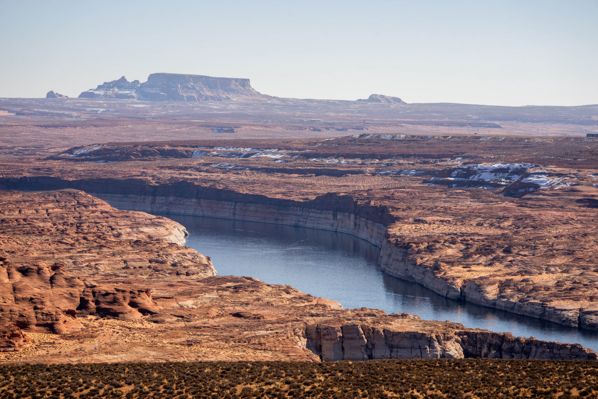
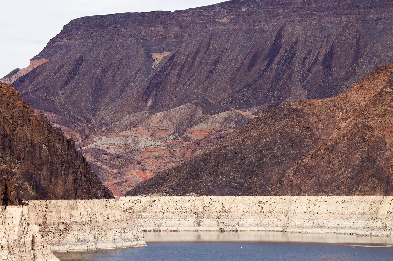
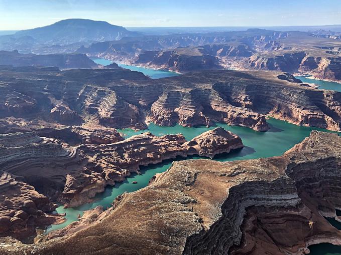
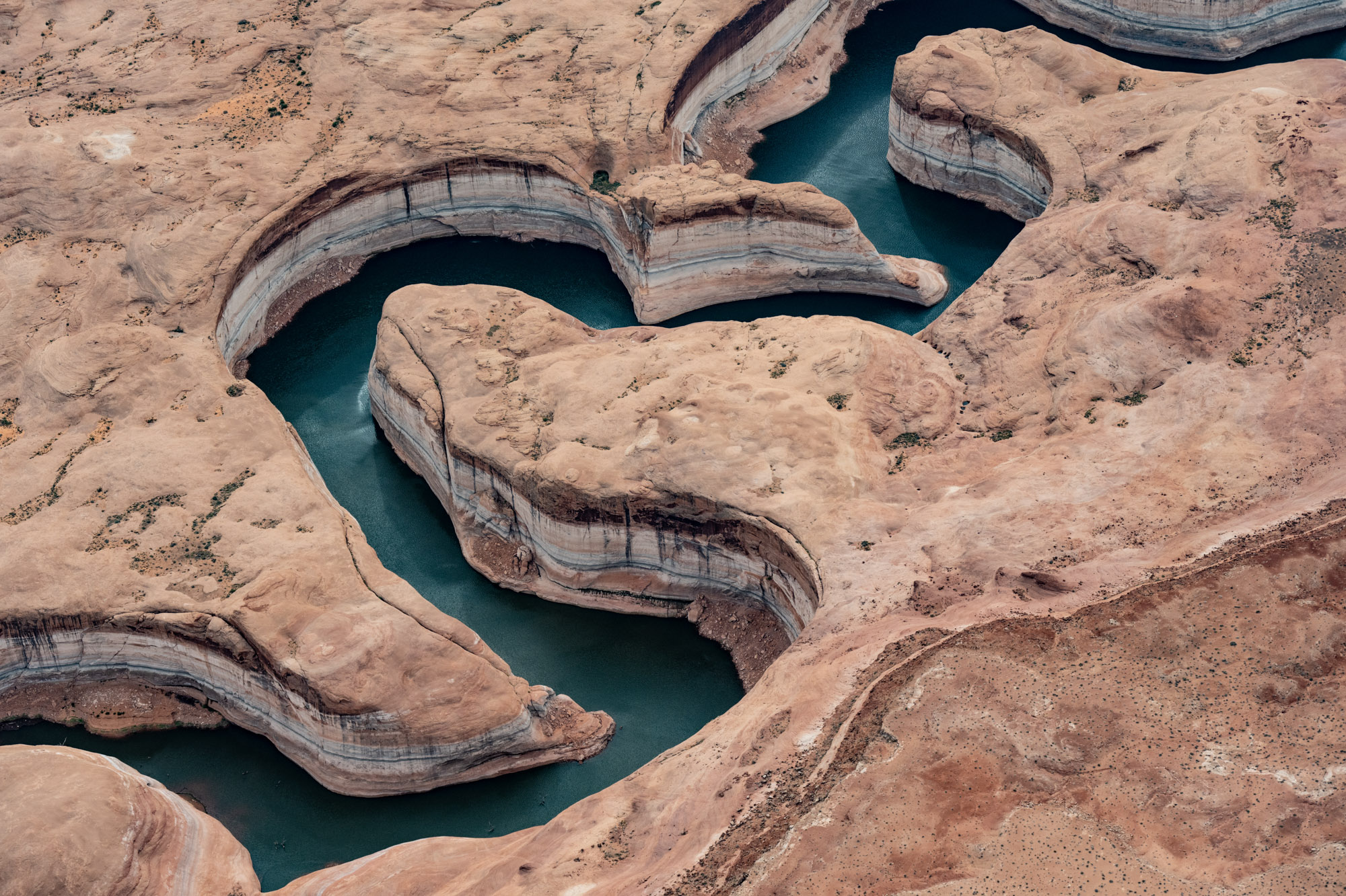
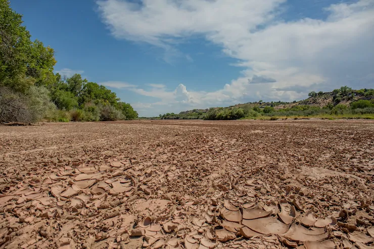
The so-called “bathtub ring”, a deposit of pale minerals left behind where reservoir water levels once reached, is shown on the edge of Lake Powell near Page, Arizona on Sunday, Feb. 2, 2025. (Photo by Spenser Heaps for Utah News Dispatch)
With just weeks to decide how to share the Colorado River’s shrinking water supply, negotiators from seven states hunkered down in a Salt Lake City conference room.
Outside was busy traffic on State Street and South Temple. Inside was gridlock that eased up for a time, only to return, Utah’s chief negotiator, Gene Shawcroft said Tuesday of last week’s meetings.
The states moved forward on a deal for two-and-a-half days, then went back by almost as far as they’d come, Shawcroft said.
“I would just tell you that four days is too long. We got tired of each other,” he said.
Shawcroft reiterated Tuesday what he and his counterparts from the other Colorado River states have said in recent months: They don’t have a deal, but they do have a commitment to keep talking and meet their upcoming February deadline.
The earlier goal was to reach a 20-year deal, but Shawcroft told Utah News Dispatch the states are now working on an agreement for a shorter time frame.
“I think it’ll be fairly simple, but I think it’ll allow us to operate for the next five years,” Shawcroft said.
Map of the Colorado River drainage basin, created using USGS data. By Shannon1 Creative Commons Attribution-Share Alike 4.0
The river provides water to 40 million people across the U.S. and Mexico, contributing 27% of Utah’s water supply. It is shrinking because of drought, [ed. and aridification]overuse and hotter temperatures tied to climate change.
Time for negotiators is also drying up as a Feb. 14 deadline set by the federal government approaches. The current agreement runs through late 2026.
The four Upper Basin states — Utah, Colorado, New Mexico and Wyoming — are at odds with the Lower Basin states of Nevada, Arizona and California.
The upstream states don’t want to make mandatory cuts in dry years, saying they typically use much less than they’re allocated. The downstream states say all seven need to absorb cuts in difficult years.
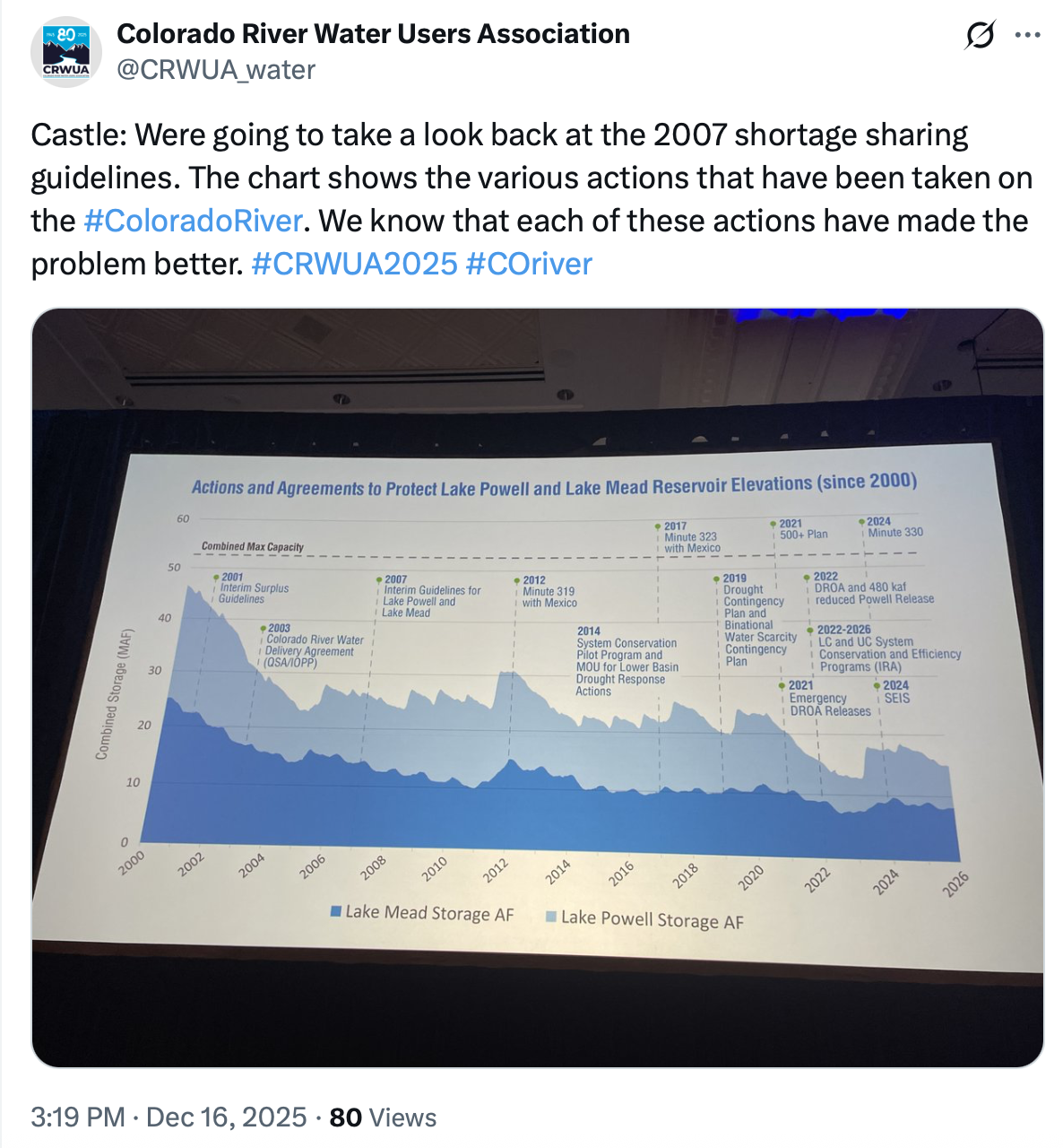
Conservation groups have criticized the states for not reaching a deal yet, saying “escalating risks” — including declining storage in lakes Powell and Mead — are piling up every month they fail to agree on a plan.
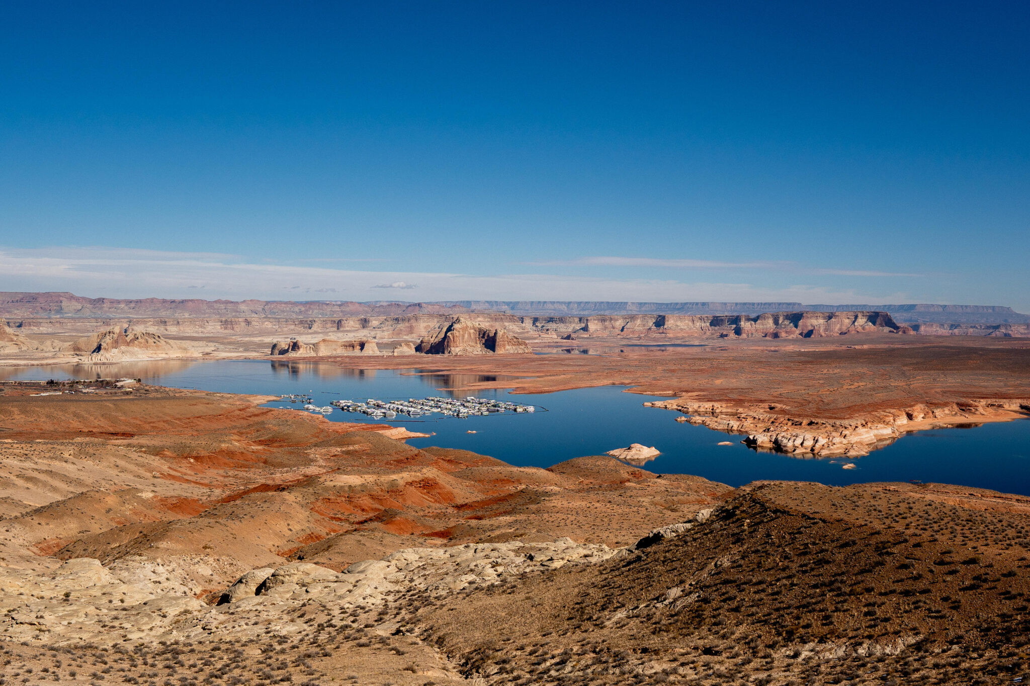
Lake Powell and the Wahweap Marina are pictured near Page, Arizona on Sunday, Feb. 2, 2025. (Photo by Spenser Heaps for Utah News Dispatch)
The debate centers in part on upstream reservoirs like Flaming Gorge on the Utah-Wyoming border and whether they’ll be managed under the new plan.
“Lower Basin believes those reservoirs ought to be used at the beck and call of the lower basin to reduce their reductions,” Shawcroft said at the meeting. “Obviously, we think differently.”
Arizona Gov. Katie Hobbs, for her part, has criticized the upstream states’ “extreme negotiating posture,” saying they refuse to participate in any sharing in managing water shortages.
West Drought Monitor map January 13, 2026.
Demand for water is outpacing the river’s supply, and extended dry periods aren’t helping. At the meeting, board members viewed a map covered in yellow, orange and red, noting the entire Colorado River watershed is experiencing some level of drought.
Earlier this month, the U.S. Bureau of Reclamation, the federal agency that oversees water in the West,released five options for a framework on managing the river’s biggest reservoirs, Lake Mead in Nevada and Lake Powell on the Utah-Arizona line.
Amy Haas, executive director of the Colorado River Authority of Utah, said she and her colleagues were still reviewing the 1,600-page document but one thing is clear.
“None of the five can provide what for Utah is really the central consideration for the deal, and that is a waiver of compact litigation,” Haas said.
States can sacrifice more than just time and money in lawsuits over water use. In Texas, similar litigationgave the federal government more leverage in negotiations.
One of the Bureau of Reclamation’s plans would have Nevada, Arizona and California face potential water shortages. It could go into effect next year if the seven states don’t reach a deal.
“The river and the 40 million people who depend on it cannot wait,” Andrea Travnicek, assistant interior secretary for water and science, said in a Jan. 9 statement announcing the five alternatives. “In the face of an ongoing severe drought, inaction is not an option.”
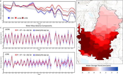
Udall/Overpeck 4-panel Figure Colorado River temperature/precipitation/natural flows with trend. Lake Mead and Lake Powell storage. Updated through Water Year 2025. Note the tiny points on the annual data so that you can flyspeck the individual years. Credit: Brad Udall
Secretary Scott Turner (L) with Secretary Doug Burgham (R).
Click the link to read the article on the AZCentral.com website (Brandon Loomis). Here’s an excerpt:
January 17, 2026
Key Points
After negotiators for the seven Colorado River states failed to reach a water-sharing agreement, federal officials have invited governors to continue talks.
The feds may impose their own plan if states cannot agree, potentially leading to major cuts for Arizona, with its junior water rights.
The states face a mid-February timeline to present a “deal in principle” to replace guidelines expiring in September.
Interior Secretary Doug Burgum has invited all seven governors and their negotiators to meet in Washington in late January, [Tom] Buschatzke said. Perhaps getting the governors face-to-face could lead to a breakthrough, he added..The seven states have tried unsuccessfully for more than a year to reach a voluntary agreement to replace dam-operating guidelines that will expire with the end of the water year in September. The U.S. Bureau of Reclamation has asked states to submit an agreement by Feb. 14. That date falls on a weekend and likely isn’t a hard deadline for every detail in the plan, Buschatzke said, but a “deal in principle” probably needs to take shape by then if the states want to control their own destinies.
Udall/Overpeck 4-panel Figure Colorado River temperature/precipitation/natural flows with trend. Lake Mead and Lake Powell storage. Updated through Water Year 2025. Note the tiny points on the annual data so that you can flyspeck the individual years. Credit: Brad Udall
Click the link to read the article on the Summit Daily News website (Ali Longwell). Here’s an excerpt:
January 17, 2026
While the four Upper Basin states in the compact — Colorado, New Mexico, Utah, and Wyoming — rely predominantly on snowpack for water supply, the Lower Basin states — Arizona, California, and Nevada — rely on releases from Lake Powell and Lake Mead..It’s not the compact, but the 2007 operational guidelines for Lake Powell and Lake Mead that are being renegotiated as they are set to expire this year. A decision must be made prior to Oct. 1, 2026, according to the Bureau…The federal government, seven states and 30 tribal nations all agree the best path forward is for a consensus between the upper and lower basins. However, with the looming deadline and unresolved disagreements about the future of the river, the Department of the Interior and its subagency, the Bureau of Reclamation, are forging ahead.
”The Department of the Interior is moving forward with this process to ensure environmental compliance is in place so operations can continue without interruption when the current guidelines expire,” said Andrea Travnicek, the assistant secretary of water and science for the Bureau of Reclamation, in a news release announcing the agency’s latest draft options. “In the face of an ongoing severe drought, inaction is not an option.”
One of the main disagreements throughout negotiations has been who should be making cuts to water use. The Lower Basin states have advocated for basin-wide water use reductions. The Upper Basin states, however, have pushed back on the idea, claiming they already face natural water shortages driven primarily by the ups and downs of snowpack…The draft Environmental Impact Statement released by the Bureau of Reclamation last week offers five options — including a required “no action” alternative and four others — that represent a broad range of operating strategies. The draft’s publication initiates a 45-day public comment period ending on March 2, 2026. In a statement, Scott Cameron, acting lead of the Bureau of Reclamation, said that the federal agency has purposefully not identified a preferred alternative, “given the importance of a consensus-based approach to operations for the stability of the system.” The expectation is that whatever agreement is reached incorporates elements of all five options offered by the Bureau of Reclamation, Cameron added.
The five options identified are:
No Action
Basic Coordination
Enhanced Coordination
Maximum Operational Flexibility
Supply Driven
Each option offers differing methods for how the Bureau of Reclamation will operate Lake Powell and Lake Mead, particularly under low reservoir conditions; allocate, reduce or increase annual allocations for consumptive use of water from Lake Mead to the lower basin states; store and deliver water that has been saved through conservation efforts; manage and deliver surplus water; manage activities above Lake Powell; and more.
Map of the Colorado River drainage basin, created using USGS data. By Shannon1 Creative Commons Attribution-Share Alike 4.0
In order to avoid conflict with Colorado Water Congress the first Aspinall Coordination Meeting of 2026 is being rescheduled.
The next coordination meeting for the operation of the Aspinall Unit is rescheduled for Wednesday, February 11th 2026, at 1:30 pm.
This meeting will be held at the Western Colorado Area Office in Grand Junction, CO. There will also be an option for virtual attendance via Microsoft Teams. A link to the Teams meeting is below.
The meeting agenda will include updates on current snowpack, forecasts for spring runoff conditions and spring peak operations, and the weather outlook.
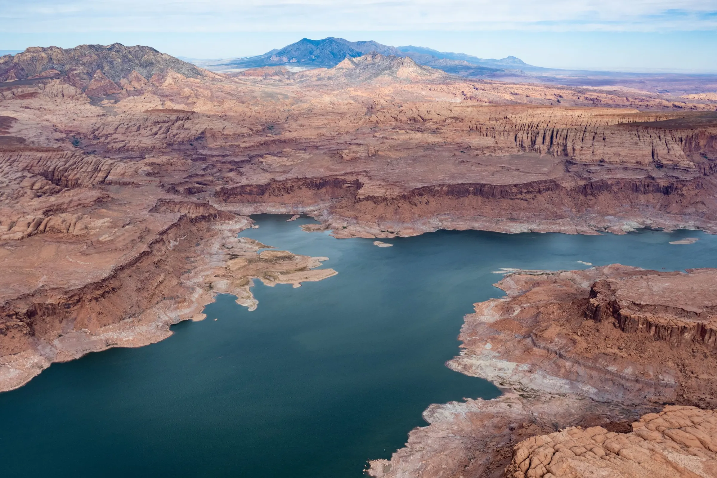
Lake Powell is seen from the air in October 2022. Three of the management options released by the feds have the option for an Upper Basin conservation pool in Lake Powell. CREDIT: ALEXANDER HEILNER/THE WATER DESK
Federal officials have released detailed options for how the Colorado River could be managed in the future, pushing forward the planning process in the absence of a seven-state deal. But some Colorado River experts and water managers say cuts don’t go deep enough under some scenarios and flow estimates don’t accommodate future water scarcity driven by climate change.
On Jan. 9, the U.S. Bureau of Reclamation released a draft of its environmental impact statement, a document required by the National Environmental Policy Act, which lays out five alternatives for how to manage the river after the current guidelines expire at the end of the year. This move by the feds pushes the process forward even as the seven states that share the river continue negotiating how cuts would be shared and reservoirs operated in the future. If the states do make a deal, it would become the “preferred alternative” and plugged into the NEPA process.
“Given the importance of a consensus-based approach to operations for the stability of the system, Reclamation has not yet identified a preferred alternative,” Scott Cameron, the acting Reclamation commissioner, said in a press release. “However, Reclamation anticipates that when an agreement is reached, it will incorporate elements or variations of these five alternatives and will be fully analyzed in the final EIS, enabling the sustainable and effective management of the Colorado River.”
For more than two years, the Upper Basin (Colorado, New Mexico, Utah and Wyoming) and the Lower Basin (California, Arizona and Nevada) have been negotiating, with little progress, how to manage a dwindling resource in the face of an increasingly dry future. The 2007 guidelines that set annual Lake Powell and Lake Mead releases based on reservoir levels do not go far enough to prevent them from being drawn down during consecutive dry years, putting the water supply for 40 million people in the Southwest at risk.
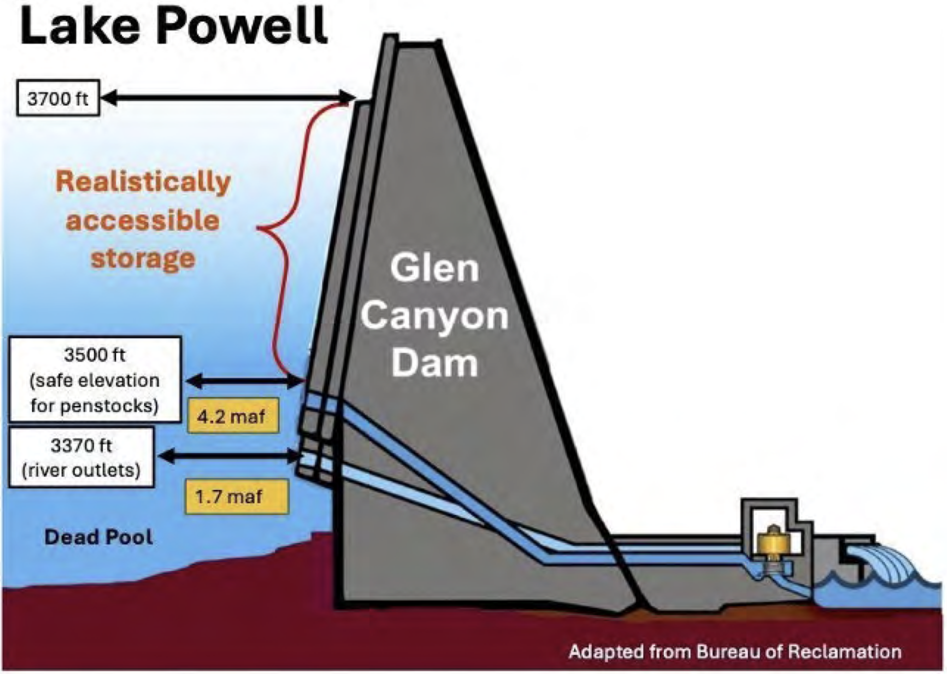
The crisis has deepened in recent years, and in 2022, Lake Powell flirted with falling below a critical elevation to make hydropower. Recent projections from the U.S. Bureau of Reclamation show that it could be headed there again this year and in 2027.
John Berggren, regional policy manager with Western Resource Advocates, helped craft elements of one of the alternatives, Maximum Operational Flexibility, formerly called Cooperative Conservation.
“My initial takeaway is there’s a lot of good stuff in there,” Berggren said of the 1,600-page document, which includes 33 supporting and technical appendices. “Their goal was to have a wide range of alternatives to make sure they had EIS coverage for whatever decision they ended up with, and I think that there are a lot of innovative tools and policies and programs in some of them.”
The infamous bathtub ring could be seen near the Hoover Dam in December 2021. The U.S. Bureau of Reclamation has released a draft Environmental Impact Statement for post-2026 management of the river. CREDIT: HEATHER SACKETT/ASPEN JOURNALISM
Alternatives
The first alternative is “no action,” meaning river operations would revert to pre-2007 guidance; officials have said this option must be included as a requirement of NEPA, but doesn’t meet the current needs.
The second alternative, Basic Coordination, can be implemented without an agreement from the states and represents what the feds can do under their existing authority. It would include Lower Basin cuts of up to 1.48 million acre-feet based on Lake Mead elevations; Lake Powell releases would be primarily 8.23 million acre-feet and could go as low as 7 million acre-feet. It would also include releases from upstream reservoirs Flaming Gorge, Blue Mesa and Navajo to feed Powell. But experts say this alternative does not go far enough to keep the system from crashing.
“It was pretty well known that the existing authorities that Reclamation has are probably not enough to protect the system,” Berggren said. “Especially given some of the hydrologies we expect to see, the Basic Coordination does not go far enough.”
The Enhanced Coordination Alternative would impose Lower Basin cuts of between 1.3 million and 3 million acre-feet that would be distributed pro-rata, based on each state’s existing water allocation. It would also include an Upper Basin conservation pool in Lake Powell that starts at up to 200,000 acre-feet a year and could increase up to 350,000 acre-feet after the first decade.
Under the Maximum Operational Flexibility Alternative, Lake Powell releases range from 5 million acre-feet to 11 million acre-feet, based on total system storage and recent hydrology, with Lower Basin cuts of up to 4 million acre-feet. It would also include an Upper Basin conservation pool of an average of 200,000 acre-feet a year.
These two alternatives perform the best at keeping Lake Powell above critical elevations in dry years, according to an analysis contained in the draft EIS.
“There are really only two of these scenarios that I think meet the definition of dealing with a very dry future: Enhanced Coordination and the Max Flexibility,” said Brad Udall, a senior water and climate research scientist at Colorado State University. “Those two kind of jump out at me as being different than the other ones in that they actually seem to have the least harmful outcomes, but the price for that are these really big shortages.”
The final scenario is the Supply Driven Alternative, which calls for maximum shortages of 2.1 million acre-feet and Lake Powell releases based on 65% of three-year natural flows at Lees Ferry. It also includes an Upper Basin conservation pool of up to 200,000 acre-feet a year. This option offers two different approaches to Lower Basin cuts: one based on priority where the oldest water rights get first use of the river, putting Arizona’s junior users on the chopping block, and one where cuts are distributed proportionally according to existing water allocations, meaning California could take the biggest hit.
This alternative is based on proposals submitted by each basin and discussions among the states and federal officials last spring. Udall said the cuts are not deep enough in this option.
“You can take the supply-driven one and change the max shortages from 2.1 million acre-feet up to 3 or 4 and it’s going to perform a lot like those other two,” he said. “I think what hinders it is just the fact that the shortages are not big enough to keep the basin in balance when push comes to shove.”
Reclamation’s Acting Commissioner Scott Cameron speaks at the Colorado River Water Users conference in Las Vegas in December 2025. The agency has released a draft Environmental Impact Statement, which outlines options for managing the river after this year. CREDIT: HEATHER SACKETT/ASPEN JOURNALISM
Pivotal moment
In a prepared statement, Glenwood Springs-based Colorado River Water Conservation District officials expressed concern that the projected future river flows are too optimistic.
“We are concerned that the proposed alternatives do not accommodate the probable hydrological future identified by reliable climate science, which anticipates a river flowing at an average of 9-10 [million acre feet] a year,” the statement reads. “The Colorado River Basin has a history of ignoring likely hydrology, our policymakers should not carry this mistake forward in the next set of guidelines.”
The River District was also skeptical of the Upper Basin conservation pool in Lake Powell, which is included in three of the alternatives. Despite dabbling in experimental programs that pay farmers and ranchers to voluntarily cut back on their water use in recent years, conservation remains a contentious issue in the Upper Basin. Upper Basin water managers have said their states can’t conserve large volumes of water and that any program must be voluntary.
Over the course of 2023 and 2024, the System Conservation Pilot Program, which paid water users in the Upper Basin to cut back, saved about 101,000 acre-feet at a cost of $45 million.
The likeliest place to find water savings in Colorado is the 15-county Western Slope area represented by the River District. But if conservation programs are focused solely on this region, they could have negative impacts on rural agricultural communities, River District officials have said.
“Additionally, several alternatives include annual conservation contributions from the Upper Basin between [200,000 acre-feet] and [350,000 acre feet],” the River District’s statement reads. “We do not see how that is a realistic alternative given the natural availability of water in the Upper Basin, especially in dry years.”
In a prepared statement, Colorado officials said they were looking forward to reviewing the draft EIS.
“Colorado is committed to protecting our state’s significant rights and interests in the Colorado River and continues to work towards a consensus-based, supply-driven solution for the post-2026 operations of Lake Powell and Mead,” Colorado’s commissioner, Becky Mitchell, said in the statement.
The release of the draft EIS comes at a pivotal moment for the Colorado River Basin. The seven state representatives are under the gun to come up with a deal and have less than a month to present details of a plan by the feds’ Feb. 14 deadline. Federal officials have said they need a new plan in place by Oct. 1, the start of the next water year. This winter’s dismal snowpack and dire projections about spring runoff underscore the urgency for the states to come up with an agreement for a new management paradigm.
Over a string of recent dry years, periodic wet winters in 2019 and 2023 have bailed out the basin and offered a last-minute reprieve from the worst consequences of drought and climate change. But this year is different, Udall said.
“We’re now at the point where we’ve removed basically all resiliency from the system,” he said. “Between the EIS and this awful winter, some really tough decisions are going to be made. … Once we finally get to a consensus agreement, the river is going to look very, very different than it ever has.”
The draft EIS will be published in the Federal Register on Jan.16, initiating a 45-day comment period that will end March 2.
Udall/Overpeck 4-panel Figure Colorado River temperature/precipitation/natural flows with trend. Lake Mead and Lake Powell storage. Updated through Water Year 2025. Note the tiny points on the annual data so that you can flyspeck the individual years. Credit: Brad Udall
Just over a month before the deadline for the Colorado River states to agree on a plan for sharing the river’s diminishing waters, the feds released their options, one of which could be implemented if the states don’t reach a deal. The Bureau of Reclamation’s “Post-2026 Operational Guidelines and Strategies for Lake Powell and Lake Mead” offers five alternative scenarios for how to run the river, all of which are aimed at keeping the two reservoirs viable through different methods of divvying up the burden of inevitable shortages in supply.
The document, and the need to deal with present and future shortages, is necessary because human-caused climate change-exacerbated aridification has diminished the Colorado River’s flow, throwing the supply-demand equation out of balance. So it is somewhat surreal to peruse the voluminous report that was published by an administration whose leader has called climate change a “hoax” and a “con job.”
My cursory search of the document turned up only one occurrence of the term “climate change.”1 Yet the authors do acknowledge, if obliquely, that global warming is shrinking the river. “The Basin is experiencing increased aridity due to climate variability,” they write, “and long-term drought and low runoff conditions are expected in the future.” This tidbit also evaded the censors: “Since 2000, the Basin has experienced persistent drought conditions, exacerbated by a warming climate, resulting in increased evapotranspiration, reduced soil moisture, and ultimately reduced runoff.”
All of the alternatives put most of the burden of cutting consumptive use on the Lower Basin states, while directing the Upper Basin to take unspecified conservation measures. I’ll summarize the alternatives below, but first, it seems telling to see which which proposed alternatives the Bureau considered, but ultimately eliminated from detailed analysis.
The “boating alternative,” which would prioritize maintaining Lake Powell’s surface level at or above 3,588 feet to serve recreational boating needs. This proposal was put forward in the “Path to 3,588” plan by motorized recreation lobbying group BlueRibbon Coalition. It was dismissed because, basically, it would sacrifice downstream farms and cities for the sake of boating.
The ecosystem alternative, which would prioritize the Colorado River’s ecosystem health by focusing management and reducing consumptive human use to protect wildlife, vegetation, habitats, and wetlands.
One-dam alternative, a.k.a. Fill Mead First. This proposal would entail either bypassing or decommissioning Glen Canyon Dam with the aim of filling Lake Mead. The Bureau said they rejected the plan because it would be inconsistent with the Law of the River and might be unacceptable to stakeholders (even though some Lower Basin farmers got a little Hayduke-fever a couple of years back, suggesting that ridding Glen Canyon of the dam might be the best way to manage the river).
Okay, so that’s what’s NOT going to happen. So what might happen if the feds feel the need to intervene? Here’s a very short summary of each alternative:
No Action: This is always offered in these things, and it just means that they would revert back to the pre-2007 interim guidelines era, when releases from Lake Powell were fixed at an average of 8.23 million acre-feet per year and shortages were determined based on Lake Mead levels and would be distributed based on priority.
Basic Coordination Alternative: Lake Powell releases would range from 7 to 9.5 maf annually, based on the reservoir’s surface level, and releases from upper basin reservoirs would be implemented to protect Glen Canyon Dam’s infrastructure. Lower Basin shortages (and cuts) would be based on Lake Mead elevations and would be distributed based on water right priority (meaning Arizona gets cut before California).
Enhanced Coordination Alternative: Lake Powell annual releases would range from 4.7 maf to 10.8 maf, based on: a combination of Powell and Mead elevations; the 1-year running average hydrology; and Lower Basin deliveries. The Upper Basin would implement conservation measures to bolster Lake Powell levels if needed, and the Lower Basin shortages would range from 1.3 maf (when Mead and Powell, combined, are 60% full) to 3.0 maf (when Mead and Powell are 30% full or lower) annually. The Lower Basin shortages would be distributed proportionally, meaning that California — which has the largest allocation — would take 49% of the cuts, Arizona 31%, Nevada 3.3%, and Mexico 17%.
Maximum Operational Flexibility Alternative: Lake Powell annual releases would range from 5 maf to 11 maf, based on total Upper Basin system storage and recent hydrology. But when Lake Powell’s surface level drops to 3,510 feet, Glen Canyon Dam would be operated as a “run of the river” facility, meaning that it would release only as much as what it running into the reservoir minus evaporation and seepage to keep the elevation from dropping further. Lower Basin shortages would be on a sliding scale, starting when Powell and Mead drop below 80% full, reaching 1 maf when the two reservoirs are 60% full. When the reservoirs drop below 60%, then shortages would be determined by the previous 3-year flows at Lee Ferry, topping out at a maximum shortage of 4 maf. Shortages would be distributed according to priority and proportionally.
Supply Driven Alternative: This one is based on the amount of water that is actually in the river (go figure!). Lake Powell releases would range from 4.7 maf annually to 12 maf, or about 65% of the 3-year natural flows at Lees Ferry. Lower Basin shortages would kick in when Lake Mead’s surface elevation drops below 1,145 feet, reaching a maximum of 2.1 maf at 1,000 feet and lower. (As of Jan. 12, Mead’s level was 1,063 feet). Shortages would be distributed according to priority and proportionally.
The estimated “natural flow” at Lee Ferry. Some of the alternatives would base Lake Powell releases on recent average natural flows at Lee Ferry. If the recent past is an indicator of what’s to come, we could expect a relatively minuscule amount of water running through the Grand Canyon to the Lower Basin states. Source: Bureau of Reclamation.
The Lower Basin states reportedly aren’t too happy about any of the alternatives, because they put most of the onus for cutting consumption on the Lower Basin. Under the Maximum Flexibility option, for example, Lower Basin shortages could go as high as 4 million acre-feet, or about half of those states’ total annual consumptive use. And under another, California alone could have to cut up to 1.5 million acre-feet of water use, which could trigger litigation, since California users have some of the most senior rights on the river. Some of the alternatives would potentially nullify the Colorado Compact’s clause ordering the Upper Basin to “not cause the flow of the river at Lee Ferry to be depleted below an aggregate of 75 maf for any period of ten consecutive years.”
The Bureau does not pick a “preferred” alternative, like federal agencies typically do with environmental impact statements, leaving readers guessing about which option or combination of options might be chosen should the need arise. But it also gives more room for the states to reach some sort of agreement to pick an option from the provided list.
* It is found in the Hydrologic Resources section: “While the flows in the Colorado River would not affect groundwater in the region, changes to the groundwater systems in the Grand Canyon due to climate change may be an additional environmental factor that affects flows in the Colorado River.”
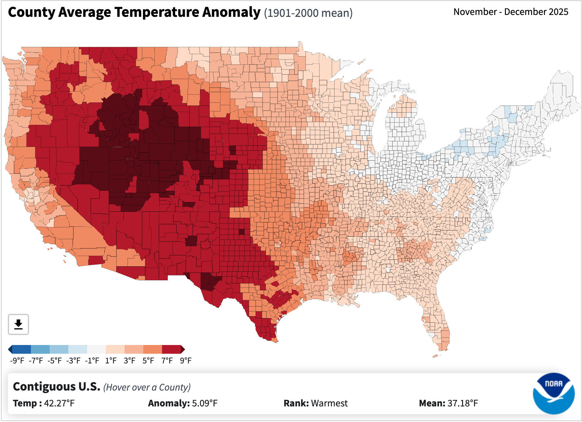
The snowpack remains dismal in most of the West, and it’s not just because of lack of precipitation. In fact, it’s probably more due to the crazy-warm temperatures. The average temperatures across the Interior were way above normal in November and December, as the map below shows. And January’s similarly unseasonably balmy so far. Yikes.
Precipitation levels were mixed across the West during late autumn and early winter, but temperatures were warmer than normal across the entire region, diminishing snowpack and leading to rather unwintery conditions. Source: NOAA.
🌵 Public Lands 🌲
Last week the new public lands media outlet, RE:PUBLIC, warned readers of “major shrinkage” this year. They meant, of course, that the Trump administration will probably get around to eliminating or eviscerating at least one national monument in the next twelve months. It’s probably a pretty safe bet, given that in Trump’s first term he shrank Bears Ears and Grand Staircase-Escalante national monuments, and Project 2025, which the administration has hewn closely to, calls for even more reductions.
Indeed, I’m surprised they haven’t already moved to eliminate some of these protected areas, especially the more recently designated ones like Bears Ears, Baaj Nwaavjo I’tah Kukveni-Ancestral Footprints of the Grand Canyon National Monument, or Chuckwalla National Monument in California. An optimist might hope that the Trump administration has realized how deeply unpopular this would be, or has come to terms with the fact that the Antiquities Act only allows presidents to establish national monuments, not eliminate them. But I think it’s more likely they were simply too busy dismantling other environmental safeguards — and, for that matter, democracy — to get around to diminishing national monuments.
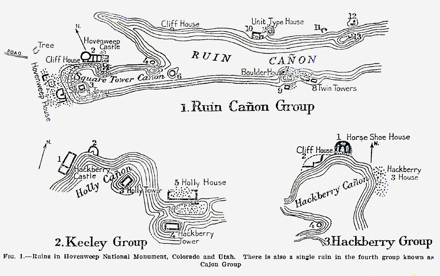
I was a little surprised by RE:PUBLIC’s list of vulnerable national monuments, however. It included Bears Ears et al, which makes sense, but then also speculates about other “likely targets, due to their proximity to energy and mining interests,” including: Aztec Ruins, Dinosaur, Hovenweep, and Natural Bridges national monuments.
I hate trying to predict what the Trump administration will do in the future, but I’m going to go out on a limb here and say that these particular national monuments are not in the administration’s crosshairs. While these protected areas are close to energy-producing areas, and probably have some oil and gas, uranium, lithium, and/or potash producing potential, they simply offer too little to the extractive industries to make it worth the political blowback from eviscerating them.
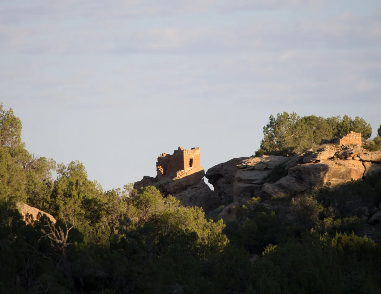
Hovenweep National Monument. Jonathan P. Thompson photo
For those who may be unfamiliar with these places, I’ll take each one individually:
Aztec Ruins: First off, this tiny national monument adjacent to the residential neighborhoods of Aztec, New Mexico, is an amazing place and well worth the visit. The Puebloan structures here are built in the style of Chacoan great houses, and the community — which was established at the end of Chaco’s heyday — may have been become succeeded Chaco as a regional cultural and political center. It is in the San Juan Basin coalbed methane fields and is surrounded by gas wells. In fact, there are a few existing, active wells within the monument boundaries. But no one is champing at the bit to drill any new wells in this region, and they certainly don’t need to do so in this tiny monument.
Dinosaur National Monument, in northwestern Colorado, is probably somewhat vulnerable, given its size and proximity to oil and gas fields. But again, there’s not a whole lot of new drilling going on in the area. It was established in 1915 to protect dinosaur quarries — clearly in tune with the Antiquities Act — so shrinking it would be met with serious bipartisan political pushback.
When Warren G. Harding designated Hovenweep National Monument in 1923 to protect six clusters of Puebloan structures in southeastern Utah from development and pothunters, he strictly followed the Antiquities Act’s mandate to confine its boundaries to “the smallest area compatible with proper care and management of the objects to be protected.” As such, the boundaries of each “unit” is basically drawn right around the pueblo and a small area of surroundings, leaving little room for shrinkage. Though it lies on the edge of the historically productive Aneth Oil Field, oil and gas drillers have no need to get inside the boundaries to get at the hydrocarbons. Besides, Trump and Harding have a lot in common, so Trump’s not likely to want to erase his predecessor’s legacy.
Natural Bridges: It’s odd to me that this one, which is currently surrounded by Bears Ears National Monument, is included on this list. Yes, there are historic uranium mines nearby, and yes, White Canyon, where the monument’s namesake formations are located, was once considered for tar sands and oil shale development. But the small monument itself — which was designated by Teddy Roosevelt in 1908 — is not getting in the way of any of this sort of development. It’s much more likely that Trump would remove the White Canyon area from Bears Ears National Monument, as he did during his first term, potentially opening the area around Natural Bridges back up to new uranium mining claims, while leaving the national monument’s current boundaries intact.
So, in summary: Don’t fret too much about these national monuments getting eliminated or shrunk anytime soon. And for now, maybe we shouldn’t worry about any national monument shrinkage. It is possible that Trump won’t go there this term. Trump shrunk Bears Ears and Grand Staircase-Escalante during his first term in part out of spite toward Obama and Clinton, but also to get then-Sen. Orrin Hatch’s legislative support. That the shrinkage also re-opened some public lands to new mining claims and drilling was a secondary motivation.
This time around, Trump has come up with far more generous gifts for the mining and drilling companies, and much more sinister ways to attack his political adversaries. Besides, he’s got his eyes on much bigger prizes — like Greenland.
1 * The single use of the term “climate change” is found in the Hydrologic Resources section: “While the flows in the Colorado River would not affect groundwater in the region, changes to the groundwater systems in the Grand Canyon due to climate change may be an additional environmental factor that affects flows in the Colorado River.”
Map of the Colorado River drainage basin, created using USGS data. By Shannon1 Creative Commons Attribution-Share Alike 4.0
The Government Highline Canal, in Palisade. The Government Highline Canal near Grand Junction. The Grand Valley Water Users Association, which operates the canal, has been experimenting with a program that pays water users to fallow fields and reduce their consumptive use of water. Photo: Brent Gardner-Smith/Aspen Journalism
Click the link to read the article on The Denver Post website (Elise Schmelzer). Here’s an excerpt:
January 15, 2026
Absent a crucial but elusive consensus among the seven Colorado River states, federal authorities are forging ahead with their own ideas on how to divvy up painful water cuts as climate change diminishes flows in the critical river. The Bureau of Reclamation last week made public a 1,600-page behemoth of a document outlining five potential plans for managing the river after current regulations expire at the end of this year. The agency did not identify which proposal it favors, in hopes that the seven states in the river basin will soon come to a consensus that incorporates parts of the five plans. But time is running out. The states — Colorado, Wyoming, Utah, New Mexico, California, Arizona and Nevada — already blew past a Nov. 11 deadline set by federal authorities to announce the concepts of such a plan. They now have until Feb. 14 to present a detailed proposal for the future of the river that makes modern life possible for 40 million people across the Southwest. They were set to meet this week in Salt Lake City to continue negotiations. Federal authorities must finalize a plan by Oct. 1…
“The Department of the Interior is moving forward with this process to ensure environmental compliance is in place so operations can continue without interruption when the current guidelines expire,” Andrea Travnicek, the assistant secretary for water and science at the Department of the Interior, said in a news release announcing the document. “The river and the 40 million people who depend on it cannot wait. In the face of an ongoing severe drought, inaction is not an option.”
A 45-day public comment period opens Friday on the proposed plans for managing the river system, contained in a document called a draft environmental impact statement. The current operating guidelines expire at the end of 2026, but authorities need a replacement plan in place prior to the Oct. 1 start to the 2027 water year. The water year follows the water cycle, beginning as winter snowpack starts to accumulate and ending Sept. 30, as irrigation seasons end and water supplies typically reach their lowest levels…
Udall/Overpeck 4-panel Figure Colorado River temperature/precipitation/natural flows with trend. Lake Mead and Lake Powell storage. Updated through Water Year 2025. Note the tiny points on the annual data so that you can flyspeck the individual years. Credit: Brad Udall
Already, Lake Mead — on the Arizona-Nevada border — and Lake Powell are only 33% and 26% full, respectively. Projections from the Bureau of Reclamation show that, in a worst-case scenario, Powell’s waters could fall below the level required to run the dam’s power turbines by October and remain below the minimum power pool until June 2027. Experts monitoring the yearslong effort to draft new operating guidelines said any plan implemented by Reclamation must consider the reality of a river with far less water than assumed when the original river management agreements were signed more than a century ago.
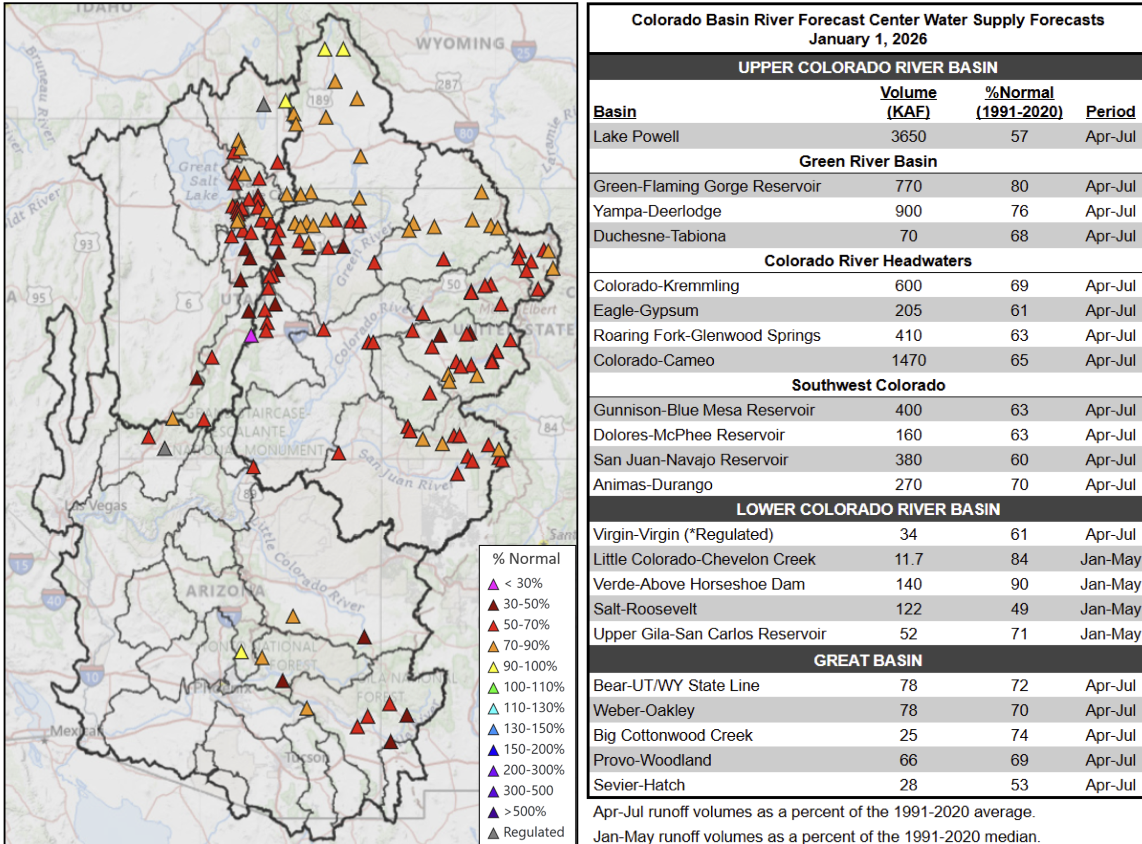
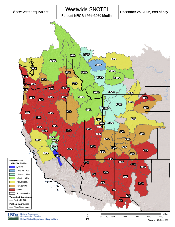
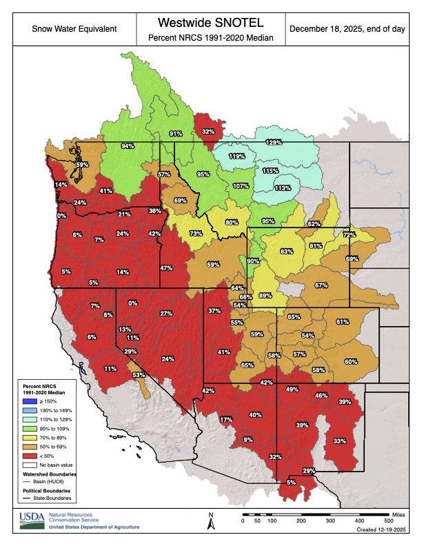
Water forecasts for the Colorado River are grim going into 2026 as several bad trends are converging. The Colorado Basin River Forecast Center (CBRFC) cited snowpack levels that are lagging badly, dry ground conditions that will soak up moisture that falls, and snow cover statistics that are the lowest on record since satellite monitoring started in 2001. CBRFC water scientist Cody Moser said conditions are “extremely poor” right now. He spoke during a webinar on Thursday morning. The two biggest factors in the CBRFC’s forecasts are snowpack levels and soil conditions. Storms that soaked California in November and December didn’t continue on to the Colorado Rockies, and that meant a slow start on building the foundation for a good snowpack to feed the river before it flows to Lake Powell and down the Grand Canyon to Lake Mead…Water flowing into Lake Powell this year is expected to be 57% of normal levels, and those “normal” levels are based on 30-year averages that include a 25-year megadrought.
Left: January 1, 2026 SWE – NRCS SNOTEL observed (squares) and CBRFC hydrologic model. Right: CBRFC hydrologic model SWE condition summary.
Incorporating instream flow uses into municipal water supply planning efforts can provide numerous public benefits. This article discusses the framework and opportunity for collaborative instream flow protection in municipal water supply operations.
Colorado’s instream flow program is a dynamic approach to protecting the natural environment that encourages practical and creative solutions to evolving environmental concerns. While water rights typically involve diverting water from the stream, the instream flow program protects water in the stream. Environmental values associated with instream flow uses can work synergistically with municipal water supply operations to realize several public benefits, such as improved water quality, riparian health, urban cooling, resiliency, recreational opportunities, and aesthetic value. As illustrated by the examples discussed later in this article, the instream flow program can facilitate cooperative agreements with municipal water providers for shared beneficial use of our state’s most precious resource.
Water Rights and the Prior Appropriation Doctrine in Colorado
The prior appropriation doctrine governs the ownership and use of water and water rights in Colorado. In simple terms, the prior appropriation system is described as “first in time, first in right.” A water user that has demonstrated an intent to put water to beneficial use first has a vested and prior right to use water in that amount against subsequent water users. This system developed out of necessity during the colonial expansion westward and was influenced by Spanish settlers and early miners to allocate water in the arid environment of Colorado, as an alternative to the more common riparian system of water rights based on land ownership abutting water ways.1
The prior appropriation doctrine has been enshrined in the Colorado Constitution. Article XVI, § 5 dedicates water in Colorado as public property for use by the people, subject to appropriation, and § 6 gives the right to appropriate water for beneficial use in priority.2 The 1969 Water Rights Determination and Administration Act (1969 Act) provides the legal framework for surface and tributary ground water distribution and use under the prior appropriation doctrine.3
An appropriation of a water right under the 1969 Act, as originally codified, meant “the diversion of a certain portion of the waters of the state and the application of the same to a beneficial use.”4 Similarly, beneficial uses were limited to diversions of water from the stream system for extractive uses such as domestic or municipal, irrigation, and manufacturing or industrial activities.5 Environmental uses of water, including instream flows, were not initially addressed in the 1969 Act but were later incorporated through amendments.6
Colorado Instream Flow Program
The Colorado Water Conservation Board (CWCB) was first established by the Colorado legislature in 1937 to protect and develop Colorado’s water resources for the benefit of present and future generations.7 It was not until the national environmental movement in the late 1960s, however, that discussions regarding the value of instream flows and role of the CWCB in the protection of such flows began to garner serious attention and focus.8 In 1973, those discussions culminated in the passage of SB 97 to create the Colorado Instream Flow and Natural Lake Level Program.9 SB 97 was unprecedented at the time and amended the 1969 Act to define beneficial use of a water right to include use by the CWCB for protection of stream flows within a specified reach without a diversion of water from the stream.10
Under the instream flow program, the CWCB has exclusive authority to hold a water right for instream flow uses in Colorado and may appropriate water rights or acquire existing water rights for instream flow, provided that it determines that such water rights are necessary to preserve or improve the natural environment to a reasonable degree.11 Since the program’s inception, the CWCB has appropriated nearly 1,700 instream flow rights across 9,700 miles of stream and completed over 35 water acquisition transactions.12
The General Assembly has reinforced and expanded the CWCB’s ability to acquire water rights for instream flow purposes on several occasions.13 Acquiring and changing senior water rights for instream flows in over-appropriated systems can add great value by preserving the priority date, and therefore the availability, of the water for greater instream flow protection.14 Acquisitions can be donated to or purchased by the CWCB, and the statutory language specifically anticipates potential acquisitions from governmental entities, like municipalities.15 Other free-market developments to the Colorado instream flow program enacted by the state legislature over the years include streamlined processes for loans of water rights for instream flow use, instream flow protection for mitigation releases, and stream flow augmentation plans.16 These developments provide additional opportunities for water users, including municipalities, to participate in the program in support of instream flows.
In addition to implementing the instream flow program, the CWCB is tasked with creating the Colorado Water Plan, which addresses the state’s water challenges through collaborative water planning, including expanded opportunities for instream flow protection.17
Case Studies Along the Front Range
The instream flow program provides reasonable protection of the environment for benefit of the public and is emphasized in the Colorado Water Plan as a balanced approach to addressing environmental needs in the face of climate change.18 Similarly, municipal water service providers, acting in the interest of their respective jurisdictions, must often balance water supply with other public interests. Municipal water projects and water supply planning efforts can be designed to address multiple needs and related uncertainties across a jurisdiction, informed by integrated planning efforts. The various public interests typically considered by municipalities may align with instream flow protection in many respects. The Colorado Water Plan includes several policy considerations that highlight this potential overlap between municipal water interests and instream flows.19
Fundamentally, the Colorado Water Plan encourages a holistic, collaborative approach to water management that balances multiple uses and benefits to meet water shortages throughout the state.20As competition for water resources in Colorado becomes more pronounced with increased demands and costs, the benefits of water sharing and collaboration will also likely increase.21 The Colorado Water Plan focuses on thriving watersheds as an action area to support stream health, recreational uses, resiliency, erosion control, and water quality, all of which provide tangible benefits to municipal water service providers.22 Accordingly, more water in the stream system for instream flows can be a natural complement to a municipality seeking to balance growing water demands with related public interests. The following examples demonstrate how instream flow uses can benefit municipal water supply, and vice versa, to realize this balance in a meaningful way.
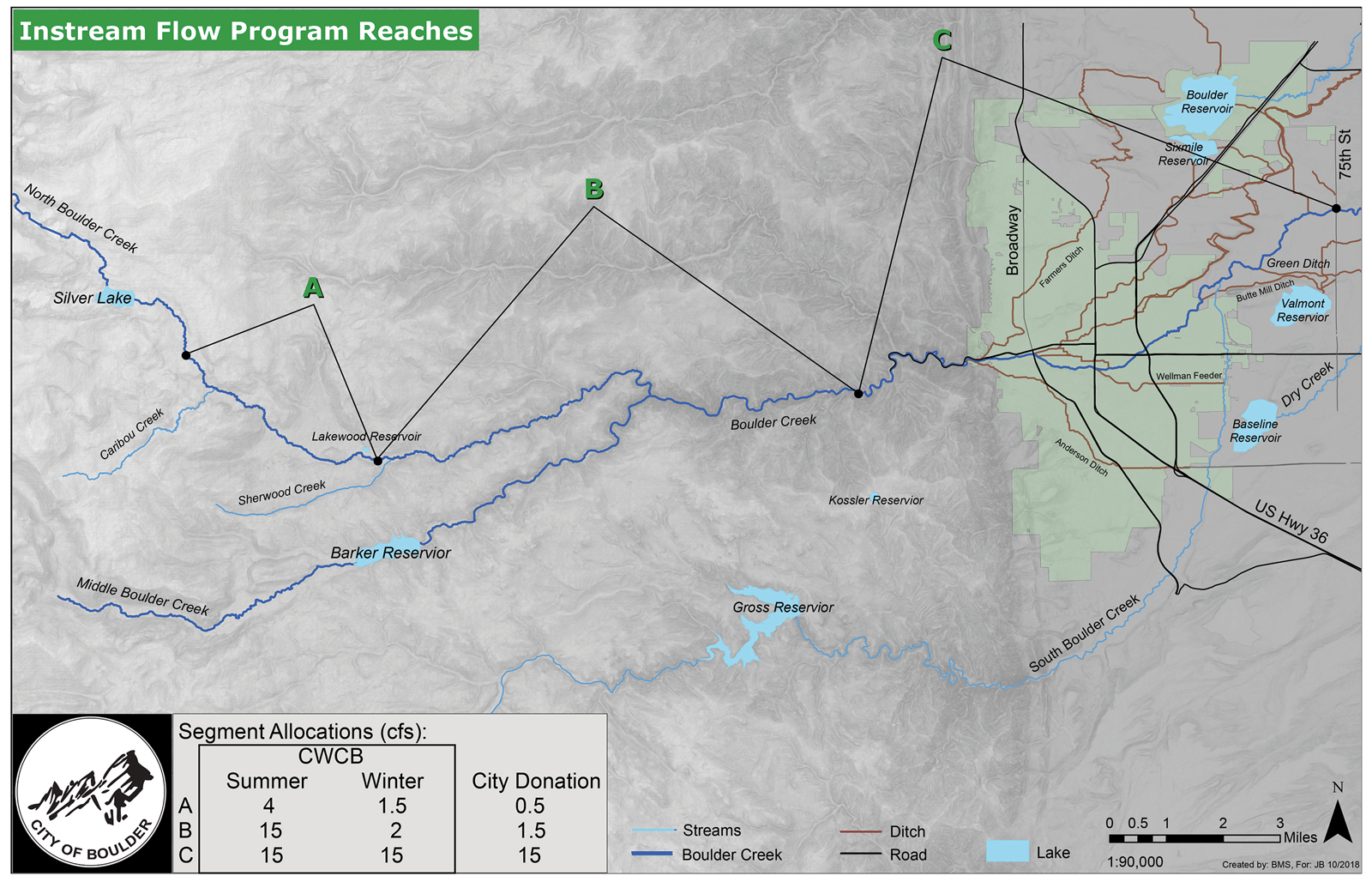
Boulder Creek Instream Flow Project
The Boulder Creek instream flow project is a long-standing cooperative project that has been operating in Boulder County for almost 35 years. This project has operated successfully due in large part to the partnership between the City of Boulder and the CWCB and their collaboration with neighboring water users in Boulder County to support environmental stream flows and other uses in the creek.
In the early 1990s, Boulder donated a suite of valuable senior water rights to the CWCB to establish a year-round instream flow program on North Boulder and Boulder Creeks.23 The acquisition was memorialized in a series of donation agreements between Boulder and the CWCB pursuant to CRS § 37-92-102(3), following certain legislative amendments throughout the 1980s that clarified and enhanced the CWCB’s acquisition authority for instream flows.24 Boulder and the CWCB, as co-applicants, also received a water court decree to change the use of the donated rights to include instream flow uses for the project.25
Figure 1. Map depicting locations of instream flow protected reaches along Boulder Creek. Image created by the City of Boulder (Oct. 2018).
The Boulder Creek instream flow project protects three segments from below the Silver Lake Reservoir near the headwaters of North Boulder Creek down to 75th Street in Boulder County (see fig. 1). The donated rights include reservoir releases, bypassed diversions, and changed irrigation ditch shares to support instream flows throughout the year. As part of its donation to the CWCB, Boulder retained the right to use water available under the donated rights (1) for municipal purposes under certain conditions, including drought and emergency conditions in its municipal water supply operations; (2) for municipal purposes anytime they are not needed to meet instream flow amounts; and (3) for beneficial reuse downstream of the protected reaches.26This provides operational flexibility for the city’s municipal water supply while also supporting instream flow uses by the CWCB in most years. Its participation in the Boulder Creek instream flow program has also helped the city address US Forest Service regulatory requirements for bypasses related to its diversions from North Boulder Creek as part of federal permitting for one of its raw water pipelines.27
The City of Boulder has a long-standing environmental ethos that incorporates instream flows into its water supply planning and operations. Boulder’s water supply planning documents from the 1980s identified the goal of supporting instream flows in Boulder Creek to enhance aquatic and riparian ecosystems, reflecting city planners’ prediction that dry-up periods in the creek would become more severe and frequent with increased water demands.28 Subsequent Boulder water supply and land use planning documents have included similar goals focused on balancing instream flows and environmental preservation with municipal water demands and operations, and emphasizing the connection between stream health and reliable drinking water supplies.29
Because the protected stream segments run through the Boulder city limits, and extend both above and below the city, the project benefits water quality, riparian health, and resiliency in the Boulder municipal watershed and water system operations and provides additional environmental benefits to the larger Boulder County community.
Gross Reservoir Environmental Pool Project
The cities of Boulder and Lafayette entered into an intergovernmental agreement in 2010 with Denver Water to establish a 5,000 acre-foot environmental pool in an enlarged Gross Reservoir to augment stream flows in South Boulder Creek.30 Boulder recognized the need to address low flows on South Boulder Creek as a key goal in its planning documents and identified Denver Water’s planned expansion of Gross Reservoir as an opportunity to use upstream storage to establish a robust instream flow program. Lafayette similarly identified Gross Reservoir for potential water storage in its water rights decrees, providing both a water supply and environmental benefit to its operations. The parties proactively agreed to cooperate to mitigate the reservoir expansion’s impacts to aquatic resources in the South Boulder Creek basin by creating and operating the environmental pool.31
Coordinated with municipal water system operations, releases from the environmental pool will allow Boulder and Lafayette to store their decreed water rights for later release to meet specific target flows below Gross Reservoir in South Boulder Creek throughout the year. The segments identified for the target flows include Gross Reservoir to South Boulder Road (Upper Segment, depicted as segments 1 and 2 in fig. 2) and South Boulder Road to the confluence with Boulder Creek (Lower Segment, depicted as segment 3 in fig. 2).32 The agreement also includes provisions to address emergencies such as extended drought or an unexpected problem with water storage, conveyance, or treatment infrastructure to allow for flexibility in operations to meet both target flows and municipal needs.
Boulder’s releases from the environmental pool are protected as instream flows according to a Water Delivery Agreement with the CWCB dated September 9, 2019, and a water court decree entered for Boulder, Lafayette, and the CWCB.33 Water released by Boulder to meet the target flows will be protected for instream flow uses to the extent that such flows do not exceed the amounts that CWCB has determined to be appropriate to preserve the natural environment to a reasonable degree in South Boulder Creek. Boulder’s target flow releases will support CWCB’s existing appropriated instream flow rights up to the specified amounts (see fig. 2). Boulder may then redivert the water downstream of the protected reaches for its municipal uses.
The environmental pool will provide permanent, dedicated storage for water rights owned by Boulder and Lafayette to be released to enhance stream flows in South Boulder Creek prior to downstream uses for municipal purposes by the parties. These operations provide added flexibility, resiliency, and redundancy to the cities’ respective water supply systems. In turn, the enhanced stream flows will benefit 17.3 miles of South Boulder Creek, including Eldorado Canyon State Park, South Boulder Creek Natural Area, and City of Boulder open space lands, and will support native fish populations and riparian and wetland habitats.
Figure 2. Map depicting target flows and reaches for enhanced stream flows on South Boulder Creek. Image created by the City of Boulder (Aug. 7, 2018).
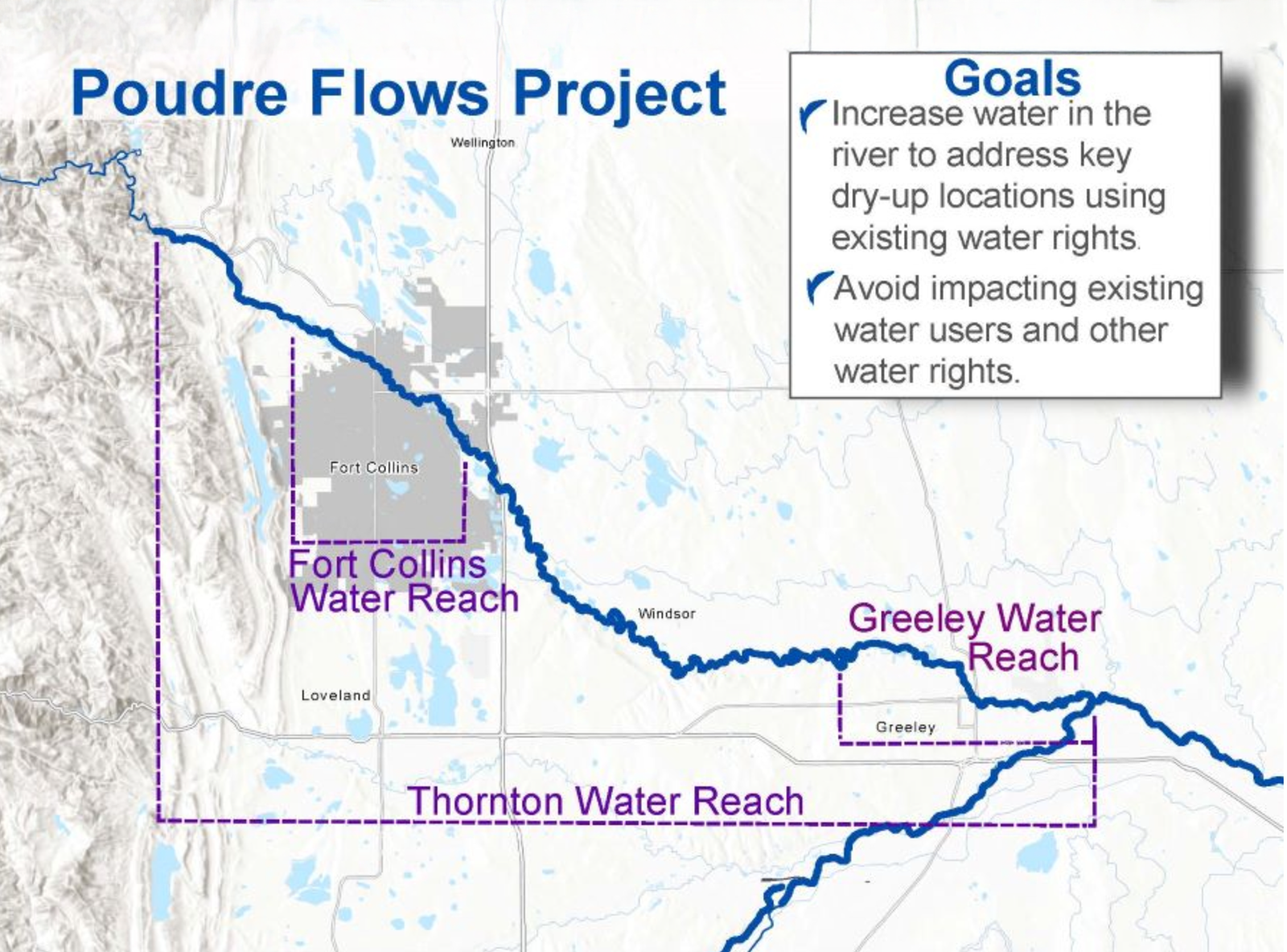
Poudre Flows Project
The Poudre Flows Project is the first stream flow augmentation plan developed pursuant to CRS § 37-92-102(4.5).34 It is a partnership amongst the CWCB; municipalities of Fort Collins, Thornton, and Greeley; Colorado Water Trust; Northern Colorado Water Conservancy District; Cache la Poudre Water Users Association; and Colorado Parks and Wildlife. The project will augment stream flows through a 52-mile reach of the Cache la Poudre River, with an overarching goal to improve river health (see fig. 3).35 The concept was first envisioned as part of the Poudre Runs Through It working group, a collaborative group of diverse partners and stakeholders in the Poudre River.36 The City of Fort Collins planning priorities incorporate similar goals, including to “[p]rotect community water systems in an integrated way to ensure resilient water resources and healthy watersheds.”37
The project anticipates that the CWCB, through agreements with water right owners, including Fort Collins and Greeley, will use previously changed and quantified water rights owned by these municipalities and potentially others to augment stream flows in six segments of the Poudre River spanning from Canyon Gage to the confluence with the South Platte River.38 Besides the instream flow protection of the environment to a reasonable degree, project partners have identified numerous additional benefits such as connectivity for fish passage and decreased temperatures and nutrient concentrations, all while avoiding impacts to existing water rights and operations.39
By integrating water supply planning with a holistic approach to water development and management that provides multiple public benefits, municipalities can become strong partners with the CWCB. Together, they can help protect instream flows and balance growing water demands and future uncertainties with the environmental values that make Colorado a beautiful place to live.
1. See generallyCoffin v. Left Hand Ditch Co., 6 Colo. 443, 447 (Colo. 1882).
2. Colo. Const. Art. XVI, §§ 5–6. See also Colo. River Water Conservation Dist. v. CWCB, 594 P.2d 570, 573 (Colo. 1979) (“The reason and thrust for this provision was to negate any thought that Colorado would follow the riparian doctrine in the acquisition and use of water.”).
9. SB 97, 49th Gen. Assemb., Reg. Sess. (Colo. 1973). See CRS § 37-92-102(3).
10. Bassi, supra note 6 at 398. See also Colo. River Water Conservation Dist., 594 P.2d at 576. SB 97 was carefully drafted to provide environmental protection through the CWCB, as a fiduciary to the public, without inviting riparian rights for adjacent landowners. Id. The Colorado Supreme Court reiterated this important distinction in St. Jude Co. v. Roaring Fork Club, LLC, 351 P. 3d 442 (Colo. 2015), ruling that a diversion from a steam for private instream flows is a “forbidden right” contrary to the prior appropriation doctrine; only the CWCB, with strict limitations identified by the general assembly, can hold an instream flow right for the benefit of the public. Id. at 451.
11. CRS § 37-92-102(3) (The CWCB is “vested with exclusive authority, on behalf of the people of the state of Colorado, to appropriate . . . such waters of natural streams . . . as the board determines may be required for minimum streamflows . . . to preserve the natural environment to a reasonable degree.” The board also may acquire water rights “in such amount as the board determines is appropriate for streamflows . . . to preserve or improve the natural environment to a reasonable degree.”). Legislation enacted in 2002 expanded the Colorado instream flow program to provide that water rights may also be used by the CWCB to improve the natural environment (and not just for preservation purposes). Bassi, supra note 6 at 391.
14. Id. at 406. The Colorado Water Trust was formed in 2001 to support Colorado’s instream flow program by promoting voluntary, market-based efforts to restore stream flows in Colorado’s rivers. The Water Trust has been instrumental in facilitating and streamlining the acquisition of water rights from willing partners for use by the CWCB. Seehttps://coloradowatertrust.org.
16. See generally CRS §§ 37-83-105, 37-92-102(8), 37-92-102(4.5).
17. The Colorado Water Plan was adopted by the CWCB in 2023 as a framework for decision-making to address water challenges and build resiliency in the state. The 2023 Water Plan is an update to the first iteration of the plan released in 2015. Seehttps://cwcb.colorado.gov/colorado-water-plan.
18. SeeSt. Jude Co., 351 P. 3d at 449 (in its use of water for instream flows, the CWCB has a “‘statutory fiduciary duty’ to the people . . . to both protect the environment and appropriate only the minimum amount of water necessary to do so . . . .”).
20. See id. at 217–19, 231, 233 (“All areas of the Water Plan are interconnected, and projects need to consider multi-purpose, multi-benefit solutions.”).
21. See id. at 217 (“Multi-purpose projects better address water supply challenges across municipal, agricultural, environmental, and recreation sectors as they occur.”).
22. See id. at 181, 204–07 (stream health and related environmental benefits can enhance municipal supply or improve the quality of life in urban areas).
23. See Decree, In re Application for Water Rts. of the Colo. Water Conservation Bd. on Behalf of the State of Colo. and Water Rts. of the City of Boulder, No. 90CW193 (Colo. Water Div. 1, Dec. 20, 1993).
30. See Decree, In re Application for Water Rts. of City of Lafayette, City of Boulder, and Colo. Water Conservation Bd. in Boulder Cnty., No. 17CW3212 (Colo. Water Div. 1, Feb. 11, 2021). The author represented the City of Boulder in Case No. 17CW3212 and was involved in prosecuting the case and negotiating the underlying agreement with CWCB.
31. Denver Water’s enlargement of Gross Reservoir is the subject of pending litigation.
32. The target flows and target reaches are based on previously collected data and analysis by Colorado Parks and Wildlife using the R2Cross method, which supported CWCB’s previous instream flow appropriations.
38. See Application, In reApplication for Water Rts. of Cache La Poudre Water Users Ass’n, City of Fort Collins, City of Greeley, Colo. Water Tr., N. Colo. Water Conservancy Dist., City of Thornton and Colo. Water Conservation Bd. in Larimer and Weld Cntys., No. 21CW3056 (Colo. Water Div. 1 Apr. 29, 2021).
Click the link to read the article on the Pagosa Springs Sun website (Clayton Chaney and Randi Pierce). Here’s an excerpt:
January 7, 2026
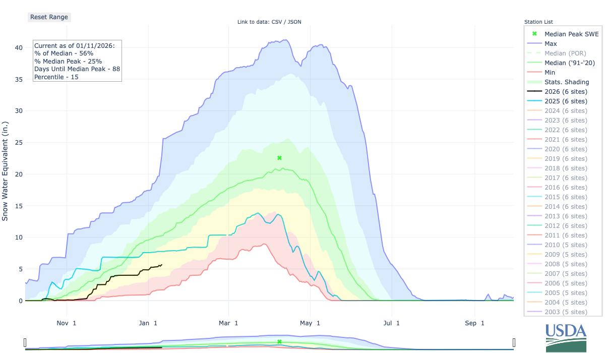
Snowpack and stream flow
According to data from the Natural Resource Conservation Services (NRCS), as of 1 p.m. on Wednesday, Jan. 7, the Wolf Creek Pass site at 10,930 feet had a snow water equivalent of 7.6 inches, compared to that date’s median of 15.5 inches. This is up from the Dec. 31, 2025, report of 7 inches. The current amount is 49 percent of that date’s median snow water equivalent…The San Miguel, Dolores, Animas and San Juan River basins were measured to be at 49 percent of its 30-year median snowpack as of December 31, 2025, and at 56 percent on January 7, 2026…
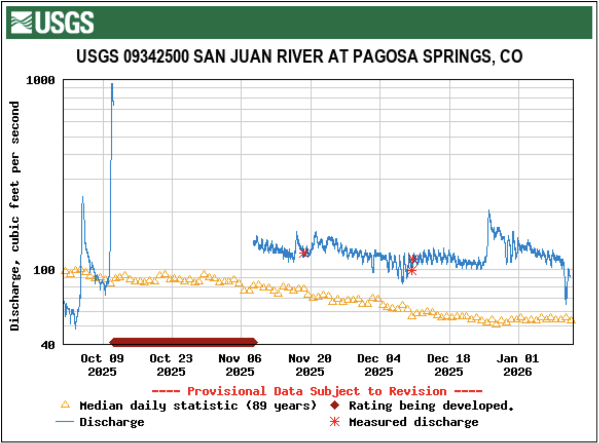
In Pagosa Springs, U.S. Geological Survey for the San Juan River at Pagosa Springs has showed record flows multiple times since the start of the year. For example, at 9 a.m. on Jan. 2, the river was running at 128 cubic feet per second (cfs), which compares to a median of 53 cfs and a previous high of 118 in 1986. At 11 a.m. on Jan. 5, the river was running at 119 cfs, which compares to a median for that date of 54.5 cfs and a previous max value of 116 in 1987. By 11 a.m. on Wednesday, Jan. 7, the river was flowing at 111 cfs. The Jan. 7 median is 55, and the record high is 116 cfs, which was recorded in 1987. According to the U.S. Drought Monitor’s most recent map released on Dec. 31, 2025, 100 percent of Archuleta County is in an “abnormally dry” drought stage.
The Bureau of Reclamation today released a draft Environmental Impact Statement evaluating a range of operational alternatives for managing of Colorado River reservoirs after 2026, when the current operating agreements expire. The draft EIS evaluates a broad range of potential operating strategies. It does not designate a preferred alternative, ensuring flexibility for a potential collective agreement.
Prolonged drought conditions over the past 25 years, combined with forecasts for continued dry conditions, have made development of future operating guidelines for the Colorado River particularly challenging.
“The Department of the Interior is moving forward with this process to ensure environmental compliance is in place so operations can continue without interruption when the current guidelines expire,” Assistant Secretary – Water and Science Andrea Travnicek said. “The river and the 40 million people who depend on it cannot wait. In the face of an ongoing severe drought, inaction is not an option.”
The draft EIS evaluates a broad range of operational alternatives for post-2026 reservoir management informed through input and extensive collaborative engagement with stakeholders, including the seven basin states, tribes, conservation organizations, other federal agencies, other Basin water users, and the public. It includes the following alternatives that capture operational elements and potential environmental impacts:
No Action
Basic Coordination
Enhanced Coordination
Maximum Operational Flexibility
Supply Driven
The document will be published in the Federal Register on January 16, 2026, initiating a 45-day comment period that will end on March 2, 2026. The draft EIS and additional information on the alternatives are available on Reclamation’s website.
“Given the importance of a consensus-based approach to operations for the stability of the system, Reclamation has not yet identified a preferred alternative,” said Acting Commissioner Scott Cameron. “However, Reclamation anticipates that when an agreement is reached, it will incorporate elements or variations of these five alternatives and will be fully analyzed in the Final EIS enabling the sustainable and effective management of the Colorado River.”
The Colorado River provides water for more than 40 million people and fuels hydropower resources in seven states. It serves as a vital resource for 30 Tribal Nations and two Mexican states, sustaining 5.5 million acres of farmland and agricultural communities throughout the West, while also supporting critical ecosystems and protecting endangered species.
The Draft EIS addresses only domestic river operations. A separate binational process addressing water deliveries to Mexico is underway and the Department is committed to continued collaboration with the Republic of Mexico. The Department will conduct all necessary and appropriate discussions regarding post-2026 operations and implementation of the 1944 Water Treaty with Mexico through the International Boundary and Water Commission in consultation with the Department of State.
To provide certainty for communities, tribes, and water users, a decision regarding operations after 2026 will be made prior to October 1, 2026 – the start of the 2027 water year.
Photo shows Lake Mead with a water elevation of 1078. Credit: USBR
Udall/Overpeck 4-panel Figure Colorado River temperature/precipitation/natural flows with trend. Lake Mead and Lake Powell storage. Updated through Water Year 2025. Note the tiny points on the annual data so that you can flyspeck the individual years. Credit: Brad Udall
The consensus-based effort to develop new rules to manage the Colorado River system hasn’t worked – it’s time for a new approach
Federal leadership and the credible threat of managing reservoirs to protect the system is that new approach
Missing Deadlines
Way back at the end of the last century, at the annual Colorado River conference in Vegas, Marc Reisner repeated the Margaret Thatcher quote that consensus is the absence of leadership. On Veterans Day, the seven Colorado River basin states missed yet another deadline to reach consensus on a conceptual plan for managing the shrinking Colorado River after the current rules expire in 2026. Valentine’s Day marks the next holiday deadline, this time for a detailed plan, but multiple missed deadlines give no indication that the states will reach consensus then, either.
The basin state negotiators have met for years behind closed doors, without success. It’s time for a new approach. Aggressive federal intervention and the credible threat of a federally-imposed Colorado River management plan would offer political cover – or a political imperative – for the negotiators. The credible threat of a federal plan would give the negotiators the space to compromise without having to do so unilaterally and then being accused of not protecting their state’s interests.
But federal leadership alone is not enough – it must be coupled with a plausible federal plan that compels the states to act and can meet the magnitude of the ongoing crisis. As the Department of the Interior announced in its 6/15/2023 press release, the purpose of and need for the post-2026 guidelines is “to develop future operating guidelines and strategies to protect the stability and sustainability of the Colorado River.” To date, the development of the post-2026 guidelines has prioritized routine operations of Glen Canyon and Hoover dams over the system as a whole, a focus inconsistent with the magnitude and urgency of the problem. Prioritizing routine dam operations and hydropower generation over water delivery and environmental protection elevates the tool over the task. Seeking to preserve routine operations of the dams while imposing draconian cuts on water users is not a path to resilience and precludes alternatives that would help stabilize the system.
The Plan
Instead, by early next year, the Secretary should announce that Interior will implement a federal plan incorporating the following elements:
As a condition precedent, the Lower Basin states agree not to place a “compact call” for the duration of the agreement.
Implement annual Lower Basin water use reductions for the following calendar year based on total system contents on August 1:
75% – 60%: cuts to Lower Basin water uses increasing from 0 to 1.5 MAF<60% – 38%: static cut to Lower Basin water uses of 1.5 MAF<38% – 23%: increasing cuts to Lower Basin water uses of up to 3.0 MAF total
below 23% of total system contents – cut Lower Basin water uses to the minimum required to protect human health and safety and satisfy present perfected rights
If the Lower Basin states do not satisfy the condition precedent in #3 above, Reclamation limits Lower Basin deliveries to the minimum required to satisfy present perfected rights when total system contents are <75%.
Recover water stored in federal Upper Basin reservoirs unless the Upper Basin states reduce annual water use based on total system contents:
<34% – 23%: Assuming the first 0.25 MAF “reduction” would be contributed by the elimination of Powell’s evaporative losses and gains from Glen Canyon bank storage, reduce Upper Basin water uses up to 0.65 MAF
below 23% of total system contents – limit total Upper Basin water uses to 3.56 MAF (the minimum volume reported this century)
Expand the pool of parties eligible to create Intentionally Created Surplus (ICS) beyond existing Colorado River contractors, to include water agencies and other entities with agreements to use Colorado River water.
Eliminate the existing limits on the total quantity of Extraordinary Conservation ICS and DCP ICS that may be accumulated in ICS and DCP ICS accounts, while maintaining existing limits on delivery of such water.
Fully mitigate the on-stream and off-stream community and environmental impacts of the water use reductions identified above.
After a three-year phase-in period, condition Colorado River diversions on a clear “reasonable and beneficial use” standard predicated on existing best practices for water efficiency, including but not limited to the examples listed below (state(s) that already have such standards):
Require removal of non-functional turf grass (California, Nevada)
Incentivize landscape conversion and turf removal statewide (California, Colorado, Utah)
Adopt stronger efficiency standards for plumbing and equipment (Colorado, California, and Nevada)
Require urban utilities to report distribution system leakage, and to meet standards for reducing water losses (California)
Require all new urban landscapes to be water-efficient (California)
Require metering of landscape irrigation turnouts (Utah)
Ensure that existing buildings are water-efficient when they are sold or leased (Los Angeles, San Diego)
Require agricultural water deliveries to be metered and priced at least in part by volume (California)
Many of the elements listed above raise important questions about federal authorities, accounting and data challenges, the roles and obligations of state water officials to implement coordinated actions in-state, water access for disadvantaged communities, environmental compliance, and potential economic and social costs, among others. For each item listed, many details will need to be refined. Similarly, the plan’s duration will need to be determined. But as temperatures again climb into the high 40s in the Rockies near the Colorado River’s headwaters (in mid-December!), drying soils and reducing next year’s runoff, and the National Weather Service issues red flag fire warnings for Colorado’s Front Range, the need for bold action is clear.
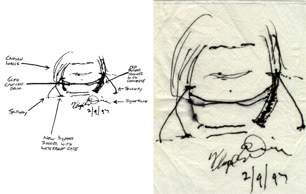
The Dominy Bypass
Recovering water stored in Lake Powell will require the construction of new bypass tunnels around Glen Canyon Dam. Former Reclamation Commissioner Floyd Dominy sketched the design of such tunnels almost thirty years ago (see image). Such tunnels would enable the recovery of about 5.6 MAF of water stored below the minimum power pool elevation – more water than the Upper Basin states consume each year. Current operating rules and the scope of the current planning process effectively treat this massive volume of water as “dead storage” – a luxury the system can no longer afford. After Reclamation constructs the bypass tunnels, water recovery should be timed to maximize environmental and recreational benefits in the Grand Canyon.
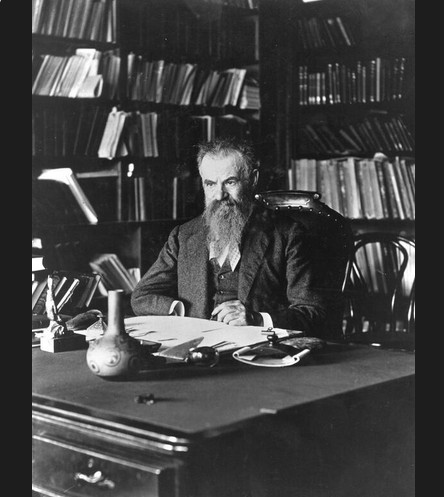
John Wesley Powell at his desk—same desk used by the USGS Director today via the USGS
Running the River
Almost 160 years ago, John Wesley Powell – the reservoir’s namesake – demonstrated bold leadership, going where no (white) man had gone before. With leadership and a clear goal, he charted a route through the Colorado River’s iconic canyons. Now is the time for more bold leadership, a clear goal, and a plan to get there.
About the author
Michael Cohen. Photo credit: Pacific Institute
Since 1998, Michael Cohen’s work with the Pacific Institute has focused on water use in the Colorado River basin and delta region and the management and revitalization of the Salton Sea ecosystem. Michael received a B.A. in Government from Cornell University and has a Master’s degree in Geography, with a concentration in Resources and Environmental Quality, from San Diego State University.
Map of the Colorado River drainage basin, created using USGS data. By Shannon1 Creative Commons Attribution-Share Alike 4.0
It doesn’t matter if you’re a full-time ski bum, a longtime resident, or a first time visitor — the ramifications of the distressing 2025-26 winter on the Western Slope impacts everyone. The combination of unseasonably warm temperatures and jarring lack of snow has created a perfect storm — or lack thereof — and will continue to impact agriculture, recreation, and potable water for over 30 million people long after the 2025-26 winter concludes. Brendon Langenhuizen, the Director of Technical Advocacy for the Colorado River Water Conservation District, compared the snowpack to a reservoir but said the extreme heat is detracting from the benefits of a natural reserve.
Westwide SNOTEL basin-filled map January 8, 2026.
“How warm it’s been has been a concern for me, because snowpack is really a big reservoir for us,” he said. “You can hold that water for the warmer times of the year and then it slowly runs off or melts into the deltas and then comes back into the rivers later in the summer when we need it for crops and water temperatures and recreation.
“If we have these really warm temps continuing, it just diminishes the snowpack and we can’t hold as much snow into the spring — making it so even if we had the moisture, we wouldn’t be able to hold it.”
[…]
According to a Colorado Climate Center graph, parts of Colorado experienced some temperatures exceeding averages by double digits during the first week of January. The graph shows all of Garfield County experienced average temperatures at least eight degrees hotter than average, with northern Garfield County facing average temperatures at least 12 degrees hotter than average. He continued to explain that there was already evidence of a fast runoff, using the Dotsero marker on the Colorado River as reference…Although the area has finally experienced some precipitation since the calendar flipped to 2026, the temperatures aren’t letting a solid base build in the higher alpines – further threatening the snowpack. Walter admitted that every little bit helps, but doesn’t think the recent storms were enough to move the needle, especially since the forecast dries out after Thursday night.
In May of 2023, the Supreme Court handed down a decision that significantly limited the scope of the Clean Water Act, undoing protections that safeguarded the nation’s waters for over 50 years. Specifically, it erased critical protections for tens of millions of acres of wetlands, threatening the clean drinking water sources for millions of Americans.
While the Biden administration amended rules to comply with the Supreme Court ruling, the Trump administration recently released a new draft rule that would go further than even the Supreme Court in limiting what waters can be protected.
Nooksack River, Washington | Brett Baunton
The Clean Water Act’s definition of “Waters of the United States” (WOTUS) is core to defining what waters are protected and which aren’t. Unfortunately, the Trump Administration’s newly proposed WOTUS rule would roll back protections for vast areas of wetlands and river tributaries. It’s estimated that close to 80% of America’s remaining wetlands would lose Clean Water Act protections. As written, the rule would leave many waterways vulnerable to pollution, degradation, and destruction, threatening water quality and community resilience across the country.
Blanca Wetlands, Colorado BLM-managed ACEC Blanca Wetlands is a network of lakes, ponds, marshes and wet meadows designated for its recreation and wetland values. The BLM Colorado and its partners have made strides in preserving, restoring and managing the area to provide rich and diverse habitats for wildlife and the public. To visit or get more information, see: http://www.blm.gov/co/st/en/fo/slvfo/blanca_wetlands.html. By Bureau of Land Management – Blanca Wetlands Area of Critical Environmental Concern, Colorado, Public Domain, https://commons.wikimedia.org/w/index.php?curid=42089248
Here are our top four concerns with the new WOTUS proposal
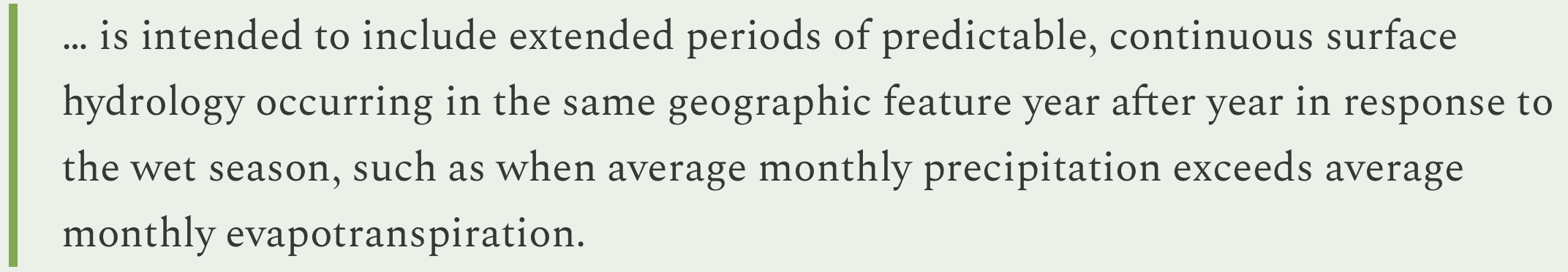
1. The rule requires streams and wetlands to have surface water “at least during the wet season” in order to qualify for protection. But it never defines what the wet season actually is.
What this means for rivers: Wet seasons vary dramatically from region to region, and without a clear, science-based definition, many healthy and ecologically important streams risk being excluded.
2. Narrow definitions and expanded exemptions shrink the scope of protected waters.
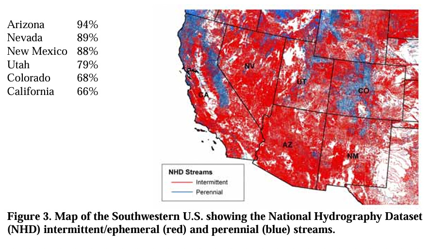
What this means for rivers: By redefining “tributary” to include only streams with year-round or steady “wet-season” flow, and expanding exemptions for wastewater and waste-treatment systems, the new rule would eliminate protections for many intermittent streams and man-made infrastructure that function like natural streams, opening the door to more unregulated pollution. Many rivers in the Southwest only flow for part of the year. This updated definition would put many of these rivers at risk.
3. The rule suggests any artificial or natural break in flow cuts off upstream protection.
What this means for rivers: Under the proposed rule, a culvert, pipe, stormwater channel, or short dry stretch can sever jurisdiction. This means upstream waters that feed larger rivers may no longer be protected, allowing pollution to still flow into nominally protected rivers and streams.
4. The rule significantly eliminates wetland protections by requiring “wetlands” to physically touch a protected water and maintain surface water through the wet season.
What this means for rivers: The new definition excludes many wetlands, which naturally store floodwater, filter pollutants, and safeguard communities. This puts the drinking water for millions at risk and increases the risks of flooding for many communities.
The health of our rivers depends on the small streams and wetlands that feed them. By discarding science, narrowing long‑standing definitions, and creating confusing jurisdictional tests, the Trump Administration’s proposed WOTUS rule risks undoing decades of progress toward cleaner, safer water. America’s rivers—and the communities that depend on them—deserve better.
These rollbacks will put our waterways and the life that depends on them in jeopardy. The public comment period to speak up and defend clean water protections is open until January 5. Please take action today and send a letter to the EPA urging them to keep the current definition of Waters of the United States in place!
Ephemeral streams are streams that do not always flow. They are above the groundwater reservoir and appear after precipitation in the area. Via Socratic.org
Colorado State University researcher Perry Cabot talks to a group about forage crops at the Fruita field station. Cabot studies the effects of irrigation withdrawal and forage crops that use less water. CREDIT: HEATHER SACKETT/ASPEN JOURNALISM
The findings of recent water-conservation studies on the Western Slope could have implications for lawmakers and water managers as they plan for a future with less water.
Researchers from Colorado State University have found that removing irrigation water from high-elevation grass pastures for an entire season could have long-lasting effects and may not conserve much water compared with lower-elevation crops. Western Slope water users prefer conservation programs that don’t require them to withhold water for the entire irrigation season, and having the Front Range simultaneously reduce its water use may persuade more people to participate. Researchers also found that water users who are resistant to conservation programs don’t feel much individual responsibility to contribute to what is a Colorado River basinwide water shortage.
“It’s not a simple economic calculus to get somebody to the table and get them to sign a contract for a conservation agreement,” said Seth Mason, a Carbondale-based hydrologist and one of the researchers. “It involves a lot of nuance. It involves a lot of thinking about tradeoffs.”
Udall/Overpeck 4-panel Figure Colorado River temperature/precipitation/natural flows with trend. Lake Mead and Lake Powell storage. Updated through Water Year 2025. Note the tiny points on the annual data so that you can flyspeck the individual years. Credit: Brad Udall
Over the past 25 years, a historic drought and the effects of climate change have robbed the Colorado River of its flows, meaning there is increasing competition for a dwindling resource. In 2022, water levels in Lake Powell fell to their lowest point ever, prompting federal officials to call on the seven states that share the river for unprecedented levels of water conservation.
The Upper Basin states (Colorado, New Mexico, Utah and Wyoming) have experimented for the past decade with pilot programs that pay agricultural water users to voluntarily and temporarily cut back by not irrigating some of their fields for a season or part of a season.
The most recent program was the federally funded System Conservation Pilot Program, which ran in the Upper Basin in 2023 and 2024, and saved about 100,000 acre-feet of water at a cost of $45 million. The Upper Basin has been facing mounting pressure to cut back on its use, and although some type of future conservation program seems certain, Upper Basin officials say conservation must be voluntary, not mandatory.
Despite dabbling in these pilot conservation programs, Upper Basin water managers have resisted calls for cuts, saying their water users already suffer shortages in dry years and blaming the plummeting reservoirs on the Lower Basin states (California, Nevada and Arizona). Plus, the Upper Basin has never used its entire allocation of 7.5 million acre-feet a year promised to it under the 1922 Colorado River Compact, while the Lower Basin uses more than its fair share.
Sketches by Floyd Dominy show the way he’d end the Glen Canyon Dam. From the article “Floyd Dominy built the Glen Canyon Dam, then he sketched its end on a napkin” on the Salt Lake Tribune website
But as climate change continues to fuel shortages, makes a mockery of century-old agreements and pushes Colorado River management into crisis mode, the Upper Basin can no longer avoid scrutiny about how it uses water.
“We need a stable system in order to protect rivers,” said Matt Rice, director of the Southwest region at environmental group American Rivers, which helped fund and conduct the research. “(Upper Basin conservation) is not a silver bullet. But it’s an important contributing factor, it’s politically important and it’s inevitable.”
Researchers from Colorado State University used this monitoring station to track water use on fields near Kremmling. Researchers have found that Western Slope water users are more likely to participate in conservation programs if there is a corresponding Front Range match in water use reduction. CREDIT: HEATHER SACKETT/ASPEN JOURNALISM
Findings
Papers by the researchers outline how water savings on Colorado’s high-elevation grass pastures — which represent the majority of irrigated acres on the Western Slope — are much less than on lower-elevation fields with other annual crops. Elevation can be thought of as a proxy for temperature; fewer frost-free days means a shorter growing season and less water use by the plants.
“Our results suggest that to get the equivalent conserved consumptive-use benefit that you might achieve on one acre of cornfield in Delta would require five acres of grass pasture if you were up near Granby, for example,” said Mason, who is a doctoral candidate at CSU. “This is a pretty important constraint as we’re thinking about what it means to do conservation in different locations across the West Slope.”
In addition to the science of water savings, Mason’s research also looked at the social aspects of how water users decide to participate in conservation programs. He surveyed 573 agricultural water users across the Western Slope and found that attitudes toward conservation and tendencies toward risk aversion — not just how much money was offered — played a role in participation.
Many who said they would not participate had a low sense of individual responsibility to act and a limited sense of agency that they could meaningfully contribute to a basinwide problem.
If you don’t pay attention to the attitudes of water users, you could end up with an overly rosy picture of the likelihood of participation, Mason said.
“It may do well to think less about how you optimize conservation contracts on price and do more thinking about how you might structure public outreach campaigns to change hearts and minds, how you might shift language as a policymaker,” he said. “A lot of the commentary that we hear around us is that maybe this isn’t our problem, that this is the Lower Basin’s problem. [ed. emphasis mine] The more you hear that, the less likely you are to internalize a notion of responsibility.”
Mason also found that a corresponding reduction in Front Range water use may boost participation by Western Slope water users. The fact that Front Range water providers take about 500,000 acre-feet annually from the headwaters of the Colorado River is a sore spot for many on the Western Slope, who feel the growth of Front Range cities has come at their expense. These transmountain diversions can leave Western Slope streams depleted.
Western Slope water users often describe feeling as if they have a target on their back as the quickest and easiest place to find water savings.
“I think they tend to be appreciative of notions that have some element of burden sharing built into them,” Mason said. “So they aren’t the only ones being looked at to contribute as part of a solution to a problem.”
Perry Cabot, a CSU researcher who studies the effects of irrigation withdrawal and forage crops that use less water, headed up a study on fields near Kremmling to see what happens when they aren’t irrigated for a full season or part of a season. The findings showed that fields where irrigation water was removed for the entire season produced less hay, even several years after full irrigation was resumed. Fields where water was removed for only part of the season had minimal yield loss and faster recovery.
“In the full season, you can have a three-year legacy effect, so that’s where the risk really comes in if you’re a producer participating in these programs,” Cabot said. “For three years after, you’re not getting paid even though you’ve diminished that yield.”
At the CSU research station in Fruita, Cabot is studying a legume called sainfoin, a forage crop and potentially an alternative to grass or alfalfa. He said sainfoin shows promise as a drought-tolerant crop that can be cut early in the season, allowing producers to have their cake and eat it too: They could maintain the income from growing a crop, avoid some of the worst impacts of a full-season fallowing, and still participate in a partial-season conservation program.
“I’d like to see flexible options that allow us to think about conservation happening on fields that still have green stuff out there,” Cabot said.
This field near Kremmling participated in an early study on the effects of removing irrigation water. Researchers found the effects of full-season fallowing can have lasting impacts. CREDIT: HEATHER SACKETT/ASPEN JOURNALISM
Part of the solution
The Glenwood Springs-based Colorado River Water Conservation District has been one of the loudest voices weighing in on conservation in recent years, helping to fund Cabot’s and Mason’s studies, as well as conducting its own. The River District, which represents 15 counties on the Western Slope, is not a fan of conservation programs, but it has long accepted their inevitability. It has advocated for local control and strict guidelines around a program’s implementation to avoid negative impacts to rural agricultural communities.
River District General Manager Andy Mueller said there is still a lot of resistance to a conservation program in Colorado — especially if the saved water is being used downstream to fuel the growth of residential subdivisions, computer-chip factories and data centers in Arizona. In addition to wanting the Front Range to share their pain, Western Slope water users don’t want to make sacrifices for the benefit of the Lower Basin. [ed. emphasis mine]
“They want to be part of the solution, but they don’t want to suffer so that others can thrive,” Mueller said. “That’s what I keep hearing over and over again from our producers on the ground: They are willing to step up, but they want everybody to step up with them.”
Water experts agree Upper Basin conservation is not a quick solution that will keep the system from crashing. Complicated questions remain about how to make sure the conserved water gets to Lake Powell and how a program would be funded.
And as recent studies show, the tricky social issues that influence program participation, multiseason impacts to fields when water is removed and the scant water savings from high-elevation pastures mean the state may struggle to contribute a meaningful amount of water to the Colorado River system through a conservation program.
“If the dry conditions continue, it’s hard to produce the volumes of water that make a difference in that system,” Mueller said. “But are we willing to try? Absolutely. It has to be done really carefully.”
Map of the Colorado River drainage basin, created using USGS data. By Shannon1 Creative Commons Attribution-Share Alike 4.0
Click the link to read the article on the AZCentral website (Debra Utacia Krol). Here’s an excerpt:
December 29, 2025
Key Points
A new intertribal land trust has acquired 10,000 acres of land along the Klamath River from former dam operator PacifiCorp.
The land transfer is a key step in restoring the river basin’s ecosystem following the removal of four dams.
Indigenous values and traditional practices will guide the restoration of the land, which includes important salmon habitat.
Another milestone in restoring the Klamath River Basin has been reached. A new land trust received title to land on Dec. 22 that includes important salmon habitat and lands upstream of and adjacent to four now-removed dams and the shallow reservoirs that impeded fish and nurtured deadly algae in northern California and southern Oregon. The Klamath Indigenous Land Trust was formed by a coalition of members from four basin tribes after the historic 2002 fish kill to remove the dams as the beginning of a long-term effort to restore health to one of the West’s most imperiled rivers. PacifiCorp, the previous landowner and former hydropower operator, agreed to sell 10,000 acres to the land trust to return stewardship to the tribes who fought for decades to remove the dams as the first step in river recovery. Indigenous values and millennial-long practices which once made the basin one of the West Coast’s largest salmon habitats will direct the job of restoring the ecology of the area, which is the size of West Virginia. The Catena Foundation, the Community Foundation of New Jersey and an anonymous donor provided the funding for the purchase, which is one of the largest such purchases by an Indigenous-led land trust to date…
“Dam removal allowed the salmon to return home,” said Molli Myers, the land trust’s board president and member of the Karuk Tribe. “Returning these lands to Indigenous care ensures that home will be a place where they can flourish and recover.”
“PacifiCorp is pleased to see these lands transition to a stewardship model that honors their cultural and ecological significance,” said Ryan Flynn, president of Pacific Power, the division of PacifiCorp that serves customers in the Northwest.
Aerial view of the snowpack in the San Juan Mountains of southwest Colorado on Dec. 3, 2021. Scientists and water managers use a variety of methods to monitor the snowpack, which supplies most of the water flowing in many Western streams and rivers. Photo by Mitch Tobin/The Water Desk.
A controversial recent study highlights an old truth about the American West’s snowpack: it’s difficult to measure—and just as hard to forecast how much of its water will ultimately reach tens of millions of people and vast swaths of farmland.
Water managers have increasingly turned to aircraft that use lasers to gauge the snowpack across entire basins. But the Aug. 15 scientific paper argues for a less expensive strategy: focusing new monitoring efforts on a select number of locations known as “hotspots” that excel at predicting how much water will run off from the snowpack—a frozen reservoir that can change dramatically over short distances.
Snowfall rates vary widely with elevation, and the amount of water locked in falling snowflakes shifts from storm to storm.
On the ground, snow accumulation depends on the wind, the forest canopy overhead, the exposure to the sun and the amount of dust that lands on the snowpack. Even a homeowner armed with a ruler can find very different snow depths depending on where they poke in their backyard.
For water providers, knowing how much water is stored in the snowpack is essential. In much of the West, snowmelt supplies most of the runoff that flows through streams, rivers, reservoirs, irrigation canals and household faucets.
If water managers overestimate the snowpack, their customers can be left high and dry later in the year. But if analysts underestimate streamflows, reservoirs can fill faster than expected—raising the risk of disastrous flooding.
With climate change making the snowpack less reliable and redefining what “normal” means, the pressure on forecasters is intensifying in a rapidly growing region with a well-documented gap between water supply and demand. Even a perfect knowledge of the snowpack’s water content doesn’t guarantee accurate streamflow projections because factors such as soil moisture, groundwater levels and late-season weather cloud the picture.
Karl Wetlaufer (NRCS), explaining the use of a Federal Snow Sampler, SnowEx, February 17, 2017.
Scientists and water managers, aware of the high stakes, began formally measuring the snowpack to make water forecasts more than a century ago. They selected key locations in the high country, plunged hollow metal tubes into the snow and weighed the extracted cores to calculate the water content—a technique still used extensively today.
During the late 20th century, officials installed hundreds of automated stations across the West’s watersheds as part of the SNOTEL network. These sites use “snow pillows” to measure the weight of the overlying snow and estimate its water content. Forecasters then correlate these long-term snow records with historical streamflows to predict a basin’s water supply.
In the 21st century, airborne snow surveys have expanded rapidly. Aircraft equipped with lidar—a laser-based technology—precisely map the snow depth across entire watersheds while an onboard spectrometer scans the snowpack’s reflectivity. Snow depth is determined by subtracting lidar readings taken when snow is absent from those taken when snow is present. Scientists combine those measurements with estimates and observations of snow density to calculate the water content, known as the snow water equivalent.
Satellites also provide valuable data on the snowpack, especially its extent on the ground, but reliably measuring snow water equivalent from space remains elusive. Clouds and forests can also obscure or complicate a satellite’s view.
Four ways scientists monitor the snowpack. Clockwise from upper left: a manual snow-course survey (California Department of Water Resources); an automated SNOTEL station (Mitch Tobin/The Water Desk); an illustration of a satellite carrying the MODIS instrument (NASA); and airborne mapping (NASA).
While technologies that estimate an entire watershed’s snowpack are on the rise, the recent hotspots study argues that water forecasters could gain crucial insights by targeting future monitoring at a limited set of locations.
The authors say these 62-acre hotspots not only are strong predictors of how much water will run off in the spring and summer, but also could be more cost-effective than mapping the snowpack across a whole watershed using aircraft. That approach has become more common due to the work of Airborne Snow Observatories, Inc. (ASO), a company that spun out of research at NASA’s Jet Propulsion Laboratory.
“The greatest gains in water supply prediction come from leveraging existing stations and expanding snow measurements to the right places, rather than everywhere,” the authors write in Communications Earth & Environment.
But in the tight-knit world of Western snow science, the paper has sparked pushback from supporters of airborne snow monitoring.
Jeff Deems, a co-founder of ASO, said the paper is a “statistical curiosity” and criticized both its methodology and the conclusions it draws about snowpack monitoring.
“Our datasets have become the gold standard, the benchmark against which others are evaluated,” Deems said.
The Colorado Airborne Snow Measurement (CASM) program produced a strongly worded critique of the study, which used a proxy for the ASO data, rather than actual measurements from aircraft.
“Although this paper is published in a well-known journal, it makes unsupported, misleading and editorialized claims about the cost, value, and performance of airborne lidar for streamflow forecasting,” said the rebuttal from CASM, a group of stakeholders whose planning team includes ASO, water providers, the Colorado Water Conservation Board (CWCB) and other organizations. “The authors make a series of critical logic and analysis errors which when combined with their over-broad conclusions result in a very misleading paper.”
But study co-author Cam Wobus wrote in an email that the paper “might have struck a nerve” because “it showed that wall to wall measurement of snow may not be needed to create more accurate water supply forecasts, which ASO could have perceived as a threat to their business model.”
Despite the sharp differences among snow researchers, experts agree there’s no silver bullet for monitoring the snowpack or predicting streamflows. As warming temperatures and evolving storm patterns continue to transform the snowpack, both old-school methods and newer technologies will be needed to better manage the region’s scarce water resources.
“Snowpack estimation and streamflow forecasting is a vast and unsolved field of research,” the CWCB wrote in response to questions from The Water Desk.
Although CWCB’s logo was included at the bottom of CASM’s rebuttal, the agency said in an email that the document “should not be misconstrued as an official position statement” and that “CWCB has acted as a funding and coordination partner” to CASM.
An airborne survey created this map of snow depth for Colorado’s Maroon Bells on April 9, 2024. Source: ASO.
Searching for snowpack hotspots
The hotspots study set out to test an intuitive idea: in high-elevation watersheds, the snowpack in certain locations can be especially useful for predicting streamflow.
“There are places within drainage basins that, if you train your water-supply forecast on the snow record in those locations, you’ll have a better forecast than if you use the basin average,” said co-author Eric Small, a professor of geological sciences at the University of Colorado Boulder.
“If you think about a drainage basin, there’s going to be places in that drainage basin where there’s not a lot of snow, or there’s not much connection between the snowmelt and the runoff,” Small said. “There’s going to be other places in the basin where there is a lot of snow and a lot of connectivity between the snowmelt and the runoff. So it should not be a surprise that there’s locations within a basin that are more predictive of this seasonal water supply.”
In general, locations with the deepest, most persistent snow are more likely to be hotspots.
“Anyone who’s seen a basin in Colorado and sees the south-facing slopes that are bare of snow and the north-facing slopes that have snow three feet deep in the springtime recognizes that once you take an average across all of that, the stuff on the south-facing slopes isn’t going to matter at all,” said Wobus, a principal at CK Blueshift, LLC, a consulting firm that works on water and climate issues.
“It’s silly to fly an entire basin if 30% of that basin doesn’t have any snow on it, so that’s an easy fix right there,” Wobus said.
While hotspots typically accumulate lots of snow, what’s happening beneath the snowpack is just as important. “The hotspots are locations where there’s both a lot of water, and when it melts, a large fraction of that water would get into the stream,” Small said.
Hotspots tend to have shallow or relatively stable groundwater storage and soil moisture levels that don’t vary year to year.
“The hotspots are places where there’s either enough snow or minimal enough variations in storage that the water is getting to the stream and the water is getting to the stream at the right timescale,” Small said.
Each basin may have numerous hotspots. “The hotspots weren’t unicorns,” Small said. “There were many possible hotspots. We had an objective measure to choose the official hotspot in the paper, but you could have chosen many other locations that were also predictive.”
Once a hotspot is identified, the authors outline several potential ways to tap its predictive power. One option is to add a new SNOTEL station at the site, although that may not be feasible because of the terrain or land protections. Another possibility is to use remote sensing from a plane or a drone. The authors write that one or two flight paths that observe the hotspot could gather data “at a substantially lower cost than more conventional wall-to-wall basin coverage.”
Even recreationists could help gather data from snowpack hotspots. “You could use citizen science to do it. You could send a bunch of backcountry skiers out to your location for fun, give them an app,” Small said. “They’re probably already going there. If you saw where people were skiing, they would probably have mapped out the hotspots already.”
Map: Mitch Tobin/The Water Desk • Source: Natural Resources Conservation Service • Created with Datawrapper
A shortcut, or a statistical trap?
Critics of the hotspots paper agree that some parts of a watershed can carry more predictive weight for streamflows than others.
“It’s not a new concept, and it’s a very seductive one. It’s essentially the premise behind the SNOTEL network,” Deems said.
But to some scientists who dispute the study, hotspots can hide as much as they reveal—and potentially mislead water managers as the West’s climate evolves and as the hydrology of high-country landscapes is reshaped by disturbances, such as the increasing frequency of wildfires.
“Even if they did everything right—found these hotspots—the likelihood of them retaining the same statistical predictive power going forward is essentially nil,” Deems said.
The rebuttals to the paper have challenged both its analysis and the real-world implications the authors infer from their results.
Noah Molotch, a professor of geography at the University of Colorado Boulder and director of the Mountain Hydrology Group at the Institute of Arctic and Alpine Research, said “the study doesn’t accurately portray the direction that water managers have been moving for a couple of decades now.”
“My concern there is that it takes us further down the path of being blind to the spatial patterns that govern water supply and that can lead to surprises for water managers,” Molotch said.
Although the hotspots study has implications for airborne snowpack monitoring, the paper didn’t analyze data gathered by aircraft, which has been collected only in select watersheds and over a shorter time period than the authors examined.
Instead, one of the ways the researchers probed the snowpack in 390 basins in the West was to combine satellite data from 2001 to 2023 with historical weather data. The satellite images, collected by the MODIS instruments aboard two NASA spacecraft, show the fraction of each pixel covered by snow and the reflectivity of the snowpack, among other metrics. Each pixel is a square with 500-meter (1,640-foot) edges.
The authors argue that this type of data serves as a reasonable “proxy” for the basin-wide estimates that could be obtained from prospective satellite missions and current airborne monitoring. Small said five different datasets were examined, and all showed similar results.
But the CASM critique argues that the proxy dataset has “a demonstrated average error of 35% (ranging from 20-60%)” when compared to airborne lidar, and its much coarser resolution further limits its utility.
The paper’s authors “make the assertion that that dataset has been shown to be accurate and, in their language, therefore serves as a reliable proxy for airborne lidar,” Deems said. “That assertion is incorrect, and that undercuts the entire rest of the paper, sadly.”
Deems said the study used the date of snow disappearance to back-calculate how much snow was there while also “blending in an atmospheric model precipitation product, which is highly uncertain.”
By contrast, Deems said, ASO creates “a highly accurate map of snow depth throughout the watershed,” which is then paired with estimates of snow density informed by SNOTEL measurements and hand-dug snow pits. What emerges, he said, is a basin-scale estimate of snow water equivalent that’s within about 1% of the actual volume.
“That’s better than we can measure streamflow,” Deems said.
A video from Colorado’s Northern Water explains how the utility uses ASO data.
Clashes over the merits of datasets are grist for the academic mill, but critics raise a broader concern: the paper takes a retrospective look at snowpack-streamflow relationships in an age of extreme weather and shifting baselines.
Scientists have an awkward name for this pivotal issue: “stationarity.” In simple terms, it’s the assumption that the past is a reliable guide to the future. But just as mutual-fund disclaimers warn that past performance is no guarantee of future returns, climate change is making historical patterns less trustworthy.
Storm tracks are migrating. Warmer temperatures mean more winter rain and less snow. Rising evaporation rates are drying out soils. And both the timing and volume of runoff are in flux as the weather changes and high-elevation wildfires remake watersheds.
The hotspots strategy, according to the CASM rebuttal, “does not test whether those sites remain predictive under shifting climate conditions or extreme events” and “what looks like a hotspot in the historical record may fail under current or future conditions.”
What to do with hotspots?
On a practical level, the hotspots paper argues that snow researchers and water managers could mine these locations for essential data by installing additional SNOTEL stations or using remote sensing. But critics say several big hurdles stand in the way of implementation, many of which are acknowledged in the study.
First, a hotspot with 500-meter edges covers nearly 2.7 million square feet, but the snowpack may vary greatly within that footprint. Where in that area should a new SNOTEL monitoring station go? Cost is another concern. “Installing and maintaining a station is not cheap either—$100,000 easily between gear and personnel time and maintenance,” Deems said.
Second, terrain and land-use rules can make installation impractical or illegal. “In many cases, it’s going to be impossible to put a station there, either because it’s sloped and the snow pillows don’t work on slopes, or because it’s in the wilderness or in avalanche terrain or something like that,” Deems said. Drone flights—another potential monitoring tool—are also prohibited in federal wilderness and face their own logistical challenges.
Third, any new station only generates data going forward. It doesn’t provide the long historical record that water managers need to train their models and make streamflow predictions. “It’s not going to be useful until you probably get about 30 years of data,” Molotch said, “and then let’s think about how much the climate may have changed over those three decades.”
The components in a typical SNOTEL station. Source: Natural Resources Conservation Service.
At its core, the dispute over hotspots reflects a long-standing divide in hydrology. One camp relies on statistically based approaches, such as using a select number of “index” sites to measure the snowpack and predict streamflow based on historical records. Another paradigm favors physically based methods that employ the laws of physics to account for the coming and going of water molecules in a basin, such as using aircraft to map the snowpack.
“Historically, we’ve increasingly been moving toward physically based approaches in hydrology,” Molotch said. “At some point, we may have a complete passing of the baton toward physically based approaches. I don’t know if and when that will be in our future, but I think that that is the way that things are migrating over time.”
Small said that ASO data “will give you the total number of water molecules in a basin” if you accept their snow density model, but that’s only part of the story. To predict streamflow, forecasters must account for other factors, including how much water is lost to the atmosphere when it evaporates, transpires from plants or converts directly from ice to water vapor, a process known as sublimation. Soil moisture and groundwater levels also shape the hydrologic cycle.
“The total volume of water in the snowpack is not hugely predictive of streamflow compared to what you get from the hotspots, and that has to be the case,” Small said. “If you have any variations in the basin from evapotranspiration or soil moisture storage or groundwater storage—that has to be the outcome. And I think we probably should have said that in the first sentence of the paper.”
Using an “all of the above” approach
Denver Water describes the snowpack in the mountains west of the city as the utility’s biggest reservoir. To supply its 1.5 million customers, Denver Water uses a variety of techniques to track the snowpack, including manual measurements, automated SNOTEL stations, ASO flights above key watersheds and satellite data that is blended into reports that Molotch and colleagues generate at the University of Colorado Boulder.
“We take an all of the above approach,” said Taylor Winchell, climate change adaptation program lead at Denver Water. “We think that all of these systems really have their place and are all important in giving us the full picture of the snowpack that we’re hoping to gather to help us make confident decisions.”
Each type of snow monitoring has its benefits and limitations. “They each fill a gap that the other doesn’t,” Winchell said.
The SNOTEL system, for example, can provide hourly or daily readings of the snowpack and offers long historical records, but it only measures conditions at a single point. The stations also tend to sit in mid-elevation clearings that are easy to access, so they don’t necessarily reflect the diversity of the West’s terrain and overlying snowpack.
“We often don’t have measurements at those higher elevations, and it kind of leaves a blind spot in our understanding of the snowpack,” Winchell said.
Westwide SNOTEL basin-filled map December 28, 2025.
Like many water providers in the West, Denver Water has been grappling with a growing mismatch between snowpack levels and the amount of water that eventually reaches streams and rivers in the spring and summer.
“We just don’t quite expect the same amount of streamflow production nowadays as we would’ve historically with similar levels of snowpack,” Winchell said, noting the influence of soil moisture levels, evaporation and sublimation. “We can’t go off the same assumptions that we might’ve had in the past, and so every year it creates this kind of new and intensified challenge to understand how the snowpack is going to translate into streamflow.”
Denver Water has used ASO data since 2019 and spent an average of about $200,000 per year on the airborne surveys. That first year, ASO surveyed the watershed around Dillon Reservoir—a linchpin in the utility’s supply that collects runoff west of the Continental Divide so that it can be pumped through a 23-mile tunnel bored beneath the Rocky Mountains and reach the east side of the Divide, where most of Colorado’s population lives.
“With those flights, we saw kind of immediately the high value of this information for our decision-making processes,” Winchell said. ASO found the snowpack was bigger than what Denver Water expected, Winchell said, so the utility “immediately increased outflows from Dillon Reservoir so that we’d be able to capture that snowpack without flooding downstream of the reservoir.”
ASO’s high-resolution data is valuable for Denver Water because it “fills in the gaps between those station measurements,” Winchell said.
In the large watersheds that supply the utility, “you can have storms and snow patterns that are quite different from one side of the watershed to the other, and you might have different diversion systems in each part of that watershed,” Winchell said. “You might have had a forest fire in one part of the watershed that impacts the snowmelt within that sub-watershed. So really being able to have that detailed picture of the full watershed, we do find value in that.”
But the cost of airborne surveys remains a critical issue.
“It’s still been a struggle year over year to get the funding needed even to fly what we see as the baseline number of useful flights,” Winchell said. “There’s still a lot of room for both adding additional flights in watersheds that are already being flown, as well as conducting ASO flights in watersheds throughout the state that don’t currently have ASO flights.”
Costs versus benefits
In Colorado, CASM was formed in part to secure additional funding to expand ASO flights above the state. CASM’s annual budget in 2025 was $4.5 million, with state funding accounting for 52% and the rest from federal, local and other sources.
The U.S. House of Representatives recently passed bipartisan legislation that would reauthorize and update the federal Snow Water Supply Forecasting Program “to incorporate modern technologies, including LiDAR and satellite imagery, to improve the accuracy of snowpack and water-supply predictions,” according to sponsor Jeff Hurd, R-Colo.
Backers of airborne surveys acknowledge that flights aren’t cheap—two flights over a basin can cost a couple of hundred thousand dollars per year—but they say the data can generate far greater benefits. A more precise read on the snowpack can prevent flooding and allow water managers to devote excess supplies to groundwater recharge. Conversely, advance warning of shortages can help avoid disruptions for both agricultural and urban water users.
“The value of these data can be off the charts,” Deems said, with some case studies from California showing a return on investment between 50 and 200 to one.
In the headwaters of Northern California’s Feather River, which supplies the California State Water Project, Deems said ASO’s data improved water management. In 2021, the year before ASO’s flights began, water managers “thought they had a decent snowpack,” Deems said, but they had to dramatically scale back allocations, eventually to zero, “because the water just didn’t show up,” causing significant impacts to farmers and other water users.
“The following year, we started flying in the Feather River,” Deems said. “Our February flight showed that they had half the water they thought they had, so it looked like essentially a repeat of the prior year, except this time they knew about it in February, rather than finding out about it when the water didn’t show up at the stream gauge in July.”
Dillon Reservoir supplies water to Denver and releases water into the Blue River which feeds into the Colorado River.
The future of snowpack monitoring
Looking ahead, the stakes are only growing for snowpack monitoring and streamflow forecasting as the climate warms and the West continues to add new water users.
Despite their varying views, snow experts agree that a diversity of approaches will be needed in the foreseeable future. The hotspots study authors see value in the ASO flights, and backers of airborne surveys would like to see more SNOTEL stations.
“We are first in line to advocate for more observations, especially if they can be in environments that are different than the current set of observations covers,” Deems said.
The question, Wobus said, is “how do we use combinations of advanced monitoring technologies like lidar and satellite observations and things like that in a framework that will help you improve water supply forecasts without having to measure everything?”
“There’s a lot of room to improve the economics of snow monitoring,” Wobus said. “If we’re talking about the difference between flying every basin once a year and getting total coverage at a cost of, let’s say $10 million a year for the state of Colorado, versus adding a few more SNOTEL stations in a few places where you really need it—there’s a lot of real estate in between those two things.”
Left to right, Jack Hannaford, Robert Miller, Chief of the Snow Survey Office for the California Department of Water Resources and helicopter pilot Harry Rodgers conduct the monthly snow survey near Loon Lake reservoir in the Eldorado National Forest in El Dorado County. A helicopter was used to access the remote location in the Sierra Nevada Mountains. Photo taken March 9, 1960. Vince R. Arrant / California Department of Water Resources
When ASO maps the snowpack in an entire basin, its aircraft flies back and forth in a pattern often likened to mowing a lawn. Small and Wobus said that one way to save money would be to do more limited flights and use machine learning—a type of artificial intelligence—to extrapolate the results.
“If you fly one strip and combine that with a machine-learning model, you can get like 98% of the way there, and you can save a whole boatload of money,” Wobus said. “You could just fly a straight line across the state of Colorado and then turn around and fly back and get almost as much information as you’re getting by flying like a lawnmower back and forth across the basin.”
But some backers of airborne mapping are skeptical.
“That would be bringing a lack of confidence back into the system, and that’s a difficult thing to ask a water manager to accept, especially after we’ve shown what’s possible,” Deems said.
Drones have also become part of snow hydrologists’ toolbox. While the hotspots paper argues that using lidar technology mounted on drones would be less costly than flying large aircraft, that approach “does not reflect the logistical and financial realities of operating such a program in Colorado’s mountain environments,” according to CWCB.
“Drone-based lidar systems require extensive permitting, frequent flights due to limited range and battery life, and highly trained operators to meet accuracy standards comparable to crewed aircraft,” CWCB wrote. “No program currently exists with the resources, planning, or data management structure to deploy drone surveys at the basin scale needed for operational water forecasting.”
For many snow hydrologists, the holy grail would be to launch a dedicated satellite that could look down from space and estimate the water content of the snowpack around the planet using, for example, microwave sensors. But that’s literally a heavy lift.
“There’s lots in the works,” Deems said. “But the global solution is pretty elusive, and folks have been trying to do this for decades.”
The technology exists today to measure snow water equivalent with a satellite, “but not everywhere and not all the time,” Molotch said. One major obstacle is that satellite monitoring may not work when the snowpack is wet, which is especially vexing in the warmer, maritime snowpacks near the West Coast.
“Snowpack conditions in the Sierra Nevada of California can be wet at any time of year between storms when the sun’s out and it starts to warm up,” Molotch said. “As the climate warms, we would expect that snow wetness will be increasingly problematic for microwave remote-sensing techniques. But I think on the positive side, if we’re able to make snow water equivalent measurements in some locations, that helps us provide information for models that can fill in the gaps.”
In July, NASA and India’s space agency launched NISAR, a new radar satellite built to track how Earth’s surface is evolving. While not dedicated to monitoring the snowpack, the mission will measure changes in snow, glaciers, sea ice, ice sheets and permafrost. Operating day or night, NISAR’s signals can penetrate clouds, and the satellite will observe nearly the entire Earth’s surface twice every 12 days.
Illustration of the new NISAR satellite. Spacecraft hold promise for measuring the West’s snowpack but face challenges of their own. Source: NASA.
The NISAR mission “introduces a promising avenue for cost-effective, large-scale snow depth and snow water equivalent” estimates, according to a January study in Frontiers in Remote Sensing. A 2024 paper in Geophysical Research Letters concluded that NISAR offers a “promising path toward global snowpack monitoring.” While errors increase in forests with a denser canopy, the 2024 study said the satellite “may be feasible for snowpack monitoring in sparse to moderate forest cover.”
What research and data would deepen understanding of the snowpack in the future?
“Where to begin?” Winchell said with a laugh.
In addition to having more manual measurements, more SNOTEL stations, more ASO flights and even a citizen-science effort, Winchell said better knowledge of snowpack temperatures would be helpful to Denver Water because that “provides a really strong indication of when the snowpack is ready to melt.” Additional soil moisture data could also improve the utility’s forecasts of how the snowpack translates into streamflows.
“The field of snowpack research is just a crucial field with really lots of exciting work ahead, especially as these new, really high-value, high-accuracy datasets are coming into play,” Winchell said. “I think decades into the future we’ll wonder how people really went about managing the snowpack water supplies without this information.”
Aerial view of the Rocky Mountain snowpack over central Colorado on Dec. 3, 2024. Photo by Mitch Tobin/The Water Desk.
This story was produced and distributed by The Water Desk at the University of Colorado Boulder’s Center for Environmental Journalism.
Editor’s note: Two of the co-authors of the hotspots paper and one of the critics of the study are affiliated with the University of Colorado Boulder. The Water Desk is also based at the University of Colorado Boulder but operates as an editorially independent journalism initiativeand is solely responsible for its content.
The Colorado River Water Users Association annual conference met in Las Vegas [December 16-18, 2025]. Each year, over a thousand government officials, members of the press, municipal water district leaders, water engineers, ranchers, and tribal members meet to discuss the management of the mighty Colorado River. Hanging over the three-day conference was a stalemate between the upper and lower basin states over how to manage the Colorado River after current operational guidelines expire at the end of 2026.
Throughout the conference, the states’ inability to reach a consensus deal produced ripple effects. The stalemate held back progress on both near term shortage concerns (experts predict that Lake Powell will be only 28% full at the end of the ’25-’26 water year) and long-range planning, such as the development of the next “Minute” agreement between the United States and Mexico.
The closing act of CRWUA 2025 was an orderly (and familiar) report from each of the basin states’ principal negotiators that their state is stretched thin but remains committed to finding a consensus agreement. This final session had no discussion or Q&A. The basin states now have until February 14th to provide the Bureau of Reclamation with their consensus deal, which would presumably be added to an Environmental Impact Statement (EIS) draft that is expected to be released in early January. With time running short, many worry that public participation in the EIS process – vital to informed decision-making – will be greatly reduced.
Still, as Rhett Larson of Arizona State University said on the first day of the conference, “Desert rivers bring people together.” Tribal governments continue to innovate in the areas of conservation and storage, even in spite of ongoing challenges to meaningful access of federally reserved tribal water rights. For instance, the Colorado River Indian Tribes, or CRIT, shared news of a Resolution and Water Code recently passed by their Tribal Council which work together to recognize the Colorado River’s personhood under Tribal law. This provides CRIT with a holistic framework for on-reservation use and requires the consideration of the living nature of the Colorado River in off-reservation water leasing decisions. John Bezdek, who represented CRIT at the conference, put it this way: “If laws are an expression of values, then this tribal council is expressing to the world the importance of protecting and preserving the lifeblood of the Colorado River.” Among others, Celene Hawkins of The Nature Conservancy and Kate Ryan of the Colorado Water Trust also shared about the unique, and often unlikely, partnerships formed to protect stream flows and the riparian environment across the Colorado River basin.
Notwithstanding the basin states’ current deadlock, one theme rang true at CRWUA 2025: Despite the dire hydrologic and administrative realities facing decision-makers today, the Colorado River continues to bring unlikely parties together.
Left to right: Becky Mitchell, Tom Buschatzke, Brandon Gebhart, John Entsminger, Keith Burron, Gene Shawcroft, JB Hamby, Estevan López. Photo credit: Yes To Tap via X (Twitter)
The single most important gathering of Colorado River Basin officials came and went — with no significant announcements regarding the often frustrating yet crucial seven-state negotiations for how to divvy up the river over the next 20 years…Here are three takeaways as the states wrestle with basinwide overuse of water, declining river flows due to a warming world and how to meet the federal government’s Valentine’s Day deadline for a consensus-based deal.
States far from deal — with less than 60 days left
Unlike last year’s conference, the seven states agreed to sit on a panel that was added to the agenda for the last day. The ballroom was still packed for the early morning session. That’s because the stakes are high for states to meet Burgum’s Feb. 14 deadline for a seven-state agreement. Should they not deliver one, Burgum could intervene and states are likely to sue. The Lower Basin states have agreed to shoulder the brunt of a massive deficit the system faces that totals 1.5 million acre-feet, or almost 489 billion gallons. However, the Upper Basin states of Colorado, Utah, New Mexico and Wyoming say they don’t have more water to give should cuts in their jurisdictions become necessary. Conflicts exist with state laws, too…
Temporary deal could be on the table to avoid courtroom
Nevada’s governor-appointed negotiator, John Entsminger, spoke last on the panel and called out the other six states for failing to cede any ground on further conservation in their remarks. Without some compromise from each state on these long-standing arguments, the negotiations are “going nowhere,” he said. While the states have been expected up until this point to deliver a 20-year deal, Entsminger suggested on the panel that a temporary, five-year deal could be on the table to comply with the Feb. 14 deadline.
Udall/Overpeck 4-panel Figure Colorado River temperature/precipitation/natural flows with trend. Lake Mead and Lake Powell storage. Updated through Water Year 2025. Note the tiny points on the annual data so that you can flyspeck the individual years. Credit: Brad Udall
Poor outlook sending shockwaves throughout basin
The underlying issues of the Colorado River are making this moment much more precarious. Several experts presented a dismal picture for the system at large. Carly Jerla, senior water resource program manager at the Bureau of Reclamation, said the agency’s most recent projections place flows into Lake Powell anywhere between 44 percent to 73 percent of average this upcoming year. And since 2006, that replenishment of the reservoir has declined about 15 percent because of poor snow years, evaporative losses and more…
The back of Glen Canyon Dam circa 1964, not long after the reservoir had begun filling up. Here the water level is above dead pool, meaning water can be released via the river outlets, but it is below minimum power pool, so water cannot yet enter the penstocks to generate electricity. Bureau of Reclamation photo. Annotations: Jonathan P. Thompson
Jack Schmidt, who leads the Center for Colorado River Studies at Utah State University, has published several papers this year alongside a group of experts throughout the basin. By his estimation, should snowpack in the Rocky Mountains fail to impress again this winter, water managers may be blowing through a crucial buffer that ensures water can be released from Lake Powell into Lake Mead — and that hydropower generation can continue.
Map of the Colorado River drainage basin, created using USGS data. By Shannon1 Creative Commons Attribution-Share Alike 4.0
A new report from Colorado Law’s Colorado River Research Group warns the Colorado River Basin is “out of time,” describing conditions so severe they threaten the region’s water supply, economy and governance. Called “Colorado River Insights 2025: Dancing with Deadpool,” the report details a dire assessment of the basin’s worsening crisis and offers options for reform. According to the report, reservoirs that once stored four years of river flows are now more than two-thirds empty. The authors note a single dry year or two could push Lake Powell and Lake Mead below critical thresholds, jeopardizing hydropower, water deliveries, and even physical conveyance downstream. The report concludes that current operating rules through 2026 are unlikely to prevent this scenario.
“This report underscores that the basin is out of time, the crisis is no longer theoretical,” said Douglas Kenney, director of the Western Water Policy Program of the Getches-Wilkinson Center at the University of Colorado Law School and chair of the Colorado River Research Group.
“Post-2026 negotiations must produce durable, equitable, climate-realistic solutions — and they must do so urgently. The message is stark: the Colorado River system is now dancing with Deadpool.”
Among the key challenges:
Severe shortage risk: The authors warn that if the next two winters are dry, combined usable storage in Powell and Mead could fall below 4 million acre-feet — far short of what’s needed for water supply and compact obligations.
Climate-driven decline: Rising temperatures, shrinking snowpack efficiency and ocean-atmosphere interactions are reducing runoff and precipitation.
Safety nets collapsing: Groundwater reserves are rapidly depleting, while federal capacity — funding, staffing and science programs — are eroding. Interstate cooperation is fraying, and litigation may be on the table.
Authors stress that many challenges are self-inflicted and, in their view, solvable with technical, legal and financial tools already available.
Colorado River Basin Plumbing. Credit: Lester Doré/Mary Moran via Dustin Mulvaney and Twitter
The year is ending with the Colorado River at a critical juncture.
Figure 4. Graph showing active storage in Lake Powell, Lake Mead, and in Powell+Mead between January 1, 2023, and November 30, 2025. Credit: Jack Schmidt/Center for Colorado River Studies
The big reservoirs Mead and Powell remain perilously low and the seven states that share the basin have been unable to agree on cuts that would reduce their reliance on the shrinking river.
Reservoir operating rules expire at the end of 2026. If no agreement is reached the federal government could step in, or the states could take their chances in court. It’s a risky move that no one in principle seems to want. Yet brinkmanship and entrenched positions have stymied compromise.
Native America in the Colorado River Basin. Credit: USBR
The basin’s Indian tribes, which collectively have rights to more than a quarter of its recent average annual flow, are adamant that their interests – and more broadly, the river itself – be protected. “Any progress made in the negotiations to date is merely rationing a reduced supply, not actively managing and augmenting it as a shared resource with strategies and tools that can benefit the entire basin,” the leaders of the Gila River Indian Community wrote on November 12.
At Lake Mead National Recreation Area in Nevada, “the National Park Service’s focus remains on sustaining boating access and visitor services across the park, including operations at Hemenway Harbor, Callville Bay Marina, Echo Bay, Temple Bar Marina, and South Cove to the extent feasible,” the National Parks Traveler was told.
“As part of that effort, construction began at Hemenway Harbor last summer to extend the launch ramp and help maintain access as conditions change. Lake levels are closely monitored, and NPS operations continue to be adjusted as needed to support safe recreation while protecting park resources,” the Park Service said.
Two years ago Lake Mead officials adopted a plan to “maintain recreational motorboat access in the event water declines to 950 feet.” As of Tuesday, the elevation was 1061.76 feet, according to the U.S. Bureau of Reclamation. At Glen Canyon National Recreation Area, which straddles the Utah-Arizona border, the Park Service has spent more than $100 million in recent years to extend boat ramps and relocate a takeout for river runners coming down the Colorado River through Canyonlands National Park.
Colorado River negotiators are seen, from left to right: Becky Mitchell (Colorado), Tom Buschatzke (Arizona), Brandon Gebhart (Wyoming), and John Entsminger (Nevada). (Photo by Jeniffer Solis/Nevada Current)
Western states that rely on the Colorado River have less than two months to agree on how to manage the troubled river – and pressure is mounting as the federal government pushes for a compromise and a troubling forecast for the river’s two biggest reservoirs looms.
Top water officials for the seven Colorado River Basin states — Arizona, California, Nevada, Colorado, New Mexico, Utah, and Wyoming — gathered for the three-day Colorado River Water Users Association conference at Caesars Palace in Las Vegas last week.
Colorado River states have until Feb. 14 to reach a new water sharing agreement before current operating rules expire at the end of 2026 —or the federal government will step in with their own plan.
Despite the fast-approaching deadline, states reiterated many of the same issues they did during previous years at the conference, namely, which water users will need to sacrifice more water to keep the Colorado River stable as overallocation, climate change, and rising demand sucks the river dry.
Nevada’s chief river negotiator and general manager of the Southern Nevada Water Authority John Entsminger offered a succinct but sharp assessment of the negotiations during a panel discussion Thursday.
“If you distill down what my six partners just said, I believe there’s three common things: Here’s all the great things my state has done. Here’s how hard/impossible it is to do any more. And here are all the reasons why other people should have to do more,” Entsminger said.
“As long as we keep polishing those arguments and repeating them to each other, we are going nowhere,” he continued.
The seven states that share the river’s flows have been deadlocked for nearly two years over how to govern the waterway through the coming decades — even as water levels at Lake Mead and Lake Powell are forecasted to reach record lows after two straight years of disappointing snowpack across the West.
The Colorado River’s headwaters saw a weak snowpack last winter, contributing to one of the worst spring runoff seasons on record. Water flow into the river this year was only 56% of average, leading to significant reductions in Lake Powell, according to the Interior Department’s Bureau of Reclamation.
Federal officials also released a troubling forecast of expected flows for the river in 2026, which were significantly lower than previous predictions. Projections from the Bureau of Reclamation found the Colorado River’s inflow next year would likely be 27% lower than normal, with worst-case scenarios predicting even lower flows.
Without a strong winter snow season, it’s possible Lake Powell’s levels could drop low enough to cease hydropower production by next October — a scenario that would also limit the department’s ability to send water downstream to Arizona, California and Nevada.
The federal government has refrained from imposing its own plan for the river, preferring the seven basin states reach consensus themselves. But the Interior Department has ramped up pressure on states to reach a deal.
The Bureau of Reclamation’s Acting Commissioner Scott Cameron said he and other federal officials have intensified efforts to bring states to a consensus, flying out West every other week since early April to meet with the seven states’ river negotiators.
“The expiration of the current agreements is not a distant horizon. It’s less than a year away. The time to act is now,” said Cameron.
Within the next few weeks, the Bureau of Reclamation will release a range of proposals to replace the river’s current operating rules, but said they would not identify which set of operating guidelines the federal government would prefer
During the conference, negotiators for the seven states repeated that they are still committed to finding a consensus despite missing previous deadlines. California’s biggest water districts said they were willing to “set aside many of their legal positions” in order to reach a seven-state agreement.
However, a long-term multidecade strategy for managing low river flows is likely out of reach.
“I went into this process…advocating strenuously for a 20- to 30-year deal,” said Entsminger. “I no longer believe that’s possible with the time we have left and with the hydrology that we’re facing.”
Entsminger said the “best possible outcome at this juncture” is a short-term five-year deal that sets new rules around water releases and storage at Lakes Powell and Mead.
During a panel of state negotiators, states highlighted water conservation efforts they have undertaken to reduce water use and protect the river, but all explained why their state can’t take on more cuts.
Figure 4. Graph showing active storage in Lake Powell, Lake Mead, and in Powell+Mead between January 1, 2023, and November 30, 2025. Credit: Jack Schmidt/Center for Colorado River Studies
“Our savings accounts are totally depleted,” said Utah’s’s river negotiator, Gene Shawcroft. “Reserviours were full when we started this process. They’re empty now.”
One of the biggest disagreements between the Upper and Lower Basin states is over which faction should have to cut back on their water use during dry years.
The Lower Basin – Nevada, Arizona, and California – have agreed to take the first 1.5 million acre-feet in water cuts needed to address deficits and evaporation that are reducing flows in the river, but say any additional cuts during dry years must be shared with upstream states. Under the current agreement, Lower Basin states must take mandetory cuts when water levels in Lakes Powell and Mead are low.
The Upper Basin, which is not subject to mandatory cuts under the current guidelines, say they already use much less water than downstream states and should not face additional cuts during shortages.
Any more cuts to water users in downstream states during dry years will be politically perilous, explained Arizona’s top negotiator, Tom Buschatzke. Arizona requires the state legislature to approve any changes to Colorado River management rules impacting the state.
Buschatzke called for the Upper Basin – Colorado, Wyoming, New Mexico, and Utah – to split any additional water cuts with the Lower Basin states 50-50.
“We need conservation in the Upper Basin that is verifiable and mandatory,” Buschatzke said, during the panel.
“I have to go to my legislature and get that approval,” he continued. “And I will say right now, I do not think there is anything on the table from the Upper Basin that would compel me to do that today.”
New Mexico’s river negotiator, Estevan López, responded, “I think we’ve been pretty clear. We are unwilling to require additional mandatory reductions on our water users.”
This story was originally produced by Nevada Current, which is part of States Newsroom, a nonprofit news network which includes Stateline, and is supported by grants and a coalition of donors as a 501c(3) public charity.
Map of the Colorado River drainage basin, created using USGS data. By Shannon1 Creative Commons Attribution-Share Alike 4.0
Click the link to read the report from “Dancing with Dead Poll” on the Getches-Wilkinson website (Jack Schmidt1, Anne Castle2, John Fleck3, Eric Kuhn4, Kathryn Sorensen5, Katherine Tara6) Here’s Chapter 1:
In Brief
The rains of mid-October caused significant flooding in the San Juan River basin and increased reservoir storage throughout that basin and in Lake Powell.7 However, basinwide reservoir storage remains low, and the October rainfall offerings were insufficient to alleviate the peril of declining overall water supply.
While the attention of the Basin’s water management community remains focused on the thus far unsuccessful effort to forge a seven-state agreement on future long-term operating rules, the Basin continues to face the risk of short-term crisis. If winter 2025-2026 is relatively dry and inflow to Lake Powell and other Upper Basin reservoirs is similar to that of 2024-2025, low reservoir levels in summer 2026 will challenge water supply management, hydropower production, and environmental river management. Under such a scenario, it is likely that less than 4 million acre feet in Lake Powell and Lake Mead would be realistically available for use during the nine months between late summer 2026 and the onset of snowmelt runoff in 2027. If winter 2026-2027 is also dry, water supply would be further constrained. The present reservoir operating rules that remain in place through 2026 are insufficient to avert this potential water supply crisis. Action to further reduce consumptive water use across the basin is needed now.
How did we get here?
The Basin’s reservoirs were nearly full in late summer 1999,8 acting as a buffer against dry years and serving their fundamental purpose. At that time, the 46 Colorado River Basin reservoirs tracked by the Bureau of Reclamation in its Hydro database held 59.5 million acre feet (maf) in active storage,9 more than four times the Basin’s average consumptive uses and losses in the 1990s (Fig. 1).10 Beginning in 2000, five years of below average runoff11 resulted in a 46% reduction in storage in the Basin’s reservoirs.12 During that time, the reduction in storage in Lake Powell and Lake Mead accounted for 90% of the Basin’s total loss in storage, because most of the Basin’s water was stored in those two reservoirs.
Figure 1. Graph showing active storage in Colorado River basin reservoirs between January 1, 2021, and November 30, 2025. Credit: Jack Schmidt/Center for Colorado River Studies
During the next fourteen and a half years, the amount of storage in the Basin’s reservoirs changed little, despite four years of large runoff (2005, 2011, 2017, and 2019). The increase in storage during the few wet years was nearly completely consumed during the more frequent dry years, and active storage in Powell and Mead was only 5% greater in late July 2019 than it had been at the beginning of 2005.13 When dry years of low runoff returned between 2020 and 2022,14 the Basin’s water users had little of the buffer that they had at the beginning of the 21st century. Combined active storage of Powell and Mead was halved again between mid-July 2019 and mid-March 2023,15 reducing the combined contents of these two reservoirs to only 27% of what it had been in late summer 1999.16 If next winter’s runoff is as low as it was in 2025 17 and consumptive use is not significantly reduced, Powell and Mead will drop below the previous unprecedented low stand of mid-March 2023.
How much of active storage is realistically available?
One of the challenges of the current water supply crisis is uncertainty over how much water is actually available in the reservoirs for use. Although Reclamation regularly reports the amount of water in active storage, our analysis identifies realistically accessible storage as the more appropriate metric of the amount of water that is available for use without challenging the integrity of the dam structures, efficient production of hydroelectricity, or implementation of environmental river management protocols, especially in Grand Canyon.
The back of Glen Canyon Dam circa 1964, not long after the reservoir had begun filling up. Here the water level is above dead pool, meaning water can be released via the river outlets, but it is below minimum power pool, so water cannot yet enter the penstocks to generate electricity. Bureau of Reclamation photo. Annotations: Jonathan P. Thompson
Reservoir water that can be physically released from a dam is termed active storage. In virtually all reservoirs, there is a small amount of water below the elevation of the lowest outlets–the infamously named dead pool. Active storage is everything above dead pool–water that can be physically released through the reservoir’s lowest outlets.
We know, however, that not all the water above dead pool is readily usable. Engineering assessments have indicated that infrastructure constraints at Hoover and Glen Canyon Dams require that higher reservoir elevations be maintained, thereby constraining utilization of the lowest part of the active storage. We defined realistically accessible storage as the volume of water whose release does not impact previously identified engineering or hydropower-production constraints.
At Glen Canyon Dam, for example, the lowest release tubes, called the “river outlets,” are at elevation 3370 ft. Reservoir water below that elevation cannot be released and constitutes the dead pool. Above the river outlets, at elevation 3490 ft, are the intakes for the power generating turbines, known as the penstocks. The penstocks are the conduits that withdraw water from the reservoir into the powerplant to generate electricity, and thereafter discharge the water to the Colorado River downstream from the dam. When the reservoir falls below the elevation of the penstocks, the river outlets are the only means of discharging water through the dam (Fig. 2). The river outlets are not routinely used to release water; virtually all normal releases go through the penstocks.
Experience has shown that the river outlets were not designed for continuous release at the discharge rates required to meet downstream obligations. If the river outlets were to be used continuously, there is significant concern that structural damage to those outlets could occur.18
Accordingly, Reclamation has determined that it will take steps to avoid Lake Powell elevation declining below 3500 ft, considered a safe elevation for continuous withdrawal of water through the penstocks without risk of harm caused by cavitation to the turbines that produce electricity.19 Similarly at Lake Mead, Reclamation has indicated its intent to protect the reservoir from going below elevation 1000 ft.20
Figure 2. Diagram showing schematic of Glen Canyon Dam elevations at which Lake Powell’s waters can be released downstream, and the volumes of water defined by these elevations. Active storage between 3370 and 3500 ft is not realistically accessible for continuous downstream release without risk to engineering infrastructure at the dam and powerplant. Hydroelectricity cannot be produced below 3490 ft, and 3500 ft has been established as a minimum safe level for intake through the penstocks.
The total volume of active storage in Lake Powell above dead pool but below elevation 3500 ft is 4.2 maf. Release of this stored water is constrained, because it cannot be safely withdrawn through the penstocks, and continuous use of the river outlets is considered unwise. At Hoover Dam, there is 4.5 maf of active storage below elevation 1000 ft, also not realistically accessible. In these two largest reservoirs of the Colorado River Basin, there is a total of 8.7 maf of active storage below the elevations required for safe and efficient operation of the infrastructure (Fig. 3). Thus, of the 14.9 maf of active storage at Lake Powell and Lake Mead on November 15, 2025, only 42% of that active storage, 6.2 maf, was realistically accessible.
Figure 4. Graph showing active storage in Lake Powell, Lake Mead, and in Powell+Mead between January 1, 2023, and November 30, 2025. Credit: Jack Schmidt/Center for Colorado River Studies
Implementation of environmental river management protocols at Glen Canyon Dam are constrained when the elevation of Lake Powell is low. Since 1996, controlled floods, administratively termed High Flow Experiments (HFEs), have been conducted at Glen Canyon Dam to rebuild eddy sandbars along the river’s margin and conserve sediment. HFEs are now an essential component of the Long Term Experimental and Management Plan for Glen Canyon Dam.21 Reclamation did not, however, release an HFE in 2021 or 2022 when sediment conditions were sufficient to trigger implementation of the HFE Protocol because Lake Powell was low. In early October of those years, when decisions about implementing HFEs were made, active storage in Lake Powell was 7.3 maf (elevation 3545.3 ft) and 5.8 maf (elevation 3529.4) in 2021 and 2022, respectively. Reclamation cited low storage as the reason not to release those controlled floods.22 Although administrative decisions change with time, it is doubtful that any HFEs would be released if Lake Powell fell below elevation 3500 ft.
Low reservoir levels also impact Reclamation’s ability to control the invasion into Grand Canyon of smallmouth bass, and other warm water reservoir fish species, that dominate the recreational fish community of Lake Powell. These nonnatives are significant predators and competitors of endangered or threatened native fish species and live near the surface of Lake Powell. At moderate and low reservoir elevations, water withdrawn through the penstocks (termed fish entrainment) includes some fish that survive passage through the powerplant turbines and are delivered into the Colorado River downstream from the dam. These fish have the potential to successfully spawn downstream from the dam if river temperatures are relatively warm, such as occurs when Lake Powell is low and water is only released through the penstocks.
This infographic shows how as Lake Powell water levels decline, warm water containing smallmouth bass gets closer to intakes delivering water through the Glen Canyon Dam to the Grand Canyon downstream. Credit: U.S. Geological Survey
Reclamation has implemented a protocol to eliminate the potential of smallmouth bass population establishment in Grand Canyon by releasing some cooler water through the river outlets when the water released through the penstocks is warm. The objective of these Cool Mix releases is to disrupt smallmouth bass spawning downstream from the dam. Water released through the river outlets bypasses the powerplant and does not produce electricity, and Western Area Power Administration (WAPA) must purchase electricity on the open market to replace electricity that the agency contractually committed to provide. WAPA estimated that the cost of replacing contracted electricity was $18.9 million23 and $6.5 million24 during the Cool Mix releases of 2024 and 2025, respectively. The risk of fish entrainment from Lake Powell increases significantly as Lake Powell’s elevation drops, and the need to implement the Cool Mix protocol therefore increases. The risk is minimized if Lake Powell is higher than 3590 ft (10.8 maf active storage) and significantly increases when Lake
Powell is below 3530 ft (5.8 maf active storage).25 When water is no longer withdrawn through the penstocks, the risk of entrainment decreases, because all water passes through the lower elevation river outlets.
What would happen if the coming winter and spring snowmelt is similar to 2024-2025?
In an analysis released in September 2025, we reviewed what might happen in the coming year if runoff is the same as it was last year and Basin consumptive uses and losses are the average of the past four years. We used a simple mass balance approach and estimated the available water supply and consumptive uses and losses, and calculated the difference between the two. The available water supply is the sum of the natural flow of the Colorado River at Lees Ferry plus inflows that occur in the Lower Basin, primarily in Grand Canyon. Consumptive uses and losses are those associated with diversions that support irrigated agriculture, municipal and industrial use, water exported from the Basin by trans-basin diversions, and reservoir evaporation. The difference between supply and use is the net effect on reservoir storage. We then estimated the effect of the Basinwide imbalance between supply and use on the combined realistically accessible storage in Powell and Mead, i.e., above elevations 3500 and 1000 ft in Lake Powell and Lake Mead, respectively.
In the scenario that we considered, we assumed that natural flow at Lees Ferry in the coming year will be 8.5 maf, the same as in Water Year 2025,26 and inflow in the Grand Canyon is 0.8 maf. Thus, we assumed a total supply in the coming water year of 9.3 maf. We analyzed a scenario wherein consumptive uses and losses in the United States portion of the Colorado River would be the average of the most recent four years (2021-2024), namely 11.5 maf,27 and we assumed that 1.4 maf would be delivered to Mexico.
The gap between supply and use under this scenario is 3.6 maf, which would have to be met by additional withdrawals from reservoir storage. Assuming that 75% of this deficit would be withdrawn from Lake Powell and Lake Mead (2.7 maf), then the realistically accessible storage in these two reservoirs would be reduced to 3.5 maf, slightly less than the 21st century low that occurred in mid-March 2023 (Fig. 3). Our analysis of this one realistically low inflow scenario–the coming year’s supply is just like last year’s and consumptive uses and losses are the average of the past four years–is consistent with, but less dire than, Reclamation’s most recent 24-Month Study minimum probable forecast28 for the coming year. That study projects that total storage in Lake Powell and Lake Mead will be drawn down by 3.8 maf during the next year, 2.9 maf from Lake Powell alone. Under Reclamation’s minimum probable projection, the elevation of Lake Powell would drop below 3500 ft in August 2026. All of the remaining realistically accessible storage, 2.5 maf in the scenario modeled by Reclamation, would be in Lake Mead. Under the assumption that the current operating rules remain in effect in 2027, Reclamation’s projection is that the elevation of Lake Powell would stay below elevation 3500 ft through at least July 2027.
Further complicating the situation is that the status and ownership of water in Lake Mead at very low storage levels is unclear. Lake Mead holds (a) water available for allocation in the Lower Division under the prior appropriation system, (b) at least some amount of the water due to Mexico under treaty obligations, and (c) assigned water. Assigned water, commonly known as Intentionally Created Surplus or ICS, is water that can be delivered independent of the Lower Basin’s prior appropriation water allocation system and that is held in Lake Mead by the Secretary of the Interior for the benefit of a specific entity. Assigned water also includes delayed water deliveries held for the benefit of the Republic of Mexico that can be delivered subsequently in amounts in excess of the U.S. treaty obligation to Mexico of 1.5 maf/year. Owners of assigned water have the right to withdraw that water when Lake Mead water levels are above 1025 ft, but entitlement holders in the priority system also have a right to water deliveries, as does Mexico via treaty.
Sketches by Floyd Dominy show the way he’d end the Glen Canyon Dam. From the article “Floyd Dominy built the Glen Canyon Dam, then he sketched its end on a napkin” on the Salt Lake Tribune website.
So long as there is water in Lake Mead adequate to fulfill all required and requested deliveries, no conflict arises. However, as the amount of water in Lake Mead decreases, the potential for a clash increases. International treaty obligations take precedence over deliveries pursuant to the priority system within the U.S., but it is unclear how competing priorities and entitlements will be resolved within the U.S. Holders of higher-priority entitlements would likely contest the Secretary’s authority to reduce their deliveries while withholding assigned water from the priority system. As of the end of 2024, there was approximately 3.5 maf of assigned water in Lake Mead, almost the same as the amount of realistically accessible water in storage above elevation 1000 ft. If Lake Powell ever became a “run of the river” facility, the potential for conflict over access to water in Lake Mead would also increase.
Implications
We are not weather forecasters and have no crystal ball that reveals the coming winter snowpack. We are not predicting that our assumptions about the gap between supply and use/losses and the resulting drawdown of Lake Powell and Lake Mead will inevitably occur. Our scenario is merely one of many possibilities, but our assumptions are sufficiently realistic to serve as a warning of how close the Basin is to a true water crisis. Our results should serve as a call to action. We need to adopt additional and immediate measures across the Basin to reduce water consumption even further during the next year, well before any new guidelines are in place.
Taking steps now to decrease consumptive uses across the Basin will reduce the need to implement draconian measures next summer or in the following years. Every acre foot saved now is an acre foot available for our future selves, slowing the rate of reservoir decline and creating more room for creative Colorado River management solutions. If, on the other hand, we delay reducing water usage and addressing reservoir drawdown, we may find ourselves in more significant distress at the beginning of the Post-2026 guidelines. As we wrote in October, continued reduction in Lake Powell releases also brings the Basin perilously close to the Colorado River Compact “tripwire,” the point at which the ten-year rolling total of water delivered from the Upper Basin to the Lower Basin might trigger litigation asking the U.S. Supreme Court to interpret long avoided ambiguities in rules written a century ago by the drafters of the Colorado River Compact.
We do not presume to make specific recommendations about the steps that should be taken immediately to reduce consumptive use in the Basin. There are many smart and experienced individuals in the Colorado River community whose sole focus is on the mechanics of operating the Colorado River water system and the impacts of operations on their particular constituencies.
We can, however, highlight the available mechanisms for reduction of consumptive use that should be explored for their immediate utility in diminishing the looming jeopardy to the overall system. Such mechanisms include:
Releases from federal reservoirs upstream of Lake Powell to stabilize storage in Lake Powell.
Such releases would be made pursuant to the Drought Response Operations Agreement or similar successor agreement or pursuant to the Secretary of the Interior’s inherent authority to operate federal water projects. Obviously, such releases do nothing to solve the imbalance between supply and demand and will create additional depletions in the system when these reservoirs are refilled. Such releases can, however, provide a temporary bulwark against exceptionally low levels in Lake Powell.
Additional reductions in deliveries from Lake Mead under the Secretary’s Section 5 delivery contracts in the Lower Basin, as authorized by Section II.B.3 of the decree in Arizona v. California, 376 U.S. 340 (1964).
By reducing deliveries from Lake Mead, releases from Lake Powell could also be reduced without the risk of causing exceptionally low storage in Lake Mead.
Extension of system conservation programs in the Lower Basin, and facilitation of an Upper Basin water conservation program, both funded through compensation from federal or state governments or other water users in the Basin, and requiring specific quantities of saved water.
Relying on compensated annual forbearance alone is unsustainable, however, because it is not feasible to pay water users in the long term to forgo the use of water that nature no longer supplies. Permanent reductions in consumptive use are both necessary and also the most productive use of limited funding. In addition, to be effective, changes to state law in some Upper Basin states may be necessary, including recognition of water conservation as a beneficial use for the purpose of avoiding litigation concerning the Colorado River Compact. Finally, authorization for shepherding of saved water to the intended place of storage is essential, including across state borders.
Reductions in deliveries to Mexico through negotiation of a new minute.
Reductions in consumptive use by federal water projects in the Upper Basin, if allowable pursuant to the Secretary’s authority.
It should be noted, however, that in order to benefit the Colorado River system, any such reductions must be recognized at the point of diversion and shepherded to the intended place of storage.
It is obvious that any long-term agreement for future Colorado River operations among the Basin States should be evaluated based on its immediate ability to reverse the storage declines experienced in recent years and anticipated in the future under similar hydrology. An agreement that does not reliably balance supply with uses and losses is not sustainable. Similarly, any operational alternative proffered by the Department of the Interior must achieve the same objectives. When our reservoir storage is as low as it is now, we have very little buffer to rely on–we simply cannot use more water than nature provides.
The focus within the Basin and among its principal water users and state negotiators has been on the formulation of the Post-2026 guidelines for operation of the river. But action is necessary now to avoid creating conditions that will doom the next set of operating principles by initiating their implementation when the Basin is in full crisis mode. No governmental administration, state or federal, wants to see the Colorado River system fail on its watch. Negotiators have worked tirelessly to reach agreement, yet have come up short. The hour is late. The Secretary must take decisive action.
Photo Credit: John Weishei via the Colorado River Research Group
Footnotes
1 Director, Center for Colorado River Studies, Utah State University, former Chief, Grand Canyon Monitoring and Research Center.
2 Senior Fellow, Getches-Wilkinson Center, University of Colorado Law School, former US Commissioner, Upper Colorado River Commission, former Assistant Secretary for Water and Science, US Dept. of the Interior.
3 Writer in Residence, Utton Transboundary Resources Center, University of New Mexico.
4 Retired General Manager, Colorado River Water Conservation District.
5 Kyl Center for Water Policy, Arizona State University, former Director, Phoenix Water Services.
6 Staff Attorney, Utton Transboundary Resources Center, University of New Mexico.
7 Between 9 October and 8 November, five reservoirs in the San Juan River basin gained 204,000 af in total storage, especially in Navajo and Vallecito Reservoirs. Between 9 October and 20 October, Lake Powell gained 105,000 af in active storage, and the total contents of Lake Powell and Lake Mead increased by 108,000 af between September 25 and October 27.
8 Schmidt, J.C., Yackulic, C.B., and Kuhn, E. 2023. The Colorado River water crisis: its origin and the future. WIREs Water 2023;e1672.
9 Total active storage in the Basin’s 46 reservoirs was at its maximum on 24 August 1999.
10 Total Basin consumptive uses and losses, including deliveries to Mexico, averaged 14.2 maf/yr between 1990 and 1999.
11 Average natural flow of the Colorado River at Lees Ferry, estimated by Reclamation, was 9.5 (Water Year, WY) and 9.6 (Calendar Year, CY) maf/ yr between 2000 and 2004. Average natural flow for the preceding ten years (1990-1999) was 15.0 maf/yr (WY, CY). Average natural flow for the entire 21st century between 2000 and 2025 was 12.3 maf/yr (WY, CY).
12 Total active storage of the Basin’s reservoirs was 32.0 maf on 19 October 2004.
13 Total active storage in Lake Powell and Lake Mead was 23.0 maf on 1 January 2005 and was 24.2 maf on 28 July 2019, a 5% increase.
14 Average natural flow at Lees Ferry averaged 9.0 (WY) and 9.2 (CY) maf/yr between 2020 and 2022.
15 Total active storage in Lake Powell and Lake Mead was 12.7 maf on 14 March 2023, 48% less than it had been on 28 July 2019.
16 Total active storage in Lake Powell and Lake Mead was 47.7 maf on 19 September 1999.
17 Reclamation estimates that natural flow at Lees Ferry was 8.5 (WY, CY) maf in 2025.
18 Bureau of Reclamation, Establishment of Interim Operating Guidance for Glen Canyon Dam during Low Reservoir Levels at Lake Powell (2024).18
19 Bureau of Reclamation, Supplement to 2007 Colorado River Interim Guidelines for Lower Basin Shortages and the Coordinated Operations of Lake Powell and Lake Mead, Record of Decision (2024) (SEIS ROD).
20 Id.
21 U.S. Department of the Interior, Record of Decision for the Glen Canyon Dam Long-Term Experimental and Management Plan, Final Environmental Impact Statement, December 2016.
22 Salter, G. and 7 co-authors, 2025, Reservoir operational strategies for sustainable sand management in the Colorado River. Water Resources Research 61, e2024WR038315.
23 Ploussard, Q., Pavičević, M., and Yu, A. 2025. Financial analysis of the smallmouth bass flows implemented at the Glen Canyon Dam during Water Year 2024. Argonne National Laboratory report ANL 25/44, 17 pp.
24 C. Ellsworth, Western Area Power Administration, pers. commun.
25 Eppenhimer, D. E., Yackulic, C. B., Bruckerhoff, L. A., Wang, J., Young, K. L., Bestgen, K. R., Mihalevich, B. A., and Schmidt, J. C. 2025. Declining reservoir elevations following a two-decade drought increase water temperatures and non-native fish passage facilitating a downstream invasion. Canadian Journal of Fisheries and Aquatic Sciences 82:1-19.
26 During the 21st century, natural flow at Lees Ferry was lower than this amount in 2002, 2012, 2018, and 2021, meaning that this is not a worst case scenario.
27 In 2024, consumptive uses and losses in the Upper and Lower Basins totaled 11.4 maf.
28 October 2025 24-Month Study Minimum Probable Forecast. For a discussion of why the Minimum Probable forecast has become a more reliable indicator of the future than the Most Probable 24-Month Study, see Awaiting the Colorado River 24-Month Study, Aug. 14, 2025.
Map of the Colorado River drainage basin, created using USGS data. By Shannon1 Creative Commons Attribution-Share Alike 4.0
Anne Castle, Jeff Kightlinger, Jim Lochhead at the 2025 CRWUA Conference. Photo credit: Water Mark (@OtayMark)
Click the link to read the article on the Aspen Daily News website (Austin Corona). Here’s an excerpt:
December 17, 2025
Federal officials have released a “sobering” forecast of 2026 water levels in the Colorado River, with expected flows plummeting from previous predictions. Precipitation later in the winter could turn those dire forecasts around, officials say, but the current outlook is grim for a river already flirting with crisis. Officials published the new forecast on Monday, only a day before negotiators and stakeholders from the river’s basin states gathered in Las Vegas for a three-day conference. The federal government has given states until February to agree on a longer-term strategy for managing low river flows. The Colorado River’s flow in 2026 (specifically, the unregulated inflow to Lake Powell) could be 27% lower than normal, according to the most probable scenario in the December forecast, with worst-case scenarios predicting even lower flows. The projection has worsened estimates released in November (16% lower than normal in most probable scenarios).
“We all know Mother Nature is a trickster and can often confound our expectations. We certainly hope she intends to do that this year,” said Wayne Pullan, the Bureau of Reclamation’s regional director for the Upper Colorado River Basin, on Tuesday. “But December’s outlook is troubling.”
The bureau, which manages federal dams, will delay water releases at Lake Powell to conserve supplies in the reservoir during the dry winter months in 2026, Pullan said. Even with those efforts, however, the lake’s water levels could fall to critical levels in 2027 as another disappointing year hits the basin. A bad water year in 2026 would compound already poor conditions from 2025, when river flows have been less than half of normal. The new forecast increases the possibility that water levels in Lake Powell could drop below the intakes for hydropower turbines and that releases from the lake could fall below the annual average required to meet the requirements of the 1922 Colorado River Compact, which governs water allocation between the seven states that use the river. Without above-average flows in future years to bring averages back up, or an interstate deal on how to manage drought, those low releases could set the stage for a legal battle on the river.
The back of Glen Canyon Dam circa 1964, not long after the reservoir had begun filling up. Here the water level is above dead pool, meaning water can be released via the river outlets, but it is below minimum power pool, so water cannot yet enter the penstocks to generate electricity. Bureau of Reclamation photo. Annotations: Jonathan P. Thompson
Colorado River states have been given less than two months to agree on how to share water cuts from the shrinking river.
Homeland Security waives environmental laws to speed the construction of a border wall in parts of New Mexico.
A federal judge proclaims federal authority over the contentious Line 5 oil pipeline that crosses the Great Lakes.
U.S., Mexican governments sign Tijuana River sewage cleanup agreement.
The House passes a bill to change environmental reviews for infrastructure permitting.
USGS study finds lower water levels in Colorado’s Blue Mesa reservoir the cause of increased toxic algal blooms.
And lastly, a draft EIS for post-2026 Colorado River reservoir operations, when current rules expire, will be published in the coming weeks.
“Let me be clear, cooperation is better than litigation. Litigation consumes time, resources, and relationships. It also increases uncertainty and delays progress. The only certainty around litigation in the Colorado River basin is a bunch of water lawyers are going to be able to put their children and grandchildren through graduate school. There are much better ways to spend several hundred million dollars.” – Scott Cameron, acting commissioner of the Bureau of Reclamation, speaking at the Colorado River Water Users Association conference on December 17, 2025. Cameron encouraged the states to reach an agreement on water cuts and reservoir operating rules instead of suing each other.
By the Numbers
February 14: New Interior Department deadline for the seven Colorado River states to reach an agreement on water cuts and reservoir operations. If the states fail at that, Interior could assert its own authority. There could also be lawsuits. A short-term agreement might be necessary.
The deadline, according to Interior’s Andrea Travnicek, is for several reasons. It gives states time to pass legislation, if necessary. It provides time for consultation with Mexico and the basin’s tribes. And it allows for reservoir operating decisions in 2027 to be set this fall.
“Time is of the essence, and it is time to be able to adjust those stakes, to arrange so compromises can be made,” Travnicek said.
News Briefs
Line 5 Oil Pipeline Court Case A U.S. district judge ruled that the federal government, not the state of Michigan, has authority over the contentious Line 5 oil pipeline that crosses the Great Lakes at the Straits of Mackinac.
Michigan’s top officials have attempted to shut down Enbridge Energy’s Line 5 since 2020 when Gov. Gretchen Witmer revoked the company’s easement.
In his ruling, Judge Robert Jonker determined that the federal Pipeline Safety Act gives the U.S. government the sole authority over Line 5’s continued operation, the Associated Press reports.
Tijuana River Sewage Pollution Cleanup U.S. and Mexican representatives signed an agreement that will facilitate the cleanup of chronic sewage pollution in the Tijuana River, a shared waterway.
Called Minute 333, the agreement outlines actions and sets timelines. A joint work group will assess project engineering and feasibility studies. Mexico will build a wastewater treatment plant by December 2028 and a sediment control basin by winter 2026-27. The agreement also addresses monitoring, planning, and data sharing.
Permitting and Land Use Bills House Republicans used the week before the holiday break to pass a bill that changes infrastructure permitting processes.
The SPEED Act, which passed with support from 11 Democrats, changes the National Environmental Policy Act and the environmental reviews it requires for major federal projects. It restricts reviews to immediate project impacts, sets timelines, and limits lawsuits.
“On net, these reforms are likely to make it easier to build energy infrastructure in the United States,” asserts the Bipartisan Policy Center.
Border Wall Kristi Noem, the secretary of the Department of Homeland Security, is waiving environmental laws in order to speed the construction of a border wall in parts of New Mexico near El Paso, Texas.
The affected laws include the Clean Water Act, National Environmental Policy Act, Safe Drinking Water Act, Migratory Bird Conservation Act, and others.
Studies and Reports
Mississippi River Recap The U.S. Army Corps of Engineers published a December state of the Mississippi River report, noting how drought conditions this year have influenced operations on the country’s largest river system.
The Corps authorized construction of an underwater dam that was completed in October in order to impede the upstream movement of salty water from the Gulf of Mexico.
Harmful Algal Blooms in Colorado Reservoir Blue Mesa is the largest reservoir in Colorado and is part of the Colorado River basin water storage system.
The U.S. Geological Survey investigated why Blue Mesa has been experiencing toxic algal blooms in recent years. Its report concluded that warmer water temperatures enabled by lower water levels are the likely cause.
Reducing nutrient inflows is unlikely to help, the researchers said. There are naturally occurring phosphorus inputs and the algae can fix nitrogen from the air.
The best solution might be keeping the reservoir high enough, the report says. That will not be easy in a drying and warming region with competing water demands.
On the Radar
Colorado River Draft EIS Coming Soon In the coming weeks – in early January if not by the end of the year – the Bureau of Reclamation will publish a draft environmental impact statement for changes to how the big Colorado River reservoirs will be managed.
Reclamation began its environmental review about two and a half years ago. The agency had hoped to slot a seven-state consensus agreement into the document. But since there is no agreement, the document will instead describe a “broad range” of options, said Carly Jerla of Reclamation, who spoke at the Colorado River Water Users Association conference.
The draft will not select a preferred option, Jerla said. Instead that will come in the final version.
“We’ve set up a draft EIS that reflects a range of carefully crafted alternatives to enable the further innovation and the ability of the basin to come to a consensus agreement to be able to adopt in time for the 2027 operations,” Jerla said.
Federal Water Tap is a weekly digest spotting trends in U.S. government water policy. To get more water news, follow Circle of Blue on Twitter and sign up for our newsletter.
The Colorado River Basin spans seven U.S. states and part of Mexico. Lake Powell, upstream from the Grand Canyon, and Lake Mead, near Las Vegas, are the two principal reservoirs in the Colorado River water-supply system. (Bureau of Reclamation)
The seven states that rely on the Colorado River to supply farms and cities across the U.S. West appear no closer to reaching a consensus on a long-term plan for sharing the dwindling resource. The river’s future was the center of discussions this week at the annual Colorado River Water Users Association conference in Las Vegas, where water leaders from California, Nevada, Arizona, Colorado, New Mexico, Utah and Wyoming gathered alongside federal and tribal officials. It comes after the states blew past a November deadline for a new plan to deal with drought and water shortages after 2026, when current guidelines expire. The U.S. Bureau of Reclamation has set a new deadline of Feb. 14. Nevada’s lead negotiator said it is unlikely the states will reach agreement that quickly.
“As we sit here mid-December with a looming February deadline, I don’t see any clear path to a long-term deal, but I do see a path to the possibility of a shorter-term deal to keep us out of court,” John Entsminger of the Southern Nevada Water Authority told The Associated Press.
The Colorado River Basin spans seven U.S. states and part of Mexico. Lake Powell, upstream from the Grand Canyon, and Lake Mead, near Las Vegas, are the two principal reservoirs in the Colorado River water-supply system. (Bureau of Reclamation)
The federal government continues to refrain from coming up with its own solution — preferring the seven basin states reach consensus themselves. If they don’t, a federally imposed plan could leave parties unhappy and result in costly, lengthy litigation. Not only is this water fight between the upper and lower basins, individual municipalities, tribal nations and water agencies have their own stakes in this battle. California, which has the largest share of Colorado River water, has over 200 water agencies alone, each with their own customers.
“It’s a rabbit hole you can dive down in, and it is incredibly complex,” said Noah Garrison, a water researcher at the University of California, Los Angeles.
Lower Basin states pitched a reduction of 1.5 million acre-feet per year to cover a structural deficit that occurs when water evaporates or is absorbed into the ground as it flows downstream. An acre-foot is enough water to supply two to three households a year. But they want to see a similar contribution from the Upper Basin. The Upper Basin states, however, don’t think they should have to make additional cuts because they already don’t use their full share of the water and are legally obligated to send a certain amount of water downstream.
“Our water users feel that pain,” said Estevan López, New Mexico’s representative for the Upper Colorado River Commission.
Udall/Overpeck 4-panel Figure Colorado River temperature/precipitation/natural flows with trend. Lake Mead and Lake Powell storage. Updated through Water Year 2025. Note the tiny points on the annual data so that you can flyspeck the individual years. Credit: Brad Udall
Lake Powell is seen from the air in October 2022. The December 24-month study from the U.S. Bureau of Reclamation projects Powell could drop below the threshold needed to make hydropower in 2026. CREDIT: ALEXANDER HEILNER/THE WATER DESK
Federal water officials addressed the increasingly grim river conditions and laid out their options for dealing with plummeting reservoir levels over the first two days of the largest annual gathering of water managers in the Colorado River Basin.
On Monday, the U.S. Bureau of Reclamation released its monthly report, which projects a two-year hydrology outlook for the operation of the nation’s two largest reservoirs: Lake Powell and Lake Mead. The report provided a sobering backdrop to the Colorado River Water Users Association conference at Caesar’s Palace in Las Vegas.
Westwide SNOTEL basin-filled map December 18, 2025. via the NRCS.
With the slow start to winter in the Upper Basin (Colorado, New Mexico, Utah and Wyoming), the report showed a drop in Lake Powell’s projected 2026 inflow of 1 million acre-feet since the November forecast. Under the “minimum” possible inflow, Lake Powell would fall below the surface-elevation level of 3,490 feet needed to generate hydropower by October 2026 and stay there until spring runoff briefly bumps up reservoir levels in summer 2027; but the water level would again dip below 3,490 in the fall of 2027.
Under the “most probable” forecast, the reservoir’s level stays above minimum power pool, but falls below the target elevation of 3,525 until the 2027 runoff. (Reservoir levels below the target elevation trigger more drastic emergency actions.) The reservoir is currently about 28% full, down from 37% at this time last year.
Wayne Pullan, regional director for the bureau’s Upper Basin, called the December projections troubling.
“That outlook is sobering for all of us,” Pullan said at Tuesday’s meeting of the Upper Colorado River Commission.
Snowpack, which is lagging across the Upper Basin, hovered at around 61% of median Wednesday. Snowpack in the headwaters of the Colorado River was 53% of median.
The Colorado River basin has been locked in the grip of a megadrought since the turn of the century. Climate change and relentless demand have fueled shortages, pushed reservoirs to all-time lows and sent water managers scrambling.
Pullan laid out four tools that the Bureau of Reclamation can use to respond to the projected low water levels to prevent the surface of Lake Powell at the Glen Canyon Dam from falling below 3,500 feet in elevation.
This 2023 diagram shows the tubes through which Lake Powell’s fish can pass through to the section of the Colorado River that flows through the Grand Canyon. Credit: USGS and Reclamation 2023
The first tool is shifting some winter releases to the summer months when runoff into the reservoir will compensate for those releases. The second is releasing water from upstream reservoirs to boost Lake Powell. The third is reducing releases when water levels hit a certain trigger elevation.
Representatives from the Upper Basin and Lower Basin (Arizona, California and Nevada), which share the river, have been in talks for two years — with long periods of being deadlocked in disagreement — about how to manage the river after the current guidelines expire at the end of 2026. The 2007 guidelines set annual Lake Powell and Lake Mead releases based on reservoir levels and did not go far enough to prevent them from being drawn down during consecutive dry years.
“We have learned that if we failed at all in these last 25 years, it might have been that our vision wasn’t sufficiently pessimistic,” Pullan said.
States’ representatives have said they are still committed to finding a consensus after they blew past a Nov. 11 deadline to come up with an outline of a plan. Federal officials have set a second deadline of Feb. 14 for the states to submit a detailed plan.
While water managers across the basin wait for an agreement from the states, federal officials are moving ahead with the National Environmental Protection Act review process and crafting an environmental impact statement for future reservoir operations. Reclamation officials said that they plan to release a draft EIS around the end of the year and that the alternatives analyzed in the EIS will be broad enough that they would capture any seven-state agreement. The draft EIS will not choose a preferred alternative.
“Probably all of you have heard us say, ad nauseum, this emphasis on creating a broad range of alternatives,” Carly Jerla, a senior water resource program manager at the Bureau of Reclamation, said Wednesday. “We really went about this by taking input over the last almost two years from you all … to craft a broad range that really reflects the ideas on how to operate the system.”
Wayne Pullan, Reclamation’s Upper Colorado Basin Regional Director, speaks at the meeting of the Upper Colorado River Commission at the Colorado River Water Users Association Conference on Tuesday in Las Vegas. CREDIT: HEATHER SACKETT/ASPEN JOURNALISM
Not a routine water source
This isn’t the first time the basin has experienced dire straits. In 2021, as Lake Powell flirted with falling below minimum power pool, the Bureau of Reclamation made 181,000 acre-feet in emergency releases from three Upper Basin reservoirs — Flaming Gorge, Navajo and Blue Mesa — to protect critical Lake Powell elevations.
These reservoirs are part of the Colorado River Storage Project, and their primary purpose is to control the flows of the Colorado River. But the unilateral action by the feds rubbed Upper Basin water managers the wrong way. The 36,000 acre-feet released from Blue Mesa cut short the boating season on Colorado’s largest reservoir, which is on the Gunnison River.
On Tuesday, Colorado’s representative, Becky Mitchell, said Upper Basin reservoirs are not a routine water source for the Lower Basin.
“I appreciate as we’re in critical and dire situations how we use our resources to protect our infrastructure, but we have to shift,” Mitchell said. “Our biggest resource is post-2026 and figuring out how do we do this in a way that doesn’t create those to be routine water sources.”
Udall/Overpeck 4-panel Figure Colorado River temperature/precipitation/natural flows with trend. Lake Mead and Lake Powell storage. Updated through Water Year 2025. Note the tiny points on the annual data so that you can flyspeck the individual years. Credit: Brad Udall
So far, the basin has avoided the worst outcomes by getting last-minute reprieves in the form of wet years in 2019 and 2023. But overall, Jerla said, the Colorado River can expect to see persistent dry years and challenging conditions in the future, and water managers will need more adaptive, flexible solutions.
“(This is) really our last year together operating under the existing agreements, kind of stretching the flexibilities and the bounds and stability which those agreements provide,” she said.
The Colorado River Basin spans seven U.S. states and part of Mexico. Lake Powell, upstream from the Grand Canyon, and Lake Mead, near Las Vegas, are the two principal reservoirs in the Colorado River water-supply system. (Bureau of Reclamation)
The Colorado River fills Glen Canyon, forming Lake Powell, the nation’s second-largest reservoir. The reservoir could drop to a new record low in 2026 if conditions remain dry in the Southwestern watershed. (Alexander Heilner/The Water Desk with aerial support from LightHawk)
Click the link to read the article on the Inside Climate News website (Wyatt Myskow, Blanca Begert, Jake Bolster):
December 19, 2025
At the Colorado River Water Users Association annual conference in Las Vegas, Colorado River Basin states remain at an impasse over how to cut their water use as Lake Mead and Lake Powell verge on record lows.
The Colorado River Basin is, quite literally, 50 feet away from collapse, and an agreement to save it is nowhere in sight.
Water titans clashed at Caesars Palace in Las Vegas this week, where negotiators from each of the seven Colorado River Basin states outlined what they have done to protect the river—and pointed fingers at each other, demanding more.
Udall/Overpeck 4-panel Figure Colorado River temperature/precipitation/natural flows with trend. Lake Mead and Lake Powell storage. Updated through Water Year 2025. Note the tiny points on the annual data so that you can flyspeck the individual years. Credit: Brad Udall
Talks over how to manage the river after 2026, when current drought mitigation guidelines expire, began two years ago. Federal deadlines have come and gone, and the stakes are higher than ever as climate change and overuse continue to push the river that 40 million people rely on to the edge. Still, the states are refusing to budge.
“It’s now 2025, we’re here in a different hotel a couple years later and the same problems are on the table. In the last two years, we’ve been spinning our wheels,” said JB Hamby, California’s lead negotiator, at the annual Colorado River Water Users Association conference.“Time has been wasted, and like water, that’s a very precious resource.”
The back of Glen Canyon Dam circa 1964, not long after the reservoir had begun filling up. Here the water level is above dead pool, meaning water can be released via the river outlets, but it is below minimum power pool, so water cannot yet enter the penstocks to generate electricity. Bureau of Reclamation photo. Annotations: Jonathan P. Thompson
The Colorado River flows from Wyoming to Mexico, supplying water to seven U.S. states, two Mexican states and 30 tribes. But the bedrock law guiding its management, the 1922 Colorado River Compact, overestimated how much water the river could provide, leading to state allocations that promised more than was ultimately available. The nation’s two largest reservoirs, lakes Mead and Powell, which for decades have met the excess demand driven by overly optimistic allocations, are at the brink. Lake Mead is 33 percent full; Powell is just 28 percent full. If the latter’s water levels drop by an additional 50 feet, the water behind Glen Canyon Dam would be trapped, limiting deliveries to California, Arizona and Nevada, and preventing the dam from generating hydropower.
The federal government’s data indicate that Lake Powell could drop to that level, known as “deadpool,” by the summer of 2027 if significant cuts aren’t made.
Yet, the states remain stuck on the same points that, for years, have prevented any of them from agreeing to reduce their long-term use enough to prevent the collapse of the Colorado River system.
The structural deficit refers to the consumption by Lower Basin states of more water than enters Lake Mead each year. The deficit, which includes losses from evaporation, is estimated at 1.2 million acre-feet a year. (Image: Central Arizona Project circa 2019)
In a proposal to the federal government from March 2024, Arizona, California and Nevada, the three states that make up the Lower Basin, which uses the greatest amount of the river’s water and has historically over-consumed its allotments, put annual cuts of 1.5 million acre feet of water on the table for a post-2026 agreement. [ed. This includes 1.2 MAF for the “Structural Deficit”. The Lower Basin has never been charged for shrink in Lake Mead and in the Colorado River mainstream. USBR said earlier in the Post-2026 guideline negotiations that the LB would have to be charged for shrink going forward.] They want to see any necessary reductions after that, which experts estimate could range from another 2 to 4 million acre-feet per year, divided among all seven states. One acre-foot of water is enough to supply somewhere between two and four households for a year.
The Upper Basin states of Colorado, New Mexico, Utah and Wyoming have proposed taking voluntary reductions. They argue they should not face mandatory cuts because the Upper Basin has never used the full amount of water it was allocated under the 1922 compact, which apportions 7.5 million acre-feet to each basin. Due to climate change and a lack of storage infrastructure, they say they’re already living with cuts while delivering the required water to the Lower Basin.
— Colorado River Water Users Association (@CRWUA_water) December 18, 2025
In closing comments on Thursday, which provided a rare opportunity for the public to hear what have otherwise been behind-closed-doors conversations, negotiators expressed frustration, rehashing the same talking points they have used for years.
“As long as we keep polishing those arguments and repeating them to each other, we are going nowhere,” said John Entsminger, Southern Nevada Water Authority’s general manager, and that state’s negotiator. He added that at this point, the best he could envision was an interim five-year operating plan agreement, not the multi-decadal deal that would be necessary to bring certainty to the region. Even a short-term deal still requires resolving debates about what each state can commit to.
The impasse heightens the risk that the federal government will have to step in to implement a plan to protect its infrastructure. Many fear that a failure to reach state consensus could lead to exorbitantly expensive litigation, delay needed action for years and cause uncertainty throughout the region.
The federal Bureau of Reclamation has told the basins to develop a plan by Feb. 14, 2026, after the states blew past a previous Nov. 11 deadline, so it can include their agreement in the federal government’s environmental analysis of a post-2026 plan to operate Lakes Mead and Powell and oversee their dam releases.
Lorelei Cloud, Vice-chair of the Southern Ute Tribal Council, and Southwest Colorado’s representative of the Colorado Water Conservation Board, which addresses most water issues in Colorado. Photo via Sibley’s Rivers
Lorelei Cloud, chair of the Colorado Water Conservation Board and co-founder of the Indigenous Women’s Leadership Network, cautioned against federal intervention. The federal government has fallen short of its trust responsibility to the tribes by failing to provide water, she said.
”All the people on the ground really need to step up and provide a solution,” she said.
Bill Hasencamp, manager of Colorado River Resources for the Metropolitan Water District of Southern California, said that federal intervention would mean reverting to pre-2007 operating guidelines under which water allocations are determined annually. That would make it harder for Metropolitan, which serves 19 million people across Southern California, to plan for the future.
“We might invest in sources that we don’t need, but also we may have to restrict water deliveries from time to time, as we’ve done in the past,” said Hasencamp. “For us, that’s a fail.”
But Tom Buschatzke, the director of the Arizona Department of Water Resources and the state’s lead negotiator, told Inside Climate News that federal leadership could break the deadlock between the states, a move that Arizona Gov. Katie Hobbs has called for recently.
Buschatzke feels that nothing the Upper Basin has proposed would withstand scrutiny from Arizona legislators, who would have to approve it. Visibly upset, he said the Upper Basin’s claim that they can’t take more cuts is “absurd” and is based on them not getting their “paper” water—a term used to refer to water that exists legally but has never been put to use or proven to currently be available.
“They need mandatory conservation that results in more water being in Lake Powell that can be moved to Lake Mead,” he said.
From left, J.B. Hamby, chair of the Colorado River Board of California, Tom Buschatzke, Arizona Department of Water Resources; Becky Mitchell, Colorado representative to the Upper Colorado River Commission at #CRWUA2023. Hamby and Buschatzke acknowledged during this panel at the Colorado River Water Users Association annual conference that the lower basin must own the structural deficit, something the upper basin has been pushing for for years. CREDIT: TOM YULSMAN/WATER DESK, UNIVERSITY OF COLORADO, BOULDER
Upper Basin negotiators counter that it is not their responsibility to cut their use to accommodate Lower Basin users who have long overdrawn the system. “We cannot subsidize overuse,” said Becky Mitchell, Colorado’s negotiator.
Lower Basin water use since 1964. 2025 data provisional, based on USBR projections Oct. 29, 2015.
At one point, the Lower Basin used several million acre-feet more water per year than it was allocated, but it has since reduced its consumption and now uses less than it is legally entitled to. California, the river’s biggest user, touted drastic conservation measures that have reduced water use to its lowest levels since the 1940s, despite booming growth in the state. Lower Basin leaders argue, too, that the region’s biggest cities, farms and economic outputs from the river are within the three states.
Upper Basin officials argue they have the right to grow as the Lower Basin has, and it’s unfair for those four states to sacrifice their future.
— Colorado River Water Users Association (@CRWUA_water) December 17, 2025
Earlier this week, leaders in both basins saw a preview of the federal government’s draft environmental review, which included a range of options for managing Lake Powell and Lake Mead. Some in the Lower Basin expressed concern that the options relied too heavily on them making future cuts. Hamby, California’s negotiator, emphasized that if the basin states eventually reach an agreement, it will determine how the federal government manages the river.
“Ultimately, none of it should matter if we get to a seven-state consensus,” said Hamby, who is also a board member of Southern California’s Imperial Irrigation District, the river’s single-largest water user. “But as part of the [environmental review] process, what we look forward to seeing from California is an equally balanced risk across the basin that motivates people to develop a seven-state consensus.”
Brandon Gebhart, Wyoming’s state engineer and Colorado River negotiator, called the analysis “broad enough to accommodate any seven-state consensus agreement” in an email.
Andrea Travnicek, assistant secretary for water and science at the Interior Department, said the government expects to publish the environmental impact statement in the last week of December or first week of January.
Despite the urgency, conference attendees weren’t surprised that negotiations remain stalled and no deal appeared imminent.
Cynthia Campbell, the director of policy innovation for the Arizona Water Innovation Institute at Arizona State University, said she expects one of two outcomes in the next 18 months, and perhaps both: the system will collapse or there will be litigation.
The public, she said, will then ask what happened, and leaders will have no good answers.
“I came with very low expectations, and they were met,” she said.
The Colorado River Basin spans seven U.S. states and part of Mexico. Lake Powell, upstream from the Grand Canyon, and Lake Mead, near Las Vegas, are the two principal reservoirs in the Colorado River water-supply system. (Bureau of Reclamation)
Bureau of Reclamation’s Acting Commissioner Scott Cameron speaks at the annual Colorado River Water Users Association’s conference. (Photo: Jeniffer Solis/Nevada Current)
In the next few weeks, the public will get their first look at a critical document two and a half years in the making that will define how the Colorado River is managed for the next decade.
The Bureau of Reclamation – which manages water in the West under the Interior Department – is on track to release a draft environmental review by early January with a range of options to replace the river’s operating rules, which are set to expire at the end of 2026.
Several elements of the draft were shared during the annual Colorado River Water Users Association’s conference in Las Vegas at Caesars Palace Wednesday.
Negotiations between federal officials and the seven western states that rely on the Colorado River have largely remained behind closed doors since 2023, but any new operating rules will be required to go through a public environmental review process before a final decision can be made.
Interior Department Assistant Secretary for Water and Science, Andrea Travnicek, said the agency is committed to meeting the self-imposed January deadline in order to finalize new rules before the current ones expire.
“The Department of the Interior recognizes a shrinking timeline is in front of us in order to operate under a new potential agreement,” Travnicek said.
In an unusual move, federal water officials said the draft will not identify which set of operating guidelines the federal government would prefer, which is typically included in environmental reviews.
“We will not be identifying a preferred alternative, but we anticipate the identification of that between the draft and the final,” said Bureau of Reclamation’s senior water resource program manager, Carly Jerla.
Instead, the draft environmental review will list a broad range of possible alternatives designed to enable states to continue working towards a seven-state consensus agreement on how to share the river’s shrinking water supply.
“We want to continue to facilitate, but not dictate these operations. The goal here is to inform decision makers and encourage parties to adopt agreements that put consultation and negotiation first,” Jerla continued.
The Colorado River Basin spans seven U.S. states and part of Mexico. Lake Powell, upstream from the Grand Canyon, and Lake Mead, near Las Vegas, are the two principal reservoirs in the Colorado River water-supply system. (Bureau of Reclamation)
Lower Basin states — California, Arizona, and Nevada — and Upper Basin states — Colorado, Wyoming, Utah and New Mexico — have been at an impasse for months over how to manage the Colorado River’s shrinking water supplies.
Last month, the states missed a federally-imposed deadline to submit a preliminary seven-state consensus plan that could replace the river’s operating guidelines after days of intense closed-door negotiations.
States’ last chance to share a final consensus-based plan will be mid-February 2026 in order to reach a final agreement in the summer with implementation of the new guidelines beginning in October 2026.
The Bureau of Reclamation’s Acting Commissioner Scott Cameron said he and other federal officials have intensified efforts to bring states to a consensus, flying out West every other week since early April to meet with the seven states’ river negotiators.
“There are a number of issues from decades past that some people are having some difficulty getting past,” Cameron said, adding that states must “be willing to set aside previous perceived inequities and unfairness.”
One of the biggest disagreements between the Upper and Lower Basin states is over which faction should have to cut back on their water use, and by how much.
Lower Basin states want all seven Colorado River states to share mandatory water cuts during dry years under the new guidelines. The Upper Basin, which is not subject to mandatory cuts under current guidelines, say they already use much less water than downstream states and should not face additional cuts. [ed. Also, the UB states face cuts every year from Mother Nature with the variability, but generally lower, snowpack each season.]
Despite states missing past deadlines, Cameron said he was “cautiously optimistic” states will reach a consensus deal by the February deadline.
“It’s not unusual in the negotiating process that tougher decisions get made the closer you get to the deadline. And frankly, there are tough decisions that have to be made,” Cameron said.
On Tuesday, California’s biggest water districts said they were willing to “set aside many of their legal positions” in order to reach a seven-state agreement.
The Bureau of Reclamation provided a broad overview of the components that will be included in draft’s range of options, including guidelines to reduce water deliveries from Lake Mead during shortages, coordinated reservoir operations for Lake Mead and Lake Powell, and storage and delivery mechanisms for conserved water.
Jerla, Reclamation’s senior water resource program manager, said the draft alternatives will include some components previously proposed by states.
She said the agency has adopted a number of temporary operational agreements since 2008 to address changing conditions on the river. Those agreements have served as test runs for a long term agreement and emphasized the need for more flexibility when managing the river from year-to-year.
“We want to preserve ourselves the flexibility to come back to the table, to do reviews, to make consensus adjustments if needed,” Jerla said.
That flexibility to operations will likely be needed again this year due to a less-than-average upcoming snow season, that combined with a dry spring or early summer in 2026, could create conditions for another low runoff year.
“We’re monitoring the forecast, and we’re seeing not a great start to water year 2026. It’s still early in the year, but the way things are setting up it isn’t looking good,” Jerla said.
Figure 1. Graph showing active storage in Colorado River basin reservoirs between January 1, 2021, and November 30, 2025. Credit: Jack Schmidt/Center for Colorado River Studies
The two biggest reservoirs in the country, Lake Powell and Lake Mead, are currently at a fraction of their full capacity. Lake Mead is at 32% capacity, while Lake Powell is at 28%.
Additionally, water inflow into the reservoirs in 2026 are projected to most likely be 75% of the average, according to the federal agency. The minimum probable inflow forecast for 2026 is 44% of average, indicating a potentially very dry year.
As the 80th annual Colorado River Water Users Association (CRWUA) conference wraps up, SNWA General Manager John Entsminger reflects on the shared responsibility of everyone on the river, emphasizing collaboration while continuing to protect Southern Nevada’s water future. pic.twitter.com/JjuvUrHwuR
I apologize, I missed the first Session Friday, “Near-term analysis of Colorado River Basin Storage” with Eric Kuhn, Sarah Porter, and Jack Schmidt. Here’s the link to “Colorado River Insights 2025: Dancing with Deadpool“. Their contribution is in Chapter 1, “Colorado River Reservoir Storage – Where We Stand”.
LAS VEGAS — About [1,700] people from every corner of the Colorado River Basin flocked to the palm tree-lined Caesars Palace casino in Las Vegas this week thirsty for insights into the stalled negotiations over the future management of the river.
New insights, however, were sparse as of Tuesday morning.
The highly anticipated Colorado River Water Users Association conference is the largest river gathering of the year. It’s a meet up where federal and state officials like to make big announcements about the water supply for 40 million people, and when farmers, tribal nations, city water managers, industrial representatives and environmental groups can swap strategies in hallway chats.
The meetings started Tuesday morning before the conference officially kicked off. Officials from basin states, including Colorado, set the tone by digging into their oft-repeated rhetoric about the worrisome conditions in the basin, impacts in their own states and conservation efforts. Conference-goers pushed state leaders for more transparency and progress in the discussions over the river’s future.
The basin’s main reservoirs, lakes Mead and Powell, have fallen to historic lows despite pouring state and federal dollars into broad conservation efforts, said Commissioner Becky Mitchell, Colorado’s governor-appointed negotiator on Colorado River issues.
“We’re in a precarious time because none of that is enough,” Mitchell told hundreds of audience members during an Upper Colorado River Commission meeting Tuesday. “It has not been enough.”
Natural flows — which is a calculation of how much water would pass Lees Ferry without upstream human intervention — has trended downward since the mid-1980s. Even before that, however, the river rarely carried as much water as the drafters of the 1922 Colorado River Compact presumed it did. They based the Compact on a median flow of 20 million acre-feet. The 1906-2025 median flow has actually been just 14.3 MAF, while the most recent six-year average has been just over 10 MAF. Data source: Bureau of Reclamation via The Land Desk.
As the river’s water supply is strained by a 26-year drought and human demands, officials are trying to replace an expiring agreement from 2007, which manages how Mead and Powell capture water from upstream states and release it downstream for water users in Arizona, California, Nevada and Mexico.
The Department of the Interior is managing the effort, dubbed the post-2026 process, but deciding new rules is simpler said than done: Basin officials will have to address a changing climate and decide on painful water cuts going forward.
The Interior Department has given the seven basin states until Feb. 14 to reach a consensus. If they can agree, the feds will use the states’ proposal to manage the basin’s reservoirs. If not, the federal officials will decide what to do.
Udall/Overpeck 4-panel Figure Colorado River temperature/precipitation/natural flows with trend. Lake Mead and Lake Powell storage. Updated through Water Year 2025. Note the tiny points on the annual data so that you can flyspeck the individual years. Credit: Brad Udall
Officials from the Upper Basin states — Colorado, New Mexico, Utah and Wyoming — did not share examples of progress in the post-2026 negotiations. They said the basin’s water cycle, not its legal issues, are the main problem.
“It’s not political positions. It’s not legal interpretations,” Brandon Gebhart, Wyoming’s top negotiator, said. “It’s the hydrology of the entire basin.”
Native America in the Colorado River Basin. Credit: USBR
Others, including some of the 30 tribes in the basin, saw it differently. Some tribal representatives called for more transparency. Others said they couldn’t support a plan that is geared toward sending water to downstream states.
“Despite those that think hydrology is the problem, it’s not, and it can’t always be the scapegoat,” said Kirin Vicenti, water commissioner for the Jicarilla Apache Nation, located within New Mexico just south of the Colorado state line. “Our planning and policies must allow flexibility, and innovative and dynamic solutions.”
Portion of a Roman aqueduct Barcelona, Spain, May 2025.
A basin divided by a Rome-inspired wall
Relationships between upstream states and Lower Basin states — Arizona, California and Nevada — have been strained since the post-2026 effort kicked into gear in 2022 and 2023.
On the other side of the casino wall from the Upper Basin meeting, the Colorado River Board of California met Tuesday morning. Each audience could hear muffled clapping from the other room as the officials spoke to their constituents.
“We know one thing for sure, which is that we have a smaller river and that requires less use,” JB Hamby, chairman of the Colorado River board and California’s top negotiator, told the gathering.
He lauded California’s “massive” and expensive efforts to address the river’s shrinking supply while still growing the state’s economy and agriculture industry.
Lower Basin water use since 1964. 2025 data provisional, based on USBR projections Oct. 29, 2015.
California has cut its water use to 3.76 million acre-feet, the lowest it has been since 1949, state officials said. It has a proposed plan to conserve 440,000 acre-feet of river water per year.
One acre-foot roughly equals the annual water use of two to three households.
“We hear lots of applause lines from our friends next door, and we encourage them to take some examples from what California has been able to put together,” Hamby said. “We must all live with the resources we have, not the ones that we wish for.”
Crossing basin lines
While the states might be divided in water politics, conference attendees like Ken Curtis of Colorado moved between the rooms to hear each group’s discussion.
“We appear to be talking past each other,” said Curtis, the general manager of the Dolores Water Conservancy District in southwestern Colorado.
Some water managers from central Utah said they were already looking beyond the current negotiations to the next few decades. The basin’s challenges don’t end next fall — this is just a speed bump in a long future ahead, they said.
Others were waiting for updates from federal officials, scheduled for Wednesday. The Department of the Interior is set to release a highly anticipated look at different options for how to manage the basin around the end of the year.
Curtis said he is at the conference mainly to learn how other states were grappling with the tough water conditions and to get more insight into the negotiations beyond what’s in the media, he said.
“Squeezing it (water) out of the Upper Basin isn’t going to make enough water for the Lower Basin demands,” Curtis said. “And that may be a biased view, obviously, so I’m trying to get a little bit beyond my own biases.”
September 21, 1923, 9:00 a.m. — Colorado River at Lees Ferry. From right bank on line with Klohr’s house and gage house. Old “Dugway” or inclined gage shows to left of gage house. Gage height 11.05′, discharge 27,000 cfs. Lens 16, time =1/25, camera supported. Photo by G.C. Stevens of the USGS. Source: 1921-1937 Surface Water Records File, Colorado R. @ Lees Ferry, Laguna Niguel Federal Records Center, Accession No. 57-78-0006, Box 2 of 2 , Location No. MB053635.
The Colorado River Basin spans seven U.S. states and part of Mexico. Lake Powell, upstream from the Grand Canyon, and Lake Mead, near Las Vegas, are the two principal reservoirs in the Colorado River water-supply system. (Bureau of Reclamation)
Palm trees in the Imperial Valley 2017. Photo credit: Allen Best/Big Pivots
Click the link to read the article on the Big Pivots website (Brian McNeece):
December 15, 2025
Where Colorado and other Upper-Basin states need to retreat from trying to develop full compact allocation. But Lower Basin states need to acknowledge Mother Nature.
This was published on Dec. 13, 2025, in the Calexico Chronicle, a publication in California’s Imperial Valley. It is reposted here with permission, and we asked for that permission because we thought it was an interesting explanation from a close observer who was reared in an area that uses by far the most amount of water in the Colorado River Basin.
This week is the annual gathering of “water buffaloes” in Las Vegas. It’s the Colorado River Water Users Association convention. About 1,700 people will attend, but probably around 100 of them are the key people — the government regulators, tribal leaders, and the directors and managers of the contracting agencies that receive Colorado River water.
Anyone who is paying attention knows that we are in critical times on the river. Temporary agreements on how to distribute water during times of shortage are expiring. Negotiators have been talking for several years but haven’t been able to agree on anything concrete.
I’m just an observer, but I’ve been observing fairly closely. Within the limits on how much information I can get as an outsider, I’d like to propose some principles or guidelines that I think are important for the negotiation process.
A. When Hoover Dam was proposed, the main debate was over whether the federal government or private concerns would operate it. Because the federal option prevailed, water is delivered free to contractors. Colorado River water contractors do not pay the actual cost of water being delivered to them. It is subsidized by the U.S. government. As a public resource, Colorado River water should not be seen as a commodity.
B. The Lower Basin states of Arizona, California, and Nevada should accept that the Upper Basin states of Colorado, New Mexico, Utah, and Wyoming are at the mercy of Mother Nature for much of their annual water supply. While the 1922 Colorado River Compact allocates them 7.5 million acre-feet annually, in wet years, they have been able to use a maximum of 4.7 maf. During the long, ongoing drought, their annual use has been 3.5 maf. They shouldn’t have to make more cuts.
C. However, neither should the Upper Basin states be able to develop their full allocation. It should be capped at a feasible number, perhaps 4.2 maf. As compensation, Upper Basin agencies and farmers can invest available federal funds in projects to use water more efficiently and to reuse it so that they can develop more water.
D. Despite the drought, we know there will be some wet years. To compensate the Lower Basin states for taking all the cuts in dry years, the Upper Basin should release more water beyond the Compact commitments during wet years. This means that Lake Mead and Lower Basin reservoirs would benefit from wet years and Lake Powell would not. In short, the Lower Basin takes cuts in dry years; the Upper Basin takes cuts in wet years.
E. Evaporation losses (water for the angels) can be better managed by keeping more of the Lower Basin’s water in Upper Basin reservoirs instead of in Lake Mead, where the warmer weather means higher evaporation losses. New agreements should include provisions to move that water in the Lower Basin account down to Lake Mead quickly. Timing is of the essence.
H. In the Lower Basin states, shortages should be shared along the same lines as specified in the 2007 Interim Guidelines, with California being last to take cuts as Lake Mead water level drops.
I. On the home front, Imperial Irrigation District policy makers should make a long-term plan to re-set water rates in accord with original water district policy. Because the district is a public, non-profit utility, water rates were set so that farmers paid only the cost to deliver water. Farmers currently pay $20 per acre foot, but the actual cost of delivering water is $60 per acre foot. That subsidy of $60 million comes from the water transfer revenues.
J. The San Diego County Water Authority transfer revenues now pay farmers $430 per acre-foot of conserved water, mostly for drip or sprinkler systems. Akin to a grant program, this very successful program generated almost 200,000 acre-feet of conserved water last year. Like any grant program, it should be regularly audited for effectiveness.
K. Some of those transfer revenues should be invested in innovative cropping patterns, advanced technologies, and marketing to help the farming community adapt to a changing world. The Imperial Irrigation District should use its resources to help all farmers be more successful, not just a select group.
L. Currently, federal subsidies pay farmers not to use water via the Deficit Irrigation Program. We can lobby for those subsidies to continue, but we should plan for when they dry up. Any arrangement that rewards farmers but penalizes farm services such as seed, fertilizer, pesticide, land leveling, equipment, and other work should be avoided.
M. Though the Imperial Irrigation District has considerable funding from the district’s QSA water transfers, it may need to consider issuing general obligation bonds as it did in its foundational days for larger water efficiency projects such as more local storage or a water treatment plant to re-use ag drain water.
Much progress has been made in using water more efficiently, especially in the Lower Basin states, but there’s a lot more water to be saved, and I believe collectively that we can do it.
The Colorado River Basin spans seven U.S. states and part of Mexico. Lake Powell, upstream from the Grand Canyon, and Lake Mead, near Las Vegas, are the two principal reservoirs in the Colorado River water-supply system. (Bureau of Reclamation)
Native America in the Colorado River Basin. Credit: USBR
State leaders seek durable post-2026 plan and make significant contributions
December 16, 2025
Las Vegas – California’s water, tribal, and agricultural leaders today presented a comprehensive framework for a durable, basin-wide operating agreement for the Colorado River and highlighted the state’s proposal for conserving 440,000 acre-feet of river water per year.
At the annual Colorado River Water Users Association conference, California underscored the state’s leadership in conservation, collaboration, and long-term stewardship of shared water resources that inform its approach to post-2026 negotiations.
California takes a balanced approach, relying on contributions from the upper and lower basins to maintain a shared resource. California supports hydrology-based flexibility for river users, with all states contributing real water savings. Any viable framework would need to include transparent and verifiable accounting for conserved water, along with several other elements outlined in the California framework.
State leaders also noted that they are willing to set aside many of their legal positions to reach a deal, including releases from Lake Powell under the Colorado River Compact, distribution of Lower Basin shortages, and other provisions of the Law of the River, provided that there are equitable and sufficient water contributions from every state in the Basin and the country of Mexico.
Constructive California
“California is leading with constructive action,” said JB Hamby, chairman of the Colorado River Board of California. “We have reduced our water use to the lowest levels since the 1940s, invested billions to modernize our water systems and develop new supplies, partnered with tribes and agricultural communities, and committed to real water-use reductions that will stabilize the river. We are doing our part – and we invite every state to join us in this shared responsibility.”
Despite being home to 20 million Colorado River-reliant residents and a farming region that produces the majority of America’s winter vegetables, California’s use of Colorado River water is projected at 3.76 million acre-feet in 2025 – the lowest since 1949.
That achievement comes on top of historic reductions in water use over the past 20 years, led by collaborative conservation efforts. Urban Southern California cut imported water demand in half while adding almost 4 million residents. And farms reduced water use by more than 20% while sustaining more than $3 billion in annual output. Tribes also have made critical contributions, including nearly 40,000 acre-feet of conserved water by the Quechan Indian Tribe to directly support river system stability.
Going forward, California is prepared to reduce water use by 440,000 acre-feet per year – in addition to existing long-standing conservation efforts – as part of the Lower Basin’s proposal to conserve up to 1.5 million acre-feet per year, which would include participation by Mexico. When conditions warrant, California is also committed to making additional reductions to address future shortages as part of a comprehensive basin-state plan.
The state’s history of conservation illustrates what can be accomplished through collaboration, and all Colorado River water users in California are preparing to contribute to these reductions – agricultural agencies, urban agencies, and tribes.
Framework for a Post-2026 Agreement
In addition to conservation contributions, California provided a framework of principles for the post-2026 river operating guidelines to advance a shared solution for the seven Basin States, the tribes and Mexico. More specifically, California outlined the following key components for a new framework:
Lake Powell releases – California supports a policy of hydrology-based, flexible water releases that protects both Lake Powell and Lake Mead. Flexibility must be paired with appropriate risk-sharing across basins, avoiding disproportionate impacts to any one region.
Upper Initial Units (Colorado River Storage Project Act) – Releases should be made when needed to reduce water supply and power risks to both basins.
Shared contributions – The Lower Basin’s proposed 1.5 million acre-feet per year contribution to address the structural deficit, including an equitable share from Mexico (subject to binational negotiations), is the first enforceable offer on the table. When hydrology demands more, participation by all seven Basin States is essential.
Interstate exchanges – Interstate exchanges need to be part of any long-term solution to encourage interstate investments in new water supply projects that may not be economically viable for just one state or agency.
Operational flexibility – Continued ability to store water in Lake Mead is vital to maintain operational flexibility. California supports continuation and expansion of water storage in Lake Mead as a long-term feature of river management and to encourage conservation. We also support Upper Basin pools for conservation, allowing similar benefits.
Phasing of a long-term agreement – California supports a long-term operating agreement with adaptive phases. Tools like water storage in Lake Mead and Lake Powell need to extend beyond any initial period due to significant investments required to store conserved water in the reservoirs.
Protections and federal support: Any agreement should be supported with federal funding and any necessary federal authorities, allow agriculture and urban areas to continue to thrive, protect tribal rights, and address the environment, including the environmentally sensitive Salton Sea.
“There are no easy choices left, but California has always done what is required to protect the river,” said Jessica Neuwerth, executive director of the Colorado River Board of California. “We have proven that conservation and growth can coexist. We have shown that reductions can be real, measurable, and durable. And we have demonstrated how states, tribes, cities, and farms can work together to build a sustainable future for the Colorado River.”
What California agencies are saying:
“The future of the Colorado River is vital to California – and our nation. As the fourth largest economy in the world, we rely on the Colorado River to support the water needs of millions of Californians and our agricultural community which feeds the rest of the nation. California is doing more with less, maintaining our economic growth while using less water in our urban and agricultural communities. We have cut our water use to its lowest levels in decades and are investing in diverse water supply infrastructure throughout California, doing our part to protect the Colorado River for generations to come. We look forward to continued discussions with our partners across the West to find the best path forward to keep the Colorado River healthy for all those who rely on it.” – Wade Crowfoot, Secretary, California Natural Resources
“Metropolitan’s story is one of collaboration, of finding common ground. We have forged partnerships across California and the Basin – with agriculture, urban agencies and tribes. And through that experience, we know that we can build a comprehensive Colorado River Agreement that includes all seven states and the country of Mexico. We must reach a consensus. That is the only option.” – Adán Ortega, Jr., Chair, Metropolitan Water District Board of Directors
“California’s leadership is grounded in results, and the Imperial Valley is proud to contribute to that record. Our growers have created one of the most efficient agricultural regions in the Basin—cutting use by over 20% while supporting a $3 billion farm economy that feeds America. Since 2003, IID has conserved more than nine million acre-feet, and with the Colorado River as our sole water supply, we remain firmly committed to constructive, collaborative solutions that protect America’s hardest-working river.” – Gina Dockstader, Chairwoman, Imperial Irrigation District
“The path to resiliency requires innovation, cooperation, and every Basin state’s commitment to conservation. The San Diego County Water Authority supports an approach that provides flexibility to adapt to changing climate conditions. That means developing a new framework that allows for interstate water transfers to move water where it’s most needed and incentivizes the development of new supplies for augmentation.” – CRB Vice Chair Jim Madaffer, San Diego County Water Authority
“Palo Verde Irrigation District is committed to maintaining a healthy, viable river system into the future. We at PVID have always gone above and beyond in supporting the river in times of need. Since 2023 our 95,000-acre valley, in collaboration with Metropolitan and the U.S. Bureau of Reclamation have committed over 351,000 acre-feet of verifiable wet water to support the river system and Lake Mead. It is important to our stakeholders in the Palo Verde Valley and all of California that Colorado River water continues to meet the needs of both rural and urban areas. We must find workable solutions that keep food on people’s plates and water running thru the faucets of homes.” – Brad Robinson, Board President, Palo Verde Irrigation District
“California continues to lead in conservation and collaboration, setting the standard for innovation and sustainability. Together, we strive to ensure reliability for millions of people, tribes, and acres of farmland. For decades, CVWD has invested in conservation efficiency, alongside investments from growers. Additionally, we have saved more than 118,000 acre-feet of Colorado River water since 2022 — underscoring our shared commitment to long-term sustainability. CVWD remains dedicated to finding collaborative solutions to protect the river’s health and stability.” – Peter Nelson, Board Director, Coachella Valley Water District
“As stewards of the Colorado River since time immemorial, our Tribe is committed to protecting the river for the benefit of our people and all of the communities and ecosystems that rely on it. We believe partnerships and collaboration, such as our agreement with Metropolitan Water District and the Bureau of Reclamation to conserve over 50,000 acre-feet of our water in Lake Mead between 2023 and 2026, are essential to ensure that we have a truly living river.” – President Jonathan Koteen, Fort Yuma Quechan Indian Tribe
“Bard Water District remains committed to continued system conservation and responsible water management. While small in size, the District continues to make meaningful contributions to regional sustainability efforts on the Colorado River.” – Ray Face, Board President, Bard Water District
“LADWP is dedicated to delivering and managing a water supply that prioritizes resilience, high quality, and cost-effectiveness. These investments illustrate that achieving urban water resiliency is indeed feasible.” – Dave Pettijohn, Water Resources Director, Los Angeles Department of Water & Power
Water shooting out of Glen Canyon Dam’s river outlets — as opposed to the penstocks and hydroelectric turbines — in autumn 2025. The releases were part of the Cool Flow project that is intended to lower the temperature of the river downstream of the dam to protect native fish by disrupting non-native smallmouth bass spawning. The releases diminished hydroelectric output, forcing the Western Area Power Administration to spend over $25 million over two years to purchase replacement electricity on the open market. Jonathan P. Thompson photo.
A new report from the Colorado River Research Group, aptly named “Dancing with Deadpool,” paints a grim picture of the critical artery of the Southwest. Reservoir and groundwater levels are perilously low, the 25-year megadrought is likely to persist — perhaps for decades, and the collective users of the river have yet to develop a workable plan for cutting consumption and balancing demand with the river’s dwindling supply.
Amid all the darkness however, the report also delivers a few glimmers of hope, noting that mechanisms do exist to avert a full-blown crisis, and that humans do have the power to slow or halt human-cased global heating, which is one of the main drivers of reduced flows in the river.
Udall/Overpeck 4-panel Figure Colorado River temperature/precipitation/natural flows with trend. Lake Mead and Lake Powell storage. Updated through Water Year 2025. Note the tiny points on the annual data so that you can flyspeck the individual years. Credit: Brad Udall
Those reduced flows seem like a good place to start, since the Colorado River Basin is experiencing the very phenomenon that Jonathan Overpeck and Brad Udall write about in the second chapter, “Think Natural Flows Will Rebound in the Colorado River Basin? Think Again.”
Natural flows — which is a calculation of how much water would pass Lees Ferry without upstream human intervention — has trended downward since the mid-1980s. Even before that, however, the river rarely carried as much water as the drafters of the 1922 Colorado River Compact presumed it did. They based the Compact on a median flow of 20 million acre-feet. The 1906-2025 median flow has actually been just 14.3 MAF, while the most recent six-year average has been just over 10 MAF. Data source: Bureau of Reclamation.
The authors call the Southwest “megadrought country,” since tree rings and other sources show that severe, multi-decadal dry spells — like the one gripping the region currently — have occurred somewhat regularly over the last 2,000 years. The current drought, then, is likely a part of this natural climate variability.
But there’s a catch: The previous megadroughts most likely resulted from, primarily, a lack of precipitation. The current dry-spell is also due to lack of precipitation, but it is intensified by warming temperatures, which are the clear and direct result of climate change. They also find evidence that climate change may also be exacerbating the current climate deficit.
The takeaway is that even when we move through the current dry part of the cycle, the increasingly higher temperatures will offset some of the added precipitation and continue to diminish Colorado River flows. And, when the natural cycle comes back around to the drought side, it’s going to be even worse thanks to climate change.
Westwide SNOTEL basin-filled map December 16, 2025.
Water year 2026 is so far looking like an example of the former, with normal to above-normal precipitation accumulating, but as rain, not as snow, leaving much of the West with far below normal snowpack levels.
If the trend continues, it will not bode well for the Colorado River, according to the chapter written by Jack Schmidt, Anne Castle, John Fleck, Eric Kuhn, Kathryn Sorensen, and Katherine Tara. In an updated version of a paper they put out in September, they find that if water year 2026 (which we’re about 2.5 months into) is anything like water year 2025, Lake Powell is in trouble, and “low reservoir levels in summer 2026 will challenge water supply management, hydropower production, and environmental river management.”
The top water users on the Lower Colorado River Basin. Imperial Irrigation District in southern California once again tops the list. But it’s notable how much consumption they’ve cut since 2003; the IID is expected to use even less water in 2025. Nevada is broken out as a state here because of the way the accounting works. Nearly all of Nevada’s Colorado River allocation goes to Southern Nevada and the Las Vegas metro area. Data source: Bureau of Reclamation.
In order to avoid a full-blown crisis in the near-term, Colorado River users must significantly and quickly cut water consumption — independent of whatever agreement the states come up with for dividing the river’s dwindling waters after 2026.
While there is a long-running debate over whether the Upper Basin or the Lower Basin will have to bear the brunt of those cuts, the math makes it indisputable that the agricultural sector in both basins will have to pare down its collective consumption. That’s because irrigated agriculture accounts for about 74% of all direct human consumptive use on the River, or about three times more than municipal, commercial, and industrial uses.
Chart showing how water from the Colorado River is used. Source: “New accounting reveals why the Colorado River no longer reaches the sea,” by Brian Richter et al.
That’s why, in recent years, the feds and states have paid farmers to stop irrigating some crops and fallow their fields. While this method has achieved meaningful cuts in overall water use in those areas, it is in most cases not sustainable because the deals are temporary, and because they rely on iffy federal funding. So, in another of the report’s chapters, Kathryn Sorensen and Sarah Porter offer a different proposal: The federal government should simply purchase land from willing sellers and stop irrigating it (or at least compensate landowners for agreeing to stop or curtail irrigation permanently).
They emphasize that this is not a “buy-and-dry” proposition, where a city buys out the water rights of farms to serve more development. That doesn’t actually save any water, since the city is still using it, and it wrecks farms and communities. Instead, this proposal would actually convert the farmland into public land, and put the water back into the river. This proposed program would target high-water-use, low economic-water-productivity land in situations where the water savings would benefit the environment and the land transfer would help local communities.
Even then, this would be disruptive, in that it would take land out of agriculture and potentially remove farms — and the farmers — from the community. There would also be the question of how to manage the freshly fallowed fields so that they don’t become weed-infested wastelands or sources of airborne, snow-melting dust.
In the following chapter, a quartet of authors suggests a slightly softer approach, in which farmers adapt to dwindling water amounts by shifting crops or to reduce cattle herd sizes or approaches.
The report concludes with a call for a basin-wide approach to managing the Colorado River, and the creation of an entity that would address Colorado River issues in a more comprehensive, transparent, and inclusive way. The current approach, which arbitrarily cuts the watershed in half along an imaginary line, pitting one set of states against another while excluding sovereign tribal nations, and trying to operate within an outdated framework known as the Law of the River, is an opaque mess that has thus far resulted only in gridlock.
The authors propose, instead:
And, finally, a little smidgeon of hope from the report’s second chapter, although it’s hard to be hopeful about reversing climate change in times like these and with a presidential administration intent on burning more and more fossil fuels …
Remote camera image of a wolf pup taken during the summer of 2025. Source: Colorado Parks & Wildlife.
🦫 Wildlife Watch 🦅
The News:Colorado Parks and Wildlife last week thanked New Mexico wildlife officials for successfully capturing gray wolf 2403, a member of Colorado’s Copper Creek pack that had roamed over the state line. The wolf was re-released in Grand County, Colorado, where officials hope it will find a mate.
The Context: WTF!? Are these folks trying to bring an extirpated species back to a state similar to the one that existed before it was systematically slaughtered — i.e. the “natural” state — or are they running a zoo?
The CPW said that the wolf’s capture was in compliance with an agreement with bordering states that is purportedly intended to “protect the genetic integrity of the Mexican wolf recovery program, while also establishing a gray wolf population in Colorado.”
I’m no wildlife biologist, but it sure does seem to me that if a gray wolf from Colorado heads to New Mexico in search of a mate, as is their instinctual tendency, then that’s a good thing. And trying to confine the wolves to artificial and arbitrary political boundaries is counterproductive.
“Historically, gray wolf populations in western North America were contiguously distributed from northern arctic regions well into Mesoamerica as far south as present day Mexico City” explained David Parsons, former Mexican Wolf Recovery Coordinator for the US Fish and Wildlife Service in a written statement. “The exchange of genes kept gray wolf populations both genetically and physically healthy, enhancing their ability to adapt and evolve to environmental changes.” He added that 2403’s walkabout, along with that of “Taylor,” the Mexican gray wolf that has defied attempts to constrain him to southern New Mexico by traveling into the Mt. Taylor region, were “simply retracing ancient pathways of wolf movements. Rather than being viewed as a problem, these movements should be encouraged and celebrated as successful milestones toward west-wide gray wolf recovery efforts.”
Amen to that.
It’s clearly very tough to run a predator reintroduction program in the rural West, fraught as it is with political and cultural complications. And I respect and admire the folks that are running the project, and understand they are working within serious constraints. Still, there has to be a better way to let nature run its course.
Colorado River “Beginnings”. Photo: Brent Gardner-Smith/Aspen Journalism
December 15, 2025
The effort to permanently protect the historic Shoshone water rights gained additional momentum as two more west slope communities committed funding in their 2026 budgets toward the Colorado River District’s $99 million purchase agreement with Xcel Energy. The Town of Breckenridge has pledged $100,000, and the Town of Gypsum has committed $15,000, underscoring the importance of reliable Colorado River flows for communities from the headwaters to the state line and beyond.
By committing financial support for the Shoshone Water Rights Preservation Project, Breckenridge and Gypsum join a large and growing coalition of Western Slope partners working to safeguard flows that support local economies, healthy rivers, and long-term water security for Colorado.
Breckenridge circa 1913 via Breckenridge Resort
“The Shoshone water rights are a cornerstone of the Colorado River system and a critical part of protecting our quality of life in the high country,” said Breckenridge Mayor Kelly Owens. “Breckenridge is proud to stand with partners across the West Slope and headwaters region to keep water in the river, support our outdoor recreation economy, and protect this vital resource for generations to come.”
Town of Gypsum via Vail.net
“Look, in Gypsum we see it every single day, our local ranches, our jobs, our families all depend on the Eagle and the Colorado running strong and flowing,” said Gypsum Mayor Steve Carver. “Backing Shoshone just makes sense. It gives us some certainty when water gets tight. We’re happy to jump in with everybody else and keep that water right here on the Western Slope.”
The Shoshone Water Rights Preservation Coalition, led by the Colorado River District, now includes 35 local governments, water entities, and regional partners across the Western Slope, as well as support from across the state. Together, these partners have committed over $37.3 million toward the $99 million purchase price, in addition to state and federal investments to protect a critical piece of Colorado’s water security.
“Communities across the West Slope continue to step up together in a powerful way,” said Andy Mueller, general manager of the Colorado River District. “Support from Breckenridge and Gypsum reflects a shared understanding that Shoshone is about more than one community or region. It’s about working together to keep the Colorado River and its tributaries flowing for the environment, agriculture, recreation and local communities across Colorado that rely on this water.”
Shoshone Hydroelectric Plant back in the days before I-70 via Aspen Journalism
The Shoshone hydroelectric plant, located in Glenwood Canyon, holds nonconsumptive senior water rights that date back to 1902. These rights are essential for supporting flows in the Colorado River, benefiting agriculture, recreation, rural economies, and water users across the West Slope and beyond.
In December 2023, the Colorado River District entered a purchase and sale agreement with Xcel Energy to acquire and permanently protect the water rights, with plans to negotiate an instream flow agreement with the Colorado Water Conservation Board. This agreement would safeguard future flows, regardless of the Shoshone plant’s operational status.
In January 2025, the Bureau of Reclamation awarded $40 million in federal funding through a program authorized by the Inflation Reduction Act. The River District continues to work with the Bureau and remains optimistic that the project’s broad support and clear public benefit will secure the necessary federal funds to complete this once-in-a-generation investment.
Learn more about the Shoshone Water Rights Preservation Project & Coalition at KeepShoshoneFlowing.org.
The Colorado River Water Conservation District spans 15 Western Slope counties. Colorado River District/Courtesy image
Aldo Leopold, Colorado River delta, Baja California, Mexico Credit: Courtesy Aldo Leopold Foundation and the University of Wisconsin-Madison Archives
Click the link to read the article on the AZCentral.com website (Brandon Loomis). Here’s an excerpt:
December 15, 2025
Key Points
Seven states and 30 tribes that depend on the Colorado River are looking for ways to share a shrinking resource, but environmental groups fear little will be left for the river itself.
A wetlands at the end of the river and a fishery at its midpoint show what can happen when water is managed to preserve nature’s needs.
Growing demand on the river and competing interests, including electric power providers, could force negotiators for the states to confront difficult decisions.
CIÉNEGA DE SANTA CLARA, Mexico — The rusty observation tower at the edge of this wastewater-fed marsh offers an osprey-eye view of two possible futures for the parched and overworked Colorado River. To one side, the marsh spreads across more than 20 square miles of pools and islands choked with cattails and phragmites, convoys of pelicans descending and splashing down for a rest on their journey south from the Great Salt Lake or other western waters. Dragonflies hover below, while a fish hawk circles above, scanning the open water between the reeds. This is a vision of a future in which partners across the Western United States and Mexico save enough water that they can spare some for nature, even if it means irrigating it with the salty dregs. On the tower’s other side, boundless flats of sand and cracked mud spread to the horizon across what was, prior to the river’s damming a century ago, one of Earth’s great green estuaries.
Colorado River Dry Delta, terminus of the Colorado River in the Sonoran Desert of Baja California and Sonora, Mexico, ending about 5 miles north of the Sea of Cortez (Gulf of California). Date: 12 January 2009. Source http://gallery.usgs.gov/photos/10_15_2010_rvm8Pdc55J_10_15_2010_0#.Ur0mcvfTnrd. Photographer: Pete McBride, U.S. Geological Survey
Jennifer Pitt leaned against a rail atop the tower and scanned that dusty horizon. A century ago, she said, the river had meandered so widely and soaked so much verdant ground there that the naturalist Aldo Leopold had written in “A Sand County Almanac” that “the river was nowhere and everywhere,” unable to “decide which of a hundred green lagoons offered the most pleasant and least speedy path to the Gulf (of California).”
Now the Grand River’s delta supports just a handful of green lagoons, all fed either by wastewater or by targeted environmental irrigation. Pitt leads the Audubon Society’s Colorado River program. She has toiled for decades alongside American and Mexican conservationists to rebuild slivers of living delta from what’s left of the water after dams, farm ditches and growing cities divert most of the great river along its 1,450-mile route from the Rocky Mountains toward its dry mouth on the Sea of Cortez near here. A century ago, the river would have wandered a soaked delta teeming with birds, jaguars and legendary biodiversity. Now, a wastewater marsh must do the ecological heavy lifting.
Jennifer Pitt and Brad Udall at the Getches-Wilkinson Center/Water and Tribes Initiative conference June 5, 2025. Photo credit: Allen Best/Big Pivots
“If we can’t prioritize taking care of a place like this, I fear for our ability to take care of ourselves,” Pitt said.
Udall/Overpeck 4-panel Figure Colorado River temperature/precipitation/natural flows with trend. Lake Mead and Lake Powell storage. Updated through Water Year 2025. Note the tiny points on the annual data so that you can flyspeck the individual years. Credit: Brad Udall
The next few months will be a turning point in efforts to preserve a measure of nature here and across the river’s length, as the seven U.S. states that split the bulk of the water struggle to reach a new deal among themselves that could also determine how much water is available to nurse a remnant of the river’s own environment. Federal officials have said Interior Secretary Doug Burgum is prepared to impose his own cuts if the states can’t reach their own deal, and have said they need a negotiated plan by late winter to avoid that outcome. More than two decades of “megadrought,” unprecedented in U.S. history, have left little wiggle room for year-to-year operations. Reservoirs that were near their 58.48 million-acre-foot capacity in 2000 began the 2026 water year on Oct. 1, with just 21.8 million acre-feet behind the dams. Each acre-foot contains about 326,000 gallons and is roughly enough to support three households for a year, though the bulk of the water flows to the region’s farms.
Jennifer Pitt, the National Audubon Society’s Colorado River program director, paddles a kayak through a restoration site. (Source: Jesus Salazar, Raise the River)
Click the link to read the article on the Big Pivots website (Allen Best):
December 12, 2025
New ‘book’ explores the evolving thoughts about an increasingly dire situation
To put that into perspective, the Colorado River Compact assumed an average 16.5 million acre-feet at that site, Lees Ferry. The river this century has produced far less. Since 2020, the river flows have declined even more, to an average of 10.8.
September 21, 1923, 9:00 a.m. — Colorado River at Lees Ferry. From right bank on line with Klohr’s house and gage house. Old “Dugway” or inclined gage shows to left of gage house. Gage height 11.05′, discharge 27,000 cfs. Lens 16, time =1/25, camera supported. Photo by G.C. Stevens of the USGS. Source: 1921-1937 Surface Water Records File, Colorado R. @ Lees Ferry, Laguna Niguel Federal Records Center, Accession No. 57-78-0006, Box 2 of 2 , Location No. MB053635.
Might it get worse?
“Dancing With Deadpool,” a new product from the Colorado River Research Group, delivers the short answer.
“Another year or two of low inflows and we will completely blow through the cushions provided by reservoir storage,” says the document’s executive summary. The word “crisis” litters the 64-page production. It has eight chapters written by 22 authors from Colorado and three other Colorado River Basin states.
The Colorado River has fascinated journalists since at least the 1980s. Then, the river was still delivering water to Mexico’s Sea of Cortez but troubles were evident on the horizon. The river now, except for specially engineered releases from upstream dams, disappears entirely after crossing into Mexico.
Since 2022, the Colorado River had become a national story. Empty seats at the annual Colorado River Water Users Association conference in Las Vegas have disappeared, press credentials harder to secure.
The tension even in the last year has grown. The river runoff this year was only 55% of long-term average. The seven basin states remain at an impasse about solutions proportionate to the problem.
“We have now entered a new era: Dancing with Deadpool,” says the report.
Deadpool is the point at which reservoirs can release no water. In 2022, that moment seemed imminent as sandstone walls of Glen Canyon were exposed directly to sunlight after being submerged since shortly after Lake Powell began filling. Then a miracle winter arrived, water levels in the two big reservoirs, Powell and Mead, rose once again, the emergency receded.
Now the crisis is back — and looming larger.
You can scare yourself to death with what-ifs, but we may need something akin to a miracle to avoid full-blown crisis. We cannot have another winter and then runoff like 2002-2003. Or, as several authors point out, runoff like we had in 2025.
As it is, we need another miracle winter, something akin to what diehard Denver Broncos fans remember as “the drive” in a 1987 playoff game. John Elway led his football team 98 yards down the field in Cleveland to tie the game with 37 seconds left. They won in OT.
Brad Udall and Jonathan Overpeck warn against too much optimism. Mother Nature can be stingy. She has been in the past, with one drought period as long as 80 years during the last 2,000 years. Now, the evidence grows that our monkeying with Mother Nature has produced this drought.
Udall/Overpeck 4-panel Figure Colorado River temperature/precipitation/natural flows with trend. Lake Mead and Lake Powell storage. Updated through Water Year 2025. Note the tiny points on the annual data so that you can flyspeck the individual years. Credit: Brad Udall
In 2017, Udall and Overpeck issued the results of their study that showed that warming alone was responsible for roughly half of the reduced natural flows of the Colorado River, at that point 17%. They delivered a new phrase: “hot drought” as distinguished from “dry drought.” The warmer temperatures were robbing the Colorado River Basin of water.
Precipitation in the basin has also declined 7% in the 21st century, as compared to the 20th century. In their chapter, Udall from Colorado State and Overpeck now at the University of Michigan (but with a summer cabin in San Miguel County), cite two new studies that together provide evidence “suggesting” complicity of humans. Greenhouse gases explain the declined precipitation, too.
As science is never 100%, Udall and Overpeck use cautious language. The studies, they say, “strongly suggest we are in for extended dry periods in the Colorado headwaters in the decades ahead.”
If there is less water, then isn’t the solution simple? Use less!
Easy to say. And for the last 20 years, efforts have been made to nibble away at uses. Cities have been working to make less water-intensive urban landscapes popular. But the far larger story lies in agriculture.
In Colorado and the three upper basin states, for example, about 70% of all the Colorado River water (after trans-basin diversions for irrigation are accounted for) goes to agriculture. How can ag use less water?
Two of the chapters work on this. A trio of academics from Wyoming and one from Colorado take aim specifically at the upper basin states. “The relevant questions are not whether or when cuts will happen, but how deep will they go, how will they be distributed, and how well can the consequences be mitigated?” they ask.
The four upper-basin researchers argue that evidence already exists for success. With creativity and collaboration, they say, farmers and ranchers can sustain crop and livestock production even as water becomes scarce. They get into the details, talking about adjustments of cow-calf operation, for example, to reduce water-dependent needs. They call for more research into limited irrigation, crop switching and other practices.
Two other academics, both from Arizona State, take a somewhat broader view, acknowledging the challenge.
“In a landscape of poor choices, in a failing river system in which all solutions are deeply unpopular to some or other powerful constituency, potentially harmful to one community or another or inordinately expensive and founded on unreliable funding, it is at least worth considering another option,” write Kathryn Sorensen and Sarah Porter.
They see cuts of up to 4 million acre-feet in the basin annually being necessary. Again, that’s about 25% of what those who created the Colorado River Compact expected would be annual flows for the seven basin states.
How to get there? They introduce a new concept, “economic water productivity,” a measure of the value of water. Instead of buy and dry programs, they see need for a federally financed effort to pivot uses through incentives to reduce water use on those agricultural lands.
Similar buy-down of high-volume irrigated agriculture is underway in two groundwater depletion areas in Colorado, the San Luis Valley and the Republican River Basin. Some federal money is providing help in the latter basin. They contend federal money will be needed, and lots of it, to pay for this big pivot in the Colorado River Basin. That, they say, would be fitting, because it was federal money that financed the infrastructure for this hydraulic empire.
GRACE TWS trend map. (a) The time series of nonseasonal GRACE/FO TWS (km3/year) over UCRB and LCRB for the period (4/2002–10/2024). (b) Spatial variation in TWS trends for the Colorado River Basin for the investigated period (mm/year) (c) Time series comparison of the change in storage ΔS/Δt derived from the water balance equation (Equation 1) and GRACE/FO. ΔS/Δt calculated from GRACE/FO TWS anomalies in km3. The light shading represents uncertainties.
As for groundwater, that part of the Colorado River story has been generally overlooked. A study released several months ago found that nearly two-thirds of storage — both surface and groundwater — lost from 2002 to 2024 in the Colorado River actually came from groundwater depletion, mostly in Arizona.
Whoa!
“Simply shifting unsustainable surface water uses to unsustainable groundwater uses does nothing to address the core mismatch of supplies and demands,” observes Doug Kenney, who directs the Western Water Policy Program at University of Colorado Law School.
Other contributors dissect the complexities of what would seem to be simple, common sense solutions. For example, Eric Kuhn, the former general manager of the Colorado River District, works through the concept of water sharing among the states based on a percentage basis. The Colorado River Compact divides water between the upper and lower basins, a mistake in retrospect although even in 1922, when it was adopted, there had been an argument for using a percentage.
Later, when the upper-basin sates adopted a compact among themselves, they did use a percentage basis.
Kuhn goes deep into the history, as he has done with book-writing (“Science be Dammed,” 2019, with John Fleck) to sort through the thinking of this idea over the last century. It came up again earlier this year as the seven basin states tried to figure out how to share the river given the changed realities. The states, however, could not agree on what percentages should be used for sharing. It may have been just too much of a transformational change for some states to accept, he says.
However, the idea may come back if the stalemate between the upper and lower basins of the Colorado River ends up in the federal courts. Or failing that, what exactly would federal intervention look like? That’s an impolite question, but one of those what-ifs that must be wondered about. (For the record, the water people I know seem to have high regard for people in the Department of Interior in charge of looking after the Colorado River).
The large story here is that the states, with enormous aid from the federal treasury, created the infrastructure and expectations of water that no longer exists and, as per the studies of scientists, will almost certainly not return within the lifetimes of any of us. What, then, should be the federal role in defining the future balance? Once again, might the dismantling of Glen Canyon Dam be such a wild idea after all?
Thoughts in this book will likely be part of the conversations next week in Las Vegas when representatives of the seven basin states gather, as they always do, at the Colorado River Water Uses Association conference. Might a hallway conversation lead to a breakthrough?
Like huge snowstorms in the Rockies and then cool temperatures during runoff, there might be miracles, but I wouldn’t count on it. This deadpool dance might end sooner than anybody actually likes.
Map of the Colorado River drainage basin, created using USGS data. By Shannon1 Creative Commons Attribution-Share Alike 4.0
Graphic credit: Colorado River Research Group from the report “Dancing with Deadpool”
Click the link to access the report Dancing with Deadpool on the Getches-Wilkinson Center website (Doug Kenney1):
The rapid loss of storage in Lakes Mead and Powell is certainly deserving of the attention and angst it has generated and continues to generate, but it is the tip of larger trends altering the landscape of risk in the basin. The dismantling of many other “safety nets,” defined broadly, is happening at a pace far surpassing the already unprecedented declines in reservoir storage. Presumably that’s not an immediate problem if new post-2026 rules are able to recover and protect storage in Mead and Powell (and some of the other upstream facilities), but does anyone have that much faith in the power of new reservoir operating rules to combat the forces that have brought us to this point? What about when we have a 10 million acre-feet/year river?
GRACE TWS trend map. (a) The time series of nonseasonal GRACE/FO TWS (km3/year) over UCRB and LCRB for the period (4/2002–10/2024). (b) Spatial variation in TWS trends for the Colorado River Basin for the investigated period (mm/year) (c) Time series comparison of the change in storage ΔS/Δt derived from the water balance equation (Equation 1) and GRACE/FO. ΔS/Δt calculated from GRACE/FO TWS anomalies in km3. The light shading represents uncertainties.
From Groundwater to Governance
Perhaps the most obvious of those other diminishing safety nets is groundwater. Data on groundwater reserves throughout the basin is spotty at best. One approximation of a truly regional assessment comes from a creative use of satellite-based tools—namely NASA’s GRACE (Gravity Recovery and Climate Experiment) system that can detect tiny changes in gravitational forces associated with the fluctuating mass of aquifers losing (or gaining) storage. Those findings paint a truly disturbing picture. Despite the familiar (and troubling) images of bathtub rings emerging at Mead and Powell, researchers using GRACE data now estimate that, from 2002 to 2024, nearly two-thirds of storage—both surface and groundwater—lost in the Colorado River Basin actually came from groundwater depletions.2 Significant groundwater losses have occurred throughout the basin, but the problem is particularly acute in Arizona and is likely to accelerate as shortages in Central Arizona Project (CAP) deliveries are likely offset by groundwater pumping—an ironic outcome given that CAP was originally proposed as the solution to groundwater mining in the region. Simply shifting unsustainable surface water uses to unsustainable groundwater uses does nothing to address the core mismatch of supplies and demands.
A very different and multi-faceted trend undercutting the regional safety nets is happening within the federal government, where federal agencies, programs and science programs are being systematically dismantled under the guise of “efficiency.” It’s hard to understate the significance of these actions, as it is the federal government that, presumably, has the scope, mandate and resources to oversee the entirety of the River and the full diversity of its roles and values. Interior Department agencies in 2025, like much of the overall federal bureaucracy, have been tasked to achieve significant staffing reductions, and to eliminate (or significantly scale back) spending on key water conservation programs—including programs under the Inflation Reduction Act (IRA) and WaterSMART.3
Additionally, agencies across the federal landscape have mobilized to coerce and shut down climate-related science and scientists, despite the nearly universal acknowledgment among water managers of the central role of climate change in the unfolding crisis.4 Collectively these efforts constitute a systematic effort to discredit and hide the primary cause of the broken water budget, while sabotaging the most effective coping mechanisms available. As members of the research community, the Colorado River Research Group (CRRG)unfortunately has a front-row seat to this culling of the people and programs essential to long-term data collection and analysis. It defies logic, and is dangerous.
Unfortunately, hostility toward the people and programs essential to responding to the Colorado River crisis is not the full extent of federal obstruction. One largely unappreciated threat to the water budget resulting from federal policy shifts comes from efforts to “re-carbonize” (and accelerate) water-intensive energy generation, in part to meet the demands of AI, a particularly troubling trend given that the previous emphasis on renewable energy generation and enhanced energy conservation was one of the few positive trends working to repair the regional water budget.5 Attempts to weaken or dismantle bedrock environmental laws, such as NEPA and the Endangered Species Act, are an additional wildcard likely to inflict irreparable harm on already strained species and ecosystems.6
Given the turmoil at the federal level, it’s tempting to absolve the States for stubbornly clinging to a policy making system reliant on 7-state dealmaking, but that would ignore the reality that the governance of the river has been a problem for decades. A seemingly never-ending series of crisis-inspired negotiations, held in largely secretive forums without direct tribal involvement or tools for meaningful public or scientific engagement, is an uninspired way to manage and protect the economic, cultural and environmental heart of the American Southwest. The river is too big and too important to govern in such an ad hoc and primitive manner. [ed. emphasis mine]
That this approach mostly ”worked” to keep deliveries flowing for so long—except, of course, for the tribes and the environment—rested, in part, on the accepted norm that decisions would emerge collaboratively from the States and would not spill over to the federal courts. But even that governance safety net is eroding, as the States seem to be increasingly resigned—and almost “comfortable”—with the notion that the resolution of existing conflicts may not emerge from a negotiated 7-state agreement. For those parties and viewpoints that have historically been left out of the state-dominated processes and the resulting agreements, then maybe this prospect is welcome. But all would concede that would be a stunning outcome with ramifications that are difficult to predict.
Ever since the Arizona v. California experience, the use of litigation to resolve interstate (and/or interbasin) conflicts in the basin has been a third rail issue, and for very good reasons. As shown by the basin’s earlier foray into Supreme Court action, the process would undoubtedly be lengthy, expensive, and likely to create as many issues and questions as it resolves. It certainly wouldn’t reduce risk, as the states, and the water management community more broadly, would lose control over the process of managing the shared resource. In fact, judicial intervention might be the impetus to trigger yet another traditionally feared decision pathway to be invoked—a Congressional rewrite of river allocation and management—either before or after the litigation concludes. In this setting, the extreme disparity in political influence—as measured by the number of Congressional representatives—between the Upper and Lower Basin is an obvious concern, as is the realization that congressional involvement means the future of the Colorado now becomes a national issue and, potentially, a bargaining chip to be used in the political logrolling necessary to enact legislation in dozens of otherwise unrelated areas.
Screenshot from Kestrel Kunz’s presentation at the CRWUA 2023 Annual Conference.
Rowing in the Wrong Direction
Managing water in the arid and semi-arid West is often more about risk than water. From the seniority concept in prior appropriation to the sizing of infrastructure based on low probability events, the goal of water management is often to clearly define and then minimize the risks of running out. Given that, you’d think that the communities dependent upon Colorado River water would be more committed to protecting (and enhancing) the safety nets that are increasingly critical as storage in Lakes Mead and Powell—the basin’s primary risk management tools—increasingly flirt with deadpool. But at the basin scale, that’s typically not what I see. Sure, individual water managers serving major cities or districts have their own risk management plans focusing on everything from new infrastructure to market solutions, but that’s far from a comprehensive or integrated approach, and safety nets designed by and for the “established players” only deepen the inequities that increasingly divide the Colorado River community.
There’s a lot of work left to do in this basin, both prior and after the 2026 deadline. Viewing the problems through the lens of risk management is not a bad place to start. But if doing so, it’s also not a bad idea to remember that poor risk management often comes at expense of diminished equity—an indispensable element of an equitable apportionment. Numerous examples around the world remind us that water scarcity can be the impetus for joint problem-solving in a spirit of camaraderie and mutual support, or it can sharpen and refine alliances that further distance the powerful from the weak. In this regard, I’m inclined to think we are rowing in the wrong direction. ●
Footnotes
1 Director, Western Water Policy Program, Getches-Wilkinson Center, University of Colorado Law School; and Chair, Colorado River Research Group.
2 Abdelmohsen, K., Famiglietti, J. S., Ao, Y. Z., Mohajer, B., & Chandanpurkar, H. A. (2025). Declining freshwater availability in the Colorado River basin threatens sustainability of its critical groundwater supplies. Geophysical Research Letters, 52, e2025GL115593. https://doi.org/10.1029/2025GL115593.
3 Finding accurate data on federal workforce reductions is challenging; see Competing numbers emerge on federal workforce reductions. Between “incentivized retirements,” RIF (reduction in force) layoffs, recently resumed terminations of employees losing court-ordered protections, remaining planned cuts, and the ongoing hiring freeze, the total workforce of the Department of Interior could drop by over a third in 2025. The Interior Department is taking steps to implement layoffs – Government Executive. Similarly, data on efforts to reduce agency budgets is difficult to compile, particularly given the complex back and forth between the administration, Congress, and, increasingly, the courts. The President’s 2026 budget request cuts Reclamation’s budget approximately by a third (Fiscal-Year-2026-Discretionary-Budget-Request.pdf (see page 28 and Table 2); Briefly: Budget proposal defunds Western water conservation grants – Water Education Colorado). Overall, proposed cuts to the Department of Interior total over $5 billion, or 30.5% of the 2025 enacted budget (Table 2). To this point, that request has not been embraced by Congress.
4 For example, within NOAA, the administration’s 2026 budget request “terminates a variety of climate-dominated research, data, and grant programs,” and “cancels contracts for instruments designed for unnecessary climate measurements,” while also cutting National Science Foundation support of research “with dubious public value, like speculative impacts from extreme climate scenarios” (Fiscal-Year-2026-Discretionary-Budget-Request.pdf; see pages 24-25, and 38).
5 Data Center Energy and Water Use Trends Explained – Circle of Blue
6 Regulatory Tracker – Environmental and Energy Law Program
Colorado River “Beginnings”. Photo: Brent Gardner-Smith/Aspen Journalism
On the evening of November 19, a packed conference room in the Denver West Marriott erupted in cheers when the Colorado Water Conservation Board approved one of the largest ever dedications of water for the environment in Colorado’s history. This new deal, if completed, will ensure that water currently running through the aging Shoshone Hydropower Plant on the Colorado River, deep in the heart of Glenwood Canyon, will keep flowing through the canyon when the plant eventually goes off-line. It’s not a sure thing yet – water court wrangling over the details and financial hurdles remain. But the Board’s action was a crucial step forward.
Currently, when the plant is running full steam, 1,400 cubic feet/ second (think 1,400 basketballs full of water passing by every second) is diverted out of the river into a tunnel and then into massive pipes visible against the canyon walls, where the power of falling water spins turbines to generate electricity. The water is then returned back to the river. Under the new deal, when the plant stops operating (it is over 100 years old and vulnerable to rockfall), the water would instead stay in the river, vastly improving conditions for fish and the bugs they eat in the 2.4-mile reach between the diversion and the powerplant’s return flows. The dedication of the plant’s water rights to that stretch of river would bring benefits that ripple hundreds of miles up and downstream because of the crucial role these water rights play in controlling the river’s flow through Western Colorado.
Shoshone Power Plant, Colorado | Hannah Holm
In Colorado, as in most of the West, older water rights take priority over newer ones when there’s not enough water to satisfy everyone’s claims. On the Colorado River, the Shoshone Hydropower rights limit the amount of water that can be taken out of the river upstream by junior rights that divert water from the river’s headwaters through tunnels under the Continental Divide to cities and farms on the eastern side of the Rocky Mountains. The new deal to enable the Shoshone rights to be used for environmental flows would preserve those limitations on transmountain diversions in perpetuity.
Upstream from the power plant, near the ranching town of Kremmling, Colorado, the river carries less than half the water it would without the existing transmountain diversions. This stresses fish populations and the iconic cottonwood groves that line the river. The Shoshone rights downstream prevent these diversions from being even larger. Because the power plant returns all the water it uses to the river without consuming it, the water continues to provide benefits downstream from the plant to rafters, farms, cities and four species of endangered fish that exist only in the Colorado River Basin. Securing these flows for the future is particularly important as climate change continues to reduce the river’s flow, which has already declined by roughly 20% over the past two decades.
The people cheering in the hearing room represented cities, towns, counties and irrigation districts from up and down the Colorado River. Their entities had pledged ratepayer and taxpayer dollars to help secure the rights in the complex transaction spearheaded by the Colorado River Water Conservation District. Environmental organizations, including American Rivers, Audubon, Trout Unlimited and Western Resource Advocates, were also parties to the hearing and supportive of the deal, but were vastly outnumbered.
The Coloradans cheering in that room were there because their constituents’ livelihoods, clean drinking water and quality of life depend on a living Colorado River. American Rivers is proud to stand with them and will continue advocating for the completion of this historic water transaction.
In a collection of essays and research summaries, eleven members of the Colorado River Research Group (with eight guest contributors) touch on issues as diverse as plummeting reservoir storage, climate change trends, risk management, agricultural water conservation, equity, and governance, all against the backdrop of the need to fashion post-2026 reservoir operating rules.
Chapter 1. Colorado River Reservoir Storage – Where We Stand Jack Schmidt, Anne Castle, John Fleck, Eric Kuhn, Kathryn Sorensen, and Katherine Tara
Chapter 2. Think Natural Flows Will Rebound in the Colorado River Basin? Think Again. Jonathan Overpeck and Brad Udall
Chapter 3. The Erosion of the Colorado River “Safety Nets” is Alarming Doug Kenney
Chapter 4. Water Equity in the Colorado River Basin Bonnie Colby and Zoey Reed-Spitzer
Chapter 5. The Tale of Three Percentage-Based Apportionment Schemes Eric Kuhn
Chapter 6. A Humbly Proffered Proposal to Aid the Colorado River System: Conservation Easements & Land Purchases Kathryn Sorensen and Sarah Porter
Chapter 7. Facing the Future: Can Agriculture Thrive in the Upper Basin with Less Water? Kristiana Hansen, Daniel Mooney, Mahdi Asgari, and Christopher Bastian
Chapter 8. Towards a Basinwide Entity: Moving from Vision to Action Matthew McKinney, Jason Robison, John Berggren, and Doug Kenney
Contributors
Colorado River Research Group (CRRG) Members
Bonnie Colby, Professor, University of Arizona.
John Fleck, Writer in Residence, Utton Transboundary Resources Center, University of New Mexico.
Kristiana Hansen, Professor, Department of Agricultural and Applied Economics, University of Wyoming.
Doug Kenney, Director, Western Water Policy Program, Getches-Wilkinson Center, University of Colorado Law School; and Chair, Colorado River Research Group.
Eric Kuhn, Retired General Manager, Colorado River Water Conservation District.
Matthew McKinney, Co-director, Water & Tribes Initiative; Senior Fellow, Center for Natural Resources & Environmental Policy, University of Montana; Fulbright Specialist 2025-2027.
Jonathan Overpeck, Dean, School for Environment and Sustainability, University of Michigan.
Jason Robison, Professor of Law and Co-Director, Gina Guy Center for Land & Water Law, University of Wyoming.
Jack Schmidt, Director, Center for Colorado River Studies, Utah State University, and former Chief, Grand Canyon Monitoring and Research Center.
Kathryn Sorensen, Kyl Center for Water Policy, Arizona State University; and former Director, Phoenix Water Services.
Brad Udall, Senior Water and Climate Research Scientist/Scholar, Colorado Water Center, Colorado State University.
Guest Contributors
Mahdi Asgari, Postdoctoral Scholar, Department of Agricultural and Applied Economics, University of Wyoming.
Christopher Bastian, Professor, Department of Agricultural and Applied Economics, University of Wyoming.
John Berggren, Regional Policy Manager, Western Resource Advocates.
Anne Castle, Senior Fellow, Getches-Wilkinson Center, University of Colorado Law School; former US Commissioner, Upper Colorado River Commission; and former Assistant Secretary for Water and Science, US Department of the Interior.
Daniel Mooney, Associate Professor of Agricultural and Resource Economics, Colorado State University.
Sarah Porter, Director, Kyl Center for Water Policy, Arizona State University.
Zoey Reed-Spitzer, Research Assistant, North Carolina State University (formerly University of Arizona).
Katherine Tara, Staff Attorney, Utton Transboundary Resources Center, University of New Mexico.
Here’s the preface:
Welcome to the Colorado River Research Group’s (CRRG) inaugural Colorado River Insights report. This publication marks a new (and still evolving) direction for the CRRG, transitioning away from the group-authored policy briefs of the past to more personal “Individual Submissions” that allow members to be more focused, direct and sometimes prescriptive than in the past efforts authored jointly and requiring unanimous consent. While each of the Individual Submissions (i.e., Chapters) that follows is unique in structure and tone and detail, each member was given the same charge: to speak directly about issues on the river where they have been directing much of their current focus, and where feasible, to identify a path forward on those issues. Given this approach, each Individual Submission is truly individual—or, in several cases, the product of small groups—and thus should not be attributed to the entire body, although in practice there is usually very little internal conflict on any of the major themes featured throughout these pages. One byproduct of this approach is that it shines a light on some of the CRRG’s most glaring holes in terms of disciplines and substantive expertise, helping to steer us to new potential members (and guest contributors) and, perhaps, new approaches. Unless or until that happens, we readily acknowledge that our collective snapshot of current and emerging basin issues is far from comprehensive. But how could it be? That’s an impossible standard for a river as vast in size, importance and complexity as the Colorado.
We are hopeful that this new approach can be helpful in better funneling the knowledge emerging from the research community into the hands of decision-makers, journalists, NGOs, water users, and other concerned parties in a more hands-on position to implement the changes needed to restore the economic and environmental sustainability of the River. Clearly, we are in an era screaming for new ideas and new approaches; the status quo isn’t working. — Doug Kenney, CRRG Chair
Map of the Colorado River drainage basin, created using USGS data. By Shannon1 Creative Commons Attribution-Share Alike 4.0
Negotiations among the Magnificent Seven representing the seven states of the Colorado River region begin to resemble the ongoing negotiations between the military and diplomatic representatives for North and South Korea, where negotiations for something beyond an armistice have been going on for more than sixty years. Here, as there, the negotiations have reached a stalemate, and both sides are now engaged in an information war. Between the two Koreas, this war takes the form of everything from huge arrays of speakers blasting pop music across the demilitarized zone to smuggled USB drives with movies and TV shows. Here, it is mostly just propaganda bombs tossed over our ‘DMZ,’ the Grand Canyons, about each side’s virtue and the other side’s obstinacy, depending on their regional media’s love of conflict and tendency to support the home team. The missed November deadline has been seamlessly replaced – as we all suspected it would be – by a February deadline. But otherwise – nothing new on that front. We can just hope it doesn’t go on for another fortysome years.
So I’m going to take advantage of the stalemate to ask the reader to think about a bigger picture that may be more interesting. It stems from a comment from my partner Maryo, from whom I learn too much to dismiss anything she says. ‘Why are you “romancing the river”?’ she asked the other day. ‘Romance is such a cheapened concept today – bodice-ripping stories of ridiculous antagonistic love. You’re undermining the value of your work, calling it a “romance.”’
‘Well,’ I said – figuring that if she feels that way, maybe my readers raise the same question – ‘maybe one of the things a writer ought to try to do is restore the value of words and the concepts they once represented that have become devalued through misuse.’ Spoken like a true Don Quixote, another old man who took arms, sort of, against abuse of the concept of ‘romance.’
I do think that one of the things that ‘civilization’ does in civilizing us is to simplify things for us, including words whose complexity and depth embrace concepts, ideas and feelings that can be inconvenient to an orderly civilized society. A ‘romance,’ from the medieval era on into the early 20th century, was a story of an adventure in pursuit of something mysterious, exciting, challenging, something beyond everyday life. That could be the pursuit of a love relationship that was life-changing (and maybe life-endangering) for its participants – Tristan and Isolde, Launcelot and Guinevere, Romeo and Juliet, Bonnie and Clyde.
But on a much larger scale, the romantic adventure can be establishing a relationship with anything outside of ourselves that intrigues or challenges us. The relationship can emerge with a place, a house, a horse, a car, a continent, a river, an idea, as well as another person, anything that intrigues us, wakes up our imagination – arational or prerational relationships that make the civilizing forces nervous. The relationship can run the quick dynamic spectrum from arational love to its flip side arational hate, through all the intermediary love-hate variations. It can also have a mythically selective or even creative attitude toward the gray-zone relationship between ‘truth’ and fact. Which leads those trying to develop an orderly civilization to dismiss anything (ad)venturing into the mythic as a lie. It just seems simpler that way.
The Powell survey on its second trip down the Colorado River, 1871. Photo credit: USGS
The first comprehensive study of the Colorado River region was uncivilized enough to state upfront its romantic origins: Frederick Dellenbaugh’s Romance of the Colorado River. Dellenbaugh’s book (available online for a pittance) delved as deeply as was possible at that time into both the First People prehistory in the region and the early history of the Euro-American invasion, from the Spanish trying to work their way up the river from its contentious confluence with the Gulf of California (‘Sea of Cortez’ to them) to the trappers imposing the first major Euro-American change on the river, stripping its tributaries of their beavers which increased the size and violence of the river’s annual spring-summer runoff of snowmelt. But the heart of the book is John Wesley Powell’s explorations to link the upper river and the lower river through its canyons.
Dellenbaugh, as a seventeen-year-old, accompanied Powell on his second Colorado River expedition, a ‘baptism under water’ (often literally) that shaped his ‘romantic’ vision. In his ‘Introduction,’ after observing that most of the great rivers that humans encountered in exploration and settlement gradually became like foster parents to those who settled along them, carrying goods for them and generally watering and growing their settlements, he says of the Colorado:
Dellenbaugh’s Romance was published in 1903. That same year, another great southwestern writer, Mary Hunter Austin came out with her Land of Little Rain, a fascinating collection of her explorations in the deserts of the lower Colorado River region. In that book she offered what might be a cautionary note about ‘romancing the river,’ in an observation about a small Arizona tributary of the Colorado River, ‘the fabled Hassayampa… of whose waters, if any drink, they can no more see fact as naked fact, but all radiant with the color of romance.’
I will now indulge my tendency to take a ‘tectonic’ look at history – looking for large chunks colliding or grating together or subducting under each other. I see the history of our engagement with the Colorado River dividing into three ‘tectonic romances’: first, the Romance of Exploration, which is chronicled in a couple different ways by those two explorers, Dellenbaugh and Austin; their 1903 publications summarize that age and put a semi-colon at the end of the period, as it were.
Second, the Romance of Reclamation: 1903 also marks the year the U.S. Reclamation Service came into being, an organization created almost specifically for settling the Colorado River deserts. Civilized people on both sides of the question would deny that there was any ‘romance’ to reclamation, but one early Bureau engineer would publicly disagree, writing in 1918 about ‘the romance of reclamation’:
C.J. Blanchard of the U.S. Reclamation Service authored that steaming verdure. The Service at that time was under the U.S. Geological Survey, a scientific organization disciplined to the ‘look before you leap’ methods of science, discerning the reality of a situation and adapting to that; but the Reclamation Service, frustrated by the seasonal flood-to-trickle flows of the Colorado, thought that changing that reality (through storage and redistribution) was a more promising route than adapting to it, and so was on its way to becoming independent of the USGS when Blanchard wrote his ‘romance of irrigation’ for an educational journal called The Mentor(thanks, Dave Primus, for calling it to my attention).
Members of the Colorado River Commission, in Santa Fe in 1922, after signing the Colorado River Compact. From left, W. S. Norviel (Arizona), Delph E. Carpenter (Colorado), Herbert Hoover (Secretary of Commerce and Chairman of Commission), R. E. Caldwell (Utah), Clarence C. Stetson (Executive Secretary of Commission), Stephen B. Davis, Jr. (New Mexico), Frank C. Emerson (Wyoming), W. F. McClure (California), and James G. Scrugham (Nevada) CREDIT: COLORADO STATE UNIVERSITY WATER RESOURCES ARCHIVE via Aspen Journalism
The best-known document of the Romance of Reclamation was of course the Colorado River Compact – a document in which the romance of reclamation overrode any relationship to ‘naked fact’ about the river and its flows, a situation that is now biting our collective ass.Yet an Arizona water maven said recently that any Bureau of Reclamation solution to the seven-state impasse would have to cleave closely to the Compact…. The history of the Romance of Reclamation has been written in the gaggle of Congressional acts, court decisions, treaties, regulations and directives that make up the ‘Law of the River’ (recitations of which never seem to include the 1908 Winters Doctrine allocating assumed water to federal reservations, including to the First Peoples).
The end of the Romance of Reclamation would be in the 1960s, pick your date: publication of Rachel Carson’s Silent Spring in 1962, passage of the Wilderness Act in 1964, passage of the Environmental Policy Act in 1969 – a decade in which the general American perception of the West underwent a sea change, from seeing it as a workplace for producing the resources to feed the American people and industries, to seeing it as a great natural playground to which America’s predominantly urban population could go to recharge, with a resulting desire to protect it from the very industrial consumption that supported the American ‘lifestyle.’.
This was the dawn of the third romantic epoch in our relationship with the river (and the continent in general) – the Romance of Restoration and Revision, driven by a belief that we have sinned against capital-N Nature – with many naked facts as evidence – and can only expiate our sins by preserving what remains of the nonhuman environment, restoring what we can of the damage we’ve done, and revising our own systems for consuming nature (e.g., renewable energy).
Aesthetics are at the root of our romance with capital-N Nature, aesthetics best served by the (increasingly rare) opportunity to be alone with and ‘silent on a peak in Darien,’ as Keats put it. We have a large (and growing) number of excellent writer[s] who work to elaborate on that aesthetic – Ed Abbey first, Craig Childs, Heather Hansman, Kevin Fedarko, to name a few.
But the aesthetic yearning to ultimately ‘put it back the way it was’ does not extend to other equally naked facts, like the dependence of the outdoor recreation industries on the creation of big mountain-highway traffic jams pumping big quantities of carbon and nitrogen gases into the already overladen atmosphere, as we all load up our cars with expensive gear to go off to commune with Nature. Or the naked fact that maintaining civilization-as-we-know-it for 300 million people involves a lot of nonrewable extraction from Nature that it will be very difficult to move away from entirely – unless we figure out how to control our breeding.
Just as significant achievements were achieved under the Romance of Reclamation, so significant achievements have been achieved under the Romance of Restoration and Revision – the setting aside of millions of acres of still-sort-of-wild land, instream flow laws, increasingly responsible forest management, et cetera. But we are clearly still in the early transition – half a century later – to a more realistic romance with restoring and revising to a kinder gentler relationship with the nonhuman systems of nature. And right now, we are experiencing a major counter-attack from the societal forces whose aesthetics still imagine a ‘working landscape’ of derricks, mines and other industrial-scale harvests, all suffused with the ‘smell of money,’ societal forces that believe the best of times were before we woke up to the increasingly fragile finitude of our planet under the burden of us. Let’s all go back and make America great again!
The back of Glen Canyon Dam circa 1964, not long after the reservoir had begun filling up. Here the water level is above dead pool, meaning water can be released via the river outlets, but it is below minimum power pool, so water cannot yet enter the penstocks to generate electricity. Bureau of Reclamation photo. Annotations: Jonathan P. Thompson
I cannot now imagine when and how this third epoch of our romance with the river will end. I think this aesthetic romance might peak with the ‘breaching’ of Glen Canyon Dam, an action that has taken on a somewhat mythic quality for today’s river romantics. I don’t think we will tear it down – let it stand as a monument to…something. But I suspect that even the Bureau of Reclamation is exploring some way of tunneling around it at river level, as we continue to flirt with the disaster of dead pool behind the dam. It will not be easy, due to the silt already piled up at the dam – but really, nothing is going to be easy anymore; that blessed civilization is now in the rear-view mirror.
I’m going to take advantage of the lull in the short-term news about the river’s management for maybe the next decade, to take a look at each of these three epochs of ‘romancing the river’ and their relationship to the ‘naked facts’ of the river – mostly see if there might be something there we’ve overlooked that might help us move forward in our ever-emerging relationship of this ‘First River of the Anthropocene.’ Onward and outward.
Map of the Colorado River drainage basin, created using USGS data. By Shannon1 Creative Commons Attribution-Share Alike 4.0
Click the link to read the article on the KUER website (David Condos). Here’s an excerpt:
December 3, 2025
Price Mayor Michael Kourianos drew an imaginary line in the air between two scrubby desert hills. His hand traced the path of a planned 100-foot dam for a new reservoir just north of the city in Carbon County. The project, which Kourianos described as vital to the area’s future, would provide irrigation to farmers and shore up the city’s water supply. It’s a big deal in a drought-prone area, and it could be built within five years, he said — if the federal funding that’s supposed to pay for it doesn’t disappear.
“I’m very much worried about that,” Kourianos said. “That could be at risk. That’s the unknown.”
To finish the project’s environmental impact study by next spring, he said the city and county had to scrape together about $215,000. That was after they were told there were no more federal funds to help with it due to the Trump administration’s recent cuts. The next step will be designing the reservoir, which he said is supposed to be paid for by the Natural Resources Conservation Service, part of the U.S. Department of Agriculture. The agency is set to pay 75% of construction costs, too. In all, the project will cost around $200 million. For a city of 8,216 people, that’s just not in the budget…
Price’s reservoir isn’t the only one threatened. In January, for example, the Biden administration awarded more than $70 million to 10 proposals in Utah and another $50 million to four on the Navajo Nation and Ute tribal land within the state’s watersheds. The projects range from improving wetland habitat for endangered fish to removing invasive plants, such as Russian olive trees, from riverbanks. It was part of a $388.3 million effort to improve drought resilience across the Colorado River Basin with money from the Inflation Reduction Act. Just a few days after the money was awarded, however, President Donald Trump took office and paused it. Several months later, recipients are still waiting…One of the impacted proposals is a collaboration between the Utah Division of Wildlife Resources and conservation organizations Trout Unlimited and The Nature Conservancy that would pay people to voluntarily leave water in the Price River rather than use it.
A warm fall in Albuquerque 2025. Credit: John Fleck/InkStain
Click the link to read the article on the InkStain website (John Fleck):
December 3, 2025
Inspired by this morning’s Downtown Albuquerque News Climate and Transport Index (come for the bus boardings and river flow data, stay for the Shawarma restaurant news), I give you data, one of those “Science confirms the obvious, but with graphs!” things.
The overnight lows were 2.5F higher than the recent average. I wonder if that sensibly improves your quality of life if you’re sleeping rough?
The News:The Trump administration last week weighed in on the 53-year battle over what waterways are covered by the 1972 Clean Water Act — with a draft rule that would narrow the definition of “Waters of the United States,” or WOTUS. The rule would effectively remove federal CWA protections from hundreds of arroyos, rivers, and ephemeral streams in the Southwest, giving developers industries more latitude to alter or pollute those waterways. The public has until Jan. 5 to submit comments.
The Context: For years, the Environmental Protection Agency and Army Corps of Engineers—the agencies charged with enforcing the CWA—considered WOTUS to include everything from arroyos to prairie potholes to sloughs to mudflats, so long as the destruction or degradation thereof might ultimately affect traditionally navigable waters or interstate commerce (which could include recreation, sightseeing, or wildlife watching). It was a broad definition that gave the agencies latitude to “restore and maintain the chemical, physical, and biological integrity of the Nation’s waters,” as Congress mandated when creating the law in 1972.
Developers and property rights ideologues pushed back on this definition, saying it was too broad and therefore gave the feds too much power to curb pollution or restrict development. The issue ended up in the courts and, ultimately, to the U.S. Supreme Court.
The waters were muddied, so to speak, by the 2006 Supreme Court split decision on the Rapanos case. The late Justice Antonin Scalia wrote what would become the right-wing’s preferred definition of waters of the U.S. He argued that they should include only “relatively permanent, standing or continuously flowing bodies of water … described in ordinary parlance as streams[,] … oceans, rivers, [and] lakes.” Scalia’s definition emphatically excluded “ephemeral streams” and “dry arroyos in the middle of the desert.” Justice Anthony Kennedy disputed Scalia, saying instead the CWA should extend to any stream or body of water with a “significant nexus” to navigable waters, determined by a wetland’s or waterway’s status as an “integral part of the aquatic environment.”
Then, in 2023, in its ruling on the Sackett case, the SCOTUS majority deferred to Scalia’s Rapanos definition, writing: “… we conclude that the Rapanos plurality was correct: the CWA’s use of ‘waters’ encompasses ‘only those relatively permanent, standing or continuously flowing bodies of water forming geographical features that are described in ordinary parlance as streams oceans, rivers and lakes.’”
It’s up to the relevant agencies to translate these rulings into actual rules, often adding their own ideological twists. The W. Bush, Obama, and Trump I administrations issued their own post-Rapanos definitions of WOTUS, Biden weighed in post-Sackett, now Trump II is submitting its own set of industry-friendly, deregulatory definitions.
The EPA’s proposed definition of ‘‘waters of the United States’’ would include:
“Relatively permanent,” under the new rule, would mean
And then there’s this weird and vague, yet critical, term, “wet season,” which the rule defines as:
Sometimes you have to wonder whether the bureaucrats who come up with these things have ever even been to the Western U.S., particularly the arid Southwest.
The “relatively permanent” requirement clearly excludes thousands of arroyos, ephemeral streams, washes, gullies, and even rios and rivers — from the Santa Cruz to the Rillito to the Santa Fe to the Puerco and the Dirty Devil — from CWA jurisdiction. Indeed, it leaves huge swaths of the Southwest without Clean Water Act protections, and at the mercy of respective states or counties. A 2008 EPA study estimates that ephemeral and intermittent streams make up 59% of all of the waterways in the U.S. (excluding Alaska) and over 81% in the arid and semi-arid Southwest (AZ, NM, UT, CO, CA).
Source: U.S. EPA.
The ecological benefits of ephemeral streams are obvious to any Western wanderer who happens to venture down a seemingly dry and barren arroyo bed, where they may find cool air, the smell of water even on the hottest day, tiny tracks of animals seeking sanctuary from the sun, the lascivous bloom of a datura, and cottonwoods and even willows miles and miles away from any “relatively permanent” water source. And if that’s not enough, then consider that peer-reviewed research has found that these same ephemeral streams are major contributors to the water quantity and quality of the entire river drainage network of which they are a part.
Ephemeral streams are streams that do not always flow. They are above the groundwater reservoir and appear after precipitation in the area. Via Socratic.org
A 2024 study by Craig Brinkerhoff et al concludes: “This ephemeral influence directly implicates downstream water quality standards: Excluding ephemeral streams from coverage under the CWA would substantially narrow the extent of federal authority to regulate water quality in the United States.”
While the administration was looking to provide “clarity,” the “wet season” provision does exactly the opposite, especially when one tries to apply it to the desert Southwest. If southern Arizona has a wet season, wouldn’t it be the days and weeks of the late summer monsoon? Many arroyos do run continuously during a good monsoon season, even if it is only for two or three weeks. So would that put them back under CWA jurisdiction?
How these proposed changes would play out on the ground is a bit of a puzzle — especially given the “wet season” ambiguity. But what is clear is that developers of big housing projects in the desert outside Phoenix or Las Vegas or Tucson, for example, would be allowed to fill in or build roads through arroyos and washes without obtaining a federal CWA permit from the Army Corps of Engineers. That would leave it to the state and county to implement their own, similar, permitting systems if they chose to do so.
As one might expect, the energy industry, developers, ranchers, and farmers generally support the changes, since it will eliminate some of the red tape that tangles up and delays projects.
“For U.S. oil and natural gas operators, this is a game-changer,” wrote the head of a Texas petroleum industry group in the Odessa American. “Picture the Permian Basin or Bakken Formation: vast swaths dotted with intermittent draws and playas that previous rules treated like sacred rivers, triggering Section 404 permits under the U.S. Army Corps that could drag on for years and cost millions in mitigation. Now, with ephemeral features sidelined and groundwater off-limits, operators can overcome those hurdles for well pads, access roads, and seismic surveys.”
If you live in the West, you probably live near at least one of the ephemeral streams that would lose federal protections under these new definitions. You might want to go walk up it sometime soon before it goes away.
In the meantime, you have until Jan. 5 to send your comments, identified by Docket ID No. EPA–HQ– OW–2025–0322, by any of the following methods:
Federal eRulemaking Portal: https://www.regulations.gov/ (our preferred method). Follow the online instructions for submitting comments.
Email: OW-Docket@epa.gov. Include Docket ID No. EPA–HQ–OW– 2025–0322 in the subject line of the message.
Mail: U.S. Environmental Protection Agency, EPA Docket Center, Water Docket, Mail Code 28221T, 1200 Pennsylvania Avenue NW, Washington, DC 20460.
Read more about the Clean Water Act, WOTUS, and the value of ephemeral waterways here (but remember, you gotta become a paid subscriber to bust through the paywall!)
Scene from a huge coal mine in the Powder River Basin. Jonathan P. Thompson photo.
🌵 Public Lands 🌲
Congressional Republicans have apparently decided that the best way to turn over public lands to the extractive industries is to do away with the plans guiding management of those lands. Earlier this year, Congress revoked three Bureau of Land Management resource management plans in Montana, North Dakota, and Alaska. Now, they’ve done the same for the RMP for the BLM’s Buffalo Field Office in Wyoming, which covers a good portion of the coal-rich Powder River Basin.
These mark the first times ever that the Congressional Review Act, which is intended to give Congress the power to review and possibly revoke recently implemented administrative rules, has been used in this manner. That’s in part because RMPs have not been considered “rules” in the past, meaning they are not subject to congressional review.
Resource Management Plans provide a framework for managing large swaths of land and authorize the BLM to permit mining, drilling, grazing, and other activities. They endeavor to balance the agency’s multiple-use mandate with environmental protections, guiding resource extraction and development away from sensitive areas and toward more appropriate ones, for example. They can take years to develop, and incorporate science, legal considerations, court orders, tribal consultation, and input from local officials and the general public.
And then, with just a few hours of debate and no opportunity for public input, Congress can toss the whole thing into the can.
In this case, the main target was a provision of the Biden-era RMP that halted new coal leasing on that swath of public land. While the moratorium was celebrated by environmentalists and panned by fossil fuel lovers when it was implemented late last year, it was largely symbolic, since existing leases contain enough coal to meet demand at least until 2040. So revoking the ban similarly won’t lead to any new mining anytime soon, nor are resulting lease sales likely to fetch much industry interest or acceptable bids.
But in their haste to scrap the ban, Congress also may have taken away the BLM’s power to issue new leases altogether — not just for coal, but for oil and gas drilling, grazing, or any other use. And not just for the Buffalo Field Office, either. This is a bit wonky, but basically it goes like this:
By applying the CRA to RMPs, Congress is saying that RMPs are “rules.”
According to the CRA, rules must be submitted to Congress before they can take effect.
No RMP that has been implemented since 1996 has been submitted to Congress.
Therefore, no post-1996 RMP has legally taken effect, making it invalid.
The Federal Land Policy Management Act says the BLM can only issue permits, leases, rights of way, and other authorizations “in accordance with” a valid land use plan, or RMP.
Therefore all permits, leases, ROWs, and other authorizations issued under post-1996 RMPs — including over 5,000 oil and gas leases, and hundreds more coming up for auction in the near future — are invalid.
This summer, 31 law professors and public land experts called on Congress to refrain from using the CRA to revoke RMPs. “The resulting uncertainty could trigger an endless cycle of litigation,” they wrote, “effectively freezing the ability of the BLM and other agencies to manage public lands for years, if not decades to come.”
Just last week, a group of conservation organization legal analysts expanded on the potential for chaos, and called on the BLM to pause new leasing and address the “potential legal deficiencies” of oil and gas leases covering some 4 million acres that were issued under now potentially invalid RMPs. The agency should not issue drilling permits for those leases, the analysts wrote, and it should consider canceling the leases.
Somehow, I don’t think the BLM under the current administration is going to follow that suggestion. Given its track record, it seems more likely that the agency will see the sudden lack of valid RMPs as an open gate through which it can ferry its pro-extractive agenda. This one is almost sure to end up in court.
🦫 Wildlife Watch 🦅
The Trump administration is proposing new regulations that would dial back Endangered Species Act protections and weaken the landmark law to “strengthen American energy independence,” according to an Interior Department news release.
The new rules would:
Make it more difficult for the U.S. Fish & Wildlife Service to designate critical habitat in areas that are not currently occupied by an endangered species — likely because they were extirpated from the area — but that are essential for the conservation of that species. This would make recovering an endangered species that much more difficult.
Remove a rule that extends ESA protections to species that are listed as “threatened,” which is one step away from “endangered.” This would potentially remove protections for species such as the marbled murrelet, vernal pool fairy shrimp, western snowy plover, Gunnison sage grouse, northern sea otter, and many others.
Direct agencies to give economic impacts greater weight when deciding whether to extend ESA protections to a species. This could have potentially pushed the feds to, say, back off on listing the Tiehm’s buckwheat under the ESA, because doing so would potentially restrict or nix a proposed lithium mine in its only known habitat.
“This plan hacks apart the Endangered Species Act and creates a blueprint for the extinction for some of America’s most beloved wildlife,” said Stephanie Kurose, deputy director of government affairs at the Center for Biological Diversity, in a written statement.
📸 Parting Shot 🎞️
Raven and the red, white, and blue. Digital Painting by Jonathan P. Thompson.
And, finally, the Land Desk readers have spoken, and they have chosen El Burro Blanco as the name for the new Land Desk dispatch-mobile, with Hank coming in a distant second.
The Colorado River and its woes tend to get all of the attention, but the Southwest’s “other” big river, the Rio Grande, is in even worse shape thanks to a combination of warming temperatures, drought, and overconsumption. That’s become starkly evident in recent years, as the river bed has tended to dry up earlier in the summer and in places where it previously had continued to carry at least some water. Now Brian Richter and his team of researchers have quantified the Rio Grande’s slow demise, and the conclusions they reach are both grim and urgent: Without immediate and substantial cuts in consumption, the river will continue to dry up — as will the farms and, ultimately, the cities that rely on it.
The Rio Grande’s problems are not new. Beginning in the late 1800s, diversions for irrigation in the San Luis Valley — which the river runs through after cascading down from its headwaters in the San Juan Mountains — sometimes left the riverbed “wholly dry,” wrote ichthyologist David Starr Jordan in 1889, “all the water being turned into these ditches. … In some valleys, as in the San Luis, in the dry season there is scarcely a drop of water in the riverbed that has not from one to ten times flowed over some field, while the beds of many considerable streams (Rio la Jara, Rio Alamosa, etc.) are filled with dry clay and dust.”
San Luis Valley farmers gradually began irrigating with pumped groundwater, allowing them to rely less on the ditches (but causing its own problems), and the 1938 Rio Grande Compact forced them to leave more water in the river. While that kept the water flowing through northern and central New Mexico, the Rio Grande’s lower reaches still occasionally dried up.
Then, in the early 2000s, the megadrought — or perhaps permanent aridification — that still plagues the region settled in over the Southwest. [ed. emphasis mine] Snowpack levels in the river’s headwaters shrank, both due to diminishing precipitation and climate change-driven warmer temperatures, which led to runoff and streamflows 17% lower than the 20th century average, according to the new study. And yet, overall consumption has not decreased.
“In recent decades,” the authors write, “river drying has expanded to previously perennial stretches in New Mexico and the Big Bend region. Today, only 15% of the estimated natural flow of the river remains at Anzalduas, Mexico near the river’s delta at the Gulf of Mexico.” Reservoirs, the river’s savings accounts, have been severely drained to the point that they won’t be able to withstand another one or two dry winters. As farmers and other users have increasingly turned to groundwater pumping, aquifers have also been depleted. The situation is clearly unsustainable.
Something’s gotta give on the Rio Grande, and while we may be tempted to target Albuquerque’s sprawl, drying up all of the cities and power plants that rely on the river wouldn’t achieve the necessary cuts.
Source: “Overconsumption gravely threatens water security in the binational Rio Grande-Bravo basin” by Brian Richter et al.
It will come as little surprise to Western water watchers that agriculture is by far the largest water user on the Rio Grande — taking up 87% of direct human consumption — and that alfalfa and other hay crops gulp up the lion’s share, or 52%, of agriculture’s slice of the river pie. This isn’t necessarily because alfalfa and other hays are thirstier than other crops, but because they are so prevalent, covering about 433,000 acres over the entire basin, more than four times as much acreage as cotton.
Source: Overconsumption gravely threatens water security in the binational Rio Grande-Bravo basin
This kind of math means farmers are going to have to bear the brunt of the necessary consumption cuts — either voluntarily or otherwise. In fact, they already have: Between 2000 and 2019, according to the report, Colorado lost 18% of its Rio Grande Basin farmland, New Mexico lost 28%, and the Pecos River sub-basin lost 49% (resulting in a downward trend in agricultural water consumption). Some of this loss was likely incentivized through conservation programs that pay farmers to fallow their fields. But it was also due to financial struggles.
Yet even when farmers are paid a fair price to fallow their fields there can be nasty side effects. Noxious weeds can colonize the soil and spread to neighbors’ farms, it can dry out and mobilize dust that diminishes air quality and the mountain snowpack, and it leaves holes in the cultural fabric of an agriculture-dependent community. If a field’s going to be dried up, it should at least be covered with solar panels.
Another possibility is to switch to crops that use less water. This isn’t easy: Farmers grow alfalfa in the desert because it’s actually quite drought tolerant, doesn’t need to be replanted every year, is less labor-intensive than other crops, is marketable and ships relatively easy, and can grow in all sorts of climates, from the chilly San Luis Valley to the scorching deserts of southern Arizona.
Still, it can be done, as a group of farmers in the San Luis Valley are demonstrating with the Rye Resurgence Project. This effort is not only growing the grain — which uses less water than alfalfa, is good for soil health, and makes good bread and whiskey — but it is also working to create a larger market for it. While it’s only a drop in the bucket, so to speak, this is the sort of effort that, replicated many times across the region, could help balance supply and demand on the river, without putting a bunch of farmers out of business.
Photo credit: The Rye Resurgence Project
***
Oh, and about that other river? You know, the Colorado? Representatives from the seven states failed to come up with a deal on how to manage the river by the Nov. 15 deadline. The feds had mercy on them, giving them until February to sort it all out. I’m not so optimistic, but we’ll see. Personally, I think the only way this will ever work out is if the Colorado River Compact — heck, the entire Law of the River — is scrapped, and the states and the whole process is started from scratch, this time with a much better understanding of exactly how much water is in the river, and with the tribal nations having seats at the table.
⛏️ Mining Monitor ⛏️
There are a bunch of wannabe uranium mining companies out there right now, locating claims and acquiring and selling claims and touting their exploratory drilling results. But there are only a small handful of firms that are actually doing anything resembling mining. One of them is the Canada-based Anfield, which just broke ground on its Velvet-Wood uranium mine in the Lisbon Valley, even without all of the necessary state permits.
Now Anfield says it has applied for a Colorado permit to restart its long-idle JD-8uranium mine. The mine is on one of a cluster of Department of Energy leases overlooking the Paradox Valley from its southern slopes, and was previously owned and operated by Cotter Corporation. The mine has not produced ore since at least 2006. Anfield says it will process the ore at its Shootaring Mill near Ticaboo, Utah, which has yet to get Utah’s green light.
🏠 Random Real Estate Room 🤑
Look! Affordable housing near Moab! Sure, it’s a cave, but it’s only $99,000. Oh, what’s that? $998,000? They’re selling a cave for a million buckaroos? But of course they are. To be fair, it’s not just a cave. It’s several of them, plus a trailer. Crazy stuff.
📸 Parting Shot 🎞️
A work train in the Animas River gorge just below Silverton. Jonathan P. Thompson photo.
Rio Grande and Pecos River basins. Map credit: By Kmusser – Own work, Elevation data from SRTM, drainage basin from GTOPO [1], U.S. stream from the National Atlas [2], all other features from Vector Map., CC BY-SA 3.0, https://commons.wikimedia.org/w/index.php?curid=11218868
The city of Aspen’s drought response committee is recommending the city maintain a stage 2 water shortage that was declared in August. Monsoonal moisture and cooler temperatures that came since Aspen City Council activated the stage 2 restrictions have helped drought conditions, but not changed them, according to an information memo sent to city council this week. As of Nov. 6, Aspen and Pitkin County remained in severe and extreme drought categories, according to the U.S. Drought Monitor.
“Pitkin County has experienced its second driest year to date (January — September 2025) in 131 years of record with a precipitation deficit of 6.84 inches from normal,” the memo states.
Data collected from a National Weather Service station at the city’s water treatment facility recorded 1.52 inches of rain in August and 1.89 inches of rain in September. It brought the city’s precipitation deficit to 3.43 inches. Water demand typically decreases in Aspen during the winter when irrigation systems are turned off, but it is when streams are at their lowest point in the year, according to the memo. Councilman John Doyle, a staunch supporter of water conservation, said restrictions are especially important now as ski seasons get shorter and less snow falls…The stage 2 water shortage declaration came two months after the city declared a stage 1 water shortage with a goal to cut overall water consumption by 10% within city limits. Well below-average stream flows led the city to enact the second stage of water shortage, which represents severe drought conditions…The city relies primarily on streamflow from Castle and Maroon creeks for its water supply. It depends on consistent release of water from snowmelt. The city’s stage 2 water restrictions are mandatory. Watering of any lawn, garden, landscaped area, tree, shrub or other plant is prohibited from 9 a.m. to 6 p.m. Household watering schedules are also mandatory.
For the second time in the 21st century, this segment of the Rio Grande in Albuquerque went dry, leaving this image of cracked sediment on a blistering afternoon on Aug. 7, 2025. Photo (and copyright)/WWF-us, Diana Cervantes
Click the link to read the article on the Associated Press website (Susan Montoya Bryan). Here’s an excerpt:
November 20, 2025
Research published Thursday says the situation arguably is worse than challenges facing the Colorado River, another vital lifeline for western U.S. states that have yet to chart a course for how best to manage that dwindling resource. Without rapid and large-scale action on both sides of the border, the researchers warn that unsustainable use threatens water security for millions of people who rely on the binational basin. They say more prevalent drying along the Rio Grande and persistent shortages could have catastrophic consequences for farmers, cities and ecosystems…The study done by World Wildlife Fund, Sustainable Waters and a team of university researchers provides a full accounting of the consumptive uses as well as evaporation and other losses within the Rio Grande-Bravo basin. It helps to paint the most complete — and most alarming — picture yet of why the river system is in trouble…The research shows only 48% of the water consumed directly or indirectly within the basin is replenished naturally. The other 52% is unsustainable, meaning reservoirs, aquifers and the river itself will be overdrawn…
Irrigating crops by far is the largest direct use of water in the basin at 87%, according to the study. Meanwhile, losses to evaporation and uptake by vegetation along the river account for more than half of overall consumption in the basin, a factor that can’t be dismissed as reservoir storage shrinks…The irrigation season has become shorter, with canals drying up as early as June in some cases, despite a growing season in the U.S. and Mexico that typically lasts through October. In central New Mexico, farmers got a boost with summer rains. However, farmers along the Texas portion of the Pecos River and in the Rio Conchos basin of Mexico — both tributaries within the basin — did not receive any surface water supplies…The analysis found that between 2000-2019, water shortages contributed to the loss of 18% of farmland in the headwaters in Colorado, 36% along the Rio Grande in New Mexico and 49% in the Pecos River tributary in New Mexico and Texas. With fewer farms, less water went to irrigation in the U.S. However, researchers said irrigation in the Mexican portion of the basin has increased greatly.
Rio Grande and Pecos River basins. Map credit: By Kmusser – Own work, Elevation data from SRTM, drainage basin from GTOPO [1], U.S. stream from the National Atlas [2], all other features from Vector Map., CC BY-SA 3.0, https://commons.wikimedia.org/w/index.php?curid=11218868
San Luis Valley farm. Photo credit: Allen Best/Big Pivots
Click the link to read the article on the Big Pivots website (Allen Best):
November 20, 2025
In November 2023, I stopped by the office of Cleave Simpson, then (and still now, at least for a brief time more), the general manager of the Rio Grande Water Conservancy District.
There, in Alamosa, he shared with me his observation that the Rio Grande during the 21st century has had water declines parallel to those of the Colorado River.
Both rivers originate in Colorado, and neither river has been able to deliver the water assumed by any number of diversion projects. Problems began in the 20th century but have intensified greatly in the 21st century because of drought but also rising temperatures.
The Rio Grande has had 17% reduced flows since 2000. The Colorado River flows have declined 20%.
Of the two rivers, the Rio Grande is longer, at 1,900 miles but carries less water, 9.1 million acre-feet/year. The Colorado flows 1,450 miles and has been carrying an average 15.4 million acre-feet. Neither river has delivered water into oceans with any reliability in decades.
Sandhill cranes and a few mallard ducks roost at sunset on a sandbar of the Rio Grande in Albuquerque during January. Photo(and copyright)/WWF-us, Diana Cervantes. Top: The San Luis Valley near Del Norte. Photo/Brian Richter
Despite these parallels, the Colorado has received far more attention, as is pointed out in a new report by Brian Richter of the World Wildlife Fund and nine others from academic institutions in Arizona, California, and other states.
Why is that? The Colorado provides drinking water for about 40 million people compared to 15 million for the Rio Grande. In irrigated agriculture, it’s a similar story: 22,300 square kilometers in the Colorado River Basin vs. 7,800 square kilometers in the Rio Grande.
“However, the water crisis facing the Rio Grande Basin is arguably more severe and urgent than the Colorado River Basin,” Richter and his colleagues contend. They argue for some rethinking and institutional alignments to help ratchet water use down to sustainable levels.
The study is the first full accounting of how water is consumed across the entire Rio Grande Basin. Mexico calls it the Rio Bravo.
Doesn’t Colorado also have a strong accounting system, as necessary to meet requirements of the 1938 compact among states that share the Rio Grande?
Yes, says Richter. However, he adds a “but.” He reports difficulty in getting estimates of how much water is being consumed by each sector and by each crop. He believes he has succeeded.
“To my knowledge, nobody has laid out the numbers at the level of clarity and accuracy that we were able to accomplish,” he said.
Another major contribution of the paper is the estimation of the degree to which water consumption is unsustainable, he said.
“We estimate that 11% of water consumption in Colorado is unsustainable. Natural replenishment from snowmelt runoff, precipitation, and groundwater recharge supplies only 89% of the water being consumed; the remainder (deficit) is being met by depleting groundwater.”
“The Rio Grande basin is at a tipping point, and everyone needs to be part of the solution,” said Enrique Prunes, a co-author and the World Wildlife Fund Rio Grande manager. “These findings will help us rethink how we manage water to secure a future for everyone.”
For the second time in the 21st century, this segment of the Rio Grande in Albuquerque went dry, leaving this image of cracked sediment on a blistering afternoon on Aug. 7, 2025. Photo(and copyright)/WWF-us, Diana Cervantes
Dry cracked sediment from the Rio Grande on a blistering afternoon on Aug. 7, 2025 in Albuquerque, N.M. For the second time in the 21st century the Rio Grande has gone dry in the Albuquerque stretch. (TC) (EDITOR’S NOTE: T/C, to fact check).
Agriculture uses 99.9% of the water in Colorado’s San Luis Valley and 87% in the basin altogether.
Dramatic declines in reservoir storage illustrate the scope of problem. Altogether, 12% of reservoir storage has been lost in the 21st century. The decline is most severe in New Mexico, where 71% less water was stored at the end of 2024 compared to 2002.
Groundwater depletion has been even more drastic. Roughly 15 times more groundwater has declined compared to surface storage. The two are coupled. As surface water supplies decline, groundwater mining grows.
“In the San Luis Valley of Colorado, diminished river flows and aquifer recharge have led to continued over-pumping, causing aquifers levels to decline,” Richter and his team write. “The Colorado state engineer has threatened to shut off hundreds of groundwater wells if the aquifer supporting irrigated farms cannot be stabilized.”
The San Luis Valley is famous for its potatoes as well as the barley to make Coors beer, but potatoes use just 7% of the water and barley 9%. The vast majority of water in the valley produces feedstocks for livestock: 47% for alfalfa, 27% for other hay, and 6% for pasture lands.
The study finds that groundwater in the San Luis Valley has been depleted at a rate of 89,179 acre-feet/year, equivalent to 11% of the annual average of direct water consumption in the valley.
What can be done? Large cities have done more with less. Albuquerque’s population grew 40% while its water use declined by 17%. However, municipal and commercial water consumption account for only 7% of all direct consumption in the three-state and two-country basin.
Strategies for reducing consumption in irrigated agriculture have been proven but must be rapidly deployed at sufficient scale and financially sustained by governments, companies, and credit institutions to rebalance the basin’s water budgets, state, and binational levels.
At the same time, water shortages have contributed to the loss of 18% of farmland in the river’s headwaters in Colorado, 36% in New Mexico, and 49% in the Pecos River tributary in New Mexico and Texas.
Strategies being embraced to curb groundwater drafting in the closed basin of the San Luis Valley have been controversial. A key case is likely to go before the Colorado Supreme Court. In Mexico, cutbacks have led to violence. One protestor died.
The study points to several strategies that could reshape how water is used in the basins. These include restoring river habitats, adjusting dam operations to better support seasonal flows, improving water-sharing agreements, and helping farmers switch to crops that require less water.
That effort to encourage crop-switching has been underway in the San Luis Valley, but with successes only at the margins.
Rio Grande and Pecos River basins. Map credit: By Kmusser – Own work, Elevation data from SRTM, drainage basin from GTOPO [1], U.S. stream from the National Atlas [2], all other features from Vector Map., CC BY-SA 3.0, https://commons.wikimedia.org/w/index.php?curid=11218868