Greg Hobbs rehearsing his presentation for the 2017 CRWUA Annual Conference.
Click the link to read the article on the KUNC website (Alex Hager). Here’s an excerpt:
The biggest water policymakers in the arid West (and Coyote Gulch) will soon convene at the Colorado River’s marquee annual event – the Colorado River Water Users Association meeting in Las Vegas. Ahead of this year’s conference, leaders say they have more bandwidth to find a solution to the growing supply-demand imbalance that is straining the river. The event brings together hundreds of scientists, politicians, tribal members, farmers and others with a stake in the future of the water supply for roughly 40 million people across the Southwest. While they’re still facing the daunting challenge of agreeing on cutbacks to water use by farms, ranches and cities from Wyoming to Mexico, many say last year’s wet winter helped clear the way for more productive talks…
Since the earliest days of Colorado River management, Indigenous people have been on the fringes of talks about how to share its water. Some of the 30 federally-recognized tribes which use water from the Colorado River say they’re still being kept out of the rooms where important decisions are made about water policy. Calls for greater inclusion of tribes have been a staple of recent annual meetings in Las Vegas, but tribal water advocates say there’s still a need for more.
“We want our participation to be institutionalized,” said Lorelei Cloud, acting chairman of the Southern Ute Indian Tribe. “That is going to be key.”
Cloud, whose tribe sits in the southwest corner of Colorado, said she and other Indigenous water leaders are pushing for legally-protected seats at the table in post-2026 water management. Those seats, she said, should be designed to withstand changes in tribal, state or federal administrations. Tribal leaders say some progress has been made to give them a larger role in water talks. Cloud, who recently became the first Native American person to serve on the Colorado Water Conservation Board, praised the efforts of her state and the Upper Colorado River Commission. That body helps give Colorado, Utah, Wyoming and New Mexico a unified voice in region-wide water talks.
“We’ve had to hash out a lot of historical traumas and things that have happened to us, preventing us from being a part of those conversations,” she said. “In the Upper Basin, I think we’re blazing that trail right now. We’re ahead of the game.”
[…]
“As we listen to the agreements, you would think that our rate of consumption was significantly less than it had ever been after any other wet year, and that is not the case,” said Jack Schmidt, who directs the Center for Colorado River Studies at Utah State University. “We are sort of using water at a similar rate as in other years.”
Schmidt wrote about the current status of reservoir storage around the Colorado River basin in a blog post showing that the boost from last winter has been relatively modest and is being depleted in a way that could quickly erase any temporary gains. He said the region is currently using water at a rate that is “unexceptional,” comparing the current situation to 2011, 2017 and 2019, when big winter gains were consumed or lost to evaporation within two years.
“New plot using the nClimGrid data, which is a better source than PRISM for long-term trends. Of course, the combined reservoir contents increase from last year, but the increase is less than 2011 and looks puny compared to the ‘hole’ in the reservoirs. The blue Loess lines subtly change. Last year those lines ended pointing downwards. This year they end flat-ish. 2023 temps were still above the 20th century average, although close. Another interesting aspect is that the 20C Mean and 21C Mean lines on the individual plots really don’t change much. Finally, the 2023 Natural Flows are almost exactly equal to 2019. (17.678 maf vs 17.672 maf). For all the hoopla about how this was record-setting year, the fact is that this year was significantly less than 2011 (20.159 maf) and no different than 2019” — Brad Udall
“New plot using the nClimGrid data, which is a better source than PRISM for long-term trends. Of course, the combined reservoir contents increase from last year, but the increase is less than 2011 and looks puny compared to the ‘hole’ in the reservoirs. The blue Loess lines subtly change. Last year those lines ended pointing downwards. This year they end flat-ish. 2023 temps were still above the 20th century average, although close. Another interesting aspect is that the 20C Mean and 21C Mean lines on the individual plots really don’t change much. Finally, the 2023 Natural Flows are almost exactly equal to 2019. (17.678 maf vs 17.672 maf). For all the hoopla about how this was record-setting year, the fact is that this year was significantly less than 2011 (20.159 maf) and no different than 2019” — Brad Udall
November was generally drier and warmer than average across the region. Regional snowfall was also below average during November and the month ended with Colorado at 54% snow water equivalent (SWE) statewide and Utah at 60% of average SWE. Drought conditions expanded slightly to cover 14% of the region with the most severe conditions in western Colorado. Strong El Niño conditions currently exist and there is an 80% chance that El Niño conditions continue through spring. NOAA seasonal forecasts suggest an increased probability of above average December–February precipitation for much of Colorado and Utah and an increased probability of below average precipitation for northern Wyoming.
November precipitation was below normal for much of the region, especially in Colorado and eastern Wyoming where large areas received less than 50% of average monthly precipitation. A few locations in southern Colorado received record-low November precipitation. Locations in southwestern and central Wyoming received average to above average precipitation. In Utah, November precipitation was a mix of below and above average conditions.
Regional temperatures were above average during November. In Utah, western Colorado and southwestern Wyoming, November temperatures were slightly above average. In eastern Colorado and much of Wyoming, temperatures were generally 2-4 degrees above average.
November snowfall was below average across the region. As of December 1, snow water equivalent was below to much-below average for all river basins; statewide SWE was 60% of average in Colorado and 54% of average in Utah. A prolonged winter storm affected the region on December 1-3, significantly improving snowpack conditions across most of Utah, western Colorado and parts of Wyoming.
Monthly streamflow during November was lowest relative to the average in Colorado where many sites along the Arkansas, Rio Grande and San Juan Rivers reported below to much-below average streamflow, coinciding with regions experiencing the worst drought conditions. November streamflow in Utah was near-average at most streamflow gauges except for a few drier sites in central and southeastern Utah. In Wyoming, November streamflow was average across most of the state except for northern Wyoming where November streamflow was above average. The Colorado Basin River Forecast Center will issue its first water supply forecast of the season by December 13.
Regional drought conditions expanded slightly during November and now cover 14% of the region, a 3% increase from late October. Drought conditions remained largely unchanged in Utah and Wyoming, but expanded in Colorado. By late November, most of western Colorado was in drought and extreme (D3) drought developed in the Rio Grande River Basin.
El Niño conditions continued during November and Pacific Ocean temperatures are consistent with a strong El Niño. There is over an 80% probability of El Niño conditions persisting through spring and a 55% chance of a strong El Niño continuing through mid-winter. The NOAA temperature outlook for December suggests an increased probability of above average temperatures for much of the region. The NOAA seasonal forecast for December–February suggests an increased probability of above average precipitation for much of Utah and Colorado and an increased probability for below average precipitation across much of Wyoming. In northern Wyoming, there is an increased probability of above average temperatures from December–February.
Significant weather event. December 1-3 winter storm. November was a relatively quiet month for regional weather, but December began with a very powerful winter storm impacting most of Utah, northern Colorado and western Wyoming. The three-day storm began very cold with snowfall across all elevations, but warmed significantly during the second half of the storm. Utah saw the most significant snowfall and statewide SWE improved from 60% of average before the storm to 113% of average after the storm. Colorado’s statewide SWE improved from 54% to 85% following the storm. While early season snowpack as a percentage of average can change dramatically with single storms, snowfall, especially in northern Utah, was significant. Snowfall and SWE totals from the storm included: 38” of snow (6.6” SWE) at Tony Grove Lake near Logan, 50” of snow (6.6” SWE) at Ben Lomond SNOTEL near Ogden and 51” of snow (4.7” SWE) at Alta. The storm also brought prolonged periods of very strong winds with peak gusts approaching 110 mph at 11,000 feet in the central Wasatch Mountains.
Breckenridge, CO. December 2. Photo credit: Ethan Knight
Little Cottonwood Canyon, UT. December 3. Photo credit: Seth Arens
Click the link to read the article on the Department of Interior website:
Projects funded from President Biden’s Investing in America agenda will generate renewable energy, increase water efficiency
December 8, 2023
The Biden-Harris administration today announced $5.65 million from President Biden’s Investing in America Agenda for the Gila River Indian Community in Arizona to construct and install solar panels over the Casa Blanca Canal. Acting Deputy Secretary Laura Daniel-Davis and Bureau of Reclamation Commissioner Camille Calimlim Touton celebrated the investments with the Gila River Indian Community today.
“President Biden’s Investing in America agenda is unlocking resources for new and innovative ways to combat the climate crisis, including simultaneously generating renewable energy and increasing water efficiency,” said Acting Deputy Secretary Laura Daniel-Davis. “In partnership with local stakeholders, the Interior Department will continue to invest in essential water infrastructure projects that mitigate the worst impacts of climate change and invest in communities across the country.”
“We look forward to working with the Gila River Indian Community on this novel idea to conserve water and generate renewable energy with funding from President Biden’s Inflation Reduction Act,” said Reclamation Commissioner Touton. “Reclamation is working hard on projects that support water conservation and energy efficiency. This project will help inform similar projects to better understand their impacts and make that information publicly available so that we can all understand the scale and corresponding benefits they provide.”
Solar panels placed over canals have the potential to create several significant benefits, including:
Generating renewable energy;
Reducing evaporation losses of the canal;
Increasing efficiency and production of solar panels because of the cooling effect of the water beneath the panels;
Creating land savings for open space and agricultural use;
Reducing facility maintenance by mitigating algae and/or aquatic plant growth; and
Reducing the energy footprint and carbon emissions required to operate and maintain the facility.
The Department of the Interior’s Bureau of Reclamation will work with the Gila River Indian Community to cover 2,782 linear feet of the Casa Blanca canal with approximately 2,556 solar panels. The solar panels are expected to generate 1.31 megawatts of clean energy, providing 2.26 million kilowatt-hours of annual electricity to the Gila River Indian Community. This pilot will serve as a five-year study period and provide important information for future solar projects over canals and for the Gila River Indian Community as they seek to include solar panels over 18.5 miles of canal.
President Biden’s Investing in America agenda represents the largest investment in climate resilience in the nation’s history and provides much-needed resources to enhance Western communities’ resilience to drought and climate change. The Inflation Reduction Act made available $25 million for the design, study and implementation of projects to cover water conveyance facilities with solar panels. Today’s announcement is the first award of this funding, with more expected in the coming months.
Through the Bipartisan Infrastructure Law, Reclamation is also investing $8.3 billion over five years for water infrastructure projects, including rural water, water storage, conservation and conveyance, nature-based solutions, dam safety, water purification and reuse, and desalination. Over the first two years of its implementation, Reclamation selected 372 projects to receive almost $2.8 billion.
This funding is also advancing President Biden’s Justice40 Initiative, which aims to ensure that 40 percent of the overall benefits of certain climate, clean energy, and other federal investments flow to disadvantaged communities marginalized by underinvestment and overburdened by pollution.
Click the link to read the post on the NOAA website (Amy Butler and Laura Cisato):
We are excited to announce that NOAA Climate.gov, home of the highly popular ENSO Blog, is venturing into a colder, darker, and windier corner of the atmosphere with the new Polar Vortex Blog. We plan to explore various facets of the winds, climate, and chemistry within the fascinating region of the atmosphere known as the polar stratosphere, and explain how this region can sometimes drive big changes in our weather patterns!
While ENSO may be the seasoned celebrity in the seasonal forecasting world, in recent years the stratospheric polar vortex has become a rising star: constantly making headlines and being stalked by the paparazzi, but often misunderstood or misrepresented. We hope to clear up misconceptions, highlight new research, and discuss what the polar vortex is up to and how it may affect our winter’s weather. We expect there to be 1-2 posts per month between December and March, with the initial focus on the Northern Hemisphere polar vortex (yep, there’s one down south, too!).
So who’s on the team?
Amy Butler is a research scientist at the NOAA Chemical Sciences Laboratory and an expert on the stratosphere and its influence on weather;
Laura Ciasto is a meteorologist at the NOAA Climate Prediction Center. She leads the development of stratospheric and teleconnection forecast products, but is also a Week 3-4 forecaster (NOAA’s description for forecasts of weather conditions 3-4 weeks in the future);
The Climate.gov graphics and data visualization team and managing editor, Rebecca Lindsey, with the NOAA Climate Program Office.
While we [Amy & Laura] are the lead editors of the blog, we hope to have guest contributors who can share their own perspectives and research on the polar vortex and related topics. And of course, this blog will not succeed without active engagement from you, our readers. We are happy to hear your constructive feedback and suggestions, and are excited to engage with you on this topic!
After reading this introduction, the first question you might have is likely: What is the polar vortex? And so, that’s where we’ll begin!!
What is the stratospheric polar vortex?
In recent years, most people have heard the phrase “the polar vortex”, which has made regular appearances in media headlines, often with an exciting, albeit sometimes ominous “Day after Tomorrow”, flavor:
“Get ready: here comes the polar vortex”
“Northeast U.S. latest to experience polar vortex temperatures”
But the “polar vortex” is not actually a synonym for “cold snap”; rather, it’s a well-known feature of Earth’s atmosphere that describes the high-altitude winds that blow around the pole every winter, miles above us in a region called the stratosphere.
The polar vortex is in the polar stratosphere, above the layer of the atmosphere (the troposphere) where most weather, including the jet stream, occurs. NOAA Climate.gov graphic.
The stratospheric polar vortex forms in the winter hemisphere when the Earth’s pole is pointed away from the sun. The polar stratosphere enters darkness and becomes cold relative to the tropical stratosphere [footnote 1]. The temperature contrast makes for strong winds in the stratosphere that blow from west to east. This wintertime stratospheric wind is what we call the Arctic polar vortex [footnote 2].
An atmosphere dance party: who’s the wallflower, and who’s the extrovert?
If we were at a dance party, your first impression might be that the stratospheric polar vortex is the wallflower standing alone on the upstairs balcony, while the tropospheric jet stream is showing off on the dance floor with its flamboyant troughs, ridges, and cut-off lows. But as is so often true, first impressions are not always correct: while the polar vortex often doesn’t mind doing its own thing, it is not a passive watcher of the atmospheric dance down below. With some encouragement, polar vortex can actually become one of the most dynamic dancers there.
Making an impression
Why does the polar vortex matter to us, given it is so high and far away in the polar atmosphere? That’s one of the things we hope to explore in much more detail on this blog. But one of the main reasons is because the vortex does not always sit quietly by itself. Though it might (literally) need a little push from the troposphere to get its groove on, it can really break down with a move called a “sudden stratospheric warming”.
In this move, the polar vortex may wobble, swing far from its normal position over the pole, or stretch itself way out, sometimes even splitting in two (doing the “splits”? We can hear the groans from here…). And when this happens, the chances of cold weather across many populated regions can increase for many weeks afterwards.
When the Arctic polar vortex is especially strong and stable (left globe), it encourages the polar jet stream, down in the troposphere, to shift northward. The coldest polar air stays in the Arctic. When the vortex weakens, shifts, or splits (right globe), the polar jet stream often becomes extremely wavy, allowing warm air to flood into the Arctic and polar air to sink down into the mid-latitudes. NOAA Climate.gov graphic, adapted from original by NOAA.gov.
Alternatively, sometimes the vortex does another extreme move where it becomes super fast and stable, encouraging the cold air at the surface to stay over the pole, which increases the chances of winter heat extremes in some regions. We will be getting into all the details of these events and their influence on our weather in future blog posts.
Polar vortex groupies
It’s hard to not be fascinated by the strong silent type that suddenly wows you with its awesome dance moves, particularly when those moves can cause extreme weather impacts, so scientists and forecasters have increasingly appreciated the need to monitor what the polar vortex is doing. We usually start by looking at the zonal (east-west) winds at 60N (the latitudes near Anchorage, AK or Oslo, Norway) at around 19 miles (30 kilometers) in altitude, where the air is so thin that the pressure is only 10 millibars (10 hectoPascals). By looking at a time series of these zonal winds we can get an idea of whether the polar vortex is really strong and stable, or weakening and ready to bust into its sudden stratospheric warming moves.
In early December 2023, NOAA’s Global Ensemble Forecasting System (GEFS for short) began hinting that the winds of the Northern Hemisphere polar vortex might be about weaken. The spread of the individual forecasts is still pretty wide (thin pinkish-purple lines), but the average (heavier, bright purple line) predicts that winds will be weaker than average (royal blue line) in December. Climatology of highest and lowest daily values is from Climate Forecast System Reanalysis. NOAA Climate.gov graph, adapted from original by Laura Ciasto.
In addition to the strength of the vortex, we often want to know more about its shape. A great way to do this is by simply looking at a map of the thickness of the atmosphere. Throughout the winter, the polar vortex can shift, stretch, or just wobble from its usual spot over the pole, kind of like dancing in place. During strong events or sudden stratospheric warmings, these moves become much more distinct. Seeing the shape shows us which areas are poised to feel the biggest impacts of any unusual polar vortex behavior. There are other cool ways to see what the polar vortex is up to and whether it’s interested in tangoing with the troposphere but we’ll leave that for another post.
The polar vortex on December 4, 2023. Because the air within the polar vortex is generally much colder than the air outside of it, the polar vortex shows up on maps of atmospheric thickness (“geopotential height”) as a region of low thickness. The 10-hectoPascal geopotential height is the altitude at which the pressure is 10 hectoPascals. NOAA Climate.gov image, based on Global Forecasting System (GFS) data from Laura Ciasto.
So what’s the polar vortex doing now? For the last few weeks it’s been embracing its wallflower persona as it sits over the polar region with stronger than average westerly winds. However, it does look like the stratosphere is at least thinking about joining the winter dance. If we look at the average of all the model forecasts from NOAA’s operational forecasting system (known as the Global Ensemble Forecasting System, or GEFS), it predicts that the zonal winds will weaken through the start of the new year.
The real question is whether the polar vortex just wants to dance in place (like it often does) or really show its steps. If we look at the individual forecasts that make up the average, some indicate that those polar vortex westerlies will not only weaken but change direction to blow from east to west [footnote 3], which is how we define a sudden stratospheric warming. In addition, the leading forecast system for Europe (the ECMWF model, short for European Centre for Medium-range Weather Forecasting) shows an even higher likelihood that the vortex will be weaker than normal during December. These hints of a shift towards a weaker polar vortex means we will keep a close eye on whether the polar vortex wants to join an early winter party or sit this one out.
Further Reading
If you can’t wait for the next post to learn more about the polar vortex, our friends at the ENSO blog and at Climate.gov have posted several primers on the polar vortex and some of its most recent disruptions.
Now, you might be thinking, “But isn’t the stratosphere always colder at the poles than it is at the equator? No! In the summer, it’s actually warmer. We’ll cover this in a future post.
Most of our descriptions in this post are talking about the Arctic polar vortex, but there is also an Antarctic polar vortex at 60S. It has some of the same features as its Arctic counterpart, but the Antarctic polar vortex is also unique, often dancing to the beat of a different song. We’ll delve into that more in future posts.
When the winds blow from west to east, as is typically the case with the stratospheric polar vortex, this is said to be “westerly” flow, and is marked by zonal wind speeds that are positive in sign. When the winds blow from east to west, which is what happens when a sudden stratospheric warming occurs, the flow is instead called “easterly” and is denoted by zonal wind speeds that are negative in sign.
Colorado transmountain diversions via the State Engineer’s office
Click the link to read the article on the Aspen Daily News website (Austin Corona). Here’s an excerpt:
As competition grows for Colorado’s limited water resources, Front Range cities are disproportionately vulnerable to interstate water cuts on the beleaguered Colorado River, according to a recently updated study. The study found that 96% of Front Range water use from the Colorado River is subject to possible cuts under an interstate agreement. Updated this year by Hydros Consulting, the study was conducted on behalf of the Colorado River Water Conservation District. It is part of a seven-year effort to analyze the potential impacts of water cuts under the Colorado River Compact in Colorado…
While the vast majority of Front Range water use is theoretically subject to compact curtailment, only 30% of Western Slope water use — consumptive use, not diversions — shares the same vulnerability. In addition, the Front Range accounts for 48% of the state’s curtailable Colorado River water use, despite only making up 23% of the state’s overall use of the river. The majority of Front Range water rights on the Colorado River are vulnerable to curtailment because they are newer than the Colorado River Compact, which was signed in 1922. In Colorado water law, water rights receive priority during shortages according to their age, meaning the compact trumps any water rights newer than it…
The study found that under current hydrologic trends and reservoir operations, Colorado’s growing water demand is not likely to trigger this situation. [ed. emphasis mine] A sustained period of severe drought, however, could make it happen. In the last 20 years, the Colorado River’s average flow dropped to 11 million acre-feet for a period of seven years (the longer-term norm has been 13 million). Study facilitators say that if that seven-year stretch were to become the new normal, river flows would drop below the lower basin’s entitlement, even if Colorado’s water demand stays flat. If Colorado’s water demand follows future growth projections, it would likely speed up that process, potentially decreasing annual flows by an additional half-million acre-feet. Even without a natural drop in river flows, rising Colorado water demand could cause other interstate issues on the river outside of the Colorado River Compact. Under Colorado water demand projections for 2050, created by the Upper Colorado River Commission, the upper basin could fail to meet its obligation of sending an additional .75 million acre-feet downstream to Mexico.
“New plot using the nClimGrid data, which is a better source than PRISM for long-term trends. Of course, the combined reservoir contents increase from last year, but the increase is less than 2011 and looks puny compared to the ‘hole’ in the reservoirs. The blue Loess lines subtly change. Last year those lines ended pointing downwards. This year they end flat-ish. 2023 temps were still above the 20th century average, although close. Another interesting aspect is that the 20C Mean and 21C Mean lines on the individual plots really don’t change much. Finally, the 2023 Natural Flows are almost exactly equal to 2019. (17.678 maf vs 17.672 maf). For all the hoopla about how this was record-setting year, the fact is that this year was significantly less than 2011 (20.159 maf) and no different than 2019” — Brad Udall
State Engineer Kevin Rein is retiring at year’s end and agreed to join The Valley Pod podcast for an interview with host Chris Lopez before he departs. We’re calling it an exit interview.
In it, Rein talks about the importance of bringing sustainability to the unconfined aquifer of the Rio Grande Basin, how the economic future of the San Luis Valley and its agricultural industry is at stake without a sustainable aquifer system, the unique nature of the Rio Grande compared to the Colorado River Basin and others, and the urgency of achieving sustainability in the face of prolonged drought and climate change.
“I wish there was enough water for everybody, but we developed agricultural and municipal uses in a state that is largely a desert and it often has an abundance for a couple months out of the year,” Rein said. “I think it’s good for us to at least feel comfortable that we have that structure in place. But the other thing we need to know, as I alluded to, is that that structure is going to cause us to make difficult decisions, especially as we see climate change, the effects of climate change reducing our water supply, and we see our demands grow.”
Here’s an edited version of the conversation. The full Valley Pod episode is here.
ALAMOSA CITIZEN: Thank you again for giving us some of your time as you exit. And again, congratulations on your retirement. Is the stress of the job starting to subside?
KEVIN REIN: No. The stress, if we can call it that, is not subsiding at all. This trepidation that I face with the idea of retirement and ending a job that I really love doing, weighs pretty heavily on me and wanting to get in every last bit of good work I can do. That’s weighing on me. Yes. Yeah, it’s very important for me to try to finish this. We’re doing as much as I can.
Rio Grande and Pecos River basins. Map credit: By Kmusser – Own work, Elevation data from SRTM, drainage basin from GTOPO [1], U.S. stream from the National Atlas [2], all other features from Vector Map., CC BY-SA 3.0, https://commons.wikimedia.org/w/index.php?curid=11218868
AC: We want to start with some local issues with you of the Rio Grande Basin and then stretch more into the role of the state engineer for Colorado, if you don’t mind. First, can you sum up the importance of the upcoming year 2024 and the influence upcoming water court trials will have on the Rio Grande Basin? And we’re thinking specifically of the water trial around Subdistrict 1 Plan of Water Management, the alternative plan for operating in that particular subdistrict with the Sustainable Water Augmentation Group court filing, and then the idea of the U.S. Supreme Court weighing in on a new settlement between Texas, New Mexico and Colorado when it comes to the Rio Grande Compact. 2024 seems like a significant year in water court.
REIN: It’s going to be very significant that affects the people in the Valley to greater or lesser degrees depending on those three items that you just mentioned. And so that is critical. And Chris, I’ll apologize to you and the listeners that I’m going to be very cautious about my comments on these because of the legal implications and the fact that it’s really active litigation in three areas and regarding the lawsuit on the Rio Grande Compact with Texas and New Mexico. And then as you mentioned the United States, I will probably not say much at all about that because the facts are there and I don’t want to step in front of our good legal staff and say something that is not quite true to the case in terms of the legal implications of what’s going on. But when it comes to SWAG and that case and the groundwater management plan containing the plan of water management for Subdistrict 1, those are very important issues. And I will admit that I’m going to be a little guarded in my comments about those two because pardon me, as you know, the SWAG case was dismissed, but they have re-filed and we may see that play out in a similar fashion. And without saying too much about that and the groundwater management plan for the subdistrict, from my perspective as a state engineer, there’s one critical aspect of that for both cases and that is the sustainability of the unconfined aquifer. As we know, that’s a difficult component of groundwater management in the Valley because we have a statutorily required sustainability objective. And that has found its way into the rules and into the groundwater management plan for the subdistrict. And I’ll speak to the existing groundwater management plan that’s in place right now that has a deadline of 2031 to meet the objectives, the sustainability objectives, that that very plan sets out. As we all know, and I’ve been on record through letters and public comments, that it’s going to be very difficult to meet that sustainability objective under that existing plan of water management. And I know that the subdistrict has worked hard toward an alternative in this current plan that I approved and is before the court and the way that plays out is going to be so important to the irrigators in the Valley under the rules under their annual replacement plans. And I look forward to seeing the resolution of that. Obviously I won’t be the state engineer at the time and I’m not certain to what extent I personally will stay involved in that, but it is critical to get resolution on that for the irrigators. And since we are under active litigation, if I can use that term for the groundwater management plan component of the plan of water management, I’ll stop right there, but I will mention that as we know, the SWAG applicants have also attempted to address sustainability, at least in their previous application they did. That was dismissed. And for this upcoming application, I’ll admit that I have not reviewed that in detail yet, but that will be also very important to properly review and respond to sustainability objectives in the upcoming SWAG case.
AC:Why is it important for the water court to be dealing with these particular issues now? Can you address the importance of the court doing its work in 2024 and what’s the best scenario in terms of how the court adjudicates these trials or deals with these cases?
REIN: The importance of the water court’s involvement now is because the issue is important now in 2024. The reason it’s important right now is because we’re currently working under the 2031 deadline, and that seems, it doesn’t just seem it is seven years away, it seems like a lot of time, but as we know, we’re under sustained drought in the valley and obviously the economic future is at stake. We can’t just shut down production. So we need to find that way to address sustainability now. And as I said, we’re under sustained drought. There’s no confidence I think from anyone in saying that that will turn around and end. You have to assume a difficult case scenario. And with that seven years is not a lot of time to make up the perhaps 1 million acre-foot gain that would be necessary to get to the sustainability standard. Therefore it is timely.
AC: Do you think groundwater users as a whole in Division Three are making good or reasonable enough progress in solving our water security challenges and what stands out for you there?
REIN: Yeah, so a broader water groundwater availability use challenges, and I need to break away from this sustainability discussion for a minute and just talk about the efforts of all the water users through seven subdistricts under the rules in the Rio Grande Basin. And as we know, the rules that became final in 2019 and are now completely applicable do hold the water users to a high standard. It’s a standard that we have statewide. It’s a standard that came out of our 1969 water right Determination and Administration Act that we need to administer groundwater in conjunction with surface water in the prior appropriation system. That’s what came upon the water users in the Rio Grande gradually over the last 10 to 15 years, but again, in 2019 and certainly a couple years later, finally hit them. And what they have done is developed very comprehensive, very complex annual replacement plans that allow them to pump and comply with the law. What is compliance with the law? Basically it means replacing depletions to the stream system in time, location and amount to prevent injury to senior surplus water rights, and obviously the stay of compliance with a compact. And let me just say quickly, we have a unique situation in Division Three, the Rio Grande Basin, that instead of replacing depletions, they can enter into forbearance agreements to just compensate financially for that. But that’s what they have done to respond to this groundwater challenge is they have developed these annual replacement plans, they have gotten their sources of replacement water, they operate according to the Rio Grande decision support system to ensure that their depletions are properly recognized at the time, location, and the amount so that they can be replaced. I think it’s very gratifying. I wish I could take more credit, but I think it’s very gratifying that the water users, excuse me of the basin, have responded as they’ve needed to, but responded in such a complete and detailed and verifiable way. And I really can’t say that without also addressing the division of water resources staff in our Alamosa office, Craig Cotton and his highly competent staff, they’ve just put in countless hours to analyze and verify and approve these annual replacement plans. Without those, the wells just simply are not pumping.
AC: I want to ask you one more question about 2024 and the Rio Grande Compact because there’s a lot of people scratching their heads around the federal government’s opposition to the negotiated agreement between Texas, New Mexico and Colorado is also a party, too. And I just wonder if you’ve figured out the federal government’s motivation in that case?
REIN: Chris, that’s a very good question and if you don’t mind, I’d like to just not answer that because of the legal implications and I leave those questions to our attorney general staff.
AC: No, I appreciate that. One of the issues or one of the programs right now is the Groundwater Compact Compliance Fund and the $60 million that was put into that fund through Senate Bill 28. What should be the overall outcome of that $60 million for both the Rio Grande Basin, the Republican River Basin as it’s spent? What’s the expectation and what is the advantage gained by spending that money on those two basins?
REIN:The ultimate outcome for both basins is similar but distinct and the mechanism by which those outcomes are realized is also pretty similar. But let me just start with the end game. The outcome for the Republican River Basin, first of all, is to assist in the retirement of irrigated acres to comply with a 2016 resolution entered into by the states of Kansas, Nebraska, and Colorado. And it’s tempting to get into great detail, but just let me say at a high level that part of compact compliance in the Republican River Basin is operating a compact compliance pipeline to deliver water at the state line to make up for overuse of Colorado’s allocation in the Republican River Basin. That works well except for a detail that not all the water is delivered exactly where it should be. And to deal with that, the three states entered into a resolution that among other things, allows a consideration that Colorado is meeting the compact. If Colorado retires 25,000 acres, this began in 2016, by the year initially 2027 but now 2029, with that background, how to retire 25,000 acres, it’s very difficult because people own land, they have water rights, they want to continue irrigating. So it’s through funding. The funding is difficult, you’re assessing fees, you are asking people to help fund this out of their economic development. Senate Bill 28 for the Republican (River Basin) then brought that $30 million in to help fund the irrigated acres, the reduction of irrigated acres, and it’s just purely economic incentive. People want to do the right thing, but it’s very helpful to have that economic incentive. So thank you for letting me go into some detail, but that is the outcome. The desirable outcome is to stay in compact compliance by tying that 25,000 acres in the south port and it’s working well. We’ve met an intermediate goal for the Rio Grande. It is a similar situation as you know, with great interest toward meeting sustainability obligations in the unconfined aquifer, but in general throughout the basin, reducing groundwater usage. And then to do that, and let me just go back specifically to our sustainability discussion in the unconfined aquifer. Subdistrict 1, reduce those irrigated acres. Their current plant of water management has a goal of reducing 40,000 irrigated acres. Reduce that and then you’re going to reduce groundwater consumption. That helps the water balance so that the aquifer can begin to, and they can meet their sustainability obligation. But we have to say that it’s not limited to Subdistrict 1 or the unconfined if we are reducing groundwater usage throughout the basin. The endgame again is to meet the sustainability obligations and also it makes it easier to comply with a compact if we do that, but reduce the pumping from the aquifers and reduce that groundwater usage.
AC: Does it look to you now that that money, all $60 million, $30 million for each basin will get appropriated at this point? Does it look like the conservation districts have put in place enough of the programs for that money to get spent?
REIN: I believe first of all on the Republican (River Basin) that since they had a structure in place and were already retiring acres in the south, just not at the pace they wanted, that with that structure in place, they are on a good pace to use that funding. For the Rio Grande, they did not have as much of a structure in place and have developed that. But with that development, I believe they have the interest, the applications, I can’t quantify that or go into detail on that, but they certainly will have the interest. And I believe that I would have to really check in with some of the district and subdistrict folks to see what their projection is. But certainly the need is there and the funding is there. So we would hope those come together to see the effective use of all that funding to accomplish the goals.
AC: When you think of the work that’s been done and being done both on the Rio Grande Basin and then Colorado River Basin, what lessons, if any, can be learned from those efforts as we work to bring sustainability to our water resource, our water supply? What are the lessons or what is the work that stands out for you now.
Map credit: AGU
REIN:My role as state engineer, I like to keep my eyes on a few different things just to ensure balance. And we need to look in both the Rio Grande Basin and the Colorado River Basin, first and foremost at the importance of agriculture and how important that is in the Rio Grande Basin. It’s the culture, it’s the economy, it’s a way of life. That’s what sustains that basin. And that’s also true in the Colorado River Basin, but in different ways for the Rio Grande. We just need to balance that attention to the importance of agriculture, to compliance with the law, balance those and balance the importance of agriculture with a compact. And that’s why we have to make these difficult decisions to reduce irrigated acreage because with drought and with demands, the water is just not there. We can’t achieve a water balance. And so that’s how we do that. And I can’t therefore go to the Rio Grande Basin and encourage as much beneficial use as they can possibly accomplish because that would run counter to this effort to comply with the Arps and to achieve sustainability in a slightly different way. I have to deliver a message to the Colorado River Basin that says, yes, our balance is important to the way we regard agriculture and it’s important. And my message to them is, if you have water available and you have a beneficial use and you have the right to water as your water administrator, I’m going to tell you to divert it. I don’t have a basis to tell you to try to conserve, to try to curtail because this is important. I deliver a message of beneficial use on the Colorado River Basin. Now that’s within their water right. And within our system of prior appropriation and in consideration of the fact that in the Colorado River Basin, those tributaries in Colorado and the other three upper basin states, we use less than our allocation under the compact. But there’s no basis to tell people as the state engineer, I want you to conserve. That might be a message from someone else, but not from me. And that’s the message I have to deliver there. But at the same time, we need to be mindful of what other obligations could be put on Colorado in the future. And perhaps you or others who’ve heard me talk about that in the Colorado River Basin right now, we are well in compliance with a compact 75 million acre-feet over every running 10 years. Well in compliance. I spoke to the task force about it just a couple days ago, and we have to be mindful of that number. And if we ever do drop below that number as four upper basin states, the next question is ‘Did we cause it?’ Which really goes to the language of the compact. So it’s very complex and it’s inquiry based. I can’t really project in the near future that we would be out of compliance with a compact. So that’s that different message. But still responsible water usage is the same.
AC: I want to switch to another general topic here, and that’s water for the state of Colorado and the Front Range communities as a whole. In your judgment, have Front Range communities secured enough water for their future or what has to happen for the Front Range to be able to maintain any of its population growth?
REIN: I’m going to give you some quick background as far as our role, and then I’ll be giving you a couple of thoughts on your question. But first of all, it’s good to understand that the role of the Division Water Resources from a statutory standpoint is somewhat limited. And certainly when there’s a development in an unincorporated area, we have a statutory responsibility to provide an opinion to the county, whether the water supply for that developing area is adequate and can be delivered without causing injury. So we do that and that really helps the developments incorporated areas take the steps to ensure that they don’t overextend themselves so that they don’t develop land that has no reliable water supply. When we look at the big municipal and quasi-municipal water providers along the Front Range, it’s a different approach because we don’t have that role or that authority to review their portfolio, review their developments, and ensure that they have enough water. And my observation, even though it’s not a statutory obligation, is that their approach is to develop their water supplies, look closely at their developments, and then they have their role, to things like water and restrictions or other steps. They might take incentives for turf removal, conservation measures, funding conservation measures, or encouraging conservation measures. And that’s how they, and by they I mean greater minds than mine, run municipal water systems. That’s how they keep that balance and ensure that they’re able to provide the water they need to, for their communities in the future.
AC: We’re used to associating you with the enforcement of groundwater rules in the San Luis Valley and Rio Grande Basin. But in reality, that’s just a portion of what the state engineer’s responsible for. Explain the larger role and where the majority of the focus is in the state engineers position.
REIN:The state engineer’s role is just so interesting, and I can’t help but go back about 140 years to 1881 when the position of the state hydraulic engineer was created. And that was created largely to major stream flows so that we could implement these tenets of our prior appropriation system and know the stakes of our 10 newly appointed water commissioners, how to administer water rights that called for the state hydraulic engineer. And over time some of those responsibilities developed to approving bridge design and highway design and reviewing county surveys. But it has both narrowed and expanded in the last 140 years and actually, beginning a hundred or more years ago, to administering these water rights in prior appropriations statewide and supporting our local staff that does that. And of course our dam safety and our water information program. But to answer your question more directly, it is that oversight and support of on-the-ground, bread-and-butter water administration. We have a hundred, 120 water commissioners on the ground that do this work and do it well. What do we need to do to support them? That’s often engineering and technical support. And that comes to a large degree through our involvement in water court, ensuring that we have decrees that are administrable that can be implemented through proper accounting. And then one other facet of that that is very significant, Chris, that I’d like to highlight is what I call or what are known as administrative approvals. And those administrative approvals substitute water supply plans or in the case of the Valley, annual replacement plans, or in the case of the Arkansas, replacement plans. And these are plans that allow water users to use water out of priority, which otherwise would just be disallowed, and recognize their efforts to quantify their impacts to the stream and mitigate those impacts usually through replacement water. This is a significant matter, particularly in the South Platte, the Arkansas and the Rio Grande Basin, and it’s much of what we talked about earlier.It is recognition that groundwater, our formal recognition in 1969, groundwater impacts surface water diversions and we need to account for that in prior appropriation. So since we talked about that in depth before, I will say that much of our staff is actively reviewing the engineering and the administration and the legal aspects of these plans to use groundwater out of priority with replacement to the stream to keep the stream and therefore the other water users whole.
AC: What should the general public know about water as a resource when you think of the years ahead?
REIN: First, I would say that we’re very fortunate in Colorado that we started 150, 160 years ago with a structure in the system called prior appropriation that although it can be very rigid and very harsh, gives us structure and order in what we do so that people have a reasonable ability to project how their water supply may or may not be affected by future conditions and how it might be administered. That structure is so important. I wish there was enough water for everybody, but we developed agricultural and municipal uses in a state that is largely a desert and it often has an abundance for a couple months out of the year. I think it’s good for us to at least feel comfortable that we have that structure in place. But the other thing we need to know, as I alluded to, is that that structure is going to cause us to make difficult decisions, especially as we see climate change, the effects of climate change, reducing our water supply, and we see our demands grow.Those two curves have unfortunately crossed and when they cross, we call it over-appropriation. So we’ve got to implement that. But I think people should also know that Coloradans are smart, they’re creative, they’re solution-oriented. So a lot of these areas where we do see that crossing of those curves, that conflict of the water balance between demand and supply, we’re trying to solve that in ways that address people’s needs. And that may be, or it is so well articulated in our Colorado water plan, but it also is what you see daily on the ground as people maybe seek new initiatives to the general assembly on ways to do things or just creative ways to share water with each other all within the legal structure of our prior appropriation system. Of course. And that’s what I see for the future of Colorado water. We’ve got a difficult balance to achieve, but people are being creative within the system to achieve it.
Water sustains the San Luis Valley’s working farms and ranches and is vital to the environment, economy and livelihoods, but we face many critical issues and uncertainties for our future water supply. (Photo by Rio de la Vista.)
AC: What is the effect of these drought periods and the warming temperatures that we definitely are feeling in the San Luis Valley and across Colorado?
REIN:Let me be very specific and then work my way out to a more geographically diverse answer to that. But let’s go back to the unconfined aquifer again. Why are we struggling? The fact is that with the prolonged at this point, 20-plus year drought, oh, we’ve had a couple of good years, but the trend is, it’s a 20-year drought that reduced inflows into the unconfined aquifer. There are sources that recharge either through import or through natural inflow. These sources recharge the unconfined aquifer and provide water for the wells to pump, plain and simple. When that inflow is reduced, there’s less water to pump. And that’s also made more difficult by the fact that under these drought conditions, higher temperatures, drier climate, then those crops are going to demand more water. So we get hit twice by that climate impact, and that’s just the unconfined aquifer. If we look at the Rio Grande Basin in general and the reduced snowpack and the San Juans and the Sangres, then we’re going to see less water in the rivers available for diversion. And of course, the compact is somewhat complex in the way that flows are indexed within the state and result in the need to deliver a certain amount to the state line. That’s of course more difficult because of the prolonged drought and the climate change. That’s the impact in the Rio Grande statewide, because we are this headwater state, because we rely so heavily on snowpack that occurs in our central mountains and flows out of the state, then that reduced snowpack is a big part of what’s going to impact us and we’ll get less runoff typically. And that reduced runoff also may occur later, earlier in the season, more likely earlier, and that changes the dynamics. But then the crops are going to demand irrigation at different timing. And again, like I said, for the Rio Grande, the crops have a higher demand if we have a hot or drier climate, so we get hit twice. Again, all in all, it’s that reduced supply generally from snow, excuse me, generally from snowpack that’s going to impact our water users. Now you’ve noticed my focus is really on agriculture because as most Coloradoans know around 85 percent of our diversions go toward agriculture. Now consumption is always a different, more complex matter, but at least 85 percent or so of our diversions go toward agriculture. The municipal supplies are being managed, but that’s where we see the big impact, our lion’s share of diversions.
AC: What is the most worrisome aspect you see when it comes to water as a natural resource?
REIN: I would say that the most worrisome aspect is, again, watching your irrigators. Let me say our irrigators in the Valley. I’ve spent enough time and I seem to know those folks and have a high regard for them. So hopefully they’ll let me say our irrigators in the Valley and the impacts it has on them as they try to deal with this reduced water supply. It’s happening in the Republican River Basin, it’s happening on the South Platte, all of our irrigators in their diversions in the Colorado River Basin. And when I say that, I mean all the tributaries from the YM of the white, the Colorado main stem, the Gunison, the San Juan Animas, La Plata, Dolores, all those areas on the west slope that contribute to the Colorado River. Their irrigation diversions are incredibly important to them. They’re necessary. It’s part of the economy on the west slope. So I spent a lot of time thinking about their need for solutions and strategies and initiatives. That’s an answer to your question of what is worrisome to me. But again, I need to go back to what I said earlier, it’s worrisome but then I also watch creative people with creative solutions. So maybe that takes away some of my worry.
AC: Are there improvements that have to happen so Colorado and the Division of Water Resources get a better at reading snowpack levels with what we’re seeing in the changes of the environment? Because you hear different things about the snowpack itself and is it really as strong as it appears?
REIN:I think that Colorado can benefit from more measurement. I won’t say that Colorado has to get better because Colorado does so many things so well, but I’ll be geographically specific and address the Rio Grande Basin. Due to the nature of the compact and the way Craig Cotton has to administer the compact, I know that he is uniquely interested in good snowpack data because he needs literally to forecast amounts of water so that he knows how much will need to be delivered to the state line on a year-to-year, sorry, maybe I should say on a month-to-month basis. And in order for him to do that, he is actively curtailing water rights again, just to ensure that he comes close to hitting that target and that target is so dynamic based on the types of flows that are occurring. So he has that unique interest in being able to see what’s up in the mountains early on and what could occur as runoff around the state in general, we do have an interest in that. It helps our water users, our municipalities, our producers, forecast what they’re going to see and maybe they can make their own economic decisions too. More data is always good, so I won’t deny that, but I’ll fall short of saying Colorado needs to do better.
AC: Fair enough. Again, we really appreciate all the time you’ve given us. Let me ask you, what’s the advice you leave for your successor when dealing with the Rio Grande Basin and Colorado River issues moving forward?
REIN:My advice for my successor in the Rio Grande and the Colorado River Basin probably applies statewide, but you are right on target that those are two very sensitive areas. And my advice is we really need to give our water users the assurance that the structure I described – prior appropriation, water court decrees – are in place and they’re there for a reason. They’re there for us to abide by them, but we also need to keep one eye on solutions that are based on flexibility, technical innovation that you described, new ways of looking at old problems and being very thoughtful and deliberative about those potential solutions. Can we, under our very rigid system, entertain those solutions? And of course, the answer should be yes, but it requires a character that is willing to say, let me look at that. Let me consider, even though I have concerns right now, let me consider whether there are ways that we can make that work and not injure other water users and not step outside of our very important legal tenants that we have to follow.
AC: What’s next for you?
REIN:Oh boy. I am so looking forward to doing more things with my wife, who, of course, she’s my bride all that time and love in my life, and I have kids and a grandson. And so to have so much of my time opened up to do that is important. Will I step away from water? That would be very hard to do. Do I have a specific plan? No, but I do intend to, either as an observer or something beyond a passive participant, I plan to stay mentally engaged in water.
“I can’t downplay the frequency of the ‘bad water years’ and the fact that persistent drought has impacted both surface water users and groundwater users; that impact is felt across the Basin.” – Kevin Rein, director of the Colorado Division of Water Resources. Photo credit: Alamosa CitizenKevin Rein, Colorado state water engineer, explains why Colorado needs stepped-up measuring of water diversions in the North Park and other rivers in Northwest Colorado while Erin Light, Division 6 engineer, looks on during a meeting in Walden on Oct. 22, 2021. Credit: Allen BestThe Colorado Water Conservation Board is hoping the nine basin roundtables adopt their code of conduct. From left, back row: Steve Anderson, Dan Gibbs, Kevin Rein, Jim Yahn, Heather Dutton, Russell George, Curran Trick, Greg Felt; front row: Jessica Brody, Gail Schwartz, Celene Hawkins, Jaclyn Brown, Becky Mitchell.
CREDIT: HEATHER SACKETT/ASPEN JOURNALISMKevin Rein. Photo credit: Aspen Journalism
Click the link to read the article on The Pagosa Springs Sun website (Derek Kutzer). Here’s an excerpt:
After a Pagosa Springs Sanitation General Improvement District (PSS- GID) Board of Directors special meet- ing on Dec. 5, it appears that the board is poised to raise its fee rates to $66.50 — the rate recommended by the hired consultant Roaring Fork Engineering, who analyzed the town’s wastewater system and conducted a rate study analysis for the district.
The rate for the district’s customers is currently set at $53.50, but after problems with a wastewater conveyance system that sends wastewater several miles uphill to the Vista wastewater treatment plant (run by the Pagosa Area Water and Sanitation District, or PAWSD), as well as confronting the reality of aging infrastructure, the board is “seeing increased operational costs and mounting costs for capital projects tomaintainandplanforfutureneeds,” states agenda documentation.
Interim Town Manager Greg Schulte explained that the board is faced with three choices, and that all of them include raising rates. The board could choose to raise rates to the $57.25 number that’s in the 2024 budget draft; it could raise them to the level recommended by Roaring Fork, $66.50; or it could arrive at a number somewhere in the middle.
Residents and river lovers may have noticed weeks of river cleanup and streambank restoration work that took place this fall along the Yampa River in south Steamboat Springs at the site of a former concrete batch plant of decades past. For about five weeks this fall, workers removed dozens of dump truck loads of concrete, rebar, debris and an old concrete truck, said Mitch Clark, owner of Snow County Nursery, who purchased the 10-acre site located off Dougherty Road just south of the current southern end of the Yampa River Core Trail. Heavy machinery could be seen in the river this fall moving huge boulders…
Clark purchased the land on either side of the Yampa River adjacent to his existing nursery, garden center and landscape company. The business owner received a floodplain development permit to clean up the river bank, stabilize the bank, prevent erosion, increase sediment transport and provide habitat, according to Alan Goldich with Routt County Planning. The river work was designed by Landmark Consultants in Steamboat..
“The floodplain permit does allow for that type of activity, and he did receive an Army Corps permit as well,” Goldich noted.
Clark received significant grant support for the restoration project through the USDA Natural Resources Conservation Services EQIP program, or Environmental Quality Incentives Program, which provides financial and technical assistance to agricultural producers, said Vance Fulton, NRCS engineering tech in Steamboat…Fulton said the Yampa River through the property was too wide and too shallow, so material was being deposited in that section of the river during high water runoff in the spring.
Click the link to read the release on the USDA website (Elizabeth Thomas):
December 8, 2023
This Friday meet Audrey Gehlhausen and Chris Dellabianca of Billy Goat Hop Farm LLC, located in Montrose, Colorado. Chris and Audrey’s passion for the industry started while working in different microbreweries in Idaho, and they eventually decided to start the process of owning an operation to grow hops. This operation is a dream come true for these beginning farmers, and it was made possible with hard work, determination, and a beginning farmer loan from USDA’s Farm Service Agency (FSA).
Billy Goat Hop Farm is a dream come true for beginning farmers Audrey Gehlhausen and Chris Dellabianca. Photo courtesy of Billy Goat Hop Farm LLC.
Chris found an internship with an 800-acre Idaho hop farm where he experienced all the aspects of the job throughout a full hop season. After the season, Chris and Audrey packed up their life to go on a road trip across five states to learn more and find the right land to start their own operation, eventually planting roots in Montrose in 2017.
Settling Down in Colorado
“We really enjoyed the craft brew scene, the people we were around, and the outdoors,” Audrey said. The town’s access to outdoor activities and agricultural resources like local cooperatives, irrigation companies, and a local USDA Service Center made Montrose a great fit.
Local resources and outdoor activities made Montrose a great fit for Chris and Audrey’s operation. Photo courtesy of Billy Goat Hop Farm LLC.
Once settled in Colorado, Audrey and Chris reached out to their local FSA office to apply for a farm ownership loan to purchase their land.
Farm ownership loans can be used to purchase or expand a farm or ranch. This loan can help with paying closing costs, constructing or improving buildings on the farm, or to help conserve and protect soil and water resources.
“We would not have done this if that didn’t exist and that opportunity was not there,” Audrey said. “I don’t think we would have even gone on the road trip looking at properties without the FSA loan. We were really starting at ground zero for everything and a [traditional] bank isn’t going to loan you that kind of money.”
Once settled in Colorado, Audrey and Chris reached out to their local FSA office to apply for a farm ownership loan to purchase their land. Photo courtesy of Billy Goat Hop Farm LLC.
Once the land was purchased, Audrey and Chris utilized FSA’s operating loans to establish the stand of hops and to purchase farm equipment for harvesting, drying and baling. Operating loans help producers start, maintain, and strengthen a farm or ranch.
Billy Goat Hop Farm sits on 32-acres where they produce hops and brew beer, in addition to offering brews from other farms. They are currently partnered with eight local breweries on the eastern slope of Colorado and sell microbrews to over 120 different breweries across the United States.
Growing for the Future
Audrey and Chris recently received the prestigious Cascade Cup Award, judged by the Hop Quality Group. They submitted their sample and won first place, being the first ever to win outside of Washington or Oregon, the largest hop producing states in the country.
Outside of their success, Audrey and Chris are passionate about bringing awareness to communities about agriculture and the smaller producers.
FSA’s operating loans helped establish the stand of hops and to purchase farm equipment for harvesting, drying, and baling. Billy Goat Hop Farm
FSA’s operating loans helped establish the stand of hops and to purchase farm equipment for harvesting, drying, and baling. Billy Goat Hop Farm
“[People] have gotten used to looking for local products and that’s normal,” Audrey said. “When you go to a local craft brewery, you are looking at supporting the local brewery, but you aren’t necessarily thinking where the ingredients come from.”
Audrey and Chris don’t plan to slow down any time soon. They have high hopes for the future and have set goals of selling out their hops before the next harvest and building a client base that cares.
More Information
Visit local farms, ranches, forests, and resource areas through our Fridays on the Farm stories. Meet farmers, producers, and landowners who are working to improve their operations with USDA programs.
USDA offers a variety of risk management, disaster assistance, loan, and conservation programs to help producers weather ups and downs in the market and recover from natural disasters as well as invest in improvements to their operations. Learn about additional programs.
Click the link to read the article on the NOAA website:
Record-warm seas fuel active Atlantic hurricane season and a lake-effect snowfall buries portions of the Northeast in more than three feet of snow
Key Points:
Record- warm sea surface temperatures in the Atlantic basin brought 20 named tropical systems during 2023, ranking fourth for the most named storms in a year since 1950. Three of these storms made landfall—Hurricane Idalia and tropical storms Harold and Ophelia.
The first significant lake-effect snowstorm of the season occurred on November 27–29, bringing snow accumulations of greater than 40 inches to portions of New York state.
Year-to-date temperatures across the eastern U.S. have been warmer than average in 2023 with 31 states experiencing a top-10 warmest January–November.
Although no new events were identified in November, a total of 25 separate billion-dollar weather and climate disasters have been confirmed this year—the most events on record during a calendar year. The total cost of these events exceeds $81.0 billion.
November 2023 was the 19th-warmest November on record for the nation, and precipitation ranked 12th driest in the historical record for the month.
Other Highlights
Temperature
The average temperature of the contiguous U.S. in November was 44.4°F, 2.7°F above average, ranking 19th warmest in the 129-year record. Generally, November temperatures were above average across much of the contiguous U.S., while below-normal temperatures were observed in parts of the Northeast. No state ranked among their top-10 warmest or coldest November on record.
The Alaska statewide November temperature was 20.3°F, 8.6°F above the long-term average, ranking fourth warmest in the 99-year period of record for the state. Above-normal temperatures were observed across the entire state during the month.
The meteorological autumn (September–November) average temperature for the contiguous U.S. was 56.1°F, 2.5°F above average, ranking sixth warmest on record. Temperatures were above average across most of the contiguous U.S., with record-warm temperatures observed in parts of New Mexico, western Texas and northern Maine. New Mexico and Texas each ranked third warmest on record, while Maine ranked fourth warmest for this autumn season. An additional 10 states ranked among their top-10 warmest on record for this period.
The Alaska autumn temperature was 29.6°F, 3.7°F above the long-term average, ranking 13th warmest on the record for the state. Temperatures were above average across most of the state of Alaska while some parts of south-central Alaska saw near-average autumn temperatures.
For January–November, the average contiguous U.S. temperature was 55.8°F, 2.0°F above average, ranking 10th warmest on record for this period. Temperatures were above average from parts of the Southwest to the East Coast and along much of the Northern Tier, with near- to below-average temperatures from the central Rockies to California and in parts of the northern and central Plains. Texas, Louisiana and Mississippi each ranked warmest on record while Massachusetts, Connecticut and Florida each ranked second warmest for the January–November period. An additional 25 states had a top-10 warmest year-to-date period. No state experienced a top-10 coldest January–November.
The Alaska January–November temperature was 30.5°F, 2.5°F above the long-term average, ranking 18th warmest in the historical record for the state. Much of the state was above normal for the 11-month period while temperatures were near average across small parts of western and interior parts of the state.
Precipitation
November precipitation for the contiguous U.S. was 1.38 inches, 0.85 inch below average, ranking 12th driest in the historical record. Precipitation was near to below average across most of the contiguous U.S., while above-normal precipitation was observed in parts of southern California, the Rockies, central and southern Plains and Southeast. No state ranked in their top-10 wettest November on record for this period. On the dry side, Indiana ranked third driest on record for the month, while four additional states in the Midwest ranked among their top-10 driest November on record.
Across the state of Alaska, the average monthly precipitation was 4.62 inches, ranking as the 16th- wettest November in the historical record. Precipitation was above average in parts of the North Slope, Interior and along parts of the Gulf of Alaska, while precipitation was near normal across much of the West Coast and in parts of the Southwest, northeast Interior and Panhandle. Below-normal precipitation was observed in the parts of the Aleutians during the month.
The U.S. autumn precipitation total was 5.66 inches, 1.22 inch below average, ranking 15th driest in the September–November record. Precipitation was below average across much of the eastern half of the U.S., the Southwest, California and in parts of the Northwest and central Plains. Autumn precipitation was above average from the northern Rockies to the western Great Lakes and in parts of the Great Basin, southern Plains, Northeast and Southeast. Tennessee ranked third driest with three additional states in the Mississippi and Ohio Valleys ranking among their top-10 driest autumn season on record. No state ranked in their top-10 wettest on record for the September–November period.
For autumn season precipitation, Alaska ranked in the wettest third of the record with wetter-than-average conditions observed across much of the state. Near-normal precipitation was observed in parts of the Interior and south Central Alaska, while below-normal precipitation occurred in parts of the Southwest and Aleutians during this season.
The January–November precipitation total for the contiguous U.S. was 26.89 inches, 0.70 inch below average, ranking in the driest third of the 129-year record. Precipitation was near to above average across much of the Northeast, from the northern Plains to the West Coast, as well as in parts of the central and southern Plains, northern Great Lakes, Lower Mississippi Valley and Southeast. Wyoming ranked seventh wettest on record, while four additional states ranked among their top-10 wettest for this year-to-date period. Conversely, precipitation was below average from parts of the Southwest to the Gulf of Mexico and in parts of the Northwest, upper and central Mississippi Valley and Mid-Atlantic during the January–November period. Louisiana and Maryland ranked seventh and eighth driest on record, respectively, for this 11-month period.
The January–November precipitation ranked ninth wettest in the 99-year record for Alaska, with above-average precipitation observed across most of the state. Near-normal precipitation was observed in parts of the Southwest, while parts of the Aleutians experienced below-average precipitation during this period.
Other Notable Events
Persistent heat brought above-normal temperatures to much of the U.S. during 2023. Approximately 32 million people were impacted by record heat during the January–November period.
By November 21, more than 39 inches of snow accumulated in Anchorage, Alaska, with this November becoming the snowiest November since record-keeping began in 1953—the previous record was 38.8 inches set in 1994.
Much of the country observed temperatures 10–20°F below average during the late part of November. On the morning of November 29, record-low temperatures occurred over parts of the eastern U.S.
A Kona Low brought heavy rains and flooding to parts of the Hawaiian Islands during late November. Parts of the Big Island received up to 7 inches of rain while higher elevations reported up to 5 inches of snow.
Drought
According to the November 28 U.S. Drought Monitor report, about 36.1% of the contiguous U.S. was in drought, down about 0.4% from the end of October. Moderate to exceptional drought was widespread across much of the Lower Mississippi Valley to the Tennessee Valley, central Great Plains and Southwest, with moderate to extreme drought across parts of the southern Great Plains, Hawaii and in parts of the Florida Peninsula. Moderate to severe drought was present in parts of the Northwest, Mid-Atlantic and New York, as well as moderate drought in parts of the Great Lakes and Puerto Rico.
Drought conditions expanded or intensified across much of the central Mississippi and Ohio valleys, and in parts of the Southwest, central plains, Southeast, Mid-Atlantic, Northeast and Hawaii this month. Drought contracted or was reduced in intensity across much of the Northwest and southern Plains, and in portions of the Southeast, Great Lakes and Puerto Rico.
Monthly Outlook
According to the November 30 One-Month Outlook from the Climate Prediction Center, above-normal monthly average temperatures are favored for much of the contiguous U.S. and parts of northern Alaska in December, with the greatest odds across parts of the Mississippi River Valley. Below-normal temperatures are most likely for parts of Southwest Alaska this month. Much of the Pacific Northwest and parts of the central and southern Plains to the East Coast, as well as eastern Alaska are favored to see above-normal monthly total precipitation while below-normal precipitation is most likely to occur for parts of North Dakota to northern Michigan. Drought improvement or removal is forecast along parts of the Pacific Northwest coast, for parts of the central and southern Plains, Hawaii, and in parts of the Southeast and Mid-Atlantic. Persistence is more likely across much of the Northern Tier, Southwest and upper Midwest.
According to the One-Month Outlook issued on December 1 from the National Interagency Fire Center, the islands of Hawaii have above-normal significant wildland fire potential during the month of December.
“New plot using the nClimGrid data, which is a better source than PRISM for long-term trends. Of course, the combined reservoir contents increase from last year, but the increase is less than 2011 and looks puny compared to the ‘hole’ in the reservoirs. The blue Loess lines subtly change. Last year those lines ended pointing downwards. This year they end flat-ish. 2023 temps were still above the 20th century average, although close. Another interesting aspect is that the 20C Mean and 21C Mean lines on the individual plots really don’t change much. Finally, the 2023 Natural Flows are almost exactly equal to 2019. (17.678 maf vs 17.672 maf). For all the hoopla about how this was record-setting year, the fact is that this year was significantly less than 2011 (20.159 maf) and no different than 2019” — Brad Udall
By the end of November 2023, storage in the reservoirs of the Colorado River watershed had been reduced 1.73 million acre feet from the high of mid-July. We’ve used 21% of the gains from the exceptional 2023 runoff, a drawdown slower in the annual cycle than in it has been in all but one year of the previous decade. New policies to reduce basin-wide consumptive use may be working. To date, about one-third of losses were from Lake Powell and Lake Mead, one third from CRSP reservoirs upstream from Lake Powell, and one-third from other Upper Basin reservoirs. Losses in the combined storage in Lake Powell and Lake Mead specifically have been much less than in previous years.
Farview Reservoir Mesa Verde NP
Reservoirs are the ultimate buffer between water use and a water crisis, especially during extreme dry spells, such as occurred in 2002-04 and 2020-22. Although the runoff in 2002-04 was worse than the later event, the later one caused relatively more alarm, as reservoir storage was already low. Then the exceptional water year in 2023 provided the second largest runoff of the 21st century and restored some lost storage in the reservoirs. We still have a long way to go to return the reservoir system to full conditions (see blog post, Water Year 2023 in Context: a cautionary tale). There is an imperative to retain as much of the 2023 runoff as possible to create a buffer, especially if another dry spell occurs.
During the 1983 Colorado River flood, described by some as an example of a “black swan” event, sheets of plywood (visible just above the steel barrier) were installed to prevent Glen Canyon Dam from overflowing. Source: Bureau of Reclamation
Some Context
The last time the basin’s reservoirs were completely full (in fact, a bit overfull) on July 15, 1983, they held 63.6 million acre feet (af) of water, as reported in Reclamation’s basin-wide reservoir database. Today, the maximum capacity of the reservoir system is a bit extended, due to completion of few new reservoirs (e.g., McPhee and Nighthorse). Reclamation’s database, although quite complete, and reporting the status of 42 reservoirs, does not include every reservoir in the basin (for example, Wolford Mountain, Stagecoach, and Elkhead reservoirs). The data as it stands is still useful for assessing the present condition of basin reservoir storage.
During the 21st century, 60-80% of all reservoir storage (not including storage on Lower Basin tributaries) has been in Lake Powell and Lake Mead, the two largest reservoirs in the United States. Further downstream on the mainstem river, 4-8% of the basin’s storage occurs in Lake Mohave and Lake Havasu. These reservoirs are typically maintained near full pool. Lake Havasu is operated to provide a stable pumping forebay for California’s Colorado River Aqueduct and for the Central Arizona Project, and Lake Mohave is operated to maximize hydroelectric power generation and to reregulate releases from Lake Mead. These four reservoirs – from Lake Powell to Lake Havasu — store water to meet the needs of the Lower Basin and Mexico. Because there are no significant withdrawals from Lake Powell or in the Grand Canyon, Lake Powell and Lake Mead can be considered one integrated reservoir unit, even though the reservoirs are in the Upper Basin and Lower Basin, respectively. The reservoirs upstream from Lake Powell provide storage for Upper Basin agriculture and trans-basin diversions and account for 16-32% of the total storage in the watershed.
The amount of water in a reservoir is a result of the difference between the amount of water that flows in, and the amount released downstream, as well as the amount that evaporates or seeps into the regional ground water. For ease of writing, “loss” here means the amount of reservoir storage decline—loss results from changes in reservoir inflows, reservoir releases, and evaporation.
How are we doing this year?
Conditions this year are “so far, so good.” Between July 13, 2023, when total storage reached its maximum — 29.7 million af — and November 30, 2023, storage declined by 1.73 million af (Fig. 1). The total gain in storage that occurred from the 2023 snowmelt runoff was 8.38 million af. We have now lost 21% of that original gain. Losses between mid-July and November 30 were only 68,000 af greater than the total losses between mid-July and October 31 (see blog post, Protecting Reservoir Storage Gains from Water Year 2023: how are we doing?), and 79% of the total reservoir storage gained in the 2023 runoff season remains.
Since mid-July, the loss in storage has occurred in three places:
Total storage in Lake Mead and Lake Powell between mid-July and November 30 has declined by 540,000 af;
Total storage in other Upper Basin reservoirs of the Colorado River Storage Project (Blue Mesa, Morrow Point, Crystal, Fontenelle, Flaming Gorge, Navajo) during the same period declined by 500,000 af; and,
Total storage in other Upper Basin reservoirs, such as Granby, Dillon, McPhee, Strawberry, Starvation, and Nighthorse, declined by 620,000 af.
Figure 1. Graph showing reservoir storage in 2023 in three parts of the watershed, as well as the total storage. Note that most of the loss in basin-wide storage was due to decreases in storage upstream from Lake Powell. Credit: Jack Schmidt
The rate of loss this year is much lower than in any other of the previous ten years (except for 2014 when there were large monsoon season inflows), suggesting that current policies of reducing consumptive use may be working. I calculated the loss in each of the last ten years, beginning on the day of maximum basin storage (Fig. 2). Each curve in this graph represents the loss in storage from the peak of each year. For example, on November 20, 2020, reservoir storage was 4.42 million af less than the peak storage that had occurred on June 18, 2020. In contrast, storage on November 30, 2023, was only 1.73 maf less than the peak storage that occurred on July 17, 2023.
Figure 2. Graph showing loss in basin-wide storage from the maximum storage of each year. Note that the losses in 2023 have been less than in any other year except 2014. Credit: Jack Schmidt
Management policy concerning where storage is retained and where storage is reduced appears to be in transition. In contrast to previous years, storage in Lake Powell and Lake Mead is being reduced very slowly (Fig. 3). Today, storage in these two reservoirs is only 544,000 af less than the mid-July peak, whereas storage in these reservoirs in 2020 was 2.85 million af less than the maximum storage of that year.
Figure 3. Graph showing loss in the combined contents of Lake Powell and Lake Mead from the maximum storage in each year. Note that the losses in 2023 have been less than in any other year, indicating that the combined water storage in Lake Powell and Lake Mead remains relatively high. Credit: Jack Schmidt
Next week, Colorado River water users and managers will gather for the 2023 Colorado River Water Users Association meeting in Las Vegas. The river’s stakeholders are in the midst of negotiating new agreements on how to share the pain of water shortage during the ongoing Millennium Drought, and there is significant interest centered on this event.
Although we ought to feel good about our collective effort to retain desperately needed storage, we must remain vigilant to continue the hard work to reduce consumptive use. Today’s total watershed reservoir storage of 28.0 million af is the same as it was in early May 2021 in the middle of the 2020-2022 dry period (Fig. 4). Let’s hope for a good 2023/2024 winter and spring snowmelt.
Figure 4. Graph showing reservoir storage in the 21st century in three parts of the watershed, as well as the total storage. Note that conditions on 30 November 2023, at the far right hand side of the graph, are similar to conditions in early May 2021 and less than during most of the 21st century. Credit: Jack Schmidt
Acknowledgment: Helpful suggestions to a previous draft were provided by Eric Kuhn.
As we near the end of another impactful year, we are delighted to present our 2023 Annual Report, titled “Power of Progress.” This report embodies our focus on delivering results with a commitment to diverse and equitable outcomes for communities across the North American West.
Inside our 2023 Annual Report, you’ll learn how our more than two decades of work restoring and reconnecting communities to the Colorado River Delta is now a proposed state park that protect as much as 85,000 acres from the U.S.-Mexico border to the Upper Gulf of California for generations to come. Our $4.3 million partnership with California Water Boards promises to reshape the lives of more than 200,000 people in Mexicali and Calexico and improve water quality in the New River. Our award- winning program Growing Water Smart has expanded from Colorado and Arizona into California and along the U.S.-Mexico border to provide tools for the Colorado River communities to address the worst drought in modern history. Our One Basin initiative has assessed the water needs of 19 Tribal Nations, setting the stage for accessing much-needed capacity building partnerships. The Santa Cruz River Program’s three decades of restoration have revitalized the river, drawing diverse communities to a thriving ecosystem. In Tucson, volunteers collected 11,000 pounds of trash during river cleanups, turning these events into vibrant community celebrations.
Your support has been instrumental in these accomplishments. As the year ends, consider making a meaningful year-end gift to continue powering our progress and inspiring positive change.
Thank you for being a part of the Sonoran Institute’s journey and mission.
The Biden-Harris administration today announced $72 million from President Biden’s Investing in America agenda to accelerate restoration of the Salton Sea, California’s largest lake. The funding will expedite implementation of the state’s 10-year Salton Sea Management Plan by accelerating dust suppression, aquatic-restoration, and water conservation efforts needed to protect the important wildlife habitats and the surrounding communities.
Acting Deputy Secretary of the Interior Laura Daniel-Davis and Bureau of Reclamation Commissioner Camille Calimlim Touton announced the agreements during an event with leaders from the California Natural Resources Agency, Torres Martinez Desert Cahuilla Indians and other members of the Salton Sea Coordinating Committee.
“The Biden-Harris administration is committed to bringing every tool and resource to bear to help manage the drought crisis and provide a sustainable water system for families, businesses and our vast and fragile ecosystems,” said Acting Deputy Secretary Laura Daniel-Davis. “As we seek to stem the impacts of the drought crisis on wildlife, habitats and communities, historic investments from President Biden’s Investing in America agenda are helping to support the Imperial and Coachella Valley and the environment around the Salton Sea.”
“This funding is a critical step in our collective efforts to address the challenges at the Salton Sea and our important partnership with the State of California, the Imperial Irrigation District and the Coachella Valley Water District,” said Reclamation Commissioner Camille Calimlim Touton. “As we look to conserve critical water supplies in the Colorado River, we are united in our desire to preserve the Salton Sea, not only as a vital link in the Pacific Flyway but also as a valuable resource for the people of Southern California, in protecting their health, and in protecting the regional economy.”
Today’s agreements, funded by the Inflation Reduction Act, include:
$70 million to the state of California to fund expansion of the Species Conservation Habitat Project, which will create up to 7,000 acres of aquatic habitat for wildlife and cover exposed lakebed.
$2 million to the Torres Martinez Desert Cahuilla Indians over five years to expand the Tribe’s technical capacity by funding positions entrusted with supporting Salton Sea project implementation.
An additional $178 million of funding will be made available upon the implementation of voluntary conservation actions by the Imperial Irrigation District and Coachella Valley Water District under the Lower Basin System Conservation and Efficiency Program.
The Inflation Reduction Act investment complements the $583 million in state funding committed to date for Salton Sea projects.
Approximately 60 miles from Palm Springs, California, the Salton Sea has suffered from declining inflows of water in recent years because of the impacts of climate change, including reduced agricultural runoff. The exposed lakebed is contributing to dust emissions in the surrounding environment, and declining water levels have reduced important wildlife habitat.
Map of the Colorado River drainage basin, created using USGS data. By Shannon1 Creative Commons Attribution-Share Alike 4.0
The Colorado Department of Natural Resources (DNR) and the Colorado Department of Agriculture (CDA) would like to congratulate the Colorado River Drought Task Force, who voted today to recommend a number of drought mitigation concepts for consideration by the Colorado General Assembly for potential legislation.
“The 17 members of the task force, representing diverse interests throughout Colorado, worked diligently on a short timeline to come together and support thoughtful and impactful ideas on how we can protect Colorado’s most precious resource– our water,” said Dan Gibbs, Executive Director, Department of Natural Resources. “I want to thank the Task Force for their hard work and conscientious consideration of drought, water supply and infrastructure, and wildlife issues these past few months. I also want to thank the engagement and initiative of the Colorado legislators who formed the Task Force, particularly Senator Dylan Roberts and Speaker Julie McCluskie. Their leadership has elevated these critical issues and we look forward to working with them and continuing conversations on relevant legislative proposals in the upcoming 2024 legislative session.”
“The Colorado River Drought Task Force’s representation gave a voice to those who have and will be most directly affected by our challenges on the Colorado River,” said Kate Greenberg, Colorado Commissioner of Agriculture. “The grim hydrologic reality that Colorado’s farmers and ranchers in particular have been living with for the past several decades has now reached a crisis point for others. The agricultural community will continue to lead the effort to live within the means of the river. Along with the recommendations of the task force, we hope that their example and efforts will see tangible, impactful results in the coming years for the Colorado River Basin.”
In addition, the Sub-Task Force on Tribal Matters has worked collaboratively to understand the barriers preventing the Southern Ute Tribe and Ute Mountain Ute Tribe from fully developing their water rights.
“I want to thank Letisha Yazzie with the Ute Mountain Ute Tribe and Lisa Yellow Eagle with the Southern Ute Tribe for this valuable opportunity to identify solutions and funding that will undoubtedly benefit each Tribal Nation,” said Rebecca Mitchell, Colorado’s full-time Commissioner to the Upper Colorado River Commission, and member of the Sub-Task Force. “I look forward to when the Sub-Task Force finalizes its recommendations on Dec. 8.”
The work of the Drought Task Force comes at a time when the Colorado River faces significant challenges. Decades of unprecedented climate change-fueled drought, coupled with years of overuse in the Lower Basin States, means there’s now less water in the reservoirs. The Tribes and States that share this vital resource are confronted with the extraordinary challenge of creating new operating rules for Lake Powell and Lake Mead to sustain and share this dwindling resource.
Many final recommendations of the Drought Task Force align with the ongoing work of the Colorado Water Plan, which conserves and protects Colorado’s water for present and future generations. The Colorado Water Conservation Board oversees the Colorado Water Plan, and DNR is excited to see the Drought Task Force support items like prioritizing forest health and wildfire-ready watersheds, increasing funding for the state’s turf removal program, and expanding tools to support environmental streamflows.
The CWCB’s proposed 2024 Projects Bill, which makes recommendations to the legislature to support water projects and loans, includes more than $23.3 million for Water Plan Grants, $2 million for turf replacement efforts, $4 million for programs aimed at improving drought resiliency, and $1.8 million for high-tech water measurement.
For Rebecca Mitchell, it is clear that the responsibility to live within the means of the river, and to build healthy reservoirs to see us through dry years, starts with the states downstream of Lake Powell and Lake Mead. Last year, the three Lower Basin states used an estimated 10.3 million acre-feet of water from the Colorado River. The four Upper Basin States only used an estimated 4 million acre-feet. It is obvious that any durable solution needs to begin with addressing this systemic overuse.
At this critical juncture, Commissioner Mitchell is focused on negotiating a sustainable path forward for the post-2026 operations of Lake Powell and Lake Mead, one that is protective of both Colorado’s significant interests in the Colorado River and the 40 million people who rely on it. Commissioner Mitchell has developed priorities that will serve as her North Star throughout these negotiations. One of them is that water users in the Upper Basin are just as important as those in the Lower Basin. The hard work of the Drought Task Force has made this clear.
One of DNR’s top priorities is to help Colorado build resiliency in the face of challenging hydrologic conditions in the Colorado River Basin so that we have vibrant communities, robust agriculture, and thriving watersheds. We are better able to make long-term, viable decisions when we work together. DNR and CDA appreciate the Task Forces and legislature’s recognition that, to make this future a reality, we need to unite around consensus-based solutions that do not hinder Colorado’s ability to protect its interests in the Colorado River at this pivotal time.
DNR and CDA look forward to working with legislators, water providers, municipalities, agricultural interests, conservation organizations, and other stakeholders on drought resiliency solutions that provide for long-term sustainable solutions that benefit Colorado’s economy, communities, and environment.
“New plot using the nClimGrid data, which is a better source than PRISM for long-term trends. Of course, the combined reservoir contents increase from last year, but the increase is less than 2011 and looks puny compared to the ‘hole’ in the reservoirs. The blue Loess lines subtly change. Last year those lines ended pointing downwards. This year they end flat-ish. 2023 temps were still above the 20th century average, although close. Another interesting aspect is that the 20C Mean and 21C Mean lines on the individual plots really don’t change much. Finally, the 2023 Natural Flows are almost exactly equal to 2019. (17.678 maf vs 17.672 maf). For all the hoopla about how this was record-setting year, the fact is that this year was significantly less than 2011 (20.159 maf) and no different than 2019” — Brad Udall
Colorado could spend millions more to replace water-hungry lawns, keep extra water in streams to protect fish and their habitats, and repair water-wasting farm and city delivery systems, according to a list of potential fixes from a state task force hoping to drought-proof the Colorado River.
The 17-member panel finished its preliminary list of recommendations [December 1, 2023]. It will finalize the list Thursday and hone it for a final report to lawmakers due December 15, 2023.
The task force’s job has been to identify new policies and tools to help save water and ensure neither Colorado water users nor the environment are adversely affected by any new federal Colorado River agreements designed to protect the drought-strapped river across the seven-state region where it flows.
Created by lawmakers last spring when they approved Senate Bill 23-295, the task force includes representatives of environmental and agricultural groups, urban and rural water users, and the Southern Ute and Ute Mountain Ute tribes, among others.
In all, 24 recommendations will be voted on this week, covering a broad range of options, including small storage projects, more flexibility in sharing water stored in reservoirs, and new tools to measure water so that conservation programs can operate effectively.
“It has been a very short timeline, but it has been concentrated time,” task force chair Kathy Chandler-Henry said. “People showed up every other week in far-flung places for five-hour meetings and we have worked well together. It has felt as if it was a common goal to do something positive for drought in Colorado and get something useful to the legislature.”
The recommendations could make their way to lawmakers next year, or could be addressed by water agencies if no legislation is required to make the changes.
Among the proposals is a request to dramatically boost funding for a new state program that gives cities, water districts and nonprofits cash to help residents and businesses tear out thirsty lawns and replace them with water-saving landscapes. Last year, lawmakers provided $2 million for the work, including $1.5 million in actual grants. But some task force members would like to see that number rise significantly, perhaps as high as $5 million, according to Randi Kim, utilities director for the City of Grand Junction. Nevada spends $24 million on such programs, according to the task force.
“The current levels are helpful,” Kim said. “We received a $25,000 grant and we can do about 50 single-family homes. More money would have a broader effect.”
Also on the list are several proposals that would bolster tools used to keep water in streams, including a state program that allows water to be loaned to a stream for a certain period of time. Under one task force recommendation, the loan program could be operated for longer periods of time.
In another proposal, Tri-State Generation and Transmission Association is asking that water rights it controls, which are used to help run its coal plants in the Yampa River Valley, be preserved once the plants are shut down, a process that is scheduled to occur between 2025 and 2028. The recommendation isn’t specific only to Tri-State, but could include other utilities with coal-fired power plants and creates a pilot program in the Yampa Valley.
Under Colorado law, the rights to water that is no longer used must be transferred or sold to another user or the water must be returned to the river. Traditionally, the idea has been to prevent water right holders from hoarding water they are not using. But the utility is asking that its water rights be protected and left in the river even if they are not being used through 2050, in case they are needed for future green power projects.
Such proposals have won the support of environmental groups, including Conservation Colorado, which maintain that finding ways to leave additional water in streams offers more protection for the environment, and the communities and recreation economies that rely on the waterways.
“The Western Slope in particular has been threatened by drought, by river closures due to low flows, and fish kills due to low flows. These measures could help Colorado become more resilient,” said Josh Kuhn, senior water campaign manager for Conservation Colorado.
There also are recommendations to provide more funding to improve leaky water systems for irrigators and cities. Though water funding has increased from some sources, such as tax revenue from sports betting in Colorado and from the federal government, task force members said funding is still difficult to come by and needs to be prioritized.
Steve Wolff, a task force member representing the Southwestern Water Conservation District in Durango, said it’s unclear how many of the recommendations will turn into on-the-ground drought fixes.
“I certainly think it’s been a good discussion,” Wolff said. “But a lot of these things involve more funding. We need to understand if by doing these things, are we taking money from elsewhere and is that fair? I think it would be helpful to start prioritizing, whether it should be for aging infrastructure, or more storage, or other things.”
More by Jerd SmithJerd Smith is editor of Fresh Water News. She can be reached at 720-398-6474, via email at jerd@wateredco.org or @jerd_smith.
Millions of acres of wetlands recently lost federal protection under the Clean Water Act after a U.S. Supreme Court ruling. Some states are attempting to fill the void, but permitting programs — and the staff needed to enforce them — have proven costly. Flickr/USDA NRCS TX
Earlier this year, the U.S. Supreme Court stripped federal oversight from millions of acres of wetlands long protected under the Clean Water Act. Now, erecting safeguards to ensure those waters are not polluted, drained or filled in by developers falls to the states.
They’re finding that it’s not easy.
“States and tribes already didn’t have enough funding to support the programs they have, and now they are being put in a position where they need to step up,” said Marla Stelk, executive director of the National Association of Wetland Managers, a nonprofit group that represents state and tribal regulators.
Wetlands play a crucial role in filtering pollution and nutrient runoff. They also absorb stormwater, help to recharge aquifers and provide essential habitat for many species. When wetland areas are lost, water managers say, communities may suffer from flooding, become more vulnerable to droughts or require expensive treatment plants to make water safe to drink.
In some states, the loss of federal rules means that many waters are now largely unregulated. Some lawmakers, mostly in Democratic-led states, are looking to craft rules to replace the lost Clean Water Act protections, but they expect a yearslong process just to get new regulations on the books.
Other states have had strong rules in place even without the federal coverage. But now they can no longer rely on federal partners such as the U.S. Environmental Protection Agency to help enforce those standards. Regulators in those states are asking lawmakers for millions of dollars to hire more staff to process permits and monitor water quality.
States and tribes already didn’t have enough funding to support the programs they have, and now they are being put in a position where they need to step up.
– Marla Stelk, executive director with the National Association of Wetland Managers
Meanwhile, some conservative states view the rollback as an opportunity for developers and industry. Soon after the court decision, North Carolina passed a law eliminating all state protections that exceeded the federal standard. Environmental advocates say other business-friendly states are unlikely to enact their own protections, and fear that some will follow North Carolina’s lead by cutting existing rules.
“It ought to help with regard to costs and predictability,” said Ray Starling, president of the NC Chamber Legal Institute, the legal strategy arm of the business advocacy group, in a June interview with Stateline. “The Supreme Court knew that this would end up yielding quite a bit more jurisdiction to the states. We would argue that’s actually good.”
State leaders say they remain unclear on exactly which waters have lost federal oversight following the Supreme Court decision and a subsequent EPA rule based on it. Officials expect plenty of litigation as they attempt to make sense of murky legal definitions from the feds. Some fear that developers may take advantage of the confusion, using states’ uncertainty as implicit permission to bulldoze wetlands.
“Every state’s risk has increased,” said Julian Gonzalez, senior legislative counsel for policy and legislation at Earthjustice, an environmental law group. “The whole point of the Clean Water Act was to ensure that there’s not a patchwork of regulations. Even when EPA had full jurisdiction, there were tons of enforcement issues all across the country. This is only going to exacerbate them.”
Staffing shortfalls
In May, the Supreme Court ruled that the Clean Water Act does not cover wetlands that lack a continuous surface connection to a larger body of water, which excludes many waters that connect underground. The court also narrowed the law to exclude from protection “ephemeral” streams that flow only seasonally.
Of the nation’s 118 million acres of wetlands, more than half could lose federal protection under the new definition, Earthjustice estimated. The EPA in August issued a new rule revising its regulation known as the “waters of the United States” rule to meet the court’s limitations.
“We still don’t know how [courts] are fully going to interpret what constitutes a surface connection, but we’re still assuming that at least 50% of [Washington’s] wetlands are no longer jurisdictional [under the Clean Water Act],” said Lauren Driscoll, manager of the wetlands program with the Washington State Department of Ecology.
With the feds bowing out, Driscoll’s agency may have to process an additional 50 to 100 permits a year, up from the 12 or so it currently handles. The agency is currently enforcing state wetland standards using a customized administrative order for each permit. Regulators are asking state lawmakers to enact a dedicated permit program that would create a standardized application process.
The agency also is seeking 10 more staffers to process permits, and three more temporary workers to help develop the new program. Once established, the permit program will cost about $2.2 million per year to administer, Driscoll said.
In California, regulators say they’ll also need more funding and staff to enforce state wetlands laws. For waters that are losing federal protection, states such as California will lose access to environmental analyses, expertise and staff capacity from federal partners such as the U.S. Army Corps of Engineers.
“We are anticipating no longer having support from the [U.S.] Army Corps of Engineers for things we’ve relied on them to do on the technical side” in waters that are no longer protected as waters of the United States, said Karen Mogus, deputy director of the Division of Water Quality within the State Water Resources Control Board. “We have protections in place, we have state authority, but we are certainly seeking additional resources to cover the gap that we have estimated is going to be opened up.”
While the agency’s specific funding request remains confidential, Mogus said, the loss of federal support could delay the issuance of permits. Regulators also might have to set up a state version of a federal pollution discharge program that covers wastewater plants and other industries.
GET THE MORNING HEADLINES DELIVERED TO YOUR INBOX
SUBSCRIBE
A few states already have passed laws that are broader than the federal standard, with well-established permit programs to uphold them. In Minnesota, for instance, state officials say their efforts will be largely unaffected by the court decision. But they acknowledge that other states may be hard-pressed to enact protections such as Minnesota’s 1991 Wetland Conservation Act.
“It would be very difficult to even consider doing something like that today,” said Dave Weirens, assistant director for programs and policy with the Minnesota Board of Water and Soil Resources. “Democrats and Republicans found it easier to find common cause to solve problems than they do today.”
Last year, New York lawmakers passed a measure to expand the wetlands covered by state regulators, in part because of the pending Supreme Court case. Officials with the state Department of Environmental Conservation did not grant an interview about that effort, but supplied a statement saying the expansion would protect an additional 1 million acres of wetlands.
Making investments
Other states are working to put firmer protections on the books. In New Mexico, officials already had been working prior to the ruling to establish a surface water permitting program.
While the state currently has standards to protect wetlands, it’s enforcing them via administrative orders rather than a well-defined program. Agency officials have been coordinating with counterparts in Washington state, which is also using administrative orders, even as both states work toward a more defined program.
“We’d like to get away from boutique permits, these individual one-off permits and standardize this,” said John Rhoderick, director of the Water Protection Division within the state Environment Department. “Each permit is an adventure to say the least.”
Rhoderick said it will take about five years to get the state program fully established, requiring an additional 35 to 40 staff members and $5 million to $6 million per year. He said state lawmakers have been supportive of that effort, and he anticipates they will empower his agency to begin a rulemaking process late next year.
Colorado is among the states without strong wetlands protections. Gov. Jared Polis, a Democrat, has proposed $600,000 in his budget request as an “initial investment” toward developing a program, spokesperson Katherine Jones said in an email. The governor’s office declined an interview request seeking more details on that proposed program. Developers in the state say they’re monitoring the process, while environmental advocates say they’re working with officials to craft laws that will restore protections for Colorado’s waters.
“We are fully intent, both advocates and the government, to get a program in place that will at a minimum return us to where we were at [with federal oversight],” said Ean Tafoya, Colorado state director with GreenLatinos, an environmental justice organization. “What’s frustrating is that we could have been taking these steps a few years ago.”
While Polis’ budget request may help to kick-start a rulemaking process, Tafoya said, establishing a full regulatory program will cost millions of dollars. While specific bill language hasn’t been released, he said he expects lawmakers to consider legislation that would direct the state Water Quality Control Division to establish standards by a certain date.
Illinois activists also are pushing for legislative action.
“Wetlands are one of the few natural tools we have to filter our nutrient pollution, and they have the capacity to hold water, which helps mitigate flooding,” said Eliot Clay, land use programs director with the Illinois Environmental Council. “They are going to help us get through some of the worst impacts of climate change.”
At present, Clay said, the state’s wetlands protections are vague, and the state Department of Natural Resources is understaffed. But he believes Democratic Gov. JB Pritzker is interested in bolstering the state’s standards, and advocates expect to see a bill in the legislature next year.
Pritzker’s office did not respond to a request for comment.
SUPPORT NEWS YOU TRUST.
DONATE
Stateline is part of States Newsroom, a nonprofit news network supported by grants and a coalition of donors as a 501c(3) public charity. Stateline maintains editorial independence. Contact Editor Scott S. Greenberger for questions: info@stateline.org. Follow Stateline on Facebook and Twitter.
Romancing the River – I am aware, as you are probably aware, that when I title these posts ‘Romancing the River,’ I am talking about the life work of the kinds of people who do not usually think of themselves as ‘romantics,’ or of their water-related work as ‘romancing the river.’
Engineers, lawyers, politicians, managers, career bureaucrats, scientists – they all see themselves as rational beings just doing what must be done to rationalize a random force of nature, to put the river to beneficial use feeding, watering, powering and even entertaining us. That’s‘romancing the river’? It’s almost an insult to call these serious public servantsromantics, a term which resonates with most people today as not really very serious, just ‘love stories’ – so unserious it’s hardly worth them answering me when I call them romantics (which they don’t); easier for them to just dismiss me as some kind of nut (which they might).
“New plot using the nClimGrid data, which is a better source than PRISM for long-term trends. Of course, the combined reservoir contents increase from last year, but the increase is less than 2011 and looks puny compared to the ‘hole’ in the reservoirs. The blue Loess lines subtly change. Last year those lines ended pointing downwards. This year they end flat-ish. 2023 temps were still above the 20th century average, although close. Another interesting aspect is that the 20C Mean and 21C Mean lines on the individual plots really don’t change much. Finally, the 2023 Natural Flows are almost exactly equal to 2019. (17.678 maf vs 17.672 maf). For all the hoopla about how this was record-setting year, the fact is that this year was significantly less than 2011 (20.159 maf) and no different than 2019” — Brad Udall
So let me try again to explain myself – and why I believe it is neither criticism nor praise to suggest that the army of engineers, lawyers, politicians, career bureaucrats, scientists who have remade the Colorado River have been ‘romancing the river.’ It is a perspective to get up on the table and think about, as we find ourselves at a kind of still point: trying to figure out how to go forward from a century of river development that has ended uncomfortably close to a systemic collapse. It is hard to see 2022-23 as anything other than that, and we’ve only been temporarily reprieved with a wet winter and Biden’s infrastructure bucks giving us time to figure out how to do better for the future.
A stopover during Powell’s second expedition down the Colorado River. Note Powell’s chair at top center boat. Image: USGS
My thinking on this started with the book, mentioned here in posts more than a year ago, by Frederick Dellenbaugh, who came right out and said it in his title: The Romance of the Colorado River. Dellenbaugh, remember, first encountered the Colorado River as seventeen-year-old, in a boat with Major John Wesley Powell, on the scientist’s second trip down the canyons of the river in 1871-2.
Major Powell was better prepared and more experienced on that second trip, and actually able to accomplish some scientific work rather than just trying to survive. But for young Dellenbaugh, it was a big eye-opening experience – life-shaping, really: he spent the rest of his life exploring other unknown parts of the still-wild West, and collecting the stories of other adventurers.
He published The Romance of the Colorado River in 1902, thirty years after his formative trip with Powell – and the year the federal Reclamation Service was created as a branch of the U.S. Geological Survey, within 20 years the organization orchestrating the river’s development.
Dellenbaugh pulled no punches in describing his sense of the river and the challenge it represented. After noting in his introduction that ‘in every country, the great rivers have presented attractive pathways for interior exploration—gateways for settlement,’ serving as ‘friends and allies’ – he launches into his impression of the Colorado River:
THE GRAND CANON,
LOOKING EAST FROM TO-RO-WEAP
From “Exploration of the Colorado River of the West and Its Tributaries” By J. W . Powell, 1875
‘By contrast, it is all the more remarkable to meet with one great river which is none of these helpful things, but which, on the contrary, is a veritable dragon, loud in its dangerous lair, defiant, fierce, opposing utility everywhere, refusing absolutely to be bridled by Commerce, perpetuating a wilderness, prohibiting mankind’s encroachments, and in its immediate tide presenting a formidable host of snarling waters whose angry roar, reverberating wildly league after league between giant rock-walls carved through the bowels of the earth, heralds the impossibility of human conquest and smothers hope.’
There’s Dellenbaugh’s ‘romance of the river’ – an adventure story of rising to meet a challenge, a call to action to overcome obstacles. A veritable dragon refusing to be bridled? Impossible? Prohibiting encroachment? Smothering hope? We would see about that!
And while it’s not a conventional love story, passion is involved, the kind that can turn on a dime between love and hate. We loved the presence of water in a dry land – but the water was fickle at best, destructive at worst. Every farmer trying to irrigate from its two-month flood that turned into a trickle when they most needed it knew that love-hate relationship; it became the century-long (thus far) story of a strong and ornery people testing some new-found technological strength through picking a fight with a strong and ornery protagonist: we would teach the river to stand in and push rather than cutting and running.
Dellenbaugh was not the only one turning it into a romantic adventure. When the Colorado River Compact had been hammered out in 1922, the Commission Chair and Commerce Secretary Herbert Hoover announced that ‘the foundation has been laid for a great American conquest.’ In a 1946 report cataloging all the possible developments for the Colorado river’s upper tributaries, the Bureau of Reclamation carried forward Dellenbaugh’s assessment in its subtitle: ‘A Natural Menace Becomes a National Resource.’ These were the official public perceptions guiding our relationship with the Colorado River.
For three-quarters of the century that followed publication of Dellenbaugh’s Romance, America embraced that romantic challenge, answering the call to conquest, taking on those obstacles, not just individually but as a national project, a big last step in the ‘Winning of the West.’ And fueled by the power unleashed by buried carbon fuels, we were ready for the fight; it was the Early Anthropocene, and it was our planet to reform.
Graphic via Holly McClelland/High Country News.
Remarkable things were done to the river as a result. The ‘veritable dragon’ has been broken and bridled for commerce and ‘utility everywhere.’ Its breaking and taming for commerce and utility is so massive that it practically requires the satellite view to take it in – the vast new ‘desert delta’ where the waters of the former desert river are spread from Phoenix and Tucson on the east, around through large squared-off green agricultural developments spotted with towns and cities, through the Imperial and Coachella valleys to Los Angeles and San Diego on the west…. And that’s just downriver; upriver are the tunnels through the mountains, taking water from the headwaters into the Platte, Arkansas, Rio Grande Basins, and into the Great Basin itself – how long will it be before Anthropocene math calculates that there might be enough water left in the Green River to move some through the Central Utah Project workings to help recharge the Not-So-Great Salt Lake?
For me, the ‘utility’ that cements the idea that this has been a big romantic adventure is the way we have kept significant reaches of river ‘wild’ enough for industries replicating Dellenbaugh’s formative adventure. Slipping onto the tongue and into the thrashing maw of Lava Falls, it is still easy to imagine a ‘veritable dragon,’ and millions of people from all over the planet come out of the Grand Canyon having relived Dellenbaugh’s romantic adventure.
But at the same time…. We also have to face some things that are less to be celebrated. Which brings me to Mary Austin again, another writer of the southwestern deserts mentioned here before, and her skeptical observation on Arizona’s ‘fabled Hassayampa,’ an intermittent tributary of the Gila River west of Phoenix, ‘of whose waters, if any drink, they can no more see fact as naked fact, but all radiant with the color of romance.’ Phoenicians have been drinking from the Hassayampa for a century now, wrapped up in the romance of the happy golden years in green and sunny places – and the underlying standard American romance of great wealth to be harvested fulfilling such romantic dreams.
But the ‘naked facts’ don’t go away just because we don’t want to see them, and there’s a kind of cosmic irony in the fact that, right where the Hassayampa flows into the Gila (when it’s actually flowing), two big developments, Buckeye and Teravalis, have been shut down at least temporarily on further development because they can’t present evidence of a hundred-year water supply. (See this post last spring.)
The mayor of Buckeye, Eric Orsborn, who also owns a construction business, is not discouraged by this. ‘My view is that we’re still full steam ahead,’ he said in an article in The Guardian. ‘We don’t have to have all that water solved today…. What we need to figure out is what’s that next crazy idea out there’ for bringing in a new water supply. An idea under consideration currently is a desalinization plant down in Mexico on the Gulf of California, and a pipeline to bring the desalted water a couple hundred miles uphill to central Arizona. Crazy, and very expensive – but we’ve been saying in Colorado for decades now, as though it were a mother truth, ‘Water flows uphill toward money.’
But other naked facts have also been dimming the radiance of the Anthropocene conquest of the Colorado River. Water users have been coping for half a century with water quality issues stemming from using water over and over to irrigate alkaline soils. We also didn’t really know – and some states continue to refuse to acknowledge – how much water would be lost to evaporation from big reservoirs, hundreds of miles of open and unlined canals, and flood or furrow irrigation on subtropical desert lands. About a sixth of the river is vaporized annually.
The basic explanation for why CO2 and other greenhouse gases warm the planet is so simple and has been known science for more than a century. Our atmosphere is transparent to visible light — the rainbow of colors from red to violet that make up natural sunlight. When the sun shines, its light passes right through the atmosphere to warm the Earth.
The warm Earth then radiates some of its energy back upward in the form of infrared radiation — the “color” of light that lies just beyond red that our eyes can’t see (unless we’re wearing infrared-sensitive night-vision goggles). If all of that infrared radiation escaped back into space, the Earth would be frozen solid. However, naturally occurring greenhouse gas molecules, including not just CO2 but also methane and water vapor, intercept some of it — re-emitting the infrared radiation in all directions, including back to Earth. That keeps us warm.
When we add extra greenhouse gases to the atmosphere, though, we increase the atmosphere’s heat-trapping capacity. Less heat escapes to space, more returns to Earth, and the planet warms.
But the biggest, most unforeseen collateral fact diminishing our conquest of the river is the turbulence we’ve wrought in the climate – increasingly an unignorable ‘naked fact.’ All the heavy technology and concrete we’ve invested in controlling the river, as well as all the technology of daily living that depends on burning carbon fuels, not to mention the methane from livestock and human waste – all our gaseous carbon emissions have increased the heat-holding capacity of the atmosphere, which in turn increases the heat energy driving our weather systems. We’ve seen this just this past year: how that changing balance can result in ‘atmospheric rivers’ of vapor forming over the ocean and dumping huge snowpacks when it condenses over the mountains – but then being back on the ‘abnormally dry’ edge of drought within a few months of the day-to-day water-sucking aridification that is the shape of the future.
So we Anthropocenes have conquered the river, bridled the dragon – but as we saw in the previous post here, we lost a full third of the river as the collateral consequences, unforeseen or just ignored, of the conquest. And all responsible prognosticators project that we will lose maybe another sixth of the river by mid-century to our drying out of the planet.
There are a number of ways to look at this. One would be to say, like Eric Orsborn, okay, there have been setbacks, but we can’t stop now; we need to finish the job. And he is far from the only Phoenician saying that. The state has a governor now and a Water Resources Department who know when it’s time to call a halt, but the state also has a Water Infrastructure Finance Authority charged with creating new water supplies for the state. The Mexican desal plant and megamile pipeline is just one idea in WIFA’s portfolio of possibilities; the old unkillable idea of bringing water over from the Missouri or Mississippi Rivers is still on their list.
‘Those are big, audacious ideas, but I don’t think any are off the table,’ WIFA director Chuck Podolak told The Guardian. ‘We’re going to seek the wild ideas and fund the good ones.’ The romance of conquest throbs on; Hoover Dam was a wild idea a century ago, so why stop now?
A water policy analyst at Arizona State University, Kathryn Sorensen, toldThe Guardian that ‘the degree of [Buckeye’s] success will depend on the degree to which people are willing to pay for those more expensive solutions. But it’s absolutely feasible. We pave over rivers, we build sea walls, we drain swamps, we destroy wetlands, we import water supplies where they never would have otherwise gone. Humans always do outlandish things, it’s what we do.”
There is diminishing enthusiasm today, however, for the romance of conquest; dwellers in the megacities are increasingly reluctant to embrace higher water bills in order to finance more growth, more people, more traffic, longer lines everywhere – San Diego is an example today. The same is true for urban/suburban water conservation; there is a romantic appeal to helping one’s city by conserving in an emergency situation, a drought period or a maintenance shutdown; but conservation-in-perpetuity just to make more water available for growth lacks that romantic appeal.
For many of us, the ‘romance of the river’ has probably shifted 180 degrees over the past half century to a belated appreciation for the ‘natural river’: the Colorado River that once flowed to the ocean in a two-month flood and watered a beautiful wild delta, the river that would flow through a resurrected Glen Canyon if the dam were taken down, et cetera. This eco-rec perspective nurtures the belief that the world would be a better place if we would ‘just stop digging’ and leave it to nature to heal itself from our efforts. This idea has the ‘radiant color of romance’ for many of us, but it also has its underlying naked facts – not least of which are nature’s extreme remedies for a swarming species overpopulating its resource base.
I tend to think, myself, that, yes, we can’t stop now with our tinkering and meddling; we are all too deeply into this love-hate relationship with nature. Just as we will continue to thwart nature with vaccines against its leveling pandemics, we will continue to try to keep passable water in the pipes and faucets, on the fields, and in the recreational reaches for an ever-growing population because that is who we are; it’s what we do.
This U.S. Drought Monitor (USDM) week saw continued improvements on the map in drought-affected areas of the South, Southeast, and Pacific Northwest. In the South and Southeast, heavy rains over the weekend impacted areas of the Mid-South, and Gulf Coast states with isolated locations in southern Louisiana and the Florida Panhandle receiving up to 7-inch accumulations. In the Pacific Northwest, a series of atmospheric rivers delivered heavy rainfall to western Oregon and Washington as well as significant mountain snow to the higher elevations of the Olympic Peninsula, Cascade Range, and the Blue Mountains of northeastern Oregon. Some of the highest precipitation accumulations (8-15+ inches liquid) were observed in the Olympic Mountains, Cascades of southwestern Washington, and in the coastal ranges of west-central Oregon. Further inland, higher elevations in central Idaho and northwestern Montana ranges, Northern Great Basin ranges, the Tetons and Wind River ranges in northwestern Wyoming, the Wasatch Range in northern Utah, and the Colorado Rockies all received significant snowfall accumulations that helped to boost snowpack levels closer to normal to above normal levels. Likewise, high-elevation snows were observed in the mountains of the Southwest including along the Mogollon Rim and Chuska Mountains of Arizona as well as in the Nacimiento and Sangre de Cristo ranges of New Mexico. In California, snowpack conditions continue to lag normal levels with the statewide snow water equivalent (SWE) at 29% of normal (12/5). According to the Natural Resources Conservation Service (NRCS) SNOTEL network (12/5), region-wide (2-digit HUCs) percent of median snow water equivalent (SWE) levels were as follows: Pacific Northwest 73%, Souris-Red-Rainy 70%, Missouri 73%, California 73%, Great Basin 102%, Upper Colorado 86%, Lower Colorado 78%, Rio Grande 65%, and Arkansas-White-Red 64%. In areas of the Midwest, Great Lakes, and northern New England, light-to-moderate snowfall accumulations (ranging from 1 to 12+ inches) were observed during the past week with the highest totals (12+ inches) reported in areas of Vermont, New Hampshire, and Maine. In areas of the Hawaiian Islands, locally heavy showers and flash flooding were observed last week in association with a Kona Low system that helped to ease drought conditions across the island chain…
On this week’s map, some widespread one-category improvements were made across southeastern Kansas in response to precipitation during the past 30-60 days. According to the USGS, streamflow levels in the southeastern and east-central part of the state are normal to above normal. Conversely, numerous stream gauges are reporting much below-normal flows (< 10th percentile) in the central part of the state. In the Dakotas, conditions on the map remained status quo. In terms of snowpack conditions, the NWS NOHRSC reports the Upper Midwest Region (which includes the Dakotas, eastern Montana, and northeastern Wyoming) is currently 4.8% covered by snow with a maximum depth of 10 inches. Average temperatures for the week were generally above normal (2 to 10+ degrees F) with the greatest departures observed in the Dakotas. Today (12/5), high temperatures in North Dakota are expected to reach near 60 degrees F…
Colorado Drought Monitor one week change map ending December 5, 2023.
On the map, improvements were made across areas of the Southwest and Pacific Northwest including New Mexico, Oregon, and Montana. In northern New Mexico, areas of Extreme Drought (D3) were reduced in response to recent precipitation (past 14-day period) including high-elevation snowfall in the Nacimiento and Sangre de Cristo ranges. According to the NRCS SNOTEL network (12/5), sub-basin (8-digit HUCs) percent of median SWE levels were above normal in several New Mexico sub-basins including: Rio Grande-Santa Fe 116%, Jemez 170%, Chaco 161%, Rio Puerco 212%, and Upper Gila 192%. In the Pacific Northwest, an extended atmospheric river event delivered much-needed precipitation to the region including heavy rains and high elevation snowfall in western portions of Oregon and Washington as well as in the far northwestern corner of California, leading to one-category improvements on the map. According to the USGS, streamflow levels across western Washington and Oregon are ranging from normal (southern Oregon) to well above normal (northwestern Oregon and western Washington). The highest flows, including areas with severe flooding (i.e., Skagit and Snohomish rivers), were observed in western Washington. For the week, average temperatures across the region were generally above normal (2 to 8 degrees C) with the greatest positive departures observed in central portions of Oregon and Idaho and across the eastern two-thirds of Montana…
In the South, locally very heavy rainfall (up to 9 inches) was observed along the Gulf Coast regions of Texas, Louisiana, and Mississippi leading to one-category improvements in areas experiencing severe drought conditions. In Texas, areas of Extreme Drought (D3) expanded on the Edwards Plateau and South Central due to a combination of factors including long-term precipitation deficits and poor hydrologic conditions (streamflows, groundwater, and reservoir storage). Statewide reservoir conditions in Texas were at 68% full (12/6), with some poor conditions being reported including in the San Angelo area reservoirs which were at 22.9% full, according to Water Data for Texas. In northeastern Oklahoma, recent precipitation events led to some minor improvements in areas of Moderate Drought (D1) and Severe Drought (D2) while areas of Abnormally Dry (D0) were added in the Panhandle region. According to the Oklahoma Mesonet (12/5), the Panhandle region has gone 64 consecutive days with less than 0.25 inches of rainfall. In Tennessee, reductions in areas of Severe Drought (D2) and Extreme Drought (D3) were made on the map in response to precipitation during the past 14-day period. However, 4-to-8-inch precipitation deficits (60-day period) remain across the state as well as areas with poor surface water conditions…
Looking Ahead
The NWS Weather Prediction Center (WPC) 7-Day Quantitative Precipitation Forecast (QPF) calls for moderate-to-heavy precipitation accumulations ranging from 2 to 5+ inches (liquid) across western portions of Washington and Oregon as well as northwestern California, while 1 to 2+ inch accumulations (liquid) are expected in areas of eastern Washington and Oregon, Idaho Panhandle, and northwestern Montana. In the Intermountain West, accumulations around an inch are expected in areas of the northern Great Basin, and the Rockies (central and northern). In the eastern tier of the conterminous U.S., accumulations of 1 to 4 inches are expected with the heaviest totals anticipated in western North Carolina. The NWS Climate Prediction Center (CPC) 6-10 Day Outlooks call for a moderate-to-high probability of above-normal temperatures across California, Arizona, Nevada, southern Oregon as well as in the northern Plains, New England, and south Florida. Conversely, temperatures are expected to be below normal across most of the Gulf Coast region, Texas, and eastern New Mexico. In terms of precipitation, below-normal precipitation is expected across most of the conterminous U.S. except for areas of Texas, Florida, and upper New England.
US Drought Monitor one week change map ending December 5, 2023.
Craig Station. Photo credit: Allen Best/Big Pivots
Click the link to read the article on the Big Pivots website (Allen Best):
December 1, 2023
Wholesale power provider for 42 electrical cooperatives hopes for federal help as it pivots from coal-heavy portfolio during the next few years.
In planning for the years 2026-2031, Tri-State Generation and Transmission wants to hasten its exits from two coal plants and add a ton of new wind and solar generation plus battery storage. This is to supplemented by new electrical production from natural gas.
The electric resource plan is to be filed with the Colorado Public Utilities by 5 p.m. [December 1, 2023]. However, these details were obtained by Big Pivots from a memorandum sent to members of the Colorado Solar and Storage Association. Important details were confirmed by other stakeholders.
Two accelerated coal plant retirements will be identified in the PUC filing. At Craig, in northwest Colorado, the utility proposes to advance the retirement of its last coal-burning unit to no later or earlier than Jan. 1, 2028, two years earlier than is currently the plan.
The proposal also calls for retirement of Springerville Unit 3, a 400-megawatt coal-burning unit in Arizona. Tri-State had not previously announced plans for retiring the plant, in which it holds a 51% interest, according to a September 2023 Securities and Administration filing. The proposal calls for a retirement no later than Sept. 15, 2031, but leaves the door open for a sooner date.
Tri-State does not see getting out of fossil fuels. It will retain an interest in a coal plant near Wheatland, Wyo., called Laramie River Station.
It also proposes to augment its existing natural-gas-burning fleet with a combined-cycle gas plant. That plant could also be coupled with carbon capture and sequestration technology. Tri-State has 8 member cooperatives in Wyoming in addition to 18 in Colorado, with others in New Mexico and Nebraska. Tri-State has significant transmission across the four-state region.
Not least, Tri-State proposes to add 1,240 megawatts of new renewable generation plus 210 megawatts of energy storage in four installations.
Many of these ambitions depend almost entirely upon federal funding to buy down debt on assets stranded as the United States tries to dampen its greenhouse gas emissions. The Inflation Reduction Act of 2022 allocated $9.7 billion for a national program called New ERA (Empowering Rural Communities).
In September, Jeff Wadsworth, chief executive of Poudre Valley Electric, one of the largest of Tri-State’s 42 member cooperatives, told Big Pivots that the New ERA was the “single biggest investment for electric cooperatives since the New Deal.” The law creating the Rural Electrification Administration was passed by Congress in 1936, providing federal aid for extension of electrical lines to rural areas.
As the IRA was being crafted in 2022, Tri-State representatives lobbied Congress and the Biden administration hard to carve out funds for the energy transition in rural communities.
Tri-State has filed a letter of interest in applying for $970 million in federal funds. Whether it will get full funding is uncertain. In its SEC filing Tri-State reported overall long-term debt of $2.9 billion.
The National Rural Electric Cooperative Association, or NRECA, in September pointed out that the U.S. Department of Agriculture, the federal agency responsible for administering the program, had received 157 letters of interest from electric co-ops for 750 projects. The money is to be divided between small- and medium-sized cooperatives as well as Tri-State and other large cooperatives.
The federal agency has not set a timeline for a decision on federal funding, but stakeholders in the Tri-State process at the PUC expect a decision from commissioners by early summer. This presumed a decision by federal funding by mid-spring.
In a memo sent to some members of the Colorado Solar and Storage Association on Tuesday, the organization’s president, Mike Kruger, and general counsel, Ellen Howard Kutzer, said they believe it is best to support Tri-State in its quest for federal aid.
“We continue to believe it is better for the Colorado energy market to have a solvent and functioning Tri-State making an energy transition,” they said.
COSSA and several other key groups involved in the proceeding at the PUC agree to a stipulation that expresses their broad support while reserving the right to push back on elements that aren’t part of the plan that presumes federal money through the New ERA program. Other signatories include Western Resource Advocates, the Sierra Club, and the Colorado Energy Office as well as two of Tri-State member cooperatives. At least two other groups declined.
The Office of the Utility Consumer Advocate, the state agency with the mission of speaking on behalf of consumers, also supported the narrow agreement.
“We are supportive of the broad concept that Tri-State has laid out in their electric resource plan, although we think there is a lot of work to do,” said Joseph Pereria, deputy director of the agency. “There are a lot of unknowns, but a good process has been started.”
Tri-State’s insistence that it needs more natural gas backup for its major expansion into renewables is likely to be a major source of disagreement going forward. Xcel Energy and Platte River Power Authority are making the same argument as they prepare for a life of making electricity without coal.
Another major discussion will likely be about what constitutes just transition for Craig as it closes its coal-burning units. In adopting its goals for dramatic decarbonization in 2019, Colorado legislators also created an Office of Just Transition. The mission as summarized by the agency is to help “workers transition to new, high-quality jobs, to help communities continue to thrive by expanding and attracting diverse businesses, and to replace lost revenues.”
What this means in practice, though, is unclear. In the case of Pueblo, Xcel Energy has agreed to pay property taxes for 10 years after the last of the three coal-burning units at the Comanche Generating Station closes by 2031. As part of that process, Xcel will be conducting what is called a just transition electric resource plan. Xcel will see what kind of assets needed for its business can be located in Pueblo to replace the lost tax base and jobs.
Northwest Colorado communities need the same level of consideration and assistance, said Pereira.
Pueblo has started the conversation. “Craig and Moffat County are in a different part of the state, with different needs and concerns,” he said. “So it’s important that we listen to those communities and that we think big about how we can help them plan for a future without coal.”
Wade Buchanan, director of the Office of Just Transition, said only that it’s useful to have certainty when planning for retirements of coal plants and mines.
The University of Wyoming’s School of Energy Resources, and its partners, are advancing multiple CO2 capture and sequestration demonstration projects at Basin Electric’s Dry Fork Station north of Gillette, seen here on Sept. 2, 2022. (Dustin Bleizeffer/WyoFile)
State seeks public comment on proposals submitted by Black Hills Energy, natural gas pipeline giant Williams Companies and others.
The Wyoming Energy Authority has recommended Gov. Mark Gordon award a combined $37.5 million to support six energy projects, including coal-to-hydrogen and carbon capture proposals.
To pay for the initiatives, Gordon would tap a $150 million pot of Wyoming taxpayer money that the Legislature established in 2022 and set aside for the governor to spend at his discretion. The Wyoming Energy Authority, which screens proposals for the Energy Matching Funds program, is accepting public comment on the projects through Sunday.
The agency is looking for both technical input and comments regarding the merits of each project, according to spokesperson Honora Kerr. None of the six recommended applications include renewable energy proposals that don’t involve fossil fuels.
Summaries of the six projects can be viewed at the Wyoming Energy Authority’s website, and comments can be submitted to wea@wyo.gov.
Wyoming utility Black Hills Energy and natural gas pipeline giant Williams Companies are among the six private firms to potentially receive state matching funds. The state’s $37.5 million investment would leverage a total $120 million in federal and private funding, according to the Wyoming Energy Authority.
This map depicts the location of the proposed Sweetwater Carbon Storage Hub. (Bureau of Land Management)
The aim of the Energy Matching Funds program is to give Wyoming-based clean- and low-carbon energy projects a competitive edge by providing matching funds needed to land federal dollars available via the Inflation Reduction Act and Infrastructure, Investment and Jobs Act, according to the energy authority.
Recommended projects
The Wyoming Energy Authority compiles and updates questions and answers about project proposals to this spreadsheet. Here’s a brief description of each of the six energy projects.
° Membrane Technology and Research, Inc.’s partnership with the Department of Energy for carbon capture and storage efforts at Basin Electric’s Dry Fork Station: $8,000,000.
Click the link to read the release on the AWWA website:
A collaborative agreement among several water partners will increase flows and improve the health of stretches of the Fraser River in Grand County, Colorado, popular for recreational activities.
Several years of discussion and analysis led to the agreement, which stipulates that Colorado Water Trust, a nonprofit organization, will pay Grand County Irrigated Land Company (GCILC) to release water from the Meadow Creek Reservoir to increase flows in a section of the Upper Fraser River. This 10-mile stretch, between the cities of Winter Park and Tabernash, is a popular spot for fly fishing and an area where brown trout spawn in the fall.
The water released from the reservoir will go to Denver Water’s Moffat Collection System. In exchange, Denver Water will divert about five cubic feet per second less water from the Jim Creek collection point. The Coca-Cola Company and Swire Coca-Cola (Coca-Cola’s distributor in the western United States) are funding the transaction.
The agreement is for one year, but all parties involved hope to extend the agreement as part of a long-term solution to increase Fraser River flows.
“Historically, the Upper Fraser River near Winter Park has seen low flows, particularly in August and September when resident trout are starting their fall spawning migration,” said Tony LaGreca, project manager for the Colorado Water Trust, in a press release. Since 2001, the nonprofit has restored nearly 21 billion gallons of water to 600 miles of Colorado’s rivers and streams by developing and implementing voluntary, water sharing agreements.
“Boosting flows at this time can help those fish have successful spawning runs and keep this valuable recreational fishery healthy,” LaGreca said. “We are fortunate to have an excellent partner in GCILC and we look forward to working with them long into the future to keep the Fraser River flowing strong.”
GCLIC, located in Granby, Colorado, operates an irrigation ditch that transports water to shareholders and leasing properties.
“By partnering with the Water Trust, GCILC hopes the releases of water from Meadow Creek Reservoir will, in a small way, help to mitigate the impacts to the watershed from the trans-mountain diversions, and be consistent with the Colorado River Cooperative Agreement,” said Mike Holmes, president of GCILC.
“Water in Colorado is complex, and this project has a lot of different entities involved to make sure Denver Water is kept whole in terms of water,” said Nathan Elder, manager of water supply at Denver Water. “Denver Water has the infrastructure to make it happen, Grand County Irrigators brought the water and Colorado Water Trust brought the money. All those made it work together.”
Colorado River Basin in Colorado via the Colorado Geological Survey
Thanks to a federal grant through the U.S. Bureau of Reclamation, the Mancos Conservation District will build three permanent diversion structures on the Mancos River that will better facilitate irrigation and fish passage. The improved structures, seen here, are tiered so that fish can still swim upstream. (Courtesy of the Mancos Conservation District)
The grant, part of the Bipartisan Infrastructure Law, is a ‘game-changer’ for the small district.
The funding will be used for infrastructure improvements, such as permanent diversion and water monitoring structures, and 650 acres of wildfire mitigation in the Mancos River watershed…
“We’re so grateful and thankful for this opportunity,” said MCD Executive Director Gretchen Rank. “We are really looking forward to working with our team at the Bureau of Reclamation and our private landowners here.”
The Mancos River headwaters meet north of its namesake community, pass east of Mesa Verde before cutting southwest and ultimately converging with the San Juan River.
The grant will fund the conservation district’s work to benefit irrigators, as well as the ecosystem. The MCD will build three permanent diversion structures, replacing the push-up dams currently in place. The existing dams are made of stream bed material and are washed away regularly and tend to block fish passage. Instead, the push-up dams will be replaced by permanent tiered structures that create a consistent flow of water for irrigators and allow fish to pass…The project is part of an ongoing effort to enhance fish passage in the Mancos River. In addition to the three diversion installations, 10 existing diversion points will be upgraded with advanced metering technology…There are over 50 irrigation ditches in the Mancos River watershed, Wolcott said. Federal funding will also support wildfire mitigation work on 650 acres of forested private land and riparian zone invasive plant removal.
Today, the Polis administration released the first on-its-kind Climate Preparedness Roadmap that identifies ways Colorado can better understand, prepare for, and adapt to the impacts of climate change, and outlines actions the administration will take to protect Colorado’s future. The report looks at risks facing Colorado specifically and how the impacts of climate change will affect the future of the state.
Here is what leaders, experts, and organizations are saying about Colorado’s action to better prepare for the future impacts of climate change:
“The completion of Colorado’s first-ever climate adaptation-focused roadmap by the Office of Climate Preparedness and Disaster Recovery is a huge milestone, underscoring the state’s proactive stance in preparing for and addressing our climate challenges. This vital work not only signifies a commitment to resilience but also exemplifies Colorado’s leadership in taking tangible steps towards an adapted, sustainable and climate-ready future,” said Ben Livneh, Associate Professor, CU Boulder and Director, Western Water Assessment, a NOAA CAP/RISA Team.
“We know that climate change is impacting Coloradans and the state’s rich wildlife resources in substantial ways. The Climate Preparedness Roadmap is an important step in approaching these impacts proactively to ensure a future where people and nature thrive,” said Carlos Fernandez, Colorado State Director, The Nature Conservancy.
“It’s exciting to see the Polis administration building on its efforts to combat the impacts of climate change. The Climate Preparedness Roadmap does an excellent job identifying and prioritizing the most impactful actions that must be implemented in the future if we are to ensure that the most vulnerable communities are not subject to further environmental injustices,” said Luke Schafer, West Slope Director, Conservation Colorado. “While efforts to reduce emissions are critical, we must strive to have a more equitable Colorado and this means creating resilient systems that help communities across the state alongside the lands, waters and wildlife that make our state unique and beloved.”
Jeri Curry, Executive Director of Marshall ROC-Restoring Our Community, the Marshall Fire long term recovery group said “We are encouraged by the efforts of the Governor and the Office of Climate Preparedness and Disaster Recovery and their commitment to coordinating a multi-stakeholder and community level approach to wildfire mitigation and adaptation actions. The need to prepare for, and help to prevent, future catastrophic wildfires in Colorado is urgent.”
“Increasing our resilience in the face of climate-driven stresses and hazards is a major challenge. I’m excited for our state’s leadership in this arena and applaud the Governor’s office for tackling the challenge of improving coordination across various state efforts and with partners across Colorado,” said Courtney Schultz, Associate Professor of Forest and Natural Resource Policy, CSU and Director of the Climate Adaptation Partnership. “We look forward to continued partnership and work together as we collectively draw upon our strengths to build a climate-resilient future for Coloradoans.”
“Colorado has undertaken a monumental effort to engage communities statewide and coordinate action across agencies to address our climate challenges. Colorado now has a data-driven roadmap to build climate preparedness over the next critical few years. The commitment to revisiting this plan every three years shows that Colorado is serious about tracking progress and updating strategies on climate adaptation over time. This plan represents a strong step in the right direction,” said David Rojas-Rueda, MD, MPH, PhD, Assistant Professor, Epidemiology, Colorado State University, CDPHE Environmental Justice Advisory Board Member.
“The roadmap marks another great step for Colorado partners and our great outdoors,” said Great Outdoors Colorado (GOCO) Executive Director Jackie Miller. “Its focused, forward-thinking approach to climate adaptation will help inform Colorado’s Outdoors Strategy, a regionally rooted, statewide vision and action plan for conservation, recreation, and climate resilience,” said Jackie Miller, Executive Director, Great Outdoors Colorado (GOCO).
“This roadmap represents a proactive approach to the critical work of helping our communities adapt to climate change and become more resilient. It reflects the best-available science and data to inform management scenarios that are going to make Coloradoans better prepared for our future.” said Jennifer Balch, Associate Professor of Geography, CU Boulder and Earth Lab Director, fire ecology researcher.
“It is inspiring to see the State of Colorado take action and invest in projects like the Climate Preparedness Roadmap. Risk to communities—from hazards such as wildfires, floods, and drought—has grown substantially in the past decade. It is critical to apply the best science, evidence-based practice, and resources to prepare for, mitigate against, and adapt to the changing environment,” said Jennifer Tobin, Assistant Director, Natural Hazards Center, University of Colorado Boulder. “This Roadmap is building the foundation for a safer and more sustainable Colorado.”
“Acclimate Colorado, a health and climate initiative of the Colorado Health Institute, is honored to have partnered with the governor’s Office of Climate Preparedness and Disaster Recovery in the release of the state’s inaugural Climate Preparedness Roadmap,” said Karam Ahmad, Director, Acclimate Colorado, Colorado Health Institute. “The roadmap and its implementation signal a crucial step in advancing climate adaptation to safeguard Coloradans from the pressing impacts of climate change. These actions, led by state agencies, alongside the collaborative efforts of the Climate Preparedness Office, will lead to tremendous progress toward the preparedness and protection of Colorado’s communities.”
“Climate change is a real and growing threat to Colorado. We are experiencing longer and more severe heat waves, increased severity of wildfires, changing streamflows, and increased water stress all around our state. As someone who has helped document climate vulnerability and impacts on agriculture and other ecosystems, I believe we need to both respond now to current conditions and prepare for the continued changes that are projected over coming decades. This is why I am so excited to see the Governor and his team develop a climate preparedness roadmap for our state. Thinking ahead on a statewide level can help us adapt effectively, safeguard our communities, reduce risks to businesses and livelihoods, and protect the ecosystems and natural areas that are so important to all of us,” said Peter Backlund, Associate Director, School of Global Environmental Sustainability.
“The focused climate adaptation information in this Roadmap will help inform the Colorado Resiliency Framework update in 2025. Given the scale of the challenge, our partnership grows the state’s capacity to foster a more resilient Colorado,” said Anne Miller, Director of the Colorado Resiliency Office in the Colorado Department of Local Affairs
“Cities have unique challenges and opportunities when it comes to the impacts of the climate crisis, and Denver is proud to work hand in hand with the State of Colorado to ensure our communities are climate adaptive, resilient places where all Coloradans can thrive,” said Elisabeth Cohen, Adaptation and Resiliency Manager with Denver’s Office of Climate Action, Sustainability and Resiliency.
Here’s the executive summary from the roadmap:
Colorado will celebrate its 150th birthday in 2026 and urn 200 in 2076. As we imagine what we want Colorado to be like at those milestones, we recognize that better understanding, predicting, preparing for and adapting to the realities of a changing climate are foundational to a healthy and prosperous Colorado.
Colorado is already experiencing the impacts of climate change. These trends have been described for decades by the world’s foremost climate experts, many of whom call Colorado home. They have long described the realities we now see unfolding in real time. In both large and small ways, Coloradans are being affected by extreme heat and warming temperatures, wildfires, drought, flooding, and combinations of these events. These hazards have very real impacts on natural systems, the built environment, economic sectors, and people and communities, especially those communities that face higher vulnerabilities and disproportionate impacts.
Colorado has important differences from other states and regions. Our elevation, low humidity, topography, and other special characteristics significantly influence how we experience climate change and can provide some notable opportunities and benefits compared with other states or regions.
The Climate Preparedness Roadmap places a focus on climate adaptation — the state’s near-term actions to reduce risks and prepare for the future impacts of climate change. At the same time, Colorado continues to be a national leader in reducing Greenhouse Gas pollution, and is concurrently producing its second roadmap focusing on reducing the pollution that causes climate change through the deployment of clean technologies across all sectors of Colorado’s economy. While these efforts are coordinated, they maintain distinct areas of focus, analysis and outcomes.
This roadmap shares state government agencies’ actionable and achievable near-term steps toward climate adaptation. Included in this roadmap are next-step actions across multiple agencies and offices for near-term implementation. Where needed, these actions are coordinated with any other plans or actions to avoid duplication amongst ongoing state efforts. Updated every three years and based on iterative learning, the Climate Preparedness Roadmap charts the next steps on the path for a climate adapted, healthy, and prosperous future Colorado.
KEY TAKEAWAYS
Colorado statewide annual temperature anomaly (F) with respect to the 1901-2000 average. Graphic credit: Becky Bolinger/Colorado Climate Center
Colorado Faces Significant Climate Hazards and Risks
Colorado is already experiencing the impacts of climate change. A warming climate is projected to increase these impacts through hazards such as extreme heat, wildfire frequency, and drought, while decreasing snowpack and water availability. These are key hazards with high levels of certainty, and they pose high climate risk to Colorado.
Topographic map of the US. Credit: Epic Maps
Approaches to Climate Adaptation: Must Factor in Colorado-Specific Needs
Adaptation solutions should take into account Colorado-specific needs and Colorado-specific opportunities. Unique characteristics like elevation, dry air and topography will influence how Colorado experiences climate change impacts. Our understandings and interventions should take these into account to support better prioritization, efficiency, and Colorado-specific outcomes.
Denver City Park sunrise
Climate Risk is a Function of Multiple Interconnected Factors,and Varies Across Colorado
A climate risk assessment layers climate influenced hazards with types of exposure on top of areas of vulnerability to provide an aggregated view of the domains and geographic regions most at risk. By analyzing these interplays, we can better develop Colorado-tailored adaptation strategies and prioritize near-term actions. For instance, extreme heat will have the most pronounced effects on the Eastern Plains and specific areas of the Western Slope, as well as population centers when overlapped with urban heat island effects. The state’s overall aging population and disproportionately impacted communities face higher vulnerabilities and exposures to many types of climate impacts.
Lands in Northern Water’s collection system scarred by East Troublesome Fire. October 2020. Credit: Northern Water
Near-Term Progress on Climate Adaptation Requires: Identifying and Understanding Areas of Focus
The state has and continues to do a great deal on climate resilience and adaptation — even indirectly. This report found several areas that deserve prioritization or continued direct climate adaptation focus, including: extreme heat; adaptation within natural systems including biodiversity; drought and water scarcity; agriculture and outdoor workers; wildfire mitigation and preparedness; compounding impacts such as flood after fire; and areas home to disproportionately impacted and vulnerable communities. In addition, actions supporting improved coordination and collaboration, education and technical assistance, research and integration into existing programs, and community-centered approaches deserve proactive focus. While the state should and will continue to act and adapt to known climate risks throughout state government, new or increased coordinated efforts and focus are important for these priority areas.
With four locations within the Upper Eagle Regional Water Authority and one location with the Eagle River Water & Sanitation District showing elevated levels of the “forever” chemical PFAS, the two entities have decided to opt out of current lawsuits against PFAS producers 3M and Dupont in expectation of future developments on the topic.
Eagle River Water & Sanitation District/Courtesy image
Board members cited confusing language in the lawsuits, potential for significant future knowledge and regulation developments regarding PFAS
During a special joint meeting on Nov. 30, the Eagle River Water & Sanitation District and the Upper Eagle Regional Water Authority both decided to opt out of accepting settlements resulting from class action lawsuits between thousands of United States public water systems against 3M and a collective of companies including DuPont de Nemours, Inc., The Chemours Company, and Corteva, Inc. Eastern Eagle County’s drinking water entities began sampling for PFAS, the catch-all name for a collection of thousands of so-called “forever chemicals,” five years ago, at the request of the state of Colorado. Three studies have been conducted in the county, with the most recent study in 2023. The 2023 data shows that PFAS has been detected in five out of 11 sources throughout the county, with four detections within the Authority, and one in the District. All five detections were below the maximum contaminant level of four parts per trillion. For reference, one part per trillion is a single drop of water in 20 Olympic-sized swimming pools…
“The main reason I put this up is to emphasize that this is super limited data. We have three sampling events, and they are snapshots in time. We have no idea about variability, and we have no idea how this data is trending over time,” said Brad Zachman, District director of operations.
PFAS contamination in the U.S. October 18, 2021 via ewg.org.
A wetland area along Homestake Creek in Eagle County. A recent U.S. Supreme Court decision says only wetlands with a direct surface water connection to a stream or permanent body of water are now protected under the Clean Water Act. Photo credit: Brent Gardner-Smith/Aspen Journalism
Colorado lawmakers are expected to consider legislation next session aimed at providing project permits while still protecting wetlands, which were left vulnerable after a U.S. Supreme Court decision in May.
The Environmental Protection Agency’s Clean Water Act has protected the “Waters of the United States” (WOTUS) since 1972. But exactly which wetlands and water bodies fall under the definition of WOTUS has long been the subject of litigation and policy that changed with each presidential administration. In Sackett v. EPA, the U.S. Supreme Court found that the definition of WOTUS did not include wetlands adjacent to streams. Only wetlands with a direct surface water connection to a stream or permanent body of water are now protected under the Clean Water Act.
While it is not always clear whether a wetland has a direct surface connection to a qualifying stream, experts say the decision removed federal protections from at least half of Colorado’s wetlands. The ruling also excludes from protection many ephemeral streams that run only seasonally during spring runoff or summer monsoons.
Colorado Rivers. Credit: Geology.com
The state will have to decide how to protect the wetlands that now fall outside the purview of the Clean Water Act, which water policy experts are calling “gap waters.”
According to a policy brief by Andrew Teegarden, a water fellow at the Getches-Wilkinson Center for Natural Resources, Energy and the Environment at the University of Colorado Boulder, “the Supreme Court’s decision in Sackett created a gaping hole in Colorado’s program for protecting and regulating discharge and fill activities and the current state of the law in Colorado is inadequate to fill the gap.”
“Sackett was more devastating than anyone envisioned it being,” said Alex Funk, director of water resources and senior counsel at the Theodore Roosevelt Conservation Partnership. “Basically, if it’s not a continuously flowing stream or interstate river, it’s no longer protected.”
The main way many wetlands had federal protection under the Clean Water Act in the past was through a permitting process with the U.S. Army Corps of Engineers. Developers and property owners had to get a 404 permit — also known as a dredge-and-fill permit — if they wanted to undertake certain projects that involved wetlands. The corps applied guidelines and criteria for making sure the project would not destroy or degrade the waters.
The Colorado Department of Public Health and Environment is now expected to present to lawmakers a state-level permitting process that would step in to fill the regulatory gap left by Sackett v. EPA. Last summer, CDPHE enacted a new policy that requires notice of discharge into state waters and allows the agency to take enforcement actions when unpermitted discharges of dredge and fill materials takes place. This policy was intended to be temporary while the state comes up with a permanent program.
CDPHE has also been meeting with and taking input from stakeholders — including environmental groups, agriculture interests and water providers — to explore creating a more permanent regulatory program to protect Colorado’s streams and wetlands to the same extent they were protected before the Sackett v. EPA decision.
In August, Trisha Oeth, CDPHE’s director of environmental health and protection, told lawmakers at a meeting of the Water Resources and Agriculture Committee that the agency has been hearing from stakeholders that any program should have a clear scope and also avoid permitting delays. She said stakeholders want to maintain the status quo and do not have an interest in developing a program that goes beyond the scope of what was federally protected prior to Sackett v. EPA.
“We are going to need to be creative here in Colorado to address those concerns about balance — preserving the status quo with having an efficient program,” Oeth said. “We’ve also been hearing it’s really important to protect source waters.”
These wetlands along Homestake Creek in Eagle County may no longer be protected under the Clean Water Act after the Supreme Court decision in Sackett v. EPA. Colorado will now have to decide how to protect the wetlands without a direct surface connection to a stream, which water policy experts are calling “gap waters.” Photo credit: Heather Sackett/Aspen Journalism
Fens could be at risk
One example of those source waters is a type of sensitive, high-country wetland now potentially left vulnerable: fens. These are groundwater-fed wetlands that form peat over thousands of years, are home to rare plants and insects, and cannot be easily restored if destroyed. Fens are sometimes isolated with no stream as an outlet.
“All of our groundwater-fed wetlands are outside of the Clean Water Act regulation now,” said David Cooper, a senior research scientist at Colorado State University and a fen expert. “In the San Juan mountains, we did a project and I think we estimated there were about 10,000 fens, and most of them, because of the Sackett decision, would not be considered adjacent to navigable waters.”
Cooper said most of the water that feeds streams in Colorado goes through fens in the highest part of watersheds, which remove sediment and pollutants. They are also a key piece of the ecosystem that support biodiversity, he said.
“Fens occupy a 10th of 1% of our landscape, but they support probably 25% of species in Colorado,” Cooper said. “Their importance greatly exceeds their tiny presence on the landscape.”
Aaron Citron, a senior policy adviser for The Nature Conservancy, said any new state program should provide regulatory certainty, redirect development to less environmentally sensitive areas and be consistent with the best available wetlands science.
“Every presidential administration has kind of redefined the scope of the 404 program,” he said. “And that’s not good for regulated entities; it’s not good for the natural environment. It just makes everything more complicated. So, one of the goals is to just set a standard and decide that Colorado knows what’s best for Colorado waters.”
Photo credit from report “A Preliminary Evaluation of Seasonal Water Levels Necessary to Sustain Mount Emmons Fen: Grand Mesa, Uncompahgre and Gunnison National Forests,” David J. Cooper, Ph.D, December 2003.
Heather Brubaker has used Resource Central services as she nibbles at her large yard in Longmont. PhotosAllen Best
Click the link to read the article on the Big Pivots website (Allen Best):
This story, a collaboration of Big Pivots and Aspen Journalism, is part of a series that examines the intersection of water and urban landscapes in Colorado.
by Allen Best
Heather Brubaker had a sprawling yard of Kentucky bluegrass at her home in Longmont. Mowing the turf took her more than two hours. During summer, her monthly water bill jumped to $400.
To what good purpose, she asked herself. “It’s not really doing anything for anybody. And the grass is not native to Colorado,” she said.
Three years later, the lot at the corner of a cul-de-sac has not shrunk. Most of it remains in grass. But in increments, Brubaker has started replacing the thirsty turf with waterwise landscaping, also called xeriscaping or Coloradoscaping.
Cactuses and rocks do not define this new front yard. Colorado’s Front Range has a semiarid climate, but it’s not in the Mojave Desert. The result has spurred Brubaker’s neighbors to inquire as to her landscaper. “I tell them that my children and I have done most of the work,” she said.
Brubaker’s front yard is part of a broad and accelerating shift in Colorado’s towns and cities. Many homeowners and some businesses have started replacing lawns of Kentucky bluegrass and other varieties of thirsty cool-weather turf with vegetation that needs less water.
Mrs. Gulch’s landscape September 14, 2023.
Outdoor water use constitutes roughly half of the water used in Colorado’s towns and cities. Many water utilities have offered rebates for these water-saving landscape shifts, reasoning that more-efficient use of existing water supplies will be far cheaper than development of new sources to meet growing populations. This reduced demand can also insulate them from the extremes posed by a changing climate.
Kentucky bluegrass and other cool-weather grasses are imports from wetter climates. Philadelphia, for example, gets 44 inches of annual precipitation. Even Oklahoma City gets 36 inches. Denver averages 15.6 inches. Bluegrass requires between 24 and 29 inches of water in the metropolitan area. Waterwise landscapes can reduce outdoor water use by half and, depending upon choices, even more.
Change, however, can be hard. There’s the sod itself. Once established, it is very difficult to remove. For most homeowners, that’s the most arduous task in a landscape conversion. Deciding what to plant in place of the thirsty grass can also be perplexing.
Brubaker started in 2021 with a narrow 100-square-foot strip along her front porch. She had volunteered for research being conducted by a team from Colorado State University that wanted to see how well pollinator-attracting plants would grow along the dripline of her front porch without supplemental irrigation. She now has many more buzzing visitors.
Emboldened by that success, Brubaker then applied for grants offered through Longmont’s municipal water provider. In two sequences, each involving sod removal and then plantings, she replaced other and larger portions of her front yard. The new section will need only half the water of before. She also created a place for whiling away languid summer evenings around a fire pit.
After rebates, she has spent $1,500, which will be recouped in time with reduced water bills.
Crucial to the success of Brubaker’s transformation was Boulder-based Resource Central. Spawned by the 2002 drought, the nonprofit’s first and still most popular program is called Garden In A Box. Designed with the aid of landscape architects, these do-it-yourself kits include quart-size perennial plants, plant-by-number maps, suggestions for seasonal maintenance and recommendations for water.
You want variety? This program has it. Consumers have at least six choices based on preferences for colors, full sun or shade, and whether attracting pollinators is a goal. Each box also delivers instructions about spacing and soils. Too sandy? Too much clay? How can it best be amended? Orders are made in March for May and June plantings, and again in June for August and September plantings.
“Everything a person needs to get started is included in their packaging, and it’s laid out very simply about what plants to put together and how to maintain them,” said Brubaker. “If you’re a novice, you can still do it easily with all the education that they put into the Garden In A Box program. It really made me want to try it.”
Resource Central volunteers Josh Kingen loads a tray of plants while volunteer Ellen Olson and event staff member Jeff Jordan await their turns during a Resource Central distribution in Westminster. Photo credit: Allen Best/Big Pivots
Making it easy to conserve
Neal Lurie, executive director of Resource Central, said the nonprofit seeks to meet people where they are. Often, they are pressed for time and not fully knowledgeable. Learning about how to transform landscapes can be overwhelming.
“If you make it easy to conserve water, they will do it,” he said. “If you make it really difficult, then they will come back to it when they have time. That is the reason that so many people continue with their current landscaping year after year. It takes time to make changes.”
Resource Central this year expanded Garden in a Box offerings by 30% — and still sold out in just four weeks. This year, the nonprofit distributed 13,000 boxes while working with 47 municipal and other partners for its various programs from Fort Collins to Pueblo. It secures its plants from local nurseries who agree to grow the sets without aid of chemicals that will harm pollinators.
Those ordering can pick up their choices at central distribution locations. For example, volunteers and staff quickly delivered the boxes to cars and pickups that made their way through a queue in the parking lot of the Westminster Municipal Building on a Saturday in August. Customers arrived when they wished. Waits at fast-food restaurants are often longer.
Turf removal is among Resource Central’s newer programs, a result of focus-group research that in 2019 found it was a key reason that even more people didn’t convert their lawns. Sod can be removed in several ways. All have challenges or difficult choices.
Convinced this was a needed service, Resource Central reached out to more than 30 landscape firms but found no potential partner. “The reason is that landscape service companies are in the business of mowing lawns, not removing lawns,” said Lurie.
Undeterred, Resource Central launched the service and this year removed 600 lawns, among them the plot at Brubaker’s house. This relieves homeowners of the hard part, leaving them with the fun of planting and creating. The removed turf is composted by A1 Organics and other companies.
The Colorado Water Conservation Board in September awarded Resource Central $1.6 million for turf replacement and removal. The two overlapping grants were the largest for water conservation ever awarded by the state agency. The terms require Resource Central to expand its water-conservation programs to new participants and communities. The Western Slope is one of the targeted regions.
“Our vision is to help make beautiful waterwise yards the new norm in Colorado,” said Lurie.
In many ways, Brubaker is typical of those wanting to shift their landscapes in that she hopes to be part of the answer to the West’s water limits. “I know we have a water crisis, and we have to conserve water,” Brubaker said.
She also wanted to provide “places for the bees.” In that, she has much company. Concern about pollinators ranks third among motivations for Resource Central customers, up from seventh a few years ago. Native vegetation does that.
Once established, maintenance of native grasses can be far easier. Other low-water landscapes, though, can still require considerable work.
There’s also this: The goal of a lawn is to grow something that, once harvested, is promptly thrown away. To some, that amounts to silly.
Retired and with her children grown, Lois Witte decided it was time to save water and help out pollinators by replacing the front-yard turf at her Lakewood home. Photo/Allen Best.
Attracting pollinators and reducing water use motivated Lois Witte. A retired water attorney, she decided last year that with her kids on their own, it was time to replace plants in her front yard with plants mostly native to the region.
Plant species with flowers from elsewhere, such as the East Coast or Europe, may attract bees and insects, said Witte. But plants native to the region will attract far more insects. After all, they evolved together.
To kill the grass, she and her husband, Scot Kersgaard, began in the late summer of 2022 using what is called a lasagna method. First came cardboard, then wood chips, followed by horse manure that a friend with a barn full of it was only too happy to share. On top of that were more wood chips, then dirt and pea-size gravel, called squeegee. Nine months of this method killed the grass — but not the bindweed.
By late this past summer, Witte’s work was enough to spur praise from neighbors out for evening walks. Little water will be needed once the new plants are established. Until then, however, they can take more water.
So, what spurred Witte and her husband? “In general, it’s a good idea, living in a semiarid environment,” she said of low-water landscapes. “We shouldn’t just be throwing water on the ground.”
When chaos can be good
In south Denver during August, a street corner proved to be an ideal place to meet women — and a few men, too — who loved talking about birds and bees. They were on a tour organized by the Front Range chapter of the Wild Ones, a national organization devoted to the transformation of outdoor places to habitats for native species.
“We’re not going to save the world, but we’re going to do our part,” said Vicki Saragoussi Phillips. After she and her husband, Rick Phillips, began converting their Kentucky bluegrass lawn, water use dropped from 45,000 gallons a month to 15,000. They expect even less water use once the garden becomes fully established.
Vicki described her yard as a place of chaos. Vegetative chaos, she believes, is good. Most front yards in their upper middle-class neighborhood, near South Colorado Boulevard and Interstate 25, suggested a different aesthetic. They were deep green, possibly the result of chemical treatments. They were also mowed with the care that a shirt might be pressed to eliminate wrinkles.
Owners of this house in southeast Denver describe their front yard as a place of chaos. They belong to the Front Range chapter of a national group called Wild Ones. Photo/Allen Best
A young woman from the neighborhood, pushing her baby in a stroller, confided to the couple that when she rounded the corner to see their yard, she felt liberated.
Resource Central classifies most of its customers as early adopters. The nonprofit hopes to see their enthusiasm for alternative landscapes expand to create a paradigm shift. And if that helps save water — well, so much the better.
“Just say no to lawns and exotics,” Leslie Klusmire said in response to a Facebook post. She lives in Monte Vista, where she now has a yard in its third year of restoration to native plants. If some neighbors were skeptical about the weeds of spring, later they were admiring her wildflowers.
“If you look at my meadow now, it’s alive,” she said in early October. “It’s full of butterflies and bees and everything. That’s the point, to create an environment for everything.”
This is not new for Klusmire. Her father, a landscaper for Caltrans, the transportation agency in California, talked frequently about how imported grasses wasted water. Studying landscape architecture at Cal Poly Pomona in the 1970s, Klusmire got the same message.
For many homeowners, finding a contractor can be a challenge. It was for Lakewood resident Rebecca Cantwell.
Cantwell grew up in Denver during the 1950s, a time of drought that resulted in Denver Water going forward with its boring of the Roberts Tunnel and the damming of the Blue River, creating Lake Dillon. Denver supplies water to Lakewood, a city of 157,000, and about half of that water comes from the Blue and other Colorado River tributaries.
“The crisis in the Colorado River is waking up a lot of people, but our long-held assumption that everyone deserves a bluegrass lawn is just not really OK anymore,” she said.
Cantwell knew she didn’t want rock and juniper bushes to replace the grass. “That’s a false choice,” she said. “I wanted something beautiful.”
She finally found a landscape contractor to execute her vision, but it took awhile.
With rebates from municipal water providers, consumers can choose from a great variety of plants through Resource Central’s popular Garden In A Box program. The program will be expanded next year to the Western Slope. Photo by Allen Best
In another part of the metropolitan area, professional landscaper Kevin Cox has been eager to help homeowners and businesses shift to what he calls “sustainable landscaping.” That generally involves eliminating all cool-weather, high-water turfs except in areas where specifically needed.
His company, Centennial-based Professional Landscape Services, has a dozen large commercial clients, a few dozen medium to smaller commercial accounts, and 80 to 90 residential homes across the metro area, including Castle Rock, Aurora and Denver.
Mowing bluegrass is part of what Cox’s company does. But he also suggests landscape alternatives. When he does, he sometimes gets pushback.
“Everyone still wants their green grass. They say, ‘I don’t want it to look like Arizona.’ I’ve heard that a thousand times,” said Cox. “The other thing I hear is the amount of money it costs to rip out grass. They say, ‘That buys a lot of water.’”
Pay now or pay later, Cox tells them. Water will only get more expensive over time.
Beyond money, Cox sees what he calls low-water landscapes being the moral high road. “It just starts with ethics. Water is a finite resource,” he said.
Although a good case can be made for keeping some cool-weather grasses, such as for ball fields and places where toddlers play, Cox finds much of it wasteful.
“I mean, some of this grass nobody even looks at. We’re the only ones that look at it. It’s just there for us to mow, especially in some of these people’s backyards. They’re not even there half the year.”
The best way for Front Range cities such as those where his customers live, Cox said, is to do it right the first time. When new homes and business parks are developed, they should create landscapes that use less water. Led by Aurora and Castle Rock, more jurisdictions are deciding that it’s better to get it right first instead of correcting later. And in early 2024, legislators are almost certain to hear a bill that would make that state policy.
Next in this series: Aurora, Castle Rock and other municipalities in Colorado have aggressively limited new water-thirsty turf. Should the state have a broader role? Legislators in January will take up a bill that would impose restrictions on new water-thirsty turf everywhere. Expect a lively debate about state vs. local control.
ColoradoScaping helps improve the biodiversity of the city. Adding new habitats in the Quebec Street medians provides “fuel stops” for birds and bees as they move around the city. Photo credit: Denver Water.
…when it finally freezes, [Ruedi Reservoir’s] surface becomes an ephemeral world all to itself. Al Beyer, an Old Snowmass-based architect who has been skating Ruedi’s winter surface since the 1990s, sees the ice as dynamic and complicated. Beyer said a person can even notice the ice forming its own kind of tectonic plates, which press and warp one another in a slow drama.
“It has tension and compression to it,” Beyer said.
The lake chatters, whistles and peals as vibrations run for miles across the lake. The sound of the ice is almost entirely unique — something between the sound of wind against high-tension bridge cables and a whale’s song.
“The whole thing starts moving and creaking with these really crazy sounds when you’re out on it. It’s a sound show,” Beyer said.
November 7, 2023: In what’s been described as “the largest aquatic habitat connectivity project ever undertaken in state history,” crews successfully tested the new Colorado River Connectivity Channel (CRCC) at the end of October. The new channel around Windy Gap Reservoir hydrologically and ecologically now reconnects two segments of the Colorado River for the first time in approximately 40 years.
Northern Water staff were joined by Grand County officials, Windy Gap Project Participant Representatives, Colorado Parks and Wildlife representatives and others to watch the first flows go through the long-awaited channel. This new video captures the historic day and includes comments from the project participants and stakeholders who were present to witness the occasion.
While water is now running through the new channel, there is still construction work to be done. Crews will continue putting the finishing touches on the project’s new dam embankment, diversion structure and other elements before winter weather brings activity to a stop in the upcoming weeks. Construction is expected to resume
next spring and wrap up later in 2024. Vegetation establishment along the channel will continue into 2025 and 2026, before the area is anticipated to open for public recreation in 2027.
The new channel will enable fish and other wildlife to move freely upstream and downstream around what is now a smaller Windy Gap Reservoir. Meanwhile, the reservoir will continue providing a diversion point on the Colorado River for the Windy Gap Project during the high flows of spring and early summer.
The CRCC is part of a package of environmental measures, valued at $90 million, associated with construction of Chimney Hollow Reservoir, which is ultimately where Windy Gap Project water will be stored once reservoir construction is completed.
A wet summer 2022 was followed by a wet winter/spring. But summer 2023’s monsoon was underwhelming. 5.6% of the Basin was in drought on July 18, 2023. It’s increased almost every week since to 39.1%. https://drought.gov/watersheds/colorado…
On Tuesday, the town trustees approved a 5% annual rate hike for 2024-2028 that would cost the average ratepayer and extra $5.37 per month in winter and $12.45 in summer, when more water is used to water lawns. New rates will go into effect Jan. 1. Trustees also approved an increase in capital investment fees paid by developers from $10,437 for water and $9,742 for wastewater per single-family home to $10,959 and $10,229, respectively. The 2024 base water rate will go from $49.71 to $52.20 and the usage rate will go from $11.70 to $12.29 for the use of 4,000 to 7,000 gallons.
This is not a new problem for Wellington, which raised water rates and impact fees in 2020 to pay for an expansion of its water and wastewater treatment plants, imposed water restrictions and limited new residential building permits until the expansions are complete. Once the water and wastewater treatment plant expansions are completed, they should accommodate additional growth for 20 to 30 years, which would generate more building and tap fees, allowing the water and wastewater funds to show a profit.
Currently, however, the water fund will be in a $593,000 hole in 2026 and the sewer fund $700,000 short…Trustees also approved transferring the maximum amount from the general fund to the water and wastewater enterprise funds to reduce the impact to residents. Enterprise funds may only receive up to 10% of the revenue received in the fund from taxpayer transfers through the general fund under the Colorado Taxpayer’s Bill of Rights, known as TABOR. The total transfer will reduce the general fund by $935,000 in 2023 and an estimated $1.06 million in 2024.
What a great learning experience yesterday in Greeley at the 2023 South Platte River Forum. The panels were all excellent as were the speakers (even the presentation by Brent Young about crop insurance 😊).
This U.S. Drought Monitor (USDM) week saw some minor expansion of drought across areas of the West (Colorado, Idaho, Montana, Wyoming) and Midwest (Illinois, Indiana, Missouri), while conditions improved on the map in drought-affected areas of the South (Mississippi, Oklahoma, Tennessee, Texas), Southeast (Alabama, Carolinas, Florida, Virginia), Northeast (Delaware, New Jersey, Pennsylvania), High Plains (Kansas), and the West (Montana, New Mexico). For the week, cooler-than-normal temperatures prevailed across most of the conterminous U.S. with the largest departures observed across areas of the Intermountain West, central and southern Plains, and Texas where temperatures were 6 to 10 degrees below normal. In terms of precipitation, light to heavy snowfall accumulations (2 to 36 inches) were observed across areas of the central and southern Plains, Upper Midwest, and the Northeast with the heaviest accumulations falling in the Northeast. In areas of the South, Southeast, and Mid-Atlantic, light to heavy precipitation accumulations (1 to 4 inches) were observed leading to targeted improvements in drought-affected areas on the map. Out West, moderate to heavy snowfall accumulations were observed in the mountain ranges of central Utah and western Colorado as well as in northern portions of Arizona and New Mexico. The heaviest accumulations (up to 36 inches) were observed in the San Juan Mountains of southwestern Colorado. Overall, early-season snowpack conditions across the West have been below normal apart from some drainage basins (6-digit HUCs) in the Great Basin, Lower Colorado, and Rio Grande basins. According to the Natural Resources Conservation Service (NRCS) SNOTEL network (11/28), region-wide (2-digit HUCs) percent of median snow water equivalent (SWE) levels were as follows: Pacific Northwest 53%, Missouri 62%, California 39%, Great Basin 62%, Upper Colorado 59%, Lower Colorado 100%, Rio Grande 53%, and Arkansas-White-Red 55%. In the Hawaiian Islands, locally heavy showers and thunderstorms associated with an ongoing Kona Low system are bringing much-needed moisture to drought-affected areas of the island chain this week…
On this week’s map, some minor improvements were made in areas of Kansas in response to improving conditions during the past 30-60 days, including beneficial snowfall observed over the Thanksgiving holiday weekend. Elsewhere, degradations were made in areas of eastern Colorado where drier-than-normal conditions have prevailed during the past 30-60-day period. In the Dakotas, conditions on the map remained status quo. In terms of snowpack conditions, the NWS NOHRSC reports the Upper Midwest Region (which includes the Dakotas and eastern portions of Montana) is currently 3.1% covered by snow as compared to 66.3% last month. Average temperatures for the week were below normal (2 to 8 degrees F) with the greatest departures observed in the plains of Colorado and Wyoming as well as in Kansas…
Colorado Drought Monitor one week change map ending November 28, 2023.
On the map, improvements were made across areas of the Southwest and Pacific Northwest including New Mexico, Oregon, and Montana. In northern New Mexico, areas of Extreme Drought (D3) were reduced in response to recent precipitation (past 14-day period) including high-elevation snowfall in the Nacimiento and Sangre de Cristo ranges. In Montana, a mix of improvements and degradations were made on this week’s map, including the removal of an area of Moderate Drought (D1) in north-central Montana where conditions have improved across various metrics during the past 60-day period. In northeastern Oregon, areas of Moderate Drought (D1) were trimmed back around the Blue Mountains where Water-Year-to-Date precipitation (10/1) has been above normal. In south-central Colorado, areas of Severe (D2) and Extreme (D3) drought expanded slightly in areas where month-to-date precipitation has been well below normal. Overall, the West has gotten off to a slow start in terms of snowpack conditions across the region except for some basins in the southern tier of the region. In California, the California Cooperative Snow Surveys reports statewide snowpack conditions at 30% of normal for the date (11/29). For the week, average temperatures were below normal across most of the region with areas of the Intermountain West experiencing departures ranging from 4 to 10 degrees F below normal…
In the South, precipitation during the past 14-day period led to improvements on the map in isolated areas of Mississippi, Tennessee, Oklahoma, and Texas. However, significant precipitation deficits remain across areas of the region including along the Gulf Coast regions of Texas, Louisiana, and Mississippi where 6-month shortfalls range from 8 to 20+ inches. According to the latest U.S Department of Agriculture (USDA) Weekly Weather and Crop Progress Bulletin (11/26), the percentage of topsoil in Louisiana rated short to very short was 72%, while neighboring Mississippi was rated 66% short to very short. In Texas, statewide reservoir conditions were at 68% full (11/29), according to Water Data for Texas. Moreover, the best reservoir conditions (% full) were observed in the East Texas (86.6%), North Central (84.1%), and Upper Coast (84.9%) climate regions while the poorest conditions were reported in the South (21%), Edwards Plateau (31.1%), and High Plains (36.9%) regions. Looking at streamflow conditions in Louisiana and Mississippi, the U.S. Geological Survey (USGS) is reporting numerous streams and rivers with flows below the 10th percentile (11/29). In terms of drought-related impacts during the past 30 days, there has been a significant decline in the number of impact reports coming into the NDMC CMOR system…
Looking Ahead
The NWS Weather Prediction Center (WPC) 7-Day Quantitative Precipitation Forecast (QPF) calls for moderate-to-heavy precipitation accumulations (including heavy snowfall) ranging from 3 to 10+ inches (liquid) across the Olympic Mountains, Cascades of Oregon and Washington, Klamath Mountains, and Coast Ranges of northwestern California. Further inland, lesser accumulations (1 to 3 inches liquid) are expected in areas of the Northern Rockies, northern Great Basin, and ranges of the Intermountain West. In the South and Southeast, moderate to heavy rainfall accumulations (2 to 5 inches) are forecasted while light accumulations (generally <1 inch) are expected in eastern portions of the southern Plains, Lower Midwest, Mid-Atlantic, and the Northeast. The NWS Climate Prediction Center (CPC) 6-10 Day Outlooks call for a moderate-to-high probability of above-normal temperatures across the western two-thirds of the conterminous U.S. in an area extending from the Midwest to the West Coast, while near-normal temperatures are expected across most of the eastern tier. Conversely, below-normal temperatures are expected across Florida. In terms of precipitation, below-normal precipitation is expected across much of the southern tier of the conterminous U.S. as well as the central and southern Plains, lower Great Basin, and the central and southern Rockies. Meanwhile, above-normal precipitation is forecasted for the Pacific Northwest, northern California, northern Great Basin, northern Rockies, Mid-Atlantic, and the Northeast.
US Drought Monitor one week change map ending November 28, 2023.
Myriad proposals to tap lithium deposits in southeastern Utah are progressing from the conceptual to the exploratory phases. But they are running up against a familiar obstacle in these arid parts: concern about how the projects might affect diminishing water supplies in the Colorado River Basin.
Lithium is the primary ingredient in lithium-ion batteries, which power everything from cell phones to electric vehicles to grid-scale energy storage. Demand for the stuff has shot up tremendously over the last decade, which has also elevated prices. That, in turn, has sparked interest in developing a domestic lithium industry, with projects sprouting in Nevada, at the Salton Sea and Great Salt Lake, in southern New Mexico, and in the Paradox Formation in the Four Corners Country.
The Paradox Basin and Anson/A1/Blackstone’s main target areas: A. Green River Project; B. Paradox Project; C. Wayne County water rights (and possible future processing plant?).
The Paradox Formation (or Basin), stretching from the northwestern edge of the San Juan Basin up to the town of Green River, Utah, contains oodles of lithium (along with potash and bromide and so on). That’s because some 300 million years ago a sea covered the area, then evaporated, then flooded the area, then evaporated, repeating this cycle about 29 times over the course of 15 million years. The process left behind thick deposits of salts and other materials. Over the ensuing millennia, rock piled up atop the salt, squeezing it into fault lines, where the salt was pushed up into domes that shaped the overlying landscape. Those salt deposits contain lithium.
Geologic cross-section of a portion of the Paradox Basin showing a salt dome.
Companies have poked around in the Paradox Formation in search of potash for years. Now they’re going after lithium in a big way, with several firms staking claims in the Lisbon Valley and beyond.
Anson Resources’ Paradox and Green River Projects are probably the furthest along (if investor presentations are to be believed). The Australian company and its subsidiaries — A1 Lithium, Blackstone Minerals, and Blackstone Resources — have been staking claims fervently among the sandstone formations northwest of Moab between the Green and Colorado Rivers over the last several years, amassing more than 1,000 federal mining claims. They also acquired private land surrounding the Department of Energy’s uranium tailings disposal site on the southern edge of the town of Green River as well as securing leases on Utah state land.
Conventional lithium operations pump mineral-filled water to the surface, put it in shallow ponds, and allow the water to evaporate, concentrating the lithium and associated materials. Potash is extracted like this, as well — a complex of potash evaporation ponds near Moab have gone viral as instagram targets due to their vivid colors. This method not only requires a lot of land for the ponds, but also is water-intensive, with as much as 200,000 gallons of water evaporating for each ton of material produced. Plus, the process can produce a lot of waste and takes a long time.
Anson plans a different approach. They say they will partner with China-based Sunresin and use that firm’s patented direct lithium extraction, or DLE, method. Anson would drill a well (or redrill an old oil and gas well), pump the brine to the surface, and use resin beads to extract the lithium from the water, without evaporation ponds. After the lithium is extracted, the water is injected back underground. That, in theory, makes it a non-consumptive use of the water, meaning it shouldn’t have as much of an effect on water supplies.
But direct lithium extraction is a largely unproven technology, and it’s not clear that it will work in the Paradox Basin. The technique may require fresh water to be injected into the lithium deposits before pumping it to the surface, since the minerals may not be adequately saturated. In the 1950s and 1960s, a couple of facilities in Moab pumped up brine for use in the Atlas uranium mill; they had to pump fresh water into the subterranean salt beds, first, in order to dissolve the salts. Plus, any time you drill deep into the earth and remove or inject water, you’re potentially screwing with the hydrology — and even the geology.
Paradox Valley via Airphotona.com
This has been shown in the oil and gas fields, where “produced water,” or wastewater left over from the drilling and extraction process, is often reinjected deep underground. The process has induced seismic activity, or triggered earthquakes, in the Permian Basin and elsewhere. During the coalbed methane drilling boom in the San Juan Basin in the 1990s, all sorts of weirdness occurred, from methane flowing from water taps to a freshwater spring suddenly becoming hotter — all likely the result of pumping billions of gallons of water from the coal beds to “liberate” the methane, and then shooting it back into the ground. And in the Paradox Basin, a project that captures salt before it can enter the Dolores River and then injects it 16,000 feet underground (to keep Colorado River salinity levels in check) also triggered tremors in western Colorado.
In other words, while direct lithium extraction could be a “game changer” for the industry, making it feasible to commercially extract lithium from geothermal brines under the Salton Sea, for example, many unknowns remain about the technology in general and this proposal specifically.
What we do know is that Anson is looking to secure a bunch of water for its operations. Their water right applications seek:
Dead Horse State Park panorama via the State of Utah.
19 cfs (13,755 acre-feet or 4.5 billion gallons per year) from wells located on Utah state land north of Dead Horse Point state park. The brine presumably would then be piped to a processing plant near the Colorado River, the lithium would be extracted, and the wastewater injected back underground. Intrepid Potash, the National Park Service, and a coalition of environmental groups protested the application, in part for its lack of detail and because, well, there really isn’t any extra water available.
Green River Basin
Another 19 cfs from several 8,000- to 9,000-foot deep wells on the south end of Green River adjacent to the uranium tailings depository. After extracting the lithium from a plant on this property, they would inject the wastewater into 5,000- to 7,000-foot deep wells. The Bureau of Reclamation protested this application because of its close proximity to the Green River and the potential to affect surface water supplies and quality. They also worry about direct lithium extraction, writing: “Data shows the success of DLE is hard to predict, consumes both freshwater and brine water, contaminates aquifers, reduces the groundwater table, hurts wildlife, worsens soil conditions …” Ooof.
And they leased 2,500 acre-feet (814 million gallons) per year from the Wayne County Water Conservancy District. This water may be used for processing, but it’s not clear where, yet. Anson has indicated it could have processing facilities in Green River and on the Colorado River below Moab, neither of which is near Wayne County (home of Hanksville). Perhaps they also plan on having a processing plant there.
The water rights applications are still pending.
For more information, check out John Weisheit’s post for FarCountry.org, the website of the Canyonlands Watershed Council.
Click the link to access the report on the Colorado Climate website (Russ Schumacher, Becky Bolinger, Peter Goble, Alistair Vierod). Some highlights:
Coolest water year since 2010. Cooler temperatures in fall/winter. Warm final quarter to the water year.
Average statewide temperature: 44.6 ̊F. Coolest in 13 years! Still above the 20th century average
Only the 31st wettest year on record but…Record wet in portions of Weld, Morgan, Boulder, Adams, Denver, Arapahoe, Washington, Elbert, Douglas, and El Paso Counties. Drier than normal for San Luis Valley.
Statewide average: 20.02”. Wettest since 2017. Wet by recent standards, but not compared to the 80’s and 90’s.
Snowpack on April 1 – above average in all basins
Snowpack on May 1 – above average in all basins except the Arkansas
Click the link to read the article on the USFS website (Randy Moore):
November 24, 2023: In January 2022, we launched our Wildfire Crisis Strategy. This strategy provided a vision for what it will take to meaningfully change how people, communities and natural resources experience risk from wildfire. Its implementation to this point has been funded by the historic down payments Congress made through the Bipartisan Infrastructure Law and the Inflation Reduction Act.
I’m pleased to report that we have made significant progress in implementing this daring and critical strategy.
We are focusing our initial efforts on the 250 highest risk firesheds in the West, which account for roughly 80% of the wildfire risk to communities. Our employees and partners have now collectively treated more than 1 million acres within the 21 Wildfire Crisis Strategy priority landscapes. This initial accomplishment is commendable, and I am incredibly proud of our agency. It has come as result of tremendous effort from thousands of employees across all parts of the agency. Our diligent work to reduce hazardous fuels and restore forest health in these landscapes directly translates to mitigating wildfire risk for 550 communities, 2,500 miles of power lines and 1,800 watersheds. In addition, we were able to exceed our national 4-million-acre fuels reduction target, including a record 1.9 million acres treated with prescribed fire. Going into this year, we know we must keep our focus and build upon this accomplishment. With more than 19 million acres still left to treat, this year we plan to exceed last year’s accomplishments as we realize the capacity we built throughout the past year.
In 2023, we worked with partners to reduce hazardous fuels on more acres than any year in our history: over 4.3 million acres, including 2 million acres of prescribed burns. USDA Forest Service graphic by Caitlin Garas.
This includes efforts by 148 unique partner organizations, including tribal nations, state agencies, non-government organizations, and finance and industry partners. Programs like the Collaborative Forest Landscape Restoration Program and Joint Chiefs’ Landscape Restoration Partnership helped bolster these efforts in and around high-risk firesheds.
As you know, the number of acres treated represents just one piece of the larger effort to confront the wildfire crisis. We are assisting at-risk communities with planning for and mitigating wildfire risk through the new Community Wildfire Defense Grant Program. This year alone we’ve invested $197 million of Bipartisan Infrastructure Law funding into projects spanning 22 states and seven tribes. In June, we invested more than $43 million in 123 projects nationwide through the Community Wood Grants Program and Wood Innovations Grant Program. These investments will directly support the strategy to reduce risk in the places where it poses the most immediate threats to communities.
Working in partnership on the 21 wildfire crisis strategy landscapes, we have reduced hazardous fuels and restored forest health on 1 million acres, to date, mitigating wildfire risk for: 550 communities, 2,500 miles of power lines and 1,800 watersheds. USDA Forest Service graphic by Caitlin Garas.
While we strive to limit the severity of future wildfires, another agency priority is reforesting areas after our past wildfires. These two priorities go hand in hand—reducing risk of future wildfires and restoring areas impacted by the historic wildfires over the past years. We have identified 4 million acres of National Forest System lands in potential need of reforestation, which is key to long-term forest recovery and mitigating the effects of climate change. While this need is largely caused by wildfires, additional reforestation needs have also been created by insect infestations, diseases and drought.
To address this reforestation backlog, we released the National Forest System Reforestation Strategy in July 2022. This strategy outlines the goals and objectives that are necessary for successful reforestation, including robust framework to increase the pace and scale of reforestation, address existing needs, anticipate future events and meet the requirements of the Repairing Existing Public Land by Adding Necessary Trees, or REPLANT, Act of 2021.
Accomplishing this work has taken the dedication, time and energy of employees like you. It has required each of us to work in new ways. We have experienced growing pains and challenges, but we are already seeing meaningful results. I want to extend my sincere thanks and gratitude to all of you who have contributed to these efforts. You are making a difference for the American public whom we serve and the natural resources we manage.
We know that fully achieving the vision laid out by the Wildfire Crisis Strategy will require further investments and that those investments need to be sustained. In the coming years, continued funding will allow us to build upon the work we’ve already accomplished. We will continue ramping up the pace and scale of our hazardous fuel reduction and forest management treatments to confront the crisis, using every tool and authority at our disposal and growing the list of partners we work with.
Our goal is a great challenge, but one I know our agency and partners are up for.
Editor’s Note: Provide feedback about this column, submit questions or suggest topics for future columns through the FS-Employee Feedback inbox.
West Fork Fire June 20, 2013 photo the Pike Hot Shots Wildfire Today
Click the link to read the article on the NOAA website:
October Highlights:
January–October 2023 ranked as the warmest such period on record, and there is a greater than 99% chance that 2023 will be the warmest year in NOAA’s 174-year record.
For the seventh consecutive month, global ocean surface temperature set a record high. Antarctica had its sixth consecutive month with the lowest sea ice extent on record.
Fifteen named storms occurred across the globe in October, which was above the 1991–2020 average of 12.
Globally, October 2023 was the warmest October in the 174-year NOAA record. The year-to-date (January–October) global surface temperature ranked as the warmest such period on record. October 2023 marked the fifth consecutive month of record-warm global temperatures. According to NCEI’s Global Annual Temperature Outlook and data through October, there is a greater than 99% probability that 2023 will rank as the warmest year on record.
This monthly summary, developed by scientists at NOAA’s National Centers for Environmental Information, is part of the suite of climate services NOAA provides to government, business, academia and the public to support informed decision-making.
Monthly Global Temperature
The October global surface temperature was 2.41°F (1.34°C) above the 20th-century average of 57.1°F (14.0°C) and ranks as the warmest October in NOAA’s 174-year record. This was 0.43°F (0.24°C) above the previous record from October 2015. October 2023 marked the 47th consecutive October and the 536th consecutive month with temperatures above the 20th-century average. The past 10 Octobers (2014–2023) have been the warmest Octobers on record.
South America and Asia had their warmest Octobers on record. North America, Africa and Europe each had their second-warmest Octobers, while October in Oceania ranked 15th warmest on record. October in the Arctic ranked fifth warmest while the Antarctic region had its sixth-coldest October on record. For the seventh consecutive month, global ocean surface temperature set a record high.
Temperatures were above average throughout most of North America, South America, western, southern and eastern Europe, Africa, Asia, Oceania and the Arctic. Parts of Central and South America, Africa, Europe, northeastern North America and central Asia experienced record-warm temperatures this month. Sea surface temperatures were above average across much of the northern, western and southwestern Pacific as well as the northern Atlantic and the Indian Oceans. Record-warm temperatures covered nearly 11% of the world’s surface this October, which was the highest percentage for October since the start of records in 1951.
Temperatures were near to cooler than average across parts of Antarctica, southern South America, north-central North America, the Nordic countries, Greenland and northern Oceania. Sea surface temperatures were near to below average over parts of the southeastern Pacific Ocean, the eastern Indian Ocean and the southern Atlantic Ocean. Less than 1% of the world’s surface had a record-cold October.
Snow Cover and Sea Ice Extent
October 2023 set a record for the lowest global October sea ice extent on record. This primarily resulted from record-low sea ice extent in the Antarctic, which saw its sixth consecutive month with the lowest sea ice extent on record. Globally, October 2023 sea ice extent was 380,000 square miles less than the previous record low from October 2016.
Map of Arctic (left) and Antarctic (right) average sea ice extent for October 2023. Image courtesy of NSIDC and NOAA NCEI.
The Arctic sea ice extent for October 2023 ranked as the seventh smallest in the satellite record at 2.46 million square miles, or 430,000 square miles below the 1991–2020 average. October sea ice extent in the Antarctic ranked lowest on record at 6.25 million square miles, which was 780,000 square miles below the 1991–2020 average. Eight of the first 10 months in 2023 have seen Antarctic sea ice extent at record-breaking low levels.
According to data from NOAA and analysis by the Rutgers Global Snow Lab, the Northern Hemisphere snow cover extent during October was 170,000 square miles below the 1991–2020 average. This ranks as a near-average Northern Hemisphere snow cover extent for October. Extent was slightly below average in both North America and Eurasia.
Global Precipitation
In general, rainfall anomaly patterns followed the current El Niño and Indian Ocean Dipole patterns, ranging from floods in eastern Africa to drought in Central and South America. Above-average precipitation in Europe somewhat alleviated drought conditions in the region, with floods affecting Italy and the United Kingdom. The mean global precipitation for this October set the record for this month with a value 6% above the long-term average, and the intensity of the global Intertropical Convergence Zone also set a record for October due to global warming and current El Niño conditions.
Global Tropical Cyclones
Across the globe in October, 15 named storms occurred, which was above the 1991–2020 average of 12. Nine of those reached tropical cyclone strength (≥74 mph), and seven reached major tropical cyclone strength (≥111 mph). Super Typhoon Bolaven in the West Pacific and Hurricane Otis in the East Pacific both reached Category 5 strength (≥157 mph). The global accumulated cyclone energy, which is an integrated metric of the strength, frequency, and duration of tropical storms, was about 34% above the 1991-2020 average for October.
Four recently announced federal Bipartisan Infrastructure Law grants for water projects in the region all included one notable common denominator — they all got help in their application process through a special Colorado River District program made possible by a voter-approved tax measure in 2020…According to a news release from the Colorado River District, based in Glenwood Springs, four of the projects are in the district’s boundaries, and all four made use of the district’s Accelerator Grant program, which was established last year to help West Slope water users in navigating the time-consuming and often-expensive requirements for applying for the considerable funding available under the Bipartisan Infrastructure Law. The assistance includes helping pay for feasibility analysis, design, preliminary environmental review and engineering costs. Altogether, through the Bipartisan Infrastructure Law, the Bureau of Reclamation is investing a total of $8.3 billion over five years for water infrastructure projects…
Photo courtesy Wright Water Engineers via the Middle Colorado Watershed Council
■ $746,423 to the Middle Colorado Watershed Council, which in partnership with Garfield County plans to install a fish barrier to prevent non-native fish migration, and upgrade a diversion structure, on Roan Creek outside De Beque.
Uncompahgre River Valley looking south
■ Nearly $1.2 million to American Rivers, which, working with partners, plans to upgrade irrigation infrastructure and enhance aquatic and riparian habitats along a mile of the Uncompahgre River;
August, in the Elk Creek valley. Photo: Brent Gardner-Smith/Aspen Journalism
■ About $3 million to Trout Unlimited and the Middle Colorado River Agriculture Collaborative to upgrade, relocate or combine six diversion structures in order to remove instream barriers to fish passage along five miles of Elk Creek in the New Castle area.
Photo credit: Jonathan Thompson
■ Nearly $1.6 million to the Western Slope Conservation Center, which, in partnership with the North Fork Farmer’s Ditch Association, will modernize the Farmers Ditch diversion and headgate structures downstream of Paonia Reservoir to improve upstream fish passage, increase diversion efficiency and improve safety for boaters.
From email from the Arkansas River Compact Administration (Kevin Salter):
Click the links for the final notice and agenda for the upcoming Arkansas River Compact Administration Annual and Committee Meetings to be held on December 6thand 7th. Please note that the meeting dates and location were changed at the ARCA Annual Meeting held in December 2023. Also attached are the draft agendas for the ARCA committee and Annual meetings.
The ARCA Committee and Annual meetings will be held at the Jim Rizzuto Banquet Room, Otero College Student Center, 2001 San Juan Ave, La Junta, Colorado.
The 2023 Annual Meeting of the Arkansas River Compact Administration (ARCA) will be held on Thursday, December 7, 2023, commencing at 8:30 a.m. MST (9:30 a.m. CST). If necessary, the annual meeting may be recessed for lunch and reconvened for the completion of business in the afternoon. The public is invited to attend the Annual Meeting.
The Engineering, Operations, and Administrative/Legal Committees of ARCA will meet on Wednesday, December 6, 2023, starting at 2:00 p.m. MST (3:00 p.m. CST) and continuing to completion. The public is invited to attend the Committee meetings.
Meetings of ARCA are operated in compliance with the federal Americans with Disabilities Act. If you need a special accommodation as a result of a disability, please contact Stephanie Gonzales at (719) 688-0799 at least three days before the meeting.
The meeting announcement and draft agendas can be found on ARCA’s website:
If you have any questions please feel free to contact Andrew or myself.
Kevin Salter, Division of Water Resources, Kansas Department of Agriculture, 4532 W Jones Ave Suite B Garden City, KS 67846, Kevin.Salter@ks.gov, (620) 276 – 2901.
Andrew Rickert, Program Manager, Interstate, Federal, and Water Information Section, Colorado Water Conservation Board, P 303-866-3441 x 3249 | M 720-651-1918, 1313 Sherman St., Room 718, Denver, CO 80203, andrew.rickert@state.co.us.
This view is from the top of John Martin Dam facing west over the body of the reservoir. The content of the reservoir in this picture was approximately 45,000 acre-feet (March 2014). By Jaywm – Own work, CC BY-SA 4.0, https://commons.wikimedia.org/w/index.php?curid=37682336
November 15, 2023: A state commission that sets water quality standards in Colorado is declining for now to wade into a debate over murky water in Grand Lake.
The Colorado Water Quality Control Commission will instead continue to monitor concerns about the popular tourist destination as federal and state authorities pursue solutions, the commission said at its regularly scheduled meeting Monday.
The lake is considered a prime jewel in Colorado’s scenic landscapes. Located on the western edge of Rocky Mountain National Park, it has been a tourist haven since the late 1800s.
But clarity deteriorated when the federal government began construction on the Colorado-Big Thompson Project, or C-BT, in the late 1930s.
The system gathers water from streams and rivers in Rocky Mountain National Park and Grand County, and stores it in Lake Granby and Shadow Mountain Reservoir.
From there it is eventually pumped up into Grand Lake and delivered under the Continental Divide via the Alva B. Adams Tunnel to Carter Lake and Horsetooth Reservoir on the Front Range to serve more than 1 million residents and hundreds of farms.
The pumping creates turbidity that clouds the lake during the resort area’s prime tourist season in the summer. Before the C-BT was built, the lake was clear to a depth of 9.2 meters, or roughly 30 feet. Now it is far less.
The U.S. Bureau of Reclamation plans to re-examine several options to fix the problem, including harvesting weeds and introducing aeration at Shadow Mountain, said Jeff Reiker, who manages the agency’s Eastern Colorado Area office. Reclamation owns the C-BT system, which is operated by Northern Water.
“We don’t have any major structural alternatives that have been identified as viable,” Rieker said. Some ideas considered previously involved things such as building a tunnel that would transport murky water from Shadow Mountain through Grand Lake, preventing the murkier water from mixing with Grand Lake’s.
“However, we are continuing our efforts to see if any structural alternatives need to be reconsidered. We want to focus on what can be done with our existing funding and authorities.”
The situation is complicated because it involves federal and state agencies, and any effort to redesign the massive system would cost hundreds of millions of dollars.
Early on locals had hoped the lake would be protected from damage caused by the project. A 1937 federal law, U.S. Senate Document 80, was approved in part to protect Grand Lake’s recreational and scenic values, and a 15-year-old state standard was designed to improve water clarity, setting a goal for clarity of 3.8 meters, or about 12.5 feet.
During the pumping process, algae and sediment from Shadow Mountain are carried into Grand Lake, clouding its formerly clear waters, causing algae blooms and weed growth, and harming recreation.
In 2008, the state water quality commission moved to set a clarity standard, but it has since been replaced with a clarity goal and the aim of achieving “the highest level of clarity attainable.”
Northern Water and others have implemented different management techniques, including changing pumping patterns, to find ways to improve water quality. In some years, Northern has been able to improve clarity, but not to historical levels.
The utility is getting better at managing clarity, meeting the 3.8-meter standard 50% of the time in recent years, up from 27% historically, said Esther Vincent, Northern Water’s manager of environmental services.
“We have made notable progress,” she said.
Grand Lake advocates did not object to the commission’s decision, but urged it to bolster efforts to improve water quality.
“There are numerous documents related to efforts to improve Grand Lake clarity,” he said. “And we have seen some improvements. But none of these agreements have moved the needle.”
During the next several months, Reclamation and Northern Water will continue leading efforts to find a fix and the commission could revisit the issue again after 2024.
At the same time, advocates hope to involve Colorado legislators in their efforts to restore the lake and plan to introduce a resolution next year asking lawmakers to endorse their efforts…
Fresh Water News is an independent, nonpartisan news initiative of Water Education Colorado. WEco is funded by multiple donors. Our editorial policy and donor list can be viewed at wateredco.org.
At the Nov. 14 Pagosa Area Water and Sanitation District (PAWSD) Board of Directors meeting, District Engineer/Manager Justin Ramsey announced that PAWSD received a $1 million grant from the Colorado Department of Local Affairs (DOLA) Energy/Mineral Impact Assistance Fund (EIAF) for construction on the Snowball Water Treatment Plant expansion. In an interview with The SUN, Ramsey explained that the grant funding will support the installation of “floating slabs” of concrete as part of the foundation for the expanded plant. He explained that the grant funding will help make up the gap be- tween the $38 million loan PAWSD acquired for the project and the final project cost of just over $40 million. PAWSD obtained “well over $6 million” in grants and principal forgiveness for the project in the last year, Ramsey highlighted.
The Farmers Union Canal and Headgate Improvement Project is going forward with a bump in funds from the Department of Interior. The multi-benefit project from the Rio Grande Headwaters Restoration Project, in conjunction with the San Luis Valley Irrigation District and Colorado Rio Grande Restoration Foundation, will replace the diversion dam and headgates with new structures that divert water more efficiently and provide increased watershed health benefits, including improved fish and boat passage.
The old and ailing headgate, which bifurcates the Rio Grande into its north and south channels downstream of Del Norte, is in need of repairs. So a full replacement will be done instead. A new diversion dam and automated headgates will improve ditch operations, reduce maintenance, and protect and preserve the Farmers Union Canal’s full water rights in the future.
The diversion upgrade will provide safe boat passage and more efficiently deliver water to the Farmers Union Canal and Rio Grande #1 Ditch.
The new diversion dam will include fish and boat passage, connecting aquatic habitat and improving community safety. Adjacent streambank stabilization work will also be done along with the replacement of the headgate. This streambank work will protect the diversion infrastructure, reduce sedimentation in the river, improve water quality for downstream users, and enhance surrounding wildlife habitat. This work will include the installation of rock and root wad structures, along with streambed and aquatic habitat through improved sediment transport at the diversion structure.
By controlling flows into the North Channel, this irrigation infrastructure delivers water to the Farmers Union Canals’ 140 water users and nine other irrigation ditches, irrigating a combined 42,980 acres.
The Farmers Union Multi-Benefit Diversion Infrastructure Improvement Project was awarded a $1.27 million grant on Nov. 15 from the Department of Interior through the Bureau of Reclamation. Along with 30 other projects across 11 states, the funding is part of President Joe Biden’s Investing in America agenda. Colorado U.S. Senators Michael Bennet and John Hickenlooper wrote letters in support of the project.
The collaborative projects focus on water conservation, water management and restoration efforts that will result in significant benefits to ecosystem or watershed health.
“Adequate, resilient and safe water supplies are fundamental to the health, economy and security of every community in our nation,” said Interior Secretary Deb Haaland. “The Interior Department is focused on ensuring that funding through President Biden’s Investing in America agenda is going to collaborative projects throughout the West that will benefit the American people.”
Through the Bipartisan Infrastructure Law, the Bureau of Reclamation is investing a total of $8.3 billion over five years for water infrastructure projects, including rural water, water storage, conservation and conveyance, nature-based solutions, dam safety, water purification and reuse, and desalination. Over the first two years of its implementation, the Bureau of Reclamation selected 372 projects to receive almost $2.8 billion.
The WaterSMART program also advances the Justice40 Initiative, part of the Biden-Harris administration’s historic commitment to environmental justice, which aims to ensure 40 percent of the overall benefits of certain climate, clean energy, and other federal investments flow to disadvantaged communities that have been marginalized by underinvestment and overburdened by pollution.
Colorado Attorney General Phil Weiser this week expressed reservations about the Colorado River District’s proposal to acquire major senior water rights associated with the Shoshone hydroelectric power plant in Glenwood Canyon, voicing discomfort with the idea of a proposed instream flow right not being owned by the state. Speaking at a Colorado Water Conservation Board meeting, Weiser told river district General Counsel Peter Fleming that the ordinary structure in Colorado is for the state, through the state board, to own instream flow rights…
The proposal is for the river district to lease the acquired water rights back to Xcel for operation of the plant. The river district proposes that it and the CWCB would apply to state water court to get an alternate beneficial purpose of an instream flow added to the Shoshone water rights, to ensure the ability to keep the water in the river when it isn’t used for power generation, such as when the power plant is undergoing repairs. Although water entities already have agreed to generally keep water flowing as if the plant is in operation even when it is shut down, the river district and partners are seeking to protect those historic flows permanently, including in the case of the plant closing…
Fleming said the river district’s position is that the river district would assign the state the right to use the water rights for instream flows. He said that effectively the state would hold the right to use the water for instream purposes, but the only caveat is that Xcel wants to use the water for hydropower as long as the plant is operating, and the river district as the owner of the water rights would lease to Xcel the right to use the water…
Fleming said that although the CWCB ordinarily owns instream flow rights, state law also lets water users loan water to the CWCB for instream flows on a temporary basis, and other types of agreements also are in place. He said state law contemplates the state board using any means of acquiring the right to use instream flows, whether it be via loans, donations, acquisitions or obtaining “any sub-interest in the water right.”
[…]
Said Weiser, “What I don’t understand is why you’re talking at all about owning a title for something that’s use is in perpetuity and ordinarily managed by the state. That is not quite making sense to me as something that is outside of the way we tend to operate.” Weiser said the river district’s goal of getting to a status quo that’s sustainable for the Western Slope “seems to be accomplished by an instream flow right that is owned by the state and this body (the CWCB).”

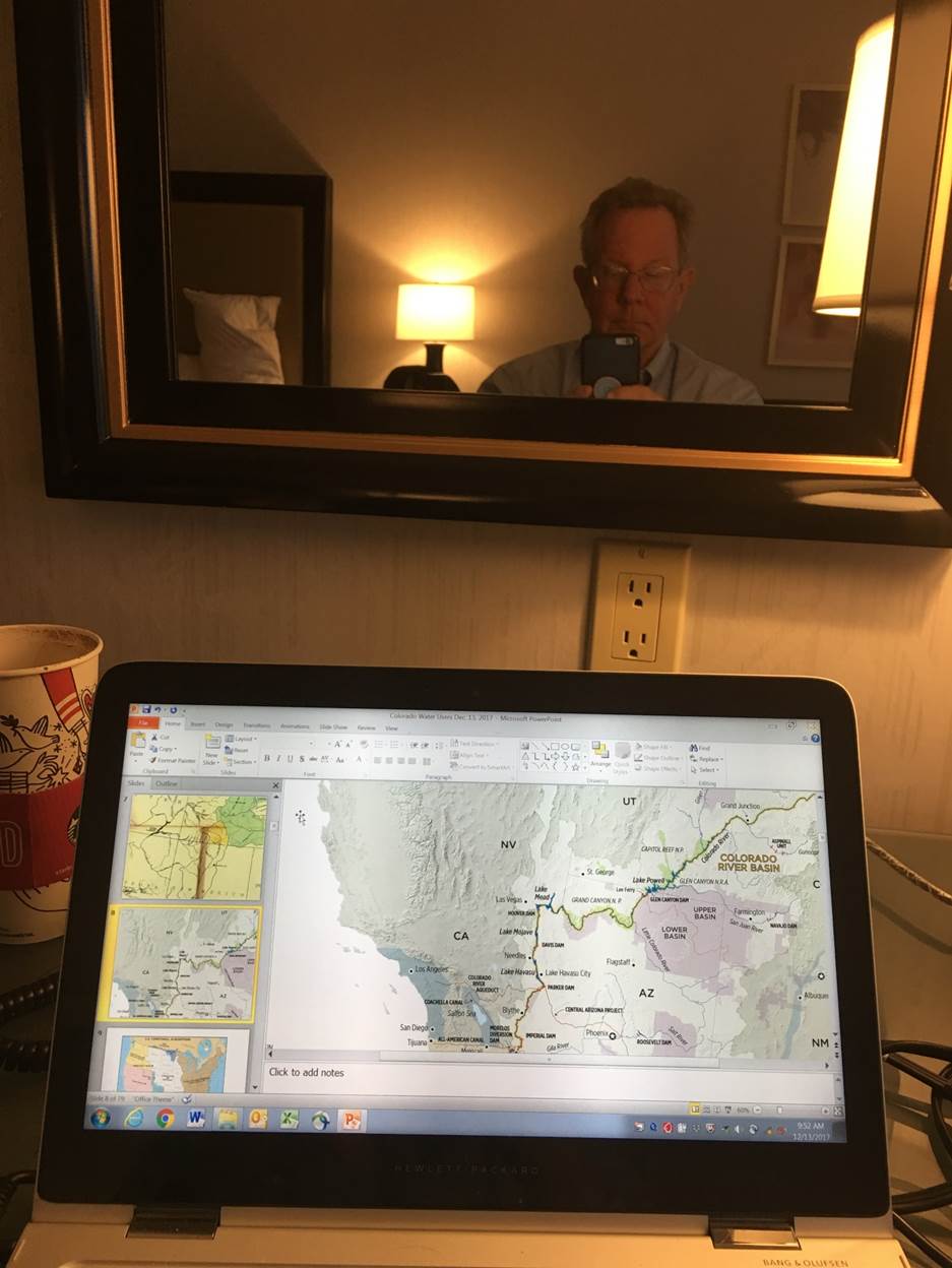
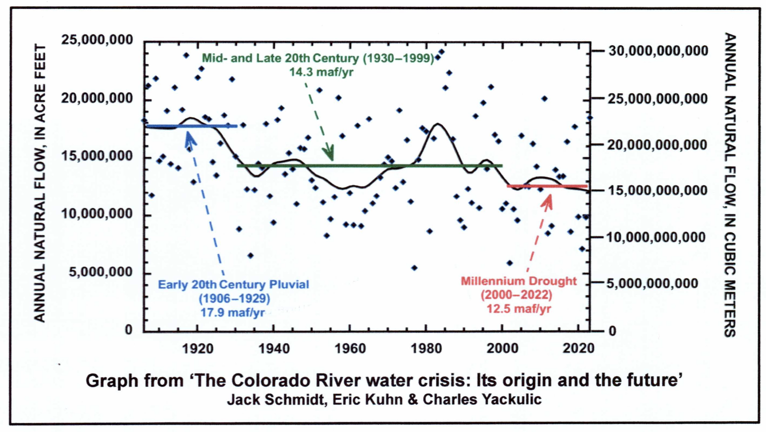


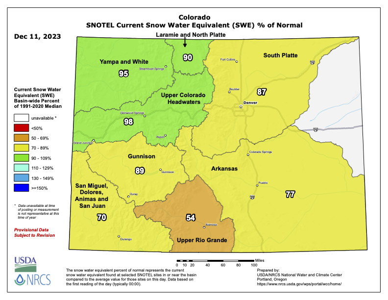
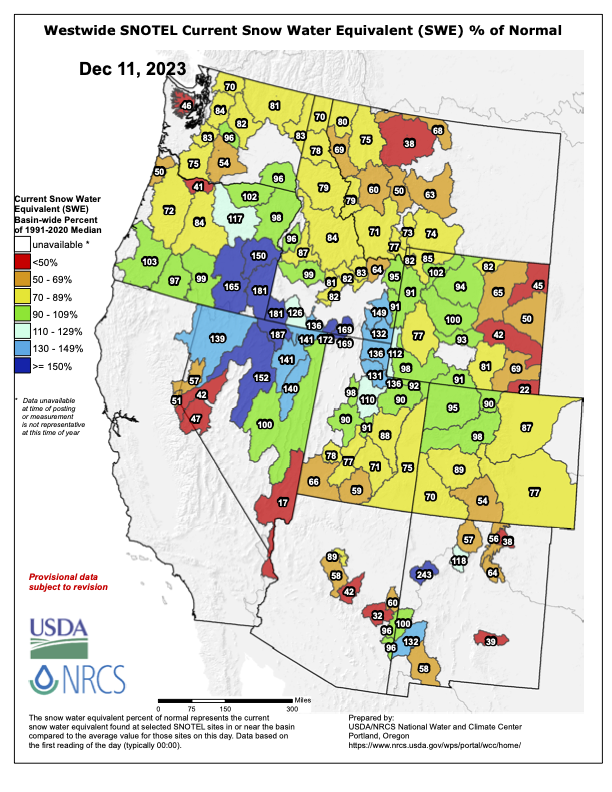
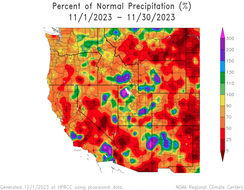
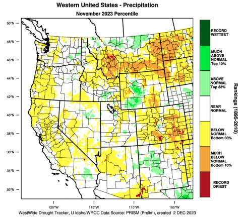
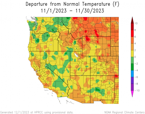
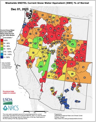
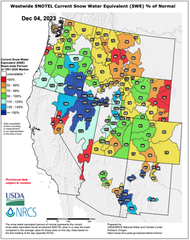
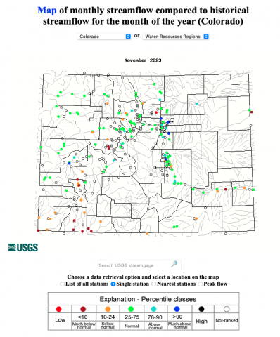
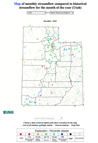
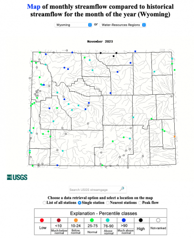
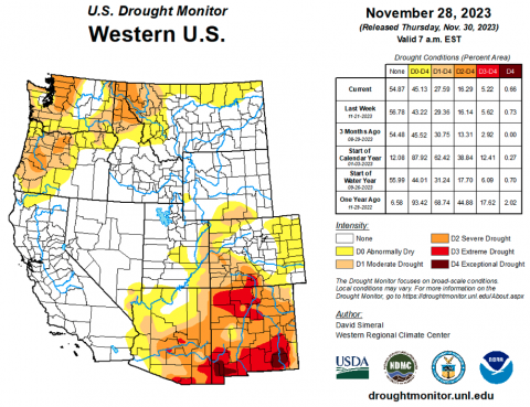
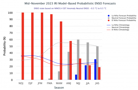
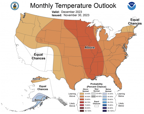

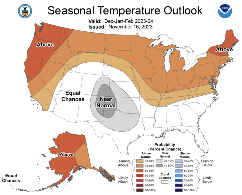

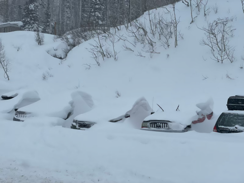
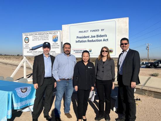

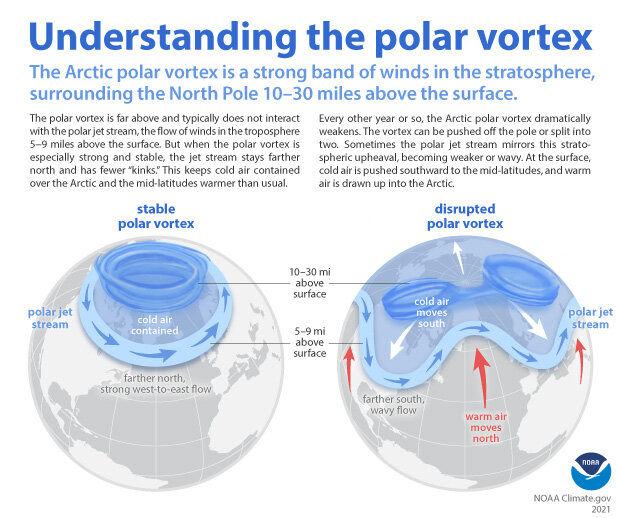
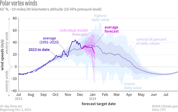
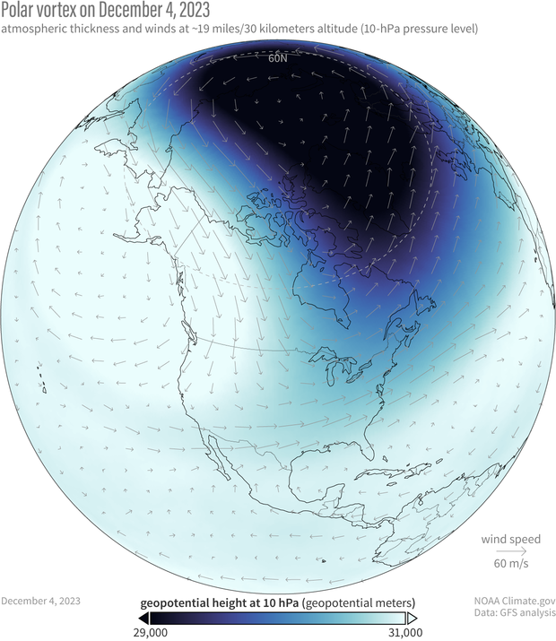


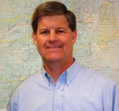


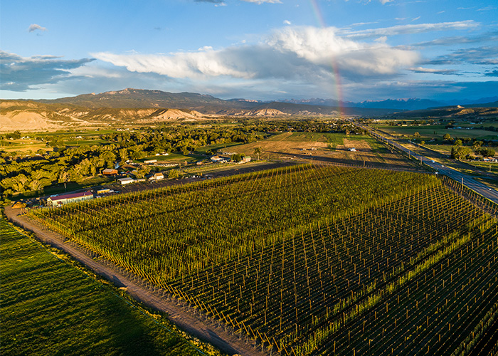
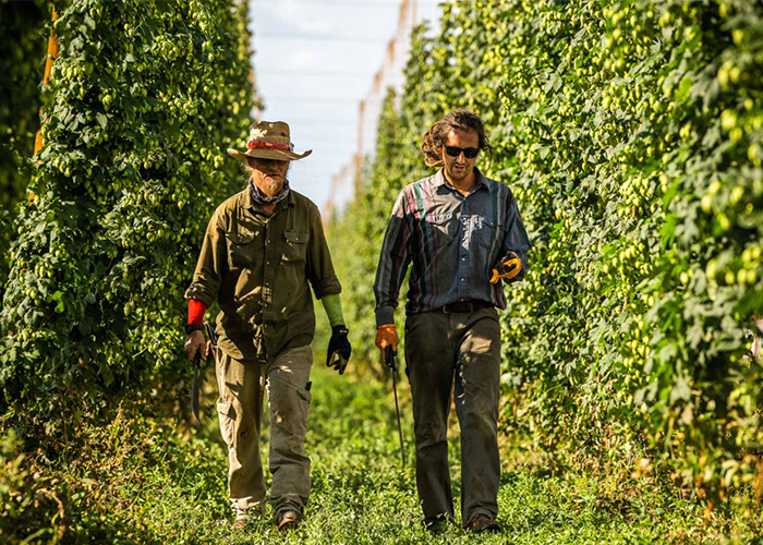

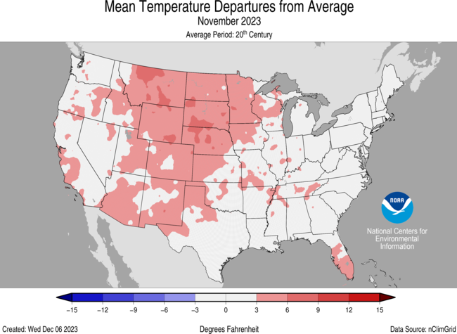
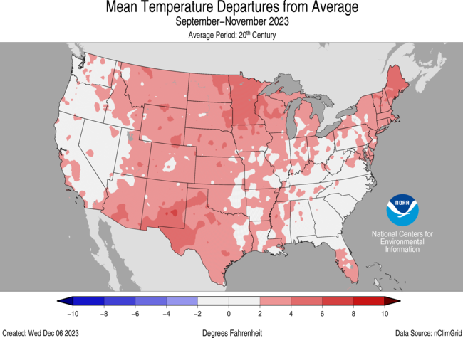


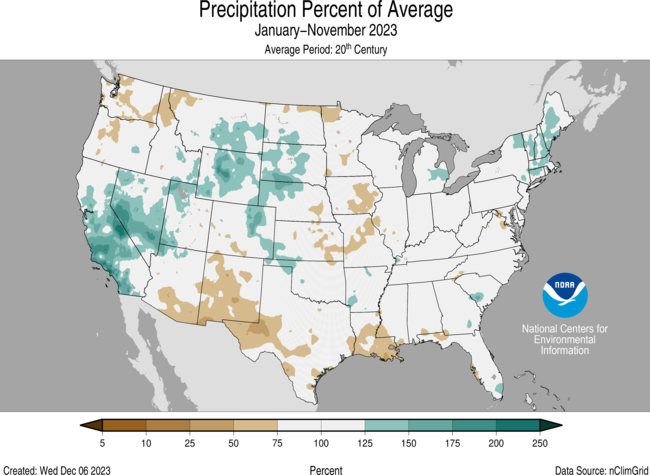
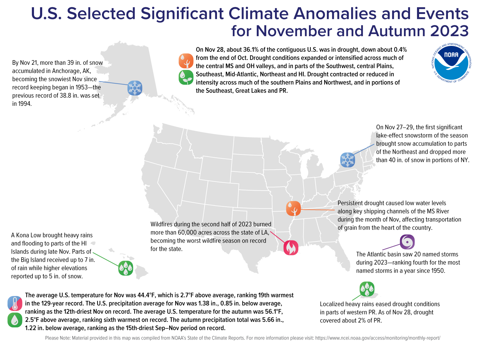


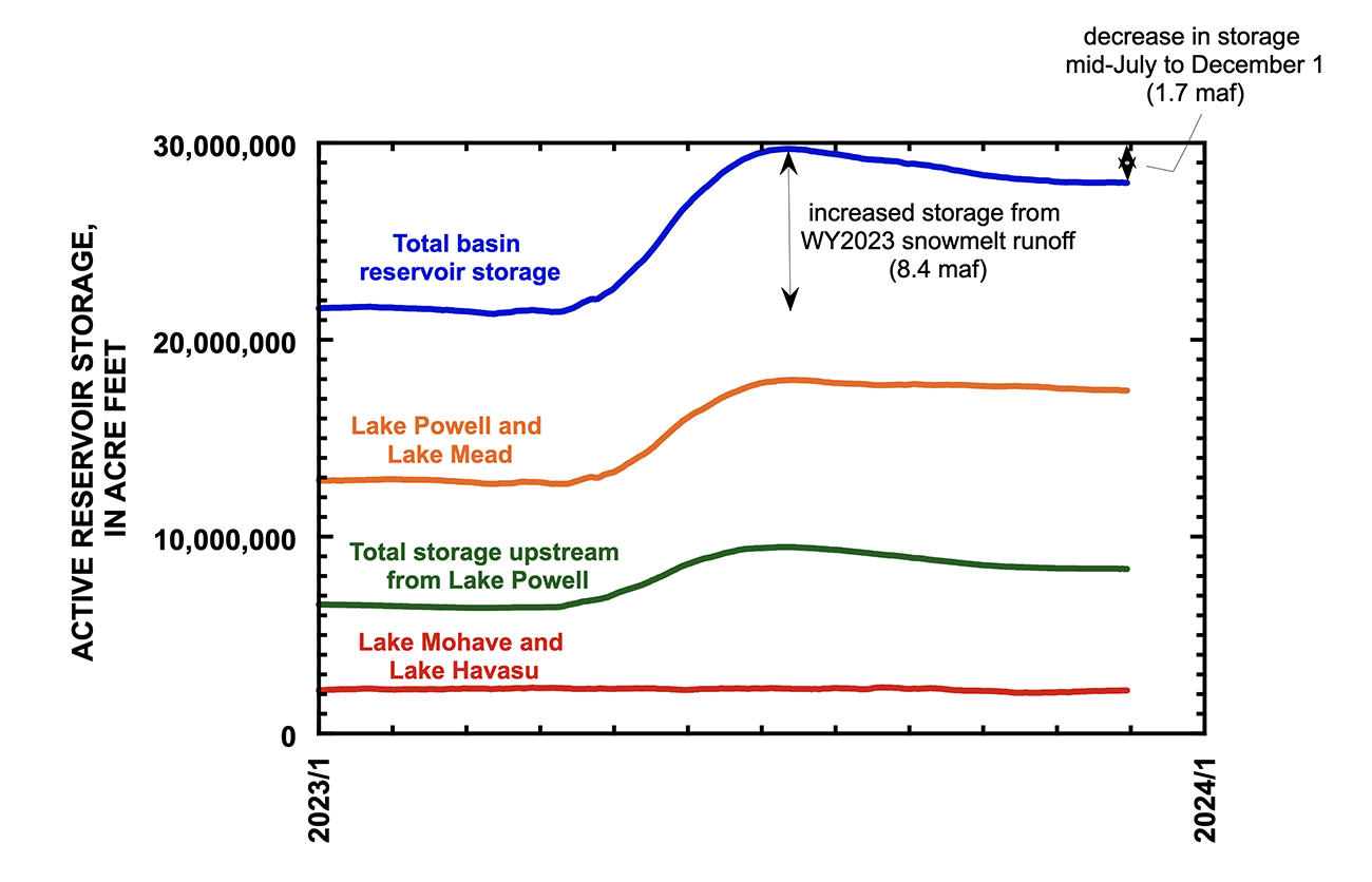
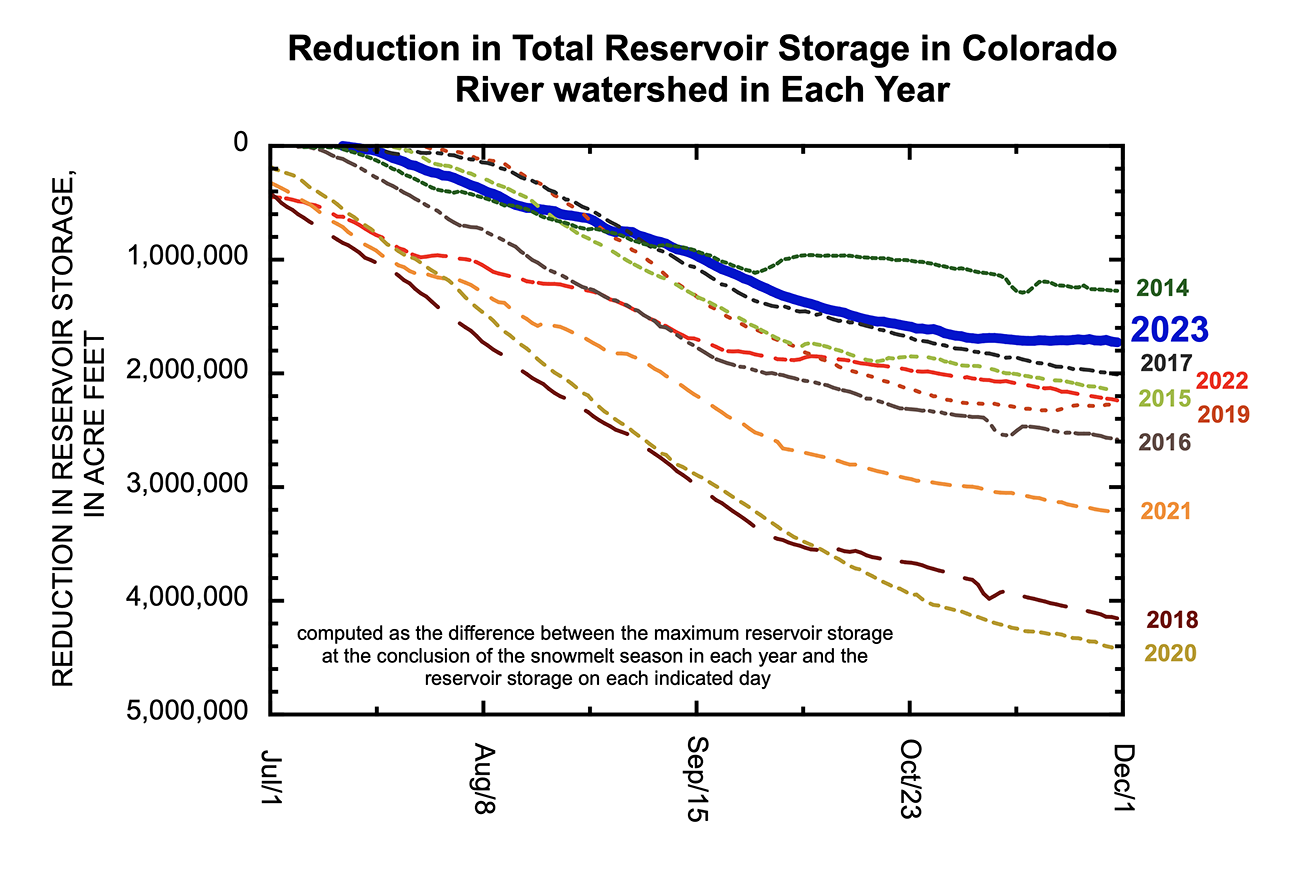
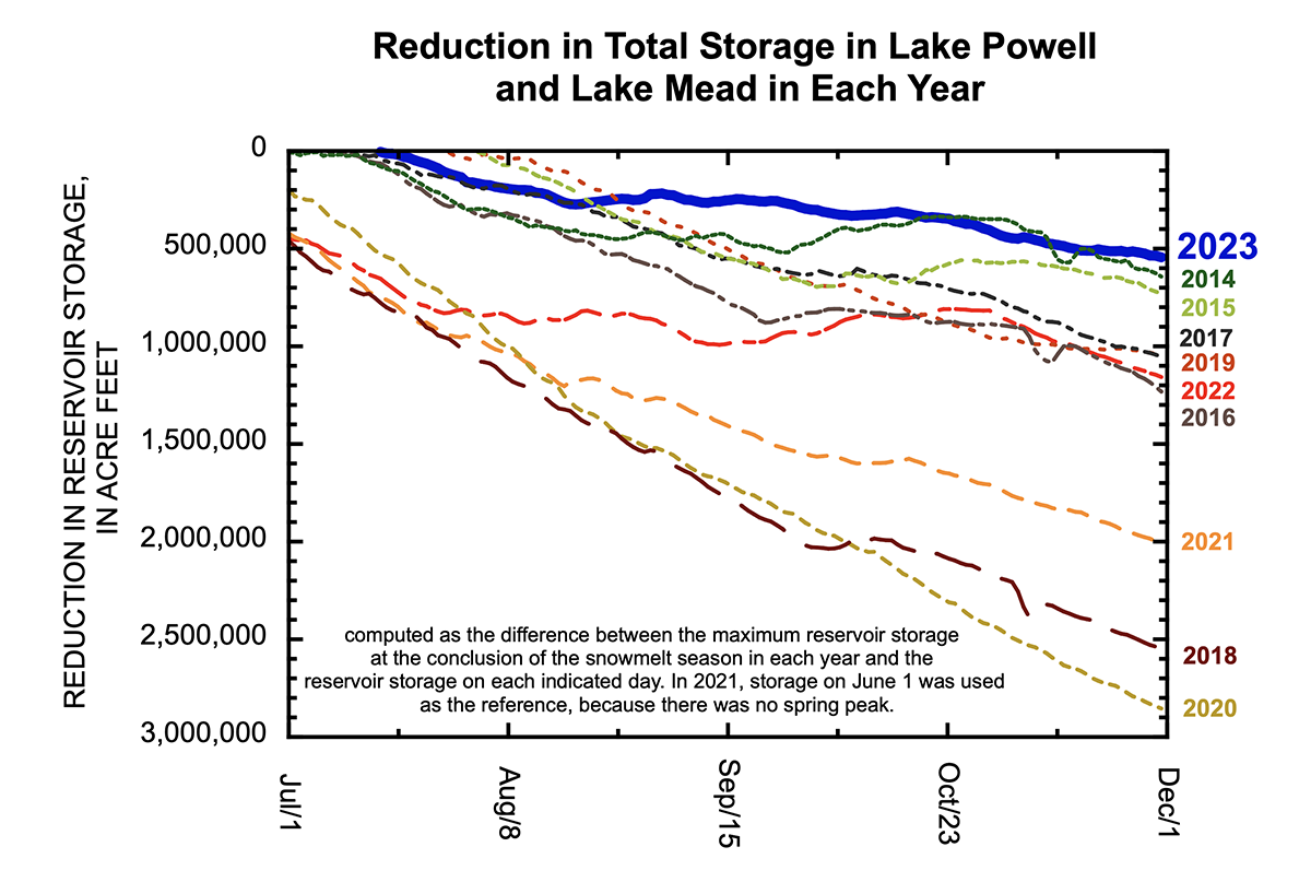
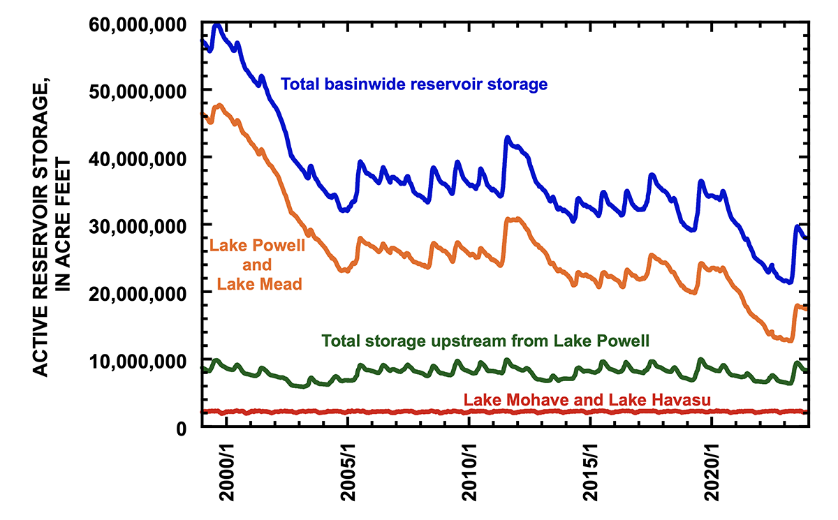


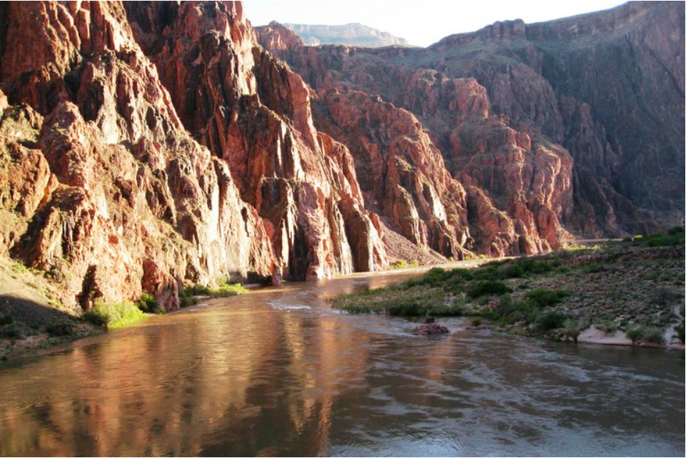

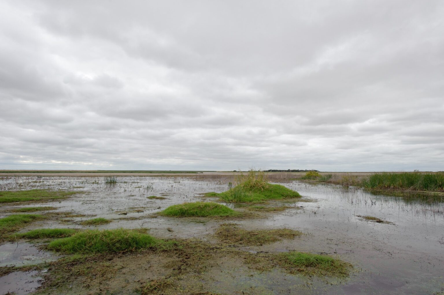

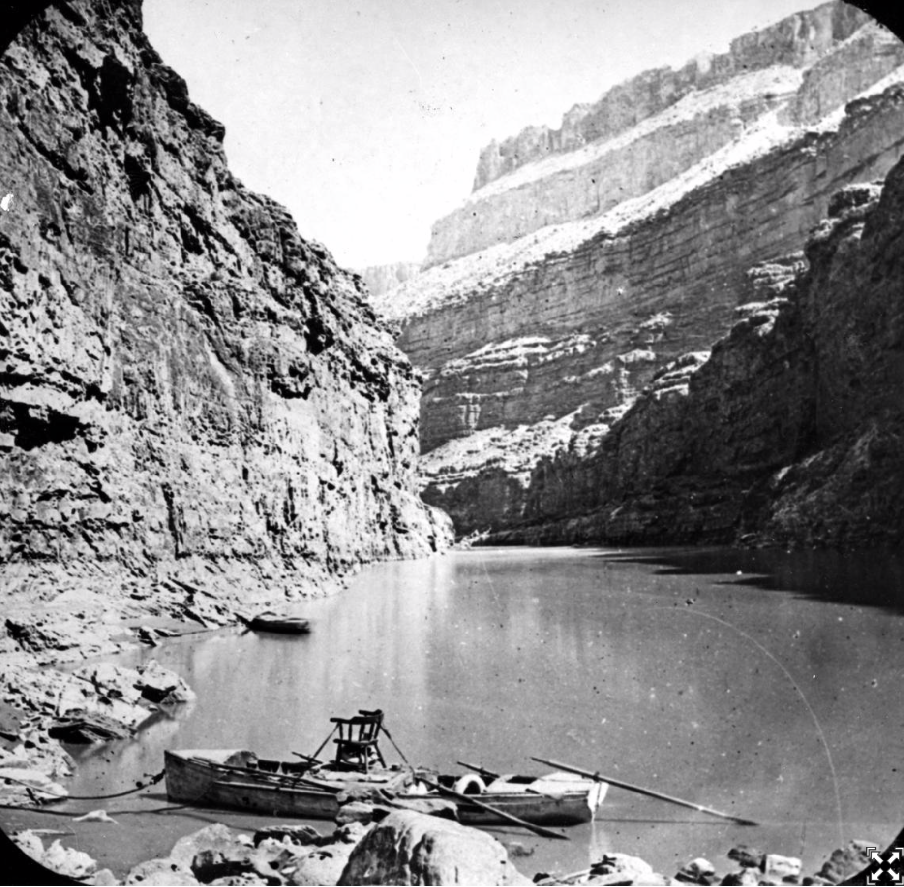
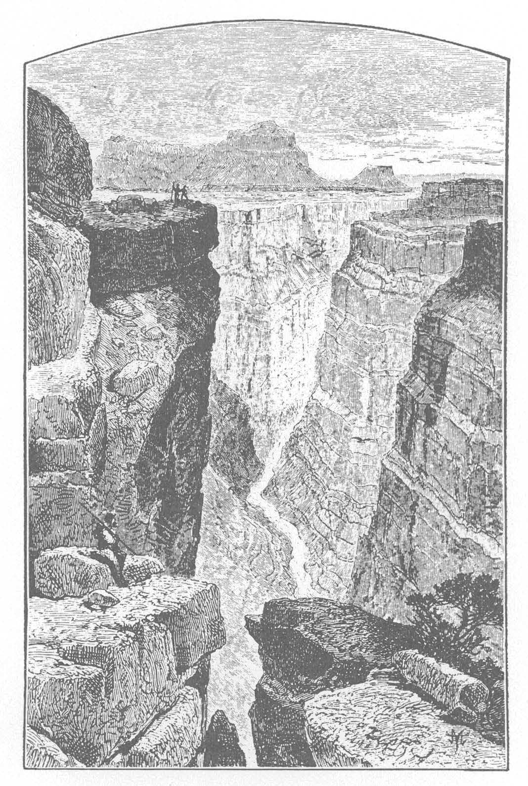


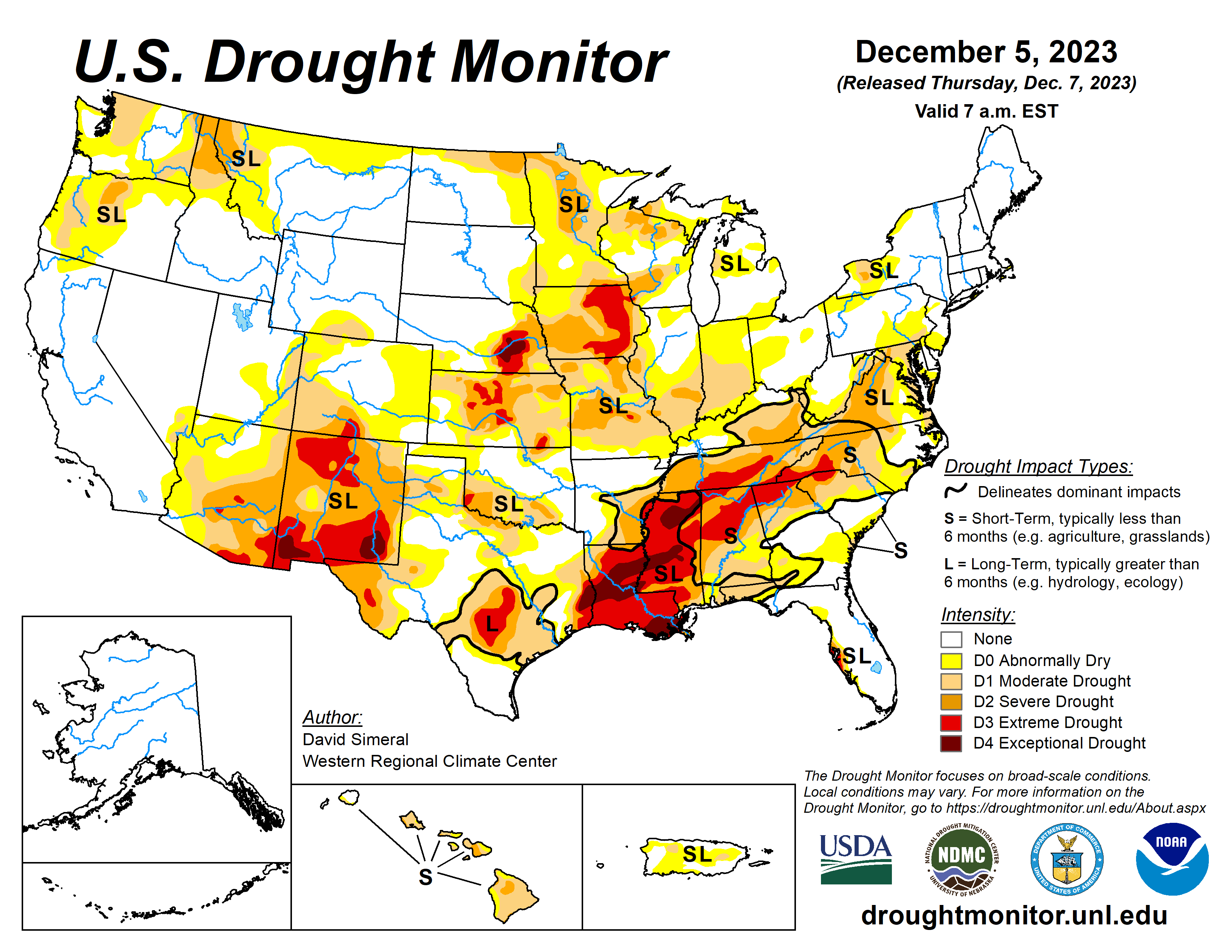
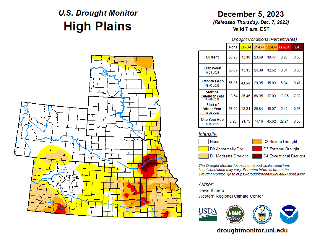


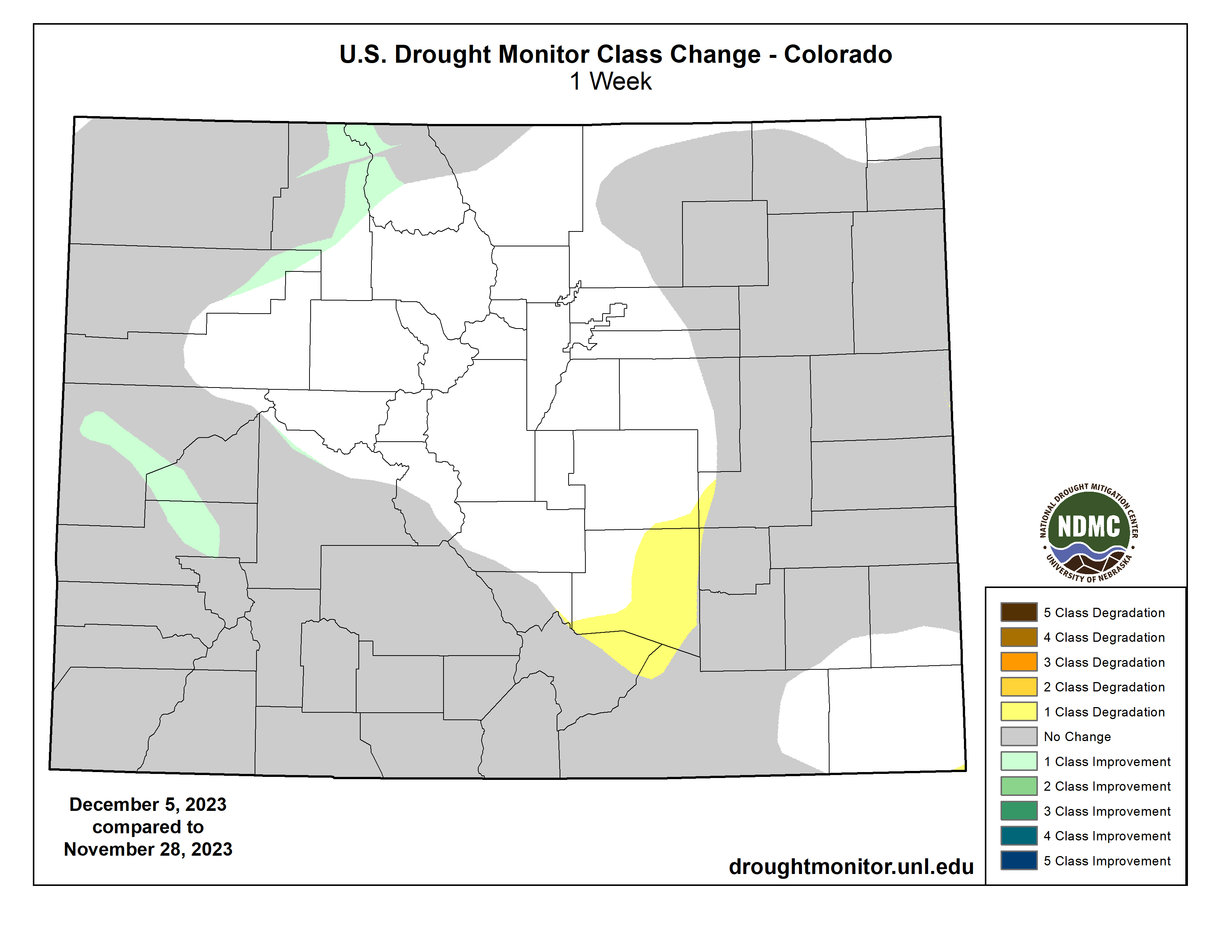
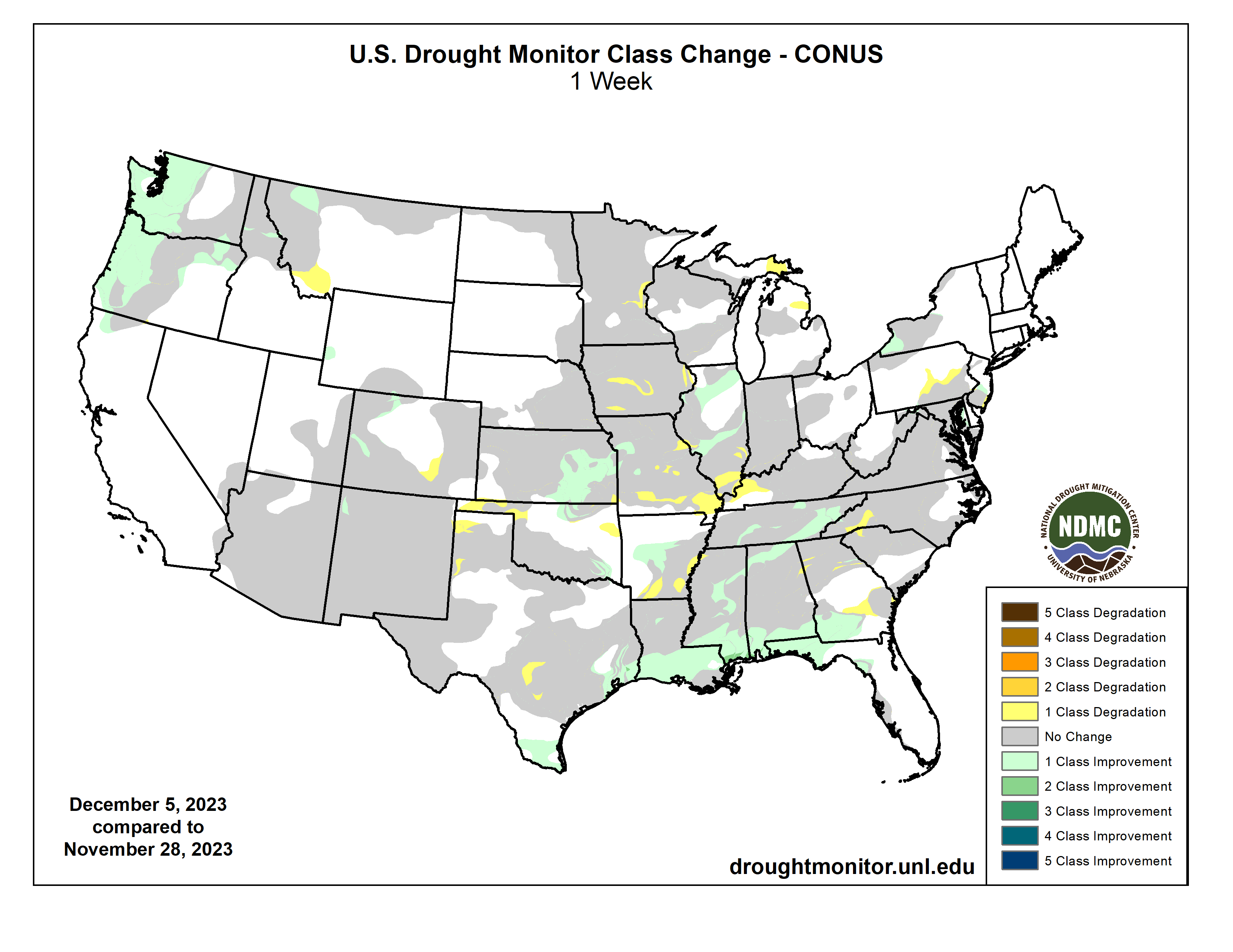
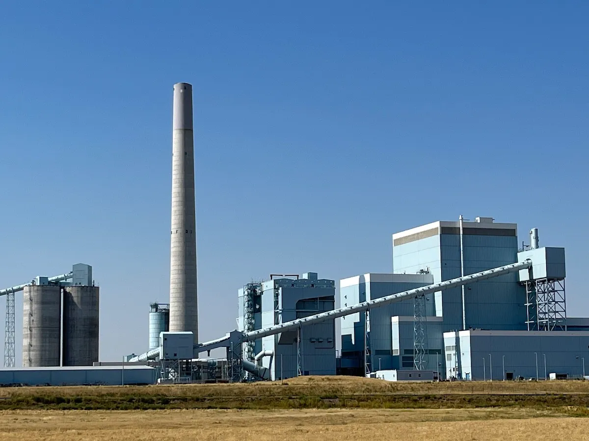
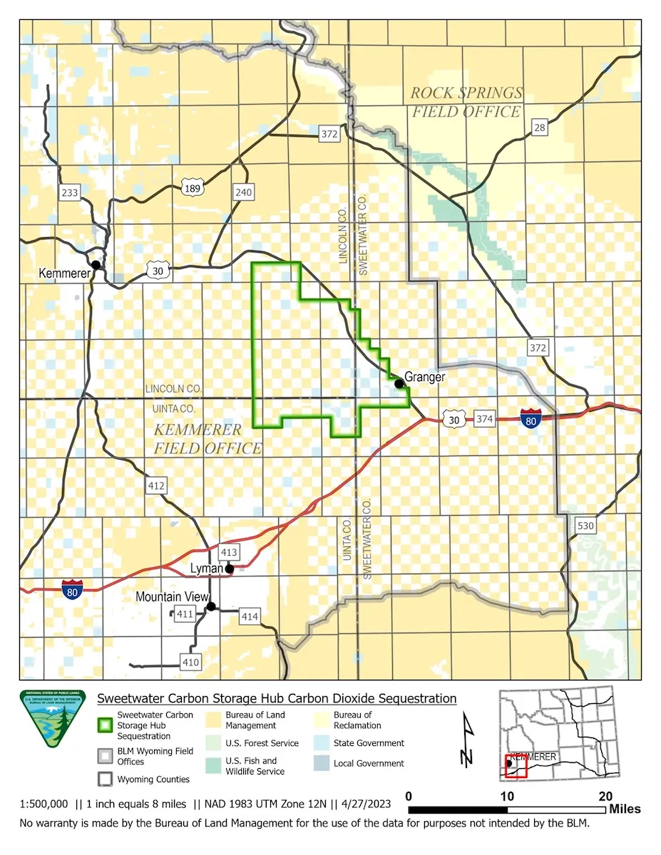


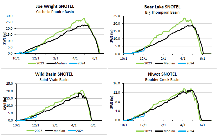


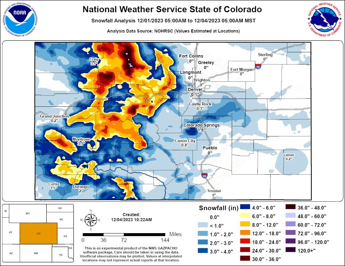


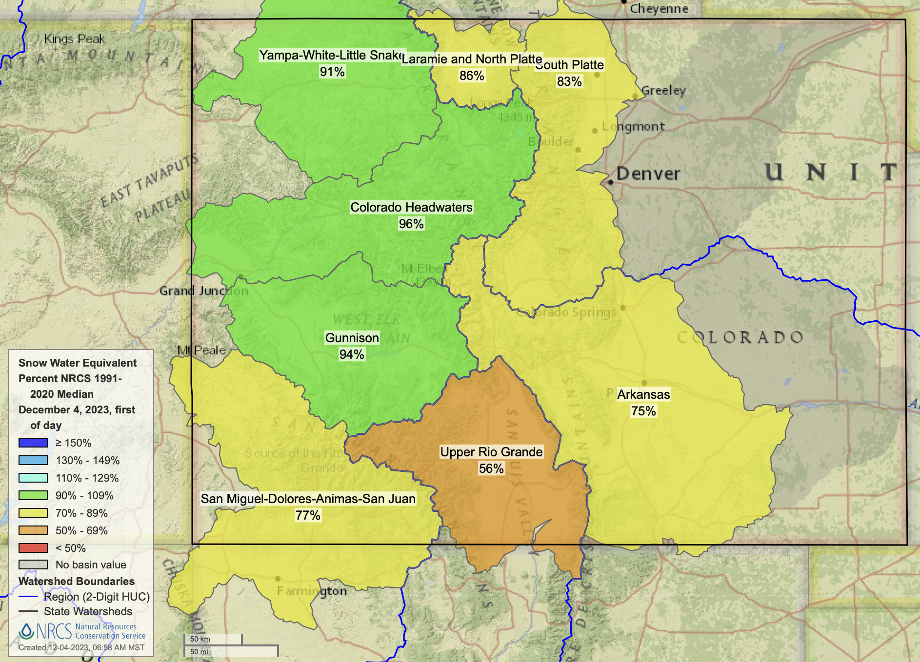
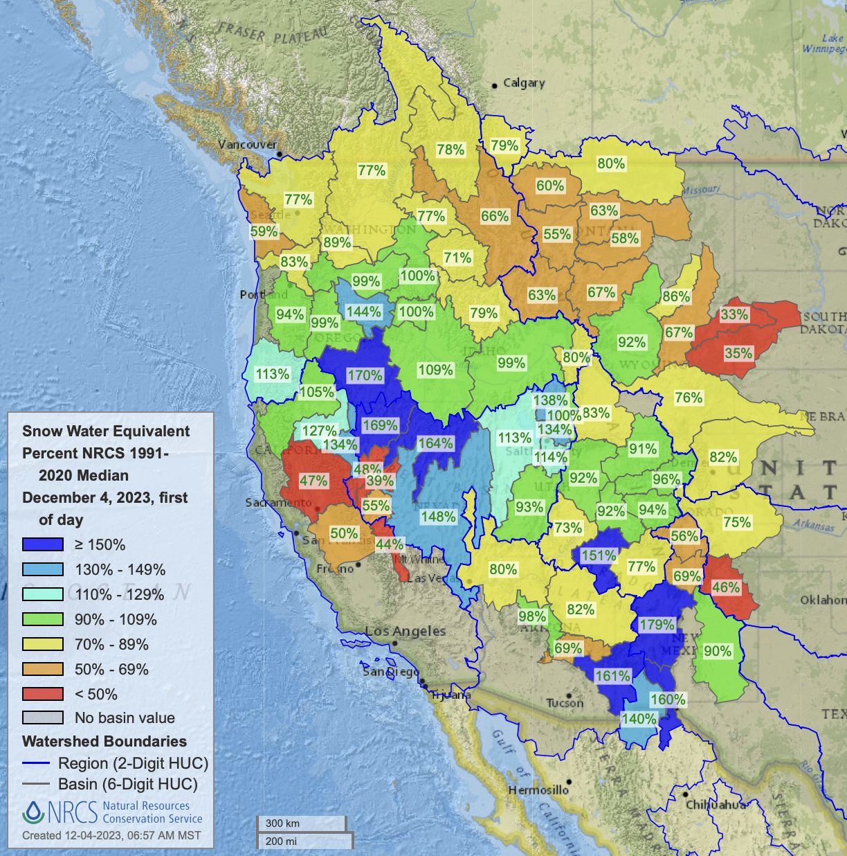
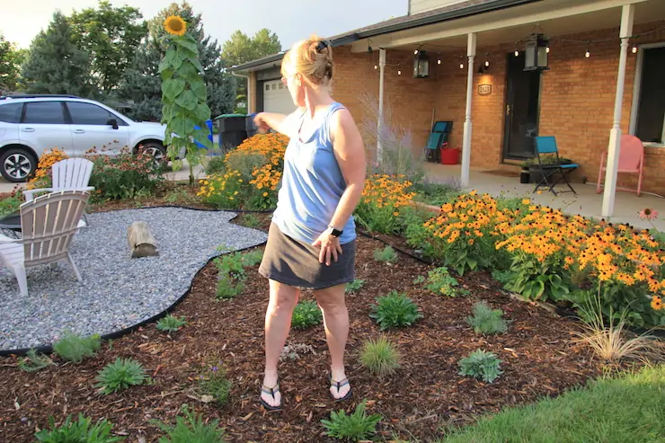
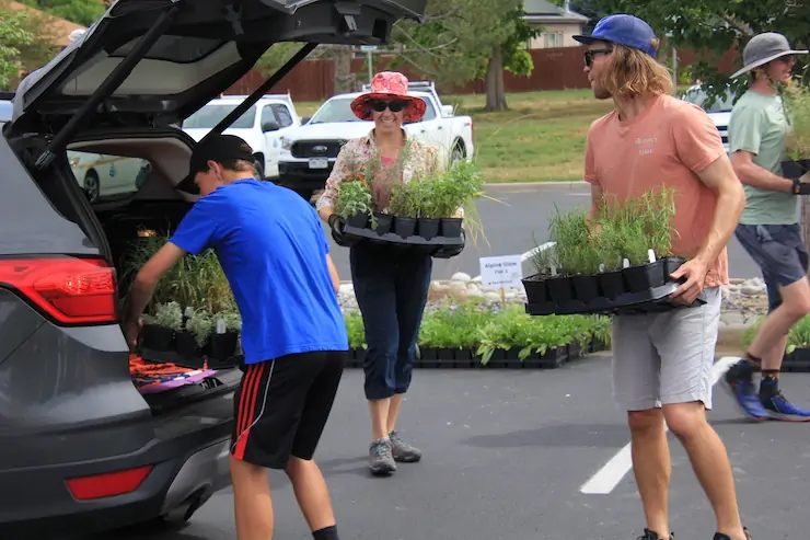
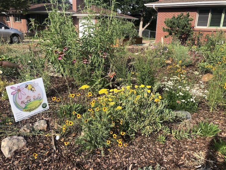
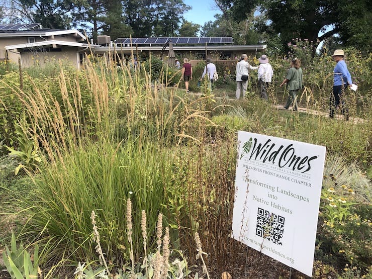


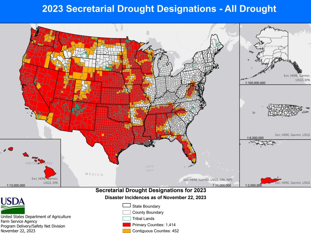

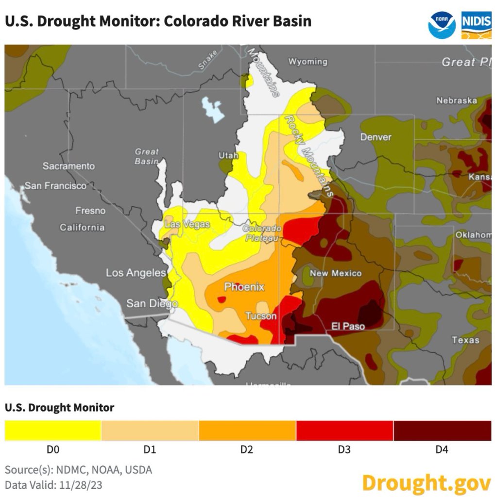


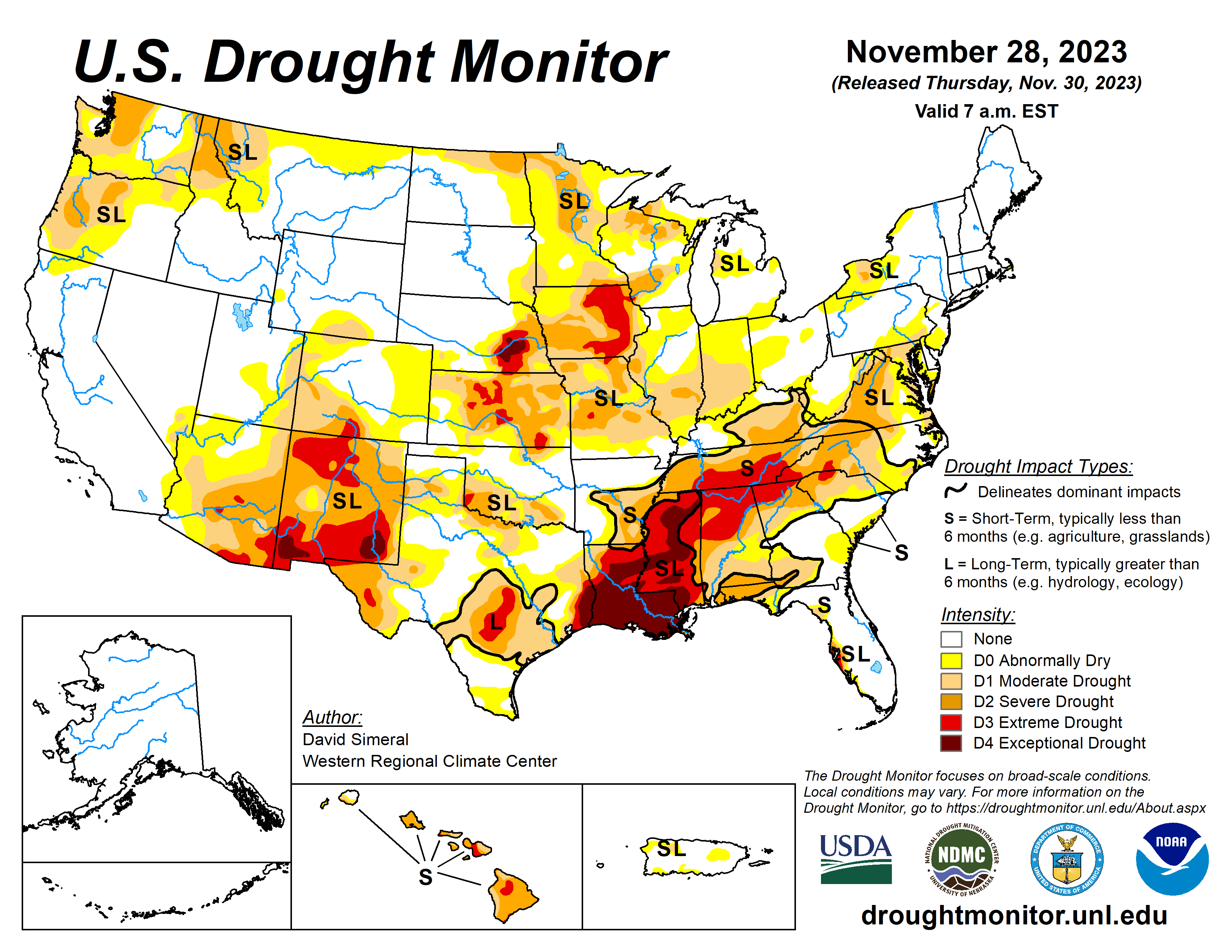
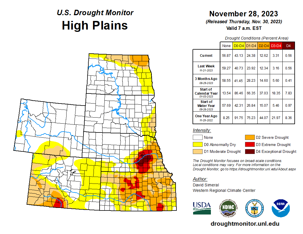
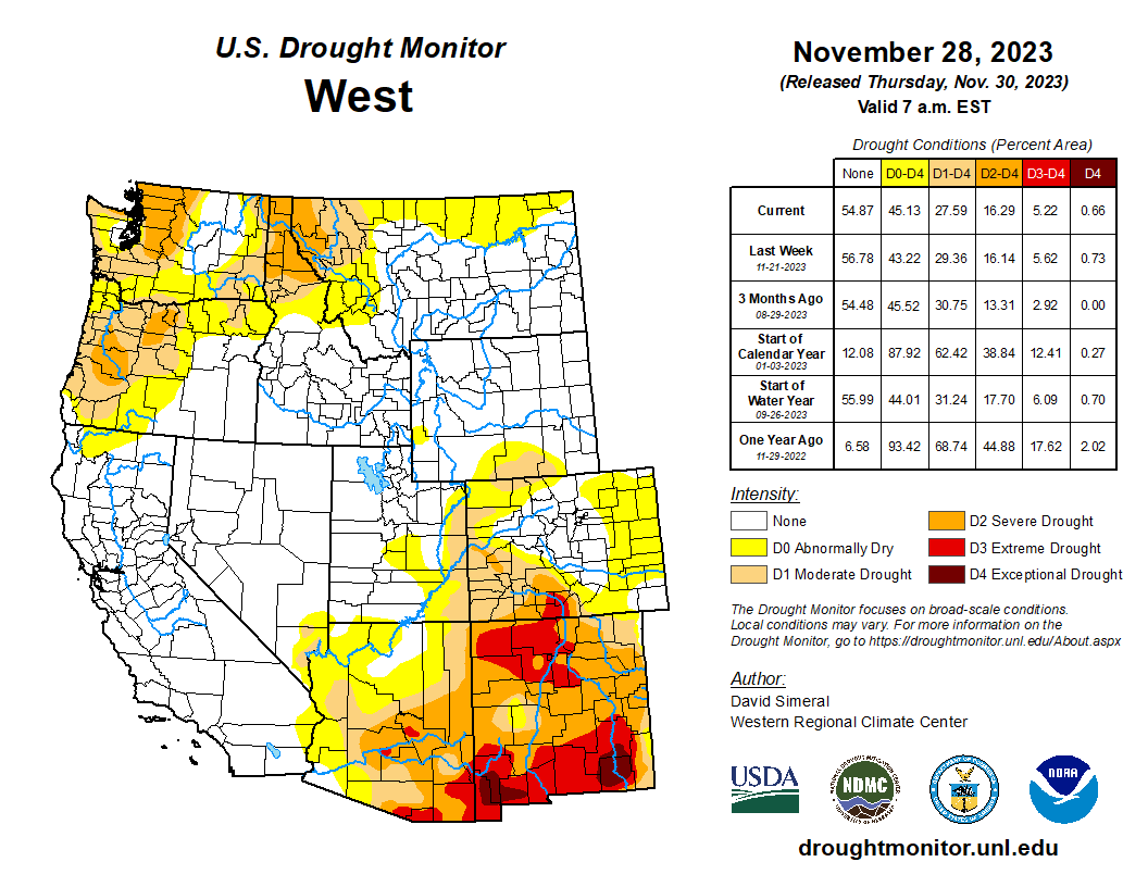
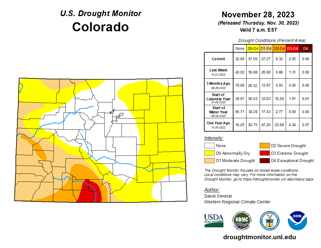
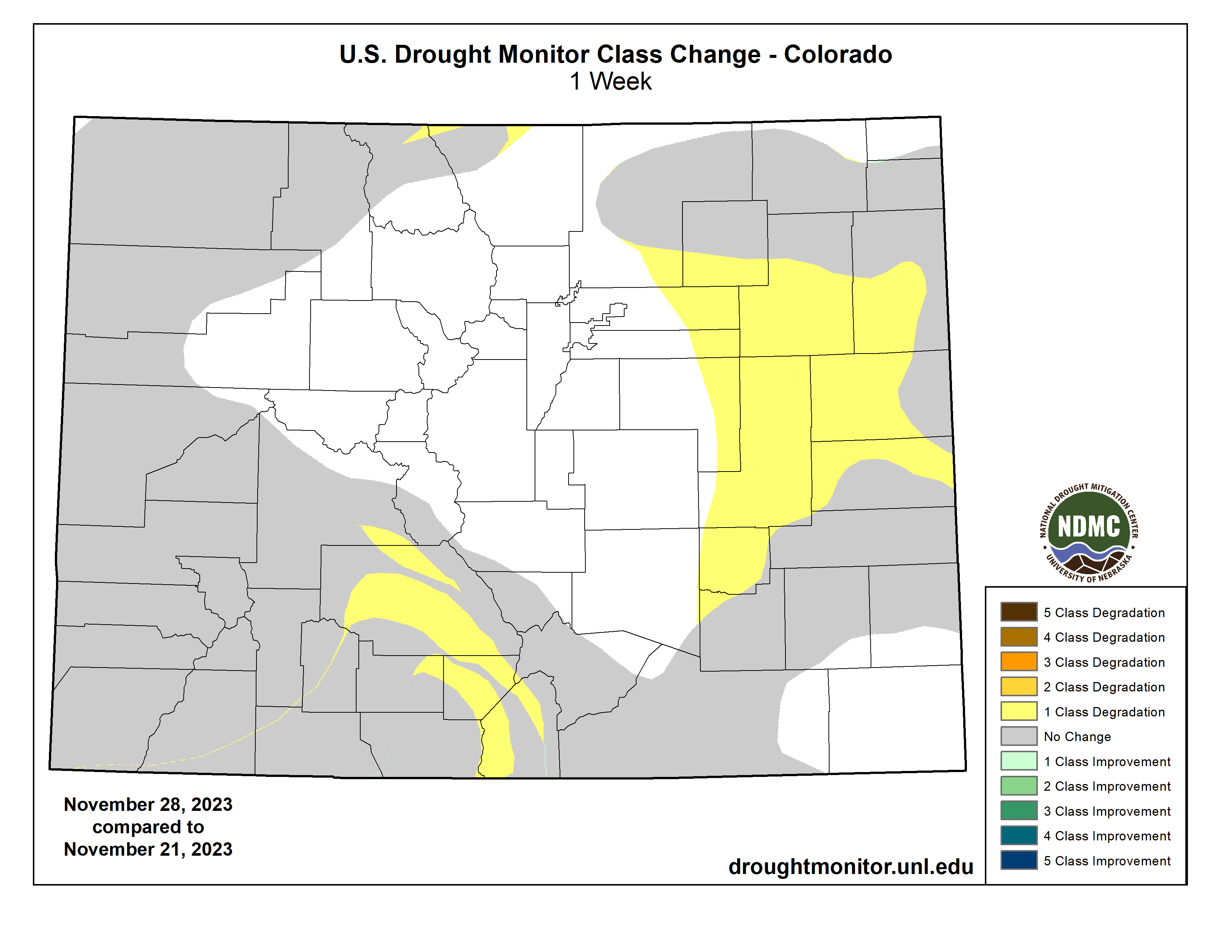
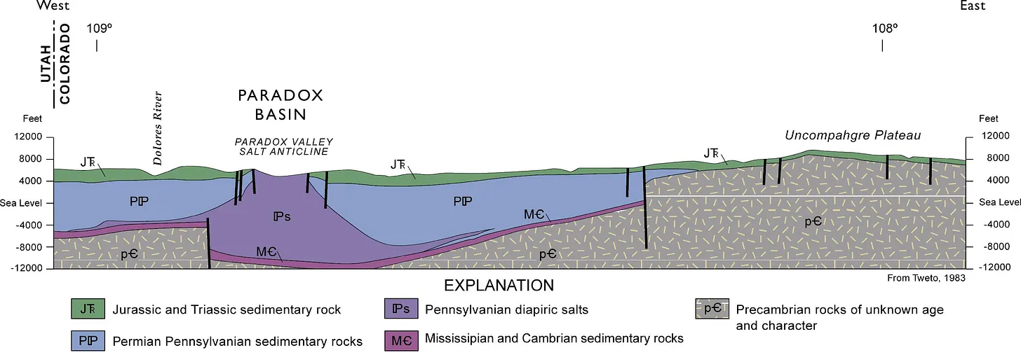

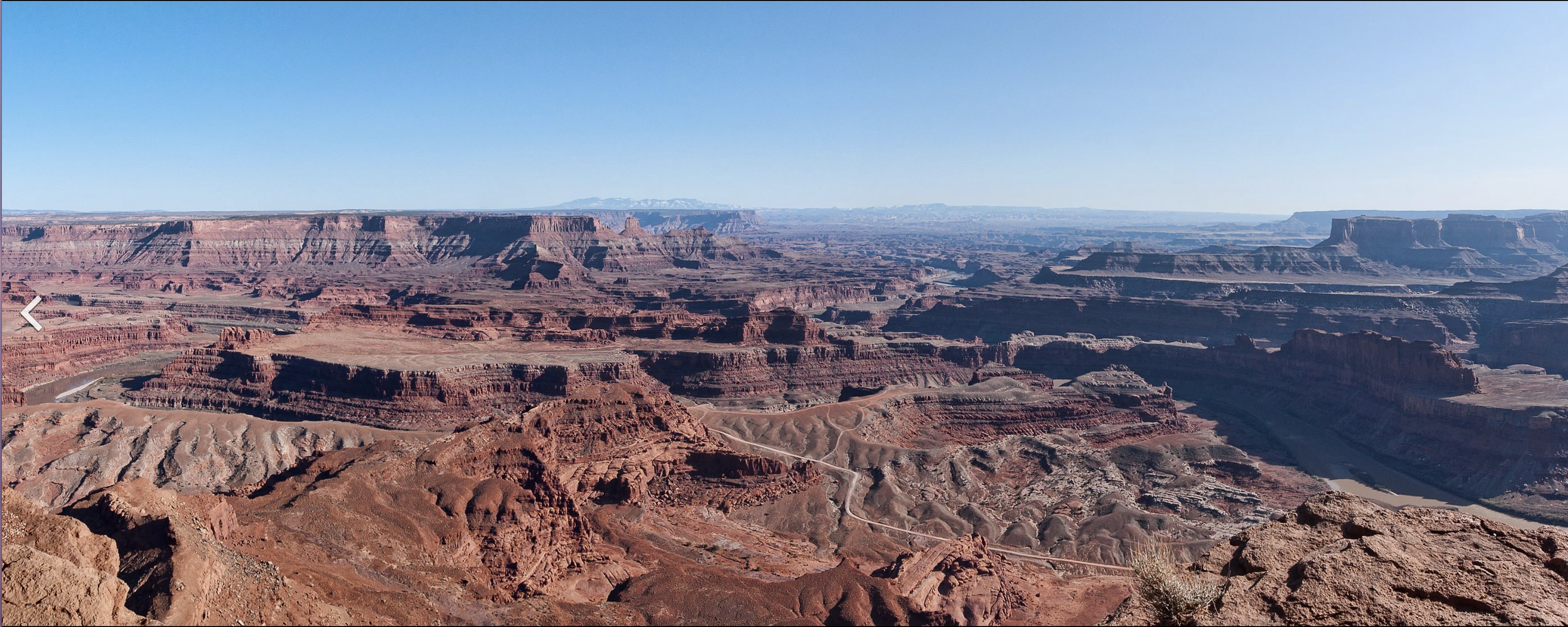


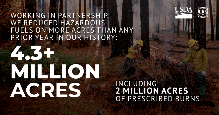
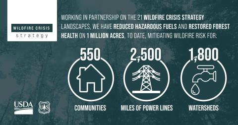


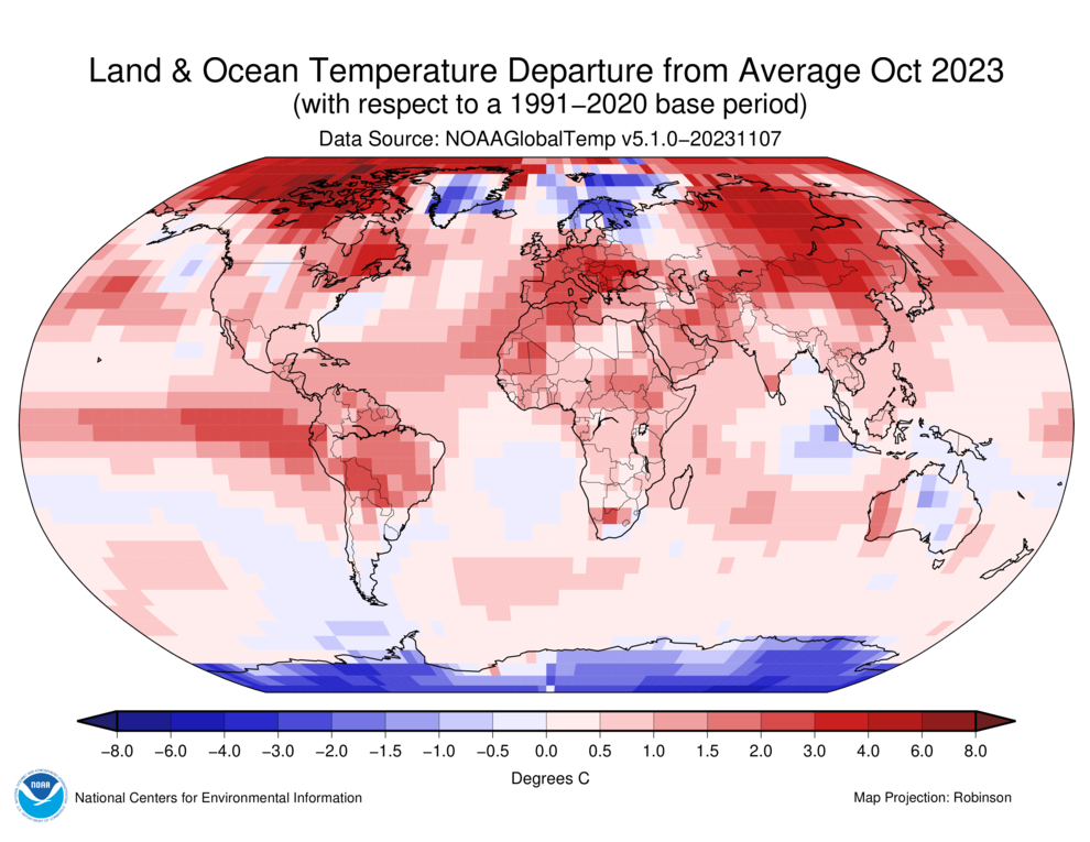
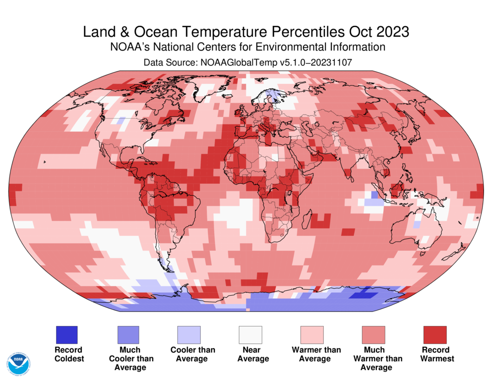
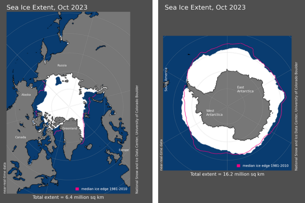
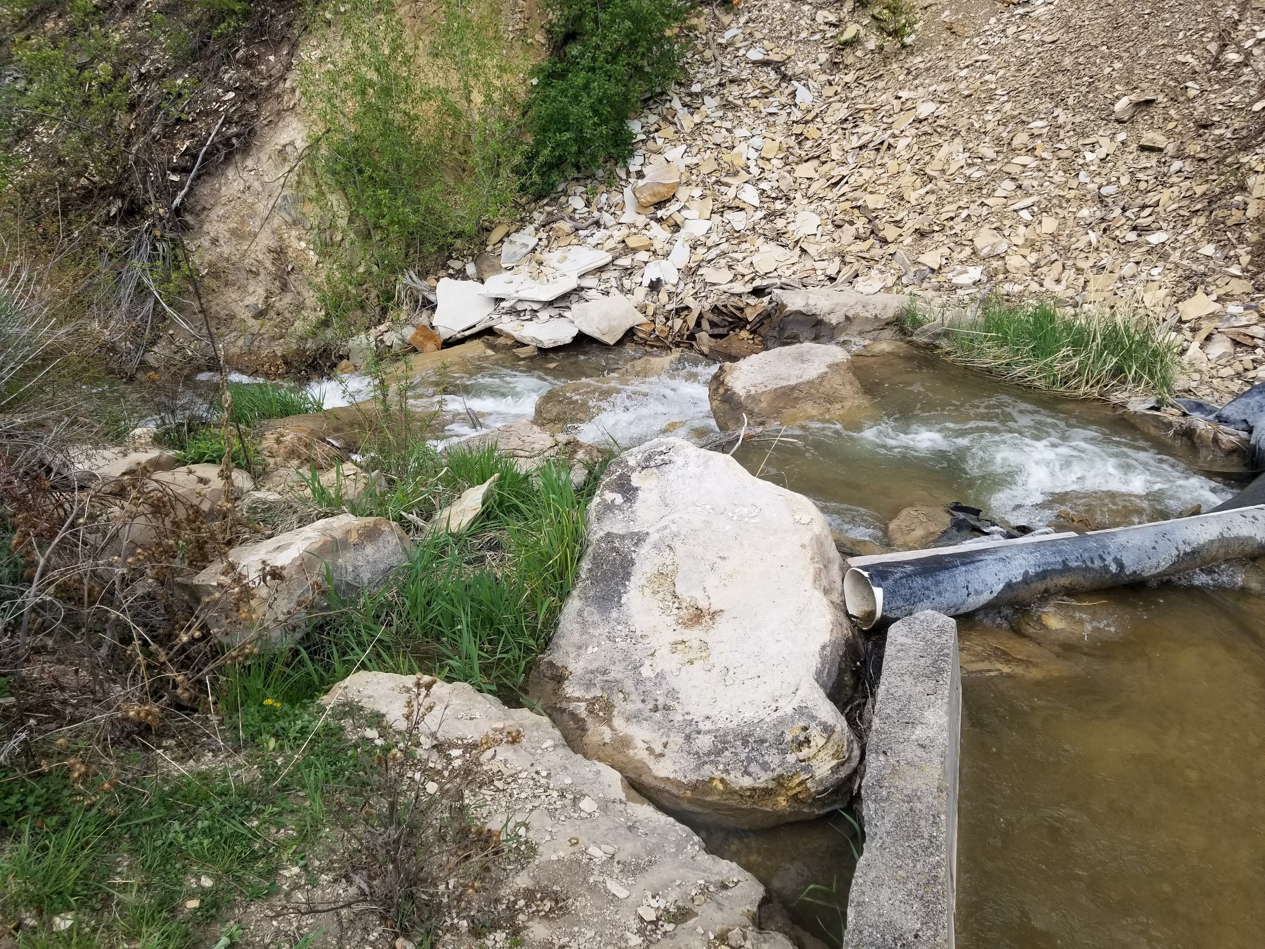

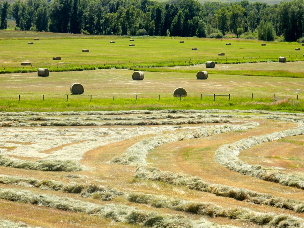
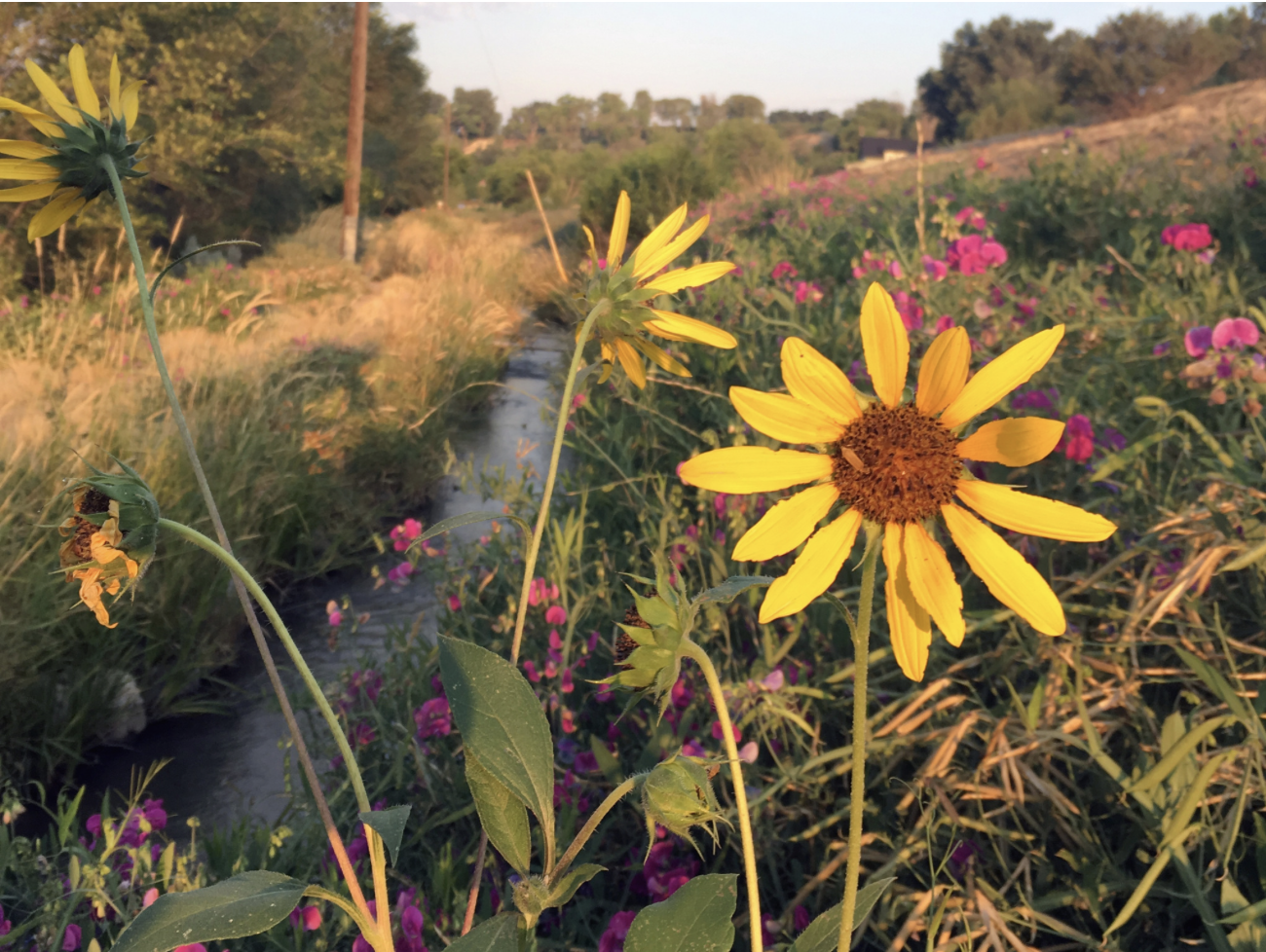


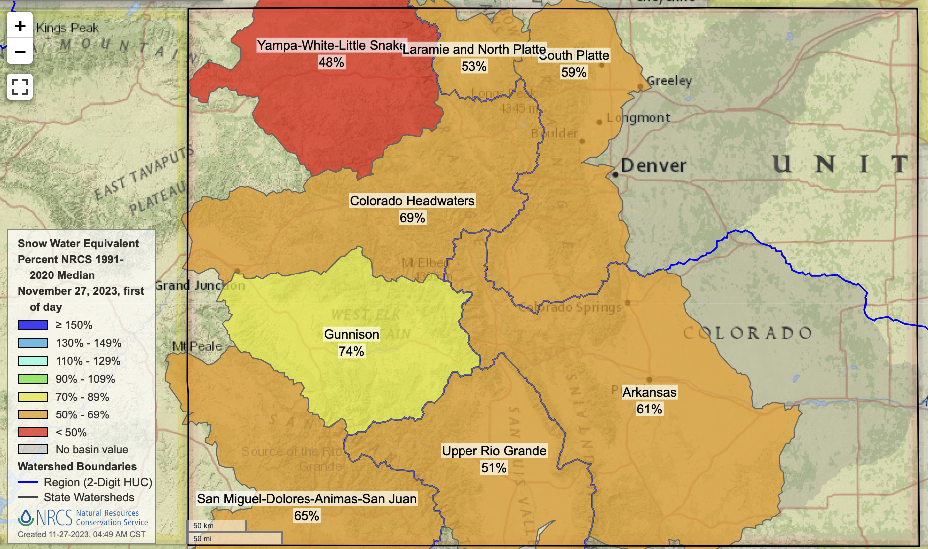
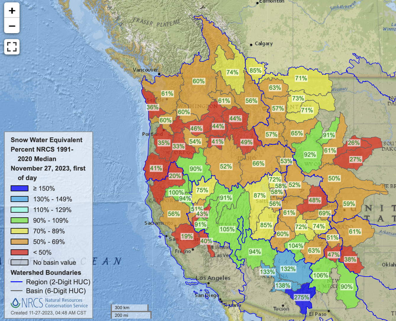


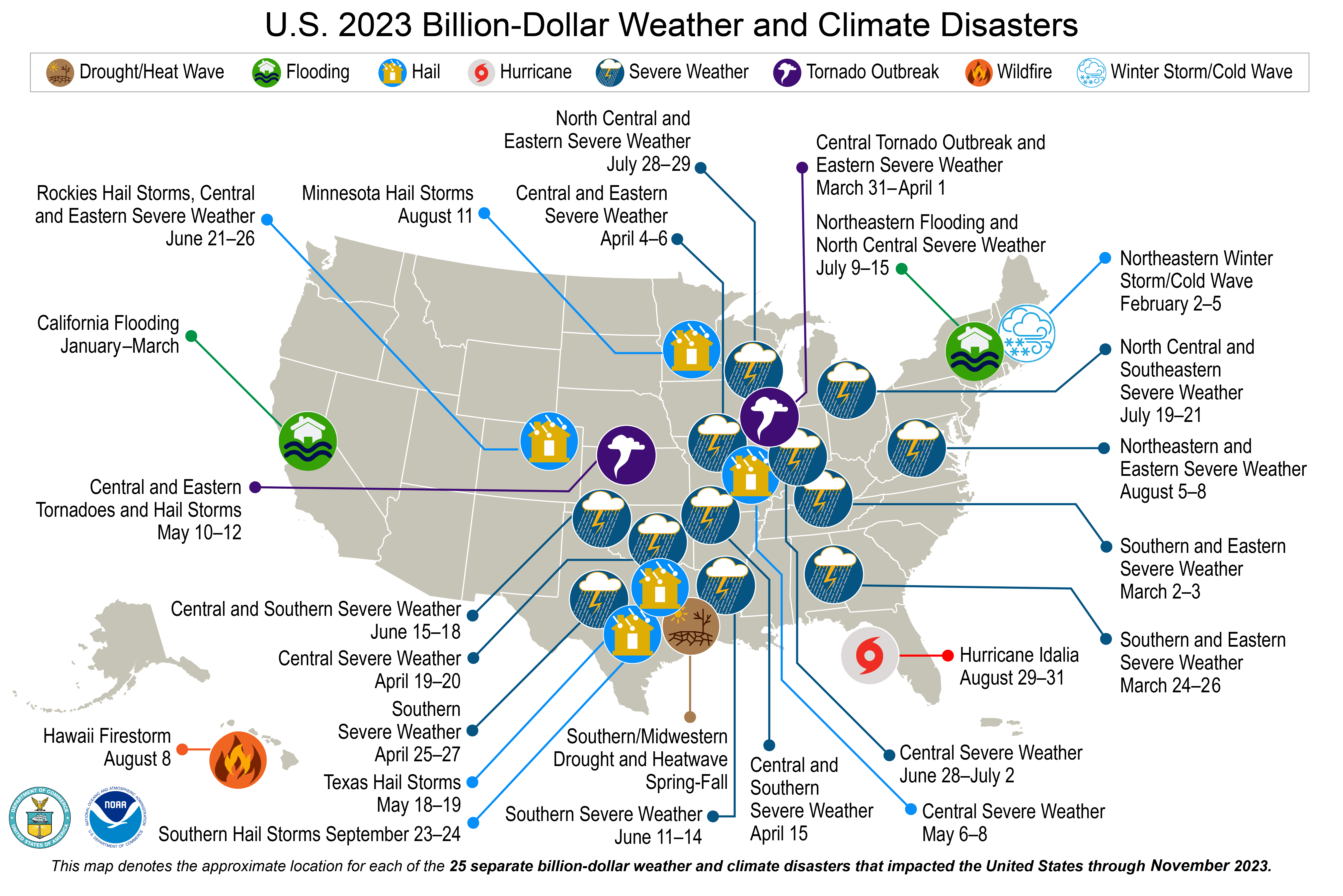