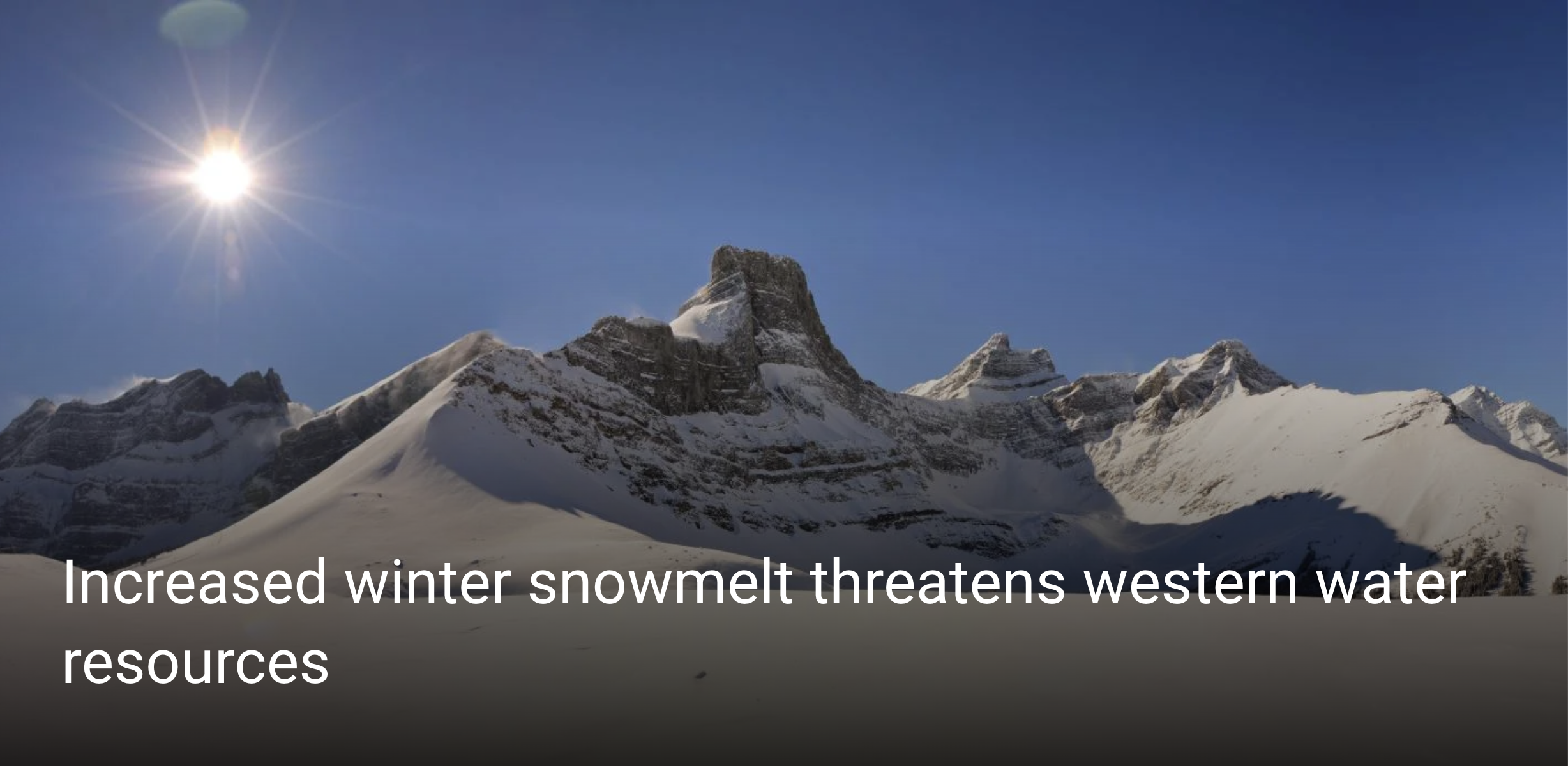
More snow is melting during winter across the West, a concerning trend that could impact everything from ski conditions to fire danger and agriculture, according to a new CU Boulder analysis of 40 years of data.
Researchers found that since the late 1970s, winter’s boundary with spring has been slowly disappearing, with one-third of 1,065 snow measurement stations from the Mexican border to the Alaskan Arctic recording increasing winter snowmelt. While stations with significant melt increases have recorded them mostly in November and March, the researchers found that melt is increasing in all cold season months—from October to March.
Their new findings, published today in Nature Climate Change, have important implications for water resource planning and may indicate fewer pristine powder days and crustier snow for skiers.
“Particularly in cold mountain environments, snow accumulates over the winter—it grows and grows—and gets to a point where it reaches a maximum depth, before melt starts in the spring,” said Keith Musselman, lead author on the study and research associate at the Institute of Arctic and Alpine Research (INSTAAR) at CU Boulder.
Combined photos of the Senator Beck basin in the Colorado San Juan mountains during increasingly warmer months. (Credit: Jeffrey Deems/CIRES and Matthew Kennedy/CU Boulder Extreme Ice Survey)
But the new research found that melt before April 1 has increased at almost half of more than 600 stations in western North America, by an average of 3.5% per decade.
“Historically, water managers use the date of April 1 to distinguish winter and spring, but this distinction is becoming increasingly blurred as melt increases during the winter,” said Noah Molotch, co-author on the study, associate professor of geography and fellow at INSTAAR.
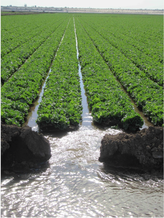
Snow is the primary source of water and streamflow in western North America and provides water to 1 billion people globally. In the West, snowy mountains act like water towers, reserving water up high until it melts, making it available to lower elevations that need it during the summer, like a natural drip irrigation system.
“That slow trickle of meltwater that reliably occurs over the dry season is something that we have built our entire water infrastructure on in the West,” said Musselman. “We rely very heavily on that water that comes down our rivers and streams in the warm season of July and August.”
More winter snowmelt is effectively shifting the timing of water entering the system, turning that natural drip irrigation system on more frequently in the winter, shifting it away from the summer, he said.
This is a big concern for water resource management and drought prediction in the West, which depends heavily on late winter snowpack levels in March and April. This shift in water delivery timing could also affect wildfire seasons and agricultural irrigation needs.
Wetter soils in the winter also have ecological implications. One, the wet soils have no more capacity to soak up additional water during spring melt or rainstorms, which can increase flash flooding. Wetter winter soils also keep microbes awake and unfrozen during a time they might otherwise lay dormant. This affects the timing of nutrient availability, water quality and can increase carbon dioxide emissions.
SNOTEL automated data collection site. Credit: NRCS
An underutilized data source
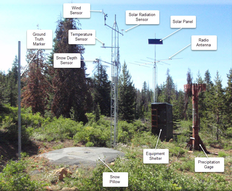
Across the western U.S., hundreds of thin, fluid-filled metal pillows are carefully tucked away on the ground and out of sight from outdoor enthusiasts. These sensors are part of an extensive network of long-running manual and automated snow observation stations, which you may have even used data from when looking up how much snow is on your favorite snowshoeing or Nordic skiing trail.
This new study is the first to compile data from all 1,065 automated stations in western North America, providing valuable statistical insight into how mountain snow is changing.
And by using automated, continuously recording snowpack stations instead of manual, monthly observations, the new research shows that winter melt trends are very widespread—at three-times the number of stations with snowpack declines, according to Musselman.
Snowpack is typically measured by calculating how much water will be produced when it melts, known as snow-water equivalent (SWE), which is affected by how much snow falls from the sky in a given season. But because winter snowpack melt is influenced more by temperature than by precipitation, it is a better indicator of climate warming over time.
“These automated stations can be really helpful to understand potential climate change impacts on our resources,” said Musselman. “Their observations are consistent with what our climate models are suggesting will continue to happen.”
Other authors on this publication include Nans Addor at the University of Exeter and Julie Vano at the Aspen Global Change Institute.
The U.S. Supreme Court has ruled in Sackett v. EPA that federal protection of wetlands encompasses only those wetlands that directly adjoin rivers, lakes and other bodies of water. This is an extremely narrow interpretation of the Clean Water Act that could expose many wetlands across the U.S. to filling and development.
Under this keystone environmental law, federal agencies take the lead in regulating water pollution, while state and local governments regulate land use. Wetlands are areas where land is wet for all or part of the year, so they straddle this division of authority.
Swamps, bogs, marshes and other wetlands provide valuable ecological services, such as filtering pollutants and soaking up floodwaters. Landowners must obtain permits to discharge dredged or fill material, such as dirt, sand or rock, in a protected wetland.
This can be time-consuming and expensive, which is why the Supreme Court’s ruling on May 25, 2023, will be of keen interest to developers, farmers and ranchers, along with conservationists and the agencies that administer the Clean Water Act – namely, the Environmental Protection Agency and the U.S. Army Corps of Engineers.
For the last 45 years – and under eight different presidential administrations – the EPA and the Corps have required discharge permits in wetlands “adjacent” to water bodies, even if a dune, levee or other barrier separated the two. The Sackett decision upends that approach, leaving tens of millions of acres of wetlands at risk. https://www.youtube.com/embed/bFGMoFIjKRM?wmode=transparent&start=1 The U.S. has lost more than half of its original wetlands, mainly due to development and pollution.
The Sackett case
Idaho residents Chantell and Mike Sackett own a parcel of land located 300 feet from Priest Lake, one of the state’s largest lakes. The parcel once was part of a large wetland complex. Today, even after the Sacketts cleared the lot, it still has some wetland characteristics, such as saturation and ponding in areas where soil was removed. Indeed, it is still hydrologically connected to the lake and neighboring wetlands by water that flows at a shallow depth underground.
In preparation to build a house, the Sacketts had fill material placed on the site without obtaining a Clean Water Act permit. The EPA issued an order in 2007 stating that the land contained wetlands subject to the law and requiring the Sacketts to restore the site. The Sacketts sued, arguing that their property was not a wetland.
In 2012, the Supreme Court held that the Sacketts had the right to challenge EPA’s order and sent the case back to the lower courts. After losing below on the merits, they returned to the Supreme Court with a suit asserting that their property was not federally protected. This claim in turn raised a broader question: What is the scope of federal regulatory authority under the Clean Water Act?
The Supreme Court has previously recognized that the “waters of the United States” include not only navigable rivers and lakes, but also wetlands and waterways that are connected to navigable bodies of water. But many wetlands are not wet year-round, or are not connected at the surface to larger water systems. Still, they can have important ecological connections to larger water bodies.
In 2006, when the court last took up this issue, no majority was able to agree on how to define “waters of the United States.” Writing for a plurality of four justices in U.S. v. Rapanos, Justice Antonin Scalia defined the term narrowly to include only relatively permanent, standing or continuously flowing bodies of water such as streams, oceans, rivers and lakes. Waters of the U.S., he contended, should not include “ordinarily dry channels through which water occasionally or intermittently flows.”
Acknowledging that wetlands present a tricky line-drawing problem, Scalia proposed that the Clean Water Act should reach “only those wetlands with a continuous surface connection to bodies that are waters of the United States in their own right.”
In a concurring opinion, Justice Anthony Kennedy took a very different approach. “Waters of the U.S.,” he wrote, should be interpreted in light of the Clean Water Act’s objective of “restoring and maintaining the chemical, physical, and biological integrity of the Nation’s waters.”
Accordingly, Kennedy argued, the Clean Water Act should cover wetlands that have a “significant nexus” with navigable waters – “if the wetlands, either alone or in combination with similarly situated lands in the region, significantly affect the chemical, physical, and biological integrity of other covered waters more readily understood as ‘navigable.’”
Neither Scalia’s nor Kennedy’s opinion attracted a majority, so lower courts were left to sort out which approach to follow. Most applied Kennedy’s significant nexus standard, while a few held that the Clean Water Act applies if either Kennedy’s standard or Scalia’s is satisfied.
The Biden administration responded with its own rule defining waters of the United States in terms of the presence of either a significant nexus or continuous surface connection. However, this rule was promptly embroiled in litigation and will require reconsideration in light of Sackett v. EPA.
The Sackett decision and its ramifications
The Sackett decision adopts Scalia’s approach from the 2006 Rapanos case. Writing for a five-justice majority, Justice Samuel Alito declared that “waters of the United States” includes only relatively permanent, standing or continuously flowing bodies of water, such as streams, oceans, rivers, lakes – and wetlands that have a continuous surface connection with and are indistinguishably part of such water bodies.
None of the nine justices adopted Kennedy’s 2006 “significant nexus” standard. However, Justice Brett Kavanaugh and the three liberal justices disagreed with the majority’s “continuous surface connection” test. That test, Kavanaugh wrote in a concurrence, is inconsistent with the text of the Clean Water Act, which extends coverage to “adjacent” wetlands – including those that are near or close to larger water bodies.
“Natural barriers such as berms and dunes do not block all water flow and are in fact evidence of a regular connection between a water and a wetland,” Kavanaugh explained. “By narrowing the Act’s coverage of wetlands to only adjoining wetlands, the Court’s new test will leave some long-regulated adjacent wetlands no longer covered by the Clean Water Act, with significant repercussions for water quality and flood control throughout the United States.”
The majority’s ruling leaves little room for the EPA or the Army Corps of Engineers to issue new regulations that could protect wetlands more broadly.
The court’s requirement of a continuous surface connection means that federal protection may no longer apply to many areas that critically affect the water quality of U.S. rivers, lakes and oceans – including seasonal streams and wetlands that are near or intermittently connected to larger water bodies. It might also mean that construction of a road, levee or other barrier separating a wetland from other nearby waters could remove an area from federal protection.
Congress could amend the Clean Water Act to expressly provide that “waters of the United States” includes wetlands that the court has now stripped of federal protection. However, past efforts to legislate a definition have fizzled, and today’s closely divided Congress is unlikely to fare any better.
Whether states will fill the breach is questionable. Many states have not adopted regulatory protections for waters that are outside the scope of “waters of the United States.” In many instances, new legislation – and perhaps entirely new regulatory programs – will be needed.
Finally, a concurring opinion by Justice Clarence Thomas hints at potential future targets for the court’s conservative supermajority. Joined by Justice Neil Gorsuch, Thomas suggested that the Clean Water Act, as well as other federal environmental statutes, lies beyond Congress’ authority to regulate activities that affect interstate commerce, and could be vulnerable to constitutional challenges. In my view, Sackett v. EPA might be just one step toward the teardown of federal environmental law.
This is an update of an article originally published on Sept. 26, 2022.
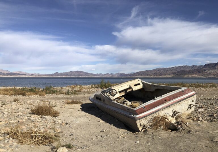
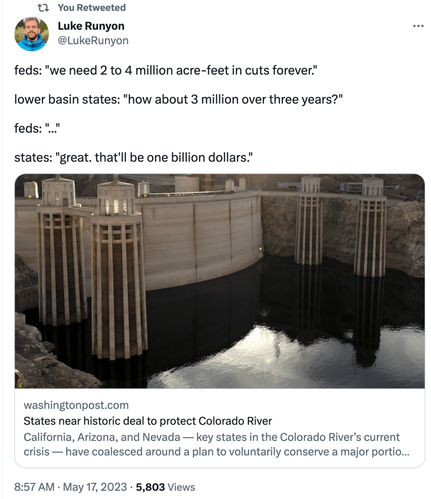
The Lower Basin “structural deficit”, reified. Maybe if Lake Mead rises enough this year the boats will be back underwater and we can stop worrying about deadpool. Photo credit: John Fleck
Click the link to read the article on the InkStain website (John Fleck):
I’ve had long conversations this week with smart friends grudgingly supporting of the Lower Basin deal to reduce Colorado River water use over the next few years. Their case for it is simple. Yes, it’s an awful deal in so many ways, but it does have the potential to generate some short term water use reductions and cut the red wire on the ticking time bomb.
My friends making this argument have a crucial credential that I don’t have in making their “sure whatever, it’s terrible but let’s just smile politely and get on with things” argument: they have been or are in the room for negotiations like this. I’m just heckling from the cheap seats.
YAY SAVINGS!
The best thing about the deal is an apparent commitment (see below for my reasons for italicizing) to deeper reductions in Lower Basin water use than folks down at that end of the system have been willing to agree to in the past. Three million new acre feet of savings above and beyond what has already been agreed to falls well short of the two to four million acre feet Reclamation Commissioner Camille Touton told us last year would be needed, but with a big snowpack the numbers have changed.
BUT THE SAVINGS FALL SHORT OF WHAT WE KNOW IS NEEDED
It’s been clear for as long as I’ve been writing seriously about the Colorado River that, if the Upper Basin meets its (contested) Lee Ferry delivery obligation, the Lower Basin needs to cut 1.2 million to 1.5 million acre feet per year. Permanently. Three million acre feet from 2023-26 falls well short of that.
For more than two decades, the Lower Basin has been dithering over how to make the cuts and in the meantime draining the reservoir, essentially building the time bomb that we’re now trying to defuse.
To be clear, enormous progress has been made in the last two decades to build the necessary institutional widgets to bring the system into balance.I wrote a whole book about it! My purpose in writing the book was to build a case for three things:
that fears communities often have about the impact of water reductions are misplaced – that we can all get by with less water
that successful institutional widgets had been built based on collaboration and sharing that could allow us to adapt
that a lot more work was needed to cut far more deeply than we had by the time I handed in the book’s manuscript in December 2015
But in the midst of crisis, and with a ticking bomb, we still haven’t been able to come up with even the bare minimum that we’ve all known for decades that we need in Lower Basin cuts.
WE DON’T ACTUALLY KNOW WHAT THE DEAL IS
What we’ve got at this point documenting the deal is a “term sheet” and a round of celebratory press releases. We have no official breakdown of the makeup of the 3 million acre feet – what’s California’s share, Nevada’s, Arizona’s – how much is Imperial and Metropolitan and Palo Verde, how much is CAP and Yuma. We’ve got individual state reps telling reporters (shout out to my friends in the fourth estate for trying to push down the path of actually breaking down the numbers). But that’s not the same thing as all of us being able to look at it in writing rather than passing around news site links, to be interpreted like fragments of a Dead Sea scroll.
The deal at this point is a pile of stuff shrouded in a tarp that we’re not allowed to peak under. We’ve just gotta trust the Lower Basin folks that they’ll actually come up with the water.
The reason, as one of my smart “been-in-the-room-where-it-happens” friends pointed out, is that the actual detailed reductions will need to go before the boards of a bunch of water agencies. Which hasn’t happened yet. Which means there are umpty reasons for this to spin out of control.
We all remember the ducking and diving around the celebrated “500 Plus Plan”. Know, those of you who know what’s under the tarp, why those of us who don’t are legitimately nervous about your approach to cutting the red wire.
So spare me the celebratory press releases and puff pieces about politicians breaking roadblocks.
One imagines federal officials desperate to somehow fly a seven-state flag over the deal, and the last-minute phone calls and emails over the weekend aimed at drafting a letter that says something.
At this point, Upper Basin communities (That’s me! Hi!) are just hostages in the next room, unable to help defuse the bomb and hoping y’all down there can figure out how to cut the right wire.
It’s even worse that y’all in the Lower Basin are demanding that the federal taxpayers kick in a billion dollars or you won’t cut any wire at all.
WAIT. WHICH WIRE WAS IT WE WERE SUPPOSED TO CUT?
Oh shit. Was it the red wire we were supposed to cut? The blue one?
Colorado River “Beginnings”. Photo: Brent Gardner-Smith/Aspen Journalism
The Wood River Wetland in southern Oregon is home to an array of biodiverse vegetation and is a freshwater ecoregion. Photo credit: Bureau of Land Management
Experts in environmental law said the decision would leave many wetlands subject to pollution without penalty, sharply undercutting the E.P.A.’s authority to protect them under the Clean Water Act…Kevin Minoli, who worked as a senior E.P.A. lawyer from the Clinton through the Trump administrations, overseeing the enforcement of Clean Water Act regulations, said the decision would have enormous practical consequences and estimated that it would affect more than half the nation’s wetlands…
The decision was nominally unanimous, with all the justices agreeing that the homeowners who brought the case should not have been subject to the agency’s oversight because the wetlands on their property were not subject to regulation in any event. But there was sharp disagreement about a new test the majority established to determine which wetlands are covered by the law. Justice Brett M. Kavanaugh, joined by the three liberal justices in a concurring opinion, said the decision would harm the federal government’s ability to address pollution and flooding.
“By narrowing the act’s coverage of wetlands to only adjoining wetlands,” he wrote, “the court’s new test will leave some long-regulated adjacent wetlands no longer covered by the Clean Water Act, with significant repercussions for water quality and flood control throughout the United States.”
[…]
“There,” she wrote, “the majority’s non-textualism barred the E.P.A. from addressing climate change by curbing power plant emissions in the most effective way. Here, that method prevents the E.P.A. from keeping our country’s waters clean by regulating adjacent wetlands. The vice in both instances is the same: the court’s appointment of itself as the national decision maker on environmental policy.”
Arizona, California and Nevada have narrowly averted a regional water crisis by agreeing to reduce their use of Colorado River water over the next three years. This deal represents a temporary solution to a long-term crisis. Nonetheless, as a close observer of western water policy, I see it as an important win for the region.
Seven western states – Colorado, Wyoming, Utah, New Mexico, Arizona, Nevada and California – and Mexico rely on water from the Colorado River for irrigation for 5.5 million acres and drinking water for 40 million people. Their shares are apportioned under a compact negotiated in 1922. We now know, thanks to tree-ring science, that its framers wildly overestimated how much water the river contained on a reliable basis. And climate change is making things worse.
Some recent commentators have argued for revamping the compact. The lawyer in me shudders to think of the utter chaos that would ensue as states, tribes that were left out of the original agreement, and Mexico try to unwind settled expectations and create new ones.
In my view, the agreement announced on May 22, 2023, strongly repudiates the need to revamp the compact. Seven states were able to finesse an agreement that will ultimately result in significant changes to the legal documents collectively known as the Law of the River, without the need to begin again. The next step – a broader, longer-lasting overhaul of the compact – will be even more challenging. https://www.youtube.com/embed/-xTv3xYx8b4?wmode=transparent&start=0 The May 2023 deal staves off an immediate water crisis but does not solve long-term problems in the Colorado River Basin.
Overallocated and shrinking
The Colorado River, the lifeblood of the U.S. Southwest, faced the prospect of going dry if its two largest reservoirs – Lakes Mead and Powell – hit dead pool, the level at which no water flows through their dams. Several forces led to this catastrophic prospect.
First, the 1922 Colorado River Compact and other elements of the Law of the River dole out rights to more water than the river provides.
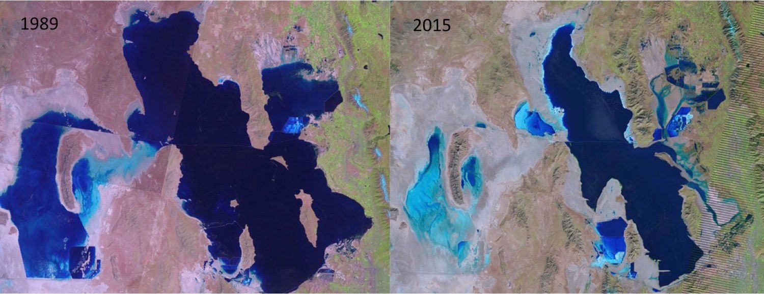
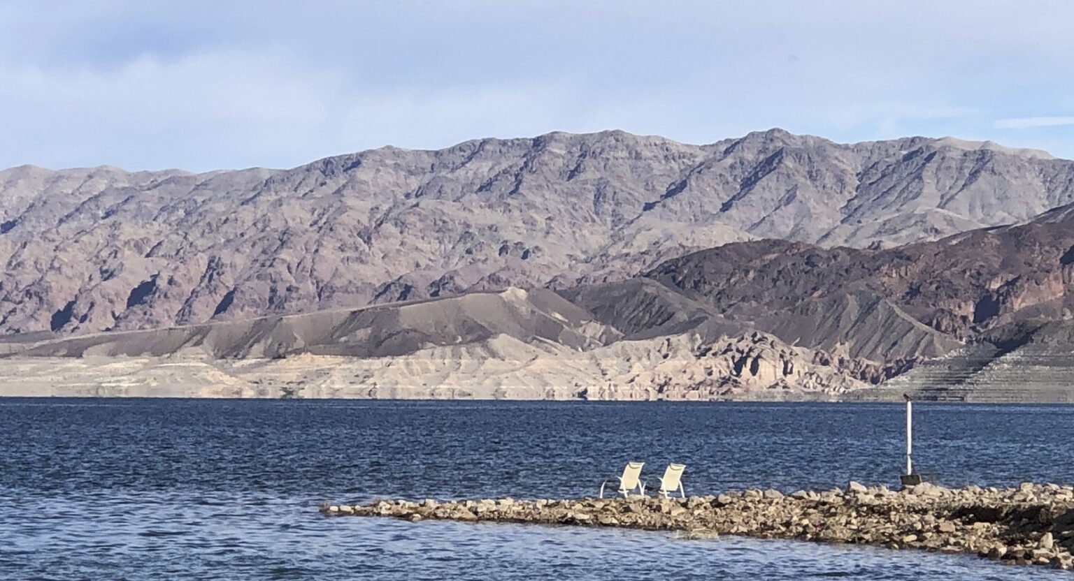
Second, a historic drought that commenced in 2000 has caused water levels in the reservoirs to plummet by 75%.
Third, climate change has reduced the flow in the river by more than 1 million acre-feet. (One acre-foot is the amount of water required to cover an acre of land to a depth of 1 foot – about 325,000 gallons.) Evaporation off the surface of the reservoirs annually claims in excess of an additional 1 million acre-feet. https://cdn.knightlab.com/libs/juxtapose/latest/embed/index.html?uid=562fd2cc-fb2c-11ed-b5bd-6595d9b17862 These satellite images show water levels declining from 2020 through 2022 in Lake Mead, located in the Mojave Desert in Arizona and Nevada (move slider to see change).NASA Earth Observatory
In 2022, the U.S. Department of the Interior broke this stalemate with a plea and then a demand for the states to do more, faster, to protect the river. Then, in April 2023, the agency released a draft supplemental environmental impact study that offered two alternatives – one more favorable to California, the other to Arizona. The message to states was clear: If you can’t reach a consensus, we’ll act to protect the river. Intense negotiations followed, leading to the May 22 agreement.
Will payments promote long-term conservation?
The new cuts center on California, Nevada and Arizona because they draw their shares of the river mostly from Lake Powell and Lake Mead. The states have agreed to reduce their consumption of Colorado River water by 3 million acre-feet by 2026, which represents about 14% of their combined allocations.
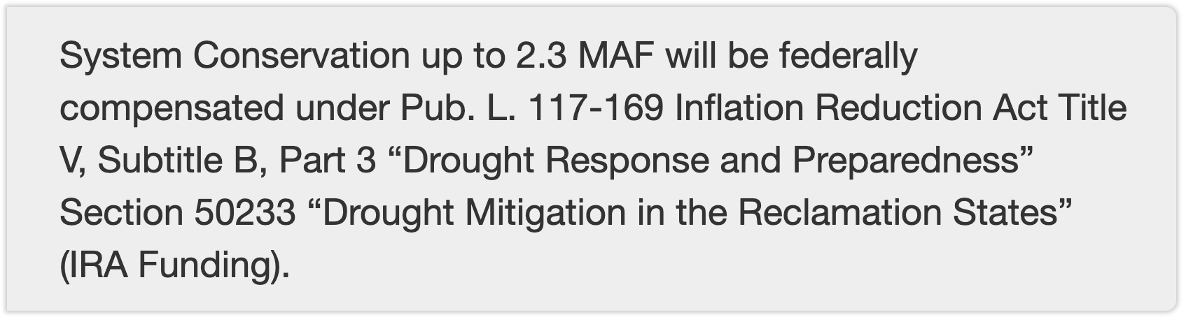
This pact temporarily protects water supplies for cities, farmers and tribes. The U.S. Bureau of Reclamation immediately accepted the proposal and committed to pay for steps that are expected to conserve 2.3 million acre-feet of water with money from the Inflation Reduction Act. For example, the Gila River Indian Community will receive $50 million from the Lower Colorado River Basin System Conservation and Efficiency Program in each of the next three years for improvements such as new pipelines.
It’s now up to California, Nevada and Arizona to divvy up the remaining 700,000 acre-feet of cuts. I expect that water reallocation, with water moving from lower-value to higher-value uses, will play a key role. Water marketing – negotiating voluntary sales or leases of water – is a tool to facilitate that transition.
Most of the water involved in the recent agreement will be freed up by one party paying another party to use less – for example, cities paying farmers to conserve water that the cities can then use. That’s the essence of water marketing. The agreement will provide funding to irrigation districts, tribes and water providers, who will then figure out how to generate the savings each organization has committed to deliver.
Negotiation, not litigation
The next steps are for the states to begin discussions about replacing guidelines that currently govern the sharing of Colorado River water, which expire in 2026. These discussions will be more painful because federal funding will expire and cuts will be more severe. Thus far, the Upper Basin states – Wyoming, Colorado, Utah and New Mexico – have not had to endure significant water use cuts. My hope is that the states will seize this three-year window as an opportunity to develop procedures and identify funding for major water reallocations.
Over the last couple of years, there have been threats to solve these issues in court. But litigation is a lengthy, costly process fraught with uncertainty. The original Arizona v. California suit was filed in 1930, and the Supreme Court did not enter its final decree until 2006.
Many legal arguments that individual basin states could present to a court rest on interpretations of vague or ambiguous Law of the River documents. The river can’t wait for the legal process to adjudicate gnarly, complicated claims made trickier by a century of statutory and case law embellishments. As I see it, negotiation and concessions leading to consensus are the only viable solution going forward.
The Colorado River and the silt flats left behind by a receding Lake Powell. Note the old Hite Marina boat ramp on the left side of the image. This was once at water’s edge. Jonathan P. Thompson photo.
Click the link to read the article on The Land Desk website (Jonathan P. Thompson):
The News: Arizona, California, and Nevada have come up with a landmark agreement to slash their consumption of Colorado River water by 3 million acre-feet in coming years. The Colorado River and its reservoirs are saved!
The Buzzkill: Nope. Not quite.
Yes, the three Lower Basin states came up with an agreement to cut water use substantially. Yes, it’s a breakthrough (as any such agreement would be). But no, it won’t be enough to save the Colorado River if the climatic conditions of the last couple decades persist or worsen. Plus, the proposed cuts are only for the next few years. What then?
Map credit: AGU
The Background: For those who may have forgotten, the 1922 Colorado River Compact divvied up the river between the Upper and Lower Basin states (Mexico was included in the 1940s). The problem: The 16.5 million acre-feet pie they parceled out was bigger than what actually existed—even back then. They assumed the river carried about 20 million acre-feet each year, on average. In fact, it was more like 14 million acre-feet, so they were already in debt to reality when the Compact was signed. Oof.
Updated Colorado River 4-Panel plot thru Water Year 2022 showing reservoirs, flows, temperatures and precipitation. All trends are in the wrong direction. Since original 2017 plot, conditions have deteriorated significantly. Brad Udall via Twitter: https://twitter.com/bradudall/status/1593316262041436160
In the decades since, the population of all of the states burgeoned and water consumption also increased. Meanwhile, after the wet and wild 1980s, long-term drought and warmer temperatures diminished the river and the reservoirs that were supposed to carry the users over during dry years. Last summer it looked like Lake Powell might drop below minimum power pool, or the level needed to allow water to flow through the hydroelectricity-generating turbines, within a couple of years. Losing hydropower is one thing, but losing the ability to release water through the penstocks is another, with its own dire ramifications.
That prompted federal water officials to call on the states to cut consumption by 2 million to 4 million acre-feet per year, or else they would implement the cuts themselves. The states blew past deadlines without an agreement until finally, last month, the Bureau of Reclamation presented two alternatives:
Cut Lower Basin use according to the concept of priority (meaning Arizona would take the biggest cuts); or,
The matrix for the Bureau of Reclamation’s priority-based alternative, which would burden Arizona with the biggest cuts and barely lean on California at all. USBR.
2. Cut a flat percentage of each state’s water use (meaning California would take the biggest cuts).
The matrix for the Bureau of Reclamation’s flat percentage-based alternative, which would result in larger volume cuts for California. USBR.
The prospect apparently was enough to scare the bejeezus out of the states, pushing them back to the negotiating table where they came up with this week’s deal. Details so far are sketchy, but here’s what we know:
The Agreement:
The Lower Basin states together will cut consumption by 3 million acre-feet over the 2023-2026 period, with at least 1.5 million acre-feet in cuts coming by the end of 2024 (there is no indication of how these cuts will be distributed across the states, but the Washington Postreports California will bear about half the cuts);
Up to 2.3 million acre-feet of those cuts will be federally compensated by about $1.2 billion in Inflation Reduction Act funds. Most likely this means that farmers will be paid not to irrigate their crops.
So what’s wrong with this deal? I’ll admit that when I first read the stories on this, I was pretty damned impressed: 3 million acre-feet is good! Thing is, all those cuts are spread out over three years, meaning it’s only about 1 million acre-feet per year. That’s only half the minimum amount of cuts the feds say are needed to shore up the river system and its reservoirs. It just won’t cut it, so to speak, if the drying trend continues.
Furthermore, the deal clearly is meant only to be temporary — a stopgap, a band-aid — that runs out in three years. What happens then? Even if the agreement were to be extended, where would the billions of dollars come from to keep paying the farmers not to irrigate? What if the Republicans’ obstructive ways nix the payments? And what about the additional 700,000 acre-feet of cuts promised? Where will they come from? Or will that require a whole new round of negotiations?
I don’t want to be a party pooper. It’s great that the states came to an agreement and, yes, it is a solution, of sorts. But it’s not the sustainable, permanent one that’s necessary.
Colorado River from CR-311(?) May 23, 2023.
But who knows? Maybe this past wet winter and huge runoff isn’t an anomaly. Maybe it’s the new normal and big rains and snows will come regularly over the next 20 years, filling up the reservoirs, saturating the soil, and swelling the Colorado River into the muddy monster of yore. Maybe we won’t need these cuts after all. But I sure as heck wouldn’t bank on it.
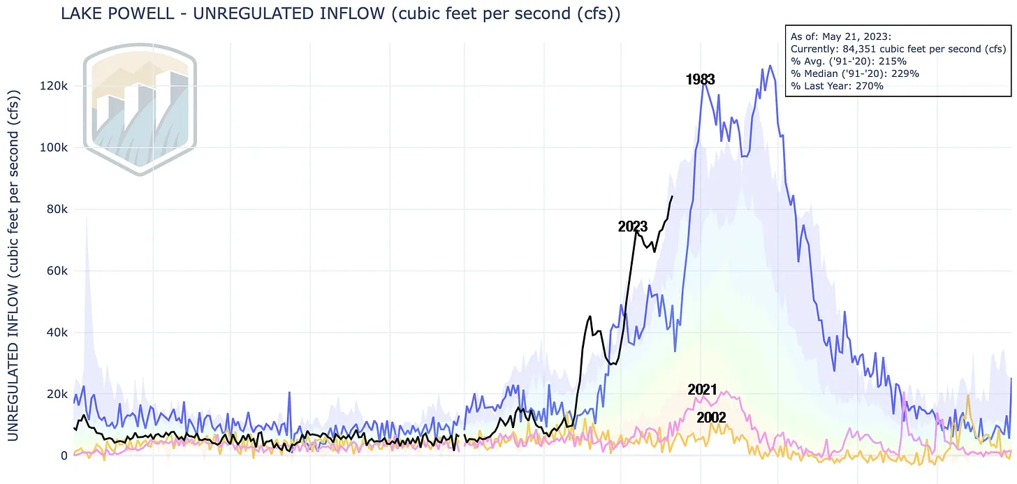
Big water! That’s what this chart shows in the form of unregulated inflow into Lake Powell. That is an estimate of how much water would be flowing into the reservoir if there were no upstream diversions or dams. The actual inflow is slightly lower (74,000 cfs instead of 84,000), but the patterns are basically the same. Note that 2023’s runoff is bigger even than the monster flows of 1983 — so far. That’s unlikely to continue as the snowpack is melting fast. This also illustrates just how awful 2002 and 2021 were. USBR.
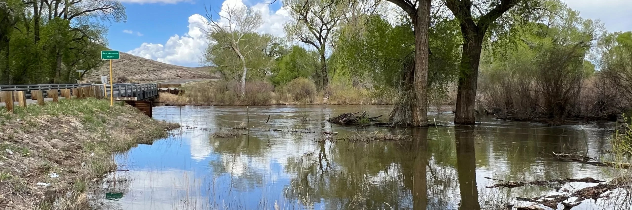
San Antonio River May 2023. Photo credit: Alamosa Citizen
Click the link to read the article on the Alamosa Citizen website (Chris Lopez):
HIGH rivers, rising natural surface water in agricultural and livestock fields, country roads washing out – there’s water everywhere across the San Luis Valley.
“We would like to remind people to be aware and prepared for voluntary evacuations if necessary,” Conejos County Sheriff Garth Crowther said in a released statement as Conejos County went under a county flood watch this week.
Both the Rio Grande and Conejos River are running dangerously high and fast. The Rio Grande at the Del Norte gauging station shows a 10-day streamflow average of 4,788 cubic feet per second. The Conejos River, meanwhile, was standing at five feet and the San Antonio River, one of its tributaries east of Manassa along Colorado Highway 142, was flowing at a healthy 1,224 cfs with swampy fields dotting the road to San Luis.
“Still seeing snowpack in the mountains. It feels like it’s going to be a year like we haven’t had in 20 years,” said Rio Grande Water Conservation District General Manager Cleave Simpson.
The month of May has exceeded what’s normal for rain accumulation, with .68 inches of precipitation measured so far. A historically normal May would see a bit over a half-inch of accumulated moisture.
The May rains timed themselves to healthy spring runoffs across the San Juans, which experienced snowfall totals at 200 percent and above of normal. It’s the San Juans that affect the Upper Rio Grande and Conejos streamflows.
On the recreation front, the expected 200 or so participants in this weekend’s Valley Bottom Rio Trio adventure race will find high water to canoe through on the second leg of the race. It’ll be the strongest and highest streamflow that canoers have had to deal with in the three years of the adventure race.
Minor flooding conditions along the banks of the Rio Grande through Alamosa also had organizers re-route the overall race course.
For Valley residents who may find themselves in flood watch or flood warning conditions, Conejos County offered these tips:
Gather emergency supplies, including non-perishable food and water. Store at least 1 gallon of drinking water per day for each person and pet.
If it looks like you need to evacuate, turn off all utilities at the main switch and close the main gas valve.
Leave areas subject to flooding such as low spots, canyons, washes etc.
Wetlands, which are havens of biodiversity, offer priceless ecological benefits. As wetlands are lost to development nationwide, critics of the dam project worry about its local impact.
(Photo Credit: John Fielder via Writers on the Range)
In today’s [May 25, 2023] ruling on Sackett v. EPA, the Supreme Court dramatically narrowed the scope of the Clean Water Act, undoing protections that have safeguarded the nation’s waters for over 50 years. Because it erases critical protections for tens of millions of acres of wetlands, the court’s ruling threatens the clean drinking water sources for millions of Americans.
Overturning federal protections for wetlands makes them vulnerable to pollution and harmful development, which impacts water quality, groundwater supplies, flood protection, and habitat for plants, fish, and wildlife. It will also make it more expensive to treat our water, driving up costs for millions of people. The court’s ruling will allow further destruction of wetlands, which will increase the rate and severity of flooding and flood damages in many places.
Tom Kiernan, President and CEO of American Rivers, made the following statement:
“The court’s ruling is a serious blow to wetlands, which are essential to clean, affordable drinking water, public health, and flood protection. Today’s ruling puts rivers and people at greater risk from pollution and harm. We urge state officials, the Biden Administration, and Congress to act quickly to safeguard rivers, wetlands, and streams that are so vital to our health and safety, environment, and economy. Rivers should unite us, not divide us.”
“Without strong, science-based protections, the rivers and wetlands that are the lifeblood of our nation will suffer irreparable harm. We risk going backwards to a time of beach closures and rivers choked with pollution. This ruling will exacerbate environmental injustices as the worst impacts harm communities of color. American Rivers will continue to stand with local partners and frontline communities to secure equitable protections for rivers and clean water nationwide. ”
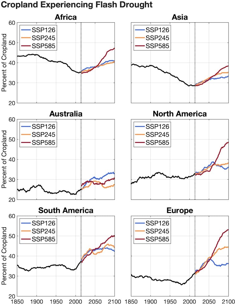
In North America and Europe, cropland that had a 32% annual chance of a flash drought a few years ago could have as much as a 53% annual chance of a flash drought by the final decades of this century. The result would put food production, energy and water supplies under increasing pressure. The cost of damage will also rise. A flash drought in the Dakotas and Montana in 2017 caused US$2.6 billion in agricultural damage in the U.S. alone.
Stunted corn in Nebraska struggles to grow during the 2012 flash drought that covered much of the central U.S. AP Photo/Nati Harnik
How flash droughts develop
All droughts begin when precipitation stops. What’s interesting about flash droughts is how fast they reinforce themselves, with some help from the warming climate.
When the weather is hot and dry, soil loses moisture rapidly. Dry air extracts moisture from the land, and rising temperatures can increase this “evaporative demand.” The lack of rain during a flash drought can further contribute to the feedback processes.
Under these conditions, crops and vegetation begin to die much more quickly than they do during typical long-term droughts.
Global warming and flash droughts
In our new study, we used climate models and data from the past 170 years to gauge the drought risks ahead under three scenarios for how quickly the world takes action to slow global warming.
If greenhouse gas emissions from vehicles, power plants and other human sources continue at a high rate, we found that cropland in much of North America and Europe would have a 49% and 53% annual chance of flash droughts, respectively, by the final decades of this century. Globally, the largest projected increases would be in Europe and the Amazon.
Slowing emissions can reduce the risk significantly, but we found flash droughts would still increase by about 6% worldwide under a low-emissions scenario.
Climate models indicate that more land will be in flash drought in every region in the coming decades. Three scenarios show how low (SSP126), medium (SSP245) and high (SSP585) emissions are likely to affect the amount of land in flash drought. In some regions, rising global emissions will bring more extreme rainfall, offsetting drought. Jordan Christian
Timing is everything for agriculture
We’ve lived through a number of flash drought events, and they’re not pleasant. People suffer. Farmers lose crops. Ranchers may have to sell off cattle. In 2022, a flash drought slowed barge traffic on the Mississippi River, which carries more than 90% of U.S. agriculture exports.
If a flash drought occurs at a critical point in the growing season, it could devastate an entire crop.
Corn, for example, is most vulnerable during its flowering phase, called silking. That typically happens in the heat of summer. If a flash drought occurs then, it’s likely to have extreme consequences. However, a flash drought closer to harvest can actually help farmers, as they can get their equipment into the fields more easily.
During Europe’s flash drought in 2022, floating houses were left sitting on a dry riverbed in the Netherlands. Thierry Monasse/Getty Images
In the southern Great Plains, winter wheat is at its highest risk during seeding, in September to October the year before the crop’s spring harvest. When we looked at flash droughts in that region during that fall seeding period, we found greatly reduced yields the following year.
Looking globally, paddy rice, a staple for more than half the global population, is at risk in northeast China and other parts of Asia. Other crops are at risk in Europe.
Ranches can also be hit hard by flash droughts. During the huge flash drought in 2012 in the central U.S., cattle ran out of forage and water became scarcer. If rain doesn’t fall during the growing season for natural grasses, cattle don’t have food, and ranchers may have little choice but to sell off part of their herds. Again, timing is everything.
It’s not just agriculture. Energy and water supplies can be at risk, too. Europe’s intense summer drought in 2022 started as a flash drought that became a larger event as a heat wave settled in. Water levels fell so low in some rivers that power plants shut down because they couldn’t get water for cooling, compounding the region’s problems. Events like those are a window into what countries are already facing and could see more of in the future.
One way to help agriculture adapt to the rising risk is to improve forecasts for rainfall and temperature, which can help farmers as they make crucial decisions, such as whether they’ll plant or not.
When we talk with farmers and ranchers, they want to know what the weather will look like over the next one to six months. Meteorology is pretty adept at short-term forecasts that look out a couple of weeks, and at longer-term climate forecasts using computer models. But flash droughts evolve in a midrange window of time that is difficult to forecast.
We’re tackling the challenge of monitoring and improving the lead time and accuracy of forecasts for flash droughts, as are other scientists. For example, the United States Drought Monitor has developed an experimental short-term map that can display developing flash droughts. As scientists learn more about the conditions that cause flash droughts and about their frequency and intensity, forecasts and monitoring tools will improve.
Increasing awareness can also help. If short-term forecasts show that an area is not likely to get its usual precipitation, that should immediately set off alarm bells. If forecasters are also seeing the potential for increased temperatures, that heightens the risk for a flash drought’s developing.
Nothing is getting easier for farmers and ranchers as global temperatures rise. Understanding the risk from flash droughts will help them, and anyone concerned with water resources, manage yet another challenge of the future.
Greeley residents can continue watering their lawns, gardens and outdoor landscapes under normal watering rules through Oct. 31, thanks to the declaration of an adequate water year by the city’s Water and Sewer Board this past month. Above-average snowpack and low temperatures in the high mountains have helped the mountains maintain the snowpack before it melts and feeds the rivers. Recent rainstorms have caused river flows to increase, according to a city news release. The city’s water resources confirmed the city’s reservoirs are either full or filling, with Cache la Poudre and Big Thompson runoff peaking in early June…
Given the adequate water year, the city will also continue its water rental program, renting excess water to farmers and ranchers. Excess water may be rented out so long as the target storage volume of 21,300 acre-feet is maintained. Depending on snowmelt and river conditions, the city may rent out additional water after the initial April allocation…The city averages 6.41 inches of precipitation each year through May 21, according to a city news release. As of earlier this week, the city received 8.03 inches of rainfall — 1.6 inches above average.
Tina Turner, the earthshaking singer whose rasping vocals, sexual magnetism and explosive energy made her an unforgettable live performer and one of the most successful recording artists of all time, died on Wednesday at her home in Küsnacht, Switzerland, near Zurich. She was 83…Ms. Turner embarked on her half-century career in the late 1950s, while still attending high school, when she began singing with Ike Turner and his band, the Kings of Rhythm. At first she was only an occasional performer, but she soon became the group’s star attraction — and Mr. Turner’s wife. With her potent, bluesy voice and her frenetic dancing style, she made an instant impression. Their ensemble, soon renamed the Ike and Tina Turner Revue, became one of the premier touring soul acts in Black venues on the so-called chitlin’ circuit. After the Rolling Stones invited the group to open for them, first on a British tour in 1966 and then on an American tour in 1969, white listeners in both countries began paying attention…Ms. Turner, who insisted on adding rock songs by the Beatles and the Stones to her repertoire, reached an enormous new audience, giving the Ike and Tina Turner Revue its first Top 10 hit with her version of the Creedence Clearwater Revival song “Proud Mary” in 1971 and a Grammy Award for best R&B vocal performance by a group…
But her solo album “Private Dancer,” released in 1984, returned her to the spotlight — and lifted her into the pop stratosphere. Working with younger songwriters, and backed by a smooth, synthesized sound that provided a lustrous wrapping for her raw, urgent vocals, she delivered three mammoth hits: the title song, written by Mark Knopfler of Dire Straits; “Better Be Good to Me”; and “What’s Love Got to Do With It.” Referring to its “innovative fusion of old-fashioned soul singing and new wave synth-pop,” Stephen Holden, in a review for The New York Times, called the album “a landmark not only in the career of the 45-year-old singer, who has been recording since the late 1950s, but in the evolution of pop-soul music itself.”
[…]
The album went on to sell five million copies and ignite a touring career that established Ms. Turner as a worldwide phenomenon. In 1988 she appeared before about 180,000 people at the Maracanã Stadium in Rio de Janeiro, breaking a record for the largest paying audience for a solo artist. After her “Twenty Four Seven” tour in 2000 sold more than $100 million in tickets, Guinness World Records announced that she had sold more concert tickets than any other solo performer in history.
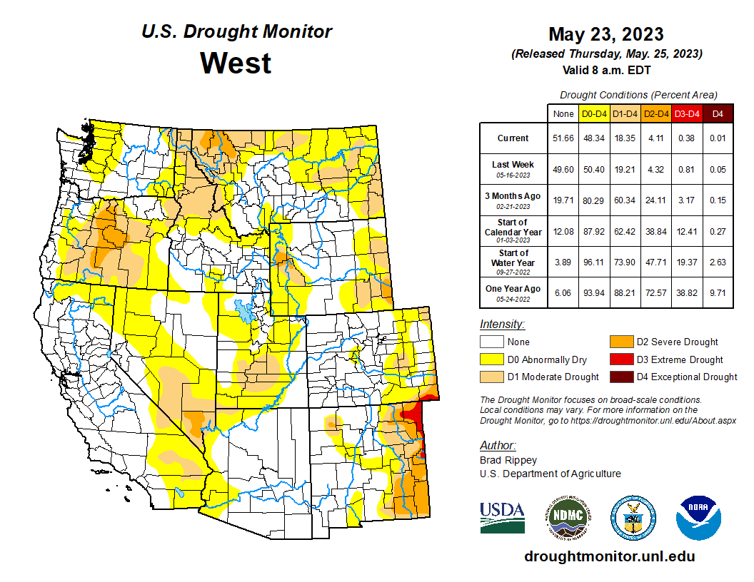
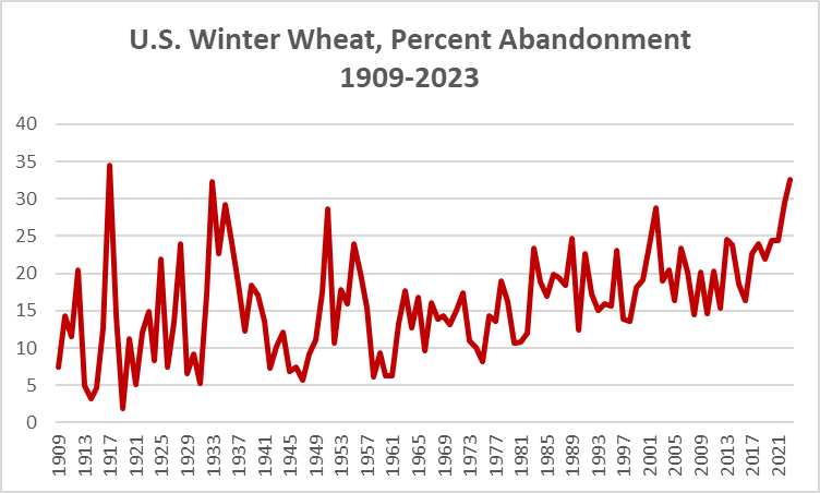
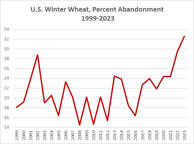
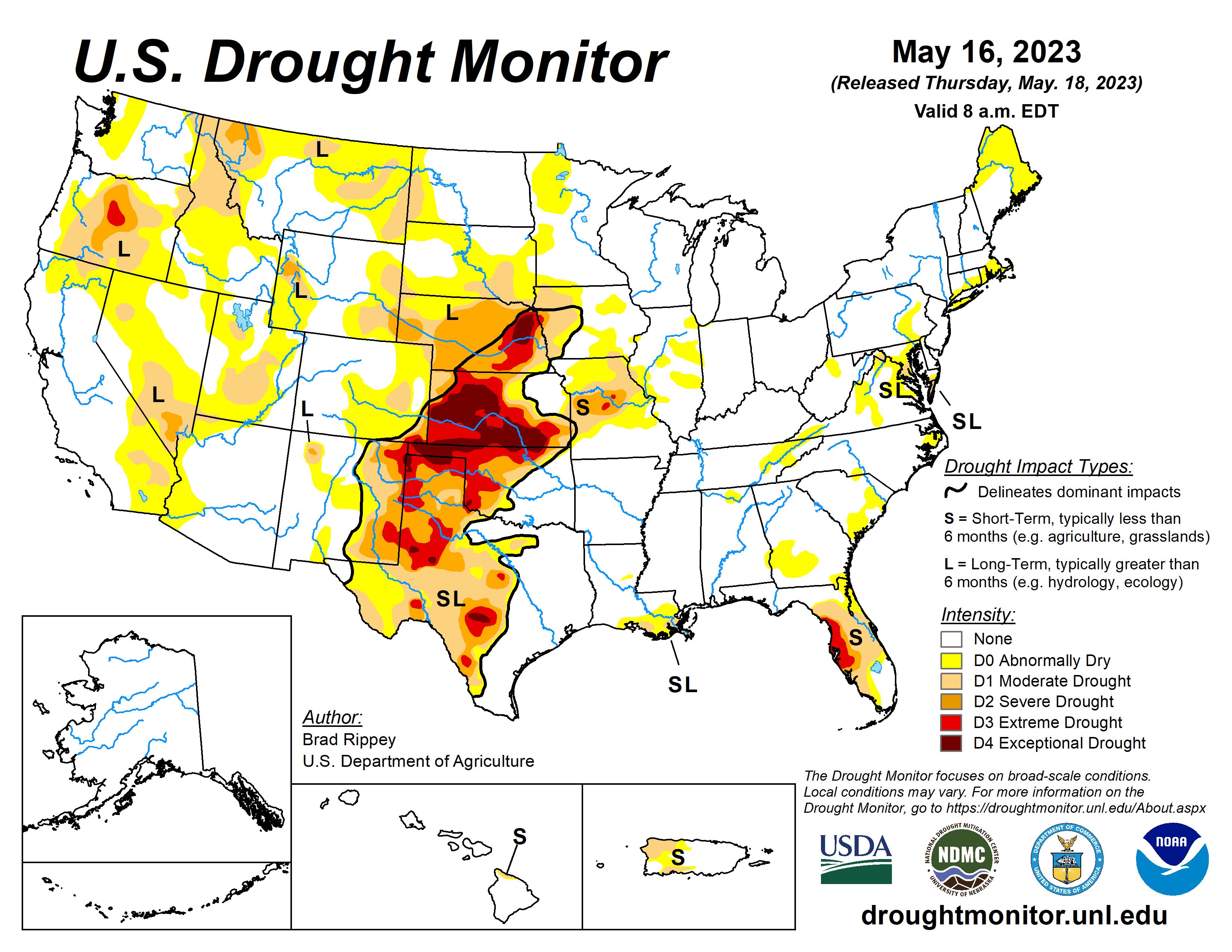
Showery weather across the southern half of the Plains provided additional drought relief, following the previous week’s major storm. Still, much of the rain arrived too late to rescue winter wheat, although rangeland, pastures, and summer crops greatly benefited from the soil moisture improvements. Variable rainfall extended westward into the central and southern Rockies and eastward to the southern Atlantic Coast, maintaining generally favorable growing conditions for pastures and summer crops. Eventually, rain shifted northward along the northern Atlantic Coast, easing dry conditions. Meanwhile, light showers dotted the Northwest, while little or no rain fell across the remainder of the country, including the north-central U.S. and the Far West. A week-long hot spell elevated temperatures in the Pacific Northwest, although temperatures began to fall late in the drought-monitoring period. A separate area of heat, accompanied by high humidity, affected much of the Deep South. Elsewhere, near- or slightly below-normal temperatures prevailed across the central and southern Plains, while cooler-than-normal weather covered much of the Northeast and environs…
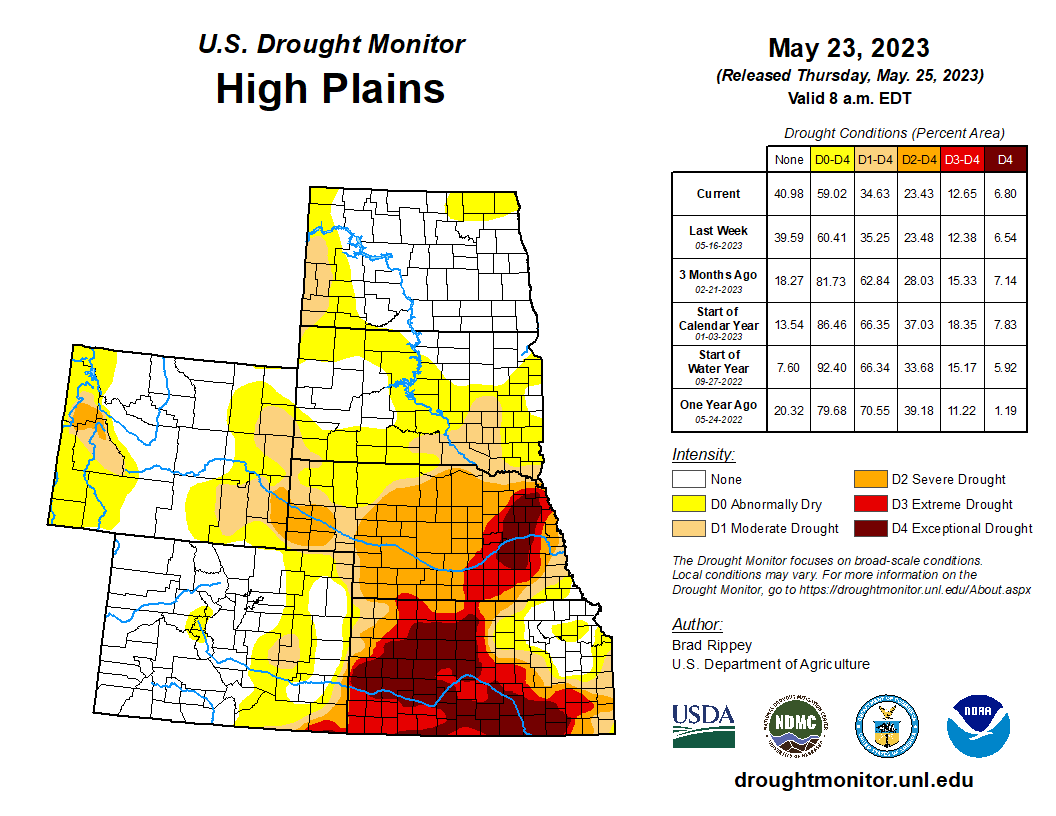
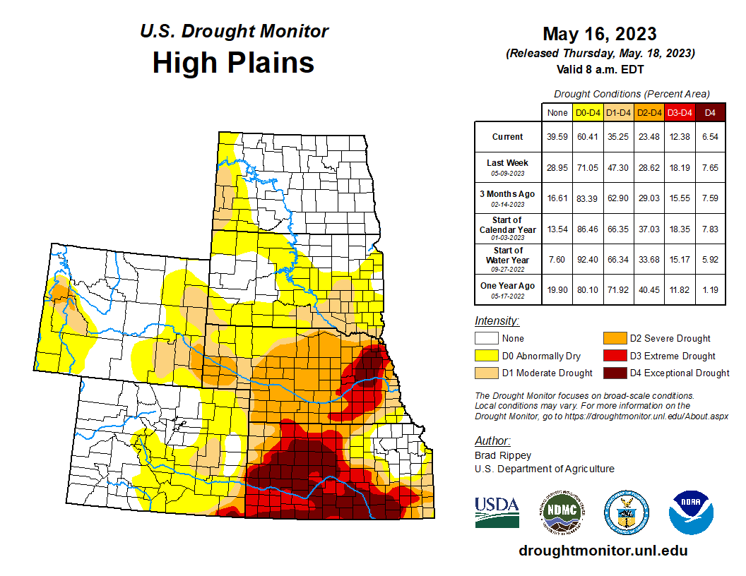
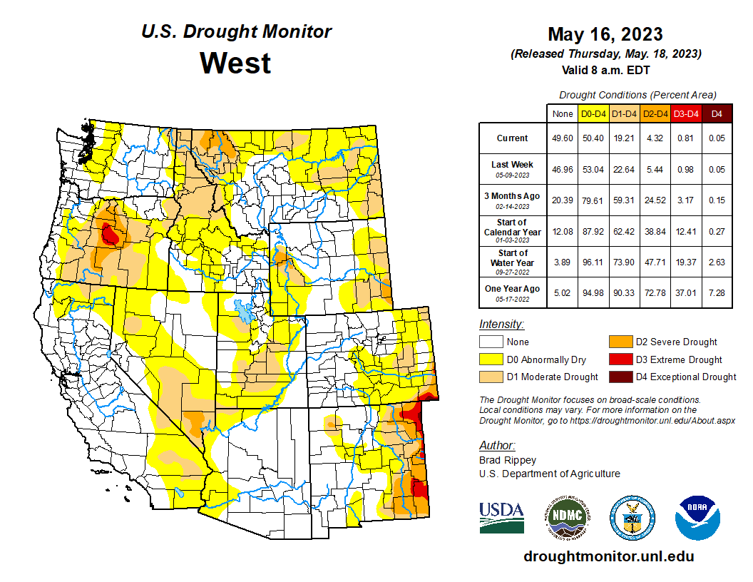
Following the previous week’s substantial drought relief, mostly dry weather returned across the High Plains. However, locally heavy showers continued in parts of eastern Colorado and southern and western Kansas, leading to some additional reductions in the coverage of moderate to exceptional drought (D1 to D4). By May 21, Nebraska led the U.S. with rangeland and pastures rated 55% very poor to poor, according to the U.S. Department of Agriculture. On the same date, Nebraska led the High Plains with topsoil moisture rated 58% very short to short, followed by Kansas at 52% and South Dakota at 36%. Much of the recent rainfall has bypassed eastern sections of South Dakota and Nebraska, with some increase in drought coverage noted in the latter state…
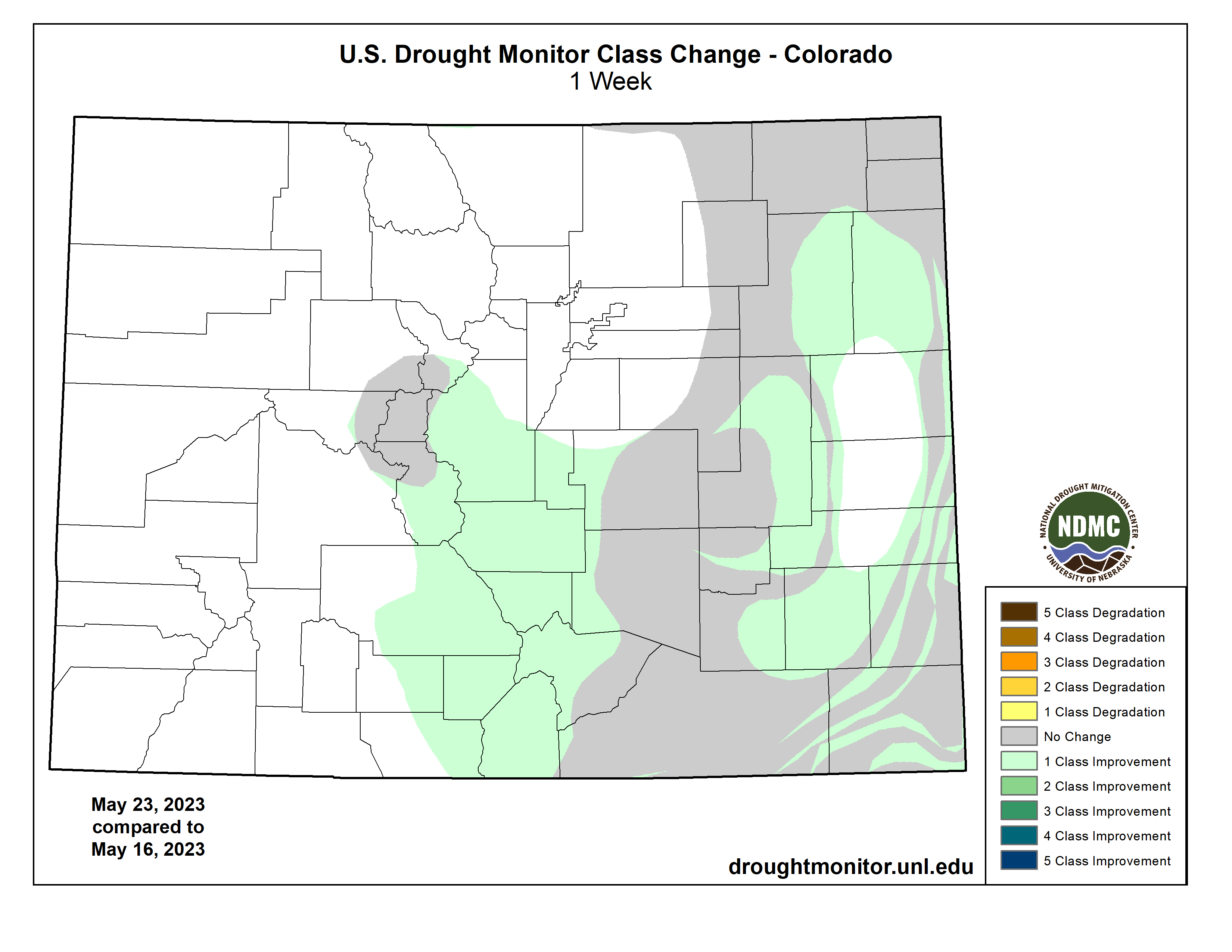
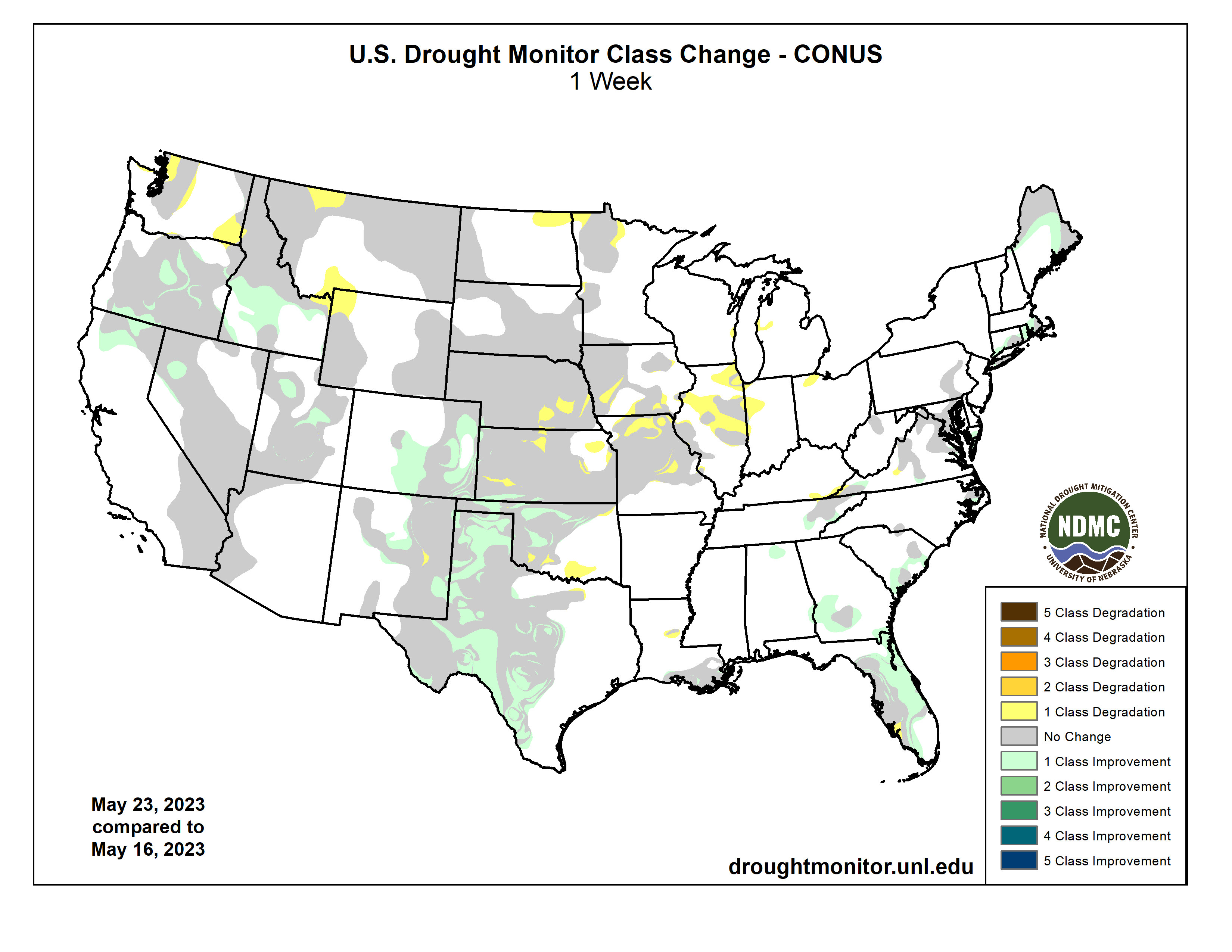
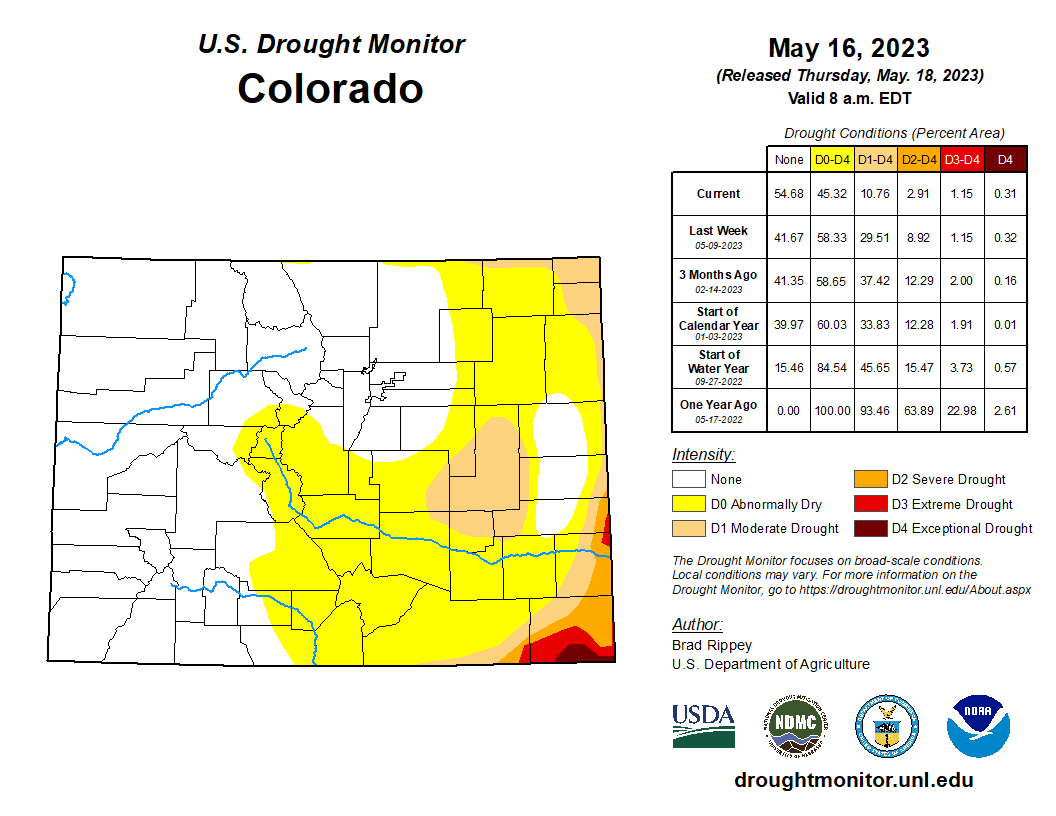
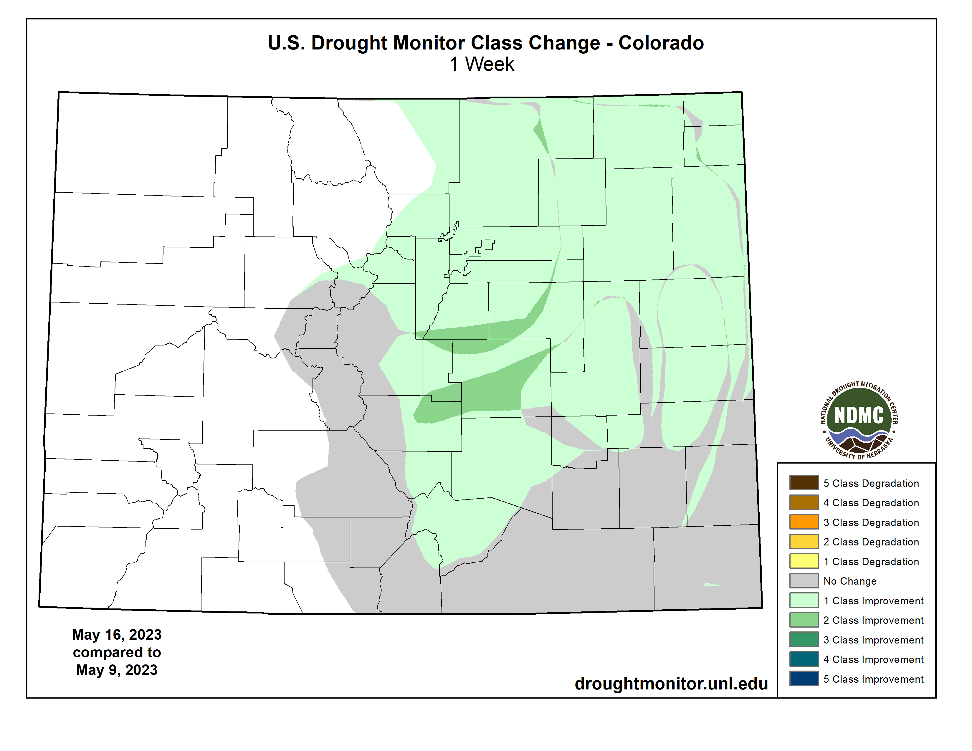
Colorado Drought Monitor one week change map ending May 23, 2023.
Some further improvements were introduced across roughly the southern two-thirds of the West, a combination of precipitation—especially in the central and southern Rockies—and further analysis and assessment of snow that fell during the impressively wet winter of 2022-23. In fact, recent warmth has caused some rapid melting of high-elevation snowpack, leading to some flooding. In south-central Idaho, for example, the Big Wood River at Hailey recently rose more than 2 feet above flood stage to reach its highest level since May 2017. The northern tier of the western U.S. received less winter precipitation, and in combination with the recent early-season heat wave, has experienced the return of patchy dryness (D0). During the week ending May 21, topsoil moisture rated very short to short by the U.S. Department of Agriculture increased from 32 to 47% in Oregon and 23 to 40% in Washington…
Significant drought improvement occurred in some of the hardest-hit areas of Oklahoma and Texas, as rain benefited rangeland, pastures, and summer crops. In Texas, rangeland and pastures rated in very poor to poor condition by the U.S. Department of Agriculture improved from 51 to 36% during the week ending May 21. On the same date, topsoil moisture was rated less than one-third very short to short in Texas (29%) and Oklahoma (28%). Still, even with abundant showers and thunderstorms, pockets of extreme to exceptional drought (D3 to D4) persisted in western and central Texas and across the northwestern half of Oklahoma. Farther east, most areas remained free of dryness and drought, aside from a few areas in the central Gulf Coast region…
Looking Ahead
A slow-moving Southeastern disturbance interacting with a plume of Atlantic tropical moisture could lead to heavy rain in the southern and middle Atlantic States, especially in coastal areas, through the Memorial Day weekend. Five-day rainfall totals could reach 2 to 4 inches or more from Florida to the Carolinas. Meanwhile, a cold front draped across the northern High Plains and the northern Intermountain West will remain the focus for widespread rain, which could total at least 1 to 2 inches in Montana and portions of neighboring states. A separate area of rain—in the form of daily thunderstorms—will affect the central and southern High Plains, resulting in additional drought relief. In contrast, dry weather will prevail during the next 5 days in much of the Southwest, Midwest, and Mississippi Valley. The NWS 6- to 10-day outlook for May 30 – June 3 calls for the likelihood of near- or above-normal temperatures and precipitation across most of the country. Cooler-than-normal conditions should be confined to an area stretching from southern California to the southern High Plains, while drier-than-normal weather should be limited to western Washington and an area stretching from the Great Lakes region to New England.
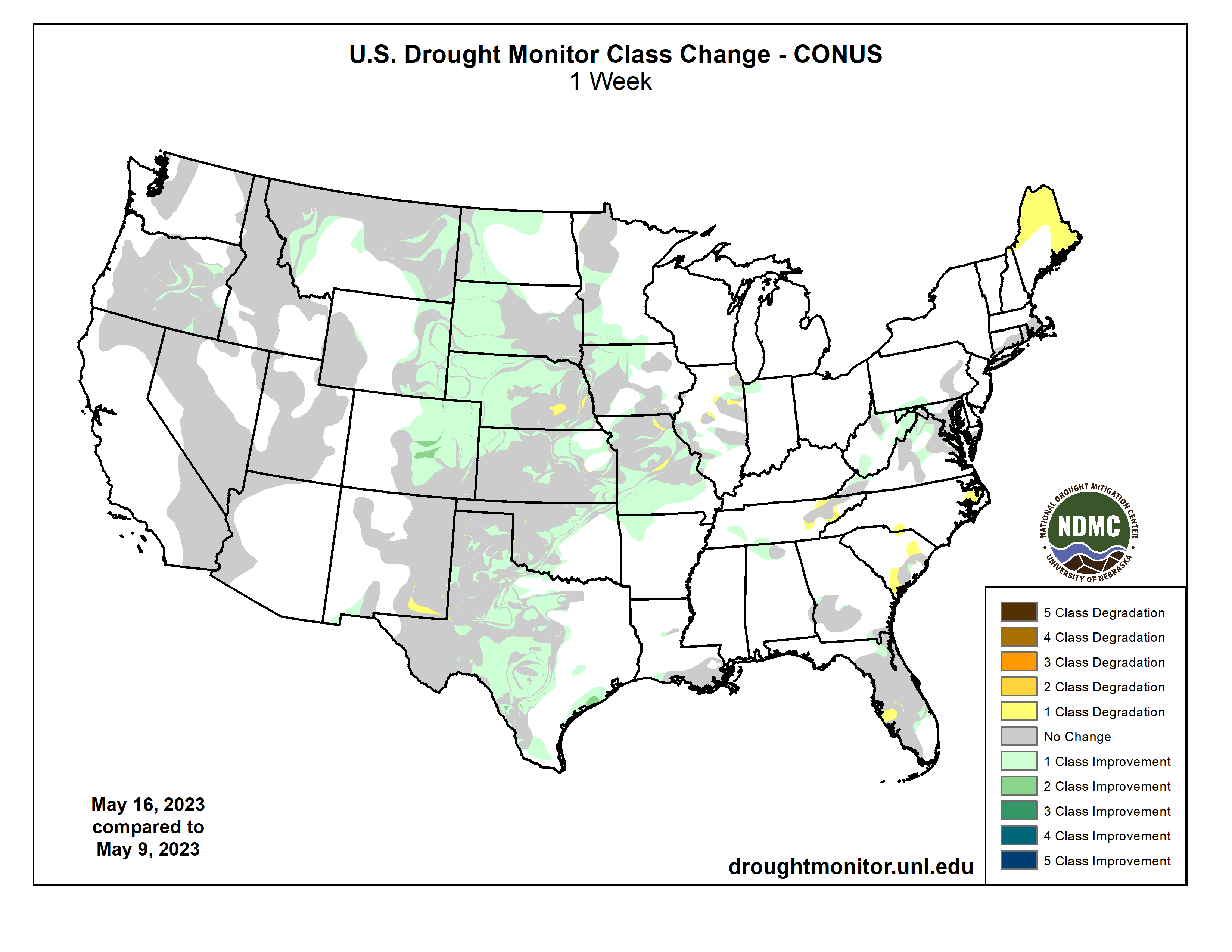
US Drought Monitor one week change map ending May 23, 2023.
We’re in a bit of a holding pattern along the Colorado River today, at least in the Upper Basin: on the one hand, waiting for the Bureau of Reclamation to weigh the options for big cuts in Lower Basin use; and on the other hand, seeing the Lower Basin states trying to come up with a less painful set of big cuts to impose on themselves over three years, taking advantage of the big snow year that relieves a little (but just a little!) of the immediate pressure.
At any rate, it’s an opportunity for me to step back a step and try to restore something of the perspective with which I started these posts – ‘learning to live in the Anthropocene.’ I’ve been calling the posts ‘Romancing the River,’ wanting to work in the spirit of Frederick Dellenbaugh in his book The Romance of the Colorado River: making the story of the First River of the Anthropocene something to engage in rather than deny. But the stories keep getting lost in the avalanches of mostly dispiriting details coming down these days….
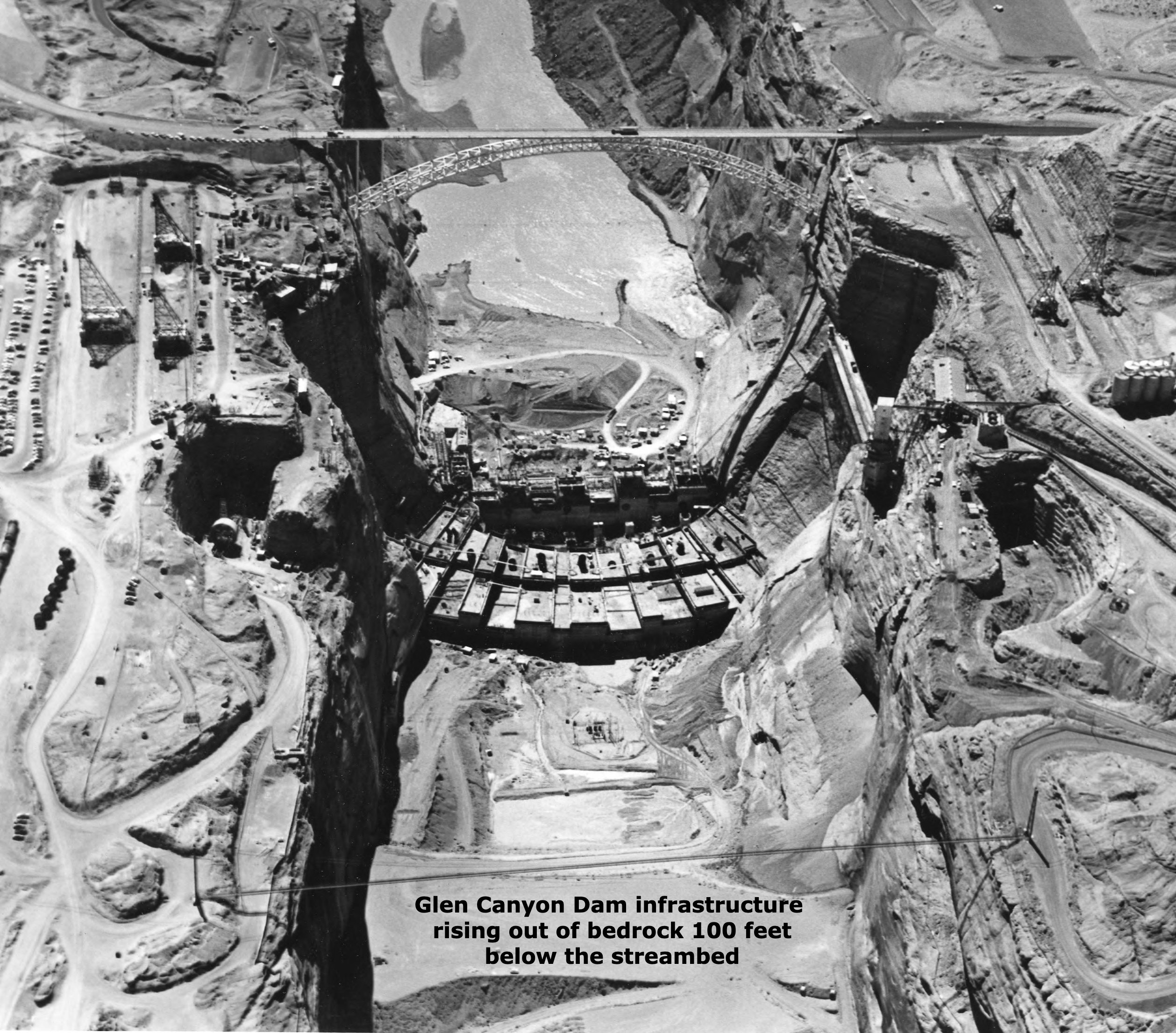
So anyway, today – an unremembered part of the story of Glen Canyon Dam. Last post, we explored the structure of the dam itself, a good solid Early Anthropocene structure. But today I want to explore the infrastructure of the dam. As with most dams, what you can see is not the whole thing, even physically. To get a firm foundation on bedrock for ten million tons of concrete, the builders had to dig out more than a hundred feet of rock, rubble and sand from the natural streambed. That hundred feet of dam below the streambed is the physical infrastructure of the dam.
But even before that digging-down could begin, a political, economic, legal and philosophical infrastructure had be cobbled together on which to erect the physical structure. Recent articles about the river and its troubles that try to offer any river history at all tend to give credit (or blame) for the dam to a large mass of ego and bluster, Floyd Dominy, but he was just the Reclamation Commissioner when the dam was legislated, a guy who wanted to build dams as big as his ego. He built the structure, but he didn’t assemble the legal and political infrastructure that enabled it.
The larger story of Glen Canyon Dam’s infrastructure is mostly, but not entirely, a story of the Old West – a story of the most serious attempt to achieve a working truce between the Old West and the New West. And for those with my tendency toward an iconoclastic interpretation of history, it was one of the final episodes (thus far anyway) in America’s semi-civil westward war between the advance of the well-defined and well-funded Industrial Revolution and the retreat of a vaguely defined agrarian counter-revolution. For a review of that semi-civil war, go to ‘Westward the Curse of Empire,’ April 4, 2022.
When we talk about the Old West and the New West, we are talking about two very different cultures. Most (over)simply, we can say that the Old West is the west to which people went to live and make a living developing and marketing the natural resources of the West; and the New West is the west where people who live in the urban-industrial realm go to play, to ‘recreate’ themselves among the natural wonders and magnificent scale of the West.
It is useful to make a further distinction about the Old West: it was populated by ‘settlers’ and ‘unsettlers’: the unsettlers usually arrived first, the human equivalent of a plague of locusts with a mining mentality (mining gold and silver, other metals, old-growth timber and grass) – a drive to get there first, get the goods, and get rich. The settlers, on the other hand, came to farm or ranch with the intention of staying and making a life, settling down, homesteading. Some of the farmers tended to be soil miners, but the ones who stayed were true agrarians, the counterrevolutionaries to the industrial revolutionaries.
People of course do come to live in the New West too, not just to visit: they are usually either relatively well-off people retiring, or professionals working remotely with incomes from elsewhere, or they are mendicant people like I was sixty years ago (relatively poor, mostly by choice) who work for the recreation industries set up for the people who come to play, in exchange for getting to live and play themselves among the natural wonders of the West.
The story of Glen Canyon Dam, and the counterrevolutionary effort to co-opt it, began in the years immediately following World War II. The Lower Colorado River Basin had already been transformed into a desert empire through the 1928 Boulder Canyon Project, completed just in time for Southern California to grow explosively through the war effort. The four Upper Basin states figured that they would get their day after World War II. And in 1946 the Bureau – eager to follow the creation of Hoover Dam and the desert empire with more river miracles – came out with a pamphlet: ‘The Colorado River: A Natural Menace Becomes a National Resource.’ In it the engineers presented a smogasbord of 88 possible projects, large and small, all in the four states of the Upper Colorado Basin. They cautioned that there would not be enough water for all 88, so there must be some choosing.
Palisade peach orchard
The principal architect for the legal, political and economic infrastructure underlying what came to be the Colorado River Storage Project was no larger-than-life figure like Dominy, but an unprepossessing Congressman, Wayne Aspinall, from Colorado’s West Slope and the river’s largest headwaters catchments. Aspinall did not stand out in a crowd, but he was savvy, and absolutely committed to the Old West as an economy of working people engaged in the production of resources needed in the larger society – and with a deep love for irrigated agriculture, having grown up with his father’s peach orchard in the Grand Valley after the Bureau’s highline canal brought them water.
He was a Democrat, an unlikely representative from one of Colorado’s most conservative districts, but he began his political career in the late 1920s as a common sense alternative to the mess the Ku Klux Klan had made everywhere in Colorado, and he kept getting re-elected to state, then national offices because he got things done.
When the West Slope sent him to Washington in 1948, he got appointed to the House Committee on Interior and Insular Affairs, mastered the arcane procedures of the House, and as the district kept returning him to office, he gradually ascended to the chair of that committee, which gave him a lot of power over the budget and operations of the Interior Department and its Bureau of Reclamation. He exercised that power so vigorously and, in the opinion of many of his colleagues, so arbitrarily, that House committee rules were changed after he left, to diminish the power of chairs who took the time to learn the rules well enough to manipulate them.
A bust of Wayne Aspinall, in Palisade, facing the Colorado River. Photo: Brent Gardner-Smith/Aspen Journalism
He also knew which way the tide was running in America. The 1920 census for the first time showed more people living in the cities than in the rural areas, and by the end of World War II, that imbalance was accelerating. (‘How ya gonna keep’em down on the farm, after they’ve seen Paree?’) His Old West constituency was being diluted by newcomers aghast at learning a few eggs had been broken in making the omelet they took for granted. The cities they came from were also needing more water, and Aspinall was often caught between constituents angry about yet another transmountain diversion, and east-slope movers and shakers angry about what he could not deny but could often delay.
Nonetheless, his Old West constituents knew where his heart lay, and returned him to Congress 12 times. That might have continued indefinitely, but his own Democrat party outgrew its working-class roots, became a big city party, and gerrymandered him into a mostly urban district where he could not win; he was ‘primaried out’ in 1972. It was probably time; he had become a lightning rod for the early naive-environmentalist movement, and being aligned with that movement myself, I felt naively righteous in voting against him. I still think it was the right thing to do then; he had become increasingly reactionary and defensive, at least as he was being reported in the newspapers. But given what I’ve learned about him since, and my ambiguous feelings about the New West that has replaced the Old West, and about the staggering march of American history in general – I wish I had cast that vote a little more humbly.
In the 1950s, however, Aspinall was just hitting his stride when the Bureau was ready to finish remaking the First River of the Anthropocene, and he jumped on the opportunity to do something big and (he hoped) enduring for the West he and his constituents believed in. More than any other single person, he laid the infrastructure for the Colorado River Storage Project. For better or worse.
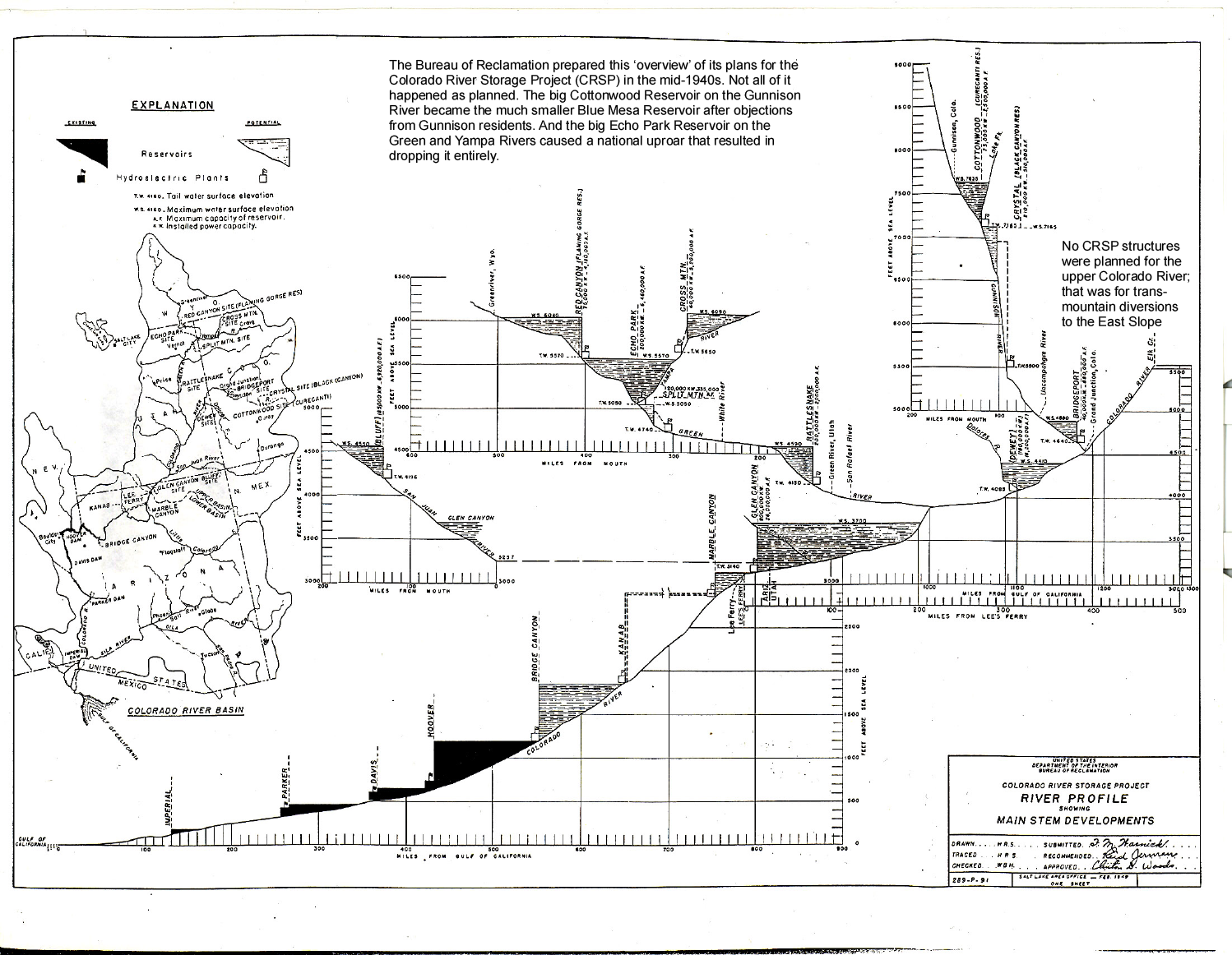
The Bureau of Reclamation prepared this ‘overview’ of its Colorado River Storage Project (CRSP) in the mid-1940s. Not all of it happened as planned. The big Cottonwood Reservoir on the Gunnison River became the much smaller Blue Mesa Reservoir after objections from Gunnison residents. And the big Echo Park Reservoir on the Green and Yampa Rivers caused a national uproar that resulted in dropping it entirely. Credit: USBR (Click to enlarge)
The Colorado River Storage Project had to first be a really serious storage project, to assuage Upper Basin water users’ fears of a Compact call, which they thought would come even if nature, not human overuse, caused a shortfall in Lower Basin deliveries. Another time we will take a look at the Upper Basin Compact created in 1948, and the knots the four states tied themselves into, due to their Caliphobia. So the first charge to the Bureau was to build some big ‘holdover’ reservoirs on the scale of Mead Reservoir – dams capable of storing at least two years of inflow.
But the Bureau and Aspinall also wanted big hydropower units in those dams – ‘humming the tunes of endless wealth,’ as a bit of precious Bureau prosody put it. ‘Cash register dams’ was a more prosaic nickname for the big power-generating dams: they wanted the wealth so generated to be applied not only to paying off the big dams, but also to pay for a lot of smaller dams in the higher country.
The biggest problem farmers and ranchers in the arid lands had in irrigating from a desert river fed primarily by snowmelt was the erratic flows – snowmelt floods early in the irrigating season and then almost no water in the late summer when it was most needed. Storage to even out the flows was the key, and storage was expensive. Every community of farmers could go out after harvest with shovels, black powder and mule scrapers, and dig canals to move water, but water storage required materials and equipment they couldn’t afford. Every irrigation district had sketch plans for dams and reservoirs, but for small communities, the Bureau’s cost-benefit analyses for dam repayment were impossible.
But – if a general fund for a big multi-unit project could be created, with power revenues pouring into it, and some small storage projects drawing on it, with cost-benefit analysis calculated for the whole multi-unit project, then the big dams could carry the otherwise unaffordable little dams…. Glen Canyon Dam would (‘twas hoped) assure that the industrial revolution’s desert empire got its water – but it would also provide storage for the counterrevolutionaries’ ‘headwaters republics.’ Win-win.
And that was essentially the Colorado River Storage Project Aspinall and his collaborators in the Upper Basin put together. They started in 1950 with a bill calling for nine big holdover dams and reservoirs, and a couple dozen ‘participating projects’ (the smaller storage dams for the local communities). By the time they finally got the project through Congress in 1956, they were down to three actual holdover dams (Glen Canyon Dam on the Colorado mainstem and Flaming Gorge on the Green River, both with full power generating units, and Navajo Dam on the San Juan with no power unit), the Curecanti unit of three dams on the Gunnison that was primarily for power production, and eleven ‘participating projects’ to be partially paid for from the power revenues – and another two dozen potential participating projects for further study.
And because Aspinall knew the New West was coming, like it or not, the Act included a requirement that every unit would include recreational facilities.
Did it work out as planned? Yes and no. The ‘cash register’ dams were all built, and facilitated the building of around a dozen of the small ‘participating projects.’ My great-grandparents would have been glad for the dam built on the North Fork of the Gunnison River above Paonia, the erratic river whose spring floods had forced them to move their house to higher ground. But they had sold the homestead by the time the dam was built because none of their offspring wanted to contend with the erratic water supply.
Animas-La Plata Project map via USBR
By the late 1960s, however, the nation had grown tired of building (and paying for) western water projects, and NEPA and the advent of the Environmental Impact Study after 1970 made even small water projects problematic. The last project done under CRSP auspices was an Animas-LaPlata project originally intended to help the Ute Indians develop agricultural lands, but it got so scaled down that it was not much use to anyone.
By the turn of the century, ‘reclamation’ was more likely to be interpreted as work to reclaim and restore land and waterways damaged by the collateral debris that the Old West’s heavier industrial unsettlement left behind. Then in the 1980s a large portion of the power revenue from the big holdover dams was diverted from further CRSP counterrevolutionary structures, to an all-out effort to restore four endangered fish species that, back in the 1970s, the U.S. Fish and Wildlife Service tried to kill off by poisoning the Green River. Mistakes have been made, and visions and dreams got carried out with the debris.
The recreation industries, and the accompanying real estate and construction industries, have pretty much overrun and occupied Aspinall’s would-be agrarian republic; but there are, nonetheless, still places in the West where small farms and ranches hang on, some of them ‘heritage cultures’ passed on through families predating CRSP, some of them new and serious about growing local food – and many of them served by CRSP facilities generated by Glen Canyon Dam. But the agrarian philosophy and vision they represent is largely unarticulated in the mainstream culture; I believe, however, that a careful and potentially difficult interrogation of a large number of rural MAGA supporters would reveal that a virulent form of the agrarian counterrevolution still lives, mute but mad, in a twisted variant of unarticulated hope.
Just call it all another story in the romance of the Colorado River – the story of how Glen Canyon Dam was, for a time, put in service to another America.
A high desert thunderstorm lights up the sky behind Glen Canyon Dam — Photo USBR
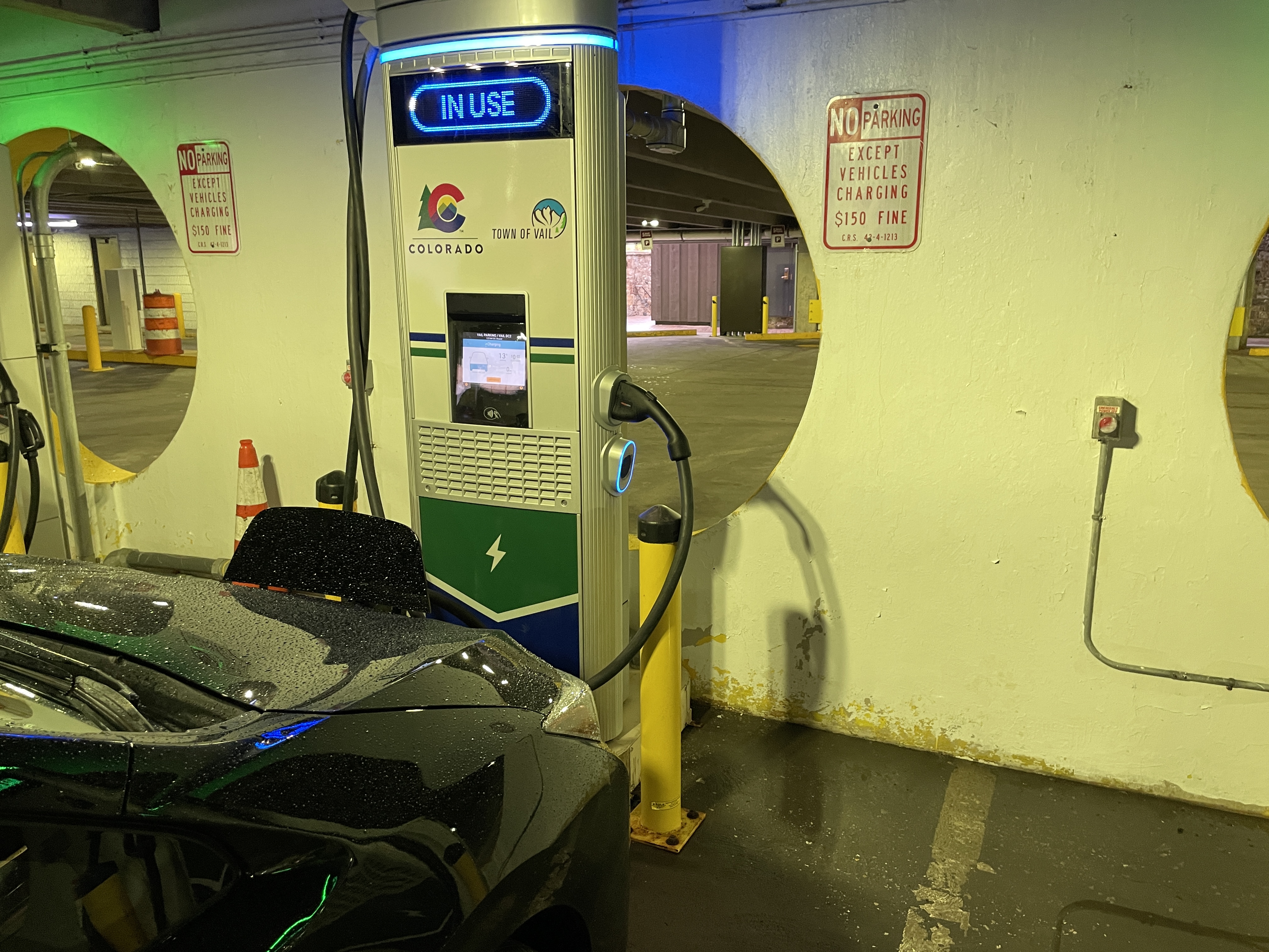
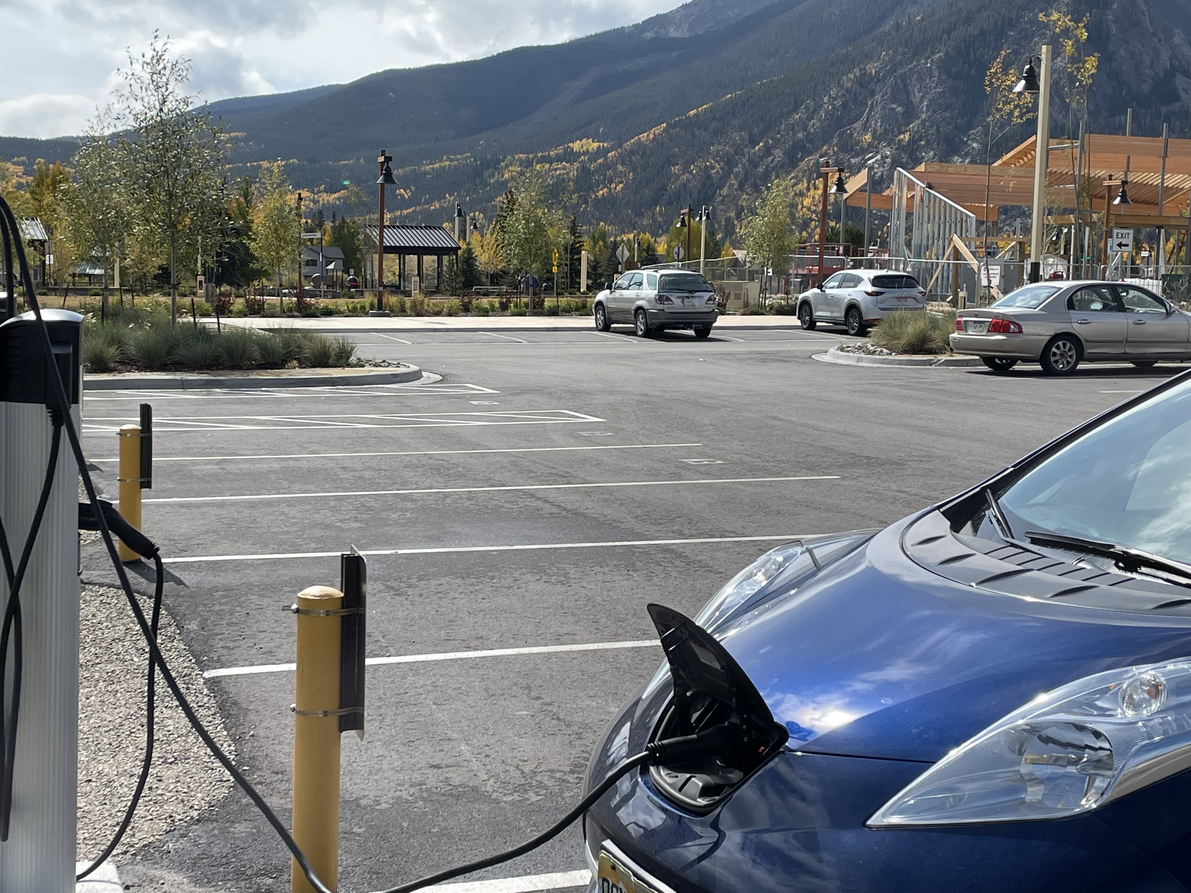
Coyote Gulch’s Leaf charging at the City of Vail Lionshead parking structure May 24, 2023.
Day 6 was a drive back to Denver from Glenwood Springs to return to work and the urban landscape that has run amok with all the beautiful precipitation. We followed US-6 as much as we could to save charge, see more of the countryside and the Eagle River.
Charging was in Vail (CHAdeMO) where the Leaf reported 56% charge and 118 miles of range. We stopped for lunch in Frisco and charged at the Town of Frisco facility (J1772) and then keeping with the US-6 strategy we climbed up to Loveland Pass. It is pretty much downhill from Loveland Pass to our home in Denver and the Leaf reported 56% charge and 191 miles of range when we got home. You have to love regenerative charging.
Coyote Gulch’s Leaf charging at Red Rock Hyundai in Grand Junction May 23, 2023.
Day 5 was a short drive day from Grand Junction to Glenwood Springs.
Colorado River at Los Colonias Park in Grand Junction May 23, 2023
Before leaving Grand Junction we drove to Los Colonias Park to see what the city was up to. The water level was high in the small craft zone and no one was braving it.
Colorado River from CR-311(?).
I like to get off the Interstate when possible, it takes less charge and you leave the tension and traffic behind. I stumbled upon CR-311(?). It dead-ended and I had to backtrack a ways to get back to I-70 but snagged a short video.
Glenwood wave May 23, 2023.
The Glenwood wave is a favorite for many in Glenwood Springs. I asked a guy who was preparing to engage the wave what the velocity was, he answered with a broad smile, “12,000 cfs.”
Nice boat ya got there, would be a shame if somethin’ happened to it.. Photo credit: John Fleck
This feels like a shakedown.
For decades, Lower Colorado River water users have been taking more water than the river can provide, threatening their own communities’ futures. Unable to come up with a plan to live within their water means, they’re now asking us to pay them to not crash the system on which we all depend.
The shakedown comes in the form of a letter this morning from California, Arizona, and Nevada to the Department of Interior laying out an agreement that would (as near as I can tell, the letter is light on details) reduce water use in the Lower Basin by 3 million acre feet above and beyond already agred-upon cuts (the 2007 Guidelines and Drought Contingency Plan) between now and 2026, with the bulk of those reductions to be compensated with federal money.
SOME GOOD THINGS IN THE PROPOSAL
I’ve been putting off reporters today, saying I didn’t want to comment without seeing more detail on the proposal’s water numbers. I stand by that hesitancy. It’s hard to know if the cuts will be enough to accomplish what needs to be accomplished. But there’s some language that is encouraging.
First, the proposal includes a helpful “what if” – if the hydrology is bad and the cuts aren’t enough, the states will come up with “an implementable plan” to keep Mead above elevation 1,000. “If such an acceptable plan, as determined by Reclamation, is not developed, Reclamation may independently take action(s) to protect 1,000 feet.”
But I hope you can see the weirdness here. “If we can’t figure out how to save ourselves from our overuse of water, we give Reclamation permission to save us.”
Second, if the hydrology is bad enough to risk dropping Powell below elevation 3,500, the states are cool with Reclamation dropping releases from Powell as low as 6 million acre feet. Sorta. “If we can’t figure out how to reduce our use enough to save Glen Canyon Dam, we give Reclamation permission to go ahead and save it anyway.”
OTHER PEOPLE’S MONEY, OTHER PEOPLE’S VALUES
In the fall class Bob Berrens and I teach in the University of New Mexico’s Water Resources Program, we have a common refrain in discussion of the students’ suggestions for dealing with water shortfalls: “That sounds like a great idea, how are you going to pay for it?” The answer is invariably state or federal money – “other people’s money”, not the money of the community benefitting from the use of the water and suffering the consequences of shortages.
We spend a lot of time talking about the tradeoff. When you take other people’s money, you also have to accept other people’s values.
Here’s the pertinent language from today’s letter from California, Arizona, and Nevada:
That’s the shakedown. If you don’t pay us a big pile of federal cash, we’ll just run Lake Mead to deadpool. Or, alternatively, if you don’t pay us a big pile of federal cash, we’ll drag the Colorado River Basin into litigation that will make the river ungovernable, a sort of institutional deadpool. Either way, it’s a shakedown.
There’s nothing here that is any sort of a nod to what we might expect from the Lower Basin in return for our largesse other than, “If you pay us, we won’t crash the thing.”
THE DANGEROUS PRECEDENT
I am sympathetic to the water users whose entitlements were ensured under Article VIII of the Colorado River Compact: “Present perfected rights to the beneficial use of waters of the Colorado River System are unimpaired by this compact.”
This is an important protection for Tribal water rights, and also some of the big ag districts. Great! Let the Lower Basin’s junior users work out a deal with the pre-compact rights holders to move that water around. Let’s see a QSA for Arizona. Let’s see QSA II for California. Show us your plan to live within your means, other than “Pay us to live within our means.”
The approach in the Lower Basin states letter – have the federal taxpayers pick up the tab rather than the people who’ve created the mess – sets a dangerous precedent for our approach in the post-2026 Colorado River management world.
Turf replacement. Photo credit: Western Resource Advocates
Click the link to read the article on the CBS Denver 7 website (Katie Perkins). Here’s an excerpt:
Gov. Jared Polis has signed into law a measure that would change Coloradans’ Homeowner Association rules. Around 60% of Coloradans live under a HOA, according to a press release from the governor’s office. Under the newly confirmed State Senate Bill 178, homeowners can now swap their grass lawns for alternatives like turf that require less water.
Previously, state law granted an exception for an HOA to adopt design or aesthetic guidelines that apply to “nonvegetative turf grass and drought-tolerant vegetative landscapes.” The association was allowed to regulate the type, number and placement of drought-tolerant plants installed on a homeowner’s property.
The Bureau of Reclamation is continuing to schedule release changes for the spring peak release from Navajo Reservoir.
The scheduled increase to 4,600 cfs for today will be postponed. The release will remain at its current level (4,000 cfs) until tomorrow. At that point, the river conditions will be re-evaluated for the scheduled ramp-up.
Release changes are made based on river conditions and coordination with federal, state, and local agencies.
The shape and timing of the hydrograph have been coordinated with the San Juan River Basin Recovery Implementation Program to balance Recovery Program benefits with flood control and operational safety. During spring operations, releases from the Navajo Unit will be made in an attempt to remain at or below the U.S. Army Corps of Engineers safe channel capacity of 5,000 cfs between Navajo Reservoir and the confluence with the Animas River in Farmington, and 12,000 cfs downstream of Farmington. The release may be changed or reduced if the precipitation forecast shows a risk of exceeding safe channel capacity in the San Juan River.
Areas in the immediate vicinity of the river channel may be unstable and dangerous. River crossing may change and be impassable as flows increase. Please use extra caution near the river channel and protect or remove any valuable property in these areas.
Please stay tuned as a notice with an updated schedule will be sent out daily during the release. Notices will also be posted to our website along with the latest release schedule. http://www.usbr.gov/uc/wcao/water/rsvrs/notice/nav_rel.html
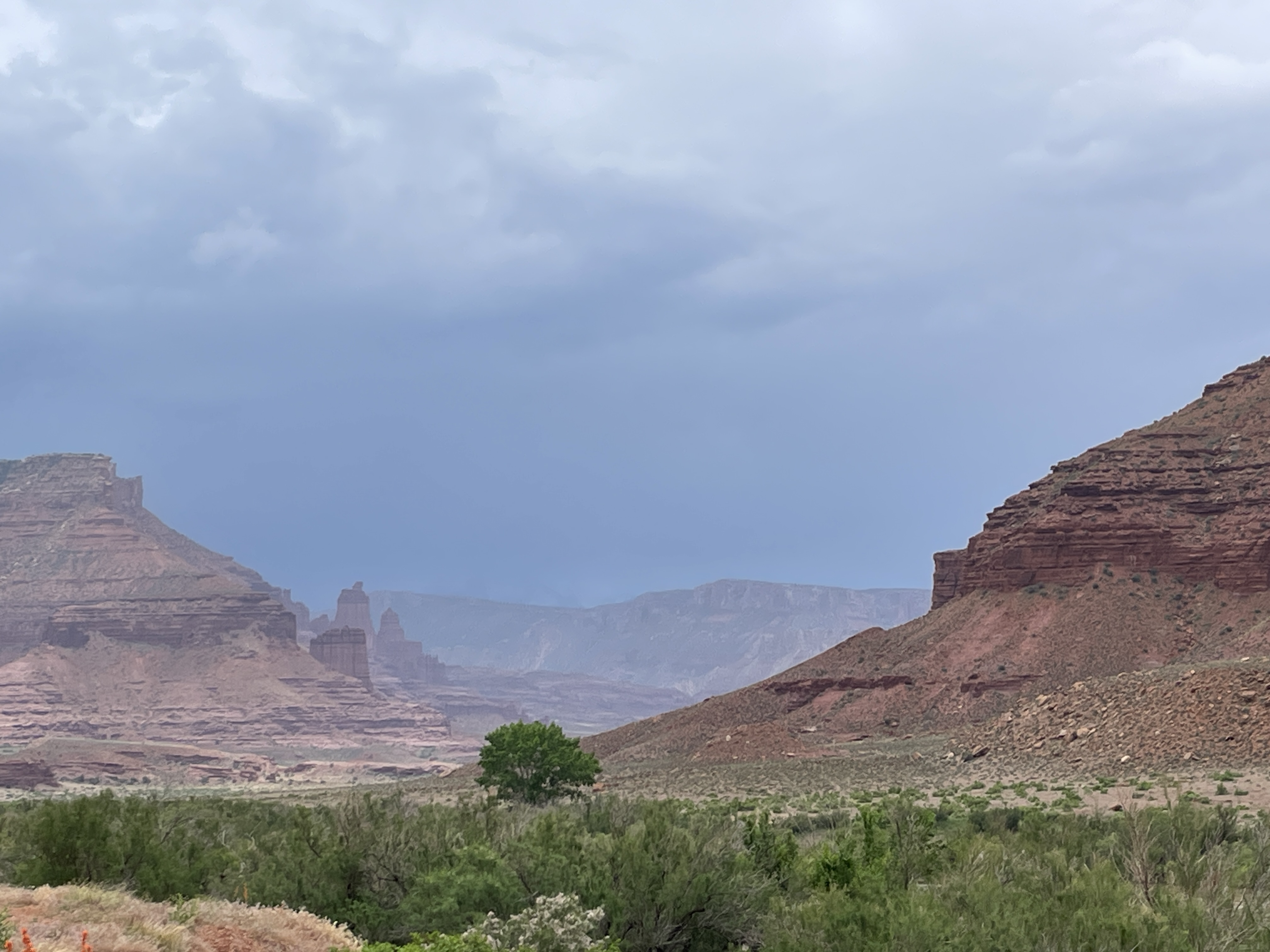
Convective storm obscuring the La Sal mountains along Utah-128 near Castle Valley May 22, 2023, Colorado River mainstem in the foreground.
Day 4 was the longest day so far. We travelled from Grand Junction to Moab along I-70 at first and then along Utah-128. The rainy weather joined us along the way. This route into Moab is one of my favorites as the road winds along the canyon walls near the river. We spotted a few folks testing the high flows in rafts nearer to Moab and a pair of enthusiasts in an inflatable kayak and on a standup paddle board.
The Colorado River near Dewey Bridge May 22, 2023.
The river was all the more impressive along this route, bankfull and moving along at a pace where you could experience the power.
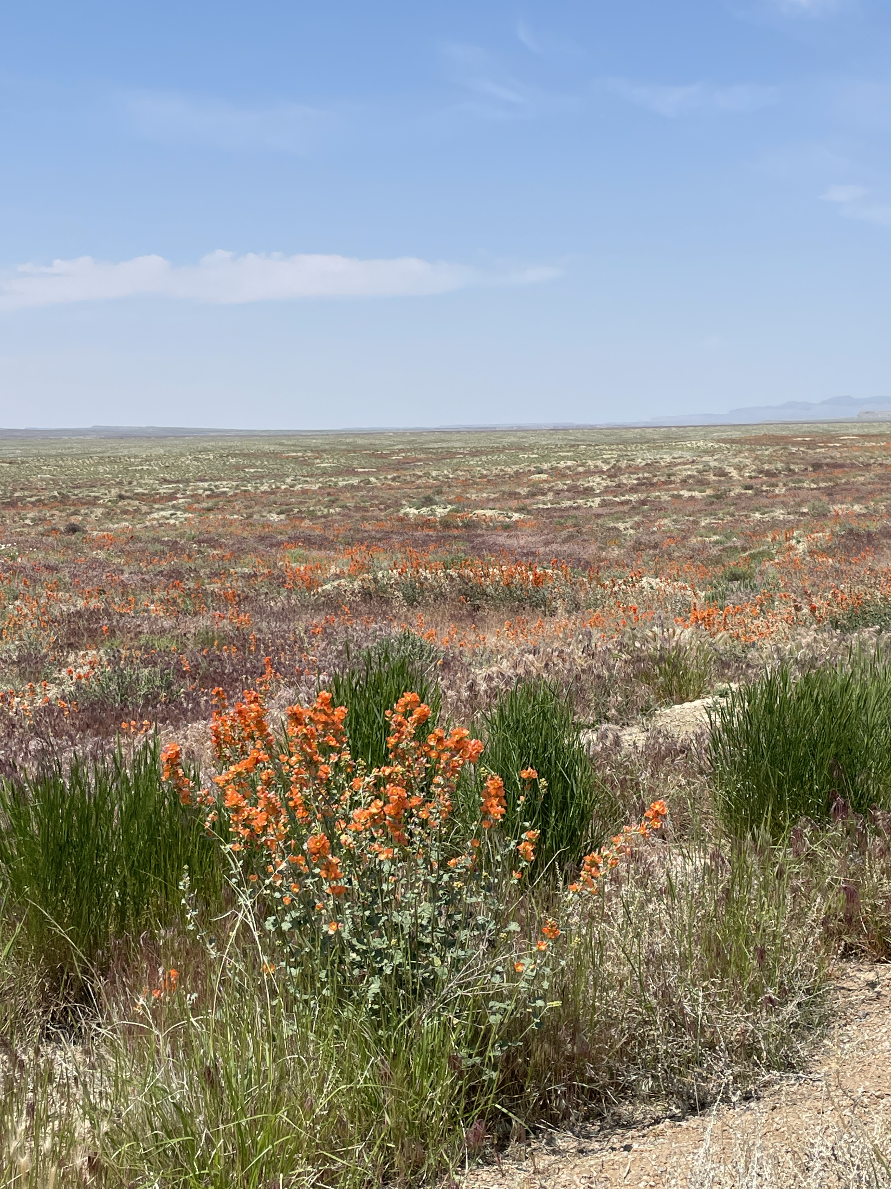
Superbloom along Utah-128 May 22, 2023. A species of Globemallow (I think) in the foreground.
A real treat this wet water year was the super bloom along Utah-128 near Cisco. The desert was so green compared to other years and the wildflowers put on a great show.
Green River at Green River, Utah May 22, 2023.
We left Moab driving by Arches and up to Green River to get a look at the river there. The Green River was also bankfull. There is a restaurant along the river where I’ve seen the tire tracks of off-roaders in the river bed — not this year.
Seven Basin states agree on analyzing consensus-based approach proposed by the Lower Basin
Funding from President Biden’s Investing in America agenda combined with voluntary commitments will conserve 3-million-acre feet of water through 2026
WASHINGTON — The Department of the Interior today [May 22, 2023] announced significant new developments in the Biden-Harris administration’s efforts to protect the stability and sustainability of the Colorado River System now and into the future.
As part of the Department’s continued efforts to address ongoing severe drought conditions and a changing climate in the Colorado River Basin, representatives from the seven Colorado River Basin states have agreed to the submission of a Lower Basin, consensus-based system conservation proposal. They are requesting the proposal be fully analyzed as an action alternative under the Bureau of Reclamation’s draft Supplemental Environmental Impact Statement (SEIS), published last month.
The consensus-based proposal – agreed upon by the three Lower Basin states – commits to measures to conserve at least 3 million-acre-feet (maf) of system water through the end of 2026, when the current operating guidelines are set to expire. Of those system conservation savings, 2.3 maf will be compensated through funding from the historic Inflation Reduction Act, which is supporting efforts to increase near-term water conservation, build long term system efficiency, and prevent the Colorado River System’s reservoirs from falling to critically low elevations that would threaten water deliveries and power production. Under this consensus proposal, the remaining system conservation needed for sustainable operation will be achieved through voluntary, uncompensated reductions by the Lower Basin states.
“There are 40 million people, seven states, and 30 Tribal Nations who rely on the Colorado River Basin for basic services such as drinking water and electricity. Today’s announcement is a testament to the Biden-Harris administration’s commitment to working with states, Tribes and communities throughout the West to find consensus solutions in the face of climate change and sustained drought,” said Secretary Deb Haaland. “In particular I want to thank Deputy Secretary Tommy Beaudreau and Reclamation Commissioner Camille Calimlim Touton, who have led the discussions with Basin state commissioners, Tribes, irrigators, local communities, and valued stakeholders to reach this critical moment.”
“I commend our partners in the seven Basin states who have demonstrated leadership and unity of purpose in developing this consensus-based approach to achieve the substantial water conservation necessary to sustain the Colorado River System through 2026,” said Deputy Secretary Tommy Beaudreau. “Reclamation’s SEIS process succeeded in facilitating this agreement, and we will carry forward the consensus proposal by analyzing it under the SEIS.”
“For over a century, Reclamation has led with solutions grounded in partnership and collaboration. The agreement today continues in this tradition,” said Bureau of Reclamation Commissioner Camille Calimlim Touton. “I am proud of the Reclamation team’s work and thank our partners across the basin and the Basin states representatives for reaching this moment. This is an important step forward towards our shared goal of forging a sustainable path for the basin that millions of people call home.”
In light of the Lower Basin states’ conservation proposal, the Department today announced that it is temporarily withdrawing the draft SEIS published last month so that it can fully analyze the effects of the proposal under the National Environmental Policy Act (NEPA). Reclamation will then publish an updated draft SEIS for public comment with the consensus-based proposal as an action alternative. Accordingly, the original May 30, 2023, deadline for the submission of comments on the draft SEIS is no longer in effect. The Department plans to finalize the SEIS process later this year.
Early next month, the Department will formally advance the process for the development of new operating guidelines replacing the 2007 Colorado River Interim Guidelines for Lower Basin Shortages and the Coordinated Operations for Lake Powell and Lake Mead at the end of 2026. In the coming weeks, Reclamation will publish the Notice of Intent for the Environmental Impact Statement related to the post-2026 guidelines.
President Biden’s Investing in America agenda represents the largest investment in climate resilience in the nation’s history and is providing pivotal resources to enhance the resilience of the West to drought and climate change, including to protect the short- and long-term sustainability of the Colorado River System. Through the Bipartisan Infrastructure Law, Reclamation is investing $8.3 billion over five years for water infrastructure projects, including water purification and reuse, water storage and conveyance, desalination and dam safety. The Inflation Reduction Act is investing an additional $4.6 billion to address the historic drought.
To date, the Interior Department has announced the following investments for Colorado River Basin states, which will yield hundreds of thousands of acre-feet of water savings each year once these projects are complete:
$281 million for 21 water recycling projects that are expected to increase annual water capacity by 127,000 acre-feet annually
Over $73 million for infrastructure repairs on water delivery systems, $19.3 million in fiscal year 2022 and another $54 million announced last month
$71 million for 32 drought resiliency projects to expand access to water through groundwater storage, rainwater harvesting, aquifer recharge and water treatment
Click the link to read “Colorado River Protection” release from The Arizona Department of Water Resources and the Central Arizona Project on the CAP website (Doug MacEachern, Shauna Evans, Crystal Thompson, and DeEtte Person):
The Arizona Department of Water Resources and Central Arizona Project announce a consensus proposal developed by Arizona, California, and Nevada to conserve historic volumes of Colorado River water in Lake Mead.
This proposal is expected to have an immediate impact on the stability of the Colorado River system, a source of water for 40 million people, including some of the most productive farmland in North America.
“This proposal does more than just ‘protect’ elevations in the system’s major reservoirs, Lake Powell and Lake Mead,” said Arizona Department of Water Resources Director Tom Buschatzke. “It builds critical elevation in both reservoirs.”
The proposal is built around the collaborative actions by water users in the lower basin through enforceable commitments to conserve water that will total three million acre-feet in Lake Mead over the next three years. This winter’s good hydrology in the west has provided the flexibility for water users to pledge their water to this program.
We commend our Arizona partners including tribes, cities, agriculture and industry who have committed water as part of this effort.
We also appreciate our river partners, the Bureau of Reclamation and the Department of the Interior for working together on these agreements.
“This proposal protects the system in the short term so we can dedicate our energy and resources to a longer-term solution, ” says Central Arizona Project General Manager Brenda Burman. “New guidelines for operating the river system will be due by the end of 2026. There’s a lot to do and it’s time to focus.”
Updated Colorado River 4-Panel plot thru Water Year 2022 showing reservoirs, flows, temperatures and precipitation. All trends are in the wrong direction. Since original 2017 plot, conditions have deteriorated significantly. Brad Udall via Twitter: https://twitter.com/bradudall/status/1593316262041436160
Coyote Gulch’s Leaf in the hotel parking lot upon arriving in Grand Junction May 21, 2023.
Day 3 was a short jaunt from Glenwood Springs to Grand Junction. We stayed on US-6 as much as possible to get closer to the Colorado River along with the hay fields and small towns between the two cities. Spring has sprung in the area and the Colorado River was bankfull all the way.
Charging was in Rifle at the Kum & Go. I charge here whenever I’m in the vicinity becasus they have several ChargePoint (CHAdeMO) chargers, and it is a short walk to restaurants.
Click the link to read the article on The Denver Post website (Conrad Swanson). Here’s an excerpt:
Those states, which make up the river’s lower basin, are reportedly close to an agreement that would cut the amount of water they draw from the waterway. They’re racing against the clock to find an agreement before the end of the month or else the U.S. Bureau of Reclamation might make the cuts for them. But their proposed savings – reported Thursday by the Washington Post – amount to half of the minimum amount of water federal officials said the basin must save. And while the Colorado River’s headwaters saw an above-average snowpack this year, that extra water only buys the West a bit more time and the boon isn’t expected to last.
“The river is telling us that we haven’t done enough,” Jennifer Gimbel, a senior water policy scholar at Colorado State University said. “It’s challenging us.”
[…]
The proposal, which hasn’t formally been proposed, would mean the Imperial Irrigation District would be conserving nearly a quarter of its water supply, spokesman Robert Schettler said. Already those measures could mean that fewer crops come out of the major farming district in southern California (the largest water user in the most water-consumptive state), lowering national supply and raising prices. Digging deeper would exacerbate those issues, he said.,,Negotiations to meet those federal requirements are fraught, pitting rural communities against urban ones and forcing a type of standoff between Arizona and California, the two largest water users on the river. Upper-basin states of Colorado, New Mexico, Utah and Wyoming offered a small effort, for their part, but water managers there are reluctant to commit further without more substantial movement from the downstream states…
Currently, the lower-basin states are nearing an agreement to conserve 3 million acre-feet over the next three years, The Washington Post reported. That’s half of Reclamation’s minimum required savings of 2 million acre-feet annually, though. And the states would want to be paid more than $1 billion from the federal government to forego that water, the Post continued, citing state and federal officials familiar with the negotiations. Massive amounts of federal money are available for conservation projects, Gimbel said. Programs are already in place to pay farmers and others to use less water and they’ve seen mixed results. But paying people, businesses and states not to use water isn’t a long-term strategy, Gimbel noted. She praised lower-basin states for coming together but noted that the water saved by the prospective deal wouldn’t be enough.
Updated Colorado River 4-Panel plot thru Water Year 2022 showing reservoirs, flows, temperatures and precipitation. All trends are in the wrong direction. Since original 2017 plot, conditions have deteriorated significantly. Brad Udall via Twitter: https://twitter.com/bradudall/status/1593316262041436160
Craig Station is the No. 2 source of greenhouse gas emissions in Colorado, behind Comanche station at Pueblo. Photo/Allen Best
Click the link to read the article on the Big Pivots website (Allen Best):
No doubt, nuclear energy has key advantages. So why isn’t it likely to be the silver bullet to replace coal plants in Craig, Pueblo and other places?
Oliver Stone has a new movie, “Nuclear Now,” that made its Colorado debut in Boulder on May 1. In it Stone argues that the grave risks posed by climate change require we embrace nuclear energy.
A few hours before, at a hearing in Denver, state legislators heard an even more urgent equation. “Anybody who opposes nuclear I believe is a climate denier,” an individual testified before the Senate Transportation and Energy Committee.
And in Pueblo that evening, city council members heard about a committee formed by Xcel Energy to study options to replace tax base, jobs, and electrical generation once the last coal plant there closes. The group will hear about nuclear.
In the background is the federal government, offering gambling money on all sorts of decarbonization solutions, including nuclear.
Mauna Loa is WMO Global Atmosphere Watch benchmark station and monitors rising CO2 levels Week of 23 April 2023: 424.40 parts per million Weekly value one year ago: 420.19 ppm Weekly value 10 years ago: 399.32 ppm 📷 http://CO2.Earthhttps://co2.earth/daily-co2. Credit: World Meteorological Organization
People on the left and right find common ground in support of nuclear energy, but their motivations differ. Some, like Stone, the movie-maker, are driven by the existential danger posed by climate change. Even the pleasant days of spring are spoiled by news that the carbon dioxide detector atop Mauna Loa has recently rolling past 425 parts per million. We’re still barreling toward a much rockier climate road. Climate scientists have long talked about tipping points. It’s like your head turning gray, one hair at a time — until suddenly, it all goes gray or white.
Some in Colorado see nuclear energy replacing coal plants. The last coal unit at Pueblo will close no later than 2031. Xcel has guaranteed property tax revenues through 2040, but not to 2070, the original retirement date. Craig also faces giant uncertainties. Increased tourism? “We don’t want to become sheet-changers,” one Moffat County landowner told me.
Western Montrose County, where a uranium boom occurred during the 1950s —and which lost a small coal plant in 2019, is also interested in nuclear.
HB23-1247, titled “Assess Advanced Energy Solutions in Colorado,” now awaiting the governor’s signature, will direct study of nuclear energy but also other options. All have upsides but questions marks. Green hydrogen, made from renewables and water, can store energy for use when renewables are unavailable. However, the technology remains costly. Too, some scientists question whether accidental release of hydrogen into the atmosphere will create as many problems as it solves.
Nuclear can also backup intermittent renewables. Nuclear does provide 20% of U.S. electricity. We have a fleet of nuclear-powered submarines. They seem to operate without problems. But some questions remain about nuclear safety. Would you want a large-scale reactor in your town or city? I have to also wonder about nuclear technology falling into the wrong hands.
St. Vrain, Colorado’s only nuclear power plant, operated only a decade before its owner, Public Service Co. of Colorado, pulled the plug on it and, in the early 1990s, converted it into a natural gas plant. Spent fuel is stored on site. Photo: Allen Best/Big Pivots
Many have been closely following the progress in Wyoming of a nuclear plant planned next to a coal plant at Kemmerer. TerraPower, the company founded by Bill Gates in 2008, says it will require less water and produce less nuclear fuel waste while plugging nicely into old coal plants. It projects cost of $4 billion for this plant that will use Natrium technology.
WyoFile reported that while in Kemmerer during early May, Gates called it a “pioneering move,” key to the global energy future. This project is projected to be ready in in 2030. PacifiCorp, a major regional power provider, has said it could add five more such Natrium reactors at existing coal-fired plants in Wyoming and Utah.
Another potential model is assembly-line-style production of small modular reactors, lowering costs. That sounds appealing, but by definition that model will not replace the big coal plants at Pueblo and Craig. For that matter, it does not yet exist.
Here in Colorado, I hear people with degrees in nuclear engineering express doubts about nuclear. State Sen. Chris Hansen, at the recent legislative hearing, objected to how a witness had characterized his skepticism about nuclear. “It has nothing to do with science or technology,” said Hansen, who has a degree in nuclear engineering. “It’s the cost profile.” He cited a recent Georgia reactor that came in at $33 billion, three times the projected cost. It’s not the only example.
Chuck Kutscher got his master’s degree in nuclear engineering and worked in the nuclear sector California before turning his attention to solar in 1978 and moving to Colorado. “New nuclear power plants, including new U.S. reactor technologies currently under development, will likely be too expensive and take too long to build to make a significant contribution to climate change mitigation,” he says.
In Boulder, Oliver Stone’s movie talked little of costs. But in Pueblo, a representative of Idaho National Laboratory, speaking to a municipal energy study group, openly conceded that cost remains the million dollar question.
She misplaced a comma or two in that string of zeroes, though. It’s the billion dollar question. Many billions.
Allen Best is a Colorado-based journalist who publishes an e-magazine called Big Pivots. Reach him at allen.best@comcast.net or 720.415.9308.
We headed over to Glenwood Springs from Kremmling on Day 2 going over Gore Pass to Toponas and Yampa then along CO-131 S. to the Colorado River Road where we joined the Colorado River. The route winds along the river to Dotsero where we picked up I-70 to Glenwood Springs through Glenwood Canyon. The river was runinng bank to bank. We were treated to beautiful cool and wet weather for most of the drive.
Colorado River along the Colorado River Road from CO-131 to Dotsero.
Charging was near Penny’s Diner in Yampa — a ChargePoint fast charger (CHAdeMO connector) installed by the Yampa Valley Electric Association.
The Grand River Diversion Dam, also known as the “Roller Dam”, was built in 1913 to divert water from the Colorado River to the Government Highline Canal, which farmers use to irrigate their lands in the Grand Valley. GVWUA is not participating the rebooted System Conservation Program after water managers couldn’t agree on how much farmers should be paid to cut back their water use. Photo credit: Bethany Blitz/Aspen Journalism
Three of western Colorado’s biggest irrigation districts are not participating on a large scale in a federally funded program to conserve water, and the amount of water saved by the program overall won’t be enough to rescue depleted reservoirs.
The rebooted System Conservation Program was one of the legs of the Upper Colorado River Commission’s 5-Point Plan, announced in July and aimed at protecting critical elevations in Lake Powell and Lake Mead, which have fallen to record-low levels in recent years because of overuse, drought and climate change. System conservation will take place in the four upper Colorado River basin states — Colorado, New Mexico, Wyoming and Utah — and will pay water users to cut back. It’s being funded by $125 million from the federal Inflation Reduction Act.
The total water estimated to be saved across the upper basin for this year of the restarted, temporary and voluntary System Conservation Program is nearly 39,000 acre-feet. By comparison, Lake Powell when full holds more than 23 million acre-feet; Ruedi Reservoir, on the Fryingpan River, can hold about 100,000 acre-feet. (An acre-foot is the amount of water needed to cover an acre of land to a depth of 1 foot and can supply one to two households a year.)
Becky Mitchell, Colorado commissioner to the UCRC, said in a UCRC meeting last month that although the upper basin will do its part in response to last summer’s calls from the federal government that the seven Colorado River basin states needed to conserve 2 million to 4 million acre-feet of water, the majority of that needs to come from cuts in the lower basin (California, Arizona and Nevada).
“(System conservation) will not resolve the crisis in the reservoirs,” she said.
Last month the UCRC approved moving forward with executing agreements with program participants, which are still being finalized.
Although a goal of the program was to get participation across all water sectors — agricultural, municipal and industrial — all of the projects proposed in Colorado involve Western Slope agriculture. None of the state’s Front Range water providers, which collectively take about 500,000 acre-feet per year of the Colorado River’s headwaters across the Continental Divide to thirsty cities and farms, are participating.
Paying water users to irrigate less has long been controversial on the Western Slope, with fears that these temporary and voluntary programs could lead to a permanent “buy and dry” situation that would negatively impact rural farming and ranching communities.
Of the four upper basin states, Colorado has the largest number of projects (29) but the least amount of saved water (3,532 acre-feet). This is an indication that most of Colorado’s participants are proposing small projects. UCRC Executive Director Chuck Cullom said if the program is undertaken again, officials may consider a minimum size requirement because doing very small projects may not be worth it.
“From a practical standpoint of the cost of monitoring and administering a verification program for that (small number of) acres may not pencil out relative to the amount of water conserved,” Cullom said.
Of the 29 Colorado projects, most involve reducing water use for forage crops, according to information provided by UCRC. Eight involve fallowing grass hay as part of a cow-calf operation, saving 1,163 acre-feet of water; seven plan to fallow alfalfa and save 1,029 acre-feet; and eight propose switching to less-thirsty crops, saving 791 acre-feet.
The UCRC received 88 proposals across the four states, 72 of which met the qualifying criteria. Utah has 20 projects that meet preliminary criteria; Wyoming has 22 and New Mexico has one. The UCRC’s opening offer was $150 per acre-foot of saved water, but the average compensation will probably end up being higher — $434 per acre-foot, according to information provided by UCRC.
Grand Valley Water Users Association not participating
Although some water users in the Grand Valley Water Users Association participated in the original system conservation pilot program, which ran from 2015 to 2018 and conserved 47,000 acre-feet of water at a cost of about $8.6 million, they won’t be taking part this time around.
The Government Highline Canal flows past Highline State Park in the Grand Valley. CREDIT: BETHANY BLITZ/ASPEN JOURNALISM
GVWUA, whose Highline Canal delivers water to roughly 24,000 acres of farmland on the north side of the valley between Grand Junction and Mack, withdrew its application from the process after manager Tina Bergonzini said she couldn’t come to an agreement on the price with the UCRC. GVWUA had rejected the concept of paying farmers based on an amount of unused water, instead proposing to pay farmers for each acre of land they took out of production.
Individual farmers would have had to apply to the program through the association, which proposed to cap total member participation at 1,000 acres and 3,000 acre-feet of water.
GVWUA was asking for between $686 and $1,306 per each acre fallowed, depending on whether farmers reduced water use during the entire irrigation season or just part of it.
Bergonzini said the price represents what it would cost to administer the program in a way that provides equity and protection; at any lower price, the funding from system conservation would not be enough to cover the extra staff and engineering costs. Cullom said his organization was unlikely to approve those costs, so GVWUA withdrew its application.
“They were not wanting to pay per acre what we had requested,” Bergonzini said. “They had a line drawn in the sand and so did I.”
The Grand Valley Irrigation Company, which serves about 40,000 acres of farmland between Palisade and Mack, has four projects proposed within its service area, covering a total of 120 acres and 285 acre-feet of water savings.
“It’s not a very big amount,” said GVIC Assistant Superintendent Charlie Guenther. “I did hear from a handful of ag people that they didn’t want to be part of this because it sounded very technical and it was government involvement. That’s something that came up.”
Unlike GVWUA, individual water users within GVIC did not have to apply to the program through the irrigation company, and the company’s board did not take a stance on whether or not to support system conservation, according to Guenther.
There is just one conservation project proposed in the boundaries of the Uncompahgre Valley Water Users Association, the largest irrigation district in Western Colorado, at more than 83,000 acres of farmland in Delta and Montrose counties. The project would enroll about 33 acres in the program and would result in about 46 acre-feet of water savings.
UVWUA manager Steve Pope said the system conservation program didn’t get much interest from his water users because of the timing. Bergonzini agreed.
“They didn’t want to do a last-minute thing,” Pope said. “By the time this thing was rolled out, these guys had already made their decisions and they were already committed for the next season.”
Cullom has acknowledged that there were shortcomings with the program’s rollout. The UCRC unveiled details of the program in December, with an original application deadline of Feb. 1, which was later pushed to March 1 for this summer’s irrigation season.
“We need to do much better when we think about how to do this in the future, if we do this in the future,” he said. “We need more clarity on the data requirements, what we expect from a proposal. We need to give people more time to engage in understanding what the opportunity is and we need to start sooner. Start in the fall for an irrigation season instead of January.”
Conservation district concerns
The Western Slope’s two largest conservation districts — the Colorado River Water Conservation District and Southwestern Water Conservation District — submitted letters to the UCRC stating their concerns with the program. Mitchell had promised the districts that they could participate in the review and approval process for applications, thereby securing a measure of local control. But in March, she walked back that commitment, saying the UCRC had sole authority in the approval process.
The UCRC has released few details so far on project proposal specifics, and publicly available applications have been heavily redacted. In addition to redacting the applicants’ personal identifying information, nearly everything else has been blacked out: the precise location of projects; which streams and ditches are involved; details of the water rights involved; and how much the applicants are asking to be paid for their water.
The districts say this makes it impossible to meaningfully review them to determine whether the projects would cause injury to other water users. Their letters to the UCRC say the lack of transparency raises questions about whether public funds are being used wisely.
“In short, SWCD is very disappointed and concerned about the process that has been undertaken by the UCRC and the state of Colorado,” reads the letter from Southwestern General manager Steve Wolff.
In response, Amy Ostdiek, CWCB section chief for interstate, federal and water information, said that the review process respected project proponents’ privacy and that striking a balance between transparency and privacy is an ongoing effort.
“The Colorado State Engineer’s Office has been directly involved as implementation agreements and verification plans are developed to ensure no injury results from SCPP participation,” Ostdiek said in an email.
She said additional information will be available when the UCRC finalizes agreements with project participants, which should happen late this month, according to Cullom.
The 39,000 acre-feet of water across the four upper-basin states will do little to boost Lake Powell. It’s the proverbial drop in the bucket. But the political value of 39,000 acre-feet may be far greater than any benefit to the nation’s second-largest reservoir. The effort shows that upper-basin water managers are willing to do their part to prevent the system from crashing, but that part is small compared with the cuts they say are needed in the lower basin.
“It’s unlikely any system conservation stood up in the upper basin is going to move the needle,” Cullom said. “But it’s important for the upper basin to participate and contribute within the resources and the tools we have available, and what we are demonstrating in this process is that we do have tools, we do have resources. They are narrow in scope and small in volume.”
Click the link to read the article on The Deseret News website (Amy Joi O’Donoghue). Here’s an excerpt:
So far this year, staff at the Utah Geological Survey have taken 1,000 photos, spent 400 hours on landslides in the last six weeks and had 20 emergency responses.
Two homes have collapsed and one had to be razed by the city, Keach said.
The UGS Geologic Hazards Program conducted a reconnaissance to evaluate two landslides along U.S. Highway 89 in Logan Canyon in the Bear River Range, Cache County. They were reported on May 3, 2023. Details of these landslides are located here–https://t.co/1qcZrBahO9pic.twitter.com/uzvtzRywV8
Sources/Usage: Public Domain.
Research Hydrologist Martin Briggs (USGS) collects ground-penetrating radar (GPR) data. He is wearing special ice cleats on his shoes to have better traction walking on the ice. (April 2017)
Click the link to read the article on the USGS website:
What is Hydrology?
Water is one of our most precious natural resources. Without it, there would be no life on earth. Hydrology has evolved as a science in response to the need to understand the complex water system of the earth and help solve water problems. This hydrology primer gives you information about water on Earth and humans’ involvement and use of water.
Introduction
Hydrology is the study of water
Water is one of our most important natural resources. Without it, there would be no life on earth. The supply of water available for our use is limited by nature. Although there is plenty of water on earth, it is not always in the right place, at the right time and of the right quality. Adding to the problem is the increasing evidence that chemical wastes improperly discarded yesterday are showing up in our water supplies today. Hydrology has evolved as a science in response to the need to understand the complex water systems of the Earth and help solve water problems. Hydrologists play a vital role in finding solutions to water problems, and interesting and challenging careers are available to those who choose to study hydrology.
Water and People
Estimates of water use in the United States indicate that about 355 billion gallons per day (one thousand million gallons per day, abbreviated Bgal/d) were withdrawn for all uses during 2010. This total has declined about 17 percent since 1980. Fresh groundwater withdrawals (76.0 Bgal/d) during 2010 were 8 percent less than during 1980. Fresh surface-water withdrawals for 2010 were 230 Bgal/d, 18 percent less than in 1980.
Much of our water use is hidden. Think about what you had for lunch. A hamburger, for example, requires water to raise wheat for the bun, to grow hay and corn to feed the cattle and to process the bread and beef. Together with french fries and a soft drink, this all-American meal uses about 1,500 gallons of water — enough to fill a small swimming pool. How about your clothes? To grow cotton for a pair of jeans takes about 400 gallons. A shirt requires about 400 gallons. How do you get to school or to the store? To produce the amount of finished steel in a car has in the past required about 32,000 gallons of water. Similarly, the steel in a 30-pound bicycle required 480 gallons. This shows that industry must continue to strive to reduce water use through manufacturing processes that use less water, and through recycling of water.
What is Hydrology?
Hydrology is the science that encompasses the occurrence, distribution, movement and properties of the waters of the earth and their relationship with the environment within each phase of the hydrologic cycle. The water cycle, or hydrologic cycle, is a continuous process by which water is purified by evaporation and transported from the earth’s surface (including the oceans) to the atmosphere and back to the land and oceans. All of the physical, chemical and biological processes involving water as it travels its various paths in the atmosphere, over and beneath the earth’s surface and through growing plants, are of interest to those who study the hydrologic cycle.
There are many pathways the water may take in its continuous cycle of falling as rainfall or snowfall and returning to the atmosphere. It may be captured for millions of years in polar ice caps. It may flow to rivers and finally to the sea. It may soak into the soil to be evaporated directly from the soil surface as it dries or betranspired by growing plants. It may percolate through the soil to ground water reservoirs (aquifers) to be stored or it may flow to wells or springs or back to streams by seepage. The cycle for water may be short, or it may take millions of years.
People tap the water cycle for their own uses. Water is diverted temporarily from one part of the cycle by pumping it from the ground or drawing it from a river or lake. It is used for a variety of activities such as households, businesses and industries; for irrigation of farms and parklands; and for production of electric power. After use, water is returned to another part of the cycle: perhaps discharged downstream or allowed to soak into the ground. Used water normally is lower in quality, even after treatment, which often poses a problem for downstream users.
The hydrologist studies the fundamental transport processes to be able to describe the quantity and quality of water as it moves through the cycle (evaporation, precipitation, streamflow, infiltration, groundwater flow, and other components). The engineering hydrologist, or water resources engineer, is involved in the planning, analysis, design, construction and operation of projects for the control, utilization, and management of water resources. Water resources problems are also the concern of meteorologists, oceanographers, geologists, chemists, physicists, biologists, economists, political scientists, specialists in applied mathematics and computer science, and engineers in several fields.
What Hydrologists Do?
Hydrologists apply scientific knowledge and mathematical principles to solve water-related problems in society: problems of quantity, quality and availability. They may be concerned with finding water supplies for cities or irrigated farms, or controlling river flooding or soil erosion. Or, they may work in environmental protection: preventing or cleaning up pollution or locating sites for safe disposal of hazardous wastes.
Persons trained in hydrology may have a wide variety of job titles. Scientists and engineers in hydrology may be involved in both field investigations and office work. In the field, they may collect basic data, oversee testing of water quality, direct field crews and work with equipment. Many jobs require travel, some abroad. A hydrologist may spend considerable time doing field work in remote and rugged terrain. In the office, hydrologists do many things such as interpreting hydrologic data and performing analyses for determining possible water supplies. Much of their work relies on computers for organizing, summarizing and analyzing masses of data, and for modeling studies such as the prediction of flooding and the consequences of reservoir releases or the effect of leaking underground oil storage tanks.
The work of hydrologists is as varied as the uses of water and may range from planning multimillion dollar interstate water projects to advising homeowners about backyard drainage problems.
San Luis Valley. Photo credit: The Alamosa Citizen
Surface Water
Most cities meet their needs for water by withdrawing it from the nearest river, lake or reservoir. Hydrologists help cities by collecting and analyzing the data needed to predict how much water is available from local supplies and whether it will be sufficient to meet the city’s projected future needs. To do this, hydrologists study records of rainfall, snowpack depths and river flows that are collected and compiled by hydrologists in various government agencies. They inventory the extent river flow already is being used by others.
Managing reservoirs can be quite complex, because they generally serve many purposes. Reservoirs increase the reliability of local water supplies. Hydrologists use topographic maps and aerial photographs to determine where the reservoir shorelines will be and to calculate reservoir depths and storage capacity. This work ensures that, even at maximum capacity, no highways, railroads or homes would be flooded.
Deciding how much water to release and how much to store depends upon the time of year, flow predictions for the next several months, and the needs of irrigators and cities as well as downstream water-users that rely on the reservoir. If the reservoir also is used for recreation or for generation of hydroelectric power, those requirements must be considered. Decisions must be coordinated with other reservoir managers along the river. Hydrologists collect the necessary information, enter it into a computer, and run computer models to predict the results under various operating strategies. On the basis of these studies, reservoir managers can make the best decision for those involved.
The availability of surface water for swimming, drinking, industrial or other uses sometimes is restricted because of pollution. Pollution can be merely an unsightly and inconvenient nuisance, or it can be an invisible, but deadly, threat to the health of people, plants and animals.
Hydrologists assist public health officials in monitoring public water supplies to ensure that health standards are met. When pollution is discovered, environmental engineers work with hydrologists in devising the necessary sampling program. Water quality in estuaries, streams, rivers and lakes must be monitored, and the health of fish, plants and wildlife along their stretches surveyed. Related work concerns acid rain and its effects on aquatic life, and the behavior of toxic metals and organic chemicals in aquatic environments. Hydrologic and water quality mathematical models are developed and used by hydrologists for planning and management and predicting water quality effects of changed conditions. Simple analyses such as pH, turbidity, and oxygen content may be done by hydrologists in the field. Other chemical analyses require more sophisticated laboratory equipment. In the past, municipal and industrial sewage was a major source of pollution for streams and lakes. Such wastes often received only minimal treatment, or raw wastes were dumped into rivers. Today, we are more aware of the consequences of such actions, and billions of dollars must be invested in pollution-control equipment to protect the waters of the earth. Other sources of pollution are more difficult to identify and control. These include road deicing salts, storm runoff from urban areas and farmland, and erosion from construction sites.
Researchers with the University of Nebraska-Lincoln take groundwater samples from the Loup River in the Sandhills of Nebraska in September 2018. By sampling groundwater and determining its age, they hope to determine whether predictions for groundwater discharge rates and contamination removal in watersheds are accurate. Photo credit: Troy Gilmore
Groundwater
Groundwater, pumped from beneath the earth’s surface, is often cheaper, more convenient and less vulnerable to pollution than surface water. Therefore, it is commonly used for public water supplies. Groundwater provides the largest source of usable water storage in the United States. Underground reservoirs contain far more water than the capacity of all surface reservoirs and lakes, including the Great Lakes. In some areas, ground water may be the only option. Some municipalities survive solely on groundwater.
Hydrologists estimate the volume of water stored underground by measuring water levels in local wells and by examining geologic records from well-drilling to determine the extent, depth and thickness of water-bearing sediments and rocks. Before an investment is made in full-sized wells, hydrologists may supervise the drilling of test wells. They note the depths at which water is encountered and collect samples of soils, rock and water for laboratory analyses. They may run a variety of geophysical tests on the completed hole, keeping and accurate log of their observations and test results. Hydrologists determine the most efficient pumping rate by monitoring the extent that water levels drop in the pumped well and in its nearest neighbors. Pumping the well too fast could cause it to go dry or could interfere with neighboring wells. Along the coast, overpumping can cause saltwater intrusion. By plotting and analyzing these data, hydrologists can estimate the maximum and optimum yields of the well.
Polluted groundwater is less visible, but more insidious and difficult to clean up, than pollution in rivers and lakes. Ground water pollution most often results from improper disposal of wastes on land. Major sources include industrial and household chemicals and garbage landfills, industrial waste lagoons, tailings and process wastewater from mines, oil field brine pits, leaking underground oil storage tanks and pipelines, sewage sludge and septic systems. Hydrologists provide guidance in the location of monitoring wells around waste disposal sites and sample them at regular intervals to determine if undesirable leachate — contaminated water containing toxic or hazardous chemicals — is reaching the ground water.
In polluted areas, hydrologists may collect soil and water samples to identify the type and extent of contamination. The chemical data then are plotted on a map to show the size and direction of waste movement. In complex situations, computer modeling of water flow and waste migration provides guidance for a clean-up program. In extreme cases, remedial actions may require excavation of the polluted soil. Today, most people and industries realize that the amount of money invested in prevention is far less than that of cleanup. Hydrologists often are consulted for selection of proper sites for new waste disposal facilities. The danger of pollution is minimized by locating wells in areas of deep ground water and impermeable soils. Other practices include lining the bottom of a landfill with watertight materials, collecting any leachate with drains, and keeping the landfill surface covered as much as possible. Careful monitoring is always necessary.
Careers in Hydrology
Students who plan to become hydrologists need a strong emphasis in mathematics, statistics, geology, physics, computer science, chemistry and biology. In addition, sufficient background in other subjects — economics, public finance, environmental law, government policy — is needed to communicate with experts in these fields and to understand the implications of their work on hydrology. Communicating clearly in writing and speech is a basic requirement essential for any professional person. Hydrologists should be able to work well with people, not only as part of a team with other scientists and engineers, but also in public relations, whether it be advising governmental leaders or informing the general public on water issues. Hydrology offers a variety of interesting and challenging career choices for today and tomorrow. It’s a field worth considering.
Source: Hydrology: The Study of Water and Water Problems A Challenge for Today and Tomorrow, a publication of the Universities Council on Water Resources
Click the link to read the article on The Denver Post website (Bruce Finley). Here’s an excerpt:
Colorado’s mountain snowpack is starting to melt faster, potentially bringing more high water after recent heavy rain turned some of the state’s typically feeble creeks into torrents. Big water rose to levels up to 80 times higher than the norm during rain bursts in Colorado Front Range cities this week, forcing police in Denver to warn creekside campers who lack housing to clear out, and scrambling 30 firefighters in Colorado Springs who recovered the body of a person swept away. More rain was falling Friday — and National Weather Service meteorologists forecast thunderstorms nearly every day next week — saturating soils to the point that water more easily gains momentum…
“Certainly on the Western Slope, all of our gauge readings will increase as the snow melts over the next few weeks,” Forbes said. “We are preparing for high flows on Colorado’s Western Slope over the next two weeks to a month. For flooding risk, the slower it melts the better. That all depends on the weather.”
[…]
The mountain snowpack in watersheds feeding the Dolores, Animas, Gunnison, Yampa, Colorado and other rivers in the farthest western parts of Colorado this year measured exceptionally high and promise the biggest runoff. Mountains east of the Continental Divide received relatively less snow. The South Platte watershed had snowpack near average, and snowpack in the Arkansas River Basin lagged, peaking at around 74% of the 1999-2020 norm. Meanwhile, heavy rain — falling in scattered bursts around Colorado since May 9 — has led to unusually high flows in creeks and rivers. On Thursday, the Arkansas River overflowed its banks in southeastern Colorado near La Junta, inundating U.S. 50. Coal Creek west of metro Denver last week overflowed banks, forcing closures along Colorado 52…
Water levels in the South Platte River northeast of Denver at Fort Morgan, averaging over 36 years around 300 cfs, hit a high flow on May 14 of 5,930 cfs, data show. And on the Arkansas River a mile east of Pueblo, flows exceeded the norm of 900 cfs fivefold at 4,780 cfs on May 12…
Here at Lee’s Ferry, seven southwestern American states divided up the Colorado River with the 1922 river compact. Every single drop was spoken for, between Wyoming, Colorado, New Mexico, Utah, Nevada, Arizona, California, and later Mexico. The water was destined for colonized farmland and cities. But crucially, that 1922 compact denied 30 different Indigenous tribes any share of the water that they needed to survive in the hot and dry southwest. While the federal government helped states build pipes, dams and reservoirs to access the water they were allocated, it didn’t do the same for Indigenous reservations, and many people living on those reservations didn’t know what water they could use.
From the 2018 Tribal Water Study, this graphic shows the location of the 29 federally-recognized tribes in the Colorado River Basin. Map credit: USBR
This was an abrupt departure from the way tribes had lived before white colonizers arrived in the West and forced the tribes onto reservations. For thousands of years, many Indigenous people moved with the river; they adapted to it and responded to it. This is how Daryl Vigil’s ancestors lived in communion with the river.
“That’s the level of reverence you give that stream or that river,” Vigil, a member of the Jicarilla Apache Nation and of Jemez and Zia Pueblo descent, said. “The dances all revolved around this cyclical nature of the environment and most importantly, rain and snow in terms of what it meant to our existence.”
But as the colonizers built gigantic dams and carved up the river, filling Lake Mead and Lake Powell, the Jicarilla Apache and dozens of other tribes that rely on the Colorado River no longer had the same access to the water as they once did. This was the West that Vigil was born into and where he grew up on three different reservations – at times without indoor plumbing. He now lives on the Jicarilla Apache Reservation north of Santa Fe, New Mexico, and until recently was the tribe’s water administrator. He is among the most recent generation of leaders in a decades-long fight for tribes to regain rights to the water they had access to for thousands of years.
“Part of the need to build economies is also based in an ability to build a basic infrastructure that everybody else in this country is supposed to be entitled to: water, wastewater,” he said. “Native American communities [are] 19 times more likely to not have indoor plumbing.”
Updated Colorado River 4-Panel plot thru Water Year 2022 showing reservoirs, flows, temperatures and precipitation. All trends are in the wrong direction. Since original 2017 plot, conditions have deteriorated significantly. Brad Udall via Twitter: https://twitter.com/bradudall/status/1593316262041436160
“My message for 20 years now has been: watch out,” said Brad Udall from his home near Boulder, Colorado. “We’ve overdone it, we need to cut back and this is going to get worse. And that’s not a message that, for years, anybody wanted to hear.”
Remember the Colorado River water rights that took 20 years for the Jicarilla Apache Nation to win? They and other tribes have collectively secured rights to use 25 percent of the water in the river. That’s more than Arizona has rights to. But here’s the catch: reservoirs and canals the reservations need to access their full supplies of water don’t exist yet. Without that infrastructure, the water is still going to states, rather than the tribes. This is why many people, including Vigil and Udall, want tribes to have an equal say in how we save the Colorado River in the face of climate change.
Lands in Northern Water’s collection system scarred by East Troublesome Fire. October 2020. Credit: Northern Water
Click the link to read the article on the Environmental Research Letters website (Kristina A Dahl, John T Abatzoglou, Carly A Phillips, J Pablo Ortiz-Partida, Rachel Licker, L Delta Merner, and Brenda Ekwurzel). Here’s the abstract:
Increases in burned forest area across the western United States and southwestern Canada over the last several decades have been partially driven by a rise in vapor pressure deficit (VPD), a measure of the atmosphere’s drying power that is significantly influenced by human-caused climate change. Previous research has quantified the contribution of carbon emissions traced back to a set of 88 major fossil fuel producers and cement manufacturers to historical global mean temperature rise. In this study, we extend that research into the domain of forest fires. We use a global energy balance carbon-cycle model, a suite of climate models, and a burned area (BA) model to determine the contribution of emissions traced to the major carbon producers to the long-term increase in VPD during 1901–2021 and to cumulative forest fire area during 1986–2021 in the western US and southwestern Canada. Based on climate model data, we find that emissions traced to these carbon producers contributed 48% (interquartile range (IQR) 38%–63%) of the long-term rise in VPD between 1901 and 2021. BA modeling indicates that these emissions also contributed 37% (IQR 26%–47%) of the cumulative area burned by forest fires between 1986 and 2021 in the western US and southwestern Canada. The increase in VPD in this region is linked to both increased fire activity and the region’s current and prolonged megadrought. As loss and damage from these hazards mounts, this research can inform public and legal dialogues regarding the responsibility carbon producers bear for addressing past, present, and future climate risks associated with fires and drought in the western US and southwestern Canada.
Dawn Buehler, chairwoman of the Kansas Water Authority, presides over a meeting Wednesday in Colby. The authority voted to adopt language saying Kansas should not deplete the Ogallala Aquifer. (Allison Kite/Kansas Reflector)
COLBY [December 15, 2022] — Kansas should scrap its de facto policy of draining the Ogallala Aquifer, a state board decided Wednesday.
Instead, the board said, the Kansas government should take steps to stop the decline of the aquifer and save it for future generations.
“It has taken decades for this to be said formally in writing by an official state body,” said Connie Owen, director of the Kansas Water Office. “… This is nothing less than historic.”
Saving the water source that supports Western Kansas’ economy and communities may seem like an obvious stance to take, but for about 70 years, the state’s policies and management decisions have reflected the idea that eventually, the Ogallala would dry up, said Earl Lewis, Kansas’ chief engineer.
The Kansas Water Authority, which is made up of agricultural and industrial water users and utilities, wants to chart a new course. It voted almost unanimously Wednesday to recommend that the state scrap the policy of “planned depletion.”
“It’s time to deal with this while we still have some choices,” said John Bailey, a member of the Kansas Water Authority from Pittsburg. “If we don’t, we’re going to find ourselves in a very bad situation.”
Ogallala Aquifer. Credit: Big Pivots
The Ogallala Aquifer, one of the world’s largest underground sources of fresh water, stretches across parts of eight states from South Dakota to Texas. After World War II farmers started pumping water from it to irrigate crops in arid western Kansas, establishing the region as a booming farming economy. For decades, the water was used with little thought of ensuring enough remained for future generations.
Draining the aquifer would fundamentally change life in western Kansas. Farm properties would lose their value if there’s no water to grow a crop. Families could lose their livelihoods and communities could disappear.
But while it’s widely accepted that the Ogallala is essential to western Kansas, Kansas Water Authority chairwoman Dawn Buehler said many farmers have been waiting on the government to tell them it’s time to do something.
“We’ve heard that over and over from people — that, ‘Well, you know, we’re not at a dangerous zone yet because they’ll let us know when it’s time,’ ” Buehler said.
She continued: “I think the importance of today was saying, ‘It’s time.’ ”
Kansas Geological Survey at the University of Kansas is embarking on a two-year study of playas that hold water during wet periods in Scott County and elsewhere to better understand their role in recharge of the underground Ogallala aquifer. (Bill Johnson/Kansas Geological Survey)
A vote to change course
The Kansas Water Authority, which meets roughly every two months in different locations around the state, voted Wednesday to place language in the body’s annual report to the governor and legislature saying the “policy of planned depletion of the Ogallala Aquifer is no longer in the best interest of the state of Kansas.”
The report will also recommend the state create a formal process to establish goals and actions to “halt the decline of the Ogallala Aquifer while promoting flexible and innovative management within a timeframe that achieves agricultural productivity, thriving economies and vibrant communities — now and for future generations of Kansans.”
It had wide support among the authority members.
“My opinion of this is that it should have been done 15 years ago or 20,” said Lynn Goossen, a farmer from Colby who serves on the Kansas Water Authority and the board of the groundwater management district in northwest Kansas.
Goossen said there are parts of Kansas where the aquifer still has abundant water left but that people are “sticking their heads in the sand” rather than saving it.
Kansas Aqueduct route via Circle of Blue
Some water users have pursued a longshot idea to draw water from the Missouri River via an aqueduct to southwest Kansas. They trucked 6,000 gallons of water from northeast Kansas across the state as a “proof of concept.”
The goal to “halt” the decline of the aquifer gave pause to one member of the authority who asked that the statement instead say officials should “address” the decline of the aquifer.
Randy Hayzlett, a farmer and rancher from Lakin who serves on the authority, was the lone vote against the language, though the subsequent vote to send the full annual report to policymakers was unanimous.
Hayzlett said he couldn’t support establishing the goal without details about what it would mean to “halt” the decline of the aquifer.
“That’s a pretty strong word, and it’s going to affect a lot of people,” he said.
Hayzlett said he wanted to do everything possible to remedy the decline of the Ogallala but didn’t want to throw a word out there without a plan to achieve it.
“Is it going to halt declining the aquifer? Is it going to halt the economy of western Kansas?” he said. “Just what’s it going to put a cap on and then how are we going to get there?”
Lewis said Kansas has talked about the issue of the Ogallala Aquifer for 50 years. If authority members wait for a plan, he said, they’ll get bogged down in the details.
“What you’re doing is really setting a course,” Lewis said. “You’re saying, ‘I want to go in that direction. … I don’t know how I’m going to get there and it’s going to take a lot of us working together to get there.’ ”
Saying the state will fare best if it stands together when it comes to protecting Colorado River water rights, Western Slope legislators are hailing a bill that creates a drought task force.
“It’s to get Colorado to come to the table and start talking about what we can do, rather than somebody on the eastern side of the state, or the governor, talking,” Rep. Marc Catlin, R-Montrose, who was House sponsor of Senate Bill 295, with Rep. Julie McCluskie, D-Dillon, House speaker. “We’re trying to get people from the Western Slope, particularly since the Western Slope is going to have to deal with it.”
Senate Bill 295 passed 63-2, with Sens. Perry Will, R-Newcastle, and Dylan Robert, D-Eagle, carrying it in the Senate. The bill creates a Colorado River Drought Task Force, with subcommittees, to guide the development of water legislation. It is to include the Ute Mountain Ute and Southern Ute tribes, regional water conservation districts, local government, farmers, ranchers, environmental nonprofits and the Colorado Department of Natural Resources. Members are charged with developing steps and tools the legislature can use to address drought in the Colorado River Basin and commitments under the Colorado River Compact through conservation of the river and its tributaries, such as the Gunnison River and the Uncompahgre. If the bill creating the task force is signed into law, its members have a short window to act: between July and Dec. 15, they are to furnish their recommendations and a summary of their work to the legislative water resources and agricultural review committee…
The bill says recommendations need to be for programs that can be reasonably implemented in a way that does not harm economic or environmental concerns in any sub-basin or region in the state. The recommendations must also fall in line with the 2019 Colorado River Drought Contingency Plan. The recommendations must further ensure any program related to acquiring water rights is voluntary, temporary and compensated, while also looking at revenue sources for the acquisition of program water. [Perry] Will and [Marc] Catlin worry about entities that are purchasing farm land, as well as buying or leasing water, especially if they are not providing adequate compensation…
“The Uncompahgre (River), we’ve got the oldest, biggest water right on the Western Slope of Colorado. Certainly, there are people looking at us,” Catlin said. He said speculators need to understand that when they buy water, they are affecting the entire ag community, not just individual farmers — and that reality needs to be part of the conversation.
WAM bought this 57-acre parcel as part of a $6 million deal in January 2020, leading some to suspect the company was engaging in investment water speculation. WAM’s activity in the Grand Valley helped prompt state legislators to propose a bill aimed at curbing speculation.
CREDIT: BETHANY BLITZ/ASPEN JOURNALISM
High snowpack in the San Juan River Basin this year has led to an above-average inflow forecast into the Navajo Reservoir. The latest most probable inflow forecast from the Colorado Basin River Forecast Center has increased to 160% of average inflows due to snowmelt runoff from April through July.
The forecast now allows for a spring peak release as recommended by the San Juan River Basin Recovery Implementation Program (SJRIP). The release will ramp up slowly, peaking at 5,000 cfs for approximately 21 days before ramping back down.
As this operation is entirely dependent on weather, inflows, and on-the-ground conditions, this schedule may change.
This operation is subject to changes in river flows and weather conditions and will be coordinated daily with local, state, and federal agencies to ensure objectives are met in a safe manner.
Areas in the immediate vicinity of the river channel may be unstable and dangerous. River crossing may change and be impassable as flows increase. Please use extra caution near the river channel and protect or remove any valuable property in these areas.
5/19/2023
Fri
TIME
RELEASE (CFS)
6:00 AM
2000
8:00 AM
2200
10:00 AM
2400
12:00 PM
2600
2:00 PM
2800
4:00 PM
3000
5/22/2023
Mon
TIME
RELEASE (CFS)
6:00 AM
3000
8:00 AM
3200
10:00 AM
3500
12:00 PM
3800
2:00 PM
4000
5/23/2023
Tues
TIME
RELEASE (CFS)
8:00 AM
4000
10:00 AM
4300
12:00 PM
4600
For more information, please see the following resources below:
We headed up to the west entrance to Rocky Mountain National Park over Berthoud Pass on Day 1 and drove into the park up the Kawuneeche Valley as far as we could for the official start to our jaunt along the Colorado River. It was cloudy (and smoky?) and rained off an on. Cold and wet is pretty much my favorite weather so things were near perfect.
It was great to see the river bank to bank on the way to Kremmling. It was roiling in Byers Canyon and there is a lot of the snowpack left at higher elevations to feed the runoff in the weeks ahead.
First road charge for Coyote Gulch’s Leaf in Kremmling May 19, 2023. Note the Colorado Energy Office’s logo below the connectors on the unused charger.
After driving my 2017 Leaf for six years the range of the new Leaf, greater than 200 miles, helps immensely with range anxiety. The first road charge for the new Leaf was in Granby on the way to Rocky Mountain National Park although we could have easily waited until after the excursion in the park. I always charged the old Leaf in Granby on the way to Steamboat Springs and old habits die hard. Also, the chargers at the Kum & Go have CHAdeMO connectors which the Leaf requires for fast charging. All of the ChargePoint chargers I’ve used in western Colorado have those connectors. The free chargers provided by the Town of Kremmling were working when I tested them.
The charging infrastructure along US 40 has improved greatly since my first EV adventure to Steamboat Springs in 2017 so you can concentrate on the scenery. Much of this is due to the Colorado Energy Office’s efforts.
Moose heading down to the wetlands and the Colorado River in Rocky Mountain National Park May 19, 2023.
Canal in the San Luis Valley. Photo credit: Allen Best/Big Pivots
Click the link to read the article on the Big Pivots website (Allen Best):
Colorado will probe the pairing of solar panels with canals and reservoirs. Can solar integrated into agriculture help solve the San Luis Valley’s water woes?
Agrivoltaics—the marriage of solar photovoltaics and agriculture production— has been filtering into public consciousness, if still more as an abstraction than as a reality. In Colorado, other than Jack’s Solar Garden near Longmont, there’s little to see.
Aquavoltics? The idea of putting solar panels above water? Similarly thin. You have to travel to North Park to see the solar panels above the small water-treatment pond for Walden.
SB23-092, a bill passed on the final day of Colorado’s 2023 legislative session, [ed. Signed by Governor Polis May 18, 2023] orders study of both concepts. In the case of aquavoltaics, the bill headed toward the desk of Gov. Jared Polis authorizes the Colorado Water Conservation Board to study the feasibility of using solar panels over or floating on, irrigation canals or reservoirs. The bill also authorizes the state’s Department of Agriculture to award grants for new or ongoing agrivoltaics demonstration projects.
Still another section requires the Colorado Department of Agriculture, in consultation with related state agencies, to begin examining how farmers and ranchers can be integrated into carbon markets. The specific assignment is to “examine greenhouse gas sequestration opportunities in the agricultural sector, including the use of dry digesters, and the potential for creating and offering a certified greenhouse gas offset program and credit instruments.”
While Democrats and Republicans got angry with each other in some cases, in this case there was broad comity. The primary Democratic sponsors were from Denver and Boulder County, and the Republicans from the San Luis Valley and Delta. Votes were lopsided in favor.
The agrivoltaics idea was originally included in the 2022 session in a big suitcase of ideas sponsored by Sen. Chris Hansen, a Democrat from Denver. It fell just short of getting across the finish line.
This past summer, Sen. Cleve Simpson, a Republican from the San Luis Valley whose district now sprawls across southwestern Colorado, took keen interest—and for very good reason. A fourth-generation native of the San Luis Valley, his day job there is general manager of the Rio Grande Water Conservation District, whose farming members must cut back water use so that Colorado can comply with the Rio Grande Compact with New Mexico and Texas. It will be a tough challenge—and he’s trying to figure out how to leave his communities as economically whole as might be possible.
This canal in the South Platte Valley east of Firestone, north of Denver, could conceivably also be a place to erect solar panels without loss of agricultural productivity. Photo/Allen Best
The aquavoltaics idea is new to this year’s bill, though.
Hansen, who grew up along the edge of the declining Ogallala Aquifer in Kansas, said his study of water conservation efforts around the world found that aquavoltaics was one of the most advantageous ways to reduce evaporation from canals and reservoirs. Doing so with solar panels, he said in an April interview, produces a “huge number of compounded value streams.”
Covering the water can reduce evaporation by 5% to 10%, he explained, while the cooler water can cause solar panels to produce electricity more efficiently, with a gain of 5% to 10%. Electricity can in turn be used to defray pumping costs.
Solar panels in cooler climates can actually produce electricity more efficiently, which is why solar developers have looked eagerly at potential of Colorado’s San Luis Valley. At more than 7,000 feet in elevation, the valley is high enough to be far cooler than the Arizona deserts but with almost as much sunshine.
Walden became Colorado’s first location for aquavoltaics when solar panels were placed atop the pond at the water-treatment plant in 2018. Christmas 2020 photo/Allen Best
Colorado already has limited deployment of aquavoltaics. Walden in 2018 became the state’s first location to deploy solar panels above a small pond used in conjunction water treatment. The 208 panels provide roughly half the electricity needed to operate the plant. The town of 600 people, which is located at an elevation of 8,100 feet in North Park, paid for half the $400,000 cost, with a state grant covering the other.
Other water and sewage treatment plants, including Fort Collins, Boulder and Steamboat Springs, also employ renewable generation, but not necessarily on top of water, as is done with aquavoltaics.
Hansen said he believes Colorado has significant potential for deploying floating solar panels on reservoirs or panels installed above irrigation canals. “There is significant opportunity in just the Denver Water reservoirs,” he said. “Plus you add some of the canals in the state, and there are hundreds of megawatts of opportunity here.”
Bighorn, Colorado’s largest solar project, has a 300-megawatt generating capacity on land in Pueblo adjacent to the Rocky Mountain Steel plant Comanche’s two remaining units have a combined capacity of 1,250 megawatts, although both are scheduled to be retired by 2031.
Why now and not a decade ago for aquavoltaics? Because, says Hansen, most of the best sites for solar were still available. Because aquavoltaics has an incremental cost, land-based solar was the low-hanging fruit.
Now, as land sites are taken, the economics look better, says Hansen, who has a degree in economics. Plus, with solar prices dropping 10% annually, the economics look even better. The Inflation Reduction Act passed by Congress in August 2022 delivers even more incentives. “I think there will be more and more aquavoltaic projects that will pencil out,” he said.
Arizona water providers have resisted aquavoltaics but are now taking a second look. The Gila River Indian Community announced last year that it is building a canal-covering pilot project south of Phoenix with aid of the U.S. Army Corps of Engineers. “This project will provide an example of new technology that can help the Southwest address the worst drought in over 1,200 years,” said Stephen Roe Lewis, governor of the tribe.
When completed, the canal-covered solar project will be the first in the United States. But both the Gila and a $20 million pilot project launched this year by California’s Turklock Irrigation District are preceded by examples in India.
Officials with the Central Arizona Project, the largest consumer of electricity in Arizona, responsible for delivering Colorado River water through 336 miles of canals to Phoenix and Tucson, will be following closely the new projects in Arizona and California, according to a report in the Arizona Republic.
Byron Kominek on a February afternoon at the site of his late grandfather’s farm, which he calls Jack’s Solar Garden. Photo/Allen Best
In its final legislative committee hearing in late April, the bill got robust support. Both the Colorado Farm Bureau and the Rocky Mountain Farmers Union voiced support.
So did a Nature Conservancy representative. “If we want to solve the climate crisis while at the same time not exacerbating biodiversity and farmland loss, we have to think creatively,” testified Duncan Gilchrist.
“This bill has nothing but winners,” said Jan Rose, representing the Colorado Coalition for a Livable Climate.
The most probing questions were directed to Byron Kominek, the owner and manager of Jack’s Solar Garden. There for the last several summers, vegetable row crops have been grown in conjunction with dozens of solar arrays assembled on a portion of the 24-acre farm. He readily receives reporters and all others, casting the seeds of this idea across Colorado and beyond.
The questions were directed by State Sen. Rod Pelton, whose one district covers close to a quarter of all of Colorado’s landscape, the thinly populated southeast quadrant. A farmer and rancher from the Cheyenne Wells area, Pelton wondered how high off the ground the panels were and what kind of racking system was high enough to address the issue of cattle rubbing against them?
The question, though, jibes with what Mike Kruger, chief executive of the Colorado Solar and Storage Association, sees for agrivoltaics. “I don’t think it will ever be ‘amber waves of grain’ under panels,” he said in April. “It will more likely be cattle and sheep grazing.”
Hansen, in his wrap-up comments before the committee in April, talked about different places needing different approaches depending upon climate zones, topography, growing conditions and other factors. That, he said, was the intent of the studies: to figure out how to maximize potential, to get it right.
NREL researcher Jordan Macknick and Michael Lehan discuss solar panel orientation and spacing. The project is seeking to improve the environmental compatibility and mutual benefits of solar development with agriculture and native landscapes. Photo by Dennis Schroeder, NREL
Click the link to read the article on the Newsweek website (Robyn White). Here’s an excerpt:
Some of the U.S’. most famous lakes could disappear as climate change worsens.
The Great Salt Lake in Utah could disappear in 10 years if nothing is done, an expert told Newsweek.
Lake Mead could reach “dead pool” in just a few years, which would plunge the Southwest into a severe water crisis.
Lake Powell hit its lowest levels ever this year.
Climate change is causing extremely long periods of drought, particularly in the western U.S—a region that has suffered extreme drought for over two decades. Rising water temperatures caused by climate change are enhancing evaporation, which in turn dries out the soil…
PHOTO CREDIT: McKenzie Skiles via USGS LandSat
The Great Salt Lake has been shrinking as more people use water upstream.
The Great Salt Lake
Utah’s Great Salt Lake— the largest saltwater lake in the Western Hemisphere—has reached historic lows in recent months. The lake has now lost 73 percent of its water. Ben Abbott, plant and wildlife sciences professor at Brigham Young University in Utah, told Newsweek that it could be gone within just ten years.
“Irrigated agriculture has diverted too much of the river flow that Great Salt Lake depends on. If we don’t increase the amount of water getting to the lake, it could be gone within a decade,” Abbott said. “Even those who live far from Utah will be affected if we lose the lake. Industry and agriculture across the country and beyond depend on magnesium and fertilizer from Great Salt Lake, and it is the most important inland wetland in the western US.”
Ringside seats to the decline of Lake Mead. Credit: InkStain
Lake Mead
Lake Mead, the largest man made reservoir in the U.S., lies on the border between Nevada and Arizona, and is formed by the Hoover Dam on the Colorado River. It is a popular recreational spot, but is now most famous for its rapidly declining water levels. Being located in an area seeing severe drought and water shortages, Lake Mead’s water—which provides for 25 million people—is being used too quickly, with no means to replenish itself. In summer last year, the lake reached its lowest level yet recorded at around 1,040 feet. This was the lowest it had been since it was constructed in the 1930s. As of May 10, the lake’s water levels stood at 1,051.07 feet. The slight rise was due to wet weather that descended on the U.S. throughout winter, but again, it provides only a short-term solution. The reservoir is inching closer to “dead pool” level, around 895 feet, which would have dire consequences for the surrounding areas—it would plunge the Southwest into a major water crisis. And experts predict that this could happen in just a few years…
“Ultimately, the only way to save the Colorado River and other major waterways in the West is to use less water. This means prioritizing system stability over maximizing all water deliveries. Our current rules, policies, and funding are not currently sufficient to protect the West for the medium or long-term,” [Karyn] Stockdale said…
Lake Powell has been about a quarter-full. The snowpack looks strong now, but it’s anybody’s guess whether there will be enough runoff come April and May to substantially augment the reservoir. May 2022 photo/Allen Best
Lake Powell
Lake Powell is another Colorado River reservoir that faces the very real threat of drying up in the near future…In February this year, Lake Powell’s water levels reached a historic low of 3,521.77 feet. The water levels has since risen to 3,532.90 feet as of May 9, but this is still dangerously low…
While the Great Salt Lake, Lake Mead and Lake Powell are of the most concern as climate change worsens, there are many others in the U.S. that face a dire future if nothing is done.
Black Canyon July 2020. Photo credit: Cari Bischoff
From email from Reclamation (Erik Knight):
The May 15th forecast for the April – July unregulated inflow volume to Blue Mesa Reservoir is 830,000 acre-feet. This is 131% of the 30 year average. Blue Mesa Reservoir current content is 468,000 acre-feet which is 57% of full. Current elevation is 7475.3 ft. Maximum content at Blue Mesa Reservoir is 828,000 acre-feet at an elevation of 7519.4 ft.
Based on the May forecasts, the Black Canyon Water Right and Aspinall Unit ROD peak flow targets are listed below:
Black Canyon Water Right
The peak flow target is equal to 6,400 cfs for a duration of 24 hours.
The shoulder flow target is 810 cfs, for the period between May 1 and July 25.
Aspinall Unit Operations ROD
The year type is currently classified as Average Wet.
The peak flow target will be 14,300 cfs and the duration target at this flow will be 2 days.
The half bankfull target will be 8,070 cfs and the duration target at this flow will be 20 days.
The ramp up for the spring peak operation has been paused as flows on the Gunnison River at Whitewater are already above the spring peak target flow. Flows on the Gunnison River at Delta are close to the flow level that could impact the Delta Wastewater Treatment Plant. Currently Crystal Reservoir is spilling with a total release of 5,300 cfs. Flows in the Gunnison River through the Black Canyon are 4,600 cfs.
With the projected increase in flows on the North Fork of the Gunnison River, releases at Morrow Pt Dam (which is now controlling the spill at Crystal Dam), will be reduced by a total of 1,400 cfs by tomorrow, May 19th. This should bring flows in the Gunnison River through the Black Canyon down to around 3,200 cfs. This release rate will be maintained through the weekend and may possibly continue well into next week.
This adjustment to the release plan is based on the latest forecast for river flows in the Gunnison Basin. Adjustments in Aspinall Unit release rates may be made in either direction to achieve downstream target flows or if water gets too high at points along the Gunnison River through Delta.
There were clearly great difficulties during the 1930s &1950s in growing winter wheat, produced mainly on the central and southern Plains. H/T Brad Rippey @usda_oce
Click the link to read the article on the Sky-Hi News website (Kyle McCabe). Here’s an excerpt:
Smith Creek Crossing and Sun Outdoors residents started making public comments at Granby Board of Trustees meetings in April expressing concerns about their water rates increasing from $10 per thousand gallons to $50 per thousand gallons. At the second meeting with public comments dominated by residents of the Sun Outdoors’ properties, the trustees decided to hold a workshop session during their May 9 meeting to discuss the West Service Area water system, which serves Sun Outdoors and its residents.
Town Manager Ted Cherry included a memo in the board’s meeting packet that outlines the history of the West Service Area and its water rates. When Sun bought its property from the town in 2018, it agreed to make necessary improvements, including to the water system, Cherry said…Cherry’s memo states the agreement also requires Sun to cover all the costs involved with operating the West Service Area system…In February 2021, SGM, the town’s engineers, completed a draft rate study for the West Service Area. It used estimates for water usage and total cost of operation provided by Sun, according to Cherry. Those figures came in at 69,562,125 gallons and $527,900 for 2023, respectively. SGM used the number to estimate that 2023 potable water rates in the West Service Area would be $7.59 per thousand gallons. When Sun later applied for initial acceptance of its water system improvements, it prompted a final rate study, which SGM completed in August 2022. Cherry wrote in his memo that the study used updated figures for water usage and total cost of operation based on data collected by the town.
I’m heading up to the Colorado River headwaters with Mrs. Gulch this morning for the start of a few days of touring next to the river. Posting may be intermittent if I’m too awestruck to doomscroll on the Web. There’s also a chance we may find ourselves driving some of the tribs.
Map of the Colorado River drainage basin, created using USGS data. By Shannon1 Creative Commons Attribution-Share Alike 4.0
US Drought Monitor map May 16, 2023.High Plains Drought Monitor map May 16, 2023.West Drought Monitor map May 16, 2023.Colorado Drought Monitor map May 16, 2023.
Click the link to go to the US Drought Monitor website. Here’s an excerpt:
This Week’s Drought Summary
A complex, slow-moving storm system delivered heavy rain across much of the nation’s mid-section, but largely bypassed some of the country’s driest areas in southwestern Kansas and western Oklahoma, as well as neighboring areas. Still, the rain broadly provided much-needed moisture for rangeland and pastures, immature winter grains, and emerging summer crops. Significant rain spread into other areas, including the southern and western Corn Belt and the mid-South, generally benefiting crops but slowing fieldwork and leaving pockets of standing water. Excessive rainfall (locally 4 to 8 inches or more) sparked flooding in a few areas, including portions of the western Gulf Coast region. Little or no rain fell across much of the remainder of the country, including southern Florida, the Northeast, the Great Lakes region, and an area stretching from California to the southern Rockies. Warmth in advance of the storm system temporarily boosted temperatures considerably above normal across parts of east-central Plains, western Corn Belt, and upper Great Lakes region. Meanwhile, record-setting heat developed in the Pacific Northwest, setting several May temperature records…
Phenomenal rainfall totals led to significant reductions in drought coverage, especially from eastern Colorado and northwestern Kansas into western North Dakota. Goodland, Kansas, received consecutive daily-record totals of 1.50 and 1.12 inches, respectively, on May 10 and 11. Daily-record totals topped 3 inches on the 11th in Imperial, Nebraska (3.56 inches), and Colorado Springs, Colorado (3.18 inches). That marked the wettest May day on record in Colorado Springs, toppling 2.34 inches on May 30, 1935. In Denver, Colorado, where 2.92 inches fell on the 11th, it was the wettest calendar day since May 6, 1973, when 3.27 inches fell. Denver’s storm total (4.40 inches from May 10-12) represented more than 30 percent of its normal annual precipitation. During the week ending May 14, the U.S. Department of Agriculture reported double-digit improvements in topsoil moisture rated very short to short in several states, including Nebraska (from 66 to 46%), South Dakota (from 38 to 19%), and Colorado (from 45 to 35%). The rain also helped to revive winter wheat and benefited emerging summer crops. Still, even with the rain, Kansas led the nation on May 14 with 68% of its winter wheat rated in very poor to poor condition. In addition, the rampant storminess largely bypassed some of the extreme to exceptional drought (D3 to D4) areas in a strip extending from southwestern Kansas into eastern Nebraska…
Colorado Drought Monitor one week change map ending May 16, 2023.
Aside from some heavy precipitation in the central Rockies and environs, much of the West experienced warm, mostly dry weather. As a result, there were only minor Western changes to the drought-depiction, some due to further assessment of the impact of cold-season precipitation as the snow-melt pace accelerated. Indeed, a Northwestern heat wave—rare for this time of year—resulted in multiple monthly record highs, starting on May 14. On that date in Oregon, both Astoria and Seaside attained 93°F. Astoria tied a monthly record, originally set on May 16, 2008, while Seaside toppled its monthly mark of 86°F, attained most recently on May 19, 1978. Notably, Portland, Oregon, achieved highs of 90°F or greater on 4 consecutive days, from May 12-15. Prior to this year, Portland’s May record of three 90-degree readings occurred in 1947 and 1987, with only the latter being observed on 3 consecutive days (May 6-8, 1987). Meanwhile in Washington, Hoquiam (91°F on the 14th) posted a monthly record high, shattering the standard of 87°F originally set on May 29, 2007. With a high of 92°F on the 14th, Quillayute, Washington, tied a monthly record first achieved on May 7, 1987. Elsewhere, Western reservoir storage as a percent of average for the date reflected varying degrees of drought recovery. As May began, California’s 154 primary intrastate reservoirs held 28.6 million acre-feet of water, 104 percent of average. However, storage on that date in the Colorado River basin was 15.5 million acre-feet, just 48 percent of average. Still, the surface elevation of Lake Mead has risen nearly 9 feet since setting an end-of month record low of 1,040.92 feet in July 2022…
Most of the region remained free of drought, but moderate to exceptional drought (D1 to D4) persisted in parts of central and western Texas and across the northwestern half of Oklahoma. During the drought-monitoring period, ending on the morning of May 16, extremely heavy rain drenched the western Gulf Coast region, especially near the central Texas coast. On May 10, Palacios, Texas, measured 6.21 inches of rain—part of a very wet stretch that included an additional 3.93 inches on May 13-14. Heavy showers extended northeastward into southeastern Oklahoma, northern Louisiana, Arkansas, and western Tennessee. By May 14, the U.S. Department of Agriculture reported that topsoil moisture was rated 30% surplus in Arkansas, along with 29% in Louisiana. Farther west, however, serious drought impacts persisted, despite spotty showers. Statewide in Texas, rangeland and pastures were rated 51% very poor to poor on May 14. Any rain was generally too late for the southern Plains’ winter wheat, which is quickly maturing. More than half of the wheat—52 and 51%, respectively, in Texas and Oklahoma—was rated very poor to poor by mid-May. A recent estimate by the U.S. Department of Agriculture indicated that 32.6% of the nation’s winter wheat will be abandoned—highest since 1917—including 70.1% of the Texas crop…
Looking Ahead
Showers and thunderstorms will linger for the next couple of days across the lower Southeast, in the vicinity of a weakening cold front, with an additional 1 to 3 inches of rain possible in some areas. Meanwhile, another cold front will race eastward across the northern U.S., generating showers before reaching the Atlantic Coast on Saturday. Rainfall associated with the Northern cold front will be short-lived, with most locations receiving less than an inch. However, late-week thunderstorms may become heavy along the tail of the cold front, with 1 to 3 inches of rain possible in central and southern sections of the Rockies and Plains. Elsewhere, little or no precipitation will fall during the next 5 days along and near the Pacific Coast. The NWS 6- to 10-day outlook for May 23 – 27 calls for the likelihood of near- or above-normal temperatures and precipitation across most of the country. Cooler-than-normal conditions will be confined to parts of the South, while drier-than-normal weather should be limited to the Pacific Northwest and an area stretching from the mid-South and lower Midwest into the Northeast.
US Drought Monitor one week change map ending May 16, 2023.
After nearly a year wrestling over the fate of their water supply, California, Arizona and Nevada — the three key states in the Colorado River’s current crisis — have coalesced around a plan to voluntarily conserve a major portion of their river water in exchange for more than $1 billion in federal funds, according to people familiar with the negotiations. The consensus emerging among these states and the Biden administration aims to conserveabout 13 percent of their allocation of river water over the next three years and protect the nation’s largest reservoirs…But thorny issues remain that could complicate a deal. The parties are trying to work through them before a key deadline at the end of the month, according to several current and former state and federal officials familiar with the situation…
State officials have suggested they could make a deal on their own and are resisting a May 30 deadline to comment on the alternatives the federal government has laid out in that process, according to people familiar with the talks. The review process is intended to define Interior Secretary Deb Haaland’s authority to make emergency cuts in states’ water use, even if those cuts contradict existing water rights. These developments represent a new phase in the long-runningtalks about the future of the river. For much of the past year, negotiations have pitted California against Arizona, as they are the states that suck the most from Lake Mead and will have to bear the greatest burden of the historic cuts that the Biden administration has been calling for to protect the river. But these states now appear more united than ever and are closing their differences with the federal government, even as significant issues remain unresolved…
Some water authorities in the West want to ensure that any deal that emerges would entail binding commitments among the Lower Basin states, which draw from Lake Mead and consume more of the river each year than the states of the Upper Basin: Colorado, New Mexico, Utah and Wyoming.
“We want to support the Lower Basin if they have significant additional reductions, verifiable, binding and enforceable,” said Becky Mitchell, Colorado’s commissioner for the negotiations. “Are we going to make a choice to do better? If we don’t want the secretary to manage us, can we show we can manage ourselves?”
[…]
But the bleak reservoir levels outlined in that review date back to September and the weather has improved markedly since then. Abundant snow cloaked the Rocky Mountains over the winter and atmospheric rivers doused California’s drought. Water levels in the big reservoirs have started to rise. Colorado River experts have grown increasingly confident that the most draconian cuts in fact wouldn’t be needed, at least this year. And the $4 billion in federal funding from the Inflation Reduction Act pledged to this problem meant that those that voluntarily gave up their rights to water would be well-compensated for it. Those conditions helped the Lower Basin negotiators come up with a plan to volunteer about 3 million acre-feet of cuts total until 2026, when a major renegotiation of the rules of the river is scheduled to begin. This scale of cuts is smaller than some of the most dire scenarios outlined in the environmental review if reservoirs had continued to plummet.
Map credit: AGU
Click the link to read “Western states and feds are closing in on a landmark deal to prevent Lake Mead from plummeting further” on the CNN webslite (Ella Nilsen). Here’s an excerpt:
Top water negotiators from California, Arizona and Nevada have discussed leaving 3 million acre-feet of water in Lake Mead over the next four years, the sources said – while cautioning negotiations with the US Interior Department were fluid and could change. The tentative amount would be around 10% of the states’ normal water allocation and would be in addition to previously agreed-to cuts that were negotiated in 2019 and 2007. The federal funding being offered for water cuts was part of $4 billion in drought relief funding passed in the Inflation Reduction Act. States and the US government are trying to clinch a framework agreement ahead of May 30, the end of the comment period for a dramatic environmental analysis released by federal officials last month. That analysis could force the three states to cut nearly 2.1 million additional acre-feet of their Colorado River usage in 2024 alone. At the time, top federal officials said publicly they hoped their proposal would spur discussion among states who have spent the past year sparring over cuts. Even though the states have struck an agreement among themselves, finalizing the details with the federal government could prove tricky. Outstanding issues include a proposal that some of the water cuts go uncompensated by the feds, and whether the Upper Basin states of Colorado, Utah, New Mexico and Wyoming will go along with the agreement…
Western water officials say a key goal this year is to build water elevation at Lake Mead. Some of that will be refilled naturally from the good winter runoff, but state officials said more should come from farmers, cities and tribes reducing their water use in exchange for federal dollars.
“What I’m hoping happens is people who were considering putting their water into the (federal water cut) program still do,” Arizona’s top water official Tom Buschatzke told CNN in April. “It’s a bit easier to do the conservation when you can be compensated and when it’s really wet, versus when it’s really dry and you’re looking at forced cuts – a lot more uncertainty about how far down Lake Mead could go and how big those cuts might get.”
[…]
Before this month’s breakthrough, California, Arizona and Nevada struck an agreement among themselves, which was unveiled to Deputy Interior Sec. Tommy Beaudreau and Touton at an April 21 meeting in Nevada, one source told CNN. But some new tensions between the states and feds have cropped up over the analysis produced by the Interior Department last month. States were hoping their plan for voluntary, compensated cuts could essentially happen in the place of federal action on the river, an idea federal officials pushed back on, according to one source familiar with the meeting. And there has also been haggling over what level Lake Mead would have to drop to in order for the federal government to be able to step in and make additional unilateral cuts.
Updated Colorado River 4-Panel plot thru Water Year 2022 showing reservoirs, flows, temperatures and precipitation. All trends are in the wrong direction. Since original 2017 plot, conditions have deteriorated significantly. Brad Udall via Twitter: https://twitter.com/bradudall/status/1593316262041436160
This home is part of the City of Aurora’s water-wise landscape rebate program. Aurora City Council last month passed an ordinance that prohibits turf for aesthetic purposes in all new development and redevelopment, and front yards. Photo credit: The City of Aurora
BOULDER – Today [May 17, 2023], Governor Polis is signing bills into law today to protect Colorado’s water resources and pollinators.
“With these exciting new laws, Coloradans will now have the opportunity to save water at their home, while also saving money, doing their part to be stewards of our environment with composting and recycling, and protect our pollinators,” said Gov. Polis. “We are also continuing to boost Colorado’s role as a national leader in the advanced industries sector, providing bold support to companies that find cures to deadly diseases, innovative solutions to the climate crisis, and keep Colorado at the epicenter of the aerospace industry.”
This morning in Boulder at Harlequin’s Gardens, Governor Polis was joined by First Gentleman Marlon Reis, state lawmakers and advocates as he signed the bipartisan SB23-178 Water-wise Landscaping In Homeowners’ Association Communities sponsored by Senators Sonya Jaquez Lewis and Perry Will, Representatives Karen McCormick and Mandy Lindsay to remove HOA barriers to water-wise landscaping, and giving Coloradans opportunities to save water with the way they plan their yards.
Native solitary bee. Photo: The Xerces Society / Rich Hatfield
Also this morning, at Long’s Gardens, Governor Polis was joined by First Gentleman Reis, legislators, and advocates as he signed into law SB23-266 Neonic Pesticides As Limited-use Pesticides sponsored by Senators Kevin Priola and Sonya Jaquez Lewis, Representatives Kyle Brown and Cathy Kipp to protect pollinators from harmful toxins. Taking action to save consumers and local governments money and making it easier for consumers to understand what are and are not compostable products, Governor Polis signed into law SB23-253 Standards For Products Represented As Compostable sponsored by Senator Lisa Cutter, Representatives Meg Froelich and Karen McCormick. He also signed SB23-191 Colorado Department Of Public Health And Environment Organics Diversion Study, which directs the agency to examine how to improve the diversion of organic materials away from landfills. That bill was sponsored by Representatives Junie Joseph and Cathy Kipp, and Senator Lisa Cutter.
Later this afternoon at MSU Denver’s Advanced Manufacturing Sciences Institute, Governor Polis will sign the bipartisan SB23-066 Advanced Industry Acceleration Programs sponsored by Senators Cleave Simpson and Chris Hansen, Representatives Shannon Bird, and Mike Lynch to ensure Colorado continues to lead the advanced industry sector, extending the successful Advanced Industry Acceleration programs for a decade. This high-impact initiative provides critical support to advanced industry companies in Colorado so that they can innovate and develop new products and services.
The Colorado Supreme Court heard this month the case, years in the making, of an angler seeking river access that could have wide-reaching implications for public access to wade and fish certain river stretches in Colorado.
Beyond expanding or restricting fishing access, the court’s decision could also have “monumental consequences for water rights in Colorado,” according to an April 2022 brief from Colorado Attorney General Phil Weiser. The state argues that the case could open the door to what’s known as the public trust doctrine, a move that could upset years of water law and impact how water rights are administered.
The lawsuit pits the State of Colorado and water users against the recreation industry and thousands of people in Colorado who believe that the public should have access to streams, even through segments on private lands.
The case, The State of Colorado v. Roger Hill, was initiated more than a decade ago, after Hill waded into the Arkansas River to fish. But private landowner Mark Warsewa, who, with Linda Joseph, owns the land adjacent to that stretch of river, pelted Hill with small stones, shooing him away from fishing on their land. Upon return to his car, Hill found a note threatening that if he returned to the stream, he would be arrested for trespassing on the property.
In 2018, Hill sued Warsewa and Joseph in federal court for Arkansas River access where the river flows past their property, arguing that the state owns the riverbed, and the public has a right to wade, walk, stand and fish there. The case moved to Colorado district court, where it was initially dismissed. But it was heard by the Colorado Court of Appeals in January 2022, and that court agreed that Roger Hill does have standing and sent the case back to the lower court.
Concerned, Weiser weighed in, asking the state’s Supreme Court to intervene in the suit. According to Weiser’s memo, if the state’s high court upholds the Court of Appeals’ decision, it could “disrupt settled agreements for the use of state rivers,” “threaten statewide collaborative efforts providing public fishing access,” upset the “settled expectations” of landowners and water right holders, and “encourage dangerous behavior.”
In December 2022, the Colorado Supreme Court agreed to hear the case, and to look at one question only: Whether Roger Hill has the right to even bring the lawsuit, a principal known as standing. The court heard oral arguments on May 2[, 2023].
The Colorado Supreme Court hears arguments May 2, 2023 in a case that could help introduce a public trust doctrine in Colorado. Credit: Caitlin Coleman/Water Education Colorado
“We’ve been focusing on standing for five years now,” said Hill’s attorney Mark Squillace, a University of Colorado law professor, last month during a talk at the University of Denver Water Law Review’s 2023 Symposium. “The argument we’re making is that Roger Hill has the right to stand on the bed of the river which is held by the state in trust for the people if the court is able to determine, which we think it will, that the Arkansas River at this particular location is navigable for title.”
This is the federal “equal footing doctrine,” which says that upon entering the union, a state gains title to the beds of streams that are navigable. For Colorado that means looking at navigability in 1876.
To be considered “navigable for title,” a river must have been used for commerce at the time of statehood using the type of boat or watercraft that would have been used at that time, Squillace said. This “trust” idea comes in if, indeed, the river was navigable in 1876, in which case, the state should be holding the riverbed “in trust” for the people.
During oral arguments, Supreme Court justices focused much of their questioning not on navigability but on the public trust doctrine.
The doctrine is a common law principle which provides that a state hold “in trust” for the public, the public right to navigable waters and the lands beneath them — it must be adopted at the state level.
“The Colorado Supreme Court has held, multiple times, that there is no public trust doctrine,” said Eric Olson, who represented the state on May 2 for the Colorado Attorney General’s Office. Olson has since left the AG’s office.
Establishing a public trust doctrine would require either an amendment to the state constitution or a change in how the Supreme Court interprets the constitution. This case could introduce a public trust doctrine in Colorado.
The Colorado Water Congress, a group that represents water interests in Colorado, opposes any move toward establishing a public trust doctrine because it could undo the way in which the state constitution has been interpreted and interfere with the state’s prior appropriation system of water rights. The state constitution says that water is the property of the public and is subject to appropriation — currently, Coloradans also have a private property right to put water to beneficial use.
According to a fact sheet by the Colorado Water Congress, establishing a public trust doctrine would threaten the state’s “first in time, first in right” prior appropriation system, placing more emphasis on the public’s ownership of water rather than the rights of private water users. The Colorado Water Congress also argues that a public trust doctrine could prohibit or limit the consumptive use of water, alter the timing of diversions, and could invalidate or interfere with existing water rights.
If the court sides with Hill, it would be “destabilizing” said Steve Leonhart, an attorney with the firm Burns, Figa and Will who represents Colorado Water Congress.
“Common law public trust is problematic in itself. If standing is allowed [in State of Colorado v. Hill], what kind of a can of worms could it open for other litigation?” Leonhart asked. “It would just be the beginning of potential litigation up and down the Arkansas River, potential litigation on other streams, potential litigation on land rights but also on water rights,” he said.
But Squillace said other states have public trust doctrines that allow more public access to streams.
“In virtually every other state in the country, the state enjoys broad access rights,” Squillace said during oral arguments. “We’re worse than any other state. One of the things the state is doing in this case is protecting wealthy private landowners. If the public is entitled to have access to those waterways, that’s something the court should protect.”
Groups who filed briefs in support of Hill include American Whitewater, Backcountry Hunters and Anglers, and Colorado River Outfitters Association. Those who filed briefs in support of the state’s arguments include Colorado Water Congress, the landowners, the Colorado Farm Bureau, and the Pacific Legal Foundation.
When Colorado’s high court will rule on the case isn’t clear yet, but attorneys said a decision could come by the end of the year.
Caitlin Coleman is a contributor to Fresh Water News and is editor of Water Education Colorado’s Headwaters Magazine. She can be reached at caitlin@wateredco.org.
Council members voted 6-1 to approve the proposed “1041 regulations” during their meeting on May 2. Council member Shirley Peel voted against adopting the regulations, which must pass a vote on Tuesday, May 16, to be implemented. Adopting these 1041 regulations gives “the city a tool in our toolbox to have a binding review of a certain set of major infrastructure projects,” Community Development and Neighborhood Services Director Paul Sizemore said during a City Council meeting in February. These projects include major new water or wastewater systems and new highway or interchange projects….Council placed a moratorium on these projects through June 30. The Northern Integrated Supply water delivery project is an example of a project that would be impacted by 1041 rules.
The city’s stated goals for the regulations include:
Address deficiencies with the city’s Site Plan Advisory Review (SPAR) process, which is the current tool used for such projects.
Establish predictability for applicants.
Establish a meaningful public process.
Incentivize project designs that avoid impacts to critical natural habitats and cultural resources.
Water providers and leadership from surrounding communities criticized the 1041 regulations for hindering regional collaboration on current and future water projects, while representatives from environmental groups asked council to adopt the regulations and continue to look at ways to further protect the city’s natural areas and resources.
Throughout the Colorado River Basin, it’s been a wet winter. There is great snowpack in the Rocky Mountains, where the Colorado River and many of its tributaries begin. And in Arizona, the Salt and Verde Rivers benefited from the above average winter precipitation. This spring, Phoenix Valley residents received a beautiful reminder that there is a river running through the heart of the region—the Salt River, or Rio Salado.
The river, which is typically dry due to damming and water demands in the Valley, has been flowing through the Salt River Pima-Maricopa Indian Community and the cities of Mesa, Tempe, and Phoenix since late March. The Nina Mason Pulliam Rio Salado Audubon Center sits on the south bank of the river, just two miles south of downtown Phoenix.
Spring flooding used to be a regular occurrence before dams were built in the 1900s on the Verde and Salt Rivers. Indigenous communities have thrived in the region for millennia thanks to these rivers. Spring floods benefit the ecosystem by hydrating the soil, germinating riverside plant seeds, replenishing groundwater, and attracting birds like Great Egrets and Green Herons.
Here are some questions asked and answered about the Salt River/Rio Salado:
Why is the Salt River flowing now?
The Salt River Project (SRP) manages the Salt and Verde reservoir systems that bring water into the Phoenix region. This winter created an impressive snowpack that resulted in a special occurrence—the SRP reservoirs filled up to near-capacity. In early March, to prepare for spring’s rising temperatures and increasing snowmelt, SRP began releasing water—from the Verde River through Bartlett Dam and on the Salt River through Roosevelt Dam—to create additional storage capacity within the reservoirs to safely capture the upcoming snowmelt and river runoff.
How much water has flowed down the river so far?
According to SRP, more than 700,000 acre-feet of water from the Salt and Verde Rivers has been released from their reservoirs downstream. This has meant there is enough water to flow to the Gila River, and the Gila River has rejoined with the Colorado River near Yuma. One acre-foot of water can provide for approximately 3.5 Arizona households per year.
Will the Salt River flow like this every time we have a wet winter?
It depends. When there is more water than the reservoir systems can hold, SRP has to release water into the riverbed (yay!). SRP is also planning infrastructure projects to raise the height of Bartlett Dam to increase the water storage capacity in Barlett Reservoir. This will capture and store more water on the Verde River, for delivery to water users. This could also mean less water released downstream into the Salt River, depending on rain and snowfall amounts.
Will this wet winter bring us out of drought?
While this winter provided relief to our short-term drought conditions in Arizona and throughout much of the Colorado River Basin, it would take many years of greater-than-average snow and rainfall to recover from the record-breaking megadrought we are experiencing. To stabilize Lake Mead and Lake Powell, we need to use less water.
What can we do to support birds, people, habitat, and rivers?
We can turn towards our waterways—by reinvesting and revitalizing key stretches of rivers with habitat restoration projects to bring back the trees and plants that once thrived, creating not only habitat, but green spaces, bike paths, and community amenities as well.
We can also manage groundwater throughout all of Arizona. Right now, in more than 80% of the state (outside of the “Active Management Areas”), a landowner can drill a well and pump unlimited amounts of groundwater, even if it causes declines in or dries up neighboring wells; even if it leads to the depletion of a nearby community’s water supplies; and even if the pumping depletes the water flowing in connected rivers.
Where can I enjoy the Salt River near downtown Phoenix?
You can visit the Rio Salado Audubon Center at no cost. Located along the Rio Salado Habitat Restoration Area, you can use the accessible trails. Come experience native plants and wildflowers, wildlife like racoons and beavers, and of course, birds—more than 200 species of birds have been sighted along the area. Blue-gray Gnatcatchers and Abert’s Towhees are frequent visitors to the Rio Salado Audubon Center.
We are grateful for years like this one when we see the Salt River come back to life. And while we don’t expect years like this all that often, it reminds us of the importance of rivers, lakes, and steams—for people and birds.
Watch the recent local news coverage of the flowing Salt River / Rio Salado near the Nina Mason Pulliam Rio Salado Audubon Center:
Click the link to read the article on The Denver Post website (Noelle Phillips). Here’s an excerpt:
Environmental advocates said the Democrat-controlled General Assembly created some new policies that should help chip away at air pollution, but the legislators missed out when making changes that could have a sweeping, long-term impact. The successes included a push toward expanded use of electric-powered cars and trucks, lawn equipment and home appliances that should eliminate some greenhouse gas emissions as the state weans itself from a reliance on fossil fuels. But the failures, environmentalists said, hurt the state’s overall goal to get into compliance with the federal Clean Air Act by reducing ozone pollution. The Front Range is listed by the Environmental Protection Agency as being in “severe non-attainment” for failing for years to meet federal clean air standards. On that front, HB23-1294, a bill that would have closed loopholes for new oil and gas permits, was gutted in order to win over Gov. Jared Polis’ support. And a massive land-use bill, which would have benefitted the environment by building more dense housing projects and encouraging people to drive less, failed…
The land-use bill, which would have reshaped how the state plans housing development, was mostly discussed as an answer to Colorado’s affordable housing issues. But SB23-213 was backed by environmentalists, who believed it would reduce sprawl and eliminate people’s reliance on cars by building more dense housing around places where people live, work and play. Denser development also means buildings use less energy and water, said Matt Frommer, senior transportation associate at Southwest Energy Efficiency Project. Frommer said he was so disappointed in the bill’s failure that he had to step away from talking about it for a few days after the session ended…
Kirsten Schatz, a clean air advocate for the Colorado Public Interest Research Group, was pleased that the legislature approved tax credits of up to 30% for Coloradans who buy electric-powered lawn and garden equipment…
Mauna Loa is WMO Global Atmosphere Watch benchmark station and monitors rising CO2 levels Week of 23 April 2023: 424.40 parts per million Weekly value one year ago: 420.19 ppm Weekly value 10 years ago: 399.32 ppm 📷 http://CO2.Earthhttps://co2.earth/daily-co2. Credit: World Meteorological Organization
SB23-016: Greenhouse gas emissions reduction measures
This lengthy bill created multiple measures aimed at reducing greenhouse gas emissions and changes the goals for how fast the state must meet certain benchmarks between 2035 and 2045. The bill created a 30% tax credit for electric lawn and garden equipment and added regulations to how the Colorado Oil and Gas Conservation Commission regulates greenhouse emissions from fracking. Polis signed the bill on Thursday.
Hydrocarbon processing in the Wattenberg Field east of Fort Lupton, Colo., on July 2, 2020. Photo/Allen Best
This bill requires the Colorado Oil and Gas Conservation Commission to conduct a rulemaking to define, evaluate, and address the cumulative impacts of oil and gas drilling by April 2024. It also updates the complaint process by requiring the commission to respond to public complaints within 30 days, requiring the commission to consider credible evidence of pollution violations.
The bill eliminates a statute of limitations loophole as well as what’s known as the “start-up, shutdown and malfunction” loophole. It also establishes an interim legislative committee to craft more comprehensive legislation tackling these air pollution problems.
The bill is awaiting the governor’s signature and proponents believe he will do so.
Air-source heat pumps at the home of Joe Smyth and Kristen Taddonio in Fraser, Colo. Photo/Joe Smyth
The bill creates a package of tax credits for consumers who buy climate-friendly technology such as electric cars and trucks, electric bicycles and heat pumps. Polis signed the bill on Thursday.
The bill sets tougher emissions standards for new gas furnaces and water heaters sold in Colorado, phases out the sale of fluorescent light bulbs that contain mercury and sets new energy- and water-saving standards for appliances. The bill is on the governor’s desk but has not been signed.
Leaf charging in Frisco September 30, 2021.
HB23-1233: Electric vehicle charging and parking requirements
This bill accelerates the implementation of new electric vehicle charging requirements for new buildings, increasing the availability of charging stations at apartment buildings and condominiums. It also created a standard definition of disproportionately impacted communities to guide the state in establishing environmental programs in the areas that need them the most. The bill has not been signed.
Xcel truck at Shoshone plant. Photo credit: Brent Gardner-Smith/Aspen Journalism
The bill’s goal was to lower utility bills for Coloradans but environmentalists liked it because it pushes the state further away from a reliance on natural gas. It prohibits utility companies from charging their customers to subsidize natural gas service for new construction projects and requires the Public Utilities Commission to stop charging customers who choose to stop using natural gas. Polis signed the bill on Thursday.
A homeowner with a warranty contract can opt for electric alternatives to gas-fueled equipment such as heat pumps. The governor signed the bill on March 31.
Volunteers help to construct the solar system at a low-income, rental-housing subdivision in La Plata County. Photo/LPEA
The bill creates a standard for labels on products that can be composted, such as trash bags, paper plates, disposable cups and utensils. The bill has not been signed by the governor.
Pesticides sprayed on agricultural fields and on urban landscaping can run off into nearby streams and rivers. Here, pesticides are being sprayed on a soybean field in Iowa. (Credit: Eric Hawbaker, Blue Collar Ag, Riceville, IA)
According to a statement issued by Logan County Emergency Management Officer Jerry Casebolt Monday afternoon, the river level at the Atwood Gauge had peaked at 7.45 feet, nearly two feet below any level requiring action.
Casebolt said the high water had made it to the Crook bridge on County Road 55 early Monday, with river flow rising from 323 cubic feet per second on Sunday to 2,180 cfs on Monday. He said the Fort Morgan gauge was reporting 12.11 feet on Monday afternoon, down from 13.72 ft yesterday at this time. Meanwhile, the gauge at Kersey also had leveled off at 5.45 ft, which is down from its peak of 8.41 ft on Saturday morning. The high water was caused by nearly two days of continuous rain along the Front Range, The hardest rainfall seemed to occur in the central metro area, with Aurora recording 5.1 inches of rain between May 9 and May 12. In that same time period Denver reported 5 inches, Boulder 2.5 inches, Longmont 2.3 inches, Broomfield 3.5 inches, Loveland 2.4 inches, Fort Collins 2.25 inches and Greeley 4 inches.
While the runoff will subside over the next day or so, it will be followed by snowmelt as temperatures become warmer in the coming week. Daily highs along the Front Range should be in the upper 60s and upper 70s the rest of the week, with periods of possible thunderstorms at the end of the week.
The South Platte River Basin is shaded in yellow. Source: Tom Cech, One World One Water Center, Metropolitan State University of Denver.