Reclamation scores $1 billion for infrastructure, Colorado-Big Thompson to get $14 million

A picture named coloradobigthompson.jpg

The stimulus dough from the American Recovery and Investment Act keeps flowing. Here’s a report from Kelly King writing for the Fort Collins Coloradoan. From the article:

U.S. Secretary of the Interior Ken Salazar announced Wednesday that the Bureau of Reclamation will use $1 billion from the American Recovery and Reinvestment Act to repair water infrastructure across the country, including a $14 million upgrade to water-delivery pipes at the Flatiron Hydroelectric Plant west of Loveland…

The Flatiron Hydroelectric Plant is stationed at Flatiron Reservoir, one of several facilities used by the Colorado-Big Thompson Project, or C-BT, to deliver water from the Colorado River on the Western Slope for use as supplemental water on the Eastern Plains…

Dubbed one of the larger infrastructure improvements in the overall national upgrade, the $14 million will be used to recoat 50-year-old linings on the interior and exterior of water-delivery pipes called penstocks. The dual water pipeline is one mile long and drops water down more than 1,000 feet from the Pinewood Reservoir to the Flatiron Power Plant, creating the most electricity in the C-BT system, according to the Bureau of Reclamation. The C-BT Project was built from 1938 to 1957 and features equipment from 60 to 70 years old that spreads across 250 miles to store, regulate and divert water. The project also generates enough electricity to power 58,300 homes for one year, equal to 759 million kilowatt-hours of electricity, according to the Bureau of Reclamation. The C-BT project provides supplemental water to 800,000 people in Northeastern Colorado.

CWCB: Joint meeting of Water Availability Task Force and Flood Task Force April 22

A picture named spainsunflower.jpg

From email from the Colorado Water Conservation Board (Ben Wade):

A joint meeting of the Water Availability Task Force (WATF) and the Flood Task Force (FTF) will be held on April 22 from 9:30a-12p at the Colorado Division of Wildlife Headquarters, Bighorn Room. The agenda is available on the CWCB website on the WATF and the FTF pages. Following the joint meeting, the Drought Sub-Committe will meet in the same room from 12:30-2p. Members of the sub-committee are encouraged to bring a brown bag lunch to eat in between meetings. Please contact Ben Wade at 303-866-3441 ext. 3238 or at ben.wade@state.co.us if you have any questions.

Arkansas Valley Conduit: Meeting set for April 21

A picture named pipeline.jpg

From the La Junta Tribune (Alicia Gossman-Steeves):

An important meeting for potential recipients of water from the The Arkansas Valley Conduit Project is scheduled at 10 a.m. April 21 at La Junta Municipal Building.

Bill Long, chairman of the Arkansas Valley Conduit Committee, said the water companies that expect to receive water from the pipeline, will begin working on memorandums of understanding that prescribe how much water each entity will expect to receive and how much per capita they will be charged to pay back the cost of constructing the project, estimated at close to $300 million. Federal legislation offered by U.S. Rep. John Salazar recently was approved to bring the federal government’s share of the project costs up to 65 percent. The conduit project also is the recipient of a STAG grant to help with initial costs of getting the project under way.

More Coyote Gulch coverage here and here.

Steamboat Springs: Draft conservation plan

A picture named yampariverbasin.jpg

Here’s a look at the shiny new water conservation plan being developed jointly by the City of Steamboat Springs and Mount Werner Water and Sanitation, from Brandon Gee writing for the Steamboat Pilot & Today. From the article:

The plan sets a goal of reducing peak day demand 10 percent by the year 2015 and anticipates that 60 percent of those water savings will come from irrigation efficiency measures. “That’s probably the easiest and largest component of overuse,” Mount Werner Water and Sanitation District General Manager Jay Gal lagher said. “That’s what we would call the low-hanging fruit. … Most people over-water their lawns.”

The plan recommends guidelines such as no outdoor watering between 10 a.m. and 6 p.m., discouraging water-intensive landscapes and encouraging the use of native grasses and shrubs. In dry years or drought situations, the plan recommends more restrictive measures…

The city and water district estimate that the conservation plan could defer the cost of building new filtration bays as much as $4 million. Every gallon saved, according to the plan, postpones $1 or more toward a new filtration bay…

The plan also sets goals to reduced peak-day demand 15 percent by 2020 and 20 percent by 2030. Other strategies to reduce water use include encouraging conservation practices indoors and requiring the use or installation of water-saving appliances and fixtures.

South Platte River Cleanup

A picture named southplattecanoe.jpg

Click here for information on the 3rd Annual South Platte River Cleanup taking place on April 26.

Wiggins: Town meetings for review of supply options April 22 and April 29

A picture named waterfromtap.jpg

From the Fort Morgan Times (Dan Barker): “Two town meetings are scheduled in Wiggins on April 22 and April 29 to help residents review the town’s options for replacing its water supply. Both meetings will be at 7 p.m. at Wiggins Town Hall. The idea is to make sure residents understand exactly what each option entails so they can compare them correctly, Town Clerk Craig Trautwein said after Wednesday’s Wiggins Town Council meeting.”

[More…]

At an earlier meeting, the council gave out some cost estimates for the various options, which included costs of water acquisition and some infrastructure for 240 acre-feet of water, which would meet the entire demand for residential and commercial use.

Town Administrator Bill Rogers explained that the cost from Quality Water would be $8.28 million, from Fort Morgan it would cost $4.8 million and for Wiggins to buy its own water it would be $5.16 million.

However, because of debt service and possible grants to pay for infrastructure, the average minimum price to residential customers would be $184.75 per month if Wiggins went with Quality Water; $174 a month if it went with Fort Morgan water; and $107 monthly if the town bought and treated its own water, he said.

Yet another option offered by Fort Morgan would mean only buying 160 acre-feet — the most for which Wiggins has enough water shares to use for augmentation — and blending that water with Wiggins well water. The idea is to mix Fort Morgan water at a two-to-one ratio with town water during the summer, which would require some water softening, and have pure Fort Morgan water during the winter. That plan would have a base cost of $3.9 million and cost households $136 per month, Rogers said.

However, a similar blending plan if Wiggins bought its own water would cost $3.96 million and the monthly cost would be about $83, he said.

More Coyote Gulch coverage here and here.

Flaming Gorge pipeline: How will it effect endangered species?

A picture named millionpipelineproject.jpg

Wyoming’s Governor, Dave Freudenthal, is less than lukewarm about Aaron Million’s proposed Flaming Gorge Pipeline (Regional Watershed Supply Project). Here’s a report from Joan Barron writing for the Casper Star-Tribune. From the article:

During a news conference Freudenthal said he was concerned about the parallel between the proposed trans-basin diversion project and the state’s dispute with Nebraska over the North Platte River several years ago. One of the tools Nebraska used against Wyoming in that legal dispute, he said, was the availability of flows in other parts of the river to support the whooping crane. These endangered species concerns were in addition to the issue of allocation of the river between the two states, he said.

He questioned whether the state would find itself in the same position if the trans-basin diversion of the Green River goes through and there are downstream demands made for environmental reasons. If that happened, the demands for increased flow would be made on the upper Green River in Wyoming…

[Aaron Million] told the group that federal studies have shown there should be plenty of water to meet needs for hydropower, recreation and endangered species. If not the project won’t go forward, he said.

Freudenthal said he personally doesn’t like the project and doesn’t intend to support it. “I think I have to be fair and hear it out. But I’ve never liked trans-basin diversions,” he said. The state may have some leverage depending on whether the right-of-way the developers select is on sections of state trust land. The state also will comment to the federal government during the scoping period, Freudenthal said. “There are an incredible number of unanswered questions about the implications of taking water from the point they’re taking it for the management of the upper Green and the rest of the area,” the governor said.

More Coyote Gulch coverage here and here.

Clear Creek: Spill at Big Five Mine not expected to cause quality problems

A picture named clearcreekcanyon.jpg

From the Denver Post (Karen E. Crummy): “State health officials said the release of the mine water — containing iron and possibly zinc, copper and manganese — did not pose any health risks to humans, but they were still unsure Thursday about the risks posed to fish and other wildlife…The spokesman for the city of Golden, which is downstream from the contamination, said there won’t be any problems with the city’s water. The release of the contaminated water resulted from a blockage that was inadvertently backing up water within the Big Five Mine, Smith said. When miners hit the area with a shovel about 4:30 p.m. Wednesday, water rushed out of the mine at a higher capacity than the treatment facility could handle. The release stopped six hours later.”

I grew up in North Denver. I remember my Grandmother saying, as I set out to play along the bluffs overlooking Clear Creek, “Don’t go in Clear Creek!” It used to often run orange and yellow in those days. What a difference a few years can make. I’ve caught trout near Idaho Springs while Thornton, Golden and Westminster (and perhaps others) take water from the creek for municipal supplies. Of course the work of the EPA on the Clear Creek/Central City superfund site should get a good deal of credit. And don’t forget the Clear Creek Watershed Assembly when you’re handing out kudos.

Poudre River dropped from American Rivers top 10 most endangered list

A picture named cachelapoudre.jpg

From Fort Collins Now (Rebecca Boyle): “The Poudre River is not listed as one of the nation’s top 10 most endangered rivers this year, according to the environmental group American Rivers…Gary Wockner, a spokesman for the Save the Poudre Coalition, said the river is still threatened — American Rivers simply chooses different ones to highlight each year.”

More Coyote Gulch coverage here and here.

President Obama to nominate Pete Silva to lead the US Environmental Protection Agency Office of Water

A picture named effluent.jpg

From Water and Wastewater:

Silva currently serves as a policy advisor to the Metropolitan Water District of Southern California, and an MWD spokesman said he specializes in Colorado River issues. The White House announcement mentioned his “work in the public sector specializing in water resources policy with extensive experience in US–Mexico border issues.”

Silva previously served six years on the California Water Resources Control Board, leaving as vice chairman. His appointments to that board came from both a Republican and a Democratic governor of California. He also served three years on the Board of the Border Environment Cooperation Commission, appointed by President Clinton. Silva served three years as the BECC Deputy General Manager, based in Ciudad Juarez, Mexico.

His prior experience also includes 10 years with the city of San Diego, four years in charge of the International Boundary & Water Commission San Diego office and five years with the California Regional Water Quality Board in San Diego.

As USEPA’s Assistant Administrator for Water, Silva would supervise Water Office programs implementing the Safe Drinking Water Act, the Clean Water Act and provisions of several other laws to prevent water pollution and reduce risks for humans and ecosystems.

Stimulus dough for Summitville

A picture named summitvillemine.jpg

Stimulus dough is poised to rain down on the Summitville Mine superfund site, according to a report from Mark Jaffe writing for the Denver Post. From the article:

The Summitville Mine Superfund site will receive up to $25 million in federal stimulus funds to replace an aging plant used to treat polluted mine water…

…there were five small water-treatment plants on the site. A couple were closed and the rest consolidated into a single, upgraded operation, Wangerud said. That plant, however, had a rated capacity of 1,000 gallons per minute. “It just didn’t have the capacity to treat all the water,” Wangerud said. The new plant will handle 1,600 gallons a minute, removing acid and metal contamination from the mine drainage water, according to the EPA. The treated water is discharged into Wightman Fork, a tributary of the Alamosa River, which flows into the Rio Grande. When the plant is operational, cleanup work at the mine site will be complete.

More coverage from the Valley Courier (Eric Mullins) including a timeline for the Summitville Mine superfund site.

More Coyote Gulch coverage here.

Flaming Gorge pipeline: Is the water there?

A picture named millionpipelineproject.jpg

Wyoming residents are lining up against Aaron Million’s proposed Flaming Gorge pipeline (Regional Watershed Supply Project), according to a report from Jack H. Smith writing for the Green River Star. From the article:

A meeting in which the Army Corps of Engineers had intended to put up informative displays of the proposal and receive written comments, instead turned into an angry community showing disapproval. At one point during the meeting, in a show of unison Green River Mayor Hank Castillon, Rock Springs Mayor Tim Kaumo and Sweetwater County Commission Chair Debby Dellai-Boese all stood before the crowd and showed strong opposition. One by one, each local leader stood up and protested the proposal and received loud cheers from the crowd…

[Rena Brand project manager for the Corps] said this is a time for the public to put forth written comments on the issue. She said the Corps of Engineers is working with the BLM, Bureau of Reclamation, U.S. Fish and Wildlife and several other entities on the proposal. The first scheduled EIS draft could be available to the public in 2012, and according to Brand a record of decision could be made in 2014. She said the Army Corps of Engineers is neither a proponent or opponent of the issue…

After Brand started the meeting with a brief set of comments, several residents began to express their concerns. One by one residents expressed concerns over the impacts on such things as fisheries, water quality and the group being a private entity. Brand finally stopped the discussion despite a strong opposition from the crowd, who voiced their displeasure throughout the proceedings…

Shortly after listening to Million and comments from concerned residents, State Rep. Stan Blake said he is totally opposed to the proposal with his biggest problem being this is a private entity profiting from our public water…

One local resident may have summed up the feelings for most of the crowd as he quickly left the high school before he could be identified. As he left, the man could be heard saying that he told Million, “You may be a hero on the other side of the Continental Divide, but you are not one here.”

More Coyote Gulch coverage here and here.

Energy policy — oil shale: Studies of effects of development and production ‘unnecessarily heighten public anxiety’ according to the National Oil Shale Association

A picture named shelloilshaleprocess3.jpg

Now here’s a surprise. The National Oil Shale Association is crying foul over three studies of the environmental effects of potential oil shale development and production. Here’s a report from Gary Harmon writing for the Grand Junction Daily Sentinel. From the article:

None of the reports assesses any benefits that might be expected from oil shale development, such as distribution of royalties, taxes, economic development opportunities and a sustainable employment base, the Glenwood Springs-based association said in a statement.

A study conducted by the Associated Governments of Northwest Colorado Association of Governments based forecasts on the growth associated with development of tar sands in Alberta, Canada. That study, the National Oil Shale Association said, failed to offer a reliable projection of development, but was nonetheless used to project population growth and then to forecast water use by the Colorado, White River and Yampa river basin roundtables. The studies, released last year, “tend to create public fear and may stymie the current efforts by industry to perfect technologies that can meet regulatory, economic and public expectations,” according to the oil shale association.

The criticism is fair as far as it goes, said Aron Diaz, executive director of the Associated Governments of Northwest Colorado. “We do understand there are some big differences” between the tar sands and oil shale, but the tar sands model was the one considered most prudent. “Local government is not ready for full-scale development” of oil shale, Diaz said. “We’re more interested in making sure local, state and federal government recognize that local government will need a lot of help up front to make sure the industry can thrive.”

The roundtable study also appears to overstate demand for water, the industry association said, because it fails to anticipate the demands of different technologies. The roundtable study predicted an annual demand of 400,000 acre feet of water but that “a realistic large-growth scenario would be half of that, or less,” the association said.

An inventory of water rights held by energy companies also overstates the holdings because the count by Western Resource Advocates includes all the rights held by the Colorado River Water Conservation District and the Yellow Jacket Water Conservancy District, the oil shale association said. That inventory did include the entire holdings of the river district, spokesman Chris Treese said. It’s unlikely that the district would devote all its water rights to industrial uses for oil shale, Treese said.

More Coyote Gulch coverage here and here.

USDA funding for vital watershed projects

A picture named trinidadlake.jpg

From Hoosier Ag Today:

Agriculture Secretary Tom Vilsack announced Thursday that the USDA will be sending $84.8 million to state and local governments to improve water quality, increase water supply, decrease soil erosion, and improve fish and wildlife habitat in rural communities as part of the American Recovery and Reinvestment Act (ARRA) of 2009…

Location, Project, and Funding amount:

Colorado Beaver Creek 2,500,000
Colorado Highline Breaks 629,000
Colorado Holbrook Lake Ditch 185,000
Colorado Limestone-Graveyard Creeks 187,000
Colorado Trinidad Lake North 79,000

Funding provided through the American Recovery and Reinvestment Act of 2009 is part of the Obama Administration’s plans to modernize the nation’s infrastructure, jumpstart the economy and create jobs. For more information on the American Recovery and Reinvestment Act of 2009, visit http://www.recovery.gov.

Clear Creek/Central City superfund site to get $5 million in stimulus dough

A picture named big5tunnel.jpg

From TradingMarkets.com:

“This funding is going to help speed up efforts to clean up this site, bringing us closer to the goal of restoring this watershed, which extends from the Continental Divide to the Denver metro area,” Senator Udall said. “Not only will it create jobs now, but it will strengthen the local communities and protect a watershed that supplies more than 50,000 Coloradans with drinking water. This is exactly why we worked so hard to pass the American Recovery and Reinvestment Act, and I’m very pleased to join Senator Bennet and Congressman Polis in announcing these funds.”[…]

The new money for the Clear Creek/Central City site will accelerate the cleanup of the 400-square-mile Clear Creek watershed that is impacted by wastes from historic mining activities. Improvements will include the consolidation and capping of mine waste piles, sediment control and water treatment to mitigate heavy metals impacts to Clear Creek, a tributary of the South Platte River. Work at the site will also reduce metals entering the watershed which supplies water to Denver-area residents.. For more information on the implementation of the American Recovery and Reinvestment Act, please visit Recovery.gov or Colorado.gov/Recovery.

More Coyote Gulch coverage here.

El Paso County to look at septic pollution of groundwater?

A picture named septictankbasics.jpg

Three special districts in El Paso county are willing to bank a proposed study of septic pollution of groundwater, according to a report from Pam Zubeck writing for the Colorado Springs Gazette. From the article:

“Are septic systems causing problems with aquifers? The answer is yes,” said development code administrator Mark Gebhart.

Before 1980, developers were limited to one home per five-acre tract to avoid well contamination. In 1980, the rule changed to allow 2.5-acre lots. Since then, wells and septics have been allowed on even smaller lots if developers showed there wouldn’t be contamination. Now, a state study and anecdotal evidence suggest septic tanks might be fouling water wells…

[Tim Hunker with the Meridian Service Metropolitan District] and officials with the Upper Black Squirrel Groundwater Management District and Cherokee Metropolitan District said they’ll help fund a well-water study. Gebhart said a similar study in Jefferson County triggered development restrictions in areas where aquifers were susceptible to sewage leaks due to shallowness or bedrock cracks. Commissioners said they support a study, but it’s unclear when it will be done…

Lower Ark farmers criticize Chieftain editorial

A picture named arkbasinditchsystem.jpg

An editorial that ran in Sunday’s Pueblo Chieftain caused a flash flood of negative reactions from downstream of Pueblo, according to a report from Chris Woodka writing for the…umm…Pueblo Chieftain. From the article:

“If Bob Rawlings had asked me, he wouldn’t be making all those dumb statements,” said Leroy Mauch, a Lamar farmer who sits on the Lower Ark board. Rawlings is the publisher of The Chieftain. Mauch’s comment came after farmers who are members of Super Ditch told the board an editorial Sunday unfairly characterized how the ditch operates and what the effects of future agreements with Aurora would be. They also told the board they agreed with the Aurora deal, which limits how Aurora will lease water in years to come. The Lower Ark district sued Reclamation in 2007 over a contract that allows Aurora to move water out of the Arkansas Valley…

Last month, Aurora and the Lower Ark agreed to support a two-year stay while they ask Congress to approve Aurora’s use of the Fry-Ark Project, the central point of dispute in the case. The Lower Ark also helped form the Super Ditch, a water leasing corporation formed by water rights owners on seven canal systems, last year. Super Ditch figures heavily in the lawsuit agreement.

“It’s disturbing to me that we are accused of selling the water. We never suggested we would be selling the water,” said John Schweizer, Super Ditch president and a Rocky Ford farmer. “The Pueblo Board of Water Works can buy Bessemer Ditch water and it’s OK, but not if anyone else wants to lease water. It’s not fair.”

“(Rawlings) says he’s a fan of the Arkansas Valley, but not if it helps farmers east of Pueblo? He contradicts himself,” said Dale Mauch, a Lamar farmer. “The Super Ditch was formed to protect the water. The alternative is buy-and-dry. If we don’t have the Super Ditch, that’s what’s going to happen.”

“(The editorial) makes it sound like in a drought we would be drying up 100 percent of the valley. Only a very small percent of the land would be taken out,” said Fred Heckman, a McClave farmer. “It’s missing the economic benefit of leasing water.”[…]

In the past month, some shareholders of the Bessemer Ditch have joined others from the Catlin, Fort Lyon, High Line, Holbrook, Otero and Oxford canals in Super Ditch.

More Coyote Gulch coverage here, here, here, here and here.

Lower Arkansas Valley Water Conservancy District purchasing shares of the Larkspur Ditch

A picture named cotransmountaindiversions.jpg

From the Pueblo Chieftain (Chris Woodka): “The ditch diverts water from the Gunnison River into the Arkansas River basin and was purchased by the Catlin Canal in 1943. It is expected to produce up to 500 acre-feet of imported water this year, which will be leased by the district to water users in the valley. The Lower Ark board voted in February to exercise its option to purchase shares under an agreement with the Catlin Canal. The district has maintained the ditch since 2004, increasing its productivity. About 70 percent of Catlin shareholders said they wanted to sell their Larkspur shares in a December survey. As of Monday, about 130 shareholders had lined up to sell, and offers will be taken on a first-come, first-served basis, said Bill Hancock, Lower Ark conservation program manager. The Lower Ark is paying about $70 per share and expects to spend up to $500,000 this year for Larkspur purchases. Next year, it will spend up to $500,000 more to purchase the entire ditch, if possible.”

Roaring Fork River restoration project

A picture named roaringfork.jpg

Here’s a report on a restoration project on the Roaring Fork River, from the Aspen Times. From the article:

A half-mile stretch of the Roaring Fork River 2 miles east of Aspen is slated for restoration work later this year, according to an announcement by the Aspen Center for Environmental Studies. ACES director Tom Cardamone announced that a coalition of local, state and national agencies and organizations will be involved in the project, which is meant to restore the river to “a stable, healthy channel, and reclaim two damaged sections of river bank which are undercut and collapsing.” The agencies and organizations involved include ACES, the Aspen Valley Land Trust, the Colorado Division of Wildlife, the U.S. Army Corps of Engineers, The Nature Conservancy and Pitkin County.

EnCana and Occidental Petroleum to test deep injections wells north of Debeque

A picture named deepinjectionwell.jpg

From the Grand Junction Daily Sentinel (Le Roy Standish):

EnCana Oil and Gas (USA) and Occidental Petroleum are looking at putting disposal wells to use in the area, according to the Bureau of Land Management. Occidental is testing an existing well. EnCana has moved beyond the testing phase and has an application on file with the BLM for the well, which would accept wastewater from drilling operations. The disposal wells are a sign of the times, said Doug Hock, EnCana spokesman. In this slowing economy, the water that drillers would normally recycle and use to drill new wells is now simply wastewater.

Pueblo City Council backs Aurora’s long-term contract with Reclamation

A picture named fryingpanarkansasproject.jpg

From the Pueblo Chieftain (Chris Woodka):

Council voted 6-0 Monday, with Mike Occhiato absent, to approve a resolution that affirms a 2004 six-party intergovernmental agreement that pledges Pueblo’s support for what was then called the Preferred Storage Options Plan. PSOP also had a component that looked at excess-capacity storage in the Fryingpan-Arkansas Project, which has continued to progress as the rest of the proposed legislation stalled.

“What the city of Pueblo wanted to do was maintain the voluntary flow program,” Council President Vera Ortegon said Tuesday. The resolution, which is being sent to all members of the Colorado congressional delegation, reaffirms the 2004 IGA among Pueblo, the Pueblo Board of Water Works, Colorado Springs, Aurora, Fountain and the Southeastern Colorado Water Conservancy District. Part of that agreement curtails exchanges – out-of-priority diversions to store water in exchange for equivalent downstream releases – during certain flow conditions.

More Coyote Gulch coverage here and here.

Southern Delivery System: Colorado Springs City Council approves Pueblo County permit requirements

A picture named sdspreferredalternative.jpg

From the Pueblo Chieftain (Chris Woodka):

Now, Colorado Springs Utilities will spend the next few months evaluating the expense and scheduling of the Pueblo County route versus a fallback option in Fremont County to determine where the pipeline will go. Pueblo County commissioners are expected to give final approval to the 1041 permit next Tuesday. Fremont County commissioners approved permits in February and continue to meet with Colorado Springs Utilities about the possibility of that route. “We need to choose the route before the end of the year,” Mayor Lionel Rivera said. “We’re working on the alignment through El Paso County, so we have to know where we’re coming in.”

Although the decision hasn’t been made, it sure sounded like the pipeline would come through Pueblo, however, with many calling Tuesday’s vote “historic,” including Rivera. “This is a new beginning for Pueblo and El Paso counties to work together for regional economic development,” Rivera said…

Councilman Darryl Glenn voted in favor of Pueblo conditions after staff assured him that northern El Paso County communities would be able to use the pipeline for water supplies. In his remarks at the meeting, Pueblo County Commissioner Jeff Chostner said northern El Paso County’s use of the pipeline is fine, so long as water is not taken over the Palmer Divide into the South Platte basin.

Chostner also hailed the agreement as beneficial to Fountain Creek, pointing out that the money for improvements will not go to Pueblo County or Pueblo, but to the newly formed Fountain Creek Flood Control and Greenway District, a joint body that represents interests in both counties. “Fountain Creek will not continue to be a no-man’s land, but can become a true amenity,” Chostner said. He also praised the benefits to the Arkansas River that would come of preserving the Pueblo flow agreement and regional cooperation. “I look to this as an opportunity for our communities to work together. . . . Let’s move forward.”

More Coyote Gulch coverage here, here, here and here.

Craig Cotten named to lead Colorado Division of Water Resources Division 3

A picture named collerswariogrande.jpg

From the Valley Courier (Ruth Heide): “Cotten began serving as acting division engineer after Michael Sullivan moved into the deputy state engineer position last fall. A graduate of Monte Vista High School, Cotten earned a civil engineering degree from Colorado State University in 1990 and returned to the Valley to work for the Division of Water Resources. He had previously served a summer internship with the office. ‘I was able to get hired back on after graduating and have been here ever since,’ he said. Cotten initially served as a hydrographer, measuring stream and ditch flows. He then became lead hydrographer and served in that role until becoming assistant division engineer about two and a half years ago.”

Meanwhile the project to map the San Luis Valley’s geology moves on. Here’s a report from Ruth Heide writing for the Valley Courier:

“We are in the Rio Grande Rift,” [U.S. Geological Survey (USGS) Geophysicist Dr. V.J.S. (Tien) Grauch] explained to Rio Grande Roundtable meeting attendees in Alamosa on Tuesday. “This is why there’s a basin here.” Grauch explained that at one time there was a large body of water (Lake Alamosa) in the basin basically lying between the modern-day towns of Monte Vista and La Jara on the west and the sand dunes and the town of Blanca on the east. Grauch explained that if the fill in this basin were removed, it would look like a deep hole. The Baca Graben is the deep part of the hole, and the dunes are located to the side of that hole. At its deepest point, the Baca Graben is 23,000 feet deep, Grauch said. Using various measurement methods including airborne magnetic surveys conducted from low-flying helicopters over the dunes, experts were able to detect a signal and subsequently map out a fault line running parallel to a known fault line called the Range Front Fault near the edge of the Sangre de Cristo Mountains.

The north/south road to the sand dunes on the surface essentially follows this underground anomaly, Grauch explained. The parallel fault extends northward to where Medano Creek comes out of the mountains “and we lose the signal,” Grauch said. What geophysicists were able to determine about this fault, Grauch said, were: it is about 200 feet deep; it is at least the same thickness as it is deep; and it is more magnetic on the east side than on the west side. Grauch said the hypothesis she is leaning toward is that the parallel fault abuts a thick clay layer. “Where that thick clay ends on the east side it’s abruptly ending against a fault,” she said.

As the USGS team looked under the dunes via its aeromagnetic surveys it mapped other fault trends intersecting the dunes area in northeast/southwest patterns. Grauch said some of those faults coincided with drainages either past or present such as Big Spring Creek.

Snowpack news

A picture named snowflakesbentley.jpg

From the Denver Post (Charlie Meyers):

• The snowpack in the upper Colorado River system that provides another large complement of Denver’s delivery has swelled to 116 percent of normal.

This means the agency will pull a large volume through the Roberts Tunnel, a relief for the mainstream Platte. Flows on the Blue River are projected at up to 110 percent of normal.

• More good news for those who fish the Platte below Cheesman Reservoir in the vicinity of Deckers. Divers will work throughout most of the summer to prepare valves. Dam releases will range from 200-400 cubic feet per second, nearly perfect for fishing and recruitment of young trout.

• An ample snowpack in the Fryingpan-Arkansas system will enable Aurora Water to fill Spinney Reservoir by early June, another boon to angling.

Nestlé Waters Chaffee County project: County planners submit comment review

A picture named nestlehaffeepipelinec.jpg

The Chaffee County commissioners will take up Nestlé Waters’ 1041 application on April 21. Here’s a report from Paul Goetz writing for The Mountain Mail. From the article:

Comments were based on staff recommendations, rhetoric and evidence provided by consultants from Nestlé and Chaffee County, as well as other review agencies. Nestlé has provided a “substantial” list of 22 different documents since the March 10 planning commissioners 1041 application special meeting, Don Reimer, county planning director said. A complete application review will be placed on the county Web site, http://www.chaffeecounty.org, within the next few days, Reimer said…

The 1041 application was found to need further investigation with experts in wetlands hydrology and economic impacts. The county retained consultants for this purpose on April 7. Information from both consultants are expected April 17. Included in the draft application review, planners said Nestlé’s need to show the proposed project can be substantiated is not applicable. The application does not meet economic diversity and economic development standards, planners said…

Bruce Lauerman, Nestlé natural resources manager, announced a $500,000 endowment would be established and used for grants to local non-profits who facilitate the values of the Nestlé project. An ad will be placed in The Mountain Mail within the next week which will search for local truck drivers to work with Nestlé’s contracted trucking company, Lauerman said. The company plans to research whether or not it can draw 50 percent of its drivers from Chaffee County…

Planners said they agreed with county staff and found several items in the comprehensive plan need to be addressed including: protecting the scenic and visual quality of the valley and providing access to public lands and river and stream corridors. Efficient use of water including the recycling and reuse of water is satisfactory, planners said.

Nestlé is currently considering Chaffee County water counsel comments and proposed a condition of approval to address concerns. County staff and planners agreed Nestlé comply with water counsel, which will be addressed by a separate report. Planners said further information from the wetlands consultant is needed to determine whether the proposed project and diversion of water shall not decrease the quality and total maximum daily load of peripheral or downstream surface water resources. In reference to not significantly degrading groundwater quality, Sig Jaastad, planning commissioner, said he had concerns if the project would adversely affect upstream users. Planners agreed the standard would be satisfied if a ground water monitoring plan is established.

In addition, planning commissioners gave the following comments on recommended conditions:

•Develop land management plan with the Colorado Division of Wildlife, National Resource Conservation Service, Colorado State University extension and county staff.

•Obtain approval for land management plan from county.

•Plan should include a time line for implementation of practices and annual reports.

More Coyote Gulch coverage here and here.

Flaming Gorge pipeline: Is the water there?

A picture named millionpipelineproject.jpg

Here’s a look at the proposed Flaming Gorge pipeline (Regional Watershed Supply Project) from the viewpoint downstream of Flaming Gorge Dam, from Mary Bernard writing for the Vernal Express. From the article:

“This will not be a good thing,” says Bob Leake, regional water rights engineer. “We already have times when we operate below minimal flows on the Green River now.”[…]

“Flaming Gorge already operates at minimum flows, which means we barely break even,” Leake says. That means the reservoir is never full and managers struggle to maintain water levels. Leake explains that the reservoir operates for two singular reasons; “first, for hydroelectric power and second, to protect the endangered fish on the river.” Reduced flows would likely impact the Colorado pikeminnow, razorback sucker, humpback chub and bonytail, which are endangered fish species. Once thriving species, they are now managed by the Upper Colorado River Endangered Fish Recovery Program and monitored under a three-state implementation plan.

More coverage from Jeff Gearino writing for the Casper Star Tribunt:

An estimated 200-plus residents came out Tuesday night to express their disapproval of the proposed privately funded trans-basin water diversion project…Sweetwater County residents vowed to fight the project that, which they said would hurt industry, curtail future growth, threaten a world-class fishery and impact the livelihoods of cities such as Green River and neighboring Rock Springs, which depend on the Green River for their very existence.

More Coyote Gulch coverage here and here.

Greeley: Water conservation plan approved by CWCB

A picture named watersprinkler.jpg

From the Greeley Tribune: “A water conservation plan adopted by the Greeley Water and Sewer Board in November was approved by the Colorado Water Conservation Board on April 6. The plan is expected to reduce Greeley’s water demand by more than 8 percent during the next 20 years through rebates, landscaping ordinances, leakage reduction, regulatory measures and more, according to a press release.”

S.B. 09-147, Water Supply Plans Pre-2003 Depletions

A picture named southplattealluvialaquifer.jpg

Here’s a look at S.B. 09-147 — legislation that will give some groundwater irrigators a break on water they pumped from the South Platte alluvial aquifer prior to 2003 — by allowing augmentation using leased water, from K.C. Mason writing for the Sterling Jounral Advocate. From the article:

A new law allowing South Platte River well users to use leased water for payment of past depletions in decreed augmentation plans is being hailed as proof that groundwater and surface users can resolve their differences. The heavy hitters attending a recent bill-signing news conference emphasized the importance of Senate Bill 147 to the agriculture economy of northeastern Colorado…

The measure, sponsored by Sen. Mary Hodge, D-Brighton, and Rep. Kevin Priola, R-Henderson, will allow groundwater irrigators to buy or lease water from wherever they can, including the Colorado-Big Thompson project, for use in substitute water plans that are recognized in water court. Before the new law, well users could not get decreed water rights without paying back depletions from pumping between 1974, when wells were brought into the prioritization system, and 2003, when the Colorado Supreme Court ruled in the Empire Lodge case that the state engineer no longer could approve annual substitute plans. “The key is that they won’t have to keep going back to water court to amend their augmentation plans, which is both costly and time consuming,” [Harris Sherman, DNR director] said.

More Coyote Gulch coverage here, here and here.

Lake Mead poised to drop below 1965 levels

A picture named hooverdamspilling.jpg

From the San Diego Union-Tribune: “The U.S. Bureau of Reclamation says in a recent report that by July the vast Colorado River reservoir on the Nevada-Arizona border will drop more than 13 feet from its current level of 1,105 feet above sea level. The lake level is now 30 feet above elevation 1,075. That’s the trigger point for a federal shortage declaration that would force Nevada, Arizona and Mexico to reduce their combined water use by 400,000 acre-feet a year.”

Ogallala (High Plains) Aquifer has dropped 9% in 60 years

A picture named ogallalaaquifer.jpg

From the Houston Chronicle: “The U.S. Geological Survey says in a report issued Tuesday that by 2007, the aquifer has dropped a foot on average in Nebraska since the early 1950s…The aquifer supplies about 30 percent of the nation’s groundwater used for irrigation. And the USGS says the aquifer provides drinking water to more than 80 percent of the people who live above it.”

From the McCook Daily Gazette:

…it’s easy to forget just how big, and important, the aquifer is, and to take it for granted. Covering 174,000 square miles under Nebraska, Kansas, Colorado, New Mexico, Oklahoma, South Dakota, Texas and Wyoming, The High Plains Aquifer is the primary source of drinking water for most of us and provides the life-giving liquid that makes one fourth of the United States agricultural production possible. Although extensive irrigation has caused the aquifer to decline, some of the same technology that made irrigation possible, such as the highly efficient systems produced by Valmont right here in McCook, is making the most efficient use of the valuable resource of water.

A complete copy of the report is available at http://pubs.usgs.gov/sir/2009/5019/ and an abbreviated version is at http://pubs.usgs.gov/fs/2009/3005/

More coverage from the Omaha World-Herald:

The total amount of drainable water in the aquifer in 2007 was about 2.9 billion acre-feet, a decline of about 270 million acre-feet since before development, the U.S. Geological Survey said in a report Tuesday…The High Plains aquifer, also popularly known as the Ogallala Aquifer, is a nationally important water resource that likes under some 174,000 square miles in parts of eight western states—Colorado, Kansas, Nebraska, New Mexico, Oklahoma, South Dakota, Texas and Wyoming.

More Coyote Gulch coverage here.

Southern Delivery System: Colorado Springs City Council approves Pueblo County permit requirements

A picture named sdspreferredalternative.jpg

From the Colorado Springs Gazette (R. Scott Rappold): “The Council approved the conditions set by Pueblo County to build the $1.1 billion Southern Delivery System water pipeline from Pueblo Reservoir. Officials from both communities then shook hands and spoke of a new spirit of cooperation, where there was once litigation and mistrust, over water issues…

Council members said the conditions are things Colorado Springs should have done long ago. “We have to recognize we have a responsibility to take action, not only for Colorado Springs, but for all of our region, to protect this very valuable resource we have on Fountain Creek,” said Councilman Larry Small. Councilman Darryl Glenn said the regional approach should extend north as well as south, and he voted for approval because the conditions allow Colorado Springs to provide water to northern El Paso County water users. “We have to change the way we view water management. We need to manage water and the impacts of water on a regional basis, and I do believe this is a solid step forward,” Glenn said.

The dissenting vote came from Councilman Tom Gallagher, who said he believes water demand here will outpace the pipeline’s capacity in 20 years, and Colorado Springs will have to find more water…

What isn’t locked in is the route. Utilities officials will return to the council later this year to ask which route the pipeline should take ? though Pueblo has always been the preferred route, and it is $150 million cheaper than the Fremont County route. Colorado Springs officials have said they hope to start building the pipeline this year; the permit allows them up to three years.

More Coyote Gulch coverage here, here, here and here.

New porous pavement uses recycled glass

From Glass On Web:

The new environmentally friendly pavement, called FilterPave™, combines a durable and decorative surface with porosity that minimizes runoff by quickly percolating stormwater into the ground or an underground storage system. Recycled Glass Key Component Although various kinds of porous pavements have been around for more than 25 years, the FilterPave system is the first to use recycled glass as one of its components. Presto Geosystems, Appleton, WI, and Kaul Corporation, Lakewood, CO, designed the patented FilterPave pavement for driveways, parking lots, walkways, golf-cart paths, landscaped areas, or anywhere else that needs to combine a smooth, hard surface with environmentally friendly stormwater control. Presto Geosystems Director Bill Handlos, P.E., says that Presto chose recycled glass as a main component because glass meets the application’s physical requirements and is plentiful everywhere at low cost. “A bottle manufacturer usually wants recycled glass in just one trademark color,” he says, “so recycled glass of mixed color often ends up in landfills.

We know how to turn that unwanted glass into aggregate for FilterPave porous pavements.” Handlos says the recycled glass undergoes a special process to round its edges and reduce the particles into specifically sized and shaped “glass aggregate” that is harder than stone aggregate but no more brittle when bound. The recycled glass is supplied through certified glass suppliers. Structure Combines Strength With Porosity The FilterPave system’s other key ingredients are an open-grade clear-stone base course, small various-colored granite and the tough but flexible elastomeric glue that binds the glass-and-granite surface layer together, yet leaves it porous. Although the binder is strong, it is safe for use around plants and animals. The elastomeric binder, granite chips and glass aggregate set up strong and hard, with a top surface that’s smooth, like finished concrete, and an inner structure that is about 38 percent porous. The depths of the base course and the top layer are matched to each application’s water-handling needs and strength requirements. Handlos explains, “Usually, a top layer and base deep enough to hold and pass the required amount of water will also provide more than enough pavement strength.

Craig: Colorado River District/Colorado Division of Water Resources informational meeting

A picture named elkheadreservoir.jpg

From the Craig Daily Press: “The Colorado Division of Water Resources, in partnership with the Colorado River Water Conservation District, and the Fish and Wildlife Service, is hosting an informational meeting at 4 p.m. Wednesday at the Holiday Inn of Craig. Elkhead Creek Reservoir operations and releases will be at the center of the discussion. All interested water users on lower Elkhead Creek and the Yampa River, downstream of Elkhead Creek, are encouraged to attend the public meeting.”

Water Information Program: Women and Water

A picture named bonnyreservoir.jpg

From the Water Information Program: “The March 2009 WIP newsletter is now available. This is our first issue to focus on ‘Women and Water.’ We hope you enjoy and please provide us with your comments.”

Nestlé Water Chaffee County Project: Lowdown on 10 year lease with Aurora

A picture named nestlehaffeepipelinec.jpg

The Salida Citizen (Lee Hart) has the lowdown on Nestlé’s lease for Twin Lakes water from Aurora for augmentation. From the article:

Minutes from the council hearing show interest in the deal as a way to keep water rates low to Aurora citizens outweighed concerns that the price was too low, or sent the wrong message about Aurora’s water resource availability to third parties, or that in so doing, Aurora would become part of the controversy between Nestle and Chaffee County citizens opposed to the project. Aurora Water Director Mark Pifner noted there was little public input during the negotiations with Nestle.

Here’s a look at Chaffee County’s fact finding around the economic impacts and site restoration from Lee Hart writing for the Salida Citizen. Read the whole thing, there is a lot of details. Here’s an excerpt:

Denver-based Coley-Forrest Inc. has been hired at an estimated cost of $4,500 to $8,000 to further study the economic impacts of the Nestle project within Chaffee County. Hydrologic Systems Analysis LLC of Golden has been charged with a closer examination of the interaction of groundwater and the aquifer on wetlands as a result of Nestle pumping hundreds of gallons per day from springs in Nathrop for transport to Denver where it will be bottled and distributed under Nestle’s Arrowhead brand. That report is expected to cost no more than $8,000. Nestle is required to reimburse the county for all the expenses, including consultants, necessary to process its applications.

More Coyote Gulch coverage here and here.

Flaming Gorge pipeline: Who are the customers?

A picture named millionpipelineproject.jpg

Aaron Million has lined up many potential customers for the water he hopes to move via the Flaming Gorge Pipeline (Regional Water Supply Project). Skeptics feel that the Corps of Engineers is putting the cart before the horse and that the project is “speculative” which of course is not allowed under Colorado water law. Here’s a report from Ben Neary writing for the Associated Press via Forbes. From the article:

Critics say it’s impossible to evaluate the project without knowing who the end users are. And if Million has reached any firm deals to supply water, he’s not saying…

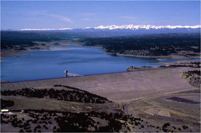
Million says the pipeline could carry up to 250,000 acre feet of water a year. That’s more than Denver Water supplies annually to the metro Denver area…

“We’ve spent the last three years with one of the best water teams in the U.S. looking for snake bites, or fatal flaws, and we have found none,” Million said, emphasizing he’s not interested in building any project that’s not environmentally sound. Rena Brand, project manager for the Corps of Engineers in Littleton, Colo., said Million’s application for a permit to draw water triggered her agency’s decision to proceed with the detailed environmental study. She said the Corps has retained a consultant to do the work and that Million will cover the cost. Brand said the study could take up to five years. She said it will evolve to include issues such as how delivering the water to particular areas might affect them. “The Corps is not making any preliminary decisions about this project,” Brand said. Brand said it’s unusual for a private party to undertake such a large water project. Her agency used to do such projects itself in years past, but “not so much anymore,” she said.

Million doesn’t propose to pay for the water he plans to move. Rather, he’s relying on Colorado’s rights to the water under the Colorado River compacts – agreements among western states that spell out how to manage the river and its tributaries, including the Green River. Colorado law generally allows anyone to take unappropriated water and put it to use in the state. The river compacts, meanwhile, allow water to be diverted in one state and used in another. Alexandra L. Davis, assistant director for water at the Colorado Department of Natural Resources, said that all water in the state belongs to the state. She said people can get a vested right to the water as long as they continue to put it to use. “It would be Mr. Million’s water right that he would then sell the use of that to other end users,” Davis said…

Environmentalists say they see problems with such a massive trans-basin water diversion. They say piping water across the Continental Divide threatens to harm fish and riparian species in the Colorado River system…

Some in Colorado bristle, too, at the prospect of seeing a private entity control such a huge volume of water. Frank Jaeger, district manager with the Parker Water and Sanitation District, said his district, which serves about 45,000 people, was unable to get Million to spell out clearly what his water prices and terms of delivery would be. Jaeger said his district is meeting with entities in Colorado and Wyoming trying to start a similar, competing project. “What we’re looking at is a project of what actual cost of development and delivery (would be), no profit involved,” Jaeger said of the prospect of getting government entities to build a pipeline. “A public project of that magnitude is a much better way of going about it.” Jaeger questioned how the Corps of Engineers can prepare a meaningful environmental impact statement evaluating Million’s project without knowing where the water would go. “I’m very fixated on the issue of speculation,” Jaeger said. “With no end users and no description of how the water will be used, I’ve got a problem with the Corps even dealing with that. Why the hell they’re doing an EIS is even beyond me.”

Million said his company has a “protectable interest” in the pipeline idea, meaning that no one else has a right to build one.He declined to say whether his company, Million Conservation Resource Group, has reached any deals to supply water.

Gov. Freudenthal, meanwhile, said he’s not enthusiastic about the pipeline project. “I’m not a big fan of it, in part because I’ve never been a big fan of trans-basin diversions,” Freudenthal said. “However, they properly filed with the state engineer,” Freudenthal said. “Their argument obviously is that this is Colorado’s water. The compact appears to allow for this, so I guess I’d have to say that at this stage I’ve been skeptically watching it unfold.”

More Coyote Gulch coverage here and here.

Mike Connor: Reclamation Commissioner

A picture named hooverdamaerial.jpg

Here’s a release about new Reclamation Commissioner Mike Connor from Allgov.com (Noel Brinkerhoff):

Heading up the federal government’s key agency for managing water resources is Michael L. Connor, a lawyer who has spent most of his career in Washington, DC, quietly working for the Senate and the Department of the Interior during the Clinton administration.

A native of New Mexico, Connor, 45, attended Las Cruces Public Schools and graduated from Las Cruces High School. He received a Bachelor of Science in chemical engineering from New Mexico State University and his JD from the University of Colorado’s School of Law. He was admitted to the bars of Colorado and New Mexico.

Connor worked for General Electric before joining the Interior Department through its Solicitor’s Honors Program in 1993. After working in the Interior Solicitor’s Office in Washington, DC, and Albuquerque, NM, Connor served as a deputy director within the Interior Department. Beginning in 1998, he served as deputy director and then director of the Indian Water Rights Office, representing the Secretary of the Interior in negotiations with Indian tribes, state representatives, and private water users to secure water rights settlements consistent with the federal trust responsibility to tribes.

In May 2001, he joined the staff of the Senate Energy and Natural Resources Committee as legal counsel, directing the committee’s water and power subcommittee, managing legislation for both the Bureau of Reclamation and the US Geological Survey, developing water resources legislation and handling Native American issues.

Southern Delivery System: Pueblo West should not be able opt out of Pueblo flow program

A picture named sdspreferredalternative.jpg

Pueblo County is standing firm on requiring Pueblo West to participate in the Pueblo flow program if the city joins the proposed Southern Delivery System, according to a report from Chris Woodka writing for the Pueblo Chieftain. From the article:

The county and Pueblo West have been at odds over the flow program since March. Pueblo West wants to connect to the pipeline. One of the conditions Pueblo County is insisting on requires all SDS participants to participate in the Pueblo flow program. It was set up in 2004 intergovernmental agreements signed by Pueblo, the Pueblo Board of Water Works, Colorado Springs, Aurora, Fountain and the Southeastern Colorado Water Conservancy District. Colorado Springs City Council is expected to vote today on the conditions, which have the full support of other partners. Colorado Springs and Fountain already participate in the flow program. Security and Pueblo West, as SDS partners, would have to sign on as well if SDS comes through Pueblo County.

There would be little impact on Security, but Pueblo West operates on exchange on Wild Horse Dry Creek, which enters the Arkansas River in the reach controlled by the Pueblo flow management program. The flow program requires participants to stop water exchanges during certain flow conditions. That has led to a difference in interpretation. Pueblo West argues that it could jeopardize all of its potential exchanges, which could amount to the loss of more than 3,000 acre-feet per year.

That’s unrealistic, [Ray Petros, who has counseled the county on the land-use regulations used to grant permits for SDS] said. The actual number is probably only a few hundred acre-feet in a worst-case scenario, Petros said. “They are grossly exaggerating the potential loss,” Petros said.

More Coyote Gulch coverage here and here.

Tax credit for conservation?

A picture named waterefficenttoilet.jpg

From the Denver Business Journal: “Coffman’s Water Accountability Tax Efficiency Reinvestment (WATER) Act would mimic the Energy Star program under which the U.S. Environmental Protection Agency already offers tax credits for the purchase of energy-efficient appliances. The measure was introduced on April 2, and Coffman — R-Aurora — discussed it in more detail at a Denver news conference Monday. The WATER Act would reward products that already have received a “WaterSense” label from the EPA. The federal agency awards the label for products generally more than 20 percent more efficient than the market average. The measure, House Resolution 1908, would provide participants with a 30 percent tax credit, with a $1,500 cap. The EPA estimates a family of four could save 17,000 gallons of water per year by installing WaterSense faucets and toilets, Coffman noted.”

Update: More coverage from the Denver Post (John Ingold):

Coffman said he hopes the proposed credit, which was formally introduced earlier this month and has bipartisan support in Congress, will spur a greater culture of conservation in Colorado. He noted the state faces an estimated 630,000-acre-foot water-supply shortfall by 2030…

Dubbed the Water Accountability Tax Efficiency Reinvestment Act, the measure would provide a tax credit equal to 30 percent of the cost of each purchased item bearing the Environmental Protection Agency’s WaterSense label. WaterSense products, including toilets, faucets and sprinkler systems, are at least 20 percent more efficient than average ones. The credit amount would be capped at $1,500 per year. The credit would function almost identically to an existing tax credit for purchases of electricity-saving Energy Star-rated products…

A phalanx of local elected officials from the fast-growing suburbs south of Denver stood behind Coffman at the Monday news conference where he announced the legislation. County commissioners from both Arapahoe and Douglas counties said they support the measure.

More Coyote Gulch coverage here and here.

Twin Lakes, Lake Pueblo, Green Mountain, Ruedi and Colorado-Big Thompson update

A picture named ruedidam.jpg

From email from Reclamation (Kara Lamb):

[Ruedi] Now that spring has arrived, we are getting ready for spring run-off in the Fryingpan River Basin. We are looking at a slightly above average snow pack this year. As a result, beginning [April 10], we will start moving some water out of Ruedi Reservoir to make room for melting snow. At 6:00 p.m. this evening, we will increase our releases from Ruedi Reservoir to the Fryingpan River by 40 cfs. Rocky Fork Creek is currently running at about 5 cfs. Our release, plus the Rocky Fork, will put about 153 cfs total in the ‘Pan.

[Green Mountain] Just a quick head’s up about spring and Green Mountain Reservoir. As most of you have probably already noticed, we are only at an elevation of 7894 in the reservoir [April 10]. We are also releasing about 100 cfs from Green Mountain to the Lower Blue. We are anticipating run-off and getting ready for the on-coming season.

[Twin Lakes/Lake Pueblo] Today [April 10], we are releasing about 27 cfs from Twin Lakes Reservoir to Lake Creek (which flows into the Arkansas). The Wellsville gage on the Arkansas River is showing 273 cfs. We have 380 cfs flowing into Pueblo Reservoir. And the reservoir is currently sitting at an elevation of 4879.

[Colorado-Big Thompson] Today [April 10] on the C-BT, we are releasing about 63 cfs from Olympus Dam in Estes Park to the Big Thompson River. Pinewood Reservoir is looking pretty full at an elevation of 6575. And, we are still pumping to Carter Lake. Carter is also getting close to full with an elevation of 5753.

There is some regular maintenance work being conducted on the portion of the Charles Hansen Feeder Canal which runs water to Horsetooth. For this reason, water into Horsetooth has dropped off over the past couple of weeks. It has been sitting fairly consistently at an elevation of 5404–about ten feet below our average spring high of 5414. Once the work on the canal is complete, we will stop pumping to Carter and begin running water to Horsetooth, again.

If you’ve been following the snowpack information, you no doubt will have heard by now that Colorado is just slightly below average in most of its river basins. The South Platte basin is one that is sitting just below average. It has been somewhat dry this winter on Colorado’s eastern plains. The spring snow storms helped a little, but that early heat wave we had in March did melt some of the snowpack away.

Energy policy — hydroelectric: Aspen’s new Castle Creek plant

A picture named microhydroelectricplant.jpg

Here’s a letter to the editor — running in the Aspen Times — written by Phil Overeynder, Utilities and Environmental Initiatives Director, City of Aspen, explaining the benefits of the new hydroelectric plant approved in 2007 by Aspen voters, along with the City’s committment to instream flow in Castle Creek:

In the near future we plan to provide additional information about this important and environmentally responsible project. What Aspenites gained in approving this project on the 2007 ballot is the annual production of 5.5 million kilowatt-hours of environmentally responsible electricity. That power production will prevent more than 5,000 tons of carbon dioxide from entering the atmosphere every year. This represents more than 25 percent of the remaining carbon emissions resulting from power generation for Aspen’s electric utility.

The production of clean, renewable energy at the Castle Creek Hydroelectric Project will depend on the use of water drawn from Castle Creek. There is simply no way around this basic fact. However, the city is doing its best to limit the impact on Castle Creek. The only change the hydroelectric project will make in the city’s water use regime is that a portion of the water diverted by the city will return to the creek at a point approximately three-fourths of a mile downstream of the present point of return, which is below Thomas Reservoir. The new point of return will be at the Castle Creek Bridge.

From the beginning of the Castle Creek Hydroelectric Project, the city of Aspen has been aware of the critical importance of maintaining a viable, healthy stream in Castle Creek. The Colorado Water Conservation Board’s (CWCB) decreed instream flow right for Castle Creek is 12 cubic feet per second (cfs), and is decreed for the purpose of protecting the natural environment.

This is a fairly junior water right. To help assure that Castle Creek actually receives this instream flow, which applies to all of Castle Creek, the city has already voluntarily committed to operate its own, more senior, water rights in a way that will support the 12 cfs instream flow. The city currently honors this commitment, and the proposed Castle Creek Hydroelectric Project will not alter this commitment. This means it is possible that, under certain conditions, the flow in Castle Creek upstream of the hydroplant will be 12 cfs. Historical low stream flow conditions in Castle Creek (generally reaching the lowest values in late winter) have averaged in the range of 20 cfs. When the hydroplant is operating in times of low flow in Castle Creek, flows in the reach of the creek between the hydroplant intake and the plant may be reduced to 12 cfs instead (the value established by the CWCB as necessary to protect the natural environment).

Dolores River: Sections eyed by BLM for Wild and Scenic designation

A picture named snaggletoothrdoloresriver.jpg

The Bureau of Land Management is studying parts of the Dolores River for Wild and Scenic designation. Here’s a report from Kristen Plank writing for the Cortez Journal. From the article:

Approximately 32 miles of the northern Dolores River and watershed was recently evaluated in a Wild and Scenic Eligibility Report released by the U.S. Bureau of Land Management’s Grand Junction office…

“The first thing we do during this river study is to look at eligible segments of rivers that fit into the criteria of the Wild and Scenic River Act of 1968,” said Michelle Bailey, outdoor recreation planner at the Grand Junction office. “We then ask ourselves, ‘Hey, does this segment meet the criteria?’ If the answer is yes, then we further study those segments.”[…]

The Dolores River section of the study runs from the southwest border of the Grand Junction field office, running parallel to Highway 141, through Gateway until the river reaches the Colorado-Utah border, Bailey said. Conducted during the past 12 to 14 months, the eligibility study found geological, paleontological, recreational and scenic values within the 32-mile stretch of the river. The public has 30 days to comment on the eligibility portion of the report. While a segment of a river might be found “eligible” for Wild and Scenic designation, Bailey said “it may not be suitable.”[…]

The suitability study comes next, and public comment from stakeholders and the general public is taken throughout the study. The suitability study is slated to be completed in 2011. The findings will then go into the Grand Junction field office’s resource management plan, which will give recommendations of Wild and Scenic River designations to Congress. Congress will then decide which of the rivers should be given Wild and Scenic designation.

Recently, a group known as the Lower Dolores Management Plan Working Group has been meeting monthly to give input on a comprehensive river management plan known as the 1990 Dolores River Management Plan. The Dolores Public Lands Office plans to update the management plan this fall, and the working group will help determine how best to classify the Lower Dolores River so that it receives appropriate protection. The group hopes to bypass the Wild and Scenic River designation because federal management of that portion of the river conflicts with current principles the Dolores River Dialogue – a group that meets to preserve and improve water habitats in the Dolores River Valley – has already established.

On the Net: To read the Grand Junction’s eligibility report, go to http://www.blm. gov/co/st/en/fo/gjfo/rmp.html and click on “Wild & Scenic Eligibility Report.”

Palmer Lake: Wrestling with surface water treatment funding

A picture named watertreatment.jpg

Here’s an update on Palmer Lake’s search for a funding and supply solution, from Nicole Chillino writing for the Tri-Lakes Tribune. From the article:

“The existing plant is not producing water at the rate it was originally designed for,” said Paul Gilbert, with Tetra Tech Rmc Inc., a consulting and engineering firm. “Not only can we increase the capacity, we can increase the ease of running the plant, and we can more easily achieve drinking water standards.” The surface water is the town’s cheapest water, whereas the well water is more expensive to pump and process. Currently the town can utilize the deep wells to a greater extent, which are more expensive, or it can fix the plant, Gilbert said. The town could probably Band-Aid for a few years, but in the meantime costs would escalate significantly for both running the water system and constructing the plant later…

Tetra Tech looked at three alternatives to funding the filter plant, he said. The recommended option is a microfiltration system that can fit in the town’s existing building, he said. The system would have the capability of processing 500 gallons per minute, currently only 250-300 gallons per minute can be processed for short periods of time in the plant. The town’s senior water right is 400 gallons per minute, so there will be times the town can use its junior water rights for more, but the 400 gallons per minute will be comfortably covered, Gilbert said. To fund the plant, the team from Tetra Tech looked at several options including using the stimulus money that might become available to the state, but this would not be guaranteed money, said Linda Firth. Furthermore, the treatment plant project has to be ready by the end of September this year to get the money if it materializes…

Firth suggested the town go for revolving fund money, which has a low interest rate and the town is already in line for. The project will cost $1.8 million to $1.9 million for totally new internal pieces to the plant, Gilbert said. If there is any money left over, there are plenty of pipelines that need to be replaced. The new treatment units cannot handle the pressure from the gravity to the treatment plant, so it would need to be reduced on the way in and pumped on the way out, Gilbert said. The primary ongoing cost will be the tubes within the filter membranes, which will need to be replaced every 7-10 years, he said, but the cost will be comparable to that of replacing the media in a sand filter.

Elbert County: Groundwater 101

A picture named denveraquifer.jpg

Here’s a look at Colorado water law as it relates to groundwater in Elbert County, from Ashley Dieterle writing for the Elbert County News. From the article:

On April 2, in the Exhibit Hall at the Kiowa Fair Grounds, two members of the Colorado Division of Water Resources explained water rights and well permitting to Elbert County residents. Types of wells, types of ground water and adjudication of water were discussed by Kevin Rein and Keith Vander Horst from the Colorado Division of Water Resources.

All under ground water in Elbert County comes from non-tributary water in the Denver Basin. There are four bedrock aquifers, the Dawson (upper and lower) aquifer, the Denver aquifer, the Arapaho (upper and lower) aquifer and the Laramie-Fox Hills aquifer. Most questions asked by attendants concerned their own water and whether or not adjudication, obtaining a determination of a water right, was necessary in order to maintain their water without the threat of it being taken away by the state, county or other developers. According to Vander Horst and Rein, the answer is no. Rein said the landowner has a right to the ground water if it has not been adjudicated, which means the water stays attached to the land. “By virtue of land ownership you have the inchoate right so nobody can come and adjudicate and acquire the ground water underlying your land just because you haven’t adjudicated it,” Rein said.

But Rein did mention some benefits to adjudicating ground water. He said the basic outcome of adjudication is the amount of ground water available is quantified and the characteristics are legally identified. After adjudication, the water becomes a vested right, not an inchoate right. “After adjudication that water is much more readily available to sell to interested developers,” he said. “And it becomes an independent property right, which allows you to make the deed to impair property for immediate benefit and allow you more revenue when you sell it.”

More Coyote Gulch coverage here, here, here and here.

Glenwood Springs: Increase in water and sewer rates?

A picture named sewerusa.jpg

From the Glenwood Springs Post Independent (John Gardner): “According to Glenwood Springs Public Works Director Robin Millyard the recommendation from city staff is a 10 percent increase for water fees and a 20 percent increase for sewer customers…The latest review stated that water rates for financial year 2008 came up $139,000 short of projections from the previous year’s study, despite a third consecutive 10 percent increase in May 2008. While water revenues were down, operating and maintenance expenses were $171,000 higher than originally projected as well. Millyard explained that many variables contribute to the shortfall and include everything from a decrease in customer consumption to unforeseen cost increases for chemicals used in treating water. The report stated that exact reasons for the lower than expected revenue ‘was beyond the scope of the analysis,’ and that it appears less water is being sold than was anticipated by the last study…With the new plans for the wastewater plant in Glenwood, the report stated that a 47 percent rate increase, split over a three year period, for Glenwood sewer customers would be necessary to cover the projected shortfalls. The report stated that the 20 percent increase in 2008 recovered sufficient revenue to cover actual expenses, based on financial year 2008 unaudited results. However, by 2011, revenues were not expected to be sufficient to cover projected operating expenses and debt service on proposed capital improvements.”

Snowpack news

A picture named snowflakesbentley.jpg

From the Fairplay Flume (Debra Orecchio): “Measurements conducted in the South Platte basin, which includes Park County, show that the snowpack is 86 percent of average, a drop of 13 percentage points from measurements taken in January. At that time, the snowpack measured 99 percent of average. Statewide, the snowpack is about 96 percent of average. That’s the first statewide snowpack reading of this season to be below average, according to Allen Green, state conservationist with NRCS…”The press release also stated that statewide reservoir storage remains just slightly above average at 103 percent. In January, it was at 98 percent of average. Most of the reservoirs are storing at near-average volumes. The reservoir storage in the South Platte area is at 99 percent, compared to the 95 percent of average that was seen in January.”

Montezuma County: Tamarisk control update

A picture named tamarisk.jpg

From the Cortez Journal: “The board of Montezuma County Commissioners is scheduled to meet at 9 a.m. Monday, April 13, in the commissioners room at 109 W. Main St., Cortez. Jodi Downs, with the Dolores Soil Conservation District, will give an update on tamarisk control in the county…For more information on the meeting, contact the county administration office at 565-8317, or visit http://www.co.montezuma.co.us.”

More Coyote Gulch coverage here and here.

Tri-State de-emphasizing Coal?

A picture named nukeplantcattenomfrance.jpg

From the Durango Herald (Shane Benjamin): “In the near-term, [Tri-State Generation and Transmission] plans to expand energy-efficiency programs, make investments in renewable energy and increase natural gas capacity, said Lee Boughey, a spokesman for Tri-State, during a phone interview Friday. In the long-term, Tri-State will consider building a nuclear power plant in southeast Colorado, he said. It is a marked difference from four years ago when the energy supplier announced plans to pursue three new coal-fired power plants, Boughey said. The shift comes amid a changing regulatory climate. There is a great deal of uncertainty when it comes to state and federal regulatory policies as they pertain to energy and the environment, Boughey said. Tri-State wanted to take time to understand the new direction and policies and evaluate the benefits and risks of new approaches, he said.”

From the Denver Post (Gargi Chakrabarty):

Tri-State Generation and Transmission’s board decided at its annual meeting Thursday to review the company’s long-term resource plans. “Part of our re-evaluation process will review how coal- based resources fit into our long-term resource plans,” said Ken Anderson, Tri-State’s executive vice president and general manager.

The announcement comes as environmentalists urge the Colorado Public Utilities Commission to take on regulatory oversight of Tri-State’s resource plans, in part to ensure the company follows Colorado’s renewable-energy mandates. Tri-State depends on coal for 72 percent of its power generation; just 1 percent comes from renewables such as wind and solar energy. The Westminster-based company serves 44 rural electric cooperatives in Colorado, Wyoming, New Mexico and Nebraska. It is regulated by a variety of federal agencies. Tri-State’s near-term plan is to increase its energy-efficiency programs, bring in more renewable and natural-gas resources, and invest in new technology for clean coal and renewable energy, spokesman Lee Boughey said. Two weeks ago, the company announced it would develop one of the world’s largest photovoltaic solar plants in New Mexico.

More Coyote Gulch coverage here and here.

Southern Delivery System: Colorado Springs vote on Pueblo County permit conditions this week

A picture named sdspreferredalternative.jpg

From the Pueblo Chieftain (Chris Woodka): “Colorado Springs City Council will consider Pueblo County’s terms and conditions for the Southern Delivery System at its meeting this week. The meeting will be at 1 p.m. Tuesday at City Hall, 107 N. Nevada Ave. Approval of the conditions would give Colorado Springs Utilities a “green light” to build its $1.1 billion pipeline project from Pueblo Dam, Utilities CEO Jerry Forte told council at a public hearing last week.”

More Coyote Gulch coverage here, here, here and here.

Taming the Land: Sixth in the series

A picture named fryingpanarkansasproject.jpg

Here’s part six of Chris Woodka’s series “Taming the Land” running in the Pueblo Chieftain. Click through to read the whole thing and for the cool photos that he’s dug up from area libraries. From the article:

Along with the scope of the [Fryingpan-Arkansas Project], its mission changed too. Partly because of pressure from the Western Slope, the Southeastern district opted to allocate 51 percent of the water from the project to cities in its 1979 operating principles. As farmland is dried up by purchases of water off of farms, even more water is going to cities. Still, the Fry-Ark Project has been a boon for agriculture since 1972, when the first water from the other side of the mountains came into the valley. More than 1.6 million acre-feet of water have been allocated since then, with about 72 percent going to agriculture. In the future, agriculture’s share will be less, because cities have been more likely to take their full allocation since the 2002 drought. In addition, cities of the Lower Arkansas Valley will begin putting their share of water from the Fry-Ark Project into the Arkansas Valley Conduit, a drinking supply line that was part of the 1962 legislation, but was never built because of the expense. The conduit will be built under a new funding formula approved by Congress and signed into law by President Barack Obama this year.