Study indicates hail may disappear from Colorado’s Front Range by 2070

hailstonesyumacounty0609

Here’s the release from the University of Colorado (Kelly Mahoney/Jane Palmer):

Summertime hail could all but disappear from the eastern flank of Colorado’s Rocky Mountains by 2070, says a new study by the National Oceanic and Atmospheric Administration, the University of Colorado Boulder’s Cooperative Institute for Research in Environmental Sciences and the National Center for Atmospheric Research.

Less hail damage could be good news for gardeners and farmers, said lead author Kelly Mahoney, a research scientist at CIRES, but a shift from hail to rain can also mean more runoff, which could raise the risk of flash floods. “In this region of elevated terrain, hail may lessen the risk of flooding because it takes awhile to melt,” Mahoney said. “Decision makers may not want to count on that in the future.”

For the new study, published this week in the journal Nature Climate Change, Mahoney and her colleagues used “downscaling” techniques to try to understand how climate change might affect hail-producing weather patterns across Colorado.

The research focused on storms involving pea-sized and smaller hailstones on Colorado’s Front Range, a region that stretches from the foothill communities of Colorado Springs, Denver and Fort Collins up to the Continental Divide. Colorado’s most damaging hailstorms tend to occur further east and involve larger hailstones not examined in this study.

In the summer in Colorado’s Front Range above about 7,500 feet, precipitation commonly falls as hail. Decision makers concerned about the safety of mountain dams and flood risk have been interested in how climate change may affect the amount and nature of precipitation in the region.

Mahoney and her colleagues began exploring that question with results from two climate models, which assumed that levels of climate-warming greenhouse gases will continue to increase in the future, from about 390 parts per million in the atmosphere today to about 620 parts per million in 2070.

But the weather processes that form hail, like thunderstorms, occur on much smaller scales than can be reproduced by global climate models. So the team “downscaled” the global model results twice: first to regional-scale models that can take regional topography and other details into account, then again to weather-scale models that can resolve individual storms and even the cloud processes that create hail. The regional-scale topography step was completed as part of NCAR’s North American Regional Climate Change Assessment Program.

Finally, the team compared the hailstorms of the future, from 2041 to 2070, to those of the past, from 1971 to 2000, as captured by the same sets of downscaled models. Results were similar in experiments with both climate models.

“We found a near elimination of hail at the surface,” Mahoney said.

In the future, increasingly intense storms may actually produce more hail inside clouds, the team found. However, because those relatively small hailstones fall through a warmer atmosphere, they melt quickly, falling as rain at the surface or evaporating back into the atmosphere. In some regions, simulated hail fell through an additional 1,500 feet of above-freezing air in the future as compared with the past.

The research team also found evidence that precipitation events over Colorado become more extreme in the future, while changes in hail may depend on the size of the hailstones — results that will be explored in more detail in ongoing work.

Mahoney’s postdoctoral research was supported by the Postdocs Applying Climate Expertise, or PACE, program administered by the University Corporation for Atmospheric Research and funded by CIRES Western Water Assessment, NOAA and the U.S. Bureau of Reclamation. PACE connects young climate scientists with real-world problems such as those faced by water resource managers.

Co-authors of the new paper include James Scott and Joseph Barsugli of CIRES and NOAA, Michael Alexander of the NOAA Earth System Research Laboratory and Gregory Thompson of NCAR.

CIRES is a joint institute of CU-Boulder and NOAA.

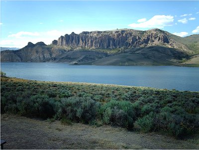
Aspinall Unit update: Reclamation is forecasting 450,000 acre-feet (67% of 30 year average) of inflow to Blue Mesa Reservoir

curecantibluemesa.jpg

From email from Reclamation (Erik Knight):

The January 1st forecast is out and the prediction is for 450,000 acre-feet of inflow to Blue Mesa Reservoir during the April-July runoff period. This represents 67% of the current 30 year average. In response to this dry forecast releases at Crystal Dam will be reduced by 300 cfs on Wednesday, January 11th. This will bring releases down to 800 cfs and with no Gunnison Tunnel diversions, flows in the Gunnison River through the Black Canyon should also be around 800 cfs…

As a reminder the next Aspinall Operations meeting will be held on Thursday, January 19th, at 1:00 p.m. in Montrose at the Holiday Inn Express. We have tentatively scheduled a presentation by Vern Jetley, a retired Reclamation photographer who will be talking about the construction history of Blue Mesa dam/reservoir.

More Aspinall Unit coverage here.

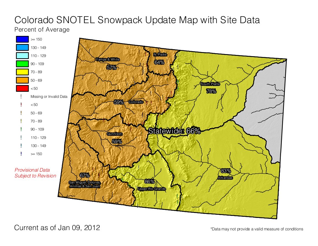
Snowpack news: Colorado River basin is at 59% of average, San Juan, Dolores and San Miguel basins come in at 67% of average

snowpackcolorado01092012

From Think Progress Green (Amanda Peterson Beadle):

Auden Schendler, vice president of sustainability at Aspen Skiing Company, points out that the NASA global temperature anomaly maps show that December just keeps getting warmer, which creates the extreme swings. “It’s key to remember that warming might actually bring bigger storms to the Rockies due to there being more moisture in the air,” Schendler said. “At the same time, because the atmosphere can hold more water, it can suck the land dry of more water than before.”

From The Grand Junction Daily Sentinel (Dennis Webb):

As of this morning [January 9], the Upper Colorado River Basin snowpack was just 59 percent of average. Portions of the basin had seen little recent snow until a storm that arrived on Saturday. The Gunnison River Basin also is at 59 percent, and the Yampa/White River is at 58 percent. Other readings include the San Juan, Animas, Dolores, and San Miguel basins, 67 percent; Arkansas basin, 83 percent; Upper Rio Grande, 86 percent; Laramie and North Platte, 64 percent; and South Platte, 76 percent.

From the Vail Daily (Jaymee Squires):

If you’ve looked at weather maps lately, you have probably noticed the dramatic shape of the jet stream as it takes weather from the Pacific Northwest and blows it north towards Canada. This leaves most of Colorado in a high pressure area, where the warm air sustains itself with the Colorado sun and deflects incoming storms. The jet stream then takes a southward dip somewhere in the Midwest, taking our much-needed moisture towards the northeast, where they just plow it into piles and wait for spring. Since most of our snow typically comes from the Pacific Northwest, it’s not likely we’ll see any of that moisture until the jet stream changes its path.

From the Vail Daily (Lauren Glendenning):

Eddie Box Jr. and his wife, Betty, of the Southern Ute Indian tribe, came to Vail Mountain [ed. last Saturday] to do a traditional prayer ritual for snow for the third time in the resort’s 49-year history. Box was first there in 1962, the resort’s inaugural year, as a teenager joining his father, Eddie Box Sr…

As people gathered around and formed a circle around the Box family and other tribe members, they looked on as the Utes performed the sacred ritual. First there was a slow waltz in a circle, followed by chants, drums and then a group dance. People all around could be heard saying “snow.” The snow got thicker and started coming down heavier. Sutner said the Utes are 3-for-3 in Vail — the snow fell consistently the first two times they did the ritual, and Saturday’s beginning was a good start. “It’s not so much about a snow dance, but it’s about honoring our rich history with the Southern Utes,” Sutner said.

Secretary Salazar Announces Decision to Withdraw Public Lands near Grand Canyon from New Mining Claims

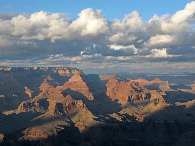
grandcanyonfromgrandviewpoint01242009nps.jpg

Here’s the release from the U.S. Department of Interior (Adam Fetcher):

Secretary of the Interior Ken Salazar today announced his decision to protect the iconic Grand Canyon and its vital watershed from the potential adverse effects of additional uranium and other hardrock mining on over 1 million acres of federal land for the next 20 years.

Secretary Salazar’s decision will provide adequate time for monitoring to inform future land use decisions in this treasured area, while allowing currently approved mining operations to continue as well as new operations on valid existing mining claims.

“A withdrawal is the right approach for this priceless American landscape,” Salazar said. “People from all over the country and around the world come to visit the Grand Canyon. Numerous American Indian tribes regard this magnificent icon as a sacred place and millions of people in the Colorado River Basin depend on the river for drinking water, irrigation, industrial and environmental use. We have been entrusted to care for and protect our precious environmental and cultural resources, and we have chosen a responsible path that makes sense for this and future generations.”

The Public Land Order to withdraw these acres for 20 years from new mining claims and sites under the 1872 Mining Law, subject to valid existing rights, is authorized by the Federal Land Policy and Management Act. A Record of Decision was signed by the Secretary today during a ceremony held at the National Geographic Museum in Washington, D.C.

The withdrawal does not prohibit previously approved uranium mining, new projects that could be approved on claims and sites with valid existing rights. The withdrawal would allow other natural resource development in the area, including mineral leasing, geothermal leasing and mineral materials sales, to the extent consistent with the applicable land use plans. Approximately 3,200 mining claims are currently located in the withdrawal area.

“The withdrawal maintains the pace of hardrock mining, particularly uranium, near the Grand Canyon,” said Bureau of Land Management Director Bob Abbey, “but also gives the Department a chance to monitor the impacts associated with uranium mining in this area. It preserves the ability of future decision-makers to make thoughtful decisions about managing this area of national environmental and cultural significance based on the best information available.”

During the withdrawal period, the BLM projects that up to 11 uranium mines, including four that are currently approved, could still be developed based on valid pre-existing rights – meaning the jobs supported by mining in the area would increase or remain flat as compared to the current level, according to the BLM’s analysis. By comparison, during the 1980s, nine uranium mines were developed on these lands and five were mined out. Without the withdrawal, there could be 30 uranium mines in the area over the next 20 years, including the four that are currently approved, with as many as six operating at one time, the Environmental Impact Statement (EIS) estimates.

The withdrawn area includes 355,874 acres of U.S. Forest Service land on the Kaibab National Forest; 626,678 acres of Bureau of Land Management lands; and 23,993 acres of split estate – where surface lands are held by other owners while subsurface minerals are owned by the federal government. The affected lands, all in the vicinity of the Grand Canyon or Grand Canyon National Park, are located in Mohave and Coconino Counties of Northern Arizona.

“The decision made today by the Secretary will help ensure continued protection of the Grand Canyon watershed and World Heritage designated Grand Canyon National Park,” said National Park Service Director Jonathan B. Jarvis. “As stewards of our national parks, it is incumbent on all of us to continue to preserve our treasured landscapes, today and for future generations.”

Today’s decision is the culmination of more than two years of evaluation during which the BLM analyzed the proposed withdrawal in an EIS prepared in cooperation with the U.S. Forest Service, U.S. Geological Survey, U.S. Fish and Wildlife Service, and the National Park Service.

Numerous cooperating agencies, tribes, counties and stakeholders were fully engaged in this process, which included an extensive public involvement period which generated more than 350,000 comments, including input from more than 90 countries. Substantive comments, including those on the economic impact discussion, were addressed in the Final EIS, released on October 27, 2011 for a final 30-day review period.

Information on the withdrawal is at http://www.blm.gov/az/st/en/prog/mining/timeout.html or can be obtained by calling (602) 417-9504.

Think Progress Green (Jessica Goad) is running lists of the top five winners and losers from Secretary Salazar’s action:

WINNERS

1. The 25 million people who get their drinking water from the Colorado River
The Colorado River is the lifeblood for residents of the southwest. It is one of the most important rivers in the nation, providing drinking water to 25 million Americans. Uranium mining could contaminate this precious water source, the legacy of which is in the water contamination across Arizona and the southwest and is felt most acutely by Native American tribes. Water authorities in Arizona, California, and Nevada have stated that “federal agencies with oversight over mineral exploration and mining operations in the Lower Colorado River Basin must use their authority to prevent any potential for deterioration of this critical water supply for millions of people.”

2. American businesses

The outdoor recreation industry thrives on Americans’ ability to get outside. In Arizona alone, the outdoor recreation economy annually supports 82,000 jobs, generates almost $350 million in state tax revenue, and stimulates about $5 billion in retail sales and services. Businesses like rafting companies, outfitters, and gear manufacturers all benefit tremendously from the Grand Canyon’s unpolluted water, air, and landscapes. As Black Diamond Equipment CEO Peter Metcalf has stated, “The outdoor industry depends on public land so its consumers have a place to recreate using the products it sells.”

3. Arizona workers
Tourists spending money in and around the Grand Canyon create jobs. Headwaters Economics found that Grand Canyon National Park supported over 6,000 jobs in 2009 and those tourists spent more than $400 million. Arizonans feel the direct, indirect, and induced impacts of this spending in places like Tusayan and Flagstaff, but also more broadly through hotels, flights, rental cars, and other expenditures. As Sherry Henry, director of the Arizona Office of Tourism said, “No other Arizona industry produces the same economic impact to the Grand Canyon State than our travel and tourism industry.”

4. Sportsmen
Hunters and anglers have been some of the most outspoken proponents of protecting the Grand Canyon from the industrialization that mining would bring. A letter from nine sportsmen groups in July 2011 noted that “Uranium mining near Grand Canyon National Park is wholly unacceptable given the best science available and the potential impacts.” The Arizona Game and Fish Commission has endorsed the mineral withdrawal. With these 1 million acres protected from new mining claims, sportsmen will not lose access to this prime fish and wildlife habitat.

5. American families
The Grand Canyon is one of America’s most popular destinations. Almost 5 million people visit every year to take part in camping, hiking below the rim, viewing the sights from the window of a lodge, or otherwise taking in the canyon’s natural magnificence. By stopping excess uranium mining on 1 million acres, all Americans and future generations will have an opportunity to visit the Grand Canyon in its untarnished state.

LOSERS

1. International atomic interests
A number of different mining companies have expressed interest in the uranium deposits around the Grand Canyon, many of which are foreign or multinational. Examples are Rosatom, Russia’s state nuclear agency; Denison Mining, partially owned by Korea’s state-owned electric utility; and Vane Minerals, a British company.

2. Reps. Jeff Flake, Paul Gosar, Trent Franks
Reps. Jeff Flake (R-AZ), Paul Gosar (R-AZ), and Trent Franks (R-AZ) have taken the lead in relentlessly attempting to block Secretary Salazar’s temporary withdrawals and forcing the administration to open the Grand Canyon area to industrial development. Flake’s effort over the summer to attach a policy rider on a budget bill to tie the Interior Department’s hands was dubbed “the Flake earmark.” Flake has already received $12,000 in campaign contributions from mining interests for his 2012 U.S. Senate campaign.

3. National Mining Association
The National Mining Association is one of the largest natural resources trade and lobbying groups in the nation. In 2011 it spent $3,580,266 lobbying Congress on various issues, and its non-coal-focused PAC has already spent $78,000 in campaign contributions for the 2012 cycle ($70,500 of which went to Republicans). A spokesman from the group in June stated that Secretary Salazar’s 6-month withdrawal “sets a troublesome precedent.”

4. Scientist Karen Wenrich

Republicans on the House Natural Resources Committee called a hearing in November 2011 to continue to push for uranium mining around the Grand Canyon. But it was revealed at the hearing by Grand Canyon champion Rep. Raul Grijalva (D-AZ) that the scientist whom they called to testify that there would be little impact from uranium mining on the Colorado River stood to make $225,000 from it. Securities and Exchange Commission filings show that Karen Wenrich, a retired United States Geological Survey scientist, entered into a deal to sell 61 uranium claims only if the mineral withdrawal did not go through.

5. Companies seeking to exploit the public’s treasures for corporate profits
Under the 1872 Mining Law, mining companies are not required to pay royalties to the public for the mineral resources that they extract. Not only are taxpayers not properly compensated for their natural resources, but they are frequently left to foot the bill for environmental cleanup. Congress must pass legislation such as Rep. Ed Markey’s H.R. 3446 to solve this problem. However, Secretary Salazar’s withdrawal will stop additional companies from profiting off this antiquated system while endangering a national treasure.

More Colorado River Basin coverage here.

Clear Creek County scores $75,000 for greenway design

clearcreekwatershedmap.jpg

From the Clear Creek Courant (Ian Neligh):

The county was…awarded $75,000 to create design documents for the Clear Creek Greenway project connecting Jefferson County to the Twin Tunnels area through Clear Creek Canyon. The plan will also allow for easier access to the Oxbow Parcel and western Clear Creek County.

The greenway, envisioned to run along Clear Creek from the Jefferson County border to the Continental Divide, is intended to link communities with a string of open spaces, trails and parks. The project is not expected to be finished for another 10 years.

The Colorado Department of Transportation has partnered with the county on the project near the Twin Tunnels as part of CDOT’s effort to expand the area.

CDOT officials are planning to add a third eastbound lane on Interstate 70 between Idaho Springs at mile post 241 to the base of Floyd Hill at mile post 244, where the highway already opens to three lanes.

The $60 million project would likely begin construction in April 2013, with completion later that fall.

Meanwhile, according to County Commissioner Tim Mauck, as part of the first phase, CDOT will construct a greenway trail from the old game check behind the Twin Tunnels to just shy of the Hidden Valley Interchange.

As part of the second phase, CDOT will complete the trail from the game check station to the Idaho Springs Baseball Fields, although CDOT has not identified project funding and a timeline.

In addition, Clear Creek County Open Space was formally asked by GOCO to submit an application for a $4 million grant to further construct the greenway trail from the county line to as far as the funding would stretch.

“I project this GOCO grant to bring significant greenway improvements to Clear Creek County in the near future,” Mauck said. “Ultimately it will leverage further resources and willpower to complete the Clear Creek Greenway Trail through our community, providing our citizens and businesses with a tremendous recreational facility to utilize.”

The Downstream Neighbor: International Water Advocates Speak on Water Security January 27-29

southplatteriverbasincgs.jpg

From email from The Downstream Neighbor:

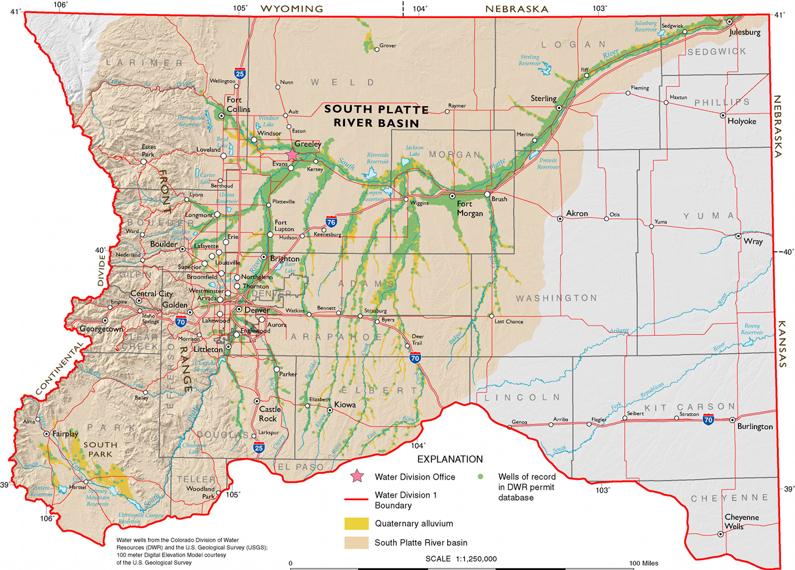
The Downstream Neighbor celebrates water as a connector, spiritual inspiration, and nurturance for our lives and explores some of the best practices for protecting water for the benefit of future generations, in a symposium January 27-29, 2012 in Denver.

This extraordinary weekend symposium brings together people from all walks of life in dialogue around the Front Range connection to the South Platte watershed. Critical conversations about our water future will be guided and inspired by international voices for Earth, water, and human rights: Maude Barlow and Elizabeth Peredo Beltrán.

The symposium takes the view that by considering Colorado water in the context of the cosmos, the global hydrologic cycle, and the entire family of life on Earth, we can better understand our home watershed and face what we must do to be responsible to the downstream neighbor.

The symposium opens Friday afternoon at 4 pm at the Theater at Colorado Heights University with a screening of Journey of the Universe. Written by religion scholar Mary Evelyn Tucker and mathematical cosmologist Brian Thomas Swimme, this film establishes an inspiring context for the beginning weeks of Colorado Water 2012.

At 7 pm on Friday, January 27, keynote speaker Maude Barlow—National Chairperson of the Council of Canadians and chair of the board of Washington-based Food and Water Watch—will present the relationship of water to the entire family of life on Earth, valuing water as a commons, and intrinsic right, and a public trust.

At 8:30 am on Saturday, January 28, the Bolivian civic leader, Elizabeth Peredo Beltrán will speak in celebration of water as a common good and a human right. “The planet is not a resource, it is our home,” Beltran emphasizes.

The Saturday session will include regional and local experts on a range of topics that increasingly focus on our home watershed the South Platte, how we may become more connected with the river and what the river needs to flourish. Saturday topics include the cosmic origins of water, deep transition, water ethics, water and food justice, respecting nature’s ways in our approaches to solving the water crisis, getting involved in watershed groups, and the nexus between water and energy choices such as coal, natural gas, and renewables.

Sunday’s session beginning at 12 noon engages participants in further discussion on concerns like those that brought the conference planning committee together. For our watershed—like most of Earth—faces a water crisis:

· Much of our water comes from another watershed—and partly as a result, a major river no longer reaches the sea.
· More water has been promised than can be delivered.
· Controversial water uses greatly diminish the water available to farmers, a swelling human population, and the rest of nature.

Yet, the waters flowing in and through our watershed belong to Earth, to all species, to future generations.

The symposium will close with an opportunity for participants to inspire one another and become more aware of the great shift required as old notions of “separation from nature” slip away.

· What are the urgent concerns of our near and farther neighbors?
· What does it mean for the public to own the water?
· What does water need from us?
· How does water connect us, inspire us?

We are all downstream neighbors.

For more information: http://downstreamneighbor.org/.

NRCS Colorado Snow Survey and Water Supply News Release

snowpackreservoirstoragenrcsjanuary2012

Here’s the release from the Natural Resources Conservation Service (Mage Skordahl):

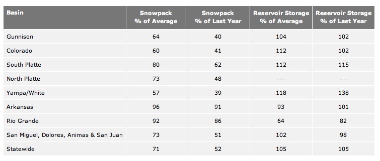
Despite a decent start to the water year with above average precipitation and near average snowfall in October; drier conditions in November and December have resulted in a below average mountain snowpack for all the major basins in Colorado. As of January 1, Colorado’s statewide snowpack was 71 percent of average and 52 percent of last year’s readings, according to Phyllis Philipps, State Conservationist, with the NRCS. This is the fourth lowest January 1 snowpack measured in the last 30 years and the lowest since January 1, 2002 when the snowpack was at 65 percent of average.

Snow accumulations on the eastern side of the Continental Divide and in south-central Colorado are closer to average than on the western slope and southwest Colorado. Early season upslope storms in October and November have kept the South Platte basin at 80 percent of average as of January 1. The Arkansas and Upper Rio Grande basins currently boast snowpack’s that are 96 and 92 percent of average respectively, the highest in the state. Current conditions in these basins are a welcome change considering both recorded well below average snowfall last season.

The start to this winter season is not as positive for the western basins. Snow accumulation in these basins is well below average for this time of year; ranging from 57 percent of average in the Yampa and White basins, to 73 percent of average in both the San Juan, Animas, Dolores, and San Miguel basins and the North Platte basin. In comparison, last year at this time these basins had snowpack’s that were at 145 percent of average in the Yampa and White, and 144 percent of average in the San Juan, Animas, Dolores, and San Miguel basins.

Statewide the current snowpack is well below what was measured last year on January 1 in all the major river basins. This trend is especially prevalent in the northwest and western portions of the state where measured snowfall totals are less than half of what was measured one year ago.

Due to last spring’s above average snowpack and subsequent runoff throughout most of the state, reservoir storage remains in good condition in Colorado. Only the Rio Grande Basin has significantly below average reservoir storage for this time of year.

Click on the thumbnail graphic above and to the right for a screen shot of the table that accompanied the release.

Precipitation news: Aspen Mountain and Snowmass receive about eight inches of snow from the weekend storm

snowpackcolorado01072012

From The Aspen Times:

Aspen and Snowmass both picked up 8 inches of much-needed new snow Saturday and Saturday night, according to the Aspen Skiing Co.’s Sunday morning snow report. Aspen Highlands saw 5 inches of fresh stuff while Buttermilk also gained 8 inches…

Around the state, most resorts reported fresh snow in the 5- to 8-inch range. Tiny Echo Mountain on the Front Range picked up 9 inches, as did Beaver Creek, but ski areas in southwest Colorado came up short this time. Wolf Creek reported 1 inch and Telluride had 4 inches. Durango reported no new snow. Elsewhere, Vail and Copper Mountain both reported 8 inches, Steamboat had 6 inches of fresh stuff, and Crested Butte and Powderhorn both reported 5 inches. Sunlight Mountain Resort near Glenwood Springs picked up 4 inches.

The closest Urban Drainage station to Gulch Manor is reporting sixteen hundredths of precipitation on the three day map.

From the Colorado Independent (David O. Williams):

“We have had some very unusual weather so far this season,” Vail Resorts CEO Rob Katz said Friday. “For the first time in 30 years, a lack of snow has not allowed us to open the back bowls in Vail as of January 6, 2012, and, for the first time since the late 1800s, it did not snow at all in Tahoe in December.”[…]

Ski industry woes aside, state water watchers and firefighters are nervously eyeing the miniscule mountain snowpack, which supplies so much of the water used by Front Range cities. As of Dec. 30, snowpack in the Colorado River basin was 44 percent of last year’s record level and just 63 percent of the annual average…

The last time Colorado’s high country was even close to this dry in mid-winter was during the 2001-02 ski season, which was followed by the worst wildfire season in the state’s history. June of 2002 saw the massive Hayman Fire scorch nearly 138,000 acres of land in the mountains southwest of Denver, darkening Front Range skies and loading key water storage facilities with debris from subsequent erosion.

Terry Scanga: ‘Lease-fallowing does a lot of good things and preserves ag water’

irrigatedagriculture.jpg

From The Pueblo Chieftain (Chris Woodka):

“There has to be better ways of using agricultural water,” said John Stulp, water policy adviser for Gov. John Hickenlooper, at a Super Ditch summit meeting Friday. “Rotational fallowing is one of the tools in the tool box,” he said…

The Lower Arkansas Valley Water Conservancy District, which supported and funded the startup of Super Ditch, plans to file a substitute water supply plan in February that would allow the program to be up and running by April. State Engineer Dick Wolfe said he believes the Super Ditch fits into the 2002 legislation that allows substitute water supply plans under certain conditions. The law initially was applied to the High Line Canal’s lease of water to Aurora in 2004-05. It allows for a three-year program with return flows accounted for over a five-year period…

If the leasing program continues, it would require a change of use decree in Division 2 water court, a process some have called “the mother of all change cases.” That would be an expensive proposition for both sponsors and objectors, so the Arkansas Basin Roundtable, part of the IBCC process, has discussed ways to develop a common platform to look at engineering as Super Ditch grows.

“Lease-fallowing does a lot of good things and preserves ag water. We might want to use it in the upper valley,” said Terry Scanga, general manager of the Upper Arkansas Valley Water Conservancy District, primary sponsors of a grant to develop an administrative tool for measurement during water transfers. “We need to know how to calculate water use. We are in this together.”

More coverage from Chris Woodka writing for The Pueblo Chieftain. From the article:

“We need to be working on new water projects, but that takes time,” said Alan Hamel, executive director of the Pueblo Board of Water Works. “We don’t want ag dry-up to be the main fallback.”

Hamel and fellow CWCB member Travis Smith addressed a water summit Friday on a proposed pilot program that would allow the Arkansas Valley Super Ditch to sell 500 acre-feet of water next year to El Paso County water providers. “Super Ditch is not without controversy, but is a local solution to determining our future,” Smith said…

Smith, superintendent of the San Luis Valley Irrigation District, hailed the state Supreme Court’s decision last month to approve a plan for subdistricts, which are needed to prevent overpumping of Rio Grande groundwater. “We’re going to fallow 80,000 acres, and the question is how do you do that and take care of the local economy,” Smith said. “In the San Luis Valley, we hurt ourselves with uncontrolled pumping up until 2002. We’re still recovering from the drought.”

Smith said the plan, like Super Ditch, was developed as farmers worked together to find ways out of a dilemma. “I’m optimistic that the ag community can work together and be successful,” Smith said.

More Arkansas Valley Super Ditch coverage here and here.

Snowpack news: ‘Mountain communities are hoping to get the attention of Ullr, Mother Nature and Old Man Winter with snow dances’

snowdancewikipediacommons.jpg

From the Summit County Citizens Voice (Bob Berwyn):

With below-normal snowfall — in some cases less than half the seasonal average — mountain communities are hoping to get the attention of Ullr, Mother Nature and Old Man Winter with snow dances, sacrificial bonfires and other ceremonies aimed at eliciting at least a few flakes.

The build the vibe, Colorado Ski Country USA is inviting everyone to spread the word via social media channels by posting videos on a special snow dance website.

Despite the lack of snow, Colorado is in better shape than some other parts of the country, thanks in part to extensive snowmaking, high elevation and relatively cold temps that have helped maintain the meager snow cover.

From the Summit County Citizens Voice (Bob Berwyn):

According to the January 6 readings from automated SNOTEL sites around the [Blue River basin], the snowpack at Copper Mountain is just 55 percent of average, with only 3.4 inches of snow-water equivalent, compared to the average 6.2 inches for this date. The Copper SNOTEL site is located at 10,550 feet. Precipitation for the weather year-to-date (starting Oct. 1) is a little closer to average, at 68 percent, with 5.2 inches compared to the average 7.7 inches, but the gap between the precipitation total and the snowpack total reflects the warm and dry weather which has eaten away at the snowpack. The other stations in Summit County are reporting similar readings. The Fremont Pass SNOTEL site (11.300 feet) is reporting a snowpack at 53 percent of average, with 4.2 inches of snow-water equivalent compared to the average 7.9 inches. Grizzly Peak (11,100 feet), near Loveland Pass and the Continental Divide, reports the snowpack at 62 percent of average, with 5 inches of snow-water equivalent compared to the average 8.1 inches. The snowpack at Hoosier Pass (11.400 feet) is at 67 percent of average, the highest reading in the basin, and Summit Ranch, in the Lower Blue, is at 56 percent of average. Farther west, the Vail Mountain SNOTEL site reports the snowpack at just 43 percent of average, with 4.3 inches of snow-water equivalent compared to the average 10 inches, while Independence Pass, above Aspen, is at 45 percent.

From Reuters (Rene Pastor):

The prolonged phenomenon [La Niña], although weaker than it was a year ago, threatens to roil commodity markets from corn to coffee as dry conditions in Argentina and Brazil whither crops while the southern United States — a prime growing area for cotton and some wheat — suffers through a once-a-century drought…

The effects of the current phenomenon are already being felt keenly in Latin America, where estimates for the 2011/12 corn crop from Argentina, the world’s No. 2 supplier, have been slashed by as much as a fifth, while Brazil’s soybean crop is also withering due to a prolonged dry spell. Without persistent rains within the next two months, Argentina’s soybean crop could also be at risk.

In the United States, an extended dry period could cause problems for farmers from the Carolinas to Kansas planning for sowing cotton in the spring, anlaysts said, particularly in top growing state Texas.

Ron Lawson, managing director of brokerage logicadvisors.com in Sonoma, California, said La Nina is worrying because conditions in parts of Texas are worse this year and could easily spread into the U.S. grain belt. “The conditions that exist today are identical to what existed before the Dust Bowl,” he said.

2012 Colorado election: The Colorado Water Congress issues an alert for Public Trust Initiatives #3 and #45

crystalcreekreservoir.jpg

From email from the Colorado Water Congress (Doug Kemper):

On Wednesday, the Title Board approved ballot titles on Public Trust Initiatives #3 and #45. The Water Congress will request a Rehearing on Initiative #45. That should take place on January 18. (Rehearing on Initiative #3 has already occurred.) Copies of the initiatives, ballot titles, and related information are attached and may be found on our website.

The Colorado Water Congress Board has unanimously voted to authorize appealing to the Colorado Supreme Court the action by the Title Board on both Public Trust Initiatives. We are seeking financial contributions for these appeals. If you are wish to contribute toward this effort (in any amount), please send me an email at dkemper@cowatercongress.org.

The sponsors’ basic premise is that the Colorado legislature and the courts have contravened the public’s ownership interest in water and the public trust initiatives are their way of tackling numerous injustices. If these initiatives pass, every water right in the state will be subject to reconsideration as to whether it is in the public’s interests. Further, discharges that are found to cause harm to the natural environment will also be subject to reexamination. And anyone could travel through private property to access the public’s waters (now all water in the Colorado) as long as they stay within the natural high water line.

After the unpleasant experience with Amendments 60 and 61 and Proposition 101; the days are gone where we can afford to let such ballot initiatives travel through the system without challenge. This system is heavily weighted in the favor of ballot proponents and legal action is very difficult.

For public entities, this appeal is your only opportunity to financially contribute toward action on the public trust initiatives. If they become certified for the ballot, your activities are severely restricted by law. Because the Colorado Water Congress receives a portion of its funding from public entities, we face the same restrictions.

Additional initiative information is available on the Colorado Secretary of State’s website at: www.sos.state.co.us/pubs/elections/Initiatives/InitiativesHome.html.

If you wish to listen to the archived audio of the hearing on Wednesday, you may access it at http://www.sos.state.co.us/pubs/info_center/audioArchives.html.

More coverage from Patrick Malone writing for The Pueblo Chieftain. From the article:

Richard Hamilton of Fairplay has been making the argument that water and its use should be at the discretion of all people in the state — not just those that the doctrine of prior appropriation ascribes rights to. He wants to institute guidelines for water that predate the Colorado Constitution, and subsequently were undone by the General Assembly. “The state constitution is very explicit that water is owned by the public,” Hamilton said, and he wants it reiterated by his initiative…

Five times between 1994 and 2002, Hamilton’s ballot proposals have met with rejection. But that hasn’t stopped him from bringing back two more with an eye on this year’s November ballot…

Hamilton’s proposals seeks constitutional amendments that would give citizens control of tributary and nontributary water in Colorado, require appropriators of water (oil and gas drilling operations or industry, for instance) to replace what they take with clean water and give citizens standing to sue if they believe water is being misused. They also aim to allow unfettered recreational access to streams and place public health and well-being ahead of other uses of water, including contractual allocation and senior water rights.

More 2012 Colorado November election coverage here.

Bayfield: The town hopes to score a $500,000 loan from the CWRPDA to fix sanitary sewer line infiltration

sanitarysewerinfiltration.jpg

From the Pine River Times (Carole McWilliams):

The town inherited various issues, including infiltration and penalties for previous permit violations, when it took over the sewer system in 2008 from the Bayfield Sanitation District, a separate, government entity that is now defunct. The town’s $7 million sewage treatment plant started operation in Sept. 2009. Its permit capacity is 600,000 gallons of sewage per day. Because of infiltration, the plant is approaching 80 percent of permit capacity, especially in summer. That’s the point when the town has to start planning to expand the plant.
The town’s 2012 budget has $50,000 designated in the sewer fund for infiltration repairs…

“Hopefully after this is done, we won’t be needing $50,000 a year to fix infiltration. We are thinking it could be cost-effective to get it fixed all at once instead of some every year.”

More wastewater coverage here.

Windy Gap Firming Project update: Chimney Hollow Reservoir could get a green light for construction later this year

chimneyhollowreservoirsite01042012

From the Fort Collins Coloradoan (Kevin Duggan):

The reservoir, which would sit southwest of Loveland, is intended to shore up the water supplies of a dozen Front Range communities and water districts as well as Platte River Power Authority. An initial decision on its future is expected this year, possibly by summer.

The reservoir also would provide access to nonmotorized boating and miles of trails expected to be built on 1,800 acres of adjacent Chimney Hollow Open Space managed by the Larimer County Natural Resources Department. The open space is part of the larger Blue Mountain Conservation Area.

Chimney Hollow Reservoir would sit directly west of Carter Lake on the other side of a towering hogback formation. With the two reservoirs about a half-mile apart, the area is expected to attract a variety of recreation enthusiasts, said Kerri Rollins, manager of the county’s open lands program…

Its main purpose is to provide water storage for its participating entities, said Dana Strongin, communications specialist with the Northern Colorado Water Conservancy District, or Northern Water, which would build the project. The participants already own rights to the water, which would be drawn from the Colorado River and conveyed to the Front Range through existing facilities of the Colorado-Big Thompson Project. But they have no way to store the water for use during dry years…

After years of studies and public debate required by the National Environmental Policy Act, the federal Bureau of Reclamation late last year released a final environmental impact statement for the project that looks at various options. A record of decision, which would designate the preferred option and the steps that must be taken for it to be approved — such as mitigating its impact on wildlife — is expected later this year. The decision could come by summer, Strongin said…

The reservoir would be created with the construction of a 350-foot-tall dam on the north side of the valley and a smaller structure on the south. Underground pipes would carry water in and out of the reservoir. Chimney Hollow would be slightly smaller than Carter Lake. Building the project would cost about $270 million, Strongin said. Going through the environmental review process has already cost about $9 million.

More Windy Gap coverage here and here.

Southern Colorado Water Summit January 31

spanishpeaks.jpg

From The Pueblo Chieftain (Chris Woodka):

John Stulp, water policy adviser for Gov. John Hickenlooper, will offer a state perspective on water issues at Action 22’s water summit on Jan. 31.

The Southern Colorado Water Summit is scheduled from 8 a.m. to 4:30 p.m. in the Occhiato Center Ballroom at Colorado State University-Pueblo. The summit was rescheduled aftera snowstorm forced cancellation of the original date in October.

Keynote speaker at the luncheon will be Chris Woodka, a Pueblo Chieftain editor and reporter, who will speak about the joys and difficulties in covering Fountain Creek water issues for the past seven years. Other presentations will look at basic information about water law, hydraulic fracking issues, statewide water supply, Rio Grande basin subdistricts, Colorado River issues, irrigation, land planning and the Southern Delivery System.

Action 22 is a network of government and private policymakers in 22 Southern Colorado counties.
For information, or to register, call 546-1558 or visit http://www.action22.org.

Pueblo stormwater utility seminar January 24

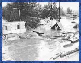
southplatteflood.jpg

Here’s the release from the utility via The Pueblo Chieftain (Chris Woodka):

The relation of stormwater to water rights, new regulations and system design will be among topics on the agenda at the stormwater educational seminar scheduled from 8 a.m. to noon Jan. 24 at the Pueblo Convention Center.

The seminar, hosted by the Pueblo stormwater utility department, is designed to assist organizations, developers, contractors, builders, professional engineers, municipalities and any others wanting to learn about:

– Underground stormwater management design, performance and regulatory drivers.
– Water rights of Colorado pertaining to stormwater management.
– Urban drainage water quality and drainage criteria updates.
– A state health department regulation about nutrient levels in discharges.

A continental breakfast will be provided.

For more information, call 553-2899.

More stormwater coverage here.

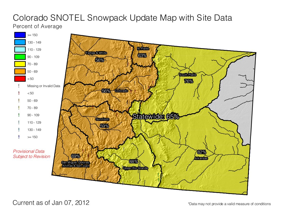
Snowpack news: Statewide snowpack at 65% of average, South Platte basin — 76%, Rio Grande basin (88%) drops to below average

snowpackcolorado01072012

Click on the thumbnail graphic to the right and then go out and conjure up the snow spirits.

From The Greeley Tribune (Eric Brown):

The snowpack for the entire state is [35] percent behind the norm.

However, most of the snowfall in the mountains comes in March and April and “some really good snowstorms during those months could get numbers back up to normal before the snow season is over,” said David Nettles, an engineer for the Colorado Division of Water Resources office in Greeley.

Also, the amount of water stored in northern Colorado reservoirs and other storage facilities is at healthy levels because of last year’s above-average snowpack. Dana Strongin, communications specialist with the Northern Colorado Water Conservancy District, said water levels in the region’s 12 reservoirs that are part of the Colorado-Big Thompson Project are nearly 30 percent above normal.

“There’s nothing terribly alarming about the snowpack numbers we’re seeing right now,” Nettles said. “If this continues, that could be a different story. But for now, we’re not panicking.”

Jim Hall, water resources manager for the city of Greeley, echoed Nettles’ comments. He said the current low levels of snowpack aren’t particularly alarming, not for a city that has plentiful access to water storage facilities.

Since reservoir levels are well above average, those with senior rights on the river and access to water storage facilities — particularly municipalities — will be in good shape for quite a while, even if low snowpack levels persist.

Nettles said it’s those with junior water rights and who don’t have access to storage water — consisting mainly of farmers in the region — who will be hurt first if snowpack numbers stay low, or fall off even further.

Frank Eckhardt — a LaSalle area farmer who serves as president for the board of directors for the Farmers Independent and West Mutual ditch companies, and also serves presidents of the Board of Consolidated Ditches, made up of 11 ditch companies — said there are only two ditch companies between Denver and LaSalle that own rights to water storage facilities.

“Just about all of us farmers depend on good snowpack and having good flows in the river to operate,” he said. “Hopefully Mother Nature starts to cooperate with us a little better. Hopefully there will be more snow.”

Sand Creek: Suncor employees have been exposed to benzene in their water supply

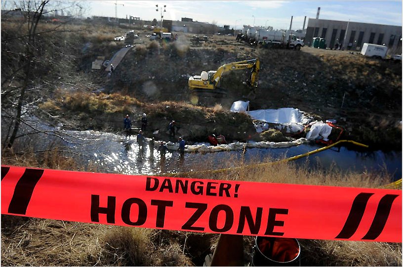
suncorcleanupsandcreek.jpg

From The Denver Post (Bruce Finley):

Workers at Suncor Energy’s oil refinery — nearly all 500 — have had their blood tested for benzene as Suncor excavates pipelines to deal with tainted tap water and tries to contain contamination of Sand Creek. Nobody knows how long drinking water at Suncor’s refinery has contained benzene. Results of blood tests at an occupational medicine clinic, done partly to reassure employees, were kept confidential…

“We believe we have a breach in the drinking water line near one of our office buildings,” Gallagher said. “We’re digging down to that pipeline to see what we can find.”[…]

Denver Water, which delivers water to Suncor, has determined that no benzene entered the metro pipe system, utility spokeswoman Stacy Chesney said.

Click through for the cool photo slideshow.

More oil and gas coverage here and here.

The November/December issue of ‘Colorado Water’ from the Water Center at CSU is hot off the press

optienzbiosensingconcept.jpg

The theme for the issue is, “Water Quality and Health.” Click here to download a copy. Here’s an excerpt:

Many situations exist in which water practitioners want to know the concentrations of organic chemicals in water, including evaluating whether a site is characterized as contaminated and/or whether a water treatment process is effective. But obtaining this informa- tion has traditionally involved collecting a water sample and analyzing it in a laboratory, usually off-site. Laboratory analyses involve various steps before the sample is analyzed in a gas chromatograph or similar instrument, and thus results are expensive and not readily available. Undesired outcomes of this situation include cases in which relatively few data are available to make important decisions (e.g., about the design of a remediation system), and that poorly functioning treatment systems are not corrected quickly.

About 15 years ago, my [Ken Reardon] laboratory at CSU began to develop biosensors to make it easier to measure this aspect of water quality. Our goals were to develop sensors that could provide continuous measurements of an organic chemical concentration and that could be placed directly in the water to be measured. The ability to take the sensor to the water (rather than removing a sample of water) is important, because sampling can skew the results in several ways.

A biosensor is a device that contains a biological detection element, usually an enzyme or antibody, as well as components that allow the biological detection event to be converted into a useable signal or number. We used our knowledge of the ways in which bacteria break down pollutants to develop enzymatic biosensors, and we chose to interface this with an optical method to produce a signal, since that approach often is more sensitive and has less environmental interference than electrical methods. These sensor systems consist of three parts: an optical- electronic hardware unit, one or more biosensor tips, and optical fiber connectors. Sensing is done using a two-layer detection element immobilized on the end of the biosensor tip (Figure 2). One layer is a fluorescent dye, and the other layer contains specific enzymes. The enzymes catalyze a reaction with the chemical of interest (the analyte), and the products of that reaction change the fluorescence properties of the dye. Those changes in fluorescence are detected and correlated to the analyte concentration. We recently started OptiEnz Sensors LLC to commercialize this technology.

Important features of the biosensor system are:

• Versatility: By matching enzymes and fluorescent dyes, biosensors for a wide range of organic chemicals can be constructed. The biosensors can also be designed to cover different concentration ranges.

• Ease of use: Measurements with these biosensors are simple and require no reagent or pretreatment. The tip of the biosensor is simply placed in the sample to be measured, and the analysis time is on the order of minutes.

• Ability to measure continuously, in place and online: These biosensors can be placed in a process vessel or in a process flow and can provide continuous, real-time measurements of the analyte concentration. Such information can then be used for process control or quality assurance/control.

• Low detection limits: Detection limits in the biosensors developed to date range from μg/L to sub-ng/L.

• Small size: The biosensors are based on plastic optical fiber that is about one millimeter in diameter, and can thus easily be placed in small wells.

• Multiplexing: Our optical-electronic hardware unit can monitor up to eight biosensors simultaneously, meaning that several contaminants can be measured.

Super Ditch: More than 100 people showed up yesterday for a palaver over the impending substitute water supply plan

arkbasinditchsystem.jpg

From The Pueblo Chieftain (Chris Woodka):

More than 100 people, representing nearly every major water interest in the Arkansas Valley, attended Friday’s meeting. State water officials also were on hand, including Gov. Hickenlooper’s water adviser John Stulp, State Engineer Dick Wolfe and Colorado Water Conservation Board members Alan Hamel and Travis Smith. Wolfe suggested the meeting as a way to hash out issues prior to a 30-day comment period when the Super Ditch files for a substitute water supply plan. “This is a one-year plan at this point. There is concern by farmers about how it will affect their water rights,” Wolfe said. “I am hoping this will allow the proponents to modify their plan before it is submitted.”

It’s anticipated the plan will be submitted in February for approval by April. It already has been approved by the Super Ditch and Catlin Canal boards, and the Pikes Peak Water Authority is expected to approve it soon.

The pilot program is a small step toward a water leasing-land fallowing program that could eventually involve 100,000 acres of farm ground in the Arkansas Valley. Only a portion of that would be dried up in any given year. This year, about one-fourth of the ground on of farms totalling more than 1,100 acres will be dried up. Only some of the ground will be dried up this year, and other areas will be rotated if the program continues in subsequent years.

One share on the Catlin Canal has a consumptive use of about 1.7 acre-feet of water per acre, while diversions can be as high as 5 acre-feet per acre. About 300 shares of water are anticipated to be used in the program, either for exchanges, delivery or return flows. Engineering is being completed on how return flows would be handled and how dry-up would be accounted for.

Heath Kuntz, engineer for the Lower Arkansas Valley Water Conservancy District, gave an in-depth presentation on how farms were chosen for the program and the parameters that will be used. Flood, sprinkler and drip systems will be included. No fields with alfalfa will be included.

More Arkansas Valley Super Ditch coverage here and here.

Colorado River Cooperative Agreement outstanding issues: Operating the Shoshone power plant and Green Mountain Reservoir

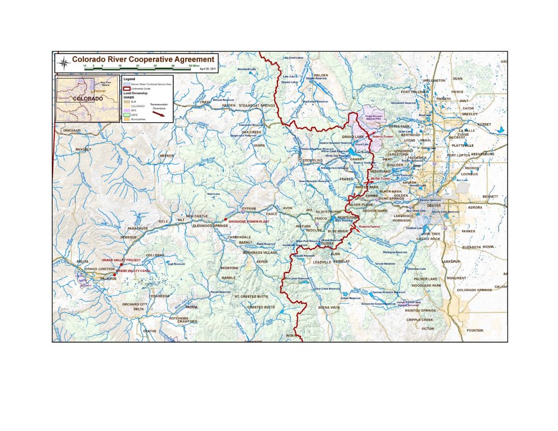
coloradorivercooperativeagreementmap.jpg

From the Grand Junction Daily Sentinel (Gary Harmon):

Two major issues, the administration of Green Mountain Reservoir and the Shoshone power plant in Glenwood Canyon, remain to be resolved. They are the same issues that parties acknowledged early on would be difficult but not insoluble. “It’s painfully slow,” Colorado River District General Manager Eric Kuhn said, “but we’re making a lot of progress.”[…]

The two issues closest to the Western Slope are joined, with the Green Mountain question needing to be dealt with first, Kuhn said. Agreement on the administration of Green Mountain Reservoir, which was built as part of the Colorado-Big Thompson Project, “fundamentally sets the stage for moving ahead on Shoshone,” Kuhn said. “A lot of issues have arisen over the years on Green Mountain Reservoir” that boil down to making sure the reservoir fills and that the demands of Denver Water and Colorado Springs are met, said Mark Hermundstad, a Grand Junction water attorney who represents several Grand Valley water users…

Colorado River water spins turbines in the Shoshone plant, and downstream users have long counted on Shoshone’s call on the river to make sure water is sent downstream through the Grand Valley rather than diverted eastward. There is a rub, though, and it concerns the times that Shoshone’s turbines are idle and the plant, therefore, is not drawing its 1,250 cubic feet per second of water from the river. The short-term answer is what has become known as the Shoshone outage protocol, in which upstream diverters agree to allow the river to flow as though Shoshone were operating. Part of that formula, however, depends on how Green Mountain Reservoir, which is owned by the U.S. Bureau of Reclamation, is managed.

More Colorado River Cooperative Agreement coverage here.

The Aspen Daily News is running a look at the parties suing the city over the proposed hydroelectric generation plant

aspen.jpg

Here’s a report from Brent Gardner-Smith writing for the Aspen Daily News. Click through and read the whole article for all the detail. Here’s an excerpt:

The city of Aspen, through its Denver-based water attorney, filed a motion to dismiss the lawsuit this past fall based on the notion that the plaintiffs don’t have standing to challenge the city’s water rights.

The plaintiffs recently submitted information to the court either detailing their water rights or giving other reasons why they should be allowed to sue the city over its water rights.

In the mix of property owners are two billionaires and two Aspen locals with a history of successfully taking on local governments.

The property owners sued the city in September 2011 in state water court in an effort to strip the city of its right to use water from the creeks for a new hydropower plant.

The city responded three weeks later by telling Judge James Boyd that the property owners don’t have the right to make their claims.

“The complaint does not identify which plaintiffs own water rights, what water rights they may own, or how those are or may be affected with respect to the alleged abandonment of the hydropower component of the subject water rights,” Cindy Covell, the city’s water attorney, told the court in a motion to dismiss the case.

The plaintiffs responded Oct. 24 with a 14-page brief and 155 pages of exhibits documenting their water rights and other interests.

The plaintiffs claim that since the city has not used its hydropower water rights on the two creeks since 1961, it no longer has the right to divert 25 cubic-feet-per-second of water from Castle Creek and 27 cfs from Maroon Creek for hydropower use.

More hydroelectric coverage here and here.

2012 Colorado legislation: Representative Looper plans legislation that will evaluate the impact of oil and gas operations on water supplies

derrick.jpg

From The Pueblo Chieftain (Chris Woodka):

“Produced water can be used, but it depends on whether it’s tributary or nontributary,” said Kevin Rein, assistant state engineer. “If the water is nontributary, it could be put to use on-site for fracking, well construction or dust suppression. If it is tributary, an augmentation plan is required.”

State Rep. Marsha Looper, R-Calhan, says she plans to introduce legislation to determine water quantity and quality impacts of oil and gas exploration. The Colorado Oil and Gas Commission does not track the industry’s water use, but estimates it to be less than 1 percent of total water use.

Water is used for hydraulic fracturing, or fracking, of deep wells and varies from 1 million to 8 million gallons of one-time use per well. Rein said the Division of Water Resources is working on estimates of how much water is actually used in mining operations, but said the number is “relatively minuscule” compared to agricultural, urban or other industrial totals.

The use of water produced in mining operations has led to controversy in Colorado. A 2009 Colorado Supreme Court decision in Vance v. Wolfe determined that water used in mining is a beneficial use. In the past, mining companies treated it as a waste product. Since the 2009 ruling, a well permit is needed if water produced during drilling is tributary to surface waterways. That means water from other water rights must be obtained for augmentation.

More 2012 Colorado legislation coverage here.

Snowpack news: Statewide snowpack 67% of average, Colorado River basin comes in at 58% of average

wyutcoprecipitation12252011to12312011

snowpackcolorado01052012

Well now, snowpack in the Upper Colorado River basin below 60% of average is concerning. Luckily, reservoir storage is in good shape in most areas including the South Platte River basin. Front Range cities in the basin move several hundred thousand acre-feet of water per year from the Colorado River. Colorado Springs and Pueblo get at least some of their supply from the Colorado River as well.

Direct irrigators can be significantly harmed in a water short year and those reservoirs which are in good shape right now may not refill during the runoff season, setting things behind for water year 2013.

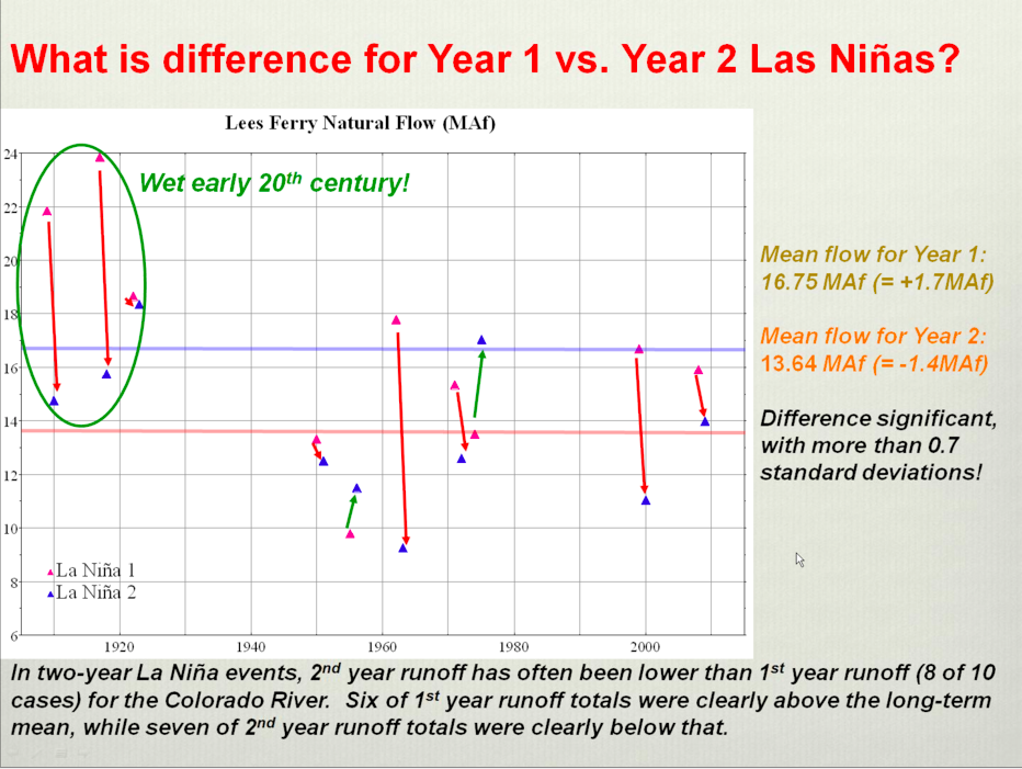
I like to link to this graphic from Klaus Wolter and the Climate Prediction Center that shows reduced flows at Lees Ferry in second-year La Niña events. We’re are in the midst of a second-year La Niña event.

Click on the thumbnail graphics above and to the right for the current snowpack map for Colorado and the precipitation summary from this week’s NIDIS Weekly Climate, Water and Drought Assessment Summary of the Upper Colorado River Basin from the Colorado Climate Center.

From the Summit County Citizens Voice (Bob Berwyn):

“A lot can happen between now and spring,” said Bob Steger, manager of raw water supplies for Denver Water. Reservoir storage is above average and above last year’s, with the Denver Water system at 90 percent of capacity, compared to the average 83 percent for this time of year, Steger said.

And that’s a good thing, because the statewide snowpack is only at [67] percent of average, with the key Colorado River Basin (encompassing Summit County) only at [58] percent of average.

That’s the fourth-lowest level in the past 30 years, according to Mage Skordahl, assistant snow survey supervisor with the Natural Resource Conservation Service. The only years with lower snowpacks at this point in the season during that 30-year span were 1990, 2000 and 2002, she said.

“When you start out like this, it’s not too often that you end up above average … We’d need to have above average snowfall the rest of the season just to get back to average,” she added.

While officials still seem sanguine at this point, Scott Hummer, the former Blue River Basin water commissioner for the State Engineer’s Office, said that, if he were still wearing that hat, he’d be starting to get concerned about long-term water supplies if the current weather trend continues.

Troy Wineland, the new Blue River Water Commissioner, said he’s definitely scratching his head about the upcoming irrigation season, but hoping that a predicted return to a snowy La Niña pattern could help boost the snowpack back toward average.

From The Mountain Mail (Ericka Kastner):

[Jennifer Stark, head meteorologist with the National Weather Service in Pueblo] said this week a ridge of high pressure in the atmosphere has been building over the Colorado Rockies and it brought in “quite a bit of warm weather…

Last winter there was a lot of snow in the west and north central United States, and in the mountains of Colorado, Stark said. “This year it is kind of reversed … the plains and southeast portion of the state have had more snow than this time last year.”

So, how about La Niña. Here’s the link to the latest ENSO diagnostic discussion from the Climate Prediction Center. Here’s the synopsis:

Synopsis: La Niña is expected to continue into the Northern spring 2012.

During December 2011, below-average sea surface temperatures (SST) associated with La Niña continued across the eastern and central equatorial Pacific Ocean. The weekly SST index in the Niño-3.4 region remained near –1.0°C throughout the month, indicating a weak to moderate La Niña. The oceanic heat content (average temperature in the upper 300m of the ocean) anomalies strengthened across the eastern Pacific, reflecting a large area of below-average temperatures in the subsurface. In the atmosphere, anomalous low-level easterly and upper-level westerly winds strengthened over the central and west-central Pacific. Convection remained suppressed in the western and central Pacific and enhanced over northern Australia and parts of Indonesia and the Philippine Islands (Fig. 5). Consistent with these conditions, the Southern Oscillation Index (SOI) also strengthened. This evolution is consistent with past events, in which the atmospheric components of La Niña become strongest and most well-defined during the Northern Hemisphere winter. Collectively, the ongoing oceanic and atmospheric patterns reflect the continuation of a weak to moderate La Niña.

A majority of models predict a weak or moderate strength La Niña to peak during the December – February season, and then to continue into early Northern Hemisphere spring season before dissipating during the March to May period. A slight majority of models predict La Niña to remain weak (3- month average SST anomaly in the Niño-3.4 region between -0.5 and -0.9°C) this winter, while several others predict a moderate-strength episode (anomaly in the Niño-3.4 region between -1.0 and -1.4°C). The latest observations, combined with model forecasts, suggest that La Niña will be of weak-to- moderate strength this winter, and will continue thereafter as a weak event until it likely dissipates sometime between March and May.

During January – March 2012, there is an increased chance of above-average temperatures across the south-central and southeastern U.S., and below-average temperatures over the western and the northwest-central U.S. Also, above-average precipitation is favored across most of the northern tier of states and in the Ohio and Tennessee Valleys, and drier-than-average conditions are more likely across the southern tier of the U.S. (see 3-month seasonal outlook released on 15 December 2011).

Mark Pifher is leaving Aurora Water to work on Colorado Springs Utilities’ Southern Delivery System

Southern Delivery System map via Colorado Springs Utilities

From The Pueblo Chieftain (Chris Woodka):

Pifher was at the helm when Aurora built Prairie Waters, a $650 million project that recycles sewer return flows from the South Platte River near Brighton to Aurora Reservoir. The project includes a well filtration field, underground pipeline and treatment plant and will be used by other Denver-area water suppliers through the WISE partnership, which includes Denver and 14 smaller water districts. “I’m looking forward to the opportunity to work on another large project,” Pifher said. “Both projects maximize the utilization of existing supplies through the reuse of water, and therefore minimize the need to go out and dry up even more farmland or move more water through transmountain diversions.”

Initially, Pifher will work on [the Southern Delivery System] and other projects as assigned, said Gary Bostrom, chief of water services for Colorado Springs Utilities. “Given his background, we’re pleased to have Mark back with us,” Bostrom said, noting that Pifher worked on water rights issues as an attorney for Colorado Springs earlier in his career…

Pifher, who lives in Colorado Springs, joined Aurora in 2005 as deputy director, after serving as director of the Colorado Water Quality Control Division. He was promoted to replace Peter Binney in 2008. Binney now works as a water consultant. Dan Mikesell will act as interim director of Aurora Water until a replacement is named.

More coverage from Pam Zubeck writing for the Colorado Springs Independent. From the article:

[ed. From the CSU release: “Mark Pifher has been hired for a new position as the SDS Permitting and Compliance Manager. With construction activities well under way in El Paso and Pueblo counties, there are an increasing number of construction-specific permits we must acquire, in addition to the extensive environmental monitoring and mitigation plans and projects required for compliance with the federal, state and local permits we’ve secured”[…]

Southern Delivery got under construction last year but got a sucker punch when most of the Banning Lewis Ranch, a residential and commercial development originally said to be a big reason for the pipeline, was sold to an oil drilling company from Texas, Ultra Resources. Utilities folks insist that even without Banning Lewis, the pipeline is needed for “redundancy,” a pitch that materialized as the project evolved but development of Banning Lewis didn’t.

More coverage from the Aurora Sentinel. From the article:

Dan Mikesell, deputy director for Aurora Water Operations, has been named interim director for Aurora Water effective Jan. 6.

More Aurora coverage here.

Two Rivers Water Company files exchange and storage change cases in water court

cucharasolandoreservoirstworivers.jpg

Here’s the release from the Two Rivers Water Company (John McKowen):

Two Rivers Water Company (http://www.2riverswater.com) announced today that it has filed two Colorado District Court, Water Division 2,Water Court applications in Pueblo, Colorado to irrigate farmland and for municipal, industrial, recreation, fire protection and other beneficial uses.

The first applicationwould allow Two Rivers to use water leased from Pueblo Board of Water Works to be stored in its reservoirs and used to irrigate farmlands in Huerfano and Pueblo County.

The second application would allow Two Rivers to use water diverted from the Huerfano River for irrigation to be stored in the Orlando Reservoir and other places upstream. In addition, itwould allow water to be used for municipal, domestic, industrial, agricultural, commercial, truck washing, stock watering, recreation, fish and wildlife, fire protection and other beneficial uses including augmentation, substitution and exchange. This application would permit Two Rivers to augment water supplies to the town of Gardner.

“The water court applications are another important step in the development of our business model, which is unique among publicly traded water companies,” stated John McKowen, Founder and Chief Executive Officer of Two Rivers.

“The exchange of water upstream to our reservoirs and ditch systems allow us to create jobs and economic growth in Huerfano and Pueblo counties at a more accelerated pace by putting water that otherwise would have to be released downstream to beneficial use first upstream for growing crops and augmenting municipal water supplies,” McKowen noted.“In particular, a water court application we filed for the Robert Rice ditch allows us to provide augmentation water to the town of Gardner, which could bein danger of losing its water supply,” he added.

McKowen noted that Two Rivers has a unique business model among publicly traded water companies in that it actively farms high-yield, irrigated farmland while also providingwholesale water for municipal, industrial and recreational use. Both farming and wholesale water are significantly demand driven in the current economic environment and provide excellent profit margins, McKowen said, adding thatone business benefits from the worldwide increase in the demand for food and the other benefits from the worldwide increase in the demand for water. In the western United States the two businesses are inextricably intertwined, McKowen noted.Two Rivers provides balance rather than the oftenseen,very intense competition for water between the agricultural and municipal communities, he said.

McKowen also pointed out that the symbiotic relationship between food and water allows Two Rivers to cover its overhead and generate profits from farming while its water business develops and establishes supply relationships.As a result, Two Rivers cansupport the development of its water business from irrigated farming and, in future years, provide support to water-short communities without permanently drying up prime farm land. Societally, McKowen noted, the Two Rivers business model provides a more holistic and sustainable solution to competing rural and urban interests.

Gary Barber, Two Rivers’ Chief Operating Officer and the architect of Two Rivers’ water strategy stated, “This is the first step of many whereby Two Rivers provides real solutions to water-short water districts along the southern portion of the Front Range of Colorado without buying and drying some of Colorado’s most productive farmland. As Chairman of the Arkansas Basin Roundtable, I have seen the tension build between smaller water districts trying to provide water to their communitiesandthose farming communities trying to sustainagriculture. Both need water.”

Barber noted, “Two Rivers’ water assets have a special character, most importantly 70,000 acre feet of storage which can be rehabilitated at 10% of the cost, and a small fraction of the time required to build new storage. We are ideally positioned to provide the ‘wet’ water solutions to both communities. It has been a problem we have been studying at the Roundtable for several years. “

In addition, Barber said, “When I was asked by Two Rivers to join its management team and saw how it had put together this unique “ag/muni” holistic business model with its unique assets, I saw it as a real opportunity to develop a public/private partnership that could genuinely serve the people of Colorado. Since joining Two Rivers in early 2010, I’ve been able to combine my water experience with the company’s entrepreneurial talent and build a unique enterprise that has many exciting opportunities ahead.”

More coverage from Chris Woodka writing for The Pueblo Chieftain. From the article:

Two Rivers’ plans call for creating about 38,000 acre-feet of storage in Cucharas and Orlando reservoirs. The company owns about 4,700 acres of land in ditch systems fed by the reservoirs, including the Huerfano-Cucharas Ditch. This year, about one-third of that will be planted as the company ramps up to full production, Barber said.

In a separate change-of-use application in water court, Two Rivers wants to dry up about 150 irrigated acres on the Robert Rice Ditch, but would change the use of the water only so it could be used in Huerfano County. Two Rivers purchased the ditch, which has a water right dating back to 1867, making it fairly senior.

Under the purchase agreement, as much as 130 acre-feet could be made available to serve future developments in Huerfano County. The water also could be used to augment existing wells in communities such as Gardner, Barber said.

“It’s not speculation, since we do have an agreement with the seller, but we did not file for the augmentation of any specific wells,” Barber said.

More Arkansas River basin coverage here.
Snowpack/precipitation news: Dry east and west of the Great Divide, Arkansas River basin is at 89 percent of average

snowpackcolorado12302011

From The Pueblo Chieftain (Chris Woodka):

“It looks really sad. There’s not much of a snowpack at all up here,” said Rick Sexton, caretaker of Clear Creek Reservoir for the Pueblo Board of Water Works. “There’s very little snow in Leadville. It’s all melted off the south faces of the mountains and up to the tree line on the north faces. It’s 50 degrees here today, and windy as well.

“It’s shaping up to be a bad winter.”

In the Colorado River basin, which the Arkansas River depends on for supplemental water imports, it’s even drier. Snowpack in the Arkansas River basin is 89 percent of normal, while it’s only 63 percent in the Upper Colorado. The Rio Grande basin is in the best shape, with 93 percent of average…

The good news is that most of the snow typically doesn’t fall until March and April, and early readings can give a misleading impression of how much snow eventually will pile up.

From The Pueblo Chieftain (Chris Woodka):

Pueblo ended the year with 9.23 inches of precipitation, about 75 percent of average. The year 2011 ranked as the fifth driest year on record in the past 40 years. Other than 2002, when only 3.94 inches of moisture was recorded, it was the driest in a decade. Drought concerns prevailed throughout most of the year in Southern Colorado, with wildfires in several Eastern Plains counties last spring, dryland crop damage and cattle sell-offs making headlines…

National Weather Service forecasts call for chances of average precipitation over the next few months, with a weak La Nina (Pacific Ocean cooling) system. It’s impossible to predict when or where the snow or rain will land, however. The U.S. Drought Monitor lists much of Southern Colorado in severe to extreme drought.

From The Greeley Tribune (Eric Brown):

As of Dec. 30, the Natural Resources Conservation Service reported that snowpack in the South Platte River Basin was 15 percent behind the 30-year average for this time of year, while the Colorado River Basin was 37 percent behind normal — its second-lowest level recorded on Jan. 1 since records started being kept in the 1980s. The snowpack for the entire state is 28 percent behind the norm.

However, most of the snowfall in the mountains comes in March and April and “some really good snowstorms during those months could get numbers back up to normal before the snow season is over,” said David Nettles, an engineer for the Colorado Division of Water Resources office in Greeley.

Also, the amount of water stored in northern Colorado reservoirs and other storage facilities is at healthy levels because of last year’s above-average snowpack. Dana Strongin, communications specialist with the Northern Colorado Water Conservancy District, said water levels in the region’s 12 reservoirs that are part of the Colorado-Big Thompson Project are nearly 30 percent above normal.

“There’s nothing terribly alarming about the snowpack numbers we’re seeing right now,” Nettles said. “If this continues, that could be a different story. But for now, we’re not panicking.” Jim Hall, water resources manager for the city of Greeley, echoed Nettles’ comments. He said the current low levels of snowpack aren’t particularly alarming, not for a city that has plentiful access to water storage facilities.

Since reservoir levels are well above average, those with senior rights on the river and access to water storage facilities — particularly municipalities — will be in good shape for quite a while, even if low snowpack levels persist.

2012 should see much increased exploration and production from the Niobrara shale play in eastern Colorado

niobrarashale.jpg

From the Fort Collins Coloradoan (Bobby Magill):

Companies exploring the shale are operating mostly in Weld County, but Niobrara activity is spreading across the entire northern tier of Colorado and down the Front Range toward Colorado Springs.

“New oil boom. The words stir the excitement in the hearts of landmen, landowners, geologists, engineers, regulators, environmentalists, tax collectors, the unemployed and charlatans. Although oil production from the Niobrara strata began early in the 20th century, the new oil wells in Colorado are causing a land rush and drilling boom in many parts of the state,” Colorado State Geologist Vince Matthews wrote in the issue of the Colorado Geological Survey’s quarterly newsletter “Rock Talk”featured on the Colorado Department of Natural Resources’ website.

New horizontal drilling technology allowing energy companies to tap the Niobrara and make a tidy profit doing it “has raised the hopes of thousands of Coloradans,” Matthews wrote.

The Niobrara shale spreads across northeast Colorado, but it’s only about 400 feet thick and thousands of feet underground. Because the shale is so thin, energy companies couldn’t drill it very efficiently before horizontal drilling technology was developed in recent years. The new technology allows a single oil well to tap an underground reservoir of oil up to 12 times larger than an older vertical well, according to the Colorado Geological Survey…

Matthews warned that some wells have gushed oil while others haven’t, showing that it’s too early in the rush to explore the Niobrara to know if it’s going to prove to be as profitable and lucrative as some energy companies hope. One thing is for sure, however: Oil and gas companies are going to invest billions in the Niobrara in Northern Colorado in 2012 and beyond. Anadarko announced, on Nov. 14, that it plans to drill up to 2,700 new oil wells into the Niobrara shale in the heavily drilled Wattenberg Field in Weld County. Noble Energy, already a big Niobrara player in northern Weld County, told the Denver Business Journal in November that it will invest about $8 billion in exploring the Niobrara and Codell formations in the Wattenberg Field in the coming years. Anadarko spokesman Brian Cain said that the company is “encouraged” by the potential for Niobrara exploration in Larimer County, where no new drilling permits have been issued since March.

From The Denver Post (Monte Whaley):

A special Ward II meeting to discuss hydraulic fracturing in [Commerce City] is scheduled for Tuesday, Jan. 10 at the Landmark Academy gym, 10550 Memphis St…

The Ward II meeting, hosted by city councilman Jim Benson, will feature panelists, including:

– Phillip D. Barber, an attorney with more than 30 years of oil and gas litigation experience.

– Charlie Montgomery, an energy organizers with the Colorado Environmental Coalition.

– Debbie Baldwin, environmental manager with the Colorado Oil & Gas Conservation Commission.

– Jim Jones, general manager, South Adams County Water and Sanitation District.

The meeting will from 6:30 — 8:30 p.m. For more information, contact Benson at jbenson@c3gov.com or 303-288-7011.

Finally, the Arapahoe County Board of Commissioners have decided to pass on the opportunity to set drilling guidelines, according to Carlos Illescas writing for The Denver Post. From the article:

Arapahoe County Commissioners today decided against passing rules for oil and gas exploration, deciding instead to focus on areas the state does not regulate. Those areas would be transportation and other types of infrastructure. The county’s planning and zoning commission had already passed a set of regulation for the commissioners to consider.

But at a public hearing today attended by about 75 people, the commissioners by a 3-2 voted denied an amendment to the county’s land development code to regulate oil and gas. Commissioners Rod Bockenfeld, Susan Beckman and Nancy Sharpe voted against the regulations, while Nancy Jackson and Frank Weddig were in favor of them. The commission also voted to work with state agencies on issues surrounding hydraulic fracturing, or fracking. A committee will also be created to help the county craft rules going forward.

More oil and gas coverage here and here.

Valley Courier Colorado Water 2012 series debuts today

coloradowater2012

From the Valley Courier (Judy Lopez):

So to help busy Coloradans connect to their water resources and their abundant uses Colorado Governor John Hickenlooper will declare 2012 the Year of Water.

2012 marks several important water milestones – it is the 100th Anniversary of the Rio Grande Reservoir. The Colorado Water Conservation Board, The Northern Water Conservancy District and the Colorado River Water Conservation District all are celebrating their 75th anniversaries. While the Southeastern Colorado Water Conservancy District turns 50 this year, it gives every water conservation, conservancy, and irrigation entity a chance to be recognized for the vital service they provide each of their communities.

More importantly the Colorado Water 2012 movement is an opportunity to celebrate the value of water and recognize the multitude of uses that it provides to everyone in Colorado.

The goals of Colorado Water 2012 are to:

* Raise awareness about water as a valuable and limited resource

* Increase support for management and protection of Colorado’s water and waterways

* Showcase exemplary models of cooperation and collaboration among Colorado water users

* Connect Coloradans to existing and new opportunities to learn about water

* Motivate Coloradans to become proactive participants in Colorado’s water future

More Colorado Water 2012 coverage here.

Montrose: Aspinall Unit operations meeting January 19

aspinallunitdescription.jpg

From email from Reclamation (Dan Crabtree):

As of midnight December 26th, Blue Mesa Reservoir reached the icing target elevation of 7490.0 feet. Due to the dry conditions over the last month and early arrival at the icing target, it is appropriate to begin conserving reservoir storage in case the drying trend continues. As a result, releases from the Crystal Dam will be gradually reduced from 1500 cfs to 1100 cfs over the course of the day (December 28th).

Also, please mark your calendars for the next Aspinall Operations Meeting which will be held on January 19th at the Holiday Inn Express in Montrose, Colorado beginning at 1:00 p.m. We have tentatively scheduled a presentation by Vern Jetley, a retired Reclamation photographer who will be talking about the Blue Mesa area prior to construction of the project. Should be interesting.

More Aspinall Unit coverage here.

Recent report chronicles Poncha Springs geothermal potential

geothermalenergy.jpg

From The Mountain Mail (Joe Stone):

Fred Henderson of Hendco Services and Paul Morgan of Colorado Geological Survey recently completed a study and issued a report providing new data about the Poncha Hot Springs geothermal resource.

The report lists several conclusions based upon information compiled during the study:

– The study area contains the highest “thermal gradient anomaly” measured to date in Colorado.
– Geological fault structures, including the main east-west Poncha Hot Springs fault and subsidiary faults to the north, appear to control the upwelling and flow of geothermal water from a deep geothermal source.
– Previous geothermometry studies indicate the possible presence of a deep, high-temperature reservoir.
– Scientific observations suggest existence of a deep, high-temperature reservoir capable of producing electricity in significant amounts.
– Findings support conducting a magnetotelluric survey followed by one or two 1,000-1,500-foot-deep thermal gradient holes to further validate and locate a potential deep geothermal reservoir.

More geothermal coverage here and here.

Brighton: City council raises utility rates, adds storm drainage fee

fountainpavementdrawing.jpg

From the Brighton Standard Blade (Kevin Denke):

Resident’s utility rates will rise for the second time in less than a year as the city continues to try to keep pace with the cost of aging infrastructure. Brighton City Council members approved staff recommended rate increases for water and sewer services Dec. 20. The new rates, which go into effect with utility bills issued after Jan. 1, include an increase to both fixed rates and user rates for water and sewer as well as the addition of a storm drainage fee.

More infrastructure coverage here.

Forecast/snowpack news: Saturday may bring snow to the central mountains, chance of snow to the Denver area

sixtotendayprecipitationclimatepredictioncenter01032012

From The Aspen Times (Janey Urquhart):

Central Colorado is suffering a La Niña weather pattern that has sent storms north, south or both, according to Chris Cuoco, senior meteorologist for the National Weather Service in Grand Junction. Weather systems have tracked south over Arizona and New Mexico or stayed north and then slipped down the Front Range and dumped in Denver and the Central Plains.

“Right now, it doesn’t look like anything’s going to happen until next Saturday (Jan. 7) at the earliest,” Cuoco said.

The local weather bloggers at aspenweather.net offered this on Saturday: “After next weekend the pattern has a distinct look of change as things totally realign themselves out in the Pacific Ocean. This could be the pivotal make or break point of our winter, depending on how things turn out in about 10 days or so.”[…]

At present, though, the snowpack in the Roaring Fork River basin stands at 55 percent of average, and at about 47 percent of average on Independence Pass, southeast of Aspen. The snowpack is at 62 percent of average on McClure Pass, according to the Natural Resources Conservation Service.

In southwest Colorado, the snowpack is at 65 percent of average or more.

From The Telluride Daily Planet (Benjamin Preston):

This is the second year in a row La Niña has shaken her snowless fists in the faces of Rocky Mountain residents dependent upon snowfall for water supply and snow sports…

[Paul Frisbie, a meteorologist at the National Weather Service center in Grand Junction] explained that the system expected this weekend will be moving quickly, so probably won’t leave much behind, especially in areas farther north of the Four Corners.

From 9News.com (Tara Meyer):

“We are sitting about where most of the western U.S. is right now, below-average snowpack across the west,” Mike Gillespie, a snow survey supervisor with the Natural Resources Conservation Service, said. “The only exception is actually down south like Arizona and New Mexico where their snowpack is actually above average.”

Across Colorado, snowpack is about a quarter below average: 73 percent of normal. It’s one of the smallest snowpacks at this point in the season in the last 30 years.

When comparing the current amount of snow to historical data, the Natural Resources Conservation Service says Colorado only has a 10 percent chance of getting back to a normal level for snowpack by spring.

The lack of moisture could have a major impact on Colorado’s farmers. However, some say they’re not too worried.

Brad Johnson grows corn, alfalfa, wheat and other crops on his farm near Berthoud in Larimer County. He says because Colorado saw above-average snowfall last year, reservoirs filled up along the Front Range and that water is still being used.

U.S. Secretary of Interior Ken Salazar to Hold America’s Great Outdoors Meeting in Colorado’s San Luis Valley on Wednesday

bacanationalwildliferefuge.jpg

Here’s the release from the Department of Interior (Adam Fetcher):

As part of President Obama’s America’s Great Outdoors initiative, on Wednesday, Jan. 4, Secretary of the Interior Ken Salazar will hold a meeting in the San Luis Valley to discuss ongoing efforts in the community to conserve the area’s natural and cultural resources.

In May, Governor John Hickenlooper and Secretary Salazar identified the San Luis Valley as one of three priority projects in Colorado for the America’s Great Outdoors initiative. Interior and other federal agencies will work with the State, local stakeholders, private landowners and other partners to help conserve healthy lands and waters and promote tourism in the San Luis Valley and the Rio Grande River Corridor.

During the meeting, Secretary Salazar will discuss the recommendations put forth in the National Park Service’s (NPS) San Luis Valley and Central Sangre de Cristo Mountains Reconnaissance Survey Report, which was recently released. The report, requested by Salazar, identifies nationally significant American Latino heritage sites that reflect the history, culture, and traditions of the American Southwest Frontier. From Colorado’s oldest documented town to the oldest church, the report covers over 3,264,000 acres located within the San Luis Valley and central Sangre de Cristo Mountains of south-central Colorado and northern New Mexico.

The meeting will be open to the public and members of the media. Secretary Salazar will hold a media availability immediately following three breakout sessions, which include:

– National Historic Park and Other Cultural/Historic Designation Options
– Trails System Proposal
– Landscape Scale Conservation and Management Opportunities

WHO: Ken Salazar, Secretary of the Interior
John Hickenlooper, Governor of Colorado
Mark Udall, U.S. Senator
Michael Bennet, U.S. Senator

WHAT: San Luis Valley Community Conversation

WHEN: Wednesday, Jan. 4, 2012
9:30 a.m. MDT Opening Remarks
11:00 a.m. MDT Breakout Sessions
12:30 p.m. MDT Media Availability
*a more detailed agenda is forthcoming

WHERE: Adams State College
208 Edgemont Boulevard
Alamosa, CO 81102

More coverage from Bob Berwyn writing for the Summit County Citizens Voice. From the article:

Specifically, federal, state and local officials will discuss potential for National Park historic and cultural designations, a trail system proposal and landscape-level conservation and management opportunities. The goal is for federal and state agencies to work with local stakeholders, private landowners and other partners to help conserve healthy lands and waters and promote tourism in the San Luis Valley and the Rio Grande River Corridor.

During the meeting, Secretary Salazar will discuss the recommendations in the recently released National Park Service’s San Luis Valley and Central Sangre de Cristo Mountains Reconnaissance Survey Report.

More coverage from the Associated Press via The Columbus Republic. From the article:

A recent report identifies American Latino heritage sites that reflect the history, culture, and traditions of the American southwest frontier. The report covers more than 3 million acres located within the San Luis Valley and central Sangre de Cristo Mountains of south-central Colorado and northern New Mexico.

More Rio Grande River basin coverage here and here.

Delta County chips in some dough for the Grand Mesa cloud-seeding effort this year

cloudseedingexplained.jpg

From the Delta County Independent (Hank Lohmeyer):

A multi-agency supported cloud seeding project on the Grand Mesa is in line to receive $1,000 in support from the Delta County Commissioners next year [2012]…

The multi-agency Water Enhancement Authority “is a non-profit organization of three water conservancy organizations,” explained WEA secretary treasurer Mark Ritterbush in a letter to the commissioners. The three agencies are the Grand Mesa Water Conservancy District, the Grand Mesa Water Users Association, and the Collbran Water Conservancy District. The three districts, along with other regional government bodies, donate to the Water Enhancement Authority.

According to Ritterbush’s letter to the BoCC, “Research conducted in the San Juan Mountains concluded that cloud seeding may increase snowpack levels by an additional 5 to 15 percent. The extra water realized through cloud seeding was produced at a cost of $0.94 to $1.15 per acre foot. Silver iodide is used to seed the clouds.”[…]

According to a map that accompanies the request letter, the WEA has 12 cloud seeding generators on Grand Mesa.

More cloud-seeding coverage here.

Brad Johnson (Ultra Resources): ‘The [El Paso County] regulations in draft form are inefficient and burdensome and I would also add arbitrary in many instances’

oilgasevaporationpond.jpg

From The Colorado Springs Gazette (Daniel Chacón):

“The regulations in draft form are inefficient and burdensome and I would also add arbitrary in many instances,” Brad Johnson, vice president of reservoir engineering and development for Ultra Resources, told county commissioners during a 3 ½-hour work session on the proposed regulations.

“The requirements are vague with conflicting definitions that will lead to ad hoc – not legislative – rulemaking, and that will eventually lead down a path of precluding a mineral owner from developing its resources, which is in fact the taking of property rights,” he said. Johnson said industry regulations at the state level were sufficient. “Important issues such as wildlife, groundwater protection, visual mitigation, location setbacks, noise, air quality and waste management, among many others, are all effectively regulated by the state agencies,” he said.

Here’s a report about the proposed drilling regulations from Debbie Kelley writing for the Colorado Springs Independent. From the article:

At the fourth public work session on the issue, commissioners agreed to move toward adopting a final document. Next, the county’s planning commission will review the proposed regulations in a special meeting next Wednesday, Jan. 4, at 9 a.m. at Pikes Peak Regional Development Center, 2880 International Circle.

The planning commission will make a recommendation to county commissioners, who will vote on the final regulations Jan. 31. A four-month temporary suspension on drilling permits expires the end of January…

Ken Wonstolen, a Denver lawyer who represents the Colorado Oil and Gas Association, a trade group, as well as Ultra Resources, an energy developer that wants to drill in El Paso County, said both of his clients are “concerned about the vulcanization of problematic aspects we find with the proposed ordinance.”

He specifically cited what he called the time consuming nature of the local permitting process, which in the draft regulations require hearings before both the county planning commission and approval by the county commissioners.

“There really is a fundamental disconnect between land-use planning and oil and gas development,” Wonstolen said. “If you can’t say no and you can’t say where and you don’t have a lot to say about how it’s down what is it you’re trying to say with your regulations? You’re trying to squash a round peg into a square hole.”

More coverage from Debbie Kelley writing for the Colorado Springs Independent. From the article:

The county started researching the issue a year ago, after companies began leasing vast amounts of mineral rights in eastern El Paso County, in preparation for drilling. Reactions, at this point, fall to one extreme or the other, says Commissioner Dennis Hisey.

“When we first started this process, I heard things about, ‘How intrusive is it going to be?’ ‘What’s it going to look like?’ ‘What will happen to the roads?’ Now, it’s either, ‘Protect our water,’ or, ‘This will be good for our county — when are they going to start drilling?’ Nothing in between,” he says…

Potential water contamination from oil and gas development — a big fear for many — is “likely to come from surface activities associated with site development,” such as fuel spills and chemical storage, Sean Chambers, general manager of the Cherokee Metropolitan District, pointed out in his written comments to county officials…

To protect drinking water, the draft regulations include conditions such as prohibiting earthen pits for storing water that comes back out of the well after drilling, says Craig Dossey, a county planner and project manager. “We favor the closed-loop system, re-piping the fluid and putting it in tanks,” he adds.

Meanwhile, Fort Lupton Mayor, Tommy Holton, is on board with the recently issued hydraulic fracturing disclosure rules issued by the Colorado Oil and Gas Conservation Commission. Here’s a report from the Fort Lupton Press. Here’s an excerpt:

According to Fort Lupton Mayor Tommy Holton, who sits on the commission, the Colorado rules appear to be a good fit for the oft-opposing factions in the debate over fracking disclosures, reducing the amount of testimony by industry and environmental concerns. “It went really well. We took 11 hours of testimony at the last hearing date, which was Dec. 5,” Holton said. “The staff compiled all of the testimony and the rebuttals, then staff and the industry worked with the environmentalists, all three got together last week and put together a new version that everyone could agree on.”

The regulations went forward virtually as written, a testament to the staff that prepared the legislation behind the scenes, balancing a host of varied concerns. “We didn’t change a thing from the recommendations of staff and industry,” Holton said. “It worked out really well. The environmentalists were happy, and the industry was happy and staff was happy.

More oil and gas coverage here and here.

Forecast for January: Near-normal temperatures and near-normal precipitation for the Denver area this month

onemonthforecastprecipitationclimatepredictioncenterjanuary2012

From The Denver Post (Brandon Swedlund):

The Climate Prediction Center forecasts near-normal temperatures and near-normal precipitation for the Denver area this month. La Niña conditions will continue over the Pacific Ocean, so expect a typical January weather pattern with periods of mild weather and periods of cold weather.

Northern Water’s new hydroelectric facility at Carter Lake should be online this summer

carterlakenorthernwater.jpg

From the Loveland Reporter-Herald (Pamela Dickman):

Northern Water, which distributes all the Colorado-Big Thompson water, is building a $6 million hydroelectric plant at Carter Lake. The district invested $4 million and borrowed $2 million from the Colorado Water Resource and Power Development Authority — a loan that will be paid back with profits from the sale of the power. The building to house the equipment that will transform the pressure from the water into electricity is nearly complete. And the actual generation turbines are on order from a company in England. They are expected to arrive in Colorado by March, and crews will install them in the new building. By June, the plant should begin adding electricity to the grid for Poudre Valley Rural Electric Association, which signed a 20-year contract to buy the water power. The plant could produce up to 2.6 megawatts of power — enough to serve 1,000 homes.

More Colorado-Big Thompson Project coverage here.

The Pueblo Chieftain: A look back at the Chieftain 100 years ago, pump irrigation looks to become popular

pueblo.jpg

Here’s Part I of their new series 1912 Century Link: A look back at the Chieftain 100 years ago. Here’s an excerpt from today’s installment from Peter Strescino:

Pueblo was a bustling city, a center of industry, the state’s second city, to Denver. Its newspaper, which went for a nickel, boasted pages packed with ads and stories, seemingly placed in every space of newsprint available. White space was nonexistent…

A Pueblo firefighter, Jim Flynn, signed to fight heavyweight champion Jack Johnson for the title sometime during the summer. Johnson was going to get $31,000 for the bout and a piece of the action for the resulting film of the fight…

But economic news dominated the paper. A story from Wall Street contended that corporations needed regulation, as did banking. There was a price-fixing scandal in meat-packing capital Chicago. Land in Hugo was going for $120 an acre and pump irrigation was going to be popular.

The Pueblo Chieftain is running the photos of the year from their staff

bryankelsenslipandslidechieftainpicturesoftheyear2011

Click here to get to the photos of the year from The Pueblo Chieftain. The one that caught my eye was of two kids at slip and slide time during the summer.

Colorado Springs: DARCA 2012 Annual Convention, February 22-24

pikespeak.jpg

Here’s the link to the web page for the convention. Here’s the link to the registration form and agenda. Here’s the link to the pre-convention workshop agenda.

Record high temperature at the South Pole on Christmas Day

antarctica.jpg

From the Summit County Citizens Voice (Bob Berwyn):

A short-lived heat wave of sorts brought a record high temperature of 9.9 degrees to the South Pole on Christmas day, according to a report in the Antarctic Sun, the newspaper of the U.S. Antarctic Program.

The old record of 7.5 degrees was set Dec. 27, 1978. Several other stations nearby also climbed into the teens, breaking previous record highs that were in the single digits.

Part I of the series, ‘Water 101: The evolution of water use in the northern San Luis Valley’ from the Crestone Eagle

artesianwellduttonranchalamosa1909

Here’s Part I from Marty Shellabarger writing for The Crestone Eagle. Click through for the whole article and cool photo slideshow. Here’s an excerpt:

Diverting water from natural flood plains meant more water consumption and evaporation. Perennial San Luis Creek marshlands dried out somewhat, creating more harvestable grass meadows. Once, Saguache County had the highest US workforce percentage producing grass hay, abundantly exported after railroads came in the 1890s. Moffat, the major shipping station for cattle in these parts, had numerous corrals holding thousands of cows. In the silver-boom years just after 1900, Moffat was even a candidate for capitol of Colorado.

Mountain reservoirs maintaining year-round livestock was status quo here for 90 years … until center-pivot sprinkler irrigation in the 1960s utilized our second great reservoir, the aquifers. That—along with large-bore water drilling, new pumps and the electricity to power them—would begin to change everything in our valley.

More Rio Grande River basin coverage here.

Metropolitan State College is adding a water studies minor, ‘designed to deepen students’ understanding of water as a critical resource’

metrostateroadrunner.jpg

From Examiner.com (Caitlin Johnson):

“Water is a central issue in Colorado,” said Sandra Haynes, Dean of the School of Profession Studies at Metro. “Explosive residential development along the Front Range is rapidly depleting the Denver basin’s aquifers.”

“Water stewardship and sustainability is an especially important and responsible education topic,” said Haynes. The One World, One Water Center’s pilot program is “designed to deepen students’ understanding of water as a critical resource that must be sustained and conserved for all,” said Haynes.

The main function of the Water Studies program is to enhance water stewardship on and beyond the campus by promoting effective use of water resources. Classes will involve education on issues such as urban waterway restoration, water law, hydro-philanthropy, conflict resolution, conservation, and stream reclamation.

More education coverage here.

Part one of series examining mine reclamation from the Pikes Peak Courier View

cripplecreekrvtravel-com.jpg

Here’s a report detailing some of the challenges and regulations around reclaiming mine sites, from Norma Engelberg writing for the Pikes Peak Courier View. Click through and read the whole article. Here’s an excerpt:

“When you file a mining claim, you have to submit a notice of intent to conduct exploration or prospecting,” [Tony Waldron, supervisor of the minerals program at the state mine reclamation office] said. “A lot of information is submitted with the notice of intent — how much topsoil will be removed, what the predisturbance biology looks like, whether there is any surface water and how you plan to explore the site.”[…]

“It’s all about showing us what’s there now and what you plan to put back,” Waldron said. “A lot of people use ‘restoration’ and ‘reclamation’ interchangeably but restoration means putting the land back exactly like it was. You’re never going to be able to do that. Reclamation means returning the land to a beneficial use. That could mean creating grazing land or wildlife habitat but it could also mean creating a parking lot or building homes on it.”

Along with all the information required, the prospective miner also has to submit a reclamation bond, the cost of which is based on how much land disturbance the mine will create and the cost of the worst-case scenario — the state stepping in to reclaim the site.

“Currently the state is holding about $423 million on reclamation bonds,” Waldron said. “About half of that belongs to a couple of big mines, the rest comes from smaller mines. A big mine might pay $100 million or more; a small mine’s bond might be anywhere from a $15,000 to $30,000.”
Waldron’s office also provides advice on planting mixtures and timetables.

“Reclamation takes time — three to five years at least,” he said. “In Colorado’s climate and terrain, plants take a while to become established but if you follow the timetables for planting you’ll probably be successful in most (non-drought) years.”

More restoration/reclamation coverage here.
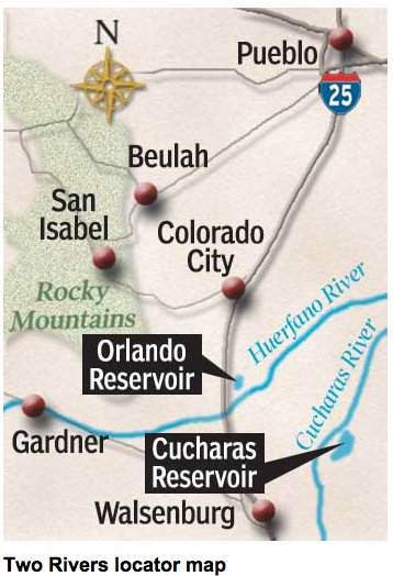
Happy New Year

fireworks.jpg

Happy New Year to you and yours. Thanks to everyone for reading Coyote Gulch and for the cool words of encouragement when I’m lucky enough to meet one of you.

John Stulp: ‘The year 2012 is a milestone for water in our state’

coloradowater2012

Here’s a guest column written by John Stulp — Governor Hickenlooper’s water wonk — running in The Pueblo Chieftain. Here’s an excerpt:

The year 2012 is a milestone for water in our state. It’s the 75th anniversary of the legislation that created many of the organizations that built the foundation for the management of Colorado’s water resources, including the Colorado Water Conservation Board, Colorado River Water Conservation District and the Northern Colorado Water Conservancy District. In addition, the Rio Grande Reservoir celebrates its 100th year, the Southeastern Colorado Water Conservancy District celebrates the 50th anniversary of the Fryingpan-Arkansas Project, the Lower Arkansas River Water Conservancy District will mark its 10-year anniversary and the Colorado Foundation for Water Education will be turning 10 as well.

Over the next year, these big anniversaries will be linked together by a statewide project called “Colorado Water 2012.” The goal is to connect Coloradans to their water.

I welcome all your readers to check in each Sunday for the next 52 weeks, as we chronicle the activities of water users, in their businesses and livelihoods.

More Colorado Water 2012 coverage here.