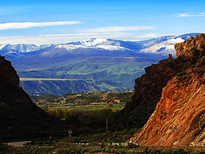
Report on the Pagosa Springs Area geothermal resources suggests that potential is more extensive than previously identified

pagosahotsprings.jpg

Here’s the abstract from the report:

Pagosa Springs, Colorado is famous for the hydrothermal activity in its groundwater system, though the system is poorly understood. At present, the hot water flow is used for both tourism and the heating of some buildings, but further expansion of the springs’ usage could reduce the effective energy produced in both cases. To better understand the nature and extent of the hydrothermal flow, several geophysical methods were designed and implemented, including: Gravity, magnetics, electromagnetics, seismic, Direct Current (DC) resistivity, and ground penetrating radar (GPR), all of which were tied in with global positioning system (GPS) data. The surveys were designed to determine the structural geology, the locations of water sources, and the direction and magnitude of that flow. These geophysical surveys were employed to give students a better understanding of geophysical methods as well as assisting Pagosa Springs in learning more about the complexion of the springs so as to better utilize the hydrothermal energy without damaging, and hopefully improving, the existing infrastructures.

The data of the geophysical methods was processed, interpreted and integrated by students to attain a plausible explanation of the results and the geothermal system the results describe. At the Stevens Airport and the Barn 3, a survey site far to the south of town, it was shown that the Eightmile Mesa Fault, as well as nearby faults, likely penetrate into the basement geology which could provide a conduit for deep hot water transport. At another site three kilometers south of Pagosa where there were geothermal springs cooler than the Pagosa springs, the data entertains the possibility that there is water flowing from the ridge to the east toward the river to the west. The data also shows that there is likely a fault to the east of the Pagosa Mother Spring. The Pagosa Mother Spring is the main spring in the town that was measured to be at least 1,000 feet deep. Closer to the Mother Spring, on the field southwest and east of the river, the flow of water in the subsurface near the spring was surveyed. Two conduits were expressed in the data: one running east-west and the other going north-south. Finally, one line indicated the possibility of two additional faults north of Pagosa, though further investigation is necessary to better define these results. These integrations can be used to sum up a plausible explanation of the hydrothermal system, however, there are several studies that could still be done in this area to better understand the hydrothermal system as well as hopefully improve the current geothermal usage in Pagosa.

From the Pagosa Sun (Jim McQuiggin):

Earlier this month, the Colorado School of Mines Geophysics Department (CSM) released results of research recently conducted throughout the area. After spending two weeks in Pagosa Country this past May, studying characteristics of the area’s geothermal aquifer, a team of CSM students and faculty members provided a lengthy report on findings during that visit.

The full report can be downloaded at http://geophysics.mines.edu/GEO-Field-Camp.

While not quite as exciting as the almost certain discovery of the Higgs boson that was announced on Tuesday, the report provided some interesting suggestions regarding geothermal resources in the area. Primary among the findings was a suggestion of geothermal resources far more extensive than had been previously postulated.

That report indicated the discovery of three previously unknown faults north, south and west of the “Mother” spring (the Great Pagosa Hot Springs that provides water for local bathers and heating systems).

“First, the seismic results from both the Stevens Airport and the Barn 3 (south of town) line show that the Eightmile Mesa Fault, and possibly other faults nearby, penetrates the basement material,” the report reads. This discovery shows that faults in the area can penetrate the basement (several layers of strified rock that sit atop the water) and provide a conduit for deep and hot water transport.

More geothermal coverage here and here.

Colorado-Big Thompson Project operations update: Reclamation is releasing 270 cfs to the Big Thompson below Olympus Dam

olympusdamrelease062011.jpg

From email (July 7, 2012) from Reclamation (Kara Lamb):

Over the past two hours, we have been slowly increasing releases from Olympus Dam to the lower Big Thompson River. We are making space in the reservoir for rain that is forecast for this afternoon, evening, and tomorrow.

Inflow to Lake Estes has been picking up with the recent rain storms and more is on the way. This morning, inflow to Lake Estes got as high as 290 cfs. So, we have been steadily increasing our release the last two hours. We’ve been doing it in 20 cfs increments, every half an hour.

By 2:00, we should be releasing 270 cfs from Olympus Dam to the lower Big Thompson River in the canyon.

Normally, this type of increase is not considered too significant. But, we typically make these sorts of operational changes very late at night when few people are out on the river. Also, with the low snow pack and resulting river flow and above average temperatures across the state, we also anticipate people visiting the Big Thompson Canyon might not be expecting an increase in river flow in the middle of the day. So, please feel free to share this information with anyone you know who might be visiting the canyon this weekend.

There is a possibility releases could go as high as 300 cfs. That will be entirely dependent on just how much rain we get and for how long. Folks visiting any river system this weekend should maintain awareness that the forecast weather patterns could quickly change flows.

More Colorado-Big Thompson Project coverage here.

Drought/precipitation news: The North American Monsoon delivers copious moisture, flooding #monsoon

Today looks to be a repeat:

From the Fort Collins Coloradoan (Robert Allen):

People waded through waist-deep water Saturday evening in Wellington, where firefighters worked to pump flooded basements — one of which was filled 8 feet to the top step with brown, murky water…

Highway 34 west of Loveland to Drake was closed at 6 p.m. and still hadn’t re-opened by 10 p.m. as crews worked to clear roads of rock- and mudslides along Big Thompson River. Farther south, Interstate 25 was closed at Dacono in both directions for most of the evening…

There’s a 60 percent chance of storms today, with a risk of flash floods especially in burned and previously-soaked areas. On Monday, the chance of storms is 30 percent. Now that much of the ground is soaked, the risk of flooding increases…

In the 24-hour period between 10 p.m. Friday and Saturday, the rain gauge near Lemay and Mulberry in Fort Collins received 2.6 inches, according to the city’s website at http://www.fcgov.com. Most areas received about an inch.

usdroughtmonitor07032012.jpg

Here’s a drought-related release from the Eagle River Water and Sanitation District (Diane Johnson):

Drought is intensifying all over Colorado, according to the weekly Drought Monitor. Extreme conditions exist in 71 percent of the state, including Eagle County. This week’s map shows exceptional drought conditions are present in two areas, with the rest of Colorado experiencing severe or extreme conditions.

About 47 percent of the nation’s land area is in various stages of drought, with 8.64 percent of the country in either extreme or exceptional drought.

Local drought conditions reflect this winter’s record low snowpack and continued hot, dry, and windy weather. Flows in local streams are correspondingly low, at 15 to 25 percent of historic averages for this time of year. The Vail Mountain SNOTEL site recorded one-tenth of an inch of precipitation on July 4, the first measurable amount since May 24. If conditions continue to be hot and dry, local streamflows will further decline and may affect the supply of water available to Eagle River Water & Sanitation District.

Should community demand for water outpace the available supply in the public water system, the district will restrict outdoor water usage beyond the current normal regulations, which allow outdoor water use up to three days per week, before 10 a.m. or after 4 p.m. Residents are strongly encouraged to evaluate their outdoor water use and allot water to their highest priorities so the overall community demand for water is reduced.

Colorado Water 2012: Rio Grande Reservoir tour July 14 to celebrate 100th anniversary

riograndereservoir.jpg

From the Valley Courier:

In celebration of the 100th anniversary of the Rio Grande Reservoir, Water 2012 in the Rio Grande Basin invites everyone interested in the early history of water in the San Luis Valley to take a caravan tour of the historic Rio Grande Reservoir on Saturday, July 14th, 2012.

The tour is co-sponsored by the San Luis Valley Irrigation District, the Colorado Field Institute and the Rio Grande Inter-basin Roundtable. Hosts of the tour include Travis Smith of the San Luis Valley Irrigation District and other special guests.

The theme for the Reservoir’s 100th Anniversary is the past, present and future of Rio Grande Reservoir. A walking tour of the Reservoir and a presentation of the Rio Grande Cooperative Project will be made.

Construction on the Rio Grande Reservoir began in 1912 and was completed in 1914.

The reservoir provides storage for agricultural needs and is used for compact compliance, fish and wildlife habitat, recreation, and flood control. Rio Grande Reservoir has been in operation since 1912 as the only pre- compact on channel reservoir on the Rio Grande main stem.

The reservoir has endured many issues during the last 100 years including many facelifts. Rio Grande Reservoir represents the vision and determination of the Landowners of the San Luis Valley Irrigation District.

The tour will begin in South Fork at the Visitors Center. The group will meet there at 10:30 a.m. and caravan up to the Rio Grande Reservoir via Highway 149. The tour will arrive at the reservoir at 11:30 a.m. From 11:30 a.m. to 12:30 p.m., there will be a walking tour of the reservoir. From 12:30-2 p.m., lunch will be served and the San Luis Valley Irrigation District will give a presentation on the history of the reservoir. Lunch will be provided by the San Luis Valley Irrigation District.

Remember, Rio Grande Reservoir is in the high country (approximately 10,000 ft) please bring a light jacket and a hat.

The tour will be capped at 30 people and all participants must register online at http://www.rgwcei.org, http://www.water2012.org, or http://www.coloradofieldinstitute.org. To register, click on “Calendar of Events” , select “July 14th Tour” and follow the registration instructions.

More Colorado Water 2012 coverage here.

Precipitation news: Flash Flood Watch extended (July 7, 2012) #monsoon

Republican River Water Conservation District meeting July 12

usdroughtmonitor07032012.jpg

From The Yuma Pioneer (Tony Rayl):

The Republican River Water Conservation District will hold its quarterly meeting on Thursday, July 12, at the Phillips County Events Center in Holyoke. It will begin at 10 a.m. and last until about 4 p.m. Public comment will be heard at 1 p.m. State Engineer Dick Wolfe will be giving an update on the State of Colorado’s efforts to obtain approval from the State of Kansas for the compact compliance pipeline. GEI Consultants, Inc. will provide an update on the pipeline construction project. The board will be discussing whether to exercise the option to lease a portion of the Laird Ditch water right owned by the Yuma County Water Authority, for 2013-15. There will be engineering and legal counsel updates. The 2011 audit report will be presented at the meeting.

More Republican River Basin coverage here and here.

Gunnison River Basin: North Delta Irrigation Company tunnel collapse repair will result in increased deliveries

gunnisonriver.jpg

From the Delta County Independent (Hank Lohmeyer):

he weeks, now going on months of massive earth moving work by excavators from Beavers Construction of Hotchkiss, achieved a milestone last Thursday when enough material was removed from the tunnel under Cory Bench to allow a four-foot-diameter pipeline to lay on a better grade and increase flow.

Lynn French, irrigation company representative, told the DCI that the excavators were able to lower the pipe about one foot or more. “That was enough to approximately double the water flowing through,” French said, from an estimated 8 cfs to 14 or possibly 15 cfs. “That’s quite an improvement,” he added. Flow volumes are estimates because the water is not measured on the North Delta system in that area, French explained.

The North Delta Irrigation Company has 49-plus cfs that can be taken from its diversion on the Gunnison River near 2100 Road. French explained that future improvements planned for the system will pipe its entire course from 2100 Road to the tunnel section. That will create additional flow head to move greater volume through the pipeline which runs on a virtual flat line grade through the tunnel section.

More Gunnison River basin coverage here and here.

Gunnison River basin: Hartland Dam rehab complete

gunnisonriver.jpg

From the Delta County Independent (Hank Lohmeyer):

The benefits from the Hartland Dam reconstruction project are several, and important to sportsmen, recreationalists, irrigators, and to environmentalists concerned about native fish habitat.

According to a narrative of the project distributed during the dedication, “The primary purpose of the project was to provide fish passage, but other benefits were considered when designing the project. The Hartland Diversion Dam was an extreme safety hazard to boaters. Addressing those safety issues provided a continuous corridor for boaters and greatly increased safe access to recreation on the Gunnison River.” The dam had been the site of river rafter deaths over the years.

More Hartland Dam coverage here.

2012 Colorado November election: ‘In this November’s election, voters may be asked to destroy Colorado’s system of water rights’ — Craig Green

justianifirstdodifierofriparianrights.jpg

Here’s an opinion piece in opposition to the Initiatives 3 and 45 writing by Craig Green running on the Independence Institute website:

In this November’s election, voters may be asked to destroy Colorado’s system of water rights. A pair of ballot proposals would confiscate the water rights of cities, water districts, farmers, and ranchers.

The Colorado Constitution has always recognized water as a public resource, subject to claims for private uses. Under our Constitution, water rights can be claimed for beneficial purposes such as irrigation, domestic and city uses. Farmers can own water rights, and so can cities.

The authors of proposed ballot initiatives #3 and #4 propose eliminating the constitutional language which recognizes long-established private claims to water. This change would destroy the water rights of farmers and ranchers, and the water rights of cities and other government entities.

This proposed government takeover of Colorado water rights would be the most extreme confiscation of private property in the State’s history. The amendment would reverse Colorado’s long-standing recognition of senior water rights, recognition that began a quarter century before Colorado became a state.

According to the Colorado Constitution, water that has not been previously appropriated can be claimed for private use. Water rights established by this process, once ratified by a court, are considered to be property rights. This process of claiming water for private use is called “prior appropriation.” It means water rights are ranked by the date at which they were first established.

Colorado Supreme Court Justice Gregory Hobbs explains: “While the prior appropriation doctrine and western water development has been lampooned and lambasted, no one has made a serious proposal for substitution of a water law system that would better serve the needs of humans and the environment with equal or greater security, reliability, and flexibility – these being the hallmarks of an effective resource allocation system.”

Most water uses return less water to the stream than they divert. This is lawful, as long as a user with junior rights does not deprive a downstream senior user of the water to which he has a right. However, the proposed ballot initiatives would require that a water user return the same quantity of water that he uses. This would be impossible for any user, such as a farmer, who consumes some of the water.

The initiatives explicitly destroy property and contract rights. They would impose the so-called “Public Trust Doctrine,” which makes government control of all water in Colorado “Superior to Rules and Terms of Contracts of Property Law.”

Finally, the initiatives authorize any citizen of Colorado to file a lawsuit against current owners of water rights.

These socialist proposals would devastate irrigation, municipal, industrial and other water uses. Almost all current users would fail the new rule that they must return at least as much water as they take. Almost all current users would be vulnerable to lawsuits from those who oppose human use of natural resources. The result would be the largest confiscation of private property in the State’s history, and none of the victims of the confiscation would receive any compensation.

More Colorado November 2012 election coverage here.

The San Miguel Power Association inks deal to buy power generated by the drop at Bridal Vail falls #CORiver

bridalveilfallstelluride.jpg

From The Telluride Watch:

As of May 1, SMPA will buy the hydroelectric energy produced at the Smuggler-Union Hydroelectric Power Plant previously purchased by Colorado’s investor-owned Xcel Energy.

The 500-kilowatt plant will generate approximately 2,000 megawatt hours a year – enough electricity to power about 2,000 average American homes, according to SMPA.

“We’re very excited to bring this power back to our local members,” said SMPA General Manager Kevin Ritter. “Telluride has a rich hydro-electric tradition, but up until now we weren’t able to keep that power local.”

The Bridal Veil Hydro Plant is one of the nation’s oldest hydroelectric facilities. It was constructed in the late 1800s to supply power to a Smuggler-Union Mine. It sits atop at 400-foot cliff overlooking Telluride. The water source for the power plant originates at Blue Lakes and eventually tumbles over the cliff as Bridal Veil Falls.

More hydroelectric coverage here and here.

Drought news: ‘If you don’t have water, nothing grows’ — said Chuck Hanagan (FSA) #CODrought

usdroughtmonitor07032012.jpg

From The Pueblo Chieftain (Gayle Perez):

The record high temperatures combined with a lack of precipitation has created a dire situation for some farmers, particularly in the Arkansas Valley. “If you don’t have water, nothing grows,” said Chuck Hanagan, county executive director of Otero/Crowley Farm Services Agency.

He said the combination of record heat, a lack of rain and a diminishing snowpack has led to dismal conditions for farmers. Hanagan said there are many Eastern Plains farmers who have left their fields fallow this year. “When you drive from Fowler to Kansas, you see more open ground,” he said. “You can see green here or there from those who have a well. They’re holding on a little better.”

From the Summit County Citizens Voice (Bob Berwyn):

In parts of northwest Colorado, drought conditions were upgraded to exceptional, the most severe category of drought, indicating extremely low stream flows, soil moisture and vegetation conditions. Much of the rest of the state is now in the severe drought category, including nearly all of the West Slope, the central mountains including the Continental Divide and big chunk of the eastern plains.

The arrival of monsoon moisture should help at least start nibbling away at drought conditions in patches where heavy rain falls from passing thunderstorms.

Including only at the 48 contiguous states, 55.96 percent of the country’s land area is in moderate drought or worse — also the highest percentage on record in that regard, officials said. The previous highs had been 54.79 percent on Aug. 26, 2003, and 54.63 percent on Sept. 10, 2002. “The recent heat and dryness is catching up with us on a national scale,” said Michael J. Hayes, director of the National Drought Mitigation Center at UNL. “Now, we have a larger section of the country in these lesser categories of drought than we’ve previously experienced in the history of the Drought Monitor.”

From the Ag Journal (Candace Krebs):

The unusually mild spring, coupled with a recent wave of unprecedented summer heat, has sapped the area of moisture. “If the trend continues, we’re on target to set a record for the warmest year — ever,” adds Wayne Shawcroft, a retired CSU irrigation agronomist based at Akron’s Central Great Plains Research Station.

Across the High Plains, dryness and heat are feeding off of each other in a vicious cycle that culminated recently in a long series of triple-digit days, stoking dozens of forest fires along the Front Range and accelerating drought conditions with little relief in sight.

“Historically the hottest weather occurs when it is already dry,” said Colorado State Climatologist Nolan Doesken, based in Fort Collins. “The very existence of the lack of moisture and vegetation is very consistent with seeing temperatures soar.”

Don’t assume the smoke spewing up into the atmosphere from the region’s fires will seed the formation of rain droplets, Doesken adds. Opinions vary on whether particulate matter in the air helps or hurts.
“Back in 2002, it was theorized that the widespread smoke from large fires suppressed thunderstorms and reduced their ability to make heavy rains,” he said. “The heavy smoke in the air probably is affecting conditions a bit, but what that effect is isn’t very clear.”

Precipitation news: Monsoon rains expected today, flash flood warnings issued through tonight (July 7, 2012) #Monsoon

Click here to go to the Colorado Flood Threat Portal for the latest forecasts and flooding information. They’ll update later this morning.

From the Montrose Daily Press (Mike Easterling):

As of 5 p.m. Thursday, Montrose had received 0.44 inches of precipitation at the automated weather reporting station at Montrose Regional Airport. That was good news for the Uncompahgre Valley and surrounding mountains, as Montrose had received only trace amounts of precipitation in May and June, Colton said. The last time Montrose had received measurable precipitation was in April, when 0.16 inches of rain fell on April 26. Other parts of the city fared even better. Colton said an NWS spotter one mile east-southeast of Montrose reported 0.57 inches of rain in a half hour.

Drought news: Governor Hickenlooper adds Weld County to the drought disaster list #CODrought

Poudre Canyon monsoon flooding photo gallery, July 6, 2012 #Monsoon

Aspinall Unit operations update: 500 cfs in Black Canyon

blackcanyoninnercanyonnps.jpg

From email from Reclamation (Dan Crabtree):

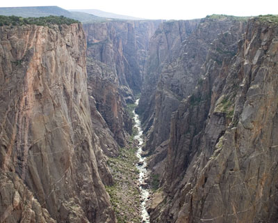
The Gunnison Basin is finally receiving some measurable precipitation from the monsoonal conditions. In order to take advantage of it and conserve storage in the Aspinall Unit, Reclamation will be decreasing releases from Crystal Reservoir by 100 cfs this afternoon. Following the change, flows in the Black Canyon and Gunnison Gorge will be about 500 cfs. With the current flow forecast, the target flow of 900 cfs at the Whitewater gage should be maintained or exceeded through this weekend and beginning of next week. However, releases will likely increase again next week as the monsoonal flow dissipates.

More Aspinall Unit coverage here and here.

Green Mountain Reservoir operations update: 370 cfs in the Blue River below the dam

coloradobigthompsonmap.jpg

From email from Reclamation (Kara Lamb):

We continue to make adjustments to our releases based on the cooperative efforts of the larger water operators’ community on the Upper Colorado River. Currently, we are releasing about 370 cfs from Green Mountain Dam to the Lower Blue River. There could be additional changes over the weekend.

San Juan Mountains: Acid rock drainage predated mining activity by millennia, mining made it worse

acidminedrainageuniversityofcolorado.jpg

From The Telluride Watch (Peter Shelton):

The report, titled “Natural Acid Rock Drainage Associated with Hydrothermally Altered Terrane in Colorado,” was recently given an award by the Geological Society of America as the best environmental publication of 2011. The report identifies a number of high-country streams in Colorado, including Red Mountain Creek, where surface water is acidic and has high concentrations of metals upstream of historic mining.

“Of course, the mining made it much, much worse,” commented Don Paulson, a former chemistry professor who is now curator of the Ouray County Historical Museum. Paulson has followed efforts to identify sources of stream pollution and the remedial measures undertaken to improve water quality in the Uncompahgre River and its tributaries.

There was a big push to clean up the water affected by mine waste (and the role it plays in the inability of high country waterways to support aquatic life) in the 1980s. At that time the Colorado Department of Health (now Colorado Department of Public Health and Environment) first sued under the Superfund Act, then negotiated with Idarado Mining and its parent company, Newmont Mining, substantial cleanups on both the Telluride and Ouray sides of the mountain. The Telluride side saw improvements to the water quality of the Upper San Miguel River. But the acid pH and the levels of zinc and other minerals in Red Mountain Creek has not changed significantly despite Idarado’s remediation in the area of the Treasury Tunnel.

More water pollution coverage here.

Drought/runoff news: How senior will the Arkansas River call go? #CODrought

canoncity.jpg

From the Cañon City Daily Record (Carie Canterbury):

In light of June’s low river readings, Bob Hartzman, supervisor for the Cañon City Water department, had expressed concern June 26 about the city possibly having to dip into stored reserves in the Fry Pan/Arkansas Water Storage project if users downstream put in a call for more water…

Hartzman said he spoke to District 12 Water Commissioner Brian Sutton about the possibility on June 27. “He was fairly certain that the river call wouldn’t go to the 1861,” he said. “That was based on data and information that he’s seen and that he’s aware of for the entire river, not just our neighborhood here.”[…]

“Even if a call came in today, we have a backup plan,” Hartzman said. “We still have a water source we can call upon to get us by, but if it came to that, we’d probably go to level two restrictions.” The city has about 315 million gallons of water in storage, Hartzman said, and for the month of June, city water customers used 265 gallons of water…

The U.S. Geological Survey recorded the Arkansas River running into Cañon City at 397 cubic feet per second as of Wednesday, compared to 318 cfs on June 29.

More Arkansas River Basin coverage here and here.

Denver Water: Waterton Canyon closed today to allow firefighters access to control Mill Gulch Fire #CODrought

watertoncanyontroutsflyfishing.jpg

From email from Denver Water (Stacy Chesney):

In the interest of public safety, Waterton Canyon will be closed to public access Friday, July 6, to allow the U.S. Forest Service to work the Mill Gulch Fire, a small three-acre fire, on U.S. Forest Service land in Douglas County.

According to the U.S. Forest Service, lightning sparked the fire around 4 p.m. today, approximately 4.5 miles from the bottom of the canyon on a ridge. Local jurisdictions responded with hand crews, engines and helicopters to help contain the fire. The U.S. Forest Service expects to have the fire contained by morning. The canyon will remain closed all day Friday as crews work to ensure the fire is mitigated.

The canyon is expected to be open this weekend, but further details will be provided Friday afternoon.

For question on the fire, please contact Cathleen Thompson, U.S. Forest Service, at 707-853-4243.

More South Platte River Basin coverage here.

2012 Colorado November election: Progressive 15 opposes Initiatives 3 and 45

justianifirstdodifierofriparianrights.jpg

Here’s the release from the Progressive 15 via The Fort Morgan Times:

Progressive 15 has issued a resolution opposing two initiatives dealing with water. The group’s board of directors has issued a statement that Progressive 15 opposes both 2011-2012 Initiative No. 3 and Initiative No. 45 as unwise, unnecessary, disruptive to the fair and responsible allocation and stewardship of Colorado’s scarce water resources and an unwarranted taking of vested property interests.

The resolution says that:

Water frequently does not naturally exist where and when it is needed in sufficient quantities to sustain human settlement and enterprise in Colorado.

As a scarce natural resource, water in Colorado requires a system of allocation, ownership, and enforcement to meet the needs of Colorado’s citizens and the natural environment.

The Colorado Water Congress supports Colorado’s system of prior appropriation as a fair and orderly system for allocating Colorado’s scarce water resources.

Colorado’s prior appropriation system has proven itself both successful and flexible in addressing the public’s changing demands, beneficial uses, and values regarding Colorado water resources (including instream flow water rights).

These two state constitutional amendment initiatives that would reject Colorado’s historical reliance on the prior appropriation doctrine for water allocation and replace it with an undefined public trust doctrine and certain public control mandates.

The adoption of either of these initiatives would undermine the constitutional foundation for Colorado’s prior appropriation system and result in a takings of private and public water rights that currently meet essential agricultural, commercial, environmental, industrial, and municipal needs.

The adoption of either of these initiatives would create great uncertainty in providing a secure water supply for agricultural, commercial, environmental, industrial, and municipal purposes.

These initiatives are masquerading as a measure to protect the public’s control of water, it would prevent farmers, cities, families and businesses from making beneficial use of water rights that have vested in them over the past 150 years under Colorado’s statues and constitution.

More 2012 Colorado November election coverage here.

Drought news: Northern Colorado officials are examining removal of streamside vegetation to increase supplies #CODrought

tamarisk.jpg

From The Greeley Tribune (Eric Brown):

Estimates show that trees and shrubs lining the South Platte Basin’s rivers and irrigation ditches — salt cedars, Russian olives, cottonwoods and others — collectively consume hundreds of thousands of acre feet of water each year, although comprehensive studies on the issue in the South Platte Basin are few, and also outdated, some say.

Some experts believe the amount of water consumed by those plants — called phreatophytes — could be rivaling or even surpassing the more than 600,000 acre feet of water that, according to Colorado Department of Natural Resources, were delivered to all of the South Platte Basin’s municipalities in 2010.

And in a year like 2012 — one in which rainfall is at a record-low, some farmers’ irrigation ditches are running dry, and cities are having to watch their supplies closely — many agree some of that water could be going to a more beneficial use than quenching the thirst of vegetation along banks in the South Platte Basin, some of which isn’t native to the area in the first place…

Additionally, some question how much water users would actually benefit in the long run if that vegetation was eradicated. Water officials and environmentalists agree that some kind of vegetation would be needed in place of the removed plants, since root systems are necessary for keeping the river’s banks from eroding, and vegetation would also be needed to provide habitats for wildlife in those areas.

It’s also not clear who would legally be entitled to the water that’s salvaged through eradicating phreatophytes. In recent decades, the state’s water courts have denied requests from individuals wanting to clear their property of trees and shrubs and stake claim to the water that’s saved…

“This issue is certainly on a lot of peoples’ radars right now … but there’s still a lot we don’t know,” said Harold Evans, chairman of the city of Greeley Water and Sewer Board, who also serves on the South Platte Roundtable. “I think we’re all in favor of finding ways to make water more available to users. We just need to learn more about this and see what’s feasible.”[…]

In recent years, the South Platte Roundtable — made up of water officials and experts in the region who convene to discuss ways of solving the water-supply gap — has spearheaded efforts to attain about $250,000 to eradicate the Russian olives and salt cedars along the South Platte River near Brush.

More invasive species coverage here. More tamarisk control coverage here and here.

Southern Delivery System update: Next Pueblo County DA promises to continue lawsuit over the project water quality permit

fountaincreekwatershed.jpg

From The Pueblo Chieftain (Chris Woodka):

Jeff Chostner, who beat District Attorney Bill Thiebaut in the June 26 Democratic primary, said he will pursue a lawsuit now under appeal by the state and Colorado Springs. “It would not be judicially efficient to drop it,” Chostner said Thursday. “We will have the expertise to handle the case within our office.”[…]

“Assuming that it’s not resolved by the end of Bill’s term, we will continue with the case,” Chostner said.

Would he take the case to the state Supreme Court if the appeal goes in the state’s favor? “Let’s handle that one when the contingency arises,” Chostner said.

More Southern Delivery System coverage here and here.

Drought/precipitation news: With the coming of the monsoon comes possible flooding in the burn areas #CODrought

waldocanyonfirejuly2012.jpg

From The Pueblo Chieftain (Chris Woodka):

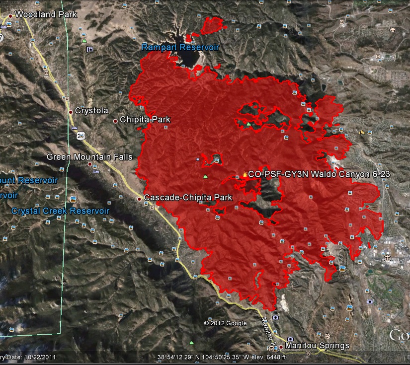
“The recent Waldo Canyon Fire on the Pike National Forest has changed the watersheds within the burned area and increased the potential for flooding and mudflows that could impact several communities adjacent to and downstream from the forest,” the Forest Service said in a press release. When heavy rains fall in a burned area, there are often mudflows, but the effects of the Waldo Canyon fire are being evaluated. The fire started June 23, has burned more than 18,000 acres, destroyed 347 homes and was about 90 percent contained Thursday…

On Thursday evening, the El Paso County Sheriff’s office hosted a meeting with landowners who might be subject to mud flows following the burn. The county is advising residents in affected areas to monitor weather reports closely and to take safety precautions if flooding is imminent.

Drought news: Colorado drought ‘extreme’ across most of the state #CODrought

usdroughtmonitor07132010.jpg

usdroughtmonitor07052011.jpg

usdroughtmonitor07032012.jpg

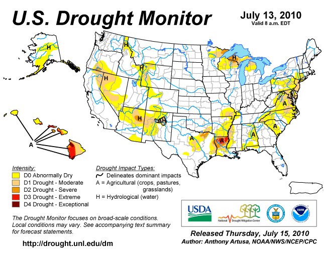
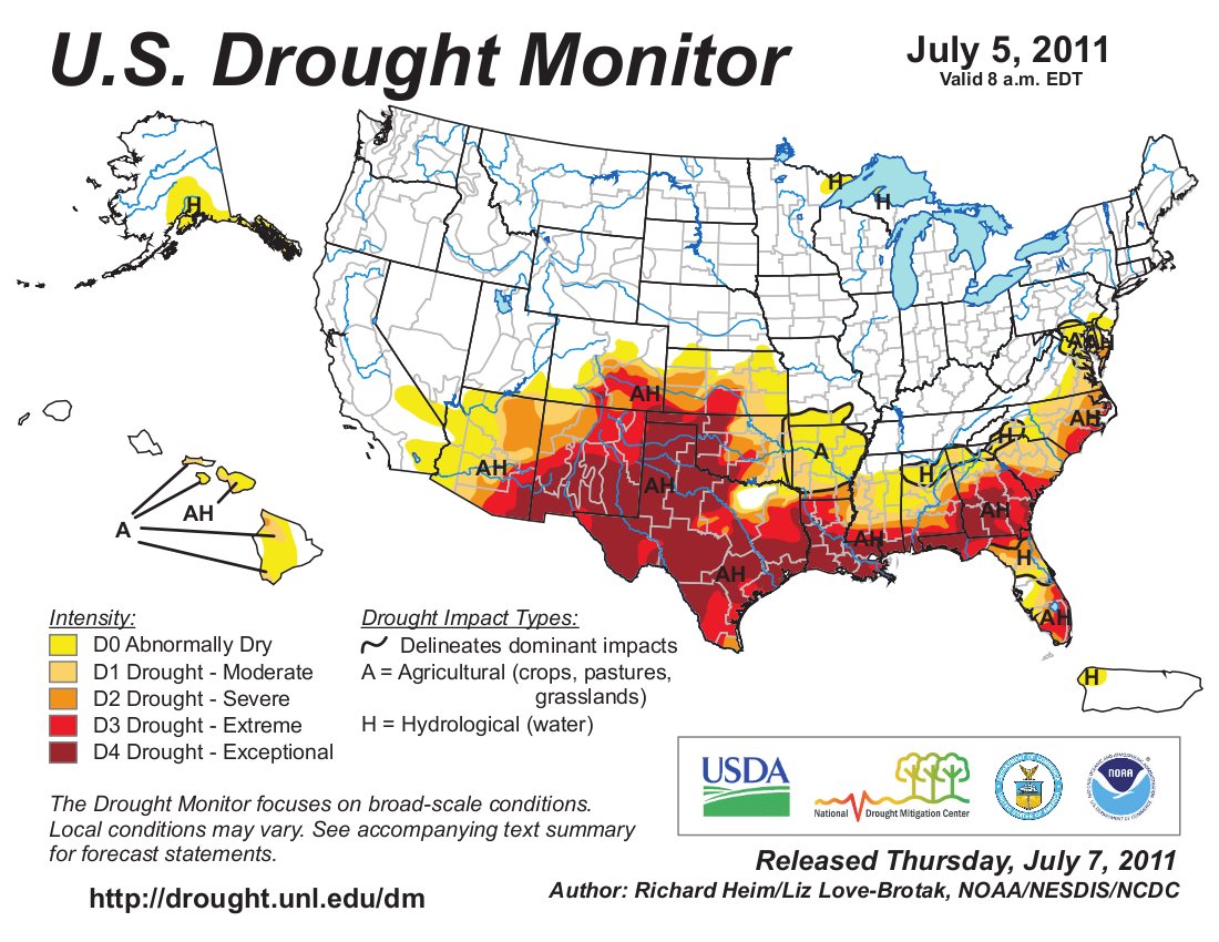
Things just keep getting worse across Colorado. It’s time to start doing your serious Monsoon dancing. Click on the thumbnail graphics for the U.S. Drought Monitor maps for this time of year in 2012, 2011 and 2010.

Aurora: Potential water lease to Anadarko could target utility debt load

anadarkohydraulicfracturingapril2011.jpg

From The Aurora Sentinel (Sara Castellanos):

Houston-based Anadarko Petroleum Corp. is expected to purchase $9.5 million worth of “used” water from Aurora for its oil and gas drilling operations across the state, pending Aurora City Council approval July 9.

Members of council’s Management and Finance committee said the revenues should be used to partially pay off debt from the construction of Prairie Waters, a $650 million project that was completed in 2010 to ensure the city’s residents had enough water during droughts. The city borrowed more than $540 million and raised water rates to pay for the project.

A second option would have been to use the revenue to reimburse taxpayers for helping to foot the bill to construct the project. But committee members decided that reimbursement wouldn’t amount to much anyway. According to Jason Batchelor, the city’s finance director, the credit to the average residential rate payer would be about 95 cents a month.

Councilman Bob LeGare said it makes better financial sense to put the money toward the Prairie Waters project. “Everyone understands paying down your (debt) early,” he said.

More Aurora coverage here and here.

Arkansas Valley Super Ditch update: Anthropologist plans to request dough from the Ark roundtable to study the impact of the project

arkbasinditchsystem.jpg

From The Pueblo Chieftain (Chris Woodka):

Ken Weber, an anthropologist who lives in Pueblo, told the Lower Arkansas Valley Water Conservancy District board he plans to take a proposal to study the Super Ditch to the Arkansas Basin Roundtable soon. Otero County commissioners already have agreed to review the study…

“It would seek to document what happens over a three-year period,” Weber said, adding that impacts to participating farmers, nonparticipants, service industries and communities would be evaluated. “It would provide accountability and transparency.”[…]

Weber replied that his study proposes to measure actual impacts, rather than predict what those impacts would be. The Lower Ark’s studies actually call for this sort of evaluation, he added.

More Arkansas Valley Super Ditch coverage here and here.

The Huerfano County Water Conservancy District is looking for a mill levy increase to fund supplies and augmentation

huerfanoriver1.jpg

From the Huerfano World Journal (Carol Dunn):

Monday night, Jay Winner, General Manager of the Lower Arkansas Valley Water Conservancy District, attended the HCWCD meeting to offer some insight and assistance.
After being briefed on the precarious augmentation plan situation in Huerfano County, Winner told the board, “You need to buy water.”[…]

“Your engineering needs to start immediately,” Winner told the board. Although the HCWCD Enterprise only has leased water at this time for augmentation, Winner encouraged the board to proceed and offered to help procure the grant for engineering. “I just need a cost estimate,” he said…

Besides funding the purchase of water, the proposed mill levy increase will play a key part in the augmentation plan going forward, and eventually through water court. Board member Mace mentioned two major expenses: $3,000-$4,000 per acre-foot for water rights; $55,000 per acre-foot of reservoir storage. The first goal of the enterprise is to obtain about 15 acre-feet of prime water rights on the Huerfano River and build a reservoir to store it.

According to one board member, there is some push-back from taxpayers around the county because the main area involved at this time is Gardner. “Some people say they got themselves into this mess, and now they want taxpayers to help them out,” said Dawson Jordan, chair of the Enterprise. “But you can’t look at it that way. You’ve gotta work for the good of the entire community.” And Mace added, “This is good for the county. We can be a bond between Walsenburg and La Veta.”

More Arkansas River Basin coverage here and here.

Drought/runoff news: NWS July 7 thru July 10 hazards outlook forecasts good moisture across Colorado #CODrought

july7tojuly202012hazardsoutlooknws.jpg

Click on the thumbnail graphic for the map from the National Weather Service.

From the CWCB Flood Threat Portal:

The highest threat period of the early summer season appears likely to develop over the July 8-11 period. Moist easterly winds will prevail along the Front Range from Fort Collins to Pueblo while monsoon moisture drips across the Continental Divide to provide plenty of fuel for slow moving thunderstorms. The recent burn areas will face a MODERATE TO HIGH flash flooding threat during these three days as storms could produce 1-3 inches of rain in less than two hours. It is way too early to develop any particulars on this evolving threat but the ingredients appear to be coming together.

From The Pueblo Chieftain (Chris Woodka):

“We don’t envision the need for restrictions this year,” said Alan Ward, water resources manager for the Pueblo Board of Water Works. “We will monitor our storage levels and see how the snowpack develops for next year.”[…]

Pueblo West also has plenty of water in storage, but is looking at adapting voluntary conservation measures as part of a new water conservation plan, said Jack Johnston, manager of the metro district…

More than 120,000 acre-feet of water in Lake Pueblo — two thirds of its current contents — is set aside for municipal use. About 55 percent of that is for El Paso County use. Colorado Springs, Aurora, Pueblo and Pueblo West also have water set aside in Turquoise and Twin lakes higher in the watershed…

Right now, the river call is sitting on the Rocky Ford Ditch 1874 right, and without summer monsoons will stay at or senior to that level, since runoff has ended, said Bill Tyner, assistant engineer for Water Division 2.

From 9News.com (Blair Shiff):

As monsoon rains intensify, water managers will be paying more attention to how the fire might impact drinking water. Runoff mixes with debris and sediment in burn areas during monsoons. That mix often hurts the ability of water treatment plants to purify water. As a result, tap water could have a smoky taste – though is typically not harmful.

From The Durango Herald (Dale Rodebaugh):

“The most important thing is to have community awareness and involvement,” city Utilities Director Stephen Salka said Monday in briefing water commissioners about possible drought issues. “It’s important not to use water in a wasteful manner.” Cooperation is preferable to coercion, he said…

It appears residents are getting the message, Salka said. The city population has increased since 2002, the peak of a severe drought that saw the Missionary Ridge Fire spread over more than 72,000 acres, but water consumption is down. In May 2002, residents used 305.6 million gallons of water, compared to 290 million gallons in May 2012. June use in 2002 and this year, was 350.6 million and 350.3 million gallons, respectively.

The flow in the Animas River barely topped 300 cubic feet a second Tuesday. The channel was carrying 481 cfs on June 8, 2002, the day the Missionary Ridge Fire started, but dropped to 172 cfs June 30. The city fills Terminal Reservoir, which holds 74.1 million gallons of water, from the Florida River by gravity flow and from the Animas by pumping.

From the La Junta Tribune Democrat:

Colorado U.S. Senators Michael Bennet and Mark Udall on July 3 announced that the U.S. Department of Agriculture (USDA) has designated 62 of Colorado’s 64 counties as primary natural disaster areas due to losses caused by drought, excessive heat, and high winds since the beginning of the year. The other two counties have been named contiguous disaster areas.

“The entire state of Colorado has been severely affected by hot and dry conditions that have hampered the production of our agricultural producers,” Bennet said. “The designations from USDA will provide much-needed assistance to farmers to help offset their losses due to drought. Agriculture is a critical part of Colorado’s economy, and these resources will help producers weather a difficult growing season.”

“I am pleased that U.S. Department of Agriculture Secretary, Tom Vilsack, has granted Governor Hickenlooper’s request to designate eligible counties in Colorado as disaster areas in response to severe drought conditions across our state,” Udall said. “The losses that face Colorado’s agriculture producers are mounting and now that this declaration has been made, Colorado’s farmers and ranchers will have access to additional resources to get them through these tough times.”

Meanwhile, the feds declared a drought disaster for most of Colorado recently. Here’s the release from Governor Hickenlooper’s office:

U.S. Secretary of Agriculture Tom Vilsack notified Gov. John Hickenlooper today that 62 of the state’s 64 counties qualify for federal disaster relief because of drought conditions [ed. emphasis mine].

“The Department of Agriculture has reviewed the Loss Assessment Reports and has determined that there were sufficient production losses in 62 counties to warrant a Secretarial disaster designation,” a letter from Vilsack says. “Therefore, I am designating all Colorado counties, except Delta and San Juan counties, as primary disaster areas due to losses caused by drought, excessive heat, and high winds that occurred from Jan. 1, 2012, and continuing.”

Hickenlooper sent a letter last week to Vilsack seeking the drought assistance.

“We are very grateful for Secretary Vilsack’s speedy review of our request,” Hickenlooper said. “This federal disaster declaration will give farmers and ranchers in Weld County and nearly every other part of the state much needed relief.”

Typically, counties must meet certain crop loss criteria to qualify for U.S. Department of Agriculture (USDA) disaster assistance. Once that crop loss criteria is met, the governor then make a request to the Secretary of Agriculture asking for a disaster designation for that county.

This year, because of severe drought conditions in across the state, the Colorado Department of Agriculture worked with the local USDA Farm Service Agency office in seeking a disaster designation before each county shows the minimum crop loss.

The federal assistance approved today includes Farm Service Agency (FSA) emergency loans. Farmers in eligible counties have eight months from the date of the declaration to apply for emergency loan assistance. FSA will consider each emergency loan application on its own merits, taking into account the extent of production losses, security available and repayment ability.

Local FSA offices can provide farmers with more information.

NIDIS Weekly Climate, Water and Drought Assessment Summary of the Upper Colorado River Basin #CODrought

wyutcoprecipitationjune2012ccc.jpg

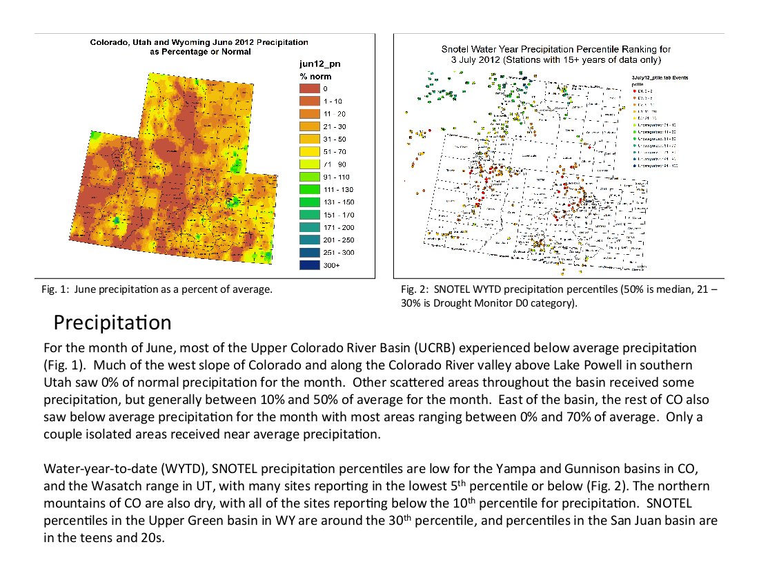
Click here for the summaries from Tuesday’s webinar. Click on the thumbnail graphic for the precipitation summary.

Drought news: Forecasters see good chance that El Niño will develop over the eastern Pacific Ocean #CODrought

elninolanina.jpg

From the Boulder Daily Camera (Joe Rubino/Erica Meltzer):

Klaus Wolter, a climatologist for the National Oceanic and Atmospheric Administration in Boulder, said he believes Colorado’s weather is transitioning from a La Niña pattern to an El Niño pattern.

El Niño, the result of unusually warm temperatures in the equatorial Pacific Ocean, tends to cause wet weather for the southwestern U.S…

However, fires burning across the state could delay the arrival of the wet weather. In 2002, another dry year in which a La Niña pattern was transitioning to an El Niño pattern, the Hayman Fire and others contributed to rain being delayed until mid-September. “Back in 2002, we had an El Niño developing, and it didn’t deliver,” Wolter said. “The monsoon was trying to work its way up, but we had all these fires and it has all these microphysical effects.

“We have all this haze and all this soot in the air, and it’s harder to get thunderstorms going because there is less heating on the ground, believe it or not,” Wolter said. Wolter said he thinks the Front Range is in a better position now than in 2002. Because the fires are concentrated along the Front Range, the circulating monsoon system is exposed to fire-free areas farther west…

Boulder meteorologist Matt Kelsch warned against getting too excited for a strong monsoon season in Colorado or the wetting effects of an El Niño pattern this early in the year. El Niño’s effects are most often felt in the fall and winter, Kelsch said, and while this week looks promising for moisture, he worries the conditions may not last long.

Rifle: Council approves loan agreement with the Colorado Water Resources and Power Authority for new treatment plant

riflegap.jpg

From the Rifle Citizen Telegram (Mike McKibbin):

Councilwoman Jennifer Sanborn, one of two council members to vote in the minority when the issue has arisen, criticized Mayor Jay Miller for what she felt was a “gross exaggeration” about a possible plant failure leaving the city without water for perhaps months.

“I think it’s wrong for an elected official to try to instill fear in people when it’s not warranted,” Sanborn said. “I just don’t think it’s morally right.”

Miller had earlier said he did not want to see the city step back and consider other plant alternatives, as Sanborn suggested.

“We’ve been diddling around with this for the last five years and I feel if we push this back and back, we’re going to have businesses leave town, then we will have a catastrophic failure of the city,” Miller said. “I’m not willing to take that chance.”

Miller added that if a core part of the current plant on Graham Mesa fails, it would take months to have a replacement part manufactured. The plant was designed to use a treatment process that is outdated and replacement parts are no longer manufactured on a regular basis…

The motion passed 4-2, with Sanborn and Councilman Randy Winkler opposed, as they have in several previous votes on the issue. Councilman Keith Lambert was absent from the meeting. City Attorney Jim Neu later noted council’s action meant city staff will move forward to close on the loan, but pointed out the city does not have to spend the entire $25.5 million on a new plant.

City Manager John Hier said he will schedule a work session with city council in the near future, to review various funding options for the new plant in an attempt to lessen the burden on rate payers. In his closing comments at the end of the meeting, Miller said his earlier statements were not intended to instill fear in residents, but felt the issue had to be discussed among councilmembers. He also asked the Citizen Telegram to not portray his comments in that light.

More Rifle coverage here and here.

Happy Fourth of July

greenmountainreservoir.jpg

Happy Fourth of July to y’all.

Click on the thumbnail graphic for a shot of Mrs. Gulch’s vegetable garden taken this morning.

Green Mountain Reservoir operations update: 420 cfs in the Blue River below the dam

greenmountainreservoir.jpg

From email from Reclamation (Kara Lamb):

The weather continues to remain hot and dry and flow in the Colorado River continues to decline. Additionally, Wolford Mountain Reservoir releases have had to cut back for some maintenance work. With all these factors in mind, it was determined on the weekly conference call this morning (held early because of the holiday tomorrow), that releases from Green Mountain Dam to the Lower Blue should go back up. As a result, we bumped releases up twice this morning: once around 7 a.m. from 320 to 350 cfs and then again at noon from 350 to 420 cfs. The 420 cfs release will stay in place at least through Independence Day.

More Blue River watershed coverage here.

Fryingpan-Arkansas Project operations update: 195 cfs in the river below Ruedi dam

ruedidam.jpg

From email from Reclamation (Kara Lamb):

Flows in the Colorado River continue to drop due to hot and dry conditions. This week, it is anticipated they will drop below the target levels set for the four endangered fish of the Colorado River. As a result, the US Fish and Wildlife Service has called for increased releases from Ruedi Reservoir. Around 5 p.m. today, July 3, we will increase releases from Ruedi by 50 cfs. The resulting flow by the Ruedi gage below the dam should be about 195 cfs. The 195 cfs release will continue through Independence Day and likely through the weekend.

More Fryingpan-Arkansas Project coverage here.

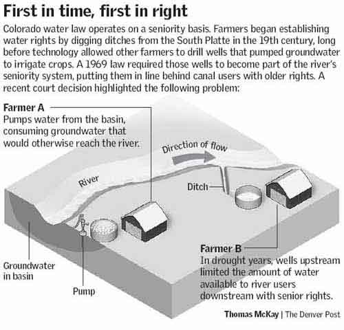
Drought news: Weld County asks Senior rights holders to allow pumping #CODrought

firstintimefirstinright.jpg

From The Greeley Gazette (Jack Minor):

After the county commissioners issued a disaster declaration for the county, governor John Hickenlooper told them that based on the advice of a staffer in Attorney General John Suthers office, he did not have the authority to allow farmers to pump using local wells and that the state could face potential lawsuits if he did. Suthers was away at a conference in Alaska at the time.

Colorado Secretary of Agriculture John Salazar, brother of Secretary of the Interior Ken Salazar essentially said the same thing. His office told the Gazette that if the attorney general’s office could find a way to turn the wells on legally he would support it.

The commissioners subsequently sent a letter to Suthers asking him to personally review the decision. “We feel that for a decision of this magnitude that has the potential to gravely affect us here in Weld County the least the attorney general can do is look at it himself,” commissioner chairman Sean Conway said.

After 10 days with no response, despite every day being critical, Suthers office finally responded this week telling the commissioners he would not bother considering the request to provide a formal opinion on the issue.

The farmers and the county have been asking for permission to use the wells for only 30 days, which would use less than half of one percent of the water in the aquifer…

In announcing his refusal to allow farmers to use the wells, Hickenlooper instead told locals to find a way to solve the problem. One solution would be to obtain water from local municipalities who as senior right holders have often had excess capacity. However, this year cities have said they have no water to spare…

With the government apparently turning a deaf ear to their pleas for water, the commissioners have now sent a letter to senior water right holders asking them for assistance. The letter was sent to 28 different entities representing some 159 senior water rights holders along the South Platte River. The letter acknowledges the prior appropriations system, however it proposes an agreement from senior surface rights owners to subordinate their water rights to any depletion this summer. [Harry Strohauer] said those opposed to allowing them to pump are being short sighted. “If we were allowed to pump, the water we would use would actually increase water flow. Pumping would help everybody, including those downstream.”

From the Associated Press via The Denver Post:

Weld County is making another attempt to help farmers struggling because of the drought. County commissioners mailed letters to about 30 holders of senior water rights on Tuesday asking them to allow farmers with more junior rights to pump their groundwater wells. Use of those wells has been restricted for about a decade because the state found that the pumping them was reducing flows in the South Platte River.

South Platte River basin coverage here and here.

From the High Country News (Cally Carswell):

Forecasters are optimistic about a productive monsoon season in the southwest this year. New Mexico is eagerly awaiting rain as we speak. “We are seeing a circulation setting up like an early monsoon,” says [Klaus Wolter], with southerly flows coming into the region from Mexico. “When you have those monsoon patterns set up, it doesn’t stay like that all summer. You need to milk those situations.”

Wolter says he’s “concerned but not convinced” that the haze and particles in the air from the spate of early fires could temper the efficiency of the monsoon patterns, causing them to produce some rain, but not the good soaking we so desperately need.

From The Denver Post (Joey Bunch):

U.S. Secretary of Agriculture Tom Vilsack notified Gov. John Hickenlooper that farmers and ranchers in parched counties are qualified for federal emergency loans, based on the extent of their individual losses.

“We are very grateful for Secretary Vilsack’s speedy review of our request,” Hickenlooper said in a statement. “This federal disaster declaration will give farmers and ranchers in Weld County and nearly every other part of the state much-needed relief.”

Those in eligible counties have eight months from Tuesday to apply for aid. The governor, the Colorado Department of Agriculture and the local USDA Farm Service Agency office worked together to attain the disaster designations.

Colorado’s relentless drought began with a weak snowpack that drove river basins across the state into single-digit percentages of their 30-year averages this spring. Since then, much of the state has continued to wither under some of the hottest and driest conditions on record, feeding the worst wildfire season in a decade this year.

Old Dillon Reservoir enlargement update: Is a Golden Trout fishery in the future?

goldentrout.jpg

From the Summit Business Journal (Bob Berwyn):

The enlargement has been in the works for years as a partnership among local water users and the U.S. Forest Service, which manages the public lands around the reservoir. When water starts flowing into the new impoundment, it will help bolster water supplies for the town of Dillon, which depends in large part on stream flows from Straight Creek, running down along I-70 from its source along the Continental Divide. The stream is vulnerable to pollution threats from I-70. During the 2002 drought, Straight Creek flowed at perilously low levels, sending Dillon officials scrambling to develop a backup water plan that included direct diversions from Dillon Reservoir, as well as water-sharing with Silverthorne.

Other local water users will also benefit, and some of the water could go toward helping boost streamflows in dry years. According to a county fact sheet, the water will be used to meet demands from new growth in Summit County and a variety of other purposes, potentially including ball fields and other recreational open space, wetlands restoration, new community facilities and augmentation of well water usage in the Blue River Basin…

For the long-term, Colorado Parks and Wildlife aquatic biologist Jon Ewert said that, since Old Dillon Reservoir presents a clean slate, he’s considering try to develop a golden trout fishery — the first in the state. Golden trout are native to a drainages in California like the Kern River. They look a bit like cutthroat trout but with more of a golden color…

Ewert said successful establishment of a golden trout fishery could give a little boost to Summit County’s fishing economy, drawing people from as far as Denver to try and catch a new species. Since golden trout aren’t native, they are subject to any special protections, and Ewert envisions a put-and-take fishery, enabling anglers to take their catch home for dinner.
Ewert said there are quite a few challenges associated with establishing the fishery, starting with getting the eggs from California, which isn’t a sure thing. The goldens mostly live in high mountain lakes and biologists have to hike in during spawning season to get the eggs, then pack them out.

More Old Dillon Reservoir coverage here and here.

Aspinall Unit operations update: 640 cfs in Black Canyon

aspinallunit.jpg

From email from Reclamation (Dan Crabtree):

Flows at the Whitewater Gage have consistently remained above the 900 cfs target. Consequently, releases from Crystal were reduced yesterday by 50 cfs. In addition, it appears there is a strong possibility of thunderstorms over western Colorado later this week. Therefore, it is likely releases will be further reduced by another 50 to 100 cfs in the next few days. Currently flows in the Black Canyon and Gunnison Gorge are about 640 cfs.

More Aspinall Unit coverage here and here.

Westminster: Colorado Lake and Reservoir Management Association Summer Workshop July 25

westeminster.jpg

Here’s the link to their webpage. Here’s an excerpt:

High quality water features such as lakes and creeks boost property values and provide refuge for wildlife and humans alike. Managing these features is part art and part science. If you want to learn more about managing your water features to optimize water quality and improve aesthetics, join us on July 25th, Westminster City Park Recreation Center, for a comprehensive workshop on lake management. Professionals from various agencies in Colorado will share their experience with recreation management, source water protection,watershed planning and regulatory compliance. A lake management template will be provided to participants to help develop a specific plan for managing their own water features.

Colorado Water 2012: The Gunnison River Basin is home to Colorado’s largest reservoir — Blue Mesa

gunnisonriverbasin.jpg

Here’s the latest installment of the Valley Courier’s Colorado Water 2012 series. Frank Kugel details water operations and facilities in the Gunnison Basin. Here’s an excerpt:

The Gunnison Basin is home to the largest body of water entirely within the state of Colorado, Blue Mesa Reservoir, which has a capacity of 940,000 acre-feet (830,000 acre-feet active capacity). It is the primary storage component of the three reservoirs comprising the Aspinall Unit. Morrow Point Dam is the middle structure and its primary purpose is production of hydropower. Crystal Dam creates a stabilizing reservoir for the variable flows produced by Morrow Point Dam releases. Below Crystal lies the Black Canyon of the Gunnison River National Park…

The Bureau of Reclamation has a number of other storage projects in the basin, in addition to the Aspinall Unit reservoirs, including Taylor Park on the Taylor River, Ridgway on the Uncompahgre River, Silver Jack on the Cimarron River, Crawford on the Smith Fork of the Gunnison, fruit growers on Current Creek and Paonia on Muddy Creek, tributary to the North Fork of the Gunnison River.

One of the first projects developed by the Bureau of Reclamation was the Uncompahgre Project, which provides irrigation water for a variety of crops in the Uncompahgre Valley between Colona and Delta. A key component of the project is the Gunnison Tunnel, a 5.7 mile long tunnel that diverts water from the Black Canyon of the Gunnison and discharges it into a series of canals in the Uncompahgre Valley. The tunnel has a 1913 water right for 1300 cfs and supplies some 60% of the irrigation water for the 76,000 acres under the project.

Taylor Park Dam was constructed in 1937 to provide supplemental irrigation for the Uncompahgre Valley. Taylor Park Reservoir has a capacity of 106,230 acre feet. The 1975 Taylor Park Exchange Agreement allows for transfer of storage downstream to Blue Mesa Reservoir to provide the Gunnison Tunnel with a more readily available source of irrigation water. An additional benefit of this exchange was the flexibility to make releases in time and amount that would benefit recreational and agricultural users in the Upper Gunnison basin.

More Colorado Water 2012 coverage here.

Wildfire can have a negative effect on watersheds #CODrought

haymanburnarea.jpg

From National Geographic (Tasha Eichenseher):

Wildfires scorch soils and create ash and debris that can clog rivers and reservoirs, increasing the cost of water treatment for years to come.

When trees and underbrush burn, there is less organic material left to absorb moisture when it rains. In addition, many plants release a waxy substance when they are incinerated, creating a water-repellent coating on burn areas that heightens the risk of flash floods and contributes to erosion. Storms flush silt and other debris from the fires into rivers, reservoirs, and ultimately into municipal water treatment facilities, slowing the treatment process.

Western water managers learned a harsh lesson ten years ago when the devastating Hayman Fire ripped through Colorado’s forests, severely impacting the extensive forested watersheds that protect rivers and water sources for more than 75 percent of the state’s residents, according to the U.S. Forest Service. The Hayman Fire—the most destructive in the state’s history, possibly until now—destroyed nearly 140,000 acres and 600 structures in 20 days…

In the wake of that 2002 fire, and the 1996 Buffalo Creek fire, Denver Water, the public agency responsible for serving water to 1.3 million people in the Denver metro area, has spent more than $26 million on fire-related restoration, maintenance, and dredging, according to agency spokeswoman Stacy Chesney…

Jennifer Pitt, Colorado River Project director for the nonprofit Environmental Defense Fund, warns that 2012 is a wake-up call for how we have to adjust to climate change and extreme water supply fluctuations, especially in the Colorado River Basin, where flows are at lower-than-average levels. “We may not always like what Mother Nature has in store,” she writes for Water Currents, a National Geographic blog. “But we’re fools if we don’t figure out how to live with it.”

Drought news: Colorado Parks and Wildlife is monitoring stream temperatures in the Upper Arkansas River #CODrought

arkansasriverleadville.jpg

Here’s the release from Colorado Parks and Wildlife (Michael Seraphin):

The heat wave sweeping Colorado has created a situation where river temperatures on the Upper Arkansas will be regularly monitored for impacts to trout. At the present time, Colorado Parks and Wildlife is taking a position of “cautious optimism.”

The reduction is snowpack last winter means less icy-cold water in the river during what is usually a time of heavy water. The result has produced plenty of insects for forage and provided trout with better opportunities to feed, which means fish are growing well and are in good shape. The flip side is that water that gets too warm can start to stress the fish.

“We are monitoring water temperatures at a number of locations along the river from Salida to Parkdale on a regular basis so we will be able to advise anglers on the best course of action,” said Rob White, park manager of the Arkansas Headwaters Recreation Area.

White added that water has been set aside this year to provide adequate flows for whitewater boating and to protect the fishery through July and August.

According to aquatic biologist Greg Policky, his concern from a fishery standpoint is that the water temps are increasing. So far, water temperatures have not reached the same point as 2002. “In that year, we saw water temperatures at Parkdale rise to nearly 80 degrees,” said Policky.

Since mid-June, temperatures on the Arkansas have been moderate, with a 72-degree reading at Lone Pine on June 26.

Anglers on the Arkansas are encouraged to continue fishing, but asked to be careful with the release of their catch. Over-playing fish, and less than delicate release of fish, could be lead to injury – particularly as water temperatures warm.

The amount of rain and the air temperatures in July and August will determine how warm the water may get.

“If there is fish mortality, it happens for a variety of reasons, so seeing a few dead fish on the side of the river is not cause for alarm yet,” said Policky. He added that there are about 4,000 to 4,500 fish for every mile of river, so what anglers do not see is the huge number of live fish beneath the surface.

Colorado Parks and Wildlife has issued fishing advisories and asked for voluntary compliance with fishing restrictions on the Yampa and the White Rivers in western Colorado and is considering other requests for voluntary restrictions in other parts of the state, but no restrictions are currently being considered for the Upper Arkansas. If daily monitoring shows the need for restrictions, public notification will occur.

Commerce City: Council approves rules governing hydraulic fracturing 8-0

hydraulicfracturingwaterislostwaterwrs.jpg

From The Denver Post (Yesenia Robles):

A crowd of about 20 residents wearing bright blue name tags applauded the 8-0 vote. Councilwoman Jadie Carson was absent at the Monday night meeting…

The rules, which will take effect Aug. 1, will prohibit drilling operations on or near the Rocky Mountain Arsenal National Wildlife Refuge and Barr Lake State Park, under a new wildlife mitigation plan. The rules also create a new level of regulation, requiring individual agreements that the city will negotiate with each company. Certain elements that will be considered in the so-called extraction agreements, such as noise-mitigation plans, water-quality-control measures, restricted hours of operation and permitted lighting, were not passed as specific city rules. They were thought by some to be overreaching and interfering with state regulations on the industry…

“We believe a layered approach to oil and gas development balances community protections with individual rights,” said Mayor Sean Ford. “In amending our existing rules, the city sought to remain within the regulatory framework of the state and be consistent with the recommendations of Governor Hickenlooper’s oil and gas task force.”

More oil and gas coverage here and here.

South Platte River Basin: Part of the Weld County corn crop will be lost this season #CODrought

southplattealluvialaquifer.jpg

From 9News.com (Dave Delozier):

Thousands of acres of corn that are supposed to be “knee high by the Fourth of July” will most likely be dead by then. “You know there are man hours in there, and there is care that’s been applied to the field, just like fertilizer has and it is difficult to watch it burn up,” says David Eckhardt, a fourth generation Weld County farmer.

Eckhardt planted approximately 1,500 acres of corn this spring. About two weeks ago, farmers in Weld County stopped receiving surface irrigation water from rivers because of the drought conditions. Eckhardt was forced to make the decision to use the limited water he has on some of his fields while letting the corn in others wither and die. He is walking away from approximately one-third of his crop. Nearly 500 acres of corn now sit baking in the sun…

In a statement released to 9News, a spokesperson for Governor Hickenlooper said, “The Governor has explored every angle of allowing wells to pump more than their legally allocated amounts, and the Attorney General has twice said that’s not possible.”

More South Platte River basin coverage here and here.

Wanted: Vision and Leadership to Ensure A Sustainable Water Future for America — Jay Famiglietti

spainsunflower.jpg

From National Geographic (Jay Famiglietti):

Let’s face facts. We can’t really manage water sustainably now, nor can we predict water availability in the future…It is absolutely essential that we determine how much water we have, as snow, surface water, soil moisture and groundwater; how much water we need, for humans and for the environment; and how these quantities will change with time, as climate and population changes, and as we adapt to a resource-limited future. We need to move forward with core observations and models that can utilize them to answer these questions, to advance prediction and to help prepare for the future.

How can we accomplish this? Since we lack a national water czar, policy or agency in the U. S., much of what I’m writing about here has fallen through the cracks for too long. There’s no one there to take ownership.

Consequently, vision and leadership are sorely needed. We need champions. Our elected officials must embrace this sustainable water challenge through awareness, commitment, and focus.

Research leadership, from our funding agencies through communities of investigators, must also take responsibility for making it happen. Communication of key results and research needs to elected officials and to the general public, though atypical for this group, is becoming increasingly important to heighten awareness

There’s a grand challenge on the table. We must aggressively tackle the frontiers of:

1)Exploration and mapping of Earth’s shallow crustal water environment, including its freshwater bathymetry, soils, hydrogeology, its water quantity and quality and synthesis of available information.

2) Advanced digital water data and information system capabilities for archiving and disseminating these data, with open, easy access to all information. New policies for sharing environmental data across political boundaries are also required.

3)Development of next-generation computer models that readily exploit this new information, as well as capabilities to evolve with rapid advances in computer power and the structure of the internet.

4)Clear pathways to transfer newly developed tools, observations and research results to water managers and practitioners, environmental decision makers, and a plan for communication to the public.

Drought news: Executive Orders address two fires in Colorado #EbyCreekFire #PineRidgeFire #CODrought

hickenlooper2007gulchie.jpg

Here’s the release from the Governor’s office (Eric Brown/Megan Castle):

Gov. John Hickenlooper signed two Executive Orders today related to different fires burning in Colorado.

The first order declares a disaster emergency for the Pine Ridge Fire, which started June 28 in Mesa County. The order authorizes $500,000 to the state’s Disaster Emergency Fund to pay for firefighting efforts. Additionally, the declaration authorizes the Colorado National Guard to help fight the fire.

The second order authorizes the Colorado National Guard to help fight the Eby Creek Fire in Eagle County.

Disaster declarations authorize the transfer of any funds in the state budget to the Disaster Emergency Fund, which is not funded unless money is needed. State law does not allow people who have lost homes or property in the fire to seek reimbursement from these disaster funds.

Verbal authority for each executive order was given June 28 and June 29, respectively. The governor formally signed the orders today.

Click here to read the Pine Ridge Fire order. Click here read the authorization for using the Colorado National Guard to take on the Eby Creek Fire in Eagle County.

Drought/runoff news: 2002 compared to 2012 #CODrought

usdroughtmonitor06282012.jpg

From The Durango Telegraph (Tracy Chamberlin):

In 2002, La Plata County was suffering from exceptional drought. This year the county is under moderate drought. Ten years ago, 78 percent of the state was under extreme drought. Currently, less than 10 percent of Coloradoans are feeling those kinds of conditions.

Also, the Animas River is running around 1,200 cubic feet per second. That’s less than half the average, around 3,000 cfs, but still a far cry from the record lows in 2002 of 500 cfs.

“There’s still some moisture out there,” said Durango Fire and Rescue Chief Dan Noonan. “But with each passing day, the situation is changing.”
The snowmelt came four to six weeks earlier than normal this year, rushing the rapids and depleting the water sources a little early. And the state is trending toward drier and drier conditions.

Three months ago, 40 percent of Colorado was suffering from moderate drought. Last week, it was 68 percent. Now that number has jumped to more than 75 percent.

The northeast part of the state, covering about 10 percent, is under extreme drought conditions. Last week that number was just more than 7 percent. The entire state is considered abnormally dry or worse, and with each passing week it continues to spread.

Wastewater: New Glenwood Springs lift station a big part of the new wastewater treatment system

sewageliftstation.jpg

From the Glenwood Springs Post Independent (Nelson Harvey):

The effluent’s three-mile journey will be possible thanks to a new sewage lift station that is nearly completed on the Seventh Street site. City sewers will route waste to the lift station, where a series of pumps will propel it three miles westward through two 16-inch pipes to the new plant.

On a tour of the new lift station, city Water and Wastewater Superintendent Buddy Burns was like a kid showing off a shiny new treehouse he’d just built. Burns, who has worked in wastewater treatment for the city since the late 1970s, said the new plant will have an average daily capacity of 1.9 million gallons, up from 1.1 million at the existing plant.

He demonstrated a new automated filter system that will remove debris from the wastewater stream, wash it, compact it and drop it in a nearby Dumpster. And he showed off the lift station’s two gleaming pump galleries that will push waste to the new plant. They are equipped with backup diesel generators, in the event of a power outage…

Burns said that the switch to the new plant would take two to three weeks after it begins in July, as operators gradually divert increasing amounts of the city’s wastewater to ensure the new system is functioning well.

A completion date in early August would wrap up the project several months ahead of schedule, as the city’s contract with Salida-based firm Moltz Construction allows until November 2012 to finish the job. Construction began in the spring of 2010…

The new lift station on Seventh Street has an air ionization system meant to keep odors contained in sewage canals. Operators hope this will dispense with odor complaints from nearby residents and businesses, which are now common during the summer months.

More wastewater coverage here and here.

Restoration: Gilman mine mitigation helps clean up the Eagle River

eagleriverbasin.jpg

From the Summit Daily News (Randy Wyrick):

After many years of Eagle Mine cleanup — cleanup of contaminants such as arsenic, cadmium, copper, lead and zinc — the river is pretty healthy, [Melissa MacDonald] said.

“It’s pretty good. It meets the existing standard for the river,” said MacDonald, executive director of the Eagle River Watershed Council. “We’d like a little higher standard, but currently they’re doing a good job.”

“They” are CBS, the media company, formerly Viacom. They acquired the Eagle Mine in the mid-1980s as part of some other deal. What they acquired was a Superfund site, designating the Eagle Mine as one of the nation’s most polluted places.

More Eagle River watershed coverage here and here.

USGS: William Holmes’ 130 year old sketch of the Grand Canyon available online #CORiver

More Colorado River basin coverage here and here.