‘Holding back water would happen regardless of the amount of snowpack’ — Donnie Dustin #CODrought

cachelapoudrehighparkpollutionusdaseptember2012.jpg

From The Denver Post (Bruce Finley):

The problem: soot, sediment and debris washing from burned forests have made the Cache la Poudre River less reliable as Fort Collins’ main water supply for urban households. Particles clog treatment facilities. So, city officials say, they must heavily tap their secondary supply — water piped under mountains from the Western Slope. That water typically has been leased to farmers…

In the big picture, this intensifying water crunch reflects a shifting balance of power between cities and the agriculture that traditionally has anchored life along Colorado’s northern Front Range. Drought and the oil-and-gas industry’s appetite for drilling water already have weakened farmers’ position. Cities in recent years have purchased interests in irrigation-ditch companies. Farmers have sold their water rights, taking advantage of high prices. Financial stress and low commodity prices forced some to sell. Others simply sought profit. The result is that city interests increasingly dominate decision-making…

“We’ve got this twofold issue of drought complicated by fire, and the issue of more fires. What that will do to our water yields is very unknown,” said John Stulp, a Colorado agriculture leader serving as a special water adviser to Gov. John Hickenlooper…

For farmers, the trouble is hitting five months after the High Park fire, just as they prepare to make business decisions for the coming year. Given the uncertainties of sediment polluting the Poudre, Fort Collins “is extremely unlikely to make any water rentals” next year, city water-resources manager Donnie Dustin told farmers in a Nov. 14 e-mail. Holding back water would happen “regardless of the amount of snowpack,” Dustin wrote. “The ability to consistently treat Poudre River water is likely to be an ongoing concern for the next few years.”

Cities cannot be blamed for holding back water they now control, said Rocky Mountain Farmers Union president Kent Peppler. “Their first priority has to be domestic use, and if they think runoff from the fire is going to pollute their supplies, they have to do this,” he said. But agriculture “isn’t going to get any easier if these fires continue…

“We’ve been under stress this whole decade,” said Grant Family Farms owner Lewis Grant, 89, who serves on advisory boards for Larimer County and Fort Collins and is involved in efforts to preserve farms amid spreading subdivisions. “It’s almost hopeless for younger farmers. Land is so expensive. Water is so expensive.”

On the sprawling farm northwest of Wellington, Grant produces eggs that end up in Whole Foods Markets. The farm’s produce — including squash, lettuce, spinach, cauliflower, kale and cabbage — is sold by King Soopers and other markets. Water rented from Fort Collins irrigates about 25 percent of his crops, he said. One solution may be for Fort Collins to install extra sediment-control tanks to enable consistent use of the Poudre. “That would seem reasonable to me,” Grant said.

City officials say they’re considering costs. Such facilities likely would force higher water bills for city dwellers and higher prices for farmers and energy companies that vie for city water.

More Cache La Poudre watershed coverage here.

Cloud-seeding rules may help to determine the efficacy of the various delivery methods #CORiver

cloudseedingexplained.jpg

From the Summit County Citizens Voice (Bob Berwyn):

As part of the state-authorized weather modification plan, operators of cloud-seeding operations are required to complete annual “target versus control” analyses, comparing snowfall in target areas against similar non-targeted control areas. Over time, the data from those evaluations may help determine if cloud seeding really does boost snowfall by up to 15 percent, as claimed by the operators.

“This method is credible and develops relationships between snow data and tracks precipitation totals over time in both seeded areas and non-seeded areas to help track the efficacy of the program,” said Maria Pastore, of Glenwood Springs-based Grand River Consulting, who manages the central mountains cloud-seeding rogram.

“In addition, the State has new data types and evaluation methods suggested for cloud seeding programs,” Pastore said. “They are not required but are suggested as good periodic evaluations that can help the long-term sustainability of these programs.”

Cloud seeding in Colorado involves burning silver iodide in ground-based generators to inject tiny particles of the material into approaching weather systems. The silver iodide is said to provide nucleii for crystal formation and growth, helping to wring a bit of additional moisture from the clouds.

For the 2012-2013 season, the central mountains program will cost $293,600 and target an area of about 1,668 square miles of the Upper Colorado River Basin, generally above elevation 8,500 feet, in parts of Pitkin, Eagle, Summit, and Grand counties. If it works, the program could benefit A-Basin, Breckenridge, Keystone and Winter Park, all included in the target area.

More cloud-seeding coverage here and here.

Drought news: Many eyes are on the water in the Missouri River reservoirs #CODrought

missouririverbasin.jpg

From The Winona Daily News (David A. Lieb):

From Montana to West Virginia, officials on both sides have written President Barack Obama urging him to intervene _ or not _ in a long-running dispute over whether water from the Missouri’s upstream reservoirs should be released into the Mississippi River to ease low water levels that have imperiled commercial traffic.

The quarrel pits boaters, fishermen and tourism interests against communities downstream and companies that rely on the Mississippi to do business.

“We are back to the age-old old battle of recreation and irrigation verses navigation,” said Sen. Claire McCaskill, a Democrat from Missouri.

If the water is held back, downstream states warn that shipping on the Mississippi could come to a near standstill sometime after Christmas along a 180-mile stretch between St. Louis and the southern Illinois town of Cairo. But if the water is released, upstream communities worry that the toll of the drought could be even worse next year for farms and towns that depend on the Missouri.

Obama has not decided whether to enter the dispute, nor has the White House set a timetable to respond. But tensions are rising in this decades-old battle.

From his perch as executive director of the Southeast Missouri Regional Port Authority, Dan Overbey watched this week as workers scrambled to ship out as much grain as possible before the Mississippi gets so low that it is not economically feasible or physically possible to move loaded-down barges…

More than 800 miles to the northwest, Michael Dwyer was also stewing. He’s the executive vice president of the North Dakota Water Users Association.

To Dwyer, the downriver interests are “taking selfishness” to “a level you can’t even comprehend.”

“We suffered the impact of these reservoirs” when they were created decades ago by dams that flooded 500,000 acres of bottomland, Dwyer said. “To have some use of the resource only seems appropriate.”

At the Mississippi River port near Cape Girardeau, Mo., about a million tons of cargo are loaded or unloaded annually, providing about 200 jobs, Overbey said.

The water is also vital in parts of the Dakotas, where the dammed-up Missouri River has spawned a tourism industry centered on boating and fishing…

Over the past three decades, more than a dozen lawsuits have been filed challenging the management of the river, many of which set Missouri and other downstream states against the Dakotas and other upstream states.

The battles started in 1982, when Missouri, Iowa and Nebraska challenged a government contract allowing water to be drawn from the Missouri River in South Dakota to flush coal through a pipeline to power plants in the southeast. The U.S. Supreme Court blocked the project, but other lawsuits followed, including an effort by upstream states to reduce the water released from dams in an attempt to boost sport fishing in the reservoirs.

Missouri, meanwhile, sued the Army Corps of Engineers when it held back water because of droughts and shortened the navigation season. Environmental groups also joined the court battles, advocating for spring surges and summer declines in downstream river levels to help threatened species of birds and fish.

So far, no lawsuits have been filed in the current competition for water. But battle lines have been drawn…

The Corps of Engineers, which manages both the Missouri and Mississippi rivers, says its guidelines prohibit it from releasing water from the Missouri River reservoirs for the primary purpose of improving navigation on the Mississippi. That position was backed up by a 1990 report from the federal government’s General Accounting Office, though officials from downstream states believe Obama could trump that by declaring an emergency to avoid an “economic calamity.”

Water Under Pressure: What Oil Shale Could Mean for Western Water, Fish and Wildlife

elktrailridgeroad08072011.jpg

Click here to read a new report on oil shale exploration and production [well, maybe someday] from Melinda Kassen:

For more than a century, efforts to wring oil out of rock formations in the Rocky Mountain West have waxed and waned. The deposits underlying northwestern Colorado, southwestern Wyoming and northeastern Utah have been portrayed as “the Saudi Arabia’’ of oil shale, a vast source of domestic energy that would cut U.S. dependence on foreign oil, create many jobs and produce millions of dollars of revenue for state and local governments.

That same area, the 16,000-square-mile Green River Formation, is home to some of the nation’s most valuable fish and wildlife habitat. Colorado’s Piceance Basin boasts North America’s largest migratory mule deer herd and some of the country’s largest elk herds. The huge tracts of public land also support greater sage-grouse, Colorado River cutthroat trout, black bear, bald eagles and mountain lions. Hunting, fishing, other wildlife-based activities and outdoor recreation are cornerstones of the regional economy and integral to the area’s lifestyle, heritage and identity. Coursing through the wildlife habitat, ranches, fruit orchards and communities is the water that allows the people, the wildlife and the commerce all to thrive in the semi-arid climate. The rivers, fed by mountain snow and beloved by anglers, include the Green, the White, Uintah, Lake Fork, Strawberry and Duchesne. They include Utah’s top two fishing destinations, the renowned Green River gorge and Strawberry Reservoir, as well as hundreds of miles of headwaters trout and larger reaches with fat rainbows and browns.

This report explores how large-scale commercial oil shale development in Utah, Wyoming and Colorado could affect the region’s water supply and quality and what that might mean for fish, wildlife and communities. After more than 100 years of trying, we are still several years away from an economically viable oil shale industry. The technology is unproven and the potential environmental impacts are unknown. Even conservative estimates indicate the volume of water needed to transform kerogen – a precursor to oil – into a usable fuel could be huge. For a resource that lies in the midst of the semi-arid West, with sparse precipitation and few large rivers, it is not
clear where the water would come from, or how it would affect the fish that live in the local streams. With the region already straining its water supply and facing continued population growth, finding another increment of water for oil shale, while protecting native and sport fisheries, may be an insurmountable challenge.

The U.S. Bureau of Land Management (BLM) is currently proposing a cautious approach to oil shale development. The BLM has proposed keeping development off sensitive wildlife habitat, limiting new public leases to research and demonstration projects and moving ahead with commercial leases only after the pilot projects produce results. This approach is a prudent way to test oil shale potential and limit the risk to the regions water supplies

From American Rivers’ The River Blog (David Moryc):

If you were to draw up a list of rivers where you wouldn’t want to extract oil shale in the United States, the Green, the White and the Upper Colorado would be in the list. (Similar to developing a massive copper and gold mine in the most productive salmon watershed on the planet, but I digress.)

Yet, due to a curse of geology that is unfortunately exactly where industrial-scale oil shale production of oil shale is proposed that could require as much as 123 billion gallons of water, according to a new report [PDF] authored by Melinda Kassen.

More coverage of oil shale — the next big thing for over a hundred years now — here and here.

‘If we’re in the same situation at the end of January, we can start worrying’ — Rege Leach #CODrought

sanjuananimassanmigueldolores.jpg

From The Durango Herald (Dale Rodebaugh):

The total flow in the Animas through Durango during November was 9,209 acre-feet, the lowest in 102 years of records, Rege Leach, the state Division of Water Resources engineer in Durango, said Thursday. The second-lowest flow in the Animas was in 1934, when 9,374 acre-feet flowed through Durango, Leach said.

Other area rivers didn’t fare much better, Leach said. The November flow in the La Plata River was the fourth lowest in 103 years of record keeping, and the Dolores River carried its third-lowest flow in 96 years of records…

“It’s too early to tell because SNOTEL sites in the San Juan and Dolores basins don’t tell that much right now,” Leach said. “If we get a couple of good storms in the next weeks, we can be back to an average snowpack.

“You can’t say it’s going to be a dry winter now,” Leach said. “But if we’re in the same situation at the end of January, we can start worrying.”

From the Christian Science Monitor (Pete Spotts):

Less than 18 months after the US Army Corps of Engineers blasted gaps in a levee on the Mississippi River to cope with a record flood, it’s getting ready to detonate explosives for the opposite reason – to clear rock outcroppings on the bottom of the drought-depleted waterway so cargo can keep moving…

Even in a year that saw hurricane Sandy, the drought could be the headline severe-weather event of 2012.

Initial estimates range from $60 billion to $100 billion, with a first official estimate from the US Department of Agriculture expected in February, says Steven Cain, a specialist with Purdue University’s Agriculture Communications Service in West Lafayette, Ind.

By some estimates, Sandy inflicted at least $75 billion in damage…

Graineries in St. Louis reportedly loaded their last barges until further notice Friday, according to Lynn Mench, a senior vice president with the American Waterway Operators (AWO), based in Arlington, Va. Grain shippers are opting to halt their work rather than send barges down partially loaded, which gets them down river but at a higher cost to the grain’s buyers. Sending them fully loaded could result in the barges running aground and remaining stuck until water levels rise.

Restrictions on barge capacity also affect winter-friendly commodities coming up river – from road salt to coal that power plants need to keep generators humming. Other forms of transportation will try to pick up the slack, but at higher cost.

One inch in a barge’s hold represents about the same capacity as one semi truck, Ms. Mench notes. Where normally barges will be loaded to a 12-foot draft, conditions now are limiting them to about 7-1/2 feet – a loss of about 54 trailers’ worth of capacity per barge.

To help keep the St. Louis-to-Cairo run navigable for as long as possible, the US Army Corps of Engineers is getting set to blast away rocks on the river bottom near Thebes, Ill. But that may not happen until early January.

Storage news: Southeastern’s winter water storage program diversions are about half of normal #CODrought

puebloreservoir.jpg

From The Pueblo Chieftain (Chris Woodka):

No surprise: Winter water storage is at about half of last year’s levels, and less than 40 percent of average. The program, administered under a water court decree by the Southeastern Colorado Water Conservancy District, allows 11 Arkansas Valley ditches to store water from Nov. 15 to March 15. The water can be used either to start crops in a dry spring or finish them in a dry summer.

But in the midst of a drought, there is just not much to store.

The first accounting of storage this year, on Nov. 30, showed just 9,764 acrefeet had been stored. The 20­year average is 24,600 acre­feet. By the same time last year, 19,500 acre­feet had been stored.

That doesn’t bode well for the next few months if dry conditions don’t let up.

Last year, winter water netted 121,000 acre­feet, about 85 percent of average.

River flows on the Arkansas River continue to lag far behind normal levels. Snowpack in the Arkansas River basin, as well as the Upper Colorado River basin, which provides supplemental water to the valley, is at just 25 percent of average.

Rainfall in the Pueblo area is just 4.7 inches, about 40 percent of normal and the driest year since 2002.

Meanwhile, the Fryingpan-Arkansas Project Board is planning to pony up $18.8 million in 2013 for various costs including $1.8 million for to enhance streamflow in the Colorado River. Here’s a report from Chris Woodka Writing for The Pueblo Chieftain:

The Southeastern Colorado Water Conservancy District board Thursday approved the 2013 budget with $18.8 million in expenditures, most of which will go to the federal government to repay the Fryingpan­Arkansas Project.

The district also approved the expenditure of about $1.8 million toward a ranch to provide water for Colorado River flows. Southeastern is joining other water providers to buy the Red Top Ranch near Granby for water rights that will be used to protect endangered fish in the Colorado River. That includes some money budgeted this year, but not spent because of delays in contract negotiations.

Revenues to the district are expected to be about $16.2 million through a 0.935 mill levy in parts of nine counties, water sales, payments from enterprise members and investments.

Most of the money will go toward repaying federal contracts for the Fryingpan­Arkansas Project to the Bureau of Reclamation — $6.5 million to repay the agricultural share of the project and $5.3 million for the Fountain Valley Conduit (paid only in El Paso County).

The budget also includes about $500,000 for continued work on the master lease contract, Arkansas Valley Conduit and outlet interconnection at Pueblo Dam.

More Arkansas River Basin coverage <a href="http://coyotegulch.blog/category/colorado-water/arkansas-basin/

Forecast news: Colder stormtrack out of the Pacific Northwest by the middle of December #CODrought #COwx

changeinstormtrackmiddecember2012.jpg

From Snow.com (Joel Gratz):

The good news is that a new storm will take shape and it’ll bring colder air to much of the country, including Colorado. Storms in this new weather pattern will originate further north, which means colder and fluffier snow. And while this next week will generally favor snow only for Colorado, the longer-range forecasts are hinting that a flatter storm track could evolve into the third week of December which would mean storms for both California and Colorado.

But first thing’s first – let’s talk about this weekend’s storm. While a few light snow showers could fall over the Colorado resorts on Thursday, Thursday night, Friday, and Friday night, the main event won’t arrive until late Saturday afternoon. A cold front will move in from the northwest and usher in heavy snow and colder temperatures on Saturday night. If things come together just right, about 4-8 inches should fall at most of the Colorado resorts Saturday night and it’ll feel a lot more like a (chilly) winter day on Sunday.

From The Denver Post:

The Arctic blast is expected to spin out of the Gulf of Alaska on Friday, travel down the northern Rockies and spill into Colorado on Saturday, according to the National Weather Service. After that, details are still sketchy, however.

“Forecast confidence is beginning to increase in the bigger picture, yet uncertainty continues with many important details such as the storm’s eventual strength and track,” the National Weather Service stated Thursday afternoon…

Unusually warm weather, like that Denver has enjoyed for two weeks, is out of the forecast.

Drought/snowpack news: ‘The positive side of it is that in most of our heavier winters, we start out dry’ — Billy Barr #CODrought

usdroughtmonito12042012.jpg

statewidebasinhighlow12062012.jpg

From The Crested Butte News (Alissa Johnson):

Out at Gothic, Rocky Mountain Biological Laboratory business manager [Billy Barr] just recorded the driest fall in 39 years. That means that out of 39 years of data, September through November ranked #39 out of 39 for snowpack and snowfall. “The positive side of it is that in most of our heavier winters, we start out dry because the weather patterns miss us the first couple months of winter and then we get it starting to come through here, and in January, February and March we get hammered,” [Barr] said…

It’s not a sure thing—last year the weather pattern never changed, and as barr pointed out, no winter has ever started like this one—but it’s a pattern locals are banking on. The streets are filled with rumors that we never get two dry winters in a row, and the last big winter during 2007-2008 was dry until December 7. Then, the skies opened up…

For skiers hoping to give Mother Nature a boost, [local historian Duane Vandenbusche] went back to the history books for some tried and true methods. “In the early days of the Crested Butte ski area and the early days of Vail they brought a group of Ute Indians in from the Four Corners to do a snow dance,” he said.

In 1963 in Vail, for example, Many Cloud of the Cloud Clan led dancers to call upon the spirits of the land. And in spite of the smirks of skeptics, the history books report that the “Next day, says a believer, it snowed like hell.”[…]

We’ve also read that sleeping with a silver spoon under your pillow can help, and here at The News, we like Murphy’s Law. If you put your bike back into storage in October, haul it out for one more ride. If you’ve been riding it every day, put it away for goodness sake.

As KBUT program director Chad Reich says, “I think that when people don’t put away their mountain bikes, it angers the snow gods.”

From the Summit Daily News (Paige Blankenbuehler):

A river that started the day with a modest flow dwindled by the afternoon to a thin sheet of ice covering the dry ground below. Dead fish lay frozen on the riverbed nearby.

John Pallaoro, a Breckenridge resident who owns a business on the Blue River, observed water levels drop significantly Tuesday.

“As I watched the river today, it went from flowing to absolutely nothing and I noticed the smell of dead fish,” Pallaoro said Tuesday. “I’ve observed several dead fish throughout the day.”

Pallaoro said the levels of the river this year compared to previous years is “black and white.”

“Something is up, something non-natural is going on,” he said. “I look up at the mountain and see them blowing all of this snow for the halfpipe and Dew Tour and I don’t know if that’s the answer or not, but it’s hard not to make a connection.”

Breckenridge Ski Resort officials say the low levels are not connected with ongoing snowmaking efforts.

“We are constantly monitoring streamflows at the Maggie Pond dam and the Highway 9 bridge gauge to make sure we are not impacting minimum streamflows in the Blue River,” said Kristen Petitt-Stewart, spokeswoman for the resort. “We have been well within our flow parameters and 100 percent compliant so far this snowmaking season and minimum streamflows are being met.”

As part of this monitoring and management of the water rights, the ski resort has legal right to call for water to be released into the Blue River from the Goose Pasture Tarn above the snowmaking intake…

The town of Breckenridge and Breckenridge Ski Resort, the two entities that divert water from the tarn and Maggie Pond that flow into the Blue River as it extends through town, are within their legal right to use the water, said Troy Wineland, water commissioner for District 36 of the Blue River Basin…

The low level of the Blue River, particularly at a section directly behind Main Street businesses near French Street that nearly dried up Tuesday, can be blamed on the dry conditions and low snowpack levels…

The minimum bypass flows at the diversion point for Breckenridge Ski Resort’s snowmaking is 2 cubic feet per second. Downstream on the Blue River near Tiger Road, the minimum streamflow requirement is 10 CFS.

“The minimum bypass flows are being met, but the streamflows are so deficient the river is not flowing above the surface of the stream bed — I need to stress that the water is there, you just can’t see it because it’s sub-surface in some sections,” Wineland said.

From The Aspen Times:

The Aspen Water Department recorded just 6 inches of snowfall last month, according to its monthly report, released Wednesday. The average for November is nearly 22 inches. Virtually all of last month’s snow fell during one weekend, Nov. 10 and 11, followed by a half-inch Nov. 12. Total precipitation, measured as water, was well below average and nearly matched the record low for the month. The water plant, at 8,161 feet in elevation, measured 0.44 inches of moisture in November, compared with an average of 2.02 inches, the report noted. The record low for precipitation in November — 0.42 inches — occurred in 1999. That year, the water department recorded 7.1 inches of snowfall for the month.

From The Greeley Tribune (Eric Brown):

October’s rain and snow might have been enough to bring 2012 out from the bottom of Greeley’s precipitation records, but November’s limited moisture put it right back down there.

Unseasonably warm temperatures last month also leaves Greeley still enduring its hottest year on record.

The 0.3 inches of precipitation Greeley received last month was 30 percent less than average for November, according to figures provided by the Colorado Climate Center in Fort Collins. And, at the end of last month, Greeley’s precipitation total for 2012 stood at 7.99 inches — well short of the 14.13 inches the city normally receives by the end of November.

Back in October, there had been a glimmer of hope for Greeley, as the city received above­normal precipitation — enough to make 2012 the second­driest year on record up to that point, instead of the driest, as it had been for most of the year.

Then the dry spell returned in November.

But as dry as it has been locally, the Greeley area is actually faring better than the rest of the state.

According to the most recent U.S. Drought Monitor from the U.S. Department of Agriculture, which was released last week, Greeley, western Weld County and some surrounding areas are experiencing “moderate” drought, while the rest of the state is enduring “severe,” “extreme” or “exceptional” drought.

Conditions are the worst in southeast Colorado.

The dry conditions across Colorado have created headaches for farmers and ranchers.
According to last week’s Colorado Crop Progress report from the USDA, 85 percent of the topsoil in the state was “short” or “very short” on moisture, while 93 percent of the state’s subsoil was short or very short on moisture.

Moisture in both is critical for the growth of crops, and farmers say conditions must improve before spring planting rolls around.

Many Weld County winter wheat farmers, who planted in September and October, say that crop is in good condition locally thanks to the rains that fell on the area around planting time.

But that hasn’t been the case for wheat growers elsewhere in Colorado. According to the Colorado Crop Progress report, 34 percent of the state’s crop is in poor or very poor condition.

Additionally, about 85 percent of pastures and rangelands in the state are in poor or very poor condition.

Particularly of concern to many right now is how dry it is in the mountains.

Greeley, like many other cities in Colorado, is one that depends heavily on snowmelt from the mountains to meet its water needs. Weld County’s farmers and ranchers, too, depend on winter and spring snows to provide runoff that fills irrigations ditches during the growing season.

But, according to numbers provided by the Natural Resources Conservation Service, snowpack in the South Platte River basin on Wednesday was at 39 percent of its historic average for Dec. 5.

That’s a decrease from where it was the previous week. On Nov. 29, snowpack in the South Platte basin was at 53 percent of average for that date.

Of the eight major river basins in Colorado, only the Arkansas River basin, with its levels at 28 percent of average, and the Rio Grande basin, at 38 percent, had lower snowpack marks on Wednesday.

Like the South Platte basin snowpack, the Colorado River basin — where the Front Range also gets some of its water supplies — stood at 39 percent of average on Wednesday.

The average high temperature last month in Greeley was 54.8 degrees, with the average temperature overall for the month at 41.8 degrees — the latter of which placed last month as the eighth­warmest November on record for Greeley.

Through the end of November, the average temperature in the city was 57.4 degrees for the year, 2.8 degrees above normal, and standing as the highest mark on record for Greeley.

Weekly Climate, Water and Drought Assessment of the Upper Colorado River Basin #CODrought

wyutcoprecipitationnovember2012.jpg

Click on the thumbnail graphic for the November precipitation summary from the Colorado Climate Center. Click here for all the summaries from the Colorado Climate Center.

ENSO-neutral is favored for Northern Hemisphere winter 2012-13 and into spring 2013

elninolanina.jpg

From the Climate Prediction Center:

During November 2012, the Pacific Ocean reflected ENSO-neutral conditions. Equatorial sea surface temperatures (SST) anomalies were slightly positive across all of the tropical Pacific Ocean except for the far eastern portion, as also indicated in the Niño indices. The oceanic heat content (average temperature in the upper 300m of the ocean) was also slightly above average, with largest amplitude in the east-central part of the basin. Despite the subsurface and surface Pacific Ocean being slightly warmer than average, the tropical atmosphere remained in an ENSO-neutral state. Upper-level and lower-level zonal winds were near average, and convection was slightly suppressed over the eastern and central tropical Pacific. Thus, both the atmosphere and ocean indicated ENSO-neutral conditions.

Relative to last month, the SST model predictions increasingly favor ENSO-neutral, with many remaining just slightly above average in the Niño-3.4 region through the Northern Hemisphere winter 2012-13 and into spring 2013. While the tropical atmosphere and especially the ocean suggested borderline ENSO-neutral/ weak El Niño conditions at times from July to September, these signs have now largely dissipated. Therefore, it is considered unlikely that a fully coupled El Niño will develop during the next several months. ENSO-neutral is now favored through the Northern Hemisphere winter 2012-13 and into spring 2013 (see CPC/IRI consensus forecast).

This discussion is a consolidated effort of the National Oceanic and Atmospheric Administration (NOAA), NOAA’s National Weather Service, and their funded institutions. Oceanic and atmospheric conditions are updated weekly on the Climate Prediction Center web site (El Niño/La Niña Current Conditions and Expert Discussions). Forecasts for the evolution of El Niño/La Niña are updated monthly in the Forecast Forum section of CPC’s Climate Diagnostics Bulletin. The next ENSO Diagnostics Discussion is scheduled for 10 January 2013.

The $631 billion Defense Authorization Act includes Senator Udall’s amendment for funding for a legacy uranium mine report

olduraniumsitesincolorado.jpg

Here’s the release from Senator Udall’s office:

What do GPS, flat-screen televisions and the Internet have in common? Before each became commonly available consumer goods, they were developed by the military. Alternative fuels are on the cusp of similar cutting-edge development.

Last week, the U.S. Senate voted 62-37 in favor of my amendment to the National Defense Authorization Act of 2013, authorizing the Defense Department to continue its efforts to develop and use alternative fuels. I worked across the aisle to secure this bipartisan victory. Passage of this amendment, when signed into law, will ensure that our military has the resources it needs to develop and use advanced alternative fuels that bring down costs, improve mission capabilities and reduce the strategic vulnerabilities associated with a reliance on foreign fossil fuels.

The Defense Department’s commitment to energy innovation is smart and strategic, especially when we consider how a heavy reliance on foreign oil increases the annual Pentagon budget. Our military consumes more than 300,000 barrels every day, so price spikes have an enormous effect on the DOD budget and mission. When the price of oil increases by a dollar per barrel, the Pentagon’s annual fuel budget skyrockets by more than $130 million.

Defense Secretary Leon Panetta highlighted the critical link between clean energy innovation and energy security in a recent speech: “As one of the largest landowners and energy consumers in the world, our drive is to be more efficient and environmentally sustainable. We have to be able to have the potential to transform the nation’s approach to the challenges we are facing in the environment and energy security.”

I could not agree more.

Over the past decade, all branches of the military have expanded their investments in energy innovation. They have made significant efforts to reduce energy consumption and increase the use of efficient energy technologies. The DOD has also worked to develop alternative energy sources such as biofuels, portable solar panels and advanced batteries. Simply put, the military is leading the way toward reducing our reliance on foreign oil – and if past success is any indicator, we can reach that goal. But we can’t turn back before reaching the summit.

In Colorado, we understand the importance of a balanced energy approach. Our national security, economy and environment are all significantly affected by our energy policies, which is why I support a comprehensive approach.

As we consider the National Defense Authorization Act and look forward to 2013, I plan to continue to advocate for a smart and strategic energy policy that keeps all options on the table and makes our nation stronger and safer. As a member of the Senate Energy and Natural Resources Committee and the Senate Armed Services Committee, I am uniquely positioned to ensure that common sense – and Western pragmatism – remain a part of our defense and energy policies.

More coverage from Dick Kamp writing for the Montrose Daily Press:

The $631 billion Defense Authorization Act that passed the U.S. Senate unanimously on Tuesday included an amendment by Colorado’s Mark Udall requiring the secretary of energy to prepare a report that details the extent to which “legacy” uranium mines impact the environment and health.

Legacy uranium mines are defined as those that provided ore for the U.S. weapons program.

The report will describe and analyze the location of legacy mines on federal, state, tribal and private land; detail when mines may pose “a potential and significant radiation health hazard to the public” or other threat, and describe when “they may have caused or may cause degradation of water quality … (or) environmental degradation.” It will prioritize and provide cost estimates for cleanup and reclamation of legacy mines.

More nuclear coverage here and here.

‘Conservation is good for you (the Front Range), but maybe not for us [West Slope]’ — typical Western Slope sentiment?

transmountaindiversionscoloradostateengineer2011.jpg

From the Grand Junction Free Press (Hannah Holm):

Taking water from agriculture through buying water rights and drying up farmland (“buy and dry”) has already economically devastated some eastern plains communities. Most stakeholders agree that further losses of irrigated agriculture should be minimized. Meanwhile, the approximately 500,000 acre fee per year already diverted across the divide from Upper Colorado Basin streams has left many streams in ecological trouble, and the surrounding communities are not happy about the prospect of more depletions. Farther downstream, concerns center around water quality and what could happen if we fail to allow sufficient water to flow to downstream states, as required by the Colorado River Basin Compact.

Conservation is the only approach no one has a problem with — until they are on the hook for actually doing enough of it to make a real difference.

On Monday, Dec. 3, representatives from several basin roundtables met in Silverthorne to hash out how to move forward on the conservation piece, which has long been a point of contention between Front Range and Western Slope interests.

As one Gunnison Basin representative put it, typical Western Slope sentiment has been: “Conservation is good for you (the Front Range), but maybe not for us.” This isn’t as cheap as it sounds, since there are legitimate issues related to the large cost relative to small benefit when you try to get small water providers to implement the kinds of conservation programs big, urban water providers do.

However, Front Range water providers pointed out that they’ve already poured millions of dollars into conservation strategies, which have in fact saved a lot of water, but they simply can’t achieve enough conservation through their own efforts alone to take significant pressure off of agriculture and Western Slope water as sources for additional future supplies.

After much inconclusive discussion about exactly how ambitious and wide-ranging conservation targets should be and insightful comments about the counter-incentives to conservation in current water law, one strong point of consensus emerged: Everyone, on both sides of the divide, needs to do more to conserve water.

And we’ll likely need some statewide legislation to conserve enough (even though it’s still not quite clear what that is). Whether that’s legislation to require low-flow appliances or something related to land-use that would limit how much water new development would use was not decided, but the consensus was nonetheless significant. The desire to keep water on the Western Slope and on farms was, at least among this group, beginning to win out over the desire to oppose any statewide encroachment on local control. That’s a big step. Stay tuned to see how big it will really be.

More conservation coverage here.

NRDC: Climate Impacts on the Winter Tourism Economy in the United States #COwx

changeinstormtrackmiddecember2012.jpg

Click here to download a copy of the report from the Natural Resources Defense Council. Here’s the release:

The winter sports industry is deeply dependent upon predictable, heavy snowfall, but climate change is expected to contribute to warmer winters, reduced snowfall, and shorter snow seasons. The estimated $12.2 billion U.S. ski and snowmobile winter sports industry has already felt the direct impact of decreased winter snowpack and rising average winter temperatures.

And climate change will spell more trouble, according to research done for the Natural Resources Defense Council (NRDC) and Protect Our Winters (POW), for all businesses dependent on winter weather from snowmobiling, snowboarding, and ice fishing to snowshoeing and skiing — as well as the other related sectors that depend on winter sports tourists, such as restaurants, lodging, gas stations, grocery stores, and bars.

This study aims to help policy makers understand both the ski and snowmobile industry’s current economic scale and the potential economic impacts that climate change may cause. Study details include how historical changes in the winter season have already impacted the ski tourism industry with a focus on the most recent decade’s skiing statistics and a review of historical winter climate observations. It also considers what is at risk from the impact of future winter climate projections.

We know that across the United States, winter temperatures have already warmed 0.16 degrees Fahrenheit per decade since 1895 and the rate of warming has more than tripled to 0.55 degrees Fahrenheit per decade since 1970. The strongest winter warming trends have occurred in the northern half of the United States, where snow plays an important role in their winter season.

Without intervention, winter temperatures are projected to warm an additional 4 to 10 degrees Fahrenheit by the end of the century, with subsequent decreases in snow cover area, snowfall, and shorter snow season. Snow depths could decline in the west by 25 to 100 percent. The length of the snow season in the northeast will be cut in half.

All of this translates into less snow and fewer people on the slopes.

In an American winter landscape where more than three-quarters of states benefit economically from winter sports and where our study finds that nationwide there are 211,900 jobs either directly or indirectly supported by the ski and snowmobile industry, changing snowfall patterns will have a significant economic effect. In order to protect winter — and the hundreds of thousands whose livelihoods depend upon a snow-filled season — we must act now to support policies that protect our climate, and in turn, our slopes.

From the Summit County Citizens Voice (Bob Berwyn):

With the state’s major ski resorts struggling to open just minimal amounts of terrain in time for the busy Christmas holiday season, two University of New Hampshire researchers estimate that the $12.2 billion industry has already suffered a $1 billion loss and dropped up to 27,000 jobs due to diminished snow fall patterns and the resulting changes in the outdoor habits of Americans.

More than 23 million people participated in winter sports during the winter 0f 2009-2010. Snow-related economic activity resulted in $1.4 billion in state and local taxes and $1.7 billion in federal taxes.

The economic study was prepared for the nonprofit groups Protect Our Winters and the Natural Resources Defense Council. The two organizations have partnered the past few years to raise awareness of climate-change impacts to snow-dependent mountain communities and snow sports industries.

“In the many U.S. states that rely on winter tourism climate change is expected to contribute to warmer winters, reduced snowfall, and shorter snow seasons,” said UNH researcher Elizabeth Burakowski. “This spells significant economic uncertainty for a winter sports industry deeply dependent upon predictable, heavy snowfall.”

The study compared and contrasted differences in skier visits and economic activity between good and bad snow years and used climate models to project the impacts in coming decades.

From The Denver Post (Jason Blevins):

The analysis — authored by a pair of doctoral students from the University of New Hampshire — concludes that the 2.2-degree rise in winter temperatures since 1970 is threatening winter tourism in 38 states. The report said the difference between a good snow year and bad snow year from 1999 to 2010 cost the industry between $810 million and $1.9 billion, 13,000 to 27,000 jobs and 15 million fewer skier visits.

Looking forward, the researchers estimate snow depth could decline to zero at lower elevations in the West and the ski season in the East could shrink by as much as half in the coming decades. In a conference call on Thursday — a day after many towns in Colorado saw record high temperatures for December — the groups urged immediate action on climate change, with government policies that reduce carbon pollution.

Auden Schendler, the environmental affairs chief at Aspen Skiing Co., said the report puts financial metrics behind what everyone in the ski industry has known for years: climate change hurts.

“This data suggests there is monetized risk and the solution should be for the ski industry leaders and trade group leaders to get off their (fannies) and move as if there was an existential threat to the business,” Schendler said. “I’m hoping this report will drive radical change. Skiers are optimists. Here’s an opportunity to do what we do, which is get in there and be active and solve problems in the world.”

The report, however, misses the mark in its analysis of Colorado, home to the most skiing in the country, with 12 million skier visits and 37,000 employees earning $1.2 billion and stirring $2.2 billion in economic activity.

The state did endure declines in skier visits between its snowiest and least snowy seasons in the years of the study — 11.13 million in the relatively dry 2001-02 and 12.54 million in very snowy 2007-08. But the researchers’ conclusion that the state’s resorts and resort communities lost $154 million in revenue and 1,867 jobs is not supported by statistics gathered locally in Colorado.

The report does not include analysis of the 2010-11 ski season — one of the snowiest in decades — and the 2011-12 season, the least snowiest in several decades. The state saw more than 1 million fewer skier visits between those ski seasons, yet most of those visits were in-state visitors who spend less. Dramatic declines in revenues and jobs did not happen between the decade’s highest and lowest snow seasons.

More Climate Change coverage here and here.

Drought news: 2012 — Colorado’s second-warmest year on record #CODrought

usdroughtmonitor11272012.jpg

From KUNC (Nathan Heffel):

Normally you would need a paddle to get to the middle of Horestooth Reservoir just west of Fort Collins. Right now you can almost walk there; the reservoir is only 40 percent full.

Horsetooth isn’t alone. Reservoir levels are dwindling around the state and Colorado’s water managers are hoping for good to average snowfall this season to replenish them. Forecast models are still unclear as to how much snow may fall. With drought conditions likely to last into early 2013, water managers in Northern Colorado remain cautiously optimistic…

Early data released November 4th shows reservoirs statewide at 43 percent capacity. Normally they should be at 61 percent. Despite the seemingly dire levels at Horsetooth, Northern Colorado’s supply going into next year remains in better shape than during 2002’s massive drought…

The forecast models aren’t looking that good to state climatologist Nolen Doesken. “In terms of what these next few months will hold, the weather patterns haven’t shed their clues very well.”

Doesken says an average winter would go a long way in bringing reservoir levels back to normal in Northern Colorado. There’s a bit of a caveat as you would imagine.

“What happens in the spring has such a bearing on our situation. And this past spring, 2012, we saw that in action when the springs storms fail to materialize. Because its spring storms at lower elevations that replenish soil moisture and get the vegetation off to a good start which will reduce the need for spring irrigation. And it won’t put that pressure on the reservoirs.”[…]

There are thousands of reservoirs around the state and all need mountain snow and the subsequent spring runoff to be replenished. Northern Water is confident they can deliver to their roughly 850,000 customers in 2013, partly due to contingency plans and its massive infrastructure for obtaining water.

“Roughly a quarter to a third of the total water supply in northeastern Colorado comes from the west slope through the Colorado Big Thompson Project system. And again, that water is coming from 150, 200 miles away to get into a tap in a school in Greeley or in Loveland or Longmont or Boulder or pick any one of the other 33 cities that get water from the project.”[…]

And that has water managers, not only dreaming of a white Christmas – but of a white January, February and March too.

From 9News.com (Matt Renoux):

“The jet stream is supposed to be changing. That’s going to produce some snow. Sunday or Monday we may see a change. It can’t keep going north all winter long,” [Dillon Marina, manager Bob Evans] said. Dillon Reservoir has seen worse. In 2003, it was 55 feet down and was still filled thanks to heavy spring snow storms.

From The Pueblo Chieftain (Dennis Darrow):

Long-range weather forecasts leave Greg Ralph hopeful that Colorado will not endure a second straight winter of dry skiing conditions. Still, the state’s ski resort operators are nervous, he says. “It’s almost like this year picked up where last year. It’s awful,” said Ralph, the veteran marketing director at Monarch Mountain ski resort near Salida.

If a repeat of last year’s season-long dry spell took place, “you would see some resorts in financial straits,” Ralph says. Also, some rental shops and ski industry suppliers could be in trouble, he said.

Monarch now hopes to open by Dec. 14, its latest start date in at least the past 15 years, Ralph said. Over the past eight years since he’s been with the resort, the latest opening date was Dec. 8. In three of those years, the resort was able to open as early as Thanksgiving weekend, he said.

In an encouraging sign, forecasts show that the dry conditions may “loosen up” by mid-December and the area’s weather will exhibit a more normal winter pattern through January and February, he said. Still, it’s a difficult time for Colorado resorts. Even though it’s still early in the season, resorts likely are losing bookings for the critical Christmas break period, he said.

“In our business, snow trumps all. I can try every marketing trick in the world but it’s really snow that gets people here,” Ralph said.

Forecast news: Things are looking up for mountain snow #CODrought #COwx

snowdancewikipediacommons.jpg

From The Denver Post (Joey Bunch):

Steamboat Springs was expected to pick up 6 inches of snow from a fast-moving Pacific storm Wednesday night and Thursday morning, as snow finally returned to the Colorado forecast. Lighter amounts were expected in Aspen, Grand and Summit counties. A mix of rain and snow moved into the northern mountains Wednesday evening. Sporadic precipitation could linger into the weekend before a more powerful storm moves in Saturday night, forecasters said…

Snowpack statewide is 41 percent of the state’s 30-year average, but just 39 percent and 37 percent, respectively, in the ski-rich Colorado River basin and the shared basin of the Yampa and White rivers.

Missouri River Reuse Project from Reclamation would water the Front Range and help the Ogallala aquifer

ogallalaaquiferriverbasins.jpg

From The Pueblo Chieftain (Chris Woodka):

A pipeline from the Missouri River to Colorado’s Front Range has the potential to bring water to two states — and into the Arkansas River basin — but has not been on the table in Colorado water discussions.

The Missouri River reuse option is being considered as one of about 100 proposals that would relieve pressure on diversion of water from the Colorado River basin. The Bureau of Reclamation began the study in 2009 to assess future supply and demand along the Colorado River and a final report should be coming out this month. Pueblo and other Front Range communities import water from the Colorado River basin each year, so new supplies could reduce that demand. The reuse would provide water to depleted aquifers across Kansas through diversion of up to 600,000 acre­feet annually from the Missouri River near Leavenworth, Kan. A description of the project on file with Reclamation indicates some of the water could reach the Arkansas River basin, north of Colorado Springs. It’s unclear from the documents available if the proposal has a sponsor.

The project would cost billions of dollars and likely face political hurdles. Although water would have to be pumped 600 miles and 5,000 feet uphill from Leavenworth in order to reach Denver, Reclamation rates the project as “technically feasible.”

Although specific plans to move water from Flaming Gorge and the Mississippi River, as well as more general options from the Missouri River, have been debated, the Kansas­Colorado plan has eluded discussion within Colorado.

“No, we have not talked about it,” said Gary Barber, chairman of the Arkansas Basin Roundtable. Barber also represents the roundtable on the Flaming Gorge Task Force, which has not reviewed the idea.

“We’ve gotten monthly reports on the Colorado River basin study,” said Alan Hamel, who represents the Arkansas River basin on the Colorado Water Conservation Board. “There has not been any discussion of this particular proposal.”

More coverage from Bruce Finley writing for The Denver Post. Here’s an excerpt:

Bureau of Reclamation officials on Tuesday said the “Missouri River Reuse Project” will be evaluated for feasibility following the release in coming weeks of a federal government study on water supply for the West.
“The state of Colorado has not taken a formal position on the pipeline or any of the options,” Colorado Department of Natural Resources spokesman Todd Hartman said…

The Missouri diversion described in Bureau of Reclamation documents would require a pipeline across Kansas, with water used to fill surface reservoirs and recharge depleted aquifers along the way to metro Denver.
It would convey 600,000 acre-feet of water a year depending on Midwestern needs. An acre-foot has been regarded as enough water to sustain two families of four for a year.

“Water would likely be stored in Front Range reservoirs such as Rueter-Hess, Carter, Barr and Chatfield,” a project summary said. “Colorado may choose to construct new reservoirs or enlarge existing reservoirs for the project.”

Some water could also be directed to the headwaters of the Colorado River Basin through pipelines and tunnels when there is great need to relieve drought in the basin, the summary continued…

The options for importing water reflect widening worries about future shortages. The Colorado River Basin, which spans Arizona, California, Colorado, New Mexico, Nevada, Utah and Wyoming, is the source of water for 30 million people. The government’s three-year Colorado River Basin Water Supply and Demand Study has found that within 50 years, the annual water deficit will reach 3.5 million acre-feet.

Bureau of Reclamation officials said their primary purpose was to define current and future imbalances in water supply and demand. They asked stakeholders and agencies across the seven basin states to submit ideas to prevent shortages. States have agreed to consider a Missouri River diversion. Other ideas are destined for an appendix.

Here’s the pitch from the U.S. Bureau of Reclamation:

The Missouri River Reuse option is a diversion of up to 600,000 AFY of water from the Missouri River for reuse within the Missouri River Basin of Kansas and Colorado. Water would be diverted from the Missouri River only when flows to support navigation and municipal water diversions along the river from Leavenworth, Kansas to Saint Louis, Missouri, are not impaired.

  • 1. Within Kansas, the water would be used to fill surface reservoirs and recharge depleted aquifers in the upper and lower Republican River Basins, Solomon River Basin, and Smoky-Hill/Saline River Basin as determined from assessment of need and feasibility by the Kansas State Water Office in cooperation with the Kansas Division of Water Resources, Army Corps of Engineers, and the States of Colorado and Nebraska. In particular, the water would be used for irrigation and municipal, commercial, and industrial use and to recharge the Ogallala aquifer in western Kansas. Each of these basins (including the Ogallala aquifer in northwest Kansas) is tributary to the Missouri River. The Ogallala aquifer discharges into the Republican River in northeast Colorado and northwest Kansas. Kansas may choose to construct new reservoirs or enlarge existing reservoirs for the project.
  • 2. Along the Front Range of Colorado, the water (totaling 500 cfs or more as Colorado determines)
    would be used for municipal, commercial, and industrial use with return flows allocated for agricultural irrigation use within the South Platte River Basin (a tributary of the Missouri River). Some water could be used to recharge the bedrock aquifers of the Denver Basin. In eastern Colorado, some water could be used for irrigation and municipal use and to recharge the Ogallala aquifer. Water would likely be stored in Front Range reservoir such as Rueter-Hess, Carter, Barr, and Chatfield and in designated alluvial storage along the South Platte River. Colorado may choose to construct new reservoirs or enlarge existing reservoirs for the project.

  • 3. Some water may be available for use outside the Missouri River Basin, particularly that portion of the water in the Missouri River which is non-native (originating as transmountain diversions from the
    Colorado and Arkansas Rivers in Colorado and nontributary Denver Basin ground-water withdrawals). Some of this water could be directed to the Arkansas River in western and central Kansas and in eastern Colorado beginning near Colorado Springs. Some water could also be directed to the headwaters of the Colorado River Basin through pipelines and tunnels when there is great need to relieve drought in the basin provided the navigation and municipal supply flows in the Missouri River are plentiful and other water needs of western Kansas and eastern Colorado are being reasonably satisfied.
  • The location of the Missouri River diversion point is in Leavenworth County, Kansas near the City of Leavenworth. The water would be treated and disinfected at a large treatment plant to be designed and constructed, as necessary, for subsequent conveyance and use. End-user treatment, such as water softening for municipal, commercial, and industrial use, is anticipated.

    Conveyance of water across Kansas and eastern Colorado would be through single or parallel largediameter pipelines located more or less adjacent to I-70. Infrastructure would include a series of highcapacity pumping stations (to be located, sized, and designed). The water conveyance infrastructure (pipeline and pumping stations) would be owned and operated by the Kansas Water Office in cooperation with the Corps of Engineers, Bureau of Reclamation, Kansas Division of Water Resources, Colorado Division of Water Resources, Colorado Water Conservation Board, and various public and private stakeholders. The diversion rights would owned by a Kansas entity

    The Missouri River Reuse Project is technically feasible as evidenced by other large diversion projects in the western United States including, but not limited to: (a) the numerous transmountain diversion projects in Colorado that bring tens of thousands of acre-feet of Colorado River and Arkansas River water to the Front Range through numerous tunnels; (b) the Colorado River Aqueduct that brings water from the Colorado River at Parker Dam to Southern California; (c) the Los Angeles Aqueduct that brings water from Owens Valley to Los Angeles; (d) the Central Arizona (canal) Project that brings Colorado River water to Phoenix and Tucson, and (e) the State Water Project of California that provides irrigation water to farms in the San Joaquin Valley, and is a major source of supply for cities in Los Angeles, Riverside, San Bernardino, and San Diego Counties and other parts of southern California. Many of these projects involve the Bureau of Reclamation, Corps of Engineers, and numerous state water resources agencies.

    A similar serious project has been proposed that would divert surface water from the Mississippi River and pump it west into the Colorado River Basin. Another large project has been proposed that would divert about 300,000 of acre-feet of surface water from the Green River at Flaming Gorge Reservoir in southwest Wyoming, pump the water across southern Wyoming along I-80 to Cheyenne and then south into the Denver Basin. Moreover, private energy and pipeline companies have constructed thousands of miles of interstate pipelines that pump vast quantities of natural gas and petroleum products across the United States.

    Legal, engineering and construction costs need to be determined for numerous possible options. Construction costs will likely be in the billions of dollars and would be borne by the various end users — water providers and irrigators in Kansas and Colorado with some participation by the Corps of Engineers and Bureau of Reclamation. Operating costs must be affordable for irrigators and municipal users for the project to be feasible. In exporting water out-of-state to Colorado, Kansas could charge and collect a reasonable severance tax, as well as the State Water Plan fee.

    The historic 2007 multi-state agreement among the seven Colorado River Basin States governing the future management of the Colorado River provides for the introduction and recovery of non-Colorado River system water and non-Colorado River system water exchanges. The Front Range of Colorado uses about 345,000 acre-feet of Colorado River water each year and releases that water into the South Platte River Basin, which is tributary to the Missouri River. According to the 2004 Colorado Statewide Water Supply Initiative (SWSI) report, the South Platte River Basin will need an additional 409,700 acre-feet of water by 2030 due largely to forecasted population increase. Bringing Missouri River reuse water to the Front Range provides an opportunity for Colorado to exchange all or a portion of this water for other water in the Colorado River Basin originating in the State of Colorado (such as from the Yampa, White, and Green Rivers) to the Lower Basin states. This exchange of water would engage the States of California, Arizona, Nevada, and New Mexico in helping to pay for the project. The federal government would also have a financial interest in the project because of the Colorado River treaty with Mexico.

    The Missouri River Reuse Project could have major interstate impacts on regional and local water supply. Congressional and state legislative approvals will likely be needed with an accompanying environmental impact statement under NEPA. A 404 permit will be needed from the Corps of Engineers including numerous state approvals. Water rights for the diversion will have to be obtained from the Kansas Department of Water Resources and will be held by a Kansas entity.

    Even though the water will be used in Kansas and Colorado, the reuse project will likely have profound and unprecedented positive impacts on the Colorado, Republican, and South Platte River compacts affecting Kansas, Colorado, Nebraska, Wyoming, Utah, Nevada, Arizona, New Mexico, California, and the Colorado River treaty with Mexico. The reuse project could also positively impact the North Platte and Arkansas River compacts involving Kansas, Colorado, Nebraska, and Wyoming. The State of Missouri will need solid assurance that the flows in the Missouri River will always be sufficient to support navigation and municipal water diversions in the state. A benefit to the states of Missouri and Kansas and Kansas City area water providers is the possible reduced risk of damage from flooding and river degradation.

    The project has numerous options that can be considered in terms of design, construction, operations, and costs. Each of these options needs to be fully explored, which will take time and money. The possible source(s) of funding need to be determined and evaluated. The project is large and will need to engage the cooperation (buy-in) and participation by numerous states and their respective water resources agencies and water providers, the Corps of Engineers, the Bureau of Reclamation, and various Missouri River stakeholders. Other federal agency cooperation will be needed from the Environmental Protection Agency, Fish and Wildlife Service, Natural Resource Conservation Service, US Department of Commerce, US Energy Department, US Forest Service, and the Bureau of Land Management. Considerable risk and uncertainty exists when seeking approval and consensus from such a cadre of stakeholders.

    Historic flows in the Missouri River demonstrate that the river it a reliable source of supply for navigation, irrigation, and municipal supply. Flows vary annually and seasonally. The main stem of the Missouri River is managed by the Corps of Engineers pursuant to an annual operating plan that is focused on flood control, navigation, municipal water supply, recreation, and habitat for fish and wildlife. The historic Missouri River flood of 2011 caused significant river-bottom degradation from Atchison, Kansas to Kansas City, Missouri, breached numerous federal and private levees, and considerable damage to public and private property. A large diversion from the Missouri River would provide another means for the Corps of Engineers to control flooding of the Missouri River in the Kansas City reach. During periods of low flow, projected river diversions would be reduced or suspended. Subsequent water stored in reservoirs west of the diversion point could be released as needed to ensure adequate supplies of water for municipal use, such as along the Kansas River.

    The amount of electrical energy required for operations would be substantial and needs to be determined based on consideration of reasonable design alternatives. Power supply to the pumping stations would be provided by a combination of existing and expanded coal-fired power plants and wind energy as determined most appropriate and feasible by objective engineering and economic analyses.

    Additional water for Kansas and Colorado reservoirs will positively support reservoir recreation activities. The reuse project would likely have a positive affect on the riparian habitat of the lower South Platte River basin, particularly for whooping cranes and other waterfowl in northeast Colorado and southwest Nebraska. Potential impacts on endangered and protected fish and waterfowl along the Missouri River would need to be determined.

    Project alternative studies, engineering, design, construction, legal support, and operations would be a significant economic benefit to the States of Kansas and Colorado in terms of employment and population growth. A large diversion works, treatment plant, and pumping station would likely employ hundreds of skilled workers and engineers in Leavenworth County, Kansas. Pipeline and booster pumping stations would likewise employ hundreds of skilled workers across Kansas and eastern Colorado. Severance tax revenue for state of Kansas from the export of water to Colorado would also be significant. The economic benefit could be similar to the Keystone Pipeline from Canada to the United States or nearly any of the aqueduct projects in California. The project could also yield substantial volumes of new water to the Lower Colorado River Basin states under the Colorado River Compact.

    More Missouri River Reuse Project coverage here.

    Forecast news: Good chance for snow in Lake and Chaffee counties and along the Great Divide

    Be sure to click through for tonight’s forecast map from the National Weather Service.

    Jefferson County: New regulations for rezoning applicants to show proof of an adequate water supply

    clearcreekcanyon.jpg

    From the Columbine Courier (Ramsey Scott):

    The county is considering altering the timing by which rezoning applicants must show proof of an adequate water supply for a development, giving developers of smaller projects more time to prove adequate supplies exist.

    Basically, under the new requirements, a development requiring more than 0.67 acre-feet of water per year would have to show an adequate water supply early in the rezoning process. Developments requiring less would get more time.

    Currently, all developments must estimate the required water needs and prove there is an adequate supply at the start of a rezoning application.

    “If the water requirements exceed that value, the applicant would have to show proof of water,” said Pat O’Connell, planning and zoning geologist for Jeffco. “If it’s less, then they wouldn’t have to show it until later in that development.”

    Along with revising the trigger amount, the county would also compile a water table for developers to use. Instead of drilling test wells and conducting their own analyses, developers could use the county’s water table to show proof of an adequate supply.

    More infrastructure coverage here.

    Forecast news: A Pacific storm Thursday should leave some snow along the Great Divide #CODrought #COwx

    nwsforecastmap12042012.jpg

    Click on the thumbnail graphic for the yesterday’s forecast map from the Nation Weather Service Pueblo office. Here’s the pitch:

    A Pacific storm system will track across northern Colorado on Thursday, dropping some snow along the Continental Divide and pushing a weak cool front south through the plains…It’s way too early to know when and where the heaviest snow will fall

    From The Denver Post (Joey Bunch):

    After a forecast high near 70 degrees on Wednesday, moisture and then cold are expected to roll across the region on Thursday and linger through the weekend. The National Weather Service expects the high temperature on Saturday to reach 38 degrees, then only 28 on Sunday and Monday. Night-time lows 15 degrees, 11 and 13, respectively, would provide the city its coldest snap so far this season, forecasters warn.
    The high Tuesday could remain below freezing. No snow totals have yet been predicted, but Denver has a 20 percent chance of precipitation on Thursday and Friday, and slight chances of rain or snow on Friday and Saturday…

    Snow chances are better in Western Colorado at midweek, but diminishing toward the weekend. Steamboat Springs has a 70 percent chance of snow Wednesday night and Thursday. Aspen has a 70 percent chance of snow Wednesday night, and a 60 percent chance on Thursday. Telluride has a 30 percent chance of snow Wednesday night and a 40 percent chance on Thursday.

    From the Cortez Journal editorial staff:

    Coloradans expect some unseasonably warm days between Thanksgiving and Christmas, but they don’t expect daytime highs in the 50s for weeks on end. When they look up at the La Platas, they expect to see the snow line descending almost daily, not fluctuating up and down. When they check the weather forecast, they expect to see some major winter storms predicted as California rainstorms become Rocky Mountain blizzards, not “partly cloudy with 15 percent chance of snow flurries.” When they head for the slopes, they expect enough snow for a fast ride; they don’t want to scan the slopes ahead for bare patches.

    Most years, those are reasonable expectations, but not this year. Last year’s winter was slow to start and quick to end.

    Almost all the terrain west of the Mississippi, with the exception of the Pacific Northwest, is abnormally dry, with most of that map labeled “severe drought,” “extreme drought” or “exceptional drought.” Western Colorado ranges from severe to extreme. Reservoirs are low. The ground is parched. And so far, runoff predictions are not optimistic.

    Weather fluctuates, of course. The West has always alternated dry spells with “wet” spells (which, generally, are actually only less dry than the long-term average), and warm winters with harsh ones. December 4 is early; a lot of snow could fall between now and late spring. Still, the same group of people most likely to call climate change a myth are the ones who insist that when they were children, winters were colder and snowier than those in recent years.

    It’s past time to consider the question, “What if this is a glimpse of the future?” What if this is the direction we’re moving? What will we do for water?

    Whether climate change has a human component — which is nearly beyond debate — and even whether the current drought is a part of it, adaptation is still essential. Don’t expect the interior West to get the attention, or the funding, commensurate with a flooded New York City coastline. New York isn’t going to send water to Kansas in exchange for wheat and corn. FEMA isn’t going to bring it in plastic bottles. California isn’t going to decide it needs less.

    What runs down from the high peaks is all the water there is to be had, and it’s past time to realize that’s not always going to be enough.

    From the Vail Daily (Scott N. Miller):

    The National Weather Service’s office in Grand Junction predicts that a few minor storms may roll through northwest Colorado starting about the evening of Dec. 5. But the real chance of snow — and, crucially, cooler temperatures — won’t come until the week of Dec. 10.

    Travis Booth, a forecaster in the National Weather Service’s Grand Junction office, said some “minor disturbances” will flow through the region later this week, but those storms will more closely resemble Monday morning’s showers, with a bit of snow in the upper valley and rain in Gypsum.

    “Farther out there’s some promise,” Booth said. “The models have been inconsistent, but they do agree there should be a push of cold air.”

    Meteorologist Joel Gratz of OpenSnow.com said the reasons for the change are complex — weather everywhere is interconnected, he said — but the most simple explanation is that the “jet stream,” a flow of air in the upper atmosphere, is shifting to the south. Generally, when the jet stream is tracking to the north, areas to the south stay fairly dry and brown — like the late fall we’ve had so far. When the jet stream drops to the south, so do the storms. This time of year, that means at least some snow.

    Booth said one of the reasons the jet stream has stayed north is that it has been influenced by a persistent low pressure system in the Gulf of Alaska. That low is expected to change to high pressure, which will push the storm track to the south, and much closer to Colorado. When that happens, temperatures drop, so what snow does fall is more likely to stick, at least for a while.

    From the Summit Daily News (Caddie Nath):

    The two inches of snow that accumulated at Breckenridge Ski Resort Sunday night were the first the ski area has seen since its opening weekend Oct. 9, but forecasts suggests there may be more to come.

    An admittedly weak winter system is set to move into Colorado Wednesday night and into Thursday — possibly favoring the northern half of the state with a few more inches of snow — may be the first storm of a changing weather pattern that could mean more snow and colder conditions for Colorado over the next few weeks…

    In the short-term, however, there is more certain good news in the forecast for snowsports enthusiasts. The storm expected to move in Wednesday night into Thursday will hit areas north of Summit County hardest, but likely deliver only an inch or two locally. It should be followed over the weekend by another system that may produce more precipitation.

    San Luis Valley: ‘Blanca Ranch conservation easement signed’ — Pueblo Chieftain

    trincheraranchfws.jpg

    From The Pueblo Chieftain (Matt Hildner):

    The San Luis Valley’s largest landowner signed off Tuesday on a conservation easement with federal wildlife officials for the 90,000­acre Blanca Ranch. Owner Louis Bacon said the preservation of the property, which takes in three 14,000­foot peaks and extends down to the valley floor, would provide a keystone link for wildlife in a previously unprotected reach of the Sangre de Cristo Mountains. The same motivation led the billionaire hedge fund manager to protect 76,700 acres in September on the Trinchera Ranch, which sits just across U.S. 160 from the Blanca.

    Steve Guertin, a deputy director for the U.S. Fish and Wildlife Service, said the easement would protect valuable habitat for animals such as the Canada lynx and the Rio Grande cutthroat trout. “We based this on strong biological planning,” he said.

    But the easement limits what Bacon can do on the ranch. “As long as he doesn’t subdivide the property, clear cut it, pave it over or do other Draconian management regimes on it, he’s free or any landowner is free to go about managing it as a working ranch,” Guertin said.

    Tuesday’s signing came nearly six months after Bacon announced his intention to preserve the ranch during a ceremony with Secretary of the Interior Ken Salazar. While Salazar was not present at Tuesday’s signing, he issued a statement praising the easement as the beginning of a new era in which private landowners and the government work together to preserve land. Bacon said he and his team rushed to finalize the easement through the fall given the looming election that might have ended Salazar’s stint as secretary.

    “We were worried that if there were a change in Washington whether the impetus in the Interior Department would be there to follow through with this,” he said. He said the service, which is a part of Interior, would be an invaluable partner because of the agency’s scientific expertise in managing wildlife and wildlife habitat.

    He also gave a hat tip to longtime ranch manager Ty Ryland, who helped convince the previous owners to sell to Bacon with the argument that he would be a good steward of the land. “This is his dream come true,” Bacon said.

    Grand County Approves Windy Gap Firming Project Permit, Agreements

    windygapparticipantsmap.jpg

    Here’s the release from the Northern Colorado Water Conservancy District:

    The Grand County Board of County Commissioners, after extensive public hearings, testimony and deliberation, have approved a permit and related agreements for the Windy Gap Firming Project. Today’s approval marks a major step forward in the permitting process for the Northern Water Municipal Subdistrict’s proposal to build Chimney Hollow Reservoir west of Carter Lake near Loveland.

    Chimney Hollow Reservoir will provide dedicated storage to improve the reliability of the Windy Gap Project, which diverts Colorado River water from Windy Gap Reservoir and moves it through Colorado- Big Thompson Project facilities for delivery to Northeastern Colorado. The Municipal Subdistrict is coordinating the firming project’s permitting on behalf of 13 municipal entities.

    By granting the permit, the Board of Commissioners established mitigation measures to offset impacts of the Windy Gap Firming Project in Grand County. Commissioners also secured environmental benefits to address current river conditions, and they provided a process that keeps the Municipal Subdistrict committed to working to improve and stabilize the Colorado River. The Municipal Subdistrict’s Board of Directors is expected to formally accept the permit on Thursday.

    “Grand County has secured protections for water quantity and quality in the Colorado River that never would have happened without the project and this permit,” said Grand County Commission Chair Nancy Stuart.

    The permit requires implementation of several other agreements that address additional Grand County and West Slope concerns, including the clarity in Grand Lake. The permit secures Northern Water’s support for the U.S. Bureau of Reclamation to address the lake’s clarity, an important issue for residents and visitors alike.

    Grand County also gains access to up to 4,500 acre feet of Windy Gap water stored in Lake Granby for release to benefit aquatic life in the Colorado River, based on an agreement between Grand County, the Municipal Subdistrict, the Middle Park Water Conservancy District, the Colorado River District and the Northwest Colorado Council of Governments. This is in addition to more than 5,400 acre feet of water that will be released each year to help endangered fish while also increasing flows in the Colorado River between Grand County and Grand Junction.

    The permit advances another agreement, drafted in cooperation with Trout Unlimited and the Upper Colorado River Alliance of landowners, which addresses the potential construction of a bypass through or around Windy Gap Reservoir in order to improve river habitats. The Municipal Subdistrict committed $2 million toward construction as well as ongoing maintenance of facilities for a bypass that will be built if studies show it would benefit habitat conditions in the Colorado River.

    “The permit and bypass agreement are the product of good faith negotiation and compromise,” said Mely Whiting, legal counsel for Trout Unlimited. “The subdistrict and project participants are to be commended for their efforts to address our concerns and do the right thing for the river.”

    When he voted to approve the county permit conditions, Grand County Commissioner James Newberry said, “It is one thing to know the right thing to do, but it is entirely another to have the guts and conviction to make it happen. We just did that for the future of Grand County.”

    Jeff Drager, Northern Water’s project manager, said, ”The permit conditions, along with the benefits they will provide to the Colorado River, demonstrate a great deal of dedication and commitment from the 13 firming project participants to address Grand County’s concerns.”

    The participants – 10 cities, two rural water districts and a power provider – are relying upon the proposed Chimney Hollow Reservoir to help meet their growing needs. The municipal water providers are expected to serve about 825,000 residents by 2050. The firming project will increase their supplies and add flexibility to their operations.

    The U.S. Bureau of Reclamation is expected to issue a final decision on the firming project in 2013.

    Here’s a release from Colorado Trout Unlimited (Randy Scholfield):

    TU supports Windy Gap project in light of new river protections: Says new permit conditions put threatened river and fishery on road to recovery

    Trout Unlimited today praised a multiparty agreement reached with the Municipal Subdistrict of the Northern Colorado Water Conservancy District (Municipal Subdistrict) that provides significant protections for the Upper Colorado River to offset impacts from the proposed Windy Gap Firming Project (WGFP). The package of protections—negotiated among the Municipal Subdistrict, Grand County staff, Trout Unlimited and the Upper Colorado River Alliance (UCRA)—was approved today by the Grand County Board of County Commissioners (BoCC) as part of a permit issued for the Windy Gap firming project.

    “These permit conditions provide critical measures for protecting the health of the Upper Colorado River and its world-class trout fishery,” said Mely Whiting, counsel for Trout Unlimited. “TU has not been able to support this project in the past. But the subdistrict and the project participants have gone the extra mile to try to address our concerns and do what’s right for the river.”

    Already, water diversions remove about 60 percent of the native flows of the Colorado headwaters. The proposed Windy Gap expansion would further reduce native flows. Without additional protections, said TU, the water-deprived river would be on life support.

    “For years, those of us living in Grand County have seen the once-mighty Colorado in a state of serious decline,” said Kirk Klancke, president of TU’s Colorado River Headwaters Chapter. “This agreement will provide protections and new investments in river health that can put the Colorado River on the road to recovery.”

    A Colorado Parks and Wildlife biologist’s study last year pointed to Windy Gap Reservoir as a primary cause for steep declines in aquatic life and habitat in the Colorado River.

    The study flagged the need for periodic flushing flows to help scour the river bottom and prevent the buildup of choking algae and sediment, along with a “bypass” channel around or through Windy Gap that would reconnect the river, improve water quality, and boost river health. Trout also depend on cold water, and excessively warm stream temperatures have been a problem, with the Colorado Water Quality Control Commission listing the Colorado River as being impaired due to high water temperatures. The conditions included in the permit approved by the BoCC today include restrictions on water diversions and other requirements that address each of these needs by:

  • preventing stream temperature impacts during low flows in the summer.
    providing periodic “flushing flows” to cleanse the river during runoff.
    requiring the construction of a Windy Gap Reservoir bypass to reconnect the river, in accordance with the bypass study and funding agreement.
  • The bypass agreement is one of the most important components of the WGFP approval package, said TU leaders, who called the bypass “critical” in addressing the root causes of habitat problems in the Upper Colorado. A bypass study, paid for by the subdistrict, is expected to be completed by October 2013. If river benefits are shown, WGFP participants committed up to $2 million to construct the bypass. An additional $2 million would be available from the Colorado Water Conservation Board if approved by the Colorado Legislature during its upcoming session.

    In addition, the permit includes measures to address impacts to water quality and clarity in Grand Lake and to riparian vegetation and wetlands, as well as monitoring requirements.

    The overall package also includes an agreement with Grand County to enable pumping and storage of water to deal with summer low flow problems and the subdistrict’s commitment—approved by the state Wildlife Commission last year—to contribute $4 million and in-kind services for stream improvement projects in the Colorado River downstream of Windy Gap Reservoir.

    “This is not a perfect deal,” said Whiting. “This is the product of compromise. But looking at the entire package, we firmly believe it offers the best chance for the upper Colorado River’s recovery. It also offers an opportunity for a new way of doing business—where stakeholders work side by side with water providers in an effort to protect our valuable streams. TU is proud to be a part of this effort to find balanced, pragmatic solutions.”

    TU noted that the agreement is the product of years of hard work, negotiations and collaboration. “We thank Grand County for its leadership role and tireless efforts to improve the conditions of the Colorado River,” said Klancke. “The efforts of our landowner partners, UCRA, were instrumental. And, of course, we commend the subdistrict and its participant water providers for their willingness to listen to our concerns and work together to find solutions.”

    Drew Peternell, director of TU’s Colorado Water Project, said the agreement had larger lessons for Colorado water planning.

    “In our Filling the Gap report, we said that WGFP, if done right, had the potential to be part of a smart supply portfolio for Colorado’s Front Range, along with stronger conservation and reuse programs and better ag-urban water sharing strategies,” said Peternell. “We’re pleased that Northern’s subdistrict has stepped up to address WGFP’s impacts on the Colorado headwaters so that it can achieve that potential as a smart supply project. Through a balanced portfolio including smart supply projects like WGFP, Colorado can meet diverse water needs, from municipal needs to recreation, while keeping our rivers healthy.”

    Peternell added, “The job of protecting the Upper Colorado isn’t finished. Denver Water needs to step up to provide additional protections for the Fraser River in its Moffat expansion project, which if done right, also has the potential to be a ‘smart’ project. We’re not there yet, but this agreement provides a roadmap of how we can get there.”

    More coverage from Scott Willoughby writing for The Denver Post. Here’s an excerpt:

    After years of negotiation, a multiparty agreement was approved Tuesday by the Grand County board of commissioners. The agreement is expected to provide significant protections for the threatened river by offsetting impacts from the Northern Colorado Water Conservancy District’s proposed Windy Gap Firming Project (WGFP). The agreement negotiated in part by Trout Unlimited, the Upper Colorado River Alliance and Grand County staff is part of a permit issued in order for the WGFP to move forward…

    For the moment, though, impacts to fish and wildlife dependent upon the state’s namesake river appear reduced to some degree because of the conditions included in the permit approved by Grand County Commissioners. Highlighting the requirements for water diversion:

    • Prevent stream temperature impacts by restricting the ability to divert water during low flows in the summer.
    • Provide periodic “flushing flows” every third and fifth year to cleanse the river bottom during runoff.
    • Require the construction of a Windy Gap Reservoir bypass to connect the river, in accordance with a bypass study and funding agreement.

    The bypass requirement is considered the linchpin of the agreement after a Colorado Parks and Wildlife biologist’s study last year pointed to Windy Gap Reservoir as a primary cause for steep declines in aquatic life and habitat in the Colorado River. The study flagged the need for periodic flushing flows to help scour the river bottom and prevent the buildup of choking algae and sediment, along with a bypass channel around or through Windy Gap that would reconnect the river, improve water quality and boost river health.

    From the Sky-Hi Daily News (Tonya Bina):

    In a 2-1 vote, with Commissioner Gary Bumgarner dissenting, commissioners granted the Northern Water Municipal Subdistrict a boost in their plans to build the Chimney Hollow Reservoir west of Carter Lake near Loveland.

    During the board’s initial approval on Nov. 20, Commissioner James Newberry called the arrival to a consensus among various parties “a historic moment.” The words echoed from the signing of the Colorado River Cooperative Agreement earlier this year, which also drew the interest various West Slope stakeholders…

    The permit’s package includes critical measures that may resuscitate the Upper Colorado River, listed by the Colorado Water Quality Control Commission as being impaired due to high water temperatures.

    A commitment from the subdistrict, Trout Unlimited, Grand County and the Upper Colorado River Alliance spells out how a possible river bypass at Windy Gap may be paid for.

    And in spite of Northern’s earlier contention that the Windy Gap 2012 permit — allowing for a greater supply of water to municipalities on the Front Range — should not be weighted down by past ruins of the federal Colorado-Big Thompson Project, an agreement tied to the permit secures the Northern Colorado Water Conservancy District’s support for addressing Grand Lake’s clarity along with the Bureau of Reclamation.

    The municipal subdistrict is expected to formally accept the permit conditions on Thursday.

    But Commissioner Bumgarner, a Middle Park rancher, is still not convinced the collaboration that resulted in these agreements is enough to save the river and repair the “cloud” that plagues Colorado’s largest natural lake.

    “The river is in decline now. I’m not sure how taking more water out of it is going to make it better,” he said after Tuesday’s vote. Of the conditions and agreements tied to the permit, “there’s no guarantee that’s happening,” he said, saying he fears the firming project may just be the “straw that breaks the camel’s back.”

    The permit package has the support from Colorado’s Trout Unlimited, as well as expected endorsements from the Upper Colorado River Alliance, The Middle Park Water Conservancy District and the Colorado River Water Conservation District, among key players…

    In the permit package, Grand County gains up to 4,500 acre feet of Windy Gap water stored in Lake Granby for release to benefit aquatic life in the Colorado River, based on an agreement between Grand County, the subdistrict, Middle Park Water Conservancy District, the Colorado River District and the Northwest Colorado Council of Governments. This is in addition to more than 5,400 acre-feet of water to be released each year to help endangered fish while also increasing flows in the Colorado River between Grand County and Grand Junction.

    On the Windy Gap bypass through or around Windy Gap in order to improve river habitats, the Municipal Subdistrict is committing $2 million for it to be built. An additional $2 million would be available from the Colorado Water Conservation Board if approved by the Colorado Legislature during its upcoming session. Grand County and an alliance of landowners and Trout Unlimited also are committed to helping finance the bypass.

    The construction of the bypass would be based on findings from a $250,000 study the subdistrict is currently funding, a report expected to be out by October 2013…

    The subdistrict’s participants of 10 cities, two rural water districts and a power provider, are relying on the proposed Chimney Hollow Reservoir to help meet their growing water needs. The U.S. Bureau of Reclamation is expected to issue a final decision on the firming project in 2013.

    More Windy Gap Firming Project coverage here and here.

    Forecast news: Chances for snow are increasing for Saturday #COwx #CODrought

    From The Mountain Mail:

    Some weather programs predict a “pretty vigorous” storm moving into Colorado and the Chaffee County area going across Monarch Pass, Eric Petersen, National Weather Service meteorologist in Pueblo, said…

    Weather Service programs show the system moving more slowly than systems the area has seen recently, and that means a better chance to accumulate snow.

    Snowpack news: ‘So we’re below the worst year ever so far’ — Rick Bly #CODrought

    snowpackuppercolorado11292012.jpg

    Click on the thumbnail graphic for the Colorado River Basin High/Low snowpack graph from November 29. It does not reflect any snowfall from the disturbance that went through the mountains yesterday.

    From the Summit County Citizens Voice (Bob Berwyn):

    The first two months (October and November) of the 2013 water year have been among the driest on record in Breckenridge, where weather observer Rick Bly tracks precipitation on a daily basis, adding to a data set that goes back more than 100 years.

    Bly tallied just four inches of snowfall in November, only about 20 percent of the 20.9 inches that’s average for the month. That snow melted down to just .26 inches of water, compare to the average 1.5 inches for the month. The historic average snowfall for October and November combined is about 33 inches. This year Bly has measured just 12 inches, less than about 64 percent below the average. Less than 1 inch of moisture has accumulated for the year to-date.

    “I’ve been looking through the worst of the worst,” Bly said, explaining that was looking for similarly dry years. What he found is that, so far this year is tracking even behind 1980-81, when the entire season brought only 57 inches. In that winter, October and November snowfall total 15.4 inches.

    “So we’re below the worst year ever so far,” he said, adding that odds favor continued dry conditions after a dry early season. That doesn’t mean it’s a sure thing — there have been other seasons that started dry and turned wet in the heart of winter, but all things being equal, there’s not much reason to believe that the winter will bring significant drought relief…

    Many of the state’s rivers and streams are flowing near historic lows, with streams farther west especially hard-hit, according to Ken Neubecker, director of the Western Rivers Institute. Attending a water conservation roundtable in Silverthorne, Neubecker said Monday that Pitkin County streams like the Crystal River and the Roaring Fork have all reached historic low flows for this time of year.

    From Steamboat Today

    The 3 inches of snow that fell at mid-mountain on Steamboat Ski Area early Monday morning didn’t amount to a game changer, but it was the most that fell at any Colorado ski area currently operating. Colorado Ski Country USA reported that Copper Mountain and Crested Butte each picked up 1 inch of snow overnight Sunday, and Loveland chimed in with a half-inch. Vail also reported 1 inch. A weather station between downtown Steamboat and the mountain reported just more than 1 inch of snow.

    From The Aspen Times (Scott Condon):

    The snowpack at Independence Pass east of Aspen is at 40 percent of average for Nov. 30, according to data from an automated snow-measurement site maintained by the U.S. Natural Resources Conservation Service.

    For the Roaring Fork River basin as a whole — which engulfs 1,451 square miles, including the Fryingpan and Crystal river watersheds — the snowpack is at 43 percent.

    To put the dry fall into perspective, the Roaring Fork Conservancy reported Thursday that Schofield Pass has the beefiest snowpack in the basin right now, but it’s only half of what it was in 2002 — another major drought year…

    The Roaring Fork River near Aspen was flowing at 18 cubic feet per second on Thursday. The median flow for that date is 29 cfs. An in-stream flow of 32 cfs is advised for river health…

    All of Pitkin County is considered in severe drought, according to the U.S. Drought Monitor. Large parts of the state are in extreme drought, and part of the eastern plains is considered in exceptional drought…

    Precipitation in western Colorado has been below average for 10 months this year. It’s only been above average for one month, in July. And there’s cause for concern to start the winter, Kuhn said. While scattered snow showers are expected on some days over the next week, no major storm systems appear to be developing. If western Colorado reaches mid- to late-December with a lower-than-average snowpack, it would be difficult, though not impossible, to catch up, [Eric Kuhn] said.

    From Aspen Public Radio (Luke Runyon):

    Colorado’s drought is unrelenting. Much of the state is still under severe and extreme drought. That’s left the state’s reservoirs below where they need to be. And water managers are already starting to hedge their bets in case of another dry winter. Driving around the state, it’s no secret that Colorado’s dozens of reservoirs are low. Muddy shorelines can be seen on nearly all of them. But some of that is normal for this time of year. Reservoirs are always low in the late fall after irrigation season has ended.

    “So to a certain extent you would expect that this time of year,” says Colorado Division of Water Resources engineer Kevin Rein. “However, looking statewide, the reservoirs are actually about 70 to 80 percent of what their average level would be right now.” That means many reservoirs are missing a fourth of the water they usually hold. Rein says the numbers aren’t alarming, but they’re enough to make water managers wary. And Rein says all eyes will be on this winter’s snowpack.

    Meanwhile, 2012 is heading for the history books as the warmest year on record. Here’s a release from the World Meteorological Organization:

    The years 2001–2011 were all among the warmest on record, and, according to the World Meteorological Organization, the first ten months indicate that 2012 will most likely be no exception despite the cooling influence of La Niña early in the year.

    WMO’s provisional annual statement on the state of the global climate also highlighted the unprecedented melt of the Arctic sea ice and multiple weather and climate extremes which affected many parts of the world. It was released today to inform negotiators at the United Nations Climate Change Conference in Doha, Qatar.

    January-October 2012 has been the ninth warmest such period since records began in 1850. The global land and ocean surface temperature for the period was about 0.45°C (0.81°F) above the corresponding 1961–1990 average of 14.2°C, according to the statement.

    The year began with a weak-to-moderate strength La Niña, which had developed in October 2011. The presence of a La Niña during the start of a year tends to have a cooling influence on global temperatures, and this year was no different. After the end of the La Niña in April 2012, the global land and ocean temperatures rose increasingly above the long-term average with each consecutive month. The six-month average of May–October 2012 was among the four warmest such periods on record.

    “Naturally occurring climate variability due to phenomena such as El Niño and La Niña impact on temperatures and precipitation on a seasonal to annual scale. But they do not alter the underlying long-term trend of rising temperatures due to climate change as a result of human activities,” said WMO Secretary-General Michel Jarraud.

    “The extent of Arctic sea ice reached a new record low. The alarming rate of its melt this year highlighted the far-reaching changes taking place on Earth’s oceans and biosphere. Climate change is taking place before our eyes and will continue to do so as a result of the concentrations of greenhouse gases in the atmosphere, which have risen constantly and again reached new records,” added Mr Jarraud.

    The Arctic reached its lowest annual sea ice extent since the start of satellite records on 16 September at 3.41 million square kilometers. This was 18% less than the previous record low of 18 September, 2007. The 2012 minimum extent was 49 percent or nearly 3.3 million square kilometers (nearly the size of India) below the 1979–2000 average minimum. Some 11.83 million square kilometers of Arctic ice melted between March and September 2012.

    WMO will release a 10-year report on the state of the climate, “2001-2010, A Decade of Extremes” on 4 December 2012. It was produced in partnership with other United Nations and international agencies and highlights the warming trend for the entire planet, its continents and oceans during the past decade, with an indication of its impacts on health, food security and socio-economic development.

    Highlights of 2012 provisional statement

    Temperatures:
    During the first ten months of 2012, above-average temperatures affected most of the globe’s land surface areas, most notably North America (warmest on record for contiguous United States of America), southern Europe, western and central Russia and northwestern Asia. Much of South America and Africa experienced above average temperatures during the first ten months of the year, with the most anomalous warmth across parts of northern Argentina and northern Africa. Much of Asia had above-average temperatures, with cooler-than-average conditions across parts of northern China. South Asia and the Pacific were also predominantly warmer than normal, except for Australia.

    Extremes: Notable extreme events were observed worldwide, but some parts of the Northern Hemisphere were affected by multiple extremes during January–October 2012.

  • Heat waves: Major heat waves impacted the Northern Hemisphere during the year, with the most notable in March–May across the continental United States of America and Europe. Warm spells during March 2012 resulted in many record-breaking temperatures in Europe and nearly 15,000 new daily records across the USA. Russia witnessed the second warmest summer on record after 2010. Numerous temperature records were broken in Morocco in summer.

    Drought: According to the U.S. Drought Monitor, nearly two-thirds of the continental United States (65.5 percent) was considered to be in moderate to exceptional drought on 25 September 2012. Drought conditions impacted parts of western Russia and western Siberia during June and July, and Southeast Europe, the Balkans and some Mediterranean countries during summer. In China, the Yunnan and southwestern Sichuan province experienced severe drought during winter and spring. Northern Brazil witnessed the worst drought in 50 years. The April–October precipitation total, in Australia was 31 percent below normal.

    Floods: Many parts of western Africa and the Sahel, including Niger and Chad, suffered serious flooding between July and September because of a very active monsoon. Heavy rainfall from the end of July through early October prompted exceptional floods across Nigeria. Parts of southern China experienced their heaviest rainfall in the last 32 years in April and May. Devastating monsoonal floods impacted Pakistan during September. Central and parts of northern Argentina suffered from record rainfall and flooding in August, and parts of Colombia were affected by heavy precipitation for most of the year.

    Snow and Extreme Cold: A cold spell on the Eurasian continent from late January to mid-February was notable for its intensity, duration, and impact. Across eastern Russia, temperatures ranged between -45°C to -50°C during the end of January. Several areas of eastern Europe reported minimum temperatures as low as -30°C, with some areas across northern Europe and central Russia experiencing temperatures below -40°C.

  • Tropical Cyclones: Global tropical cyclone activity for the first ten months was near the 1981–2010 average of 85 storms, with a total of 81 storms (wind speeds greater or equal than 34 knots, or 63 kilometers per hour). The Atlantic basin experienced an above-average hurricane season for a third consecutive year with a total of 19 storms, with ten reaching hurricane status, the most notably being Sandy, which wreaked havoc across the Caribbean and the USA East Coast. Throughout the year, East Asia was severely impacted by powerful typhoons. Typhoon Sanba was the strongest cyclone, globally, to have formed in 2012. Sanba impacted the Philippines, Japan, and the Korean Peninsula, dumping torrential rain and triggering floods and landslides that affected thousands of people and caused millions in U.S. dollars in damage.

    Today is Colorado Gives Day: Give until it hurts

    doloresriveraspens.jpg

    Here’s the link to the Colorado Gives website.

    Colorado River Basin: Your Water Colorado Blog takes a look at the recent agreement between the U.S. and Mexico #CORiver

    uppercoloradoriverbasinstatesultimatum09011925denverpost.jpg

    Click through to read the whole post from Your Water Colorado Blog. They’re linking to a video discussion of the Colorado River featuring Justice Greg Hobbs, Jennifer Gimbel (CWCB) and Dick Wolfe (State Engineer):

    At the end of the November, The U.S. and Mexico signed a monumental agreement to overhaul how the countries share the water from the Colorado River…

    Last week on Rocky Mountain PBS, Colorado Supreme Court Justice Gregory Hobbs, Colorado Water Conservation Board Director Jennifer Gimbel, and State Engineer Dick Wolfe discussed water law, the state of the Colorado River and the new agreement. Watch the full video online.

    More Colorado River Basin coverage here and here.

    The Flaming Gorge Task Force October meeting summary is hot off the press

    flaminggorgepipelineearthjustice.jpg

    Click here to read a copy.

    More Flaming Gorge Task force coverage here.

    The Colorado River District Launches 2013 Water Resources Grant Program #CORiver

    coloradoriverbasincgs.jpg

    From email from the Colorado River Water Conservancy District (Martha Moore):

    As of December 1st, the Colorado River District is accepting grant applications for projects that protect, enhance or develop water resources within its 15-county region. The Colorado River District includes all watersheds of the Colorado River within western Colorado, except those that drain to the San Juan River or to the Dolores River upstream of the Mesa County line.

    Projects eligible for the grant program must achieve one or more of the following objectives:

    ¨ develop a new water supply
    ¨ improve an existing system
    ¨ improve instream water quality
    ¨ increase water use efficiency
    ¨ reduce sediment loading
    ¨ implement a watershed management action
    ¨ control tamarisk
    ¨ protect pre-1922 Colorado River Compact water rights

    Previous successfully grant-funded projects have included the construction of new water storage, the enlargement of existing water storage or diversion facilities, rehabilitation of non-functioning or restricted water storage / delivery / diversion structures, implementation of water efficiency improvements and watershed enhancements. Such projects that utilize water rights that are senior to 1922 will be given additional ranking priority over similar projects that do not. Each project will be ranked based upon its own merits in accordance with published ranking criteria.

    Successful grantees can receive up to a maximum of $150,000 (or approximately 25% of the total project cost; in the case of smaller projects, this percentage may be slightly higher) for their project. The total amount available for the 2013 competitive grant program is $250,000. The application deadline is Jan. 31, 2013.

    To access the Water Resources Grant Program application, guidelines and policies, please visit http://www.ColoradoRiverDistrict.org/page_193. For additional information please contact Dave Kanzer, P.E., or Alesha Frederick; Colorado River District, PO Box 1120, Glenwood Springs, CO 80601; 970-945-8522; or grantinfo@crwcd.org.

    More Colorado River Basin coverage here and here.

    Custer County: The Upper Arkansas Water Conservancy District is pushing its augmentation plan

    wetmountainvalley.jpg

    From The Wet Mountain Tribune (Nora Drenner):

    Once again, Upper Arkansas Water Conservancy District board chairman Bob Senderhauf urged the county commissioners to move forward with bringing a water augmentation plan to Custer County. Such discussion ensued during a regular county commissioner’s meeting earlier this month…

    …the commissioners have met in Salida with the UAWCD board. During one meeting, UAWCD board chairman Bob Senderhauf asked the county commissioners to consider signing a memorandum of understanding with the UAWCD outlining the details regarding how the two entities should proceed with bringing a proposed water augmentation plan to water court. That has yet to occur.

    During the recent commissioners meeting, Senderhauf said that the UAWCD continued to pursue the building of reservoirs in the county as part of a blanket water augmentation plan, and those reservoirs would help to keep Custer County water in Custer County.

    More Custer County coverage here and here.

    Forecast news: Will there be a change in the dry and warm Colorado weather starting next weekend? #CODrought #COwx

    nwspuebloweathermapforecast12092012.jpg

    From the National Weather Service Pueblo Office:

    After a long stretch of extremely dry and very warm weather, there are some signs that our area may finally see some winter weather by next weekend or early next week. A front will bring cooler weather and possibly some light precipitation on Thursday, setting the stage for a second, much stronger storm system by late in the weekend. It is too early to say for sure how this storm will develop, and whether it will bring any significant precipitation to the area, but it does look increasingly likely that we will return to more seasonable conditions by next weekend or early next week. Stay tuned!

    Snowpack news: ‘Do we know what this winter is going to do? No’ — Nolan Doesken #CODrought

    snowpackstatewidebasinhighlow11292012.jpg

    From the Glenwood Springs Post Independent (Heather McGregor):

    The weather patterns of this year and the two preceding years have only been seen once before in recorded weather data, in the 1950s. And the outcome that time was a prolonged drought lasting for three years, Doesken said. But one set of precedent years doesn’t make for a secure prediction now, [State Climatologist Nolan Doesken] said…

    Snowpack in the Colorado River watershed, from Grand Junction to the Continental Divide, is at 41 percent of average for Nov. 30, according to data on the U.S. Natural Resources Conservation Service website. In the state’s eight major river basins, snowpack ranges from a low of 27 percent in the Arkansas to 52 percent in the Platte.

    Reservoir storage is also below normal for late fall, at the end of a year that has already been extremely dry. Ruedi Reservoir on the Fryingpan River is 44 feet below its high water mark and holding 63 percent of capacity, said Kara Lamb, spokeswoman for the U.S. Bureau of Reclamation. Green Mountain Reservoir on the Blue River is 53 feet below its high water mark and holding just 44 percent of capacity, she said. At both reservoirs, releases are greater than the estimated inflow, so reservoir levels continue to inch downward…

    But in the one known example of two La Niña years followed by a “No Niño,” huge snowfall occurred in December 1951, but 1953 through 1956 were very dry years.

    “There are lots of uncertainties,” Doesken said. “We don’t know for sure, but there is a nagging concern with the storm track missing southern California and not delivering much of anything to Colorado. We could be looking at a second dry year for northern Colorado, and a third dry year for southern Colorado.”

    Crystal River: Momentum building for Wild and Scenic designation

    crystalvoicepetemcbride.jpg

    Here’s an analysis of efforts to protect the Crystal River under the National Wild and Scenic Rivers Act from Brent Gardner-Smith writing for The Aspen Daily News. Click through and read the whole article. Here’s an excerpt:

    Thirty-nine miles of the Crystal River are already “eligible” for designation under the federal Wild and Scenic Rivers Act. Now four organizations are building local support to determine if much of the river is also “suitable” for protection under the act.

    Passed in 1968, the act allows local and regional communities to develop a federally backed management plan designed to preserve and protect a free-flowing river such as the Crystal River, which runs from the back of the Maroon Bells to the lower Roaring Fork River through Crystal, Marble, Redstone and Carbondale.

    Wild and Scenic status, which ultimately requires an act of Congress to obtain, prevents a federal agency from approving, or funding, a new dam or reservoir on a Wild and Scenic-designated river.

    And that’s one big reason why Pitkin County, the Roaring Fork Conservancy, the Crystal Valley Environmental Protection Association (CVEPA) and American Rivers are exploring Wild and Scenic status for the Crystal — because it would likely block a potential dam and reservoir from being built at Placita, an old coal town between Marble and Redstone.

    The West Divide Water Conservancy District and the Colorado River District are fighting to retain conditional water rights that could allow for a dam across the Crystal and a 4,000-acre-foot reservoir.

    The river district says such a reservoir could put more water in the often parched lower Crystal River in the fall and could also provide hydropower…

    Chuck Wanner, a former Fort Collins city council member, said at the meetings that it took 10 years to get sections of the Cache La Poudre River on the Eastern Slope designated under Wild and Scenic.

    Today, that’s the only river in the state that carries the designation and no river in the vast Colorado River basin is officially Wild and Scenic.

    When asked about that via email, Ely of Pitkin County said he thought Colorado had only one designated river because of the “lack of information as to the benefits and restrictions of the designation, and the time and dedication it takes to get it through Congress.”

    Another reason may be that once a river is designated Wild and Scenic, the federal government becomes a stakeholder on the river and has a chance to review potential changes to it, such as any new water rights. Some may feel that Colorado water law is complicated enough already.

    And then there is the fact that designation eliminates the possibility of federal funding for future water projects, which can dampen the enthusiasm of most cities, counties and water districts.

    Whatever the reasons for scarcity in Colorado, Pitkin County is ready to lead a Wild and Scenic process for the Crystal River.

    “I think the Crystal has the potential to be a nice clean straightforward effort because there are no out-of-basin uses yet,” Ely wrote. “If there is interest in going forward, we’re happy to be the laboring oar and do that work.”[…]

    While today only the Cache la Poudre River has stretches that are designated under the Wild and Scenic Rivers Act, the BLM is preparing a suitability study on a number of area river stretches.

    A final EIS is expected to be released in early 2013 by the BLM’s Colorado River Valley Field Office followed by a record of decision in 2014 for the following rivers and river sections:

    • Abrams Creek

    • Battlement Creek

    • Colorado River — State Bridge to Dotsero

    • Colorado River — Glenwood Canyon to approximately 1-mile east of No Name Creek

    • Deep Creek — From the BLM/Forest Service land boundary to the Deep Creek ditch diversion

    • Deep Creek — From the Deep Creek ditch diversion to the BLM/private land boundary

    • Eagle River

    • Egeria Creek

    • Hack Creek

    • Mitchell Creek

    • No Name Creek

    • Rock Creek

    • Thompson Creek

    • East Middle Fork Parachute Creek Complex

    • East Fork Parachute Creek Complex

    For more information on regarding Wild and Scenic suitability on these rivers, search for “Colorado River Valley Draft Resource Management Plan,” which will lead you to a BLM website that contains the draft EIS document.

    The BLM is also reviewing a number of stretches on major rivers in Colorado, either for eligibility or suitability, including:

    • Animas River

    • Dolores River

    • San Miguel River

    • Gunnison River

    • Colorado River

    • Blue River

    In all, according to Deanna Masteron, a public affairs specialist with the BLM in Lakewood, the BLM is currently analyzing more than 100 segments in Colorado through various land-use plans. The Forest Service also has the ability to analyze rivers for Wild and Scenic designation.

    More Wild and Scenic coverage here and here.

    Drought news: Dillon November high temperatures 7 degrees above average, statewide snowpack = 38% of avg #CODrought #COwx

    snowpackstatewidebasinhighlow11292012.jpg

    Click on the thumbnail graphic for Friday’s statewide basin high/low graph from the Natural Resources Conservation Service.

    From the Summit County Citizens Voice (Bob Berwyn):

    November precipitation added up to only 0.2 — 20 percent of average — inches at the Dillon observation site, while high temperatures for the month averaged an eye-opening 7 degrees above average.

    Some approaching weather systems could help, but only a little bit, as forecasters are calling for only a few inches of snow. The first storm will arrive Sunday night, with the best chance for significant snow across the northwestern corner of the state, where the Colorado Avalanche Information Center is calling for five to eight inches of snow. Farther south and east, storm totals will be more modest, perhaps in the one to three inch range.

    Don’t expect the weather to get too wintry, though. Temperatures will remain warm through the storm and climb back well above normal quickly once the weak cold front passes through Sunday night. Forecast highs through mid-week are in the mid-40s, with lows dropping only to the teens and 20s.

    Another storm could roll into the mountains Thursday, but forecasters are still hedging their bets on that system. The National Weather Service says confidence is low for the Thursday storm.

    tempdeparturefromnormal1101thru11302012nws.jpg

    departurefromnormalprecipitation1101thru11302012nws.jpg

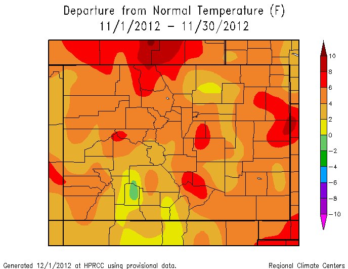
    Click on the thumbnail graphics for the November temperature and precipitation departure from normal maps from the National Weather Service.

    Here’s the December weather preview for South Central and Southeastern Colorado from the National Weather Service Office in Pueblo. Here’s an excerpt:

    After a cool month of October across most of south central and southeast Colorado, the past month of November returned to the common theme played out throughout 2012 thus far; namely warmer and drier than normal conditions…

    Pueblo recorded a trace of precipitation throughout the past month of November. This is 0.47 inches below the monthly average and makes November of 2012 tied with November of 2005 and six other previous years, as the driest November on record in Pueblo. The average temperature in Pueblo through the month of November was 43.2 degrees. This is 3.9 degrees above average and makes November of 2012 tied as the 21st warmest on record in Pueblo.

    The average temperatures in Colorado Springs through the month of November was 43.5 degrees. This is 5.4 degrees above average and makes November of 2012 the 5th warmest on record in Colorado Springs. Colorado Springs recorded 0.02 inches of precipitation in the month of November. This is 0.38 inches below normal and makes November of 2012 tied as the 9th driest on record in Colorado Springs.

    Alamosa has received 0.08 inches of precipitation through the month of November. This is 0.34 inches below average and makes November of 2012 tied as the 20th driest on record in Alamosa. The average temperature in Alamosa through the month of November was 30.4 degrees, which is 0.9 degrees above average.

    Here’s the November climatological report from the National Weather Service Office in Boulder. Here’s an excerpt:

    NOVEMBER 2012 WAS A QUIET MONTH WITH ABOVE NORMAL TEMPERATURES AND VERY LITTLE PRECIPITATION. UPPER LEVEL HIGH PRESSURE BROUGHT MILD AND DRY WEATHER TO THE FRONT RANGE EARLY IN THE MONTH…WITH EIGHT OUT OF THE FIRST NINE DAYS BEING ABOVE NORMAL. HIGH TEMPERATURES ON THE 1ST AND THE 7TH REACHED OR EXCEEDED 70 DEGREES…WITH TEMPERATURES OF 70 AND 77 DEGREES RESPECTIVELY. COLDER UNSETTLED WEATHER RETURNED TO THE REGION ON THE TENTH…AS AN UPPER LEVEL TROUGH OF LOW PRESSURE MOVED INTO COLORADO FROM THE WEST. THIS SYSTEM BROUGHT THE FIRST SNOWFALL OF THE SEASON TO THE COLORADO FRONT RANGE…WITH 1.7 INCHES FALLING AT DENVER INTERNATIONAL AIRPORT ON THE 10TH. NOVEMBER 11TH WAS THE COLDEST DAY OF THE MONTH WITH A HIGH OF ONLY 34 DEGREES AND A MORNING LOW OF 13. THE 0.27 INCHES OF PRECIPITATION WHICH FELL ON THE 10TH WAS THE ONLY MEASURABLE PRECIPITATION FOR THE MONTH. WARMER AND DRIER WEATHER RETURNED TO THE AREA ON THE 16TH…AND CONTINUED THROUGH THE 25TH…AS UPPER LEVEL HIGH PRESSURE ALONG WITH A DRY SOUTHWESTERLY FLOW ALOFT DOMINATED THE ROCKY MOUNTAIN REGION. AN UPPER LEVEL DISTURBANCE AND ASSOCIATED COLD FRONT BROUGHT COLDER TEMPERATURES TO NORTHEASTERN COLORADO ON THE 26TH. HOWEVER…TEMPERATURES REBOUNDED TO ABOVE NORMAL VALUES BY THE 27TH AS UPPER LEVEL HIGH PRESSURE ONCE AGAIN BUILT OVER THE ROCKY MOUNTAIN REGION.

    TEMPERATURES:

    THE AVERAGE TEMPERATURE FOR THE MONTH OF OCTOBER WAS 43.5 DEGREES WHICH WAS 5.2 DEGREES ABOVE NORMAL. DESPITE BEING MUCH ABOVE NORMAL…NOVEMBER 2012 FAILED TO MAKE IT INTO THE TOP TEN LIST OF WARMEST NOVEMBERS. NOVEMBER OF 1949 IS THE WARMEST NOVEMBER ON RECORD WITH AN AVERAGE TEMPERATURE OF 50.9 DEGREES. THE COLDEST NOVEMBER ON RECORD (22.0 DEGREES F) OCCURRED WAY BACK IN 1880 WHEN RUTHERFORD B. HAYES WAS PRESIDENT.

    THERE WERE NO DAYS IN WHICH THE MAXIMUM TEMPERATURE EXCEEDED 90 DEGREES. THE HIGHEST TEMPERATURE OF THE MONTH WAS 77 DEGREES WHICH OCCURRED ON THE 7TH. THE COOLEST TEMPERATURE OF THE MONTH WAS 13 DEGREES ON THE MORNING OF THE 11TH.

    PRECIPITATION.

    PRECIPITATION FOR THE MONTH OF NOVEMBER WAS 0.27 INCHES…WHICH IS 0.34 INCHES BELOW THE NORMAL 0F 0.61 INCHES. THE WETTEST OCTOBER ON RECORD OCCURRED BACK IN 1946 WHEN 3.21 INCHES OF PRECIPITATION WAS RECORDED. ONLY A TRACE OF PRECIPITATION WAS RECORDED IN OCTOBER 1934…1901 AND 1949 WHICH ARE THE DRIEST OCTOBERS ON RECORD.

    1.7 INCHES OF SNOW WAS RECORDED DURING THE MONTH…WHICH IS 7.0 INCHES BELOW THE NORMAL OF 8.7 INCHES. THE SNOWIEST OCTOBER ON RECORD OCCURRED BACK IN 1946 WHEN 42.6 INCHES OF SNOW FELL. THE LEAST SNOWIEST NOVEMBER ON RECORD WAS BACK IN 1949 WHEN NO SNOW FELL.

    THERE WERE NO THUNDERSTORMS OBSERVED AT DENVER INTERNATIONAL AIRPORT. THERE WAS ONLY ONE DAY WITH DENSE FOG WITH A VISIBILITY AT OR BELOW 1/4 MILE DURING THE MONTH. A PEAK WIND OF 37 MPH FROM A NORTHWEST DIRECTION WAS RECORDED ON THE 22ND.

    From The Grand Junction Daily Sentinel (Dennis Webb):

    It’s too early to panic, everyone agrees.

    But with this season of snowfall off to a lackluster start, water managers, utilities and agricultural interests all are anxious for the kind of storms that can lead next spring to refilled reservoirs and recharged watersheds after a year of drought.

    Western Colorado was fortunate to go into last winter with lots of full reservoirs thanks to the epic snow year of 2010-11 and heavy runoff the following spring. That took the edge off this year’s drought, in contrast to 2002, when a lingering drought had carried over two winters and there was less stored water to tap.

    But if this year proved the value of good reservoir storage in a drought year, it also points to the need to get reservoirs refilled now that they’re depleted.

    “Bottom line is, reservoirs got hard hit this year. But that’s what they’re for,” said Jim Pokrandt, a spokesman for the Colorado River Water Conservation District in Glenwood Springs. “But you still have to put more gas in the tank, or in this case water. Hopefully this will be a good enough snow year to bring them closer to full, if not full.”

    Just a year ago, conditions were quite different in some western Colorado reservoirs. The U.S. Bureau of Reclamation was making big releases from Blue Mesa Reservoir to keep the water level low enough that winter freezes didn’t pose a danger of flooding upstream in the Gunnison area.

    This year, Blue Mesa already is 40 feet lower, at just 39 percent of capacity and 57 percent of its normal storage level this time of year. Foundations of pre-dam buildings became exposed after having been underwater since 2002.

    Rifle Gap Reservoir north of Rifle was still full and spilling water last November, said Jason Spaulding, manager for the Silt Water Conservancy District, which manages the reservoir. Now it’s maybe 30 feet lower, he said.

    Bob Hurford, state Division of Water Resources engineer for Division 4 in the Gunnison River Basin, said a lot of reservoirs ended up with carryover storage last fall because they didn’t have to release it all thanks to the heavy snow of the previous winter.

    “You just keep that storage up in your reservoir. It’s like money in the bank,” he said.
    For the Clifton Water District, “the bank account got used up this summer,” said David Reinertsen, its assistant manager.

    Clifton Water relies on Colorado River water, and specifically water stored upstream in Green Mountain Reservoir near Kremmling. As of the end of October, Green Mountain’s storage was down to 43 percent of capacity and 58 percent of average, according to the Natural Resources Conservation Service.

    Statewide, reservoir storage averaged 37 percent of capacity and two-thirds of normal for Oct. 31. For Gunnison River Basin reservoirs, the average was 46 percent of capacity and 61 percent of normal, while Upper Colorado River reservoirs averaged 54 percent of capacity and two-thirds of normal.

    Slow start to winter

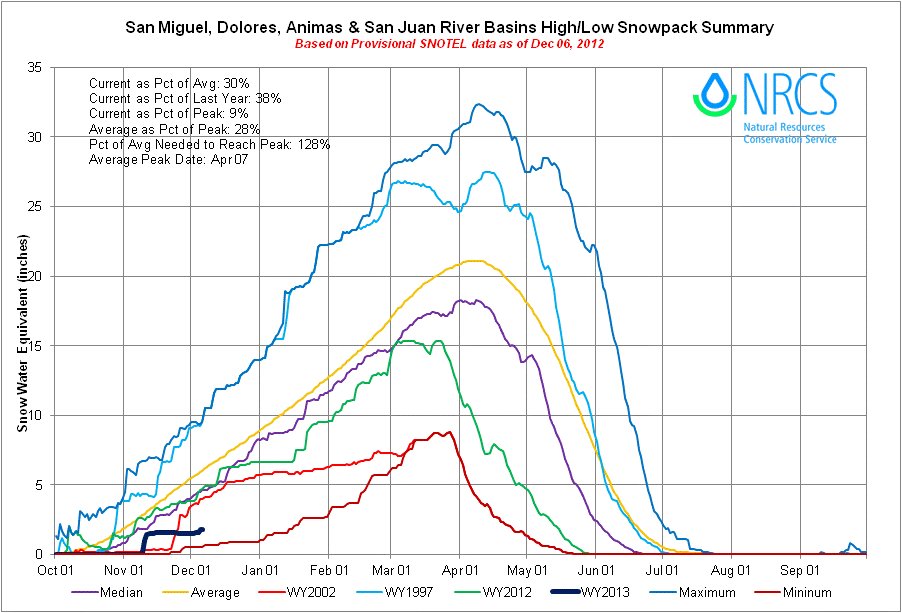
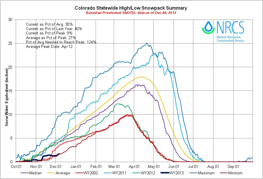
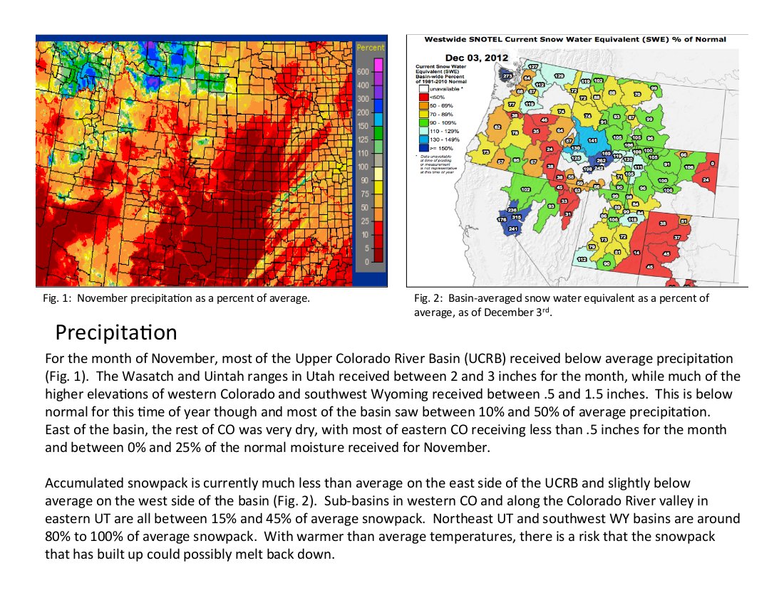
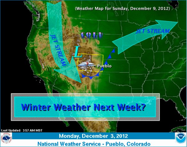
    Meanwhile, this winter’s snowpack is off to a slow start, at just 38 percent of average statewide, and 40, 42 and 37 percent, respectively, for the Upper Colorado, Gunnison and Yampa/White river basins as of Thursday.
    Mage Hultstrand, assistant Colorado snow survey supervisor for the Natural Resources Conservation Service, said while people may think October and November don’t contribute much to the year’s snowpack, between them they
    typically account for about 25 percent of the peak amount each year.

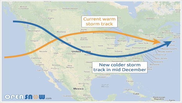
    But she added, “Really, you know, one big storm and we can be back (on track),”

    The potential consequences should western Colorado experience another dry winter vary somewhat among reservoirs and water users, depending on their circumstances. Some reservoirs, such as Paonia Reservoir, may be drawn low most years but are able to reliably fill the following spring even in drier years. Dan Crabtree of the U.S. Bureau of Reclamation western Colorado office said Paonia Reservoir is “a small bucket on a big stream,” and benefits from a huge watershed and lots of runoff above it.

    Spaulding said Rifle Gap should come close to filling this winter, but if the snowpack is light and the creek feeding it is still running low next summer, irrigators will be affected.

    “If we don’t get any snow this winter it could be bad for us next summer, for sure,” he said.
    Blue Mesa, a large reservoir, takes longer to refill than many and isn’t forecast to fully refill this year, Crabtree said. He said there’s still plenty of winter ahead, but should dry conditions persist, the Bureau of

    Reclamation has criteria in place for trying to protect and recapture storage while continuing to meet obligations. It already is making the minimum releases required to meet a streamflow right through the Black Canyon of the Gunnison and water rights for Uncompahgre Valley water users.

    Impacts on agriculture

    Crabtree said private reservoirs, and water rights holders on smaller streams, would be more impacted if there’s another drought year.

    “Lack of storage would definitely be an issue,” said Hurford, of the Division of Water Resources.

    He said some reservoirs aren’t currently filling as fast as normal because some streams above them are dry.

    If a drought continues into next spring, resulting in both reduced natural flows and less reservoir water, “there’s going to be less yield for farmers. The crops will suffer,” he said.

    Even this year’s drought affected the ability of some people with junior water rights to be able to irrigate, he said.

    “That leaves a lot of people high and dry who haven’t been used to that. The last time that happened was 10 years ago,” he said.

    Mark Harris is a partner in the Grand Valley Farms corn-growing operation in Mesa County. Even with good water rights, mostly coming out of the Grand Valley Canal system, he worries that those rights could be affected if the drought continues and there’s simply not enough water available.

    “Right now we’re planning on raising a full crop but kind of making provisions for what we would do if we had to limit the acres that we farm based on water availability. It’s kind of a scary prospect,” he said.

    Such a prospect is difficult to plan for when Grand Valley Farms is forward-contracting its corn and having to make decisions on things such as purchasing fertilizer and seed.

    “It adds a level of uncertainty that we have not had to deal with in the past. It’s kind of a new phenomenon,” he said.

    If the drought continues, Harris also wonders how municipal water needs will be met, and whether there will be attempts to change Colorado water law as domestic, agricultural and other water interests clash.

    Planning for the worst

    Grand Valley domestic water providers have been working hard to plan for shortages and be able to continue to meet their customers’ needs.

    The 2002 drought led to the Ute Water Conservancy District and the Clifton, Palisade and Grand Junction water utilities developing a drought response plan. That prompted the implementation this year of voluntary water restrictions that remain in place.

    Despite that, Ute Water temporarily saw an increase in water use as irrigation company restrictions and warm and dry conditions caused residents to use more domestic water for irrigating, said Ute Water spokesman Joseph Burtard.

    That higher use dropped off after residents received bills based on exponentially higher rates for increased use.
    Ute Water has a range of water sources, including 31 reservoirs on the Grand Mesa and a backup source on the Colorado River. Its two main sources of raw water storage, the Jerry Creek 1 and 2 reservoirs on the Grand Mesa, remain full, but Burtard said that’s because Ute Water has juggled other water rights and utilized its water portfolio in a way it’s never had to before.

    “We were looking at our portfolio with a completely different perspective this year,” he said.

    An average snowpack this winter would prevent the need to move to Stage 2, mandatory water restrictions with higher, drought rates next summer, Burtard said. But Ute Water and other Grand Valley water entities are preparing for the possibility that the drought may continue and Stage 2 measures might be required next summer, something they would agree to do jointly if the measures are needed.

    For now, though, water-watchers know that with winter still getting underway, a few major storms can ease many of their concerns.

    “It’s still early. Keep our fingers crossed,” said Hultstrand, the snow surveyor. “Really, we’ve just got to hope for snow this year.”

    Castle Rock: Assistant utilities director Rick Wilkey will take over in the interim for Ron Redd

    castlerock.jpg

    From the Castle Rock News-Press (Rhonda Moore):

    The Town of Castle Rock has announced an interim utilities director to replace Ron Redd, who leaves the department after 11 years at the helm. Assistant utilities director Rick Wilkey will replace Redd when Redd leaves Castle Rock Dec. 12. Redd will replace Frank Jaeger as district manager of the Parker Water and Sanitation District.

    More South Platte River Basin coverage here.

    San Luis Valley: ‘Aquifer faces crisis’ — Valley Courier

    artesianwellduttonranchalamosa1909.jpg

    Here’s a guest column written by Steve Vandiver that’s running in the Valley Courier. Here’s an excerpt:

    Wells were constructed from the earliest days of settlement in the Valley; and in fact, the oldest appropriation of water in the San Luis Valley is a small domestic well in the Conejos area. No new non-domestic appropriations from the aquifers in the Valley have been allowed for 30 to 40 years depending on the aquifer and the area of the Valley being considered. The moratoriums on new wells occurred as a result of the State Engineer Office’s recognition that additional groundwater appropriations would cause impacts to those aquifers and surface streams…

    Recent drought conditions, with the lowest water year being 2002, have caused significant reductions in the natural runoff that recharges this study area, and have greatly reduced the diversions from the Rio Grande that normally provide approximately 275,000 acre-feet of additional recharge into this area. Recharge into the aquifer from those diversions occurs through infiltration from the ditches and from constructed recharge pits that introduce water into the aquifer.

    Aquifer storage continues to decline even though the irrigated area within the study area has been reduced by approximately 20,000 acres over the last 12 years and recently by additional thousands of acres placed in fallowing and preventative planting insurance programs.

    Graphs of the unconfined aquifer storage study show the changes that are occurring in the unconfined aquifer and are indicative of the significant reductions in storage that have occurred from changes in the hydrologic conditions over the last decade. Well pumping in the area has been reduced by approximately 20 percent in 2012, over the last several years because of management efforts of the well owners themselves and efforts of Rio Grande Water Conservation District’s Subdistrict #1.

    More San Luis Valley groundwater coverage here and here.

    The U.S. Fish and Wildlife Service and San Luis Valley ag producers reach habitat agreement

    southwesternwillowflycatcher.jpg

    From the Associated Press via The Durango Herald:

    Federal wildlife officials and southern Colorado water and government officials have finalized a plan for the southwestern willow flycatcher and the yellow-billed cuckoo, the Pueblo Chieftain reported.

    The plan aims to protect the birds while allowing farmers and ranchers to avoid more stringent provisions in the Endangered Species Act.

    “We’re happy to see our conservation partners in the San Luis Valley develop this plan that will allow people to sustain their rich tradition of working the fertile landscape of the valley while simultaneously contributing to the conservation of fish and wildlife in their own backyards,” Noreen Walsh, an acting U.S. Fish and Wildlife Service regional director, said in a statement last week.

    The southwestern willow flycatcher is listed as endangered by the federal government. The yellow-billed cuckoo is a candidate for federal listing.

    More endangered/threatened species coverage here.

    Drought news: The drought is worsening across the Midwest #CODrought

    usdroughtmonitor11272012.jpg

    From Reuters (Carey Gillam):

    While conditions started to improve earlier in November, they turned harsh to close out the month as above-normal temperatures and below-normal precipitation proved a dire combination in many regions, according to the Drought Monitor, a weekly compilation of data gathered by federal and academic scientists issued Thursday.

    Forecasts for the next several days show little to no relief and weather watchers are predicting a drier than average winter for much of the central United States.

    “The drought’s impacts are far reaching,” said Eric Luebehusen, a meteorologist with the U.S. Department of Agriculture, in the report.

    The U.S. High Plains, which includes key farm states of Nebraska, South Dakota, and Kansas, are the hardest hit. In that region, almost 58 percent of the land area is in extreme or exceptional drought, the worst categories of drought. A week ago, the tally was 55.94 percent.

    Nebraska is by far the most parched state in the nation. One hundred percent of the state is considered in severe or worse drought, with 77.46 percent of the state considered in “exceptional” drought – the worst level, according to the Drought Monitor.

    Overall, roughly 62.65 percent of the contiguous United States was in at least “moderate” drought as of November 27, up from 60.09 percent a week earlier,

    The portion of the contiguous United States under “extreme” or “exceptional” drought – the two most dire classifications – expanded to 20.12 percent from 19.04 percent.

    From The Colorado Springs Gazette (Garrison Wells):

    A scant 0.02 inches of precipitation fell on Colorado Springs in November, a tie for 9th driest in history “and that’s bad enough,” said Randy Gray, meteorological technician with the National Weather Service in Pueblo. “It’s at a critical point now,” he said. “Currently, practically all of El Paso County is in what is called extreme drought conditions.”[…]

    November’s average high for Colorado Springs is 51 degrees and the average low is 25.2 degrees. The mean, that’s right in the middle, is 38.1 degrees, Gray said. The city’s mean temperature this November through Thursday was 5.1 degrees above where it normally sits. The average precipitation for the month is .40 inches.

    The outlook doesn’t get any better for at least the next few months, Gray said. “The bad news is that for this part of the country especially, the drought conditions are expected to persist or possibly even intensify,” he said.

    That’s bad news all around. Farmers, already hit by high prices for hay and other supplies, may face more price jumps, said Ken Bachmann, store manager at the Big R of Falcon. The price of hay is up 44 percent this year.

    DARCA: There’s still room for the train tour December 7

    westportalmoffattunnel.jpg

    From email from DARCA:

    We do have a few more seats on the California Zephyr next week so please let me know very, very, soon if you would like to join us as I am in the process of sending in the final passenger list to Amtrak. Please look at the agenda as we do have an outstanding list of speakers.

    More infrastructure coverage here.

    CMU: Drought and Agriculture panel December 3 #CODrought

    droughtcornfieldnorthdakotastate.jpg

    Here’s the email from Colorado Mesa University (Hannah Holm):

    On Monday, Dec. 3 at 4pm, a panel of speakers will discuss drought and agriculture. This panel is part of CMU’s weekly “Natural Resources of the West: Water and Drought” seminar series. The panelists will be:

    Bruce Talbott, Fruit Grower
    Hugh Sanburg, Rancher
    Mark Harris, Farmer, Grand Valley Drainage District
    Max Schmidt,Orchard Mesa Irrigation District

    All seminars are open to the public and are held from 4:00 – 5:15pm in the Saccamano Lecture Hall, Wubben Science Building Room 141, at Colorado Mesa University.

    URL to watch streaming video: http://www.ustream.tv/channel/9952647.

    NWS: A Statistical Preview of Denver’s December Weather — 3rd snowiest behind March and November

    denveraurariasketch1860frankleslieillustratednewspapernewyork12151860.jpg

    Here’s the release from the National Weather Service Denver/Boulder. Here’s an excerpt:

    THE WINTER MONTHS OF DECEMBER THROUGH MARCH ACROSS NORTHEASTERN COLORADO ARE WIDELY VARIABLE WITH RESPECT TO TEMPERATURE AND SNOWFALL. HISTORICALLY, DECEMBER CAN FREQUENTLY SEE HIGH TEMPERATURES CLIMB INTO THE MILD 60’S WHILE AT TIMES EXPERIENCE VERY COLD TEMPERATURES IN THE MINUS SINGLE DIGITS. ON DECEMBER 21ST, 1983, THE HIGH TEMPERATURE MAXED OUT AT A FRIGID -8 AND IS CURRENTLY DECEMBER’S COLDEST LOW MAXIMUM TEMPERATURE SINCE 1872.

    DECEMBER IS TYPICALLY THE FIRST MONTH OF THE WINTER SEASON WHERE EXTREME ARCTIC BLASTS CAN REACH THE EASTERN PLAINS OF COLORADO. SHORT DAYLIGHT HOURS COMBINED WITH THE OCCASIONAL DEEP TROUGH OF LOW PRESSURE CAN USHER IN A FRIGID NORTH CANADIAN AIRMASS INTO THE HIGH PLAINS REGION. DECEMBER CAN ALSO BE CHARACTERIZED AS A MONTH OF HAVING BOTH DRY AND BREEZY BROWN-GROUND CONDITIONS WITH LOW SNOWFALL, WHILE IN OTHER YEARS THE MONTH RECEIVES THE CITIES FIERCEST SNOWSTORMS.

    DENVER’S MONTHLY MEAN TEMPERATURE FOR DECEMBER IS 30.0 DEGREES AND IS DENVER’S COLDEST MONTH OF THE YEAR. DECEMBER EDGES SLIGHTLY COLDER THAN JANUARY WHICH HAS A MEAN MONTHLY TEMPERATURE OF 30.7 DEGREES (1981-2010 AVERAGES).

    DECEMBER’S DAILY NORMAL HIGH TEMPERATURES HOLD FAIRLY CONSTANT THROUGH THE MONTH STARTING WITH A HIGH OF 45 DEGREES AND ENDING THE MONTH WITH A NORMAL HIGH OF 43 DEGREES. FOR LOW TEMPERATURES, THE MONTH BEGINS WITH A NORMAL LOW OF 19 DEGREES AND FINISHES WITH A LOW OF 17 DEGREES. THE WARMEST TEMPERATURE EVER RECORDED DURING THE MONTH OF DECEMBER, SINCE RECORDS BEGAN IN 1872, WAS 79 DEGREES ON THE 5TH DAY OF THE MONTH, 1939. DECEMBER’S COLDEST TEMPERATURE EVER IN DENVER WAS -25 ON BOTH THE 24TH OF 1876 AND THE 22ND OF 1990…

    BEHIND MARCH AND NOVEMBER, DECEMBER IS DENVER’S 3RD SNOWIEST MONTH WITH THE CITY NORMALLY COLLECTING 8.5 INCHES, BASED ON AVERAGES FROM OLD STAPLETON INTL AIRPORT. SIMILAR TO DENVER’S OTHER 3 SNOWIEST MONTHS OF MARCH, APRIL AND NOVEMBER, DECEMBER HAS THE CAPABILITY TO PRODUCE BIG SNOWSTORMS. IN FACT, THE HEAVIEST AND LONGEST DURATION SNOWSTORM IN DENVER’S HISTORY OCCURRED FROM THE 1ST THROUGH THE 5TH OF DECEMBER, 1913. THAT 5 DAY SNOWSTORM DUMPED 45.7 INCHES ON THE YOUNG CITY OF DENVER AND BROUGHT ALL OPERATIONS TO A HALT FOR WEEKS…

    AFTER A NOVEMBER 2012 WITH ABOVE NORMAL TEMPERATURES AND BELOW NORMAL PRECIPITATION, THE SAME PATTERN IS EXPECTED TO HOLD THROUGH THE FIRST WEEK OF DECEMBER 2012. THE SHORT TO MEDIUM RANGE MODELS INDICATED A MEAN TROUGH OF COLD LOW PRESSURE DEVELOPING OVER THE NORTHERN AND CENTRAL ROCKIES FROM THE 2ND WEEK THROUGH THE 3RD WEEK. AFTER THE 3RD WEEK OF THE DECEMBER 2012, THE LONG RANGE MODELS INDICATE A BIAS TOWARD ABOVE NORMAL TEMPERATURES WITH NEAR NORMAL PRECIPIATION EXPECTED THROUGH FEBRUARY 2012.

    Grand Canyon as old as the dinosaurs, suggests new study led by CU-Boulder

    grandcanyontoroweapwilliamholmesusgs.jpg

    Here’s the release from the University of Colorado at Boulder (Rebecca Flowers/Jim Scott):

    An analysis of mineral grains from the bottom of the western Grand Canyon indicates it was largely carved out by about 70 million years ago — a time when dinosaurs were around and may have even peeked over the rim, says a study led by the University of Colorado Boulder.

    The new research pushes back the conventionally accepted date for the formation of the Grand Canyon in Arizona by more than 60 million years, said CU-Boulder Assistant Professor Rebecca Flowers. The team used a dating method that exploits the radioactive decay of uranium and thorium atoms to helium atoms in a phosphate mineral known as apatite, said Flowers, a faculty member in CU-Boulder’s geological sciences department.

    The helium atoms were locked in the mineral grains as they cooled and moved closer to the surface during the carving of the Grand Canyon, she said. Temperature variations at shallow levels beneath the Earth’s surface are influenced by topography, and the thermal history recorded by the apatite grains allowed the team to infer how much time had passed since there was significant natural excavation of the Grand Canyon, Flowers said.

    “Our research implies that the Grand Canyon was directly carved to within a few hundred meters of its modern depth by about 70 million years ago,” said Flowers. A paper on the subject by Flowers and Professor Kenneth Farley of the California Institute of Technology was published online Nov. 29 in Science magazine.

    Flowers said there is significant controversy among scientists over the age and evolution of the Grand Canyon. A variety of data suggest that the Grand Canyon had a complicated history, and the entire modern canyon may not have been carved all at the same time. Different canyon segments may have evolved separately before coalescing into what visitors see today.

    In a 2008 study, Flowers and colleagues showed that parts of the eastern section of the Grand Canyon likely developed some 55 million years ago, although the bottom of that ancient canyon was above the height of the current canyon rim at that time before it subsequently eroded to its current depth.

    Over a mile deep in places, Arizona’s steeply sided Grand Canyon is about 280 miles long and up to 18 miles wide in places. Visited by more than 5 million people annually, the iconic canyon was likely carved in large part by an ancestral waterway of the Colorado River that was flowing in the opposite direction millions of years ago, said Flowers.

    “An ancient Grand Canyon has important implications for understanding the evolution of landscapes, topography, hydrology and tectonics in the western U.S. and in mountain belts more generally,” said Flowers. The study was funded in part by the National Science Foundation.

    Whether helium is retained or lost from the individual apatite crystals is a function of temperatures in the rocks of Earth’s crust, she said. When temperatures of the apatite grains are greater than 158 degrees Fahrenheit, no helium is retained in the apatite, while at temperatures below 86 degrees F, all of the helium is retained.

    “The main thing this technique allows us to do is detect variations in the thermal structure at shallow levels of the Earth’s crust,” she said. “Since these variations are in part induced by the topography of the region, we obtained dates that allowed us to constrain the timeframe when the Grand Canyon was incised.”

    Flowers and Farley took their uranium/thorium/helium dating technique to a more sophisticated level by analyzing the spatial distribution of helium atoms near the margin of individual apatite crystals. “Knowing not just how much helium is present in the grains but also how it is distributed gives us additional information about whether the rocks had a rapid cooling or slow cooling history,” said Flowers.

    There have been a number of studies in recent years reporting various ages for the Grand Canyon, said Flowers. The most popular theory places the age of the Grand Canyon at 5 million to 6 million years based on the age of gravel washed downstream by the ancestral Colorado River. In contrast, a 2008 study published in Science estimated the age of the Grand Canyon to be some 17 million years old after researchers dated mineral deposits inside of caves carved in the canyon walls.

    Paleontologists believe dinosaurs were wiped out when a giant asteroid collided with Earth 65 million years ago, resulting in huge clouds of dust that blocked the sun’s rays from reaching Earth’s surface, cooling the planet and killing most plants and animals.

    Because of the wide numbers of theories, dates and debates regarding the age of the Grand Canyon, geologists have redoubled their efforts, said Flowers. “There has been a resurgence of work on this problem over the past few years because we now have some new techniques that allow us to date rocks that we couldn’t date before,” she said.

    While the dating research for the new study was done at Caltech, Flowers recently set up her own lab at CU-Boulder with the ability to conduct uranium/thorium/helium dating.

    “If it were simple, I think we would have solved the problem a long time ago,” said Flowers. “But the variety of conflicting information has caused scientists to argue about the age of the Grand Canyon for more than 150 years. I expect that our interpretation that the Grand Canyon formed some 70 million years ago is going to generate a fair amount of controversy, and I hope it will motivate more research to help solve this problem.”

    More Colorado River Basin coverage here and here.

    Snowpack news: Upper Colorado River Basin = 40% of avg, all eyes at Denver Water are on the mountains #CODrought

    snowpackuppercolorado11292012.jpg

    Click on the thumbnail graphic for today’s snowpack picture from the Upper Colorado River Basin, home to much of Denver Water’s collection system.

    From KDVR.com:

    This fall has been unusually warm and dry in the Mile High City and up and down the Front Range and not many people are complaining…

    The unusual weather has many Colorado water managers concerned. According to the latest survey, the state snow pack now measures 41 percent of average. That’s not only affecting Colorado skiers and ski resorts, it could mean water restrictions if the trend continues.

    “It’s been a really dry spring and fall and so we are concerned about the conditions,” said Stacy Chesney, Denver Water spokesperson. “We’re hopeful that we get snow this winter but if it remains really dry we may have to do additional [Mandatory] water restrictions this coming spring and summer.”

    Denver Water relies on reservoirs for a good deal of its water supply. Currently, reservoir levels are 15 percent below normal.

    From the Summit Daily News (Caddie Nath):

    Forecasters usually base long-term prediction models on El Niño and La Niña patterns. An El Niño winter will likely favor southern Colorado with the prime powder. A La Niña year, like the almost-legendary winter of 2010-11, tends to suggest a better winter is in store for the northern part of the state, including Summit County. But in the throes of a worsening drought, this year is unhelpfully following what forecasters jokingly call La Nada — showing neither pattern and making it difficult for weather watchers to anticipate any long-term trends at all.

    “The crystal ball is a little fuzzy,” said Bob Henson, of the University Corporation for Atmospheric Research in Boulder.

    But it would be reaching to call forecasters optimistic.

    There’s little moisture in the seven to 10-day forecast, the timeframe meteorologists can predict with some accuracy, and long-term models point to above-average temperatures if nothing else. This winter likely won’t deliver what Colorado needs to escape the drought, experts say.