

From the Associated Press via ABC15.com:
Dust blown in from the Southwest settled on snow over many of Colorado’s mountains during this week’s storm and will eventually affect how fast the snowpack melts and possibly how much water the state can hold onto. Researchers say the dust kicked up from Arizona, New Mexico and Utah by southwesterly winds fell in Steamboat Springs, Summit County, Vail, Aspen and the San Juan mountains. Dust was also scattered in the snow that fell along the Front Range but it’s likely that dust could have been carried by southeasterly winds from other areas too, including parched southeastern Colorado, the San Luis Valley and the Arkansas River Basin, state climatologist Nolan Doesken said.
Jeffrey Deems, a research scientist for NOAA in Boulder, said dust on top of snow can absorb up to twice as much sunlight as clean snow, speeding up melting. He compares the effect to wearing a dark T-shirt on sunny day.
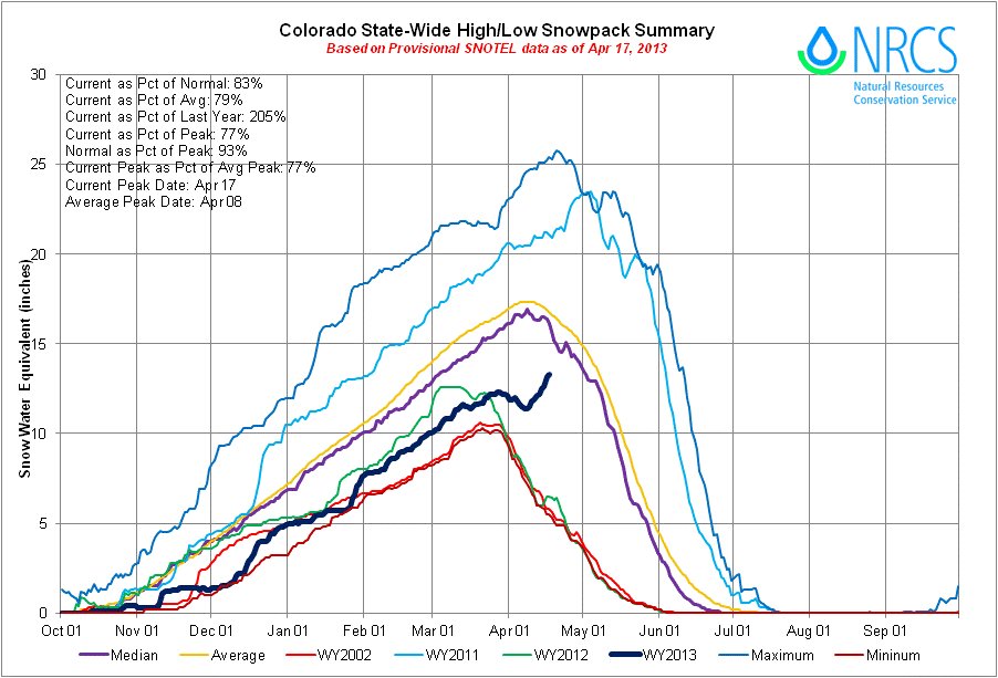
This week’s dust storm was the second widespread one in Colorado’s mountains this season. Another storm on April 8th left a thick layer of dust in the state’s snowpack, which has now been boosted to 79 percent of the peak average thanks to this week’s storm. “It’s kind of a mixed blessing now,” Deems said of the new, dusty snow.
More snow is in the forecast but whenever the dust layers from this week and earlier this month are eventually exposed, there will be a significant speed up in the melting of the snow at that time, said Chris Landry of the Center for Snow and Avalanche Studies in Silverton.
Here’s an article about the April 8 dust storm written by Chase Olivarius-Mcallister for the The Durango Herald. Here’s an excerpt:
Monday’s gusts rained red mud from Arizona and New Mexico dust onto Durango, making the sky an ominous shade of mottled pink and reducing visibility. Wind speeds were as high as 30 mph at the airport, and anyone in a car should drive at prudent speeds, Aleksa said. Drivers traversing mountain roads, where winds were fiercest, should take particular care, he said.
Click here for a Modis satellite photo of a dust storm out of northeast Arizona moving toward four corners, and the San Juans.
From the Windsor Beacon (Sam Noblett):
“At least now we have enough to get it started rather than germinating by irrigation,” said Harold Stromberger, who operates his farm in Windsor near Colorado Highway 392 and Weld County Road 21. Still, Stromberger has had to adjust his practices to plan for the reduced water allocation by switching to a few barley crops, which are more resistant to drought than his normal corn crops. He made the choice to switch to barley instead of allowing his land to sit idle. He planted the barley in mid-March and hopes to plant corn crops this weekend, depending on weather.
“You do a lot of hoping in agriculture,” said Stromberger. “Hoping for storms like this and rain.”
From the Boulder Daily Camera (John Aguilar):
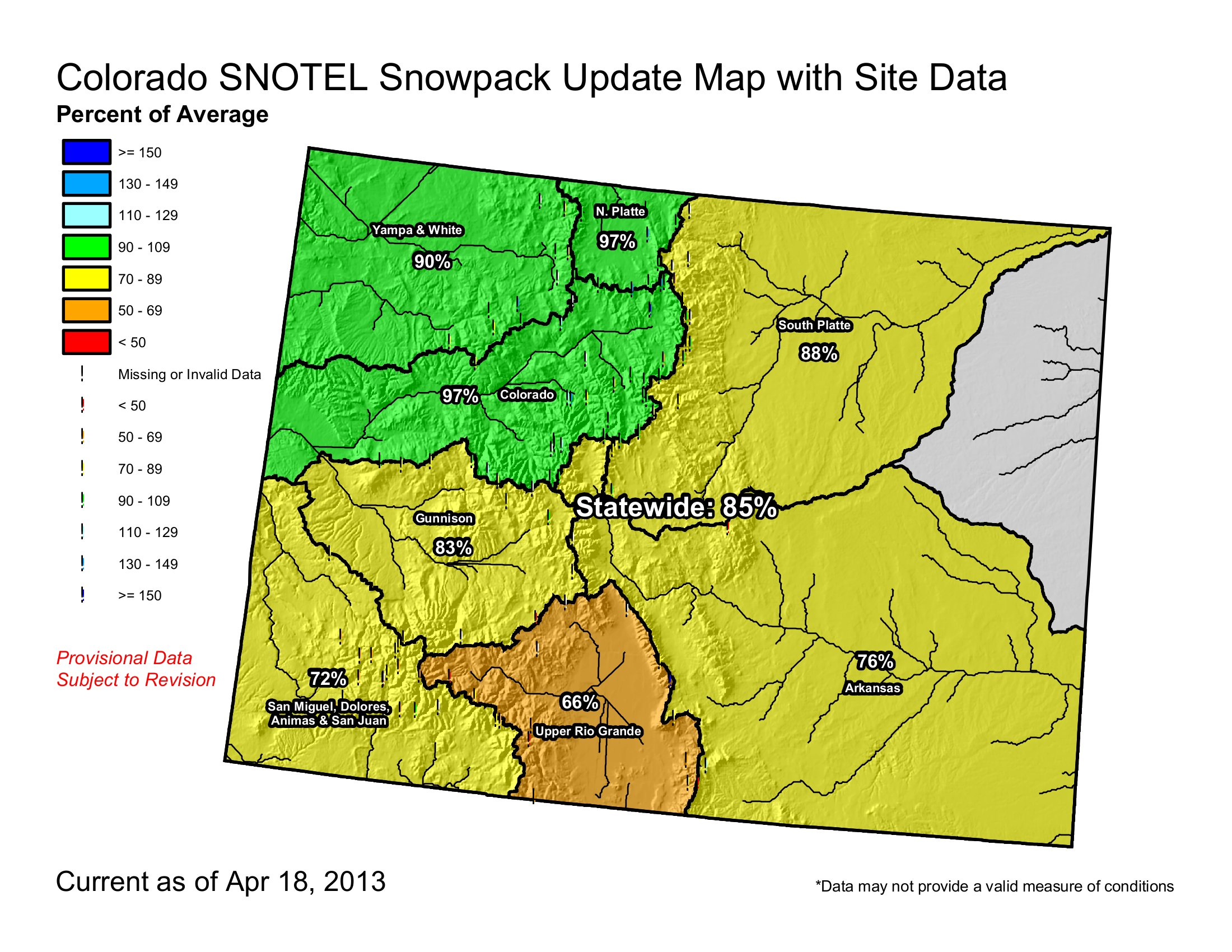
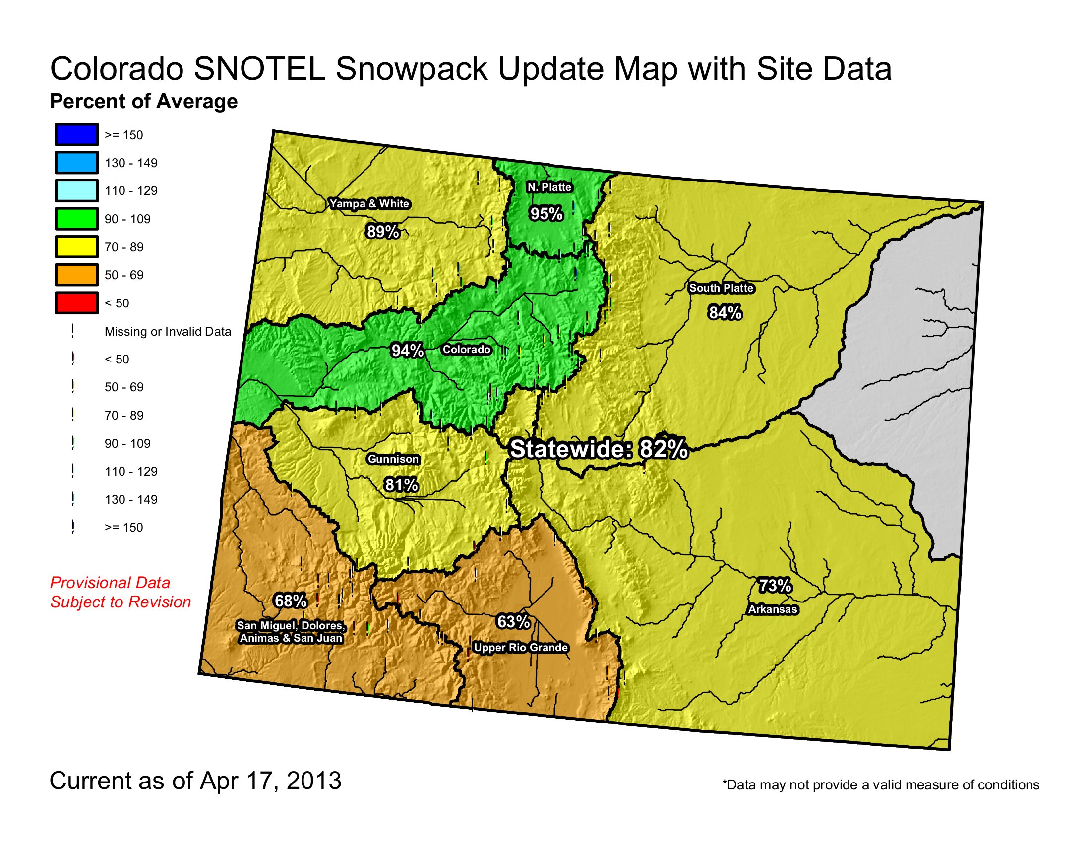
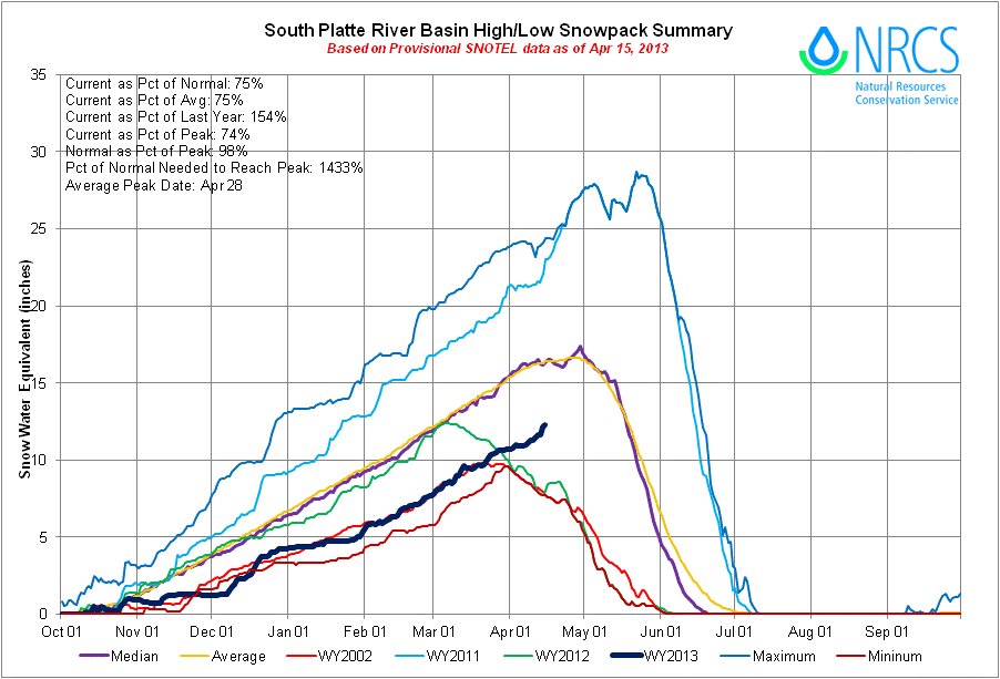
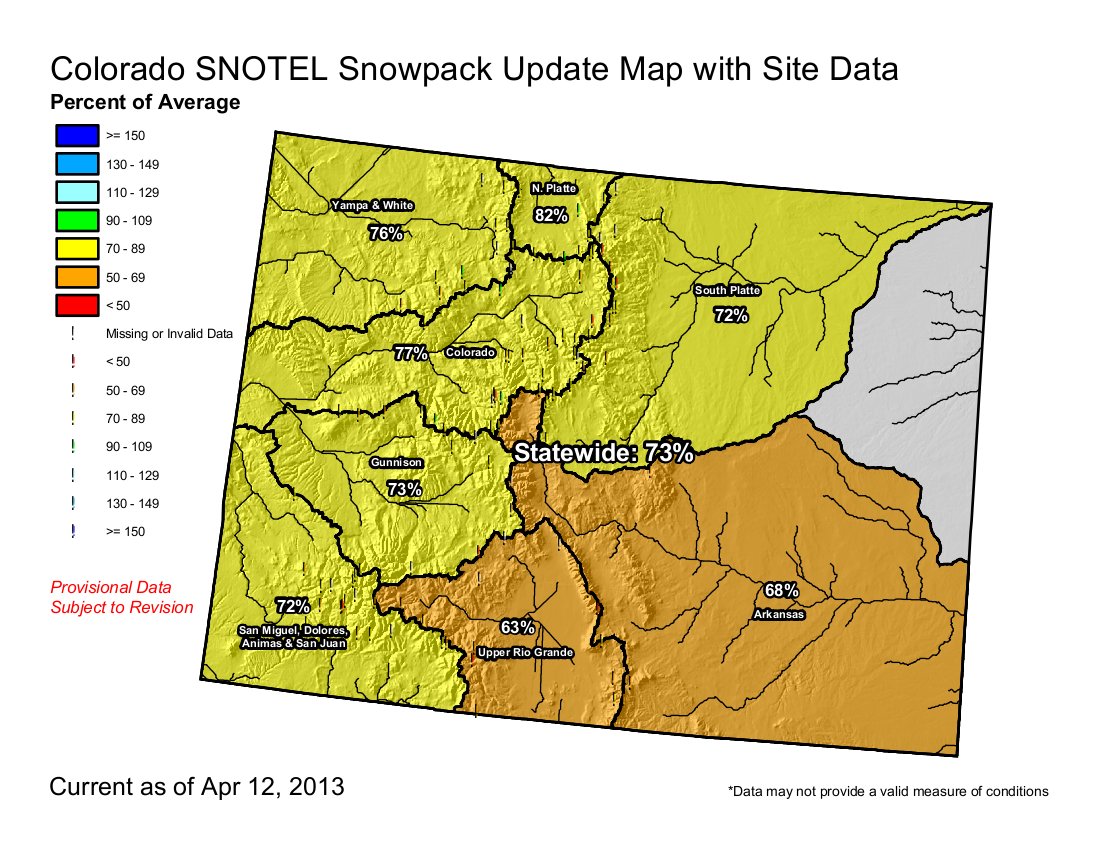
“Things were looking pretty dire here,” Mage Hultstrand, assistant snow survey supervisor for the Natural Resources Conservation Service, said Wednesday. “These are the first storms that have given the snowpack a real boost.” And a significant boost, at that. On April 8, the snowpack level in the South Platte River watershed was 70 percent of normal for that date. On Wednesday, it was measured at 83 percent of normal. Statewide, the snowpack was at 67 percent of normal 10 days ago, and on Wednesday it hit 83 percent of normal, Hultstrand said.
As of Wednesday evening, Boulder had received 34.9 inches of April snow. The record for the month is 44 inches, set in 1957. This month’s snowfall follows nearly 23 inches in March…
“We’re playing catch-up with our snowpack, and we’re also playing catch-up with our reservoir storage,” Hultstrand said. “Things can dry up really fast around here.”
So far, Broomfield and cities and towns in Boulder County are holding their ground with water restrictions. Louisville, which imposed the strictest limits in the county earlier this month — with a mandatory twice-a-week outdoor watering schedule starting May 1 — doesn’t plan to back off its restrictions for now.
“Things are looking better, and all this moisture means that no one needs to do any irrigating until at least early or perhaps even mid-May,” City Manager Malcolm Fleming wrote in an email. “However, the snow pack is still down and it will take more than this to fill the reservoirs that are very low.”
Lafayette Public Works Director Doug Short said officials aren’t going to consider easing Lafayette’s restrictions, which limit outdoor watering to between 6 p.m. and 10 a.m., until they see the state’s May 1 snowpack and runoff projections. That means the paddleboat and canoe program at Waneka Lake remains dry-docked for now.
Jody Jacobson, spokeswoman for the Boulder Public Works Department, said the city is also awaiting next month’s hydrological data before making a final decision on whether to impose water restrictions…
According to data from the Natural Resources Conservation Service, the snowpack in the Boulder Creek watershed on April 1 was at 69 percent of normal for that date, while the levels in the St. Vrain and Big Thompson watersheds were 55 percent and 59 percent of normal, respectively. The service wasn’t able to provide updated numbers for mid-April.
Like much of Boulder County, Broomfield partly relies on supplies from the Colorado Big Thompson project, which transports water from the west side of the Continental Divide to the Front Range. Broomfield Public Works Director David Allen said Wednesday that he plans to recommend to the City Council next week that it stick with a voluntary twice-a-week watering schedule across the city.
Here’s a report about the second dust storm of the month on April 16 from Shane Benjamin writing for The Durango Herald. Here’s an excerpt:
The dust storm was the result of a low-pressure system centered over Utah and Nevada that contributed to a strong southwest flow over this part of the state, said Joe Ramey, forecaster with the National Weather Service in Grand Junction. The dirt was rising out of New Mexico, he said. Some residents said they could feel and taste the grit in their teeth. “Even up here in Grand Junction our skies are hazy with dust,” he said…
A dust storm April 8, combined with light rain, coated cars and dirtied windows in the Durango area. Some of the dirt gets deposited on the snowpack in the San Juan Mountains, which turns the snow a dark color and increases the rate of the melt…
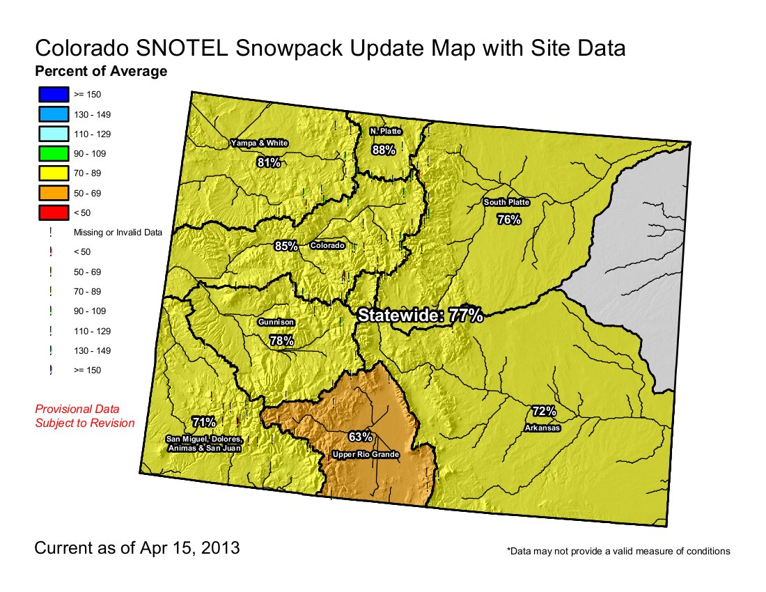
The average snowpack as of Tuesday in Southwest Colorado was 71 percent of normal, he said – second lowest in the state. The lowest was in the Rio Grande basin, east of Wolf Creek Pass. The average snowpack across the state was 77 percent, he said.
From The Wet Mountain Tribune (Nora Drenner):
Watering restrictions have been imposed on Round Mountain Water and Sanitation District bulk water users. Such action took place at the RMW board of directors meeting held April 11.
RMW manager Tracey Garcia said the district was forced to enact the restrictions due to drought and the less than average snowpack. Primarily affected by the restrictions are the Custer County Road and Bridge Department that uses the water for road grading, Custer County School for its ball fields, and the towns of Silver Cliff and Westcliffe for its municipal parks. The restrictions limit the amount of water bulk users can purchase and use by one-third to one-half.
Not affected, said Garcia, are those residential users who rely on bulk water for cisterns, as well as other residential customers. She also noted that RMW hopes to only limit the watering restrictions to large bulk users, however, she encourages all customers to conserve. “The district is hoping to only limit those users and not pass along the restrictions to residential users,” said Garcia…
“Green lawns, unfortunately, should not be anyone’s priority this year,” said Garcia. “Instead, only water newly planted trees as necessary. “
Garcia said Round Mountain Water and Sanitation District currently has 355 acre feet of storage in the Lake DeWeese reservoir, however, the current total of water in the storage vessel is around 115 acre feet. Additionally, RMW secured an additional 75 acre feet of water last year through the Pueblo Board of Water Works, however, it is unknown if that source of water will be available again this year.
From The Grand Junction Daily Sentinel (Mike Wiggins):
The biggest snowstorm of the season Wednesday layered the Grand Valley with a thick, wet blanket of flakes that triggered accidents across the region, the closure of the school in De Beque and anxiety among peach farmers whose trees have already flowered.
The storm dumped as much as 7 inches of snow in some areas of the valley and more in the higher elevations, according to the National Weather Service. Officially, 4.6 inches accumulated at Grand Junction Regional Airport between Tuesday night and Wednesday morning. The 3.8 inches of snow that fell Wednesday made it the third-snowiest April day on record in Grand Junction and accounted for the most snow on a single day this season, coming in just ahead of the 3.6 inches that fell in the city on Dec. 19, 2012, according to the National Weather Service…
The owners of Red Barn Farm & Gardens, 3419 U.S. Highway 6, posted on their Facebook page that the forecast was not looking promising for their fruit. “The apricots are all gone, cherries in the valley will be slim pickings, if any, and peaches are heading out very quickly with this snow and cold temperatures. Pray for a warm weather change and some tasty fruit this summer! I hope you all love pears, tomatoes, and the regular garden veggies, because that’s about all we might have!” the post said.
From The Greeley Tribune (Eric Brown):
Double-digit jumps in snowpack figures this month have left Randy Schwalm and other local farmers using a facial expression seldom seen in the ag world during recent months. “We’re actually smiling today,” said Schwalm, a Windsor-area crop grower.
Snowpack in the South Platte River basin had hovered around 65-70 percent of average through the end of March, but, as of Wednesday, had jumped up to 85 percent of average, thanks to recent snowstorms.
Snowpack is needed to provide runoff that fills the region’s reservoirs, rivers and irrigation ditches.
Snowpack in the Colorado River basin, from which the northern Front Range also diverts much of its water, saw snowpack increase from 74 percent of average on April 1 all the way up to 95 percent of average on Wednesday.
Along with the snowpack upswings, there’s been plenty of moisture in Weld County. The National Weather Service said 4-5 inches had fallen on areas along the Larimer-Weld County line on Wednesday. The Greeley area didn’t receive nearly that much snow Wednesday, but had gotten plenty in recent days. As of Tuesday, the city had received 43 percent more precipitation than normal in 2013, and area farmers are elated.
Schwalm said the recent moisture means farmers won’t have to irrigate immediately after planting their crops during the upcoming weeks. While the local moisture will save a round of irrigation, the additional snowpack in the mountains, too, will help extend the irrigating season. “Those seeds in the shed are starting to look a lot better,” Schwalm said.
Brian Werner, a spokesman for the Northern Colorado Water Conservancy District in Berthoud, said the sharp increase in snowpack recently doesn’t mean the Northern Water board of directors will increase its water quota for the Colorado-Big Thompson Project, which is the largest water supplier in the region. The Northern Water board of directors set a below-average quota of 60 percent earlier this month, based on low snowpack at the time and low reservoir levels. The board sets a quota each April to determine how much water can be released from the C-BT’s system, and how much water needs to remain in its 12 reservoirs. Werner said the board will take another look at its quota during its meeting in May, and consider increasing it. “There’s no guarantee, though” Werner said of the board increasing the quota based on recent snowpack increases. “The recent snow has been a big boost, but our reservoirs are awfully low. We need to get those filled back up.”
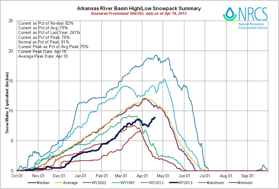
From The Mountain Mail (Joe Stone):
Natural Resources Conservation Service snowpack telemetry data for Thursday indicate the Arkansas River basin snowpack stands at 76 percent of average. However, SNOTel data from upper basin sites indicate significant snowpack gains during April. Fremont Pass snowpack reached 68 inches Thursday, up from 49 inches April 2. The Brumley SNOTel site southwest of Leadville shows a snow depth of 35 inches Thursday, compared to 26 inches April 2.
Late-season snowstorms also increase the possibility of a successful flow program for the multi-agency Voluntary Flow Management Program, White said. The program maintains minimum flows for the fishery throughout the year and provides enhanced flows for rafting and kayaking from July 1 through mid-August.


