Drought/snowpack news: Residents of Zinno Subdivision in Pueblo County opine the severity of water restrictions #codrought

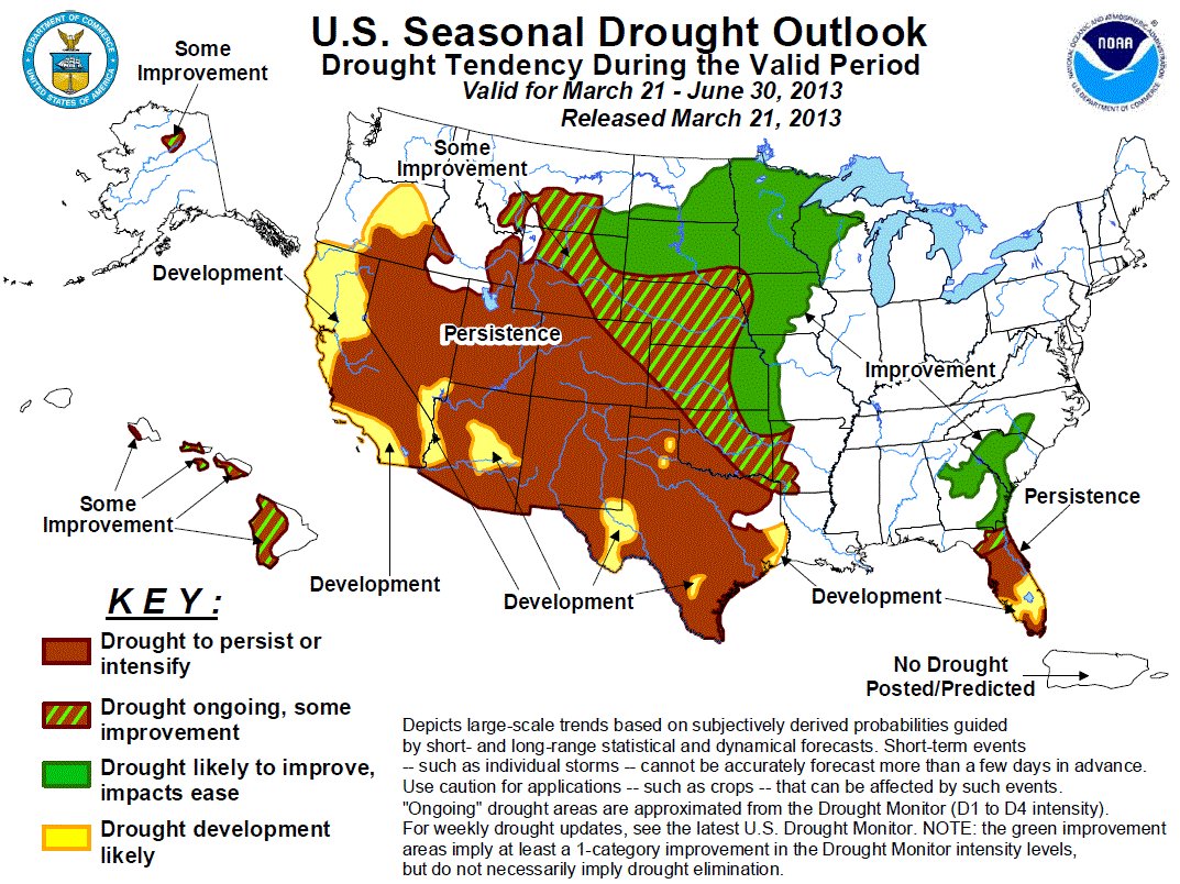
droughtoutlookcpcapriltojune2013

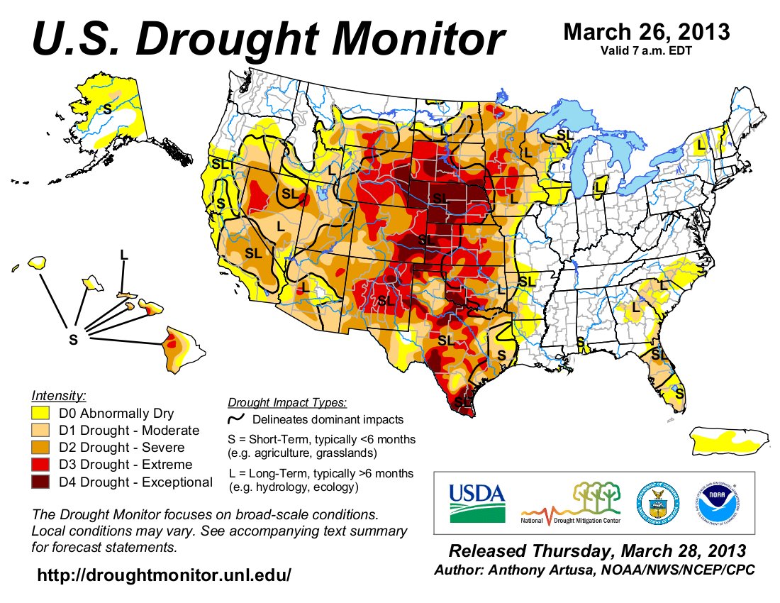
usdroughtmonitor04022013

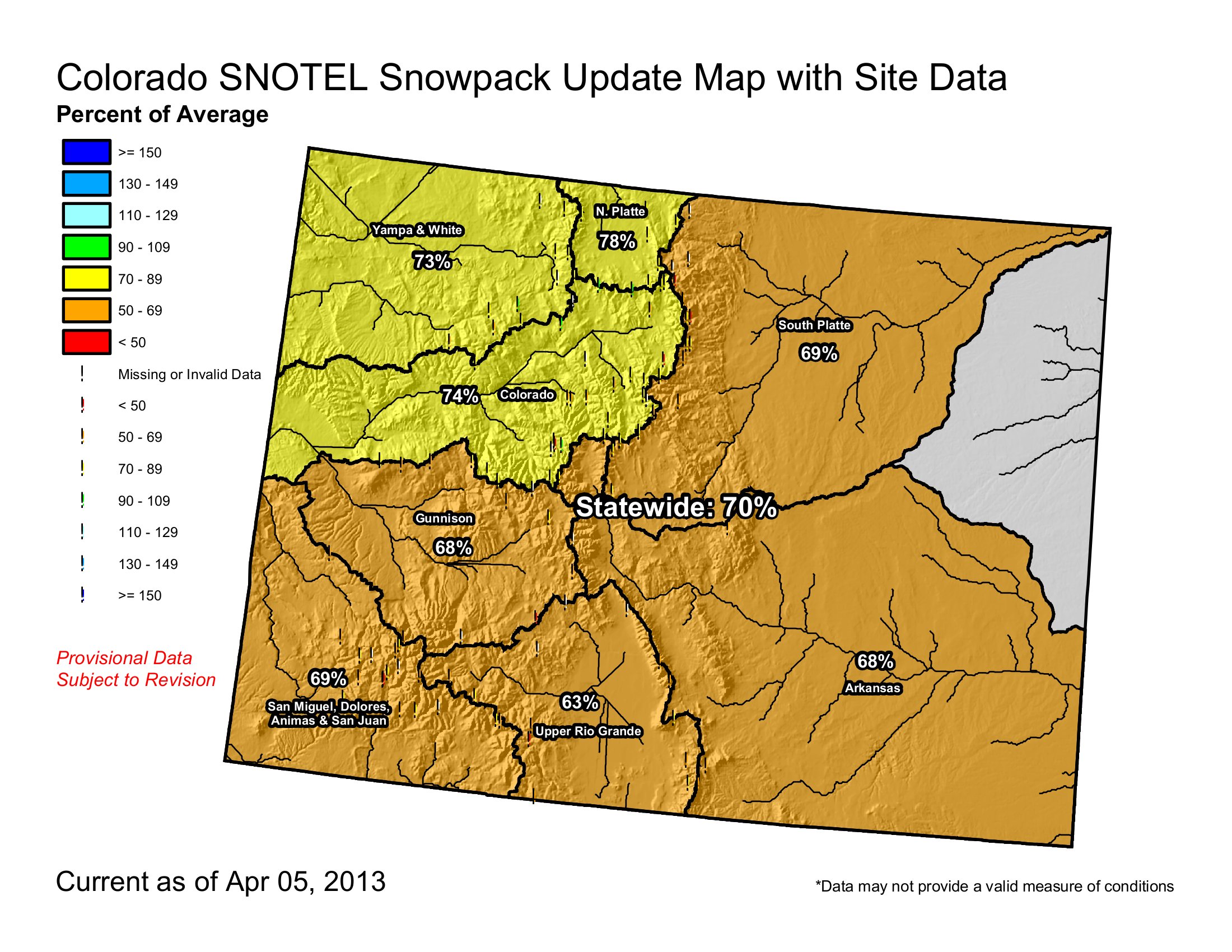
snowpackcolorado04052013

From KRDO (Dana Molina):

Residents of the Zinno Subdivision in Pueblo County said they recently received a letter stating their new water restrictions. According to the letter, each household can use only 62 gallons of water a day. Exceeding that limit results in fines. Outdoor watering results in a $1,000 fine. A second violation of outdoor watering restrictions results in a customer’s service being shut off. Residents said these are too strict to follow. “There’s no way I can live in fear every day,” [Melinda Ingo] said. “I have four children. I have to do laundry, I have to do dishes.”

The Joseph Corporation gets its water rights from the Colorado Water Protective and Development Association. In its letter to residents, it says the water restrictions come from the CWPDA.

But according to residents, the problem is how their neighborhood is being treated. A letter from the CWPDA refers to it as a farm unit.

David Stanford, utilities manager at the Joseph Corporation, said the area once was a farm unit. And that tapping into another water source would result in extremely high rates.

From The Mountain Mail (Joe Stone):

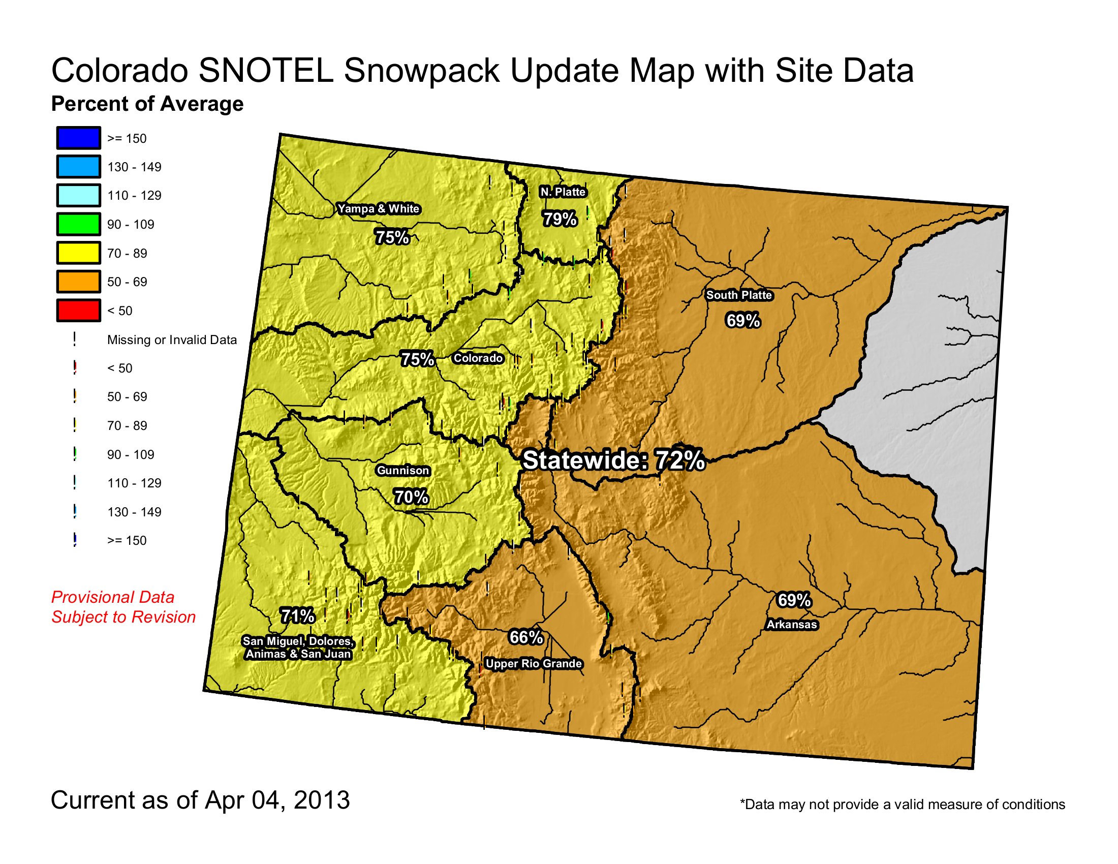
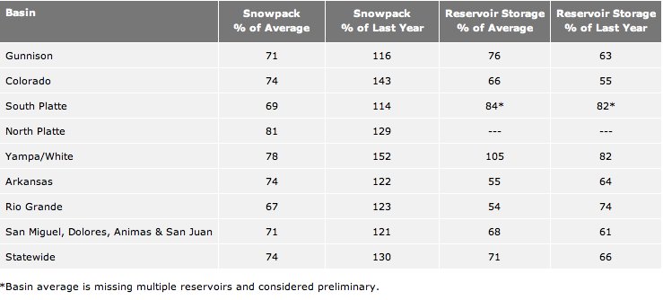
March snowfall increased snowpack in the Arkansas River basin to 74 percent of average, up from 71 percent March 1. Natural Resources Conservation Service data indicate snowpack percentages in the upper Arkansas basin ranging from 66 percent at Twin Lakes Tunnel to 88 percent at Porphyry Creek. While the numbers remain below average, snowpack stands at 122 percent of 2012 levels in the basin.

Reservoir storage in the basin stands at 55 percent of average and 64 percent of 2012 levels.

Phyllis Ann Philipps, state conservationist with the NRCS, said March snowfall “produced a nominal increase” in statewide snowpack, from 73 percent of average March 1 to 74 percent on April 1. Most major basins saw slight improvements to snowpack percentages during March, she said. “While the state snowpack remains well below normal, the good news is that most basins continue to accumulate snow and have yet to reach their peaks for the year.”

However, the southwest portion of the state saw significant decreases in snowpack percentages this month. The Gunnison and Upper Rio Grande basins saw declines of 3 and 11 percent, respectively. The combined San Miguel, Animas, Dolores and San Juan basins lost 12 percentage points. These basins have likely reached their peak snowpack for the year and are headed into the melt phase, Philipps said.

Colorado River basin snowpack, which supplies transbasin diversions into the Arkansas basin, increased from 70 percent to 74 percent of average. The South Platte and North Platte basin snowpacks increased by 6 percent.

The NRCS reports that Colorado receives approximately 20 percent of seasonal snow accumulation during March, but this year’s March snowfall was well below normal. April 8 is the average date of peak snowpack in Colorado, leaving “almost no chance that the snowpack will reach normal conditions before beginning to melt.”

Reservoir storage remains well below average statewide, and all major basins in Colorado are expected to see below-average streamflow runoff this spring and summer.

From The Denver Post (Jordan Steffen):

Heavy snowstorms and cooler temperatures helped boost Colorado’s statewide snowpack to 74 percent of average in March — almost double the levels at this time last year. Snow surveys showed that Colorado’s snowpack increased 1 percentage point from March 1 to April 1, according to the Natural Resources Conservation Service. That marks the third consecutive month that Colorado’s snowpack jumped by a percentage point…

All major basins in Colorado are expected to see below average runoff this spring and summer, according to the conservation service.

Reservoir levels in the state also remain below normal. As of April 1, average reservoir levels are at 71 percent of normal, 5 percentage points higher than this time last year.

Downlisting of Colorado pikeminnow delayed until 2018 #ColoradoRiver

coloradopikeminnow.jpg

From The Grand Junction Daily Sentinel (Gary Harmon):

Officials who had hoped to downlist the Colorado pikeminnow this year — a preliminary step toward removing it from the list of endangered species — are putting off the process until 2018.

The Colorado pikeminnow is one of four endangered fish species in the Colorado River. The forebears of the current population swarmed up and down the river in numbers so great that they were dubbed “white salmon.” Today, though, the pikeminnow is less the top predator and more often the food for non-native predators like the northern pike and smallmouth bass. That’s particularly true in the Yampa and White rivers, both northern Colorado tributaries that feed into the Green River and then into the Colorado River in Utah.

Colorado pikeminnow, once known as squawfish, are now most common in the Green and Yampa rivers, though the 15-mile stretch of the Colorado River through the Grand Valley is considered critical to survival of the fish. “We were hoping we were seeing a rebound” in the pikeminnow population of the Yampa River, said Tom Chart, Upper Colorado River Endangered Fish Recovery Program director.

The recent information. however, is that predators have feasted on pikeminnow, holding down the population and putting a damper on plans to downlist the species to threatened for five years to determine whether the species indeed has recovered.

The U.S. Fish and Wildlife Service collects data in three-year “bundles” and the next bundle is due to be complete in 2018, setting that year as a possible marker for downlisting. The pikeminnow population in the Green River has fluctuated between 2,200 and 4,500 and most recently has been on the increase, said Chart, a fisheries biologist. “But we’re not seeing that positive response on the Yampa.”

Deciding whether to downlist the pikeminnow, or other species, will require significant amounts of data, Chart said. “As biologists, we need long-term data sets to ensure populations are recovered,” he said. “We know populations will fluctuate naturally through time.”

A case in point is the Colorado River pikeminnow population, which now is between 600 and 800, Chart said. There has been a recent decline in the Colorado River population, but a data set that goes back to 1992 indicates a “fairly stable population,” Chart said.

The Upper Colorado River Recovery Program is a joint effort among the Fish and Wildlife Service, the states of Colorado, Utah and Wyoming, tribes, conservation organizations and other groups that works to manage the river to recover four species of endangered fish while allowing development of the river. In addition to the Colorado pikeminnow, the razorback sucker, humpback chub and bonytail are endangered.

More endangered/threatened species coverage here.

Permitting water projects: ‘…maybe we’re having the federal government check too many boxes’ — Randy Ray

nisp2

From The Greeley Tribune (Eric Brown):

New water-supply projects could come to fruition much faster if a Colorado congressman has his way in Washington. Rep. Cory Gardner, R-Colo., is piecing together a bill aimed at speeding up the federal permitting process for new water endeavors, if they are endorsed by the governor of that state.

Many regional water projects have been in the federal permitting stages for years, with participants having spent millions of dollars along the way, and they still have no guarantee the projects will be built.

Brian Werner — a spokesman for the Northern Colorado Water Conservancy District, which is overseeing efforts to build the Northern Integrated Supply Project, or NISP — said the project has been in its federal permitting phase since 2004, with the 15 participating cities and water districts having already spent about $12 million. He suspects the process will go on for yet another year. Gardner said it’s taking “way too long.”

The details of his bill aren’t finalized, but Gardner said it could call for federal agencies to say “yay” or “nay” on a proposed water project within six to nine months after a governor puts his support behind it.

Colorado Gov. John Hickenlooper has yet to endorse NISP, which would supply its partners with 40,000 acre feet of new water supplies annually, if ever built.

Opponents say water-storage projects like NISP could interfere with river flows and impact wildlife, fisheries, forests and recreational use.

Gardner and others say that — with future water shortages expected for a number of regions — new water-supply projects must get a “yay” or “nay” quicker, so those projects can get built or participants can go back to the drawing board. Agriculture, the biggest user of water, will suffer the most if these lulls continue, Gardner added.

Participants of large-scale, water-supply projects must work with the U.S. Army Corps of Engineers, Environmental Protection Agency, U.S. Fish and Wildlife and others to make sure all needed wildlife-, habitat- and environmental-protection measures are taken before dirt is moved. “No doubt; mitigation efforts need to be taken,” said Randy Ray, executive director with the Central Colorado Water Conservancy District in Greeley. “But maybe we’re having the federal government check too many boxes.

“I’d like to see the federal government have more faith in the state, the local water districts and the engineers who are working on these projects.”

Without new water-supply projects in the region, farmers and some water experts worry that growing cities will continue buying up farmland and agricultural water rights in the future to meet their growing needs.

The Colorado-Big Thompson Project, the largest water project in northern Colorado, has seen its water go from 85 percent owned by agricultural users, to now 34 percent owned by agricultural users. Many farmers have sold rights in times when farming wasn’t profitable. Farmers who need water today now depend on leasing it from the cities who own it. But in dry times, like this year, cities say they don’t have enough water in storage to lease to agriculture.

If Colorado had NISP-like projects in place already, Werner and others say, the above-average snowpacks of recent years would have filled those reservoirs, local cities and farmers would have more water in storage now and they would be in much better shape to endure the ongoing drought. Instead, during 2009, 2010 and 2011, a total of about 1.4 million acre-feet of water above what’s legally required flowed from Colorado into Nebraska, according to Werner. “Even if we could have captured just some of that in new reservoirs, how much better off would we be right now?” Werner asked.

Colorado’s ag industry has a $40 billion impact on the state, the second-largest contributor to Colorado’s economy, behind oil and gas.

But according to the 2010 Statewide Water Initiative Study, the South Platte River basin in northeast Colorado could lose as much as 190,000 acres of irrigated farmland by 2050 due to water shortages. Farmers and water experts agree that conservation and water-sharing projects could help Colorado meet its growing water needs, but they say new water-storage projects will also be needed.

Ray didn’t want to comment specifically on Gardner’s bill, but he stressed the need to speed up the federal permitting process for new water projects. He explained that the Central Water and others have been discussing the Chatfield Reservoir Reallocation Project since the 1980s, but are still working with the federal government to get all permitting in order. “It needs to change,” he said “Because we’re not getting anywhere.

“And we really need to get somewhere.”

More Northern Integrated Supply Project coverage here and here.

Greeley: NWS Weather Spotter training April 22 #cowx

altocumulusstandinglenticularcloudsbouldernws.jpg

From The Greeley Tribune:

A weather spotter training class, presented by the National Weather Service, will take place at 7 p.m. April 22 at the Weld County Administration Building, 1150 O St. in Greeley. The training is free and open to the public and hosted by the Weld County Office of Emergency Management and the City of Greeley Office of Emergency Management. Attendees will learn about different types of tornados and thunderstorms, how to spot and report severe weather and how to stay safe in the event of tornados, floods and lightning.

To make a reservation, call Gracie Marquez at (970) 304-6540 or email gmarquez@weldgov.com.

‘As long as there is water in the river, Florence would have water’ — Craig Lis

florence.jpg

From the Cañon City Daily Record (Charlotte Burrous):

“We’ve got enormous issues,” said City Manager Mike Patterson. “We also have a lot issues that we’ll always have, capital and improving our system. Storage is another huge issue. The city’s water right is very substantial. We could put a call on just about anybody on the river. As long as there is water in the river, Florence would have water.”

During the meeting, Lis responded to criticisms made about annexation.

“He really addressed the city’s growth potential and assured everybody, we are actually in very good shape in terms of Florence’s water rights,” Patterson said. “(Lis also) addressed the shortages that are occurring already.”

Rockvale is already on water restrictions, but Patterson said he did not know what those were.

“It would take a significantly worse situation from where we’re at now (to affect Florence),” he said. “There would have to be no water in the river for Florence to be in that situation because Florence does have a very significant water right and a very senior water right (1861).”[…]

“(The meeting) was filled with caution, but it was really very optimistic about the city’s future,” Patterson said. “There were some strong cautions there. One of the things Florence has to be aware of is every year, there are potential amendments (that could go) to the people and there are some things that could go through the legislature. Although

Florence has done a great job in protecting its water and its senior water rights, there are things that are out of our control that could dramatically impact our water future. There’s an element of ‘use it or lose it’ so we have to be very careful with our water.”

More Arkansas River Basin coverage here and here.

Chaffee County releases 1041 geothermal regulations

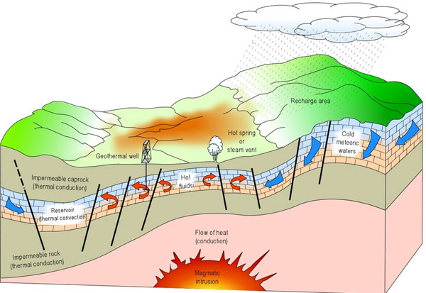
geothermalenergy.jpg

From The Mountain Mail (James Redmond):

Chaffee County officials released the draft version of their geothermal 1041 regulations and posted them on their website Thursday, in response to the release of draft regulations from partner Ouray County. To develop geothermal 1041 regulations, Chaffee County partnered with Archuleta and Ouray counties and Pagosa Springs to hire a consultant for the process, Jenny Davis, Chaffee County attorney, said.

With Ouray County releasing its draft regulations, which Davis said she presumes “are similar” to Chaffee County’s, “we’ve decided to just go ahead and release what we have.” The draft regulations “are subject to change,” and she said she thinks the consultant, Barb Green, will give the county a revised draft soon.

After the partners received a grant, Chaffee County’s portion of the contract for the consultant comes to $2,937.50, Don Reimer, Chaffee County development director, said.
County staff gave Green a list of concerns the county wanted to be included in its regulations, Reimer said. The county asked that the regulations contain clear language for development criteria; not conflict with state and federal regulations; protect the land use on adjacent and nearby properties; and protect water quality and rights.

Chaffee County currently has 1041 regulations for “Efficient Utilization of Municipal and Industrial Water Projects,” “Site Selection of New Domestic Water and Sewage Treatment Systems” and “Extension of Existing Domestic Water and Sewage Treatment Systems,” which the county adopted in 1991 and revised in 2003.

In 2003 the county also adopted 1041 regulations for “Site Selection and Development of New Communities” and “Regulations for Development in Areas Containing or Having a Significant Impact Upon Natural Resources of Statewide Importance.”

Reimer said, in his 10 years working at the county, only two 1041 applications did not get a statement of “no impact,” the Nestlé Waters application and the Pueblo West application for Hill Ranch, both of which went through the full process.

The draft regulations would prevent commercial electricity production using geothermal resources without first obtaining either a permit or statement of no impact. The regulations would apply to commercial electricity production on public and private land in unincorporated Chaffee County. The draft regulations would define and establish general regulatory provisions, designate of commercial geothermal energy production as a matter of state interest, and establish an application and review process.

The application process would consist of a pre-application conference; application submittal, determination of completeness, determination of eligibility for a statement of no impact and a permit review process.

The review process would include the Planning Commission and county staff.

Chaffee County officials also changed the date of the work session at which regulations will be discussed to 1:30 p.m. May 7 because the consultant could not make the original April 25 meeting, Davis said. The county will have the most current version of its geothermal 1041 draft regulations on its website, chaffeecounty.org.

More geothermal coverage here and here.

‘I’ve had a glorious and joyful run’ — Ken Salazar

kensalazarnewmexicoindependent.jpg

From The New York Times (John M. Broder):

“I’ve had a glorious and joyful run,” he reflected on Thursday about his four years at the top of the Department of the Interior and, before that, his four years in the Senate. “Coming to work, I’ve just been living the dream every day.”

Mr. Salazar, 58, took over an agency that had been the scene of rampant financial scandal and political malpractice in the Bush administration and succeeded in restoring a measure of ethics and morale. He had the good fortune of suffering his greatest setback — the BP oil spill in the Gulf of Mexico that laid bare persistent flaws in the agency’s regulation of offshore oil and gas operations — relatively early in his tenure.

He hired an experienced former federal prosecutor, Michael R. Bromwich, to revamp the discredited Minerals Management Service, whose mission was to prevent such drilling disasters. Its successor agencies, although still short on money and staff, have tightened oil and gas permitting and regulation and have managed, so far, to remain scandal-free.

Mr. Salazar also escaped without serious harm from a second serious miscalculation — allowing the Shell Oil Company to begin exploring for oil and gas off the North Slope of Alaska before it had the equipment, personnel or management skill to handle the challenges of working in the Arctic environment.

Though Shell had repeated accidents and delays, no one was injured and no oil spilled, in part because the regulators at the Interior Department blocked them from drilling into oil-bearing zones.

“We told Shell that we were proceeding with the utmost caution and would be watching them every step of the way,” Mr. Salazar said in a farewell interview in his expansive corner office. “The 2012 season was one in which much was learned but where we also stuck to the bright line of their meeting the requirements of their permits.”[…]

Mr. Salazar said that among the unfinished items on his agenda was an effort to expand the public lands under permanent protection. Bruce Babbitt, interior secretary under President Bill Clinton, criticized President Obama in February for lagging behind his predecessors in setting aside lands for conservation. Last month, the president designated five sites to be protected as national monuments, including parts of the San Juan Islands in Washington State and 240,000 acres of the Rio Grande del Norte in New Mexico.

2013 Colorado legislation: A look at the week ahead from the Fort Collins Coloradoan #coleg

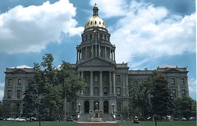
coloradocapitolfront.jpg

From the Associated Press via the Fort Collins Coloradoan:

FIGHTING FIRES

Last year’s devastating fire season has prompted lawmakers to think about establishing a state firefighting fleet. Under the bill, a new division would have the power to buy or lease firefighting aircraft. The bill faces its first test in a Senate committee on Thursday.

DRILL DEBATES

Democratic efforts to put new limits on oil and gas drillers continue this week. A House committee hears two of them Thursday, including a bill to allow local governments to charge for drill-site inspections. Another bill would commission a study of whether Front Range drilling operations can harm human health.

From The Denver Post (Mark Jaffe) via the Loveland Reporter Herald:

Drilling for oil and gas has nearly doubled on the Front Range since 2006, sparking local concerns and seven legislative bills — with more possible. Some bills focus on the Colorado Oil and Gas Conservation Commission, the agency overseeing oil and gas development. The measures seek to boost inspections, increase spill reporting, raise fines and limit industry influence. Others seek to buttress the role of local government in overseeing oil and gas development…

In 2013, the two largest operators in the region, Anadarko Petroleum Corp. and Noble Energy, are poised to spend more than $3.2 billion on Front Range oil and gas development and drill about 650 wells. The discretionary portion of the state’s budget, by comparison, is about $8.2 billion. For Hickenlooper, who supports oil and gas development and maintains that the state has sole control over regulating drilling, the Democrat-sponsored and -supported bills create a dilemma. “I am very sympathetic to communities that are seeing a changing landscape and are worried about an industrial activity within a thousand feet of their homes,” Hickenlooper said in an interview. “But what are you going to do, take away everyone’s mineral rights?”[…]

In 2012, Colorado oil production reached a 51-year high — 48 million barrels — and Anadarko and Noble are projecting drilling about 1,600 wells in the next five years. In February, ConocoPhillips announced that it had found a “sweet spot” in the Arapahoe-Adams County area and is planning to drill 38 wells this year. Almost all the activity has been in Weld County, but local officials in neighboring areas are struggling, as drilling spreads, to meet their residents’ concerns over health, safety and property values. “As a local official, you feel your hands are tied,” said Rep. Dominick Moreno, D-Commerce City. “That’s why you are seeing these bills in the legislature.”

A lack of confidence in state regulators is also fueling much of the debate…

“The people rose up and did this because they are not getting satisfaction from their government,” Kaye Fissinger, a spokeswoman for the citizens group Our Health, Our Future, Our Longmont, testified at a hearing. “They were not getting satisfaction from the Colorado Oil and Gas Commission,” Fissinger said.

The administration is trying to find common ground with legislators on some of the bills, Matt Lepore, the executive director of the oil-and-gas commission, said in an e-mail.

But bills requiring an $8.2 million increase in oil and gas inspectors and blocking anyone paid by the industry from serving on the commission — which has three industry-designated seats — are problems, administration officials said. “You want to think very carefully before you change the commission’s mission,” Hickenlooper said…

“It will be interesting to see what the governor does,” said Peter Maysmith, executive director of Conservation Colorado, an environmental group supporting the bills.

“Representatives are bringing their constituents’ concerns about a state agency they do not see as being responsive,” Maysmith said. “This is democracy playing out.”

More 2013 Colorado legislation coverage here.

Forecast news: Eight to twelve inches of snow forecast for some of the mountains, Monday into Tuesday #codrought #cowx

From the National Weather Service Pueblo office:

Active weather over Colorado beginning late Monday through Tuesday. A strong area of low pressure will bring snow to the mountains beginning Monday night, continuing through Tuesday afternoon. Thunderstorms will be possible Monday night across the San Luis Valley, I-25 corridor, and the eastern plains north of Highway 50. After a strong cold frontal passage early Tuesday, snow showers will be possible in those areas Tuesday afternoon. Blizzard conditions are possible across the Palmer Divide beginning early Tuesday morning.

From the National Weather Service Grand Junction office:

Another minor disturbance, indicated by the brown line over northern Nevada, will move across Colorado and Utah this afternoon bringing another chance for some rainshowers and thunderstorms. The closed low just off the Pacific Northwest coast will start dropping southeast today along with a strong cold front causing inclement weather Monday through Wednesday. Snow will overspread the area late Monday night through Wednesday with all mountainous terrain seeing snow accumulations with some valleys also possibly seeing some snow. Also, the pressure gradient will tighten up causing winds of 35 to 40 mph with gusts possibly reaching 60 mph over the eastern Uintas and northwestern Colorado. These winds mixed with snowfall may create blizzard conditions so a blizzard watch has been issued for those areas. Most mountainous terrain have winter weather watches in place valid from Monday evening through Tuesday evening. Snow accumulations of 8 to 12 inches are possible with locally higher amounts expected.

Say hello to the Summit County Citizens Voice

frisco.jpg

Click here to read an article about the Summit County Citizens Voice written by the purveyor, Bob Berwyn. He does a terrific job up in Summit County. Here’s an excerpt:

We also try to offer sustained and in-depth coverage of Colorado water issues, important any time, but absolutely critical in years of drought, when the outlook for summer water supplies is uncertain. Already, key players in the Colorado water stage are jockeying and juggling, trying to make a meager supply last through a long, hot summer. This past week, we reported on a Colorado River deal that will enable more storage in the Colorado River headwaters region.

Another story about the Colorado snowpack used charts and graphs to help illustrate the state’s ongoing drought conditions. Although parts of the high country did get some decent snows in March, it wasn’t nearly enough to alleviate overall drought conditions. In a typical winter, March accounts for 20 percent of the seasonal snow accumulation, but this year’s March snowfall was well below normal at most SNOTEL sites, with the exception of the South Platte and Colorado River basins. Read the story here.

I follow the Summit Voice on Twitter and have linked to them hundreds of times over the years since the venture began.

USGS: Progress Toward Establishing a National Assessment of Water Availability and Use

watershedregionsunitedstatesmap.jpg

progresstowardestablishinganestimateofwateravailability.jpg

Here’s Circular 1384 from the United States Geological Service. Here’s the introduction to the report (Alley, W.M./Evenson, E.J./Barber, N.L./Bruce, B.W./Dennehy, K.F./Freeman, M.C./Freeman, W.O./Fischer, J.M./Hughes, W.B./Kennen, J.G./Kiang, J.E./Maloney, K.O./Musgrove, MaryLynn/Ralston, Barbara/Tessler, Steven/Verdin, J.P):

Executive Summary

The Omnibus Public Land Management Act of 2009 (Public Law 111-11) was passed into law on March 30, 2009. Subtitle F, also known as the SECURE Water Act, calls for the establishment of a “national water availability and use assessment program” within the U.S. Geological Survey (USGS). A major driver for this recommendation was that national water availability and use have not been comprehensively assessed since 1978.

This report fulfills a requirement to report to Congress on progress in implementing the national water availability and use assessment program, also referred to as the National Water Census. The SECURE Water Act authorized $20 million for each of fiscal years (FY) 2009 through 2023 for assessment of national water availability and use. The first appropriation for this effort was $4 million in FY 2011, followed by an appropriation of $6 million in FY 2012.

The National Water Census synthesizes and reports information at the regional and national scales, with an emphasis on compiling and reporting the information in a way that is useful to states and others responsible for water management and natural-resource issues. The USGS works with Federal and non-Federal agencies, universities, and other organizations to ensure that the information can be aggregated with other types of water-availability and socioeconomic information, such as data on food and energy production. To maximize the utility of the information, the USGS coordinates the design and development of the effort through the Federal Advisory Committee on Water Information.

A National Water Census is a complex undertaking, particularly because there are major gaps in the information needed to conduct such an assessment. To maximize progress, the USGS engaged stakeholders in a discussion of priorities and leveraged existing studies and program activities to enhance efforts toward the development of a National Water Census.

From The Pueblo Chieftain (Chris Woodka):

The census is being developed by the U.S. Geological Survey and will provide additional tools for water planners to use in making projections. The survey will look at competing demands for water resources and supply scenarios.

Water planning of this type already is occurring in water-short areas.

The Bureau of Reclamation last year completed an assessment on the Colorado River. The Colorado Water Conservation Board has developed decision-support systems for the Colorado River and Rio Grande basins and is working on similar models for the South Platte and Arkansas river basins.

More USGS coverage here and here.

Arkansas River Basin: Two Rivers acquires Sunset Metropolitan District land, plans reservoirs near Avondale

arkansasriverbasin.jpg

From The Pueblo Chieftain (Chris Woodka):

An El Paso County water district could be used to fund a plan to build reservoirs on the Arkansas River in Pueblo County. Two Rivers Water and Farming Co. has acquired all of the land inside the Sunset Metropolitan District near Colorado Springs and plans to use the district’s bonding capacity to build reservoirs on the Arkansas River near Avondale. Two Rivers plans to amend the Sunset district’s service plan to focus on rotational farm fallowing in the Arkansas River Basin, CEO John McKowen said in a press release last week.

The plan includes changing the district’s name to Farm-City Metropolitan District and using the district’s bonding capacity to finance water infrastructure projects that support rotational farm fallowing, he said. The district has a bonding capacity of $130 million, with no bonds currently outstanding. It was originally formed to provide water to a housing development. “The district’s service plan will be amended so farmers can build and comanage the water infrastructure that supports farmers,” McKowen said.

Collaborative rotational farm fallowing agreements between farmers and municipalities make surplus urban water available for irrigation and conversely make irrigation water available for urban use during droughts without permanently drying up farmland.

Two Rivers is in discussions with the Pueblo Board of Water Works, Colorado Springs Utilities and others to develop 25,000 acre-feet of new storage. Two Rivers expects to acquire properties on which it will construct gravel pit reservoirs and lease a portion of the water storage space to municipalities in exchange for being provided longterm leases of excess municipal water to be used for irrigation. Two Rivers anticipates restoring as much as 25,000 acres of farmland in Pueblo County, planting a mix of high yield and higher value vegetable and fodder crops.

More Arkansas River Basin coverage here and here.

Forecast news: Strong spring storm heading our way, heavy mountain snow, strong thunderstorms east #codrought #cowx

From the National Weather Service Pueblo office:

The weather will become more active across Colorado early next week. A strong area of low pressure will move across the southern half of the state Monday and Tuesday. Heavy mountain snows and strong to severe thunderstorms across the eastern plains are possible Monday afternoon and evening. After a strong cold frontal passage on Tuesday, snow may be possible across the San Luis Valley, I-25 corridor, and the eastern plains. Some forecast uncertainty exists in the track of the low pressure center.

From the National Weather Service Grand Junction office:

Another wave will move across the area this afternoon and evening bringing some clouds, rainshowers, and thunderstorms. The big story though is the area of low pressure off the coast of British Columbia that will start dropping to the southeast today. By Monday, widespread precipitation is expected ahead of the cold front depicted for all mountainous terrain and maybe some northern valleys. This unsettled weather will continue through early Wednesday morning. After that, two more disturbances are expected Thursday evening and again Friday evening.

Snowpack/drought news: 2 inches of fresh snow at Vail Mountain #codrought

droughtoutlookcpcapriltojune2013

usdroughtmonitor04022013

snowpackcolorado04052013

From the Denver Business Journal (Cathy Proctor):

In the last six years, Denver Water’s customers have reduced water use by 20 percent. Now, faced with a severe “Stage 2” drought, the state’s largest water utility wants its business and residential customers to cut that by another 20 percent in the next 12 months. “This is going to affect all our customers,” said Jeff Tejral, manager of conservation for Denver Water. “For our commercial and industrial customers, we’re expecting them to be leaders in the community. We want them to see this as a challenge and opportunity.

From The Denver Post (Betty Cahill):

Water restrictions have both good and not-so-good consequences. First, sprinkler clocks and run times need to be adjusted (not easy for some folks). Second, restrictions prompt us to pay closer attention to landscape care. Whether you garden using containers on a patio or live on an acre, now is the time to think through your game plan.

NRCS: The April Colorado Basin Outlook Report is hot off the press, read it and weep #codrought

bornrcshorseshoebasinsouthplatteapril2013

Click here to read the report. Here’s the introduction:

Summary

Unlike last year, the month of March continued to bring snow to Colorado. Unfortunately the state’s snowpack, as of April 1, only showed a nominal increase from last month’s report. Beneficial storms and relatively cool temperatures helped maintain the snowpack in the mountains but were not able to bring it closer to normal conditions. This marks the fourth consecutive month of below average snowpack for the state as well as the third consecutive month of below average precipitation in the mountains. Forecasts for spring and summer streamflows are well below average across the entire state with many streams expected to see volumes that are below 50 percent of average. We are also still feeling the ill effects of the previous year’s paltry snowpack and the resulting streamflow runoff, in our reservoirs. The majority of the state’s major river basins are reporting well below average reservoir storage. Judicious use of our existing supplies will be critical in minimizing impacts this season and there is always the potential for unexpected late season snowfall and above average spring precipitation to help ease impacts.

Snowpack

Overall the snowpack percentage for the state inched up during March. Current readings are now are 74 percent of median; up 1 percentage point from the report on March 1. On the bright side, the current snowpack is 130 percent of last year’s April 1 snowpack report. By this time last year the statewide snowpack had already peaked and was melting rapidly. This year snow continued to accumulate in the mountains during March; however the storms were more focused on the northern mountains and the Front Range and missed the southwest portion of the state. While the snowpack percentages did increase in most basins, not all watersheds showed improvement, and some saw a substantial decline. The Upper Rio Grande basin dropped 9 percentage points from the March 1 readings and the combined San Juan, Animas, Dolores, and San Miguel basins lost 10 percentage points. The lowest snowpack percentages in the state occur in the Upper Rio Grande and the South Platte basins which are both at just 69 percent of median. The state’s best snowpack percentage occurs in the North Platte basin which is at 81 percent of median; the Yampa and White basins are close behind with a snowpack at 78 percent of median. All basins currently have snowpacks that are better than those reported last year at this time; but comparing bad to worse could be considered a moot point.

Precipitation

Precipitation totals for the month of March, measured at SNOTEL sites across the state, were mostly below average. Statewide precipitation for the month was just 76 percent of average. The South Platte and the Colorado basins actually recorded precipitation in the mountains that was close to average. The South Platte reported totals at 97 percent of average and the Colorado was at 96 percent of average. The driest basins this month were the Upper Rio Grande and combined San Juan, Animas, Dolores, and San Miguel basins with precipitation totals at only 47 percent and 56 percent of average respectively. Precipitation in the remaining basins ranged from 84 percent of average in the Yampa, White and North Platte basins to 63 percent of average in the Arkansas. Water year to date totals range from only 66 percent of average in the Upper Rio Grande basin, to 78 percent of average in the Yampa, White and North Platte basins. Water year to date precipitation for the state is at 73 percent of average.

Reservoir Storage

Statewide reservoir storage was reported to be 71 percent of average at the end of March. The combined Yampa and White River basins boast the highest storage amounts in the state, currently storing 105 percent of average volumes for this date; though the basin has the fewest reservoirs and lowest capacity for storage. Storage volumes in the other major basins range from 84 percent of average in the South Platte basin, to 54 percent of average in the Upper Rio Grande basin. Statewide storage volumes are way below where they were this time last year. Last year at this time, the reservoirs in the state were storing 3,651,000 acre-feet of water which was 108 percent of the average volumes. This year the reservoirs are storing 2,421,000 acre-feet of water for agricultural and municipal use this season.

Streamflow

Colorado’s water users can anticipate very low streamflow volumes this summer. Due to extremely poor snowpack conditions spring and summer streamflow volumes may approach the minimum volumes on record in some areas. The projected inflow into Dillon Reservoir calls for 66 percent of average flows; forecasts for some areas of Colorado River basin are even lower. Clear Creek at Golden is expected to flow at 72 percent of average from April to July and the forecast for the Big Thompson River is only 52 percent of average. The Gunnison and Upper Rio Grande River basins have some of the lowest forecasts in the state. Tomichi Creek at Gunnison is only expected to see volumes that are 34 percent of average and Sangre de Cristo Creek’s forecast calls for flows that are 29 percent of average. All of these forecasts assume normal precipitation amounts throughout the forecast period.

Special Note on Interpreting Forecasts

According to the National Water and Climate Center (NWCC), “a water supply forecast is a prediction of streamflow volume that will flow past a point on a stream during a specified season, typically in the spring and summer. These forecasts are given not as a single number, but as a range of numbers to reflect risk and forecast uncertainty. Each month, five forecasts are issued for each forecast point and each forecast period. Unless otherwise specified, all forecasts are for streamflow volumes that would occur naturally without any upstream influences.”

The forecasts we typically emphasize in this report are the 50 percent exceedance probability forecasts because they are in the middle of the range of forecasts with 50 percent chance that actual volumes will be above or below the predicted volume. The 50 percent exceedance forecasts assume that typical weather patterns will prevail into the forecast season. In a water year such as this one, when conditions have been anything but typical, it is important to pay attention to the other forecasts provided. If dry conditions prevail into the rest of this spring and summer it may be prudent to use the 70 or 90 percent exceedance forecasts for management purposes this season. If we continue to receive snowfall late into the season or above average precipitation this spring, actual streamflow volumes may be more in line with the 50 or 30 percent exceedance forecasts.

Parachute Creek spill: Residents ask state to take over testing at the creek #ColoradoRiver

parachutecreekspillmarch2013

From the Glenwood Springs Post Independent (John Colson):

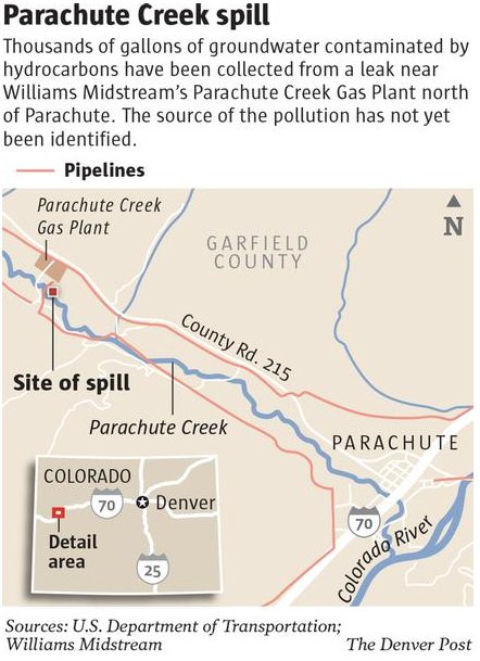
Area residents, concerned about the discovery of extremely high levels of the toxic compound benzene 10 feet from the banks of Parachute Creek, are calling on state officials to take over the water-sampling duties currently being conducted by a private company. That company, Bargath LLC of Oklahoma, is listed by the Bloomberg Businessweek website as a “subsidiary of Williams Companies, Inc.,” the parent company of Williams Midstream and WPX Energy. Bargath, according to statements from the Colorado Oil and Gas Conservation Commission, has been in charge of water sampling from Parachute Creek and from two groups of water-quality monitoring wells, one group at about 30 feet from the creek and a second group just 10 feet from the creek.

In an e-mail to Matt Lepore, director of the COGCC, Silt resident Carl McWilliams pointed out that Bargath in late 2012 was fined $275,000 for violations of the state’s stormwater-management regulations in its operations in Garfield County…

“Please notice the ‘joined-at-the-hip’ association Bargath LLC has with Williams,” wrote McWilliams. “Based upon the unthinkable environmental devastation benzene has to aquifers and ground water, and the totally unacceptable track record of Bargath LLC and Williams Production on water issues in Garfield County, this email to you is a formal demand that the COGCC immediately implement laboratory water testing of the ground water and aquifer (in the area of the plume).”

Steve Gunderson, director of the Water Quality Control Division of the Colorado Department of Public Health and Environment, disagreed with McWilliams’ concerns. “Certainly, this pipeline leak is a significant and serious situation,” Gunderson said. But, he continued, “It’s an apples-and-oranges type of thing” compared to the stormwater violations in Bargath’s 2012 violations.

From the Northern Colorado Business Journal (Steve Lynn):

A benzene spill that contaminated groundwater near Parachute Creek on the Western Slope has renewed calls by conservationists for increased buffers between oil and gas facilities and streams, rivers and lakes. Such spills could have a major impact in heavy production areas such as Weld County, which lies in the heart of the South Platte River Basin. Weld, with 20,000 wells, is the most active production area in the state…

“This was one of the things that was still outstanding, the riparian setback issue,” said Bob Meulengracht, Colorado coordinator of Sportsmen for Responsible Energy Development. “The (Colorado Oil and Gas Conservation Commission) was supposed to convene a stakeholder group to look into this.”

The state of Colorado said it has instead focused on buffers between oil drilling and buildings, which regulators expanded from 350 feet in urban areas and 150 feet in rural areas to a uniform 500 feet earlier this year. Drilling cannot take place within 1,000 feet of buildings housing large numbers of people, including schools, nursing homes and hospitals, without a hearing before the commission. Regulators also passed stricter groundwater monitoring measures, though those rules do not pertain to streams, rivers and lakes.

The state passed some regulations protecting fisheries and drinking water infrastructure in 2008. It adopted a rule to create setbacks and mitigation requirements near areas with drinking water infrastructure as well as a 300-foot buffer from streams designated as “gold medal” streams and those containing cutthroat trout. But environmentalists believe the regulations do not go far enough, saying that oil and gas spills could contaminate water supplies and harm wildlife. “Right now, other than gold medal trout waters and cutthroat trout waters, we have virtually nothing to protect our riparian areas,” Meulengracht said. “We all know that accidents happen; we’re seeing that up in Parachute.”

The Colorado Wildlife Federation believes oil and gas companies should adopt “reasonable” setbacks from water ways, said Suzanne O’Neill, executive director of the environmental group. “We don’t believe one size fits all, because there are a lot of factors that would go into it,” she said.

In Gunnison County, elected leaders did not wait for the state to overhaul its water-way setback regulations. County commissioners last year passed 150-foot buffers between oil and gas development and bodies of water. The regulations also call for another buffer from 150 to 500 feet where elements of the operation can occur. However, companies must take additional steps, such as building two-foot-tall berms around the edge of the well pad facing a body of water. “The goal is to allow the operators to extract the resources that they own, but to do that in a way that’s environmentally safe and safe for humans,” County Manager Matthew Birnie said…

Williams had removed nearly 4,300 barrels of groundwater and 140 barrels of hydrocarbons from the spill near Parachute Creek, discovered last month. Samples taken by the state oil commission had shown no evidence that the creek was contaminated.

From The Grand Junction Daily Sentinel (Dennis Webb):

Authorities on Wednesday installed and sampled three new monitoring wells within 10 feet of Parachute Creek, one day after high benzene levels were reported within the same distance of the creek. The results of those samples, along with another round of samples taken from the surface of the creek itself, were not available.

Benzene levels as much as 800 times more than the federal drinking water standard were found Tuesday in shallow groundwater in a monitoring well just 10 feet from the banks of the creek at the site of a liquid hydrocarbon leak. State officials continue to say that testing of the creek water continues to show no signs of contamination from the leak. Sampling results from well completed Tuesday show benzene levels of 1,900 to 4,100 parts per billion. The Environmental Protection Agency’s maximum allowable level for benzene, a carcinogen, in drinking water is 5 ppb. Readings from three other wells farther from the creek and closer to the contamination site have shown readings ranging from 5,800 ppb to 18,000 ppb.

The highest reading is near a recovery trench dug as part of the leak cleanup. That trench, and the area around an above-ground valve set for a 4-inch-diameter natural gas liquids line from Williams’ nearby gas processing plant, are being investigated as possible sources of what investigators think may have been historic releases of hydrocarbons. No active leak sources have yet been found.

Williams spokeswoman Donna Gray said Tuesday the 4-inch line went into service in 2008. The contamination was discovered by Williams in a pipeline corridor March 8 as it was doing location work. Some 6,000 gallons of hydrocarbons were recovered.

Colorado Department of Natural Resources spokesman Todd Hartman said the new monitoring well is about 325 feet southeast of the valve set and recovery trench. Investigators for the Colorado Oil and Gas Conservation Commission believe groundwater is flowing from the creek toward the contamination site, rather than vice versa, which is helping protect the creek from contamination.

Parachute Creek provides irrigation water to the town of Parachute. Town Administrator Bob Knight said Tuesday the town usually releases water from the creek into its irrigation reservoir on April 15. “We are hoping this matter is resolved long before that. But I have no intention of turning water into the reservoir until it is cleaned up and the leak has been found or whatever is causing that,” he said.

He said some residents probably will use the town’s domestic water system for irrigation, which will put more strain on the system’s treatment plant. “But we believe we can handle it for the interim,” he said.

From The Grand Junction Daily Sentinel (Dennis Webb):

A federal agency is looking at plugging a hole in the regulation of oil and gas gathering pipelines. The Pipeline and Hazardous Materials Safety Administration, part of the Department of Transportation, is considering regulating all gathering pipelines, which would close a loophole applying to many lines in Colorado and other states.

Gathering lines deliver oil, gas and associated substances from production areas to processing facilities.

For gas gathering lines, the agency’s pipeline safety regulations currently don’t apply to low-population areas, leaving only about 10 percent of 200,000 miles of natural gas gathering lines nationwide regulated by it. The Pipeline and Hazardous Materials Safety Administration now regulates about 4,000 of the 30,000 to 40,000 miles of hazardous liquids gathering lines in the country. Its rules for hazardous liquids lines apply to lines that are in communities, cross waterways used for commercial navigation, or in the case of certain rural lines come within a quarter-mile of environmentally sensitive areas.

The federal agency typically has agreements with state agencies for regulations and enforcement within a state, but those agencies may not impose safety rules on federally unregulated gathering lines. It has a regulatory agreement with the Colorado Public Utilities Commission for gas lines, but although the PUC imposes some minimal safety rules on rural gathering lines, the more extensive rules that PHMSA requires for those gathering lines it does regulate do not apply.

The rules of the Pipeline and Hazardous Materials Safety Administration cover areas such as pipeline design, construction, testing, operations, maintenance, and corrosion detection and prevention, agency spokesman Damon Hill said.

Williams site

Pipeline regulations associated with oil and gas development in Colorado have garnered increased attention in light of a leak of some 6,000 gallons of hydrocarbons, discovered in a pipeline corridor near Parachute Creek northwest of Parachute last month. The investigation into that leak continues, but it is focusing in part on a valve set for a natural gas liquids pipeline that runs from Williams’ nearby gas processing plant to tanks on the other side of the creek.

Williams has said that pipeline is regulated by the Occupational Safety and Health Administration. Hill said his agency continues to look into the situation, but that it doesn’t appear to regulate that pipeline. He said certain pipelines within a plant might not be considered transportation lines for regulatory purposes.

Matt Lepore, director of the Colorado Oil and Gas Conservation Commission, has said he expects his agency to review its own pipeline rules in light of the Parachute situation to see if changes might be warranted. Its rules currently apply to flow lines running from wells to metered points at which the oil or gas joins gathering lines, and cover areas such as piping materials that must be used and requirements for pressure-testing.

Williams has said the regulations apply to a liquids line that runs from the tanks by Parachute Creek to another processing plant in Rio Blanco County.

In the case of natural gas gathering lines, the federal agency doesn’t regulate lines in areas with fewer than 10 buildings intended for human occupancy within 220 yards of a line per mile — what are called Class 1 areas.

State rules dropped

Under the Colorado PUC agreement with Pipeline and Hazardous Materials Safety Administration, the state enforces Colorado safety regulations of gas pipelines when lines are entirely within the state. It regulates transmission lines, distribution lines to customers and other lines including gathering lines.

However, in the case of Class 1 gathering lines, it only mandates pipeline markers at roads and railroad crossings; telephone reporting of incidents such as leaks along with immediate, documented repairs; and other notification in certain instances.

The Colorado Oil and Gas Conservation Commission had some gathering pipeline rules in place but eliminated them in 2008 out of concern over possible duplication of, or conflict with, rules the PUC was working on. The PUC adopted its gathering rules in 2011. According to a commission rulemaking document, its past rules apparently involved requirements only to notify the commssion and affected local governments and provide construction plans when companies plan to build gathering lines subject to federal pipeline agency rules.

While leaks from gas lines can threaten the environment, a primary concern is the danger of explosion. Part of the reason the Pipeline and Hazardous Materials Safety Administration hasn’t regulated gas gathering lines in rural areas is because they historically have been generally small and have had relatively low pressures. However, diameters and pressures of gathering pipelines have been increasing in the case of some lines being installed for drilling in gas-rich shale formations. Some local energy companies have begun exploratory drilling in shale.

On its website, the agency said that it “recognizes that the state of onshore gathering pipeline safety is evolving, and is in the process of collecting new information about gathering pipelines in an effort to better understand the risks they may now pose to people and the environment.”

Garfield County has about 10,000 gas wells, generally in the less-populated western part of the county, including in many areas commonly referred to as rural-residential. It also said that while most gathering lines nationaide previously were built in minimally populated areas, populations are spreading to once-rural locations as the nation grows, the Pipeline and Hazardous Materials Safety Administration said.

Hill said the agency will have to consider the costs and benefits of regulating unregulated gathering lines, and will consult with other regulators, the industry and the public. “There’s a lot of things that are looked at and weighed when we consider developing new regulations,” he said.

WPX Energy, which has more than 4,400 gas wells in Garfield County and surrounding areas, has said it treats all of its lines as flow lines subject to COGCC rules and tests them beyond what that agency requires.

From The Grand Junction Daily Sentinel (Dennis Webb):

State regulators and an energy company said Thursday they’re still mystified as to the origins of a hydrocarbon leak near Parachute. And it’s what the industry doesn’t know that concerns some area residents.

“This is a really serious event and I am really scared and upset,” Richard Votero of Carbondale said at the Garfield County Energy Advisory Board meeting. “… I know the industry is being diligent and I know (they’re) using all best practices, all those things are going on, and they don’t know where it’s coming from.”

A handful of residents expressed similar concerns after Colorado Oil and Gas Conservation Commission director Matt Lepore and an official with Williams updated the status of the investigation into the leak of about 6,000 gallons of hydrocarbons near Parachute Creek about four miles northwest of Parachute. The contamination was found in a pipeline corridor with lines servicing a Williams gas plant. Officials have identified what they call the “hot spot” for the contamination as being beneath an above-ground valve set for a 4-inch-diameter natural gas liquids line running from the plant to tanks on the other side of the creek.

“We’re concerned, I’ll be honest,” said Dave Keylor, vice president and general manager in the Piceance Basin for Williams. “We’re concerned and we want to prevent this from getting into the creek. We know how important water is in the West. We know how important this creek is as a supply.”

The creek is used for downstream purposes including as the irrigation water supply for the town of Parachute, and it also is a tributary of the Colorado River.

Williams has taken the 4-inch line out of service and repeatedly tested it under high pressure using water, at pressures above 600 pounds per square inch, more than three times its normal operating pressure. “We put a very robust test on it and it held so we feel confident that that pipe does not have a leak,” he said.

While the valve set isn’t showing signs of leakage now, Keylor revealed that a pressure gauge above-ground in the valve area had been discovered to have been leaking Jan. 3. He said Williams removed the gauge and plugged the pipe rather than installing another gauge, and did testing at the time that indicated it likely leaked less than 25 gallons—a lower amount than it was required to report to the COGCC, and far less than has been recovered since. He said the leak also wouldn’t explain dissolved benzene being found now in a groundwater monitoring well more than 300 feet away.

Lepore said the investigation is expected to provide information on how fast groundwater travels in the area. Once it’s determined how far the contamination plume extends from the concentration point, investigators can then determine how long contamination has been there.

Investigators are considering the possibility that more than one event caused the contamination. Asked to speculate as to possible sources, Lepore said, “It seems sort of obvious that the location of the release we’ve got pinned down. Historical malfunction that got fixed, that nobody told us about? Don’t know. Truck spill? Could be a very slow, slow leak over a long period of time that somehow the current hydro tests aren’t showing us—I don’t know. The process to get us there isn’t self-evident to me either. We’re going to keep chipping away at it.”

A prime focus of the work continues to be trying to protect the creek, which investigators say so far doesn’t appear to be contaminated despite benzene in nearby groundwater. But Lepore and Keylor said attentions also are turning toward developing a long-range remediation plan for the site, which Keylor said will be made public.

Energy Advisory Board member Bob Arrington, a retired engineer, suggested that Williams should investigate the possibility of a temporary leak associated with the liquids line during this winter’s extreme cold snap.

Karen Meskin, who lives in the heavily drilled subdivision on Grass Mesa outside Rifle, told officials water quality is always a concern there. “Now you’ve scared me,” she said after hearing the presentation, before urging officials to “pay attention to our public health.”

Benita Phillips, president of Western Colorado Congress of Mesa County, said it’s time that companies show that their operations are safe. “I don’t think that they really understand what they’re doing,” she said.

A.J. Hobbs of Carbondale suggested doing water quality monitoring in the Colorado River as well as in the creek. He added, “I think it’s important that we step back and not progress (with oil and gas development) at this constant speed that will lead to inevitable leaks here … .”

Keylor said Williams has “a lot of business in this basin and we have between 90 and 100 employees and their families who live here so we are as concerned if not more concerned as anybody in this room” about the contamination.

In an apparent reference to criticism over the limited notification and communication it provided early after the contamination’s discovery, Keylor said Williams learned that “maybe we weren’t quite as responsive as we need to be with our stakeholders, so it’s a lesson learned and something that we’re going to endeavor to fix.” He added, “Our sense of responsibility here and our diligence is at the highest level that we can offer.”

More oil and gas coverage here and here.

2013 Colorado legislation: SB13-019 still alive #coleg

coloradocapitolfront.jpg

From The Pueblo Chieftain (Chris Woodka):

A controversial water bill that would give the state engineer authority over water transfers for up to 30 years was discussed Thursday in the Senate Agriculture Committee. Sen. Gail Schwartz, D-Snowmass Village, who chairs the committee, scheduled a vote for next Thursday after about three hours of testimony for and against the bill. She had concerns that the bill could be used to increase diversions from one basin to another. She added that the bill should be laid over to allow sponsors time to make amendments based on testimony, but did not call for a vote.

Sen. Nancy Todd, D-Aurora, and Sen. Randy Baumgardner, R-Hot Sulfur Springs, are sponsoring the bill after Sen. Angela Giron, D-Pueblo, removed her name as a sponsor.

The bill would expand current legislation on interruptible supply agreements. Currently, cities may lease water for three years out of 10 from farms without changing use of a water right. The bill extends the arrangement for two additional 10-year periods.

Opponents of the bill, mostly water interests in the South Platte basin, objected to the legislation because it could allow injury to senior water rights without due process in water courts.

The bill was supported by Aurora, farmers from the Rocky Ford area, the Colorado Farm Bureau and the Colorado Cattlemen’s Association. They argued the 30-year period would facilitate lease agreements between cities and farmers and prevent permanent dry-up of farmland. “I support it because it eliminates re-engineering and rediscussion,” said Alan Frantz, a Rocky Ford farmer who participated in a 2004-05 lease to Aurora. “We don’t pay any more to prove that it didn’t hurt anybody down the stream.”

Schwartz asked Kevin Rein, deputy state engineer, if farmers and cities could simply apply for an extension now. Rein said the current statute prohibits extending an application, but added that a completely new application would require less engineering work after going through the process the first time.

More water law coverage here and here.

‘There’s definitely more of a demand for water because they are fracking’ — Don Foster

marcellushydraulicfracturing.jpg

From the Northern Colorado Business Report (Steve Lynn):

Hundreds of thousands of gallons of water are used for hydraulic fracturing, or fracking, a technique that involves blasting a drilled hole with water, sand and chemicals to release oil and natural gas from porous rock formations.

“There’s definitely more of a demand for water because they are fracking,” said Don Foster, CEO of Foster’s Trucking. Foster’s is one of multiple water transport businesses in Northern Colorado, including Integrity Trucking, Magna Energy Services, Devoe Trucking and A&W Water Service, a subsidiary of publicly traded Superior Energy Services. Foster recently invested $1.05 million in seven new water tanker trucks, which hold 6,400 gallons of water each. Last fall, he expanded from running the business out of his 2,200-square-foot Barnesville home to a 10,000-square-foot building east of the Weld County Airport. He also hired seven new drivers and now employs 18 people…

Oil and gas companies depend on haulers for fresh water as Northern Colorado leads the state’s oil production. In 2012, the state produced 48 million barrels, the most since 1957. Water management can represent around 10 percent of total drilling costs, said Doug Flanders, director of policy and external affairs for the Colorado Oil & Gas Association. Transporting water represents 60 to 80 percent of that cost. “Water hauling and the availability of those commercial trucks, businesses and services are critical to the oil and gas operations,” Flanders said…

Foster’s workers bring large fracking tanks that look like construction bins to well sites, where horizontally drilled wells can use more than 2 million gallons of water.

He acknowledges the controversy over fracking, but points out that the technique uses little of Colorado’s water supply.

More oil and gas coverage here and here.

‘…creatures living in streams are likely to be stressed by low flows’ — Hannah Holm #codrought #coloradoriver

bigtroutcatch.jpg

From the Grand Junction Free Press (Hannah Holm):

Just as those taking water out of the streams are facing significant challenges this year, creatures living in streams are likely to be stressed by low flows. Low flows raise water temperatures and drop oxygen levels, harming trout in mountain streams. Low flows on the Colorado River and major tributaries like the Gunnison and the Yampa make it difficult to operate fish passages around dams, constraining the habitat available to endangered native fish species like the Colorado pikeminnow and razorback sucker.

Last year, the Colorado Water Trust pioneered a new tool to benefit both water users and the environment in drought years. The Colorado Water Trust is a private, nonprofit organization that works to restore and protect streamflows using market-based, voluntary methods.

The new tool, the “Request for Water” program, involves short-term leasing of water for streams to protect the environment. It is operated in close cooperation with the Colorado Water Conservation Board’s In-Stream Flow Program, the only entity in the state authorized to hold water rights for flows to benefit the environment.

The “Request for Water Program” has been activated again this year, and the Colorado Water Trust is accepting offers to lease water until May 3.

Those who lease water through the program are financially compensated for the temporary use of their water rights, and they suffer no penalty in their consumptive use records (the “use it or lose it” provision of Colorado water law). These short-term leases can be handled administratively, without having to go through a lengthy water court process, as long as there is no injury to other water rights.

Despite the expedited leasing process, limitations on the program prevent it from being a good fit for all interested parties. For instance, the program may only be used to fill an existing, but water-short instream flow water right. Of 94 water rights offered to the program for lease in 2012, only 6 were ultimately leased. These augmented flows on 190 miles of stream in western Colorado, including the Yampa, the White and areas of the Upper Colorado basin. The enhanced flows provided important recreation benefits, as well as environmental benefits.

Forecast news: Storm system on the way for early next week #codrought #cowx

From the National Weather Service Grand Junction office:

A series of short waves (shown in the yellow circles) in a fast westerly flow will cause unsettled conditions today through Sunday. Periods of showers including light high mountain snow are anticipated along with a gradual downturn in temperatures. Breezy afternoons are also expected during this unsettled period. A stronger storm system will drop down from the northwest Monday into Tuesday bringing the potential for significant mountain snowfall, a mix of precipitation in the valleys and much colder temperatures.

The San Miguel, Animas, Dolores, and San Juan basins had snowpack declines of 3, 11 and 12 percent in March #codrought

droughtoutlookcpcapriltojune2013

usdroughtmonitor04022013

snowpackcolorado04042013

Click on the thumbnail graphics for the current Colorado statewide snowpack chart along with the current U.S. Drought Monitor map and the April-June drought forecast from the Climate Prediction Center.

From the Associated Press (Stephen K. Paulson) via The Denver Post:

On May 1, Denver Water and Colorado Parks and Wildlife will close Antero Reservoir in southeastern Colorado then drain it to save water. In Pueblo, Lake Minnequa is drying up, and a plan to use a pipeline to bring fresh water into the lake this summer offers little hope of filling it up.

The U.S. Drought Monitor shows that all of Colorado is experiencing some level of drought this year. A large portion of southeastern Colorado is seeing exceptional drought

Denver, Fort Collins, Colorado Springs, Aurora, Thornton and other communities are trying to limit watering. Colorado Springs will also charge large water users higher rates…

The Xcel Energy decision affects the Colorado River at the Shoshone Hydro Plant. The practice gives the upstream junior water rights holders the ability to store water once the spring runoff begins in earnest.

From The Denver Post (Jordan Steffen):

While there is little chance of reaching normal levels this season, snowpack in most areas hasn’t begun melting yet and in many areas continues to gather snow, assistant snow survey supervisor Mage Hultstrand said. “At this time last year, we had reached our peak snowpack for the year and the snowpack had already started to melt,” she said.

Typically, snowpack peaks and begins melting around April 8.

For the past 10 years, snowpack has begun melting earlier each season, said Brian Werner, spokesman for Northern Water, which helps provide water to 33 cities and towns in northeast Colorado. By mid-March last year, snowpack in several areas was completely gone. “In our business we like slow, steady melt outs,” Werner said.

Rapid and early snow melts often make it difficult to capture and store runoff.

All major basins in Colorado are expected to see below average runoff this spring and summer, according to the conservation service.

Reservoir levels in the state also remain below normal. As of April 1, average reservoir levels are at 71 percent of normal, 5 percentage points higher than this time last year.

From the Vail Daily (Randy Wyrick):

The good news is that the local snowpack is 143 percent of last year’s. The bad news is that last year was drier than comedian Steven Wright’s sense of humor. The Colorado River Basin — that’s us — jumped from 85 percent of last year’s snowpack on March 1, to 143 percent on April 1 and 74 percent of the historic normal, the Natural Resources Conservation Service said Wednesday in its monthly report. The statewide snowpack is 74 percent of average. “It’s great that we’re better than last year, but last year was the worst year on record,” said Diane Johnson with the Eagle River Water and Sanitation District. “We all know we’ve gotten some snow in March, it has stayed cold and we’re not melting like crazy like we were last year. But we’re still well below average.”[…]

Snow water equivalent is measured at several SNOTEL sites, including one on Vail Mountain. On Wednesday, the Vail Mountain SNOTEL site read 12.5 inches of snow water equivalent. Normal is 20 inches, so we’re at 62.5 percent of normal…

Reservoir storage in the Colorado River Basin — that’s still us — remains at dangerously low levels — 66 percent of average and 55 percent of last year’s totals. Streamflows are expected to lag well below average, the NRCS said. One reason is because we’ve in this drought for more than a year, Johnson said. “The land doesn’t have much moisture in it, so when you have a snowpack this low and it starts to melt, a lot of it gets absorbed into the soil,” Johnson said…

The snowpack in southwest Colorado is fading like the Colorado Avalanche Stanley Cup hopes. The Gunnison, Upper Rio Grande and the combined San Miguel, Animas, Dolores, and San Juan basins had declines of 3, 11 and 12 percent. In these basins it is likely that they have already reached their peak snowpack for this year and are beginning to melt…

Mother Nature might not be much help, according to long-range forecasters with Accuweather.

Another warm spring is expected across the Rockies, with worsening drought conditions in Colorado, Wyoming, South Dakota, Nebraska, Kansas, Oklahoma and portions of Texas.

“The core of warmth for the spring is going to center itself in the dry areas, the western Plains, east-central Rockies, maybe extending down into the Southwest mid- to late-season,” said Paul Pastelok, a long range forecaster with Accuweather. “Unfortunately for the western Plains and eastern Rockies, I think the drought is going to persist, and it is going to be strong going into the springtime.”

From the Albuquerque Journal (John Fleck):

Today’s Colorado Basin River Forecast Center briefing, and some followup email conversation with forecaster Brenda Alcorn, yielded some truly remarkable numbers:

  • forecast April-July inflow into Lake Powell, which is the largest reservoir in the Upper Colorado River Basin, at 2.7 million acre feet, is the lowest forecast since the federal center began issuing them in 1979.
  • The two consecutive runoff seasons, 2012 and ’13 April-July numbers combined, will be (if the forecast holds) the driest such two-runoff period since Lake Powell began operation in the 1960s.
  • From Reuters (Carey Gillam):

    The “Drought Monitor” report, which tracks the U.S. land area stricken by drought on a weekly basis, said the Plains, which has been the hardest hit by the ongoing drought, was seeing improvement thanks to recent rains and snow. Drought Monitor has reported a slow retreat of drought conditions since February due to snowfall and rain showers. The improving conditions are closely monitored by agricultural experts as winter wheat crops are emerging after being planted last fall, and farmers are preparing to plant spring crops like corn and soybeans.

    The report issued Thursday said:

    * Nebraska, the most drought-stricken state in the nation, saw good improvement in the last week. While severe drought still grips 100 percent of the state, levels of “extreme” and “exceptional” drought declined slightly. Exceptional drought, the worst level, fell to 75.72 percent of the state, down from 76.16 percent, the report said.

    * Top wheat-grower Kansas saw only a small decline in drought. Extreme and exceptional drought – the two worst levels were unchanged, but severe drought, the third-worst level, fell to 94.50 percent of the state from 95.10 percent.

    * Oklahoma, another key wheat producing state, also saw drought levels decline over the last week, according to the Drought Monitor, though still more than 52 percent of Oklahoma was rated in extreme drought. That was down from 53.07 percent in extreme drought the prior week. Exceptional drought levels were unchanged at 9.90 percent of the state.

    * Drought grew worse in Texas over the last week, the report said. All three levels of severe, extreme and exceptional drought expanded, with nearly 44 percent of the state now in at least severe drought, the report said.

    From KUNC (Luke Runyon):

    In drought years, cities hold on to their water supplies, selling little to no water to farmers. That forces many growers to limit the acres they plant and cut back on the number of workers they hire to get seeds in the ground and harvest crops in the fall.

    In eastern Colorado, the situation’s even more dire. Thirsty cities have gobbled up water rights for decades, selling what they don’t need back to farmers, usually in the form of a lease back program. But that only works when there’s plenty of water to go around.

    Kent Peppler grows corn and barley in the small town of Mead, Colo., which sits about an hour north of Denver. He’s seen the change firsthand. His neighborhood looks a lot different from how it appeared in the early 1970s, when he was growing his first crop of cucumbers as a teenager. Back then farmland and irrigation water was easy to come by.

    “Now it’s all houses. No more cukes,” Peppler said…

    Over the years, Greeley’s been buying up agricultural water rights. After the city meets its customers’ demands the leftover water is auctioned to farmers. “In normal years, we don’t need all this water and it should go to beneficial use in terms of agriculture production,” Monson said. “It’s only in those drought years, like this one might be, that we need to pull it back and use it for municipal supplies.”[…]

    “The saying goes in Colorado that water runs uphill towards money. And that water that’s running uphill goes toward cities that have the money. It’s not the farmers that can afford to pay the going rate for water in this state any more,” Brian Werner, a spokesman for the Northern Water Conservancy District, which supplies water to close to a million people in Northeastern Colorado. Buying water rights on the open market now is incredibly expensive. Cities can afford the hefty price tag. Farmers often times cannot. Water used in the Colorado-Big Thompson project, Colorado’s largest water distribution project, currently costs about $20,000 per acre foot, or 325,000 gallons, to purchase the rights. Most years farmers pay about $30 per acre foot to rent the water from cities.

    Werner said with the tight water rental market, many farmers will be forced to leave portions of their land fallow this growing season.

    From The Watch (Samantha Wright):

    With the Uncompahgre River Watershed snowpack still well below average, and little hope of enough new snowfall in April to make up the deficit, the City of Ouray is once again bracing for a water call from downstream senior water rights holders this summer.

    Bob Hurford, Colorado Division of Water Resources Division Engineer for District 68, which encompasses Ouray County, confirmed that his agency expects the Uncompahgre Valley Water Users Association to place a call on the Upper Uncompahgre River with its Montrose & Delta Canal sometime in late April.

    The call would affect not only the City of Ouray but other junior upstream water users, including Tri County Water Conservancy District which controls the water in Ridgway Reservoir.

    The City of Ouray may be much further upstream than the M&D Canal’s multiple users, but proximity to a watershed’s headwaters does not factor into the complicated calculus of Colorado water law. What matters is who filed and adjudicated their water rights first. As the Colorado Division of Water Resources puts it: “The essence of a water right is its place in the priority system.” And when it comes to senior water rights on the Upper Uncompahgre River, the M&D Canal is the biggest (and oldest) dog in the fight.

    Last year, when the M&D Canal placed a call on junior upstream water users because sub-average snow pack and early run-off had resulted in excessively low seasonal flows, the City of Ouray scrambled to augment its junior municipal water rights in order to avoid immediate curtailment of its water supply.

    This year, the city is in better shape, having recently closed on a $72,000 deal several years in the making to augment its water rights through the purchase of the Red Mountain Ditch, a historic trans-basin diversion that starts in the Animas River Watershed near the top of Red Mountain Pass and is piped into the Uncompahgre River Watershed.

    The long-neglected ditch, formerly owned by a ranching couple near Colona, represents a 6 cubic feet per second water right that would otherwise flow into Mineral Creek in the Animas River Basin. Ideally, this will be enough for Ouray to keep its municipal water flowing, while still satisfying the downstream demands of senior water rights holders during a call. “It’s a pretty good flow,” Rondinelli said. “That [6 CFS] would meet the majority of what we had called on us last year.”[…]

    The city’s public works staff will begin eight weeks’ worth of work to rehabilitate the ditch (and maximize its water-carrying capacity) as soon as weather permits in the late spring. This work will consist of repairs of the diversion site on the Mineral Creek side, about 500 feet south of Black Bear road, where improvements will be made to the head gate and weir. “The ditch hasn’t been maintained for many years,” Rondinelli said. “There are minor blow-out spots where the bank has been eroded away. One section washed out in 2006 and will require significant repairs to the pipeline, structural beams and wing wall.”

    From The Grand Junction Daily Sentinel (Gary Harmon):

    The hope is for an eternal spring when it comes to snowpack in the Colorado high country. And if not eternal, then maybe at least through April. March left the western Colorado high country snowpack in better shape than the same month had a year ago, but that’s not the same as saying that the moisture stored among the peaks will easily recharge reservoirs and flood fields. “We don’t look as good as we did a month ago,” rancher Carlyle Currier said of the lands his cattle graze on and near Grand Mesa. “But it’s not melting like it was last year. We don’t have the wind and hot temperatures drying the ground out. “If we can still get some good April storms, there’s still the potential to have a decent year.”

    Unlike last spring, when low runoff was offset by large amounts of stored water, reservoirs are low this time around and the prospect of them filling is dim. Already water managers are moving to keep as much water in liquid form as they can. Under an agreement with Denver Water, more water is being allowed to flow downhill for capture in high-elevation reservoirs than would otherwise be the case. That arrangement, however, can continue only until May 20. Green Mountain Reservoir, a major impoundment on the upper Colorado River, began filling on Monday, about the same time as last year, possibly signaling an early runoff in that drainage, Bureau of Reclamation spokeswoman Kara Lamb said.

    The Natural Resources Conservation Service’s April 1 snowpack readings bear out the sense that moisture levels are down, but they could be worse. In the Gunnison River Basin, the moisture content was 71 percent of the median, but 116 percent of 2012 at this time. The Colorado River Basin fared slightly better, with a snowpack-moisture content that was 74 percent of the median and 143 percent of 2012 at this time. Statewide, moisture content was 74 percent of median and 130 percent of the previous year. Colorado typically gets about 20 percent of its snow accumulation in March, and the NRCS noted that the snowpack on average reaches its peak on April 8, meaning there “is almost no chance that the snowpack will reach normal conditions before beginning to melt.”

    That melt will find reservoirs statewide filled at 71 percent of average and 66 percent of last year, according to the NRCS.

    On Grand Mesa, the NRCS recorded 16.1 inches of moisture on Thursday, just below the average of 16.43 inches on that date, at Trickel Park Reservoir. At Mesa Lakes, the 13 inches of water was slightly higher than the average of 12.95 inches for the date. The Trickel Park reading is an indicator of the amount of moisture in the drainages used by the Ute Water Conservancy District, the largest supplier of domestic water in the Grand Valley, while the Mesa Lakes reading offers a glimpse of the moisture content for the drainages that feed into the Grand Junction municipal water supply.

    Ranchers who depend on snow to cover their pastures on public land, as well as irrigation to carry them through the summer, already are feeling the pinch, said Bill Martin, co-owner and manager of the Western Slope Cattlemen’s Livestock Auction in Loma. The drought is “impacting a lot of things,” Martin said. Sales of bulls are down 20 percent to 30 percent “because guys don’t know how many cows they can turn out, so they don’t buy bulls.” Martin said.

    Federal agencies such as the Bureau of Land Management and the U.S. Forest Service that lease out lands for grazing are cutting back on the number of days they’ll allow grazing and the number of animals allowed on those lands, Martin said. “Almost everybody’s cut back 10 percent to 40 percent, either on days or headcount or both,” Martin said. The numbers of stocker cattle, or lighter-weight animals taken to fatten up in the high country, “are way down,” Martin said. “Prices are quite low because people are reluctant to buy them.”

    Agreeing with Currier that April storms might bring much-needed relief, Martin said there’s another aspect, though. “It’s kind of a two-edged sword,” he said. “You want the moisture, but you don’t want it while you’re calving or lambing.”

    From The Grand Junction Daily Sentinel (Gary Harmon):

    The drought is far from over, but for the moment, Grand Valley residents are being encouraged to conserve and water managers are holding other measures in reserve. “We’re just maintaining” with what are called Stage I water-conservation measures, Dave Reinertsen, chairman of the Mesa County Drought Response Information Project, said Tuesday after water managers met. “We’re encouraging people to conserve as much as they can.” Domestic water suppliers will keep an eye on how well irrigators are coping with low flows from the melting of the high country snowpack.

    The Natural Resources Conservation Service on Tuesday said the snow-water equivalent in the Gunnison River Basin was 29 percent below average and 25 percent below average in the Upper Colorado River Basin. On Grand Mesa, which holds the water supply for Ute Water Conservancy District, Grand Junction and Palisade, the snow-water equivalent at Trickel Park Reservoir was 34 percent below normal and 25 percent below normal at Mesa Lakes. A bellwether for the domestic suppliers will be how well Grand Valley irrigators fare in the coming months, said Reinertsen, also the assistant manager of Clifton Water District. If irrigation water runs low, the domestic suppliers will reconsider whether to institute conservation measures that include water rates designed to discourage high use, as well as rationing programs.

    San Luis Valley: Groundwater Sub-District #1 plans to fallow 9,073 acres to reduce pumping by 15,600 AF

    slvdischargerecharge.jpg

    From The Pueblo Chieftain (Matt Hildner):

    A groundwater subdistrict designed to reduce aquifer pumping and protect surface water users released its draft annual replacement plan Thursday. The plan for Subdistrict No. 1, which takes in just under 3,400 irrigation wells in the north-central San Luis Valley, is subject to public comment and must still be approved by the state engineer. The subdistrict has set a 7 p.m. meeting Thursday, April 11, in the Adams State University Student Union to take public comment.

    The draft plan projects the subdistrict will send 5,102 acre-feet of water into the Rio Grande to mitigate the impacts to surface water users from groundwater pumping. Groundwater pumping by subdistrict wells is estimated to come in at 270,000 acre-feet this year. The plan lists 10 sources for the replacement water that amount to 11,165 acre-feet in available water. One of those sources is a U.S. Bureau of Reclamation project that pumps groundwater from the eastern side of the valley and delivers most of it to the Rio Grande to assist with interstate compact requirements. The subdistrict’s ability to use water from the Closed Basin Project remains under review by the Division 3 Water Court.

    The subdistrict’s other main goal is to reduce groundwater use through the fallowing of agricultural land. It has contracts with landowners to allow the fallowing of 9,073 acres this year, a move that is projected to reduce pumping by 15,600 acre-feet.

    More San Luis Valley Groundwater coverage here and here.

    USFS scientists project a possible fivefold increase for wildfire risk in Colorado due to Climate Change

    weberfiremancos.jpg

    From The Denver Post (Bruce Finley):

    Some regions, including western Colorado, are expected to face up to a fivefold increase in acres burned if climate change continues on the current trajectory. Floods, droughts and heat waves, driven by changing weather patterns, also are expected to spur bug infestations of the sort seen across 4 million acres of Colorado pine forests. “We’re going to have to figure out some more effective and efficient ways for adapting rather than just pouring more and more resources and money at it,” Forest Service climate change advisor Dave Cleaves said.

    “We’re going to have to have a lot more partnerships with states and communities to look at fires and forest health problems.”

    The Forest Service scientists this week attended a “National Adaptation” forum in Denver, where experts explored responses to climate change. They’ve synthesized 25 years of federal climate science as part of the National Climate Assessment — now being finalized for the president and Congress — as the basis for navigating changes.

    Colorado River Basin: Denver Water, et al., are operating under the Shoshone Outage Protocol

    shoshoneglenwoodcanyon.jpg

    Here’s the release from Denver Water (Stacy Chesney/Travis Thompson):

    Two back-to-back, drought-plagued winters in Western Colorado have triggered an agreement to “relax” a senior water rights call on the Colorado River at the Shoshone Hydro Plant to allow water providers to store more water this spring, a move that benefits Denver Water and the West Slope.

    The Shoshone Hydro Plant is owned by Xcel Energy and is located in Glenwood Canyon. Its senior 1902 water right of 1,250 cubic feet a second (cfs), when called, is administered by the Colorado Division of Water Resources against junior water storage rights upstream that include Denver Water’s Dillon and Williams Fork Reservoirs, the Colorado River District’s Wolford Mountain Reservoir and the Bureau of Reclamation’s Green Mountain Reservoir.

    The agreement “relaxes” the call to 704 cfs when river flows are low, or takes a Shoshone call totally off the river when flows are rising, which is the current situation. This practice gives the upstream juniors water rights holders the ability to store water once the spring runoff begins in earnest. Currently, the Colorado River is flowing through Glenwood Canyon at about 825 cfs. (The long-term historical average for this date is about 1,150 cfs.)

    Two tripping points activate the agreement: when Denver Water forecasts its July 1 reservoir storage to be 80 percent of full or less, and when the Colorado River Basin Forecast Center predicts spring runoff flows at Kremmling in Grand County will be less than or equal to 85 percent of average. Currently, the reservoir forecast is 74 percent full on July 1 and the Kremmling forecast is 60 percent of average.

    Denver Water has already enacted its Stage 2 Drought Restrictions to limit outdoor water use and enact other conservation measures.

    The winter of 2012 was the fourth worst on record in the Colorado River Basin and 2013 has been tracking just as poorly. The only improvement between the two winters occurred in March 2013 as storms continued to build snowpack. By this time in 2012, runoff was already under way.
    The relaxation period is between March 14 and May 20, in deference to boating season on the river and irrigation needs in the basin.

    As for the water that Denver Water gains by the relaxation, 15 percent of the net gain is saved for Xcel Energy power plant uses in the Denver Metro Area and 10 percent is delivered to West Slope entities yet to be determined by agreement between Denver Water and the Colorado River District.

    “This is a statewide drought, and we all need to work together to manage water resources for the health and safety of our residents, our economic vitality and the environment,” said Jim Lochhead, CEO/manager of Denver Water. “The Colorado River Cooperative Agreement and the Shoshone Outage Protocol are great examples of the partnership between Denver Water and the West Slope to do just that. Last year, even though the CRCA was not yet in effect, Denver Water released water to the river even though the Shoshone Power Plant was not operating and the call was not on. This year, under the Denver Water-Xcel Energy agreement, the Shoshone call will be relaxed.”

    “Relaxing the Shoshone water right in this limited way benefits the West Slope as well,” said Colorado River District General Manager Eric Kuhn. “It might make the difference between having a full supply at Green Mountain Reservoir and not having a full supply. In a year like this every extra drop of water we can store now will help us later.”

    Drought/snowpack news: Western Resource Advocates touts conservation over storage in these dry times #codrought

    seasonaldroughtoutlookclimatepredictioncenter03212013

    usdroughtmonitor03262013

    snowpackcolorado04032013

    From The Pueblo Chieftain (Chris Woodka):

    While water in storage reduced the impact of the 2012 statewide drought, permanent conservation measures are needed to head off future problems, a conservation group said Wednesday. “Conservation every year can help us in a drought year,” said Drew Beckwith, water policy manager for Western Resource Advocates.

    The group hosted a conference call with journalists to explain its position on drought measures being implemented around the state. Many cities already have announced water restrictions, farmers have to cut back on irrigation and storage supplies are being drawn down.

    While the group credited high storage levels last year for blunting impacts throughout Colorado, more storage is not the answer, Beckwith said. “Just because you build a reservoir doesn’t mean you’ll have water to store,” he said.

    More storage is a key component in statewide water planning discussions by the Colorado Water Conservation While water in storage reduced the impact of the 2012 statewide drought, permanent conservation measures are needed to head off future problems, a conservation group said Wednesday. “Conservation every year can help us in a drought year,” said Drew Beckwith, water policy manager for Western Resource Advocates.

    The group hosted a conference call with journalists to explain its position on drought measures being implemented around the state. Many cities already have announced water restrictions, farmers have to cut back on irrigation and storage supplies are being drawn down.

    While the group credited high storage levels last year for blunting impacts throughout Colorado, more storage is not the answer, Board and Interbasin Compact Committee. They also have recommended conservation, reuse and water sharing between farms and cities, all strategies embraced by Western Resource Advocates. The group condones some storage projects that are sustainable, but the state should adopt permanent conservation measures such as low-use appliances, drought-tolerant landscapes and prohibition of outside watering from 10 a.m. to 6 p.m., Beckwith said. Bart Miller, water program director for Western Resource Advocates, said municipal water providers and the public are more aware of drought than in 2002. “This year looks a lot like 2002, with snowpacks topping out in the first week of April,” Miller said. “Utilities are better prepared and moving more quickly.”

    But in 2002, most cities didn’t start putting restrictions in place until May.

    In 2012, when snowpack started melting in March, few cities adopted any restrictions because storage levels still were high from near-record snow levels the previous year…

    Colorado snowpack as of Wednesday was 73 percent of average, and just 68 percent of average in the Arkansas River basin. It’s 66 percent in the Colorado River basin, which provides supplemental water to cities and farms in this basin. Snowpack provides 80 percent of the state’s water.

    ● Reservoir storage in the state is about 71 percent of average, and 39 percent of capacity. It was 105 percent of average at the same time last year. Storage in the Arkansas River basin is at 55 percent of average, compared with 89 percent last year. Storage is at just 19 percent of capacity.

    ● Rio Grande snowpack is 66 percent of average, while reservoir storage is 53 percent of average and 16 percent of capacity.

    ● The entire state of Colorado is in some stage of drought, with the most extreme area over the Eastern Plains. The Arkansas River basin has been in drought since August 2010. During that 31-month period, precipitation has been half of normal in the Pueblo area.

    From The Pueblo Chieftain (Matt Hildner):

    Snowpack and streamflow figures in the Rio Grande Basin are approaching the drought conditions of a decade ago, the division engineer for the basin said Tuesday. “It’s ugly,” Craig Cotten said. “We’re getting close to what it was in 2003.”

    He said snowpack for the basin was at 73 percent of the average peak.

    And preliminary forecasts from the Natural Resources Conservation Service for the San Luis Valley’s two biggest rivers are just as grim.

    The Rio Grande is expected to have 335,000 acre-feet, which is down by roughly 70,000 acre-feet from last year.

    Forecasters predict the Conejos River will have 107,000 acre-feet, down from 215,000 acre-feet last year.

    Irrigators on the Rio Grande will be allowed to open their ditches Monday, but they’ll see a river that’s well below normal flows. “The Rio Grande right now is about 300 (cubic-feet per second) when it should be about 500 or 600 cfs,” he said.

    The low flow numbers likely will reduce the burden irrigators face under the Rio Grande Compact, the requirements for which vary depending on the level of snowpack and streamflow.
    Cotten said curtailments of diversions on the Rio Grande would start at 8 percent.

    From the Westminster Window (Ashley Reimers):

    Westminster City Council unanimously approved the city’s water conservation plan at its March 25 meeting. The plan will provide a roadmap for the city to reach conservation goals in the Comprehensive Water Supply Plan.

    Since 2010 city staff has been updating the city’s water conservation plan and staff also encouraged the community to make comments on the plan before the plan was finalized and approved during the meeting.

    The plan has also been reviewed by the Colorado Water Conservation Board (CWCB) and if approved by CWCB, the city will qualify for future funding from the state board.

    “The plan develops long-term strategies for water conservation programs, implementing and tracking water savings to assure attainment of the water conservation goals required to meet the city’s future build-out water needs,” said Stu Feinglas, city water resources analyst.

    According to the staff report, the city has a goal of conserving another 2,200 acre-feet of water by build-out, which represents a 6 percent reduction in build-out water demand due to future conservation savings. Feinglas said the city has been doing water conservation for a long time, and in turn, the city has saved quite a bit of water.

    Most of the city’s conservation needs will be met through passive conservation, like customers purchasing efficient washers and toilets and following the city’s landscape regulations, he added.

    “Our customers are already using water at a very efficient level,” Feinglas said. “People are buying efficient appliances and using the city’s free irrigation audit to learn how to effectively irrigate their yards with the appropriate amount of water.”

    From the Fort Collins Coloradoan (Bobby Magill):

    April 1 is the day Colorado’s water watchers face the truth about the state’s snowpack, which generally peaks around that date. On that day, they begin predicting how much water is going to flow into mountain streams and reservoirs and how high the Poudre River’s rollicking rapids are going to be during the spring runoff. This is the truth they face now: Snowpack in Northern Colorado is 30 percent below normal, except in the Laramie and North Platte river basins, where it’s 20 percent below normal. Statewide, the average snowpack is 28 percent below normal…

    The good news is that Northern Colorado’s snowpack often peaks later than the rest of the state, so there’s hope that new snow in the coming weeks could improve its levels, Colorado State Climatologist Nolan Doesken said. The bad news is that this dry year comes on the heels of one of the driest years on record…

    Streamflow on the Poudre River during runoff season this year is expected to be about 35 percent below normal and 49 percent below normal on the Big Thompson River, Doesken said. It’ll take three or four major spring rain and snowstorms to recover from the current drought. “Probability is we’ll have one or two,” he said.

    From the Summit County Citizens Voice (Bob Berwyn):

    The good news is that the snowpack hasn’t quite peaked yet, according to the April 1 compilation of statistics from automated SNOTEL sites and manual survey results. The bad news is that soil moisture in many parts of the state is still at drought levels, and reservoir levels are well below average and lagging behind last year. While March snowfall was above average in some parts of Colorado, the statewide snowpack increased by only one percent during the month, from 73 percent of median on March 1, to 74 percent of median on April 1.

    Water utilities are booking big revenue from selling water to oil and gas companies

    niobrarashale.jpg

    From the Northern Colorado Business Report (Maggie Shafer):

    The explosion of hydraulic fracturing in the oil and gas business in Weld County is proving to be an economic boon to water utilities, allowing them to keep rates level and invest in new infrastructure…

    Last year, the Greeley Water and Sewer Department sold $4.1 million worth of its surplus water to haulers through hydrant purchases, the majority of which went to oil rigs in the area, said Jon Monson, the department’s director. The treated water is sold for $3,700 per acre-foot, many times higher than the $30 per-acre foot the agricultural community pays. All of that new revenue is put to use in a number of ways. The city designated $1 million of the added income to pay for its share in wildfire water damage mitigation in the Poudre Watershed, and invested much of the rest into its long-range plans for a new reservoir and a new transmission main to bring water from the mountains. Additionally, the department purchased needed supplies and performed general maintenance, costs of which have historically been paid for by the residents of the city via their water bill. “The oil and gas drilling throughout Northern Colorado has benefited Greeley because it is a new revenue stream,” said Monson…

    The city of Fort Lupton, meanwhile, made more than $360,000 from sales related to the oil and gas industry in 2012. City Administrator Claud Hanes said the income goes straight to its utility fund, where it is used to pay off debt incurred when the community switched from well water to Big Thompson water from the Northern Water Conservancy District in the mid-1990s. The process necessitated the construction of a new pipeline, which Fort Lupton has been slowly paying off through residential fees…

    The town of Eaton, which sold about 14 million gallons of water to haulers last year, netted about $58,000 from the sales. Town Administrator Gary Carsten said the money was used to build a new water station “big enough for a semi” that self-regulates, shutting off like a gas pump after the user has drained what was paid for…

    While the amount of water being used to drill may sound like a lot, when compared with total water usage, it only added up to 10 percent of Greeley’s surplus water last year. Statewide, the oil and gas industry’s water consumption counts for less than 1 percent of total use, Monson said.

    “We (Northern Colorado) use a lot more in any number of other industries,” said [Brian] Werner. “We’ve always used our water. For crops to eat, to brewing beer, the uses of water have kept evolving. Just because this is different doesn’t make it bad. The big-picture take-home is that there is generally enough water to go around.”

    More oil and gas coverage here and here.

    ‘The unpredictable nature of snowpack and rainfall…underscores the need for more water storage’ — Cory Gardner

    nisppreferredalternative.jpg

    From the Denver iJournal (J.D. Thomas):

    With Colorado cities facing austere watering restrictions and farmers unable to plant crops this year, U.S. Rep. Cory Gardner, R-Yuma, believes the wait for a decision on the Northern Integrated Supply Project has gone on too long.

    “The unpredictable nature of snowpack and rainfall in Colorado underscores the need for more water storage in good years, so we are better prepared for the bad ones,” said Garner who is hoping to hurry along a U.S. Army Corps of Engineers decision regarding the project. “NISP would provide the water storage we need to support northern Colorado’s growing communities and provide protection to farmers and families when the weather turns dry.”

    An Environmental Impact Study process conducted by the U.S. Army Corps of Engineers for the project has already taken nine years and cost the participants about $11 million. The congressman is currently drafting water-storage legislation to streamline the approval process for projects like NISP, according to a statement from his office.

    “This will ensure that these projects don’t drag on for decades and waste millions of dollars,” said Rachael Boxer-George, Gardner’s spokeswoman. “We are going to set a deadline on when the initial application needs to be approved or denied. The length of the EIS process is being discussed as we draft this bill, but so far we’re focusing on just the permits.”

    Ten-year waits on an EIS are certainly not unprecedented, for instance the Northern Colorado Water Conservancy District has gone through a similar wait on the Windy Gap firming project. But as growing municipalities on the Front Range seek new quality water sources, the undammed Cache-La Poudre is a natural place to look, and participants in NISP includes not only Weld and Larimer county water districts and municipalities, but also Erie, Lafayette and the Left Hand water district in Boulder County.

    Though the two project elements will not actually dam the Poudre, the project has also attracted substantial opposition, including Western Resource Advocates of Boulder. That organization has suggested a program of water conservation, reuse of municipal water and transfer and coordinated use of agricultural water could provide the same amount of water while maintaining the riparian ecosystem of the Poudre.

    “I certainly hope the congressman doesn’t believe that he can cut out public input on this process,” said Laura Belanger, the water resources engineer with the Boulder environmental organization.

    More Northern Integrated Supply Project coverage here. More Windy Gap Firming Project coverage here.

    FIBArk Festival seeking sponsors and advertisers

    fibark2012twomancanoeslalom.jpg

    From The Mountain Mail:

    FIBArk organizers are seeking sponsors and advertisers for the festival’s program guide before its April 1 sponsorship deadline. The 65th annual whitewater festival will take place June 13-16. “Many local businesses are back for this year’s festival, and we thank them,” Shaun Matusewicz, FIBArk event coordinator, said. “FIBArk is a huge undertaking and couldn’t happen without their support.”

    The FIBArk board plans to print about 3,000 copies of the collectible program guide, which is distributed free around town during the festival. It features a schedule of events, historical information, band bios, maps and event descriptions. No format or pricing changes from last year are planned this year for the guide, board members said. “The guide is a must-have for anyone coming to the festival,” Matusewicz said. “It’s a very popular piece of information for out-of-town visitors and locals.”

    Businesses interested in advertising in the guide may email FIBArk at fibark@gmail.com for information.

    FIBArk is also planning two events in April and May. The FIBArk Youth Paddling program will host the second stop of the Rocky Mountain Whitewater Cup April 13-14 in Salida. The event will feature a wildwater race from Salida to Salida East, a slalom competition and a freestyle competition.

    On May 18 FIBArk will host the 11th annual Cruiser Crit, which raises funds to provide music during the whitewater festival. The event draws costumed participants of all ages to race cruiser bicycles along downtown streets, alleys and paths.

    More whitewater coverage here and here.

    Cañon City: The Arkansas River Coalition and the Friends of the Arkansas River to meet Saturday

    brownscanyonfrombrownscanyonorg.jpg

    From The Pueblo Chieftain:

    The Arkansas River Coalition and the Friends of the Arkansas River are scheduled to meet at the Royal Gorge Brewing Company and Brew Pub, 413 N. Main St., at noon Saturday. On the agenda are discussions of U.S. Sen. Mark Udall’s proposal for a national monument in the Browns Canyon area.

    For information, call Tom Pelikan at 720-219-3279.

    More Arkansas River Basin coverage here and here.

    Lincoln Park/Cotter Mill superfund site update: De-commissioning plan winding its way to the EPA

    lincolnparksuperfund.jpg

    From The Pueblo Chieftain (Tracy Harmon):

    A road map defining the course of action for cleanup and decommissioning of the Cotter Corp. Uranium Mill has been finalized. The plan has been prepared by state and federal health authorities after public input. It will be discussed during the Community Advisory Group meeting from 2 to 5 p.m. April 18 at the Fremont County administration building, Sixth and Macon streets, Room 207.

    The mill and a portion of the neighboring Lincoln Park community have been a Superfund site since 1988 because uranium and molybdenum contamination seeped into groundwater and soils.

    After state and federal health officials conduct a review of documentation, the site characterization will be the first step in the decommissioning process, which could take 10 to 15 years to complete. Public comment will be accepted at each stage of the process.

    The site characterization will detail any problem areas and also will include a final public health assessment for Lincoln Park.

    Final studies will be amassed in a remedial investigation report that will outline prior cleanup and current cleanup work.

    From the remedial investigation report, a proposed cleanup remedy will be outlined and health officials also will screen possible alternative actions. Among decisions that will be made along the way will be whether to seal the primary lined impoundment — which already contains tailings and demolished buildings — or move all the waste to an offsite repository.

    A final remedy will be selected followed by an EPA Superfund Record of Decision.

    The final cleanup then will take place.

    More nuclear coverage here and here.

    Arkansas Valley: The Division 2 engineer further curtails groundwater pumping #codrought

    arkansasvalleywateruse2011

    From The Pueblo Chieftain (Chris Woodka):

    Further reductions for more than 1,000 wells in the Lower Arkansas Valley were ordered this week by the Colorado Division of Water Resources. The reductions come after accounting of last year’s pumping showed almost 6,000 acre-feet of water still is owed to the Arkansas River from last year’s pumping to satisfy in-state demand, said Steve Witte, Division 2 engineer. The Arkansas Valley has been in drought since August 2010. “The unreplaced deficits through the end of January have to be taken into consideration for the new year’s plan,” Witte said.

    Three major well users groups operate plans under 1996 rules that were implemented primarily to make sure Colorado complied with the Arkansas River Compact during a federal lawsuit with Kansas. However, the depletions at issue this year reflect shortages to senior water rights holders within Colorado, he explained. The groups submitted annual operating plans that go into effect April 1. Of the three, only the Arkansas Groundwater Users Association had water available to make up last year’s depletions. The group calculated its plan based on the 2012 deficit and does not face any state-ordered changes.

    The Colorado Water Protective and Development Association told irrigators in February that there would be no water available for well augmentation unless farmers had their own supplies.

    Domestic water supplies, including those for towns and cities, have not been curtailed. Leases of Twin Lakes water will cover some of those replacement needs. CWPDA also is seeking an emergency allocation of Fryingpan-Arkansas Project water to cover losses, but the allocation won’t be finalized until May.

    Engineering showed a 3,000 acre-foot in-state deficit owed by CWPDA at the end of January, Witte said.

    The Lower Arkansas Water Management Association was ordered to cut pumping to 10 percent of normal, rather than 30 percent as planned. The group serves farmers east of John Martin Reservoir and its in-state shortfall was calculated at 2,800 acre-feet. The 10 percent figure will be re-evaluated in May, because the state wants LAWMA to recalculate the yield of its replacement sources on dry years such as 2002, 2003 and 2012, rather than average years…

    ● Arkansas Groundwater Users Association will pump at 30 percent of its normal level on the Arkansas River mainstem and 48 percent on Fountain Creek. About 250 wells are affected.

    ● Colorado Water Protective and Development Association members will be able to pump only if they have their own sources of water. About 500 wells could be affected.

    ● Lower Arkansas Water Management Association members will be able to pump only 10 percent of normal under a temporary plan that could be changed in May. About 400 wells are affected.

    More Arkansas River Basin coverage here and here.

    Weekly Climate, Water and Drought Assessment of the Upper Colorado River Region #coriver

    wyutcoprecipitationmarch2013

    Click on the thumbnail graphic to view the precipitation summary from the Colorado Climate Center. Click here to view all the summaries.

    Douglas County Water Authority video: Mini-Makeover – Water Smart Tips – 1

    Snowpack news: ‘…most basins continue to accumulate snow and have yet to reach their peaks for the year’ — Mage Hultstrand

    nrcssnowpackstoragetableapril12013

    Here’s the release from the Natural Resources Conservation Service (Mage Hultstrand):

    Snowfall in March produced a nominal increase in the statewide snowpack percentage, according to Phyllis Ann Philipps, State Conservationist with the Natural Resources Conservation Service (NRCS). The latest snow surveys confirm that statewide snowpack has increased slightly from 73 percent of median on March 1 to 74 percent on April 1. This is the third consecutive month that the snowpack has increased by just 1 percentage point. Most major basins saw slight improvements to snowpack percentages during March. While the state snowpack remains well below normal, the good news is that most basins continue to accumulate snow and have yet to reach their peaks for the year.

    The exception is in the southwest portion of the state which saw significant decreases in snowpack percentages this month. The Gunnison, Upper Rio Grande and the combined San Miguel, Animas, Dolores, and San Juan basins had declines of 3, 11 and 12 percentage points respectively. In these basins it is likely that they have already reached their peak snowpack for this year and are headed into the melt phase.

    In the Yampa and White River basins, the snowpack increased from 75 percent of median last month to 78 percent as of April 1. The Colorado River basin’s snowpack increased from 70 percent to 74 percent of the median. The South Platte and North Platte River basins’ snowpack’s both increased by 6 percentage points and the Arkansas River basin had an increase of 3 percentage points.

    In a typical winter the state receives around 20 percent of its seasonal snow accumulation during March. This winter however, March precipitation recorded at SNOTEL sites was well below normal with the exception of the South Platte and Colorado River basins. With April 8, the average date the snowpack reaches its peak in this state, less than a week away; there is almost no chance that the snowpack will reach normal conditions before beginning to melt.

    Reservoir storage remains well below average statewide and all major basins in Colorado are expected to see below average streamflow runoff this spring and summer.

    Click on the thumbnail graphic above to view the NRCS’s table for snowpack and reservoir storage.

    Forecast news: Slight chance of showers for the mountains and northeastern Colorado today #codrought #cowx

    From the National Weather Service Grand Junction office:

    A ridge of high pressure will begin to build in today, bringing warmer and drier conditions, although a few showers will remain possible over the mountains, mainly near the Continental Divide. Further warming will occur on Thursday as the ridge passes overhead. A series of disturbances in westerly flow will cause unsettled conditions Friday through early next week. Periods of showers including mountain snow are anticipated along with a gradual downturn in temperatures.

    Drought/snowpack news: Pueblo parks plan to use 30-40% less water this season #codrought

    seasonaldroughtoutlookclimatepredictioncenter03212013

    usdroughtmonitor03262013

    snowpackcolorado04012013

    From The Pueblo Chieftain (Chris Woodka):

    Odd as it might sound, Pueblo city parks will be using less water this year in an effort to improve the turf. “We realize we may get a few complaints that the parks aren’t green enough during the first year,” said Brad Bixler, interim parks manager. “But there are benefits to a reduced watering schedule.”

    The city plans to reduce water consumption by 30 percent to 40 percent from previous years through deeper, less frequent watering. Watering more deeply less often encourages roots of all plants, including trees, to grow deeper in search of water and will make turf more drought-tolerant in the future, Bixler said. Because seasonal parks staff has been reduced, it also will allow less frequent mowing and maintenance in the park because of slower turf growth.

    By eliminating wet conditions in the parks, it will reduce the threat of Japanese beetles, which damage shrubs and trees. “Drying out turf between watering days is one method to help interrupt the life cycle of the Japanese beetle,” Bixler said.

    Pioneer and Mountain View cemeteries also have agreed to voluntarily reduce watering days to four times weekly from five times weekly, he said.

    The city of Pueblo waters parks in the evenings because people are using the parks in the daylight hours. Watering during the cooler times of day increases effectiveness of irrigation by reducing evaporation. The one drawback will be the increased likelihood of weeds, which the city will manage with an earlier fertilization and weedcontrol schedule, Bixler said.

    The Pueblo Board of Water Works provides nocharge or half-price water for public landscaping to the city, county, schools and state. Last year, with less than 5 inches of precipitation, public watering increased by nearly 8 percent, while paid metered consumption increased just 5 percent, according to a water board report. Bixler said the city’s watering changes were being considered before that report was made public.

    From The Pueblo Chieftain (Chris Woodka):

    Lake Minnequa will continue to shrink if the drought persists, even though a pipeline to bring fresh water into the lake is expected to be completed in June. “The Pueblo Board of Water Works agreed to replace the evaporation when the lake is full, but there was no anticipation of having to fill the lake,” said Terry Book, executive director of the Pueblo water board. “It’s a natural lake.”

    Under an agreement among the water board, the city of Pueblo and the Lower Arkansas Valley Water Conservancy District, the water board would commit up to 450 acrefeet annually to replace evaporation. The surface area of the lake is 164 acres, when full. But one clause in the agreement gives the water board authority to make restrictions on delivery of water during times of shortage.

    Pueblo is now in its third year of drought, and unless a gullywasher occurs sometime soon, there is little likelihood of the lake filling. The Lower Ark also agreed to run up to 250 acre-feet of its water through Lake Minnequa, but again, that requires a nearly full lake. Right now, the water level is several feet below the discharge outlet to the Arkansas River. “The obligations kick in when levels are outside the natural lake levels,” Book said.

    The board and city are completing a 3.7-mile, $1 million gravity-flow pipeline from the Evraz Rocky Mountain Steel reservoirs at Stem Beach to Lake Minnequa. The city is repaying the water board for the construction work.

    The only source of water in the lake is stormwater flows from the city’s South Side. Meanwhile, city stormwater crews are working on a portion of Lake Minnequa on the north shore to create deeper pools for fish. Fish die-offs and odor problems have persisted for the last two summers as water levels declined. In late December, there was a brush fire at the lake.

    The city began to redevelop the Lake Minnequa area as a park in 2004, and last year completed football fields on the south end. The park also includes a playground, basketball courts and a trail which surrounds the lake.

    pecosriverriograndewatershedswiki.jpg

    Meanwhile, down in New Mexico, where surface water forecasts for the season are dire, Pecos River diverters are taking action to shut down groundwater pumpers. Here’s a report from John Fleck writing for the Albuquerque Journal. Here’s an excerpt:

    The leaders of the Carlsbad Irrigation District voted this afternoon to demand the state of New Mexico shut off groundwater users upstream in the Roswell and Artesia areas to protect Carlsbad-area farmers’ right to Pecos River water. With the third year of deep drought hovering over New Mexico, the unanimous vote by the irrigation district’s five-member board marks the most serious confrontation this year between New Mexico water users scrapping over increasingly scarce supply. At its worst, the “priority call” could force a large number of groundwater users in the Roswell and Artesia area, including farms, cities and industry to shut down their the pumps that supply their groundwater.

    The board’s vote is the latest and most serious volley in a longstanding water conflict between farmers in the Carlsbad area, who largely depend on water from the Pecos River, and farmers to their north in Roswell and Artesia, who use groundwater. The downstream farmers have long complained that the Roswell-Artesia pumping is slowing draining away water that would otherwise flow in the Pecos to their farms. Carlsbad-area farmer Oscar Vasquez, a member of the board, said that last year was the first time in 37 years of farming that he failed to produce a single bail of cotton on his 400 acres…

    Meanwhile upstream, pumps in the Roswell-Artesia part of the Pecos Valley were running full blast this week, creating a contrast between water haves and have nots.

    Parachute Creek spill: Benzene found in monitoring well 10 feet from Parachute Creek #coriver

    parachutecreekspillmarch2013

    From The Grand Junction Daily Sentinel (Dennis Webb):

    Benzene levels as much as 800 times more than the federal drinking water standard have been found in shallow groundwater in a monitoring well just 10 feet from the banks of Parachute Creek at the site of a liquid hydrocarbon leak. However, Todd Hartman, spokesman for the state Department of Natural Resources, said Tuesday testing of the creek water continues to show no signs of contamination from the leak. Sampling results from the newly completed well shows benzene levels of 1,900 to 4,100 parts per billion. The Environmental Protection Agency’s maximum allowable level for benzene, a carcinogen, in drinking water is 5 ppb.

    Readings from three other wells farther from the creek and closer to the contamination site have shown readings ranging from 5,800 ppb to 18,000 ppb. The highest reading is near a recovery trench dug as part of the leak cleanup. That trench, and the area around an above-ground valve set for a 4-inch-diameter natural gas liquids line from Williams’ nearby gas processing plant, are being investigated as possible sources of what investigators think may have been historic releases of hydrocarbons. No active leak sources have yet been found. Williams spokeswoman Donna Gray said Tuesday the 4-inch line went into service in 2008.

    The contamination was discovered by Williams in a pipeline corridor March 8 as it was doing location work. Some 6,000 gallons of hydrocarbons were recovered.

    Hartman said the new monitoring well is about 325 feet southeast of the valve set and recovery trench. Investigators for the Colorado Oil and Gas Conservation Commission believe groundwater is flowing from the creek toward the contamination site, rather than vice versa, which is helping protect the creek from contamination. “More work to delineate the extent of groundwater impacts continues and surface water sampling in Parachute Creek immediately adjacent to this specific monitoring well is planned for (today),” Hartman said in a daily e-mail briefing to reporters.

    Parachute Creek provides irrigation water to the town of Parachute. Town Administrator Bob Knight said Tuesday the town usually releases water from the creek into its irrigation reservoir on April 15. “We are hoping this matter is resolved long before that. But I have no intention of turning water into the reservoir until it is cleaned up and the leak has been found or whatever is causing that,” he said.

    He said some residents probably will use the town’s domestic water system for irrigation, which will put more strain on the system’s treatment plant. “But we believe we can handle it for the interim,” he said.

    More oil and gas coverage here and here.

    Greenland Ranch non-tributary Denver Basin groundwater is a potential source for developers

    denveraquifer.jpg

    From the Colorado Springs Business Journal (John Hazlehurst):

    When Philip Anschutz acquired The Broadmoor in 2011, he also acquired other significant assets owned by Oklahoma Publishing Co., including adjudicated water rights to non-tributary water beneath 7,640 acres of the Greenland Ranch in Douglas County, just north of Monument Hill off Interstate 25.

    The ranch, one of the largest tracts of undeveloped land between Denver and Colorado Springs, has had a tangled history. First settled 150 years ago, it remained the property of the Higby family until 1980, when it was sold to a partnership that included Treasury Secretary William “Bill” Simon, Oklahoma businessman Ed Gaylord and Colorado Springs developer Bruce Shepard.

    The partnership’s development plans fizzled, as did plans to develop the property’s subsurface water resources. In 2000, the entire 21,000-acre ranch was purchased by the Conservation Fund in a complex partnership with Great Outdoors Colorado, Douglas County, Colorado Division of Wildlife, Colorado State Parks, and Denver billionaire John Malone. The property is protected by a conservation easement, which forbids surface development in perpetuity.

    But on the portion of Greenland Ranch formerly owned by Gaylord, water rights were severed from surface rights. A confidential memo offering the rights for sale prior to Anschutz’ acquisition describes the process:

    “As part of the sale of the Greenland Ranch in 2000, Sun Resources Inc., a subsidiary of The Oklahoma Publishing Company, reserved the right to all non-tributary groundwater beneath 7,640 acres of the Ranch. The water right entitles the owner to withdraw 1 percent of the total amount per year (14,562 acre-feet) for 100 years. The right is decreed as non-tributary and, therefore is not subject to surface water priorities. In addition, (Sun) has completed significant legal work, as well as preliminary engineering, technical and market analysis. These work products and reports will be transferred with the water right. The right has accompanying surface land easements for well field, treatment facilities, and pipeline infrastructure development that will also be conveyed in the sale. As a result, no further legal proceedings are necessary to develop and sell the water.”

    The 14,562 acre-feet would be roughly equivalent to 20 percent of Colorado Springs’ current annual needs…

    Last fall, Sun Resources, now an Anschutz-owned company charged with developing the water rights, drilled two deep test wells on the Greenland Ranch property to confirm 1995 estimates of available water. One well, tapping the Arapahoe aquifer, was drilled to a depth of 2,040 feet, and flowed at a rate of 650 gallons per minute during a 72-hour test. The other targeted the Denver aquifer at 1,490 feet and flowed at 350 GPM. These results tended to confirm the 1995 estimates, said Sun CEO Gary Pierson. “We’ve completed those test wells,” said Pierson, “and now we’re in some very intense discussions with interested parties.”[…]

    Full development of the water rights would be expensive. Dozens of production wells would have to be drilled throughout the property, power delivered to wellheads, and pump stations and pipelines built to transport the water to potential users…

    Should communities rely upon non-renewable resources such as Greenland Ranch groundwater? Colorado Springs Utilities executive Gary Bostrom doesn’t think so.

    “That depends on how it might integrate into an existing supply mix,” said Bostrom, who heads the CSU water resources department. “We have well fields, but the value (of non-renewables) is as a supplemental source. That may be attractive to some districts.”[…]

    Despite being a non-renewable source, Greenland Ranch water may be attractive to potential users. Making a deal with Anschutz is not like making a deal with an ordinary promoter — you know Anschutz can deliver. His ability to fund a $100 million project is not dependent upon commitments from skittish lenders, or upon the solvency of unrelated parties to any deal.

    The water is also of high quality, according to a 2009 independent analysis. It’s low in dissolved solids and uncontaminated by industrial pollutants. That quality likely will remain unchanged, since there will be no surface development either on or adjacent to the property…

    Greenland Ranch water, decreed as non-tributary, therefore is not subject to surface water priorities, or any restrictions on its use. In its sweeping 1995 decree, the Water Court couldn’t have been more explicit. “19. Appropriation Doctrine Inapplicable. The rights to groundwater determined herein are not subject to and shall not be administered in accordance with the prior appropriation doctrine or any priority of appropriation. C.R.S. 37-92-305 (11).” The Water Court retains jurisdiction over any eventual Greenland water plan and, based on analysis of drilling results, may adjust the annual withdrawal rate. Pierson appears to believe any adjustment will be upward, mentioning a figure of 17,500 acre-feet annually. CSU’s Bostrom cites 10,000 acre-feet as more likely.

    More Denver Basin Aquifer System coverage here and here.

    ‘A special one tonight. From Plateau Point’ — National Park Service #coriver

    ‘In a year like this every extra drop of water we can store now will help us later’ — Eric Kuhn #codrought #coriver

    shoshoneglenwoodcanyon.jpg

    Here’s the release from the Colorado River District (Jim Pokrandt):

    Two back-to-back, drought-plagued winters in Western Colorado have triggered an agreement to “relax” a senior water rights call on the Colorado River at the Shoshone Hydro Plant to allow water providers to store more water this spring, a move that benefits Denver Water and the West Slope.

    The Shoshone Hydro Plant is owned by Xcel Energy and is located in Glenwood Canyon. Its senior 1902 water right of 1,250 cubic feet a second (cfs), when called, is administered by the Colorado Division of Water Resources against junior water storage rights upstream that include Denver Water’s Dillon and Williams Fork Reservoirs, the Colorado River District’s Wolford Mountain Reservoir and the Bureau of Reclamation’s Green Mountain Reservoir.

    The agreement “relaxes” the call to 704 cfs when river flows are low, or takes a Shoshone call totally off the river when flows are rising, which is the current situation. This practice gives the upstream juniors water rights holders the ability to store water once the spring runoff begins in earnest. Currently, the Colorado River is flowing through Glenwood Canyon at about 825 cfs. (The long-term historical average for this date is about 1,150 cfs).

    Two tripping points activate the agreement: when Denver Water forecasts its July 1 reservoir storage to be 80 percent of full or less, and when the Colorado River Basin Forecast Center predicts spring runoff flows at Kremmling in Grand County will be less than or equal to 85 percent of average. Currently, the reservoir forecast is 74 percent full on July 1 and the Kremmling forecast is 60 percent of average.

    Denver Water has already enacted its Stage 2 Drought Restrictions to limit outdoor water use and enact other conservation measures.

    The winter of 2012 was the fourth worst on record in the Colorado River Basin and 2013 has been tracking just as poorly. The only improvement between the two winters occurred in March 2013 as storms continued to build snowpack. By this time in 2012, runoff was already under way.

    The relaxation period is between March 14 and May 20, in deference to boating season on the river and irrigation needs in the basin.

    As for the water that Denver Water gains by the relaxation, 15 percent of the net gain is saved for Xcel Energy power plant uses in the Denver Metro Area and 10 percent is delivered to West Slope entities yet to be determined by agreement between Denver Water and the Colorado River District.

    “This is a statewide drought, and we all need to work together to manage water resources for the health and safety of our residents, our economic vitality and the environment,” said Jim Lochhead, CEO/manager of Denver Water. “The Colorado River Cooperative Agreement and the Shoshone Outage Protocol are great examples of the partnership between Denver Water and the West Slope to do just that. Last year, even though the CRCA was not yet in effect, Denver Water released water to the river even though the Shoshone Power Plant was not operating and the call was not on. This year, under the Denver Water-Xcel Energy agreement, the Shoshone call will be relaxed.”

    “Relaxing the Shoshone water right in this limited way benefits the West Slope as well,” said Colorado River District General Manager Eric Kuhn. “It might make the difference between having a full supply at Green Mountain Reservoir and not having a full supply. In a year like this every extra drop of water we can store now will help us later.”

    More Colorado River Basin coverage here and here.

    List and map of Colorado water providers — Leonard Rice Engineering

    lrewaterprovidersmapthorntonhighlight.jpg

    Update: Leonard Rice sent an updated link May 28, 2015:

    http://lre-projects.com/ColoradoWaterEntities/

    Last week I had the pleasure of participating in a Google Hang-Out with personnel from Leonard Rice Engineering. They introduced me to their interactive GIS mapping application for Colorado water providers. The map is quite a resource if you are involved in water issues in Colorado or if you just love maps.

    The application is built on Open Source software including Open Layers, Ubuntu Linux and KML.

    Here’s the description of the project from Shane Michael at Leonard Rice:

    Leonard Rice Engineers, Inc. is developing a web based tools to share with you water providers and district boundaries in Colorado. This includes a database that can be searched, along with a web-mapping application consisting of base-layers and 6 mapping layers: Water Conservation Districts, Water Conservancy Districts, Irrigation Districts, Water and Sanitation Districts, Water Districts, and Municipal Water Providers. We are continually working to improve the completeness and accuracy of this map and list so that it can be an effective tool for everyone in the Colorado water community to use.

    Website Link:
    http://www.dataviewer.info/ColoradoWaterEntities/ColoradoWaterEntitiesTable

    Youtube Google Hang out link:

    Click on the thumbnail graphic for a screen shot with my favorite water provider highlighted. Don’t forget to visit LRE’s map application by clicking on the link above. Shane’s Google Hangout presentation is also linked.

    Colorado-Big Thompson Project operations update: 80 cfs in the Big Thompson below Olympus Dam #coriver

    coloradobigthompsonmap.jpg

    From email from Reclamation (Kara Lamb):

    Over the weekend, releases from Olympus Dam to the Big Thompson River bumped up slightly. We are now sending about 80 cfs down through the canyon. We are collecting about 50 cfs at the Dille Diversion Dam and sending it on to Horsetooth Reservoir.

    We are running some Colorado-Big Thompson Project water through the canyon while some routine maintenance is being conducted on the Charles Hansen Feeder Canal. When the work wraps up in a couple of weeks, we will begin moving water back through the canal rather than running it down the canyon.

    To learn more about Lake Estes and Olympus Dam, please visit our website. Data on this website is updated every night at midnight.

    More Colorado-Big Thompson Project coverage here and here.

    Green Mountain Reservoir operations: Reclamation starts filling the reservoir for 2013 #coriver

    greenmountainreservoir.jpg

    From email from Reclamation (Kara Lamb):

    Today, April 1, 2013, we have officially started to fill Green Mountain Reservoir. Last year, the start of fill was declared about one week earlier than this year.

    Currently, we are releasing around 55 cfs to the Lower Blue River. The reservoir water level elevation is about 7891 feet–roughly 50 feet down from completely full, or 39% of its total content capacity. The water level should now steadily begin to rise.

    To track Green Mountain water levels and releases, please visit our website. It is updated every night at midnight.

    More Green Mountain Reservoir coverage here and here.

    Forecast news: Mountain snow down to 7,000 – 8,000 feet #codrought #cowx

    From the National Weather Service Grand Junction office:

    A closed low over east-central Utah this morning will drop southeastward reaching northwest NM by this evening. This system will continue to bring valley rain showers and mountain snow showers through early this evening, before shower activity diminishes. Isolated thunderstorms with gusty winds and brief heavy precipitation are also possible once again today. Snow levels will range from 7000 to 8000 feet with moderate snow accumulations over the higher peaks. A ridge of high pressure builds back in Wednesday into Thursday for warmer and drier conditions.

    From Brian Bledsoe:

    Pretty pessimistic on drought relief for Southern Colorado until early next week. ECMWF shows some decent moisture, and it may very well come as snow. Still way too early to get excited, but there will be a storm in the Western Plains to track early next week.

    Drought/snowpack news: Low snowpack = less acreage planted #codrought

    seasonaldroughtoutlookclimatepredictioncenter03212013

    usdroughtmonitor03262013

    snowpackcolorado04012013

    From the Denver iJournal (J.D. Thomas):

    “Normally, we plant 1.4 million acres of corn, but it’s reasonable to think we’ll plant 1.2 or 1.3 million acres this year,” Waskom said. “It’s rare that we drop 10 percent in acreage, but we know that water supplies are going to be down for both surface water and subsurface water.

    “This is going to be hard year for farming in Colorado — that’s something we can safely say.”

    Northeastern Colorado may be see some of the biggest farming cutbacks, as the Northern Colorado Water Conservancy District looks at a 50 percent quota for Colorado-Big Thompson water, though there are hopes that may be raised.

    “I can’t speak for the board, but they are at the 50 percent mark now,” said Northern spokesman Brian Werner. A normal quota for C-BT is about 70 percent, as the district usually seeks to conserve some water when supplies are good and release more water during drier conditions…

    Colorado snowpack did see some improvement in March, normally the snowiest month of the year, rising to 78 percent of average statewide on March 28. The South Platte basin in northeastern Colorado was at 71 percent and the Colorado basin, which supplies water for the C-BT project, at 80 percent.

    Making things more difficult in northeastern Colorado is the fact that Fort Collins and Greeley have been leasing more C-BT water to replace their water rights on the Poudre River. Both cities expect difficultly using those rights during runoff because of ash and sediment from the High Park Fire burn area.

    That has left many agricultural producers high and dry, as they depend on cities leasing some of their C-BT water, which just isn’t going to happen this year…

    This year, farmers may seek to plant many of their acres in spring grains, such as barley or oats, or wait to plant wheat in the fall, Waskom said. Hay crops will still be planted, though without irrigation there will be fewer cuttings and prices will remain high.

    Spring storms, of course, can dramatically change both the agricultural outlook and the snowpack, though it is extremely unlikely that Colorado will reach a normal snowpack this year, said State Climatologist Nolan Doesken.

    “There are still two months where you can have more precipitation than evaporation,” he said. And this March was a lot wetter and cooler than last year, when the early hot and dry conditions set off what climatologists termed a “flash drought” across the Midwest and the nation’s Corn Belt.

    The Corn Belt appears to have recovered from that drought, Waskom said, which means that Colorado’s corn producers could face both smaller crops and lower prices. But one crop definitely helped by the last storm in March here was winter wheat, which is harvested in early summer.

    “It did give us moisture for spring crops, and much-needed moisture for planting,” Waskom said. And there are always some Colorado farmers willing to take a risk on getting enough rainfall to grow their crops, which is commonly known as “dryland farming.”

    From The Grand Junction Daily Sentinel (Amy Hamilton):

    “We’re doing a little bit better than last year, but we’re still less than normal,” said Grand Junction National Weather Service Meteorologist Chris Cuoco…

    More rain fell in the Grand Valley this March compared to March 2012. March typically is the Grand Valley’s wettest month, but little more than one-third of an inch, or 0.35 inch, of rain fell last month. Normal rainfall is almost an inch, or 0.89 inch. In 2012, March saw 0.20 inch of rain. Year-to-date precipitation for 2013 is 1.35 inches of rain. Last year, from January through March, the Grand Valley logged a paltry 1.2 inches of rain.

    From the Grand Junction Daily Sentinel (Gary Harmon):

    In perhaps the surest sign of spring, water is flowing through the Government Highline Canal across the northern edge of the Grand Valley. Already, though, water managers across western Colorado are taking measures to make the most of what water they can and acknowledge that lean, dry times aren’t far off.

    And this week might see domestic water suppliers in the Grand Valley begin to prepare their customers for expensive water and restrictions on lawn watering and other non-essential uses of water. “The end of March is going to be tale of the tape, or at least the tale of snow-ruler,” said Dave Reinertsen, chairman of the Drought Response Information Project. Reinertsen also is the assistant manager of the Clifton Water District, which relies on the Colorado River to serve its nearly 14,000 residential and commercial customers.

    Low snowpack in the upper Colorado River Basin already has brought into play one of the key parts of an agreement governing the management of the Colorado River. The Shoshone Generating Station in Glenwood Canyon is calling water down from the high country as though the station were operating at full tilt, said Chris Treese, spokesman for the Colorado River Water Conservation District. The station, however, will draw only 750 cubic feet per second of water from the river, enough to spin one of its two turbines. That allows upstream users to set aside some water they would otherwise have to let flow by to allow for electricity generation in the second Shoshone turbine, Treese said. “We are in a drought situation, so we agreed to exercise the Shoshone relaxation agreement,” which is part of an overall agreement between Denver Water and several Western Slope water agencies and governments outlining the management of the river from its headwaters in the Never Summer Range to the Utah state line.

    Relatively cool temperatures as March neared its end appeared to have left the first line of the state’s water supply in slightly better shape than was the case in 2012, when hot, dry winds swept away much of the moisture tucked into the high peaks. Runoff “is not coming down yet, and that’s OK right now,” Treese said. A slower melt will provide a greater opportunity to store water in reservoirs, which still aren’t expected to fill this spring. Upstream water users have only a limited time to take advantage of the Shoshone relaxation agreement because it lasts only through May 20.

    Irrigators in the Gunnison River Basin also are moving to take advantage of what water they can, said Steve Fletcher, general manager of the Uncompahgre Valley Water Users Association. The association’s quandary pretty much sums up the difficulties irrigators are facing across western Colorado. “Taylor Reservoir is our storage,” Fletcher said. “Last year it was 100 percent and there was a second fill. This year it’s at 80 percent and there won’t be a second fill.”

    Irrigators are lumping together their water, making the most of some pre-irrigation practices for their corn crops and taking other measures, Fletcher said. “Everybody pretty much understands where we’re at,” he said. Many customers have been notified that they will get only 50 percent of the water they usually receive, said Fletcher, who has worked for the association for 30 years. So far, 2013 looks like early 2003, which also followed a drought year. “We started at 50 percent then,” until we got some key storms, he said.

    Grand Valley water managers will get together Tuesday to consider recommendations to their governing boards about whether to impose drought restrictions, Reinertsen said in an email, which he closed with, “Here’s to a VERY WET weekend,” then drily added, “(Probably not going to happen.)” Sure enough, Grand Junction saw high temperatures around 70 degrees over the weekend — and no precipitation.

    Meanwhile, Loveland may join the list of Front Range cities opting in for watering restrictions. Here’s a report from Tom Hacker writing for the Loveland Reporter-Herald. Here’s an excerpt:

    Loveland Water and Power so far is standing pat on a long history of allowing unrestricted water use by its customers. But that likely will change as spring marches toward summer. “We have proposed a short-term response for an event that is worse than a 100-year drought,” said Greg Dewey, Loveland’s water resources engineer.

    Loveland water managers hold in their back pockets a program of mandatory restrictions, beginning with three-day-weekly lawn watering, that are less stringent than those imposed by other cities. While the trigger point will come with Northern Water’s quota announcement, action may take another month or more. Dewey said the restrictions would take effect if the city’s water deficit — the gap between supply and customer demand — exceeds 10 percent…

    “A 50 percent (Northern Water) quota would put us at about a 14 percent deficit,” he said. But it’s likely that the restriction would not take effect until Loveland city councilors view the program, and that won’t happen until May 14.

    Adams County is still struggling with implementing stormwater fees

    cherrycreekflood08031933castlewooddamfailure.jpg

    From The Denver Post (Yesenia Robles):

    Adams County has temporarily converted its controversial new stormwater fee to a flat rate and will convene a citizens advisory panel in response to a rush of opposition and threats of litigation. Property owners who have already paid their bills will receive a refund, the Adams County commissioners said Monday. “By capping the fee and inviting the public to participate in the evaluation process, we are confident we can arrive at a fair and equitable solution,” commissioner Eva Henry said in a released statement.

    The task force of 16 to 24 people — depending on interest — is to begin meeting by May 20 and deliver recommendations to the commissioners by Oct. 1. The board hopes to have representatives from eight areas within unincorporated Adams County, as well as one citizen from each town and city. Residents of towns and cities don’t pay the stormwater fee — enacted to cover the cost of drainage improvements countywide — but they theoretically would have to help cover the shortfalls in the county budget if there was no fee…

    The flat rate will decrease the budget to about $2.2 million for 2013, from the $5.1 million originally estimated.

    The following are the temporary caps that the commissioners have agreed to:

    • $83 for residential
    • $746 for commercial properties
    • $446 for exempt properties
    • $886 for industrial properties
    • $131 for agricultural properties
    • $886 for state-assessed properties
    • $68 for mine properties

    More stormwater coverage here and here.

    Parachute Creek spill may be the result of more than one leak #coriver

    parachutecreekspillmarch2013

    From The Grand Junction Daily Sentinel (Dennis Webb):

    A continuing investigation is suggesting more than one leak that possibly occurred in the past as sources of liquid hydrocarbon contamination near Parachute Creek northwest of Parachute.

    That’s according to Colorado Department of Natural Resources spokesman Todd Hartman, in a daily emailed update Monday to reporters on a situation being investigated by the Colorado Oil and Gas Conservation Commission. That investigation continues to concentrate on a valve set for a 4-inch-diameter natural gas liquids line owned by Williams. “The investigation to date has not identified an active source; the situation suggests to COGCC investigators the possibility there may have been historic releases in the vicinity of the valve set and the recovery trench that occurred over a period of time. That is … (a) focus of COGCC’s efforts,” Hartman said.

    The recovery trench was dug to protect the nearby creek and help allow for removal of the fluids. Williams spokeswoman Donna Gray said Monday, “Growing information that we have is pointing to more than one source.”

    The 4-inch-diameter pipeline that the valve set serves originates at Williams’ gas plant east of Parachute Creek and goes beneath the creek to tanks on the other side. The plant removes liquids such as ethane and propane from the gas. The valve set last week became the focus of an investigation that began March 8 when Williams discovered contamination in the pipeline corridor, which holds several lines. Williams was doing location work as it prepares to build a second plant on the same site to remove a greater amount of natural gas liquids.

    A historic rather than ongoing leak or leaks would coincide with what remediation crews encountered. Large initial amounts of an unidentified liquid hydrocarbon were removed for several days from the corridor just east of the creek. But the flows then tapered off and the total amount recovered stopped increasing after reaching about 6,000 gallons.

    High levels of benzene, a carcinogen, have been found in shallow groundwater just 30 feet from the creek, but tests so far show no sign of contamination in the creek, authorities say.

    Gray said Williams today will be using a mechanical probe that can detect benzene and other volatile organic compounds associated with oil and gas development in groundwater and soils. That will help it more quickly delineate the extent of contamination and get a clearer picture of what’s going on, she said.

    Williams also has installed more groundwater monitoring wells, and established a fourth monitoring site along the creek, she said.

    From The Grand Junction Daily Sentinel (Dennis Webb):

    On a July day in 2010, paraffin and an oily sheen showed up in a groundwater seep from a wall of a Rifle-area gravel pit that’s owned by Dan and Doug Grant and sits near the Colorado River. The source? A produced-water pipeline associated with oil and gas development. The pipeline had a faulty weld, and the Grants say the energy developer responsible for the line, Antero Resources, has never been able to show documentation that it was tested as required before being put into service. The Colorado Oil and Gas Conservation Commission “basically relies on contractors and the oil boys to come in and test it. They just didn’t do it,” Dan Grant said.

    Just what is required in terms of safety regulations pertaining to oil and gas pipelines, and the adequacy of enforcement, are likely to undergo new scrutiny in light of the discovery this month of a leak near Parachute. Some 6,000 gallons of a still-undetermined liquid hydrocarbon were recovered near Parachute Creek in a pipeline corridor four miles northwest of the town.

    Williams found the contamination while doing pipeline location work in association with another natural gas processing plant it plans to build on the same property as its current Parachute Creek Gas Plant. An investigation continues into the possible source of the leak but has been focusing on a valve box for a 4-inch-diameter natural gas liquids line leaving the plant. Officials say any number of agencies could be tasked with regulating the infrastructure around the leak, but until the leak source is identified, it remains unclear which entity is actually in charge. The leak has contaminated groundwater, and high levels of carcinogenic benzene have been found in groundwater just 30 feet from Parachute Creek, a tributary to the Colorado River. Authorities say the creek doesn’t appear to have been contaminated.

    Bob Arrington, a retired engineer who lives in nearby Battlement Mesa and is a citizen activist on oil and gas issues, said pipelines don’t get much attention from the commission, which focuses more on regulating drilling and well pad activities. Entities at local, state and federal levels have some hand in pipeline regulations, and gray areas arise regarding regulation and enforcement, he said. “That is a big area of controversy for a lot of people because the pipelines are just as important” as other aspects of oil and gas regulations, he said.

    The commission has pipeline regulations that apply to what it calls flow lines. State Department of Natural Resources spokesman Todd Hartman said those rules apply to oil and gas lines leading from wells directly to a processing facility or to what are called gathering lines. He said they also apply to production water lines. The rules do things such as dictate piping materials that must be used and require pressure-testing before use and once per year. Commission Director Matt Lepore said he expects the agency to give its pipeline regulations new scrutiny to see if changes could help prevent an incident like the one up Parachute Creek. “Any time there is an event like this we need to look at how it came to be, why did this happen, how did it happen, and in light of that look at our regulations, and we will do that,” he said.

    Gathering line gray area

    New discussions about pipeline regulations could also turn to the issue of gathering line regulations, particularly as they apply to rural areas. Those lines transport oil and gas from production areas to processing facilities.

    Nationwide, pipeline safety is regulated by the Department of Transportation’s Pipeline and Hazardous Materials Safety Administration, covering aspects such as construction, testing, inspection and maintenance. However, its regulations currently apply to only about 10 percent of the 200,000 miles of natural gas gathering lines nationwide, and about 4,000 of the 30,000 to 40,000 hazardous liquids gathering lines, according to a 2012 Government Accountability Office report. The safety administration doesn’t regulate natural gas gathering lines in areas with fewer than 10 buildings per mile intended for human occupancy within 220 yards of a line — what are called Class 1 areas.

    Deborah Goldberg, an attorney with Earthjustice’s Northeastern U.S. office, questions what she calls a “kind of a cost-benefit analysis” by the government of risk in rural areas. “Frankly, the people who live in the low-populated areas, their lives are as important to them as populated areas,” she said.

    The pipeline safety administration regulates hazardous liquids gathering pipelines in the case of ones that are in communities, cross waterways used for commercial navigation, or are in rural areas that come within a quarter-mile of environmentally sensitive areas. The administration has arrangements with states including Colorado to oversee various pipelines. Goldberg said those arrangements rarely result in requirements more stringent than federal requirements.

    Carl Weimer, executive director of the Pipeline Safety Trust watchdog group, said some gathering lines “are pretty much unregulated by anybody, which always strikes people as amazing.”

    The administration has a regulatory agreement with the Colorado Public Utilities Commission, but only for safety involving intrastate natural gas lines, said utilities spokesman Terry Bote. And generally that jurisdiction is only for distribution lines to utility customers. “Typically gathering is not part of our safety oversight,” he said, although he said he thinks there are some circumstances where it might be. He was unable to elaborate on that last week.

    The oil and gas commission actually rescinded some rules it had applied to gathering lines as part of its regulatory overhaul of 2008. According to an explanatory document, it said that was because of new federal Department of Transportation rules leading to duplication and conflict between commission and utilities rules. It said it decided to rescind its rules until the utilities commission delineates the pipelines under its jurisdiction. “Gathering lines, if they are not regulated by the local government, then they kind of fall through the cracks” said Tresi Houpt, a former Garfield County commissioner who also was a state oil and gas commissioner at the time of the rules rewrite. Garfield County has passed pipeline rules that Houpt said were partly a response to concern over lack of gathering line rules, although she thinks they didn’t go far enough. They deal with things such as revegetation, siting lines and minimizing visual impacts. But the county once temporarily halted work on another Antero Resources pipeline project because of concerns over large rocks in the pipeline trench that could cause leaks.

    Josh Joswick, with the Oil and Gas Accountability Project in southwest Colorado, said he brought up shortcomings in safety regulations for gathering pipelines during the oil and gas commission’s discussions last year. “That’s as far as it went. They were not interested in dealing with that, although they acknowledged that it is something that needs to be addressed,” he said.

    The Government Accountability Office report notes that there are far fewer fatalities associated with pipelines than with transport by truck and rail. And traditionally, it added, gathering pipelines are smaller than other lines — 2 to 12 inches in diameter — and operate at relatively low pressures of 5 to 800 pounds per square inch. But it said larger, higher-pressure gathering lines are cropping up in association with the nation’s growing development of shale gas. Local energy companies have begun doing some shale drilling.

    Local companies’ regimens

    WPX Energy, which has some 4,400 natural gas wells in western Colorado’s Piceance Basin, has about 375 gas flow and gathering lines and about 150 miles of water transportation lines, from 2 to 20 inches in diameter, company spokeswoman Susan Alvillar said. Few of the pipelines in WPX’s system are regulated by the federal Department of Transportation, Alvillar said.

    But she added, “Any anomalies with the gas lines would be apparent to the two people who watch each well every day via our telemetry system. In addition, there are safety systems in place at the pad processing equipment which would close the well under certain conditions. We pressure test the pipelines on a regular schedule. There is also cathodic protection placed on the lines, which involves a current which reduces corrosion. “WPX has a very large stake in assuring that there are no gas leaks, as the company is paid on what it delivers to the processing plant.”

    Water lines undergo preventative measures such as being physically checked when in use, she indicated. “At WPX, we treat all of our lines as flowlines and our testing of all of our lines goes above and beyond what the COGCC prescribes. In fact, if you want to separate out the gathering lines, they are tested to 10 percent above what maximum operating pressure is on the line on a regular schedule.”

    Williams transports and processes gas rather than producing it. Most of its gas lines in Colorado consist of transmission rather than gathering lines, putting them under heightened regulation. Williams spokesman Tom Droege said federal and state regulations require pipeline operators to conduct periodic pipeline corridor patrols, which Williams does by plane, vehicle and on foot. “In addition to visual methods, leak detection equipment is commonly used in some types of patrols,” he said.

    Goldberg, of Earthjustice, said inspections, something typically not required in most states in Class 1 areas, are important because they can detect things such as dead vegetation that can be associated with a methane leak. Besides the climate impacts of possible leaks (methane is a potent greenhouse gas) leaking methane poses an explosion hazard and can get in water at places such as stream crossings, she said. That methane can contain benzene and other hazardous substances. A liquid pipeline leak can cause extensive soil or water contamination if it goes unnoticed for a long time, she said.

    Energy companies rely on pressure flow monitoring as one means of detecting leaks. When the Parachute leak was first detected, companies cited a lack of pressure drops in indicating pipelines didn’t appear to be leaking. But a study conducted for the pipeline safety administration said it’s acknowledged that such systems “will catch, at best, large ruptures.”

    Other pipeline players

    Other entities have a hand in pipeline regulation. For example, the city of Rifle has authority in the watershed area supplying its municipal supply, which includes Beaver Creek south of town. City Manager John Hier said engineers review pipeline applications in the watershed and can recommend requirements addressing construction and other matters, such as creek crossings. Those same engineers then do inspections during construction, he said. “They put some pretty stringent requirements on them when they cross places like Beaver Creek,” Hier said.

    The Bureau of Land Management imposes pipeline conditions that can vary depending on the project, and are addressed through environmental assessments, said agency spokeswoman Vanessa Lacayo. Petroleum engineers and other BLM staff do inspections to ensure requirements are followed. She said the agency works with safety administration on all pipeline right-of-way projects.

    Recently, energy companies proposed two Garfield County lines crossing beneath the Colorado River, a drinking water source for downstream communities in Colorado and beyond. According to the environmental analysis and approval decision for one of them, the entire 30-inch-diameter line, which also would cross several tributaries to the river, would be subject to safety administration testing requirements.

    While questions may linger over gathering line regulations, both Houpt and Hartman said the oil and gas commission has jurisdiction over exploration and production waste and spills, which can include material released from gathering lines. However, Hartman said the natural gas liquids line near Parachute isn’t a gathering line.

    That line runs from the gas plant and below the creek to tanks on the other side. It’s actually regulated by another agency, the Occupational Safety and Health Administration, said Sara Delgado, another Williams spokeswoman. That’s apparently because it’s part of the plant operation.

    From the tanks, the liquids are transported to Williams’ Willow Creek gas plant in Rio Blanco County, where they are combined with that plant’s liquids for transportation out of state. Where the pipeline exits the Parachute tanks, it is regulated by the safety administration, she said.

    Hartman said the question of jurisdiction can’t be answered definitively until the leak source is determined. Depending on what’s learned, the Colorado Department of Public Health and Environment may have an oversight role, working with the gas commission to continue addressing the situation. The health and environment department already has been involved in the investigation.

    Reactive versus proactive?

    Arrington, of Battlement Mesa, said that “most regulatory action comes when there’s a pipeline accident,” which is a reactionary approach. He said more pipeline inspectors are needed, and regulators rely too much on companies to monitor their lines.

    Antero received a gas commission notice of alleged violation in connection with the 2010 leak, which contaminated gravel pit settling ponds the Grants drew from for crop irrigation. Doug Grant said they used that water for a year after the pipeline was put in and probably started leaking, not knowing the water might be tainted. According to an Antero spill report for the case, the produced water involved typically contains 400 to 800 parts per million of oil. Dan Grant said benzene levels in some contaminated water measured 20,000 parts per billion, compared to the state standard of 5 ppb or less. Antero eventually removed contaminated soil, and the site is being monitored. The commission hasn’t formally found Antero in violation, but Hartman said the matter “is under ongoing enforcement.”

    The Grants are frustrated by rules that could limit any fine against Antero to $10,000 per violation except in certain circumstances. Current state legislation proposes raising the agency’s fines. The Grants’ situation makes them wonder what other leaks might be lurking around the region. Garfield County has about 10,000 active wells. “There’s so many pipelines out there,” Dan Grant said.

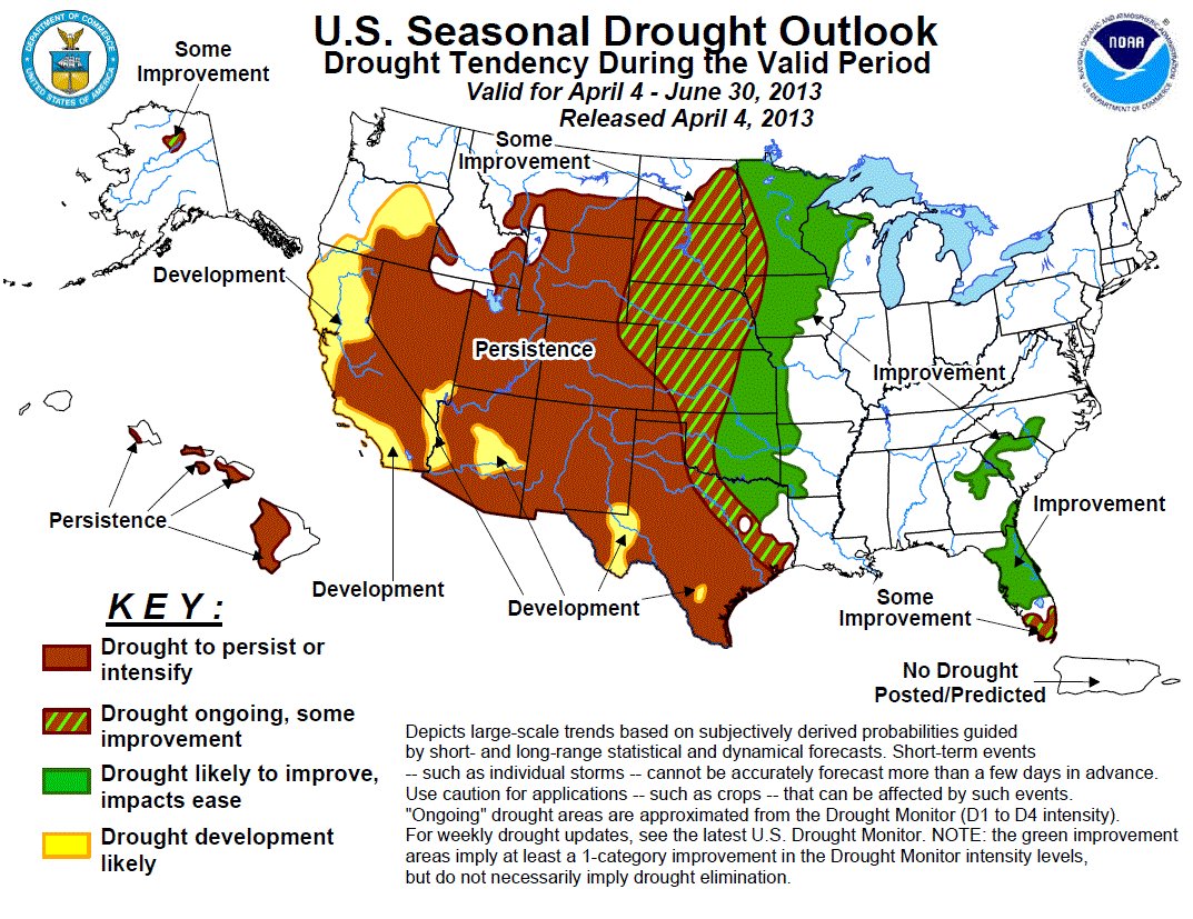
    More oil and gas coverage here and here.

    Forecast news: Pacific storm will enter Colorado today, 3-6 inches above 9,000 feet #codrought #cowx

    From the National Weather Service Grand Junction office:

    An approaching Pacific storm system currently moving onto the northern CA coast will impact the area today through Tuesday evening. Expect valley rain showers and high mountain snow showers with this system. Isolated to scattered thunderstorms with gusty winds and dangerous lightning are also possible this afternoon/evening and again on Tuesday. Snow levels will be high with this mild system, somewhere around 9000 ft today and dropping to 7000 to 8000 feet late tonight into Tuesday. Moderate snow accumulations of 3-6 inches will be possible for the higher peaks. Temperatures will be mild today then cooler on Tuesday, with readings closer to normal, before warming back up to above normal readings Wednesday through the end of the week as a ridge of high pressure builds back in.

    Drought/snowpack news: No watering restrictions for Boulder #codrought

    seasonaldroughtoutlookclimatepredictioncenter03212013

    usdroughtmonitor03262013

    snowpackcolorado03282013

    From the Sky-Hi Daily News (Tonya Bina):

    The Colorado River Basin, a major source for Denver Water, shows 73 percent of average snowpack, and the South Platte Basin, from which Denver Water also draws, shows 59 percent of average…

    Denver Water is looking to conserve 50,000 acre-feet of water, or 16 billion gallons, which amounts to about 20 percent of normal usage, by next spring, according to Lochhead…

    Some cities have followed suit already, such as Fort Collins Utility announcing its water restrictions with an April 1 start date. The city, one of the Northern Colorado Water Conservation District’s biggest metro customers that relies on Colorado-Big Thompson Project water, restricts lawn watering to two days per week, but according to its website, “lawn watering exceptions may be granted through permits … for new seed and sod, properties over 4 acres, medical hardships and religious objections.”

    As of this week, the city of Boulder, another major Northern customer, had not yet implemented restrictions, according to Mike Banuelos, spokesperson for Boulder Public Works. Boulder may not consider restrictions until May 1 when the snowiest months are over. “Boulder really does have a different water portfolio than other cities in the metro area,” Banuelos said, meaning a mixture of water rights and Northern reservoir water, “our situation isn’t as dire as other cities.”[…]

    According to the Colorado Water Conservation Board, Thorton, Colorado Springs and Aurora have also announced outdoor watering restrictions along with Denver and Fort Collins. As a water wholesaler, Northern, unlike Denver water utility, cannot mandate watering restrictions for Front Range metro customers, according to Northern spokesperson Brian Werner. Northern supplies water to 33 cities and towns on the Front Range…

    Drought conditions are expected to be similar to that of 2002.

    From The Watch (Martinique Davis):

    Anticipating yet another dry spring, officials in Mountain Village announced last week that the town will place restrictions on landscape irrigation, effective April 1. The restrictions come on the heels of reports from the Colorado Water Availability Task Force that southwestern Colorado may experience drought conditions this spring and summer. “The town is being proactive in initiating this year’s restrictions beginning in April,” said Mountain Village’s Public Works Director Finn Kjome, “in an attempt to conserve water from the start of the irrigation season, rather than waiting until June when we could potentially be in a more sensitive drought situation.”[…]

    This summer’s schedule will be the same as last year’s, with Mountain Village, Ski Ranches, Elk Run and Skyfield residents on three-day weekly waterings, with watering times reduced by at least 25 percent. Conservation brings results, Kjome said; despite last year’s late start, irrigation restrictions realized an 11 percent savings over Mountain Village’s five-year summer water-consumption average…

    Because the town’s municipal water is drawn completely from wells, Kjome explained, from the Prospect and Skunk Creek drainage areas, as well as from a few wells along the San Miguel River, in Telluride, it is dependent on underground aquifers, with hard-to-measure water levels. “We can’t see where the water levels are,” Kjome explained, “so we want to start conserving now, since we don’t know what’s going on underground.”[…]

    According to Telluride Ski Resort snow reports, February had 72 inches of snow – 155 percent of the 37-year average, and January and December had slightly above-average snowfall. But the November 2012 snowfall was just 12 inches – one-third of that month’s 36-inch average. And March, to date, has seen just 29 inches of snow, a level well below its historic 50-inch average.