From The Telluride Daily Planet (Collin McRann):
As of Thursday morning, only three one hundredths of an inch of rain had been recorded in Telluride, according to Thom Carnevale, who keeps local weather records. (An afternoon cloudburst, which brought one of the heaviest rainfalls of the summer, certainly bumped that number up.) The National Oceanic and Atmospheric Administration (NOAA) is also reporting that for the past 30 days most of San Miguel County is between 1 to 2 inches below normal rain levels. Though the forecast for the coming week is calling for more rain, it will take a lot of storms like the one on Thursday to get to normal.
“The monsoon is really late, normally it begins around the 28th of June or the first few days of July,” Carnevale said. “Here we are — it’s the 11th, and we still haven’t seen any appreciable precipitation at all.”
Normally, Carnevale records around 2.5 inches of rain for the month of July, but he said this year will likely be below average.
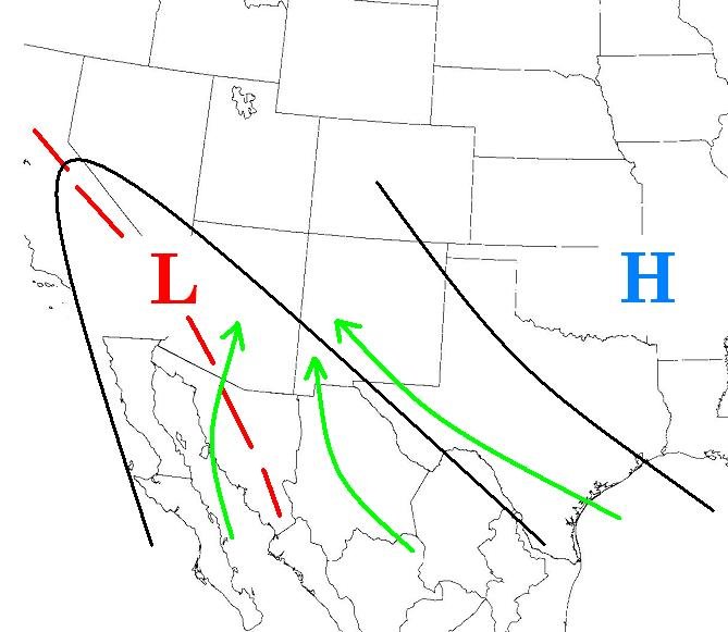
Monsoons result from a seasonal change in the wind and they are dependent on a number of factors. Joe Ramey, a meteorologist with NOAA in Grand Junction, said the region’s monsoonal winds typically blow up from the south through Arizona and New Mexico, and they depend greatly on weather patterns over Texas and the Gulf of Mexico. He said a change in the direction of the winds brings monsoons to the region. Though the patterns have not been good for rain in southwest Colorado recently, they are changing, he said…
Though the heavy rains of mid summer can bring soaking showers, mudslides and ground-shaking thunderstorms, the moisture is badly needed this year. With the lack of precipitation this spring and summer, drought conditions have been upgraded. On Tuesday the U.S. drought monitor reported the majority of San Miguel County is in extreme drought up from severe drought, which had been observed since last summer. Southwestern Colorado is in better shape than the southeastern part of the state, but it will take a lot of rain for the area to see normal conditions.
Since the beginning of June most of San Miguel County has received less than half an inch of rain, according to NOAA. Carnevale recorded just .2 inches of precipitation in Telluride during June; the month’s average precipitation is 1.22 inches, according to his records.
From the US Drought Monitor:
Southwest and West: Some monsoon moisture streamed northward over the Southwest, making it as far north as the Great Salt Lake, bringing isolated rains to Utah, Colorado, Arizona, and New Mexico. The heaviest rains (1.0 – 2.6 inches) were confined to southeastern Arizona and the highest of terrain in central New Mexico, therefore the rains had little impact on the drought in New Mexico. Some small reductions in drought intensity were noted in Arizona where SPI values rebounded slightly in response to the rains. Likewise, the same plume of moisture brought rains to the Salt Lake City area, prompting the removal of some moderate drought (D1) from that region.
From Reuters (Christine Stebbins):
U.S. drought conditions expanded for the fourth week in a row as dryness persisted in the western half of the country, including key crop states of Kansas and Nebraska, while conditions in the South reached their driest in two months, according to a weekly drought report…
“Farther north and west, across Oklahoma and southeastern Colorado, reports indicate sage brush and large trees dying and even some cacti turning brown,” the Drought Monitor said. “Some drought expansion was also introduced across Kansas, where topsoil moisture reports indicated an increase of 38 percentage points for the portion of reports indicating short or very short moisture amounts.”
In Kansas, the top wheat producer, 75.73 percent of the state is rated moderate to exceptional drought, up from 74.56 percent a week ago. But that is much improved from a year ago, when nearly 98 percent was in moderate to exceptional drought.
Nebraska, the fourth-largest corn state and a big producer of cattle, sorghum, wheat and ethanol, is the driest of the big crop states, with 88.41 percent in moderate to exceptional drought. That is unchanged from last week but far worse than a year ago at 77.22 percent.
From The Colorado Springs Gazette (Monica Mendoza):
Council member Joel Miller has asked Colorado Springs Utilities water experts to give an update how much water is now in the city’s reservoirs. The report is expected at the July 17 utilities board meeting. If the reservoirs are up to 1.75 years of storage then Miller would want to consider easing watering restrictions for the remaining summer months. As of July 1, the city had 1.7 years of water in storage.
No doubt, it is a controversial question to pose. Council members, who are also the utilities board members, have been getting pummeled with phone calls and emails about the summer’s lawn watering restrictions and the higher water rates for use of more than 2,000 cubic feet of water per month. Miller said he might be the only board member who wants to consider lifting the ban, but he said it’s worth asking the question. “What’ I’m hearing, is people are doing the best they can and getting hammered regardless,” he said.
Expect showers, thunderstorms in mountains. RT @NWSGJT Monsoonal moisture continues to stream into Colorado today. http://t.co/V98xRc95fl
— Eagle River Water (@VailCOwater) July 13, 2013
Click here to read the latest information from the Western Water Assessment special drought issue. Here’s an excerpt:
Overview of the 2012 drought
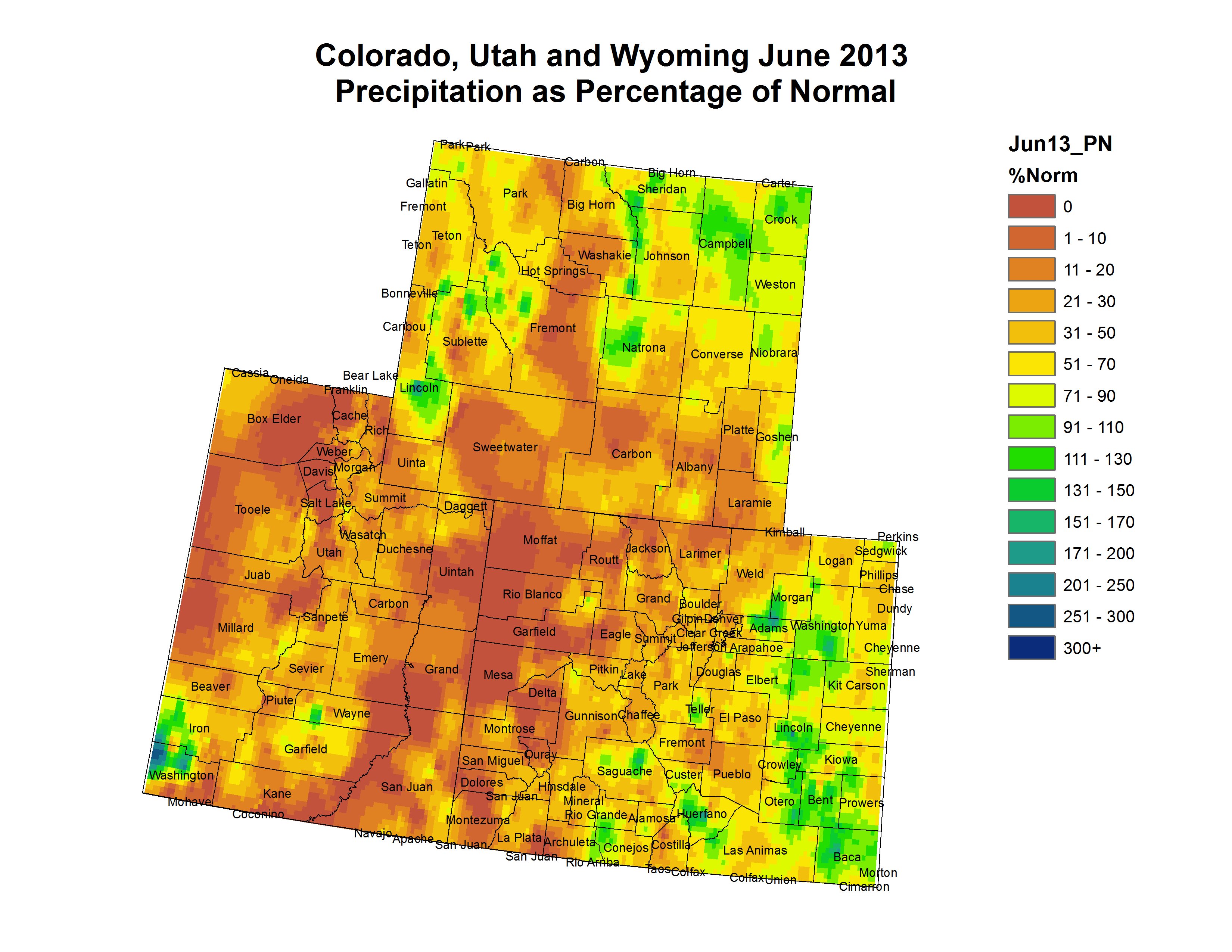
Under the influence of a second year of La Niña conditions, drought conditions emerged midway through the 2012 water year as below-average late-winter snowpacks were compounded by a very dry and warm spring. Spring and early summer runoff over most of the region was well below average, and in many basins worse than 2002 or other benchmark dry years (1977, 1992). In June, continued dry and hot conditions dried out vegetation and led to very large and intense wildfires in all three states, along with widespread range, pasture, and dryland crop losses. The US Drought Monitor as of July 10 showed severe or worse drought conditions covering all of Colorado, most of Utah, and about half of Wyoming (Figure DM-1).
A strong moisture surge into the region from July 5–9 saw up to 5″ of rain in eastern Colorado, with most parts of the state receiving the first significant moisture (>0.5″) in at least a month. Precipitation amounts were much less in Utah and Wyoming. This moisture has reduced fire danger, but only partially alleviates the long-term deficits in soil moisture and water supply in the region. The outlook for the drought shows some tentative indications for wetter conditions over the next several months. Conditions in the tropical Pacific are tipping towards El Niño, which tends to produce more moisture for the region for summer through the fall.
Since the onset of drought and the impacts so far have been similar to 2002, the comparison has been raised in many circles, particularly in Colorado. This issue will explore the different dimensions of the 2012 drought, and place most of them in the context of the 2002 drought.