Click here to go to the website. Here’s the release from Colorado State University:
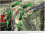
An unusually persistent and moist weather pattern in Colorado Sept. 9-15 led to rainfall totals that have been observed in only a handful of events on the Front Range in the past century.
That’s one of the conclusions in a report released Sept. 25 at the Front Range Flood Panel in Boulder. “Severe Flooding on the Colorado Front Range September 2013” was prepared by the Colorado Climate Center at Colorado State University; the CIRES Western Water Assessment at the University of Colorado; and the National Oceanic and Atmospheric Administration’s ESRL Physical Sciences Division.
“Flooding in September is rare but not totally unprecedented. It has been a long time since we’ve experienced something like this, though,” said Nolan Doesken, State Climatologist and a co-author of the report. “Southwest Colorado had extreme flooding in September in 1970 but for the Front Range you have to go back to 1938 to find anything that comes close.”
Analysis of conditions, data, impact
The report includes an analysis of weather conditions that created the storm, the rainfall totals in different locations, the hydrological impact of the storm, and a discussion of the changing climate and flood risk along the Front Range in light of the September event.
Research is underway at CIRES and NOAA to determine how human-caused climate change may have influenced this event and whether the risk of similar events occurring in the future will increase. The most plausible influence of climate change is that slightly more water vapor was made available for precipitation.
Several CSU Atmospheric Science faculty will also be engaged in research focusing on the meteorological processes of storm formation, cloud processes and atmospheric modeling.
To see the complete report, go to the Western Water Assessment website.
To see the latest data on the storm as it becomes available, go to the new website created by the Climate Center to house various analyses and precipitation reports from the week-long storm and subsequent flooding, coflood2013.colostate.edu. It features charts, graphs, photos, records that place the storm in historical perspective, and a wealth of additional information on this historic weather event.
Drought, fire, flood. What's next? #gjco, #weather http://t.co/Jph7WHYYGP
— The Daily Sentinel (@DailySentinelGJ) September 30, 2013
