
From the Natural Resources Conservation Service (Mage Skordahl):
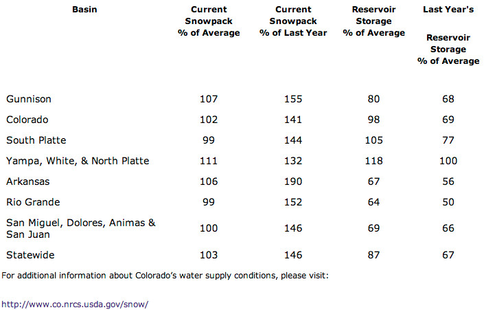
Thanks to significant early season snowfall across Colorado, the state is enjoying the best start to a winter season since 2011. Snow accumulation in the mountains was above normal during October, November and early December. This beneficial moisture dried up a bit during the second half of December, especially in the south and southwest portions of the state, but the good start to the season still puts us at slightly above normal conditions statewide as of January 1. This year’s January 1 snowpack readings are at 103 percent of median statewide, according to Phyllis Ann Philipps, State Conservationist with the NRCS. “This is a great start to the 2014 water year. As we saw in 2012 and 2013, early seasons deficits are difficult to make up later in the season; so being right where we should be this time of year gives us a head start compared to the past couple of years”, said Philipps.
There is currently not much variance in snowpack conditions between the major basins in Colorado. January 1 snowpack totals range from 111 percent of median in the Yampa, White and North Platte basins to 99 percent of median in both the Rio Grande and South Platte basins. These encouraging January 1 snowpack totals have led to decent streamflow forecasts for the spring and summer season. Streamflows in the Colorado, South Platte, Yampa, White, and Arkansas River basins are currently expected to be in the 90 to 100 percent of normal range. In the Rio Grande, Gunnison and San Juan basins forecasts as of January 1 are in the 80 to 100 percent of normal range.
Reservoir storage in some of the major basins benefited from the large precipitation events this past fall. Statewide storage is currently at 87 percent of average, with the Colorado, South Platte, and Yampa/White basins all holding water at near to above normal totals. Storage in the other major basins remains below normal but is above where it was last year at this same time.
All in all, these early season conditions are favorable leading into the bulk of the snow accumulation season. If weather patterns persist and continue to provide moisture to our state this could be a good year for water supply and recreation in Colorado.
From The Pueblo Chieftain (Chris Woodka):
Snowfall during the first week of 2014 has returned snowpack in Colorado’s mountains to normal levels.
“We’ve been getting some snow in the last week. Before that we had just a really long dry spell,” said Rick Sexton, caretaker for Clear Creek Reservoir, owned by the Pueblo Board of Water Works.
“It’s hard to tell how much new snow the mountains got, because the wind has been just horrendous over the weekend. Mount Massive, when I came down from Leadville was 50 percent brown because the wind just scoured the hillside.”
It’s too early in the year to tell how snowfall will affect water supply, he noted.
“At least it’s nothing like last year or the year before,” Sexton said, referring to persistent drought in the Arkansas River basin.
Statewide, snowpack in the state increased to about 105 percent of average by Monday, according to Natural Resources Conservation Service reports.
Basins ranged from 90-117 percent of average.
The Arkansas River basin was at 104 percent of normal on Monday, while the Rio Grande was 90 percent of average. The Colorado River basin, which supplies transmountain water to the Arkansas Valley, was 105 percent of average.
About 4-6 inches of new snow was added to 2-3 feet of snow already on the ground at Snotel sites in the Arkansas and Colorado river basins. That translates into 5-7 inches of snow water equivalent — a measure of the amount of moisture — at most sites above 10,000 feet.
The highest level of snow depth was listed at South Colony, near Westcliffe, with 41 inches and a snow water equivalent of almost 10 inches. But only about 3 inches fell in the past three days, according to the USGS.
Snowfall was heaviest in the central portion of the state, with scanty readings in the southern mountains.
There are about 2 feet of snow on the ground in Leadville, with the biggest snowfall coming on New Year’s Day, said Rego Omerigic of the Parkville Water District in Leadville.
While the snow is not deep, local officials have been warning residents to be careful in the mountains because of the possibility of avalanches.
Ski areas have ample snowpack, aided only slightly by weekend snows.
On Monday, Wolf Creek was reporting 60 inches, but no new snow in the last 48 hours; Monarch, 43 inches, 2 inches new; Ski Cooper, 39 inches, 4 inches new, according to Ski Country USA.