From the Colorado Springs Independent (J. Adrian Stanley):
If you live in or around the Pleasant Valley neighborhood on the west side, then you’re probably already aware of the dangers of the Camp Creek watershed.
But allow me to review: the Camp Creek watershed is huge by local standards, and was scorched in the Waldo Canyon fire, leaving it particularly vulnerable to flooding. Worse, the water flowing from scorched hillsides is funneled into a narrow, steep shoot near Garden of the Gods, before it comes rushing through Rock Ledge Ranch, and then down a severely undersized concrete channel that cuts through the Pleasant Valley neighborhood. From there, the water meets Fountain Creek near West Colorado Avenue.
The area already saw some flooding and debris deposits in last summer’s storms, but not nearly what it could have. In terms of potential for destruction, should the right storm hit, Camp Creek is one of the most dangerous watersheds. Which is why the city is really eager to do some upgrades to the stormwater system before next summer’s monsoon season.
On Feb. 25, the city will present alternative plans to deal with stormwater systems. Nearby residents are encouraged to attend and give input.
The bill, dreamed up by local water engineer Steve Harris, has grabbed the attention of homebuilders, local governments, water suppliers and farm advocates. His plan breaks several taboos, offending proponents of private-property rights, local control by cities and people who simply enjoy big lawns.
Despite the controversy, the Senate Agriculture Committee passed Senate Bill 17 on a 4-3 vote. It now goes to the full Senate.
Sen. Ellen Roberts, R-Durango, is the sponsor. Win or lose in the Senate, Roberts said her goal is to get people talking about the connection between water and land use…
As of 2016, Roberts’ bill would require any new development that relied on buying agricultural water rights to limit the lawn area of its lots to 15 percent. However, parks and open space would be exempted.
“I didn’t want to get between soccer moms and soccer fields, so I thought we should leave the common areas out of the bill,” Harris said.
Developers, however, said most new lawns are small, but open-space areas can be large.
“We can’t sit here and tell you as a homebuilding community that this bill will result in water savings,” said Jeani Frickey Saito, a lobbyist for the Colorado Association of Homebuilders. “It isn’t really the backyards that are the issue.”
Carlyle Currier, vice president of the Colorado Farm Bureau, urged senators to support the bill so it could at least get a vote in the full Senate.
“There are few proposals that actually do anything to save ag water. This bill does,” Currier said.
But some Front Range water utilities opposed the idea.
Pat Ratliff, a lobbyist for the South Metro Water Supply Authority, said the utility is a leader in conservation efforts.
“We have one of the lowest use rates. We’re not going to get any credit for all of the work we have done over the last 25 years to conserve,” Ratliff said.
The south metro area recently struck a deal to use recycled water from Denver and Aurora.
“We’re going to be drinking sewage. I don’t know how much more conservation-conscious you can get,” Ratliff said.
The state’s leading water lobby, the Colorado Water Congress, also opposed SB 17.
The hearing proved once again that the usual partisan politics don’t apply when it comes to water. Roberts has a Democrat as her fellow sponsor, Sen. Mary Hodge of Brighton.
Roberts called on the senator she ousted in 2010, Bruce Whitehead, as one of the star witnesses for her bill. Her chief foe on the committee was a fellow Republican, Ted Harvey of Highlands Ranch.
“You’re destroying the rights of the private homeowner to do what he wants with his property,” Harvey said.
Front Range Democrats were the swing votes. Sen. Matt Jones, D-Boulder, voted no, while Sen. Lois Tochtrop, D-Thornton, and Sen. Lucia Guzman, D-Denver, voted yes.
“I would like to see the entire Senate have a discussion about water, about Colorado, about irrigated lands, about ag,” Guzman said.
Click here to read the newsletter. Here’s an excerpt:
The Colorado Water Conservation Board (CWCB) is looking for up to 40 volunteer notetakers for the March 6, 2014 Basin Roundtable Summit. Volunteers will be needed from 7am-2pm, will need to bring their own laptop, and will receive complimentary breakfast and lunch. This is a wonderful opportunity to network and learn more about the Colorado water community, CWCB, and the important role basin roundtables play in their communities.
If interested, please contact Kate McIntire no later than February 12, 2014.
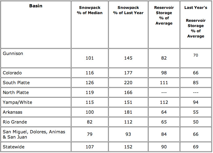
A month deeper into the year, the water supply outlook for northeast Colorado keeps getting better. Snowpack on Feb. 1 in the South Platte River Basin was 126 percent of historic average — an improvement from a month ago, when snowpack was right at about normal, sitting at 99 percent of historic average, according to figures released Thursday by the Natural Resources Conservation Service.
Additionally, reservoir levels were above normal as of Feb. 1, according to this morning’s report. Collective reservoir levels in the South Platte basin were at 111 percent of historic average, also an uptick from Jan. 1, when reservoirs were at 105 percent of average.
There’s a long way to go before the irrigation and lawn-watering seasons begin, but water providers and users in the region can’t help but be a little optimistic, with water supplies much better at this point than during the past couple years.
A healthy water supply is vital for northeast Colorado’s large agriculture industry that, according to the Colorado Division of Water Resources, uses about 85 percent of the state’s water.
And it’s especially critical for Weld County, where the ag industry makes about a $1.5 billion economic impact annually and ranks eighth nationally.
The recent NRCS report also showed that water supplies are in good shape on the western side of the state, which has an impact locally.
The Colorado River Basin — which flows in the opposite direction of Greeley and Weld County, but still supplies a large chunk of the region’s water needs through transmountain tunnels that cross the Continental Divide — had similar numbers to those of the South Platte Basin.
Snowpack for the Colorado Basin was 116 percent of average on Feb. 1, while reservoir levels were 98 percent of average.
Many have stressed that with reservoirs already full in northern Colorado, the snowpack in the mountains should make a more direct path downhill in the spring, possibly allowing farmers to get an early start on irrigating.
There’s also optimism that cities will be more willing to lease some of their extra water to farmers and ranchers this year, if the water situation still looks good down the road.
In 2013, most cities leased little or no water at all to ag users, because cities had to refill their reservoirs, which had been depleted during the 2012-13 drought.
Thanks to significant early-season snowfall across Colorado, the state as a whole is enjoying the best start to a winter season since 2011, according to the NRCS report.
Mage Hultstrand, assistant snow survey supervisor, said the southwest basins and the Upper Rio Grande basin were especially in need of the boost from the recent storm, having received very little snow since early in December.
Summit County is part of the Colorado basin, which reported snowpack 116 percent of the median. That’s 177 percent over the snowpack at this time last year. The reservoir storage in the Colorado basin is at 98 percent of average, better than last year’s 66 percent of average storage.
Across Colorado, the Feb. 1 snowpack was reported to be 107 percent of the median.
“The snowpack is above where it typically is this time of year,” Hultstrand said. “So 107 percent statewide just means it’s up 7 percentage points from the median. It’s not a lot above where we normally are.”
Across the rest of Colorado, the Feb. 1 snowpack ranged from 100 percent of median in the Arkansas basin, to 126 percent of the median in the South Platte. The reservoir storage in Colorado has improved since the last measurement; statewide storage is currently at 90 percent of average…
The snowpack is measured two different ways — the first is 120 automated SNOTEL sites, mostly at higher elevations, functioning as weather stations and generating hourly reports. The stations can weigh the snow to see how much water is in the snowpack, Hultstrand said.
There are also 102 manual sites people travel to once a month, to fill in the gaps from the SNOTEL sites. They stick a hollow metal tube in the snow, and weigh the core to get the snowpack. The type of snow can also drastically affect the snowpack measurements: A light fluffy snow doesn’t contain as much water as the heavy, denser snow, Hultstrand said.
In areas like Upper Colorado, the current percentage is higher than the state average, 121 percent of the median, Hultstrand said. That’s a comfortable number, she said, so that the next few months don’t have a lot to make up for.
“Having this early season be really good so far — and this last storm really helped — that good base will help us not go into February and March worried about a deficit,” Hultstrand said.
However, there still has not been enough snow to bring the snowpack in some regions back to normal. Two basins, the Upper Rio Grande and San Juan, were the only ones in the state to report below-normal snowpack: 82 percent of median for Upper Rio Grande and 79 percent for San Juan basin.
Burlington Ditch
From email from the Colorado Water Conservation Board (Ben Wade):
The next Water Availability Task Force meeting is scheduled for Thursday, February 13, 2014 from 9:30-10:45am & will be held at the Colorado Parks & Wildlife Headquarters, 6060 Broadway, Denver in the Bighorn Room.
Rio Grande Silvery Minnow via Wikipedia From the Albuquerque Journal (John Fleck):
The “notices of intent” allege violations of the federal Endangered Species Act and start a 60-day clock ticking toward possible litigation. The notices highlight growing tensions between human water use and the Rio Grande’s natural ecosystem in what is shaping up to be the fourth consecutive year of drought, and set the stage for potentially bruising litigation this summer.
Human water diversions have left the Rio Grande ecosystem with too little water to maintain the minnow and other species that depend on the river’s flow, including the valley’s iconic cottonwoods, said Jen Pelz, Wild Rivers Program coordinator for WildEarth Guardians.
Last year, the group filed a formal “notice of intent” that triggered negotiations with federal officials over environmental issues and river management, without litigation. Asked if WildEarth Guardians plans to actually file suit this time, Pelz on Tuesday said, “Yes.”
Spokesmen for the U.S. Bureau of Reclamation and the U.S. Fish and Wildlife Service, the two agencies named in the new filings, declined comment.
Human management of the Rio Grande, with dams upstream to regulate the river’s flow and levees to confine it to a narrow channel, have substantially changed the habitat for the minnow. The fish once lived from Española to the Gulf of Mexico, but is now only found in central New Mexico.
Low river runoff has caused minnow populations to crash further in recent years, according to data collected for the Middle Rio Grande Endangered Species Collaborative program, a joint effort by local, state and federal water managers and users.
The potential for a fourth straight drought year poses serious risk for the endangered species, Pelz said in an interview. “The minnow has not spawned in the last three years,” Pelz said, “which is crucial to their recovery and survival.”
More than 95 percent of the fish found in surveys last summer came from hatcheries, which are being used to augment the dwindling natural fish population…
While the Endangered Species Act focuses on specific species, especially the minnow, more is at risk than just a single kind of fish, Pelz said. “The cottonwood forest is reliant on flood flows, and there being enough water in the river,” she said.
Water managers say they have been doing their best to meet the needs of the environment and farmers and other human water users, given the limited supply nature has to offer.
“We’re trying to find creative ways to get everyone what they need,” said David Gensler, water manager for the Middle Rio Grande Conservancy District, the valley’s largest farm irrigation water provider.
Among the possibilities is the use of upstream dams to manage flows to create high flows in late spring for spawning, according to Rolf Schmidt-Petersen, Rio Grande basin manager for the New Mexico Interstate Stream Commission. But no decisions about that can be made until April or May, Schmidt-Petersen said…
With a 60-day clock now started, WildEarth Guardians’ filings raise the possibility that key late spring water management decisions will be made in the midst of federal litigation, University of New Mexico law professor Reed Benson, an Endangered Species Act expert, pointed out. But it is not clear whether there is time for the court fight to influence how much water is used by humans or left in the river for fish in 2014, Benson said.
Click here to read the newsletter. Here’s an excerpt:
Watershed Wednesday: the Colorado Water Plan
February 26th
Avon Public Library, Avon, CO
Did you know that 80% of our state’s water falls on the Western Slope but 80% of the population lives on the Eastern Slope? Did you know that Colorado is one of the few Western states that hasn’t yet prepared a State Water Plan? Under Gov. Hickenlooper’s direction, the state is now in the process of creating such a plan, one that aims to forge ‘a path forward for providing Coloradans with the water we need’ in all aspects of our active and productive lifestyles. (coloradowaterplan.com)
Hannah Holm, Coordinator for the Water Center at Colorado Mesa University, will help bring us up to speed on this exciting & complex process. Diane Johnson of the Eagle River Water & Sanitation District will focus on the local level and explain the Eagle River Basin Principles.
From the Glenwood Springs Post Independent (Hannah Holm):
Across the West, stream and riverbanks have been taken over by alien invaders. Tamarisk and Russian Olive form dense thickets that crowd out native plants, degrade wildlife habitat, and cut off access to the water.
As daunting as the scale of this invasion is, a tenacious group of scientists, land managers and weed wranglers are doggedly working to understand and control the problem. Many of these experts will gather in Grand Junction Feb. 18-20 to share their latest discoveries on how to tame the invaders and bring back the native willows and cottonwoods, as well as address other challenges to healthy, accessible streambanks.
The Grand Junction-based Tamarisk Coalition is teaming up with The Water Center at Colorado Mesa University to bring these experts together for the research and management conference titled “Riparian Restoration in the Western U.S.” The conference will involve presentations and workshops highlighting recent advancements and emerging issues in riparian invasive plant management and restoration on Feb. 18-19, and a half-day field trip on Feb. 20 to visit a restoration site in Palisade’s Riverbend Park and the Palisade Insectary, which has played an important role in promoting and studying the spread of a tamarisk-eating beetle.
Conference session topics will include secondary weeds and monitoring, threatened and endangered species considerations in restoration, biological control, partnerships and community, restoration planning, technology, wildlife, and water availability and challenges.
There will also be a half-day workshop on “Bridging the Gap between Land Manager Needs and Scientific Research,” and a presentation on the various ways that gardening practices can encourage or discourage certain kinds of insects, including the destructive emerald ash borer.
This conference offers a great opportunity for land and resource managers, private land owners, researchers, students, and others to convene in a collaborative venue to learn about and discuss the latest trends in riparian restoration and ecology. CMU students can attend for free, although they do need to register under the “scholarship” category.
Mark Udall, a senior member of the U.S. Senate Energy and Natural Resources Committee, said the U.S. Forest Service’s acquisition of 823 acres of private land near the James Peak Wilderness Area shows the importance of the Land and Water Conservation Fund in safeguarding Colorado’s public lands. The acquisition, located near the East Portal Trailhead in Gilpin County, will prevent future development bordering on the wilderness area and will safeguard a critical watershed for the Denver Metro Area.
“This important acquisition underscores why I have urged the White House and my colleagues to fully fund the Land and Water Conservation Fund,” Udall said. “Acquisitions, like this 823-acre purchase near the James Peak Wilderness Area, are essential to ensuring future generations of outdoorsmen, sportsmen and anglers can access and enjoy the pristine public lands that support our way of life in Colorado.”
Udall has been a strong supporter of the Land and Water Conservation Fund, which helps preserve and improve access to federal lands in Colorado and across the nation. Udall urged the White House in late January to redouble its efforts to fund the Land and Water Conservation Fund. Udall also co-sponsored the bipartisan Land and Water Conservation Authorization and Funding Act of 2013, which would use a portion of the proceeds from off-shore oil and gas production to strengthen the fund.
Udall also has been a strong supporter of cost-effective public land acquisitions that support local communities while strengthening Colorado’s wildlands. Udall championed a common-sense land swap, completed in December 2013, that improved fire safety for the approximately 500 households the Sugar Loaf Fire Protection District safeguards west of Boulder. Udall also has led the push in Congress to convey 40 acres of federal administrative land from the U.S. Forest Service Dillon Ranger District to Summit County so the county can support local jobs by building affordable, workforce housing.
From the Fort Collins Coloradoan (Ryan Maye Handy):
Colorado oil and gas regulators set a precedent on Thursday by hosting a public forum on lessons learned from oil spills caused by the September 2013 floods, said Colorado Oil and Gas Conservation Commission Director Matt Lepore.
But in recapping its response to the spills — which poured about 43,000 gallons of oil into the South Platte River basin — few new updates came out of the meeting, held in the Wells Fargo building in downtown Denver. Representatives from COGCC, a state agency that regulates oil and gas, and industry advocacy group the Colorado Oil and Gas Association, spoke about response to the spills that alarmed Front Range residents for weeks last fall. The groups intend to present a series of recommendations to the state government as a result of their review, Lepore said.
But the main purpose of the meeting — time for public discussion — was largely a bust. Lepore had set aside an hour for discussion with an audience of more than 70 people, but after four or five comments and questions, the audience was silent.
“I am pleased with the turnout,” Lepore said after the meeting adjourned almost an hour early. “Honestly, I hoped for much more dialogue.”[…]
When it comes to flood aftermath, Laura Belanger, an environmental engineer with Western Resource Advocates, is still hopeful that COGCC’s list of best management practices — now only suggestions — become hard-and-fast rules. While larger oil and gas operators might go above and beyond what the list recommends, smaller operations may not, she said.
Yampa/White/Green river basins via the Colorado Geological Survey FromSteamboat Today (Brody Farquhar):
…we know the worth of water when it is gone, in short supply, polluted or tied up in a state or federal water court. Otherwise, we don’t give much thought to the water that shows up in our faucets, irrigation ditches, streams and rivers. We often take it for granted.
Yet we have learned through the work of the Colorado Statewide Water Supply Initiative, the Interbasin Compact Committee and the basin roundtables that our current statewide water trajectory is neither desirable nor sustainable. We know that the state must take a hard look at Colorado’s future water needs as a whole and plan for how they will be addressed…
The Yampa-White-Green Rivers Basin Roundtable is hosting four meetings, inviting the residents of Northwest Colorado to participate in the one nearest them. Each meeting is aimed at gathering public input toward the creation of a Colorado Water Plan. Routt County residents are encouraged to attend either one of the following:
• Feb. 13 in Steamboat Springs at the Steamboat Springs Community Center, 1605 Lincoln Ave.
• Feb. 19 in Craig, at the American Legion Hall, 1055 Moffat County Road 7.
Following this series of meetings, public input also will be welcome at the basin roundtable meetings held at the American Legion Hall in Craig on March 12, May 14 and June 18. All meetings begin at 6 p.m.
The goal is to have a comprehensive implementation plan submitted by the Yampa-White-Green Roundtable to Colorado Water Conservation Board by July…
Interested parties are basically anyone who drinks, uses or recreates in water. More specifically, that includes homeowners and small business owners, ranchers and farmers, recreationists, energy workers (miners, drillers and power generators), town and county officials, etc.
As noted by Tom Gray, former chairperson of Yampa-White-Green Roundtable and former Moffat County commissioner, “The influence always goes to those who make the effort to get informed and participate. This (Basin Implementation Plan) process is the chance for everyone in the basin to do just that.”
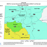
Colorado snowpack/storage table February 1, 2014 via the NRCS
Click here to read the release. Here’s an excerpt:
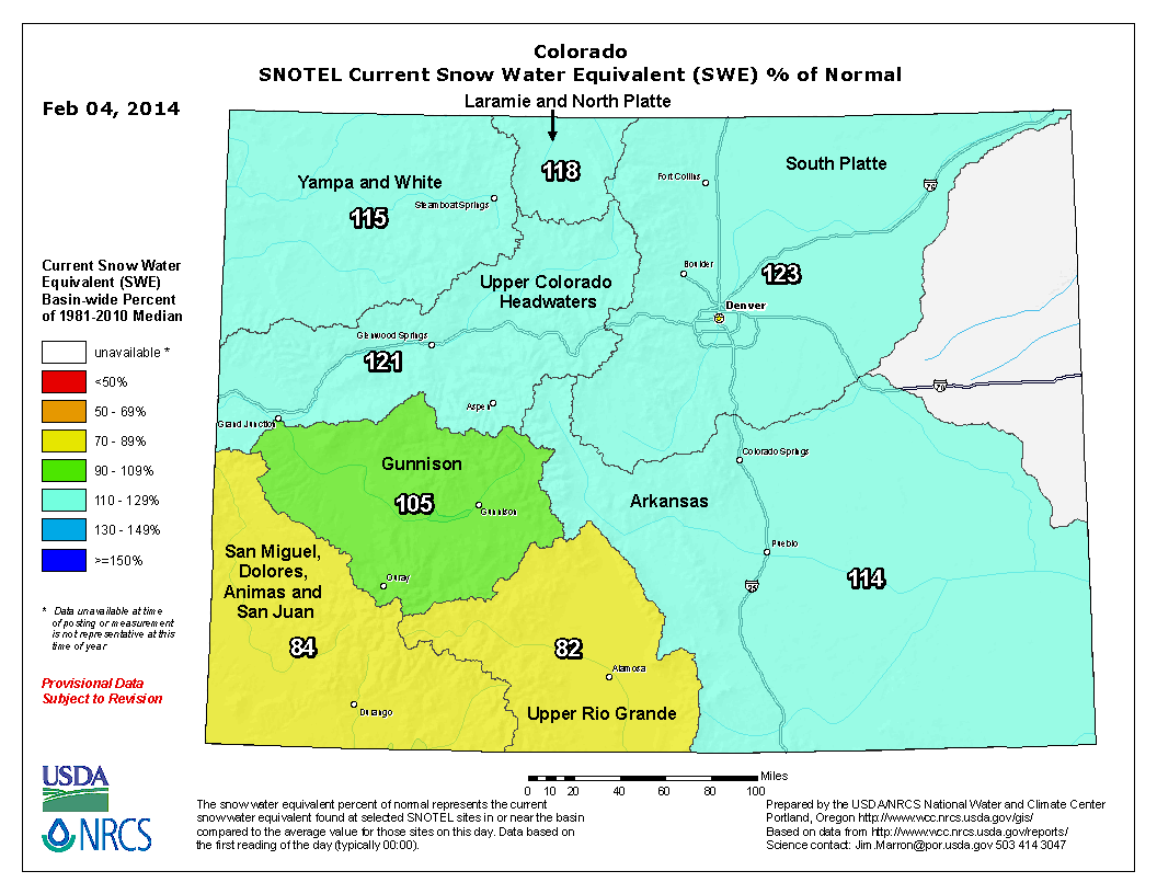
The faucet seemed to have turned off during the latter half of January, with most SNOTEL sites in Colorado recording very little snow accumulation during this time period. Thankfully a couple of significant storm systems moved through the state during the very last week of the month, just in time to boost the January totals. From January 27th to February 1st, snowpack totals measured at SNOTEL sites across the state increased from 95 percent to 109 percent of the median. In just one day, from January 30th to 31st the percentage jumped by 9 percentage points! Recent measurements at SNOTEL sites and snow courses across Colorado report the February 1 snowpack to be at 107 percent of the median. Phyllis Ann Philipps, State Conservationist with the NRCS stated, “This storm system benefited the entire state, but was especially needed in the southwest basins and the Upper Rio Grande basin. These areas had received very little snow since early in December and the recent moisture was a welcome change.”
While the snow received in the southwest and Upper Rio Grande was beneficial, it was not quite enough to boost the snowpack’s in these regions back to normal. These basins are the only basins in the state that reported below normal snowpack’s this month; 82 percent of median for the Upper Rio Grande and 79 percent of median for the San Juan basins. Across the rest of Colorado the February 1 snowpack’s range from 100 percent of median in the Arkansas basin to 126 percent of median in the South Platte.
Reservoir storage in Colorado has improved compared to last month. Statewide storage is currently at 90 percent of average with the South Platte and Yampa/White basins storing water at above average amounts for this time of year. Storage in the Arkansas and Upper Rio Grande basins remains well below average.
Expect the latest streamflow forecasts for the spring and summer season to improve compared to last month’s for the northern part of the state and to decline for the southwest and Upper Rio Grande.
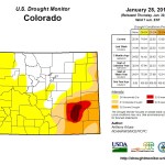
Click here to go to the US Drought Monitor website. Here’s an excerpt:
Summary
During the past 7-days, the persistent, amplified ridge that had dominated weather conditions across the western contiguous U.S. (CONUS) collapsed, which allowed Pacific storm systems to move eastward across the region. Moderate to heavy precipitation (0.5-3.0 inches liquid equivalent, locally heavier) was observed over the higher elevations of the Coastal Ranges, the Cascades, the Sierras, the Bitterroots, the Wasatch, and near the Colorado Front Range. Lower elevations across much of the West generally received light precipitation (0.5-inch or less), including the coastal areas of far southern California. Moderate to heavy precipitation (0.5-3.0 inches liquid equivalent, locally heavier) was also observed across portions of the Midwest, Ohio Valley, Great Lakes, southern New England, mid-Atlantic and southern Atlantic Coast states, Gulf Coast region, Tennessee Valley, Lower Mississippi Valley, and the ArkLaTex region. Temperatures during the past week were primarily below-normal east of the Continental Divide, and above-normal west of the Divide, though there were a few exceptions. East of the Divide, New England and Florida reported above-normal mean temperatures, while west of the Divide, Washington state was below-normal for the week…
Southern and Central Plains
Though light to moderate precipitation (under 2.0 inches) fell over parts of western, far southern, eastern, and northern Texas, many areas received little to no precipitation during the past week (though a few locations in the ArkLaTex region received 2-3 inches of rain). The precipitation that did fall helped to alleviate some of the short-term dryness. However, reservoirs along the Colorado River, as a whole, are at their lowest level (as a percent of normal) for this time of year ever, as is true of total water storage across the state. These factors prompted a number of 1-category improvements and degradations to the Texas drought depiction. In far western Oklahoma, extreme drought (D3) was expanded northward to include Roger Mills County. The latest precipitation event produced only about a tenth of an inch (radar estimated) from Roger Mills County southward across southwestern Oklahoma. There were a high number of days in January with extremely low relative humidity, mean temperatures close to normal, and wind. The January PNP was 20 percent of normal for the state as a whole (Mesonet), and the state-wide average precipitation was 0.29-inch. This was the 8th driest January on record. In Kansas, the state-wide average precipitation (PNP) for January was only 34 percent of normal. Reassessment of conditions will be needed next week after this current storm system passes through the area. In south-central Nebraska, a small drought-free area was downgraded to abnormal dryness (D0), in response to continuing dryness…
Southwest
Most of Arizona and New Mexico received little if any precipitation during the past 7-days. A predominantly dry pattern has been in place since the very beneficial and welcome late-season monsoon rains last September. Impacts are somewhat limited at this time due to lower evapo-transpiration (ET) rates during winter, but an increased snowpack in the next two months is needed to preclude more serious problems. SNOTEL Snow Water Equivalent (SWE), as of February 5, 2014, is mostly well below normal across the Mogollon Rim area (ranging from 14-41 percent), and in the White Mountains of eastern Arizona (SWE 26-36 percent of normal). The mountainous terrain of western and central Colorado received moderate to heavy precipitation (0.5-4.0 inches) during the past week, while the high plains of eastern Colorado generally received less than a half-inch of precipitation. As time is needed to evaluate regional impacts across the Southwest, it was decided not to alter the depiction this week…
The West
Though several inches of precipitation (liquid equivalent) fell over the northern one-half to two-thirds of California this week (locally 3-4 inches in the central Sierras), significantly more precipitation will be needed to justify improvement with the depiction. The central and southern Sierras report up to 4 inches of SWE, while the northern Sierras report only an inch. The precipitation received this week only keeps the snowpack/water supply from falling further behind. Reservoirs continue to go down. An 8-station index for the northern Sierras (which represents an average of 8 precipitation gauges that span the area from Lake Tahoe to up above Lake Shasta), indicates precipitation amounts of 4.5 inches since the beginning of the Water Year (Oct 1). Last year at this time, 34.3 inches of precipitation fell, while the average to date is 26.4 inches. The only change to the depiction in California this week was to slightly increase the coverage of exceptional drought (D4) conditions across most of San Luis Obispo County. Two of the larger reservoirs in the County, near the border with Monterey County, are at 5-percent capacity (Lake Nacimiento and Lake San Antonio). The City of Cambria is implementing water restrictions for residents, while many cattle owners are selling off their herds due to lack of feed and water. The higher elevations of western Washington and western Oregon received 2-5 inches of precipitation (liquid equivalent, locally heavier) during the past week, though as is the case with California, significantly more precipitation will be needed to overcome longer-term deficits. Finally, in western Montana, the valley areas have been fairly dry recently, while the mountainous areas have received significant precipitation. Given support from the latest short-term and long-term drought blends, and the recent dryness (ACIS 30-day and 60-day PNPs ranging from about 20-50 percent of normal in this area), the drought-free area in southwestern Montana was downgraded to abnormal dryness (D0)…
Looking Ahead
During February 6-10, 2014, very heavy precipitation (as much as 7-9 inches, liquid equivalent) is predicted in northern California, and 3-4 inches in western Oregon. This will go a long way in helping to mitigate some of the drought conditions in these areas, though reassessment of conditions next week will be needed to determine the extent of any potential improvements in the Drought Monitor depiction. Along the Southeast coast including northern Florida, 1.0-1.5 inches of rain is expected during the period which will be beneficial to the small areas of abnormal dryness (D0) in that region. With the exception of 3-4 inches of precipitation anticipated over the central Rockies and Wasatch Range, most other areas of the CONUS can expect a half-inch or less of precipitation within the next 5 days.
For the ensuing 5-day period, February 11-15, 2014, there are elevated odds of above-median precipitation for most of the northern and eastern Lower 48 states, and the Alaska Panhandle. Probabilities for above-median precipitation rise up to 60-percent in the Pacific Northwest, and 50-percent over the Gulf and Atlantic Coast states. Below-median precipitation is favored for southern California, much of the Southwest and southern Rockies, the central and southern High Plains, and most of Alaska.
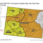
Snow Water Equivalent as a percent of normal February 4, 2014 via the NRCS
FromThe Grand Junction Daily Sentinel (Dennis Webb):
Just a week ago, Colorado’s early-season cushion of winter snowpack had evaporated, with the state dropping to 93 percent of median levels, down 10 percent from the start of the year. That was then, before a snowstorm that delivered two and in some areas even three feet of snow in the central mountains. A storm that delivered what many have called epic powder amounts to many ski areas also rapidly restored the state snowpack level. As of Monday it was at 107 percent of median, said Mage Hultstrand, assistant snow survey supervisor for the Natural Resources Conservation Service in Colorado.
And that was just last week. As much as two feet of additional snow could fall this week between the eastern portion of the Grand Mesa and the Elk and northern West Elk Mountains in the Aspen-to-Crested-Butte area, thanks to a new storm pattern that moved in Sunday night, said Joe Ramey, a National Weather Service meteorologist in Grand Junction. That storm brought an additional five inches of snow to Powderhorn Mountain Resort by Monday morning, the resort reported.
Recent days have brought a welcome change after a prolonged dry stretch in January.
“By mid-January things had dried up pretty good,” Hultstrand said.
But the storm late last week provided a “huge boost” to snowpack, she said.
The Upper Colorado River Basin, which was at 105 percent of median snow-water-equivalent as of Jan. 27, soared to 120 percent by Monday.
The Gunnison River Basin rose in a week from 91 percent to 103 percent of median.
Unfortunately, winter’s bounty has yet to extend enough to the southwest part of the state. The Upper Rio Grande Basin and the combined San Miguel, Dolores, Animas and San Juan basins are both at just more than 80 percent of median. But the Rio Grande was at 68 percent, and the others were at 71 percent, just a week earlier.
Hultstrand said the Upper Colorado’s average is so good that it could afford to get just 68 percent average snowfall for the rest of the snow season to reach average peak.
But southwest Colorado’s dearth of snow, not to mention a major drought in California, continue to worry water-watchers including Jim Pokrandt, spokesman for the Colorado River Water Conservation District in Glenwood Springs. His concern is both how much snowmelt ends up flowing into the Colorado River more regionally this spring and how much demand there will be for it downstream.
“We can rejoice locally but we have to understand the bigger picture, too, and the bigger picture isn’t as rosy as we’re enjoying,” he said.
Ramey said a high pressure ridge close to the Pacific coast has lingered since around early December, acting as a wall that has forced storms to the north and over it, and leaving California, Arizona, New Mexico and the Four Corners area drier. The good news is that that pattern seems to be breaking down, bringing the promise of moisture to that region, including southwest Colorado, this week, he said.
He said storms early and later this week should favor all of western Colorado before things dry out over the weekend.
Potential vertical and horizontal drilling conflict via The Grand Junction Daily Sentinel (Robert Garcia)
FromThe Grand Junction Daily Sentinel (Dennis Webb):
The Colorado Oil and Gas Conservation Commission plans to expand statewide a policy aimed at preventing horizontal wells from causing leaks involving existing wells, due to a leak southwest of De Beque where such a possible link is being investigated.
The Bureau of Land Management also is looking at what it can do to try to help head off such problems.
The agencies’ actions follow the Dec. 14 discovery of natural gas and fluids bubbling up around a Maralex Resources well on Jaw Ridge, which is BLM-managed land about seven miles from De Beque. The leak’s cause continues to be investigated, and one possibility the COGCC is considering is that it resulted from hydraulic fracturing of a Black Hills Exploration & Production well that was drilled from a surface site about a mile away, but made a 90-degree turn underground and passed within about 400 feet of the Maralex well.
The Maralex well was drilled in 1981 but was shut in shortly after its drilling. It stopped leaking Jan. 17, as work continued on permanently plugging it, an effort completed a week later. Fluids initially escaped from the well pad after the leak’s start. Maralex then opened the well and directed the flow into a pit for removal by truck. That flow fluctuated widely but averaged about 6,300 gallons a day during the month before it ceased. Authorities have found no indication of contamination of surface water or groundwater. Testing continues to try to determine exactly how far the fluids spread beyond the pad within what the BLM considers to be a known maximum spill parameter.
‘COMMUNICATION’ CONCERN
The COGCC currently has a policy aimed at preventing what it calls the potential for “communication” between horizontal wells and existing wells in 11 counties in eastern Colorado’s Denver-Julesburg Basin. That area is seeing a boom in horizontal drilling aimed at producing oil and other liquids, in an area with numerous existing vertical wells that in some cases may not have been constructed to withstand modern-day, high-pressure fracture operations nearby.
“It is apparent that that policy needs to be pushed out statewide. It needs to be pushed out statewide very quickly,” COGCC director Matt Lepore told the commission at its last meeting.
The policy requires the COGCC engineer to evaluate all wells within 1,500 feet of a proposed horizontal wellbore to determine whether the existing wells have adequate cement sealing around them to isolate the geological formation to be fractured, as well as all groundwater zones. Also to be evaluated is whether an existing well’s wellhead and master valve are rated to 5,000 pounds per square inch of pressure, or alternatively that there is adequate mechanical isolation down the well.
If concerns exist regarding an existing well, the company proposing the horizontal well must take measures that can range from doing remedial cement work in the existing well to isolate all formations, to properly plugging it, to replugging it if needed or proposing alternative mitigation. An existing well’s owner cannot refuse to let mitigation work occur.
The COGCC initially implemented the policy for horizontal wells coming within 300 feet of existing wells. It eventually expanded the distance after pressure readings and other data collected at existing wells during fracking of new ones indicated a need to do so.
Lepore told the commission one concern companies have is the lack of data that would justify the 1,500-foot-distance standard in the case of wells outside the DJ Basin. He also noted that there are currently few plans to drill horizontal wells elsewhere in the state. Companies have been drilling a small number of such wells for exploratory purposes in the Piceance Basin.
LEAK THEORY INVESTIGATED
The Maralex well was drilled into the Dakota sandstone formation, while the Black Hills well targeted the Niobrara shale, part of the shallower Mancos formation. The COGCC says the Maralex well wasn’t cemented to isolate the Niobrara zone because that zone wasn’t considered a producing formation when the well was drilled. It’s looking at whether gas liberated from fracking the Black Hills well reached the Maralex well, pushing gas and water to the surface.
Bruce Baizel, energy program director with the Earthworks conservation group, has said another concern in horizontal drilling is that it may occur around older existing wells that may have corroded pipes or cement sealing that has weakened over time and can’t stand up to fracking pressures.
Maralex plugged its well in stages after the discovery of the leak. When it finished plugging the Dakota sandstone formation, the leak slowed but continued. The leak stopped once plugging was completed at the top of the Mancos formation. But that in itself hasn’t been enough to convince officials that the Black Hills well fracking caused or contributed to the problem.
Test results of fluid that flowed back from the Black Hills well are still being awaited. Samples of flowback fluid from another Black Hills horizontal well farther from the Maralex well proved to differ significantly from the fluid that came up the Maralex well.
THE BLM’S ROLE
Agency spokesman Steven Hall called the Maralex situation a rare one for the BLM, which he believes has seen few instances where fracking has occurred close to shut-in wells on lands it administers in Colorado. While noting that the leak’s cause hasn’t been determined, he said the BLM wants to do what it can to prevent problems between horizontal and existing wells. He said the BLM is reviewing how it manages horizontal drilling and fracking on federal land in the state. The agency has no rules or policies addressing potential communication between horizontal and existing wells. But Hall said it has a lot of leeway during the process of reviewing drilling permit applications to impose conditions to try to avoid such situations. In addition, it is working to deal with the situation of wells that are shut in for a long time, to make sure they are permanently plugged, put into production, or tested to ensure their integrity.
“We’re going to try to be very aggressive in addressing those,” Hall said.
The agency previously has said that of 110 wells Maralex owns that involve federal lands or minerals in western Colorado, 86 are shut-in — in nearly half those cases for more than 20 years. It has met with Maralex about coming up with a strategy for addressing its shut-in wells.
So far this year snow is driving away drought in much of Colorado.
“We have a much more positive outlook going into 2014 than we had last year,” said Colorado Springs Utilities, Water Supply Planning Supervisor, Abby Ortega.
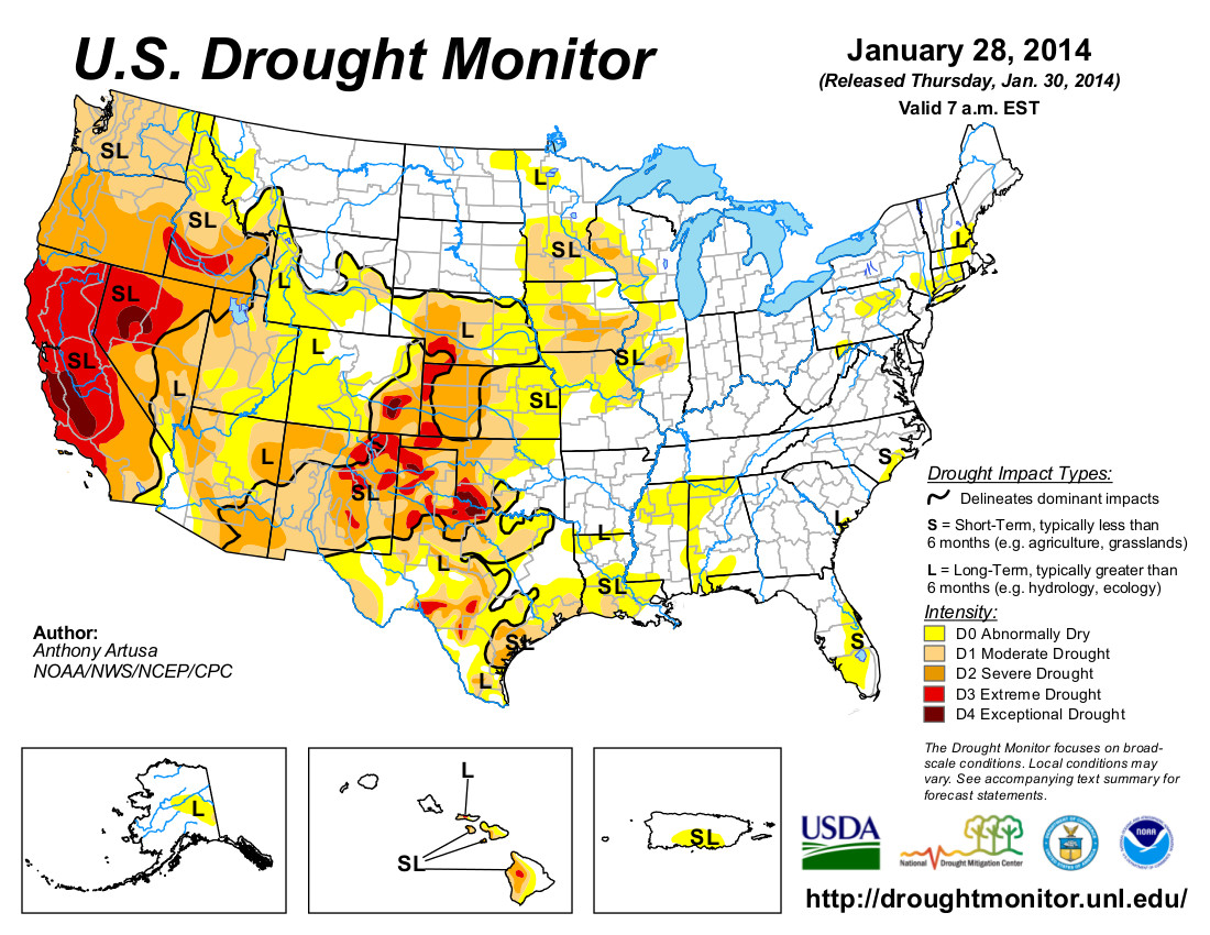
The national drought map now shows most of Colorado under “abnormally dry” conditions. It is an upgrade of several levels, from the “extreme drought” designation across most of the state last year.
There is optimism among water managers, but also caution. Snowpack is deeper than the 30 year average, but Ortega points out that this is just the start of the snow season. She says March and April are typically the months when the most significant moisture falls in Colorado. She also says we are still in a water deficit. “We’re certainly optimistic. We’re looking at the snowpack but in addition we need to keep in mind that after the last two years of dry conditions our reservoir storage is well below normal.”
With the go-ahead from Kansas, Colorado began pumping water from their northeast Colorado augmentation project. The Compact Compliance Pipeline (CCP) started delivering water to the North Fork of the Republican River on Friday, Jan. 17, according to Deb Daniel, manager of the Republican River Water Conservation District (RRWCD) in Wray, Colo.
Daniel said the CCP is scheduled to deliver approximately 4,000 acre feet of water prior to April 1. This should put Colorado in compliance with the 2003 Republican River Compact Settlement with Kansas.
In late summer 2014, Colorado will calculate if the state will be in compliance depending on weather conditions and the amount of water that is pumped in the basin during the summer months.
If additional water is required, the pipeline will deliver the necessary acre feet to be in compliance with the compact, prior to the end of 2014, Daniel said…
Daniel said the current well field, which consists of eight wells, has an annual capacity of around 15,000 acre feet. She said they plan to add seven more in the future.
RRWCD purchased the water rights to 58 irrigation wells in eastern Yuma County. The appropriations from these wells were transferred to the new well field, she said.
Water delivered by the pipeline is measured in the channel just prior to the water flowing into the river. The water passes through an open concrete flume equipped with a measuring device to calculate the amount of water delivered to the river.
Each of the wells are also equipped with flow meters to measure the amount pumped. RRWCD can pump no more from the well field than the historic consumptive use of the 58 wells.
More Republican River Basin coverage here and here.
Some Colorado lawmakers want the final say on how the state uses its limited water resources. Senate Bill 115 has been introduced and elected officials from both political parties have signed up as sponsors. The measure, if approved, would give the Colorado Legislature the authority to adopt a state water plan. In many states that have approved water plans, legislatures were the public body that developed them.
Here in Colorado, however, the details of the emerging state water plan are being debated by the nine basin roundtables, which were formed nine years ago and help guide water policy through grass-roots involvement.
According to James Eklund, director of the Colorado Water Conservation Board, the need for a state water plan is acute. As the state expects population growth to continue for decades ahead, it makes sense that we figure out how to best allocate our water.
That’s why Gov. John Hickenlooper issued an executive order in 2013 setting a deadline of December 2015 for the drafting of a strategic water plan for the entire state.
During a water policy briefing Tuesday in Pueblo, Eklund said many water policy experts think that the state’s plan “needs to be built from the bottom up.” That’s why the current roundtable process makes the most sense, he said. We completely agree.
In Colorado, water is our most important resource and we shouldn’t turn over the question of its ultimate use to politicians. Because of its Denver-centric power base, the Legislature too often leans away from rural and agricultural interests. To allow Denver politicians control of all water policy is potentially dangerous to other parts of the state.
On the roundtable level, there is an opportunity for more diverse opinions to be shared and thus more buy-in from the stakeholders throughout Colorado. Here in Southern Colorado, we place a high priority on efforts to place conservation easements on farms and ranches to tie water to the land. We also encourage proposals to restrict the further transfers of water outside the basin. Other regions of the state have different priorities and each deserves a voice at the table.
Promoting a feeling of “we’re all in this water fight together” is important as a state water plan is finalized. Residents outside of the Denver metro area don’t need another example of urban interests — such as Aurora, which has acquired a quarter of their total water supply from the Arkansas Valley — dictating the future direction of Colorado policies.
The current process already allows for legislative input as the plan is developed. There is no reason for that body to dominate the public discourse and decision making on the matter, however.
As hydraulic fracturing is increasingly used for oil and gas extraction across much of the United States and Western Canada, a new Ceres report issued today shows that much of this activity is happening in arid, water stressed regions, creating significant long-term water sourcing risks for companies operating in these regions as well as their investors.
The report provides first-ever data on oil & gas companies’ water use and exposure to the most water stressed regions, including those in Texas, Colorado and California. It includes recommendations for companies to improve their water management and reduce their overall exposure to water sourcing risks.
“Hydraulic fracturing is increasing competitive pressures for water in some of the country’s most water-stressed and drought-ridden regions,” said Ceres President Mindy Lubber, in announcing Hydraulic Fracturing and Water Stress: Water Demand by the Numbers. “Barring stiffer water-use regulations and improved on-the-ground practices, the industry’s water needs in many regions are on a collision course with other water users, especially agriculture and municipal water use. Investors and banks providing capital for hydraulic fracturing should be recognizing these water sourcing risks and pressing oil and gas companies on their strategies for dealing with them.”
The report is based on water use data from 39,294 oil and gas wells reported to FracFocus.org from January 2011 through May 2013 and water stress indicator maps developed by the World Resources Institute (WRI). It shows that nearly half of the wells were in regions with high or extremely high water stress. (Extreme high water stress regions, as defined by WRI, are areas where 80 percent of available surface and groundwater are already allocated to municipal, industrial and agricultural users.) Continue reading “New Hydraulic Fracturing Report Finds Texas and Colorado Face Biggest Water Sourcing Risks”→
Cache la Poudre River
Here’s the release from the USDA:
‘Climate Hubs’ will provide regional networks on climate science, forecasting impacts as part of President’s Climate Action Plan
Agriculture Secretary Tom Vilsack announced today the creation of the first ever Regional Hubs for Risk Adaptation and Mitigation to Climate Change at seven locations around the country. “Climate Hubs” will address increasing risks such as fires, invasive pests, devastating floods, and crippling droughts on a regional basis, aiming to translate science and research into information to farmers, ranchers, and forest landowners on ways to adapt and adjust their resource management. In his State of the Union Address, President Obama pledged that his Administration will continue to do everything in its power to act on climate change. Today’s announcement is part of the President’s Climate Action Plan to responsibly cut carbon pollution, slow the effects of climate change and put America on track to a cleaner environment.
“For generations, America’s farmers, ranchers and forest landowners have innovated and adapted to challenges. Today, they face a new and more complex threat in the form of a changing and shifting climate, which impacts both our nation’s forests and our farmers’ bottom lines,” said Vilsack. “USDA’s Climate Hubs are part of our broad commitment to developing the next generation of climate solutions, so that our agricultural leaders have the modern technologies and tools they need to adapt and succeed in the face of a changing climate.”
The Secretary first announced his intention to create the Hubs last summer. The Hubs will provide outreach and information to producers on ways to mitigate risks; public education about the risks climate change poses to agriculture, ranchlands and forests; regional climate risk and vulnerability assessments; and centers of climate forecast data and information. They will also link a broad network of partners participating in climate risk adaptation and mitigation, including universities; non-governmental organizations; federal agencies such as the Department of Interior and the National Oceanic and Atmospheric Administration; Native Nations and organizations; state departments of environment and agriculture; research centers; farm groups and more.
Across the country, farmers, ranchers and forest landowners are seeing an increase in risks to their operations due to fires, increases in invasive pests, droughts, and floods. For example, in the Midwest, growing seasons have lengthened by almost two weeks since 1950. The fire season is now 60 days longer than it was 30 years ago, and forests will become increasingly threatened by insect outbreaks, fire, drought and storms over the next 50 years. These events threaten our food supply and are costly for producers and rural economies. Drought alone was estimated to cost the U.S. $50 billion from 2011 to 2013. Such risks have implications not only for agricultural producers, but for all Americans.
The Hubs were chosen through a competitive process among USDA facilities. In addition to the seven Hubs, USDA is designating three Subsidiary Hubs (“Sub Hubs”) that will function within the Southeast, Midwest, and Southwest. The Sub Hubs will support the Hub within their region and focus on a narrow and unique set of issues relative to what will be going on in the rest of the Hub. The Southwest Sub Hub, located in Davis, California, will focus on specialty crops and Southwest forests, the Southeast Sub Hub will address issues important to the Caribbean, and the Midwest Sub Hub will address climate change and Lake State forests.
The following locations have been selected to serve as their region’s center of climate change information and outreach to mitigate risks to the agricultural sector:
Midwest: National Laboratory for Agriculture and the Environment, Agricultural Research Service, Ames, Iowa
Midwest Sub-Hub in Houghton, Mich.
Northeast: Northern Research Station, Forest Service, Durham, N.H.
Southeast: Southern Research Station, Forest Service, Raleigh N.C.
Southeast Sub-Hub in Rio Piedras, Puerto Rico Northern Plains: National Resources Center, Agricultural Research Service, Fort Collins, Colo. [ed. emphasis mine]
Southern Plains: Grazinglands Research Lab, Agricultural Research Service, El Reno, Okla.
Pacific Northwest: Pacific Northwest Research Station, Forest Service, Corvallis, Ore.
Southwest: Rangeland Management Unit/Jornada Experimental Range, Agricultural Research Service, Las Cruces, N.M.
Southwest Sub-hub in Davis, Calif.
“This is the next step in USDA’s decades of work alongside farmers, ranchers and forest landowners to keep up production in the face of challenges,” Vilsack said. “If we are to be effective in managing the risks from a shifting climate, we’ll need to ensure that our managers in the field and our stakeholders have the information they need to succeed. That’s why we’re bringing all of that information together on a regionally-appropriate basis.”
The Climate Hubs will build on the capacity within USDA to deliver science-based knowledge and practical information to farmers, ranchers and forest landowners to support decision-making related to climate change across the country.
Snow that began overnight Thursday and continued through Tuesday has significantly improved Colorado’s snowpack outlook. Last week at this time, water watchers were looking at the skies trying to determine where this year’s supply would come from. Snowpack charts appeared to be flatlining for a third consecutive year. This week, state snowpack totals in most of the state’s basins improved to above average — an encouraging sign that may not mean much if March and April fail to produce.
The Arkansas River basin is at 114 percent of median, while the Upper Colorado River basin, which provides supplemental water for the Arkansas Valley, is at 121 percent. The Rio Grande basin remains the driest in the state with just 82 percent of average.
Snow data from the Natural Resource Conservation Service Snotel sites shows a foot or more of moisture in the snowpack of many of its sites at higher elevations in both the Arkansas and Colorado basins.
Snow totals since Friday range from 3-9 inches in Pueblo County to about 2 feet in Lake County near Leadville, according to Community Collaborative Rain, Hail & Snow Network weather spotters. Tuesday’s snow even left 2-4 inches east of Pueblo in Otero and Prowers counties.
Ski areas report higher accumulations since the weekend, with 16 inches added to a 100-inch base at Wolf Creek; 6 inches, 82-inch base at Monarch; and 2 inches, 72-inch base at Ski Cooper.
That should translate into more water supply, at least in the short-term. At the end of January, winter water storage was almost 70,000 acre-feet, just 85 percent of average. However, it was 50 percent better than at the same time last year.
The massive winter storm that blanketed our region last week brought more than just smiles to skiers, it delivered needed moisture to the snowpack. Colorado’s mountains store water used for crops, in homes and for recreation so, it’s important to have a good supply. Aspen Public Radio’s Marci Krivonen spoke with the Roaring Fork Conservancy’s Sarah Johnson. (Click through to listen to the interview.)
anuary in Greeley was a wet one. Greeley received 9.7 inches of snow, which is 3.4 inches above normal, and recorded the 11th snowiest January on record, according to numbers provided by the Colorado Climate Center. That snow in January resulted in 1.06 inches of precipitation — 0.58 inches above normal, and making it the fourth-wettest January on record.
The USDA Natural Resources Conservation Service (NRCS) Kremmling Field Office snow surveyors Mark Volt and Noah Bates took the February 1 snow survey measurements during the last days of January. The readings were taken before the Jan. 30-31 snowstorm that dumped 1-2 feet of snow in the mountains.
Snowpack in the high-elevation mountains above Middle Park is now around 120 percent of the 30-year average.
It’s still early in the season but we are doing good. Last year’s snowpack at this time was only 73 percent of average.
Snow density is averaging 24 percent, which means that for a foot of snow there are 2.9 inches of water. Lower depth of the snowpack is very granular, which is responsible for the weak snow stability.
Most of the snow courses around Middle Park have been read since the 1940s. Snow course readings are taken at the end of each month, beginning in January and continuing through April. March is historically the snowiest month, and the April 1 readings are the most critical for predicting runoff and summer water supplies, as most of our high country snowpack peaks around that time.
So far this year snow is driving away drought in much of Colorado.
“We have a much more positive outlook going into 2014 than we had last year,” said Colorado Springs Utilities, Water Supply Planning Supervisor, Abby Ortega.
The national drought map now shows most of Colorado under “abnormally dry” conditions. It is an upgrade of several levels, from the “extreme drought” designation across most of the state last year.
There is optimism among water managers, but also caution. Snowpack is deeper than the 30 year average, but Ortega points out that this is just the start of the snow season. She says March and April are typically the months when the most significant moisture falls in Colorado. She also says we are still in a water deficit. “We’re certainly optimistic. We’re looking at the snowpack but in addition we need to keep in mind that after the last two years of dry conditions our reservoir storage is well below normal.”
Pueblo’s business community has become complacent about water and needs to get involved in the state’s water planning, local business leaders said Tuesday.
“We’re fortunate in Pueblo that we’ve had people watching out for us. It’s time for the business community to step up and run some cover for our water leaders” said Rod Slyhoff, president of the Greater Pueblo Chamber of Commerce.
Slyhoff was among local business leaders and elected officials who attended a water forum Tuesday at the Pueblo Convention Center. The forum was sponsored by two statewide business groups, Accelerate Colorado and the Colorado Competitive Council.
The statewide groups are preparing a list of recommendations to submit to Gov. John Hickenlooper as a statewide water plan moves toward completion.
The forum featured comments on a variety of water-related topics.
There was some disagreement between Slyhoff and Mizraim Cordero, director of the Competitive Council, over a legislative bill that would allow flex water rights. Cordero supported the bill while Slyhoff said it might lead to more farm dry-ups.
James Eklund, director of the Colorado Water Conservation Board, said the water plan is attempting to balance water needs for a statewide population that likely will double in 30 years.
“We don’t have enough water to address all the needs of the state. If people in this state want a say in water, the water plan is the place to do it,” Eklund said.
Terry Book, executive director of the Pueblo Board of Water Works, said the utility’s mission of providing the highest quality water at the lowest possible price includes assisting in community and economic development.
The utility’s economic development efforts have included investing $5 million on incentives to lure industry, he said.
However, the effort also can bring unintended consequences, Book said. Efforts to quickly expand service to the St. Charles Industrial Park for Vestas presented the utility with a new layer of regulations to address, he said.
Jack Rink, president of the Pueblo Economic Development Corp., said the average businessperson looks for guidance on complicated issues such as water from those who regularly deal with the subject.
“Let us know when we can make an impact and you’ll find we can be supportive,” Rink said.
Gary Barber, chairman of the Arkansas Basin Roundtable, explained how his group was able to bring new voices into the planning process. “The real pressure is on agriculture and that forced us to have a dialogue,” Barber said.
Steve Vandiver, general manager of the Rio Grande Water Conservation District, said it’s highly unlikely any more water will be available with conservation alone. He suggested building more reservoirs.
As for another option, slowing down the influx of people coming to the state, “When I’ve said (that) . . . you guys beat me senseless,” Vandiver said. “Unlimited growth may be good until you run out of resources.”
Planning and Drought cover via the American Planning Association
Click here to go to the NIDIS website to download or purchase a copy of the report. From the website:
People can take steps ahead of time to reduce the effects of drought, just as they would for other natural disasters. Planning ahead gives decision-makers, resource managers and citizens the chance to relieve the most suffering at the least expense. Reacting to drought in ‘crisis mode’ is often expensive and not well-targeted.
The National Drought Mitigation Center offers more information about planning ahead in Why Plan for Drought. NDMC also maintains a Drought Management Database, a growing collection of information about what has been tried in responding to and preparing for drought in the U.S.
A new report says California’s drought has had major impacts– at mid-winter, water storage in the state is at near decade low-levels. For Colorado, water watchers have been worried about the country’s largest state making new demands on the Colorado River.
Updates to satellite data show that California’s Sacramento and San Joaquin River basins are at near decade-low water storage levels. These and other findings on the State’s dwindling water resources were documented in an advisory report released today from the UC Center for Hydrologic Modeling (UCCHM) at the University of California, Irvine.
Responding to Governor Jerry Brown’s recent declaration of a drought emergency in California, a team of UCCHM researchers has updated its research on the state’s two largest river basins, and the source of most its water. The region also encompasses the Central Valley, the most productive agriculture region in the country. The Central Valley depends entirely on the surface and groundwater resources within the river basins to meet its irrigation needs and to produce food for the nation.
Using satellite data from NASA’s Gravity Recovery and Climate Experiment (GRACE) mission, the researchers, led by UCCHM Director and UC Irvine Professor Jay Famiglietti, found that as of November 2013, total water storage in the river basins — the combination of all of the snow, surface water, soil moisture and groundwater, and an integrated measure of basin-wide water availability — had declined to its lowest point in nearly a decade. GRACE data for the record- dry 2013-2014 winter months were not yet available for analysis.
The data show particularly steep water losses between November 2011 and November 2013, the early phase of the current drought. Famiglietti and fellow UCCHM researchers estimate that the basins have already lost 10 cubic kilometers of fresh water in each of the last two years — equivalent to virtually all of California’s urban and household water use each year. “That’s the steepest decline in total water storage that we’ve seen in California since the GRACE mission was launched in 2002,” Famiglietti said.
The researchers noted that snowpack, surface water and soil moisture storage in the river basins were all at their lowest points in nearly a decade, illustrating a growing threat to groundwater supplies in the Central Valley, and highlighting the urgent need to manage them sustainably. Groundwater is typically viewed as a strategic reserve that supplements sparse surface water supplies in times of drought.
By combining their satellite-based estimates of 10 years (October 2003 – November 2013) of Central Valley groundwater storage changes with long-term estimates of groundwater losses from the U. S. Geological Survey, the researchers noted that steep declines in groundwaterstorage are typical during droughts, when Central Valley farmers are forced to rely more heavily on groundwater to meet irrigation demands.
The advisory report underscores that the rates of declining groundwater storage during drought almost always outstrip rates of groundwater replenishment during wet periods, and raises fears about the impact of long-term groundwater depletion on sustaining a reliable water supply in the current, record-setting drought. The team’s previous 2011 study estimated that the Central Valley lost 20 cubic kilometers of groundwater during the 2006-2010 drought.
Historically, drought conditions and groundwater depletion in the Central Valley are responsible for widespread land subsidence, reductions in planted acreage, higher food costs and ecological damage.
Famiglietti notes that if the drought continues “Central Valley groundwater levels will fall to all- time lows.” Stephanie Castle, a UCCHM researcher who contributed to the report, believes that groundwater supplies should be more actively managed. Castle states that “the path of groundwater use that we are on threatens the sustainability of future water supplies for all Californians.” She noted that several communities within the state are on track to run out of water within the next few months.
The most populated state in the country is facing what may be its worst drought in a century of record-keeping. On January 20, the governor of California declared a state of emergency, urging everyone to begin conserving water. Water levels in all but a few reservoirs in the state are less than 50% of capacity, mountains are nearly bare of snow except at the highest elevations, and the fire risk is extreme. In Nevada, the situation is much the same.
California has a climate like the Mediterranean region: hot, dry summers and mild, wet winters. More than half of the annual precipitation arrives via winter storms between December and February. For the third winter in a row, precipitation has been below normal across the state. The last week of January is the midway point of the winter wet season, and accumulated precipitation since July is the lowest on record.
The current conditions are the product of several poor wet seasons in succession. The past 30 months—encompassing the past two winter wet seasons and the first half of the current one—are the driest since 1895 for comparable months.
On average, California will accumulate more than 53 inches of precipitation statewide over a typical 30-month span stretching from July to December, based on NOAA Climate Division Data. (Of course, there are huge differences from place to place based on elevation.) In the 30 months preceding December 2013, the state has received closer to 33 inches, just a bit less than the previous record low for a similar period, from July 1975-December 1977.
The punishing drought that has swept much of the West is confronting authorities with the worst water shortage the region has faced in more than a century, with near-empty reservoirs, parched fields, starving livestock, clouds of smog, and outbreaks of wildfires.
With no sign of significant rain, 17 rural communities in California that provide water to 40,000 people are in danger of running out of water within 60 to 120 days.
California authorities announced Friday that they had no water left in the State Water Project, the main municipal water distribution system, to supplement the dwindling supplies of local agencies that serve 25 million people. It is the first time the project has turned off its spigot in its 54-year history.
“We are on track for having the worst drought in 500 years,” said B. Lynn Ingram, a professor of earth and planetary sciences at the University of California Berkeley…
The deteriorating situation is likely to mean imposition of mandatory water conservation measures for homeowners and businesses, who have already been asked to voluntarily reduce their water use by 20 percent.
The drought, technically in its third year, is forcing big shifts in behavior. Farmers in rural Nevada said they had even given up on planting, while ranchers in Northern California and New Mexico said they were being forced to sell off cattle as fields that should be 4 feet high in grass are blankets of brown and stunted stalks.
“I have experienced a really long career in this area, and my worry meter has never been this high,” said Tim Quinn, executive director of the Association of California Water Agencies, a statewide coalition. “We are talking historical drought conditions, no supplies of water in many parts of the state.
Here’s a release about drought planning in California via Reclmation:
With California in its worst drought in the state’s 160 years of record-keeping—and following Governor Edmund G. Brown Jr.’s declaration of a Drought State of Emergency on January 17—the Departments of the Interior, Agriculture and Commerce are working with the State of California to accelerate water transfers and exchanges, provide operational flexibility to store and convey water, expedite environmental review and compliance actions, and pursue new or fast-track existing projects that might help stretch California’s water supplies.
Federal and State officials met today to discuss a collaborative response to the drought to minimize its social, economic and environmental impacts. Led by Bureau of Reclamation Commissioner Michael L. Connor and California Department of Water Resources Director Mark Cowin, administrators from U.S. Fish and Wildlife Service, National Marine Fisheries Service, Natural Resources Conservation Service (NRCS), National Integrated Drought Information System and the U.S. Army Corps of Engineers joined in a demonstration of support for an “all-in” strategy on ongoing efforts to address drought conditions in California. The agencies are seeking maximum flexibility in carrying out water supply operations, investing in conservation measures and coordinating with the California State Water Resources Control Board to implement any new operational standards.
Today Reclamation and NRCS announced they are working together to leverage Federal funds for water delivery agencies and agricultural producers, and will provide up to $14 million in funding for water districts and associated growers to conserve water and improve water management. The projects funded through this partnership in Fiscal Year 2014 will help communities build resilience to drought, including by modernizing their water infrastructure and efficiently using scarce water resources, while continuing to support the agricultural economy.
“The drought situation is dire throughout the state, and communities, farms, ranches, businesses and the environment are feeling its effects,” stated Connor. “The federal and state governments can provide assistance in a variety of ways, and we are coordinating the federal response to bring resources and assistance to California through the National Drought Resilience Partnership.”
This funding opportunity builds upon an announcement yesterday from Agriculture Secretary Tom Vilsack that funding will be made available through the NRCS for agricultural water conservation efforts throughout California. Affected landowners have until March 3, 2014 to apply for $20 million in available funds.
“The Obama Administration and USDA are doing everything within our power to support those affected by this devastating drought,” said Vilsack. “These funds will support a suite of scientifically-proven conservation techniques that will help California farmers and ranchers maximize every available drop of water while conserving and protecting water resources for future generations.”
On January 27, California’s Natural Resources Agency, EPA and Department of Food and Agriculture released the California Water Action Plan, defining the state’s goals and vision through 2019 with a focus on sustaining water supplies for people, the environment, industry and agriculture. The Governor’s proposed 2014-2015 budget recommends $618.7 million in funding for water efficiency projects, wetland and watershed restoration, groundwater programs, conservation, flood control and integrated water management. Please visit http://resources.ca.gov/california_water_action_plan/ to view the plan.
Director Cowin stated, “The Department of Water Resources welcomes our ongoing, close partnership with the Bureau of Reclamation in managing water supplies for California. It will take our combined efforts to deal with the extraordinary drought conditions we now face. Alongside the Bureau, we plan to manage our limited available water supplies in a way that protects public health and safety, and preserves these supplies should dry conditions persist.”
As called for in President Obama’s Climate Action Plan, the National Drought Resilience Partnership will help coordinate the federal response to drought impacts and work closely with state, regional and local governments. The partnership includes the Departments of the Interior, Agriculture, Energy, and Commerce (NOAA), Assistant Secretary of the Army for Civil Works, Federal Emergency Management Agency and Environmental Protection Agency.
“The federal family recognizes how serious the drought is for California,” said NOAA Acting Administrator Dr. Kathryn Sullivan. “NOAA and our partners are strengthening our real-time drought-related weather and water predictions for all the western states. As conditions on the ground in California change, we’re working to enable rapid adjustments in operations and water transfers in the Central Valley, while also looking to the future to plan for, and mitigate, on-going drought scenarios.”
In addition, today Reclamation released its 2014 Central Valley Project Water Plan, which was developed through a series of meetings that began in mid-2013 with water and power users, environmental interests, tribes, and state and federal agencies. The plan outlines numerous actions to help water users better manage their water supplies during drought conditions, such as expanding operational flexibility and streamlining the water transfer process. The plan is available at http://www.usbr.gov/mp/PA/water where visitors will also find a wide variety of current and historical information on CVP water operations, transfers, deliveries and contracts.
On Friday, January 31, the Bureau of Reclamation announced that, due to the severe drought conditions and with the consent of all settlement parties, it will begin reducing San Joaquin River Restoration Program’s Restoration Flows one month earlier than called for in the settlement, thereby making available about 13,000 acre-feet to the Friant Division long-term contractors with first priority to meet human health and safety needs.
Connor also noted that pumping operations at the federal Jones Pumping Plant, located in the Sacramento-San Joaquin Bay Delta near Tracy, California, have been restricted by the lack of water due to drought conditions and State water quality permit requirements; they have not been curtailed by Endangered Species Act requirements for protection of imperiled fish species.
By continuing to work together and remaining focused on conditions, needs and relief measures, the managers of California’s state and federal water projects remain dedicated to making decisions during this critical time that are right for California’s people and communities, agriculture, businesses, imperiled species, power and the environment.
The Clear Creek Watershed Foundation will spend $536,000 to remove the waste and re-vegetate the area between April and August. David Holm, the foundation’s executive director, hopes the mitigation will begin to make the water less acidic, eventually allowing plants to grow along the creek’s banks and fish to live in its waters.
However, he doesn’t want to mislead people into thinking the creek will be perfect when the work is complete.
“So how will it look afterward?” Holm asked. “We hope the stream corridor is going to look pretty good. There’s not going to be mine waste in it. It is going to look like a natural stream, and it is going to have vegetation on both sides as far out as we can get it.”
Empire Mayor Wendy Koch lauded the effort, saying the stream does not currently support life of any kind.
Koch said an Empire resident once questioned why he could never find deer, elk or any wildlife in that area.
“Well, that’s why,” Koch said of the stream and its acidity level. “(The project) will support our various wildlife, everything from bears to birds and anything in between.”
The project will be paid for by Miller Coors, which gave $394,000; the watershed district; the Colorado Division of Reclamation Mining and Safety; and in-kind donations from the county, the Environmental Protection Agency, U.S. Forest Service and Trout Unlimited.
Holm said the stream has a pH of 3, compared to a neutral pH of 7.
“When you get down to pH 3, you’re into 10,000 times more acidic than what you’re really going for,” Holm said. “So acidity is a real problem in North Empire Creek. There are very high elevations of copper and zinc. Both of those are very toxic to aquatic life.”
Holm said the stream also has toxic levels of iron, aluminum and manganese…
Holm said the area has an interesting history, being one of the earliest mining sites in the state.
“Initially, they did hydraulic mining in this area, which involves high-pressure hoses that are used, essentially, to wash the unconsolidated soil and subsoil … which in this area had disseminated gold deposits,” Holm said. “But it is a brute-force, ugly kind of mining that results in the hill slopes really not having a growth medium when it is said and done.”
Jim Yahn, manager of North Sterling and Prewitt Reservoirs and the past chairman of the South Platte Basin Roundtable, will be speaking at the Morgan Conservation District’s Annual meeting on Thursday, Feb. 6.
Yahn will speak on the Past, Present and Future of Colorado’s Water.
This is a very important meeting to attend if you are concerned about your water rights.
Yahn is responsible for overseeing the diversion and distribution of water to farmers. He also serves as one of the two South Platte Basin Roundtable representatives Statewide Interbasin Compact Committee.
It is not too late to RSVP to Morgan Conservation District’s Annual meeting which will be held at the Country Steak-Out Restaurant in Fort Morgan at 5:30 p.m. Cost is $25.
Please RSVP to the conservation district office at 970-867-9659, x 3.
Young farmers Click here to read the newsletter. Here’s an excerpt:
To help improve and restore Colorado’s rivers and streams, and engage youth and families in the effort, GOCO is offering $250,000 in grants to fund habitat improvement projects along the state’s waterways. The Riparian Restoration Grant Program will require applicants to demonstrate they will use youth or volunteers in their projects, which may range from erosion mitigation to eradicating thirsty non-native plants and trees.
House Bill 14-1005 flew through the House this week; it was passed by the House Agriculture, Livestock and Natural Resources Committee on Monday, got approved on second reading by the House Wednesday and a final 61-2 bipartisan vote on Thursday. It now heads to the Senate for further action. The bill was sponsored by Rep. Jerry Sonnenberg (R-Sterling) and other members of a flood relief committee appointed by the Governor after September’s floods.
Under HB 1005, a water right owner can relocate a ditch headgate without going to Water Court, so long as the relocation doesn’t interfere with other water rights. “We can do what we need to do to recover from the floods by rebuilding headgates so agriculture and cities have access to the water they’re entitled to,” Sonnenberg told the committee Monday.
Representatives from the Colorado Municipal League and the Colorado Department of Natural Resources testified in favor of the bill. Bob Randall, deputy director of DNR, said the bill would help bring water structure back online.
Next week, Sen. Greg Brophy, (R-Wray) will look for support from the Senate Agriculture, Natural Resources and Energy Committee for a bill that may try to find some good from the September floods.
Brophy and Rep. Randy Fischer (D-Fort Collins) are the sponsors of Senate Bill 14-072, which deals with groundwater depletions.
SB 72 simply states that all “out of priority” groundwater depletions that occurred in parts of the South Platte River Basin prior to Sept. 12, 2013 were “fully replaced” by the flooding. The bill impacts Division One, districts one through seven; and district 64, which encompasses the area east of Fort Morgan. Districts one through seven cover the areas from Clear Creek County north to Larimer County and east to Weld County.
What that means: Since 1974, some groundwater pumping exceeded allowed amounts, causing injury to senior water rights. Water users have been “paying back” those depletions through court-approved plans to replace the overpumped water. These augmentation plans protect the rights of senior water users.
Brophy told this reporter that “Mother Nature provided a huge augmentation plan that wiped out past pumping depletions.” His bill would recognize that the September floods “paid back” those past depletions. The only question is how much, and on that point Brophy says he is willing to negotiate. While the bill says “all” depletions were refilled, Brophy acknowledged that in some parts of the Division, such as district 64, the floodwater may have replaced about 30 percent of the groundwater depletion. The flood acted the same as an augmentation plan, Brophy said.
From the Fort Collins Coloradoan (Ryan Maye Handy):
Since 1935, snow measurements have been taken off Cameron Pass. In that time, the pass has changed very little. When [Todd Boldt] and [John Fusaro] took their first measurements of the season Thursday, the pass was as it often has been — bitterly cold, windy and shrouded in a near white-out blizzard. The two men will return to Cameron Pass, along with four other sites, monthly to measure snow until April.
While Boldt, Fusaro and the snow are constants, the federal funding for the valuable program is not.
Looming budget cuts almost forced NRCS to cut 47 of its 72 snow-measuring sites in Colorado, and since 2011 the program has taken a 15 percent cut. Shutting down the “snow course” part of the program, which mixes machine measurements with manpower, would have meant an end to nearly a century of snow data. The Northern Colorado Water Conservancy District would have lost four of the 23 snow measuring sites that it relies on for snowpack indicators.
Fearful of losing snowpack measurements, a group of 100 water conservancy districts and farmers banded together at the end of last year to try to come up with a funding plan.
They were saved in December by some adjustments in NRCS staffing — which reduced its snow surveyors from 42 to 19 — that will fund the snow survey program through August 2014. But come August, the battle for funding will begin again…
The snowpack off Cameron pass is above the 30-year average, at 102 percent. While that bodes well for the snowpack, the measurement is hardly something to get comfortable with — Colorado’s snowiest month is March, and the best indicators for drought and spring runoff are measured then.
Above average snowfall in January in Colorado Springs and heavy snow in the mountains is helping lessen the impacts of drought and has brought snowpack levels near normal.
Colorado Springs got 13.6 inches of snow in January, compared to the average snowfall for the month of 5.6 inches, according to the National Weather Service. That’s good news in a winter that brought below average snowfall and bitter cold in December. The 2.9 inches of snow that fell in December is about half the normal 5.7 inches, according to the weather service…
According to the weather service, the Jan. 4 snowfall record was broken when three inches of snow were reported at the Colorado Springs airport. The previous record for that date was 1.9 inches in 1983. The 101-year-old daily snowfall record for Jan. 31 was obliterated when Colorado Springs got 3.5 inches on Friday…
After two years of dreadfully dry conditions declared for most of Colorado, Lehermeier said the drought status was all but removed for the region. According to the U.S. Drought Monitor, 25 percent of the state is free of drought, while nearly 75 percent is abnormally dry – the least severe drought measure. With the exception of a portion of southeast Colorado that remains in severe to exceptional drought, Colorado managed to bounce back from a 100 percent drought status a year ago. Exceptional drought is the most severe level.
Meanwhile January was one of the warmest and driest on record around Durango. Here’s a report from Dale Rodebaugh writing for The Durango Herald. Here’s an excerpt:
The wind-driven rain and snow that pushed into the San Juan Mountains late Thursday to bring welcome relief to a January that ranks as one of the driest doesn’t alter the long-term outlook for Southwest Colorado, experts say.
January in Durango also was warmer than the historical average. National Weather Service records show that the average high temperature in Durango in January from 1894 to 2010 was 39 degrees. In the month just gone by, all but three days saw a maximum of at least 40 degrees, with nine days at 50 or more.
Subpar precipitation that dates to a year ago and the lack of any substantial moisture in the month that ended Friday have ranchers wringing their hands.
“I can’t remember any time that has been as dry,” said Pat Greer, a fourth-generation rancher who has hay and cattle on land homesteaded by his family in Marvel in 1907. “We got fair moisture back in September, but the wind came along and pulled it all out of the ground…
The essential element for the second annual Winter Festival at Mesa Verde National Park – snow – was missing, so the event – two Saturdays of outdoor activities – has been canceled.
The rain and snow that fell Thursday and Friday and the precipitation from a weaker front expected to arrive Monday and later this week, have been a pleasant change from the clear, sunny skies during most of January.
A high-pressure ridge that has sat off the Pacific Coast for a year is partially responsible for dry conditions in Southwest Colorado, said Jim Daniels, a forecaster at the National Weather Service in Grand Junction.
The high-pressure ridge blocks storms or shunts them to the north…
In spite of break-through storms, the long view of agencies that monitor weather and climate is that continued or increasing dryness will dog the southwest corner of Colorado for several months.
The Natural Resources Conservation Service report on snowpack and reservoir storage for December found the snowpack in the Animas, San Juan, Dolores and San Miguel drainage at 76 percent of normal…
A National Integrated Drought Information System map showed that from Jan. 1 to 26, La Plata County received 1/100th to 1/10th of an inch of precipitation. January’s historical average is 1.12 inches of moisture, as measured at Durango-La Plata County Airport. Durango typically receives more.
A map from the National Weather Service’s Climate Prediction Center shows southern La Plata County as an area where drought development is likely.
The Wednesday-Thursday storm dropped 8 inches of snow at Purgatory at Durango Mountain Resort, which had received only 9 inches through Jan. 29.
In contrast, a story in The Durango Herald almost a year ago about historic snowfall at Purgatory revealed that the 38-year average snowfall in January was 49 inches.
In Hesperus, where Pam Snyder has been measuring snow since 1999, January accumulations have declined since 2005, with the exception of two years.
The last four years, particularly, have seen scant snow in January. In 2011, Snyder recorded one-half inch; the next two years saw 7.2 and 7.25 inches, respectively. This year, she found ¼ inch in her gauge.
Aspen caught the Pineapple Express last week. Here’s a report from Karl Herchenroeder writing for The Aspen Times. Here’s an excerpt:
Aspen Skiing Co. reported 24 inches of snowfall in a 24-hour period Friday morning, and another 8 to 12 inches was expected by 5 a.m. today…
With above-average snowfall for every month this season, 2013-14 is far outpacing the city’s 151-inch yearly average. This storm alone dropped more snow than all of January 2013, when 18 inches were recorded. Longtime resident Jim Markalunas, who has records dating back to 1934, said this storm is “a biggie,” but it won’t be the biggest. The most memorable snowstorm, he said, took place in March 1965, when 38 inches fell in a two-day period and the Tompkins Hardware store collapsed. Another 22 inches fell a few days later, totaling 60 inches in a span of five days…
He said it’s important to note that the snow in this storm has a water content of 8 percent, which is much lighter than snowfall in March. Another memorable storm, he said, came in February 1936, when 72 inches fell in a two-day span.
HangingFlume.org has a new makeover with a ton of photographs. Buy their book to help fund their efforts.
Here’s an excerpt from the Home page:
It isn’t to say that the idea of building a flume was so crazy. Flumes for placer mining were common at the time. Flume construction methods had been used in California for years and required only minimal skills. To cross arroyos and washes, water could be funneled through flume boxes supported by trestles. But in the canyons of the Dolores and San Miguel Rivers, minimal engineering skill was not enough. This flume would have to be ten miles long, and to complete the entire route at the proper gradient, the Flume would have to cling to seven miles of sheer rock walls, at times suspended hundreds of feet above the river.
The Hanging Flume is perhaps one of the most risky and lofty plans in mining history . . . and for the purposes of placer mining, pretty much a complete failure. But as a heritage tourism site, it still holds our attention, long after the memory of its father, the mysterious Nathaniel P. Turner and hundreds of grunt workers have faded. Recent preservation efforts promise that we will enjoy the Hanging Flume for generations to come.
Plume of subtropical moisture streaming into Colorado September 2013 via Weather5280
Here’s the release from Colorado State University (Kortny Rolston):
It’s official – almost. Colorado set a new 24-hour rainfall record when 11.85 inches fell from midnight to midnight on Sept.12, 2013.
The measurement was taken at a rain gauge maintained by the U.S. Geological Survey at Fort Carson, south of Colorado Springs. It eclipses the previous record of 11.08 inches set in 1965 in Holly.
The Colorado Climate Extremes Committee unanimously approved the new record. It now goes to the National Oceanic and Atmospheric Administration’s National Climatic Data Center for review. The agency must approve it before it enters the official U.S. record books.
“We anticipate it will be approved, but there’s no guarantee,” said Nolan Doesken, the state climatologist based at Colorado State University and chair of the committee. “It won’t appear in the national database until then.”
Committee members include representatives from the National Weather Service offices serving Colorado (Boulder, Grand Junction, Pueblo, and Goodland, Kan.), the NWS Central Region Headquarters in Kansas City, and the University of Nebraska’s High Plains Regional Climate Center.
Before a statewide weather record is declared, several criteria must be met, including:
• The measurement must be taken at a well-functioning gauge maintained by a trained observer/data technician.
• Someone other than the observer must independently evaluate the measurement.
• The observation must be part of a series of observations or network of stations that can establish a climatology for the location and provide context.
• The measurement must be nominated for consideration.
• The observation must be archived indefinitely where the public has unrestricted access to it now and in the future.
• The previous record must be verified.
• Approval by NOAA’s National Climatic Data Center.
The new record was nominated by the National Weather Service office in Pueblo.
“The data showed there was a significant amount of rain in a short period of time,” said Jennifer Stark, the meteorologist in charge at the Pueblo office. “More than two thirds of the precipitation (8.7 inches) recorded that day fell between 6 p.m. and 9 p.m. when a band of heavy rain stalled over the site.”
While 11.85 inches may be the new record, it does not mean it was the most rain that fell in 24 hours in Colorado during September’s severe storms.
“This is the amount that fell in an official gauge and that has been scientifically verified by the committee,” Doesken said.
The most rain ever reported to have fallen in Colorado in a single day was 24 inches near what is now Bonny Reservoir. The May 1935 estimate was based on water measured in a rancher’s new water stock tank so it is not recognized as an official record. (Experts believe it is a reasonable measurement based on the flooding of the Republican River and loss of life.)
“It’s not an official record, but we still use it when we talk about the history of rainfall in Colorado,” Doesken said.
Antarctic ice core waiting to be shelved at the National Ice Core Lab March 2010
Click here to go to the CFWE website and reserve your spot. Here’s the pitch:
Each spring, CFWE is joined by a group of 50 wonderful workshop participants who bundle up to tour the National Ice Core Laboratory. During the tour, we learn how climate data is extracted from polar regions, receive interactive teaching tools and learn how climate impacts water resources and the environment. Take a look at the agenda and check out photos from 2013 on Facebook.
Pat Mulroy via The Earth Institute at Columbia University
Pat Mulroy is exiting the Southern Nevada Water Authority. The Las Vegas Review-Journal’s Henry Brean caught up with her to talk about her legacy and plans for the future. Here’s his report. Click through and read the whole thing. Here’s an excerpt:
For a quarter century, Pat Mulroy kept water flowing to the nation’s driest city.
Her work to stretch and supplement Nevada’s meager share of the Colorado River helped fuel the explosive growth of the Las Vegas Valley, which saw its population triple during her time as water chief.
In the process, she earned a reputation as a clever tactician and a tough, sometimes brash negotiator. She also cultivated numerous critics and a few outright enemies, who accused her of arrogance, empire building and worse for her single-minded pursuit of more water at almost any cost.
More Colorado River Basin coverage here. More Pat Mulroy coverage here and here.
THE WATER buffaloes are relentless in their devious pursuit of easier, quicker ways to take Colorado’s irrigated agricultural water and market it to the urban Front Range. If they have their way, these voracious urban-suburban interests would destroy rural communities while fueling lucrative but unwise population growth up north.
The latest wolf at the door is House Bill 1026, which cleared the state House Agriculture Committee on a 10-3 vote Monday. This so-called “flexible water markets” — or flex water rights — bill would turn Colorado’s time-honored anti-speculation doctrine on its head by allowing speculators to convert ag water rights to any use of their choosing — essentially at any time.
“Our big fear is that this could be a Trojan horse for municipalities to come in and take water from farms,” said Jay Winner, general manager of the Lower Arkansas Valley Water Conservancy District.
We share Winner’s alarm at the threat of speculation, which current Colorado water law prohibits.
However, even if speculation somehow was prevented with a bill amendment, [HB14-1026, Water Flexible Markets] still would pose a grave threat to the Arkansas Valley’s rural economy and future viability.
House committee amendments that did make it into the bill were touted as making it more palatable. However, that’s just so much propaganda.
One amendment would allow a change to flexible markets water rights only within the basin of origin. This might prevent Aurora, which is in the South Platte basin, from raiding the Lower Arkansas Valley again. However, it wouldn’t stop the same damage from being inflicted within our basin by, say, Colorado Springs.
Another amendment would allow a water judge to reconsider previous approval of a “flex water right” to “remedy or preclude” injury to other water rights. But it’s stated in such convoluted language that the “big guy’s” high-priced water lawyers and experts would bury the opposition in court.
There’s a lot of other things wrong with HB1026 and absolutely no compelling reason to pass it. The wolf is again at the door and must be stopped before destroying its prey.
Wildearth Guardians has given notice that it plans to sue the state of Colorado over the amount of water pumped out of the Río Grande before it crosses into New Mexico each year. The group argues that irrigation in the San Luís Valley leaves so little water in the river that it imperils habitat of two endangered species — the Río Grande silvery minnow and the Southwestern willow flycatcher.
Jennifer Pelz with Wildearth Guardians told The Taos News that while the lawsuit is based on requirements under the Endangered Species Act, it is meant to address the health of the Río Grande in general. “My focus is the river, the silvery minnow just happens to be the canary in the coal mine,” Pelz said.
Sporadic flows in the Río Grande have long alarmed environmentalists because of the effect on vegetation and wildlife that have adapted to the natural cycle of ups and down. The current drought has left some parts of the Río Grande dry, and diversions up and down the river have significantly altered its natural pattern.
River guides in Taos County have also taken issue with how water in the river is managed. Some have pointed out that Colorado irrigators pull out as much as 98 percent of the river during peak irrigation season, which often coincides with rafting season. They contend that low flows are killing business and hurting the local economy.
However, Colorado farmers point out that the drought is hurting them as well. Officials there point out that the state is still meeting its obligations under the Río Grande Compact, which spells out exactly how much water Colorado must deliver to the state line every year.
The notice from Wildearth Guardians contends that Colorado’s obligations under the Endangered Species Act are “above and beyond” the requirements of the compact.
Pelz said the notice is meant to bring Colorado into the discussion with wildlife managers and irrigation districts in New Mexico to talk about how to manage flows for the health of the river. “We’ve always known that [Colorado] had a role,” Pelz said. “Now is the time that everything is on the table.”
More Rio Grande River basin coverage here and here. More Rio Grande silvery minnow coverage here.
The WordPress.com stats helper monkeys prepared a 2013 annual report for this blog.
Here’s an excerpt:
The Louvre Museum has 8.5 million visitors per year. This blog was viewed about 220,000 times in 2013. If it were an exhibit at the Louvre Museum, it would take about 9 days for that many people to see it.
Click here to go to the download page at Colorado College. Here’s an excerpt:
The Colorado River Basin, covering a major portion of the eight-state Rockies region and extending into Mexico, has been the unified focus for all parts to the State of the Rockies Project during summer 2011 and the 2011-12 academic year and again for summer 2012 and 2012-13 attention. This basin encompasses portions of seven states in the American Southwest and continues into Mexico, supplying water to households, communities, businesses and farms, as well as natural ecosystems. Roughly 40 million people rely on the river for water, energy, food, and healthy ecosystems. Climate studies indicate the potential for inadequate water supplies throughout the 1,700-mile river system from the ori- gins of the Green River high in Wyoming’s Wind River Range to its historic outlet over the Colorado River Delta, emptying into the Sea of Cortez. Along its twisted path arise majestic mountains, deep canyons, tributaries, and a wealth of flora and fauna. The basin is indeed a natural treasure of world- class caliber, but heavily threatened. We have dedicated two years of focus on the Colorado River Basin in order to help assure that the next generation inherits a natural and economic system as spectacular, diverse, and bountiful as has existed in the past, but is in transition today. The changes currently underway and those needed for the future must have new voices, especially those of today’s youth, for they will live with the results.
The state Legislature would have final say over a state water plan being drawn up under last year’s executive order by Gov. John Hickenlooper. A bill, [SB14-115], giving the state Legislature that authority was introduced this week and has sponsors from both parties in both houses. It also calls for public hearings at basin roundtables in order to provide more public input.
“We think the state Legislature makes the laws,” said Sen. Ellen Roberts, R-Durango, in supporting the bill Thursday at the Colorado Water Congress annual convention.
The bill would give the Legislature final say over state water policy, claiming that move is necessary to protect the public interest.
The bill caused grumbling among the water community in the room, with many scoffing at Roberts’ suggestion that a legislative committee could draw in more public interest than the work of the basin roundtables that have involved hundreds of people since 2005.
“As I read it, it seems like it could circumvent the priority system and take away power from the state engineer,” said Jay Winner, general manager of the Lower Arkansas Valley Water Conservancy District and Arkansas basin representative on the Interbasin Compact Committee.
“I’m sorry if there are hurt feelings,” Roberts said. “Water is our No. 1 resource. It built our state and is critical to building our state in the future. The executive order bypasses the Legislature’s authority.”
She was backed up by Sen. Gail Schwartz, D-Snowmass, who is co-sponsoring the bill.
“You don’t have to be a water buffalo to have an opinion about water,” Schwartz said. “We have to have an inclusive process and reach out to as many people as possible.”
In a subsequent panel discussion, three members of the Colorado Water Conservation Board — Travis Smith, April Montgomery and Patricia Wells — defended the roundtable process. The CWCB is given primary responsibility for drafting the water plan under the executive order.
“We have to look at the work we’ve been doing and fit it into the plan,” Smith said.
The members, from different corners of the state, agreed that the plan must protect agricultural and environmental interests as well as meeting the needs of future population growth.
Mike King, director of the Colorado Department of Natural Resources, said the executive order already provides for legislative input into the plan.
“We will continue to work with the General Assembly,” King said.
The bill requires the Colorado water conservation board to hold a hearing on a draft state water plan within each basin roundtable, update the plan based on public comments, and present the draft plan to the water resources review committee. The committee must vote on whether to introduce legislation that would approve the plan. The plan does not embody state water policy unless the general assembly, acting by bill, approves the plan.
Status
01/27/2014 Introduced In Senate – Assigned to Agriculture, Natural Resources, & Energy
More 2014 Colorado legislation coverage here. More Colorado Water Plan coverage here.