CWCB: Climate Change in Colorado — A Synthesis to Support Water Resources Management and Adaptation

Colorado, United States, and Global Temperatures, 1895-2012 via the Colorado Water Conservation Board

From email from the Colorado Water Conservation Board (Ben Wade):

Public comments will be accepted March 12- April 11, 2014 (COB). The draft report has been posted to the CWCB website. A comment form is also available on the website to download. Both documents can be found at http://cwcb.state.co.us/environment/climate-change/Pages/Draft2014ClimateChangeReport.aspx

This report, an update of a 2008 report by the same name, is a synthesis of climate science relevant for management and planning of Colorado’s water. It focuses on observed climate trends, climate modeling, and projections of temperature, precipitation, snowmelt, and runoff. Climate projections are reported for the mid-21st century, because this time frame is being used for development of adaptation strategies by the state of Colorado and other water entities.

This report summarizes findings from peer-reviewed global and regional studies, and presents new Colorado-specific analyses and graphics derived from existing datasets. The state is home to many experts in climate and hydrology, and this report also draws from ongoing work by these scientists.

Questions and written feedback regarding the report and its contents can be directed to Jeff Lukas, lead author, by email at lukas@colorado.edu or by phone at 303-497-6212 by close of business April 11, 2014.

Click here to read the draft report. From the executive summary:

This report is a synthesis of climate science relevant for management and planning forColorado’s water resources. It focuses on observed climate trends, climate modeling, and projections of temperature, precipitation, snowmelt, and runoff. Climate projections are reported for the mid‐21st century because this time frame is being used for development of adaptation strategies by the state of Colorado and other water entities. The information in the report is also applicable to other sectors beyond those connected to water.

From the Summit County Citizens Voice (Bob Berwyn):

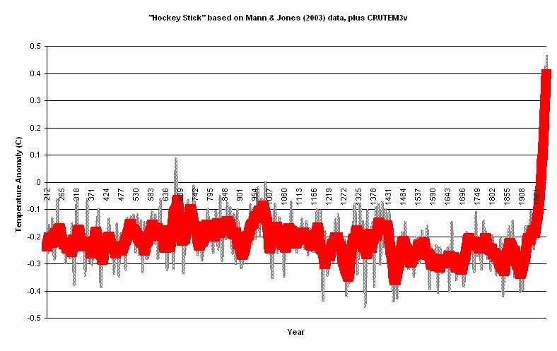
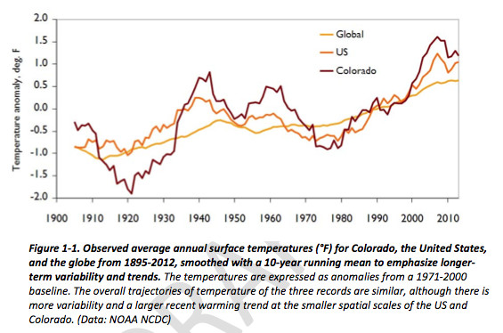
Climate experts say it’s about to get warmer —probably much warmer — in Colorado. A draft state climate report released this week for public comment shows that Colorado has warmed by 2.5 degrees Fahrenheit in the past 50 years. By the middle of this century, summer temperatures will be higher than in all but the hottest years, with another 2.5 to 5.5 degrees of warming expected.

The report, aimed at helping resource managers prepare for changing conditions, found no long-term trends in annual precipitation, even with the relatively dry period in the early 2000s. Annual observed precipitation changes the past few decades are within the range of natural variability, according to the report…

One big question mark with implications for water management is the effect of global warming in the mountains. Some recent research suggests greater warming at high elevations as global temperatures increase, but there’s a lack of data from sites above 10,000 feet in Colorado. Data gaps point to the need for better climate monitoring, some experts say, warning that federal budget cuts could threaten existing monitoring programs.

From the Associated Press via the Aurora Sentinel:

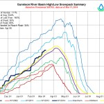
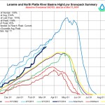
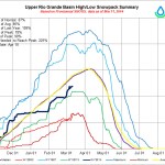
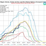
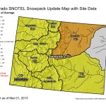
The report, released Wednesday, says most projections indicate less snow will accumulate in Colorado’s mountains because warming trends are causing it to melt earlier in the season.

The report was prepared for the Colorado Water Conservation Board by the University of Colorado’s Cooperative Institute for Research in Environmental Sciences. The board is accepting public comment through April 11…

It says statewide annual average temperatures have risen 2 degrees Fahrenheit in 30 years, the same as North America as a whole.

The report says computer models project Colorado temperatures will rise 2.5 to 5.5 degrees by mid-century, compared with a 1971-2000 baseline.

‘Think about how we can work together to keep this community alive’ — Leroy Salazar

Artesian well Dutton Ranch, Alamosa 1909 via the Crestone Eagle

From the Valley Courier (Ruth Heide):

Heading a water solutions team, San Luis Valley resident LeRoy Salazar told those attending a groundwater advisory meeting on Wednesday it is time to get beyond the blame game and work together to preserve Valley communities and the agricultural livelihoods that keep them alive. Part of a group trying to find solutions to affordable, equitable and successful water sustainability, Salazar said a year ago he was only 20 percent convinced “we would be able to make this thing work.”

He said he is presently up to 60 percent and hopes by the time the state well rules are in place, “I will have an 80 percent probability we are going to be able to keep this thing going.”

He added, “We are all working really hard.”

He commended the state engineer’s office for working hard to develop a groundwater model that would work and rules that would work for everybody.

“The well owners want these as bad as surface users,” he said. “We want to know what hand we are going to be dealt with.”

He said some flexibility may be required in the next year or two as water users work through some of the challenges they will come up against in complying with the state’s new rules.

“Some of those things may take us five to six years to work out,” Salazar added. “We may not be able to live at exactly the letter of the law. We can create a little bit of flexibility in there.”

He said it might not be possible to always replace depletions to the river in exactly the right time and place that the regulations will require.

“Think about how we can work together to keep this community alive.”

State Engineer Dick Wolfe said he believed “our greatest successes come from our greatest challenges,” and he is at an 80-percent confidence level. The well rules Wolfe hopes to submit to the water court yet this spring will require wells to make up for the injuries and depletions they have caused senior water rights and the aquifers.

Salazar said he has both senior water surface rights, which date back five generations , in addition to wells, which are junior water rights. He said wells are part of the reason that rivers are drier and aquifers diminished, but they are not the sole problem. The multi-year drought and the demands of the interstate Rio Grande Compact are also responsible, he said.

However, he said those trying to reach solutions must get beyond the blame game “and think what’s in the best interest of keeping our communities alive and keep them going.”

He said he could see at least 100,000 acres of land going out of production, and if solutions cannot be reached to the Valley’s water problems, that total could be twice that.

“Think what that will do to communities,” he said.

He said the two main issues to address are sustainability and depletions.

He said some of the solutions to sustainability are fairly easy. Changing farming practices to use less water would be a better solution than shutting wells down, he said. For example, while alfalfa requires 28-30 inches of water annually, barley only requires 20 inches, so a switch from alfalfa to grain would cut water usage by one third.

“We can do a little bit better than that,” Salazar added. “A lot of us that are raising grain and potatoes, there are a lot of conservation crops that can apply 6-8 inches that will raise some pasture for cows.”

A crop like sorghum sudan grass would only require 6-8 inches but would still provide pasture for cattle, for example.

“There’s alternatives without having to shut a bunch of wells down to increase sustainability,” Salazar said. “We know we have to reduce the drain on the aquifers. I think sustainability can be dealt with fairly easily if we all agree we need to cut back. I don’t think there will be too many farms go out of business if we cut back.”

Addressing the issue of replacing depletions is a bit trickier, Salazar said. He explained it would take on the order of 20,000-30 ,000 acre feet to replace those depletions throughout the Valley, with the Conejos system owing about 6,000 acre feet. If the drought continues, however, that number could increase to 8,000-10 ,000 ace feet on that river system, he said.

Forbearance is one key way to deal with the depletions , he said. Some senior water users who have been injured by well pumping may be willing to accept money instead of water, Salazar explained. However , there will be water right holders who will want “wet water,” and that will not always be easy to provide, he said.

“A lot of depletions we are seeing are owed on the lower Conejos might owe 10,000-15 ,000 acre feet of depletions. How do we get 10,000 acre feet down to that lower part if we have to replace it exactly in time and place and we can’t find enough forbearance agreements ?”

Another obstacle is reservoir storage in that area. Salazar said the Platoro Reservoir would be a good place to store water that could later be used to replace depletions. However, that reservoir is often restricted under the Rio Grande Compact on whether it can store water or not.

“It’s a Compact reservoir and a post-Compact reservoir , which means we can’t really store water from one year to the next ” which is what we really need to do if we are going to make this thing work. Trying to find storage is going to be a big issue.”

Dry riverbeds create other obstacles, Salazar added. If water has to move from one part of the stream to meet depletions on the other end, but there’s a dry riverbed in the middle, “we lose it all.”

Folks have four options in responding to the state’s pending groundwater rules, Salazar said. One option is to join a sub-district ; another is to formulate an augmentation plan; a third is to take the rules to court and try to keep them there as long as possible “that’s not a real good solution;” and a fourth option is to seek legislative mandates to force polices on the well users. Salazar said he would rather see the Valley work out its own solutions than to go to the state legislature.

The solutions committee, or team, has been trying to develop alternatives since last April, Salazar said. The team set up technical and legal sub groups and has held numerous meetings in the past year.

The team has looked at several alternatives such as diverting numerous junior water rights to pay for depletions and replenish the aquifer. Some of the people who own those junior water rights are not producing that much with them and would just as soon get paid for them. The San Luis Valley Well Owners own some junior water rights that produce a lot of water on certain years, Salazar said. That could be a source of replacement water.

The solutions committee is looking at many options and trying to find the most affordable and efficient ones, Salazar said.

More Upper Rio Grande River Basin coverage here.

‘Variability will drive us crazy and keep us humble’ — Nolan Doesken

Nolan Doesken -- Colorado Water Foundation for Water Education President's Award Presentation 2011
Nolan Doesken — Colorado Water Foundation for Water Education President’s Award Presentation 2011

From The Valley Courier (Ruth Heide):

“Nothing new under the sun” was pretty much the message delivered by State Climatologist Nolan Doesken yesterday during a gathering of area water leaders. Although winters have tended to be warmer, dry years more plentiful and snowfall melting off sooner in recent years, the major factors that determine the Rio Grande Basin’s climate have not changed, Doesken explained.

Colorado is still the highest elevation state in the union; it still remains in a mid-latitude location between the pole and the equator; the state is still interior continental, not any closer to an ocean than it ever was; complex mountain topography remains; and solar energy is still constant, with hundreds of sunny days a year.

In a state that boasts 300 days or more of sunshine a year, the Rio Grande Basin, which encompasses the San Luis Valley, is the sunniest part of the state, Doesken reminded the audience of the Rio Grande Roundtable group on Tuesday.

“Most of the main drivers of our climate are not changing ,” Doesken said. “Our high elevation isn’t changing, our mid-latitude location isn’t changing “”

He added, “It does appear over time there’s been a bit of a warming trend in much of the state, but down here it’s mixed signals.” He said summer days in Alamosa have been distinctly on the hot side in recent years, and when Alamosa is 90 degrees, that generally means the entire state is pretty warm.

However, Doesken said the weather station in Del Norte has recorded a colder trend, which might be attributable to a change in the weather station’s location itself.

Of the weather data available for the Valley, “Most locations show a modest upward trend in temperature,” he said.

“Precipitation, on the other hand, is all over the place.”

He said there is no discernable upward trend in precipitation. This basin’s biggest climate indicators are found within the basin itself, Doesken explained.

“It’s a local effect.”

He said if the data from 1925 to the present were examined, for example, temperature changes might be as easy to determine here as answering the question, “When did it snow last?”

Regarding Valley temperatures , residents have learned to dress in layers, because the temperatures can vary so much, even in a single day, Doesken said.

“You are the champion of diurnal range fluctuations, day to night,” he said. The Valley can experience a 50-degree temperature swing from morning to night on a routine basis. It can be 20 degrees in the morning and 70 in the afternoon.

“That’s the climate in which you live,” Doesken said.

“In the Midwest, Mississippi Valley, going north means colder, south means warmer, but in the mountains it’s local topography that drives temperatures.”

The variability of the Valley’s weather is what remains constant, or as Doesken put it, “Variability will drive us crazy and keep us humble.”

Sometimes there will be an apparent cycle of weather, while at other times it will appear random. One constant is the spring wind that the Valley experiences from March through June.

“You are in your fourmonth wind season right now, like it or not,” he said.

Regarding precipitation, this basin is dry, like it or not. Doesken said because of the basin’s location, it generally receives less than 8 inches precipitation annually , which is the climate area residents know and love.

“You love it as long as the mountains around you are full of snow. They are not always.”

The bulk of the state’s legitimate surface water comes from those mountain snows, but that can vary as much as the temperatures. Because of the moisture that came into the state last fall the majority of it in one week Denver wound up experiencing its wettest year, Doesken said. Doesken reminded the group of the fact most were painfully aware, that the Rio Grande Basin has not enjoyed a big snowpack year for a while.

“Drought happens. It keeps happening,” Doesken said. He said there have been more years with less snowpack by April 1, “but there’s a lot of noise in there.”

He explained how important it is to keep data and said the manual snow course collection sites are extremely valuable. He has been a proponent of maintaining those sites in the state.

He has served in the Colorado Climate Center since 1977 and has been the state climatologist since 2006.

“We are climate accountants ,” he said. The center monitors all aspects of climate in the state from humidity and temperature to precipitation and evaporation . Doesken said the first government weather state in Colorado was located at Fort Massachusetts in the San Luis Valley in 1855, and by 1890 there was a statewide weather reporting network that included sites like Monte Vista and Platoro.

That type of information is still valuable, and Doesken encouraged local residents to become part of the Community Collaborative Rain, Hail & Snow (CoCoRaHS) network that depends on folks in places like Villa Grove to provide weather information to the state climate center. Those interested in becoming a part of CoCoRaHS are welcome to attend an open house from 2-7 p.m. on Friday, March 21, at the Colorado Potato Administrative Committee office , 1305 Park Ave., Monte Vista.

More IBCC — basin roundtables coverage here.

Rio Grande Water Users Association board meeting recap

Upper Rio Grande River Basin via the Colorado Geological Survey

From the Valley Courier (Ruth Heide):

Groundwater rules, endangered species and interstate lawsuits, public trust doctrine ballot initiatives on top of what could be the sixth belowaverage water year in a row add up to what Rio Grande Water Users Association Attorney Bill Paddock called a “horrifying list of what’s out in front of us.”

“That’s what we’re dealing with,” Paddock told water users at the association’s annual meeting in Monte Vista yesterday.

To make a bitter pill even harder to swallow, the assessments for association members increased by $2 per unit, from $25 to $27 per unit, at the recommendation of the board. Association members, who represent area canals and ditches on the Rio Grande, approved the increase. Association President Greg Higel said the assessment increase was not a unanimous recommendation from the board, especially since many of the ditch companies had already set their own assessments for the year. However, the board believed the assessments had to be increased to handle the pending challenges of the year, such as possible lawsuits that might affect water users along the river.

Higel said the board also voted to allocate 2,500 acre feet for Subdistrict #1 again this year. In addition, the board recommended an irrigation start date for water users association members of April 1, which is the standard start date for the irrigation season.

Water user Willie Hoffner voted against the assessment increase and suggested an earlier irrigation start date for folks on Saguache Creek who might not see water again for a while if they are not able to divert it now. Colorado Division of Water Resources Division Engineer for Division 3 Craig Cotten said he would be meeting with the Saguache Creek water users later this month to discuss their preferred irrigation start date.

Cotten said the storms during the last week brought the Rio Grande Basin’s snowpack up from 77 percent to 87 percent of average, but this basin is still the lowest in the state, with other basins way above 100 percent.

“If we can keep getting some storms coming through we have a good chance of reaching that 100 percent,” he said. “We will have to wait and see what the next couple of months bring.”

If things do not improve, this will be the sixth year in a row with below average stream flow on the Rio Grande, Cotten added. Since 2002, the river has registered only three years with above average stream flow , “which is very unusual, and even more unusual the last five years in a row have been below average.”

He said there has only been one other time since the gauges were put in at Del Norte in 1890 that there were five years in a row of below average stream flow , and never six years in a row.

The preliminary forecast for the Rio Grande this year, based on the Natural Resources Conservation Service’s February forecast, at least promises a bit higher numbers than last year. The February forecast for the Rio Grande is 520,000 acre feet, which is still below average but higher than the 459,900 acre feet that passed through the Del Norte gauge last year. Last year’s total was about 71 percent of the longterm average, Cotten said. If the 520,000 acre-feet forecast holds true, the Rio Grande’s obligation to downstream states this year will be about 133,800 acre feet, and the curtailment to meet that obligation could be about 13 percent. However, Cotten stressed that is a guess at this point, and there are many different factors to consider before implementing a curtailment .

Cotten also shared National Oceanic and Atmospheric Administration predictions for precipitation and temperatures for the next three-month period, which show this area as having equal chances for average precipitation and good chances for above average temperatures. Both Cotten and Paddock spoke to the water users yesterday about pending lawsuits that could have impacts on irrigators in the San Luis Valley.

The state of Texas petitioned the U.S. Supreme Court to file a lawsuit against New Mexico and Colorado concerning the Rio Grande Compact, and the U.S. government joined with Texas in the petition last week. The Supreme Court has accepted that lawsuit, so it will now begin moving forward. Colorado is a minor player in the suit at this point but was named because it is part of the compact. Texas’ main beef was with pumping below Caballo Reservoir in New Mexico.

“It didn’t have a lot to do with us but we got drug into that court case,” Cotten said. Paddock added that if New Mexico were to win such a suit, Colorado would definitely be affected because more water would have to be diverted from Elephant Butte Reservoir, one of the main storage facilities for Rio Grande Compact water, leaving less water that could be counted as usable water for compact purposes. If that total decreases below 400,000 acre feet, which was the case last year and will likely remain the case this year, reservoirs in Colorado built after the compact was ratified cannot store water. Platoro Reservoir Paddock added that no one has filed any specific claims against Colorado in the New Mexico/Texas suit, only including Colorado because it is a signatory on the Rio Grande Compact.

“Hopefully there won’t be any spillback on water users in the Valley,” he said. “There’s significant issues that could come up in that lawsuit that could be concerns to Colorado and that could be concerns to all of you.”

Other pending lawsuits, which would more directly affect the Valley, are suits by the WildEarth Guardians. The environmental group filed notice of intent to sue and has 60 days from the time of its notice before it can officially file suit, which would be March 22. That group is alleging violations of the Endangered Species Act protection of the silvery minnow and Southwestern Willow Flycatcher, and so far those who may be named in the suit include the State of Colorado, Corps of Engineers, Bureau of Reclamation and Fish and Wildlife Service.

“They are claiming that the use of water out of the Rio Grande in Colorado is causing some injury to the endangered species in New Mexico,” said Cotten. “Our position is we have the Rio Grande Compact and we meet our compact obligations each and every year. We have done what we are supposed to do legally to deliver water down there.”

Paddock said if the WildEarth Guardians do bring suit against Colorado it would be a precedent-setting form of litigation nationally, and “it will be an incredibly high stakes lawsuit. They are asserting that endangered species overrule the compact. They are saying you can’t exercise your water rights so water can flow unimpeded to the state of New Mexico to support the silvery minnow. That’s the bottom line.” Regardless of the outcome, such a lawsuit would take years to argue and decide “and will involve every water user from the headwaters of the Rio Grande down to Elephant Butte Reservoir because they would all have the same issues .” He said, the State of Colorado “will not go quietly” if such a lawsuit were to proceed. Paddock and Cotten also reminded attendees of the Rio Grande Water Users Association annual meeting yesterday that groundwater rules will likely be filed with the court this spring. Cotten said the next advisory committee meeting is at 10 a.m. March 12 at the Inn of the Rio Grande in Alamosa, and the state engineer’s goal is to promulgate the rules in April. Paddock added if there are objections to the rules, the court would have to schedule a trial, if those are not resolved beforehand, and that could very likely take place by this time next year. If/Once the rules are ultimately approved, there will be a limited time period for wells to either be under an augmentation plan of their own or through a sub-district , Paddock reminded the water users. Sub-districts would also have a limited time to finalize their formations and plans of management, he added.

“We’re looking at a major change in water management over the next two to three years,” he said.

Capping off “horrifying list of what’s out in front of us,” according to Paddock, is the potential for ballot issues to go before voters this fall regarding a constitutional change from the current priority water system to the Public Trust Doctrine. The Public Trust Doctrine would involve a permitting system, and whoever was in charge of the permitting could choose how water would be diverted and for what uses. For example, the most beneficial use of water could be determined to be instream flows in the Rio Grande rather than diversions for agricultural irrigation, Paddock explained.

“The Public Trust Doctrine is unpredictable,” he said. “It’s terrifying because it takes away people’s certainty of how they can use their water and when it is available.”

He said if those promoting the ballot initiatives collect enough signatures, the Public Trust Doctrine initiatives would probably appear on the ballots this fall.

“It is a significant threat to everyone’s established water rights.” is one of those.

Another even more substantial potential impact of Texas winning this suit and requiring more water to be delivered out of Elephant Butte would be less chance of the reservoir spilling. In a year when Elephant Butte spills, Colorado has no delivery obligation downstream.

“That makes a whole lot more water available in Colorado ,” Paddock said. “That’s pretty high stakes.”

More Upper Rio Grande River Basin coverage here and here.

Udall, Bennet, Hickenlooper Announce $199 Million in HUD Funds to Help Colorado Recover from 2013 #COflood

Evans Colorado September 2013 via TheDenverChannel.com

Here’s the release from Senator Udall’s office:

U.S. Senators Mark Udall and Michael Bennet joined U.S. Housing and Urban Development Secretary Shaun Donovan and Gov. John Hickenlooper today to announce Colorado will receive an additional $199.3 million to help communities recover from the September 2013 flood. The recovery funds, provided through HUD’s Community Development Block Grant- Disaster Recovery (CDBG-DR) Program, will support long-term disaster recovery efforts in areas with the greatest extent of unmet need, primarily in Boulder, Weld and Larimer counties.

These new funds build on the $62.8 million Udall and his colleagues secured for Colorado in December 2013 to assist recovery efforts in Colorado. Today’s award brings HUD’s combined CDBG-DR investment to $262.1 million.

“Since the catastrophic flood half a year ago, I have been proud to lead efforts in Washington to help Colorado rebuild its devastated communities, protect our homes and businesses from future floods and mudslides, and secure federal aid for flood victims,” Udall said. “This second wave of recovery funds will supplement the emergency funds I have already helped secure for Colorado. But while these funds are an important milestone in our recovery efforts, I will keep fighting to ensure Coloradans have every resource we need to rebuild smarter and stronger.”

“These resources will help flood-ravaged communities in our state rebuild their homes and businesses, repair their roads and bridges, and invest in infrastructure to make Colorado more resilient the next time disaster strikes,” Bennet said. “We will continue to work together throughout the recovery process to build a stronger Colorado, and we are thankful for Secretary Donovan’s support.”

“After visiting Lyons and Evans in December I promised HUD would do more to help the state recover,” Donovan said. “This additional money will fund a local vision to rebuild homes and businesses, repair badly damaged roads and bridges, and spur economic development. While we can never truly replace all that was lost, I remain committed to helping Colorodo rebuild more resilient and better prepared for future storms.”

“This week marks six months since the flooding began,” Hickenlooper said. “From the beginning, HUD and our federal partners have been instrumental in investing in Colorado’s recovery. This second round of CDBG-DR funds is critical for families, businesses and economic development in the flood-impacted communities. We know we will never make whole those impacted by the floods, but these funds can help us build back sustainable, resilient communities for Colorado’s future.”

A minimum of 80 percent of the funds awarded today will be targeted in Boulder, Weld, and Larimer Counties where approximately 2,800 homes incurred major or severe damage. Although the majority of this funding is intended to address the remaining disaster recovery and resiliency needs from the September flooding, the state may target remaining funds to other especially hard-hit areas from other major disasters in 2011, 2012, and 2013. Those disasters include the 2012 High Park and Waldo Canyon wildfires, and the 2013 Royal Gorge and Black Forest wildfires.

HUD’s CDBG-Disaster Recovery grants are intended to confront housing, business and infrastructure needs beyond those addressed by other forms of public and private assistance. Using a combination of data from the Federal Emergency Management Agency (FEMA) and the Small Business Administration (SBA), HUD identified particular counties in Colorado with the greatest extent of damage to housing, businesses and infrastructure.

From The Greeley Tribune (Analisa Romano):

U.S. Senators Mark Udall and Michael Bennet joined U.S. Housing and Urban Development Secretary Shaun Donovan and Gov. John Hickenlooper today to announce Colorado will receive an additional $199.3 million to help communities recover from the September 2013 flood. The recovery funds, provided through HUD’s Community Development Block Grant- Disaster Recovery (CDBG-DR) Program, will support long-term disaster recovery efforts in areas with the greatest extent of unmet need, primarily in Boulder, Weld and Larimer counties.

These new funds build on the $62.8 million Udall and his colleagues secured for Colorado in December 2013 to assist recovery efforts in Colorado. Today’s award brings HUD’s combined CDBG-DR investment to $262.1 million.

“Since the catastrophic flood half a year ago, I have been proud to lead efforts in Washington to help Colorado rebuild its devastated communities, protect our homes and businesses from future floods and mudslides, and secure federal aid for flood victims,” Udall said. “This second wave of recovery funds will supplement the emergency funds I have already helped secure for Colorado. But while these funds are an important milestone in our recovery efforts, I will keep fighting to ensure Coloradans have every resource we need to rebuild smarter and stronger.”

“These resources will help flood-ravaged communities in our state rebuild their homes and businesses, repair their roads and bridges, and invest in infrastructure to make Colorado more resilient the next time disaster strikes,” Bennet said. “We will continue to work together throughout the recovery process to build a stronger Colorado, and we are thankful for Secretary Donovan’s support.”

“After visiting Lyons and Evans in December I promised HUD would do more to help the state recover,” Donovan said. “This additional money will fund a local vision to rebuild homes and businesses, repair badly damaged roads and bridges, and spur economic development. While we can never truly replace all that was lost, I remain committed to helping Colorodo rebuild more resilient and better prepared for future storms.”

“This week marks six months since the flooding began,” Hickenlooper said. “From the beginning, HUD and our federal partners have been instrumental in investing in Colorado’s recovery. This second round of CDBG-DR funds is critical for families, businesses and economic development in the flood-impacted communities. We know we will never make whole those impacted by the floods, but these funds can help us build back sustainable, resilient communities for Colorado’s future.”

A minimum of 80 percent of the funds awarded today will be targeted in Boulder, Weld, and Larimer Counties where approximately 2,800 homes incurred major or severe damage. Although the majority of this funding is intended to address the remaining disaster recovery and resiliency needs from the September flooding, the state may target remaining funds to other especially hard-hit areas from other major disasters in 2011, 2012, and 2013. Those disasters include the 2012 High Park and Waldo Canyon wildfires, and the 2013 Royal Gorge and Black Forest wildfires.

HUD’s CDBG-Disaster Recovery grants are intended to confront housing, business and infrastructure needs beyond those addressed by other forms of public and private assistance. Using a combination of data from the Federal Emergency Management Agency (FEMA) and the Small Business Administration (SBA), HUD identified particular counties in Colorado with the greatest extent of damage to housing, businesses and infrastructure.

From The Greeley Tribune:

Six months after the September flood, Weld County officials say they will solicit reimbursement for more than $12 million in emergency repairs, more than 130 permanent road and bridge repairs, and more than $300,000 for debris removal.

The county will also seek reimbursement from the Federal Emergency Management Agency for improvements that would reduce the risk of flooding in future events, officials said in a news release.

Weld County will submit about 35 total applications for FEMA reimbursement, some of those lumped into several small projects and some as one large project.

FEMA pays for 75 percent of the repairs, and the state of Colorado and Weld County will each contribute 12.5 percent of each project.

“Our Public Works staff, our Emergency Management staff and our consultants have been working daily to identify repair projects, estimate costs and gather the documentation needed to submit projects to FEMA for reimbursement,” said Weld County Commissioner Chairman Douglas Rademacher in a statement.

Weld officials say FEMA could approve funding for the emergency repairs by the end of April.

Weld County engineers are still examining roads and bridges and have time to submit more projects to FEMA in the future, according to the release.

The county is also working on several road repair projects with the Federal Highway Administration, which uses a separate reimbursement process.

The flood damaged seven FHA roads and bridges in Weld County, to the tune of $2.5 million in emergency repairs.

Engineers are working on the cost of permanent repairs, which the FHA will reimburse up to 80 percent.

From The Greeley Tribune (Analisa Romano):

Evans officials may seek to condemn the two mobile home parks destroyed by the September flood.

The Evans City Council is set to vote Tuesday on a resolution authorizing city staff to take legal ownership of Eastwood Village and Bella Vista mobile home parks.

The authority would allow them to clean the flood-contaminated debris county health officials warn will pose a public health hazard when warmer weather arrives.

Condemnation is a last resort, but could be the final scenario in the most “massive” of Evans’ flooding issues, said Sheryl Trent, Evans’ community and economic development director.

Trent said the city would seek help from Weld County or the state to help shoulder the $1 million cost of removing the debris, but officials will first pursue grants and other options.

The city is looking at a 60-90 day window to clear the contaminated debris, Trent said, and estimated it could be removed by June if the city gets the property through a normal purchase procedure.

If Evans has to condemn the property, she said that could be pushed back to July or later due to lengthy court procedures.

Perry Glantz, the attorney representing Eastwood Village owner Keith Cowan, said Cowan would need compensation not just for the property, but for the loss of his business.

Glantz said he would have to consult experts on an exact dollar amount, but the business and property are worth several million dollars.

Cowan last month filed a lawsuit against the city of Evans over a change in floodplain rules he says will keep him from reopening the park.

The lawsuit argues Evans has effectively taken away Cowan’s ability to use the property due to the new floodplain rules, which would require a costly investment because every mobile home in the park would have to be elevated, Glantz said.

The lawsuit also claims Evans officials rejected a plan to purchase his property through a Federal Emergency Management Agency grant.

Evans has filed a counter-lawsuit.

Glantz said Evans does have the power to take control of the mobile home park, but he said the loss in business would unfairly affect only Cowan.

“My client doesn’t own mobile homes. My client owns a mobile home park. And it wasn’t destroyed in the flood,” Glantz said. “One man doesn’t have to take the entire loss.”

Even if council members pass the resolution, Trent said the city will continue to pursue alternative solutions, including negotiations with the park owners.

If park owners show any sign of pursuing debris removal, Trent said the city will not seek condemnation.

The property acquired by the city could either be turned into a stormwater retention project or open space, Trent said.

She said Evans needs more stormwater infrastructure to handle standing water when it rains heavily, and a generous-sized retention lake could help.

If not, Trent said the city will maintain open space where the parks once were with some trails and gazebos so that if another flood does strike, no real structures would be affected.

The city has tried all other avenues to get the flood debris removed, Trent said, including reaching out to state and federal agencies for help.

The Denver Post editorial board opposes H.R. 3189 (NSAA vs. USFS)

Trail map for Powderhorn Ski Area via liftopia

From The Denver Post Editorial Board:

A battle over ski-area water rights that has been simmering in Colorado — and across the country — for several years has gotten the attention of the White House, and we’re glad to see it.

President Obama on Wednesday issued a statement opposing the Water Rights Protection Act, which passed Thursday in the U.S. House but must still go to the Senate.

The White House is right to send a strong signal about the unwise nature of this measure, which could pre-empt a compromise in the public interest.

The bill, sponsored by Rep. Scott Tipton, R-Colo., would put up road blocks to stop the federal government from re- asserting greater control over ski-area water rights.

Initially, it might sound like a no-brainer. Of course the government should allow the ski areas to keep water rights so they can keep producing the snow that is such an economic and recreational boon, right?

Unfortunately, it’s not that simple.

The U.S. Forest Service is attempting to re-establish stewardship of rights for water that originates on federal land. The goal is to ensure water stays with the public land used by resorts, even if ownership of the resort changes.

Beginning about 30 years ago in the region that includes Colorado, federal authorities started requiring ski-area permit holders to put water rights from public lands in the government’s name.

In 2004, the Bush administration changed policy, allowing ski areas to jointly hold water rights. When the Forest Service, under Obama, tried to change permit conditions to more closely follow historic practice in the Colorado region, the ski industry sued.

A federal judge ruled in 2012 that the process used to make permit changes was deficient.

Fortunately, there is room for compromise without another legal battle.

The Forest Service is creating, but has not yet released, a new ski-area water rights clause that could provide a solution. A solid compromise would be to allow resorts to keep water rights ownership, but require that the water remain with the land, regardless of whether ski resorts changed hands or business plans.

When released this spring, the draft will go through a full public vetting process, as it should.

Entire Colorado mountain towns and economies depend upon recreation on federal land, and it’s vital to ensure the people, through their government, retain control of the water that is the lifeblood of those communities.

From The Grand Junction Daily Sentinel (Gary Harmon):

A measure that would prevent federal agencies from requiring ski areas, ranches, municipalities and others to sign over water rights passed the U.S. House on Thursday in the shadow of a threatened veto. The Water Rights Protection Act by U.S. Rep. Scott Tipton, R-Colo., lost the support of U.S. Rep. Jared Polis, D-Colo., who had co-sponsored the measure, but did garner a dozen Democrat votes in passing 238-174.

Sen. John Barrasso, R-Wyo., introduced a companion measure in the Democrat-dominated Senate and Tipton said after the vote that he hoped to win the support of Colorado’s senators, Michael Bennet and Mark Udall, both Democrats. Senate President Harry Reid, a Nevada Democrat, also ought to be supportive, Tipton said.

“We’re pleased to know it passed the House,” said Club 20 Executive Director Bonnie Petersen. “Hopefully it will pass in the Senate. This is critical to everybody in the West.”

The White House, in a statement of administration policy, said the bill “is overly broad and could have numerous unintended consequences,” including damaging the ability of the Agriculture and Interior departments’ ability to manage resources for the benefit of public land and the environment, as well as maximum beneficial use of federal water facilities ensuring that adequate water is available for fisheries or threatened or endangered species.

In arguing against the measure, Polis also said the bill was overly broad and that he intended it only to apply to ski areas…

The breadth of the bill was intended from the beginning, when Polis originally signed on, Tipton said, noting that it still is supported by the National Ski Areas Association, which sued the U.S. Forest Service when it required ski areas, including Powderhorn Mountain Resort, to sign over water rights in order to obtain a permit to operate on the Grand Mesa National Forest.

The veto threat was pre-emptive, Tipton said, calling on the Senate to take a vote on the bill and let the legislative process go forward.

A federal judge ruled in the suit brought by the ski areas that the Forest Service had failed to comply with federal law in invoking the rule under which it demanded the water rights.

More water law coverage here.

Carpe Diem West: Mapping the River Ahead 2014 #ColoradoRiver

mappingtheriverahead2014

Click here to read the report from Carpe Diem West. Here’s the forward written by Anne Castle:

The Colorado River has always been known for its superlatives – the most volatile supplies, the most iconic landscapes, the most dammed, the most litigated, and recently, the most threatened. The challenges of the past have been overcome with achievements that matched the scope of the difficulties – significant and much-emulated breakthroughs in engineering and deal-making. The challenges of the present and future will require an even greater degree of creativity and ability to see through immediate gains and losses to the greater and longer term benefits to river interests and communities. The leaders in Colorado River water issues have historically risen to the challenges, tackling tough issues as they arise, and the leadership engaged today is in the complicated and painful throes of doing so again.

This report documents the concerns of some Colorado River thought leaders and their ideas about potential solutions and paths ahead. It provides a useful compilation of perceptions and suggestions gleaned from one-on-one interviews, and points out consistencies of approach that may not be evident in more public discussions. These voices point to the flexibility within the existing Law of the River that can support creative arrangements and new types of operation resulting in a more efficient overall system. While not intended as a set of recommendations, the discussions described can be mined for practical pathways forward that might garner broader support and address both the ongoing and new pressures on this critical river system.

The urgency of the present situation cannot be overestimated, and no one knows the risks better than the water managers who will guide the actions and formulate the contingency plans of the future. While each has particular interests to guard, Colorado River experts also know that solutions will not be easy and will likely require adjustment to some heretofore jealously guarded positions and anticipated benefits.

One obvious example of the evolution of thinking on Colorado River management is the recognition that a broader spectrum of interests must participate in the construction of plans and policies. Integration of Tribal rights and values, environmental stewardship, regional cooperation, and international partnerships are all emerging trends – and rightly so. More and better education of the general public about the labyrinthine nature of the existing river plumbing and operations and the corresponding complexity of securing sustainable supplies is also a common theme. Both of these conclusions follow from an appreciation that building the broad-based public and political support necessary to implement difficult solutions will require a coalition of the knowing.

There are also myths and urban legends about the Colorado River’s problems that must be dispelled before meaningful forward progress can be achieved. The foremost of these fables holds that there is a simple, silver bullet means of balancing the system. Despite well-meaning proponents who speak with conviction, simply turning off the fountains in Las Vegas or drying up golf courses in Phoenix isn’t going to take care of the problem. Similarly, the unspoken assumption that any necessary water can be obtained by drying up irrigated agriculture fails to acknowledge the very significant economic and cultural disruption that would follow.

The stakes have never been higher, but the level of engagement and willingness to acknowledge all the elephants in the room are also at an all-time peak. This report gives voice to some important ideas for potential refinement and a peek into the evolution of thinking and broad-based education that will be essential in identifying practical and implementable solutions to our common challenges.

— Anne Castle, Assistant Secretary for Water and Science, U.S. Department of Interior

Here’s a guest column written by Doug Kenney and Kate Greenberg that is running in the Boulder Daily Camera. Here’s an excerpt:

Two of the report’s themes stand out to us most clearly:

First, the emphasis on the urgency of the crisis we face. The age of denial is over, and leaders up and down the river are now grasping that we must begin to address this crisis today. Already, the water supply and demand curves have crossed. We are in uncharted territory, dealing with rapidly changing climatic conditions, facing a kind of vulnerability that is very new. So a new approach is also in order. Instead of thinking about how to “increase our supply” when water will be in shorter and shorter supply, we can begin to think about making do with what we have. Seeing our water needs through the lens of vulnerability, especially in this age of increasingly frequent extreme weather events, is the smart way to go. That allows us to stop chasing old solutions, and start coming up with ways to stretch existing supplies while planning ahead for drier days. There is enough water for us to thrive if we’re willing to look at water with this new perspective and act accordingly. This report is useful because it outlines real solutions – like water banking, urban and rural conservation programs, and city/farm water sharing agreements — that are working on the ground now.

Second is the focus on finding solutions to help both our family farms and our towns and cities. The report draws much attention to the possibilities of using temporary water transfers from farms to cities, and other innovative techniques to help farmers thrive and, at the same time, use water more efficiently. Since agriculture uses over 70 percent of surface water in the Colorado River Basin, we can and should help farmers to use their water most efficiently, while focusing on solutions that preserve independent family farms and the rural economy. Farmers simply must be a central part of any effort to ensure water security–and food security–for our region. This report acknowledges that fact while putting forward flexible, voluntary solutions that will work to balance often-conflicting needs.

While we know there are innovative solutions working already, we don’t have a lot of time to scale them up. We are facing an increasingly urgent crisis up and down the river — for communities, for natural systems, and for farms. A big part of that scaling up process is broadening out the conversation about the river and the people and natural systems that depend on it. With an informed, engaged public, we can find our way to a sustainable future in the Colorado River basin. This report is a great next step in the conversation. Learn more, and to advocate your favorite solution please submit by writing to info@carpediemwest.org.

Doug Kenney is Director of the Western Water Policy Program at the University of Colorado. Kate Greenberg is the Western Organizer with the National Young Farmers Coalition. She is based in Durango.

More Colorado River Basin coverage here and here.

‘Rivers do much more than keep fish wet’ — Jo Evans/Ken Neubecker #COWaterPlan

Saguache Creek
Saguache Creek

From The Pueblo Chieftain (Jo Evans/Ken Neubecker):

Colorado faces a future with more people and less water. A state water plan is a good idea, but we must plan carefully to get the future we want. We need to include rivers as rivers, not merely as engineered conduits bringing water to our faucets and farms.

Rivers do much more than keep fish wet. They are the life and heart of entire ecosystems. Ninety percent of Colorado’s wildlife depend on riparian habitat to survive. Riparian areas and rivers make up less than 5 percent of our total land area, but they are the most complex and important habitat we have. They are incredibly valuable economically as well as environmentally. According to the U.S. Census Bureau, Coloradoans spent $10 billion on wildlife related recreation in 2011 alone. Riparian areas and rivers statewide made that possible.

Most Colorado rivers have no prescribed minimum flows, and a healthy riparian zone needs more than that. When we take water out of a stream things change.

Riparian areas and the gravel aquifers they depend on dry out. Recent studies have shown that diverting more than 20 percent of a stream’s native flow can cause damage, and many streams in Colorado have far more water than that removed. Most water used will eventually return to the stream from which it was taken, even if many miles downstream. Water taken out of its original basin for use in another basin is gone forever. Trans-basin diversions impact the entire stream and riparian ecosystem, not just the flow of the stream.

When we add new water to a stream on this side of the Continental Divide, typically the stream becomes wider, deeper and faster. The stream may no longer fit the environment under which it was formed, impacting everything that depended on that stream habitat. This not only impacts wildlife but can make the natural drainage less able to handle floods such as we had last year.

We do pretty well at determining how much water we will need for our faucets and fields. We identify how much we need, where and when, and then look for ways to provide that quantity of water. The draft Colorado Water Plan lists specific municipal, industrial and agricultural needs for each of the major river basins and the possible projects to supply those necessities. But we need balance. Where is a comparable environmental needs list?

Specific environmental water needs are still mostly unknown. Environmental uses are usually described as “attributes” to be “enhanced” often by new storage and diversion projects. These “enhancements” may or may not be enough to maintain a healthy stream and riparian environment. If we are to meet our environmental water needs, we must identify and quantify those needs.

When we know how much water we need to repair and maintain our rivers, we can truly plan how to meet these needs. Until and unless we do, the state water plan is only half a plan and doesn’t provide for all the values expressed in the governor’s executive order calling for the plan. Not by a long shot.

Jo Evans is president of the Audubon Colorado Council. Ken Neubecker is with the Audubon Colorado Council Water Task Force.

Arkansas River Basin Water Forum, April 23-24 #COWaterPlan

Arkansas River Basin -- Graphic via the Colorado Geological Survey
Arkansas River Basin — Graphic via the Colorado Geological Survey

From the La Junta Tribune-Democrat (Pam Denahy):

The annual Forum will be held on April 23-24, 2014. The Forum will be celebrating its 20th anniversary in 2014. We will be taking the Forum down the river this year to La Junta, home of the nearby Bent’s Old Fort National Historic Site.

Additional activities to enjoy in the Otero County area can be found at the City of La Junta website: http://www.ci.la-junta.co.us and the Visit La Junta website: http://www.visitlajunta.net.

Please check out the website for details on lodging and registration: http://www.arbwf.org. Early registration ($45) may be done online at our website or by mail-in. Exhibitors are also welcome at no additional cost.

Given that the original purpose of the Forum was to encourage positive dialog about important Ark Basin issues, it is fitting that this year; the focus will be on Colorado’s Water Plan and the attendant Arkansas Basin Implementation Plan that will be of paramount importance in the coming year. The Forum will be hosting a panel with representatives from basins adjoining the Arkansas, along with James Eklund (director of the CWCB) and John Stulp (special adviser to the governor for Water Issues). The panelists will provide their basin specific perspectives on Colorado’s Water Plan. The program also includes two panels that will discuss the importance and the development of the Arkansas Basin Implementation Plan. Your feedback will be a very important component of the Basin Implementation Plan. This year the Forum has partnered with the Arkansas Basin Roundtable to provide an avenue for you to provide your input to the Basin Plan through an onsite clicker survey. You won’t want to miss this opportunity!

On the Forum’s second day, additional panel discussions will be focused on the Value and Importance of Agriculture, Invasive Species, Arkansas Basin Weather Update, and Agricultural Water Use. Based on the success of our experience with the “Community Workshop” on water education, we will be repeating this event once again the evening before the main Forum, on Tuesday, April 22, 2014 from 6 to 9 p.m. This year’s chairman, Dr. Lorenz Sutherland, and the planning committee have done a fabulous job and it’s shaping up to be a great event.

General questions may be directed to the Peaks & Plains CSU Extension Office at(719) 545-2045 or to Jean Van Pelt, Southeastern Colorado Water Conservancy District at (719) 948-2400.

What: Arkansas River Basin Water Forum

Where: Otero Junior College Student Center

When: April 23-24

Cost: $45 preregistration

Contact: CSU Extension Office, 545-2045 or Southeastern Colorado Water Conservancy District, 948-2400.

More Arkansas River Basin coverage here and here.

‘Our water right requires us to replace the water in the Box Elder. That’s what they (Select Energy) should do’ — Mark Harding

Map of the South Platte River alluvial aquifer subregions -- Colorado Water Conservation Board via the Colorado Water Institute
Map of the South Platte River alluvial aquifer subregions — Colorado Water Conservation Board via the Colorado Water Institute

From The Denver Post (Mark Jaffe):

The meandering Box Elder Creek has become a battlefield as farmers and ranchers are facing off against a plan to drill wells along its banks to provide water for fracking and other oil-field operations. While the creeks wends its way north from Elbert County to the South Platte River in Weld County — Arapahoe County is ground zero for the fight.

Boxelder Properties LLC is proposing sinking four wells to draw 500-acre feet of water annually for the fracking and other oil-drilling operations. That is enough water to supply 200 average Denver homes for a year.

Ranchers and farmers along the Box Elder say the plan will dry out wells and pools used by cattle, as well as kill vegetation along the creek’s banks east of Aurora.

“These boys from Texas think they can just ride in. Well, the people on Box Elder are going to meet ’em at the hill,” said Jerry Francis, who grazes about 30 head of cattle on the creek.

The dispute underscores the problem of trying to balance oil and gas development in Colorado with other economic activities.

“We want oil and gas development, but we have to do it so we don’t jeopardize our agricultural community,” Arapahoe County Commissioner Rod Bockenfeld said.

The county commissioners have sent a letter opposing the project to the Colorado Division of Water Resources, which must decide on the proposal.

The proposal has become so controversial that Houston-based Conoco-Phillips, the main company drilling in the area, announced that it wouldn’t use water from the wells. Houston-based Select Energy Services, the Conoco contractor that initiated the plan, has also abandoned the idea, according to company spokeswoman Brooke Jones.

Still, the permit application to drill the wells is pending with the water division, also called the Office of the State Engineer.

“The project isn’t dependent on Conoco; there are other oil service companies,” said Walraven Ketellapper, head of Boulder-based Stillwater Resources and Investment.

Stillwater, a water broker and agent, is handling the permit for Boxelder Creek Properties.

The state engineer has received 16 letters — from farmers, public officials, water districts — objecting to the plan and raising concerns about its impact on water supplies.

“We are going to do the engineering analysis, the groundwater modeling to show the wells can withdraw water without adverse impacts,” Ketellapper said. “That is our burden of proof.”

Just 15 miles east of Denver, suburban sprawl gives way to silos, barns and broad fields seemingly running all the way to the snow-capped Rockies. It is through this landscape that Box Elder Creek snakes its way to the South Platte River, 2 feet deep in some places, sometimes as wide as 12 feet, while in other spots it is just a dry, sandy bottom most of the year.

“We are a dry county,” said Bockenfeld, the Arapahoe County commissioner. “Many farms dry farm; there just isn’t a lot of water.”

Only in the early spring with the first snowmelt does the creek run full, but all year long a subterranean stream feeds ponds and pools, residents say.

“This pool is here all summer long,” Francis said as he stood in a field next to the creek. “The water and this buffalo grass gets cattle fat as a fritter.”

A retired John Deere worker who raises cattle to keep busy, the 67-year-old Francis said what he is most concerned about is the future.

“They take away the water, what’s left for my kids and grandkids?” he said.

A neighboring farmer, Bill Coyle, 60, has more immediate concerns. Coyle estimates he spent about $300,000 in an eight-year battle with the state engineer to get a water right for four irrigation wells on his 1,000-acre farm. Standing at one of his center-pivot wells, Coyle can see the spot where one of the proposed wells would be. It is beyond the state-required 600-foot setback — but still within sight.

The application for the four water wells says that they are drawing water from the creek and won’t impact local wells. Coyle doesn’t believe it.

“They are proposing pumping at 1,000 gallons a minute,” Coyle said. “My well is 42 feet deep. It will have an impact on the well, and it will be immediate.”

The decision to issue a temporary permit to drill and pump the four wells to produce 500-acre feet a year or 163 million gallons rests with the state engineer. The award of a long-term water right would be determined in Colorado Water Court — a process that can take as much as five years. The process is governed by Colorado water law — a byzantine set of rules organizing the right to draw water based on a priority system.

The key to being allowed to pump the water is a so-called augmentation plan to replace it so that the older or “senior” water rights are not impaired. This is an expensive process.

Select Energy offered four landowners — none of them local residents — $10,000 to drill a water well on their land and 1 cent for every barrel of water — about 42 gallons — pumped, according to one of the contracts.

They also purchased shares in the Weldon Valley Ditch to replace the pumped water. The application estimates that 10.4 shares — worth about $950,000 — would be needed to replace the 500 acre-feet drawn from the water wells.

Water, however, is vital to the oil and gas industry, with demand growing 35 percent to 18,700 acre-feet from 2010 to 2015, according to state estimates. The water, mixed with sand and chemicals, is pumped into wells under pressure to “hydrofracture” or frack shale rock and release oil and gas. About 4 million gallons is pumped into a single horizontal well.

“Water has always responded to the market in Colorado,” said Ken Carlson, director of the Center for Energy and Water Sustainability at Colorado State University. “First it was urban areas buying the water rights of farms. Now it is oil and gas.”

Select Energy is now getting its water from Denver-based Pure Cycle Corp., which has deep wells on the former Lowry Bombing and Gunnery Range, in Arapahoe County. Pure Cycle is opposing the plan because it also has a water right on the Box Elder that would be hurt, said Mark Harding, Pure Cycle’s president. The problem is that the plan calls for pumping along the Box Elder but returning the water about 50 miles to the north near Wiggins.

“Our water right requires us to replace the water in the Box Elder. That’s what they should do,” Harding said.

The state engineer will rule in the next few months on the temporary permit, which could enable pumping this year and last for as long as five years.

“This application is unusual in that the Box Elder isn’t a continuously flowing stream where the groundwater is continuously replenished,” Deputy State Engineer Kevin Rein said.

“We take the concerns seriously, and we’ve asked the applicant to respond to them,” Rein said. “We’ll have to see what they say.”

More oil and gas coverage here and here.

More drought planning needed by communities in the Upper #ColoradoRiver Basin #COWaterPlan

Colorado River between Granby and Hot Sulphur Springs

From the Glenwood Springs Post Independent (Hannah Holm):

According to Louis Meyer of the consulting firm SGM, most water providers that serve households in communities from the Colorado River’s headwaters in Grand and Summit counties on down to Grand Junction have done a pretty good job of planning for the range of climate conditions that have been seen over the past several decades.

However, most are not prepared for the more extreme droughts that both climate change models and ancient tree ring studies indicate could occur in the future.

SGM is working with the Colorado Basin Roundtable to assess water needs and potential projects for a “Basin Implementation Plan” that will help inform the Colorado Water Plan that Gov. John Hickenlooper wants drafted by the end of this year. The Colorado Basin Roundtable, like its counterparts in other major river basins around the state, is a group of water managers and stakeholders charged by the state legislature with doing “bottom-up” water planning. Meyer and his team have been interviewing domestic water providers throughout the river basin to determine what their needs are and what kinds of projects would help them be more prepared for the future.

One factor making communities vulnerable to prolonged or extreme droughts is the fact that many lack sufficient reservoir storage upstream from their water treatment plants. These communities rely largely on water in streams to serve their customers while releasing water from reservoirs in other drainages to satisfy any downstream senior calls on the river. This is more of an issue in headwaters communities in the upper Fraser, Eagle, Blue and Roaring Fork river watersheds than in the Grand Junction area, where water providers enjoy access to reservoirs that are physically, as well as legally, upstream…

Increasing reservoir storage, promoting conservation and addressing forest health all require money, and increasing storage requires permits as well. The small size of many water providers in the basin limits their capacity to take on big projects, so Meyer and his team have suggested more regional cooperation may make projects to increase the reliability of community water supplies more feasible.

Water customers also have a role to play in determining the capacity of their water utility to plan and prepare for the future. If customers are not willing to help pay the necessary costs through their rates, it limits a utility’s capacity to act. Water providers are not only faced with providing safe drinking water to customers at prices that are often less than 1/10th of one penny per gallon, but now customers are much more aware of water-demand impacts on local stream health.

@Amazing_Maps — Mean Elevation of each US State

H.R. 3189 passes the US House of Representatives

From The Pueblo Chieftain (Chris Woodka):

A bill that prohibits the transfer of private water rights to the federal government as a permit condition passed the U.S. House on Thursday. The bill was sponsored by U.S. Rep. Scott Tipton, R-Colo., with support from U.S. Rep. Cory Gardner, R-Colo. The Water Rights Protection Act, HR3189, passed 238-174, with 12 Democrats joining Republicans in an otherwise party-line vote. It is awaiting action by the Senate and could face a veto from President Barack Obama,

The bill is in response to U.S. Forest Service contracts with Colorado ski areas that required transfers of water rights as a condition. State water users feared the federal government would apply the same conditions to grazing contracts as well.

The bill protects Colorado water rights from federal encroachment.

The bill had widespread support from conservancy and conservation districts in both the Arkansas River and Rio Grande basins, as well as from numerous Western Slope groups.

“Water is the lifeblood of the Western United States and all water users including grazers, ski areas, businesses, tribes and municipalities need certainty that all federal land management agencies, not just the Forest Service, are prohibited from future attempts to take privately held water rights,” Tipton said.

“Water is everything to communities in Colorado,” Gardner said. “Our farmers and ranchers, our commerce, and our towns and municipalities can only thrive when there is certainty that they will have access to water.

From American Rivers (Matt Niemerski):

The House of Representatives voted today to approve a bill that could dry up countless stretches of rivers and harm river restoration efforts nationwide. H.R. 3189 – the so-called “Water Rights Protection Act” – passed by a 238-174 vote.

This bill is terrible news for rivers nationwide. It puts the interests of the oil and gas industry, corporate agriculture, and other private interests over the health of our rivers, fish and wildlife, and the millions of Americans who fish, boat, and enjoy river recreation. It is ultimately a broad swipe at federal natural resource agencies’ authority to protect public lands and recreation.

The bill, pushed by the National Ski Areas Association and Aspen’s SkiCo, as well as the Farm Bureau, the U.S. Chamber of Commerce, the National Cattlemen’s Beef Association, the Colorado Petroleum Association, and the Colorado Oil and Gas Association, would strip away critical safeguards for rivers, fish and wildlife.

The bill was originally introduced to address a specific conflict between Colorado’s ski industry and the U.S. Forest Service. Even though the Forest Service has already acted to address the ski industry’s issue, the bill became a vehicle for the oil and gas industry, corporate agriculture, and other industries, putting their interests ahead of the public’s interest in healthy rivers and recreation.

This bill was so badly written, that in a last ditch effort to try to bring some sanity to the legislative process, House Democrats offered an amendment that would, at the very least, allow federal agencies to protect rivers enough to guarantee recreation jobs, fire suppression, and communities threatened by drought. But apparently those restrictions did not work for the ski industry, the CAFO operators, and the hydrofrackers. So their supporters in the House voted no.

In a rare and almost unprecedented move, Congressman Jared Polis (D-CO) took a bold step to protect rivers in Colorado and across the nation by removing his support for a bill of which he was an original sponsor. Rep. Polis introduced an amendment that would rectify the flaws in the bill by narrowing it to address the ski areas’ original concerns, but that was ultimately rejected by the House. Congressman Polis went down to the floor of the House to oppose the bill and offer a passionate defense for rivers and the outdoor recreation economy.

River advocates spoke up, and Congressman Polis listened. We should all applaud Congressman Polis for having the courage to stand up and do what is right. Jared Polis is a true champion for healthy rivers, and for everybody who fishes, boats, and enjoys the outdoors and he called this bill out for what it truly is: a job killing water grab. His leadership sets a great example, and we hope his colleagues follow this example in the future.Additionally Rep. Grace Napolitano (D-CA), Rep. Peter Defazio (D-OR), Rep Jared Huffman (D-CA), Rep Niki Tsongas (D-MA), Rep. Ann Kuster (D-NH) all engaged the fight on behalf of the America’s rivers on the floor of the House to fight a bill which Rep. DeFazio described as “just another attempt to undermine critical environmental protections and target federal agencies that manage our public lands for future generations.” They deserve our thanks.

Most importantly I thank you, our friends who care deeply about our nations rivers. Although this bill passed the House, your voice was heard. Passing legislation like this comes with a price for its supporters, and it took the full weight of some of the nation’s most powerful interests to get it through the House. River advocates and our allies in Congress landed the blows needed slow this legislation down.

Even though the President declared his strong opposition to the bill, the ski industry and their polluter allies don’t appear to be giving up. Well, neither will we.

The bill is now in the Senate’s hands, and we have to keep the pressure on. American Rivers and our partners across the country will continue to stand against this bill and we urge the Senate to oppose this sweeping attack on our rivers. But we are only as strong as our supporters. River advocates must also stand firm and keep the pressure on the National Ski Areas Association to break with big polluters like the hydrofrackers and the CAFOs, and instead work on a solution that addresses their concerns.

More water law coverage here.

Snowpack news: WWA Intermountain West Climate Dashboard — New Briefing Available #COdrought

Click here to read the latest briefing from Western Water Assessment. From the website:

As in January, precipitation in February was unevenly distributed across our region, with the storm tracks and dynamics generally favoring the high mountains as well as some adjacent areas to the east of the mountains. Areas with above-average to much-above-average precipitation included western and north-central Wyoming, southeastern Wyoming and portions of eastern Colorado, and the high mountains in Colorado and northern and central Utah Western US Seasonal Precipitation. Central and south-central Wyoming, most of the lower-elevation areas of Colorado, and southern and northeastern Utah were drier than average. Overall, an active and consistent weather pattern persisted through the month and into early March, with repeated shots of Pacific moisture in the same locations with each passing low-pressure trough.

There was a striking pattern in temperature anomalies across the region in February Western US Seasonal Precipitation. East of the Continental Divide in Wyoming and Colorado saw temperatures colder than average by 3–12°F, as repeated Arctic cold waves sloshed into those areas. West of the Divide, including all of Utah, temperatures were 3–9°F warmer than average. Worland, in central Wyoming, was 11.5°F below normal for the month, while about 300 miles away, Salt Lake City was 7.9°F above normal for the month, an almost 20-degree differential in the anomaly.

From The Denver Post (Monte Whaley):

Six months after September flooding washed over homes, businesses and lives, residents and officials are scrambling to prepare for a spring runoff season that could be wildly unpredictable. That’s because the flooding that took 10 lives, closed 30 state highways and interstates and caused at least $1 billion in damages also drastically altered rivers and streams that carry melted snow to towns and cities, say officials. Some riverbeds were moved several football fields from where they had rested for generations. Floodwaters made some channels wider and deeper and able to carry more water, while others are now shallower and narrower and will funnel less water.

“It’s like your bathtub at home,” said George Gerstle, Boulder County’s transportation director. “If your bathtub is reshaped, it’s not going to hold water like it did before.”

This is causing unprecedented problems for those shoring up damaged canals and channels and rebuilding roads by early May. It’s hard to predict where all that water from the foothills and mountains will go when it starts barreling downhill.

“We’ve faced higher-than-normal snowmelts,” said Johnny Olson, incident commander with the Colorado Department of Transportation Infrastructure Recovery Force. “But we’ve never faced it when the roadways don’t have the right elevation or there is instability in the slope and banks of the river.

“Because of that, we’re not sure how the river is going to react.”

The signs are already there for a huge runoff. Snowpack in some areas is running almost 250 percent of normal. The ground is still saturated where floodwaters ran especially heavy, and unusually high water tables are forcing springs to pop up from under the ground in the foothills. A full-blown spring runoff event is likely to happen if temperatures in early May are unusually warm followed by heavy rainfall, said Mike Chard, director of the Boulder Office of Emergency Management.

“This will happen. This will be a reality,” Chard said.

To prepare, communities hit hardest by the September flooding began piecing together plans this winter to deal with the inevitable runoff.

In Lyons, which was split in half by the flooding, contractors and crews are stabilizing the banks of the North and South St. Vrain and building berms to protect homes and businesses, said Lyons Mayor Julie VanDomelen. So far, the town has spent $657,000 for immediate efforts to shore up stream beds, and another $571,000 is being earmarked to spend on private property through the Natural Resources Conservation Service program, VanDomelen said. She and other public officials in flood-damaged communities say they’ve been able to work with county, state and federal officials to make sure flood-prevention funds and resources are flowing.

There were some hard negotiations, however.

“With FEMA (the Federal Emergency Management Agency), they don’t usually work on future flood events,” said VanDomelen. “But we told them, ‘No, this is going to happen.’

“So now, we have a framework to work with.”

Colorado’s flood-ravaged communities got more federal help Friday, when the U.S. Department of Housing and Urban Development announced it would provide an additional $199.3 million in recovery funds. The money comes through HUD’s Community Development Block Grant Program to support long-term recovery efforts in areas of Colorado with a great extent of “unmet need,” primarily in Boulder, Weld and Larimer counties.

Debris removal and shore stabilization are ongoing in Estes Park, while farther east in Weld County, Evans is hosting Flood Preparedness Week on Monday through Saturday. Such an event probably wouldn’t have gotten much attention before the September floods, which totaled or severely damaged 200 mobile homes and 60 houses. Up to 2,500 people were displaced.

“In Colorado, flooding wasn’t really on the radar screen, and it certainly wasn’t here,” said Kristan Williams, city of Evans spokeswoman. “But this year, it is.”

Evans has spent nearly $1.7 million in its recovery efforts and is awaiting full reimbursements from FEMA and the state. The city is also working to get debris removed from two heavily damaged mobile-home parks.

Flood Preparedness Week, meanwhile, will focus on morale-boosting and practical ways to prevent flash flooding. Author Mark Hoog will speak on resiliency Wednesday. Then on March 22, residents can learn about financial programs for flood victims and the importance of tetanus shots, and view a sandbagging demonstration.

“It’s things people will need to know in case this happens again,” Williams said.

This winter, crews from Boulder County went through 3,000 flood-damage reports and walked 90 miles of creeks and drainages to pick the most likely problem areas during a spring flood. They found 200 hazardous spots that need the most attention. Those include streams that need realignments, debris removal and culverts replaced. In at least two areas, a home is either in a stream or jutting out over one, said Chard. Officials hope to get everything flood-ready by May 1. Meanwhile, they implored rural county residents in a series of public meetings this week to report any signs of early flood activity.

“I need your eyes on the mountain,” Chard said. “If you see something, let us know.”

Early May is also the deadline for CDOT crews to finish preparing flood-damaged state and federal roads for spring runoff in the foothills. On Monday, the first of 10 two-hour blasting operations is planned from 9 a.m. to 11 a.m. at mile maker 11.2, west of Pinewood Springs near Estes Park. The work is part of flood reconstruction between Lyons and Estes Park on U.S. 36. On average, the highway will be moved inland about 20 feet, away from the St. Vrain River.

“We are still in the process of getting that roadway on bedrock and making it more stable,” said CDOT’s Olson. “It’s all part of our efforts to protect the public as much as we can.”

Meanwhile, in the Boulder County foothills, Jamestown residents and crews have worked hard to stabilize and remove debris along the James and Little James creeks, said Mayor Tara Schoedinger. The town’s nearly 300 residents were forced to evacuate during September’s floods, and Schoedinger’s next-door neighbor, 72-year-old Joey Howlett, was killed.

“It was a horrible, bad day,” said Schoedinger, who praises the hard work of her constituents as spring flooding approaches.

“It’s certainly something we’re concerned about, but I don’t think anyone is panicking,” she said. “We all have a job to do, and we do it.”

She thinks they have done a good job clearing the streams that feed the town.

“We’re just more worried about what is coming for above us,” Schoedinger said.

San Luis Valley: #COWaterPlan public meetings start March 17

More Colorado Water Plan coverage here/a>.

Snowpack news (% of normal): Upper Rio Grande River Basin = 86%, South Platte still on top = 144%

Statewide snow water equivalent as a percent of normal March 13, 2014

From the Valley Courier (Ruth Heide):

If the snows keep coming, the San Luis Valley might rise up to an average water year yet. Snowpack in the Rio Grande Basin is currently 87 percent of average, Colorado Division of Water Resources Division 3 Engineer Craig Cotten said on Wednesday.

“Hopefully we will have some snowstorms coming and get a lot closer to that average line.”

He said the snowpack is not quite up to average but is better than it has been the last three years at this point.

“We are a little bit higher than we were last year,” he said, “and we have a few good months to go where we could get measurable precipitation and snow.”

The stream flow forecasts for this year are all over the board at this point, Cotten added. Some in the southern drainages are predicting as low as 40 percent of average this year while the Saguache Creek, on the northern end of the Valley, is forecast at 116 percent of average. Most are in the 80-percent-of-average range, Cotten said.

“But we have a couple of months to go,” he added.

Irrigation season has begun on a couple of the smaller streams, as of March 12, but typically the official season begins April 1. The Rio Grande Water Users Association , for example, voted April 1 as its irrigation start date. Cotten said his office is meeting with irrigation companies and water user groups yet this month to discuss further irrigation turn-on dates. On another water-related note, Cotten said the water division was going to start cracking down on folks who have exceeded their fiveyear average on acre-foot limitations for their wells but decided to incorporate those rules into the pending groundwater regulations. That means those rules will go to the water court as a part of the overall groundwater regs this spring and go into effect when the water court clears them, if there are no objections.

If the rules are promulgated this spring and go into effect next spring, the water office will use the 2011-2015 time period to calculate the five-year average for those under decreed well limits. Cotten said his office has a list of people who have already or will likely exceed their annual pumping limitations, and they will receive letters this year so they know what could be coming down next year.

From The Wet Mountain Tribune (Cyn Williams):

For the past several days, the Sangres have worn scarves of snow clouds. The mountains shine with snow, an optimistic sign of water. As of March 11, SNOTEL reports for South Colony show 67 inches of snow, which equates to 17.2 inches of precipitation. On March 10, South Colony registered 70 inches of snow, which means three inches melted over two days.

March shows an increase from SNOTEL readings in February, which registered 50 inches, or 15.5 inches of moisture. In January of this year, the reading was 41 inches of snow, with 13 inches of precipitation, so clearly March has bounded ahead in water accumulation.

According to Jim Sperry of the National Resources Conservation Service (NRCS), of a 30-year average, this year equals 104 percent, meaning moisture is up four percent. He said, “we have a good start and still have a lot of March and April left to get snow, which we need to get through the drier months of May and June.”

The entire Arkansas River Basin stands at 101 percent of the long term average. So far, water percentage for the entire state of Colorado is 108, compared to last year’s 150.

Statewide the snowpack is 116 percent of median, with February’s precipitation total reaching 133 percent of average. Last year in March snow pack was 161 percent of median. In 2014, the reservoir storage percentage sits at 87, in contrast to 67 recorded in 2013.

In the state, the deepest snow depth is recorded at SNOTEL station Tower at 134 inches, which equates to 46.6 inches of precipitation. At 10500 feet, Tower feeds the Laramie and North Platte River basin. Max temperature average at South Colony, elevation 10,800, on March 11 was 9.4 degrees.

H.R. 3189 and HB14-028 (NSAA vs. USFS): Ski area water rights bills in Denver and Washington DC are both in trouble #COleg

Trail map for Powderhorn Ski Area via liftopia

From The Durango Herald (Joe Hanel):

A dispute between Colorado ski areas and the Forest Service has caught the attention of the White House, which on Thursday threatened to veto a water-rights bill that U.S. Rep. Scott Tipton, R-Cortez will present on the House floor today.

Meanwhile in Denver, state senators delayed a vote on a related bill by Sen. Ellen Roberts, R-Durango, out of concerns that it improperly singles out the Forest Service.

The bills in Washington and Denver address an effort by the Forest Service to gain title to water rights used by ski resorts that lease federal land.

“This is important to the West. We hope the president won’t politicize this because this isn’t a Republican or Democrat issue,” Tipton said in a phone interview.

Rep. Jared Polis, D-Boulder, is a co-sponsor of Tipton’s bill, and a few other Western Democrats also support it…

“Basically, it comes down to, does Colorado decide its water-rights system, or does the federal government?” [Sen. Ellen Roberts] said Wednesday at a meeting of the Senate State Affairs Committee…

Cities that have reservoirs on federal land worry that if the Forest Service can take ski water rights, nothing would stop them from claiming reservoirs, too, Moseley said.

However, Sen. Matt Jones, D-Louisville, defended the Forest Service and said most Coloradans would support the principle of keeping ski water rights reserved for skiing.

“This isn’t the mean old federal government telling people what to do. This is the steward of our lands,” Jones said.

Sen. Jessie Ulibarri, the committee’s chairman, delayed a vote on Roberts’ bill, saying he thinks it’s an important topic but that the bill might illegally single out one entity, the Forest Service.

As the hearing was happening in Denver, the Obama Administration lowered the boom on Tipton’s bill in Washington by releasing a “statement of administration policy” – essentially, a veto threat.

The U.S. House is scheduled to vote on Tipton’s bill today. It would forbid federal land-management agencies from claiming water rights as a condition of a land-use permit.

“The bill threatens the Federal government’s longstanding authority to manage property and claim proprietary rights for the benefit of Indian tribes and reserved Federal lands, and the broader public that depends on the proper management of public lands and resources,” the unsigned administration statement said…

Tipton has allies, as well. The influential U.S. Chamber of Commerce has come out in support of his bill, and it is expected to pass the House this afternoon.

However, the version of Tipton’s bill in the Democratic-controlled Senate has stalled and has not received a hearing, and Obama’s veto threat could seal its fate.

From the Seattle Times (Kyung M. Song):

The U.S. House on Thursday passed a controversial bill triggered by the U.S. Forest Service’s equally controversial move to assert federal ownership over water rights held by ski areas to tap public streams for snow-making.

The 238-174 vote — with every Republican in favor and all but 12 Democrats opposed — capped a twisted legislative journey that began with a 2012 court fight in Colorado and ended with a bill that critics fear would handcuff federal oversight of water use by ranchers, farmers, oil companies, municipalities and other parties…

The Water Rights Protection Act had the backing of virtually all ski resorts in the United States. Among them are 13 ski areas in Washington, including Crystal Mountain, The Summit at Snoqualmie and Stevens Pass.

But the National Ski Areas Association in recent weeks had been pushing lawmakers to narrow the legislation’s scope out of fear the Democrat-controlled Senate would otherwise reject it. Rep. Jared Polis, a Colorado Democrat and one of the bill’s 15 co-sponsors, withdrew his support and pushed for an amendment to restrict the bill only to ski-area permits.

Instead, House Republicans approved a broader bill that would apply to the Interior Department and the Department of Agriculture, agencies that encompass the Fish and Wildlife Service, Bureau of Land Management, National Park Service as well as the Forest Service.

Rep. Doc Hastings, R-Pasco, chairman of the House Natural Resources Committee, managed the bill on the House floor as Democrats denounced it as sloppy legislation that would bring far-reaching consequences.

Democrats also repeatedly pointed out that Hastings’ committee held the only hearing on the bill on Oct. 10, in the middle of the 16-day federal- government shutdown and with no witnesses testifying in opposition.

Hastings rejected the criticisms and said the bill simply would protect private property from confiscation under President Obama’s “imperial presidency.”

More 2014 Colorado legislation coverage here.

South Platte River Basin: ‘…no simple answers’ to the issue of groundwater management in the area — Bill Jerke

Map of the South Platte River alluvial aquifer subregions -- Colorado Water Conservation Board via the Colorado Water Institute
Map of the South Platte River alluvial aquifer subregions — Colorado Water Conservation Board via the Colorado Water Institute

From The Greeley Tribune (Eric Brown):

The question was asked: Is the conversation about agriculture issues more emotional today than ever before?

Responding before the crowd at the University of Northern Colorado for the day’s panel on Colorado agriculture, Paul Sater, a Kersey-area farmer, threw in his two cents.

His answer was “yes.”

Sater said only a generation or two ago, everyone was just a grandfather or other relative away from the farm or ranch, and now, with only about 1 percent of the population involved in ag, an unknowing public has questions — leading some to even have suspicions.

“In absence of reason, you have emotion,” he said. “That’s where we are today.”

Taking the emotion out of the ag-conversation equation and providing information for voters on Colorado agriculture was the goal of the League of Women Voters of Greeley-Weld County, who hosted the event.

On the panel was Bill Jerke, a LaSalle-area farmer and former Weld County commissioner and state legislator; Brent Lahman, relationship manager at Rabo AgriFinance in Loveland; Ray Peterson, a Nunn-area rancher who serves as president of the Weld County Farmers Union and as a board member of the Weld County Livestock Association; Luke Runyon, agribusiness reporter for KUNC and Harvest Public Media, the latter of which is a reporting collaboration of several public media stations across the country that covers issues related to food and food production; and Sater, a rancher and farmer with experience in the dairy industry.

One of the topics brought up most was that of the use of genetically modified organisms, or GMOs, in food production.

The farmers and ranchers on the panel explained to the crowd that humans have been genetically modifying crops and livestock for thousands of years, through cross-breeding.

“Now, it’s just being done in a lab,” Jerke said. “That’s the only difference.”

Jerke also stressed that he has no issue with labeling food that contains GMOs on a voluntary basis, but not making it mandatory, which has been a ballot measure in some states recently.

Jerke said he was fine letting the producer or processor use the “GMO-free” label simply as a marketing tool, like the “organic” label is used.

He and others on the panel further noted, though, that true GMO-free food might be tough to come by, because of genetic engineering’s deep roots historically in human food production.

Peterson stressed the need for genetic modifying, explaining that his wheat crop one year was wiped out by pests before he began using a wheat variety that was resistant to it.

On the issue of water, Jerke stressed that there’s “no simple answers” to the issue of groundwater management in the area, and noted the ongoing depletion of the Ogallala Aquifer. One of the world’s largest aquifers, underlying portions of eight states, including far east Colorado, South Dakota, Nebraska, Wyoming, Kansas, Oklahoma, New Mexico and Texas, is being mined and not replenished at an alarming rate, he said, and could become a major issue for the U.S.

He further stressed agriculture’s needs for completion of two area water-storage projects still in the works — the Northern Integrated Supply Project, which if approved would include two new reservoirs and provide 40,000 acre feet of water to northern Colorado, and prevent the drying up of about 60,000 acres of farmground, according to supporters’ studies; and the Chatfield Reallocation, an endeavor that would raise the Denver-area lake by as much as 12 feet, and, in doing so, provide additional water for area farmers and others.

In reference to the Chatfield project, Jerke said he didn’t understand why the studies and mitigation efforts to raise an existing reservoir just by 12 feet would cost the estimated $183 million.

Sater stressed that one of his biggest needs in agriculture is labor, but there’s no affordable way to bring to the U.S. the migrant workers who are willing to do the work.

“I do need labor, but don’t know what to do about it,” Sater said.

Lahman said some of his customers tell him that labor shortage is the No. 1 issue they have.

More South Platte River Basin coverage here.

Snowpack news(% of normal): Roaring Fork watershed = 127%

Drought news: 3 years of early March maps from the US Drought Monitor #COdrought

Click here to go to the US Drought Monitor website. Here’s an excerpt:

The Central and South-Central Plains

Another week of below-normal precipitation affected the region, causing dryness and drought to generally persist and locally worsen. Between 0.25 and 1.0 inch of precipitation was measured from central Oklahoma northeastward into south Missouri, and in the central High Plains near the Rockies; otherwise, a few tenths of an inch fell, at best. Given the time of year, few changes were made in northern parts of this area, with more increasing areas of deterioration observed moving southward toward the Red River Valley. Severe drought expanded in central Nebraska, and D1 expanded considerably eastward from central Oklahoma to southeast Kansas. Over the past 60 days, precipitation totaled 3 to 6 inches less than normal across central and east Oklahoma, southeast Kansas, north and west Arkansas, and south Missouri. Both 60- and 90-day amounts are only half of normal at best across the south-central Plains approaching the Red River Valley and Texas…

The Central and Southern Rockies

Generally 0.5 to locally 2.5 inches of precipitation fell on the higher elevations in central and western Colorado, and central Utah. A few tenths of an inch fell on much of Wyoming, north New Mexico, and east-central Arizona, and little or none fell elsewhere. Improvement was introduced in parts of Colorado and Wyoming, where relatively wet patterns have been established for some time now. Conditions changed little elsewhere. Snowpack was considerably above normal in central Colorado, and near to a bit below normal in south Colorado, north-central New Mexico, and much of Utah. Very low snowpack – less than 25 percent of normal – was observed across higher elevations in Arizona and New Mexico. A lack oc water availability isn’t a widespread issue, but a few smaller systems are struggling to keep water flowing. In Utah, the water availability index in the Weber River, Provo, and San Pitch regions is below the 5th percentile level, but other regions are faring better…

The Intermoutain West and Far West

Heavy precipitation again pelted the northwestern and northeastern parts of this region, but dryness persisted farther south. Drought remained in the exceptional range in parts of California and northeast Nevada.

Over 3 inches of precipitation fell from the northern Sierra Nevada and the Cascades westward to the Pacific Coast, with 5 to 10 inches reported in the higher elevations of the Cascades and in northeast California. As a result, D0 and D1 was reduced in western Washington, as was some D2 in southwest Oregon, but from Oregon southward, obvious relief was not as widespread and snowpack remained very low.

In central and northern Idaho and some areas in nearby Washington and Oregon, 2 to 6 inches of precipitation was common. Conditions have improved in these regions significantly in the past few weeks, thus broad areas of improvement were introduced.

In contrast, dryness and drought persisted farther south, where precipitation was lacking. Between 1 and 3 inches fell on the central and southern Sierra Nevada, but little or none was reported from western Utah, northern Nevada, and central California southward. Snowpack remained under 70 percent of normal roughly south and west of a line from northeast Oregon to north-central New Mexico, and was less than half of normal in southern Oregon, the Sierra Nevada and southern Cascades, northwestern Nevada, southwest Utah, and the higher elevations of Arizona and New Mexico.

Water supplies are also being affected. Small-scale water supply systems serving at least 17 California communities are struggling to keep water flowing out of taps. The large Southern California Metro Water District is expected to draw about 20 percent more water than usual from Lake Meade (water it had banked in wetter years). As of March 6, the four large reservoirs on the periphery of the southern half of the San Joaquin Valley held 35 to 50 percent of their normal quantity for the date while reservoirs farther north along the central California Valley held 55 to 75 percent of normal…

Looking Ahead

The next 5 days (March 12-16) should bring moderate precipitation (0.5 to 2.0 inches) from the lower Mississippi Valley eastward across the Southeast. New England, far northwestern Washington, deep south Texas are expected to measure 0.5 to 1.0 inch. Light amounts of up to 0.5 inch at best are expected elsewhere.

For the ensuing 5 days (March 17-21), the odds favor above-normal precipitation along the immediate East Coast and in part of the Alaskan Panhandle. In contrast, there are enhanced chances for drier-than-normal conditions in a broad area covering much of the central and western states. Specifically, along a stripe from the Ohio and middle Mississippi Valleys westward through the central Rockies, California, and Oregon…and from there southward to the Mexican border and Gulf of Mexico coast. Neither wet nor dry conditions are particularly favored anywhere else.

American Rivers and Google Maps launch #ColoradoRiver Street View to spotlight endangered river

screenshotgooglestreeviewcoloradoriver

From American Rivers (Chris Williams):

The Colorado River is the focus of a new Google Maps Street View project launched today in partnership with American Rivers. The imagery features the iconic Grand Canyon and marks the first time Google Maps has used the Street View technology on a major whitewater river in the U.S.The project brings renewed attention to the wonder and beauty of the Grand Canyon, as well as the challenges facing the Colorado River’s health. American Rivers named the Colorado River America’s Most Endangered River in 2013 because of the threat of outdated water management, over-allocation and persistent drought.

Supported by the outfitter Arizona River Runners, American Rivers staff joined Google Maps on an eight-day float through the Grand Canyon in August 2013 to capture the river imagery. The Street View camera, on a special mount built for the raft, captured a full 360-degree photo sphere every few seconds. This allows users to “join the raft” and explore 286 miles of the river, from Lee’s Ferry to Pearce Ferry. Members of the team also wore the Street View Trekker camera to capture five popular side hikes, including the trail to the Nankoweap Granaries with a dramatic view overlooking the river.

“We are excited to work with Google Maps to highlight the Grand Canyon, one of our country’s crown jewels,” said Chris Williams, senior vice president for conservation at American Rivers, and a participant on the trip. “From the towering red rock walls to the thrilling rapids, the Street View project captures the magic of this special place. We hope this project inspires people to take action to protect and restore the Colorado River.”

“Making Street View imagery available of the Colorado River is a tremendous opportunity for us to drive interest for this historical and natural landmark,” said Karin Tuxen-Bettman, Project Lead for Colorado River Street View. “We hope this inspires viewers to take an active interest in preserving it.”

More Colorado River Basin coverage here and here.

Arkansas Basin Roundtable recap: Area #COWaterPlan meetings on tap

Colorado Water Plan website screen shot November 1, 2013

From The Pueblo Chieftain (Chris Woodka):

The Arkansas Basin Roundtable Wednesday reviewed its progress toward creating its part of the upcoming state water plan, planning a series of meetings to make sure all voices are heard.

The meetings will be staged in areas throughout the region in order to assure water needs that have not surfaced in the past nine years of meetings are included in the Arkansas Basin implementation plan.

“As we prepared for these meetings? Are we going to get flak jackets?” Canon City farmer Manny Colon jokingly asked.

“Maybe combat gear,” replied interim Chairwoman Betty Konarski, who wore a hard hat to her inaugural meeting as head of the roundtable.

More Colorado Water Plan coverage here.

Jennifer Gimbel named Reclamation Dep. Commissioner for External & Intergovernmental Affairs

Here’s the release from the Bureau of Reclamation (Dan DuBray):

Bureau of Reclamation acting Commissioner Lowell Pimley announced Jennifer Gimbel has been named Reclamation’s Deputy Commissioner for External and Intergovernmental Affairs. “An important component of carrying out Reclamation’s mission is working with its customers, stakeholders and the public,” said Acting Commissioner Pimley. “Jennifer’s experience working in the water community at the state, regional and federal level will be a valuable asset as we continue to work alongside our partners in the West to confront widening imbalances between water supply and demand.”

As Deputy Commissioner, Gimbel will oversee Reclamation’s congressional, legislative and public affairs activities. She will also be the executive responsible for Reclamation’s national relationships with federal, state and local governments, as well as citizen organizations and other nongovernmental groups.

Gimbel returns to Reclamation after serving as Counselor to the Assistant Secretary for Water and Science at the Department of the Interior where she focused on legislative and legal matters, concentrating on issues regarding the Rio Grande, Salton Sea, California Bay Delta, and the Clean Water Act.

She came to Interior in 2013 after serving five years as Director of the Colorado Water Conservation Board which is the water policy agency for the State of Colorado. As Director, she carried out policies and directives of a citizen board and the administration relating to the conservation, development and utilization of the state’s water resources. She represented Colorado in several interstate activities, including being the Governor’s representative on the Colorado River and as one of his appointees to the Western States Water Council.

Gimbel previously worked at Reclamation from 2001 until 2008 on a variety of policy and program issues including serving as Chair of the Secretary’s Indian Water Rights Working Group. Program areas included operation and maintenance, deferred maintenance, the Water Conservation Field Services Program, drought, hazardous waste, invasive species, water management and planning, and other issues.

Gimbel’s career also includes experience with the Colorado Attorney General’s office and the Wyoming Attorney General office, where she advised and represented the Attorney General and other state officials regarding interstate water matters, water law and administrative law.

She has a Bachelor of Science and Juris Doctorate from the University of Wyoming and a Master of Science from the University of Delaware.

Congratulations Jennifer from all of us here at Coyote Gulch.

Weekly Climate, Water and Drought Assessment of the Upper #ColoradoRiver Basin

Upper Colorado River Basin month to date precipitation map March 1 thru March 9, 2014 via the Colorado Climate Center

Click here to read the current assessment. Click here to go to the NIDIS website hosted by the Colorado Climate Center.

‘I have pictures and video from the Sandhill Crane migration’ — D. West Davies (@allthingspagosa)

Estmates of unmet needs for Boulder County flood damage = tens of $ millions #COflood

Surfing Boulder Creek September 2013 via @lauras

From the Longmont Times-Call (John Fryar):

World Renew has reported that its interviews indicated that the “recovery costs” of those Boulder County households — the expenses, often uninsured, of rebuilding or repairing homes and other structures were destroyed or seriously damaged in the floods — could total nearly $31.3 million.

The costs of replacing the furniture, appliances and other contents of those flood-ravaged homes and structures could total another $1.3 million, World Renew’s interviewers reported.

Those estimates will change, as other flood-impacted victims discover and report what it would cost or is costing them to rebuild, make repairs and replace the contents of the homes they own or the units they were renting, Anderson said.

But she predicted that total estimated costs for housing construction and repair expenses and for replacing the contents of that housing — an estimate Anderson said was based largely on a set of hour-long interviews — is a number that’s “going to grow.”

3 years of early March snowpack maps

Click on a thumbnail to take a journey down memory lane. The maps are from the first week in March for the past three snow seasons.

Say hello to the new NRCS Snow Survey page

The March 2014 Eagle River Watershed Council newsletter (The Current) is hot off the presses

Eagle River Basin
Eagle River Basin

Click here to read the newsletter. Here’s an excerpt:

Watershed Wednesday: the Eagle River Blue Trails Program
March 19th, 6 p.m.
Eagle Public Library, Eagle, CO

The Eagle River has been chosen by American Rivers to become a Blue Trail. In doing so, the Eagle River will be following in the footsteps of other projects around the nation. Just as hiking trails help people explore the land, “Blue Trails help people discover their rivers and provide communities with a host of benefits: protecting the environment; enhancing local economies; promoting healthy living; preserving history and community identity; and connect people and places.”

More Eagle River watershed coverage here.

Climate change, especially in the US, has been extraordinarily politicised — Elizabeth Kolbert

Hockey Stick based on Mann & Jones 2003

Here’s an interview with author Elizabeth Kolbert (“The Sixth Extinction”) from The Guardian (Andrew Anthony). Click through and read the whole interview. Here’s an excerpt:

Your previous writing on climate change met with scepticism. Do you think this broader approach might have a more engaged reception?

Climate change, especially in the US, has been extraordinarily politicised, and that is a real barrier to getting people to even think about the issue. The other issues in the book, which are all contributing to this mass extinction – invasive species and ocean acidification – have not been politicised. But acidification is completely the same phenomenon as global warming. It’s all about carbon emissions. Unfortunately the public discourse has really taken leave of the science and just exists in its own realm.

The irony of the previous catastrophes is that we wouldn’t be here without them…

Yes, there’s a consensus that the dinosaurs were doing just fine 66m years ago and presumably could have done fine for another 66m years, had their way of life not been up-ended by an asteroid impact. Life on this planet is contingent. There’s no grand plan for it. We are also contingent. Yet although we are absolutely part of this long history, we turn out to be extremely unusual. And what we’re doing is quite possibly unprecedented.

Weld County irrigation dealers busy due to conversion from flood irrigation to sprinklers on many area farms

Crop circles -- irrigated agriculture
Crop circles — irrigated agriculture

From The Greeley Tribune (Eric Brown):

A year ago, a historic drought spurred farmers to whip out the checkbooks more than ever and invest in new irrigation equipment to stretch their limited water farther. Today, the water outlook is exponentially better, but business between area crop growers and irrigation-supply companies hasn’t slowed at all, locals say. This year might even set the new standard in spending for farmers who are looking to be more water-efficient, some stressed.

Matt Pletcher, sales manager at Quality Well and Pump in LaSalle, said that from late fall to early spring — the time between growing seasons — his company in recent years was converting about 30-40 fields from flood irrigation to center-pivot sprinkler irrigation, the latter of which uses water much more efficiently. That workload doubled to about 80 fields last year, and Pletcher said Quality Well and Pump is on pace this year to reach those numbers again, maybe even surpass them.

Vic Fiscus, general manager at Valley Irrigation Supply near Greeley, agreed in that last year was his business’s best on the books, but this year could match it — maybe even top it.

“We certainly aren’t having any trouble staying busy right now,” Viscus said. “Need things to dry out, so we can get back in the fields and get caught up before planting time. A lot left to do.”

The giant spike in business a year ago came at time when the Greeley area had just endured 2012 — its driest year in decades — and snowpack at the start of 2013 in the South Platte Basin was only about 70 percent of historic average, while reservoirs were only filled to 77 percent of normal levels. The water outlook was bleak.

But that’s not the case this year. The Greeley area is coming off what was its fifth-wettest year on record in 2013, South Platte Basin snowpack at the start of 2014 was back up to average and has climbed to about 150 percent of average since then, and reservoirs are filled to above-average levels.

However, while this year is looking good, there’s still no telling what the future holds, local farmers say. And, in addition to anticipated roller-coaster weather down the road, farmers are still spending big on irrigation upgrades because of tightened supplies of water in the region and the increasing price of the resource

Agriculture, according to the Colorado Division of Water Resources, uses about 85 percent of the state’s water, with the heaviest ag use coming here in Weld County — the 8th-most ag-productive county in the entire U.S.

While ag is the biggest user in Weld, it’s certainly not the only one. The population of Weld County has doubled in less than 25 years and is expected to continue growing sharply, like the entire Front Range, meaning surrounding cities will need more water in the future, and also might have less excess water to rent out to farmers. And, while oil and gas development uses less than 1 percent of the state’s water, about 80 percent of the drilling in Colorado is taking place in Weld County, increasing local water demands.

The demand for water has pushed the price of the resource out of reach for farmers, local water experts say.

While the water-efficiency rate of center-pivot irrigation exceeds that of flood irrigating, making the change isn’t cheap. Pletcher estimates that overhauling a field to center-pivot irrigation ranges from $500-$1,300 per acre — so, on the typical 160-acre plot, that can add up to over $100,000.

Pletcher said he’s seeing a lot of used center-pivots selling, helping lower the cost of the transition. Pletcher also noted that activity with drip irrigation — even more expensive, ranging from about $1,500 to $2,500 per acre, but even more efficient — has increased. After doing only a couple drip-irrigation projects each year, Quality Well and Pump is doing seven this year.

Along with saving water, farmers say center-pivot irrigation and drip systems require less manual labor than flood irrigating, which, over time, are savings that can help cover the costs for irrigation upgrades. Plus, many in the ag industry have reported difficulty in finding labor.

“It’s for a number of reasons, but regardless, we’ve had a lot of farmers coming to us,” Pletcher said.

More infrastructure coverage here.

Arkansas Valley Conduit: Engineering and design requirements = $14 million to keep project on track

Arkansas Valley Conduit Comanche North route via Reclamation

From The Pueblo Chieftain (Chris Woodka):

Colorado’s congressional delegation is calling on the administration and Congress to boost funding levels for the Arkansas Valley Conduit. The administration’s budget numbers for the conduit, released late Monday, included just $500,000 for the conduit, which last month received final approval, a record of decision, from the Bureau of Reclamation. But about $14 million is needed to keep engineering and design for the project on track in order to break ground in 2016.

The project sponsors, the Southeastern Colorado Water Conservancy District, currently have secured about $3.1 million — which includes carryover funding — to begin work on the conduit.

The $400 million conduit would include 227 miles of pipeline along a 130-mile route from Pueblo Dam to Lamar and Eads. Along the way it would serve 50,000 people in 40 communities, many of them facing regulatory pressure to improve drinking water quality. The conduit was part of the 1962 Fryingpan-Arkansas Project, but never built because of expense. A renewed effort to build it began about 15 years ago, and culminated in late February when Reclamation issued a record of decision identifying the route of the pipeline through Pueblo and along the Arkansas River.

The letters were sent to congressional leadership and the Department of Interior Tuesday, just hours after the budget figures were known, by U.S. Sens. Michael Bennet and Mark Udall, both Democrats, and U.S. Reps. Cory Gardner and Scott Tipton, both Republicans. They said the budget for the conduit is insufficient for the second year in a row.

“The budget numbers released for fiscal year 2014 and 2015 are troubling. At a time when planners are trying to scale up significantly and move forward toward the construction stage, the Administration budget figures have threatened to delay work on this critical priority,” the letter stated.

The lawmakers called the Conduit a “top priority” and reminded the Administration and the Appropriations Committees that “the federal government has repeatedly promised to build this Conduit.”

The budget numbers likely were prepared last year, before the conduit had a record of decision in place, so they could conceivably be improved, say some observers.

The $14 million would complete design and engineering work, which includes connection to the south outlet of Pueblo Dam, initial filtering at the Pueblo Board of Water Works Whitlock Plant, routing the pipeline south of Pueblo by the Comanche power plant and construction that basically follows the north side of the Arkansas River to Lamar. There are numerous spurs and loops along the way that deliver water to communities in Pueblo, Crowley, Otero, Bent, Prowers and Kiowa counties.

More Arkansas Valley Conduit coverage here and here.

H.R. 3189: The House Majority Leader indicated on Mar 06, 2014 that this bill may be considered in the week ahead.

Trail map for Powderhorn Ski Area via liftopia

Click here to go to the GovTrack page for the bill.

More water law coverage here.

From The Goat (Krista Langlois):

The German philosopher with the impressively bushy mustache, Friedrich Nietzsche (below), said that all things are subject to interpretation. Had he lived in the Western U.S., he might have tacked on a clause: “Especially when it comes to water policy.”

A House bill to be voted on this week hammers his point home, with policy experts, conservation groups, the U.S. Forest Service and the ski industry each reaching different conclusions about the potential consequences of HR 3189, the “Water Rights Protection Act.” The bill seeks to prevent the federal government from imposing cond­itions on water rights owned by public land leaseholders. Opponents contend it would also weaken federal agencies’ ability to conserve stream flows for wildlife and recreation…

“This bill is written way too broadly,” says Matt Niemerski, Western water policy director for Washington, D.C.-based American Rivers. “It would undermine efforts to improve the health of rivers and public lands, and force federal agencies to put private water use ahead of public uses, like wildlife, fishing or boating.”[…]

The mess began decades ago. Reed Benson, water law professor at the University of New Mexico School of Law points to the late ‘90s, when the Forest Service began claiming authority over “bypass flows” on public lands – meaning that to get their permits renewed, entities that operate on public lands had to keep a modicum of water in streams and rivers to ensure that enough water was retained for other uses, including fish and wildlife conservation. Water users in Colorado and beyond fought for local control, but ultimately two court cases ruled in favor of the feds, Benson says.

Geraldine Link, director of public policy for the National Ski Areas Association, says the issue began even earlier, when the Forest Service changed its policies to take ownership over private water rights. Either way, the fight was renewed in 2011, when the Forest Service demanded that the 122 ski resorts that operate in national forests turn their water rights over to federal management. The ski industry sued and won. In response, the Forest Service began working on new regulations that would protect stream flows without taking rights away from ski resorts. But the process has been slow, and the ski industry doesn’t believe that the federal goernment will ultimately act in their best interest.

More H.R. 3189 coverage here.

@CityofThornton storm spotter training May 8th — via @ThorntonWeather

The March 2014 Colorado Stewardship Project newsletter is hot off the presses

Justian I first codifier of riparian rights

Click here to read the newsletter. Here’s an excerpt:

Public Trust Ballot Initiative Introduced

A proposed Public Trust Doctrine Ballot Initiative is progressing through the state’s review process. The proponents made changes to their initial version and re-submitted the amendment on February 25. It is set for a Review and Comment Hearing March 11 at 1:30pm.

The current version of proposed Initiative 83 would amend the Colorado Constitution by adding a new section to Article XVI (the provisions of the constitution that govern mining and water rights). This amendment would, among other issues, establish an “inalienable right” of the people of Colorado to clean air, clean water (including groundwater), and the preservation of the environment and natural resources (called “Public Trust Resources”), as common property of all people including future generations.

For additional summary of proposed Initiative 83 click HERE or visit http://www.cowaterstewardship.com.

CWSP and the Colorado Water Congress are monitoring all initiatives that could affect water resources. To view the full initiatives tracking document click HERE.

More 2014 Colorado November election coverage here.

Breakthrough water agreement benefits cities and rivers

Six months later a lot of irrigation infrastructure is still not in place after the September #COflood

New Saint Vrain River channel after the September 2013 floods -- photo via the Longmont Times-Call
New Saint Vrain River channel after the September 2013 floods — photo via the Longmont Times-Call

From CBS4Denver.com:

Much of the infrastructure that irrigates Colorado farmlands was destroyed last September, and people are racing against the clock before the spring runoff. This year, those who rely on snowpack will get their share but the problem is getting that water where it needs to be…

Sean Cronin of the Saint Vrain and Left Hand Water Conservancy District says, “irrigating crops in Colorado is absolutely critical.”

He feels getting the irrigation infrastructure intact and running is a number one priority. The floods wiped out dozens of floodgates and diversions. This included the main highland ditch system in Lyons. That system provided water to about 40, 000 acres of farmland and rural communities.

Most areas have been quick to repair damages and are expecting many of the water ditches to be ready by April 1st.

Other areas, like near the Big Thompson and Saint Vrain water districts, may not be ready until October.
“That’s an example of the magnitude that we were looking at,” said Cronin.

ExxonMobil and Natural Soda Holdings, Inc. to research oil shale development #ColoradoRiver

Colony Oil Shale Project Exxon -- Photo / Associated Pres
Colony Oil Shale Project Exxon — Photo / Associated Pres

From The Grand Junction Daily Sentinel (Dennis Webb):

ExxonMobil and Natural Soda Holdings Inc. have edged another step closer to undertaking oil shale research-and-development projects with the Bureau of Land Management’s approval of their development plans. The approvals are for the company’s research, demonstration and development leases on federal land southwest of Meeker in Rio Blanco County. The projects still must undergo review by the Colorado Division of Reclamation, Mining, and Safety.

For ExxonMobil, its project marks a renewed attempt to commercially extract petroleum from oil shale after what was then Exxon shut down its Colony Project in 1982. That shutdown resulted in some 2,000 workers losing their jobs and caused economic repercussions for years from Glenwood Springs to Grand Junction.

Natural Soda, meanwhile, has extensive experience with another kind of mining at a site just north of its federal lease. It injects hot water underground to solution-mine for baking soda, known as nahcolite in its natural form. On its lease, it proposes first removing the nahcolite using its normal process, then producing oil from underground by heating it using either a downhole burner or a closed-loop steam system.

ExxonMobil also is proposing an in-situ, or in-place, development project involving heating the oil shale underground and then pumping out the oil — a process different from the Colony Project, which involved surface mining and heating of oil shale. Exxon wants to hydraulically fracture the oil shale, fill the fractures with conductive material and then electrically heat the shale.

The companies acquired the leases under a second round of R&D leasing conducted by the BLM. The leases initially cover about 160 acres but potentially can be enlarged by some 480 acres for commercial development if certain conditions are met.

Shell, Chevron and American Shale Oil hold R&D leases in Rio Blanco County from the earlier round of leasing — including three leases in Shell’s case — with the potential to convert each lease to nearly eight square miles for commercial development. But while AMSO continues to work on an in-situ project, Chevron, and more recently Shell, have ended their oil shale projects in connection with their leases. Shell had done the most work of any company on an in-situ shale project in Colorado before shutting it down last year.

Economics, environment

In approval documents for the ExxonMobil and Natural Soda plans, BLM White River Field Office manager Kent Walter wrote that each proposed action “with mitigation represents an opportunity to develop domestic energy sources and to inform and advance knowledge of commercially viable production, development and recovery technologies of oil shale resources consistent with sound environmental management. It also will provide a basis for informed future decisions about whether and when to move forward with commercial scale development and allow for the assessment of its impacts on the environment.”

David Abelson, an oil shale policy advisor for the Western Resource Advocates conservation group, said that if history is any indication, there’s a strong likelihood the latest projects won’t prove economically viable.

But he added, “One thing I think we have learned over the years is to proceed cautiously so we don’t repeat what happened in western Colorado in the early ‘80s.”

He said both Shell and Chevron showed a big difference from companies’ past practice in acknowledging failure early on rather than proceeding to the point where shutting down a project is economically devastating.

New approach

He said ExxonMobil and Natural Soda also will operate under a framework governing the second round of leases that requires more reporting regarding protection of air and water quality and other concerns.

“And that is good public policy. That’s the basis for making smart decisions,” he said.

ExxonMobil repeatedly has emphasized the desire to take a prudent, step-by-step approach to its new oil shale undertaking, something reiterated in its development plan.

“It is recognized that development of a commercial(ly) viable in situ oil shale technology will require a paced approach to thoroughly evaluate and optimize technology viability, with appropriate focus on environmental protection, water conservation and responsible land use,” the company said in the plan.

It plans to first conduct an appraisal phase involving drilling one or more test wells to ascertain the oil shale resources within the lease, along with groundwater monitoring wells to do baseline testing of water quality before further work ensues.

It currently estimates a resource of 600 million barrels of oil are contained in the shale within its lease.

The appraisal phase would be followed by three experimental phases, first to establish the ability to install the technology in the test zone, secondly to heat the zone, and then to do a pilot test to determine commercial viability on a field scale.

“ExxonMobil has consistently proposed a staged and deliberate development program that allows for technical advancement while minimizing the potential for environmental impacts,” its plan says.

Natural Soda also is outlining a phased approach in its plan, starting with a monitoring well to be drilled as soon as this year. That would be followed by steps such as building processing facilities, installing heating elements, operating the facilities and expanding and replicating the process over a period of up to nine years.

More oil shale coverage here and here.

Lincoln Park/Cotter Mill: New spill contained onsite

Lincoln Park/Cotter Mill superfund site via The Denver Post

From The Pueblo Chieftain (Tracy Harmon):

For the second time in five months, Cotter Corp. Uranium Mill officials have discovered a leak of contaminated water, but both spills reportedly were contained on-site. On Monday, Cotter personnel reported to Colorado Department of Public Health officials a release of greater than 500 gallons of water from the barrier system pump-back pipeline. The water spilled was contaminated groundwater recovered by the barrier system and being pumped back to the facility.

The spill was discovered at 8 a.m. Monday and mill personnel were last on-site at approximately 4:30 p.m. Friday. The spill did not result in contaminated materials leaving the Cotter property. More information will be provided as the investigation continues, according to Deb Shaw, health department program assistant. A similar spill occurred in November when between 4,000 and 9,000 gallons of contaminated water seeped from the same pipeline.

Contaminated water usually is pumped, along with groundwater, to an on-site evaporation pond to prevent further contamination in Lincoln Park, which has been a part of a Superfund cleanup site since 1988. The now-defunct mill is in the process of decommissioning and has not been used to process uranium since 2006.

From The Pueblo Chieftain (Tracy Harmon):

More details have emerged in connection with a Cotter Corp. Uranium Mill leak of contaminated water which occurred over the weekend south of town. State health officials reported Tuesday that about 20,000 gallons of the contaminated water leaked from the pump-back system pipeline.

“Analytical results show that the water contained 2,840 micrograms per liter of uranium and 3,740 micrograms per liter of molybdenum. For comparison, the groundwater standard in Colorado for uranium is 30 micrograms per liter and for molybdenum is 100 micrograms per liter,” said Deb Shaw, program assistant for the state health department.

At those concentrations of contamination the spill is not reportable to the National Response Center because the quantity is below 10.3 million gallons, Shaw said.

The contamination did not seep off of Cotter property.

More Lincoln Park/Cotter Mill superfund site coverage here and here.

Roundtable Summit: No consensus yet on securing a new water supply for the looming gap #COWaterPlan

Colorado Water Plan website screen shot November 1, 2013

From The Pueblo Chieftain (Chris Woodka):

The most productive use of water may be drinking pitchers of it while having discussions about the state’s future. That could be the lesson of last week’s state roundtable summit, which brought together about 300 people ranging from state bureaucrats to water lawyers; farmers to water utility managers; county commissioners to fish lovers.

Oh yes, and a current and former governor of the state. Gov. John Hickenlooper and former Gov. Bill Owens spoke briefly at the all-day meeting.

As they have for the past 10 years, they talked about the “gap,” but did little to increase the state’s supply. Back in 2004, that gap was solely the municipal gap that would occur as the state’s population doubles over 50 years. As time went on, the gap has grown to include water for agricultural, environmental and recreational purposes as well.

“What sometimes gets lost in the discussion is that the gap is today,” said Alan Hamel, a Colorado Water Conservation Board member from Pueblo. “So we have to have interim solutions to address that gap.”

The roundtables — nine of them formed in 2005 — have been all about interim solutions. They have directed millions of dollars toward projects and studies aimed at patching up water shortfalls.

The Interbasin Compact Committee formed at the same time to look at the harder question: Where do we find the water to serve 5 million new Coloradans?

This year, Hickenlooper has given the group a new focus, asking the IBCC and roundtables to contribute grass-roots thinking to a state water plan now being developed by the CWCB.

During a panel discussion, IBCC members shared conclusions from a decade of meetings that has led to a broad-brush attempt to plan for various scenarios.

Summarizing reports from each committee:

Conservation:

Cities need to make full use of water imported to the Front Range from the Western Slope. The trade-off will be the reduction of return flows, said Peter Nichols, a water attorney.

Environment and Recreation:

Doing the minimum to protect the environment won’t be enough, and the state should look for ways to improve it as well, said Melinda Kassen of Trout Unlimited.

Identified projects:

As much as 200,000 acre-feet of new water — 150,000 for the Front Range and 50,000 for the Western Slope — could be attained by projects already in the works, said Eric Kuhn, manager of the Colorado River Conservation District.

Storage:

Construction of new storage and better timing of releases from existing storage will improve water supply, said Bruce Whitehead, a former state senator.

Alternative transfers:

New methods of agricultural transfers need to be tested to avoid dry-up of farmland. Without new methods, 20-40 percent of irrigated acres could disappear by 2050, said Eric Wilkinson, executive director of the Northern Colorado Water Conservancy District.

Compact issues:

Colorado has to be comfortable with the level of risk on the Colorado River in order to develop its full potential, said John Mc-Clow a CWCB member from Gunnison.

New supply:

“New supply has been the elephant wandering around in the room. We’ve been talking over it, around it and under it,” Wilkinson said.

“Sometimes the elephant isn’t all that polite,” McClow replied. “We often feel like we’re under it.

More Colorado Water Plan coverage here.

Farmers pull out of first Arkansas Valley Super Ditch project

Straight line diagram of the Lower Arkansas Valley ditches via Headwaters

From The Pueblo Chieftain (Chris Woodka):

The first pilot program under a new state law that would allow temporary water transfers under the supervision of the Colorado Water Conservation Board has been scuttled. The planned lease of water to Fowler by the Arkansas Valley Super Ditch was pulled from the table last week after farmers who were leasing the water pulled out. It was the first plan introduced under last year’s HB1284, which allows the CWCB to monitor pilot programs that develop alternatives to buy-and-dry water transfers.

“It’s disappointing that we weren’t able to put the program in place,” said Jay Winner, general manager of the Lower Arkansas Valley Water Conservancy District. “We need to make sure Fowler survives. The first job of the Super Ditch is to keep small towns viable. This is really about the Arkansas Valley solving the Arkansas Valley’s problems.”

Fowler uses wells to supply its water, but needs an outside supply to augment those wells, City Manager Dan Hyatt explained. The town has been under water restrictions.

“It appears Fowler will be fine with water this year,” Hyatt said.

Monday, the town council considered its options, which could include leasing water from the Pueblo Board of Water Works. The water board has not taken action on water leases this year.

This is the second pilot program that has fallen through for the Super Ditch. In 2012, the group set up a pilot program with Fountain and Security, but could not pull all of the pieces together in time to execute the lease. Severe drought played a role in that program.

Last year, Aurora made an offer to Super Ditch to lease water, but farmers rejected it because the asking price was too low.

The Super Ditch and Lower Ark district supported HB1248 because of the technical backlash from other water users that surfaced under the existing rules for a substitute water supply plan.

More Arkansas Valley Super Ditch coverage here and here.

Colorado continues long-term recovery efforts, marks six months since September floods #COflood

Colorado Boulevard crossing at Big Dry Creek below the Union Pacific Railroad during the September 2013 flood

Here’s a release from Governor Hickenlooper’s office (Val Beck):

Gov. John Hickenlooper today recognized the continued flood recovery and progress to rebuild from the September floods. The flooding started on Sept. 11, 2013, and impacted more than 24 counties and more than 2,000 square miles in Colorado. This Tuesday, March 11, marks six months since the flooding started.

“From the moment the devastating floods hit Colorado, we have been fortunate to receive assistance from first responders, and from State and Federal agencies, who all have worked with remarkable dedication and efficiency,” Hickenlooper said. “Because of that kind of collaboration and commitment, we opened roads before our deadline and winter’s worst, and we began getting people back to their communities. We now face the spring runoff. There’s still much to be done. This recovery will be a long-term effort. But now six months in we have been reminded like never before that Coloradans are resilient. Coloradans don’t break. We remain united in rebuilding stronger and better than before. We remain focused and will continue to collaborate and listen to the impacted communities. We will help and continue to do all we can to secure funding for their recovery.”

Since the flooding, the Governor has visited all 24 impacted counties. The Governor, his staff and Chief Recovery Officer Molly Urbina have worked with impacted communities to assess their greatest needs and have joined with the Congressional delegation to secure funding to help rebuild.

“Since the flooding in September we have been working with our partners in Federal Agencies like HUD and FEMA, the state legislature, private resources and the Congressional Delegation to secure funding for long-term recovery,” said Molly Urbina, the state’s Chief Recovery Officer. “Coloradans have accomplished a great deal in this short term recovery, but now is when we rebuild for the future. The commitment to Colorado’s recovery is needed more than ever as we hit the 6 month anniversary of the flooding.”

Here is an update of completed and ongoing long-term recovery efforts six months since the flooding began:

The Colorado Department of Transportation (CDOT) opened all 27 flood-impacted state roadways before the Dec. 1 deadline. All highways are in temporary condition and require permanent repairs. CDOT has begun the first long-term repairs on the US 36 emergency reconstruction project between Estes Park and Lyons, and also continues stabilization efforts on US 34 and SH 7. The stabilization efforts have resulted in some closures on the highways this Spring, but will help in an overall effort to maintain the temporary repairs through the Spring thaw until permanent repairs can be made. CDOT also made flood debris removal pick up available on the flooded state highways from November through March 7, which has resulted in the removal of over 115,000 pounds of flood debris. CDOT has $450 million allocated toward flood recovery funding with $55 million used to date.

The Federal government continues to be a critical partner in on-going flood-recovery efforts. In preparation for Spring runoff, The Federal Emergency Management Agency (FEMA) announced they will reimburse the state and local governments for eligible costs to reduce hazards in streams caused by the September floods that pose an immediate threat to lives and property. For impacted mountain communities, FEMA determined last week that some publicly owned roads that are not routinely maintained by the county are eligible for reimbursement. Working with the State, FEMA announced on Monday that Colorado will receive a Disaster Case Management Program (DCMP) in the amount of $2,667,963. DCMP is a time-limited process that involves a partnership between a disaster case manager and a survivor to develop and carry out a personal Disaster Recovery Plan. The Federal Emergency Management Agency (FEMA) has obligated $62 million in Public Assistance funding to 538 projects in from 18 flood impacted counties. The agency funds 75 percent of eligible state and local projects for emergency measures, debris cleanup and repair of roads, bridges and other infrastructure. FEMA has approved $60.4 million in funding for Individual Assistance for rental assistance, basic home repairs and other critical needs of emergency assistance and has approved 16,542 individuals and families in 11 flood impacted counties, 28,368 have applied for Individual Assistance. The US Small Business Administration has loaned $98.8 million to date to 2,089 homeowners and 357 businesses. National Flood Insurance has made payments of $ $63.6M to more than 2,000 claims. The US Department of Labor awarded the State a National Emergency Grant (NEG) that provides $5.7 million to perform debris removal and clean up. The funds may also be used to provide humanitarian assistance for flood victims and subsidized jobs aimed at supporting the restoration of public infrastructure in FEMA-designated areas. The US Department of Agriculture’s, Farm Service Agency (FSA) provided $2.3 million through the Emergency Conservation Program (ECP) to cover rehabilitation to farm and ranch land, debris removal, and restoring permanent fencing and water-related structures to Colorado farms and ranches. The Town of Jamestown opened their Post Office in February and Drake will re-open their Post Office on Monday, March 10th.

The U.S. Housing and Urban Development (HUD) Secretary Shaun Donovan announced $62.8 million in Community Development Block Grant Disaster Recovery (CDBG-DR) funds to assist in long-term recovery efforts. In December 2013, a statewide damage assessment was completed to determine those in most need specifically in housing, infrastructure and economic development. HUD requires that 50% of the eligible applicants for these funds be low to moderate income Coloradans and 80% of the funds must go to the three most impacted counties, Boulder, Larimer, and Weld Counties. In January a CDBG-DR Draft Action Plan was written based on the damage assessment and public input. The Draft Action Plan was made available at the end of January and early February for public comment and the public comment was incorporated into the final CDBG-DR Action Plan. Public comment was gathered through stakeholder meetings, public meetings and a public comment period on the website. The CDBG-DR Action Plan was submitted on February 21, 2014 to HUD which has 45 days to review and approve the Action Plan. Once approved the application process for the funds can begin. David Bowman, CDBG-DR Project Manager, will officially take on the role of CDBG-DR Project Manager on March 31st and manage the application and distribution process. An overview of proposed process to distribute the funds is available on the CDBG-DR Department of Local Affairs website: http://dola.colorado.gov/cdbg-dr.

Molly Urbina became Chief Recovery Office in February 2014, she leads the Recovery Office in collaboration and comprehensive long-term planning with Federal, State and local partners to build back a more resilient Colorado after the floods. Since the legislative session has started the Recovery office has worked with the bi-partisan Legislative Flood Committee to introduce bills that focus on Cost Share Allocation, Disaster Assistance, Tax Credits for property destroyed in natural disasters, and streamlining emergency response in future disasters. There are 621 employees from CDOT, OEM and FEMA currently working closely to address the ongoing needs of all Coloradans impacted by the disaster. A total of $1.42 billion has been allocated to date and $822 million is currently being used today to recover from our September flood. The Recovery Office is coordinating a long-term stream recovery group to focus on stream recovery, resilency planning and implementation strategies across State and Federal experts for Colorado Streams impacted by the flooding.

Snowpack news

Statewide Snow Water Equivalent as a percent of normal March 9, 2014

From the Vail Daily (Randy Wyrick):

Statewide, the snowpack is 116 percent of the median and 161 percent of this past year. In the Colorado River Basin, where we live, the snowpack is 130 percent of the median and 185 percent of this past year, according to the Natural Resource Conservation Service…

Colorado’s snowpack has tracked above the long-term normal for three consecutive months, said Phyllis Ann Phillips, Colorado state conservationist with the Natural Resources Conservation Service.

It helped that the “Storm of the Century” blew through in early February, even though the century is still pretty young. That storm increased snowpack totals from 95 percent to 109 percent of the median in just four days, the NRCS said.

Most years, snow keeps piling up until around April 25, said Diane Johnson with the Eagle River Water and Sanitation District…

Once again this year’s “No Nino” weather patterns favored the northern and central mountain ranges in Colorado, places like Vail, Beaver Creek and Steamboat Springs, Phillips said.

The southwest part of the state, the Upper Rio Grande and the combined San Miguel, Dolores, Animas and San Juan basins, are suffering through another below normal snow year. While the combined San Juan basins did see a 3 percentage point increase from this past month, that put them at 85 percent of median, the Upper Rio Grande basin lost five percentage points, dropping to just 79 percent of median.

Streamflow forecasts for the Colorado River Basin point toward above to well-above normal volumes for this spring and summer, Phillips said.

She said the snowpack should improve reservoir storage.

Conservation Essentials for Colorado’s Water Plan – Conservation Colorado #COWaterPlan

Update: I failed to post the second page yesterday.

Click on the graphic to read full size. Thanks to Theresa M. Conley (Conservation Colorado) for the “Essentials.”

Colorado Water Plan Essentials FINAL_030414 page 1

Colorado Water Plan Essentials FINAL_030414 page 2

Aspinall Unit update: 800 cfs in the Gunnison River below Crystal Dam #ColoradoRiver

Aspinall Unit via The Denver Post

From email from Reclamation (Erik Knight):

The March 1st runoff forecast for Blue Mesa Reservoir projects 850,000 af of inflow between April and July which is 126% of average. This represents a 35,000 af increase from the February 15th forecast.

Considering the wet conditions and increasing forecast, releases at Crystal Reservoir will be increased by 200 cfs on Friday morning, March 7th. This will bring releases and river flows up to 600 cfs. Then releases will be increased another 200 cfs on Monday morning, March 10th which will bring river flows up to 800 cfs.

On Monday, March 17th releases at Crystal will be reduced to 300 cfs for the day to accommodate an inspection of the stilling basin below Crystal dam. Flows in the Gunnison River through the Black Canyon will begin to drop to 300 cfs on Sunday before returning back to 800 cfs by Tuesday, March 18th.

More Aspinall Unit coverage here.

The March 1, 2014 Colorado Water Supply Outlook Report is hot off the presses from the NRCS #COdrought

Click here to read the report. Here’s the introduction:

Colorado Water Supply Outlook Report March 1, 2014

Summary

For the majority of the state of Colorado the outlook for spring and summer water supplies is encouraging. The snowpack in the northern and central basins continues to track above normal, but the outlook for the southwest portion of the state is not as rosy. The snowpack’s in the Upper Rio Grande and the combined San Juan, Dolores, Animas, and San Miguel basins are tracking below normal as of March 1. Both major basins received beneficial moisture from snow storms in the region in early February, but conditions dried up during the latter part of the month. The March 1 streamflow forecasts follow the trends in snow accumulation across the state; above normal runoff throughout the northern and central basins, and below normal runoff forecast for the southwest portion of the state. Improvements in snowpack and streamflow forecasts are still possible for the drier regions with March typically being a big month for snow accumulation throughout the state.

Snowpack

Colorado has now experienced three consecutive months of above normal snowpack readings. Since January 1 the snowpack percentages have been steadily increasing each month. Reports from SNOTEL sites and manual snow courses across the state put the March 1 statewide snowpack at 116 percent of the median, up from 107 percent of median recorded on February 1. The only snowpack percentage in the state to decline this past month was in the Upper Rio Grande basin. This basin’s snowpack was just 79 percent of median as of March 1, a 5 percentage point decrease from last month’s report. All other basins saw increases in their snowpack percentages this month. The North Platte and South Platte basins had the greatest increases with gains of 18 and 25 percentage points respectively. The Gunnison basin jumped 10 percentage points to 114 percent of median and the Colorado basin gained 9 percentage points putting it at 130 percent of median. The Arkansas basin saw the smallest increase as a whole, up just 1 percentage to 109 percent of median, but the headwaters portion of the watershed gained 15 percentage points. Statewide snowpack totals are an impressive 161 percent of last year’s totals for this same date. With roughly twenty percent of the accumulation season remaining, there is still plenty of time for recovery in the southern basins if weather patterns shift favorably over the next few weeks.

Precipitation

February brought some impressive precipitation totals to Colorado’s high country. Statewide monthly precipitation for February was 133 percent of average. All the northern and central basins recorded well above average precipitation over the last month with totals ranging from 123 percent of average in the Gunnison basin to 209 percent of average in the South Platte basin. The Upper Rio Grande and combined San Miguel, Dolores, Animas and San Juan basins were the only basins to record below average precipitation during February. The precipitation totals for February in the San Miguel, Dolores, Animas and San Juan basins were 96 percent of average and the Upper Rio Grande basin was at just 67 percent of average which is the lowest percentage statewide. The bright side to this is that both basins recorded higher monthly percentages than they did last month. Total year-to-date precipitation for the state was up to 108 percent of average as of March 1 which is 149 percent of last year’s total precipitation at this same time.

Reservoir Storage

Colorado’s reservoir storage remains just slightly below the long term average. As of the end of February reservoirs across the state were storing 90 percent of their average storage volumes. Across the major river basins, storage volumes range from 60 percent of average in the Arkansas basin to 112 percent of average in the South Platte basin. Storage across the state has increased slightly this past month. Currently the state’s reservoirs are storing 3,193,700 acre-feet of water, which is 52 percent of the capacity of the reservoirs. At this time last year Colorado’s reservoirs were at only 39 percent of capacity, storing 2,419,300 acre feet of water. While it is doubtful that all basins will be able to fill their reservoirs this season, the basins in the northern and central part of the state will have an opportunity to continue improving their storage totals with this spring and summers runoff.

Streamflow

Where snowpack totals are above normal, the outlook for summer water supplies are positive. The opposite is also true for areas with below normal snowpack’s. As of March 1, the highest streamflow forecasts with respect to average are for the headwaters of the Colorado River basin. All forecasts in this region are calling for well above normal April to July flows; the highest percentage is for the Inflow to Willow Creek Reservoir which predicts flows at 147 percent of average for that time period. Forecasts for the South Platte basin are also in good shape with the headwater streams predicted to flow at around 135 percent of average and the northern tributaries in the 120 percent of average range. The Upper Rio Grande and the San Juan and Animas basins currently have the lowest forecasts statewide. Streamflows in these regions are expected to be 70 to 80 percent of average for the spring and summer period. The lowest forecast percentage statewide is for Sangre de Cristo Creek in the San Luis Valley, at just 40 percent of average for the April to September period. We are still in the snow accumulation season, so expect changes to these forecasts if weather patterns change drastically over the next month.

Snowpack news

Statewide Snow Water Equivalent as a percent of normal March 9, 2014

From The Durango Herald (Dale Rodebaugh):

In the Animas, San Juan, Dolores and San Miguel basins, the snowpack on March 1 stood at 85 percent of the 30-year median. The figure is 103 percent of last year’s level.

Only the Rio Grande Basin immediately to the east is worse off. There, the March 1 snowpack was 79 percent of the 30-year median.

The other six basins were well above the median, ranging from 109 percent in the Arkansas Basin to 151 percent of the median in the South Platte Basin. The South Platte snowpack this year was 232 percent of last year’s level.

Statewide, the snowpack was 115 percent of the median March 1 and 161 percent of the March 1, 2013, level.

State reservoirs held 89 percent of their average capacity March 1, up from 67 percent of average in 2013.

Reservoirs in the Animas, San Juan, Dolores and San Miguel basins held 71 percent of average March 1. A year earlier, the reservoirs were at 66 percent of average.

From the Fort Collins Coloradoan:

Northern Colorado has seen snowpack totals nearly double last year’s mark for the start of March, as continued snowfall has led to an above-average year of mountain snowpack. Snow levels in the Cache la Poudre Basin are at 147 percent of their median historical level for March 7, NRCS reports.

The snowpack at Cameron Pass, a popular backcountry snow sports destination in the Poudre Canyon, hit 133 percent of its median March 7 mark.

It’s good news for skiers, kayakers and river rafting companies, though much could change before summer. March and April are traditionally Northern Colorado’s snowiest months. Already, Colorado Department of Transportation officials say they’re keeping an eye on the potential for spring runoff to damage roads battered by last September’s flood, while also causing new flooding.

Colorado’s water year, which begins in October, is also largely dependent on how long the mountain snowpack stays in the mountains. An early warming trend could not only stoke flood concerns, but also could lead to worries of summer wildfires and restored drought conditions that left much of the state in 2013.

Conservation easements are helping to keep water in agriculture

Lake Fork Gunnison River

From Steamboat Today (Michael Schrantz):

John McClow is general counsel for the Upper Gunnison River Water Conservancy District and a member of Gunnison Ranchland Conservation Legacy, which focuses its efforts solely on agriculture.

“We broker conservation easements to maintain working agriculture,” McClow said.

In the Upper Gunnison area, the organization has helped place easements on about 18,000 acres, which McClow said is a substantial percentage of the total area. Most of the easements have a financial incentive for the landowner, he said.

“Often, they will use the money to invest in more land,” McClow said, adding that it helps keep the ranch operation financially stable.

“Our easement activity has slowed a little bit,” he said. “We’ve pretty much picked all the low hanging fruit.”

The organization is getting into more complicated easements on lands that are more valuable and take more money, many being larger and closer to Crested Butte.

Gunnison County directs some funds from its 1 percent sales tax toward purchasing development rights, about $300,000 per year, according to Mike Pelletier.

“Typically, we’re able to fund what’s requested,” said Pelletier, who is the county contact for the program. “We have limited funds, and people just don’t ask if they don’t think we can fund it.”

The tax dollars were reauthorized in 2012, he said, and are used to match dollars from elsewhere…

“For every dollar we give to local land trusts, they attract $12 from outside” the county, he said. “By doing that you leverage a lot of outside money.”’

From Steamboat Today (Michael Schrantz):

George is working on his third easement with the Colorado Cattlemen’s Agricultural Land Trust. He’s donating the value of the development rights in return for a state tax credit he will sell for 82 cents on the dollar, but his previous two easements went through Routt County’s purchase of development rights program, which pairs tax dollars with other funds to buy the right to develop the land and places the property under an easement dedicated to conservation.

“The benefit was we were able to keep the family ranch in the family,” George said about the easements, especially one in 2012 that was valued at $2.56 million.

The PDR program contributed $825,000 toward that transaction, about 31 percent of the total cost.

That money helped buy out other family members while George’s other easements allowed him to buy more land and pay down debt on parcels he’d already purchased.

“If I die or if we sell the ranch, it cannot be subdivided,” he said. “All these parcels will stay their size.”

George thinks more ranchers should look into easements on their property.

“They lack the knowledge,” he said. “They’re scared of them.”[…]

As early as the 1980s and during the push for major development in Pleasant Valley south of Steamboat, residents banded together in support of open-space conservation.

In the mid-1990s, these efforts gained momentum with Routt County ranchers placing conservation easements on their property and new county policies being enacted to preserve open space.

The effect of this work can be seen in the absence of development.

The drive down Rabbit Ears Pass into Steamboat Springs shows an open south valley floor where hay meadows still dominate the view. Colorado Highway 131 cuts through working ranches in South Routt County, and traffic on county roads still sometimes pauses to accommodate cattle being moved to greener pastures.

Preventing the fragmentation of agricultural land through subdivision and development keeps more land in production and helps maintain the working order of the landscape.

Splitting large tracts of agricultural land into ranchettes and subdivisions means introducing new neighbors to rural Colorado.

“They just don’t have a clue to what’s going on in the ranching world,” Routt County commissioner Doug Monger said about some people who live near land he’s leased for his cattle. “No one fixes their fence.”

Colorado is a fence-out state where landowners are required to maintain a lawful fence if they want to keep cattle out of their land. The cattle owner is not responsible for trespassing by his livestock if a fence isn’t maintained…

Gunnison County, another Western Slope county with a long ranching heritage, has seen the effects of agricultural fragmentation that arise from subdividing working ranchland.

“What happens is when they put in the road and building sites then turn over management of the property to someone who has no experience in the area, it disrupts the irrigation system within that drainage,” said John McClow, general counsel for Upper Gunnison River Water Conservancy District and member of Gunnison Ranchland Conservation Legacy.

The Gunnison Ranchland Conservation Legacy brokers easements for ranches in Gunnison County.

“It’s a disruption in the process that makes shortages much more frequent,” McClow said. “It’s not collaborative anymore.”

With flood-irrigated pasture, such as in Routt County, ranchers depend on water returning from their neighbors’ fields back into the river or ditches. Turning an upstream ranch into a subdivision or 35-acre parcels takes away return flows for the ranches below it.

Subdivisions downstream and closer to towns also pose challenges as the managers might be unfamiliar with how the river was managed in the past and place a call on the river if they aren’t getting their full allocation. Under Colorado’s prior appropriation system, when a senior rights holder places a call on a river, upstream junior appropriations must stop diverting water until the senior right has its full allocation.

From The Pueblo Chieftain (Michael P. Dowling/Chris West):

There is a nice bonus for Colorado in the Farm Bill that President Obama signed last month (Feb. 7). Senate Conservation Subcommittee Chairman Michael Bennet, D-Colo., fought hard for programs that will enable Colorado conservation organizations and local governments to partner with landowners to keep our state’s unique ranches and farm lands in agriculture. The new Agricultural Lands Easement program will provide grants to purchase conservation easements that permanently restrict development on important ranches and farm lands. These voluntary agreements will ensure that land stays in agriculture and continues to be an important — and growing — part of our state’s economy.

The predecessors to this program have already conserved more than 1 million acres of economically and ecologically important agricultural lands. The new program will easily double that total.

Senator Bennet joined Senate Agricultural Committee Chairwoman Debbie Stabenow of Michigan in leading the effort to pass this bi-partisan bill, working with other Colorado leaders, including Rep. Scott Tipton, R-Colo., a member of the House Agriculture Committee.

Senator Bennett also changed the law to allow the agriculture secretary to waive a local cash-match requirement. This waiver will allow the program, at no additional cost, to protect the most important ranches and farmlands, even if they are in rural counties that don’t have the funding to match the federal grants.

But the question is: Why should this land conservation matter to the vast majority of Americans who are neither farmers nor ranchers?

While producing crops, livestock and other agricultural commodities for all Americans, properly managed working ranch lands and farms protect important habitat for our wildlife and fish; maintain cherished scenic vistas; and safeguard our water supplies and the water quality of our rivers. In addition, conserving these farms and ranches keeps farmers and ranchers on the land, and is protects an important part of our state’s economy.

Colorado has 29 land trusts that are members of the Land Trust Alliance, and they have protected more than 1.1 million acres using conservation easements alone. For example, more than 150 years of Colorado history — and a part of its future — were preserved when the Colorado Cattlemen’s Agricultural Land Trust and the Trust for Public Land completed an effort to protect 650 acres of the Hutchinson Ranch in Chaffee County. Protection of the Hutchinson Ranch was made possible by funding from the Farm Bill programs that Senator Bennet just improved, along with lottery-funded Great Outdoors Colorado and Chaffee County.

Though these lands — including such unique resources as the Hutchinson Ranch — are productive and important for agriculture, without action they are very much at risk. Non-agriculture development overtakes two acres of productive agricultural land every minute. But conservation easement programs ensure that our state’s most beautiful and productive ranches and farm land will continue into the future.

Near Rocky Ford in Southeastern Colorado, 12,200 acres of the Mendenhall Ranches were protected using Farm Bill conservation funding last summer. The Mendenhalls used the easement to secure the future for their ranch, which is almost entirely native shortgrass prairie, home to cattle and increasingly rare grassland wildlife.

That is why the Farm Bill’s Agricultural Lands Easement program makes both economic and ecologic sense for Colorado and for America. And that is why we should all thank Senator Bennet for his leadership in making the conservation programs in the Farm Bill work for ranchers and farmers.

More conservation easement coverage here and here.