Colorado River Basin including out of basin demands — Graphic/USBR From the Grand Junction Free Press (Hannah Holm):
Golden cottonwood trees and shorter days signal not just the changing of the seasons, but also the transition from one water year to the next, as irrigation demands taper off and snow starts to accumulate in the high country. Oct. 1 is the official turning point, so 2015 has already arrived in water time.
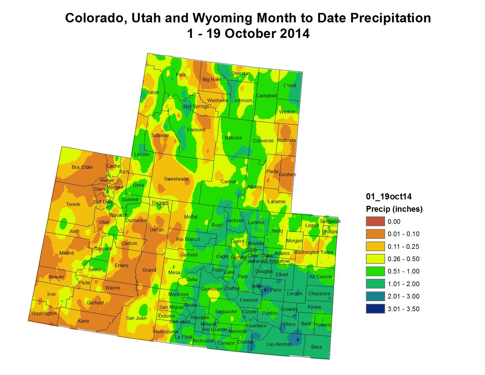
The 2014 water year brought relief to most of Colorado and the Upper Colorado River Basin after two very dry years. Above-average precipitation eased drought conditions and allowed reservoir levels to creep upwards.
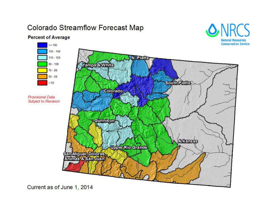
Blue Mesa Reservoir, Colorado’s largest, is now 71-percent full, in much better shape than at this time last year, when it was just 42-percent full. Near average inflows brought Lake Powell, the “savings account” for the Upper Colorado River Basin to meet downstream obligations, up to 51-percent full. It was just 45-percent full at this time last year. Inflows to Lake Powell in both 2012 and 2013 were less than half of average.
Soil moisture is also looking pretty good, with levels in most of the Upper Colorado Basin above average, although there are some dry spots in the four-corners area of New Mexico and Arizona and in southwestern Wyoming. Soil moisture in the fall is a factor in how much snowmelt reaches streams and reservoirs the following year, as opposed to being sucked into dry ground.
What will the [2015] water year bring? That remains a largely open question, although it does appear that the Southwest will get some relief from persistent drought. The three-month outlook issued by the National Oceanic and Atmospheric Administration (NOAA) in September indicates that conditions are likely to be wetter than average in Arizona, New Mexico, Southern Utah and Southern Colorado. Farther north in Colorado and Utah and in Wyoming, the three-month forecast shows “equal chances” of drier and wetter conditions.
w
The Bureau of Reclamation forecasts that the “most probable” inflows into Lake Powell in the 2015 water year will be 98 percent of average, while acknowledging that water supply forecasts at this time of year are highly uncertain. Conditions do appear favorable for another high-flow experimental release in November to benefit the Grand Canyon ecosystem by flushing sediment downstream. Total releases from Powell in 2015 are expected to 8.23 million acre feet, up from 7.480 million acre feet in 2014, which was the lowest release since Lake Powell filled in the 1960s.
This is also the time of year when we can start to look at snowpack numbers to get clues about what the coming water year (and ski season!) will bring. However, it’s also impossible to draw any reasonable conclusions from snowpack numbers now, since the total amounts are so small and “percent of normal” can swing wildly overnight.
So, keeping in mind that this is largely a recreational exercise, we do have some early data: Most Colorado river basins have less than half of the average water content in their snowpack for this time of year, except that the Gunnison has 65 percent and the Arkansas Basin has 93 percent. In Utah, the snowpack in the river basins that drain the Wasatch Mountains into the Great Basin have between 400-900 percent of their average water content for this time of year, while levels in Utah’s portion of the Colorado Basin range from 41-83 percent of average. Snowpack numbers for Wyoming are also way below average, and no data is available yet for New Mexico.
Here are two websites that are very useful for keeping track of climate, water supply and streamflow information:
• The Colorado Climate Center and National Integrated Drought Information System page on Upper Colorado River Basin water conditions, at http://climate.colostate.edu/~drought.
West Drought Monitor October 14, 2014 Click here to go the Western Water Assessment website (scroll down for the latest assessment). Here’s an excerpt:
Highlights
Water year 2014 closed with a wetter-than-average September for most of the region, but October has been much drier than average so far, except in southeastern Colorado.
At the end of September, nearly all of the region’s reservoirs were in better shape than at the same time last year, but most reservoirs in Utah and southern Colorado were still lagging the long-term average.
The NOAA CPC monthly and seasonal outlooks show mostly equal chances for above-average or below-average precipitation for late fall and early winter, while the ‘SWcast’ shows more of a wet tilt for Utah and Colorado.
ENSO indicators are more consistently pointing towards El Niño onset, which is likely to officially occur by spring, according to the latest forecasts.
[…]
September and early October Precipitation and Temperatures, and Current Drought
Water year 2014 concluded with a wet September Western US Seasonal Precipitation for most of the region, with nearly all of Utah and most of Wyoming and Colorado seeing above-average precipitation for the month. Through October 19, water year 2015 has gotten off to a dry start across the region Western US Seasonal Precipitation, with the exception of southeastern Colorado.
For the 12 months of water year 2014, most of the region saw above-average precipitation Western US Seasonal Precipitation, with nearly all of Wyoming, northern and central Colorado, and eastern, northern, and southeastern Utah ending up on the wet side of the ledger. Southeastern and southwestern Colorado, southeastern Utah, and central Utah were on the dry side. Very few areas saw less than 70% of average water year precipitation. Because the best months for precipitation across Utah were July, August, and September—a time of year that produces less efficient runoff—water-year streamflows were generally lower than would be expected given the water-year precipitation.
Despite the generally above-average precipitation in September, the temperatures were 0-4°F warmer than average over nearly the entire region Western US Seasonal Precipitation. Thus far, October has also been running warmer than average.
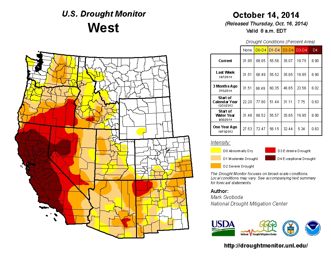
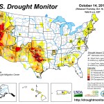
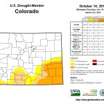
With the ample precipitation in September, the latest US Drought Monitor US Drought Monitor, based on conditions as of October 14, shows overall less drought in the region compared to early September. Drought conditions improved in southeastern and southwestern Colorado, southern Wyoming, and multiple areas in Utah. For the first time since June 2012, there are no areas of D3 or D4 drought in the region. The proportion of the region in D2 or worse drought is likewise on the decline: Utah down to 13% from 19%, Colorado down to 12% from 16%, and Wyoming unchanged at zero.
In addition to the staggering estimate, the construction must be completed by December 2017 to meet state regulations for higher water quality.
Currently, the plant is releasing more nitrogen and phosphorous into the Animas River than the new regulations allow.
If the plant does not meet the new rules, it could be placed under a consent order by the state and will not be allowed to build any more sewer taps. This would halt any city growth. It could also equate to a $25,000 daily fine, said Utilities Director Steve Salka.
The regulations were approved in 2012 because high levels of nitrogen and phosphorous causes algae to bloom faster than ecosystems can handle. Too much algae deprives fish and other aquatic life of oxygen, said Meghan Trubee, community relations liaison for the Colorado Water Quality Control Division.
“We’re affecting the base of the food cycle in the wild,” said John Sandhaus, wastewater treatment plant superintendent for the city of Durango.
To remove what is effectively too much fertilizer, the sewer plant will need greater capacity and new technology, he said.
The upgrades should make the plant quieter and reduce the sickening smell that occasionally wafts across Santa Rita Park.
“If this plant is built the way we suggest it be built, you won’t even know it’s here,” Salka said.
Designs include 11 new structures, including a new administration building that may be built near the park to distance the public from the process, Salka said.
The capacity of the plant also will be increased from 3 millions gallons of water per day to 4 million, so it would be prepared for growth.
The new structures will add more equipment to almost every step of the treatment process.
When raw sewage enters the plant, it flows into a headworks building where the current flow-measurement device is too small to handle peak times. It also violates state standards because it cannot be cleaned or calibrated because it is underneath the concrete floor, Sandhaus said.
Once inorganic matter is removed, the waste flows into stilling basins, called primary clarifiers. Here, solid waste is separated from the liquid waste. These would not be replaced, but they would be covered with domes to filter the air.
The water then flows into an aeration basin where micro-organisms digest the waste in the water.
“We call ourselves bug farmers,” Sandhaus joked, while looking out across the dark-brown bubbling basins.
Four new aeration basins must be built with about five times the capacity of the existing basins, Sandhaus said.
Management also plans to replace the blowers that pump air into the basins from direct current to alternating current for efficiency, Salka said.
Solids are then removed from the water again in secondary basins, and the plant will need two more of these basins.
The water is then sterilized with ultraviolet light. A secondary sterilizer will be part of the upgrades because the plant is violating state regulations without one.
Sludge is processed separately from water in a digester. Much as the name suggests, here micro-organisms feed on the waste. The upgrades call for another digester that will prevent the stench currently caused by cleaning and maintenance.
Under the plan, processed waste will be dried in another new building. Here, human waste will be turned into dry pellets that can be sold as fertilizer.
Currently, the plant produces four to five tanker truck loads a day of mostly water mixed with 2.5 percent processed human waste. The plant pays $250,000 a year to truck this waste away.
The preliminary designs also call for a station where restaurants could send grease instead of pouring it down a drain. This can be used to increase the production of methane and produce more electricity.
All of these improvements would be scheduled, so that the plant can continue processing waste during construction. April 2016 is the earliest that construction may start.
High-end irrigation control plus cool, moist conditions helped the Broken Tee Golf Course at Englewood reduce annual water use by 28 percent this year.
Through Sept. 30, the computer-controlled irrigation system had applied about 62.5 million gallons of water to the course. That usage was down almost 20 million gallons from the 2013 total of about 86.2 million.
No treated water was used on the golf course. The irrigation water came from the South Platte River, the lakes on the course and wells on the course property.
A regional water conservation plan already is opening doors for participants in the Arkansas Valley Conduit. The Southeastern Colorado Water Conservancy District has worked with the communities to develop strategies to improve water systems in advance of the conduit’s construction. Benefits include measuring how water is used, plugging leaks and managing pressure.
“The need is the infrastructure, and that’s what we’re trying to focus on,” said Jean Van Pelt, project coordinator for the Southeastern district. “When the conduit is completed, we don’t want it to connect to aging systems with leaking pipes.”
The conduit will take clean drinking water 130 miles from Pueblo Dam to Lamar and Eads. Along the way, 40 small communities are expected to tap into the line to bring water to 50,000 people. The $400 million project is at least a decade away from completion.
The district also is seeking a master contract for storage in Lake Pueblo for conduit participants and other water users in the Southeastern district.
One of the requirements placed on the communities by the Bureau of Reclamation is to ensure that water is not wasted, so conservation plans are needed.
“We went out and interviewed all of the conduit participants and we are in the process of integrating the master contract participants as well,” Van Pelt said.
Large utilities have more resources to employ strategies like rate structures, leak detection, metering, system audits and consumer education.
The Southeastern district also offers a tool box on its website where communities can pick and choose from ideas for reducing water waste in their systems.
The regional conservation plan also gives a leg up to private water companies seeking grants to improve their water supply, which require both conservation plans and governmental structure to administer the grant.
“The plan needs to be in place,” Van Pelt said.
The conservation plan and tool box have been under development since 2011 at a cost of $50,000-$60,000 per year using grants from Reclamation and the Colorado Water Conservation Board.
The campaign on stormwater has become a David vs. Goliath match in terms of spending and visible support.
Proponents of El Paso County Measure 1B, which would spend $40 million a year to plan, build and maintain drainage and flood control projects in four cities and portions of the county, have raised nearly $200,000 for their messaging, including television and radio commercials and billboards. The proposal has endorsements from the Regional Business Alliance, local construction and development companies, the Housing and Building Association and the Downtown Partnership.
“We are very pleased with the support we’ve gotten from the community,” said Kevin Walker, co-chairman of the regional stormwater task force that led the charge in developing the proposal. “It’s a lot of people who recognize there is a need to address this issue, and it’s past time to do that.”
The opposition is tougher to gauge. There is no splashy television campaign against 1B – just a handful of signs placed near the billboards. Douglas Bruce, the author of the Taxpayer’s Bill of Rights and the man who coined the phrase “No Rain Tax” in 2008, has a website and has been handing out fliers at events and around downtown.
Bruce said the stormwater proposal is flawed because it attempts to catch up on an estimated $700 million in backlogged projects but does not require future development to pay for flood control. Further, he said, no price tags are attached to the 114 projects listed as part of the plan, and there’s no guarantee that the projects will be built or in which order.
“In my 50 years of being involved in political activity, I have never seen a worse ballot issue,” he said.
Voters in Colorado Springs, Manitou Springs, Fountain, Green Mountain Falls and parts of El Paso County will be asked to create the Pikes Peak Regional Drainage Authority, a governmental entity that would collect fees to pay for planning, building and maintaining flood control projects such as channels, detention ponds and curbs and gutters. The proposal would allow the authority to collect fees based on the size of a property and its impervious surface, meaning driveways, parking lots and rooftops.
This month, the El Paso County Commission approved a resolution of “advocacy” in favor of the stormwater proposal.
“This plan has gone through an arduous development process to make it the most responsible plan possible. Ultimately, the people will decide, but we have to stand up as elected officials to explain to them how big the stormwater problem has become and how important it is to our to public safety, to our roads and bridges, to the protection of private property and to economic development,” said Commissioner Amy Lathen, who was a member of the stormwater task force.
The key question organizers of the proposal have been asked is, “how much is this going to cost me?” The proposed ballot question says the average residential property owner would pay $7.70 per month – $92.40 per year on the residential property tax bill.
The problem with the proposal is that fees would apply to nonprofit agencies and schools, said Vince Rusinak, a retired Air Force civil engineer and member of the Pikes Peak Area Council of Governments. He has been on the board of directors for nonprofit agencies such as the Boys and Girls Club and said that the proposed stormwater fees would take money from programs. A chart of estimated rates shows nonprofits could pay from $41.58 a year to $3,750 a year depending on the amount of impervious surface.
“That is a huge amount to those organizations,” Rusinak said.
It’s true that a stormwater fee would dip into program budgets for nonprofit organizations, said Dave Somers, executive director at the Center for Nonprofit Excellence. But the proposed fee structure, he said, is fair to nonprofit groups and schools and is lower than fees that would be imposed on commercial, industrial and government properties.
In an unprecedented move, the Center for Nonprofit Excellence weighed in on the election issue, giving the proposal its endorsement.
“With the last few years of floods, our board and staff and members recognized the importance of the community coming together in identifying a solution,” Somers said.
Organizers of the initiative believe the authority could collect about $40 million a year. Fifty-five percent of the money collected would be spent on capital projects and that portion of the fee would sunset after 20 years. However, 45 percent of the money, which would be used for administration, maintenance and emergency needs, would continue on until the authority retired it, organizers of the initiative said.
Mayor Steve Bach, who issued a proclamation in August detailing his opposition to the stormwater proposal, is uncomfortable with a never-ending portion of the fee. In his proclamation, he also said the authority could raise fees without voter approval.
Bach, who had been the most visible opponent of the proposal but recently stepped back from public comments on the issue, has said the proposal creates an unnecessary layer of government. Colorado Springs Councilwoman Helen Collins agrees. She said the city of Colorado Springs spent $46 million on stormwater projects in the past two years. An authority, she said, would shave 1 percent of the money collected off the top for administration costs.
Bruce, who finds himself aligned politically with Bach for the first time, applauded the mayor’s proclamation and added that if voters approve the stormwater fee, it will be attached to their annual property tax bill and a property owner could not refuse to pay it or the county would put a lien on their property.
“It’s on a property tax bill,” he said. “If you don’t pay the bill, it’s a threat to your home.”
Colorado Springs tried to solve its stormwater issue in 2008 when the City Council approved the creation of a Stormwater Enterprise – a property fee used to pay for drainage projects. The enterprise was phased out and ended by 2011 after voters approved the Bruce-sponsored Issue 300, and the enterprise was viewed as an illegal tax imposed without voter approval.
In August 2012, El Paso County commissioners and the council convened a summit to talk about flooding and drainage problems across the region and how to pay for them. The November ballot issue is modeled after the Pikes Peak Rural Transportation Authority, created in 2004 by voters in Colorado Springs, El Paso County, Manitou Springs and Green Mountain Falls. The PPRTA collects a 1 percent sales tax for transportation and transit improvements.
In November, the stormwater task force commissioned the Washington, D.C.-based WPA opinion research firm to survey 400 registered voters – 80 percent in Colorado Springs and 20 percent elsewhere in El Paso County – to find out if flood control is on residents’ radar. Ninety-five percent of respondents said flood control is important, and two-thirds of those said it is very important. An additional 81 percent said there should be a dedicated funding source to pay for drainage projects.
Bruce said that same survey showed that 44 percent of the respondents agreed with the fee.
“Any ballot issue that starts out under 50 percent before the opposition even surfaces is doomed,” Bruce said. “Ballot-issue support always slides; it doesn’t rise.”
Walker said the 44 percent is the amount of survey respondents who said they would prefer a fee compared with a sales tax or a property tax. It was meant as a research question and not a ballot question, he said. Once the task force settled on a fee structure, it did not conduct another survey.
“We are optimistic that we can win,” Walker said. “But it’s not over until it’s over.”
More, from The Gazette:
5 things to know about Measure 1B
1. If the measure is approved, Colorado Springs, Manitou Springs, Fountain, Green Mountain Falls and parts of El Paso County would form the Pikes Peak Regional Drainage Authority. The governmental agency would have an 11-member board of directors made up of elected officials from each entity.
2. The authority would collect fees on all property. The fee is based on the amount of impervious surface – driveways, rooftops and parking lots.
3. The authority expects to collect about $40 million a year. Of that, 55 percent of the money would be used for a list of 114 projects identified as high priority for the region; 35 percent of the money would be used for maintenance and operations; and 10 percent would be set aside for emergencies. At the end of 20 years, the portion of the fee – 55 percent – used for capital projects would sunset. The rest of the fee would remain in place until the authority dissolved it.
4. Fees would be added to annual property tax bills. Unpaid property tax bills trigger a lien process.
It’s good news, but not as good as originally reported. Contrary to an earlier misperception, water rates in the City of Alamosa will increase next year just not above what the city council had scheduled to do several years ago.
Alamosa City Manager Heather Brooks clarified that although the city will not have to go above the increases the council had set a few years ago, there will be rate increases next year.
She said in 2011 the city council passed an ordinance setting rate increases for five years. With additional costs to replace filters in the water treatment plant this year, city staff were concerned they might have to increase fees above the 2011-approved levels for 2015, but the staff were able to incorporate the additional costs for the filters into the budget without increasing water fees above the levels set out in the 2011 ordinance.
The city faces additional water system challenges in the future, such as the possibility of stricter arsenic regulations, and the staff will closely monitor those developments regarding their potential budget impacts.
City water customers are charged a monthly service charge plus a monthly volume charge according to their metered use. According to the ordinance the council approved in 2011:
In 2012 the volume charge per 1,000 gallons was $1.22 up to 8,000 gallons; $1.54 from 8,001-50 ,000 gallons; $1.97 from 50,001-100 ,000 gallons ; and $2.56 per thousand gallons in excess of 100,000 gallons.
In 2013 the volume charge per 1,000 gallons increased to $1.26 up to 8,000 gallons; $1.59 from 8,001-50 ,000 gallons; $2.04 from 50,001-100 ,000; and $2.64 per thousand gallons in excess of 100,000 gallons.
In 2014 the ordinance increased the water fees to $1.30 per 1,000 gallons up to 8,000 gallons; $1.64 from 8,001-50 ,000 gallons; $2.11 from 50,001-100 ,000 gallons; and $2.72 per thousand gallons in excess of 100,000 gallons. Next year, 2015, the ordinance set the following rates, which reflect a slight increase over the 2014 water fees: $1.35 per 1,000 gallons up to 8,000 gallons; $1.70 from 8,001-50 ,000 gallons; $2.19 from 50,001-100 ,000; and $2.80 per thousand gallons in excess of 100,000 gallons.
The ordinance the council passed in 2011 extends through 2016, increasing the above rates from 2015 to 2016 by 6 cents, 7 cents, 9 cents and 10 cents, respectively.
The public hearing for the city’s 2015 budget is scheduled this Wednesday, Oct. 15, during the 7 p.m. city council meeting at city hall, 300 Hunt Ave., Alamosa. To view the budget online go to www. cityofalamosa.org and click the agenda for Wednesday’s meeting.
This is the 15th article in the series from the Rio Grande Basin Roundtable, regarding the formation and implementation of the Basin Water Plan. The primary goal of Subdistrict No. 1 is to remedy injurious depletions to senior surface water rights and keep those water users whole.
The Subdistrict has several methods to do this. First, the subdistrict has purchased and leased water, both native to the Rio Grande Basin and water imported from the West slope. This water is stored and released as directed by the Division Engineer to replace stream depletion replacement within stream reaches of the Rio Grande as they occur. By doing this, the river itself is kept whole with wet water replacing the depletions in time, location and amount.
The subdistrict can also use what are known as forbearance agreements. Colorado law allows the subdistrict to remedy injurious depletions by a means other than supplying wet water. The subdistrict can do this by agreeing with a ditch that, rather than replace depletions with water, the subdistrict will pay the ditch some amount of money for each acre-foot of water the ditch does not receive because of depletions caused by subdistrict wells.
Each day the Division Engineer tells the subdistrict which ditch is “on the bubble,” that is the most junior ditch that is in priority that day and that is not receiving its full water supply under that priority. The subdistrict then looks at the Annual Replacement Plan to see the depletions caused by subdistrict wells on that day, water that the ditch on the bubble would have received. The subdistrict keeps track of the total amount of water due to each ditch that has a forbearance agreement and pays them at the end of the year. The ditch can then do what it wants with the money, for example upgrading the ditch or simply dividing it up among the ditch users. Forbearance agreements allow ditches and water users to remain whole, while not locking up scarce water resources. So far, the subdistrict and the forbearing ditches are very happy with this arrangement and look forward to continuing working together to reach the best solution for everyone. How the subdistrict is working towards aquifer sustainability
Throughout the recent drought, the aquifer has been shrinking as producers pump more water than is recharged back to the aquifer. The other primary goal of Subdistrict No. 1 is to recover and sustain the Unconfined Aquifer below the subdistrict to the level that existed in the early 1980s. The primary way the subdistrict plans to do this is by reducing the amount of irrigated acres within the subdistrict, which will reduce the amount of pumping from the aquifer. This concept is built into the Subdistrict’s Plan and requires 20,000 acres be retired by the fifth year from judicial approval of the plan, 30,000 acres less by the end of the seventh year, and up to 40,000 acres less by the end of the tenth year all from a base year of 2000.
One tool the subdistrict has to meet these goals is financial incentives and participation in the federal Conservation Reserve Enhancement Program (CREP) to retire up to 40,000 irrigated acres. Currently, 1,970 acres were enrolled in the program in 2013 while another 1,370 acres are currently proposed in 2014. However it is not just CREP acres that count towards the 40,000-acre goal, any program or change that retires acres reduces pumping and assists in achieving and maintaining sustainability . But remember, the subdistrict can only provide incentives, it does not have the power to require wells stop pumping.
Conclusion
The producers of the closed basin area within the San Luis Valley stepped forward when no one else did and created a subdistrict and imposed fees on themselves to replace their wells’ depletions and work to recover and sustain the unconfined aquifer. They did this not because rules or regulations were in place requiring this action, but because they believed these things had to be done.
The process has never been easy and the debate about the best way to achieve the subdistrict’s goals continues. But the subdistrict, led by its board of managers, has continuously worked towards those goals and they remain the leaders in the Valley for replacing depletions and working towards sustainability . Currently, other proposed subdistricts within different hydrological areas of the San Luis Valley are going through the same processes in an attempt to have their plan up and running before the state engineer’s ground water rules are approved within the Rio Grande Basin.
These forming subdistricts have watched and learned from Subdistrict No. 1’s struggles and accomplishments . Those other subdistricts will provide the same protection to their wells, a locally based and operated group that provides an alternative to state administration of ground water withdrawals in Division 3 while protecting senior surface water rights and providing for a long-term , sustainable ground water system.
The Plan of Water Management, Annual Replacement Plans and other information on the subdistrict and the aquifers are available on the Rio Grande Water Conservation District’s website: http:// http://www.rgwcd.org/page9.html
Meanwhile Sub-district No. 2 is gearing up for operations according to this report from Lauren Krizansky writing for the Valley Courier:
Well owners residing in the Valley’s second sub-district are ready to push forward with a petition after months of voluntary work.
Rio Grande Water Conservation District (RGWCD) Program Manager Cleave Simpson updated the Alamosa County Commissioners (ACC) Wednesday morning on the latest happenings regarding the creation of the next sub-district , which sits in both Alamosa and Rio Grande Counties.
Sub-district No. 2, also known as the Rio Grande Alluvial Sub-district , is comprised entirely of unconfined wells, and is taking on a different form than Sub-District No. 1, he said. The zone is much smaller, only 300 wells compared to 1,000, participation is voluntary and there is no “sustainability requirement” because the wells do not tap into the confined aquifer.
“We are not drawing a boundary,” Simpson said. “We will go to each individual landowner… There are not the same benchmarks to meet.”
Out of the second sub-district’s 300 wells, 152 average more than 10 acre-feet a year, making them subject to the state’s demand to either join a sub-district or to develop an augmentation plan. There are 10 non-private wells in the mix and 60 private well owners.
“It will be a patchwork of parcels,” Simpson said.
Out of those well owners, he said between 12 and 15 have regularly participated in the workgroups over the past few months, and they represent more or less half the wells in the second subdistrict .
In addition, the City of Monte Vista, the Town of Del Norte, Homelake, Colorado Parks and Wildlife and two school districts are in the zone, but will not join the second sub-district because government entities cannot legally be assessed.
They will be held, however, to the same standards, he said, and have the option to contract with Sub-district No. 2, which would include them in its Annual Replacement Plan.
Although assessment methods and fees to replace depletions are still to be determined, he said Subdistrict No. 2 is ready to petition for legitimacy.
“They are ready to go to the public,” Simpson said. “They are ready to start these discussions.”
It depends on where the state is with its pending water rules and regulations in coming months, he said, but the second sub-district hopes to submit its petition to the district court in January 2015.
“The (water) model and rules and regulations are not final ,” Simpson said. “That could cause a delay.”
Once Sub-district No. 2 is established, he said a board of managers (BOM) will be appointed via a court-approved process.
If there is no opposition to the to the second subdistrict’s formation, he said the BOM’s first task will be to draft a management plan, and, if it is also goes unchallenged , fees assessments will begin in late 2015 with collection notices delivered to Sub-district No. 2 participants in conjunction with their January 2016 county issued tax documents.
Due to its uniqueness, he said the second sub-district has options when it comes to mitigating its groundwater depletions.
“There could be some reduction in irrigated agriculture,” Simpson said, “but we might see changes in technologies, crops requiring less consumption and increases in (water) efficiency.”
He added the value of the zone’s water could also increase, but that is also to be determined.
Sub-district No. 1 has resulted in increased values, in some cases almost double, and is drawing interest from buyers from outside of the Valley. The Rio Grande Alluvial Sub-district is the second out of six identified in the Valley to come to fruition under the watch of the RGWCD. Alamosa County will eventually have three within its borders. In addition to Subdistricts No. 1 and No. 2, the fourth sub-district will also fall within its jurisdiction, but it is still in an infant stage.
“It’s good to see the well owners come together,” said Alamosa County Chair Michael Yohn. “Everyone has to be accountable for their water use.”
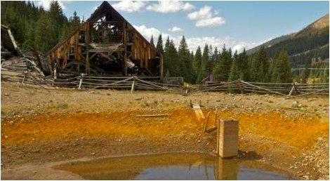
On Friday, Oct. 17, Stiegelmeier was one of several federal, state and local officials marking a milestone for the centerpiece of the county’s current mining cleanup efforts — plugging the Pennsylvania Mine.
About 8 miles east of Keystone, the abandoned mine is Summit County’s biggest mess. The mine, considered the worst in the state, spews toxic heavy metal concentrates and acidifies water flowing into the Peru Creek, a tributary of the Snake River, which feeds Dillon Reservoir. Peru Creek is without fish, insects or other aquatic life. The Snake River has life, but it’s sparse and found only in the lower reaches. In 2007, a burp of acidic water from the abandoned mine killed fish all the way to Keystone, county officials said.
This past week, the Colorado Division of Reclamation, Mining and Safety finished installing one of two bulkheads, massive plugs of concrete and steel built about 500 feet inside the mine.
According to project manager Jeff Graves, once both bulkheads are installed, toxic burps and blowouts will be a thing of the past.
“That won’t happen again — it can’t,” he said.
The bulkheads prevent water from flowing through the mine. Water will back up inside, reducing the amount of oxygen the metals and sulfides are exposed to, which should improve water quality.
POSITIVE IMPACTS
Though the more than $3 million project still has far to go, reclamation efforts seem to have had positive impacts already. Last year, the Peru Creek turned reddish-orange seven or eight times. That hasn’t happened once this year.
In addition to the bulkheads, new drainage ditches channel water away from waste-rock piles. Those piles have been capped. Eventually, they’ll be revegetated. Limestone has also been strategically added to raise the pH of the water, which could help filter out metals into settlement ponds.
Organizations involved in the project include: the Colorado Division of Reclamation, Mining and Safety, the U.S. Environmental Protection Agency, the Colorado Department of Public Health and Safety, the U.S. Geological Survey, the U.S. Forest Service, Summit County Open Space and Trails, Northwest Council of Governments, the Snake River Watershed Task Force, the Blue River Watershed Group and the Keystone Center.
Water trading can facilitate the reallocation of water to meet the demands of changing economies and growing populations. It can play a vital role in encouraging conservation and stewardship of water supplies in a way that can address cultural, social, and environmental priorities. It can facilitate building a structure for managing the ever-increasing risks of greater variability in water, including through methods such as insurance contracts, hedging tools, water banking, and other mechanisms. Deploying market tools in the allocation of water can help us to overcome the growing fragility and vulnerability of the water management institutions and infrastructure in the American West.
I agree, and their new work offers a great menu of policy options to move down this path. In brief (again quoting Culp et. al):
Reform legal rules that discourage water trading to enable short-term water transfers.
Create basic market institutions to facilitate trading of water.
Use market-driven risk mitigation strategies to enhance system reliability.
[B]etter regulate the use of groundwater by monitoring and limiting use to ensure sustainability, and by bringing groundwater under the umbrella of water trading opportunities.
To make water markets work at scale, strong federal leadership will be necessary to promote interstate and interagency cooperation in water management
This is great stuff. But how do we actually do any of them?
Each of their first four bullet points is a staggeringly difficult task that will require enormous institutional capacity within the states to carry out. Consider California’s efforts to move on number four, for example. In the midst of the drought of record, with overwhelming problems caused by groundwater pumping, all California could manage was some feeble legislation aimed at just the first part – monitoring and limiting use to ensure sustainability at some future point in time sorta maybe. This is not for lack of smart scientists and policy people pointing out that the problem is deeper and requires stronger action. This rather reflects a shortcoming of the political system that has left us at with a sub-optimal equilibrium because of the ability of individual players, acting in their own short term interest, to block progress toward a more socially optimal solution…
Having spent years watching the New Mexico legislature’s lack of institutional capacity to make even simple water rule changes, and watching California thrash about this year in the midst of genuine crisis, I think Culp and his colleagues are a tad optimistic to suggest this could be done “immediately”, but whatever. I’m all for optimism. And I’d file this under the critical category of “baby steps,” smaller and relatively easier things that can be done that provide shorter term benefits and the learning experience to help amass the necessary social capital to take on the harder challenges to come…
Minute 319, the U.S.-Mexico agreement that, among other things, allowed last spring’s Colorado River Delta environmental pulse flow (and which Culp helped design) is a great “baby steps” example. It includes some of the elements Culp, Glennon and Libecap are asking for (albeit dressed up quite differently), but it was as much about learning how to do stuff as it was about actually doing stuff. It also demonstrates the importance of the role of the U.S. federal government.
The important thing we need recognize here, I think, is that the investment in the social capital needed to do these things, an investment in what I’ve sometimes called the “institutional plumbing”, is every bit as real and important as the investment in pumps and canals and dams that make up the physical plumbing of water in the West.
A district formed to improve Fountain Creek last week made an appeal for those with water rights to get involved in the early stages of a study to build flood control structures.
“Water rights protection is something we should do before we get into any other aspect of flood control on Fountain Creek,” Larry Small, executive director of the Fountain Creek Watershed Flood Control and Greenway District told ditch company board members Friday.
Small spoke during the annual meeting of the winter water storage program, bringing experts in to talk about the issue of public safety vs. water rights.
“We’re not working in a vacuum,” said Mark Pifher, who represents the Arkansas River basin on the state Water Quality Control Commission.
Denver’s regional Urban Drainage Authority and the city of Aspen have raised questions with the Colorado Division of Water Resources over how floodwater detention rules work in the state, Pifher explained.
State Engineer Dick Wolfe has adopted policies that say that single-site developments can hold water for 72 hours, but that regional floodwater control projects must augment any water detained with equivalent releases under a substitute water supply plan. That same principle was applied to Fountain Creek when the city of Pueblo built a detention pond behind the North Side Walmart as part of a demonstration project. The city learned it needed an augmentation plan after the project was well underway. Urban Drainage and Aspen officials are not pleased with the policy and are looking at potential state legislation to force a change in that policy, Pifher said.
Short of a blanket change that would allow the 72-hour rule to apply, the Fountain Creek district wants to study whose rights would be affected by holding back a large flood.
A study by the U.S.
Geological Survey completed last year provided solid numbers about how much water dams or detention ponds would hold back at certain points on Fountain Creek. That in turn can be applied to the flows at the Avondale gauge on the Arkansas River, which is upstream from every major ditch except the Bessemer below Pueblo Dam.
Flood stage
After Pueblo Dam went into operation 40 years ago, it was determined that flood stage at Avondale was 6,000 cubic feet per second. Floods upstream of Pueblo Dam are contained by curtailing releases to that level.
The last time flood control protection from that type of event was in 1999. Flows on Fountain Creek are measured and Pueblo Dam can be cut back to prevent that flooding from affecting Avondale as well, said Bill Tyner, assistant division engineer.
“You can have those huge flashy flows on Fountain Creek and find ways to cut back at Pueblo Dam to protect downstream communities,” Tyner said.
Reservoirs on Fountain Creek would have to perform differently, because there would not be Bureau of Reclamation staff on hand to open or shut release gates, he said.
Quenching all thirst
Several storm events that occurred in the past four years caused the Avondale gauge to top 6,000 cfs for several hours.
“Those spot events did not satisfy everyone’s needs downstream,” Tyner said.
That doesn’t matter if you’re a farmer.
“If I have 24 hours of floodwater on the Colorado Canal, I’m going to take it. I need it,” said Matt Heimerich of Crowley County.
“Those floods are the only way we get water in storage,” said Donny Hansen, president of the Holbrook Canal.
The direct rights downstream from Avondale and above John Martin Reservoir can be met with about 4,115 cfs, but storage rights on the canals total 3,631 cfs, he explained. Water rights below John Martin require another 1,534 cfs to be met.
So, all water rights below Avondale on the Arkansas River total about 9,282 cfs.
The 6,000 cfs at Avondale might be enough to satisfy all those rights, since the return flows of one ditch are reused downstream, a factor of about 1.5 times, he said.
But the envisioned dams on Fountain Creek are aimed at stopping monster 100-year floods — the type where heavy rain falls for several days. In the USGS study, a large dam or series of dams upstream of the Fountain Creek confluence would cut in half the peak flow of a 100-year flood — 44,000 cfs, or five times the amount of water needed to fulfill all downstream water rights.
The 100-year flood flow at Avondale, coincidentally, is 44,000 cfs, according to the USGS.
Moving ahead
The Fountain Creek district is not the only agency working at flood control in the Pueblo area. The Pueblo Conservancy District, in the headlines recently for its plan to rebuild the Arkansas River levee through Pueblo, also is responsible for the flood plain from Pueblo to the Otero County line.
“The high flows on Fountain Creek are a source of erosion that affects the land in our district down below,” said Bud O’Hara, a retired water engineer who is on the Pueblo Conservancy District board.
O’Hara showed graphs that point out about a dozen smaller events this year that created the potential for minor erosion events.
Farmers, on the other hand, generally like the erosion on Fountain Creek because it is part of the process that carries sediment downstream to help seal ditches. Many still grumble about the “clear water” that resulted from the construction of Pueblo Dam. In effect, it meant the erosive properties of the river were transferred downstream as more erosion occurred within ditch systems.
Abby Ortega, an engineer for Colorado Springs Utilities working with the Fountain Creek district, asked the farmers to provide suggestions for consultants to study the issue.
“We’re looking at how to build structures and not injure water rights,” she said. “We’re asking for your input.”
“I think the model we should use is the irrigation efficiency rules that was hosted by Dick Wolfe,” Heimerich responded. In that process, farmers and others affected by proposed rules guiding ditch improvements met for 18 months and were able to give immediate feedback. “It’s just too important not to do it right.”
Colorado transmountain diversions via the State Engineer’s office
West portal Moffat Water Tunnel
Colorado transmountain diversions via the University of Colorado
Denver Water’s collection system via the USACE EIS
A map of the Fry-Ark system. Aspen, and Hunter Creek, are shown in the lower left. Fryingpan-Arkansas Project western and upper eastern slope facilities.
Map of the Colorado-Big Thompson Project via Northern Water
FromThe Grand Junction Daily Sentinel (Gary Harmon):
A poll aimed at influencing the drafting of the Colorado statewide water plan says residents oppose a new transmountain diversion and the plan should emphasize conservation. The poll was commissioned by WaterforColorado.org, which said the results were mirrored in more than 18,000 comments submitted for the drafting of a statewide water plan, the first draft of which is to be presented on Dec. 10.
The comment period on the plan ended a week ago and the Colorado Water Conservation Board is now factoring comments into its report.
“Our position is that any engagement is good engagement,” said James Eklund, director of the CWCB, who noted that the agency received 10,475 letters between Sept. 20, 2013, and Aug. 20, 2014.
“We’re still crunching the numbers,” Eklund said. “There’s been a spike” in comments since Aug. 20.
That total included 6,213 form letters marked “protect Colorado’s rivers,” as suggested by Water for Colorado, Eklund noted. Comments also included 730 unique emails and 92 unique submissions on web forms.
The poll, conducted by a bipartisan team, Keating Research and Public Opinion Strategies, found that 90 percent of respondents said the water plan should be to keep the state’s rivers healthy and flowing and that 78 percent of voters prefer using water conservation and recycling instead of diverting water from the Western Slope to the Front Range. It also found that 88 percent of respondents support a statewide goal of reducing water use in cities and towns by 10 percent by 2020.
WaterForColorado.org doesn’t identify its source of funding or staff members and notes on the website that it “shares insights and expertise from a variety of organizations that research and study water conservation and natural resource issues. WaterForColorado.org offers a solutions-based approach to Colorado’s water future, and opportunities for the general public to have a voice and take action.”
Other organizations have made similar findings.
“The interesting thing is that in this survey, the West Slope is at least being echoed in emphasizing conservation,” said Jim Pokrandt, spokesman for the Colorado River Water Conservation District.
The poll was conducted Sept. 5 to 8 of 500 voters across Colorado, including an oversample of 162 voters on the West Slope. Statewide, the margin of error is plus or minus 4.6 percent and plus or minus 7.7 percent on the West Slope.
Lower Arkansas Valley water users could face a different sort of challenge next year, especially if it’s a wet winter: Finding places to store the water. The possibility was discussed Friday at the annual meeting of the winter water storage program, hosted by the Southeastern Colorado Water Conservancy District.
“I think the way we’re managing reservoirs is shifting a bit,” said Jim Broderick, executive director of the Southeastern Colorado Water Conservancy District. “We need to start planning. If one area gets full, you can’t move the water there.”
The winter water program is a court-decreed plan that allows most major ditch companies east of Pueblo to store water from Nov. 15 to March 15 each year. Rather than irrigating during the winter months, the companies can store the water for use later in the season.
But the storage is not all in one place.
About one-third of last year’s water was stored in Lake Pueblo, with the rest being stored by individual canal companies or in John Martin Reservoir.
Not all ditch companies have storage.
Lake Pueblo has more water than usual going into the winter water storage season because cities were able to beef up their storage in Fryingpan-Arkansas Project space this year. In addition, the Bureau of Reclamation is moving water from Turquoise and Twin Lakes to Lake Pueblo to make room for next spring’s transmountain imports.
If rainfall and snowpack are above average in the Arkansas River basin, Lake Pueblo could fill more. If it gets too full, some water would have to be evacuated, or “spilled,” next spring in order to leave space to contain potential floods.
It’s a problem the valley hasn’t really faced since 1999. In 2011, the Southeastern District got permission from the Army Corps of Engineers to delay releases of water from the flood pool by several weeks because of conditions at the time.
Roy Vaughan, Fry-Ark Project manager for the Bureau of Reclamation, said a spill is unlikely next year if weather conditions remain in the average range. But Lake Pueblo should be nearly filled to the flood pool level by next spring.
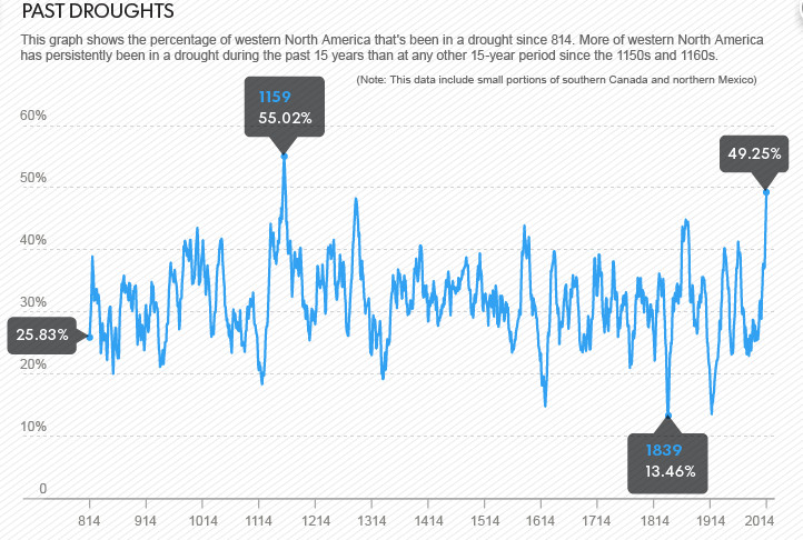
The dryness in California is only part of a longer-term, 15-year drought across most of the Western USA, one that bioclimatologist Park Williams said is notable because “more area in the West has persistently been in drought during the past 15 years than in any other 15-year period since the 1150s and 1160s” — that’s more than 850 years ago.
“When considering the West as a whole, we are currently in the midst of a historically relevant megadrought,” said Williams, a professor at the Lamont-Doherty Earth Observatory of Columbia University in New York.
Megadroughts are what Cornell University scientist Toby Ault calls the “great white sharks of climate: powerful, dangerous and hard to detect before it’s too late. They have happened in the past, and they are still out there, lurking in what is possible for the future, even without climate change.” Ault goes so far as to call megadroughts “a threat to civilization.”
In the regularly scheduled meeting of the San Juan Water Conservancy District (SJWCD) on Oct.14, board chairman Rod Proffitt discussed the progress and tour of the Dry Gulch Water Storage Facility (Dry Gulch Project), concerns of the Colorado Water Conservation Board (CWCB) and the appraisal value of the Running Iron Ranch.
In a letter of intent dated Sept. 10 between SJWCD and the Pagosa Area Water and Sanitation District (PAWSD), each party agreed to work toward finalizing a satisfactory agreement that both relieves PAWSD of its financial obligations to the Dry Gulch Project and acknowledges efforts by SJWCD to develop the Dry Gulch Project on a more practicable basis with a broader group of interested partners.
The letter of intent stated that an exchange of PAWSD equity in the ranch to the CWCB for substantial debt relief is to both parties’ mutual advantage.
The letter of intent also states that if the principal outstanding on the loan cannot be reduced by the amount equal to the appraisal value of the ranch or $4.6 million, whichever is more, PAWSD may seek other means to reduce its debt to the CWCB. The letter of intent further states that the annual interest rate may be reduced to no more than 1.75 percent and a full term for payment of 30 years.
SJWCD agreed to provide an appraisal of the ranch to the CWCB, which would establish the fair market value of the 660-acre ranch, shared water rights directly and indirectly related to the Dry Gulch Project, and long-term debt obligations to the CWCB incurred in the purchase of the ranch…
Proffitt went on to explain that the problems with comparables done on similar ranches which sold for more was the fact they had more buildings and structures in place, as well as more riverfront on the properties than those of the ranch that was appraised.
Proffitt told the board he had completed a tour of the Dry Gulch Project with CWCB Commissioner James Eklund, Jeff Robbins, legal council for PAWSD, and Kent Holsinger, legal council for SJWCD.
Eklund was impressed with the site, Proffitt explained…
Proffitt told the SJWCD board Tuesday evening that steps should be taken in order to satisfy the CWCB concerns that the board stayed focused on the Dry Gulch Project and did not wane.
“Due diligence is needed to keep the Dry Gulch Project moving forward. Hopefully, the courts will see we are exercising due diligence,” he said.
In an email, CWCB Deputy Director of Resource Management Tim Feehan stated other items CWCB would like to see as part of an agreement going forward: “SJWCD would retain an equitable interest in the Dry Gulch Project and its fee interest in the property. SJWCD would be able to move forward with land exchanges to further the Project.”
Other items for consideration mentioned in the email were that SJWCD would be provided with adequate funding to move the project forward and would take the lead in discussions with the Southern Ute Indian Tribe and other potential partners in the project.
The email went on to state that the CWCB would like to see SJWCD considered as manager/coordinator for the project once it is built and it also needs closure to be on the loan/grant agreement. The correspondence also pointed out a new operating agreement needs to include a forgiveness provision on the loan side of the existing agreement.
On Tuesday, the Court heard arguments in an original jurisdiction dispute between Kansas, Colorado, and Nebraska over flows of a common river: the Republican River. After the states disputed the terms of their 1943 compact, they enacted a 2003 settlement stipulation. When the parties confronted a breach by Nebraska and a dispute over the water supply models they used to calculate Nebraska’s share, they reached an impasse. Kansas exercised its veto power, sending the dispute first to arbitration, then the Special Master and to the Supreme Court.
At oral argument, Kansas disputed the special master’s proposal to alter the settlement stipulation’s water accounting procedures based on a claim of mistake. Kansas spent most of its argument focused on the accounting procedures changes suggested by the special master. Kansas argued that the special master exceeded the charge and upset a carefully negotiated compromise by siding with one party. Nebraska similarly focused on the accounting issue, but characterized the carefully negotiated bargain as the principle that imported water should not be counted, with the formula representing a tool for implementation as opposed to a term. Justices pushed back on both sides.
Kansas argues Against the Five-Run Solution
Kansas Solicitor General Stephen McAllister came out forcefully arguing that the settlement stipulation itself was a carefully crafted compromise. McAllister stated that all parties were aware that the accounting procedure was subject to uncertainty. Kansas’s primary objection to the special master’s report involves the special master’s recommendation to amend the accounting procedure to implement Nebraska’s proposed “five-run solution.”
Justice Stephen Breyer pushed back on the argument against reformation, noting pointedly that, due to a mistake in the model, Nebraska’s use of “imported water” from sources outside the Republican River basin is counted against it under the settlement stipulation’s accounting procedures. Justice Breyer continued: “And nobody wanted that. That would be totally unfair. … So what do you suggest we do about the mistake? Nothing?”
McAllister responded that they should send the case back and do nothing about the mistake, since it is not a mutual mistake. He emphasized that the intersection between the “five-run solution” and other issues were highly complicated and that Nebraska had gotten concessions in other areas of the settlement which kept the accounting mistake from being unfair. McAllister pointed out the effect of groundwater recharge credits as an example: “We gave Nebraska a high credit for groundwater recharge at a percentage much higher than Colorado and Kansas get and Nebraska crowed about that as a concession they got from Kansas that was worth 15 to $20 million annually, that’s Exhibit K, 133, in the record.”
Justice Antonin Scalia asked McAllister about the role of deference in the case. McAllister said that there was no deference owed the special master and argued that the special master ignored trade-offs. McAllister asserted that the parties needed to renegotiate the entire set of trade-offs in order to be fair, rather than allowing the special master to set aside one set of trade-offs to the benefit of Nebraska and Colorado.
Chief Justice John Roberts asked what Kansas thought of its chances if the matter were sent back to the Republican River Compact Administration, for resolution. (All disputes under the compact are run first though this body, consisting of one representative of each of the three states.) McAllister responded, “Twenty-some years ago, Kansas introduced a resolution in the RRCA that said, how about we all resolve that we will comply with the compact. Kansas voted yes, Colorado voted yes, and Nebraska voted no. So this goes back a long ways.” McAllister went on to explain that its proposed disgorgement remedies against Nebraska were necessary.
The United States argues for the special master’s disgorgement remedy
Assistant to the Solicitor General Ann O’Connell argued on behalf of the United States in support of the special master’s Report. O’Connell defended disgorgement by pointing out that disgorgement must be sufficient to discourage opportunistic breach, citing to the Restatement of Restitution and Unjust Enrichment. Justice Scalia asked whether the United States was overstating case law by citing the Restatement, telling her that “I don’t think the Restatement can change our law by just saying something by consensus of law professors.” O’Connell cited back to the classic case of Texas v. New Mexico to support her position. In response to questioning about the amount of disgorgement, O’Connell avoided taking any position at odds with the special master. Justice Kagan asserted that the $1.8 million figure recommended was less than what Nebraska had gained by its breach, arguing against an equitable balancing approach.
Nebraska argues that Kansas’s veto requires the Court to break the impasse
David Cookson, Nebraska’s chief deputy attorney general, argued that the bargain Nebraska struck with Kansas was that water imported from the Platte River Basin would not be counted towards Nebraska’s allocation of the Republican River. Justice Scalia questioned whether the deal was actually that broad, suggesting instead that Nebraska had agreed to a formula, not a broader principle.
Scalia explained: “The parties knew that this formula would not be entirely accurate and they agreed to a fair price, that is, none of this water should be counted. But they said the way to figure out whether this water is coming in or not is this formula. Why shouldn’t they be held to that formula?”
Cookson responded that the settlement specifically provided the parties with the ability to modify the accounting formulas. Nebraska asked the Republican River Compact Administration to modify the accounting procedures, to which Kansas objected exercising its veto powers. The issue was then sent to arbitration and finally to the special master who recommended the change to the formula, the “five-run solution.”
Chief Justice Roberts asked Cookson if he agreed that the special master would have been powerless to change the formula if it had been part of the original compact as opposed to a later settlement. Cookson readily agreed that amending the compact would be beyond the power of the special master, citing Alabama v. North Carolina for support.
Justice Kagan picked back up the thread of Justice Scalia’s question and extended it further. She asked Cookson what would happen if the parties had negotiated over three distinct formulas and had chosen one. Under that situation, she wanted to know, would it be right to continue to use the formula chosen going forward? Cookson pushed back that changing the accounting procedures is basic process under the agreement, and that prior to the current dispute, fourteen such formula changes have been approved by the three states. Cookson continued that this time is different, because Kansas has objected. He reasoned that the exercise of a veto can kick the dispute to the Supreme Court to break the impasse created by the veto process in the compact itself, likening the problem to the one faced in the Pecos River Compact, brought before the Court in Texas v. New Mexico.
Chief Justice Roberts countered that the formula, as specific language in the contract, should control the general statement that imported water not be counted. Cookson argued that the imported water stipulation was the specific term and the formula was just the tool designed to deliver that deal.
Cookson defended Nebraska’s response as not showing an intentional violation of either the compact or the stipulation. He argued that Nebraska could not have foreseen dust-bowl-like conditions. He argued that there is no need for an injunction or for disgorgement, tangling with Justice Scalia again on how those remedies interact.
Kansas rebuts Nebraska’s argument that the formula was just a toolkit
In rebuttal, McAllister returned to Justice Kagan’s line of questioning the choice of formulas for accounting made by the parties in the settlement stipulation. McAllister pointed out that the formula that Nebraska is seeking to have reformed was actually selected by Nebraska as its first choice during settlement negotiations. Citing the result in the boundary dispute of New Hampshire v. Maine, McAllister told the Court that it had given “New Hampshire the answer we think you should give Nebraska today, which is: ‘Sorry; you made the deal, and just because you now think you have a better way of doing it doesn’t mean we should rewrite the contract.’”
In closing, Justice Sonia Sotomayor asked McAllister how much money is represented by the difference between the accounting preferred by Nebraska and that preferred by Kansas. McAllister answered with the amount of water in dispute – between 8,000 and 10,000 acre-feet. (An acre-foot is the amount of water needed to cover an acre of land to a depth of one foot, approximately 325,851 gallons.) When Sotomayor pressed for a dollar figure, McAllister told her that the special master had valued the water to Nebraska at $362 per acre-foot. On that note, the Court adjourned.
Ryke Longest is the Director of the Environmental Law and Policy Clinic and a Clinical Professor of Law at the Duke University School of Law.
A historic Spanish agricultural irrigation system of unlined water ditches that irrigate farmers’ fields, with water flows directed by the movement of tarps and dirt along each ditch, the unlined acequias are also believed to recharge the area’s shallow aquifers and support biodiversity.
Costilla County has 70 acequias covering 35,000 acres and serving 270 families, while Conejos’ 50 acequias, serve 45,000 acres and 100 families, linking the water users to their 16th century Spanish heritage, maintaining that culture across some nine generations in these isolated farmlands.
When heirs were being identified during the lengthy lawsuit to ensure access to the vast “Mountain Tract,” also known as the Taylor Ranch, the owners and heirs of many early homesteads, or varas, were identified by their connection with acequias. “Without water, there is no life,” says Norman Maestas, president of the San Luis-based Land Rights Council.
Many acequia properties were never officially incorporated, adding problems to use of the ancient ditches.
In 2009, largely at the urging of Costilla County water users, the Colorado legislature passed a bill “to promote and encourage the continued operations of acequias and the viabilities of historic communities that depend on those acequias.”
From the beginning, the congresos have drawn landowners and irrigators, agencies and officials, nonprofits, University of Colorado law students and others.
Law students have taken on the challenge of developing legal protection for the acequias.
Sangre de Cristo Acequia Association Program Director Sarah Parmar in a recent interview, said there is still much to be done about educating legislators and the public about acequias, while finding a place for the ancient systems in the state water plan.
This year’s congreso agenda provides knowledge heavily focused on acequia bylaws and conflicts to support the community in Colorado water conversations.
Parmar explained that, “we want everyone to understand what the purpose of bylaws are and that they can be used in a way to continue tradition. Bylaws are also a tool to help people coming into and returning to the community. More integration of bylaws into practice can prevent arguments.”
Those arguments come when water is scarce, she explained. Differing memories instead of bylaws are often recalled regarding the matter of sharing the resource.
The acequia association and the CU Law School partner through the Getches-Wilkinson Center to provide free or low cost legal assistance and educational materials to affected communities, helping establish their priority rights to water under Colorado law.
Arkansas River Basin — Graphic via the Colorado Geological Survey FromThe Pueblo Chieftain (Chris Woodka):
Groundwater rules that could help certain farmers avoid some of the cost of water court applications are being considered for the Arkansas River basin.
“We’re not necessarily committed to this idea, but it may have benefits,” Water Division 2 Engineer Steve Witte told the Southeastern Colorado Water Conservancy District board Thursday. “The public needs to weigh in.”
The first chance to do that will be at a meeting at 1 p.m. Nov. 13 at the Lake Pueblo State Park visitors center auditorium.
The rules would apply to water replacement plans for post-1985 pumping, new uses for wells drilled prior to 1985 or new wells. They would provide an administrative alternative to water court, which can be too expensive for individual water users to navigate.
Witte reviewed the history of legal issues surrounding wells in the Arkansas Valley, including the 1972 attempt to reconcile surface and groundwater use, the Kansas v. Colorado case filed in 1985 that led to the 1996 well rules and the Simpson v. Bijou decision by the state Supreme Court in 2003 that took many well augmentation plans out of the hands of the state engineer.
“Decreed plans for augmentation costs have been so prohibitive in the South Platte that thousands of wells remain shut down to this day because of Simpson v. Bijou,” Witte said. There have also been instances in the Arkansas River basin, he said after the meeting.
On the same day that the Simpson v. Bijou ruling came, the state Legislature entered the Arkansas Valley well rules into law. In 2003, it also gave the state engineer’s office authority to approve five-year substitute water supply plans and to develop future rules.
Nearly 1,800 wells in the Arkansas Valley are covered by Rule 14 group augmentation plans under the 1996 rules, and those would stay in place even if new well rules are adopted.
The new rules could benefit a farmer who wants to use his own surface water rights to replace water pumped from wells, revegetation projects or even someone drilling a new well for a business, Witte said. At the same time, they would protect downstream water users and Colorado’s obligation under the Arkansas River Compact.
Witte acknowledged that there might an “augmentation gap” that makes finding sources of replacement water difficult, as discussed by the Arkansas Basin Roundtable recently. Permanently changing water uses still would require a trip to court.
But he said the purpose of the rules would be to give farmers a new tool to stay in business while complying with water law.
“We’re relying on data that were developed 30 years ago,” Witte said. “Life goes on and we need to think of ways to adjust and not be hampered by things already in place.”
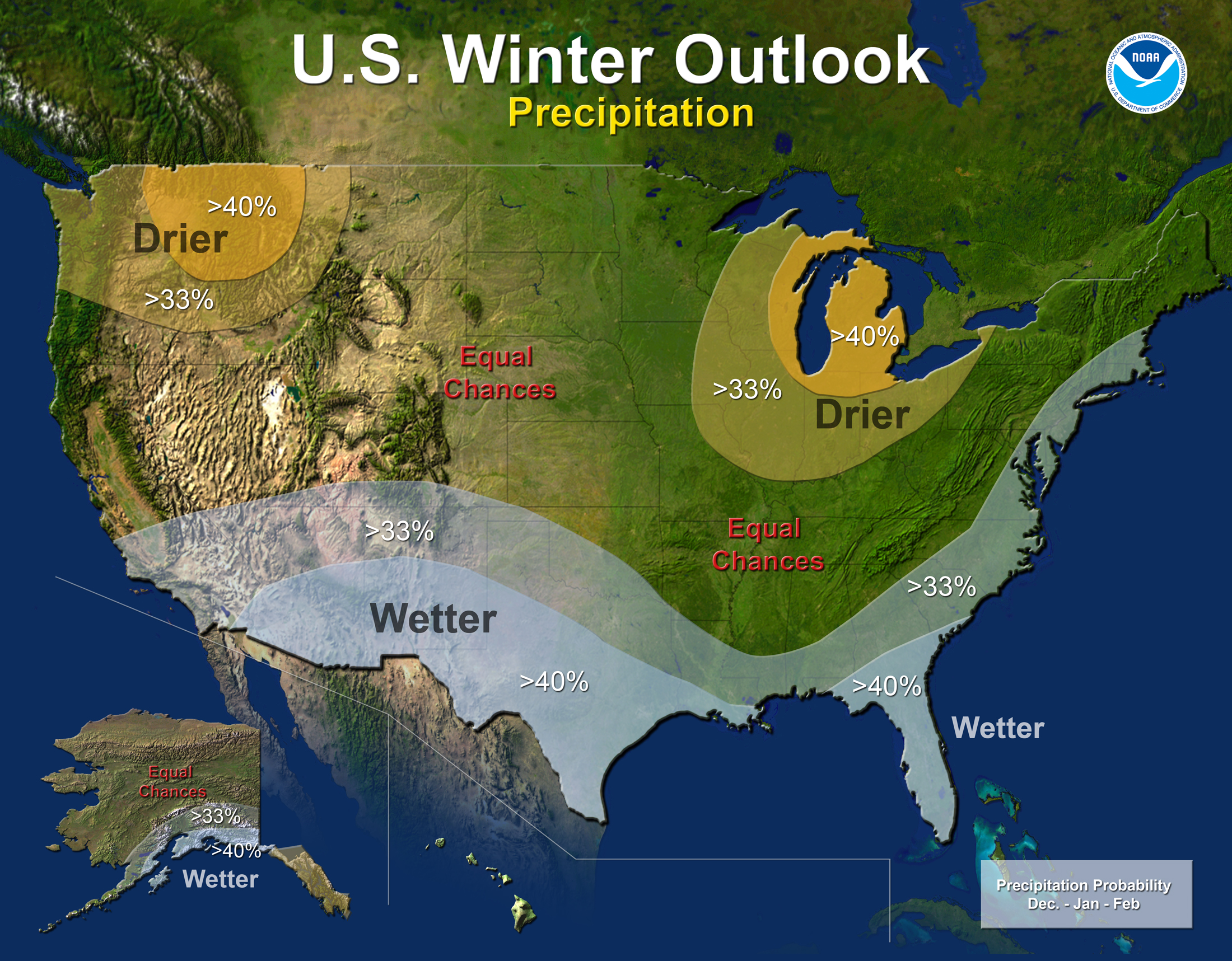
Below average temperatures are favored in parts of the south-central and southeastern United States, while above-average temperatures are most likely in the western U.S., Alaska, Hawaii and New England, according to the U.S. Winter Outlook, issued today by NOAA’s Climate Prediction Center.
While drought may improve in some portions of the U.S. this winter, California’s record-setting drought will likely persist or intensify in large parts of the state. Nearly 60 percent of California is suffering from exceptional drought – the worst category – with 2013 being the driest year on record. Also, 2012 and 2013 rank in the top 10 of California’s warmest years on record, and 2014 is shaping up to be California’s warmest year on record. Winter is the wet season in California, so mountainous snowfall will prove crucial for drought recovery. Drought is expected to improve in California’s southern and northwestern regions, but improvement is not expected until December or January.
“Complete drought recovery in California this winter is highly unlikely. While we’re predicting at least a 2 in 3 chance that winter precipitation will be near or above normal throughout the state, with such widespread, extreme deficits, recovery will be slow,” said Mike Halpert, acting director of NOAA’s Climate Prediction Center. “This outlook gives the public valuable information, allowing them to make informed decisions and plans for the season. It’s an important tool as we build a Weather-Ready Nation.”
El Niño, an ocean-atmospheric phenomenon in the Tropical Pacific that affects global weather patterns, may still develop this winter. Climate Prediction Center forecasters announced on Oct. 9 that the ocean and atmospheric coupling necessary to declare an El Niño has not yet happened, so they continued the El Niño Watch with a 67 percent chance of development by the end of the year. While strong El Niño episodes often pull more moisture into California over the winter months, this El Niño is expected to be weak, offering little help.
Winter Precipitation Outlook 2014-2015 via NOAA
The Precipitation Outlook favors above-average precipitation across the southern tier, from the southern half of California, across the Southwest, South-central, and Gulf Coast states, Florida, and along the eastern seaboard to Maine. Above-average precipitation also is favored in southern Alaska and the Alaskan panhandle. Below-average precipitation is favored in Hawaii, the Pacific Northwest and the Midwest.
Last year’s winter was exceptionally cold and snowy across most of the United States, east of the Rockies. A repeat of this extreme pattern is unlikely this year, although the Outlook does favor below-average temperatures in the south-central and southeastern states.
In addition, the Temperature Outlook favors warmer-than-average temperatures in the Western U.S., extending from the west coast through most of the inter-mountain west and across the U.S.-Canadian border through New York and New England, as well as Alaska and Hawaii.
The rest of the country falls into the “equal chance” category, meaning that there is not a strong enough climate signal for these areas to make a prediction, so they have an equal chance for above-, near-, or below-normal temperatures and/or precipitation.
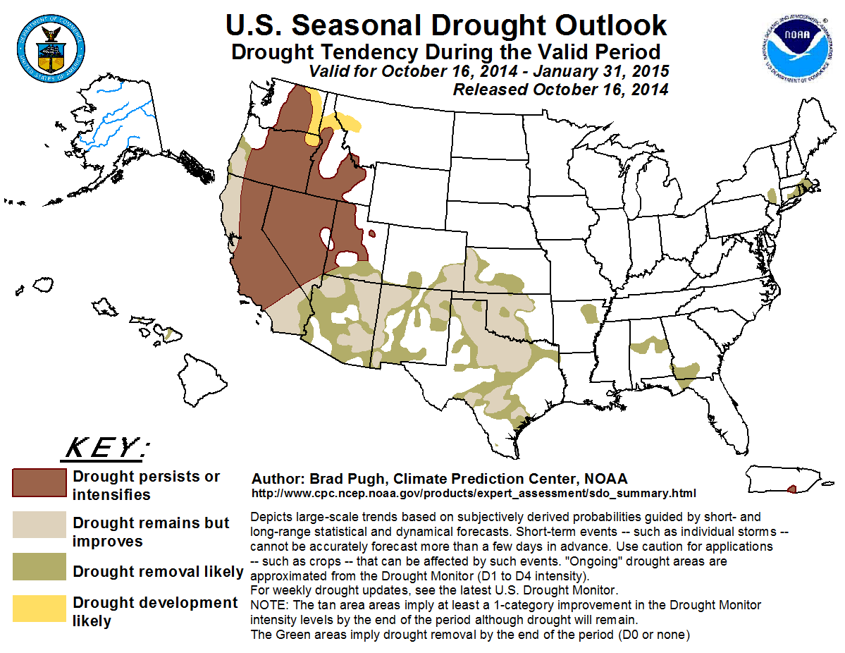
The U.S. Seasonal Drought Outlook, updated today and valid through January, predicts drought removal or improvement in portions of California, the Central and Southern Plains, the desert Southwest, and portions of New York, Connecticut, Rhode Island and Massachusetts. Drought is likely to persist or intensify in portions of California, Nevada, Utah, Idaho, Oregon and Washington state. New drought development is likely in northeast Oregon, eastern Washington state, and small portions of Idaho and western Montana.
This seasonal outlook does not project where and when snowstorms may hit or provide total seasonal snowfall accumulations. Snow forecasts are dependent upon the strength and track of winter storms, which are generally not predictable more than a week in advance.
Click here to go to the US Drought Monitor website. Here’s an excerpt:
Summary
In a repeat of last week, yet another large weather system moved across the country’s midsection, bringing copious rains to the central Plains, middle Mississippi Valley and the Tennessee Valley, with 3-6 inches being a regular occurrence. Parts of the Pacific Northwest also enjoyed some nice moisture during the week. As for temperatures, most of the West and South saw well above normal temperatures, with readings 6 to 12 degrees above the norm. Unseasonably cooler weather was confined mostly to the northern and central Plains along with the Upper Midwest and Great Lakes regions…
The Plains and Midwest
On the heels of large areas of heavy rains last week across the region, another storm dumped another round of heavy rains (2 to 6 inches) across the state of Missouri, eastern and southern Kansas, western and southern Arkansas, eastern Oklahoma and northeastern Texas. Large 1- to 2-category improvements are noted in the D0-D2 areas on this week’s map for those areas seeing the heaviest rains and deficits being erased back to six months or more in those areas listed above. Soil moisture and streamflows are in great shape heading into winter in these areas as well. Missouri saw large improvements, with all but a small remnant of D0 being all that remains in the southwest part of the state where D1 was last week. Drought has been removed in northwest Arkansas, but the dryness persists and has expanded ever so slightly in the northeast corner of the state. Texas was more of a mixed bag, with rains improving things by 1 category in the eastern portion of the state (in general), but warm and dry conditions leading to degradation, with expansion of D1-D3 sneaking back in across south Texas. North-central Texas has also fared a bit better of late, and this is reflected in a slight trimming of D2-D4 in this part of the state and along the Red River border with Oklahoma.
Farther north, the rains missed the northern Plains (with no complaints or major impacts being reported as harvesting efforts are well underway now and behind schedule), with just a slight expansion of D0 showing up in southeastern North Dakota. To the east in Wisconsin, a good late period soaking led to the removal of the D0 across the southwestern quadrant of the state…
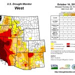
The West
High temps and dryness continue to plague much of the West during the early weeks of the new Water Year, with the exceptions being southern Colorado, southeast Arizona and the eastern third of Washington in the Cascade Range and along the coastal ranges. This trend has led to an expansion of D1 across more of northeastern Oregon.
One area that has done really well the past 6 months, and even tracking back to the beginning of the calendar year, has been in eastern Idaho, parts of northern Utah and northern Nevada. This has led to some early Water Year reassessment, noted by the trimming and shifting of D0-D2 westward in eastern Idaho and through a change of the impact line from “S/L” to “L”. As we enter the new Water Year, there are still some long-term lingering water supply issues across this region and into southwestern Montana, which bears watching to see if this wet pattern carries on during the winter.
The recent run of wetness this fall has led to some favorable soil moisture recharge and improving conditions in southern Colorado, with the removal of D3 and some reduction of D0-D2 noted there on this week’s map…
Looking Ahead
For the period October 15-20, after seeing a very wet pattern the past few weeks across the country’s mid-section, there should finally be some time to dry out and let the harvesting resume. The only areas showing good chances for heavier precipitation are in the coastal ranges and mountains in the Pacific Northwest, primarily from northern Oregon up into Canada. The other area expecting good rains is from the Mid-Atlantic up into New England, where 1-3 inches should bring some relief to the region. As for temperatures, most of the West, Pacific Northwest and the Great Plains states are expecting to see unseasonably warm temperatures, with readings likely running 3-6 degrees above-normal.
Looking at the 6- to 10-day time frame (October 21-25), the warm temperature trend continues into this period, and the entire western two-thirds of the country and most of Alaska are expected to see above-normal temperatures, with the strongest likelihood falling in the High Plains and along the Rocky Front Range from Colorado and Wyoming up into Montana. The bulls-eye for cooler than normal weather is found in the Tennessee and Ohio Valleys and within the Mid-Atlantic from Georgia northward into New Jersey. A greater likelihood of above-normal precipitation over this period is confined to the Pacific Northwest, Four Corners, southern Florida and the New England coastline. However, a large area of the country from the Great Plains eastward into the Mississippi Valley, the Midwest, Ohio Valley, Tennessee Valley and the western fringes of the Mid-Atlantic can expect it to be dry, with the highest probability falling from the Great Lakes down to the Gulf Coast along the Mississippi Valley.
NRCS Streamflow Forecast June 1, 2014 From the Valley Courier (Ruth Heide):
Nobody’s crystal ball worked very well this year when it came to predicting river flows. In a Valley-wide water meeting yesterday, former long-time Division Engineer Steve Vandiver indicated the Natural Resources Conservation Service’s (NRCS) crystal ball might be cracked.
“NRCS does their best, based on the SNOTELs they have,” he said.
However, there are only about eight SNOTEL sites in the entire basin. SNOTEL is an automated system of snowpack sensors. Most of the SNOTEL sites in this basin provide information for the Rio Grande, with only two in the Conejos River system area. Vandiver said he was concerned about the apparent move by NRCS to rely on electronic data such as SNOTEL without confirming it through manual snow courses, a move that he believed would “lessen their ability to give us a good forecast.”
Vandiver added, “It’s vitally important we keep up with a forecasting system that means something.”
NRCS forecasts are the primary tool used by the Colorado Division of Water Resources Division 3 office to determine how much water the basin has to send downriver each calendar year and how much water irrigators will have available to them during the growing season. This year the NRCS forecasted annual stream flow for the Rio Grande at the beginning of the irrigation season was nearly 150,000 acre feet lower than the current forecast of 640,000 acre feet and the Conejos River system was almost 50,000 acre feet lower than the current forecast of 225,000 acre feet.
Because the earlier forecasts were off, the water division must send more water downriver now to make its annual obligation to the states of New Mexico and Texas as required by the Rio Grande Compact, Vandiver explained. That means an earlier cut off on the irrigation season on the Conejos River water users and greater curtailments on both the Rio Grande and Conejos River irrigators. Vandiver explained that because of the way the Rio Grande Compact was structured , the more water this basin receives, the higher percentage of it must be sent downriver, and the obligation percentage on the Conejos is already higher than the Rio Grande. In a big water year, which doesn’t happen very often , the Conejos system would have to send 70 percent of its water downstream, he said.
In normal water years, the basin has to send about a third of its water downstream to New Mexico and Texas.
“The delivery schedules dictate how much we can use,” Vandiver explained. Currently Conejos River system users are seeing a curtailment of more than 40 percent and the Rio Grande irrigators about 28 percent.
“On the Conejos system we are probably going to have to shut off early just to meet the compact,” Division 3 Engineer Craig Cotten said yesterday during the Rio Grande Roundtable meeting. He added the Rio Grande could probably make it to the first of November, the scheduled ending point for the irrigation season, but not extend past that point.
He said he will meet with Rio Grande irrigators before making the final decision on when to shut off the irrigation season this year. Vandiver, who held the division engineer position prior to Cotten and Mike Sullivan, described the headaches of managing water deliveries in the Rio Grande Basin (San Luis Valley) so that Rio Grande Compact deliveries are made and irrigators receive the water due them.
He said there are so many variables that affect runoff and stream flow every year from rain to dust on snow. He said NRCS has depended on various snow measurement sites around the basin through the years but has not had the funding and manpower recently to maintain, improve or increase those sites. When SNOTEL sites are not maintained, they are not able to provide accurate information for annual forecasts. For example, he said the SNOTEL site at Wolf Creek had problems ranging from large trees laying across it to a gopher hole in the middle of it that were not fixed before last winter, so the site did not work right, and it is one of the key sites in the SNOTEL system.
Conejos River irrigators are embarking on a $237,000 pilot project to use a portable radar system coupled with meteorological stations and river data collection sites to determine if there might be a better way to forecast runoff and stream flows in the basin, or at least to augment the information provided through NRCS. The Rio Grande Roundtable and state water board provided funding for that pilot project.
Nathan Coombs, manager for the Conejos Water Conservancy District that is spearheading this project, said it is not the group’s intention to influence or circumvent NRCS “We don’t need to pitch that aside and start over” but to collect data on a parallel track and see if it is useful for future forecasting efforts. Coombs said the best place for the radar truck to be set up would either be Antonito or at the airport in Alamosa. He added the radar coverage would provide information for both the Conejos and Rio Grande.
Cotten said his office is not mandated to use NRCS forecasts , “but there’s nothing else out there really.”
He added the weather service had started doing some forecasting.
“We are looking at their forecasts also.”
He said the NRCS and weather service forecasts were about 100,000 acre feet apart from each other this year, and it appeared the weather service’s forecast was closer to the truth this time, “which doesn’t always happen.”
Roundtable board member Cindy Medina suggested the roundtable or another group take the lead on presenting a package of basin snow measurement needs to legislators like Senator Michael Bennet who could work with NRCS to make sure funding is in place to meet those needs.
The nine justices of the U.S. Supreme Court heard oral arguments from Kansas and Nebraska Tuesday on the 2013 findings of Special Master William Kayatta, Jr.
Kayatta issued the ruling last year in an ongoing dispute dating to 2010 between the two states over Nebraska’s overuse of water in 2006.
Kayatta recommended Nebraska pay Kansas $5.5 million—$3.7 million as the actual damages Kansas suffered by Nebraska’s overuse; and $1.8 million to Kansas for the gain Nebraska received by pumping extra water in 2006.
He also said the accounting methods used to calculate water supplies in the Republican River Basin should be revised.
Two primary issues
The oral arguments by the states and questioning by the justices Tuesday centered on two main subjects:
Whether Kansas was entitled to a significant disgorgement or damage payment for Nebraska’s compact violation; and
Whether new accounting procedures for measuring imported water supplies into the basin, sought by Nebraska and recommended by Kayatta, should be allowed.
Kansas Solicitor General Stephen McCallister was the first to present arguments before the high court and set out by addressing the changes in the compact accounting. He said Kansas does not agree with Nebraska and the special master that the method for calculating imported water supply should be rewritten.
“That agreement itself (2002 settlement) was a complex set of concessions and compromises,” he told the justices.
The water model is an estimation at best of what’s going in the basin, he said. Parties were aware of the imported water phenomenon when the agreement was reached, he added. He said it wasn’t fair the water master focused solely on what Nebraska wanted changed while Kansas had issues that weren’t addressed. Justice Sonia Sotomayor said Kansas was invited to provide a better solution to the accounting issues but did not. McAllister said they were working on one but didn’t have time to develop it.
If contract principles were applied to the disagreement, the remedy would be to rescind the compact settlement.
“And I don’t think you want that,” Sotomayor said. McAllister agreed that none of the states would want that.
So if rescinding the agreement isn’t possible, she said, then it falls back to reforming or revising the contract.
She asked McCallister, “If Kansas couldn’t come up with an alternative, why shouldn’t the court just accept the special master’s recommendation?”
McCallister said Nebraska’s change in accounting procedures came late in the process, as a counterclaim during arbitration.
Justice Ruth Bader Ginsburg asked about the process when the states can’t agree.
McAllister said there’s the option of non-binding arbitration, “which we all love and almost always works out our disputes.”
If that doesn’t work, and the states feel strongly about it, they can request a special master, he said. “But again, I don’t think we’ll get there because the parties can and have negotiated successfully.”
Sotomayor was skeptical of this. “But I thought you had gone through the alternatives,” with no resolution, she said.
He said they brought this case to the high court because Kansas believed there was a compact violation by Nebraska that needed a remedy.
Disgorgement remedy
That remedy would be for the justices to grant Kansas a significant disgorgement payment from Nebraska to get their attention, McAllister said.
Disgorgement is defined as the forced giving up of profits obtained by illegal or unethical acts.
Of the $80 million Kansas sought in damages, they designated $60 million as profits or unjust enrichment Nebraska received by their overuse of water.
Justice Antonin Scalia said disgorgement payments aren’t a normal contract remedy and require an intentional violation.
McAllister said if Nebraska only has to pay Kansas $3.7 million, there’s little incentive for compliance, especially if a dispute can drag out eight years before any possibility of recovery.
Justice Samuel Alito, Jr. said Kayatta found Nebraska didn’t intentionally violate the compact agreement.
McAllister said the master did find that Nebraska “knowingly exposed Kansas to a risk of violation.”
While they didn’t purposefully violate, they did violate it, McCallister said. “I think you have to say it’s more than negligent.”
McCallister continued, “Nothing less than a substantial disgorgement award seems to really get their attention. And here it has gotten their attention and it has also gotten Colorado’s attention.”
Justice Dept. sides with Kansas on disgorgement
Ann O’Connell, Assistant to the Solicitor General, U.S. Department of Justice, said disgorgement should be an available remedy when a state violates an interstate water compact.
She said the monetary remedy would “help to stabilize compacts and ensure the states are working vigorously to meet their compact obligations.”
Justice Scalia reiterated the need for intentional violation in contract law and asked O’Connell for cases where the high court imposed disgorgement, even in the case of intentional violation. She could not cite any.
She did cite a case between Texas and New Mexico where disgorgement could be a possible remedy. She continued, “It certainly left that door open.”
“For an intentional violation?” Scalia questioned. “Yes,” she replied.
“But we’ve never done it, have we?” Scalia asked. “No. And this is a novel . . .” she said before Scalia cut her off.
At the end of her argument, O’Connell did go on record that the Justice Department does support the special master’s recommendation to revisit the compact accounting methods.
Nebraska wants accounting change, not high damages
Nebraska’s Chief Deputy Attorney General, David Cookson, was the final lawyer to present arguments. He stated the compact settlement specifically says the accounting will not count imported Republican River water and requested the court approve Kayatta’s recommendation for the accounting change.
Scalia challenged him, saying the settlement included how such a water supply be determined—by a formula—and that was agreed to.
Cookson countered, saying the deal Nebraska agreed to was not the formula.
“The deal we made was not to count imported water,” he said.
He said the final settlement made it clear that accounting procedures could be modified at any time through the appropriate process.
Cookson said Nebraska followed that process, by going to the three-state compact administration. After Kansas objected, non-binding arbitration was sought.
“The master agreed the mistake occurred, sent it back to the RRCA (Republican River Compact Administration) to develop a solution. This was all presented to Kansas in 2007,” Cookson told the justices.
He said the accounting procedures are a technical appendix to the settlement and were not part of the settlement agreement.
Scalia asked if the final settlement could be amended by mutual agreement.
Cookson said no, because the three states, in the final settlement, put in a non-severability clause that they couldn’t change it. Cookson made the distinction that the accounting procedures could be changed and cited case law where the court allowed appendixes to state settlements to be changed. In addition, he said the accounting procedures appendix was not included as part of the compact settlement when it was approved by Congress.
Chief Justice John G. Roberts, Jr., said the settlement is an agreement between two sovereign states.
“The idea of a special master or this court changing the nature of that agreement is a pretty radical one,” he said.
Cookson responded, “But we’re not changing that agreement. The agreement in the final settlement stipulation is do not count imported Platte River water.”
When negotiating the settlement, Cookson asserted the parties knew the accounting procedures would change as things moved forward. He cited roughly 14 changes that have already been made and approved by the compact administrators. He said Kayatta’s recommendation doesn’t reform the compact settlement, just the technical appendix
on accounting procedures.
Disgorgement not justified
On the issue of disgorgement, Cookson said Nebraska took exception to the award because the state did not deliberately violate the compact.
Justice Elena Kagan said the special master and Justice Department Solicitor General characterized Nebraska as “a conscious wrong-doer, that you failed to act, refused to act in the face of known risk.”
Cookson took exception, noting that Nebraska took control of consumptive use in 2002, while the settlement was still being negotiated. In addition, through 2006, the state reduced its pumping by 500,000 acre-feet, a 35 percent reduction. He said it was not possible for Nebraska to foresee its allocations would fall even below the record lows that occurred during the Dust Bowl of the 1930s. He urged justices to understand that allocations in the settlement were based on a 10-year period of the Dust Bowl. He said it was reasonable for Nebraska to believe allocations would never go below those of the Dust Bowl.
“And yet in ‘05 and ‘06, our allocations significantly fell below the Dust Bowl,” he told the justices.
He said Nebraska conceded it fell short of compliance in 2006 and offered to pay Kansas its actual damages.
Since then, Cookson said Nebraska has remained in compliance “even in the driest condition now of record in the basin.”
For these reasons, he said Kansas’ claim of unjust enrichment “as a means of disgorging gain to Nebraska” is not appropriate.
In rebuttal to Cookson’s arguments, McAllister said the court should give Nebraska this answer on changing the accounting method: “Sorry; you made the deal, and just because you now think you have a better way of doing it, doesn’t mean we should rewrite the contract.”
Nebraska delegation attends
A Nebraska delegation including representatives from the Department of Natural Resources, the Attorney General’s office and attorneys and natural resource district officials closely associated with the case attended the oral arguments. Those attending from the Upper Republican NRD included Manager Jasper Fanning, Assistant Manager Nate Jenkins and Board Member Jason Kunkel.
The justices will now review the case and render a decision which could occur sometime before the end of the year but no later than the end of June 2015.
The lower Fryingpan River ecosystem is relatively healthy even though an algae with the notorious nickname “rock snot” has taken hold, according to preliminary results of a study commissioned by the Roaring Fork Conservancy.
Muck from the stream bottom was scooped up from three sites last fall to get a count of macroinvertebrates — bugs that can’t leave the river. An analysis over the winter showed the numbers were in line with results from a similar study in 2003, according to Heather Tattersall Lewin, watershed action director for the nonprofit organization.
“That was good for us to see,” she told the Basalt Town Council on Tuesday night in a briefing about the preliminary results. Macroinvertebrates provide food for the fish in the river.
Populations of the American dipper bird, an important indicator species for river health, were also promising, according to Tattersall Lewin. A consultant found 28 mating pairs and observed that 23 of them were successful in producing young.
Constant monitoring of water temperatures since October 2013 also didn’t produce any red flags…
The Roaring Fork Conservancy’s study didn’t produce all good news. Rock snot, formally known as Didymosphenia geminate and often called Didymo, appears here to stay.
The conservancy hired students from Colorado Mountain College in Leadville to monitor the river periodically for rock snot. They searched for the specific algae in the spring and after peak runoff at 20 sites. They found the coverage was in fewer places after runoff and that it wasn’t as dense in places where it was still found, Tattersall Lewin said.
The CMC students will search for the algae again this weekend to see if it surged back after the lower flows of summer.
Tattersall Lewin said rock snot isn’t your typical, slippery algae. It grows in clumps in a consistency she compared to coarse toilet paper. It appears to collect more easily on the flat, angular rocks of the Fryingpan than the rounded cobble of the Roaring Fork River, she said.
The effects of rock snot on the ecosystem aren’t certain. International studies show Didymo is proliferating even in the healthiest streams, according to Tattersall Lewin. Studies are examining whether the growth is related to climate change.
Rick Lofaro, the conservancy’s executive director, said two management policies by the reclamation bureau, which controls water flows from the dam, appear capable of reducing rock snot. First, maintaining a higher minimum flow during winters and dry times could avoid the buildup. Second, high, sustained water releases during spring runoff would help flush the river and benefit it in numerous ways. The rock snot would disintegrate.
Uncompahgre River Valley looking south
Here’s the release from the US Bureau of Reclamation (Terry Stroh/Justyn Hock):
Reclamation announced today that it has released a final environmental assessment and Finding of No Significant Impact for two proposed salinity control projects. The documents assessed and addressed the potential effects of the Bostwick Park Water Conservancy District’s Siphon Lateral Salinity Control Project in Montrose County, Colorado and the Forked Tongue/Holman Ditch Company’s Salinity Control Project located in Delta County, Colorado.
The Bostwick Park Project will pipe 1.76 miles of existing earthen ditch and will result in an annual reduction of 413 tons of salt contributions to the Colorado River. The Forked Tongue/Holman Ditch Project will pipe 1.89 miles of existing earthen ditch and will result in an annual reduction of 412 tons of salt contributions to the Colorado River. The purpose of both projects is to improve the efficiency of water delivery to canal users and reduce salinity loading in the Colorado River Basin.
Site of proposed Chimney Hollow Reservoir — Windy Gap Firming Project via the Longmont Times-Call From the Sky-Hi Daily News (Hank Shell):
The U.S. Bureau of Reclamation, Northern Colorado Water Conservancy District and the Northern Water Municipal Subdistrict have negotiated a contract that would allow the subdistrict to use excess capacity in the Colorado-Big Thompson Project for the Windy Gap Project and future Windy Gap Firming Project, according to a press release. A 30-day public comment period on the contract opened Oct. 8 and will close Nov. 7…
Currently, Windy Gap water rights are in priority during wet years, though paradoxically the C-BT project is often too full to hold excess water. Because the Windy Gap Project has a junior water right, it is often not able to divert water during dry years, when there is available capacity in the C-BT project.
“Right now the firm yield of Windy Gap is zero because there are some years where they can’t get any water out of the project,” said Brian Werner with Northern Water.
The Windy Gap Firming Project proposes construction of Chimney Hollow Reservoir near Carter Lake Reservoir in Larimer County. The added storage capacity would “firm up,” or reinforce the Windy Gap water right during dry years. The contract is needed to use federal infrastructure to firm up the Windy Gap water right.
“This project will make more efficient use of existing water rights,” said Mike Ryan with the U.S. Bureau of Reclamation, in a prepared statement. “When completed, Windy Gap Firming would provide water storage for 13 municipal providers.”
The Windy Gap project is allowed to divert a maximum of 90,000 acre feet in a single year, and its 10-year running average cannot exceed 65,000 acre feet per year.
The cost for using the excess capacity will be $34 per acre-foot, said Tyler Johnson with the U.S. Bureau of Reclamation.
Initial estimates for the Windy Gap Firming Project put the cost at $270 million.
Also up for comment is Senate Document 80, which contains guidelines for project facilities and auxiliary features, and Section 14 Determination Memos, which authorize the Secretary of the Interior to enter into contracts for the exchange or replacement of water, water rights, or electrical energy for the adjustment of water rights.
In 1909, President William Howard Taft arrived in Montrose on a train to dedicate one of the federal government’s first reclamation projects. With aid of federal funds, a 5.8-mile tunnel was bored from the Black Canyon of the Gunnison River to divert water onto the fertile fields of the Uncompahgre Valley.
Even when the portly president (he weighed 340 pounds and once overflowed a bathtub), there was talk in Montrose about harnessing the power of fast-moving water to produce electricity. Emerging from the Bureau of Reclamation’s tunnel from April through October, the time of irrigation, the water churns with great power as it tumbles toward the 80,000 acres of irrigation around the towns of Montrose and Delta.
At long last, electrical production began last year. The first small hydroelectric plant began generation in June 2013 and the second two months later. Both were developed by Delta-Montrose Electrical Association. Together, the two units can produce 7.5 megawatts of electricity.
Two more are now being built, both by a private company called Shavano Falls Hydro. They are expected to be completed in spring of 2015 and produce a maximum 7.6 megawatts.
The four units altogether will produce 15.1 megawatts.
Delta-Montrose will sell the power to co-op members, while Shavano will sell the power to Municipal Energy Agency of Nebraska. Among others, MEAN sells energy to the municipalities of Delta and Aspen.
Jim Heneghan, renewable electricity engineer for Delta-Montrose, says the return on investment is 11 years. However, a better way of calculating the investment may be that it produces electricity for 3 cents per kilowatt hour more cheaply than the power delivered by wholesale supplier Tri-State Generation and Transmission.
Both these figures are without a rate increase in the wholesale price. Coal-fired electricity has been rising rapidly in cost, however. The water will be essentially free and the turbines should last at least 50 years before they need to be retooled.
The court heard oral arguments Tuesday in the latest twist of the 1943 Republican River Compact signed by Kansas, Nebraska and Colorado. The case pits Nebraska against Kansas — not only over the amount of money Nebraska owes, but also to set the ground rules for what are sure to be future battles over the use of a critical but stressed resource.
Justices had sharp questions for both sides. They expressed skepticism about Kansas’ claim for higher damages as well as Nebraska’s desire to rewrite the formula used to calculate water usage.
As is typical in such interstate disputes, a special master earlier had reviewed the case for the court. He found that Nebraska owes $5.5 million — $3.7 million in basic damages with an additional $1.8 million attributed to the gains made by Nebraska farmers as a result of the violations. Nebraska is challenging the extra $1.8 million penalty.
Kansas Solicitor General Stephen McAllister, however, urged the justices to go significantly higher in penalizing Nebraska, contending that Nebraska’s actual gains were much larger than $3.7 million, or even $5.5 million. If Nebraska winds up with more in benefits than it is penalized for the excess water, he said, it will have no incentive to work hard at compliance in a future drought.
Justice Antonin Scalia focused on the extra penalty that Kansas is seeking.
“You want more than damages,” Scalia told McAllister. “You want to say, ‘I not only want to receive what it cost me, what your violation cost me, but I want in addition to receive any benefits that you got from the violation.’ … That’s not a normal contract remedy.”
Justice Samuel Alito pointed out that Nebraska’s violations of the compact had been ruled unintentional. But McAllister said Nebraska knew it was exposing Kansas to risk and described it as “more than negligent” on Nebraska’s part.
“These were massive violations on Nebraska’s part, knowing they were in trouble and just really not taking any kind of adequate steps,” McAllister said.
Nebraska Chief Deputy Attorney General David Cookson defended Nebraska’s efforts to stay in compliance
with the compact and to mitigate the situation once the problems were revealed. Still, he faced questions from Justices Elena Kagan and Ruth Bader Ginsburg, both of whom cited the special master’s findings that while Nebraska’s violations were not an intentional breach, the state should have seen what was coming.
“The special master also said essentially … that you were a conscious wrongdoer, that you failed to act, refused to act in the face of a known risk,” Kagan said to Cookson. She said the special master found that “unless there was some very lucky fortuitous thing that happened, the quite foreseeable effect of your actions was going to be that Kansas didn’t have enough water.”
Cookson said Nebraska does not agree with the findings about what Nebraska should have known or the idea that it took no action.
“Nebraska seized control of its consumptive use in 2002 while it was still negotiating the compact, and through 2006 reduced its pumping (by 35 percent),” Cookson said. “At the same time, however, Nebraska could not reasonably foresee that its allocations were going to fall even below the historical low period of record in this basin, which was the Dust Bowl.”
Nebraska also has asked the court to go along with the special master’s finding that the formula for calculating water usage should be reworked because it is unfair. Chief Justice John Roberts expressed skepticism about taking such a step, however.
“The idea of a special master or this court changing the nature of that agreement is a pretty radical one,” Roberts said.
The court is expected to rule before the end of the year.
After the arguments, Cookson told The World-Herald that it’s impossible to gather from the court’s questions which way the justices are leaning. They often play devil’s advocate and push harder on the side they ultimately agree with in order to sharpen the arguments in their favor.
“The court was very engaged,” Cookson said. “They asked questions that pushed the boundaries of both sides’ arguments.”
The city of Aspen and Front Range water interests have reached a compromise 20 years in the making that allows more water to be sent east when the spring runoff is plentiful, in exchange for bolstering flows when the Roaring Fork River is running low in the fall. The deal is between the Twin Lakes Reservoir and Canal Co., which operates transbasin diversion tunnels underneath Independence Pass, and the city of Aspen and the Colorado River District, which works to protect water rights on the Western Slope.
The deal, which has its roots in a 1994 water court application from Twin Lakes that sought to increase diversions during the runoff in high-snowpack years. It will leave 40 acre-feet of water in Grizzly Reservoir when Twin Lakes exercises its rights under the 1994 proposal. That water will be stored in the 500-acre-foot reservoir and released into the Roaring Fork for about three weeks in late summer, when seasonal flows are at their lowest. The water must be called for and released in the same year it was stored.
Grizzly Reservoir, located about 8 miles up Lincoln Creek Road near the Continental Divide, is a component of the transbasin-diversion system. A tunnel underneath the reservoir channels water underneath the mountain to the south fork of Lake Creek in the Arkansas River basin, on the other side of the pass.
Additionally, under the deal, the River District will have the right to store 200 acre-feet of water in Grizzly Reservoir and can call for up to 150 acre feet of that water in a year. Importantly, that 200 acre-feet can be stored long-term in the reservoir until it is called for by the River District, which manages water rights across the Western Slope.
Another 600 acre-feet will be provided to the River District for seasonal storage in Twin Lakes Reservoir, also on the east side of Independence Pass. The district will then trade and exchange that water with various entities, which could lead to more water staying on the Western Slope that would otherwise be diverted through other transbasin tunnels.
Twin Lakes diverts an average of 46,000 acre-feet a year from the headwaters of the Roaring Fork and sends it to Colorado Springs and other Front Range cities. The city of Colorado Springs owns 55 percent of the shares in the Twin Lakes Reservoir and Canal Co., entities in Pueblo own 23 percent, entities in Pueblo West own 12 percent, and Aurora owns 5 percent.
Aspen and the River District intend to cooperatively use the stored water in Grizzly Reservoir to boost late-summer flows in the Roaring Fork as it winds through Aspen proper.
Water already flowing
The stretch of the Roaring Fork River below the Salvation Ditch on Stillwater Drive typically runs below environmentally sound flows each year for about eight weeks, according to city officials. And given that this spring saw a high run-off, the three parties to the agreement managed some water this year as if the deal was already signed.
“At the close of the current water year (which ended the last day of September), Twin Lakes started making releases of some of the water stored for the River District, followed by release of the 40 acre-feet, as directed by Aspen and the River District,” Phil Overeynder, a special projects engineer for the city, wrote in an Oct. 3 memo to city council. “These releases had the effect of increasing flows in the Roaring Fork through the Aspen reach by approximately 20 percent and will last for approximately a three-week period at the end of the lowest flow conditions of the year.”
Overeynder added that “both Aspen and the River District believe that this agreement, while not perfect, is of real and meaningful benefit to the Roaring Fork.”
Aspen City Council approved the agreement on its consent calendar during a regular council meeting on Monday. The agreement is on the River District’s Tuesday meeting agenda, and Twin Lakes approved it last month.
The deal still needs to be accepted by Pitkin County and the Salvation Ditch Co. in order to satisfy all of the details of the water court’s 2001 approval of the 1994 water rights application.
Junior and senior rights
In addition to its junior 1994 water right, Twin Lakes also holds a senior 1936 water right that allows it to divert up to 68,000 acre-feet in a single year and up to 570,000 acre-feet in a 10-year period.
Originally, the water diverted by Twin Lakes was used to grow sugar beets to make sugar, but it is now primarily used to meet the needs of people living on the Front Range.
The 1936 water right still has some lingering restrictions in high-water years, according to Kevin Lusk, an engineer with Colorado Springs Utilities who serves as the president of the board of the private Twin Lakes Reservoir and Canal Co. Under its 1936 right, when there is plenty of water in the Arkansas River and the Twin Lakes Reservoir is full, Twin Lakes is not allowed to divert water, even though it is physically there to divert, Lusk explained. So in 1994 it filed in water court for a new water right without the same restrictions so it could divert more water to the east. It was dubbed the “Twin Junior,” water right.
The city of Aspen and the River District objected in court to the “Twin Junior” and the agreement approved Monday is a long-delayed outcome of the case.
Aspen claimed that if Twin Lakes diverted more water in big-water years, the Roaring Fork wouldn’t enjoy the benefits of the high water, including flooding the Stillwater section and replenishing groundwater supplies. That process, the city argued, helps the river in dry times.
“We don’t necessarily agree with the theory behind it,” Lusk said of the city’s claim, but added that Twin Lakes agreed to the deal as part of settlement negotiations.
And since 2014 turned out to be a high-water year, Twin Lakes exercised its right to divert water under its 1994 Twin Junior right, and worked cooperatively with Aspen and the River District to release 40-acre feet of “mitigation water” as described in the pending deal.
The new agreement between the city, Twin Lakes and the River District is in addition to another working arrangement between Twin Lakes and Aspen related to the Fryingpan-Arkansas diversion project, which diverts water from the headwaters of the Fryingpan River.
That agreement provides 3,000 acre-feet of water each year to be released by Twin Lakes into the main stem of the Roaring Fork beneath a dam near Lost Man Campground, normally at a rate of 3 to 4 cubic feet per second.
Here’s the release from Colorado State University:
The 25th annual South Platte River Forum will be held Wednesday, Oct. 22, and Thursday, Oct. 23, at the Plaza Event Center, 1850 Industrial Circle, Longmont. The forum, “Water and Wisdom,” will examine issues such as flood impacts on stream restoration, fisheries and hydrology, oil and gas exploration, hydraulic fracturing as well as hydropower, and overviews of South Platte River basin projects. The forum strives to provide an avenue for a timely, multidisciplinary exchange of information and ideas important to resource management in the basin.
The first day of the forum includes several presentations on flood recovery efforts, updates and concerns, as well as a history of floods on the South Platte. The Friends of the South Platte Award will be presented to Patricia J. Rettig, Head Archivist, Water Resources Archive, at Colorado State University Libraries. The keynote luncheon on Oct. 22 will be “Proposed Rule: Definitions of Waters of the U.S.” by Karen Hamilton, Chief of the Aquatic Resource and Accountability Unit, U.S. EPA Region 8. Afternoon sessions will discuss oil and gas exploration and hydraulic fracturing, and water education efforts. The day will conclude with a reception and information on water storage projects in the basin.
The final day of the forum will include a presentation on the Colorado Water Plan by John Stulp, special policy advisor to Colorado Gov. John Hickenlooper on water, followed by presentations on South Platte basin water plans, and a panel focused on water quality concerns. The day will conclude with a luncheon presentation on “At the Confluence: The Poetry of Colorado Water” by Colorado Supreme Court Justice Gregory J. Hobbs, Jr.
Winners of this year’s photo contest will be recognized during the forum and their photographs will be on display.
The South Platte River begins high in the Colorado mountains near Fairplay. It flows through Denver and continues eastward into Nebraska, joining the North Platte River near the town of North Platte, Neb.
The South Platte Forum is sponsored by Deere & Ault Consultants, Inc.,; SP WRAP,; XRI Geophysics; Applegate Group, Inc.; the Consortium for Research and Education on Emerging Contaminants (CREEC); Platte River Recovery Implementation Plan (PRRIP); Riverside Technology; Tetra Tech,and Integral Consulting, Inc. The Forum is organized by Colorado State University Extension, Colorado Water Institute, Aurora Water, Denver Water, Northern Water, Metro Wastewater Reclamation District, Colorado Division of Parks and Wildlife, St. Vrain and Left Hand Water Conservancy District, U.S. Fish and Wildlife Service, U.S. EPA, U.S. Geological Survey.