Snowpack news: Flat-line, but there is hope

Click on a thumbnail graphic for a gallery of snowpack data from the Natural Resources Conservation Service.

https://twitter.com/martyconiglio/status/543454642152038400

From the Glenwood Springs Post Independent (John Stroud):

El Niño-influenced weather patterns that have brought much-needed rains to drought-stricken Southern California have also left Colorado ski resorts high and dry heading into the critical holiday season after a spate of early snowstorms allowed many ski areas to open ahead of schedule.

The culprit, according to Joe Ramey, a forecaster and climate specialist with the National Weather Service in Grand Junction, is the warmer-than-normal sea temperatures in the eastern Pacific Ocean that define El Niño years.

“Through November, we had storms coming in from the Pacific Northwest, plowing in across Seattle and the northern Rockies and grazing northern Colorado,” Ramey explained. “But that pattern has broken down now.”

In its place is a more typical El Niño pattern where storms are now tracking due east off the Pacific and across Southern California and the desert Southwest.

“That tends to leave the central mountains and northwest Colorado drier than normal,” Ramey said.

That’s not to say the same pattern will dictate the entire winter season, but it has been the trend in other El Niño years, most recently 2009-10 and 2006-07, he said.

Conversely, years when eastern Pacific sea temperatures are colder, known as La Niña, tend to produce more snow in the central and northern Rockies, while neutral years, such as the past two winters, “tend to be wild card years,” Ramey said.

At any rate, a lack of new snow since Nov. 26 and forecasts calling for daytime highs in the mid- to upper 40s this week with little chance of precipitation until next weekend prompted Sunlight Mountain Resort south of Glenwood Springs to suspend lift operations until Friday.

“One of the problems we have with the draft is it holds the door open to potential transmountain diversions” — Pete Maysmith #COWaterPlan

Here’s the editorial from The Denver Post

You will search in vain in the state’s new draft water plan, which was formally released Wednesday, for a specific action agenda to bridge the likely gap between water supplies and demand as Colorado’s population grows.

But that is not necessarily a fatal flaw — for now. The plan, which fleshes out broad strategies, remains a work in progress, and has another year before it must be finalized.

In order for the water plan to carry the weight it should, however, officials will need to bore in more precisely not only on what should be done, but also recommend laws to facilitate the work.

Conservation needs to be a high priority, involving much more than water-friendly appliances. Reuse and recycling are key, as is the sharing of agricultural water in ways that don’t dry up farmland. Landscaping should be addressed, too — particularly in new developments.

And yet barriers exist to sensible policies.

“It’s actually not that easy to develop a reuse, recycling conservation-oriented green strategy moving into the future given the intricacies of Colorado water law,” Denver Water CEO Jim Lochhead told us.

So, for example, the plan needs to chart a path toward reducing or eliminating regulatory and permitting obstacles.

Lochhead credits the draft water plan for being a “compelling vision of the opportunities.” And indeed, it offers a statement of Colorado values toward water that stakeholders across the political spectrum have embraced.

But disagreement exists as well.

“One of the problems we have with the draft is it holds the door open to potential transmountain diversions,” says Pete Maysmith of Conservation Colorado. “We don’t think that’s the way to go.” Such projects are too political, expensive and not good for the environment, he told us.

Other experts seek to preserve all options. But the disagreement may not be as fundamental as it sounds since additional transmountain diversions are unlikely unless done in partnership with West Slope interests. And they are not about to sign off on destructive megaprojects — or on any project in the absence of serious efforts to use water wisely on the Front Range.

As the draft plan notes, “In many cases, it may be more practical and efficient to reallocate or enlarge an existing dam and reservoir than to build a completely new structure.”

Gov. John Hickenlooper praised the draft as a major step toward tamping down discord and strife over water. That’s about right, but it’s not the final step.

From The Summit Daily News (Al Langley):

On Wednesday, Dec. 10, Gov. John Hickenlooper publicly presented the draft of Colorado’s Water Plan, a first-of-its-kind guiding document for the state.

“It’s a historic moment,” said Jim Pokrandt, communications director of the Colorado River Conservation District and chair of the Colorado River Basin Roundtable. “Our economy is built on a healthy environment, and a healthy environment is built on water.”

Hickenlooper ordered the plan’s creation in May 2013, and on Wednesday, he praised the work of the hundreds of people who have helped build a collaborative approach for navigating water challenges.

The governor added that the draft strikes a balance among competing interests and upholds Colorado’s values of protecting the environment, strong cities and industries based on recreation.

“This plan represents hundreds of conversations and comments involving people in our cities, our rural communities, from both sides of the Continental Divide,” said James Eklund, director of the Colorado Water Conservation Board. “It benefited from the engagement of farmers, ranchers, environmentalists, utilities and water districts, industry and business, and the public at large.”

The 400-plus-page draft outlines concerns including the growing gap between supply and demand, critical environmental issues like at-risk fish species, climate change, inefficiencies and policies drying up farmlands.

Pokrandt said the draft identifies thorny issues without trying to solve them and outlines some future actions.

“It’s a great leap forward,” he said. Critics say the draft isn’t specific enough about conservation measures or a new transmountain diversion, but “at this time it’s a huge victory.”

CROSSING THE DIVIDE

While the draft marks a milestone in Colorado history, the document still has a long way to go.

Summit County Commissioner Karn Stiegelmeier said Thursday that she’s been frustrated by people referring to the draft as if it’s a final plan, when it’s a compilation of eight often conflicting plans created by the state’s river basin roundtables.

She said she hopes those conflicts can be resolved as the regional groups continue to refine their own plans and work together over the next year. The final plan is due to the governor in December 2015.

The hardest part of creating the final plan will be agreeing on statewide solutions and concrete future steps, which is likely why the section of the draft where legislative recommendations should be was left mostly blank.

The two most controversial issues are the construction of a new transmountain diversion, or a pipeline that would cross the Continental Divide to bring water from the West Slope to the Front Range, and different levels of commitment to conservation efforts.

PIPELINE POTENTIAL

Because the Front Range has more people and more political power, Summit County and West Slope interests have always been minority voices, Stiegelmeier said, which can be scary when considering the future of water.

“The Front Range entities still have transmountain diversions as a way to solve their gap, and the West Slope feels strongly that there isn’t more water to take,” she said. “A transmountain diversion is devastating to our West Slope economy.”

The Front Range folks should remember that they recreate in the mountains and the state’s economy is driven by tourism and recreation, she said.

“Taking water away from skiing and fishing and boating just so that people can have sprawling development with (Kentucky) bluegrass on the Front Range is not in anybody’s interest,” she said. “There’s so many great xeriscaping designs out there that can solve our problems.”

Summit County can find one source of comfort in Denver Water.

The utility, which takes 20 to 30 percent of Summit County’s water across the Divide, committed in the 2013 Colorado River Cooperative Agreement to working with 18 West Slope partners before developing a new supply project.

“We’re not doing any further water development without sitting down” with the West Slope, said Jim Lochhead, Denver Water CEO.

However, he added, the state should preserve the option of future water supply development. “It’s an option that we shouldn’t foreclose at this point and, frankly, that we should leave for future generations.”

WHO CONSERVES AND HOW

Conservation groups like Western Resource Advocates would like the final plan to set a specific target for conservation and strategies for meeting the target.

Reducing per-person consumption by an average of 1 percent per year would be an appropriate goal, said Bart Miller, Western Resource Advocates water program director.

Many cities have been doing that for the last decade or more, and some have been reducing annual use by 2 percent, he said, while the draft details conservation strategies that would equal a reduction of about 0.5 percent.

West Slope interests have called for committing to high levels of conservation, while Front Range groups talk about low- to medium-levels of conservation, Stiegelmeier said, calling the fear of commitment by Front Range folks absurd.

“If we simply reduce irrigation on the Front Range with future developments, then there is enough water,” she said. “We need to develop like we live in a desert, like we do.”

Some Front Range folks say they are focused on conservation.

Denver Water touts legislation the utility pushed along with environmental advocacy groups that mandated household water fixtures, like toilets, sold in the state be high-efficiency by 2016.

“At the same time, conservation isn’t the answer. It won’t solve all of our problems,” Lochhead said, adding that increasing conservation through a variety of methods is a “strategy to pursue across the state, and not just on the Front Range.”

Lochhead said Denver Water serves a quarter of the state’s people and a third of its economy but uses just 2 percent of its water.

About 90 percent is used by agriculture, he said, emphasizing the importance of preserving water for farming and creating solutions in that sector.

NEXT STEPS

Over the next year, the Colorado River Basin Roundtable will keep analyzing possible projects and other ways of meeting the projected water shortage locally.

Pokrandt said that includes an ongoing environmental remediation project on the Swan River a few miles northeast of Breckenridge that will improve water quality and habitat after decades of mining turned the river upside down.

The basin roundtables will also keep working on building consensus, which Miller called a necessary step toward drawing up more specific statewide policy recommendations.

“There’s a lot of good material in the plan. There’s a ton of good research and thinking,” he said. “It’s at the 50 yard line.”

Over the next year, officials will continue to accept public input on the draft, which has received more than 13,000 comments.

“It’s important for the public to weigh in on it,” Stiegelmeier said.

She encouraged people to make their voices heard, even if they don’t have historical knowledge or technical expertise.

Speaking for Denver Water, Lochhead emphasized the importance of eliminating “us versus them” attitudes and remembering how water makes everyone in the state, and the West, interdependent.

“We know how to collaborate. We have proven that, and the West Slope has proven that,” Lochhead said. “If we bring that same approach to the development of an action plan to implement the state water plan, then I have every confidence we’ll be successful.”

To learn more about the plan and submit comments, visit http://coloradowaterplan.com, email cowaterplan@state.co.us or call (303) 866-3441.

Governor Hickenlooper and James Eklund at the roll out of the Colorado Water Plan December 11, 2014 via The Durango Herald

From The Durango Herald (Peter Marcus):

Gov. John Hickenlooper on Wednesday received a draft of a historic water plan that aims to offer a framework for how the state should grapple with shortfalls in the future.

Colorado’s Water Plan begins a conversation that is sure to intensify in the coming years. Overall, the plan outlines $20 billion worth of infrastructure projects to consider through 2050, according to James Eklund, director of the Colorado Water Conservation Board. That means that voters likely would need to approve a tax increase.

There also are legislative hurdles, with an aim to approach lawmakers for measures in the 2016 session. Fighting between rural and urban lawmakers could muddy the waters at the Capitol, especially if lawmakers start to push conservation mandates.

Policy officials would need to balance the interests of rural Colorado – where water is precious for agricultural needs – with the needs of the rapidly expanding Front Range and suburban communities.

The backdrop always has been private ownership of water rights. Colorado uses a so-called “prior appropriation” system. In this system, rights are granted to the first person to take water from an aquifer or river, despite residential proximity…

While the crafting of the Water Plan took about a year-and-a-half, conversations through eight regional basin roundtables have been going on for about 10 years, meaning stakeholders were able to hit the ground running.

The Southwest Basin Roundtable is more complicated than other basins in the state, flowing through two Native American reservations – the Ute Mountain Ute reservation and the Southern Ute Indian reservation. Also, the basin includes a series of nine sub-basins, eight of which flow out of state.

But Eklund is confident the roundtables can come together, and he said they already have. He said it is time to put to rest the old adage from Mark Twain, “Whiskey is for drinking; water is for fighting.”

“We challenge the statement that water is only for fighting. Colorado’s Water Plan suggests that water is too important for bickering and potential failure. Water demands collaboration and solutions,” Eklund said…

But the plan stops short of prescribing how the state should move forward. For example, it does not present mandates for transmountain water diversions for Front Range communities, a usually contentious subject.

It does, however, try to steer municipalities away from the practice of purchasing water rights from farmers when there is no diversion, leaving agricultural land dry.

Travis Smith, director of the Rio Grande Basin Roundtable, said he is optimistic about ending in agreement through a collaborative process.

“This plan, at no other time in history, recognizes the importance of agriculture and the environment and the recreation economy for Colorado, and it also recognizes that we’re going to have a vibrant economy on the Front Range,” Smith said.

Hickenlooper said he is not worried about legislative gridlock when the time comes to get more prescriptive.

“There are long histories of discord around water. To a lot of us outside of government, we looked at that as just illogically dysfunctional,” Hickenlooper said. “But what these guys have all done is built the foundation.”

Eklund said, “This isn’t lip service.”

“We’re actually doing this,” he said. “We’re taking this conversation out to Coloradans for a genuine conversation.”

More Colorado Water Plan coverage here.

NPS via Mashable: Sea of clouds fills Grand Canyon in spectacular weather phenomenon #ColoradoRiver

Click here to go to the Mashable page.

James Eklund: “This plan is by Colorado for Colorado” #COWaterPlan

Here’s the release from Governor Hickenlooper’s office:

Gov. John Hickenlooper today presented the first draft of Colorado’s Water Plan, praising the work of hundreds of participants across the state for their role in building a collaborative approach for navigating Colorado’s water challenges.

“The collaborative and comprehensive nature of this plan marks a new way to conduct our water business, said Hickenlooper. “We owe a great debt to the hundreds of volunteers who’ve dedicated enormous amounts of their time and energy to this process, and to the thousands from every corner of the state who provided their thoughtful comments to our basin roundtables and the Colorado Water Conservation Board.”

Basin roundtable boundaries

Gov. Hickenlooper issued an executive order in May of 2013 directing creation of Colorado’s Water Plan. The plan draws on nine years of unprecedented discussion and consensus-building from a wide cross-section of interests participating in roundtables within every river basin in Colorado, as well as through the Interbasin Compact Committee, a statewide group with participants from every basin roundtable.

“This plan represents hundreds of conversations and comments involving people in our cities, our rural communities, from both sides of the Continental Divide. It benefited from the engagement of farmers, ranchers, environmentalists, utilities and water districts, industry and business, and the public at large,” said James Eklund, director of the Colorado Water Conservation Board. “This extraordinary level of dialogue has helped every interest gain a greater understanding and appreciation for the values of fellow stakeholders and created an environment where all parties can work more productively together to develop solutions.”

The initial draft of the water plan aligns with the governor’s executive order in working to strike the right balance between many important and competing interests. At the same time, the plan upholds key Colorado water values that ensure water is available to support a strong economy, vibrant and sustainable cities, productive agriculture, a thriving natural environment and world-renown recreational opportunities.

“The completion of the draft plan represents not only the countless staff and roundtable hours invested in its development but also the beginning of a new process of review, refinement and ultimately implementation of the important concepts and challenges facing Colorado’s water future,” said Eric Kuhn, general manager of the Colorado River District. “Now is the time for all of those involved – to focus collectively and collaboratively on how to meet Colorado’s current and future water needs in a manner that works for all Coloradans.”

“With strong leadership and hard work, grand ideas can become reality, said Jim Lochhead, chief executive officer of Denver Water. “We know collaborative efforts can work because we’ve seen it first-hand through the Colorado River Cooperative Agreement. We look forward to working with the Governor’s Office and water interests across the state to chart a course for our water future.”

Colorado’s Water Plan reflects agreement from water interests statewide on broad, near-term actions needed to secure our water future. These include efforts to conserve and store water, additional re-use and recycling of water and providing more options to agriculture to avoid the permanent dry-up of our farm and ranch land.

“The release of the draft Colorado Water Plan is a great milestone in planning for the state’s future,” said Eric Wilkinson, general manager of the Northern Colorado Water Conservancy District. “It is imperative that the statewide collaboration, cooperation, compromise, and problem solving discussions represented by the draft Water Plan continue if Colorado is to find ways to best manage our available water resources for the benefit of the generations that follow.”

Colorado’s Water Plan doesn’t prescribe specific projects, but outlines how various interests across basins can attain locally driven, collaborative solutions, and how balanced approaches can garner the broad support needed to accelerate environmentally sound projects and shorten the federal regulatory process often associated with water-related actions in Colorado. The plan does not do anything to change the status of water rights as a property right, nor prevent the buying and selling of those rights. Nor does it affect Colorado’s longstanding Prior Appropriation Doctrine.

“This draft Colorado plan is a milestone in the mapping of alternatives to meet Colorado’s diverse current and future demands of our limited water resources within the framework of the prior appropriation system,” said Bruce Whitehead, executive director of the Southwestern Water Conservation District. “Multiple interests in southwest Colorado and throughout the state have participated in the development of the plan, resulting in a balanced and detailed draft that will continue to evolve as it is finalized by the partners in the process.”

Work on Colorado’s Water Plan will continue as the public and stakeholders are encouraged to comment upon the draft plan (comments can be submitted here) as revisions continue ahead of a finalized version to be submitted to the governor next year. The plan itself is not intended to be formally completed, however, as public priorities and evolving conditions continue to shape its future.

From The Pueblo Chieftain (Chris Woodka):

It’s a different kind of draft for the former brew pub owner.

Let’s hope there’s something good under all the froth.

A hefty draft of a state water plan landed on Gov. John Hickenlooper’s desk Wednesday — more than 400 pages that attempt to boil down more than a year of discussion into a comprehensive plan of attack.

Rather than conclusively saying what that plan of attack is, the plan will be given another year to ferment. At its heart, the plan advocates less fighting and more cooperation over future water moves.

“It’s an important step in securing Colorado’s water future,” Hickenlooper said. “This draft reflects a collaborative, statewide effort; the culmination of years of conversations across Colorado with basin roundtables and people of all backgrounds: urban and rural, Eastern Plains and Western Slope, environmentalists and industry, agricultural producers and municipal water interests.”

The goal of the plan is to head off the impending crisis caused by booming population growth and limited water resources.

In a preface to the plan, Colorado Water Conservation Board Director said five principles were used in crafting the draft plan:

  • Strengthening the prior appropriation doctrine, Colorado’s constitutional guarantee to protect senior water rights.
  • Identifying alternatives to the permanent dry-up of agricultural land to provide future supplies to cities.
  • Honoring interstate compacts with neighboring states.
  • Reducing the regulatory burden of water projects.
  • Using state policies to support values and objectives contained within the plan.
  • The plan itself recommends a variety of strategies, with few specific suggestions for implementation, including conservation, alternative agricultural transfer methods, developing more storage and projects to preserve the environment and recreation.

    Passive and active urban conservation could reduce demand by up to 320,000 acre-feet (an acre-foot is 325,851 gallons) per year by 2050.

    Alternative transfer methods, such as the Arkansas Valley Super Ditch, could provide 50,000 acre-feet annually to cities without taking the water permanently off farm ground.

    In terms of future infrastructure projects, the plan includes wish lists developed by basin roundtables. The Arkansas River basin had about $2 million in 10 projects, with storage as a primary goal.

    Other basins dreamed bigger.

    For instance, the Gunnison River basin identified $414 million in 34 projects, with the primary goal to protect its existing uses.

    Cost estimates also were associated with recreational and environmental projects, which create wetlands or preserve flows in streams. Arkansas basin projects totaled $445,000, with most other basins appearing ready to tap into millions, with the Gunnison basin again at the high end, $79 million.

    The plan gives no assurances of when or if any of those projects would be funded, but sets criteria for cooperation and multiple purposes as guiding principles.

    The release of the plan was marked with a celebration at the Governor’s Mansion in Denver Wednesday evening. It also elicited a flood of reaction from conservation, recreation and environmental groups across the state, asking for those values to be emphasized.

    In Pueblo, the Arkansas Basin Roundtable continued to toil away at its basin implementation plan, part of the larger state water plan. Gary Barber, former chairman of the roundtable and now one of its consultants, mapped out how the basin plan will be finalized in the next four months.

    Meanwhile, roundtable members learned that 33 projects totaling $5.87 million have been approved in the last 10 years through the roundtable, underscoring the importance of collaborative effort.

    “This has got to be a living document, it should inspire people to work together,” said Jay Winner, general manager of the Lower Arkansas Valley Water Conservancy District.

    From Aspen Journalism (Brent Gardner-Smith) via the Glenwood Springs Post Independent:

    The first draft of Colorado’s first statewide water plan was handed to Gov. John Hickenlooper on Wednesday by James Eklund, the director of the Colorado Water Conservation Board, a state agency charged with water supply planning for the state.

    “This is a historic day in Colorado history, for today we have our first draft of a strategic plan for water, arguably our state’s most precious resource,” Eklund said during a brief ceremony and press conference at Capitol in Denver.

    “It’s a great, great starting place,” Hickenlooper said, holding a copy of the plan. “I think this first draft strikes a good balance between so many different interests and yet upholds our core values.”

    A final version of the Colorado Water Plan is due to be turned in to the governor a year from now, and that final plan is to be informed by more detailed plans being finalized by groups — called roundtables — in each of the state’s major river basins.

    A key question yet to be resolved in the plan, or in the state, is whether water providers can meet an increasing need for water on the Front Range without causing additional harm to rivers on the Western Slope, or by drying up the state’s ranches and farms.

    “It’s a great, great starting place. I think this first draft strikes a good balance between so many different interests and yet upholds our core values.”
    Gov. John Hickenlooper

    Today 24 transmountain diversions carry about 500,000 acre-feet a year from the West Slope to the East Slope, Eklund said, and entities in the South Platte River basin, where Denver and Fort Collins are located, are eager to see more water flow east.

    Eklund said the state is figuring out a way to meet its growing water needs, while also protecting and valuing watersheds and rivers, by working with entities on both sides of the Continental Divide.

    “This plan stands on the back of that collaboration,” he said.

    The governor concurred, but acknowledged, “We’re probably going to need some more storage somewhere.”

    “That doesn’t necessarily mean that you need to divert more water,” Hickenlooper added, noting some climate prediction models suggest the state may get wetter.

    Jim Lochhead, the CEO and manager of Denver Water, which provides 1.3 million people in and around Denver with water, said after the presentation of the water plan that he also believes future urban water needs can be met without damaging Western Slope rivers.

    “Denver Water spent over six years working in a collaborative way with over 40 entities on the West Slope and the result, the Colorado River Cooperative Agreement, is a package of protections and enhancements that will allow us to enlarge Gross Reservoir and also make the Fraser River and the West Slope better off with the project than without the project,” Lochhead said. “So there are ways that everybody can benefit if you really sit down and work hard to negotiate and collaborate.”

    A coalition of conservation groups, including American Rivers, Conservation Colorado and Western Resource Advocates, issued a press release Tuesday to coincide with the event at the state capital. While the groups praised the work done so far on the plan, they want to see the state prioritize solutions that avoid the need for another transmountain diversion.

    “This plan needs common sense solutions; not more expensive water diversions,” said Theresa Conley of Conservation Colorado. “Conservation, reuse and increased sharing opportunities are flexible and cost-effective measures already available that can meet the vast majority of new water demands.”

    Matt Rice, the director of programs for American Rivers in the Colorado River basin, said in the release, “The final water plan must help river basins assess river health and dedicate funding and other resources to protect our rivers for present and future generations.”

    While the draft water plan does not include a list of potential future water projects, Eklund said there is an estimate in the plan that it will cost $20 billion to pay for necessary infrastructure projects between now and 2050, and that includes environmental projects.

    “The reason people move to Colorado and they grow their businesses and their families here is because of the landscapes and the beauty of the eastern plains and the Western Slope, so we need to make sure that those are taken into account while we’re financing what we need to do to move forward with water infrastructure,” Eklund said.

    The draft water plan is posted online at http://www.coloradowaterplan.com, under the “resources” tab.

    Aspen Journalism and The Aspen Times, a sister paper of the Post Independent, are collaborating on coverage of rivers and water. More at http://www.aspenjournalism.org.

    More Colorado Water Plan coverage here.

    Big day: #COwaterplan is due on Governor Hickenlooper’s desk today

    Colorado Water Plan website screen shot November 1, 2013
    Colorado Water Plan website screen shot November 1, 2013

    From The Pueblo Chieftain (Chris Woodka):

    Anyone who attended meetings about the state water plan during the past year knows that the need to protect the environment and wildlife habitat were frequently discussed topics.

    But there appears to be a rainbow of opinions among conservation groups about how those comments will be interpreted in the draft water plan, which is scheduled to be delivered to Gov. John Hickenlooper by the Colorado Water Conservation Board in Denver today. The final plan is still a year from completion.

    The spectrum ranges from satisfaction that conservation voices have been heard to alarm that the plan will further hurt the state’s rivers.

    The Nature Conservancy applauded the plan for opening the discussion of water development to environmental values and science.

    “The current draft plan clearly articulates a shared commitment to protect our rivers,” said Tracey Stone of the Nature Conservancy. “We are developing a greater appreciation of water’s value to Colorado for all interests including cities, agriculture, industry, environment and recreation.”

    In a recent interview with The Pueblo Chieftain, Bart Miller, water program director for Western Resource Advocates, said the plan needs stronger language to protect the environment, citing a poll in September that showed this is what Coloradans want.

    “We heard loud and clear from the comments from people all over the state that conservation is needed,” Miller said.

    Western Resource Advocates is among those that are active in the process and pushing a program that encourages stretching current supplies rather than developing new sources.

    But some groups are charging they have been excluded from the process and say the plan will only encourage further destruction of rivers…

    The draft plan pushes development of proposed projects that will further damage the rivers by increasing withdrawals and streamlines the regulatory process, Wockner said.

    James Eklund, executive director of the CWCB, bristled at the suggestion that any environmental advocates were not heard during the process. Many of the 13,000 comments on the draft plan were aimed at preserving flows for the environment and wildlife habitat.

    Here’s a in-depth look at James Eklund and the Colorado Water Plan written by Kate Siber that’s running in 5280 Magazine. Here’s an excerpt:

    On summer mornings, young James Eklund would often wake before dawn. When daylight was just a suggestion on the horizon, the eight-year-old rode with the cattle from his family’s Flying Triangle Ranch to higher pastures in the mountains. Occasionally he would accompany his grandfather, Edwin Gunderson Jr., on the walk from the house to the irrigation ditch to bring water to the fields. He’d help his uncles fix fences, clean the ditch, and move cows on the Mesa County ranch near Collbran. These were the moments when Eklund first learned about water, the life-giving force, an inalienable right, and a critical ingredient to the business that sustained his family. He learned the water that flowed through the head gates from Plateau Creek was theirs to use because they had been in the area long before others upstream—ever since his great-great-grandfather arrived from Norway and homesteaded the land in 1888.

    Gunderson believed ranchers were the original environmentalists. They cared for and made good use of the water, and no one should mess with that right—not the neighbors, not the town, and certainly not the state government. No one. To Gunderson, water was personal.

    Three decades later, James Eklund, 39, resembles his grandfather—long-legged with a five o’clock shadow, neatly combed hair, and a pronounced brow—but he sits on the other side of the state, in a government office in Denver. His ranch-bred body seems restless, confined by these four white walls, despite the seventh-floor views that overlook south Denver, the giant cloudless sky, and, on a good day, the Rampart Range. But he has a mission, and it’s something he believes in—something that has made some of his family members anxious and that his grandfather would have looked upon with caution. Eklund is the director of the Colorado Water Conservation Board (CWCB),1 one of the state agencies that oversee water management and finance projects such as dams and stream-restoration programs, and he is in charge of overseeing Colorado’s first statewide water plan…

    “We’re going to see that there’s just not enough water for the things everybody wants at the same time,” Eklund says. “Rather than pin our hopes on pipelines from the Mississippi River or icebergs being towed down from Alaska or these pie-in-the-sky schemes, we need to be solving our own problems with our own water.”

    From Inkstain (John Fleck):

    Everyone on the Colorado River has a legitimate argument that they’ve already sacrificed, and that they have a legal entitlement to what’s left. If everyone digs in their heels on these points, the system will crash. We need to be willing to share the pain. But (scroll to the bottom) there is hope on that front.

    longer – The Unhopeful Part

    In reading and interviews for my book, I frequently run across arguments of the form that “we” (usually a state, but also sometimes a smaller water-using entity) have already done “our” share for solving the Colorado River’s problems by (insert specific sacrifice already made here).

    They all, of course, are right. Consider:

    Arizona

    With the 1968 approval of the Colorado River Basin Project Act, Arizona agreed to subordinate the bulk of its Colorado River water rights to California in return for the political supported needed to build the Central Arizona Project, which brings water to Phoenix, Tucson, farms and Native American communities in the central part of the state. As a result, Arizona currently shoulders (at least on paper) much of the risk in the face of shortfalls in the lower basin. Under the current law, all of Arizona’s CAP water would be cut off before California loses a drop. That was a major sacrifice.

    California

    But wait, didn’t California already lose a bunch of drops? Yup, in 2003 California was cut back from its historical use of in excess of 5 million acre feet per year to 4.4 million. That required major water conservation and supply shifts in metropolitan Southern California, and the fallowing of land in the Imperial Valley to free up enough to keep Southern California’s economic engine humming. So yeah, the next big cuts would hit Arizona if there’s a shortage, but that’s only because California already took a big hit.

    Nevada

    Nevada took its hit coming out of the starting gate. Its allocation of 300,000 acre feet, which goes to Vegas, is basically a rounding error if you’re rounding total Colorado River flow to the nearest million acre feet. Don’t look at Nevada for sacrifice (and even if you did, as I mentioned, sacrificing Nevada completely is just a rounding error on the Colorado River balance sheet).

    Colorado, Wyoming, Utah and New Mexico

    Under the Colorado River Compact, the four states of the Upper Basin are entitled to use 7.5 million acre feet of water per year. When they signed the deal in 1922, they knew it would be a long time before they would grow into their entitlements, but it was water in the bank to support future growth. In 2012, they only used 4.6 million acre feet, which is pretty typical. The Upper Basin states have clearly done their share.

    This isn’t cheap sophistry. Each of the above arguments is a reasonably held, legitimate view. It’s most on display this week in the development of Colorado’s water plan:

    Colorado wants to ensure its farms, wildlife and rapidly growing cities have enough water in the decades to come. It’s pledging to provide downstream states every gallon they’re legally entitled to, but not a drop more.

    “If anybody thought we were going to roll over and say, ‘OK, California, you’re in a really bad drought, you get to use the water that we were going to use,’ they’re mistaken,” said James Eklund, director of the Colorado Water Conservation Board.

    The governance boundary problem

    There’s a core issue here that involves the boundaries we draw around our Colorado River water problems. Doug Kenney and his colleagues in the new Colorado River Research Group captured this nicely in one of their first white papers, on “Repairing the Colorado River’s Broken Water Budget” (pdf). Each state, operating within what it thinks are the legal boundaries around its “share” of the Colorado River, has put down on paper a menu of future water options that are wildly unrealistic given the hydrologic reality. There is less wet water in the river than paper water embodied in each user group’s lawyers’ arguments.

    Is that realistic? “[I]t’s not, and those water managers that look at the numbers through a basin-wide lens know this,” Kenney and colleagues wrote. But while the Colorado River’s problems have to be solved at a basin scale, much of the water use decision making that matters happens at the state and local level, where the basin wide problems are less visible.

    I see this in New Mexico water politics all the time, where there is an expectation that a full firm yield of 96,200 acre feet of water per year through the San Juan-Chama diversion project is our compact-given right. Our sacrifices have been to cleverly live within that allocation, maximizing its beneficial use. The notion that the Colorado Basin as a whole is over-allocated, and that we might have to take a haircut along with everyone else, is simply not part of the discussion.

    The hopeful part

    To be clear, there are a lot of people up and down the governance ladder, from federal and state to local levels, who aren’t talking this way. Matt Jenkins’ excellent High Country News article today about the Pilot Drought Response Actions program highlights a great example. Here you’ve got a bunch of lower basin water managers trying to find a way to route around this problem, building a couple of different types of institutional widgets to reduce water use locally, but in the context of a basin wide effort.

    The PDRA (PDRAP?) attempts to overcome the problem Eklund is referring to (If I conserve, won’t it just end up in California?) by matching conservation commitments. The big metro water agencies in each of the lower basin states agrees to take a haircut and leave the saved water in Lake Mead. Arizona, which is clearly the state with the most to lose, pledges 345,000 acre feet by 2017 (the Central Arizona Project is the actor here); Southern California (Met) pledges 300,000 af; Vegas (Southern Nevada Water Authority) pledges 45,000 af and the Bureau of Reclamation agrees to throw in another 50,000 af. The water stays in Lake Mead, to prop up levels and forestall the risk of shortage.

    Matt’s story suggests Arizona’s already nailed down a portion of its savings, in the form of ag agency commitments. This is hopeful stuff.

    From 9News.com (Maya Rodriguez):

    For months, 9NEWS has been reporting on a crucial turning point in the water use issues that define life and grown in Colorado. Wednesday afternoon, state officials will release the first draft for the Colorado Water Plan. Governor John Hickenlooper issued an executive order in May of 2013 to get a water plan in place. The effort has been nearly a decade in the making and it is not without controversy.

    9NEWS looked at an earlier version of the plan, which runs hundreds of pages. It divides the state into seven major watersheds.

    On the Front Range, the focus is on the South Platte Basin, where both the population– and the demand from agriculture– is the highest in the state. The draft identifies 42 water-related plans, just for the South Platte Basin alone. Some of the plans include storing more water — specifically in underground aquifers.

    It also brings up the controversial idea of a trans-mountain diversion. That’s where water from the western slope would be physically moved to this side of the continental divide, to meet the needs of the growing population here.

    The price tag for all of the projects would be at least $690 million, with no details about where the money would come from. The early version of the draft points out that many of those projects still don’t have a price tag attached to them, so they are not included in that amount.

    The plan will be released Wednesday at 1:30 p.m. at the Capitol.

    From the Associated Press (Dan Elliott) via ABCNews.com:

    With demand increasing across the West, Colorado is drawing up a strategy to keep some of the trillions of gallons of water that gushes out of the Rocky Mountains every spring ? most of which flows downstream to drought-stricken California, Arizona, Nevada and Mexico.

    Colorado wants to ensure its farms, wildlife and rapidly growing cities have enough water in the decades to come. It’s pledging to provide downstream states every gallon they’re legally entitled to, but not a drop more.

    “If anybody thought we were going to roll over and say, ‘OK, California, you’re in a really bad drought, you get to use the water that we were going to use,’ they’re mistaken,” said James Eklund, director of the Colorado Water Conservation Board, which wrote the draft after a series of public meetings.

    Eklund’s insistence on Colorado’s water rights drew diplomatic responses from his colleagues in other states on the eve of a Las Vegas meeting of water managers. The managers, from seven states, are working on ways to ensure 40 million people in the parched Colorado River basin don’t go thirsty.

    “California has not sought any Colorado River water beyond its entitlement and has no intention of doing so,” said Jeff Kightlinger, general manager of the Metropolitan Water District of Southern California. He referred to the Colorado River Compact of 1922 that covers water allocations to Colorado, California, New Mexico, Wyoming, Utah, Arizona and Nevada.

    “Arizona has the same interest” as Colorado in ensuring its supply is protected, said Michael J. Lacey, director of the Arizona Department of Water Resources. “I am not sure we will express it as pointedly as that,” Lacey said of Eklund’s remarks.

    With drought making cooperation more important, members of the Colorado River Water Users Association deny there’s discord at their table.

    The Colorado plan is being submitted to Gov. John Hickenlooper on Wednesday. A final version is expected in late 2015 and will propose legislation.

    Nearly 4.6 trillion gallons of water originates in Colorado every year, mostly from prodigious snowstorms high in the Rockies. Two-thirds of it belongs to users in downstream states, including California, under a collection of interstate agreements and court rulings.

    The other third is available to Colorado users under a system of water rights, which are considered property that can be bought and sold.

    Colorado suffered through its own devastating drought in 2002-03, an event that prompted the state to take a close look at how its water is distributed and how it could be used better.

    That process led to the new plan, which addresses several major issues. Colorado’s cities will need more water as the population grows from 5.5 million today to a projected 8 million to 9 million by 2050. Irrigated agricultural land is drying up at an alarming rate as cities buy out farmers to get their water. And the state’s key recreational economy and its environment need to water in streams and lakes to survive.

    The 1922 compact and agreements with Mexico today promise about 16.5 million acre-feet of water annually from a river that has historically taken in about 15 million acre-feet from rainfall and snowmelt. That amount has diminished during drought. One acre-foot of water is about enough to serve two average households for a year.

    Colorado’s plan takes no position on one of the state’s most historically contentious issues: The century-old practice of pumping water from west of the Continental Divide to the populous but drier eastern side. The 163 billion gallons shipped through the divide each year is a major source for the urban Front Range corridor, including Denver.

    It does say conservation and recycling should be considered before any more giant pipeline projects.

    “All of the easy projects, those that are anywhere near the Front Range, those are already built,” said Eric Kuhn, general manager of the Colorado River District, which guides Colorado River use in western Colorado. “My concern is we take a realistic look at the Colorado River as a new supply for the Front Range.”

    Jim Lochhead, CEO and manager of Denver Water, the state’s largest municipal utility, said new transmountain projects shouldn’t be ruled out.

    “It’s really going to have to be an all-of-the-above approach if we’re going to do that right,” he said.

    More Colorado Water Plan coverage here.

    Aspinall Unit update: 1150 cfs in Black Canyon

    Fog-filled Black Canyon via the National Park Service
    Fog-filled Black Canyon via the National Park Service

    From email from Reclamation (Erik Knight):

    Releases from Crystal Dam will be increased from 800 cfs to 1100 cfs on Thursday, December 11th at 8:00 AM. This release increase is intended to lower the elevation in Blue Mesa Reservoir to the winter target of 7490 feet by December 31st. Flows in the lower Gunnison River are currently above the baseflow target of 1050 cfs. River flows are expected to stay above the baseflow target for the foreseeable future.

    Pursuant to the Aspinall Unit Operations Record of Decision (ROD), the baseflow target in the lower Gunnison River, as measured at the Whitewater gage, is 1050 cfs for September through December.

    Currently, diversions into the Gunnison Tunnel are zero and flows in the Gunnison River through the Black Canyon are around 850 cfs. After this release change Gunnison Tunnel diversions will still be zero and flows in the Gunnison River through the Black Canyon should be around 1150 cfs. Current flow information is obtained from provisional data that may undergo revision subsequent to review.

    More Aspinall Unit coverage here.

    Snowpack news: South Platte River Basin drops = 87% of normal, snow south this weekend

    Westwide SNOTEL snow water equivalent as a percent of normal December 9, 2014
    Westwide SNOTEL snow water equivalent as a percent of normal December 9, 2014

    Las Vegas: #ColoradoRiver Water Users Association conference preview

    Colorado River Basin including out of basin demands -- Graphic/USBR
    Colorado River Basin including out of basin demands — Graphic/USBR

    From the High Country News (Matt Jenkins):

    As the Colorado River grinds into what could be its 15th year of drought, the West’s biggest water agencies are finalizing a major new agreement to boost water levels in Lake Mead, on the Arizona-Nevada border. Water bosses will likely announce the deal at the annual Colorado River Water Users Association conference, which begins this Wednesday in Las Vegas.

    Under the so-called Pilot Drought Response Actions program, which would begin next year, urban water agencies in California, Arizona and Nevada hope to use a number of methods to add between 1.5 and 3 million acre-feet of water to Lake Mead over the next five years. That’s roughly as much water as 3 to 6 million households use in a year. Those “protection volumes” are designed to keep the water level in the reservoir from sinking below 1,000 feet above sea level, at which point Las Vegas will have difficulty withdrawing its share of the Colorado River from the reservoir, which could set off a humongous water fight before the U.S. Supreme Court.

    Thanks to increased demand, the drought and climate change, the Lower Basin states of California, Arizona and Nevada use more water each year than is released from Lake Powell, the major upstream reservoir on the Colorado River. Thus, each year, Mead drops lower.

    “That’s the underlying driver to the risk in the Lower Basin,” says Chuck Cullom, the Colorado River Program Manager for the Central Arizona Project, which supplies water to Phoenix, Tucson and Arizona farms. “This agreement is a first step to address that.”

    Without it, conditions will likely soon be bad enough that the U.S. Secretary of the Interior will have to declare an official shortage, thereby cutting back water deliveries to the Lower Basin states — and perhaps more ominously, effectively taking control of the river there. According to the most recent projections, there’s a 25 percent chance of that happening in 2016, and better-than-even odds it will happen in 2017.

    The new agreement is the latest chapter in the ongoing effort to stay ahead of the drought on the Colorado. Back in 2007, the Colorado River states signed a deal for managing shortages if the drought continued. At that time, computer models suggested the risk of hitting critical elevations in Lake Mead “really wasn’t very large,” says Terry Fulp, the director of the federal Bureau of Reclamation’s Lower Colorado River region. “It was in the 1 to 2 percent range through 2026.”

    But by May 2013 — when it was becoming clear that this was one of the worst droughts in the past 1,200 years — Reclamation officials realized that the severity of the drought had outstripped the assumptions underlying the 2007 agreement. “We’ve seen a drought much worse than what we had analyzed,” says Fulp. “And when we reassessed the risk, the chance of getting (to critical reservoir elevations) was quite a bit higher.”

    At a Western Governor’s Association meeting in Park City, Utah in late June, 2013, government officials met with representatives from the Colorado River states and began what turned into a year-long effort to negotiate the Drought Response Actions program. California’s Colorado River oversight board approved the Memorandum of Understanding for the program this November; the Central Arizona Project board approved it last Thursday. Nevada’s Colorado River Board will vote Tuesday, and the the Metropolitan Water District of Southern California, which supplies Los Angeles and San Diego, and Southern Nevada Water Authority, which supplies Las Vegas, will vote Wednesday.

    Under the program, water agencies in Arizona, California and Nevada will also carry out a series of in-state water swaps and operational adjustments to put more water into Lake Mead. But most significantly, the program provides a framework for farms in the Lower Basin states to play a much bigger role in buffering the cities against deepening drought. In Arizona, nine irrigation districts near Phoenix have already agreed to “forbear,” or give up, 160,000 acre-feet of water over two years — nearly half of the total amount of water Arizona is hoping to put into Lake Mead. The bulk of that farm water will come from the Central Arizona, Maricopa-Stanfield and New Magma irrigation and drainage districts, with the remainder coming from the Tonopah Irrigation District; Roosevelt Water Conservation District; Queen Creek and Hohokam irrigation and drainage districts; and BKW Farms and Kai Farms.

    More Colorado River Basin coverage here

    The Southern Ute Tribe and Reclamation start negotiations for Animas-La Plata water

    Lake Nighthorse via the USBR
    Lake Nighthorse via the USBR

    Here’s the release from Reclamation (Ryan Christianson):

    Reclamation’s Western Colorado Area Office announced today that it will initiate negotiations with the Southern Ute Indian Tribe on a proposed contract for the Tribe’s statutory water allocation of the Animas-La Plata Project. The first negotiation meeting is scheduled for Monday, December 8, 2014, at 1:30 p.m. at the Durango Community Recreation Center, 2700 Main Avenue, Durango, Colorado.

    The contract to be negotiated will provide for storage and delivery of project water, and outline the terms and conditions of operation and maintenance payments for the project.

    All negotiations are open to the public as observers, and the public will have the opportunity to ask questions and offer comments pertaining to the contract during a thirty minute comment period following the negotiation session. The proposed contract and other pertinent documents will be available at the negotiation meeting, or can be obtained on our website under Current Focus or by contacting Ryan Christianson of the Bureau of Reclamation, 445 West Gunnison Ave, Suite 221, Grand Junction, Colorado, 81501, telephone (970) 248-0652.

    From The Durango Herald (Dale Rodebaugh):

    Negotiators from the Southern Ute Native American Tribe and the Western Colorado area office of the Bureau of Reclamation opened negotiations Monday on the tribe’s use of water from Lake Nighthorse.

    The lake is a reservoir created two miles southwest of Durango as a settlement of Native American water-right claims. The reservoir holds 123,000 acre-feet of water for the Southern Utes, the Ute Mountain Utes, the Navajo Nation and nontribal entities, including the city of Durango.

    The tribes paid nothing to build the $500 million reservoir, but they will pay operation and maintenance costs once they start to use the water.

    The terms of storing and delivering water and the terms and conditions of operation and maintenance payments are being negotiated.

    Ryan Christianson from the Bureau of Reclamation said the session Monday is likely the first of many. The pace of talks and attention to detail Monday seem to bear him out.

    All negotiating sessions are open to the public and include 30 minutes for public comment at the end of each session.

    More Animas-La Plata Project coverage here and here.

    Loveland will increase fluoride in water — the Loveland Reporter-Herald

    Calcium fluoride
    Calcium fluoride

    From the Loveland Reporter-Herald:

    City officials will increase the amount of fluorine added to the city’s water by nearly 30 percent in the coming weeks, according to a release issued late Monday from Loveland’s Water and Power Department.

    The fluoridation of city water had come under scrutiny after a resident noted it had been removed for more than two years because of maintenance at the water treatment plant. When fluoride supplementation resumed in 2013, it was at a lower level than when the plant went into maintenance.

    In the statement issued Monday, department spokeswoman Gretchen Stanford said Water and Power Director Steve Adams chose to increase the fluoridation rate of Loveland water from 0.7 milligrams per liter to 0.9 milligrams per liter, a 28.6 percent increase, but not to the original levels before 2010.

    Costs of the increased supplementation were not disclosed by the department.

    In late September, members of the Loveland Utilities Commission took public testimony, both written and verbal, on the desired level of fluoridation in city water. In October, members recommended the city keep its fluoridation, but their decision was not binding.

    “(Adams’) decision is based on information provided to the Loveland Utilities Commission from local health and dental authorities, including the Colorado Department of Public Health and Environment and public comments,” Stanford said in the release.

    Currently, the U.S. Centers for Disease Control and other agencies recommend fluoridation levels between 0.7 and 1.2 milligrams per liter based on the average air temperatures of the site. Loveland is in the 0.9 milligram per liter area. Fluoride in municipal water supplies is linked to decreases in tooth decay and other dental problems.

    The ruling appears to be consistent with a Loveland City Council directive from 1952 that required the city to maintain fluoridation “to proper amounts as recommended by health and dental authorities.”

    Loveland is not the only community in Larimer County to have discussions about its level of fluoridation.

    In 2005, Fort Collins voters had to decide whether to eliminate fluoridation altogether, based on some reports that link the element with health problems. However, that vote failed on a roughly 2-1 margin on 30,000 votes cast.

    Mancos: “It’s a Front Range-Western Slope standoff” — Mike Preston #COwaterplan

    Mancos and the Mesa Verde area
    Mancos and the Mesa Verde area

    From the Cortez Journal (Jim Mimiaga):

    Recently in Mancos, the Southwest Basin Water Roundtable met with 30 local residents about the plan.

    Front Range water demand was a central topic. The Front Range’s water supply is augmented by 500,000 acre-feet per year of transmountain diversions from the Western Slope. (For comparison, McPhee Reservoir holds 380,000 acre feet.)

    “The model we have now is not sustainable, so we’re here to find solutions,” said Ann Oliver, roundtable moderator.

    The concern is that as urban areas grow, unallocated water from Gunnison’s Blue Mesa Reservoir and Flaming Gorge reservoir will be drawn into the transmountain tunnels to meet demand. That could put pressure on other basins to meet water and power obligations to lower basin states fed by Lake Powell and Lake Mead. Many say failure to control the situation threatens Western Slope agriculture.

    “We depend on the water to grow the food, and the Front Range depends on us to put dinner on the table,” said one farmer.

    The state is flirting with conservation mandates to save water, but has run into stiff political resistance from water districts in Denver, said roundtable chairman Mike Preston.

    A recent bill by state Sen. Ellen Roberts, a Durango Republican, would have put water restrictions on the lawns for new Front Range housing development. But the bill was stripped of its teeth in the legislative process.

    “It’s a Front Range-Western Slope standoff,” Preston said. “The bill would have been effective, but Denver water is saying they don’t need it.”

    Another proposal is to adjust the 60/40 water-use model on residential development to a conservation-minded 70/30 model by 2030. The strategy divides residential water use this way: 70 percent for indoor use and 30 percent for lawn and garden. Reducing outdoor water use on lawns and gardens is seen as a solution because plants consume water, whereas household water is eventually flushed and drained back into the watershed beyond the sewer treatment plants. The proposed 70/30 rule for new development would also help offset the “buy and dry” trend currently happening on the Front Range.

    “When municipalities buy up agricultural water for urban growth, that farmland is lost,” Preston said.

    When Front Range housing developers tap water diverted from the Western Slope, they should be held to a higher water-conservation standard, he added.

    J. Paul Brown, Colorado representative-elect, said Front Range water managers need to come up with options.

    “The Front Range should develop their own water before thinking about ours,” he said. “They have water they could legally store on the South Platte River, but let it flow out of state instead.”

    Drought and diminished water supply have spurred debate. And that’s a good thing, said John Porter, president of the Southwest Water Conservation board.

    “This plan wold not take precedent on water compacts, private water rights, or prior appropriation law,” he said. “Rather this process is recognizing we have a problem and need to satisfy the doubling of our population.”

    Public distaste for mandates on water conservation needs to be overcome, said Sam Carter, of the Dolores River Boating Advocates.

    “It is up to the state, cities and counties to try and regulate use,” he said. “Why are there not stronger laws for conservation?”

    Eric Janes took issue with the water plan for not considering recycling waste water as a conservation measure.

    In Southwest Colorado, 55 projects totaling $7 million has been spent including water-management working groups, more efficient irrigation systems, water optimization studies, and drought-resilient agricultural practices and technology.

    The final Colorado state water plan is due out next year.

    More Colorado Water Plan coverage here.

    The latest issue of “The Current” newsletter is hot off the presses from the Eagle River Watershed Council

    Eagle River Basin
    Eagle River Basin

    Click here to read the newsletter. Here’s an excerpt:

    When we planted saplings at the Edwards Restorations site a few years ago, we encircled them with wire cages to protect them from local beavers. The trees are now outgrowing the cages but still aren’t quite big enough to withstand the industrious beavers.

    A group of 7th and 8th graders from Stone Creek Charter School helped us to remove the beaver cages and paint the trees with a mixture of paint and sand. The beavers don’t like chewing on the sand, plus the paint is breathable and won’t hurt the trees as they continue to grow! Many thanks to Stone Creek Charter School for all their help!

    More Eagle River watershed coverage here.

    13th Annual DARCA Convention, February 11-13

    Alan Ward stands at the Ewing Ditch headgate,
    Alan Ward stands at the Ewing Ditch headgate,

    From email from the Ditch and Reservoir Company Alliance (Christian Gilmer):

    The 13th Annual Convention of the Ditch & Reservoir Company Alliance (DARCA) will be held February 11-13, 2015, at the Two Rivers Convention Center in Grand Junction, Colorado.

    Thirty-two speakers are scheduled for DARCA’s Annual Convention, Colorado’s State Water Plan – The Ditch Company Perspective. The event will focus on DARCA’s efforts to provide input to the state of Colorado’s ongoing water plan. A wide variety of speakers have been invited to not only inform, but to solicit input from ditch companies and agricultural water users. Additional topics will include presentations on the California drought and their water plan, Northern Water, the history of the prior appropriation system, and the valuation of ditch companies. Colorado State Senator Gail Schwartz will address the group to discuss the Colorado General Assembly’s present and future role in the plan.

    DARCA will be hosting a pre-convention workshop on Wednesday, February 11. The workshop, Technology and Ditch Companies will deal with cutting edge technologies used in water delivery systems across Colorado.

    On Friday, the final day of the conference, participants may choose among three concurrent workshops:

  • Corporate Formalities of Ditch Companies – Representatives from recently incorporated ditch companies and two attorneys will be on hand to discuss the process of formally incorporating your ditch company.
  • Water Court and the Appellate Process – Three Western Slope lawyers will provide the participants with a description of the water court process and appellate system. The attorneys will discuss recent cases of interest to ditch companies.
  • Ditch Rider Issues & Rights – Ditch riders are critical members in all Colorado ditch systems. A panel of seasoned ditch riders, superintendents, an insurance provider, and a water attorney will lead the discussion on ditch rider problems and solutions.
  • Please help us spread the word. For information regarding convention registration, as well as sponsorship or exhibitor registration opportunities, please visit http://www.darca.org or contact John McKenzie at (970) 412-1960 or john.mckenzie@darca.org. Sign-up now for special early bird rate!

    Water Diversions parts two, three, and four — Pagosa Daily Post #COwaterplan

    Summary of Observed Wet & Dry Surface Water Hydrology via SCW
    Summary of Observed Wet & Dry Surface Water Hydrology via SCW

    Here’s Part II of Bill Hudson’s essay on the Colorado Water Plan. Here’s an excerpt:

    One thing becomes very clear when you start trying to understand the politics of water in Colorado. It’s a complicated mess of competing priorities. Like many states in the arid West, Colorado has historically rejected the riparian water rights law that governs most of the eastern U.S. According to riparian doctrine, the water in a river or stream belongs to the land owner who owns property adjoining that waterway. This doctrine copies elements of English and Spanish common law; ownership of the water rights are attached to the related property and usually cannot be sold except with the sale of the adjoining land.

    But when American and European settlers began populating Colorado, the most profitable industry was mining, and unlike a farm — the basic economic unit for land private ownership prior to 1850 — a mine is very often established some distance from the nearest river. Some the lawyers and judges of Colorado came up with the “prior-appropriation doctrine.” That doctrine grants superior water rights to whichever water user made the earliest use of the water source, historically speaking. In Colorado, it doesn’t matter if your own property adjoining the river; it only matters that you made historical use of a water source.

    A water user who began pulling one million gallons a year from the San Juan River in 1892, for example, has — in Colorado — the legal right to pull a full one million gallons out of the river each year, even if he leaves no water at all for anyone with a later (“junior”) water right.

    And in Colorado, the owner of an 1892 water right, for example, can sell that water right without selling the land on which that water has been historically used. (Which makes no logical sense to me, but that’s how the Colorado courts have ruled.)

    This is known as the Colorado doctrine, and it was adopted by many of the other states west of the Great Plains. It has worked reasonably well, apparently… so long as we had more water in the rivers than we needed each year.

    But a couple of things have changed. Back when the Colorado doctrine was established, most people in Colorado made their living by farming, ranching or mining. They used water mainly to produce useful and necessary items. Today in Colorado, most of us use water to flush our toilets and water our lawns. Not exactly the production of useful items in the same sense. The Pagosa Daily Post, for example, uses not a drop of water in its production process (unless La Plata Electric Association happens to be buying hydro power.) We can certainly question whether any useful products are created.

    The other thing that’s changed is the population of the West. In 1950, Colorado had about 1.3 million residents; the number today is 5.3 million.

    If you take into account the seven Western states that signed the Colorado River Compact of 1922 — allocating each states’ water rights to the mighty Colorado River — we can see that the total population of the seven states in 1950 was about 14.5 million. (US Census.)

    The total population today is 58.6 million.

    The amount of water available to serve all these new residents has not increased. In fact, it may have decreased. Substantially.

    Here’s Part III. Here’s an excerpt:

    As I mentioned, about two dozen people attended the Southwest Basin Roundtable presentation on November 17, and brought with them a range of concerns. Some were concerned about federal control or Colorado’s water. But mostly, I think, we talked about the pending water diversions by Colorado’s larger Front Range community’s — diversions that might draw water out of various West Slope watersheds and pipe it over the Continental Divide to water lawns and flush toilets in Denver and Colorado Springs. That’s a potent issue. The West Slope generates most of the water in Colorado, but most of the state’s population lives on the eastern side of the Rockies…

    The users of Colorado’s water are varied, and their level of concern about water resources reflect the manner in which they use water. Families. Ranchers. Farmers. Industries. Fishermen. Boaters. These are the human users — the users that we normally include in water conversations. But we can also, if we so choose, consider other users of Colorado’s water: wild game animals, trees, grasses, fish, birds.

    Mice. Earthworms. Ladybugs.

    If we stop and consider, for a moment, how these other, non-human users interact with Colorado’s water resources, we can easily see a natural, conservative approach. Animals and trees use only what they need, and not a drop more.

    In some places in the world, humans approach water in the same manner. They use only what they absolutely need and not a drop more. How much water, then, does a human social group need? Say, for example, a social group that grows food and operates industries and hosts tourists and raises families?

    Colorado’s Water Plan sums up the primary challenges facing us, with this language:

    “Colorado faces a financial gap in addressing future environmental, recreational, agricultural, and communal needs. Without adequate investment, Colorado cannot effectively address the above-listed challenges.”

    Sometimes what appears to be a crisis is merely a lack of imagination, or an unreasonable attachment to an expectation.

    According to a 2010 report by the The Food and Agriculture Organization of the United Nations, it requires about 1,122 gallons of water per day to supply the average American with his or her daily needs. This includes the water used to produce the food we eat, and the myriad other products we consume.

    A person living in the Netherlands meets all his or her needs with about 465 gallons per day, less than half what we use here in America.

    The same report notes that the average Israeli — living in a desert climate very similar to regions of the American West — meets his or her water needs with 204 gallons a day… less than one quarter the water used by a typical American.

    Do we really have a crisis here in Colorado?

    Here’s Part IV. Here’s an excerpt:

    If Colorado is truly facing water shortages of some kind — which is a story we hear regularly from people who run water districts and from people who profit from building massive water projects — how will we prioritize the use of our ever-more-precious water? Agricultural uses? Recreational uses? More suburban lawns?

    Michael Whiting:

    “If we’re going to use taxpayer money to store more water, then I think the taxpayers ought to get a say in what that water gets used for. I don’t want to save water on the West Slope so there’s more water to irrigate golf courses in Denver. So I think, if you’re going to use taxpayer money, you have an obligation to the taxpayers.

    “And I don’t think the taxpayers are going to say, ‘Yes, more golf courses.’ The taxpayers might say, ‘More food,’ or they might say, ‘More jobs.’ I’m not suggesting that we change the [prior-appropriation doctrine]; private water is private water. I get that. But public money makes the water public.”

    Good comment. If we are going to use taxpayer money to store more water, here in Archuleta County, how will that water be used?

    We might even ask a more direct question. If we are going to use taxpayer money to someday build Dry Gulch Reservoir — one of the four projects currently listed in the draft Southwest Basin Implementation Plan — shouldn’t the taxpayers have some say in how the reservoir’s stored water gets utilized?

    The voters of Archuleta County have expressed their desires pretty clearly over the past three years, regarding the Dry Gulch Reservoir. They have elected five anti-Dry Gulch candidates to the five-member Pagosa Area Water and Sanitation District (PAWSD) board of directors, and the board currently does not show any additional reservoirs in their 25-year Capital Improvement Plan.

    So then… why is the Dry Gulch boondoggle currently part of Colorado’s Water Plan? I believe the answer is pretty simple. The voters do not elect the members of the San Juan Water Conservancy District (SJWCD); they are appointed by Judge Greg Lyman, the same judge who approved the original water rights for Dry Gulch back in 2004. And it’s the SJWCD board that has somehow inserted a glaringly unpopular water project into a statewide planning document.

    The SJWCD owns only a 10 percent interest in the Running Iron Ranch property northeast of downtown Pagosa, but it might require years of legal wrangling to separate PAWSD’s 90 percent interest in the property from SJWCD’s interest. Another alternative for partitioning the two water districts’ ownership of the reservoir site was proposed last winter by SJWCD president Rod Proffitt.

    Following a contentious meeting with the PAWSD board, the SJWCD board had voted to continue moving forward with building an 11,000 acre-foot reservoir: “to give the project a chance to succeed,” as Mr. Proffitt once put it. Mr. Proffitt began talking to the Colorado Water Conservation Board (CWCB) — the state board that had provided PAWSD and SJWCD with the $10 million to buy the Running Iron Ranch — about giving PAWSD “some breathing room” on their loan, so PAWSD wouldn’t press to sell the land to reduce its debt. (PAWSD has a lot of debt at the moment.)

    Suspension of payments, debt forgiveness and lower interest rates were all discussed, with Mr. Proffitt pitching ideas to both CWCB and PAWSD. Mr. Proffitt also approached the Southern Ute Tribe about them buying out PAWSD’s interest and becoming partners in the project.

    The PAWSD board’s lead negotiator, Allan Bunch, continued to stress ‘partition’ as the best solution to the problem of joint ownership — an action that would likely force the sale of the ranch and drive a final stake into the heart of the zombie reservoir. But Mr. Proffitt was able to get the PAWSD board to consider a trade: $4.6 million in loan forgiveness from CWCB — if PAWSD would assign its Dry Gulch ownership to CWCB.

    Numerous twists and turns later, the CWCB came back with a rather different offer. They explained that, legally, CWCB can’t own reservoir sites, so trading loan forgiveness for a share of the Dry Gulch property was not feasible.

    But CWCB might be willing, they said, to lower the interest rate on PAWSD’s $9 million loan — if PAWSD and SJWCD would hold onto the property for 20 years, and then consider whether to build a reservoir there. If they did not build the reservoir by 2035, PAWSD would have to pay the remaining $4.6 million, plus interest, in a nice big balloon payment.

    SJWCD would assume management of the Dry Gulch project. We might note that SJWCD currently cannot afford to hire any paid staff; apparently CWCB is comfortable asking a board of well-meaning volunteers to manage a $100 million water project. (I am simplifying the actual proposal somewhat, to make this article more readable.

    More Colorado Water Plan coverage here. More Dry Gulch Reservoir coverage here and here.

    #COwaterplan is, “is a good first step in moving to where we need to go” — Jim Lochhead

    Strontia Springs Dam spilling June 2014 via Denver Water
    Strontia Springs Dam spilling June 2014 via Denver Water

    From the Denver Busines Journal (Cathy Proctor):

    Now the hard work starts, said Eric Kuhn, the general manager of the Colorado River Water Conservation District, the Grand Junction-based public water agency that seeks to protect, use and develop the river’s water for the benefit of Colorado. The river starts in the state and winds downstream to California and Mexico.

    The draft has another year, until December 2015, to be finished to comply with the executive order Hickenlooper issued in 2013.
    The draft “is a good first step in moving to where we need to go,” said Denver Water CEO Jim Lochhead.

    “It sets the foundation for what I’d hope to see: the development of an action plan that would lay out an implementation strategy for how we meet the challenges of the future,” Lochhead said. He added that he hopes to be able to say — a year from now — that the action plan is in place, and that a “good, collaborative process” led to the development of the plan…

    The draft plan proposes closing the gap through five strategies: recycling water supplies, conservation, using groundwater, shifting agricultural water to municipal use in some years, and possibly shifting more water from the Western Slope to the Front Range, said James Eklund, the director of the Colorado Water Conservation Board, which is overseeing the plan.

    Complicating the issue is how water supplies might change over time due to larger issues such as climate change, according to the draft plan.

    The goal is to meet the water needs of the population, but to do so without harming the environment by taking too much water out of the streams used by wildlife and the recreation industry, and without drying up farm and ranch land, Eklund said.

    Agriculture accounts for about 85 percent of the water used in Colorado every year.

    Closing the gap is expected to require “some package of those five things, a balance of those, that doesn’t undermine the environmental and recreational attributes of the state,” Eklund said.

    But the plan doesn’t touch Colorado’s existing water court system that deems water to be a property right, with the oldest rights considered superior to younger rights to water supplies, he said.

    It does aim to smooth the historic tension in Colorado over water between the sparsely populated, but water rich, Western Slope, and the more populous, but water poor, Front Range by encouraging discussion and consensus building to reach “win-win” scenarios, Eklund said.

    “The disputes haven’t gone away, but we’re well positioned to do a plan or process on how people on both sides of the Continental Divide can come to a consensus rather than fighting each other,” he said.

    “The plan lays out a process, the state should encourage that and the state has a vested interest in making sure these things will move forward — so bring us in early and let us help broker this,” he said…

    The coming year — as the plan moves from draft stage to a final stage — will be a key part of the process, the Colorado River District’s Kuhn said.
    Western Slope advocates want to see the final plan focus on conserving water and reusing it across the state, he said.
    “The big issue that won’t be settled is the question of a big, new diversion,” Kuhn said.

    That’s a polarizing conversation, and there are questions about whether there’s any water in the Colorado River that’s available for big, new diversions to the Front Range, he said.

    That’s where the focus on conservation and reuse come into play, he said.

    “Unless you can show there’s a water supply out there, then a new project on the Colorado River is off the table,” he said.

    Denver Water’s Lochhead said he hopes the final plan will address how to overcome barriers that exist to new technologies and techniques of using and reusing water, such as capturing rainwater, retaining stormwater, and treating and reusing water — things that are difficult to do under current laws and regulations.

    “The are technologies out there to employ sustainable green practices and the marketplace wants to go in that direction,” Lochhead said.

    “I hope there’s a process (in the plan) to have those discussions about the changes that need to happen,” he said.

    Creating a statewide water plan could give also give Colorado leverage when it comes to dealing with the federal government which must sign off on infrastructure projects, and downstream states, which have claims on water that passes beyond Colorado’s borders, Eklund said.

    “We want a water plan developed by Colorado, not one dictated by the federal government or by the…downstream states and the country of Mexico via the nine intergovernmental compacts we have to provide water,” Eklund said.

    “If for some reasons drought impacts our water supplies, and they don’t get they water they believe they’re entitled to, they may try to intervene in Colorado,” he said.

    More Colorado Water Plan coverage here.

    Greeley water conservation plan under review — The Greeley Tribune

    irrigationditchgreeleyhistoricalresources

    From The Greeley Tribune (Kayla Young):

    Sixty thousand is the Greeley Water and Sewer Board’s magic number. That’s how many acre feet of water the planning body expects will be needed by 2060 to sustain a population more than double its current level.

    “Right now, we have about 31,000 acre feet in supplies and our demand is about 26,000 to 28,000. So we’re ahead of our demand at this point,” said Eric Reckentine, Greeley’s deputy director of water resources.

    While Reckentine said Greeley sits in a much better spot than many other municipalities regarding water resources, the city will need to remain active is securing additional supplies to keep pace with growth.

    “Ninety percent of our job is getting ready for what happens in the future,” he said. “What we’re doing right now is preparing supplies for future growth. We’re seeing 2 to 2-and-a-half percent growth right now.”

    In October, the city released a revised version of the Greeley Water Conservation Plan to outline its supply strategy for the public. In broad terms, the proposal identifies four key focus areas: strengthening infrastructure, continuing water acquisition, expanding storage and continuing water conservation.

    The revised plan is open to public comment until Dec. 15.

    A final draft will be submitted to the Greeley Water and Sewer Board for approval Jan. 21.

    Broken down specifically, the water department has identified several critical projects to make 60,000 acre feet of firm, guaranteed water a reality for Greeley.

    Expansion of the Milton Seaman Reservoir from 5,000 acre feet to 53,000 is among the city’s top priorities.

    “Storage is critical because of the way Colorado water law works. You have to store your water in times of drought. That’s why we’re in some storage projects that we’re doing,” Reckentine said.

    The first environmental impact statement for the project is expected in early 2016, and groundbreaking is slated for 2025 or 2030. To fill the reservoir, the city will invest $90 million over the next 15 years to acquire agricultural water rights, Reckentine said.

    “These are prime agricultural supplies we want to acquire. We want to store those supplies, exchange them up and store them in Milton Seaman Reservoir and then retime those supplies in times of drought,” he said. “That will give us about 10,000 acre feet of supplies once that’s completed. I have acquired about 2,100 of the 10,000 right now that we need in this program.”

    Reckentine pointed to the city’s leasing program to dismiss concern that purchases by the city could limit water availability for agriculture.

    In 2014, the board said 20,000 acre feet of water went to serve businesses and homes in Greeley.

    An additional 24,000 acre feet of water was leased, primarily for agricultural uses. Just 300 acre feet were leased to oil and gas. Water and sewer director Burt Knight said oil and gas needs represent a small portion of Greeley’s water use.

    Regarding agricultural uses, Reckentine said that while spot leases could be restricted in drought years, he did not expect the industry to suffer from acquisitions by the city.

    “There are some areas that are going to dry up but it’s not going to eliminate agriculture from our economy,” he said.

    “It might be more of a cultural thing too, that people don’t want to farm as much. People have been moving to cities … that’s just the way the world is. It’s more urban and less agricultural.”

    Regarding infrastructure improvements, Knight pointed to efforts over the last decade to reline piping with cement mortar lining. He said this process has reduced system water loses from 20 percent to 5 percent.

    More controversial has been completion of a 30-mile pipeline to connect the Bellvue Water Treatment Plant, located northwest of Fort Collins, to Greeley’s infrastructure. While a majority of the pipeline has been finished, the final portion of the project has been met with opposition by property owners not satisfied to allow the pipeline to pass through their land.

    “There are three property owners that we are going to need some court assistance with to acquire the easements,” Knight said. “We try very hard to work with property owners to acquire needed easements.”

    Greeley water attorney Jim Witwer said condemnation, or eminent domain, is a last resort, but with far-reaching projects like this one, it is sometimes a necessary step to finish construction.

    One property, owned by Brinks Trust, took Larimer County to court over its approval of Greeley’s Bellvue development plans, although the case was dismissed.

    For the remaining two properties in question, one came to an easement agreement with Greeley before heading to court last week.

    The third property dispute is scheduled for court review Dec. 22.

    More Greeley coverage here.

    Animas River trout in decline — The Durango Herald

    Tubing the Animas River via  Flipkey.com
    Tubing the Animas River via Flipkey.com

    From The Durango Herald (Mary Shinn):

    The number of brown and rainbow trout in the Animas River swimming through Durango has declined, according to an ongoing study.

    In particular, a decline has been noted in fish from 32nd Street to the Lightner Creek confluence with the Animas, said Jim White an aquatic biologist with Colorado Parks and Wildlife, who worked on the fish survey.

    The section of the Animas classified as Gold Medal, from Lightner Creek to Rivera Crossing Bridge (behind Home Depot), also saw a decline, but it was not as dramatic. The area maintained its classification as a prime fishing destination, but the researchers found a decline in large fish.

    This is the first time the area hasn’t met the Gold Medal standard for large fish since 1996, White said.

    Colorado Parks and Wildlife stocks the Animas with both kinds of trout, and the stocking practices have not changed in about 20 years.

    However, the most recent survey in September revealed a worrisome decline in both young and large brown trout compared with prior years, White said.

    “We’re concerned over the absence of these young brown trout,” he said.

    White plans to start monitoring brown trout specifically and tracking their population fluctuation. He completes fish surveys along this stretch of the Animas every two years.

    No clear reason has been identified as to why the fish populations may be declining, but there are many circumstances that might be playing a role…

    Zinc and cadmium from the mines near Silverton have had an adverse effect on the fish and the environment upstream of Bakers Bridge, said Peter Butler, coordinator of the Animas River Stakeholders Group.

    Some other negative factors could include warmer water in the summer, sediment levels, low water levels and other possible factors.

    An insect-population study done this fall may reveal more information about river health next year.

    The Ecosphere Environmental Services study focused on the food supply for fish, and it will be compared to a similar study completed 10 years ago. The results will be released in the spring, Skillen said.

    Anecdotally anglers have noticed a decline in caddisflies, pale morning duns, midges and blue-winged olives, he said.

    Some of these insect populations may be affected by sediment flowing into the river because it fills in areas where they live, White said.

    More Animas River coverage here.

    Proposed Glenwood Springs whitewater parks under scrutiny

    City of Glenwood Springs proposed whitewater parks via Aspen Journalism
    City of Glenwood Springs proposed whitewater parks via Aspen Journalism

    From Aspen Journalism (Brent Gardner-Smith) via The Aspen Times:

    A consulting engineer and whitewater park designer has raised concerns that three whitewater parks proposed by the City of Glenwood Springs between Grizzly Creek and Two Rivers Park on the Colorado River could make the popular stretch of river too gnarly for some boaters and floaters.

    “Changing the nature of the reach by creating a recreational in-channel diversion (RICD) to entice expert recreational experiences would be inappropriate and would likely have deleterious effects on existing recreational experiences … ,” concluded Jason Carey, an engineer with River Restoration of Carbondale, in a Sept. 9 report.

    Carey designed the popular surf wave on the Colorado River in West Glenwood Springs, as well as a whitewater park now under construction on the Colorado at Pumphouse, which is below Gore Canyon and above State Bridge.

    The Glenwood Springs Hot Springs Lodge & Pool is concerned about potential damage to its source of hot water by the installation of wave-producing “control structures” in one of the parks, and so it hired Carey to study a preliminary engineering report prepared in January for the city by another whitewater park designer, Scott Shipley of S2O Design & Engineering.

    On Friday, Shipley responded to Carey’s independent technical review of his design with a supplemental engineering report of his own.

    “It is the intent of the city of Glenwood Springs to create whitewater parks at the proposed sites that will produce a surfing and boating attraction for all types of visitors while protecting the existing floating and rafting experiences through this reach,” Shipley wrote in his Dec. 5 report.

    The key, Shipley says, is to provide a way for boaters to get around the two man-made waves in each of the three parks, if they want to.

    “The proposed RICD control structures will utilize clearly marked bypass chutes that are designed to provide a route that is easily recognizable and navigable with low to medium size waves, which provides for a concurrent ‘less difficult’ recreational experience,” Shipley wrote, adding that “the proposed structures will not change the difficulty rating of the reach.”

    But Carey’s review of Shipley’s design suggested that a wave big enough to attract expert kayakers may also produce river carnage amongst casual boaters, even with a bypass channel.

    “A recently completed RICD in Durango is notorious for flipping rafts, even with the bypass boat chute’s obvious routes of navigation designed into the structures,” Carey wrote. “One user commented how they just got off of the Grand Canyon and never flipped. First run down the Durango RICD and they flipped in their raft and lost equipment.”

    While Carey does not say so, Shipley of S20 designed the new whitewater park that opened this spring in Durango on Smelter Rapid in the Animas River.

    “This type of experience may be acceptable as Durango was a Class III reach modified into a Class III+ RICD and people know there is a risk of flipping and self rescue in these rapids,” Carey wrote. “However flipping rafts may be unacceptable in Class II rapids when children, elderly or otherwise risk adverse persons are aboard.”

    The section of the Colorado between Grizzly Creek and Two Rivers is considered Class III during bigger water, but for most of the summer the stretch is rated Class II, as the river typically runs at a consistent 1,250 cfs due to the senior water rights tied to the Shoshone hydropower plant upstream.

    The surf wave in West Glenwood, which was designed by Carey, has a bypass channel, but it also has flipped rafts. Carey notes, however, that the big wave is located on a run – Two Rivers through South Canyon – that was already a consistent Class III stretch and so the “Glenwood wave” did not change the nature of the run.

    The city is seeking a new water right in Div. 5 Water Court for the whitewater parks, which are proposed for three locations along 3.5 river miles of the Colorado River.

    The parks, each with two wave-producing structures, are proposed at No Name and Horseshoe Bend, which are both upstream of downtown Glenwood, and at upper Two Rivers Park, which is just above the confluence with the Roaring Fork River.

    The city wants the right to call for 1,250 cfs of water from April 1 to Sept. 30, for 2,500 cfs for up to 46 days between April 30 and July 23, and for 4,000 cfs for up to five days between May 11 and July 6.

    Additional comments on the city’s proposal are due in to water court by March.

    Aspen Journalism and The Aspen Times are collaborating on coverage of rivers and water. More at http://www.aspenjournalism.org.

    More whitewater coverage here.

    Governor Hickenlooper to see draft #COwaterplan this week

    Colorado Water Plan website screen shot November 1, 2013
    Colorado Water Plan website screen shot November 1, 2013

    From The Pueblo Chieftain (Chris Woodka):

    Dust storms were raking the state when Gov. John Hickenlooper issued his executive order for a state water plan in May 2013. Huge wildfires broke out the next month — for the second straight year. Just four months later, he was surveying massive damage from the worst floods in decades.

    How do you plan for something like that?

    He’ll find out this week when the draft plan is unveiled. On Wednesday, there will be a ceremony at the governor’s mansion in Denver to mark 18 months of effort in getting to the draft plan. The final plan will come a year later.

    The Colorado Water Conservation Board is developing the plan, trying to consolidate 13,000 suggestions into an understandable format. “What we’ve witnessed is that there’s a win-win here in the transactions that take place,” CWCB Executive Director James Eklund said last week.

    It’s a change from past positions where water supplies were wrenched from reluctant communities under the force of law and intransigent stands of “not one more drop.”

    Eklund acknowledged there are still those who are digging in their heels, but insisted the water plan is moving ahead.

    The main objectives of the plan are to fill the gap between population growth and demand, stop the buy-and-dry of agricultural land and preserve the natural landscapes and wildlife habitat that make Colorado an attractive place to live.

    For the Arkansas River basin, caught in the cross hairs of water wars for decades, the payoff could be big, Eklund said.

    “The Arkansas basin has suffered the longest litigation over water ever seen in the state,” Eklund said, referring to a battle of more than a century with Kansas that culminated in a 24-year court case and 2009 U.S. Supreme Court decree. “That litigation demonstrates that we have to act together as a state or we run the risk of not having a unified voice.”

    During the development of the plan, the state also came to realize the importance of watershed health after record wildfires scorched the land. One of the goals was to tie water quality to water quantity, and the ash and sediment coming off burn scars has illustrated the point, Eklund said.

    “There has to be more emphasis on cleaning that stuff and making sure it’s usable,” he said.

    New issues entered the limelight as well, including water for fracking, water for marijuana and the relationship between development and water planning. Conservation in all areas was stressed as important in all areas. The need to protect agriculture was re-emphasized. The need for water education was highlighted. Cities have begun to budge on the need to own resources, becoming more receptive to alternative supply strategies.

    Most importantly, Eklund sees the water plan as a way to streamline future water projects.

    “You’ve heard me say that it used to take three years and $3 million to get something done, and now it takes 10 years and $10 million,” Eklund said. “If we’re going to respond, we have to be more agile in order to make sure we’re not holding up the process.”

    More Colorado Water Plan coverage here.

    Western Governor’s Association winter meeting: “The motto is: We save the system as a whole” — Pat Mulroy #ColoradoRiver

    From the Associated Press via the Mohave Valley Daily News:

    Facing dwindling water supplies, Western states are struggling to capture every drop with dam and diversion projects that some think could erode regional cooperation crucial to managing the scarce resource.

    Against that backdrop, eight Western governors meeting in Las Vegas this weekend will address regional water issues, and water managers from seven states arrive this week to work on ways to ensure 40 million people in the parched Colorado River basin don’t go thirsty…

    Colorado River Water Users Association representatives deny there’s discord at their table.
    “Fifteen years of drought has tightened everything. But I don’t see this as people are getting ready to fight,” said Jeff Kightlinger, general manager of the Metropolitan Water District of Southern California. That agency is dealing with a double-whammy — drought on the Colorado River and in the Sierra Nevada and Northern California.

    Nevada Gov. Brian Sandoval will host Western Governors’ Association counterparts from Colorado, Idaho, Montana, New Mexico, South Dakota, Utah and Wyoming this weekend to consider several issues, including water. Two days of drought workshops follow.

    “The motto is: We save the system as a whole,” said Pat Mulroy, longtime general manager of the Southern Nevada Water Authority in Las Vegas and now a senior policy fellow with the Brookings Institution.
    “If we get into, ‘I’m going to win,’ and, ‘You’re going to lose,’ there won’t be a winner,” Mulroy said…

    “Diversions extract water from the system,” said Jack Schmidt, professor of watershed sciences at Utah State University. He just completed three years studying the Grand Canyon for the U.S. Geological Survey. “More water use and more water retention in the upper basin means less water flowing through the Grand Canyon to the lower basin.”

    Schmidt referred to the Colorado River Compact of 1922 and agreements with Mexico that promise about 16.5 million acre-feet of water annually from a river system that has historically taken in about 15 million acre-feet from rainfall and snowmelt. But that amount has diminished during almost 15 years of drought. One acre-foot of water is about enough to serve two average Las Vegas homes for a year.
    “You could say that we decided how to divide the pie, but the pie is smaller than anybody thought,” Schmidt said. “With climate change, it is even smaller than that.”[…]

    The Southern Nevada Water Authority already is drilling an $800 million tunnel to tap water from the bottom of the lake, at 860 feet above sea level.

    At 900 feet — so-called “dead pool” — the river would end at Hoover Dam. Nothing would flow downstream.

    The lake reached its high water mark in 1983 at 1,225 feet.

    The Metropolitan Water District’s Kightlinger said the seven basin states — Colorado, Utah, Wyoming and New Mexico upstream and California, Arizona and Nevada downstream — have a history of cooperating, and they have forged several landmark agreements.

    A 2012 amendment to a 70-year-old treaty between the U.S. and Mexico has the river flowing south of the border again.

    Last summer, water agencies in Denver, Los Angeles, Las Vegas and Phoenix began an $11 million pilot program with the federal government to pay farmers, cities and industries to cut use of Colorado River water.
    The goal is to prop up Lake Mead, which stood Friday at 1,084 feet above sea level — just 9 feet above the crucial 1,075 level that would trigger cuts to Arizona, Nevada and California.
    The federal Bureau of Reclamation this week projected a better than 50 percent chance that it will declare such a shortage in January 2017.

    The Central Arizona Project would face the first cutbacks, and farmers would be hit hardest, agency chief David Modeer said.

    “Hoping for snowpack is not sufficient to solve this,” Modeer said. “It’s going to take cooperation and sacrifice among all of us to stave off disaster in the river.”

    More Colorado River Basin coverage here.

    High flow test shows reconstruction of the Silver Bullet Rapid may have smoothed things out

    Silver Bullet Rapid via The Mountain Mail
    Silver Bullet Rapid via The Mountain Mail

    From The Mountain Mail (Maisie Ramsay):

    The problematic Buena Vista-area rapid that disrupted commercial rafting last summer is showing improvement. A pulse of high water used to assess changes at the Silver Bullet Rapid last week indicates an overpowering hydraulic has been smoothed out.

    “It looks like we took a step in the right direction,” said Rob White, park manager for Arkansas Headwaters Recreation Area. “Hopefully, it will continue to perform well when water comes up in the spring.”
    Flows reached 1,200 cubic feet per second during the Nov. 26 evaluation. The real test won’t come until spring runoff, when dramatically higher flows will create more powerful currents.

    “We still need to see how it performs at 1,500 cfs, 3,500 cfs,” White said.

    The Silver Bullet Rapid was reworked last winter to have three drops instead of one drop. Those changes proved troublesome last May when they created a “massive recirculating wave that’s tending to hold boats and potentially cause a flip,” White said at the time.

    The hydraulic was so dangerous AHRA closed Silver Bullet Rapid to rafters for 3 weeks.

    The early-season closure created logistical headaches for local outfitters, who had to disrupt, shorten and revise trips.

    “It hurt quality and cost money,” Wilderness Aware Rafting co-owner Joe Greiner said.
    Even after the closure was lifted, AHRA still required all rafts to portage around the Silver Bullet Rapid and the adjacent Helena Diversion structure.

    The issue prompted AHRA to embark on a reconstruction project in fall, splitting the cost with the engineering firm responsible for last winter’s redesign of the Silver Bullet Rapid boat chute, Recreation Engineering and Planning of Boulder.

    The final cost of the most recent redesign has not been determined. Last year’s work cost roughly $400,000.
    The most recent work included filling a hole in the riverbed with concrete, extending the rapid’s third drop about 20 feet and installing “reflectors … to create a flushing ‘V’ versus a standing wave,” White said.
    The mid-river island was lowered to lessen the force of water in the boat chute, and the portage trail was extended to better avoid a downstream eddy. Additional rock will be added to the portage trail in spring so it won’t wash out at high water, White said.

    At Wilderness Aware Rafting, Greiner is skeptical that a complete fix has been achieved for Silver Bullet Rapid.

    “It’s still channeled into pretty much all one spot,” Greiner said. “I’m not a hydrologist, but my gut feeling is there’s going to be a pretty big wave at high flows.”

    How the rapid pans out won’t be known until spring, but Greiner is braced for possible problems at high flows.

    “I hope the powers that be are on standby if it does cause a problem and are prepared to keep going until we get it right,” Greiner said. “I think we’ll be okay for most of the year, might just be a couple weeks where it causes a problem.”

    Wilderness Aware Rafting was one of many Arkansas River rafting outfitters affected by the Silver Bullet Rapid closure and subsequent portage requirement.

    “It affected us greatly,” said Mike Kissack, president of the Arkansas River Outfitters Association. “It’s an excellent stretch of river from the Numbers into Buena Vista to Johnson Village. It’s important that everyone have access to that – having that rapid function properly is important to all of us.”

    More whitewater coverage here.

    The latest ENSO diagnostic discussion is hot off the presses — ENSO neutral now, 65% chance of emergence over the winter

    Mid-November 2014 plume of ENSO predictions via the Climate Prediction Cenber
    Mid-November 2014 plume of ENSO predictions via the Climate Prediction Cenber

    Click here to read the discussion. Here’s an excerpt:

    Synopsis: There is an approximately 65% chance that El Niño conditions will be present during the Northern Hemisphere winter and last into the Northern Hemisphere spring 2015.

    During November 2014, sea surface temperature (SST) anomalies increased across the central and eastern equatorial Pacific. At the end of the month, the weekly Niño indices ranged from +0.4°C in the Niño-1+2 region to +1.0°C in the Niño-3.4 region. The subsurface heat content anomalies (averaged between 180o-100oW) also increased during November as a downwelling oceanic Kelvin wave increased subsurface temperatures in the central and eastern Pacific. However, the overall atmospheric circulation has yet to show a clear coupling to the anomalously warm waters. The monthly equatorial low-level winds were largely near average, although weak anomalous westerlies appeared in a portion of the eastern tropical Pacific. Upper level easterly anomalies emerged in the central and eastern tropical Pacific during the month. The Southern Oscillation Index has been somewhat negative, but the equatorial Southern Oscillation Index has been near zero. Also, rainfall continued to be below average near the Date Line and over Indonesia, and near average east of the Date Line. Although the SST anomalies alone might imply weak El Niño conditions, the patterns of wind and rainfall anomalies generally do not clearly indicate a coupling of the atmosphere to the ocean. Therefore, despite movement toward El Niño from one month ago, the combined atmospheric and oceanic state remains ENSO-neutral.

    Similar to last month, most models predict SST anomalies to be at weak El Niño levels during November-January 2014-15 and to continue above the El Niño threshold into early 2015. Assuming that El Niño fully emerges, the forecaster consensus favors a weak event. In summary, there is an approximately 65% chance of El Niño conditions during the Northern Hemisphere winter, which are expected to last into the Northern Hemisphere spring 2015 (click CPC/IRI consensus forecast for the chance of each outcome).

    Salida’s treatment facility wins award — The Mountain Mail

    Salida Colorado early 1900s
    Salida Colorado early 1900s

    From The Mountain Mail (Ryan Summerlin):

    The Salida Wastewater Treatment Facility was recently recognized in an article by Treatment Plant Operator magazine for winning the 2013 Wastewater Treatment Facility of the Year award.

    TPO magazine is the industry’s go-to publication, said Randy Sack, wastewater plant manager.

    “We were given this award because Salida was proactive on staying up to date with EPA (Environmental Protection Agency) and Colorado Department of Public Health and Environment mandates for effluent water quality,” said Dan Poole, a plant operator at the facility.

    “And our success is largely due to the level of experience of our crew,” said Sack.

    Sack is going on 37 years of wastewater treatment experience in Salida. The three employees under him have 30 years, 20 years and 5 years experience.

    “We do the maintenance, run the lab, do the reporting – we even take turns doing the lawn outside,” Sack said.

    “We’ve also been without a lost-time accident over the last 13 to 14 years. And we work in a very dangerous environment with poisonous gases and acids.”

    The facility has also recently implemented a new treatment process called IFAS (integrated fixed-film activated sludge), which creates an environment for microorganisms that break down the waste.

    The facility saw instant improvements when it implemented the new system, Sack said.

    Before, the plant had been using a “trickling filter” system, which consisted of large tanks with rocks lining the floor where the microorganisms lived. With the new system thousands, if not millions, of half-dollar-size discs containing the microorganisms float in the wastewater and consume the waste before the water flows to the facility’s next compartments.

    “With this new process, we were also able to get away from using chlorine gas in our disinfectant stage during final treatment,” Poole said. “Now, we use ultraviolet light for disinfectant.”

    The measure of the facility’s success is clean water flowing back into the Arkansas River, said Sack. His crew runs a variety of tests on the water in their lab, covering biochemical oxygen demand, total suspended solids, E. coli testing, pH levels, temperature, phosphorus levels and many other useful measures.

    In addition, flathead minnows and ceriodaphnia, a species of water flea, are tested in the water to make sure they can survive in the effluence, Sack said.

    “Unfortunately, you don’t achieve that success without some pretty high energy bills, but we’re working to cut those costs where we can,” he said.

    More wastewater coverage here.

    Localized climate change contributed to ancient depopulation — Washington State University

    From Washington State University (Eric Sorensen):

    Washington State University researchers have detailed the role of localized climate change in one of the great mysteries of North American archaeology: the depopulation of southwest Colorado by ancestral Pueblo people in the late 1200s.

    In the process, they address one of the mysteries of modern-day climate change: How will humans react?

    Writing in Nature Communications, WSU archaeologist Tim Kohler and post-doctoral researcher Kyle Bocinsky use tree-ring data, the growth requirements of traditional maize crops and a suite of computer programs to make a finely scaled map of ideal Southwest growing regions for the past 2,000 years.

    Their data paint a narrative of some 40,000 people leaving the Mesa Verde area of southwest Colorado as drought plagued the niche in which they grew maize, their main food source. Meanwhile, the Pajarito Plateau of the northern Rio Grande saw a large population spike.

    The plateau “also happens to be the place where you would want to move if you were doing rain-fed maize agriculture, the same type of agriculture that people practiced for centuries up in southwest Colorado,” said Bocinsky, who built the data-crunching programs while earning a WSU Ph.D. with support from a National Science Foundation graduate research fellowship.

    People try to ‘keep on keeping on’

    The dramatic changes in the Southwest took place near the end of the Medieval Warm Period, the warmest in the Northern Hemisphere for the last 2,000 years. The period had a smaller temperature change than we’re seeing now, and its impact on the Southwest is unclear. But it is clear the Southwest went through a major change.

    “At a very local scale, people have been dealing with climate fluctuations of several degrees centigrade throughout history,” said Bocinsky. “So we need to understand how people deal with these local changes to generate predictions and help guide us in dealing with more widespread changes of that nature.”

    Bocinsky, the paper’s lead author, said the study is particularly significant for modern-day subsistence farmers of maize, or corn, the world’s largest food staple.

    “People are generally going to try and find ways to keep on keeping on, to do what they’ve been doing before changing their technological strategy,” he said. “That was something extremely interesting to me out of this project.”

    Tree rings yield precipitation, temperature info

    To get a more granular look at the changing climate of the Southwest, Bocinsky and Kohler used more than 200 tree-ring chronologies, which use the annual rings of ancient trees to reconstruct the area’s climate patterns over time. Pines at lower elevations will have their growth limited by rainfall, making their rings good indicators of precipitation. High-elevation trees get good rain but are susceptible to cold, making them good indicators of temperature.

    The shifting patterns of rainfall and temperature let Bocinsky and Kohler isolate to a few square kilometers the areas that would receive just under a foot of rainfall a year, the minimum needed for ancestral maize varieties still farmed by contemporary Pueblo people.

    The area in what is now southwest Colorado’s Mesa Verde National Park ended up being one of the best places to grow maize, with good conditions more than 90 percent of the time. The Pajarito Plateau ended up being highly suitable as well, with slopes that would shed cold air and precipitation levels suited to rain-fed agriculture.

    Large disparities in small areas

    Such big climate differences in such a small area illustrates how some areas could be hit harder than others by the extremes of global climate change, said Bocinsky. He said it is telling that, when the Pueblo people moved, they moved to where they could preserve their farming techniques. He said that could be important to keep in mind as farmers, particularly subsistence farmers on marginal lands, face localized climate impacts in the future.

    “When we are looking for ways to alleviate human suffering, we should keep in mind that people are going to be looking for places to move where they can keep doing their type of maize agriculture, keep growing the same type of wheat or rice in the same ways,” he said. “It’s when those niches really start shrinking on the landscape that we start having a major problem, because you’ve got a lot of people who are used to doing something in one way and they can no longer do it that way.”

    Snowpack news: Get your snowdance on!

    Westwide snow water equivalent as a percent of normal December 5, 2014
    Westwide snow water equivalent as a percent of normal December 5, 2014

    Doing a snowdance
    Doing a snowdance

    @AmericanWater’s Mark LeChevallier discusses water utility innovations and treatment technology

    Energy Pipeline: Produced water from drilling sites may have other beneficial uses — The Greeley Tribune

    DJ Basin Exploration via the Oil and Gas Journal
    DJ Basin Exploration via the Oil and Gas Journal

    From The Greeley Tribune (Tracy Hume):

    Most of the produced water coming out of exploration and production operations in Weld County ends up being disposed of in one of 39 injection wells in the county. The produced water is injected back into the earth, thousands of feet deep, never to be used again.

    Water quality expert Gary Beers thinks that’s a waste, and he is on the front lines of a growing movement to examine the economic and environmental benefits of treating and re-using produced water from oil and gas operations. Beers’ company, Industrial Water Permitting and Recycling Consultants, LLC, helps operators navigate Colorado’s complex regulatory environment and permitting processes to find better uses for produced water than just throwing it away.

    “I was born and raised in southern Arizona, where water is very scarce,” Beers said, “I guess that planted the seed of being very concerned about not wasting water.”

    Beers’ interest in water led him to pursue several degrees in the field, including a master’s degree in fisheries management from the University of Arizona and a doctorate in aquatic ecology from Utah State University. He established his consulting firm after a long career in the water quality field, including stints with the Environmental Protection Agency office in Denver and nearly 10 years in the Water Quality Control Division of the Colorado Department of Public Health and the Environment. His extensive experience on the regulatory side helps him to help operators identify and navigate the obstacles that impede beneficial use of produced water.

    One of those obstacles is the public perception of produced water as “contaminated.” According to Beers, a lot of people “don’t understand that E&P (exploration and production) waste is just a category that’s used to identify any type of waste material generated while they’re drilling and producing oil and gas.

    “But just because it is labeled ‘E&P waste’ doesn’t mean the water is polluted or anything; it just says that’s where it came from,” Beers said, “You can have E&P waste that’s very clean, or you can have E&P waste that’s contaminated. There is a lot of variability.”

    Produced water comes in two main types, each with distinctive characteristics that have implications for beneficial use. The first type of water to return from a well, called “flowback,” is the water used to facilitate the initial drilling process, and may include traces of the chemicals used for hydraulic fracturing. The second type, “formation water,” is the water that is part of the original geological formation and is brought to the surface in the course of oil and gas production.

    “Most of the produced water people talk about is the long-term formation water that’s brought up as the well is producing oil and gas,” Beers said. “The quality of the initial flowback water can change, because of the different chemicals used in drilling and other factors, but the quality of the formation water is pretty consistent, depending upon the original geological formation.”

    Some operators in the DJ Basin have taken steps to treat and re-use produced water, including flowback water, for hydraulic fracturing. Flowback water may include chemical additives and total dissolved solids, but it typically includes fewer salts than formation water, making it easier to treat for industry re-use.

    Concord Produced Water Services is a produced water treatment provider that Beers has worked with in the DJ Basin. Among the services Concord offers is mobile recycling units, which can be taken out into the field to treat flowback and produced water for re-use.

    Re-use of produced water within industry operations is, in some ways, the most straightforward beneficial use to implement. When operators re-use produced water within their own organizations, it minimizes the number of regulatory hoops that have to be negotiated. Furthermore, the public typically supports industry re-use of produced water because it reduces the industry’s impact on public water supplies.

    “There’s a lot of controversy around the issue of using fresh water supplies, such as surface water or shallow ground water, for hydraulic fracturing,” Beers said. “The use of public water to supply the oil and gas industry is a continuing issue in Weld County.”

    The possibilities of treatment and re-use could make it possible for the industry to decrease its reliance on municipal water sources.

    “There have been significant efforts to ramp up re-use practices in Weld County,” Beers said, pointing out that “in theory, the demand for water for hydraulic fracturing in Weld County could be met by recycling all the produced water five times over.”

    Another possibility for beneficial use of produced water is dust suppression. Many rural communities with high numbers of dirt roads use significant amounts of water to mitigate dust and maintain roads. Some communities have begun exploring the idea of using produced water, particularly formation water, for this purpose.

    “The deeper formations were laid down when the land was almost totally dominated by oceans,” Beers explained, “so produced water from these marine sediments typically has a high concentration of salts.” Interestingly, the composition of these briny produced waters is similar to the composition of common commercial magnesium chloride solutions municipalities use for dust control on unpaved roads. Beers sees an opportunity there.

    “Many counties in Colorado spend hundreds of thousands of dollars a year for commercial magnesium chloride solutions,” Beers said, despite the fact that the produced water coming out of the oil fields might serve the same purpose.

    However, this particular beneficial use is quite a bit trickier to implement. The beneficial use of produced water is overseen by a complex network of regulatory agencies including the Colorado Oil and Gas Conservation Commission, the Water Quality Control Division of the Colorado Department of Public Health and the Environment, and county permitting processes. Which regulations and permitting processes apply is contingent upon variables such as the produced water source; the composition of the water; whether the water has been treated, how it has been treated, and by whom; and the proposed use.

    Beers finds irony in the fact that despite the similarities in composition between commercial magnesium chloride products and produced water (brine), there are virtually no regulatory hurdles to using a commercial magnesium chloride solution for dust suppression, but there are numerous regulatory hurdles to using produced water for the same purpose, because it is classified as industrial waste.

    “Let’s say you’re going to buy ‘Compound X’ for dust suppression,” Beers said. “The company is required to disclose what chemicals they put in their solution. If you look at that, they’ll say so much magnesium chloride, etc. Then they’ll say ‘confidential’ or ‘proprietary’ ingredients and they won’t disclose what they are. So you don’t know.

    “But if you were going to use produced water,” Beers said, “you would have to get state approval to do that. You would have to analyze hundreds of compounds and disclose what each of those were. So if you were going to buy the magnesium chloride solution from a commercial guy, he would say, ‘Well, it only has salt in it and a bunch of stuff which I can’t tell you.’ And then you look at the produced water and say, ‘Look at all of the things they found in it!’ Whether those components are harmful or not.

    “Nine times out of ten the buyer will say, ‘I’m not going to get that produced water because it’s got all these weird things in it.’ But I’ve done some side-by-side testing and there are a lot of materials in the commercial products that they should tell you about, but they don’t, because they don’t have to,” Beers said.

    The bottom line is, “it’s an uneven playing field, because recycled products, like produced water, have regulatory baggage and they have to disclose everything, unlike commercial products,” he said.

    Beers sees the possibility of change on the horizon.

    The industry is starting to acknowledge the economic benefits of water re-use. Treating and re-using water in the field cuts down on the cost of purchasing water and transporting it to the site. Treating produced water and using it for dust suppression, or similar beneficial uses, even holds the potential of turning an industry expense, such as disposal of produced water, into a revenue stream, such as selling treated produced water to municipalities.

    Stakeholders, such as regulatory agencies, are also beginning to discuss streamlining permitting processes to make it easier to recycle produced water and use it for beneficial purposes. In January of this year, the Colorado Energy Office and the Water Center at Colorado Mesa University convened 65 stakeholders from the Grand Junction community to talk about re-use projects on Colorado’s Western Slope.

    Beers said he believes that with enough education, the public, too, will begin to see the benefits of treating and using produced water.

    “A lot of people are looking at beneficial uses for produced water,” Beers said, “it’s just a matter of having a few on-the-ground projects to show people that it does work and that it can be done.”

    More oil and gas coverage here.

    NRCS snow survey program fully funded for this season

    Manual collection of snowpack data
    Manual collection of snowpack data

    From The Pagosa Springs Sun (Petra Barnes Walker):

    Elise Boeke, acting state conservationist for the Natural Resources Conservation Service (NRCS) in Colorado, recently announced the sustained maintenance and viability of the Snow Survey and Water Forecasting program (SSWF) despite continued federal budget cuts.

    As a result of Colorado’s cooperative network, the SSWF Program is able to sustain all desired manually monitored snow courses within the state this winter.

    “This is not only great news, but also a testament to the effectiveness and necessity of partnerships,” shared Boeke. “Without the natural resource partners who form the program’s cooperative network, many manually monitored snow courses may have been discontinued.”

    During the last year, NRCS worked diligently with the existing cooperative network and called upon new partnerships to be formed. In 2014, of the 97 total active snow courses in Colorado, 38 were measured by cooperators. This year, eight cooperators have pledged to support an additional 14 manually monitored sites, bringing the total of snow courses measured by partners to 52 (that’s 55 percent) with no cost to the NRCS.

    The mission of the NRCS snow survey program is to provide western states and Alaska with information on future water supplies. Trained personnel collect and NRCS staff analyzes snowpack depth and water equivalent data at nearly 956 manual snow courses in the United States, including the sites in Colorado. This allows NRCS to forecast annual water availability, spring runoff and summer stream flows. NRCS, formerly known as the Soil Conservation Service has managed the snow survey and water supply forecasting program since the early 1930s. NRCS also collects data using SNOpack TELemetry (SNOTEL) technology, which is an automated system that uses meteorburst communications to relay information about the depth and water content of the snowpack, precipitation and air temperatures to a central computer facility.

    Colorado River Research Group Delivers Message of Water Limits — Circle of Blue

    Colorado River via Google Street View
    Colorado River via Google Street View

    From Circle of Blue (Brett Walton):

    I have been reporting on Western water issues – specifically the Colorado River Basin – since 2009. Over the past five years, the question of how to meet current and future water needs in the iconic watershed has taken on new urgency as a long drought and steady water consumption sap both reservoirs and aquifers. Typically the debate is one of bridging the gap between expected demand and a shortfall in supply.

    But a refreshingly direct statement was released this week from a new university research group that is dedicated to Colorado River issues. In the second paragraph of the group’s first policy paper, the message about limits hits with force and clarity:

    “Water users consume too much water from the river and, moving forward, must strive to use less, not more. Any conversation about the river that does not explicitly acknowledge this reality is not helpful in shaping sound public policy.”

    Such sentiments are a sharp turn from a history of increasing consumption, a pattern that no longer seems tenable. As the researchers point out with graphs of shrinking water supply and rising demand, the river’s ability to drive more growth in the future cannot be hitched to the same tactics that led to economic prosperity in the 20th century. Those tactics depleted the river to the point that it no longer touches the sea. (Note: The Colorado River did reach the ocean this spring as part of an experiment to restore the river’s delta. The flush of water was part of a November 2012 agreement between Mexico and the United States.)

    “It’s such a simple message,” Doug Kenney, director of the Colorado River Research Group, told me, referring to the principle of using less. “It’s not like we’re getting veteran researchers together and coming up with something completely new. It’s an obvious problem and an obvious solution. We just need people to say it.”

    From Constraints Come Creative Solutions

    The research group is a pet project that Kenney, the director of the Western Water Policy Program at the University of Colorado, Boulder, has been pondering for two years.

    A grant from the Walton Family Foundation – no relation to me – gave life to the vision, and this fall Kenney began handpicking his research dream team. Each of the 10 members that he selected is a respected scholar with decades of experience studying the Colorado River. Their expertise strikes at all angles – public policy, law, hydrology, water management.

    Kenney’s inspiration came from another arid river basin, Australia’s Murray-Darling, a watershed that crashed during the horrendous Millennium Drought of the first decade of this century. In those bleak years, the Wentworth Group, a collection of scientists – “esteemed people with clout,” as Kenney put it – came together to guide political leaders through the crisis.

    “It looked like they helped steer the conversation in a productive way,” Kenney explained.

    For Kenney’s group, the conversation begins with the idea of limits. Going by the long-term historical record (1896-2013), water use in the Colorado River Basin began outstripping the average supply in the late 1990s or early 2000s. The Basin has since endured the driest 14-year period on record by depleting its two huge reservoirs, Lake Mead and Lake Powell. With both lakes less than half full and with the knowledge that river flows will likely decrease even more as the planet warms, a continuation of past water-development policies seems absurd.

    Yet the group’s goal of redirecting water policy in the Southwest will be a formidable challenge.

    Obstacles

    Earlier this year, I spoke with officials in each of the four Upper Basin states: Colorado, New Mexico, Utah, and Wyoming. According to legal tradition, the Basin is divided in two, and each half is granted by treaty the use of 7.5 million acre-feet of water from the river.

  • The Lower Basin – the states of Arizona, California, and Nevada – is already using its full allocation.
  • The Upper Basin – Colorado, New Mexico, Utah, and Wyoming – is using roughly 60 percent of its share, but all four states are planning to pull more water from the river, to use for irrigation or urban growth, energy development or water rights settlements with Indian tribes.
  • “We have mapped out how the remainder of our allocation can be used,” Eric Millis, director of the Utah Division of Water Resources, told me in June. “It’s going to happen sooner rather than later. We have a place for every drop.”

    All of the water officials that I have interviewed recently about this issue told me that they were thinking about the risks involved but that the existence of risk alone would not cause them to shy away from a project.

    As more water is used, the potential for a shortage increases, but each state will determine its own acceptable level of risk. It is this lack of Basin-wide perspective that Kenney says is missing in these debates about new withdrawals. Each project is analyzed individually, but the accumulation of such diversions will – drop by drop – magnify the risks for everyone. [ed. emphasis mine]

    If not more diversions, where does new water come from? Kenney is careful to point out that the principle of less use does not mean a grounding of the region’s economy. Embracing a less-is-more frugality has a way of generating creative responses to increase efficiency and wring out the waste from the system – an idea that any college student on a budget would understand.

    To that end, Kenney said his group will be publishing short policy briefs every couple of months that will address the benefits of these water-saving adaptations – measures such as transfers of water between farms and cities, fallowing farmland, and irrigating with less water. Beyond the policy briefs, Kenney is not sure where the group’s path leads.

    “We’re still evolving,” he said.

    I will be following Kenney and his group in the coming months. What other groups are doing interesting work on the Colorado River? Contact me via email at brett@circleofblue.org…

    Colorado River Research Group Members

    Robert Adler, University of Utah (Professor of Law and Dean)
    Bonnie Colby, University of Arizona (Professor of Ag. and Resource Economics)
    Karl Flessa, University of Arizona (Professor of Geosciences)
    Doug Kenney, University of Colorado (Director of Western Water Policy Program)
    Dennis Lettenmaier, UCLA (Professor of Geography)
    Larry MacDonnell, University of Colorado (Adjunct Professor of Law)
    Jonathan Overpeck, University of Arizona (Professor of Geosciences)
    Jack Schmidt, Utah State University (Professor of Stream Geomorphology)
    Brad Udall, Colorado State University (Senior Water and Climate Research Scientist)
    Reagan Waskom, Colorado State University (Director of Colorado Water Institute)

    Loveland: Regional Issues Summit recap

    Colorado and Southern depot back in the day via LovelandHistorical.org
    Colorado and Southern depot back in the day via LovelandHistorical.org

    From the Fort Collins Coloradoan (Sarah Jane Kyle):

    About 50 regional leaders and individuals attended the Regional Issues Summit in Loveland on Wednesday to tackle water and other issues.

    Keeping water in mind — especially in “years of plenty” — will be a critical to Northern Colorado’s future because of the region’s ever-shifting water supply, said Northern Water General Manager Eric Wilkinson. Colorado’s population is expected to double in the next 40 years, making good planning “essential.”

    “If you’re in a good spot in regards to water supply, you’re one day closer to a drought,” he said. “If you’re in a drought, you’re one day closer to a good water supply.”

    Wilkinson added that 2014 is a year of plenty. Lake Granby is 7 inches from spilling over. Horsetooth Reservoir is also running high.

    More rainfall meant less people needed to pull from water storage to meet their irrigation needs and contributed to Northern Colorado’s successful year.

    Peak snowpack for the North Platte Basin was 140 percent above normal for the 2013-14 snow season, which peaks in April, according to the National Weather Service…

    Addressing the need will take a tiered approach, with conservation as an important, but incomplete, piece of the puzzle, Wilkinson said.

    “Conservation is the most important thing you can do and the cheapest thing you can do in regards to water management,” he said. “However, it is not a silver bullet. There are limits to what it can do.”

    A more controversial approach is to create new water supplies and storage, such as the proposed Northern Integrated Supply Project, or NISP.

    “We owe it to ourselves to explore that,” Wilkinson said. “We’re in a very great situation now, but we have a lot to do to plan for what’s coming up.”

    More Northern Colorado Water Conservancy District coverage here.

    Aspinall Unit operation update: Blue Mesa is being drawn down for winter icing target

    Blue Mesa Reservoir
    Blue Mesa Reservoir

    From email from Reclamation (Erik Knight):

    Releases from Crystal Dam will be increased from 650 cfs to 800 cfs on Monday, December 1st at 4:00 PM. This release increase is intended to lower the elevation in Blue Mesa Reservoir to the winter target of 7490 feet by December 31st. Flows in the lower Gunnison River are currently above the baseflow target of 1050 cfs. River flows are expected to stay above the baseflow target for the foreseeable future.

    Pursuant to the Aspinall Unit Operations Record of Decision (ROD), the baseflow target in the lower Gunnison River, as measured at the Whitewater gage, is 1050 cfs for September through December.

    Currently, diversions into the Gunnison Tunnel are zero and flows in the Gunnison River through the Black Canyon are around 700 cfs. After this release change Gunnison Tunnel diversions will still be zero and flows in the Gunnison River through the Black Canyon will be around 850 cfs. Current flow information is obtained from provisional data that may undergo revision subsequent to review.

    Defense act includes Hermosa bill: Proponents see this as good — The Durango Herald


    From The Durango Herald (John Peel):

    The Hermosa Creek wilderness bill has been included in the National Defense Authorization Act, again raising hopes among supporters that Congress will pass the bill before the session ends.

    The defense act is one of the few remaining bills Congress is expected to debate this year.

    “We are one step closer to a big victory for folks in Southwest Colorado who have worked together to get this done,” U.S. Sen. Michael Bennet, D-Colorado, said in a news release Wednesday. “The Hermosa Creek watershed is one of our state’s treasures and deserves protection.”

    The Hermosa Creek Watershed Protection Act would grant protective status to more than 100,000 acres north-northwest of Durango.

    Ty Churchwell, backcountry coordinator with Trout Unlimited and a key proponent of the plan, said Wednesday afternoon that “it’s a great sign.”

    He said, however, “Until the votes are cast we can’t count on anything.”

    The Associated Press reported that quick passage of the defense bill hit a snag Wednesday over public lands, dividing Senate Republicans.

    The $585 billion measure authorizing funds for the military includes several bills to expand wilderness areas in the West and expand the program streamlining natural-gas and oil permits.

    Sen. Tom Coburn, R-Oklahoma, objected to their inclusion and promised to block any attempt to quickly finish the bill next week in the final days of the lame-duck session, the AP reported.

    “A bill that defines the needs of our nation’s defense is hardly the proper place to trample on private property rights,” Coburn wrote in a letter to Senate Minority Leader Mitch McConnell, R-Kentucky. “Nor is it the place to restrict access to hunting, fishing and other recreational opportunities on massive swaths of taxpayer-supported lands.”

    More Hermosa Creek coverage here.

    NWS Pueblo: This graph compares the average annual global temperatures since 1880 to the long-term average (1901-2000)

    Colorado River District: Water resources grant program accepting requests for funding #ColoradoRiver

    Click here to go to the grant webpage for the application and other items.

    More Colorado River Water Conservancy District coverage here.

    Water Diversions, Part One — Pagosa Daily Post #COwaterplan

    San Juan River from Wolf Creek Pass
    San Juan River from Wolf Creek Pass

    From the Pagosa Daily Post (Bill Hudson):

    We’re lucky here in Colorado. When we grow weary of ordinary, everyday political controversies — federal immigration policy, perhaps, or governments collecting personal data on private citizens, or another federally mandated standardized test foisted on our children, or more locally, streets and roads slowly crumbling into asphalt dust — we always have one big controversy that can serve as a welcome diversion:

    Water.

    I attended a couple of diversionary discussions last month in Pagosa Springs, on the subject of Colorado water. The first discussion took place on November 17 at the Ross Aragon Community Center, in the South Conference Room, and was hosted by the Southwest Basin Roundtable.

    The second meeting — related in a somewhat diversionary way — involved the elected board members of the Pagosa Area Water and Sanitation District (PAWSD) and resulted, after considerable discussion, in a closed-door executive session. More about that later… we’ll start with a summary of the Roundtable meeting .. which, interestingly enough, was attended by not a single member of the PAWSD board…

    The November 17 meeting was sparsely attended — about 24 people, mostly members of various water boards or commissions — even though the subject matter may ultimately prove relatively momentous: namely, the impending Colorado Water Plan, and more specifically the portion of that plan known as the Southwest Basin Implementation Plan. We started the meeting by going around the room and introducing ourselves. I was struck by a comment from one of the non-governmental attendees.

    “I’m Donna Formwalt, Pagosa Springs. We’re ranchers here. And I’m very interested in the water takeover by the Forest Service.”

    The Colorado Water Plan is an initiative of Governor Hickenlooper’s office, begun as the result of an executive order issued in May 2013. A press release posted on the Governor’s website states:

    Gov. John Hickenlooper today directed the Colorado Water Conservation Board (CWCB) to begin work on a draft Colorado Water Plan that will support agriculture in rural Colorado and align state policy to the state’s water values.

    “Colorado deserves a plan for its water future use that aligns the state’s many and varied water efforts and streamlines the regulatory processes,” Hickenlooper said. “We started this effort more than two years ago and are pleased to see another major step forward. We look forward to continuing to tap Colorado’s collaborative and innovative spirit to address our water challenges.”

    But as Ms. Formwalt hinted with her comment about the Forest Service, Colorado’s innovative and collaborative spirit will be challenged, in the coming months and years, by officials serving non-Colorado governments. The U.S. Forest Service, for one. And the governments of the “Lower Basin States” for another.

    Are we preparing well enough for that conflict?

    From the Colorado Water Plan website:

    Colorado’s Water Plan will provide a path forward for providing Coloradans with the water we need while supporting healthy watersheds and the environment, robust recreation and tourism economies, vibrant and sustainable cities, and viable and productive agriculture.

    Of course, no one — not even Governor Hickenlooper — can actually “provide Coloradans with the water we need.” Only Mother Nature can actually provide water, last I looked. But what the Governor and the Colorado Water Conservation Board mean to provide is a generally accepted plan for portioning out the limited water Mother Nature provides, in a state where supposedly conflicting interests want to preserve the status quo. History has taught us, you can preserve the status quo for only so long — and then people start fighting.

    In the case of an ever-more-precious resource like water, the key battles might be between Rural Colorado and Urban Colorado, or they might be between this state where so many American rivers find their source — Colorado — and the several states where those rivers end up in water taps, a thousand miles away.

    The Colorado Water Plan is, I assume, an attempt to keep both types of battles from getting too nasty.

    The Southwest Basin — a geographic area defined by the Colorado Water Conservation Board — is located in the southwest corner of Colorado and covers an area of approximately 10,169 square miles. The largest cities are Durango (pop. 15,213) and Cortez (pop. 8,328). The region also includes three ski areas: Telluride, Wolf Creek, and Durango Mountain Resort.

    A good deal of water flows through the Southwest Basin, and a good number of people want to get their hands on a share of it — including the people who will likely move into the region over the next 30 years or so. The Southwest Basin is projected to increase in municipal and industrial (M&I) water demand between 17,000 acre feet (AF) and 27,000 AF by 2050, according to Roundtable projections.

    From the Roundtable web page:

    Southwest Basin’s Major Projects and Programs
    Dry Gulch Reservoir
    Animas-La Plata Project
    Long Hollow Reservoir
    La Plata Archuleta Water District

    It’s confounding, how that Dry Gulch Reservoir keeps showing up… like a bad penny.

    More Colorado Water Plan coverage here. More Dry Gulch Reservoir coverage here.

    Water Lines: Killing trees with careless conservation — Grand Junction Free Press

    Sycamore Tree photo via Wikipedia
    Sycamore Tree photo via Wikipedia

    From the Grand Junction Free Press (Hannah Holms):

    City foresters came and chopped down the two big sycamores in my front yard recently. It was fascinating to watch the man with the chainsaw go up in a bucket truck and systematically lop off limbs and sections of trunk that were then fed into a chopper. Within an hour, probably less, a tree that took decades to grow was gone.

    I lost those trees by accident. I thought I was being a good citizen by giving my front lawn the minimum amount of water needed to keep it somewhat green, and I thought that would be enough to keep the trees alive, too. I was wrong.

    I knew sycamores weren’t the ideal trees for Grand Junction’s climate, but they were planted long before my time; and I appreciated the shade they gave to my house and the sidewalk, and then leaves to play in and feed to the compost pile. It will be a long time before replacement trees come close to providing the same service.

    Not wasting water is important. The state of Colorado projects a significant gap between water supply and demand in coming decades. Region-wide, for over 10 years more water has been sucked out of the Colorado River and its tributaries for cities and farms than has come back in through rain and snow. That’s why pictures of the infamous “bathtub rings” around Lakes Powell and Mead keep making the news. And water used on lawns is water not available for fish.

    For all these reasons and more, it makes sense to use water carefully, making sure every drop counts. What counts will be different for different people, but I believe a lot of water is used in ways that don’t really count for anyone.

    However, carelessly cutting back on water use carries costs as well. I liked my trees, and I wish I’d kept them healthy. I probably could have cut back elsewhere and saved the same amount of water without such a high cost.

    Going forward, I’ll do better research on how much water my trees and other features of my landscape really need. And, of course, I’ll choose trees better suited to a low-water lifestyle. I’ll study the Colorado State University Extension’s Web resources, such as “Xeriscaping Trees and Shrubs” (http://www.ext.colostate.edu/pubs/garden/07229.html ) and “Watering a Home Landscape During Drought” (http://www.ext.colostate.edu/pubs/garden/07240.html ), and I’ll ask a lot more questions at local nurseries.

    This is part of a series of articles coordinated by the Water Center at Colorado Mesa University in cooperation with the Colorado and Gunnison Basin Roundtables to raise awareness about water needs, uses and policies in our region. To learn more about the basin roundtables and statewide water planning, and to let the roundtables know what you think, go to http://www.coloradomesa.edu/WaterCenter. You can also find the Water Center on Facebook at http://Facebook.com/WaterCenter.CMU or Twitter at http://Twitter.com/WaterCenterCMU.

    More conservation coverage here.

    Farview Reservoir (Mummy Lake) role as storage questioned

    Farview Reservoir Mesa Verde NP
    Farview Reservoir Mesa Verde NP

    From the Associated Press via The Denver Post:

    Was it a reservoir, a ceremonial plaza, a ball court?

    Mesa Verde National Park in Colorado is taking a new look at a ruin known as Mummy Lake in hopes of determining how ancient Puebloans used it, The Cortez Journal reported.

    Archaeologists disagree about the large circular depression lined by sandstone walls. Since 1917, the prevailing view has been that it was a reservoir built as early as 900 A.D.

    Sediment buildup behind what could have been an intake canal fit the reservoir profile. And a set of stairs into the structure suggested it was used by Ancestral Puebloans to collect stored water. Faint impressions of irrigation canals also pointed to agricultural use.

    “It fits nicely into our present-day experience of dealing with drought by storing water,” said Scott Travis, Mesa Verde’s chief of research and resource management. “During heavy rains it does collect some water.”

    But archaeologist Larry Benson refutes the reservoir theory in a paper recently published in the Journal of Archaeological Science.

    Benson hypothesizes that the function of Mummy Lake was for community ceremonies.

    He points to previous studies that ancient Southwest cultures periodically relocated ceremonial structures then linked them to newly constructed facilities with broad avenues.

    A sturdy staircase, elaborate for its time, descends into Mummy Lake and could indicate it was a ceremonial plaza.

    Benson doubts the topography would have allowed for the reservoir to fill because it is on an elevated ridge.

    “Within a matter of seconds during a storm, sediment would have filled the hypothetical ditch then forced the water over the cliff edge,” Benson wrote.

    Another possible explanation is that Mummy Lake could have been used as an ancient ball court. Such courts have never been documented at Mesa Verde.

    Snowpack news: Arkansas Basin = 110% of avg (best in state), Upper Rio Grande = 63%

    Click on a thumbnail graphic for a gallery of snowpack data from the Natural Resources Conservation Service.

    Weekly Climate, Water and Drought Assessment of the Upper #ColoradoRiver Basin

    wyutcoprecipitationpercentofnormal112014

    Click here to read the current assessment. Click here to go to the NIDIS website hosted by the Colorado Climate Center.

    Appreciation: Lessons From the Man Who Stopped Grand Canyon Dams — National Geographic

    From the National Geographic (Kenneth Brower):

    “If you have to get old, get as old as you can get,” Ansel Adams would often say, raising his glass in a toast to this principle. The great outdoorsman Martin Litton, Adams’s friend and colleague in nature photography and environmental activism, certainly followed that advice. Litton, one of the last of the pioneers who shaped the modern environmental movement, died on Sunday at 97.

    It was Litton who first understood the damage that a Marble Canyon Dam would inflict on Grand Canyon National Park. It was Litton who uncovered U.S. Forest Service mismanagement of the giant sequoias of California. It was Litton who knew which stands of redwoods would make the best Redwood National Park, for he had scouted them all by foot. When things began to go wrong in Kings Canyon National Park, it was Litton who alerted the rest of us.

    He and a handful of others launched the environmental movement as we know it—or at least how we once knew it—as combative and to be reckoned with. “Passionate, original, tempestuous, stubborn, charming, obnoxious, courteous, inappropriate, dogged, fiery, and impossibly effective,” says Barbara Boyle of the Sierra Club, summing up the man. So go the adjectives now bouncing around the country in Litton’s wake, and in the emails of environmentalists who miss him already.

    They describe, it strikes me, exactly those qualities that have gone missing from environmentalism itself. Environmental organizations are much bigger and richer than they ever were in Litton’s heyday. They are also less stubborn and passionate. Many are now run by MBAs, with more and more corporate influence on boards. There is much more preoccupation with fund-raising, much more deal-making with the other side, much less fire in the belly.

    Litton’s generation brought us the Wilderness Act, the Endangered Species Act, the Wild and Scenic Rivers Act, the Environmental Protection Act, a great expansion of national parks, and a raft of other good environmental legislation. We could use that sort of explosion again…

    Stopping the Dam-Builders

    Litton is most famous for his crucial role in some of the first great conservation victories: the defeat of a series of ruinous dams in the Southwest. It was an article Litton wrote as a Los Angeles Times reporter—a story on a pair of dams proposed by the Bureau of Reclamation for Dinosaur National Monument—that started it all.

    The dams would have flooded a national preserve and ruined some of the most beautiful desert country we have. The story caught the attention of my father, David Brower, who had just become the first executive director of the Sierra Club, then a small hiking fraternity. He, Litton, and the Sierra Club led a grassroots campaign to kill the two dams proposed for Dinosaur.

    It was the first time that American citizens had stopped a big government dam project.

    A decade later, the two men led the Sierra Club and other groups in stopping a similar pair of dams in Grand Canyon, which would have flooded a stretch of the Colorado River well into the national park. These victories over the dam-builders catapulted the Sierra Club into prominence, and it quickly became the most powerful conservation organization in the country…

    Henry David Thoreau, one of the fathers of environmentalism, spoke of “men with the seeds of life in them.” For the daunting challenges ahead for the ecosystems and landscapes and species of this planet, the environmental movement will need men and women with the seeds of life in them—individuals, visionary, maddening, stubborn, obnoxious, fiery, impolite, fearless people like Martin Litton.

    More Colorado River Basin coverage here.

    Colorado Springs Fire Department graywater project will not be used for vegetable production

    graywatersystem

    From the Colorado Springs Independent (Pam Zubeck):

    In August 2013, Fire Station 21 opened with fanfare. The building, at 7320 Dublin Blvd., was billed as the city’s premier eco-project, energy-efficient with a graywater system designed to use treated laundry and shower water for a community garden.

    But the garden hasn’t been built, and the Colorado Springs Fire Department has dropped the idea of feeding vegetables with second-hand water. Instead, the station’s used water will irrigate, via drip system, the station’s landscaping, and newly installed fresh-water spigots will provide water for gardens yet to be built.

    “After consultation with the director of Pikes Peak [Urban] Gardens, and El Paso County Health Department,” Deputy Fire Chief Ted Collas says in an email, “we concluded that greywater cannot be utilized for consumable agriculture.”[…]

    “Firefighters come back and wash up after a fire,” he explains. “They’re dealing with people in accidents. There’s body fluids involved. That would go out in the graywater.”

    So where did the misunderstanding come from? Well, project architect Jim Fennell points out that graywater can be used to irrigate gardens if done with an underground drip system. He’s spoken with the county Health Department several times, most recently in mid-November, to confirm as much.

    That’s true, Stebbins says, but other places have said “under no circumstances” should it be used on edible crops (although subterranean irrigation of orchards is common). And, Stebbins says, “I think we need to err on the side of caution.”

    The website greywateraction.org says water can be reused for gardening, including berry bushes, though it advises, “Greywater should irrigate the roots, not be sprayed or dumped onto the plant itself. Greywater is not safe to drink, and thus should not touch the part of a plant someone would eat.”

    Given the differences of opinion, Fire Capt. Steve Oswald says the city opted to “take a conservative approach” — using the graywater on landscape greenery only…

    Though the water issue caused talks to stall on a community garden at Station 21, Stebbins says he’s happy to discuss moving forward now and predicts that plots will “fill up in a heartbeat,” given there are 30 people on an urban-garden waiting list in the Old Farm area nearby.

    Collas says the city hopes to build planter boxes by spring, and has installed four outdoor spigots, which are metered separately from the building, to allow gardeners to be billed for the water. Meantime, Oswald says the city is working on attaining the LEED label, which will take another 60 to 90 days.

    More graywater reclmation coverage here.

    Longmont approves flood repair micro-loans — Longmont Times-Call

    Flooding St. Vrain River September, 2013 via Voice of America
    Flooding St. Vrain River September, 2013 via Voice of America

    From the Longmont Times-Call (Karen Antonacci):

    [Longmont City Council approved] a micro-loan program designed to assist 2013 flood victims who still need financial help…

    Besides more low-income housing options, Longmont residents also have a need for a micro-loan program to help fill funding gaps for flood repair and recovery, Fedler told the council.

    “These are folks that are coming up $4,000 to $5,000 short sometimes, and these are folks that struggle with credit, or have low incomes, etc., and so going to a bank to borrow the funds isn’t necessarily something they can do,” Fedler said, adding that the micro-loans would apply to people who have already maxed out available sources of funding through charity or other flood recovery programs.

    The loan program works with the city and a yet-unnamed bank working to share the risk if a resident defaults on the loan. The city would carry half of the cost, and the bank the other half.

    Fedler said the bank cannot be named yet because officials are still negotiating about the micro-loan program.

    The program would not have a separate application process and would go out to people who the city identified through other assistance programs. Fedler said she hopes the micro-loan program could begin in early 2015.

    Mayor Dennis Coombs and other City Council members expressed concerns that the loans, however small, would go to people who never gained enough financial literacy to handle money…

    Fedler assured Coombs and the council that residents going through the micro-loan program would be vetted with credit checks and considered on a case-by-case basis in addition to undergoing financial counseling with the Boulder County housing counseling program.

    Council member Brian Bagley said on his first reading of the loan program, he thought it sounded terrible, but he eventually warmed up to what he called an “experimental” idea.

    More South Platte River Basin coverage here.

    Arkansas Basin ag water changed to other uses at twice the rate of Colorado as a whole

    Flood irrigation in the Arkansas Valley via Greg Hobbs
    Flood irrigation in the Arkansas Valley via Greg Hobbs

    From The Pueblo Cheiftain (Chris Woodka):

    Water use for irrigated agriculture in the Lower Arkansas Valley has dwindled at nearly twice the pace for Colorado as a whole over the past 25 years. That information comes from a report issued last week by the U.S. Geological Survey that gives a snapshot of water use in the nation as of 2010.

    “It’s a shame that we’ve lost so much farmland in the Arkansas basin,” said Jay Winner, general manager of the Lower Arkansas Valley Water Conservancy District, which formed in 2002 to protect water resources. “Our friends in El Paso County and Aurora need to understand the value of agriculture to this basin. We can’t become dependent on foreign food the way we have with foreign oil.”

    The report looks at diversions of streams and groundwater pumping at five-year intervals throughout the United States. It also includes links to data since 1985 that track how water is being used at the county level. Those data show that irrigation water used in Bent, Crowley, Otero, Prowers and Pueblo counties — the primary irrigated farming area of the Arkansas Valley — fell by 35.5 percent. The statewide rate fell 21.7 percent over the 25-year period.

    Two factors were at work:

  • The sales of agricultural water rights to Colorado Springs, Aurora and Pueblo decreased irrigation, particularly in Crowley County, where diversions fell to 8.4 million gallons per day (mg/d) from 114 mg/d in 1985.
  • New state well regulations that require replacement of water that is pumped with water from surface sources. In Prowers County, total diversions from both sources were 144 mg/d, down from 445 mg/d in 1985.
  • Bent County irrigation water plummeted by more than 50 percent during the 25-year period, dropping to 134 mg/d from 339 mg/d. Water use held steady in Pueblo and Otero counties, fluctuating along the lines of relative precipitation.

    “A lot of the decrease in Prowers and Bent counties goes back to the Kansas v. Colorado decision,” Winner said. “We need to have more science behind the discussion in the future.”

    Statewide, water withdrawals and use decreased by 20 percent, dropping to 12.3 million acre-feet withdrawn and 11 million acre-feet used in 2010, compared with 15.3 million acrefeet withdrawn and 13.6 million acre-feet used in 2005. (One acre-foot is 325,851 gallons.) Nationally, there was a 13 percent drop in water withdrawals during the five-year period.

    In Colorado in 2010, 88 percent of diverted water was used for irrigation, compared with 90.4 percent in 2005. The share of municipal water shifted upward to 8 percent in 2010 from 6.6 percent in 2005. Most of the rest was used for power generation.

    The proportion of groundwater dropped to 12 percent in 2010 from 16 percent in 2005, probably reflecting a state decision to shut down wells in the South Platte basin.

    More Arkansas River Basin coverage here.

    Norway company develops robot water pipe inspectors collect info on infrastructure integrity — Circle of Blue

    When the global climate wiggles, it shakes its hips at high elevations — The Mountain Town News

    Ziegler Reservoir construction via The Aspen Times
    Ziegler Reservoir construction via The Aspen Times

    From The Mountain Town News (Allen Best):

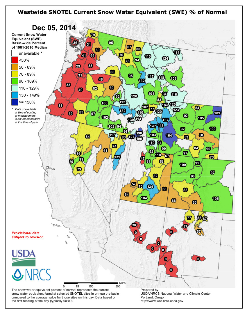
    Jeff Pigati arrived at Snowmass, Colo., just two weeks after a bulldozer operator uncovered the first bone of a juvenile mammoth. That was in October 2010. A specialist in radiocarbon dating, Pigati remembers being immediately awed by what he saw.

    “It took me about five seconds to figure out that this was something unprecedented and unique and really something that I had never seen before,” says Pigati, a geoscientist with the U.S. Geological Survey.

    In time, nearly 6,000 large-animal bones, many of them of mastodons, mammoths and other now-extinct species, were eventually unearthed. What wowed him even more was the exceptional preservation of leaves, seeds and other representations of the changing climates from 140,000 to 55,000 years ago.

    Those tell-tale clues have now allowed scientists to paint a picture of climates that changed in sometimes surprising ways. When it got warmer globally, it got warmer at the Snowmass site, located at 9,000 feet in elevation. And when it cooled globally, it got cooler at Snowmass.

    But the lake at Snowmass swung both hotter and colder than lower-elevation sites. When the global climate wiggled, the climate at 9,000 feet threw its hips.

    “The climate here doesn’t march in lockstep with global conditions. That is the absolute No. 1 take-home message,” says Pigati.

    From the outset, scientists who gathered at the site in Snowmass, which is within a quarter-mile of the ski lifts, had speculated that the site might deliver valuable clues about the climate of the last interglacial period, especially 130,000 to 110,000 years ago.

    Windows into the past

    The American West has several important windows into that period, but none at 9,000 feet. Yellowstone National Park has one site at about 6,000 feet while Bear Lake, along the Idaho-Utah border, has another at a comparable elevation. Yet a third is at American Falls, Idaho, at about 3,500 feet.

    These windows into the past, however, are more smudged. Snowmass is higher and superior in its clarity, what is called fidelity.

    One portion of this window into the past, however, is revealing for what it doesn’t show. From about 90,000 to 80,000 yeas ago the Earth’s climate chilled again, as is clear from ice cores in Greenland and Antarctica as well as sediments off the shores of North America.

    With this global trend clearly understood, scientists examining the timeline at the Snowmass site, called Ziegler Reservoir, expected to see evidence of plants and other life better suited to colder temperatures.

    Instead, they found absolutely nothing. Even midges, the insects found along creeks and in lakes, disappeared from the record. Mormon tea, a species adapted to cold, also was absent.

    What this tells scientists is that treeline had descended. Today, it is at nearly 12,000 feet. Then, it descended to below 9,000 feet. It is possible that the lake that had entombed mastodons remained frozen even during summers.

    The lesson, says Ian Miller, chairman of the Earth Sciences Department at the Denver Museum of Nature & Science, is that the climate at 9,000 feet “responds dramatically to change.”

    Scientists, he says, had expected evidence of a colder climate at Snowmass from 90,000 to 80,000 years ago, but not that much. “We have some records elsewhere in North America that says yes it’s going to get cold. But in the high mountain, it’s going gangbusters. This just drives home the point that the system responds dramatically at higher elevations.”

    This is sobering to Miller. If the high mountains have an amplified response to climate change, he says, then how will they respond during the coming century as the global climate warms due to heat-trapping greenhouse gases now accumulating in the atmosphere.

    “The implication is quite clear that the system does respond dramatically and that it does have an amplified response,” says Miller, a paleontologist who specialist in Cretaceous remains.

    Confirming amplifiers

    Patrick J. Bartlein, a paleoclimatologist in the geography department at the University of Oregon, says the Snowmass findings do not necessarily break ground but do emphatically confirm existing thinking about how climates change.

    Bartlein talks about amplifiers. Solar radiation patterns can produce changes in climate, but at Snowmass those changes blew up into even bigger changes, both hot and cold.

    Today, we have a different amplifier, the rapid accumulation of greenhouse gases in the atmosphere. Based on what has been documented at Snowmass, the Colorado Rockies might well change much more rapidly in temperatures than other, low-lying areas.

    “This helps us understand better the current experiment that we are doing with the climate system by changing the concentrations of carbon dioxide and other greenhouse gases. As we have only one climate system, and it’s sort of dangerous to experiment with it, it’s useful to see these past experiments that nature did,” says Bartlein.

    Greenhouse theory has long held that higher elevations and higher latitudes will see the effects of the reinforced greenhouse sooner and more dramatically than lower elevations, at least in terms of temperatures. Measurements have shown this to be the case in the American West but also in the Arctic. This, in turn, is causing other changes, such as the retreat of picas to higher elevations.

    In the last interglacial period, absent the buildup of greenhouse gases, the climate at Snowmass got toasty enough. During the peak of warming, about 125,000 years ago, vegetation found at Ziegler Reservoir was comparable to what is now found 3,000 feet lower and 30 miles away in the Roaring Fork Valley, near Carbondale.

    That was strictly based on natural variability. Now, add human intervention, in the form of elevated greenhouse gases. What temperatures might result from the combination?

    This evidence and thinking of 44 scientists involved in the research at Snowmass has been summarized in a special issue of Quaternary Research, a subscription-only journal.

    At the same time, the value of the Snowmass site in informing climate change models is sharpest in Colorado but recedes with points more distance. It is of some value in understanding the future of Park City, Utah, or Missoula, Mont., but most important in understanding west-central Colorado.

    “My guess is that the farther your get away for our study site, the less secure you can be about making these interpolations,” says Pigati.

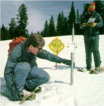
    Tools of no use here

    When Pigati first arrived at Snowmass four years ago, he knew that the remains would be older than 15,000 years old. That is roughly when mammoths disappeared in North America and there was, for sure, a mammoth bone.

    This meant Pigati’s radiocarbon dating equipment was of no value. The technique only works on material less than 45,000 years old. Everything in the depths of what is now Ziegler Reservoir was older. For that, scientists needed a different dating technique, called thermoluminescence, which measures the accumulated radiation dose of the time elapsed since material containing crystalline minerals was either heated or exposed to sunlight. It provides dating that is less precise but deeper in time than radiocarbon dating.

    Those green leaves that had so captivated Pigati when he first got to Snowmass? They were 100,000 years old.

    Using this same luminescence technique, the scientists discovered that the remains of tree-browsing mastodon bones that were found lower in the reservoir site had been deposited 140,000 to 90,000 years ago.

    “We didn’t find a single mammoth (bone) during that time period,” says Pigati.

    Mammoths bones found at Snowmass were deposited 80,000 to 55,000 years ago, before the climate veered colder once more and the Earth entered the most recent ice age, only to emerge again about 16,000 years ago.

    Absolutely nothing was found from 90,000 to 80,000 years ago, the time when the curtain of ice descended.

    Both mastodons and mammoths, who are both related to elephants of today, disappeared from North America about 10,000 years ago, or soon after the first known arrival of humans in the Western Hemisphere. They may not have been well-suited to the new shift in climate, although many scientists think their demise can be explained by the new presence of humans and their increasing technological prowess in the form of projectiles.

    Does another site with the same riches as Snowmass exist somewhere else, say in Montana? Pigati says that researched looked for other sites in the West where the same characteristics of glaciation could have yielded a similar circumstances and a comparable window into the past.

    “We found nothing,” he says. “That’s not to say they (the sites) are not out there, but it’s not obvious. This might truly be one of a kind.”

    Former Cotter Mill employees to get compensation for job-related illnesses

    Lincoln Park/Cotter Mill Site via The Denver Post
    Lincoln Park/Cotter Mill Site via The Denver Post

    From The Colorado Springs Gazette (Tom Roeder):

    Benefits for workers sickened by Cañon City’s atomic legacy will be outlined at a federal Department of Labor town hall Wednesday morning.

    The department oversees a program designed to compensate nuclear workers for cancer and other maladies associated with mining, hauling and processing uranium. Over the years, dozens of workers at Cañon City’s Cotter Mill have claimed their illnesses were caused by exposure to uranium and other toxic substances.

    Now, the federal government wants to make sure sick workers get paid.

    “The goal of the meeting is to make current and former nuclear weapons workers living in Colorado aware of the program and to assist them in finding information to determine eligibility for available compensation and medical benefits,” the Labor Department said in a news release.

    Miners hit massive uranium deposits along the Front Range in the 1950s and the mill in Cañon City was built to process it into “yellow cake” – uranium oxide – which can be refined into fuel for reactors and weapons parts.

    Processing uranium, though, left the mill in Cañon City marred by toxic leach fields and tailing ponds that were later deemed to be a federal Superfund cleanup site.

    The leaching left water contaminated with heavy metals and solvents in unlined storage ponds that continue to drive worries over groundwater contamination.

    The site, under supervision from the Colorado Department of Health and Environment, has been at the center of a controversy over how to clean up the damage.

    A settlement agreement reached over the summer says Cotter will pay for continued cleanup under state supervision.

    Taking care of workers falls under the Labor Department, which has administered health care and compensation for nuclear workers since Congress in 1990 approved the Radiation Exposure Act.

    The act offers lump-sum payments and health care coverage for those sickened by radiation work that fell under the federal Department of Energy.

    In recent years, Labor Department experts have held regular meetings in Cañon City to advise workers on the payments.

    More nuclear coverage here.

    “Conservation is definitely part of the package. But it is not the silver bullet” — James Eklund #COwaterplan

    watersprinkler

    From The Denver Post (Bruce Finley):

    Water conservationists are calling on Colorado leaders to set a clear target in the state’s first water plan: reduce use by 1 percent a year through 2050. But state officials crafting the plan to address a 163 billion gallon projected shortfall are reluctant to commit — even though Gov. John Hickenlooper has called conservation a priority.

    An aggressive water-saving goal, if it spurred action, could put Colorado on course to closing its growing gap between water supply and demand, which looms as a barrier to future economic and population growth. Conservation as a strategy also would ease degradation of Colorado’s Western Slope, where water in mountain streams increasingly is siphoned to sustain Front Range cities.

    “We definitely can save more water,” Conservation Colorado director Pete Maysmith said. “The state needs to put into the plan a high conservation goal if we’re going to fill that gap. It’s not like everybody has to get to a certain number. It’s just that, overall, we’ve got to be cutting 1 percent a year.”

    Other states have set targets: Utah committed to cutting water use by 25 percent before 2025. Texas aims for the same. California plans to cut use by 20 percent by 2020. Oklahoma plans to cap water use at today’s level through 2060.

    Colorado not only has yet to set a target but also remains the last of the arid Western states to complete an official water plan.

    However, Hickenlooper consistently has cast water conservation as essential. State planners’ efforts over the past year have embraced water-saving in principle — increased efficiency from low-flow toilets to smarter irrigation — to avoid massive projects that divert more mountain snowmelt out of rivers for people and industry.

    “Conservation is definitely part of the package. But it is not the silver bullet,” said James Eklund, director of the Colorado Water Conservation Board, who is coordinating state planning.

    A nearly completed draft of the Colorado Water Plan, to be unveiled next week, does not set a specific goal because “that doesn’t keep with what we are trying to do” in regional river basin discussions, Eklund said. “And each basin is unique.”

    The state still may end up committed to a water-saving goal after further deliberation, he said. The plan is to be finalized next year.

    Among the complications: Some areas are drier than others, requiring more water to sustain people. Climate change is affecting natural water flows. And residents in some cities who already have reduced water use could be hard-pressed to make further cuts.

    The 1.3 million metro Denver residents served by Denver Water cut average daily use to 85 gallons a person, down from 104 gallons in 2002 — compared with an estimated 123 gallons a day in Parker and 111 in Grand Junction.

    While comparisons can be difficult due to different counting methods, utility data showed Denver’s average daily use ranked less than water use in Salt Lake City (117 gallons), San Diego (136 gallons) and Los Angeles (123 gallons), but more than in Albuquerque (70 gallons).

    Historically, Colorado has relied on massive federally funded engineering projects, dams and diversions that pump about 500,000 acre-feet a year west-to-east under the Continental Divide with devastating consequences for ecosystems.

    Agriculture uses the largest share of water in Colorado, roughly 85 percent of developed supplies. But Colorado’s population of 5.2 million is expected to reach 10 million by 2050 and companies seek water for industry, including the oil and gas boom.

    Denver Water was taking the same position as state planners on water-saving goals. The utility favors a “tailored approach” rather than a statewide water-saving target because some communities conserve more than others, spokeswoman Stacy Chesney said.

    “Those who have not taken steps toward water conservation could more easily reduce their use than those who have already made significant strides in becoming efficient,” Chesney said.

    “We believe a better approach would be if every water user — from municipalities to agriculture, industrial users and more — knows their current use and establishes goals, such as investing in new water-saving technologies and striving for more water-use efficiencies.”

    More Colorado Water Plan coverage here.

    Transmountain diversions in the #COWaterPlan drive conversation, consternation

    Colorado transmountain diversions via the State Engineer's office
    Colorado transmountain diversions via the State Engineer’s office

    From Aspen Journalism (Brent Gardner-Smith) via The Aspen Times:

    The Colorado River Basin Roundtable last week pushed back against a perception that Western Slope interests have reached an agreement about a conceptual transmountain diversion, as indicated by a draft of the Colorado Water Plan and recent remarks by James Eklund, the director of the Colorado Water Conservation Board.

    “It is important that nobody oversells this as a done deal and a clear-cut pathway to a new transmountain diversion,” said Jim Pokrandt, the chairman of the roundtable and the communications director at the Colorado River District. “It is a way to talk about it.”

    Pokrandt was referencing a seven-point draft conceptual agreement put out in June by the Interbasin Compact Committee that is now included in the state water-plan draft. The 15-member committee includes representatives from the state’s nine basin roundtables and six other appointees.

    The first of the committee’s seven points is that “the East Slope is not looking for firm yield from a new transmountain diversion project and would accept hydrologic risk for the project.”

    Or, as Ken Ransford, the secretary of the Colorado roundtable, put it in the group’s October meeting, “This means that the East Slope will take less or perhaps no water in low-snow years instead of drying up a West Slope river.”

    An article in The Denver Post on Nov. 11 fueled the perception, some roundtable members said Nov. 24, that an agreement on the concept had already been reached.

    “The reality is the Western Slope is seeing available water in wet years for the Front Range to bring over,” Elklund told the Post. They are OK with that as long as there is mitigation or compensatory storage.”

    Eklund also told the Post, “Most people I talk with, even in the intense water community, view themselves as Coloradans first and members of river basins second.”

    Pokrandt called Eklund’s comments “unfortunate.”

    Eklund’s remarks conflict with the view of the roundtable’s executive committee, which said in a recent draft memo that “there is no water remaining from the Colorado River than can reliably be developed for Front Range use without putting Western Slope agriculture and recreation at peril and risking the certainty of current water users.”

    On Nov. 19, the Conservation Board’s board of directors, which oversees both the committee and the nine roundtables, unanimously approved the draft water plan, including the committee’s draft conceptual agreement.

    And it did so in a chapter called “Interbasin Projects and Agreements.”

    “Once finalized, these points of consensus may serve as the foundation for any new future transmountain diversion projects seeking state support,” the draft water plan says about the committee’s seven points.

    But Louis Meyer, who represents Garfield County on the roundtable and is the CEO of the engineering firm SGM in Glenwood Springs, said Nov. 24 that it was too soon to roll out the committee’s seven points.

    He said they did not have “public buy-in,” they were “exceptionally vague” and agreeing to the points “would result in unintended consequences.”

    “How can we go back to all the folks we represent, our constituents, and tell them we support these seven points when we don’t know what it means?” Meyer said.

    Eric Kuhn, who sits on the committee and also is director of the Colorado River District, said the seven points were “intentionally vague” and that in hindsight, he wished the committee had not called them a draft conceptual agreement.

    “This is not an agreement,” Kuhn said. “It’s really a list of discussion topics.”

    Stan Cazier, who represents the roundtable on the committee and supported the seven points being released, said the first point — where the Front Range accepts there may not always be water to divert — could actually be favorable to the Western Slope.

    “This is the only thing that I understand is in the Colorado Water Plan, which basically doesn’t give a green light to the other basins to develop anything they want to,” Cazier said. “This kind of puts the brakes on, possibly, what they could do in the future.”

    The committee’s draft conceptual agreement, or, if you prefer, its list of discussion topics,” will be on the agenda at a meeting in Grand Junction on Dec. 18, when the Colorado, Gunnison, Yampa/White and Southwest basin roundtables are slated to come together as the West Slope Roundtable.

    Editor’s note: Aspen Journalism and The Aspen Times are collaborating on coverage of rivers and water. More at http://www.aspenjournalism.org.

    More Colorado Water Plan coverage here.