
"El Limbo" – a warming Pacific, but lack of atmospheric coupling. Good Tony Barnston explainer of current El Nino http://t.co/0EpxPGqlY9
— John Fleck (@jfleck) December 19, 2014
Month: December 2014
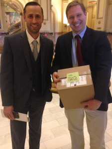
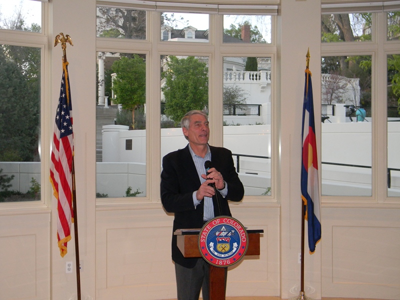
Former Interior Secretary Ken Salazar to speak at Colorado State University Water Tables event in January

Ken Salazar

Minute 319 signing

Here’s the release from Colorado State University (Kate Hawthorne Jeracki):
The Honorable Ken Salazar, former U.S. Secretary of the Interior, will be the keynote speaker at the annual Colorado State University Water Resources Archive Water Tables event Jan. 29, 6:15-9:15 p.m., at the Hyatt Regency Denver Tech Center.
The theme of this year’s evening is Partnering the Waters. Two dozen tables will be hosted by experts on how partnerships – public/private, regulation/conservation, education/industry, ranching/recreation – affect the health of rivers in Colorado and throughout the West.
Attendees can join any table on a first-come, first-served basis for 90 minutes of discussion and dinner, followed by Secretary Salazar’s remarks, dessert and more conversation. Water Tables will be preceded by a reception, 5-6:15 p.m., hosted by the Colorado Water Congress.
Some of the table topics include the recently released Colorado Water Plan; Climate Change, Resiliency and Adaptation; Extreme Drought; and Diversion Dam Removal on the South Platte River. Tables will be hosted by Patty Rettig, Head Archivist of the Water Resources Archive; historian George Sibley; John Sanderson, director of science for The Nature Conservancy; James Ecklund, director of the Colorado Water Conservation Board; and Patricia Wells, general counsel for Denver Water, among others.
Salazar, a fifth-generation Coloradan, also served as the state’s 35th U.S. Senator. He was a key leader in creating the successful energy framework created by the 2005 Energy Policy Act, the 2006 Gulf of Mexico Security Act, and the 2007 Energy Independence and Security Act, all of which passed the Congress and were signed by the President. He also was recognized for his leadership on conservation, veterans, agricultural and immigration reform matters. He is now a partner in the global law firm of Wilmer-Hale.
Water Tables is a fundraiser for the CSU Water Resources Archive and open to the public.
Tickets cost $150, which includes a $75 gift to the Archive. More information and registration is available at http://lib.colostate.edu/archives/water/water-tables/2015/
Water Tables is held in conjunction with the 2015 Colorado Water Congress Annual Convention, Jan. 28-30, also at the Hyatt Regency DTC. The premier water industry event in the state attracts 500+ attendees who convene for networking and collaboration on the important water issues of the day. This year’s theme is Rethinking Water. Experts from across the state will celebrate successes in water management innovation and plan towards a future with new ideas and flexible philosophies.Learn more, view the agenda, and register at: http://www.cowatercongress.org.
Cortez rates going up

From the Cortez Journal (Tobie Baker):
Public works officials said a “slight” rate adjustment was needed next year to keep up with the rising cost of infrastructure repairs, treatment chemicals and capital expenditures. Water rates will increase 5 percent in 2015.
The measure means a resident with a ¾-inch water meter, which includes the first 1,000 gallons, would pay $16.30 per month in 2015, an increase of 80 cents per month over current rates.
Rates for water usage over 1,000 gallons will also rise next year, from $2.10 to $2.20, and so will fees for the commercial water dock, increasing in 2015 from $12 for 1,000 gallons to $12.50.
The city will also raise its current tap fee of $3,800 to $3,900, starting Jan. 1.
The city’s 2015 water enterprise fund will receive more than $4.1 million in appropriations, which includes nearly $730,000 for personnel services, $670,000 for commodities and $1.85 million for capital projects.
More infrastructure coverage here.
“Our agriculture water is the low-hanging fruit” — J. Paul Brown

From The Grand Junction Daily Sentinel (Dennis Webb):
Protecting Western Slope agriculture appears to be one area of agreement as the region looks for ways of speaking with one voice on Colorado water issues. That was one takeaway from what was effectively a Western Slope water summit held [December 18] in Grand Junction with the goal of presenting some consolidated messages on the state’s newly drafted water plan.
Members of four roundtable groups — representing the Gunnison and Colorado river basins, southwest Colorado and the Yampa, White and Green river basins — already have developed their own plans that were incorporated into the newly completed draft plan. Representatives from all those roundtables gathered Thursday to talk about common themes that have emerged that they can be jointly voicing to the rest of the state as a final plan is developed.
In the case of agriculture, Colorado roundtable basin chair Jim Pokrandt said it’s important that the state not engage in poor water planning that forces farmers and ranchers out of business.
Said state Rep. J. Paul Brown, R-Ignacio, who works in agriculture himself, “Our agriculture water is the low-hanging fruit. It’s the easy water to buy and that’s exactly what’s happened.”
He talked about a need for more Front Range storage of its own water and alternatives like bringing in water from the Missouri River “so you’re not buying that agricultural water.”
Jim Spehar, a former Mesa County commissioner and Grand Junction mayor, agreed about the importance of considering agriculture in state water planning.
“If this discussion isn’t done by and for agriculture I think it will be done to agriculture,” he said.
Thursday’s discussion also turned to other areas including municipal and agriculture conservation. Gunnison County rancher Ken Spann said one thing those in agriculture need to know is where any water they might free up from conservation would go. He’d like to see it help fill Lake Powell to help states in the Upper Colorado River basin meet interstate compact water obligations.
But he worries that instead it could just end up supplying another new subdivision, or perhaps simply being offset by new water use being sought in the Yampa basin, which would mean no net increase in Colorado River water reaching Powell.
“The trade-offs (from conservation efforts) have to be identified and we are now at the point where we have to do that or people won’t play,” he said.
Western Slope water interests plan to continue talking about seeking a unified voice on water, including by addressing issues such as a somewhat controversial proposed framework for discussing any possible new diversions of western Colorado water to the Front Range.
“This is just the start of the West Slope conversation,” said Moffat County rancher T. Wright Dickinson, who also sits on Colorado’s Interbasin Compact Committee, a statewide forum for discussing water issues.
More IBCC — basin roundtables coverage here.
Report Documents Initial Results of Environmental Water Release on the #ColoradoRiver — IBWC

Here’s the release from the International Boundary Waters Commission (Sally Spener/Gilbert Anaya):
The International Boundary and Waters Commission, United States and Mexico (IBWC) today released the Initial Progress Report for the Minute 319 Colorado River Delta Environmental Flows Monitoring. The report documents initial success in delivering water to key areas in order to promote habitat restoration in the Colorado River riparian corridor.
Minute 319 is a 2012 IBWC agreement on U.S.-Mexico cooperation on a variety of Colorado River issues, including the environment. The Minute provides for a pulse flow — a one-time event to deliver water to the environment in the Colorado River Delta in Mexico. The pulse flow release, totaling approximately 105,392 acre-feet (130 million cubic meters) began March 23, 2014 and ended May 18, 2014. The water was intended to help restore native vegetation and wildlife habitat in parts of the Colorado River and its Delta that usually have little to no water.
A team of scientists, environmental experts, and technical personnel from universities, non- governmental organizations, and federal agencies from the United States and Mexico closely monitored the pulse flow under the Commission’s coordination. Their Initial Progress Report documents the inundation of 4,522 acres (1,830 hectares) of river channel and floodplain, including key habitat restoration sites. The report confirms the river’s temporary reconnection with the sea. Scientists also observed that a significant amount of water infiltrated to groundwater. Another key finding is the pulse flow’s effect in dispersing seeds and germinating both non-native and native vegetation, including cottonwood and willow, two species important to ongoing habitat restoration efforts. Preliminary observations further indicate an increase of migratory bird species along open water areas and at the active restoration sites.
“The report shows we were successful in delivering environmental water to key areas. I look forward to hearing from our team of scientists as they continue to study the pulse flow’s impact on our habitat restoration efforts,” said U.S. Commissioner Edward Drusina of the IBWC.
Mexican Commissioner Roberto F. Salmon Castelo indicated that these preliminary results confirm that nature always reacts positively even to small efforts like this one that was included in Minute 319, and that this will certainly prompt continued consideration of this type of action in subsequent agreements that could be generated with respect to Colorado River cooperation between both countries.
A mid-term report on the pulse flow is expected in 2016 and the final comprehensive report is expected in 2018.
The Environmental Pulse Flow Initial Progress Report is available on the website of the U.S. Section of the IBWC at: http://www.ibwc.gov/EMD/Min319Monitoring.pdf A summary of Minute 319 is available at: http://www.ibwc.gov/Files/Press_Release_112012.pdf
Interviews with scientists who worked on the report can be arranged upon request.
Here’s a release from the United States Geological Survery:
A pulse of water released down the lower reaches of the Colorado River last spring resulted in more than a 40 percent increase in green vegetation where the water flowed, as seen by the Landsat 8 satellite. The March 2014 release of water – an experimental flow implemented under a U.S.-Mexico agreement called “Minute 319” – reversed a 13-year decline in the greenness along the delta.
The year 2000 was the last time the Colorado River reached the Sea of Cortez, between Mexico’s mainland and Baja California. Since then, said Pamela Nagler of the U.S. Geological Survey’s Southwest Biological Science Center in Tucson, Arizona, information from ground measurements and satellites, including NASA/USGS’s Landsat missions and the Moderate Resolution Imaging Spectroradiometer, or MODIS, instrument on NASA’s Terra satellite, have shown a decline in the amount of healthy vegetation along the lower reaches of the river.
This spring’s pulse flow brought back some of the green. Nagler and other members of the Minute 319 Science Team used Landsat 8’s sensors to track the response of plants to the pulse of water. Landsat 8 is a joint project of NASA and the U.S. Geological Survey (USGS).
“The vegetation that desperately needed water was finally able to support more green leaves,” Nagler said. “These are existing trees, like saltcedar, willow and cottonwood, and a lot of shrubs and grasses that hadn’t seen much water in a long time.”
When they compared satellite images of pre-flow August 2013 to post-flow August 2014, the researchers calculated a 43 percent increase in green vegetation along the route wetted by the flow, called the inundation zone, and a 23 percent increase in greening of the riparian zone, or the river banks. Scientists presented these and other results this week at the American Geophysical Union’s Fall Meeting in San Francisco.

“Data from Landsat and the MODIS sensor are well-suited to help people make informed policy decisions about ecosystem health, water management, agriculture and much more,” said Jim Irons, Landsat 8 project scientist at NASA’s Goddard Space Flight Center in Greenbelt, Maryland. “It’s especially gratifying to see these sensors help scientists evaluate several of those components in one project,” he said. Remote sensing data were used in studies showing the impact of other relatively small flows prior to the Minute 319 agreement, and researchers are currently using Landsat 8 and MODIS to continue studying the effects of the 2014 water release.
Irons said that projects like this one demonstrate that researchers need an archive of good Earth observations of the past to refer to, as well as comparable measurements into the future to measure how a policy changes the landscape. “It’s important to have continuity of the data, so that when a policy decision is made to release the water, we have a system in place to evaluate its effects,” he said.
The Minute 319 pulse flow is part of an agreement adopted by the International Boundary and Water Commission, under the framework of a 1944 U.S.- Mexico treaty that governs water allocations on the Colorado River between the two countries. The 2012 agreement prescribed 130 million cubic meters (105,000 acre feet) of water to flow through Morelos Dam, which straddles the border.
Although most of the water soaked into the ground in the 37 miles below the dam, the river’s surface flow reached areas farther downstream that had been targeted for restoration, and groundwater revived vegetation along the entire route to the sea.
“Remote sensing with satellites such as Landsat and sensors such as MODIS allows scientists to conduct a range of studies they wouldn’t otherwise be able to,” said Karl Flessa, the co-chief scientist of the Minute 319 Science Team studying the hydrologic and biologic effects, and a geosciences professor at the University of Arizona in Tucson.
It’s just one of the tools scientists are using, along with on-the-ground monitoring, to detect changes in the river channel, surface water, groundwater, plant growth, and habitat for resident marsh birds and migratory birds.
“In addition to remote sensing, ground-based geophysical methods such as time-lapse gravity maps provide information about the change in groundwater storage, which ultimately supports riparian vegetation,” said Jeff Kennedy, USGS hydrologist and participant in the study.
The Minute 319 pulse flow was the result of significant cooperation between a large group of partner organizations and agencies in the U.S. and Mexico.
With so many interested parties, and water such a precious resource, scientists will continue to monitor the lower Colorado River Delta’s vegetation and hydrological response to the pulse flow, Flessa said. Using greenness data collected both from the ground and from satellites, researchers will investigate the long-term impacts to groundwater, and they’ll continue to study whether new trees and shrubs take root due to the flow. They will also study how the new vegetation affects birds migrating along the Pacific Flyway.
“There’s hope that we could release a pulse of water below Morelos Dam again,” Flessa said.
More Minute 319 coverage here.
Feds ink $300 million Windy Gap water diversion out of #ColoradoRiver — The Denver Post

From The Denver Post (Bruce Finley):
Federal water authorities signed off Friday on the $300 million Windy Gap Firming Project to siphon more water out of the Colorado River Basin into a huge new reservoir for the high-growth Front Range.
The west-flowing river water — up to 8.4 billion gallons a year pumped back eastward and under the Continental Divide — is expected to meet the needs of 400,000 residents around Broomfield, Longmont, Loveland and Greeley.
A U.S. Bureau of Reclamation decision clears Northern Water to build the 29 billion-gallon Chimney Hollow Reservoir, assuming it obtains state water quality and federal wetlands permits.
The reservoir would sit southwest of Loveland, west of Carter Lake. Work would begin by 2018, Northern Water spokesman Brian Werner said.
“It’s going to make water supplies more reliable,” Werner said. “You want to make sure you have a firm supply year in, year out so you have water for the basic needs of your communities.
“With all the growth we’ve seen in northern Colorado, we keep pushing that envelope of how close we are when that really dry year hits. We’ve got a lot more people moving in — one of the fastest-growing populations in the country — and part of this is about preparing for the future.”
For more than a decade, western Colorado communities have fought the project, contending it will degrade the ailing Colorado River Basin.
The project would divert river water near Granby and pump it through an existing 9-foot-diameter tunnel under the Continental Divide, to be stored in Chimney Hollow.
Numerous studies have found this will increase environmental harm that began in the 1930s, when federal agencies began pumping west-flowing water back eastward, through the Adams, Moffat and other tunnels, to Colorado’s semi-arid Front Range. Water temperatures spiked. Algae spread. Sediment clogged channels and choked aquatic life.
Negotiations during the past six years led to plans to try to minimize environmental harm and offset damage.
Northern Water has agreed to:
• Install temperature-monitoring devices and not divert water when the river gets too warm.
• Release trapped water for 50 hours at least once every three years, ensuring flows of 600 cubic feet per second, to simulate natural floods essential for ecosystem health.
• Give 977 million gallons a year to Grand County.
The project would increase the amount Northern Water diverts annually to more than 250,000 acre-feet, bringing total water diverted from the Colorado River Basin to 67 percent of the natural flows. Northern Water supplies 33 cities and irrigation water for 650,000 acres of crops.
From KUNC (Nathan Heffel):
The record of decision states that the proposed Chimney Hollow Reservoir site is the preferred location for holding water transported from the Western Slope via the Colorado Big Thompson Water Project. The proposed reservoir would feed 10 municipalities across Northern Colorado including Greeley, Loveland and Fort Lupton.
Northern Water’s Brian Werner said this is an important step in a long process bringing, what he calls, water stability to Northern Colorado users.
“We have two steps remaining next year [2015], we need a state water quality certification and then a wetlands permit from the Army Corps of Engineers,” Werner said. “Once those steps happen we move forward with design, that’s probably a year, year and a half. And then we can start going out to bid and onto construction.”
Werner said a 2017 or 2018 ground breaking on the project is likely.
Project managers said the Windy Gap Firming Project could provide 26,000 acre-feet of additional yearly water to Northern Colorado cities if constructed. Currently that additional water is lost in years of high run-off since there’s no place to hold it. During low run-off years, water is unavailable because the Windy Gap Project holds junior water rights.
“This makes reliable a water supply to a number of Northern Colorado communities that haven’t had the reliability factor with their Windy Gap water supplies. So it gives them another comfort level in terms of future water supplies,” Werner said.
“With the drought throughout the Colorado River basin and always on people’s minds, this is a huge step in terms of finding and putting together a future water supply for these communities.”
The federal permitting process for the project began in 2003, and the Bureau of Reclamation issued a final Environmental Impact Statement in 2011. A fish and wildlife mitigation plan was also approved at that time by the Colorado Parks and Wildlife Commission.
Creating a secure water future for south metro Denver — The Denver Post #COWaterPlan
Here’s a column about the south metro area and Colorado’s Water Plan from Eric Hecox that’s running in The Denver Post:
Colorado took an important step in addressing the state’s long-term water challenges by completing a draft of a state water plan. The plan offers a foundation from which local and regional water entities can work as we pursue solutions that balance local needs with statewide priorities. One need only look to the suburbs south of Denver to find many of the plan’s key tenets in action and a picture of what an effective “all-of-the-above” strategy looks like.
The water challenges facing the south metro region are well known. Historically we have relied too heavily on non-renewable underground aquifers. We must transfer to a secure, sustainable supply to protect property values, jobs, our economy and our quality of life.
What’s less known is the progress we have made. In the late 1990s, aquifer declines averaged 30 feet per year. This has dropped to an average of 5 feet per year today. A decade ago, about 70 percent of our region’s water came from non-renewable sources. By 2020, that will be reduced to 45 percent. Some communities, including Highlands Ranch, are close to or have cut that number to zero.
While we still have work to do, we have made tremendous progress in short time because we followed an “all-of-the-above” approach that mirrors the one advocated by state water leaders.
The approach begins with conservation. The south Denver metro region has reduced per capita water use by more than 30 percent since 2000. A few examples of local efforts:
• Providers serving Highlands Ranch and Castle Rock are two of only three in the state to put water customers on a water budget that tracks use by household.
• Sterling Ranch is conducting the state’s first rainwater harvesting pilot study.
• Inverness provides rebates for replacing turf with low water use landscaping.
Being a good steward of our limited water resources means more than conserving, however. It also means being as efficient as possible with this precious resource, which is why the state plan makes water reuse a priority. Here, too, the south metro region is leading, with all of our providers reusing their reusable water supplies or planning to:
• Inverness Water and Sanitation and the Meridian Metropolitan District are among the earliest adopters of water reuse in Colorado. They reuse 100 percent of collected wastewater.
• Castle Rock recently completed the Plum Creek Water Purification Facility as part of its goal of attaining a 75 percent renewable water source.
Increased water storage is another component of the statewide plan that the south metro area has put to action:
• The recently completed Rueter-Hess Reservoir provides storage to Parker and three other South Metro Water members. When filled, the reservoir will be 50 percent larger than Cherry Creek Reservoir.
• The expansion of Chatfield Reservoir is a collaboration among nine entities, including four South Metro Water members, to add storage to an existing reservoir.
Regional cooperation is another key tenet of the state water plan that is playing out in the south Denver suburbs. Through local and regional partnerships, we are getting more use out of existing infrastructure and supplies.
The WISE Project is a first-of-its-kind partnership with Denver Water and Aurora Water that bolsters water supplies to the south Denver suburbs while maximizing existing water assets in Denver and Aurora. Similarly, Arapahoe County Water and Wastewater Authority and East Cherry Creek Valley partnered to complete a state-of-the-art water treatment plant in 2012 and are working with several other South Metro Water members to share capacity on the ECCV Northern Pipeline.
The Colorado Water Plan provides a helpful roadmap. Born out of necessity, South Metro Water is proud to lead the way toward a secure and sustainable water future.
ICYMI: Full video of @hickforco press conference on the @COWaterPlan: #cowaterplan https://t.co/75TYp8q4oB
— WaterForColorado (@water4colorado) December 11, 2014
From the Sky-Hi Daily News (Hank Shell):
Western Slope water interests still reeling from the Gross Expansion Project may barely have enough time to catch their breath before they’re again summoned to the bargaining table…
Regarding another diversion, the plan “seeks to find a path forward that considers the option of developing a new (trans-mountain diversion), while addressing many of the concerns expressed by the Colorado Basin roundtable and others.”
The threat of another trans-mountain diversion has loomed behind the development of localized basin implementation plans for each of Colorado’s eight largest river basins.
The South Platte/Metro Basin roundtables have called for new Colorado River water supplies since their draft plan was released this summer.
The state water plan outlines seven “points of consensus” for a new diversion, one of which states that the Eastern Slope isn’t seeking firm yield from a new diversion, and that it “would accept hydrologic risk for that project.”
But Grand County Manager Lurline Underbrink Curran said many of those points are overly vague.
“What does risk mean?,” Curran said. “What does a new (trans-mountain diversion) mean? What does that mean when you have millions of people relying on it? The devil is in the details.”
Grand County has been active in the Colorado Basin Roundtable, which has actively opposed any new trans-mountain diversion from the Colorado River.
Jim Pokrandt, chair of the Colorado Basin Roundtable, said in an email that the Western Slope basin roundtables would probably draft an official response at their Dec. 18 meeting in Grand Junction.
Pokrandt did provide a list of points from a November discussion, in which the Colorado Basin Roundtable calls it “premature” to include the seven points in the state water plan.
“We need to recognize that there may come a point where we cannot back down,” the document states, “where we will need to take a stand for the sake of the West Slope and Colorado as a whole.”
In past discussions, Pokrandt has maintained that any additional diversions from the Colorado River could trigger a compact call, in which junior water rights holders must stop diverting to supply Lower Basin states with water.
A compact call could impact municipal and other users on the West Slope, including the Colorado-Big Thompson Project.
Each basin will submit its final basin implementation plan to the Colorado Water Conservation Board in April 2015. The board will submit its final state water plan to the governor in December 2015.
To view the draft state water plan, visit http://coloradowaterplan.com
More Colorado Water Plan coverage here.
Water Lines: Cloud seeding can work, but it won’t fill Lake Powell — Grand Junction Free Press

From the Grand Junction Free Press (Hannah Holm):
In the arid West, the perpetual search for new water supplies, like the mythical search for the Holy Grail, has given rise to numerous fantastical adventures and grand schemes. Some of these have resulted in the impressive feats of engineering that have re-plumbed much of the Colorado River Basin, and some have remained fantasies, like towing ice bergs from the Arctic and building pipelines from the Great Lakes.
“Cloud seeding” to wring more moisture from the sky has long been hard to classify in those terms. Water agencies and ski resorts have been doing it for decades, mostly by sending plumes of silver iodide from ground-based burners into likely-looking clouds. Cloud seeding has been done in Colorado since the 1950s and ramped up significantly after the 2002 drought. Still, until recently, no one could say with any certainty if cloud seeding really worked, or if so how well.
Draft conclusions from a much-anticipated, very rigorous nine-year study conducted in Wyoming indicate that cloud seeding can, in fact, increase the water yield from some storms, but the ultimate effect on the water supply is quite modest. The draft executive summary of the Wyoming Weather Modification Pilot Program study, conducted by numerous collaborators, was presented to the Wyoming Water Development Commission on Dec. 10; it is due to be finalized in March of 2015.
The study combined physical, modeling and statistical studies of the effects of cloud seeding in Wyoming’s Medicine Bow, Sierra Madre and Wind River Ranges and concluded that seeding could increase snow accumulations from some storms by 5-15 percent. This does not, however, translate to a 5-15 percent increase in the seasonal snowpack because not all storms are “seedable,” and those that are cover only a limited area.
In order for the inserted silver iodide to stimulate significant additional snowfall, atmospheric temperatures must be below 17 degrees Fahrenheit, with sufficient moisture in the air and favorable winds. These conditions were met less than one-third of the time during the winter in the study area. Using modeling, the study concluded that increased precipitation from seeded storms of 5-15 percent affecting 30-80 percent of the cloud-seeding impact area could increase streamflow in Wyoming’s portion of the North Platte River Basin between 0.4 to 3.7 percent.
Depending on numerous factors related to the operations of the cloud seeding program, the cost-per-acre-foot of water produced through cloud seeding ranges from $27-$427 per acre-foot. This compares favorably with other options for producing “new water.” In a 2013 article in the Mountain Town News, Allen Best reports that the Bureau of Reclamation has estimated that desalting brackish groundwater in Arizona would cost $650 per acre-foot, and desalting ocean water near Los Angeles would cost $2,100 per acre-foot. Cost estimates for building new storage reservoirs run from a few hundred dollars per acre-foot to over $1,000 per acre-foot.
In addition to assessing the potential impact of cloud seeding as a feasible strategy for impacting Wyoming water supplies, the study also assessed the environmental impacts of seeding and impacts on precipitation outside the seeded area (i.e. does it steal water from downwinders?).
The environmental analysis found that concentrations of silver iodide in the affected snowpack was in the parts per trillion range, while concentrations already in the soil were much higher, in the parts per billion range, indicating a very minimal impact from cloud seeding. Modeling of impacts on precipitation outside the seeded area indicated effects of less than 0.5 percent, which is consistent with previous studies and undermines claims that cloud seeding injures those downwind of seeded areas.
This study indicates that cloud seeding likely deserves its relatively newfound respectability as a water supply strategy, but also that its impacts are far too small for it to be a panacea for the West’s water woes.
To read the draft executive summary for yourself, go to the Wyoming Water Development Commission’s website at http://wwdc.state.wy.us.
More cloud seeding coverage here.
Mining the Ogallala — The Pueblo Chieftain

From The Pueblo Chieftain (Chris Woodka):
Wells are depleting the High Plains Aquifer at an alarming rate, according to a study released last week by the U.S. Geological Survey.
“The measurements made from 2011 to 2013 represent a large decline,” said Virginia McGuire, USGS scientist and lead author of the study. “This amount of aquifer depletion over a two-year period is substantial and likely related to groundwater pumping.”
The aquifer, also known as the Ogallala Aquifer underlies 175,000 square miles in Colorado, Kansas, Nebraska, New Mexico, Oklahoma, South Dakota, Texas and Wyoming.
Wells began tapping the aquifer heavily in the 1930s and 1940s, and the acreage irrigated expanded to 15.5 million acres in 2005 from 2.1 million acres in 1949.
The total water stored in the aquifer in 2011 was estimated at 2.92 billion acre-feet (951.5 trillion gallons). Pumping in two years depleted that by 36 million acre-feet (11.7 trillion gallons), causing an average drop in the aquifer of 2.1 feet. The overall rate of decline in the entire aquifer since pre-development is 267 million acre-feet, or 8 percent, resulting in a drop of 15,4 feet through 2013.
The change has been most significant in Texas, where levels dropped 44 feet in some places in the 2011-13 study period and 256 feet since pumping began. In some places, the well levels rose. With the highest rise since predevelopment recorded in Nebraska at 85 feet. Over time, Texas well levels have declined by 41 percent, and Kansas wells by 25 percent. Colorado dropped 14.3 percent over that same period, with more severe declines in the northern part of the state.
For the 2011-13 period, 7,460 wells were studied, 411 of those in Colorado. For the pre-development study, 3,349 wells were included, with 325 in Colorado.
“This multi-state, groundwater-level monitoring activity tracks water-level changes in all eight states through time and has provided data critical to evaluating different options for groundwater management,” said McGuire. “This level of coordinated groundwater-level monitoring is unique among major, multi-state regional aquifers in the country.”
Here’s the release from the United States Geological Survey (Virginia L. McGuire):
Abstract
The High Plains aquifer underlies 111.8 million acres (about 175,000 square miles) in parts of eight States—Colorado, Kansas, Nebraska, New Mexico, Oklahoma, South Dakota, Texas, and Wyoming. Water-level declines began in parts of the High Plains aquifer soon after the beginning of substantial irrigation with groundwater in the aquifer area (about 1950). This report presents water-level changes in the High Plains aquifer from predevelopment (generally before 1950) to 2013 and from 2011 to 2013. The report also presents change in water in storage in the High Plains aquifer from predevelopment to 2013 and from 2011 to 2013.
The methods to calculate area-weighted, average water-level changes; change in water in storage; and total water in storage for this report used geospatial data layers organized as rasters with a cell size of 500 meters by 500 meters, which is an area of about 62 acres. These methods were used to provide a raster dataset of water-level changes for other uses.
Water-level changes from predevelopment to 2013, by well, ranged from a rise of 85 feet to a decline of 256 feet. Water-level changes from 2011 to 2013, by well, ranged from a rise of 19 feet to a decline of 44 feet. The area-weighted, average water-level changes in the aquifer were an overall decline of 15.4 feet from predevelopment to 2013, and a decline of 2.1 feet from 2011 to 2013. Total water in storage in the aquifer in 2013 was about 2.92 billion acre-feet, which was a decline of about 266.7 million acre-feet since predevelopment and a decline of 36.0 million acre-feet from 2011 to 2013.
Click here to read the report.
More coverage of the 2012 drought and its affect on the Ogallala Aquifer from Stephanie Paige Ogburn writing for KUNC. Here’s an excerpt:
In Northeastern Colorado, farmers growing food like corn and potatoes depend for water on a giant, underground reservoir. Called the Ogallala, or High Plains aquifer, this water source spreads across eight high plains states like a giant, underground lake.
In times of drought, farmers who use the aquifer for water take more of it. A report from the U.S. Geological Survey, published December 16, shows the 2012 drought significantly diminished the Ogallala’s water.
“The bottom line was, there was with the drought, increased pumping and you have decline of the water levels,” said Virginia McGuire, the U.S. Geological Survey scientist who authored the report.
Over the last six decades, Colorado has exceeded the aquifer’s resupply by 18.8 million acre-feet of water. An acre-foot is the amount of water needed to cover an acre of land one foot deep.
Between 2011 and 2013, the state used up 3 million acre-feet more than was recharged. Across most of the aquifer, other areas also used a whole lot of water during that period. Kansas and Texas, both hard hit by drought, caused the largest declines in Ogallala water levels.
McGuire, who has been tracking the aquifer’s water level for years, said she knew the drought would make an impact. She was a little surprised at how significant an effect it was, though.
“The story is drought was widespread and there were declines in most of the aquifer for the 2011 to 2013 time frame.”
More Ogallala Aquifer coverage here.

Conservation easements aren’t working out for everyone, assessed land values were inflated

David Migoya hits it out of the park with this in-depth look at Colorado’s conservation easement program, which was designed to be self-regulated and what happened when that didn’t work out. Take the time to read the whole thing. Follow the links as well:
From The Denver Post (David Migoya):
Rocky Ford hay farmer Timothy Crow despises staring at bankruptcy. The 61-year-old says he hates it even more that Colorado put him there. “This was supposed to be a good thing for everyone,” Crow says of the state’s conservation easement program, where land-rich but cash-poor ranchers and farmers like him can preserve their property forever in return for needed income. “It’s become a living nightmare,” he said.
Crow and thousands of others like him preserved millions of acres of land in return for state income-tax credits they could either sell for cash or use to pay their own income tax bill.
Now, the state is forcing a handful of those landowners — and hundreds of people who bought those credits — to pay as much as $220 million in back taxes because the state says the land isn’t worth what the landowners claimed.
“It’s like a bait-and-switch scam,” Crow said. “Now my land is worth nothing, and I’m broke because of it. The only one making out is the state.”
At issue are nearly 500 conservation easements like Crow’s, the bulk of them donated between 2003 and 2007, that were created under a state law that for years had no oversight.
Things went wrong from the start. Wealthy investors and their lawyers latched onto an apparent loophole where the amount of tax credits they could get — and later sell at huge profits — were maximized by way of an appraisal method the state later said was flawed.
And although many landowners went into the program honestly, they relied on appraisers who used the flawed method.
Although it took years to unravel, state investigations ensued, and corrective action was taken to prevent further abuses and works well today.
But the fallout to taxpayers who bought in during the program’s earliest days is just now reaching a crossroad.
Instead of looking to the landowners who reaped the cash from selling the tax credits, the state is reaching into the pockets of the taxpayers who used the credits to pay their tax bills. The taxpayers say they bought the credits believing the state had scrutinized the process.
“This just stinks all the way around,” said Fort Collins businessman Michael McCurdie, who today is staring at a $100,000 bill for back taxes and penalties because he bought $65,000 in easement credits in 2003.
“How is any of this our fault?” he asked.
Landowners also are reeling, with many pushed into bankruptcy or its edge, because the taxpayers who bought the credits now want their money back. Landowners, such as Crow, used the tax-credit money to keep their farms and ranches operating. A few made improvements to homes or vehicles. There isn’t much left for refunds.
“The state created, advertised, and promoted the conservation easement program with the full understanding of the (land) appraisals, and (knew about) them for years,” said Fort Collins businessman Mark Lueker, who paid $52,000 to buy about $60,000 in easement tax credits. The state has since disallowed most of his credits and forced him to pay an additional $43,000 in taxes and penalties.
State officials say they’re merely collecting on taxes due.
“It is inaccurate to suggest that buyers of (conservation easement) credits, which were subsequently disallowed, have paid their tax twice,” state Department of Revenue spokeswoman Daria Serna said in an e-mail to The Denver Post. “They were private deals negotiated by private parties, and as with any investment there is risk.”
Serna said the original idea in creating the tax credits was for landowners and tax-credit buyers to keep each other honest, not for the state to police them.
The legislation was enacted in 1999 “with the intention the program would be self-regulated,” Serna said. [ed. emphasis mine]
Lueker, like others, says the state is culpable for creating the monster and not keeping track. The mere existence of the state tax credits led many buyers to believe they were safe, he said.
“The state has to accept responsibility for fiscal losses due to its internal negligence,” Lueker said.
Triple play
The conservation easement program was to be a triple play for Colorado.
“You want landowners to put their property into easements. That’s what makes our state beautiful. That’s a win,” McCurdie said. “And the tax credit helps us, the taxpayer, facilitate it. Everyone is winning.”
The state wins because easements are donated to a nonprofit land trust that ensures it remains pristine forever, protected from urban sprawl and development.
That’s how Crow saw it when he placed his 30-acre farm into an easement in 2003. He said he wanted to ensure it would never be developed, “that it would stay part of the valley forever.”
Crow claimed income-tax credits worth $160,000 based on an appraisal that valued his land on its potential use for a housing development should nearby Rocky Ford reach him.
Crow either could apply the credits against what he owed on his own income taxes, or he could sell the credits to someone else, who in turn could use the credits to pay their taxes.
To entice buyers, tax credits are typically sold at a discount, so $10,000 of tax credits would sell for as little as $8,000. The buyer can claim the whole $10,000 against their state income-tax debt or stretch it out over a few years.
And instead of paying the state, the buyer’s money went to the landowner.
Thousands bought into the idea. To date there have been 4,243 easement donations comprising nearly 2 million acres of land since it began.
Like hundreds of other ranchers, Crow had little use for tax credits — he never owed that much — and preferred the cash-flow for his small farm.
“I’m one of the small guys,” he said. “Like so many others, I’m usually just waiting around for the wrath of God to change things.”
He sold the credits through a broker.
“We didn’t get rich, but that money sure helped when times were tough,” Crow said. “Those were not easy years.”
Everything would have been fine had state revenue agents not noticed some tax-credit buyers were making claims in dollar amounts that were out of line from others participating in the program. Something was wrong.
Money-making scheme
Investigators found a small group of investors and attorneys had twisted the fledgling program into a monumental money-making scheme.
Not only were land appraisals abused, but the investors decided a 1,000-acre donation could garner many more times the state maximum of $260,000 in tax credits by carving it into smaller donations.
Suddenly one property was worth millions of dollars in tax credits that could then be sold for cash.
Retired attorney Stanley Mann led a group of real-estate investors whose 1,000-acre development near Walsenberg was at a near stand-still with only two houses built.
“Developing in Walsenberg doesn’t happen overnight, and we saw a minimum of 19 years to get it done,” Mann said. “But we were getting older, and the (easement) idea made perfect sense.”
The group pared the land into two dozen 35-acre donations at $260,000 in tax credits each, then sold them.
It was a payday. Between 2003 and 2007, there were 2,417 donations statewide totalling $498 million in tax credits, state officials said.
About a third of them — covering nearly half the tax-credit total — were found to have faulty appraisals.
Landowners such as Crow saw only needed money they could make on land they never wanted used for anything other than what it had been for generations — for pasture and plow.
“There were those who got sucked in because it probably seemed like just another Farm Bill program,” said John Swartout, special policy adviser to Gov. John Hickenlooper and former executive director of Outdoors Colorado.
Faulty appraisals
Irregularities first caught investigators’ eyes in about 2007. The early abusers eventually were taken down, some attorneys were sanctioned, a handful of appraisers lost their licenses, and a few speculator investors repaid millions of dollars of credits they had sold to hundreds of unsuspecting taxpayers.
Meanwhile, the state backtracked through hundreds of other donations, disallowing tax credits that were claimed on 682 donations based on faulty appraisals from 2000 to 2010.
More than 80 percent of the problem donations were from 2003 to 2007.
So many credits were disqualified that the state Department of Revenue, which was in charge of the easement program at the time, couldn’t keep up. Cases were tied up in administrative red tape and legal challenges for years.
In 2011, the legislature devised a shortcut in HB11-1300, creating three regions of conservation easement district courts where the cases would go. All those involved — the state, the taxpayers and the landowners — would be part of a court process to work out who was to pay and how much.
Although landowners could choose a hearing before revenue department administrators, few did. Ultimately 478 easements headed to court, each with a dozen or more credit buyers.
“The state encouraged the conservation easements then turned around to nail everyone who had one,” said Walter Kowalchik, a retired lawyer in Jefferson County who was part of Mann’s group. “It was a horrible disappointment to hundreds of people.”
In dozens of cases since, tax-credit buyers have been told they can either repay the original amount of income tax they owed from as long as a decade ago — penalties and interest forgiven — or fight it out and risk hefty add-ons later.
“Basically I had two choices: Settle, be happy and pay the smaller amount, or complain and then pay the whole thing with penalties and interest,” said Julius Medgyesy, who runs Front Range Cancer Specialists in Fort Collins. “I had to cut another fat check.”
Not every credit buyer had to pay. Some wealthy landowners and developers, like Mann’s group, covered the tab because tax credits are sold with a promise of indemnity. If something goes wrong, the seller agrees to pay up.
Many, like Crow, couldn’t afford that. They had little money left or not enough equity in their property to pay the taxpayers back.
The money was spent long ago on their farms. Worse, their land is permanently stuck in a conservation easement that’s worth nothing now. They can never develop it, never change its current use. Selling won’t get very much. For Crow, it’s forever a hay farm.
“It’s a State of Colorado Ponzi scheme,” Medgyesy said.
“The state doesn’t care”
When the Department of Revenue told Crow the appraiser’s error on his easement donation meant he should not have gotten $160,000 in tax credits, his heart sank.
“When they pulled the plug, that was it for us,” Crow said.
The 10 people who bought the tax credits from Crow had to pay up.
That meant Jeannine Thomas, who in 2003 paid Crow about $12,000 for $15,000 of his income tax credits, had to write a second check for taxes she thought she’d handled years ago.
In all, she’s repaid about $40,000.
“What I’ve paid the state is on top of what I gave the land donors,” she said. “I can put a lien on their property or force a sale of what little they have left.”
Thomas takes a long pause.
“So, I can either kick them out of their homes or simply be quiet and eat the loss,” she said. “The state says the easements did not meet their standards, and that it’s just business. Is this what this program was intended to do? Pit the tax-credit buyers against the conservation easement donors? To hurt people?”
Many say they’ve simply put their head down and accepted their fate.
“We’ve tried to make noise, but no one wants to go toe to toe with state (tax) revenue,” McCurdie said.
The Lamar landowner from whom McCurdie and 13 others purchased tax credits works three jobs today, his land nearly worthless because of the easement on it and the subsequent disallowance of its donation value. All the money from the tax credits he sold years ago was put into the farm.
With penalties and interest, Colorado pegged McCurdie and the others for roughly $1.4 million — on top of the nearly $1 million they’d already paid for the tax credits.
“We’ve tried to make the point that we bought into (the program) on good faith,” McCurdie said. “The state simply doesn’t care. They’re very clear this is their money and they will have it.”
No one has helped
Efforts at fixing the problem have fallen on deaf ears, several say. There have been letters to officials, meetings with agencies, phone calls to the governor’s office. No one has helped.
“Our point is that the (Department of Revenue) had by far the better chance to catch this abuse back in 2004 than we did,” Fort Collins builder David Neenan wrote Hickenlooper in March, appealing for a solution.
Neenan bought $80,000 of tax credits for himself and his family for $64,000. Earlier this year, he paid the state $128,000 in back taxes, penalties and interest.
A tax bill of $80,000 has now cost him more than $200,000.
“I received a form letter thanking me for my letter,” Neenan said of his plea to Hickenlooper.
The farmers from whom Neenan bought the credits have gone bankrupt or have only a small house or a few tractors in assets.
“There’s nothing to collect from,” he said.
Sen. John Kefalas, D-Fort Collins, said he’d like to take up the cause, but it’s uphill. Two earlier legislative efforts at amnesty have died.
“There’s an element of fairness here, and we need to find a way to deal with that,” Kefalas said. “But it’s a challenge.”
Even some businesses have suffered.
“We thought of participating with the state for a good cause,” said Mark Bower, executive vice president and CFO at Home State Bank in Lafayette. “It was their program. We thought we’d be a good corporate citizen and participate.”
In all, the bank lost $225,000 because of disallowed credits. Bower said it was “unpleasant” having to explain the loss to the bank’s board of directors.
“And what were we going to do, evict a rancher over it?” Bower said.
Today, mostly disabled and a widower, Crow gets by on his wife’s death benefit, too proud, he says, to apply for disability.
“This whole thing sucked the last bit of life right out of my wife,” he said of his wife, Jane, who died last year.
Looking north over the barren land behind his small home, Crow sighs.
“I was broken-hearted about how it’s all fallen apart,” he said, “and now we’re all backed into a corner.”
Even if Crow had the money to pay the buyers back, nothing would change.
His small farm is trapped in an easement for Colorado to enjoy — forever.
Click here to go to the November 23, 2007 Coyote Gulch post when things first breaking. Here’s a post about HB11-1300 designed to provide some relief to taxpayers that got caught up in the shenanigans.
Kudos to The Denver Post for keeping links alive in the archives.
More conservation easement coverage here.
@EklundCWCB talks water on the radio show “Diversions” #ColoradoRiver #COWaterPlan
Another great chat w/ Marc Catlin @COWaterPlan on his Western Slope radio show "Diversions" this weekend! #KUBC 580 AM @ColoradoRadio
— James Eklund (@EklundCO) December 21, 2014
Hundreds celebrate #Hermosa wilderness designation — The Durango Herald
Hundreds celebrate #Hermosa wilderness designation: http://t.co/qjRWRdxPGk @PowSciCenter @SenBennetCO @RepTipton pic.twitter.com/VvEZVks09C
— Durango Herald (@DurangoHerald) December 19, 2014
Windy Gap Firming Project one step closer — the Sky-Hi Daily News
From the Sky-Hi Daily News:
The U.S. Bureau of Reclamation has given its go-ahead to the Windy Gap Firming project which, if brought to fruition, will supply up to 26,000 acre-feet of additional Upper Colorado River water to the Front Range. The delivery system for the Colorado-Big Thompson project includes Windy Gap Reservoir, Lake Granby, Shadow Mountain Reservoir, Grand Lake and the Alva B. Adams Tunnel under Rocky Mountain National Park.
Look for more details next week in the Sky-Hi News and at http://www.skyhidailynews.com. Following are excerpts from the press release about the decision from by the Bureau of Reclamation:
The Bureau of Reclamation’s Great Plains Regional Director Michael J. Ryan signed the Record of Decision, contract and associated documents, for the Windy Gap Firming Project, located southwest of Loveland.
“The Windy Gap Firming Project is an exceptional example of the federal government working with our partners to get big things done,” said Ryan. “This project represents an immense effort from a diverse group of stakeholders who pulled together and created a workable project that provides benefits to the people of Colorado and the nation.”
The signing of the ROD culminates a years-long effort by multiple water providers to increase the reliability of, or “firm,” the Windy Gap Project water supply, increasing reliable annual yield from zero to approximately 26,000 acre-feet. …
The project potentially entails construction of a 90,000 acre-foot water storage reservoir, Chimney Hollow, south of Flatiron Reservoir on the East Slope, to provide more reliable water deliveries to Colorado’s Front Range communities and industry. The construction of Chimney Hollow Reservoir will also provide additional recreational opportunities that would be developed and managed by Larimer County.
“The process outcome is what all future water projects should be based on,” the Grand County Commissioners said in a statement. “We believe that consultation with Grand County during the 2014 contract negotiations is an indication of Reclamation’s commitment to open decision-making on matters involving operations of the Colorado-Big Thompson Project.”
Reclamation, along with Northern Water Conservancy District and Northern Water’s Municipal Subdistrict, have negotiated a contract allowing the Subdistrict to use excess, or unused, capacity in Reclamation’s Colorado-Big Thompson Project for Windy Gap Project water. New connections between Chimney Hollow Reservoir and C-BT Project facilities would allow water delivery to participants using existing C-BT infrastructure. Colorado-Big Thompson Project water would also be “prepositioned” in the Subdistrict’s Chimney Hollow Reservoir to help improve the reliability of Windy Gap Project water deliveries. Total allowable C-BT Project storage or yield would not change.
The estimated total construction cost for Chimney Hollow Reservoir and associated facilities is $223 million (in 2005 dollars) for the dam, reservoir, appurtenances and conveyance facilities. It is estimated that Chimney Hollow could be operational in five to seven years.
To view the Record of Decision, Final Environmental Impact Statement and other associated documents, visit: http://www.usbr.gov/gp/ecao/nepa/windy_gap.html.
From The Greeley Tribune (Kayla Young):
The future of water storage for Greeley and several other northern Colorado municipalities became a little more clear on Friday.
The Windy Gap Firming Project hit a historic milestone with the signing of its long-awaited record of decision at the Northern Water headquarters here.
Officials from Northern Water and the Bureau of Reclamation also signed a new contract to allow Windy Gap water to be transported from the Western Slope to Chimney Hollow Reservoir, to be located southwest of Loveland, through the Colorado Big Thompson Project infrastructure.
“For the participants in this project that have worked so tirelessly over a number of years to make today a reality, today the development of construction of the Windy Gap project has taken one significant step toward reality,” said Northern Water’s general manager, Erik Wilkinson.
The signing concludes 11 years of efforts and six years of negotiations to establish Chimney Gap Reservoir as the preferred alternative for the Windy Gap project. Once built, the reservoir will hold 90,000 acre-feet of water for 13 participating municipalities and water districts on the Front Range. The Windy Gap Firming Project will provide 26,000 acre-feet of water a year to the project to supply northeastern Colorado.
Although Friday’s signing marks a significant step forward in the project, several key steps remain, including certification on water quality, permitting from the Board of Engineers and the actual construction of the project. Construction is expected to begin on Chimney Hollow Reservoir in 2018.
Burt Knight, water and sewer director for Greeley, one of the top participants in the project with 4,400 acre-feet, recognized the signing as an important step forward in securing the city’s water assets.
“This strengthens our supply portfolio. We get water from four different basins. This strengthens our water that comes from the Western Slope and actually helps us with our reuse and irrigation side of the system, since this water can be reused over and over,” Knight said.
While the interests of the Front Range and Western Slope were often at odds during negotiations, Grand County Manager Lurline Curran said the relationships built during discussions were ultimately what allowed the project to move forward.
“I believe these negotiations have set a precedence on how water projects should be done in the future, not just here in Grand County but in the whole West,” she said.
Mike Applegate, president of Northern Water’s board of directors, said the project provides benefits to both sides of the divide.
“It’s one where there were definitely some tough negotiations but both sides listened to each other. Both sides got something out of the agreements. We’ve made the river better than it has been in a long time over in the Colorado River Basin,” he said.
He pointed to the importance of the plan statewide and its role in the recently released Colorado Water Plan draft.
“This project is recognized even in the Colorado Water Plan as critical for the future of the region, a project that really needs to get built if we really want to protect agriculture in the South Platte Basin,” Applegate said. “These communities that are signed up for this, they have the need right now, so we need to get this project built and get it working.”
James Eklund, director of the Colorado Water Conservation Board, said that much like the state water plan, this step forward on the Windy Gap Firming Project has been a long time coming.
“It’s really indicative of something you’ll find in the draft plan, that we, in this very board room, approved sending to the governor’s office last week. What that is, is this idea that there is a path for projects that involve water from the West Slope to the East Slope that are win-win type projects, that it’s not a situation where it’s a zero sum game,” he said.
From the Longmont Times-Call (Karen Antonacci):
The new Chimney Hollow Reservoir, which is expected to be complete in five to seven years, will allow member communities to store water during wet years.
While many Front Range cities and water districts get their water from the Windy Gap project near Lake Granby, water from Windy Gap can be pumped to the communities only in a year that’s not too dry or not too wet.
Too dry and there’s not enough water to pump. Too wet, and the water pumped to Lake Granby fills the lake past capacity and it just flows back to Windy Gap. The proposed Chimney Hollow reservoir could fix this problem, holding water in wet years to use in dry years.
The 31,575-acre-feet reservoir just west of Cater Lake will cost an estimated $273 million for the dam, reservoir and pumping facilities, according to a Bureau of Reclamation news release.
The federal permitting process for Chimney Hollow began in 2003, culminating Friday as a representative from the U.S. Bureau of Reclamation signed a contract and environmental impact statement as a consortium of county officials, mayors, water district board members and other public officials looked on.
The event celebrated the culmination of not just the permitting process but successful — yet many times contentious — negotiations that went on among entities on both the eastern and western sides of Rocky Mountain National Park. The water must be pumped from Windy Gap to Lake Granby, on the western slope, and then to the Front Range communities on the eastern slope via an underground tunnel already in place.
As the various environmental and other permits were being acquired, negotiations were occurring between entities on the Western and Eastern slopes.
“We didn’t start off in a big group hug,” Greeley Water and Sewer Board Vice Chairman Mick Todd told the group of assembled mayors and water officials Friday.
Dale Rademacher, Longmont’s director of public works and natural resources, said the effort was important for not only Longmont but for all of the other surrounding communities.
“The entire West is water short, and these types of collaborative efforts are going to be important and are going to work for a wide variety of people,” Rademacher said.
Longmont Mayor Dennis Coombs said moving forward with Chimney Hollow is especially exciting for him because Longmont Mayor Ralph Price is the one who filed for water rights for the Windy Gap project in 1967.
“We are standing on the shoulders of some great leaders,” Coombs said. Among the 13 entities sharing use of the future Chimney Hollow reservoir, Longmont will have the third most shares at roughly 16.2 percent. Broomfield will own the most shares at about 18 percent, and Platte River Power Authority will own the second most at about 16.3 percent. The authority provides electricity to Longmont, Estes Park, Loveland and Fort Collins.
Platte River Power Authority General Manager Jacqueline Sargent said that when completed, Chimney Hollow will make the supply of water they need for cooling during power generation more reliable.When there isn’t enough Windy Gap water available, Platte River Power Authority must buy it from other sources, which in dry years can get expensive.
“What this really means to us is that it enhances our ability to have a reliable source of energy to serve our communities and that’s really important to us,” Sargent said.
If you missed yesterday’s historic signing ceremony with @usbr you can watch it all online. http://t.co/dAPf4Kzr6c.
— Northern Water (@northern_water) December 20, 2014
Milky Way above Navajo sandstone in Arizona — EarthSky

Click here for the inside skinny on the 16-image panorama of the Milky Way arced above a little known area in northern Arizona.
Reclamation Signs Record of Decision for Windy Gap Firming Project in North Central Colorado

Site of proposed Chimney Hollow Reservoir — Windy Gap Firming Project via the Longmont Times-Call

Chimney Hollow Reservoir site

Chimney Hollow Reservoir site via the Bureau of Reclamation

Windy Gap participants (2012)

Windy Gap Reservoir

Moffat Collection System Project/Windy Gap Firming Project via the Boulder Daily Camera

Windy Gap and C-BT Granby area facilities

Windy Gap Reservoir
Here’s the release from Reclamation (Tyler Johnson):
Today, the Bureau of Reclamation’s Great Plains Regional Director Michael J. Ryan signed the Record of Decision, contract and associated documents, for the Windy Gap Firming Project, located southwest of Loveland, Colo.
“The Windy Gap Firming Project is an exceptional example of the federal government working with our partners to get big things done,” said Ryan. “This project represents an immense effort from a diverse group of stakeholders who pulled together and created a workable project that provides benefits to the people of Colorado and the nation.”
The signing of the ROD culminates a years-long effort by multiple water providers to increase the reliability of, or “firm,” the Windy Gap Project water supply, increasing reliable annual yield from zero to approximately 26,000 acre-feet.
“This is an important milestone for the Windy Gap Participants who have worked tirelessly over many years to make today a reality,” said Eric Wilkinson, General Manager for the Northern Colorado Water Conservancy District. “Today the development and construction of the Windy Gap Firming Project is one very significant step closer to reality. Thanks go out to all those who negotiated in good faith over the last several years to develop a number of agreements that form the foundation for the documents being signed today.”
The project potentially entails construction of a 90,000 acre-foot water storage reservoir, Chimney Hollow, south of Flatiron Reservoir on the East Slope, to provide more reliable water deliveries to Colorado’s Front Range communities and industry. The construction of Chimney Hollow Reservoir will also provide additional recreational opportunities that would be developed and managed by Larimer County.
“The process outcome is what all future water projects should be based on,” the Grand County Commissioners said in a statement. “We believe that consultation with Grand County during the 2014 contract negotiations is an indication of Reclamation’s commitment to open decision-making on matters involving operations of the Colorado-Big Thompson Project.”
Reclamation, along with Northern Water Conservancy District and Northern Water’s Municipal Subdistrict, have negotiated a contract allowing the Subdistrict to use excess, or unused, capacity in Reclamation’s Colorado-Big Thompson Project for Windy Gap Project water. New connections between Chimney Hollow Reservoir and C-BT Project facilities would allow water delivery to participants using existing C-BT infrastructure. Colorado-Big Thompson Project water would also be “prepositioned” in the Subdistrict’s Chimney Hollow Reservoir to help improve the reliability of Windy Gap Project water deliveries. Total allowable C-BT Project storage or yield would not change. The estimated total construction cost for Chimney Hollow Reservoir and associated facilities is $223 million (in 2005 dollars) for the dam, reservoir, appurtenances and conveyance facilities. It is estimated that Chimney Hollow could be operational in five to seven years.
To view the Record of Decision, Final Environmental Impact Statement and other associated documents, please visit: http://www.usbr.gov/gp/ecao/nepa/windy_gap.html.
Here’s the release from Northern Water (Brian Werner):
The Windy Gap Firming Project received its Record of Decision Dec. 19, 2014, during a signing ceremony at Northern Water’s headquarters in Berthoud. Mike Ryan, Great Plains Regional Director for the U.S. Bureau of Reclamation, signed the firming project’s long- anticipated ROD.
Officials from Northern Water, Northern Water’s Municipal Subdistrict and Reclamation also signed a new Carriage Contract allowing Windy Gap water to be transported from the West Slope to Chimney Hollow Reservoir using existing Colorado-Big Thompson Project facilities.
The ROD identifies and confirms Chimney Hollow Reservoir as the firming project’s preferred alternative. If built as proposed, Chimney Hollow Reservoir would store up to 90,000 acre-feet of water southwest of Loveland and just west of Carter Lake.
“Signing the Record of Decision and new Carriage Contract is a major milestone for the project,” said Jeff Drager, Project Manager for the Windy Gap Firming Project. “With Chimney Hollow Reservoir, the Windy Gap Firming Project will be able to provide 26,000 acre-feet of water year in and year out to growing communities in Northeastern Colorado.”
Dennis Yanchunas, President of Northern Water’s Municipal Subdistrict, applauded the participants’ perseverance. “While this has taken a number of years, it is worth the effort as Chimney Hollow Reservoir is that much closer to reality.”The Windy Gap Firming Project is a collaboration of 12 Northeastern Colorado water providers and Platte River Power Authority to improve the reliability of their Windy Gap water supplies. Windy Gap began delivering water in 1985.
The participants include 10 municipalities: Broomfield, Erie, Evans, Fort Lupton, Greeley, Lafayette, Longmont, Louisville, Loveland and Superior; two water districts: Central Weld County and Little Thompson; and one power provider: Platte River.
The firming project’s federal permitting process began in 2003 under the National Environmental Policy Act. Reclamation issued a final Environmental Impact Statement in 2011 along with the Colorado Parks and Wildlife Commission’s approval of a fish and wildlife mitigation plan.
Construction of Chimney Hollow Reservoir could begin in 2018.
Northern Water’s Municipal Subdistrict is a separate and independent conservancy district formed by six municipalities in 1970 to build and operate the Windy Gap Project. The Windy Gap Project consists of a diversion dam and pump plant on the Colorado River, and a six-mile pipeline to Lake Granby.
Northern Water is a public agency created in 1937 to contract with Reclamation to build the Colorado-Big Thompson Project, which collects water on the West Slope and delivers it to the East Slope through a 13-mile tunnel beneath Rocky Mountain National Park. Northern Water’s boundaries encompass portions of eight counties, 640,000 irrigated acres and a population of about 880,000 people. For more information, visit http://www.northernwater.org.Reservoir.
The signing of Record of Decision for the Windy Gap Firming Project. #cowater #chimneyhollow pic.twitter.com/VEFtAkaLnS
— Northern Water (@northern_water) December 19, 2014
Record of Decision signed for Windy Gap Firming Project in Colorado #COWater http://t.co/tjDYxII5lM pic.twitter.com/fgCW34yasq
— Bureau of Reclamation (@usbr) December 19, 2014
GM Eric Kuhn expresses congratulations at the signing of documents related to Windy Gap. #cowater pic.twitter.com/am1azMPszO
— Colorado River District (@ColoradoWater) December 19, 2014
Kokanee take a dive in Lake Granby — The Sky-Hi Daily News

Kokanee Salmon

Granby Dam via Reclamation

Lake Granby spill June 2011 via USBR. Granby Dam was retrofitted with a hydroelectric component and began producing electricity earlier this year as water is released in the Colorado River.

Granby Reservoir Indian Peaks in background

Colorado-Big Thompson Project Map via Northern Water
From the Sky-Hi Daily News (Hank Shell):
The numbers are in, and once again, the cards seemed to be stacked against the kokanee salmon population in Lake Granby.
This year’s annual kokanee salmon egg collection at Lake Granby yielded around 72,000 eggs, an alarming drop from the 357,000 eggs collected in 2013.
“This is the worst egg take since 1999,” said Jon Ewert, a biologist with Colorado Parks and Wildlife.
Ewert heads the annual egg count in Grand County, which includes Granby, Wolford and Williams Fork reservoirs.
“Historically, Granby used to be the biggest producer of eggs for the whole state, and it used to be the only source of eggs that we needed,” Ewert said…
Perfect storm
The question of why the kokanee are struggling in Lake Granby is a complicated one, and some are quick to point to one culprit – lake trout.
Lake trout, which eat kokanee, have grown in numbers in recent years, putting pressure on the kokanee population. But Ewert said the equation is more complicated.
Recent high water years have favored Mysis shrimp, which compete with the kokanee for zooplankton.
Lake Granby has a tendency to stratify in normal to low water years, which means warm water rises above cold to create two separate zones.
Mysis shrimp are usually confined to cold bottom layer, while kokanee and zooplankton stay in the warmer top layer, Ewert said.
In high water years, the lake takes longer to stratify, giving the shrimp access to the zooplankton for longer.
The high variability of water levels makes it difficult to maintain a consistent fishery.
“You’re always trying to achieve a balance between the Mysis, lake trout, kokanee and zooplankton,” Ewert said. “Those are kind of the main players, but the scale is always tipping one way or the other. There are very few years when you can say that it’s perfect.”
If the interplay of environmental pressures isn’t enough, Ewert said spilling over Granby Dam has also had an impact on the kokanee population.
Specifically, Ewert pointed to 2011, which was a heavy spill year. That year, CPW found kokanee at the bottom of Granby Dam.
This would be about the time when population impacts from spilling in 2011 would become apparent, Ewert said.
“There’s definitely a relationship there, too,” Ewert said.
Searching for solutions
CPW has been looking for a solution to Lake Granby’s kokanee problem in recent years.
But restocking isn’t enough to prop up Laky Granby’s dwindling population, and the CPW has been asking anglers in Lake Granby to keep their limit of Lake Trout.
Additionally, Ewert said that an increase on the bag limit for lake trout is a possibility.
But Keefe, whose main livelihood is trophy lake trout, said any future action needs to take the economic benefits of the lake trout fishery into account.
“If we’re changing the limits, we’ve got to make sure we’re changing them where it’s good for the long haul,” Keefe said. “If we take big fish out of the lake then we may never see them again.”
A healthy lake trout populations does rely on a healthy kokanee population, Ewert said.
Keefe suggested a slot limit, to help protect the trophy mackinaw that draw so many to Lake Granby.
Currently, Keefe said he asks anglers to throw back lake trout over 20 inches.
“Very few fish make it past 20 inches,” Keefe said.
An increase in the bag limit isn’t necessarily on tap for this year, but anglers could see one in the future, Ewert said.
“A lot of it is going to depend on what kind of a snow year that we have,” he said.
More Colorado-Big Thompson Project coverage here.
Mark Udall: Bringing out the best in us
From the Boulder Daily Camera (Mark Udall):
Recently, a lot of people have been asking me what it’s like to lose an election. It stings, that’s for sure. And while I wouldn’t recommend it, falling short in a race is a very humbling way of appreciating just how far you’ve come. In fact, as a lifelong mountain climber, I’ve learned far more from the mountains I did not summit, than those I did.
For the past 18 years, my most rewarding challenge has been exercising the power lent to me by the people of Colorado to fight on their behalf, first in the State House and then in the U.S. Congress. Throughout my career in public service — my six years in the U.S. Senate being but one chapter — I have always been guided by the rugged independence, strength and cooperative spirit that defines who we are as Coloradans and as Westerners.
This uniquely Western perspective holds that compromise is not capitulation, and that we are stronger when we all have a seat at the table — not only the privileged. This is a cause that my family has championed for generations and it is a creed that will continue to drive all Coloradans who answer the call to serve.
At this point in our politics, Americans are rightly impatient with the willful, partisan gridlock and dysfunction in Washington. Yet, in Colorado, we also know that by working together we have been able to keep our nation and our state moving forward and do our part to overcome Washington silliness for the good of the nation.
The idea that we don’t inherit the earth from our parents — we borrow it from our children — is the central idea of my long record of accomplishment. Throughout my career, this has led me to champion protecting our public lands and the special places that define Colorado, including Great Sand Dunes National Park, the James Peak Wilderness Area and Browns Canyon. It also has driven me to lead the fight to confront the real problem of climate change.
Colorado has spearheaded the nation’s pursuit of a balanced energy strategy. Most of the progress Colorado has made came after I fought alongside Republican Speaker of the Colorado House Lola Spradley to pass our state’s first renewable electricity standard. That important policy has meant Colorado is leading the clean energy revolution, creating good-paying jobs while fighting the causes of climate change. I’ve been proud to continue this fight in the U.S. Senate by successfully extending the Production Tax Credit for wind energy and introducing a national renewable electricity standard mirroring Colorado’s.
I also have led the charge to meet the promise of the Bill of Rights. Thomas Jefferson once said that a true patriot loves her country not just for what it is but what it can be. We still have a ways to go, but I am proud to have followed in the footsteps of leaders like my father to meet the promise of equality enshrined in the Constitution. That includes leading the successful fight to repeal the military’s discriminatory “Don’t Ask, Don’t Tell” policy and supporting policies that help women, the middle class and our immigrants get a fair shot at the American Dream.
I’ve said for years that Coloradans pull together come hell or high water. Little did I know that this saying would be proven true during my time in the U.S. Senate, from wildfires that left thousands homeless to a biblical flood in 2013 that swept over much of the Front Range. I was proud to help Coloradans rebuild in the wake of disasters and to secure resources that will help fight tomorrow’s wildfires, including a series of next-generation air tankers. I also went to work immediately after the 2013 flood and partisan federal government shutdown and successfully delivered more than $770 million in emergency flood support and marshalled nearly $2.5 billion in additional federal assistance so that Colorado could rebuild better and stronger than before.
And while there is much work left to be done to protect our privacy from government interference, I’m proud to have led the effort to reconcile the enormous power of our nation’s intelligence agencies with the bedrock principles of our democracy. We’ve proven that the choice between ensuring our security and protecting our privacy is a false choice, and that we can keep faith with our nation’s founding principles while also safeguarding our communities.
When I first came to the U.S. Senate, I told my colleagues that we were not elected to deal with Democratic or Republican problems, but to find uniquely American solutions to our toughest challenges. Just like mountain climbers who are all on the same rope, we know that we’re all in this together — and that we are only truly successful when we all succeed together.
The great writer Wallace Stegner challenged us to build communities to match our scenery. In a narrow sense, that means that we should strive to make our society as beautiful and thriving as the natural landscape that surrounds us. But in a broader sense, it also means that our communities should bring out the best in us, and that we should never stop building on the uniquely independent yet cooperative spirit that makes Colorado great.
That’s the spirit that has guided me throughout my time in public service, and it’s the spirit that will continue to guide me as I find new ways to help Colorado and our country move forward.
Mark Udall is Colorado’s outgoing senior U.S. senator.
More 2014 Colorado Novembee election coverage here.
UAWCD continues efforts to complete Thompson Ditch dry-up — The Mountain Mail

From The Mountain Mail (Joe Stone):
The Upper Arkansas Water Conservancy District board of directors discussed several topics at its December board meeting, including the district’s efforts to complete the dry-up of Thompson Ditch near Buena Vista. The dry-up is necessary for the district to be able to use its Thompson Ditch water right to augment out-of-priority water usage in the Cottonwood Creek drainage.
District General Manager Terry Scanga reported that the district has entered into an
agreement with the Yale Lakes Homeowners Association to stop diverting water into Yale Lake.Scanga said the next step is to install piezometers to monitor groundwater levels in the area previously irrigated by the Thompson Ditch, and hydrologist Jord Gertson and engineer Chris Manera will install the devices soon.
Harvard Lake will not be drained, Scanga said, until Gertson and Manera can assess the effects of draining Yale Lake.
Scanga also said the owners of nearby Ice Lake are trying to prevent the lake from being drained by finding ways to reduce evaporative losses from the lake as well as possible sources for augmentation water to offset evaporative losses.
Addressing an issue that arose following maintenance work on the outlet ditch at the district’s Conquistador Reservoir in central Chaffee County, attorney Kendall Burgemeister reported on a “disappointing” meeting with local landowner James Hood and his attorney.
The work involved removing an overgrowth of willows along the ditch. Willows are phreatophytes, deep-rooted plants that draw water directly from the water table, and failure to remove them can cause water losses that injure downstream water users.
Burgemeister said the meeting was scheduled 2 months out after Hood’s attorney contacted Upper Ark district officials to complain about work performed on the outlet ditch where it crosses Hood’s property.
The ability of a water-right holder to maintain a ditch used for that water right is protected by Colorado law, and while Burgemeister said Hood was “not happy,” he had no proposals to address the situation.
During the engineers’ report, Manera said the U.S. Bureau of Land Management will analyze the use of DeWeese-Dye Ditch with the intention of improving the efficiency of the ditch.
The ditch diverts water from Grape Creek, southwest of Cañon City in Custer County, and that water is stored in DeWeese Reservoir, one of the lakes in which the Upper Ark district stores water.
Manera said information provided by the district’s new gauge “was really helpful” in convincing the Bureau of Land Management to analyze water losses in the ditch.
In a brief discussion of the state water plan currently under development, long-time water attorney John Hill commented, “You could solve the problem if you could declare bluegrass a noxious weed.”
In other business, Upper Ark directors:Unanimously approved contracting with Hancock Froese & Co. LLC to conduct the district’s 2015 audit. Learned that Manera recently updated the emergency action plans for Boss Lake and North Fork Reservoir. Learned that Manera has begun the mapping to support a new Fremont County augmentation plan. Heard updates on district filings in Water Court from Burgemeister, including a report on the resolution of a Victor-Cripple Creek exchange case that the district opposed and then stipulated out of. Learned from Director Greg Felt that scientific research demonstrates that the last time the Earth’s atmosphere contained current levels of carbon dioxide, there were no polar ice caps, without which ocean levels would rise 60 feet.
More Upper Arkansas River Water Conservancy District coverage here.
Why saving water makes sense, and how one Front Range utility does it award-winningly well
Morning photo: Holiday lights
“The West is founded on an understanding of scarcity issues” — Michael Connor
"The West is founded on an understanding of scarcity issues" @DOIDepSec at #LasVegas #Drought Forum http://t.co/t18Q9BZGdU #wgadrought
— Western Govs Assoc. (@westgov) December 18, 2014
MillerCoors, Pepsi, Wells Fargo donate $1M to Colorado forests — Denver Business Journal

From the Denver Business Journal (Cathy Proctor):
MillerCoors, PepsiCo and the Wells Fargo Foundation announced Tuesday that the three organizations will donate $1 million to The Nature Conservancy to help restore forests along Colorado’s Front Range.
The money will help pay for the nonprofit to spend three years designing, implementing, and measuring the progress of forest restoration projects intended to “improve water security” for the Denver metro area and also reduce the threat of catastrophic wildfires.
The projects will include thinning tree stands, removing dry vegetation and conducting prescribed burns to clear out underbrush in controlled conditions, according to the announcement.
The projects are important because the mountain snowpack is the source of most of Colorado’s drinking water.
“Water is an essential ingredient in beer, so at MillerCoors we are deeply invested in water stewardship efforts,” said Kim Marotta, MillerCoors director of sustainability, in a statement.
“We rely on Rocky Mountain Water from the Front Range Forests to brew our quality beers, so we are proud to stand alongside our partners and The Nature Conservancy to preserve this vital resource for years to come,” she said…The project is the first one that PepsiCo (NYSE: PEP) has teamed up with The Nature Conservancy to do, said Meagan Smith, the director of sustainability for PepsiCo North America Beverages.
“We believe simple acts can have a big impact and this project is a great way to begin our relationship with
The Nature Conservancy and show our ongoing commitment to the communities in which we operate,” Smith said.
Decades of work putting out fires as well as prolonged drought has put more than 6 million acres of Colorado’s forests at risk for catastrophic wildfires that could damage the land and the drinking water supplies, the group said.Along the Front Range, about 1.5 million of the 6 million forested acres are at similar risk, the group said.
“Wells Fargo is committed to being environmentally minded in all that we do. This includes finding ways to protect one of our most precious resources: water,” said Ashley Grosh, Wells Fargo’s vice president of environmental affairs.
More restoration/reclamation coverage here.
WWA Intermountain West Climate Dashboard: New Briefing Available
Click here to go to the Western Water Assessment Intermountain West Climate Dashboard to read the latest briefing. Here’s an excerpt:
Highlights
November brought mixed results for precipitation for the region, with most Colorado and Wyoming mountain areas wetter than average, and nearly all of Utah much drier than average. The snowpack is still lagging behind normal conditions in most of the region’s basins, with southwestern Colorado, southern and eastern Utah, and southeastern Wyoming under 70% of median. Most indicators continue to move in the direction of El Niño, with the forecasts indicating that the probability of onset is around 60% through the winter months.
Snowpack news

Statewide snowpack December 18, 2014 via the NRCS

Arkansas River Basin High/Low graph December 18, 2014 via the NRCS

Upper Colorado River Basin High/Low graph December 18, 2014 via the NRCS

Gunnison River Basin High/Low graph December 18, 2014 via the NRCS

Laramie and North Platte Basin High/Low graph December 18, 2014 via the NRCS

Upper Rio Grande Basin High/Low graph December 18, 2014 via the NRCS

San Miguel, Dolores, Animas, and San Juan Basin High/Low graph December 18, 2014 via the NRCS

South Platte Basin High/Low graph December 18, 2014 via the NRCS

Yampa and White Basin High/Low graph December 18, 2014 via the NRCS
Click on a thumbnail to view a gallery of snowpack data from the Natural Resources Conservation Service.
Snowpack is at 78% of normal across the watershed today. http://t.co/q3WFIbmmG5 http://t.co/xroL5oedbD
— RoaringFkConservancy (@rfconservancy) December 18, 2014
Politifact readers choose “Climate change is a hoax” as the “Lie of the year”
Politifact readers choose "climate change is a hoax" as "Lie of the Year" http://t.co/MiqyWspiFK pic.twitter.com/PajjMLggFh
— Climate Power (@ClimatePower) December 18, 2014

Rio Grande Restoration Project’s Outcalt Project wraps up, 12 miles of river now restored

Photo via the Rio Grande Restoration Project

Photo via the Rio Grande Restoration Project
From The Pueblo Chieftain (Matt Hildner):
The Rio Grande isn’t a raging torrent of white water on the San Luis Valley floor.
But that doesn’t mean it can’t do damage.
For decades, the river has carved shelf-like banks on segments of the river between here and Del Norte, leaving increased sedimentation, degraded fish and wildlife habitat and property damage.
The nonprofit Rio Grande Restoration Project has set out to fix that problem, having restored roughly 12 miles of riverbank, including the completion of the Outcalt Project last week.
“It’s a typical stream bank and river restoration project for around here where there’s been a loss of anchoring vegetation, so that results in instability in the stream bank,” said Heather Dutton, the project’s executive director.
The increased erosion that comes from the river carving up its banks leads to more sediment, which is a water quality problem for fish and makes it more difficult for the channel to carry water downstream to meet the needs of other irrigators.
It also makes it harder for state water officials to meet the demands of the Rio Grande Compact, which divvies up the river’s flows between Colorado, New Mexico and Texas.
The river’s carving can also impact property owners.
“Landowners freakout when they see their property wash away in the river and especially if they have a house there or some kind of infrastructure the river is getting close to,” Dutton said.
But she added that the roughly 50 property owners she’s worked with have been interested for reasons beyond self-interest.
“The neat thing about the valley is, people get it,” said Dutton, who grew up on a farm near Sargent. “People understand the need to restore the river for the river’s sake.”
The threat to buildings was not a problem at the Outcalt property, which sits roughly 10 miles upstream of Alamosa.
The project’s contractor — Antonito-based Robins Construction — shaped sections of stream bank, replacing vertical shelves with a more gradual grade.
Rock barbs then were planted to help keep current off the freshly molded banks.
On properties with large cottonwood galleries, root wads also can be dug into the banks, offering the same type of protection but one that’s more attractive to fish and the bugs on which they feed.
“That was a really neat part of this project is there were more cottonwoods than we knew what to do with,” Dutton said.
But the ultimate tool, albeit one that takes longer to take effect, is the planting of willows along the banks to provide long-term stabilization.
All told, 0.65 miles of stream bank were restored in the Outcalt Project. Funding for the projects includes 20 percent payment from the property owner.
Other funding has come from the Rio Grande Basin Roundtable, the Colorado Water Conservation Board, the San Luis Valley Water Conservancy District, the Rio Grande Water Conservation District and the Natural Resources Conservation Service.
The restoration project also has an eye on the 33-mile segment of the river that runs from the southern end of the Alamosa National Wildlife Refuge to the New Mexico State line.
Program Manager Emma Regier is set to start work on a plan that will identify stretches in need of restoration and the prioritization of potential projects.
Both tasks will be subject to public input and the plan should be completed by next year, Dutton said.
But in the meantime, the restoration project still will have plenty of work to do on the upper reaches of the river between Alamosa and Del Norte fixing diversion structures.
Its biggest and first diversion work came on the McDonald Ditch project, which involves the replacement and relocation of a check dam and the extension of the ditch to a new diversion point upstream.
Construction is underway on the project.
Dutton said she has secured funding for three other projects designed to fix irrigation diversions and has identified another three that still need money.
“We’ll be working on ditch projects for a long time,” she said.
More Rio Grande River Basin coverage here.
The ‘greening’ of the Colorado River Delta
Water Values podcast: Check out @JohnforWASH’s WASH discussion — great insight and info on WASH issues
Check out @JohnforWASH's WASH discussion – great insight and info on WASH issues http://t.co/UIOwvCwYC1 #WaterValues
— David McGimpsey (@DTM1993) December 18, 2014
Clifton water rates going up — The Grand Junction Daily Sentinel
From the Clifton Water District via the The Grand Junction Daily Sentinel:
Water customers of the Clifton Water District will see their usage rates go up again starting the first of the year, the fifth time in as many years at the utility.
Clifton water users will see their minimum monthly rate for 3,000 gallons rise $1 from $22 to $23, and customers with an average of 7,000 gallons a month will see an increase of $1.40 in their monthly bill. The changes are in effect beginning Jan. 1, 2015.
Rates for minimum usage were raised $2 last year, and rates increased in 2011, 2012 and 2013, as well at the utility.
By comparison, in 2012 the minimum rate charged for customers using 3,000 gallons or less was $14.50.
Water usage rates in larger quantities will also bump up $.10 per 1,000 gallons across all tiers in 2015.
There is no change this year to the district’s $2.50 monthly system investment fee, and out-of-district customers will still pay 1.5 times the in-district rates.
In a press release, the district cited three primary objectives in raising their rates again: funding the operation of aging infrastructure improvements, loan repayment and encouraging conservation.
Clifton Water is the second-largest system in the region, behind the Ute Water Conservancy District.
Clifton serves a population of some 37,000, and 13,000 taps.
More Colorado River Basin coverage here.
Mild winter likely because of effects of El Niño pattern — The Grand Junction Daily Sentinel

From The Grand Junction Daily Sentinel (Amy Hamilton):
The zeros stack up on Powderhorn Mountain Resort’s website: zero snow in the last 48 hours, no snowpack at its mid-mountain base and none of the four lifts are open. To the anguish of skiers and snowboarders itching to get in a few turns, a lack of snow on Grand Mesa so far this year is pushing back Thursday’s scheduled opening day.
Yet down in the sun-splashed Grand Valley, folks have little to complain about.
Afternoon temperatures in the high 40s and 50s have people walking around in long sleeves and sweaters, but fewer jackets. Those hats and gloves are safe in storage a bit longer.
With temperatures ranging between 8 and 13 degrees above normal for this time of year, one starts to wonder if winter will arrive before the Dec. 21 solstice when the Earth’s northern hemisphere starts to tip back toward the sun.
“It’s been nice, hasn’t it?” remarked Ellen Heffernan, a meteorologist with the National Weather Service in Grand Junction. “It has been very warm. Last winter it was so cold so early. It’s nice that we can work our way into the cold.”[…]
A weak El Niño pattern is expected for Colorado this winter. The weather pattern in winter tends to favor milder temperatures in the northern U.S. and wetter weather over the southern part of the country.
In typical El Niño years, southern and southwest Colorado tend to receive more rainfall than the northern part of the state, Heffernan said.
In the Grand Valley, March is normally the year’s wettest month and December and January are the driest.
The warmer, dry winter temperatures may lift the spirits of humans, but it can be rough on trees. People should try to water trees, away from their bases and early on in the day to avoid nighttime freezing temperatures, said Susan Carter, horticulture program coordinator with Mesa County’s Colorado State University Extension Office.
“Without the moisture we should probably be thinking about watering them at least once a month,” she said. “Ideally you want to be able to get the moisture down about 6 to 8 inches. You can push a screwdriver down into the soil to check it.”
Gardeners also can place boughs or more mulch on bulbs and other plants to keep them from flowering early, Carter said.
Overall, thanks to a wet summer, Grand Junction is nearly 2 inches ahead of normal rainfall for the year. A reported 10.95 inches has fallen so far this year when the area normally receives nearly nine inches of rain by this time of year. Last year, the Grand Valley reported 12.4 inches of rain by this time.
Nearly an inch of snow normally falls by this time of year in the Grand Junction area. By this time last year, a whopping 10 inches of snow blanketed the Grand Valley, and a total of 14.8 inches of snow fell all winter.
What’s in store climate-wise for the next 3 months?

Seasonal Drought Outlook December 18, 2014 thru March 31, 2015 via the Climate Prediction Center

Precipitation outlook December 18, 2014 thru March 31, 2015 via the Climate Prediction Center

Temperature outlook December 18, 2014 thru March 31, 2015 via the Climate Prediction Center
Click here to go to the Climate Prediction Center website.
Here’s what NIDIS has to say about drought over the next 3 months (via Twitter):
Drought to persist/intensify thru March across Far West, S Plains; improvement likely in CA.
Drought news: Still plenty of time to build snowpack in the west

US Drought Monitor December 16, 2014

West Drought Monitor December 16, 2014

Colorado Drought Monitor December 16, 2014
Click here to go to the US Drought Monitor website. Here’s an excerpt:
Summary
Strong storm systems brought heavy, widespread precipitation to both the Northeast and West Coasts, providing beneficial moisture and drought relief to both regions. In the West, a broad trough of low pressure over the eastern North Pacific Ocean funneled several storm systems into the Pacific Coast that tapped subtropical moisture. The week’s greatest precipitation amounts fell on central and northern California where many locations totaled 4 to 12 inches. This precipitation came after the previous week’s moderate to heavy precipitation in the same area, continuing a wet pattern from northern California northward into the Pacific Northwest since mid-October. The wet weather finally allowed ample runoff (while producing stream and river flooding) that raised major reservoir levels (as of Dec. 16) in most of northern and central California by 6 to 10 percentage points from normal capacity (compared to Nov. 28 values). However, major California reservoir capacities still remained below normal, and due to above-normal temperatures accompanying these Pacific storms, more rain than snow has fallen on the lower elevations of the Sierra Nevada and Cascades, producing well below normal snow pack and water content this Water Year (since Oct. 1). Only the highest elevations have seen abundant snows. Fortunately, the West still has plenty of time this winter to build its snow pack for spring and summer stream runoff. Early in the week, a developing storm off the mid-Atlantic Coast looped back eastward, then tracked slowly northward, and eventually stalled over New England, dropping more than 1.5 inches of precipitation from eastern New York state eastward, with locally more than 4 inches in Maine. Late in the period, a storm system in the Nation’s mid-section brought widespread light to moderate precipitation to most of the Plains and Midwest, finally bringing welcome moisture to the central Plains and western Corn Belt after a very dry November and early December. Weekly temperatures averaged well above normal in the western two-thirds of the Nation and in New England, while the Southeast experienced subnormal temperatures…
Central and Southern Plains
The storm system previously mentioned in the Northern Plains and upper Midwest brought beneficial and welcome precipitation to the southern Great Plains (northeastern Texas, eastern Oklahoma) and central Plains (eastern and northern Kansas and most of Nebraska). The greatest totals (between 1.5 and 2 inches, locally to 2.7 inches) fell along the eastern Red River Valley, with 1 to 1.5 inches occurring in eastern Oklahoma, eastern and northwestern Kansas, and central and eastern Nebraska, with most locations (even Nebraska) seeing this precipitation fall as rain on unfrozen ground. With winter precipitation totals typically low, this was a significant moisture event. But due to the very dry autumn weather, this event was not quite enough to erase D0 over most of the central Plains; however, where November was wetter (Kansas southward) and this event had higher totals (at least an inch), a slight 1-category improvement was made. This included northwestern and eastern Kansas, southeastern Oklahoma, and northeastern Texas. In contrast, minimal or no precipitation fell on western and southern sections of Texas, and some slight deterioration was warranted in Texas in the northwestern Panhandle, along the southeastern coast near Matagorda Bay, and northeast of Houston…
Northern Plains and upper Midwest
After a rather dry November and early December, a storm system developed over the Southwest and intensified over the south-central Plains while tracking northeastward, bringing welcome moisture not only to the southern and central Plains, but also to parts of eastern South Dakota, Iowa, and much of Minnesota. The precipitation (0.25 to 0.75 inches, locally to 1.2 inches) was enough to stave off any deterioration in the region, and was a nice moisture bonus where the soils were not frozen (and since December normals are quite low). In the western Dakotas where little or no precipitation fell, short and medium-term surpluses existed, so dryness was not a factor. Accordingly, status-quo was applied here…
Southwest
With most of this week’s significant precipitation concentrated in the Far West (e.g. California), only light amounts (0.1 to 0.5 inches, locally to 1.2 inches) fell on most of the Four-Corners States. Toward the east, little or no precipitation was reported in eastern New Mexico and western Texas. After the previous week’s light to moderate totals in Arizona and northwestern New Mexico, and a rather robust and long-lasting Southwest monsoon, surplus precipitation still lingered at 90- and 180-days across much of the region, thus no deterioration was needed. This is fortunate as the WYTD (since Oct. 1) basin average precipitation and SWE are both below normal, ranging from 50-70 percent of normal (precipitation) and 10-80 percent of normal (Dec. 15 SWE), with conditions closer to normal in central Colorado and northeastern New Mexico…
The West
Two consecutive weeks of widespread heavy (7-day totals of 4 to 12 inches) precipitation, augmented by above-normal autumn precipitation, produced major stream and river flooding in north-central California. The flooding on the Sacramento River was the highest since Dec. 31, 2005. The runoff led to good capacity increases (6 to 10 percentage points) in major reservoirs across northern and central California; however, they were still below the historical averages for Dec. 16. For example, the Nov. 28 Trinity, Shasta, Oroville, Folsom, and San Luis Lakes percent of capacity was 23, 23, 26, 28, and 23; on Dec. 16, they increased to 29, 32, 33, 38, and 33 percent, respectively, but the Dec. 16 historical averages were 44, 53, 54, 79, and 52 percent. Based upon historical storage data, almost every major reservoir saw a 1-category drought improvement in their levels during the first half of December, and combined with wet start to the Water Year (and December), a broad 1-category improvement was made in north-central and along the central coast of California (D4 to D3, or 0-2 to 2-5 percentile). In addition, the mountains east of San Diego and south of San Bernardino in southern California received between 6-12 inches of December precipitation, improving overall moisture conditions there from D3 to D2 levels. Lastly, along the border of California and Arizona, a reassessment of conditions noted surpluses at 30- and 180-days, hence D0 was extended northward to the tip of southern Nevada.
Unfortunately, remaining areas to the south and east of the 1-category improvements were unchanged as the storms precipitation amounts were lower (but welcome), the autumn months were quite dry, runoff was minor to non-existent (albeit a few mudslides in fire-scarred slopes), and not surprisingly, the major reservoir levels in the south remained static. Furthermore, the rain shadow effect was notable on the Nevada side where much less moisture made it over the Sierra Nevada Mountains. Also, temperatures accompanying the storms have been above-normal, leading to more rain than snow at the higher elevations (e.g. Sierra Nevada). As a result, the snow water equivalents (SWE) for the northern, central, and southern Sierras were only at 43, 43, and 63 percent of normal for Dec. 16, which was actually higher than SWE values farther north in the Cascades of Oregon and Washington (10-30 percent). Fortunately, there are still many months left in their normal wet season for the Far West to build-up their snow pack, even though the Water Year-to-Date (WYTD) precipitation was at or slightly above normal in the Pacific Northwest. In north-central Washington, the past few months have been wet enough to justify a 1-category improvement to D1 as WYTD basin average precipitation was 112 to 120 percent. Similarly, surplus precipitation has fallen on extreme northern Idaho during the past 6-months to justify removal of D0. Elsewhere across the West and Rockies, enough precipitation (0.2 to 1 inch) fell from these Pacific storms to prevent any further deterioration, but not enough to warrant improvement.
In summary, a wet December (to date) has provided California a foothold for drought recovery, but 3 straight winters of subnormal precipitation will take time (possibly several consecutive wet winters) to fully recharge the reservoir levels and subsoil moisture back to normal. With several more months still left in the wet season, it is possible that additional storms similar to the ones that just occurred will continue to chip away at the long-term hydrological drought, and the addition of lower temperatures would help build the snow pack. “Cautious optimism, but still a long way to go” would be the very short summary for this week’s California drought picture…
Looking Ahead
For the upcoming 5-day period (December 18-22), heavy precipitation (up to 10 inches in northwest Oregon) is forecast for the Pacific Northwest (and southward to northwestern California) and northern Rockies, with lighter amounts in the central Rockies. A southern storm system should bring widespread moderate to heavy precipitation (1 to 4 inches) from central Texas eastward to Georgia and the Carolinas (including the expanding drought area in the Southeast), and lighter amounts along the Northeast Coast and in the central Great Plains. Mostly dry weather is expected in the Southwest (including southern California), High Plains, upper Midwest, Ohio Valley, and southern Florida. Near to above normal temperatures should envelop most of the lower 48 States, with the greatest positive departures in the northern Rockies and Plains and upper Midwest.
For the ensuing 5-day period (December 23-27), the CPC 6-10 day outlooks tilt the odds toward subnormal precipitation for eastern and southeastern Alaska, and from southern Oregon and California southeastward into the lower Mississippi Valley (lower Delta). Favorable chances of above median precipitation are expected in western Alaska, across the northern tier of States, and in the eastern quarter of the Nation, with the highest odds in the Great Lakes region and Northeast. Above median temperatures are expected in Alaska, the Far West, Southwest, and New England, with subnormal readings favored in the northern Plains and Florida.
South Platte Basin: The Nature Conservancy scores $1 million to enhance forest health #SouthPlatte

Upper South Platte Basin

Hayman burn area via The Denver Post

West Fork Fire June 20, 2013 photo the Pike Hot Shots Wildfire Today

Four Mile Canyon Fire September 6, 2010

Graphic via the Clear Creek Watershed Foundation

Hewlett Fire May 5, 2012

Waldo Canyon Fire. Photo credit The Pueblo chieftain.
From Denver.CBSLocal.com:
Three companies on Tuesday donated $1 million to help sustain clean drinking water for Denver and other metro-area communities.
MillerCoors, PepsiCo and Wells Fargo donated the money to the Nature Conservancy also to help with forest restoration in the Upper South Platte River.
Heidi Sherk, with the group, said much of Denver’s water supply originates in the river. Protecting the forest and the water shed will help ensure a reliable supply, she said.
“After fires like the Hayman Fire, the water supply can be severely impacted through the erosion that happens after fires, which interrupts the supply of clean water,” Shrek said.
Years of aggressive fire suppression, coupled with periods of drought, have left more than six million acres of Colorado’s forests at risk for large and damaging wildfires.
Tuesday’s donation will be used to restore forests and clean water over the next three years by conducting restoration efforts on forest lands, including thinning trees, removing dry vegetation and conducting prescribed burns.
Here’s the release from The Nature Conservancy:
MillerCoors, PepsiCo and the Wells Fargo Foundation announced today that they are teaming up to donate $1 million to The Nature Conservancy to ensure a clean and sustainable source of water for Denver and neighboring metropolitan communities along the Front Range forests.
Colorado’s Front Range forests catch the winter snowpack and seasonal rains that replenish rivers and reservoirs and directly furnish drinking water to more than two-thirds of Colorado’s population. Years of aggressive fire suppression and prolonged drought have left more than 6 million acres of Colorado’s forests at risk for unnaturally large and damaging wildfires, threatening people, water and wildlife. 1.5 million of the 6 million forested acres at risk are in the heavily populated Front Range.
“We are grateful to MillerCoors, PepsiCo and the Wells Fargo Foundation for this generous donation,” said Heidi Sherk, The Nature Convervancy’s interim state director in Colorado. “The funds will enable us to increase the scale and scope of restoration, making an impact in this critical watershed that will truly make a difference.”
The donation will ensure that The Nature Conservancy, over the next three years, can design, implement and measure progress on a suite of forest restoration projects in the Front Range that will improve water security for the Denver metropolitan area and reduce the threat of catastrophic wildfires. Restoration efforts include thinning trees, removing dry vegetation and conducting prescribed burns.
“Water is an essential ingredient in beer, so at MillerCoors we are deeply invested in water stewardship efforts,” said Kim Marotta, MillerCoors director of sustainability. “We rely on Rocky Mountain Water from the Front Range Forests to brew our quality beers, so we are proud to stand alongside our partners and The Nature Conservancy to preserve this vital resource for years to come.”
“This critical watershed protection effort is the first project we’re working on with The Nature Conservancy as part of our recently announced Recycle for Nature partnership,” said Meagan Smith, PepsiCo North America Beverages director of sustainability. “ Joining together with MillerCoors and Wells Fargo will amplify the important work of preserving a vital water source for Denver. We believe simple acts can have a big impact and this project is a great way to begin our relationship with The Nature Conservancy and show our ongoing commitment to the communities in which we operate.”
“Wells Fargo is committed to being environmentally minded in all that we do. This includes finding ways to protect one of our most precious resources: water,” said Ashley Grosh, Wells Fargo vice president of environmental affairs. “We’re proud to join together with MillerCoors, PepsiCo and The Nature Conservancy on critical restoration efforts that are needed to build a more resilient future for communities in Colorado and the larger region.”
More restoration/reclamation coverage here.
Ogallala aquifer drops by 36 million acre-feet from 2011-2013
From Net Nebraska (Grant Gerlock):
The aquifer lost enough water over a recent two-year period to cover the entire state of Iowa in a foot of water, according to a new report by the U.S. Geological Survey that studies water level changes from 2011-13.
The vast underground lake that supplies water to wells in some of the country’s most productive agricultural land – including parts of Nebraska, Kansas, Colorado, Oklahoma and Texas – lost 36 million acre-feet of water from 2011-13. The aquifer has lost about 8 percent of its stored water since 1950.
Prolonged drought is mostly to blame for the recent depletion, said USGS’ Virginia McGuire.
“If you were a farmer in this area you would have known about the 2012 drought and you would have known about increased pumping in that time-frame,” McGuire said.
In parts of western Kansas and northern Texas, the aquifer is no longer a reliable or sustainable source for irrigation, which has forced some farmers to change how they use their land.
“They’ve had to make some adjustments in farmers going to dry land farming or maybe changing crop types,” McGuire said. “They’ve definitely had to adjust to the declining water levels.”
Irrigation is meant to supplement rainfall, but many arid parts of the Plains states haven’t received typical rainfall in recent years. Without irrigation, farmers may have to cut back on growing lucrative crops like corn and soybeans, in favor of crops like winter wheat and beans, which can require less water.
More Ogallala Aquifer coverage here.
Estevan López Confirmed as 22nd Commissioner for the Bureau of Reclamation
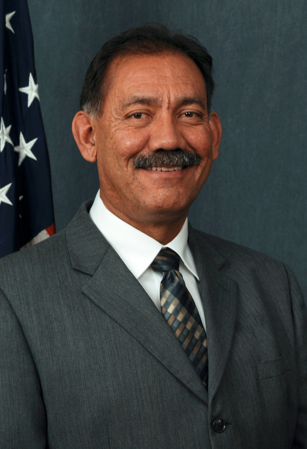
The United States Senate has confirmed President Obama’s selection for Commissioner of the Bureau of Reclamation. Having served as Principal Deputy Commissioner since October 8, 2014, with all of the responsibilities of Commissioner, Estevan López will now carry the title and formally take the helm of the 5500 person agency that manages water and generates power in the western United States. For the past 2 months as Principal Deputy Commissioner, López has immersed himself in Reclamation’s issues, met with stakeholders, become familiar with policy and personnel and is prepared to lead Reclamation into the future.
“I am deeply honored to be a part of the proud tradition of Reclamation and all of its accomplishments as we move into the future of the West,” said Commissioner López. “I am grateful to President Obama and Secretary Jewell for asking me to join this administration and I am very proud to lead this professional, knowledgeable and extraordinary team.”
“I am pleased the Senate confirmed Estevan López as the Bureau of Reclamation’s Commissioner. He is uniquely qualified to lead Reclamation, with a strong background in water management, dealing with drought and climate change issues,” said Secretary Sally Jewell.
López has 25 years of experience in the public sector including being appointed by Governor Bill Richardson of New Mexico, as the Director of the Interstate Stream Commission in January 2003. He was re-appointed to that position by Governor Susana Martinez in 2011. As Director of the ISC, López oversaw water management within New Mexico and negotiations with other states over interstate water matters. He represented New Mexico as the Governor’s Representative on Colorado River Compact matters and as Commissioner to the Upper Colorado River Compact and Canadian River Compact Commissions. While at the ISC, he also served as the Deputy State Engineer. Previous public sector positions included serving as County Manager and Land Use and Utility Department Director for Santa Fe County, and Public Utility Engineer for the New Mexico Public Utilities Commission. López also worked for several years in the private sector as an Engineer for ARCO Alaska, Inc.
A native New Mexican, he earned two Bachelor of Science degrees from New Mexico Institute of Mining and Technology; one in chemistry and one in petroleum engineering. López is a registered Professional Engineer in New Mexico.
López and his wife Susana live in Peñasco, New Mexico. They have two grown children, Victoria and Juan, who attend college in New Mexico.
The Bureau of Reclamation is a contemporary water management agency and the largest wholesale provider of water in the country. It brings water to more than 31 million people, and provides one out of five Western farmers with irrigation water for farmland that produces much of the nation’s produce. Reclamation is also the second largest producer of hydroelectric power in the Western United States with 53 powerplants.
Weekly Climate, Water and Drought Assessment of the Upper #ColoradoRiver Basin
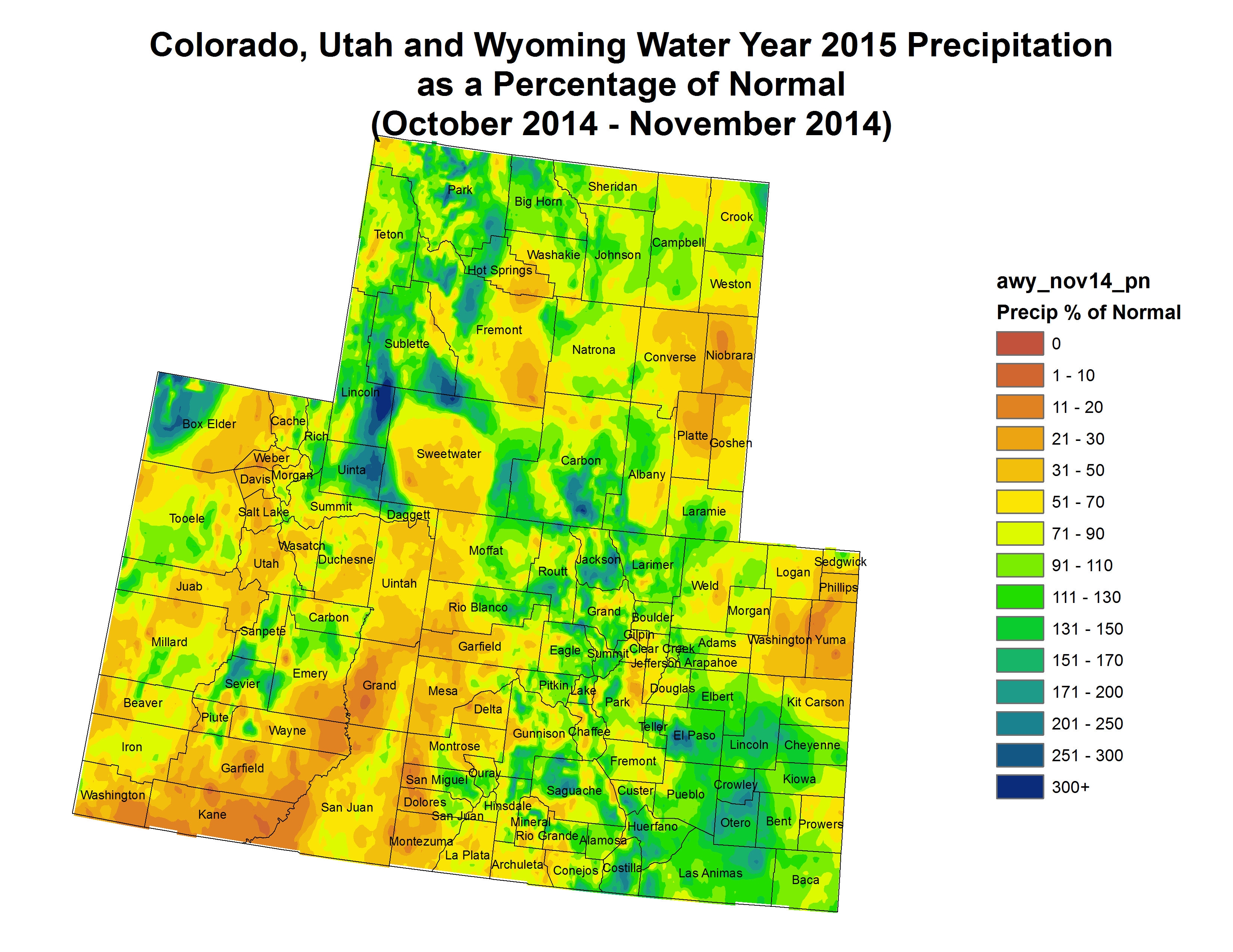
Click here to read the current assessment. Click here to go to the NIDIS website hosted by the Colorado Climate Center.
Reclamation: Bureau of Reclamation’s Desalination and Water Purification Research Program Seeks Proposals to Improve Water Treatment Technologies

Here’s the release from Reclamation (Peter Soeth):
The Bureau of Reclamation is seeking proposals within two funding opportunity announcements to improve water treatment technologies aimed at increasing water management flexibility through new usable water supplies in the United States. The first is for research, laboratory studies and the second is for pilot projects.
Reclamation will make a total of up to $1.4 million available for the funding opportunities. Research and laboratory studies may request up to $150,000 and pilot projects may request up to $400,000. Applicants are required to provide at least a 50 percent cost-share utilizing non-federal dollars. Institutions of higher education are not required to provide a cost-share for research and laboratory studies, but it is encouraged.
The funding opportunities are available at http://www.grants.gov by searching for announcement number R15AS00019 for research and laboratory studies and R15AS00021 for pilot projects. Applications are due on February 16, 2015, at 4:00 p.m. Mountain Standard Time.
Eligible applicants include individuals, institutions of higher education, commercial or industrial organizations, private entities, public entities and Indian Tribal Governments.
The Desalination and Water Purification Research Program is helping Reclamation and its partners confront widening imbalances between supply and demand in basins throughout the west through testing and development of new advanced water treatment technologies.
The DWPR Program priorities in 2015 are: (1) overcoming technical, economic and social barriers for direct and/or indirect potable reuse treatment, (2) novel processes and/or materials to treat impaired waters, and (3) concentrate management solutions leading to concentrate volume minimization for inland brackish desalination.
To learn more about Reclamation’s Advanced Water Treatment activities, please visit: http://www.usbr.gov/awt/.
USGS: Urban Stream Contamination Increasing Rapidly Due to Road Salt
Here’s the release from the United States Geological Survey (Marisa Lubeck/Steve Corsi):
Average chloride concentrations often exceed toxic levels in many northern United States streams due to the use of salt to deice winter pavement, and the frequency of these occurrences nearly doubled in two decades.
Chloride levels increased substantially in 84 percent of urban streams analyzed, according to a U.S. Geological Survey study that began as early as 1960 at some sites and ended as late as 2011. Levels were highest during the winter, but increased during all seasons over time at the northern sites, including near Milwaukee, Wisconsin; Chicago, Illinois; Denver, Colorado; and other metropolitan areas. The report was published today in the journal Science of the Total Environment.
“Some freshwater organisms are sensitive to chloride, and the high concentrations that we found could negatively affect a significant number of species,” said Steve Corsi, USGS scientist and lead author of the study. “If urban development and road salt use continue to increase, chloride concentrations and associated toxicity are also likely to increase.”
The scientists analyzed water-quality data from 30 monitoring sites on 19 streams near cities in Wisconsin, Illinois, Colorado, Michigan, Ohio, Pennsylvania, Maryland, Texas and the District of Columbia. Key findings include:
- Twenty-nine percent of the sites exceeded the U.S. Environmental Protection Agency’s chronic water-quality criteria (230 milligrams per liter) by an average of more than 100 days per year from 2006 through 2011, which was almost double the amount of days from 1990 through 1994. This increase occurred at sites such as the Menomonee and Kinnickinnic Rivers near Milwaukee and Poplar Creek near Chicago.
- The lowest chloride concentrations were in watersheds that had little urban land use or cities without much snowfall, such as Dallas, Texas.
- In 16 of the streams, winter chloride concentrations increased over the study period.
- In 13 of the streams, chloride concentrations increased over the study period during non-deicing periods such as summer. This finding suggests that chloride infiltrates the groundwater system during the winter and is slowly released to the streams throughout the year.
- Chloride levels increased more rapidly than development of urban land near the study sites.
- The rapid chloride increases were likely caused by increased salt application rates, increased baseline conditions (the concentrations during summer low-flow periods) and greater snowfall in the Midwest during the latter part of the study.
“Deicing operations help to provide safe winter transportation conditions, which is very important,” Corsi said. “Findings from this study emphasize the need to consider deicer management options that minimize the use of road salt while still maintaining safe conditions.”
Road deicing by cities, counties and state agencies accounts for a significant portion of salt applications, but salt is also used by many public and private organizations and individuals to deice parking lots, walkways and driveways. All of these sources are likely to contribute to these increasing chloride trends.
Other major sources of salt to U.S. waters include wastewater treatment, septic systems, farming operations and natural geologic deposits. However, the new study found deicing activity to be the dominant source in urban areas of the northern U.S.
The USGS conducted this study in cooperation with the Milwaukee Metropolitan Sewerage District. For more information about winter runoff and water-quality, please visit the USGS Wisconsin Water Science Center website.
More water pollution coverage here.
Robbing our groundwater savings accounts for today’s needs — The Mountain Town News


Crop circles — irrigated agriculture

Graphic credit: RogerWendell.com

Groundwater movement via the USGS


Significant portions of the Ogallala Aquifer, one of the largest bodies of water in the United States, are at risk of drying up if it continues to be drained at its current rate. Courtesy of MSU

Kansas Aqueduct route via Circle of Blue

Ogallala aquifer boundaries
From The Mountain Town News (Allen Best):
Dick Wolfe, Colorado’s state water engineer, recently defined “sustainable groundwater supply” as one that is managed so that recharge matches withdrawals in a way to avoid long-term depletion of the aquifer.
By that definition, Colorado is not, for the most part, using its aquifers sustainably. Nor, for that matter, is most of the nation or world.
That much was made clear at a conference on Dec. 4 that was conducted by the American Ground Water Trust. Andrew Stone, the organization’s executive director, said 14 percent of all water used to irrigate crops in the United States comes from mining groundwater aquifers. This started slowly, but picked up as pumps and cheap energy became available around the end of World War II. The extraction by farmers and cities of water above the rate of recharge is now close to 400 cubic kilometers.
“We are robbing our savings account,” he said.
Driven by population growth and the uncertain effects of climate change, pressures on these subterranean savings accounts will only worsen, he said. This is not inevitable. He cited Los Angeles, which after World War II turned to groundwater exploitation to satisfy growth. “In the 1960s, it was pretty clear that the LA Basin was cruising for big trouble,” he said. But unsustainable exploitation has ended.
Problems of groundwater exploitation are common in many areas of the country, but solutions must be forged locally, “aquifer by aquifer, region by region,” said Stone.
Sobering statistics
The day was littered with fascinating statistics. Jeff Lukas, of the Western Water Assessment, explained that of the 95 million acre-feet that falls on Colorado, only 14 million acre-feet end up as runoff in our streams and rivers. The remainder, 80 million acre-feet, evaporates or gets drawn back into the atmospheric through transpiration. Together, the two are called evapotranspiration, or ET.
This rate of ET will almost certainly rise as the atmosphere warms. In the last 30 years, temperatures have ratcheted up 2 degrees Fahrenheit. Climate models forecast another increase of between 2.5 to 5 degrees by mid-century in Colorado. By mid-century, the hottest summers of the last 50 to 100 years will become the norm.
Too, everything from corn to urban lawns will need 5 to 30 percent more moisture during the longer, hotter summers—assuming precipitation does not increase.
How much precipitation will change as the result of elevated greenhouse gases in the atmosphere remains a mystery. Unlike temperatures, average precipitation in Colorado has not changed appreciably in the last three decades. Climate models have been clear about increasing temperatures, but precipitation remains a flip of the coin.
However, warming alone will drive changes, “pushing both the supply and demand in the wrong direction,” said Lukas. Increased evapotranspiration will reduce runoff and the amount of moisture available to percolate into soils and down into aquifers. Spring runoff has already accelerated and will come one to three weeks earlier.
Bottom line: Hotter temperatures will drive farmers to suck up more subterranean water. If anything, aquifers will recharge more slowly.
Wolfe, in his turn at the microphone, had even more statistics: Of Colorado’s 16 million acre-feet, 10 million acre-feet flow out of state, mostly as a result of compacts governing the Colorado and other rivers.
“That leaves us about 6 million acre-feet in Colorado to use,” he said. This surface water provides about 83 percent of water used in Colorado, and the other 17 percent comes from aquifers, which are tapped by 270,000 wells.
Of this groundwater, 85 percent goes to agriculture, for more than 2 million acres, but there’s also a strong urban component. One in five Coloradans get their water from wells. Most prominent are Denver’s southern suburbs in Douglas County.
Denver’s South Metro
South Metro has been a poster child for living in the moment. It’s affluent and rapidly growing. Served almost exclusively by wells, the residents of Castle Park, Parker and adjoining areas comprise about 6 percent of Colorado’s population but command 30 percent of income. Today’s population of 300,000 residents is projected to grow to 550,000 by mid-century.
Wells have been dropping rapidly, five feet in just one year in Dawson, one of the aquifers.
Eric Hecox, executive director of the South Metro Water Supply Authority, explained that it was always understood that wells would not last forever. The area had hoped to benefit from Denver’s Two Forks Dam, which was to have been filled primarily by expanded diversions from the Western Slope.
Two Forks was sunk by environmental concerns in the early 1990s. Inconveniently, Douglas County surged in population, routinely landing in the top 10 of the nation’s fastest-growing counties, a distinction that only lately has abated.
Other projects have also nudged the South Metro area off its exclusive dependence on groundwater, but even collectively they do not provide the answer. Hecox called for continued efforts to pinpoint needs while creating a new generation of partnerships and infrastructure.
Can South Metro’s needs for sustainable water supplies be answered by building a giant pipeline from Flaming Gorge Reservoir, on the Utah-Wyomng border? That idea was proposed in 2006 by entrepreneur Aaron Million, and then echoed by Frank Jaeger, the now-retired director of Parker Water and Sanitation District.
Hecox said the Bureau of Reclamation study about water availability from Flaming Gorge has not been completed. That study will provide the 14 members in Hecox’s South Metro coalition “base information on which to decide whether we want to pursue it any further,” he said.
Two key agriculture areas
Two agriculture areas in Colorado that rely upon aquifers are in arguably worse shape. The San Luis Valley has an area called the Closed Basin. With the arrival of electricity to farms in the 1950s, large-scale pumping began and, for a number of years, all went well, said Steve Vandiver, general manager of the Rio Grande Water Conservation District.
Despite earlier hints of problems, the magnitude of over-pumping started becoming apparent in 1998. One million acre-feet had been pumped from the aquifer above the amount of recharge. Figuring out what to do took time and negotiation. “There have been rocks thrown from every quarter,” he said.
The plan now in place has cut pumping by 30 percent during the last three years. The amount of irrigated acreage has declined from 175,00 to 150,000 acres. Water use on those remaining acres has been reduced in some cases by planting different, less water-intensive crops and also by using different irrigation methods.
Up to 300,000 cubic feet per second of water continues to be pumped on the fields in the Closed Basin on hot summer days.
And the Ogallala….
The Ogallala Aquifer is perhaps America’s best-known story of groundwater depletion. It extends over parts of eight states, from Texas to South Dakota, and the aquifer has declined at a shocking rate in several of those states, but more slowly or not at all in places, especially the Nebraska Sand Hills.
The Republican River Basin of northeastern Colorado is emblematic of many. Farmers working with local districts and the state government have been shifting the paradigm. Whether they’re shifting rapidly enough is an open question.
The river and its tributaries originate on the high plains, gaining no benefit from mountain snowpack. Yet this region had 480,000 irrigated acres in an area where annual precipitation is only 17 inches a year.
The key: mining the Ogallala. In the late 1970s, Colorado began taking action to slow the unsustainable over-pumping, but more radical measures were triggered by the need to comply with the interstate compact governing the river shared with Nebraska and Kansas. Colorado was forced to release more water downstream.
It did this partly by abandoning Bonny Reservoir, eliminating the evaporative losses. At greater expense, the district constructed an expensive pipeline and now pumps water—ironically from wells—to release into the Republican River at the state line. The total cost of the pipeline and the purchase of water rights was $48 million.
Much is being done to steer the Titanic away from the iceberg of exhausted aquifer water, but Deb Daniel, general manager of the Republican River Water Conservation District, suggested the magnitude of the challenge when she said: “Sustainable, that’s a scary word where I come from.”
(For a story I recently wrote about the Ogallala in Colorado, see the Headwaters Magazine website).
Wells along the South Platte
Unlike everything else said in the day, several speakers argued that not enough pumping has been occurring along the South Platte River. Their solution: more reservoirs and also more acreage returned to production.
Robert A. Longenbaugh, a consulting water engineer, pointed to 400,000 acre-feet average annually flowing into Nebraska above the compact requirement. “I call that a waste of water,” he said. At the same time, he and others pointed to reports of basements in Weld County getting flooded because of rising groundwater levels.
Even in the 1960s, a Colorado law was adopted that formally recognized that aquifers and surface streamflows comingled waters . In other words, if you have a well a quarter-mile from the South Platte River at Greeley and pump it, that might mean less water in the river as it flows toward Fort Morgan.
The drought of 2002 forced the issue, and in 2006 the state put well irrigators into the priority system. In 2012, a hot and dry year, many wells had to be shut down and corn and other corps left to dry up. Longenbaugh called for changes.
“Strict priority administration of ground and surface rights does not maximize the beneficial use,” he declared. Instead, he wants to se a “real-time management of the South Platte, to monitor surface and ground water and “make short-term decisions” looking out six months ahead while still maintaining the priority-appropriation doctrine that is the bedrock of Colorado water law.
A panel of state legislators later in the day acknowledged varying degrees of agreement with Longenbaugh’s statement. Sen. Mary Hodge, a Democrat from Brighton, described a pendulum that went from “too lax” to now one of being “too stringent.”
Sen. Vicki Marble, a Republican from Fort Collins, described the situation as deserving of an “emergency measure.” She later added: “We should let people self-regulate,” while suggesting that the wells should be allowed to pump. “It’s their right,” she said.
More groundwater coverage here.
NOAA: State of the Climate Global Summary Information – November 2014
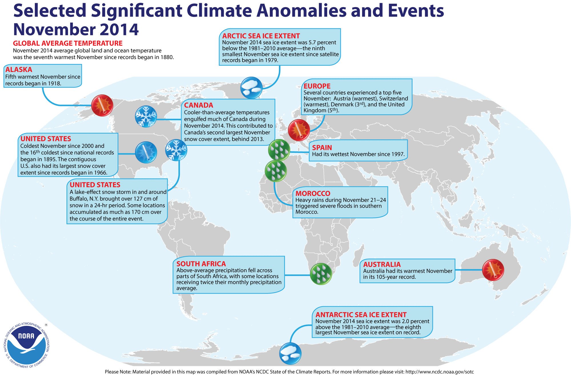
Click here to go to the summary page from the National Climatic Data Center. Here’s an excerpt:
Global temperature highlights: November
The combined average temperature over global land and ocean surfaces during November tied with 2008 as the seventh highest for the month, at 1.17°F (0.65°C) above the 20th century average. The margin of error associated with this temperature is ±0.13°F (0.07°C). This ends a streak of three consecutive months with a record warm monthly global temperature.
The global land temperature was the 13th highest on record for November, at 1.46°F (0.81°C) above the 20th century average. The margin of error is ±0.20°F (0.11°C). Warmer-than-average temperatures were evident over most of the global land surface, except for most of North America, parts of southwest Asia, and a few isolated areas of northern Russia. Neither El Niño nor La Niña was present across the central and eastern equatorial Pacific Ocean during November 2014. NOAA’s Climate Prediction Center estimates there is a 65 percent chance that El Niño will be present during the Northern Hemisphere winter and last into the Northern Hemisphere spring 2015. The combined average temperature over global land and ocean surfaces for September–November was the highest on record for this period, at 1.26°F (0.70°C) above the 20th century average of 57.1°F (14.0°C), surpassing the previous record set in 2005 by 0.02°F (0.01°C). The margin of error associated with this temperature is ±0.16°F (0.09°C). The global land temperature was the ninth highest for September–November on record, at 1.62°F (0.90°C) above the 20th century average of 48.3°F (9.1°C). The margin of error is ±0.31°F (0.17°C). Much of southern Australia was record warm, as was much of southern South America, the west coast of the United States, Far East Russia, and parts of southern Europe extending into northwestern Africa. The average Arctic sea ice extent for November was 4.00 million square miles, 240,000 square miles (5.7 percent) below the 1981–2010 average and the ninth smallest November extent since records began in 1979, according to the National Snow and Ice Data Center. Sea ice extent was below average on the Pacific side of the Arctic and near-average on the Atlantic side. Antarctic sea ice during November was 6.42 million square miles, 130,000 square miles (2.0 percent) above the 1981–2010 average. This was the eighth largest November Antarctic sea ice extent on record. The first 11 months of 2014 was the warmest such period on record, with a combined global land and ocean average surface temperature of 1.22°F (0.68°C) above the 20th century average of 57.0°F (13.9°C), surpassing the previous record set in 2010 by 0.02°F (0.01°C). The margin of error is ±0.18°F (0.10°C). 2014 is currently on track to be the warmest year on record if the December global temperature is at least 0.76°F (0.42°C) above its 20th century average.
Remembering the genius who got BPA out of your water bottles, and so much more — Grist

From Grist (Heather Smith):
It was the late 1970s and Theo Colborn was, like pretty much everyone else in the ’70s, getting divorced. She was in her 50s and already retired from a career as a pharmacist.
She’d moved to a hobby farm that was close to the Rocky Mountain Biological Station in Colorado and volunteered as a field researcher, sampling water and insects for signs that they were picking up toxics released by mining operations in the area. When she thought about what she should do next with her life, the answer that came to her was “become an expert in water sampling techniques.”
So Colborn went back to school. In 1985, at 58, she graduated from the University of Wisconsin-Madison with a Ph.D. in zoology and minors in epidemiology, toxicology, and water chemistry. “I wanted to get the education,” she said, in a 1988 Frontline interview,”so that I could maybe undo some of the things that my generation basically foisted on society.”
By the time Colborn died yesterday, at the age of 87, she had immersed herself in decades of research — and inspired even more research — that sought to do just that. The many, many proposed BPA bans? Go back to the very beginning, and you’ll find Colborn. The concern over dwindling sperm counts? Same thing…
What Colborn was seeing was the result of a wide variety of synthetic chemicals that had come into being in the 1950s and ’60s. Even though they were present in the water at very low concentrations, they were subtly changing how the animals in that system developed — how their genes were programmed, how their cells differentiated and spread out through their bodies, and, ultimately, how they were able to survive and reproduce into the next generation. The healthy wildlife around the Great Lakes, often, were those animals that had grown up elsewhere and migrated as adults. When their offspring failed to reach adulthood, or couldn’t reproduce, they were replaced by a fresh fleet of new arrivals. The lakes looked healthy, in other words, but they were a death trap.
Colborn credited this breakthrough, in part, to her unconventional scientific background.
I looked at it from an entirely different perspective. I looked at endocrinology differently. I began to look at toxicology. I was not trained in toxicology. I was trained in pharmacology until I went back to college to get my Ph.D. in my old age. Only then did I begin to sit in on toxicology courses.
There is a reductionism in scientists, in the scientific community. I have never been a reductionist. I am always thinking about the big picture. My thesis committee for my Ph.D. will tell you that. They had trouble with me.
At the time, Colborn said, scientists working on environmental issues had primarily been looking for cancer, which she described as “the big bugaboo.” Cancer was a rare event: In order to emerge, it had to circumvent the body’s defenses, and in a polluted community, not everyone would come down with it. What Colborn found was different: To a developing organism, even an infinitesimally small exposure could alter fetal development and the possible effects — lower IQ, organ damage, trouble reproducing — could be spread out across a community like jam on toast. The concept was so new there wasn’t even a term for it. In 1991, Colborn and a team of 21 international scientists working on the issue came up with one: endocrine disruption.
Unlike a lot of scientists, Colborn was not shy about becoming a public figure. She co-authored a popular science book with the dramatic title of Our Stolen Future. She founded a nonprofit called the Endocrine Disruption Exchange, which, among other things, helped fund and cheerlead more research into endocrine disruption and its causes.
Colborn continued to do solid research and she also went pretty far out on quite a few limbs, blaming chemicals derived from fossil fuels for everything from Parkinsons to Alzheimers to obesity to autism spectrum disorder. “Governments must take heed immediately,” she wrote, earlier this year, “or there will be too few healthy, intelligent individuals left to preserve our humanitarian society and create some semblance of world peace.” (As if we don’t have a pretty significant historical record showing that humans were more than eager to be complete jerks to each other long before anyone started messing with the benzene ring.)
Still, her big message was incontestable — that over 60 years ago, we began to introduce all of these chemicals into the environment, and we still have no idea what most of them do to us. In raising these questions, Colburn got us closer to looking for answers.
From The Grand Junction Daily Sentinel (Dennis Webb):
A Paonia scientist who earned international recognition for bringing attention to the impacts of endocrine-disrupting chemicals to humans and wildlife has died.
Theo Colborn, 87, founded The Endocrine Disruption Exchange, based in Paonia, and in recent years focused her attention on possible health impacts of chemicals related to oil and gas development.
She died this week at home, surrounded by her family, according to a statement issued by TEDX’s executive director, Carol Kwiatkowski.
“As with all great leaders, Theo’s inspiration lives on — in her published works, in the scientists she mentored and the activists she inspired, in the people she helped in so many ways, and in the love of her friends and family,” Kwiatkowski said.
TEDX focuses on possible health and environmental harms of chemicals that interfere with hormones important in the development of people and wildlife.
Colborn co-authored a 1996 book on the subject, “Our Stolen Future,” which drew comparisons to Rachel Carson’s landmark 1962 environmental book, “Silent Spring.”
In 2002, Colborn began living full-time in the home she owns in Paonia. She became interested in possible impacts of hydraulic fracturing and other drilling-related fluids on groundwater after an energy company began talking about drilling on nearby Grand Mesa.
She became involved in efforts including creating a spreadsheet of chemicals used in drilling and their potential ill effects.
In 2008, she received the Göteborg Award for Sustainable Development, which is given by the city of Göteborg, Sweden, and several companies. She and three fellow recipients all were honored for their roles in examining negative health and environmental effects of chemicals. Past recipients had included Al Gore, and the engineers behind Toyota’s Prius hybrid vehicle.
According to a statement on TEDX’s website, until the day she died Colborn continued to work on a statement, “The Fossil Fuel Connection,” weaving together some of her concerns. It concludes, “Governments must take heed immediately or there will be too few healthy, intelligent individuals left to preserve our humanitarian society and create some semblance of world peace.”
Kwiatkowski said, “Theo’s immense courage was both intimidating and inspiring. Against all odds, she succeeded in getting the world to pay attention to an invisible threat. Yet there is much work still to be done.
“As TEDX’s executive director for the past six years I can assure you that we will continue with the same fierce commitment to ensuring that the science of endocrine disruption drives better laws to protect the health of all people.”
Snowpack news
From the Associated Press via Denver.CBSlocal.com:
A fast-moving snowstorm brought more than a foot of snow to some areas of the Colorado mountains as remnants of the so-called Pineapple Express band of storms headed across the Eastern Plains on Saturday and began losing steam.
National Weather Service meteorologist Jeff Colton said Sunday portions of southern Colorado got more than a foot of snow overnight and snow picked up at Colorado ski resorts to the north. He said the storm began slowing down as it crossed the Continental Divide.
Beginning Saturday, Telluride picked up 13 inches of new snow and Winter Park got a foot along with Purgatory at Durango Mountain Resort. Snowmass reported 6 inches of new snow. Up to 5 inches of snow was forecast for parts of the Eastern Plains.
Colton said the heavy snow came from the remnants of the so-called Pineapple Express band of strong winds and rain that brought floods and mudslides to the West Coast.
Colorado Aquifer Management Conference recap

From the La Junta Tribune-Democrat (Candace Krebs):
Water managers, farmers, scientists, economists and policymakers are all scrambling to find solutions as the ripple impacts of a historic drought continue to be felt across the Southwest. Potential options, including water banking and storage, conservation incentives, farmland reallocation, irrigation retirement and sustainable urban planning, were all discussed during the recent Colorado Aquifer Management Conference, organized by the American Ground Water Trust.
As residential development picks up again following the recession, urban planners in Jefferson County are relying on a new water availability analysis tool that uses inputs like precipitation and consumptive loss as part of an in-depth spreadsheet. “We get to some bottom lines here,” said Roy Laws, an environmental engineer for the county.
South Denver’s booming bedroom communities have shifted toward treating the underlying aquifer as “a drought proof supply” rather than their base water source, according to Eric Hecox, executive director of the South Metro Water Supply Authority. Through water budgeting, improved water re-use systems and creative regional partnerships, these fast-growing suburbs have been able to reduce per capita water use by up to 30 percent, he said.
In addition, cities like Castle Rock have added new user fees ($5 per user in their case) to fund future use planning, Hecox added.
So far, however, it’s the managers of agriculturally dependent districts who are experiencing the most dramatic challenges.
Steve Vandiver, executive director of the Rio Grande Water Conservation District, outlined the painstaking process the San Luis Valley was forced to undertake after six years of below normal precipitation coupled with new requirements for augmenting water wells.
“I can tell you it’s been a struggle,” he said.
The district is working on dividing up into subdivisions for the purpose of creating new revenue streams to purchase water rights and retire them, he said. The first of the proposed subdivisions has been able to reduce pumping by 30 percent. But the process has drawn mixed reviews, which was evident even among the San Luis Valley farmers scattered in the audience.
David Warsh, of Center, and Jake Burris, manager of ELE Farms of Alamosa, both potato growers, supported the plan, saying it allowed farmers to take control of their destiny.
“What it’s done is that it got us to take less productive land out of production,” Warsh said. “The new sub-areas allow for oversight by like-minded people. And it provides conservation incentives. If you pump, you pay.”
But John Noffsker, owner of Two Creek Ranches of Monte Vista and a surface water rights holder, was less enthusiastic. “Surface water isn’t fair like it used to be,” he said. “We need a solution that works rather than using the water to benefit a few. Smaller farms raising lower value crops will not be able to afford the increased fees.”
More groundwater coverage here.
Blue Mesa Reservoir water bank study #ColoradoRiver
Click here to read the report.
From The Pueblo Chieftain (Chris Woodka):
Another piece of the Colorado River shortage puzzle has been put in place with the completion of a Blue Mesa Reservoir water bank study. The study was a joint effort by the Arkansas Basin Roundtable, Gunnison Basin Roundtable and Colorado Water Conservation Board. It looked at whether water could be stored in Blue Mesa Reservoir near Gunnison to be released during a drought when Colorado might owe water to downstream states.
“There are benefits to the environment during low-flow periods,” said Mark McCloskey, of CDM-Smith, consultants for the study, as he explained the study to the Arkansas Basin Roundtable this week.
Under the 1922 Colorado River Compact, upper basin states (Colorado, New Mexico, Utah and Wyoming) are required to deliver 75 million acre-feet to Lake Powell under a 10-year rolling average. If that fails to happen, downstream states (Arizona, California and Nevada) could issue a call on the river. Colorado’s share is 51.25 percent of the deficit.
Another 1.5 million acre-feet annually must be delivered to Mexico.
While there has never been a shortfall of deliveries, there are indications from tree-ring studies that decades-long dry spells are possible.
The study used the worst-case scenarios from the Bureau of Reclamation’s Colorado River Basin study — high demand in very dry years — to develop models of optimum timing and levels of storage in a water bank in Blue Mesa. It projected water that would be needed if levels fell to 80-98 percent of minimum levels. The study also determined how much water would be lost to evaporation or to stream banks along the way to Lake Powell.
Replacement water likely would be purchased by Front Range or statewide interests from ranchers, and it’s not known how those purchases would affect high-altitude hay meadows, McCloskey acknowledged.
It’s important to the Front Range, because a call on the Colorado River could mean curtailment of diversions across the Continental Divide.
A curtailment could mean less water for Pueblo, the Fryingpan- Arkansas Project, Colorado Springs, Denver, Aurora and the Colorado-Big Thompson Project.
All of those have water rights that were established after the 1922 compact.
The study showed the optimum time to store water would begin when deliveries fell to 85 million acre-feet in a 10-year period. The optimum amount to keep in storage would be about 300,000 acre-feet. Some benefit was also seen in deficit irrigation below Blue Mesa in dry years to preserve river flows.
The compact was drawn up by the states and approved by Congress because downstream development was already occurring in Arizona and California. While it was known that drought impacts the basin, most thought the average flows in the 1920s could be used as a yardstick.
The flows at that time actually were higher than they have been in the ensuing decades. Record low flows were recorded during the 2000s.
More Colorado River Basin coverage here.
Arkansas Basin Roundtable meeting recap
From The Pueblo Chieftain (Chris Woodka):
Wildfires can send irritating smoke into the air for days or even weeks, but the damage to water lingers much longer. So the Arkansas Basin Roundtable agreed this week to form a committee that will look at watershed health. Roundtable groups are open to all members who are interested in the topic.
Mark Shea, a Colorado Springs Utilities employee who has spearheaded recovery efforts for the Waldo Canyon and Black Forest fires, will head the committee.
“After the fires of 2012-13, watershed health popped up on everyone’s radar screen,” Shea said. “The reclamation of watersheds in the state has become a huge issue.”
Collaboration, one goal when the basin roundtables were formed in 2005, would have benefits leveraging federal money for watershed health projects.
“The future of competing for federal dollars is going to be dependent on the ability to show that all stakeholders are working together,” said Paul Crespin, ranger for the San Carlos district of the U.S. Forest Service.
Carol Ekarus, director of the Coalition for the Upper South Platte, reinforced that viewpoint. CUSP has stepped to help with efforts to stabilize the Waldo Canyon burn scar and other damage throughout the state.
“There are interests that stretch across an entire watershed,” she said.
The danger from large wildfires to water supplies comes from ashes, sediment and debris washing into reservoirs when rains return after the burn.
The damage was evident after the 2002 Hayman burn and large water suppliers like Denver, Aurora and Colorado Springs were sounding alarms even before the disastrous 2012-13 fire season.
Water providers already are working with the Forest Service and Bureau of Land Management to reduce the danger of fires in watersheds that have not burned as well as recovery in those that have.
More effort is needed.
“This has more to do with forest health,” Crespin said. “We feel the forest is in very poor condition.”
Jeris Danielson, a former state engineer who now runs the Purgatoire Conservancy District, pointedly asked Crespin if water rights issues are involved.
The Forest Service has tried in recent years to insinuate federal water rights in ski area contracts and it’s feared that ranching contracts also could contain such provisions if not checked.
“Water rights issues have to be resolved at the local level,” Crespin said, adding that he is not the Forest Service expert on water rights.
Others on the roundtable enthusiastically supported forming the committee, noting that Shea, who has been working with watershed health issues for the past two years, is the best choice to head it.
“I see it as a bigger umbrella than just fire prevention and restoration,” said Jay Winner, general manager of the Lower Arkansas Valley Water Conservancy District.
“Watershed protection, what more can you do to deal with water quality?” said Reeves Brown, a Beulah rancher.
“This is a good idea,” said Terry Scanga, general manager of the Upper Arkansas Water Conservancy District.
More IBCC — basin roundtables coverage here.
To Gov’s Office with Colorado Water Plan
Report: Wyoming cloud seeding program said to increase snowpack

Click here to read the draft executive summary. Here’s an excerpt:
The Wyoming Weather Modification Pilot Program (WWMPP) was conducted to assess the feasibility of increasing Wyoming water supplies through winter orographic cloud seeding. Following a Level II feasibility study that found considerable potential for cloud seeding in the state (WMI 2005), the Wyoming Water Development Commission (WWDC) funded the WWMPP (2005-2014) as a research project to determine whether seeding in Wyoming is a viable technology to augment existing water supplies, and if so, by how much, and at what cost. The WWMPP then established orographic cloud- seeding research programs in three Wyoming mountain ranges considered to have significant potential: the Medicine Bow, Sierra Madre, and Wind River Ranges…
Orographic cloud seeding is a technology designed to enhance precipitation in winter storms with an inefficient precipitation process due to a lack of natural ice nuclei. This inefficiency allows supercooled water to persist for long periods instead of being depleted by ice crystals, which grow and fall as snow. This fact is well documented by the measurement of sustained supercooled liquid water in orographic clouds taken by aircraft and ground-based instruments, such as radiometers. In contrast to natural ice nuclei, artificial ice nuclei, such as silver iodide, will nucleate substantial numbers of ice crystals at subfreezing temperatures of −8 °C (+17 °F) and cooler, creating ice crystals in clouds that are typically too warm for natural ice formation. In the presence of supercooled water droplets, these ice crystals rapidly grow into larger particles that fall to the ground as snow. The technology of orographic cloud seeding uses ground-based generators to produce a silver iodide plume, which is then transported by the ambient wind into orographic clouds to increase precipitation. This process of seeding clouds to create additional snow is complex and to date has not been scientifically verified in well-designed statistical tests.
More cloud seeding coverage here.
How scientists unraveled the El Nino mystery — Climate Central
How scientists unraveled the El Nino mystery: http://t.co/qZHs65s0Rv via http://t.co/h1QayIRBem pic.twitter.com/oBmpxBhueC
— Bobby Magill (@bobbymagill) December 13, 2014
How genetics works
Hermosa Creek in southwest Colorado gains protection — The Denver Post

Proposed Hermosa Creek watershed protection area via The Durango Herald

Hermosa Park
From The Denver Post (Mark Matthews):
In a win for both conservationists and snowmobile riders, more than 100,000 acres of wilderness in southwest Colorado soon will gain an extra layer of protection under legislation that passed the U.S. Senate on Friday.
The safeguards for the Hermosa Creek area, near Durango, were included as part of a broad defense bill that sailed through the Senate by an 89-11 vote. The measure now heads to President Barack Obama, who is expected to sign it.
“The cooperation, compromise and hard work put into this bill over a number of years by a diverse group of Coloradans should serve as a model for Washington,” U.S. Sen. Michael Bennet, D-Colo., said in a statement.
Its passage caps the end of a legislative journey begun years ago when community leaders near Durango began debating how best to protect the Hermosa Creek area while allowing its use by backpackers, anglers and snowmobile riders.
That debate led to a compromise land-use proposal that became the basis of federal legislation introduced last year by Bennet and fellow lawmakers U.S. Sen. Mark Udall, D-Colo., and U.S. Rep. Scott Tipton, R-Cortez.
Its prospects of becoming law looked good until September, when Tipton sought to amend the legislation as it moved through the House. Broadly, the changes he supported would have “locked in” snowmobile trails in the Molas Pass area of Hermosa Creek while raising the possibility of widespread mining throughout the region.
Tipton said he backed the revisions to help local business. But the eleventh-hour changes threatened to sink the legislation, as they came only a few weeks before lawmakers were to conclude their business for the 113th session of Congress.
The move triggered another round of negotiation between Bennet and Tipton, who ultimately agreed to new language that restricted mining in nearly all of the new preserve while providing a small amount of flexibility in the routing of snowmobile trails.
“The people of southwest Colorado who have dedicated so much time and effort as a community to help craft and support this legislation that will protect the Hermosa Creek Watershed and the multiple uses of that land have reason to celebrate today,” Tipton said in a statement.
An aide to Bennet said the legislation would take effect as soon as Obama signs the bill.
As written, it sets aside about 38,000 acres in the Hermosa Creek watershed as wilderness — a designation that prohibits roads, mining and mechanized vehicles — and transforms another 70,650 acres into a “special management area” that would support activities from ATV riding to “selective timber harvesting,” according to a synopsis of the bill.
Mining would be allowed on roughly 2,400 acres of the new preserve.
Here’s the release from Conservation Colorado:
Conservation Colorado Wilderness Advocate, Scott Braden, released the following statement on Congress passing the Hermosa Creek Watershed Protection Act, attached to the National Defense Authorization Act, which now heads to President Obama’s desk to be signed into law:
“Today is an historic and celebratory day for Colorado. Thanks to the diligent work of U.S. Senator Michael Bennet, U.S. Representative Scott Tipton, and local stakeholders in southwest Colorado, we are poised to add 108,000 acres of protected lands, including 37,236 acres of new wilderness, to the Hermosa Creek Watershed near Durango. This stunning area will now be protected to continue providing vital wildlife habitat, unparalleled recreation opportunities, and clean water for the region for generations to come.
Conservation Colorado has partnered with a wide array of diverse stakeholders in southwestern Colorado to promote protections for Hermosa Creek, and today those efforts, and the efforts of so many of our partners and friends, have paid off. It is refreshing to see Congress acting in bipartisan fashion to protect public lands that are crucial to our local economy, environment, and our quality of life. While not every public lands portion of the National Defense Authorization Act is a win for the environment, designating 250,000 acres of new wilderness across the country breaks a long drought in Congressional land protection. We sincerely thank Rep. Tipton and Sen. Bennet, for honoring the community consensus spirit of the Hermosa Creek effort and protecting an important part of Southwest Colorado for current and future generations to enjoy.”